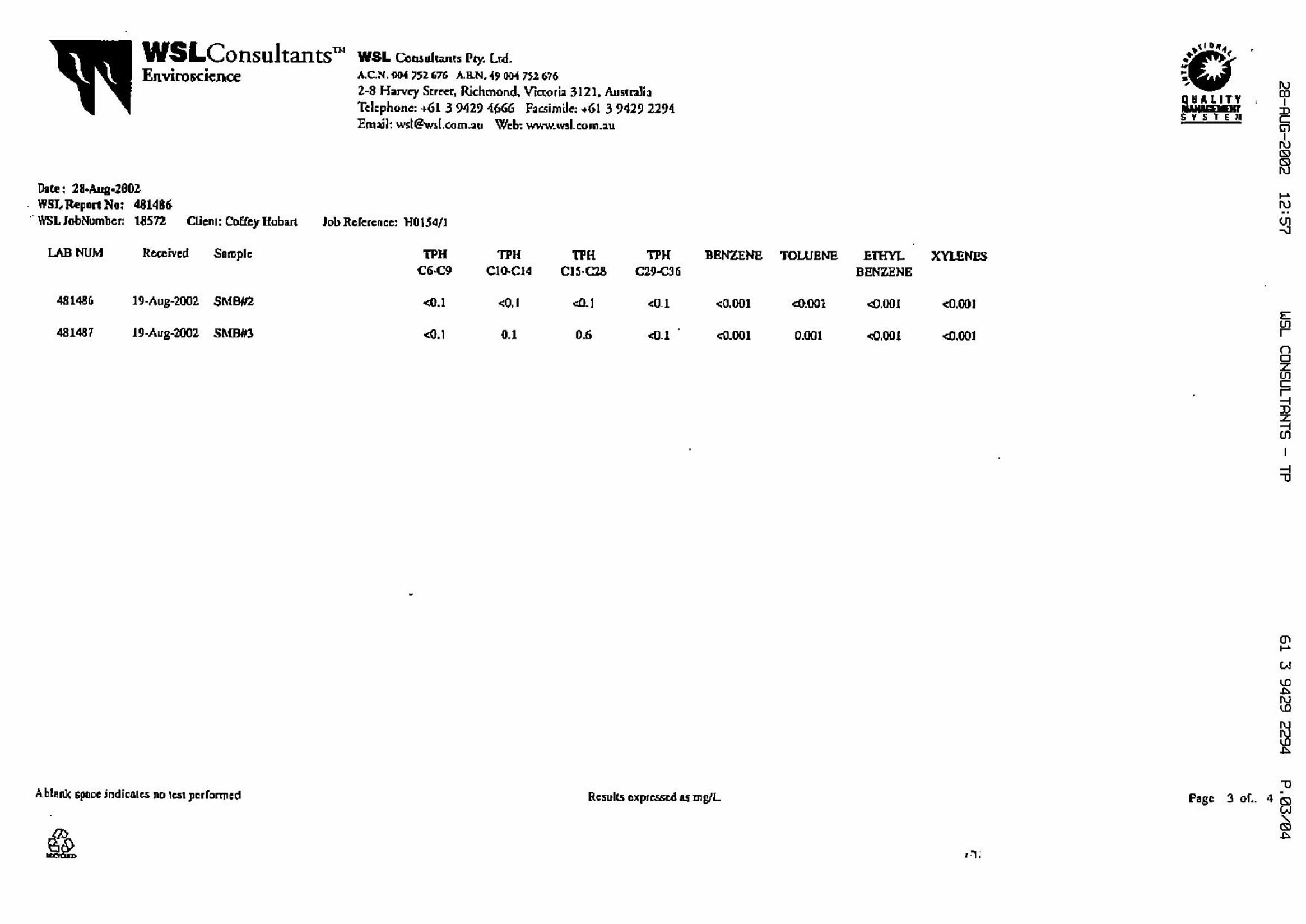
engineering log - borehole · refusal 1 2 3 notes samples, ... engineering log - borehole method...
TRANSCRIPT

L
VSt
MD/VSt
MD/D
W
CL
ML
SM
Alluvium
Most fines washed out with bore water,minor sandy residue around collar, easydrill to 11.6m
MQuartzite cobbles
SILTY CLAY: medium palsticity, some gravel and cobbles,rounded
SANDY SILT: low plasticity, some clay, quartz chips
SILTY SAND: quartz sand particles, white, some to tracegravel and cobbles
slope:
bearing:
supp
ort
support
T timberingC casing
water inflow
material
VSSF
StVStHFbVL
LMDDVD
no resistanceranging torefusal
1 2 3
notes
samples,tests, etc
100
200
300
400
method
ASAD
RRWCTHADT
BVT*bit shown by suffixe.g.
DMW
WpWl
1 of 4
structure andadditional observations
100mm
undisturbed sample50mm diameterdisturbed sample
standard penetration test (SPT)SPT - sample recoveredSPT with solid conevane shear (kPa)pressure meter
bulk samplerefusal
moisture
1 2 3 4
1
2
3
4
5
6
7
8
-90°
penetration
very softsoftfirm
stiffvery stiffhardfriablevery loose
loosemedium densedensevery dense
auger screwing*auger drilling*
roller/triconewashborecable toolhand augerdiatube
blank bitV bitTC bit
ADT
10/1/98 water levelon date shown
cons
isten
cy/
dens
ity in
dex
drill model and mounting:
hole diameter:
class
ificat
ion
sym
bol
pene
tratio
n
depthmetres gr
aphi
c lo
g
water
moi
stur
eco
nditio
n
Borehole Location:
wat
er
classification symbols and
soil description
based on unified classification
system
U50
D
NN*NcVP
BsR
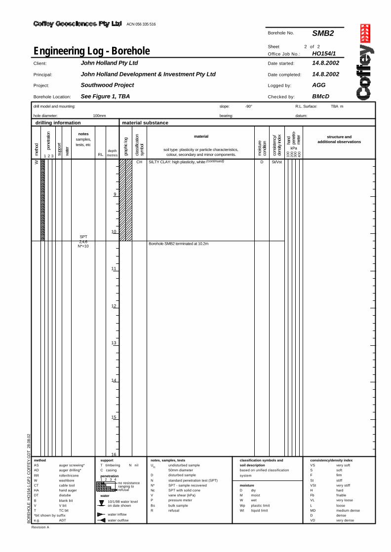
Borehole No.
consistency/density index
Engineering Log - Borehole
met
hod
Revision A
N nil
RL
water outflow
drymoistwet
plastic limitliquid limit
material substancedrilling information
hand
pene
tro-
met
er
kPasoil type: plasticity or particle characteristics,colour, secondary and minor components.
notes, samples, tests
R.L. Surface:
datum:
TBA m
Date started:
Date completed:
Logged by:
Checked by:
SMB1
HO154/1Sheet
Office Job No.:
12.8.2002
14.8.2002
AGG
BMcD
Client:
Principal:
Project:
John Holland Pty Ltd
John Holland Development & Investment Pty Ltd
Southwood Project
See Figure 1, TBA
BO
RE
HO
LE H
O15
4-1.
GP
J C
OFF
EY
.GD
T 2
8.08
.02
ACN 056 335 516

MD/D
VSt/H
W SM
CL
CL Becoming harder to drill
MSILTY SAND: quartz sand particles, white, some to tracegravel and cobbles (continued)
Core Borehole. Clay with some quartzite gravel and cobbles.Recovery <20%
SANDY CLAY: medium plasticity, medium density, pink
slope:
bearing:
supp
ort
support
T timberingC casing
water inflow
material
VSSF
StVStHFbVL
LMDDVD
no resistanceranging torefusal
1 2 3
notes
samples,tests, etc
100
200
300
400
method
ASAD
RRWCTHADT
BVT*bit shown by suffixe.g.
DMW
WpWl
2 of 4
structure andadditional observations
100mm
undisturbed sample50mm diameterdisturbed sample
standard penetration test (SPT)SPT - sample recoveredSPT with solid conevane shear (kPa)pressure meter
bulk samplerefusal
moisture
1 2 3 4
9
10
11
12
13
14
15
16
-90°
penetration
very softsoftfirm
stiffvery stiffhardfriablevery loose
loosemedium densedensevery dense
auger screwing*auger drilling*
roller/triconewashborecable toolhand augerdiatube
blank bitV bitTC bit
ADT
10/1/98 water levelon date shown
cons
isten
cy/
dens
ity in
dex
drill model and mounting:
hole diameter:
class
ificat
ion
sym
bol
pene
tratio
n
depthmetres gr
aphi
c lo
g
water
moi
stur
eco
nditio
n
Borehole Location:
wat
er
classification symbols and
soil description
based on unified classification
system
U50
D
NN*NcVP
BsR
Borehole No.
consistency/density index
Engineering Log - Borehole
met
hod
Revision A
N nil
RL
water outflow
drymoistwet
plastic limitliquid limit
material substancedrilling information
hand
pene
tro-
met
er
kPasoil type: plasticity or particle characteristics,colour, secondary and minor components.
notes, samples, tests
R.L. Surface:
datum:
TBA m
Date started:
Date completed:
Logged by:
Checked by:
SMB1
HO154/1Sheet
Office Job No.:
12.8.2002
14.8.2002
AGG
BMcD
Client:
Principal:
Project:
John Holland Pty Ltd
John Holland Development & Investment Pty Ltd
Southwood Project
See Figure 1, TBA
BO
RE
HO
LE H
O15
4-1.
GP
J C
OFF
EY
.GD
T 2
8.08
.02
ACN 056 335 516

VSt/H
MD/D
VSt/H
MD/D
W CL
SC
CL
SM
MSANDY CLAY: medium plasticity, medium density, pink(continued)
Possible Gravelly Sand layer, CLAYEY SAND: fine, harder,some quartz cobbles
SANDY CLAY: medium plasticity, brown, quartz and somegravel/cobbles
SILTY SAND: fine, brown, with some clay, somegravel/cobble layers
slope:
bearing:
supp
ort
support
T timberingC casing
water inflow
material
VSSF
StVStHFbVL
LMDDVD
no resistanceranging torefusal
1 2 3
notes
samples,tests, etc
100
200
300
400
method
ASAD
RRWCTHADT
BVT*bit shown by suffixe.g.
DMW
WpWl
3 of 4
structure andadditional observations
100mm
undisturbed sample50mm diameterdisturbed sample
standard penetration test (SPT)SPT - sample recoveredSPT with solid conevane shear (kPa)pressure meter
bulk samplerefusal
moisture
1 2 3 4
17
18
19
20
21
22
23
24
-90°
penetration
very softsoftfirm
stiffvery stiffhardfriablevery loose
loosemedium densedensevery dense
auger screwing*auger drilling*
roller/triconewashborecable toolhand augerdiatube
blank bitV bitTC bit
ADT
10/1/98 water levelon date shown
cons
isten
cy/
dens
ity in
dex
drill model and mounting:
hole diameter:
class
ificat
ion
sym
bol
pene
tratio
n
depthmetres gr
aphi
c lo
g
water
moi
stur
eco
nditio
n
Borehole Location:
wat
er
classification symbols and
soil description
based on unified classification
system
U50
D
NN*NcVP
BsR
Borehole No.
consistency/density index
Engineering Log - Borehole
met
hod
Revision A
N nil
RL
water outflow
drymoistwet
plastic limitliquid limit
material substancedrilling information
hand
pene
tro-
met
er
kPasoil type: plasticity or particle characteristics,colour, secondary and minor components.
notes, samples, tests
R.L. Surface:
datum:
TBA m
Date started:
Date completed:
Logged by:
Checked by:
SMB1
HO154/1Sheet
Office Job No.:
12.8.2002
14.8.2002
AGG
BMcD
Client:
Principal:
Project:
John Holland Pty Ltd
John Holland Development & Investment Pty Ltd
Southwood Project
See Figure 1, TBA
BO
RE
HO
LE H
O15
4-1.
GP
J C
OFF
EY
.GD
T 2
8.08
.02
ACN 056 335 516

MD/D
H
W SM
SM
CH Residual/EW rock
MSILTY SAND: fine, brown, with some clay, somegravel/cobble layers (continued)
SILTY SAND: black, some clay
CLAY: high plasticity, black, weathered carbonateousmudstone? or organic soil?
Borehole SMB1 continued as cored hole
slope:
bearing:
supp
ort
support
T timberingC casing
water inflow
material
VSSF
StVStHFbVL
LMDDVD
no resistanceranging torefusal
1 2 3
notes
samples,tests, etc
100
200
300
400
method
ASAD
RRWCTHADT
BVT*bit shown by suffixe.g.
DMW
WpWl
4 of 4
structure andadditional observations
100mm
undisturbed sample50mm diameterdisturbed sample
standard penetration test (SPT)SPT - sample recoveredSPT with solid conevane shear (kPa)pressure meter
bulk samplerefusal
moisture
1 2 3 4
25
26
27
28
29
30
31
32
-90°
penetration
very softsoftfirm
stiffvery stiffhardfriablevery loose
loosemedium densedensevery dense
auger screwing*auger drilling*
roller/triconewashborecable toolhand augerdiatube
blank bitV bitTC bit
ADT
10/1/98 water levelon date shown
cons
isten
cy/
dens
ity in
dex
drill model and mounting:
hole diameter:
class
ificat
ion
sym
bol
pene
tratio
n
depthmetres gr
aphi
c lo
g
water
moi
stur
eco
nditio
n
Borehole Location:
wat
er
classification symbols and
soil description
based on unified classification
system
U50
D
NN*NcVP
BsR
Borehole No.
consistency/density index
Engineering Log - Borehole
met
hod
Revision A
N nil
RL
water outflow
drymoistwet
plastic limitliquid limit
material substancedrilling information
hand
pene
tro-
met
er
kPasoil type: plasticity or particle characteristics,colour, secondary and minor components.
notes, samples, tests
R.L. Surface:
datum:
TBA m
Date started:
Date completed:
Logged by:
Checked by:
SMB1
HO154/1Sheet
Office Job No.:
12.8.2002
14.8.2002
AGG
BMcD
Client:
Principal:
Project:
John Holland Pty Ltd
John Holland Development & Investment Pty Ltd
Southwood Project
See Figure 1, TBA
BO
RE
HO
LE H
O15
4-1.
GP
J C
OFF
EY
.GD
T 2
8.08
.02
ACN 056 335 516

NQ SILTSTONE: medium to high, black,
highly weathered, moderately fractured<50mm core pieces
Core Loss 27.8-29.4m
SILTSTONE: extremely weathered,intense fracturing <50mm core pieces,clay along structures
SILTSTONE: extremely weathered,sil icif ied.
Core Loss 30.5-31.5m
Continued from non-cored borehole
SMB1 terminated at 31.5m
generalcore
-lift
-90°
estimatedstrength
method
10/1/98 water levelon date shown
diatubeauger screwingauger drilling
roller/triconeclaw or blade bitNMLC corewireline core
water inflow
partial drill fluid loss
complete drill fluid loss
slope:
bearing:
Is (50)
MPa
depthmetresw
ater
jointpartingseam
planarcurvedirregularroughsmooth
slickensided
water
Revision A
A-
D- diam-etralaxial
defectspacing
m m
met
hod
30 100
300
1000
3000
JTPTSM
PLCVIRROSO
SL
ELVLL
MHVHEH
FrSWMW
HWEW
Borehole Location:
graphic log/core recovery
defects
freshslightlymoderately
highlyextremely
strength
water pressure test result
(lugeons) for depth
interval shown
R L
barrel withdrawn
1 of 1
grap
hic
log
core
rec
over
y
particular
Engineering Log - Cored Borehole
EL
VL
L M H VH
EH
28
29
30
31
32
33
34
35
weathering/alteration
core recovered- hatching indicates
material
extremely lowvery lowlow
mediumhighvery highextremely high
25
case-lift
(W/A)casing used
no core recovered
DTASAD
RRCBNMLCNQ, HQ, PQ
RQ
D %
wea
ther
ing
alte
ratio
n
Borehole No.
drill model and mounting:
hole diameter:
material substancedrilling information rock mass defects
defect description
type, inclination, planarity, roughness,coating, thickness
rock type; grain characteristics, colour,structure, minor components
material
R.L. Surface:
datum:
TBA m
Date started:
Date completed:
Logged by:
Checked by:
SMB1
HO154/1Sheet
Office Job No.:
12.8.2002
14.8.2002
AGG
BMcD
Client:
Principal:
Project:
John Holland Pty Ltd
John Holland Development & Investment Pty Ltd
Southwood Project
See Figure 1, TBA
CO
RE
D B
OR
EH
OLE
HO
154-
1.G
PJ
CO
FFE
Y.G
DT
28.
08.0
2ACN 056 335 516

D
St/Vst
W SW
SW
SW
SW
CH
Drill stalling on cobbles
Harder drill area 3-3.5m, cobbles ofquartzite
SPT1,2,2N*=4
W
D
QUARTZ SAND: white/pink with quartz pebbles and chips,with some pale brown silt
QUARTZ SAND: fine to medium, white/pink with pale brownsilt
QUARTZ SAND with dark brown silt, some cobbles
QUARTZ SAND: fine, pale brown silt
SILTY CLAY: high plasticity, white
slope:
bearing:
supp
ort
support
T timberingC casing
water inflow
material
VSSF
StVStHFbVL
LMDDVD
no resistanceranging torefusal
1 2 3
notes
samples,tests, etc
100
200
300
400
method
ASAD
RRWCTHADT
BVT*bit shown by suffixe.g.
DMW
WpWl
1 of 2
structure andadditional observations
100mm
undisturbed sample50mm diameterdisturbed sample
standard penetration test (SPT)SPT - sample recoveredSPT with solid conevane shear (kPa)pressure meter
bulk samplerefusal
moisture
1 2 3 4
1
2
3
4
5
6
7
8
-90°
penetration
very softsoftfirm
stiffvery stiffhardfriablevery loose
loosemedium densedensevery dense
auger screwing*auger drilling*
roller/triconewashborecable toolhand augerdiatube
blank bitV bitTC bit
ADT
10/1/98 water levelon date shown
cons
isten
cy/
dens
ity in
dex
drill model and mounting:
hole diameter:
class
ificat
ion
sym
bol
pene
tratio
n
depthmetres gr
aphi
c lo
g
water
moi
stur
eco
nditio
n
Borehole Location:
wat
er
classification symbols and
soil description
based on unified classification
system
U50
D
NN*NcVP
BsR
Borehole No.
consistency/density index
Engineering Log - Borehole
met
hod
Revision A
N nil
RL
water outflow
drymoistwet
plastic limitliquid limit
material substancedrilling information
hand
pene
tro-
met
er
kPasoil type: plasticity or particle characteristics,colour, secondary and minor components.
notes, samples, tests
R.L. Surface:
datum:
TBA m
Date started:
Date completed:
Logged by:
Checked by:
SMB2
HO154/1Sheet
Office Job No.:
14.8.2002
14.8.2002
AGG
BMcD
Client:
Principal:
Project:
John Holland Pty Ltd
John Holland Development & Investment Pty Ltd
Southwood Project
See Figure 1, TBA
BO
RE
HO
LE H
O15
4-1.
GP
J C
OFF
EY
.GD
T 2
8.08
.02
ACN 056 335 516
St/VstW CH
SPT2,4,6
N*=10
DSILTY CLAY: high plasticity, white (continued)
Borehole SMB2 terminated at 10.2m
slope:
bearing:
supp
ort
support
T timberingC casing
water inflow
material
VSSF
StVStHFbVL
LMDDVD
no resistanceranging torefusal
1 2 3
notes
samples,tests, etc
100
200
300
400
method
ASAD
RRWCTHADT
BVT*bit shown by suffixe.g.
DMW
WpWl
2 of 2
structure andadditional observations
100mm
undisturbed sample50mm diameterdisturbed sample
standard penetration test (SPT)SPT - sample recoveredSPT with solid conevane shear (kPa)pressure meter
bulk samplerefusal
moisture
1 2 3 4
9
10
11
12
13
14
15
16
-90°
penetration
very softsoftfirm
stiffvery stiffhardfriablevery loose
loosemedium densedensevery dense
auger screwing*auger drilling*
roller/triconewashborecable toolhand augerdiatube
blank bitV bitTC bit
ADT
10/1/98 water levelon date shown
cons
isten
cy/
dens
ity in
dex
drill model and mounting:
hole diameter:
class
ificat
ion
sym
bol
pene
tratio
n
depthmetres gr
aphi
c lo
g
water
moi
stur
eco
nditio
n
Borehole Location:
wat
er
classification symbols and
soil description
based on unified classification
system
U50
D
NN*NcVP
BsR
Borehole No.
consistency/density index
Engineering Log - Borehole
met
hod
Revision A
N nil
RL
water outflow
drymoistwet
plastic limitliquid limit
material substancedrilling information
hand
pene
tro-
met
er
kPasoil type: plasticity or particle characteristics,colour, secondary and minor components.
notes, samples, tests
R.L. Surface:
datum:
TBA m
Date started:
Date completed:
Logged by:
Checked by:
SMB2
HO154/1Sheet
Office Job No.:
14.8.2002
14.8.2002
AGG
BMcD
Client:
Principal:
Project:
John Holland Pty Ltd
John Holland Development & Investment Pty Ltd
Southwood Project
See Figure 1, TBA
BO
RE
HO
LE H
O15
4-1.
GP
J C
OFF
EY
.GD
T 2
8.08
.02
ACN 056 335 516

VD
L/MD
St/Vst
W
SM
CL
Fill. Low water return to surface, water ismoving thru road at ~500
Old log at 2.3m
Alluvium
SPT4,4,4N*=8
MRoad surface, siltstone and dolerite cobbles, with brownsilt/clay
SILTY SAND with some clay, fine, light brown
2.3-3m log backfill
SANDY CLAY: medium plasticity, white, some silt
Borehole SMB3 terminated at 6.55m
slope:
bearing:
supp
ort
support
T timberingC casing
water inflow
material
VSSF
StVStHFbVL
LMDDVD
no resistanceranging torefusal
1 2 3
notes
samples,tests, etc
100
200
300
400
method
ASAD
RRWCTHADT
BVT*bit shown by suffixe.g.
DMW
WpWl
1 of 1
structure andadditional observations
100mm
undisturbed sample50mm diameterdisturbed sample
standard penetration test (SPT)SPT - sample recoveredSPT with solid conevane shear (kPa)pressure meter
bulk samplerefusal
moisture
1 2 3 4
1
2
3
4
5
6
7
8
-90°
penetration
very softsoftfirm
stiffvery stiffhardfriablevery loose
loosemedium densedensevery dense
auger screwing*auger drilling*
roller/triconewashborecable toolhand augerdiatube
blank bitV bitTC bit
ADT
10/1/98 water levelon date shown
cons
isten
cy/
dens
ity in
dex
drill model and mounting:
hole diameter:
class
ificat
ion
sym
bol
pene
tratio
n
depthmetres gr
aphi
c lo
g
water
moi
stur
eco
nditio
n
Borehole Location:
wat
er
classification symbols and
soil description
based on unified classification
system
U50
D
NN*NcVP
BsR
Borehole No.
consistency/density index
Engineering Log - Borehole
met
hod
Revision A
N nil
RL
water outflow
drymoistwet
plastic limitliquid limit
material substancedrilling information
hand
pene
tro-
met
er
kPasoil type: plasticity or particle characteristics,colour, secondary and minor components.
notes, samples, tests
R.L. Surface:
datum:
TBA m
Date started:
Date completed:
Logged by:
Checked by:
SMB3
HO154/1Sheet
Office Job No.:
15.8.2002
15.8.2002
AGG
BMcD
Client:
Principal:
Project:
John Holland Pty Ltd
John Holland Development & Investment Pty Ltd
Southwood Project
See Figure 1, TBA
BO
RE
HO
LE H
O15
4-1.
GP
J C
OFF
EY
.GD
T 2
8.08
.02
ACN 056 335 516

Topsoil
Alluvium
TOPSOIL: peat sward
SANDY SILT: pale grey
ORGANIC SILTSILTY CLAY: medium plasticity, light orange
SANDY CLAYEY SILT: low to medium plasticity, lightbrown-light orange, ~10% to 15% subrounded gravels, gravelsincrease with depth up to 200mm
ML
OLCL
ML
E W
M VL
St
H/D
N
N nilmethod
NX
BHBREHA
DT
0.5
1.0
1.5
2.0
2.5
3.0
3.5
4.0
penetration
drymoistwet
plastic limitliquid limit
natural exposureexisting excavation
backhoe bucketbulldozer bladeripperexcavatorhand auger
diatubewater
VSSF
StVStHFbVL
LMDDVD
met
hod
cons
isten
cy/
dens
ity in
dex
Test pit No.
DMW
WpWl
water levelon date shown
1 2 3 4
100
200
300
400
Excavator 20t, 0.75m bucket
m long m wide
structure andadditional observations
1 2 3
depthmetres m
oist
ure
cond
ition
Test pit location:
supp
ort
1 of 2Engineering log - Excavation
undisturbed sample50mm diameterdisturbed sample
vane shear (kPa)bulk samplerefusal
moisture
water outflow
support
T timberingconsistency/density index
Pit Orientation:
noranging torefusal
pene
tratio
n
U50
D
VBsR
Revision A
grap
hic
log
equipment type and model:
excavation dimensions:
class
ificat
ion
sym
bol
Sketch
water inflow
wat
er
RL
material
classification symbols and
soil description
based on unified classification
system
very softsoftfirm
stiffvery stiffhardfriablevery loose
loosemedium densedensevery dense
material substanceexcavation information
hand
pene
tro-
met
er
kPa
notes
samples,tests, etc soil type: plasticity or particle characteristics,
colour, secondary and minor components.
notes, samples, tests
R.L. Surface:
datum:
See plan for approximation m
Date started:
Date completed:
Logged by:
Checked by:
STP1
HO154/1Sheet
Office Job No.:
14.8.2002
14.8.2002
ASAZ
BMcD
Client:
Principal:
Project:
John Holland Pty Ltd
John Holland Development & Investment Pty Ltd
Southwood Project
Approximate GPS: 484840.00mE 5233285.00mN
TES
TPIT
HO
154-
1.G
PJ
CO
FFE
Y.G
DT
28.
08.0
2ACN 056 335 516

No refusal
SANDY CLAYEY SILT: low to medium plasticity, lightbrown-light orange, ~10% to 15% subrounded gravels, gravelsincrease with depth up to 200mm (continued)
Test pit STP1 terminated at 6.7m
E M H/DN
N nilmethod
NX
BHBREHA
DT
4.5
5.0
5.5
6.0
6.5
7.0
7.5
8.0
penetration
drymoistwet
plastic limitliquid limit
natural exposureexisting excavation
backhoe bucketbulldozer bladeripperexcavatorhand auger
diatubewater
VSSF
StVStHFbVL
LMDDVD
met
hod
cons
isten
cy/
dens
ity in
dex
Test pit No.
DMW
WpWl
water levelon date shown
1 2 3 4
100
200
300
400
Excavator 20t, 0.75m bucket
m long m wide
structure andadditional observations
1 2 3
depthmetres m
oist
ure
cond
ition
Test pit location:
supp
ort
2 of 2Engineering log - Excavation
undisturbed sample50mm diameterdisturbed sample
vane shear (kPa)bulk samplerefusal
moisture
water outflow
support
T timberingconsistency/density index
Pit Orientation:
noranging torefusal
pene
tratio
n
U50
D
VBsR
Revision A
grap
hic
log
equipment type and model:
excavation dimensions:
class
ificat
ion
sym
bol
Sketch
water inflow
wat
er
RL
material
classification symbols and
soil description
based on unified classification
system
very softsoftfirm
stiffvery stiffhardfriablevery loose
loosemedium densedensevery dense
material substanceexcavation information
hand
pene
tro-
met
er
kPa
notes
samples,tests, etc soil type: plasticity or particle characteristics,
colour, secondary and minor components.
notes, samples, tests
R.L. Surface:
datum:
See plan for approximation m
Date started:
Date completed:
Logged by:
Checked by:
STP1
HO154/1Sheet
Office Job No.:
14.8.2002
14.8.2002
ASAZ
BMcD
Client:
Principal:
Project:
John Holland Pty Ltd
John Holland Development & Investment Pty Ltd
Southwood Project
Approximate GPS: 484840.00mE 5233285.00mN
TES
TPIT
HO
154-
1.G
PJ
CO
FFE
Y.G
DT
28.
08.0
2ACN 056 335 516

Topsoil
Alluvium
No refusal; groundwater not encounteredduring excavation
TOPSOIL: peat sward
SANDY GRAVELLY SILT: low plasticitry, pale orange to palebrown, with some clay, gravel becomes coarser with depth
Test pit STP2 terminated at 2.5m
ML
E W
M D/St
N
D
N nilmethod
NX
BHBREHA
DT
0.5
1.0
1.5
2.0
2.5
3.0
3.5
4.0
penetration
drymoistwet
plastic limitliquid limit
natural exposureexisting excavation
backhoe bucketbulldozer bladeripperexcavatorhand auger
diatubewater
VSSF
StVStHFbVL
LMDDVD
met
hod
cons
isten
cy/
dens
ity in
dex
Test pit No.
DMW
WpWl
water levelon date shown
1 2 3 4
100
200
300
400
Excavator 20t, 0.75m bucket
m long m wide
structure andadditional observations
1 2 3
depthmetres m
oist
ure
cond
ition
Test pit location:
supp
ort
1 of 1Engineering log - Excavation
undisturbed sample50mm diameterdisturbed sample
vane shear (kPa)bulk samplerefusal
moisture
water outflow
support
T timberingconsistency/density index
Pit Orientation:
noranging torefusal
pene
tratio
n
U50
D
VBsR
Revision A
grap
hic
log
equipment type and model:
excavation dimensions:
class
ificat
ion
sym
bol
Sketch
water inflow
wat
er
RL
material
classification symbols and
soil description
based on unified classification
system
very softsoftfirm
stiffvery stiffhardfriablevery loose
loosemedium densedensevery dense
material substanceexcavation information
hand
pene
tro-
met
er
kPa
notes
samples,tests, etc soil type: plasticity or particle characteristics,
colour, secondary and minor components.
notes, samples, tests
R.L. Surface:
datum:
See plan for approximation m
Date started:
Date completed:
Logged by:
Checked by:
STP2
HO154/1Sheet
Office Job No.:
14.8.2002
14.8.2002
ASAZ
BMcD
Client:
Principal:
Project:
John Holland Pty Ltd
John Holland Development & Investment Pty Ltd
Southwood Project
See Figure 1
TES
TPIT
HO
154-
1.G
PJ
CO
FFE
Y.G
DT
28.
08.0
2ACN 056 335 516

Topsoil
Alluvium
Bulk sample for CBR testing
No refusal; Groundwater not encounteredduring excavation
TOPSOIL: peat sward
SAND: fine grained, pale grey
PEAT: ~50-100mmCLAYEY GRAVELLY SILT: fine to medium grained, paleorange, with some claySILTY SAND with some clay, light orange, dense
Test pit STP3 terminated at 2.6m
SP
PtML
SM
E W
M
VL
St/VSt
D
N
D
N nilmethod
NX
BHBREHA
DT
0.5
1.0
1.5
2.0
2.5
3.0
3.5
4.0
penetration
drymoistwet
plastic limitliquid limit
natural exposureexisting excavation
backhoe bucketbulldozer bladeripperexcavatorhand auger
diatubewater
VSSF
StVStHFbVL
LMDDVD
met
hod
cons
isten
cy/
dens
ity in
dex
Test pit No.
DMW
WpWl
water levelon date shown
1 2 3 4
100
200
300
400
Excavator 20t, 0.75m bucket
m long m wide
structure andadditional observations
1 2 3
depthmetres m
oist
ure
cond
ition
Test pit location:
supp
ort
1 of 1Engineering log - Excavation
undisturbed sample50mm diameterdisturbed sample
vane shear (kPa)bulk samplerefusal
moisture
water outflow
support
T timberingconsistency/density index
Pit Orientation:
noranging torefusal
pene
tratio
n
U50
D
VBsR
Revision A
grap
hic
log
equipment type and model:
excavation dimensions:
class
ificat
ion
sym
bol
Sketch
water inflow
wat
er
RL
material
classification symbols and
soil description
based on unified classification
system
very softsoftfirm
stiffvery stiffhardfriablevery loose
loosemedium densedensevery dense
material substanceexcavation information
hand
pene
tro-
met
er
kPa
notes
samples,tests, etc soil type: plasticity or particle characteristics,
colour, secondary and minor components.
notes, samples, tests
R.L. Surface:
datum:
See plan for approximation m
Date started:
Date completed:
Logged by:
Checked by:
STP3
HO154/1Sheet
Office Job No.:
14.8.2002
14.8.2002
ASAZ
BMcD
Client:
Principal:
Project:
John Holland Pty Ltd
John Holland Development & Investment Pty Ltd
Southwood Project
Approximate GPS: 484720.00mE 5233312.00mN
TES
TPIT
HO
154-
1.G
PJ
CO
FFE
Y.G
DT
28.
08.0
2ACN 056 335 516

Topsoil
Residual/Colluvial
Rock, near vertical joints, iron stained,dipping westwards, <200mm spacing
Rock ripper used from 3m
TOPSOIL: organics
CLAYEY SILT: medium plasticity, pale orange to pale brownwith some rootlet inclusions
SILTSTONE: fine grained, pale cream, low to mediumstrength, extremely weathered
CL
E W
M St
N
N nilmethod
NX
BHBREHA
DT
0.5
1.0
1.5
2.0
2.5
3.0
3.5
4.0
penetration
drymoistwet
plastic limitliquid limit
natural exposureexisting excavation
backhoe bucketbulldozer bladeripperexcavatorhand auger
diatubewater
VSSF
StVStHFbVL
LMDDVD
met
hod
cons
isten
cy/
dens
ity in
dex
Test pit No.
DMW
WpWl
water levelon date shown
1 2 3 4
100
200
300
400
Excavator 20t, 0.75m bucket
m long m wide
structure andadditional observations
1 2 3
depthmetres m
oist
ure
cond
ition
Test pit location:
supp
ort
1 of 2Engineering log - Excavation
undisturbed sample50mm diameterdisturbed sample
vane shear (kPa)bulk samplerefusal
moisture
water outflow
support
T timberingconsistency/density index
Pit Orientation:
noranging torefusal
pene
tratio
n
U50
D
VBsR
Revision A
grap
hic
log
equipment type and model:
excavation dimensions:
class
ificat
ion
sym
bol
Sketch
water inflow
wat
er
RL
material
classification symbols and
soil description
based on unified classification
system
very softsoftfirm
stiffvery stiffhardfriablevery loose
loosemedium densedensevery dense
material substanceexcavation information
hand
pene
tro-
met
er
kPa
notes
samples,tests, etc soil type: plasticity or particle characteristics,
colour, secondary and minor components.
notes, samples, tests
R.L. Surface:
datum:
See plan for approximation m
Date started:
Date completed:
Logged by:
Checked by:
STP4
HO154/1Sheet
Office Job No.:
14.8.2002
14.8.2002
ASAZ
BMcD
Client:
Principal:
Project:
John Holland Pty Ltd
John Holland Development & Investment Pty Ltd
Southwood Project
Approximate GPS: 484561.00mE 5233418.00mN
TES
TPIT
HO
154-
1.G
PJ
CO
FFE
Y.G
DT
28.
08.0
2ACN 056 335 516

Rock, near vertical joints, iron stained,dipping westwards, <200mm spacing
Close to refusal
SILTSTONE: fine grained, pale cream, low to mediumstrength, extremely weathered (continued)
Test pit STP4 terminated at 4.7m
E N
N nilmethod
NX
BHBREHA
DT
4.5
5.0
5.5
6.0
6.5
7.0
7.5
8.0
penetration
drymoistwet
plastic limitliquid limit
natural exposureexisting excavation
backhoe bucketbulldozer bladeripperexcavatorhand auger
diatubewater
VSSF
StVStHFbVL
LMDDVD
met
hod
cons
isten
cy/
dens
ity in
dex
Test pit No.
DMW
WpWl
water levelon date shown
1 2 3 4
100
200
300
400
Excavator 20t, 0.75m bucket
m long m wide
structure andadditional observations
1 2 3
depthmetres m
oist
ure
cond
ition
Test pit location:
supp
ort
2 of 2Engineering log - Excavation
undisturbed sample50mm diameterdisturbed sample
vane shear (kPa)bulk samplerefusal
moisture
water outflow
support
T timberingconsistency/density index
Pit Orientation:
noranging torefusal
pene
tratio
n
U50
D
VBsR
Revision A
grap
hic
log
equipment type and model:
excavation dimensions:
class
ificat
ion
sym
bol
Sketch
water inflow
wat
er
RL
material
classification symbols and
soil description
based on unified classification
system
very softsoftfirm
stiffvery stiffhardfriablevery loose
loosemedium densedensevery dense
material substanceexcavation information
hand
pene
tro-
met
er
kPa
notes
samples,tests, etc soil type: plasticity or particle characteristics,
colour, secondary and minor components.
notes, samples, tests
R.L. Surface:
datum:
See plan for approximation m
Date started:
Date completed:
Logged by:
Checked by:
STP4
HO154/1Sheet
Office Job No.:
14.8.2002
14.8.2002
ASAZ
BMcD
Client:
Principal:
Project:
John Holland Pty Ltd
John Holland Development & Investment Pty Ltd
Southwood Project
Approximate GPS: 484561.00mE 5233418.00mN
TES
TPIT
HO
154-
1.G
PJ
CO
FFE
Y.G
DT
28.
08.0
2ACN 056 335 516

Rock joints dipping westwards, <200mmspacing, rock ripper used from 2.2m,ripping became very difficult at 3m
Effective refusal; groundwater notencountered during excavation
TOPSOIL: organics
CLAYEY SILT: medium plasticity, pale brown, some rootlets
SILTSTONE: fine grained, cream, very low to low strength,extremely weathered
SILTSTONE: fine grained, cream, medium strength, highlyweatherd
Test pit STP5 terminated at 3.3m
CL
E M
St
N
N nilmethod
NX
BHBREHA
DT
0.5
1.0
1.5
2.0
2.5
3.0
3.5
4.0
penetration
drymoistwet
plastic limitliquid limit
natural exposureexisting excavation
backhoe bucketbulldozer bladeripperexcavatorhand auger
diatubewater
VSSF
StVStHFbVL
LMDDVD
met
hod
cons
isten
cy/
dens
ity in
dex
Test pit No.
DMW
WpWl
water levelon date shown
1 2 3 4
100
200
300
400
Excavator 20t, 0.75m bucket
m long m wide
structure andadditional observations
1 2 3
depthmetres m
oist
ure
cond
ition
Test pit location:
supp
ort
1 of 1Engineering log - Excavation
undisturbed sample50mm diameterdisturbed sample
vane shear (kPa)bulk samplerefusal
moisture
water outflow
support
T timberingconsistency/density index
Pit Orientation:
noranging torefusal
pene
tratio
n
U50
D
VBsR
Revision A
grap
hic
log
equipment type and model:
excavation dimensions:
class
ificat
ion
sym
bol
Sketch
water inflow
wat
er
RL
material
classification symbols and
soil description
based on unified classification
system
very softsoftfirm
stiffvery stiffhardfriablevery loose
loosemedium densedensevery dense
material substanceexcavation information
hand
pene
tro-
met
er
kPa
notes
samples,tests, etc soil type: plasticity or particle characteristics,
colour, secondary and minor components.
notes, samples, tests
R.L. Surface:
datum:
See plan for approximation m
Date started:
Date completed:
Logged by:
Checked by:
STP5
HO154/1Sheet
Office Job No.:
14.8.2002
14.8.2002
ASAZ
BMcD
Client:
Principal:
Project:
John Holland Pty Ltd
John Holland Development & Investment Pty Ltd
Southwood Project
Approximate GPS: 484550.00mE 5233698.00mN
TES
TPIT
HO
154-
1.G
PJ
CO
FFE
Y.G
DT
28.
08.0
2ACN 056 335 516

Topsoil
Residual
Rock
Close to refusal
TOPSOIL: organics, peat
SILTY CLAY: medium to high plasticity, pale brown to paleorange, some roots
SILT: slightly clayey, low to medium plasticity, orange stainedcream,
SILTSTONE: fine grained, cream, low strength, extremelyweathered, highly fractured
Test pit STP6 terminated at 2m
CH
ML
E W
M F/St
H
N
D
N nilmethod
NX
BHBREHA
DT
0.5
1.0
1.5
2.0
2.5
3.0
3.5
4.0
penetration
drymoistwet
plastic limitliquid limit
natural exposureexisting excavation
backhoe bucketbulldozer bladeripperexcavatorhand auger
diatubewater
VSSF
StVStHFbVL
LMDDVD
met
hod
cons
isten
cy/
dens
ity in
dex
Test pit No.
DMW
WpWl
water levelon date shown
1 2 3 4
100
200
300
400
Excavator 20t, 0.75m bucket
m long m wide
structure andadditional observations
1 2 3
depthmetres m
oist
ure
cond
ition
Test pit location:
supp
ort
1 of 1Engineering log - Excavation
undisturbed sample50mm diameterdisturbed sample
vane shear (kPa)bulk samplerefusal
moisture
water outflow
support
T timberingconsistency/density index
Pit Orientation:
noranging torefusal
pene
tratio
n
U50
D
VBsR
Revision A
grap
hic
log
equipment type and model:
excavation dimensions:
class
ificat
ion
sym
bol
Sketch
water inflow
wat
er
RL
material
classification symbols and
soil description
based on unified classification
system
very softsoftfirm
stiffvery stiffhardfriablevery loose
loosemedium densedensevery dense
material substanceexcavation information
hand
pene
tro-
met
er
kPa
notes
samples,tests, etc soil type: plasticity or particle characteristics,
colour, secondary and minor components.
notes, samples, tests
R.L. Surface:
datum:
See plan for approximation m
Date started:
Date completed:
Logged by:
Checked by:
STP6
HO154/1Sheet
Office Job No.:
14.8.2002
14.8.2002
ASAZ
BMcD
Client:
Principal:
Project:
John Holland Pty Ltd
John Holland Development & Investment Pty Ltd
Southwood Project
Approximate GPS: 484406.00mE 5233768.00mN
TES
TPIT
HO
154-
1.G
PJ
CO
FFE
Y.G
DT
28.
08.0
2ACN 056 335 516

Topsoil
Residual
Rock
Groundwater not encountered duringexcavationRipper used from 2.6m
TOPSOIL: organics
CLAYEY SILT: medium plasticity, pale brown to pale orange
SILTSTONE: fine grained, cream, very low to low strength,highly weathered
Test pit STP7 terminated at 2.6m
ML/CL
E W
M St/VSt
N
N nilmethod
NX
BHBREHA
DT
0.5
1.0
1.5
2.0
2.5
3.0
3.5
4.0
penetration
drymoistwet
plastic limitliquid limit
natural exposureexisting excavation
backhoe bucketbulldozer bladeripperexcavatorhand auger
diatubewater
VSSF
StVStHFbVL
LMDDVD
met
hod
cons
isten
cy/
dens
ity in
dex
Test pit No.
DMW
WpWl
water levelon date shown
1 2 3 4
100
200
300
400
Excavator 20t, 0.75m bucket
m long m wide
structure andadditional observations
1 2 3
depthmetres m
oist
ure
cond
ition
Test pit location:
supp
ort
1 of 1Engineering log - Excavation
undisturbed sample50mm diameterdisturbed sample
vane shear (kPa)bulk samplerefusal
moisture
water outflow
support
T timberingconsistency/density index
Pit Orientation:
noranging torefusal
pene
tratio
n
U50
D
VBsR
Revision A
grap
hic
log
equipment type and model:
excavation dimensions:
class
ificat
ion
sym
bol
Sketch
water inflow
wat
er
RL
material
classification symbols and
soil description
based on unified classification
system
very softsoftfirm
stiffvery stiffhardfriablevery loose
loosemedium densedensevery dense
material substanceexcavation information
hand
pene
tro-
met
er
kPa
notes
samples,tests, etc soil type: plasticity or particle characteristics,
colour, secondary and minor components.
notes, samples, tests
R.L. Surface:
datum:
See plan for approximation m
Date started:
Date completed:
Logged by:
Checked by:
STP7
HO154/1Sheet
Office Job No.:
14.8.2002
14.8.2002
ASAZ
BMcD
Client:
Principal:
Project:
John Holland Pty Ltd
John Holland Development & Investment Pty Ltd
Southwood Project
Approximate GPS: 484463.00mE 5233870.00mN
TES
TPIT
HO
154-
1.G
PJ
CO
FFE
Y.G
DT
28.
08.0
2ACN 056 335 516

Topsoil
Rock
Close to refusal; groundwater notencountered during excavation
TOPSOIL and organics
SILTSTONE: fine grained, cream, very low to low strength,extremely weathered
Test pit STP8 terminated at 1.8m
E M/WN
N nilmethod
NX
BHBREHA
DT
0.5
1.0
1.5
2.0
2.5
3.0
3.5
4.0
penetration
drymoistwet
plastic limitliquid limit
natural exposureexisting excavation
backhoe bucketbulldozer bladeripperexcavatorhand auger
diatubewater
VSSF
StVStHFbVL
LMDDVD
met
hod
cons
isten
cy/
dens
ity in
dex
Test pit No.
DMW
WpWl
water levelon date shown
1 2 3 4
100
200
300
400
Excavator 20t, 0.75m bucket
m long m wide
structure andadditional observations
1 2 3
depthmetres m
oist
ure
cond
ition
Test pit location:
supp
ort
1 of 1Engineering log - Excavation
undisturbed sample50mm diameterdisturbed sample
vane shear (kPa)bulk samplerefusal
moisture
water outflow
support
T timberingconsistency/density index
Pit Orientation:
noranging torefusal
pene
tratio
n
U50
D
VBsR
Revision A
grap
hic
log
equipment type and model:
excavation dimensions:
class
ificat
ion
sym
bol
Sketch
water inflow
wat
er
RL
material
classification symbols and
soil description
based on unified classification
system
very softsoftfirm
stiffvery stiffhardfriablevery loose
loosemedium densedensevery dense
material substanceexcavation information
hand
pene
tro-
met
er
kPa
notes
samples,tests, etc soil type: plasticity or particle characteristics,
colour, secondary and minor components.
notes, samples, tests
R.L. Surface:
datum:
See plan for approximation m
Date started:
Date completed:
Logged by:
Checked by:
STP8
HO154/1Sheet
Office Job No.:
15.8.2002
15.8.2002
ASAZ
BMcD
Client:
Principal:
Project:
John Holland Pty Ltd
John Holland Development & Investment Pty Ltd
Southwood Project
Approximate GPS: 484513.00mE 5233847.00mN
TES
TPIT
HO
154-
1.G
PJ
CO
FFE
Y.G
DT
28.
08.0
2ACN 056 335 516

Topsoil
Residual
Rock
No refusal; groundwater not encounteredduring excavation
TOPSOIL and organics
CLAYEY SILT: medium to high plasticity, pale brown/cream,friable, with some gravel
SILTSTONE: fine grained, cream, very low to low strength,highly weathered
Test pit STP9 terminated at 2m
MH
E M
F/St
N
D
N nilmethod
NX
BHBREHA
DT
0.5
1.0
1.5
2.0
2.5
3.0
3.5
4.0
penetration
drymoistwet
plastic limitliquid limit
natural exposureexisting excavation
backhoe bucketbulldozer bladeripperexcavatorhand auger
diatubewater
VSSF
StVStHFbVL
LMDDVD
met
hod
cons
isten
cy/
dens
ity in
dex
Test pit No.
DMW
WpWl
water levelon date shown
1 2 3 4
100
200
300
400
Excavator 20t, 0.75m bucket
m long m wide
structure andadditional observations
1 2 3
depthmetres m
oist
ure
cond
ition
Test pit location:
supp
ort
1 of 1Engineering log - Excavation
undisturbed sample50mm diameterdisturbed sample
vane shear (kPa)bulk samplerefusal
moisture
water outflow
support
T timberingconsistency/density index
Pit Orientation:
noranging torefusal
pene
tratio
n
U50
D
VBsR
Revision A
grap
hic
log
equipment type and model:
excavation dimensions:
class
ificat
ion
sym
bol
Sketch
water inflow
wat
er
RL
material
classification symbols and
soil description
based on unified classification
system
very softsoftfirm
stiffvery stiffhardfriablevery loose
loosemedium densedensevery dense
material substanceexcavation information
hand
pene
tro-
met
er
kPa
notes
samples,tests, etc soil type: plasticity or particle characteristics,
colour, secondary and minor components.
notes, samples, tests
R.L. Surface:
datum:
See plan for approximation m
Date started:
Date completed:
Logged by:
Checked by:
STP9
HO154/1Sheet
Office Job No.:
15.8.2002
15.8.2002
ASAZ
BMcD
Client:
Principal:
Project:
John Holland Pty Ltd
John Holland Development & Investment Pty Ltd
Southwood Project
Approximate GPS: 484389.00mE 5233900.00mN
TES
TPIT
HO
154-
1.G
PJ
CO
FFE
Y.G
DT
28.
08.0
2ACN 056 335 516

Topsoil
Residual/Colluvium
Seepage at 0.9m depth at Northerncorner, ~0.5 liters per second
No refusal
TOPSOIL: peat and organics
CLAYEY SILT: medium plasticity, orange stained grey
SILTY SAND: fine grained, pale gray
Test pit STP10 terminated at 2.1m
ML
SM
E M/W
D
M
St/VSt
N
D
N nilmethod
NX
BHBREHA
DT
0.5
1.0
1.5
2.0
2.5
3.0
3.5
4.0
penetration
drymoistwet
plastic limitliquid limit
natural exposureexisting excavation
backhoe bucketbulldozer bladeripperexcavatorhand auger
diatubewater
VSSF
StVStHFbVL
LMDDVD
met
hod
cons
isten
cy/
dens
ity in
dex
Test pit No.
DMW
WpWl
water levelon date shown
1 2 3 4
100
200
300
400
Excavator 20t, 0.75m bucket
m long m wide
structure andadditional observations
1 2 3
depthmetres m
oist
ure
cond
ition
Test pit location:
supp
ort
1 of 1Engineering log - Excavation
undisturbed sample50mm diameterdisturbed sample
vane shear (kPa)bulk samplerefusal
moisture
water outflow
support
T timberingconsistency/density index
Pit Orientation:
noranging torefusal
pene
tratio
n
U50
D
VBsR
Revision A
grap
hic
log
equipment type and model:
excavation dimensions:
class
ificat
ion
sym
bol
Sketch
water inflow
wat
er
RL
material
classification symbols and
soil description
based on unified classification
system
very softsoftfirm
stiffvery stiffhardfriablevery loose
loosemedium densedensevery dense
material substanceexcavation information
hand
pene
tro-
met
er
kPa
notes
samples,tests, etc soil type: plasticity or particle characteristics,
colour, secondary and minor components.
notes, samples, tests
R.L. Surface:
datum:
See plan for approximation m
Date started:
Date completed:
Logged by:
Checked by:
STP10
HO154/1Sheet
Office Job No.:
15.8.2002
15.8.2002
ASAZ
BMcD
Client:
Principal:
Project:
John Holland Pty Ltd
John Holland Development & Investment Pty Ltd
Southwood Project
Approximate GPS: 484303.00mE 5233898.00mN
TES
TPIT
HO
154-
1.G
PJ
CO
FFE
Y.G
DT
28.
08.0
2ACN 056 335 516

Topsoil, Vegetation and root zone
Residual/Colluvium
No refusal; groundwater not encounteredduring excavation
TOPSOIL
CLAYEY SILT: medium plasticity, orange stained, pale grey
SILTY SAND: fine grained, pale grey, silt decreasing withdepth
Test pit SPT11 terminated at 2.1m
MH
SM
E W
M St
MD
N
D
N nilmethod
NX
BHBREHA
DT
0.5
1.0
1.5
2.0
2.5
3.0
3.5
4.0
penetration
drymoistwet
plastic limitliquid limit
natural exposureexisting excavation
backhoe bucketbulldozer bladeripperexcavatorhand auger
diatubewater
VSSF
StVStHFbVL
LMDDVD
met
hod
cons
isten
cy/
dens
ity in
dex
Test pit No.
DMW
WpWl
water levelon date shown
1 2 3 4
100
200
300
400
Excavator 20t, 0.75m bucket
m long m wide
structure andadditional observations
1 2 3
depthmetres m
oist
ure
cond
ition
Test pit location:
supp
ort
1 of 1Engineering log - Excavation
undisturbed sample50mm diameterdisturbed sample
vane shear (kPa)bulk samplerefusal
moisture
water outflow
support
T timberingconsistency/density index
Pit Orientation:
noranging torefusal
pene
tratio
n
U50
D
VBsR
Revision A
grap
hic
log
equipment type and model:
excavation dimensions:
class
ificat
ion
sym
bol
Sketch
water inflow
wat
er
RL
material
classification symbols and
soil description
based on unified classification
system
very softsoftfirm
stiffvery stiffhardfriablevery loose
loosemedium densedensevery dense
material substanceexcavation information
hand
pene
tro-
met
er
kPa
notes
samples,tests, etc soil type: plasticity or particle characteristics,
colour, secondary and minor components.
notes, samples, tests
R.L. Surface:
datum:
See plan for approximation m
Date started:
Date completed:
Logged by:
Checked by:
SPT11
HO154/1Sheet
Office Job No.:
15.8.2002
15.8.2002
ASAZ
BMcD
Client:
Principal:
Project:
John Holland Pty Ltd
John Holland Development & Investment Pty Ltd
Southwood Project
Approximate GPS: 484267.00mE 5233840.00mN
TES
TPIT
HO
154-
1.G
PJ
CO
FFE
Y.G
DT
28.
08.0
2ACN 056 335 516

Topsoil
Residual
Extensive roots
Rock; seepage from southern end at ~1.6m depthNo refusal
TOPSOIL and root zone
SILTY CLAY: medium to high plasticity, orange stained,cream,
SANDY CLAYEY SILT: low plasticity, pale grey
SILTY SAND: with numerous quartzite rock pieces
SILTSTONE: fine grained, pale grey, low to medium strength,extremely weathered, highly fracturedTest pit STP12 terminated at 1.8m
CH
ML
SM
E
M/W
M
F/St
St
MD
N
D
N nilmethod
NX
BHBREHA
DT
0.5
1.0
1.5
2.0
2.5
3.0
3.5
4.0
penetration
drymoistwet
plastic limitliquid limit
natural exposureexisting excavation
backhoe bucketbulldozer bladeripperexcavatorhand auger
diatubewater
VSSF
StVStHFbVL
LMDDVD
met
hod
cons
isten
cy/
dens
ity in
dex
Test pit No.
DMW
WpWl
water levelon date shown
1 2 3 4
100
200
300
400
Excavator 20t, 0.75m bucket
m long m wide
structure andadditional observations
1 2 3
depthmetres m
oist
ure
cond
ition
Test pit location:
supp
ort
1 of 1Engineering log - Excavation
undisturbed sample50mm diameterdisturbed sample
vane shear (kPa)bulk samplerefusal
moisture
water outflow
support
T timberingconsistency/density index
Pit Orientation:
noranging torefusal
pene
tratio
n
U50
D
VBsR
Revision A
grap
hic
log
equipment type and model:
excavation dimensions:
class
ificat
ion
sym
bol
Sketch
water inflow
wat
er
RL
material
classification symbols and
soil description
based on unified classification
system
very softsoftfirm
stiffvery stiffhardfriablevery loose
loosemedium densedensevery dense
material substanceexcavation information
hand
pene
tro-
met
er
kPa
notes
samples,tests, etc soil type: plasticity or particle characteristics,
colour, secondary and minor components.
notes, samples, tests
R.L. Surface:
datum:
See plan for approximation m
Date started:
Date completed:
Logged by:
Checked by:
STP12
HO154/1Sheet
Office Job No.:
15.8.2002
15.8.2002
ASAZ
BMcD
Client:
Principal:
Project:
John Holland Pty Ltd
John Holland Development & Investment Pty Ltd
Southwood Project
Approximate GPS: 484290.00mE 5233752.00mN
TES
TPIT
HO
154-
1.G
PJ
CO
FFE
Y.G
DT
28.
08.0
2ACN 056 335 516

Topsoil
Alluvium
gravels up to 150mm in sizeClose to refusal; groundwater notencountered during excavation
TOPSOIL
GRAVELLY SILT: non plastic to low plasticity, pale grey, partlycemented
ORGANIC SILT with some gravels
Silty GRAVEL: medium to coarse grained, pale orange/palebrown; sub-rounded quartzite gravels of low to mediumstrength
Test pit STP13 terminated at 1.5m
ML
OL
GW
E W
M
St
F
MD
N
D
N nilmethod
NX
BHBREHA
DT
0.5
1.0
1.5
2.0
2.5
3.0
3.5
4.0
penetration
drymoistwet
plastic limitliquid limit
natural exposureexisting excavation
backhoe bucketbulldozer bladeripperexcavatorhand auger
diatubewater
VSSF
StVStHFbVL
LMDDVD
met
hod
cons
isten
cy/
dens
ity in
dex
Test pit No.
DMW
WpWl
water levelon date shown
1 2 3 4
100
200
300
400
Excavator 20t, 0.75m bucket
m long m wide
structure andadditional observations
1 2 3
depthmetres m
oist
ure
cond
ition
Test pit location:
supp
ort
1 of 1Engineering log - Excavation
undisturbed sample50mm diameterdisturbed sample
vane shear (kPa)bulk samplerefusal
moisture
water outflow
support
T timberingconsistency/density index
Pit Orientation:
noranging torefusal
pene
tratio
n
U50
D
VBsR
Revision A
grap
hic
log
equipment type and model:
excavation dimensions:
class
ificat
ion
sym
bol
Sketch
water inflow
wat
er
RL
material
classification symbols and
soil description
based on unified classification
system
very softsoftfirm
stiffvery stiffhardfriablevery loose
loosemedium densedensevery dense
material substanceexcavation information
hand
pene
tro-
met
er
kPa
notes
samples,tests, etc soil type: plasticity or particle characteristics,
colour, secondary and minor components.
notes, samples, tests
R.L. Surface:
datum:
See plan for approximation m
Date started:
Date completed:
Logged by:
Checked by:
STP13
HO154/1Sheet
Office Job No.:
15.8.2002
15.8.2002
ASAZ
BMcD
Client:
Principal:
Project:
John Holland Pty Ltd
John Holland Development & Investment Pty Ltd
Southwood Project
Approximate GPS: 484846.00mE 5233508.00mN
TES
TPIT
HO
154-
1.G
PJ
CO
FFE
Y.G
DT
28.
08.0
2ACN 056 335 516
N nil
water outflow
drymoistwet
plastic limitliquid limit
1
2
3
4
5
6
7
8
moi
stur
eco
nditi
on
1 2 3
drill model and mounting:
hole diameter:
slope:
bearing:
U50
DNN*NcVPBsREPIDWSPZ
cons
iste
ncy/
dens
ity in
dex
penetration
no resistanceranging torefusal
VSSF
StVStHFbVL
LMDDVD
classification symbols and
soil description
based on unified classification
system
supp
ort
very softsoftfirm
stiffvery stiffhardfriablevery loose
loosemedium densedensevery dense
support
T timberingC casing
pene
trat
ion
auger screwing*auger drilling*
roller/triconewashborecable toolhand augerdiatube
blank bitV bitTC bit
ADT
DMW
WpWl
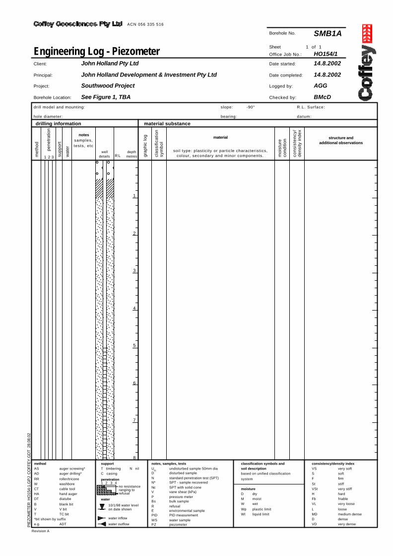
Borehole No.
R L
1 of 1
welldetails
moisture
10/1/98 water levelon date shown
Borehole Location:
undisturbed sample 50mm diadisturbed samplestandard penetration test (SPT)SPT - sample recoveredSPT with solid conevane shear (kPa)pressure meterbulk samplerefusalenvironmental samplePID measurementwater samplepiezometer
method
ASAD
RRWCTHADT
BVT*bit shown by suffixe.g.
Revision A
wat
er
1 2 3 4
met
hod
depthmetres gr
aphi
c lo
g
clas
sific
atio
nsy
mbo
l
materialnotes
samples,tests, etc
Engineering Log - Piezometer
water inflow
consistency/density index
water
structure andadditional observations
-90°
material substancedrilling information
soil type: plasticity or particle characteristics,colour, secondary and minor components.
notes, samples, tests
R.L. Surface:
datum:
Date started:
Date completed:
Logged by:
Checked by:
SMB1A
HO154/1Sheet
Office Job No.:
14.8.2002
14.8.2002
AGG
BMcD
Client:
Principal:
Project:
John Holland Pty Ltd
John Holland Development & Investment Pty Ltd
Southwood Project
See Figure 1, TBA
PIE
ZOM
ETE
R H
O15
4-1.
GP
J C
OFF
EY
.GD
T 2
8.08
.02
ACN 056 335 516

QUARTZ SAND: white/pink with quartz pebbles and chips,with some pale brown silt
QUARTZ SAND: fine to medium, white/pink with pale brownsilt
QUARTZ SAND with dark brown silt, some cobbles
QUARTZ SAND: fine, pale brown silt
SILTY CLAY: high plasticity, white
Drill stalling on cobbles
Harder drill area 3-3.5m, cobbles ofquartzite
W
D
W D
St/Vst
SW
SW
SW
SW
CH
SPT1,2,2N*=4
N nil
water outflow
drymoistwet
plastic limitliquid limit
1
2
3
4
5
6
7
8
moi
stur
eco
nditio
n
1 2 3
drill model and mounting:
hole diameter:
slope:
bearing:
U50
DNN*NcVPBsREPIDWSPZ
cons
isten
cy/
dens
ity in
dex
penetration
no resistanceranging torefusal
VSSF
StVStHFbVL
LMDDVD
classification symbols and
soil description
based on unified classification
system
supp
ort
very softsoftfirm
stiffvery stiffhardfriablevery loose
loosemedium densedensevery dense
support
T timberingC casing
pene
tratio
n
auger screwing*auger drilling*
roller/triconewashborecable toolhand augerdiatube
blank bitV bitTC bit
ADT
DMW
WpWl
Borehole No.
100mm
RL
1 of 2
welldetails
moisture
10/1/98 water levelon date shown
Borehole Location:
undisturbed sample 50mm diadisturbed samplestandard penetration test (SPT)SPT - sample recoveredSPT with solid conevane shear (kPa)pressure meterbulk samplerefusalenvironmental samplePID measurementwater samplepiezometer
method
ASAD
RRWCTHADT
BVT*bit shown by suffixe.g.
Revision A
wat
er
1 2 3 4
met
hod
depthmetres gr
aphi
c lo
g
class
ificat
ion
sym
bol
materialnotes
samples,tests, etc
Engineering Log - Piezometer
water inflow
consistency/density index
water
structure andadditional observations
-90°
material substancedrilling information
soil type: plasticity or particle characteristics,colour, secondary and minor components.
notes, samples, tests
R.L. Surface:
datum:
TBA m
Date started:
Date completed:
Logged by:
Checked by:
SMB2
HO154/1Sheet
Office Job No.:
14.8.2002
14.8.2002
AGG
BMcD
Client:
Principal:
Project:
John Holland Pty Ltd
John Holland Development & Investment Pty Ltd
Southwood Project
See Figure 1, TBA
PIE
ZOM
ETE
R H
O15
4-1.
GP
J C
OFF
EY
.GD
T 2
8.08
.02
ACN 056 335 516

SILTY CLAY: high plasticity, white (continued)
Borehole terminated at 10.2m
DW St/VstCH
SPT2,4,6
N*=10
N nil
water outflow
drymoistwet
plastic limitliquid limit
9
10
11
12
13
14
15
16
moi
stur
eco
nditio
n
1 2 3
drill model and mounting:
hole diameter:
slope:
bearing:
U50
DNN*NcVPBsREPIDWSPZ
cons
isten
cy/
dens
ity in
dex
penetration
no resistanceranging torefusal
VSSF
StVStHFbVL
LMDDVD
classification symbols and
soil description
based on unified classification
system
supp
ort
very softsoftfirm
stiffvery stiffhardfriablevery loose
loosemedium densedensevery dense
support
T timberingC casing
pene
tratio
n
auger screwing*auger drilling*
roller/triconewashborecable toolhand augerdiatube
blank bitV bitTC bit
ADT
DMW
WpWl
Borehole No.
100mm
RL
2 of 2
welldetails
moisture
10/1/98 water levelon date shown
Borehole Location:
undisturbed sample 50mm diadisturbed samplestandard penetration test (SPT)SPT - sample recoveredSPT with solid conevane shear (kPa)pressure meterbulk samplerefusalenvironmental samplePID measurementwater samplepiezometer
method
ASAD
RRWCTHADT
BVT*bit shown by suffixe.g.
Revision A
wat
er
1 2 3 4
met
hod
depthmetres gr
aphi
c lo
g
class
ificat
ion
sym
bol
materialnotes
samples,tests, etc
Engineering Log - Piezometer
water inflow
consistency/density index
water
structure andadditional observations
-90°
material substancedrilling information
soil type: plasticity or particle characteristics,colour, secondary and minor components.
notes, samples, tests
R.L. Surface:
datum:
TBA m
Date started:
Date completed:
Logged by:
Checked by:
SMB2
HO154/1Sheet
Office Job No.:
14.8.2002
14.8.2002
AGG
BMcD
Client:
Principal:
Project:
John Holland Pty Ltd
John Holland Development & Investment Pty Ltd
Southwood Project
See Figure 1, TBA
PIE
ZOM
ETE
R H
O15
4-1.
GP
J C
OFF
EY
.GD
T 2
8.08
.02
ACN 056 335 516

Road surface, siltstone and dolerite cobbles, with brownsilt/clay
SILTY SAND with some clay, fine, light brown
2.3-3m log backfill
SANDY CLAY: medium plasticity, white, some silt
Borehole terminated at 6.55m
Fill. Low water return to surface, water ismoving thru road at ~500
Old log at 2.3m
Alluvium
MW VD
L/MD
St/Vst
SM
CL
SPT4,4,4N*=8
N nil
water outflow
drymoistwet
plastic limitliquid limit
1
2
3
4
5
6
7
8
moi
stur
eco
nditio
n
1 2 3
drill model and mounting:
hole diameter:
slope:
bearing:
U50
DNN*NcVPBsREPIDWSPZ
cons
isten
cy/
dens
ity in
dex
penetration
no resistanceranging torefusal
VSSF
StVStHFbVL
LMDDVD
classification symbols and
soil description
based on unified classification
system
supp
ort
very softsoftfirm
stiffvery stiffhardfriablevery loose
loosemedium densedensevery dense
support
T timberingC casing
pene
tratio
n
auger screwing*auger drilling*
roller/triconewashborecable toolhand augerdiatube
blank bitV bitTC bit
ADT
DMW
WpWl
Borehole No.
100mm
RL
1 of 1
welldetails
moisture
10/1/98 water levelon date shown
Borehole Location:
undisturbed sample 50mm diadisturbed samplestandard penetration test (SPT)SPT - sample recoveredSPT with solid conevane shear (kPa)pressure meterbulk samplerefusalenvironmental samplePID measurementwater samplepiezometer
method
ASAD
RRWCTHADT
BVT*bit shown by suffixe.g.
Revision A
wat
er
1 2 3 4
met
hod
depthmetres gr
aphi
c lo
g
class
ificat
ion
sym
bol
materialnotes
samples,tests, etc
Engineering Log - Piezometer
water inflow
consistency/density index
water
structure andadditional observations
-90°
material substancedrilling information
soil type: plasticity or particle characteristics,colour, secondary and minor components.
notes, samples, tests
R.L. Surface:
datum:
TBA m
Date started:
Date completed:
Logged by:
Checked by:
SMB3
HO154/1Sheet
Office Job No.:
15.8.2002
15.8.2002
AGG
BMcD
Client:
Principal:
Project:
John Holland Pty Ltd
John Holland Development & Investment Pty Ltd
Southwood Project
See Figure 1, TBA
PIE
ZOM
ETE
R H
O15
4-1.
GP
J C
OFF
EY
.GD
T 2
8.08
.02
ACN 056 335 516

FALLING HEAD TEST
Hvorslev, 1951 - Well Point : Filter in Uniform Soil TEST DATAElapsed Depth to Active Active Head/
Time (mins) Water (mbGL) Head (m) Initial Head Fixed Parameters Unit Value 0 0.00 8.71 1.00 SWL = Standing Water Level m bGL 8.71 0.17 1.70 7.01 0.80 D = diameter of test section or ID of casing m 0.100 0.33 2.20 6.51 0.75 d = diameter of standpipe m 0.057 0.50 3.55 5.16 0.59 L = length of test section m 8.71 0.67 3.71 5.00 0.57 estimated kh/kv ratio 5.00 0.83 3.74 4.97 0.57
where kv = vertical coefficient of permeability 1.00 3.80 4.91 0.56 kh = horizontal coefficient of permeability 1.17 3.82 4.89 0.56
m = transformation ratio = kh/kv ratio 2.236 1.50 3.84 4.87 0.56 T = basic time lag = t when (Ht/H0 = 0.37) mins 1.1 2.00 3.88 4.83 0.55
3.00 3.94 4.77 0.554.00 3.96 4.75 0.55
Water Level at t1 5.00 3.97 4.74 0.54 H1 6.00 3.98 4.73 0.54
Water Level at t2 7.00 4.00 4.71 0.548.00 4.02 4.69 0.54
H2 9.00 4.05 4.66 0.54 SWL 10.00 4.15 4.56 0.52 d 11.00 4.29 4.42 0.51
12.00 4.41 4.30 0.49Bentonite / grout seal 13.00 4.50 4.21 0.48
14.00 4.61 4.10 0.4715.00 4.72 3.99 0.4616.00 4.81 3.90 0.45
L 17.00 4.91 3.80 0.44Slotted Section 18.00 4.97 3.74 0.43
19.00 5.04 3.67 0.42Sump 20.00 5.10 3.61 0.41
Bentonite / grout seal 25.00 5.36 3.35 0.38 kh kv kmean kh kv kmean
D 30.00 5.50 3.21 0.37 m3/m2/s = m/s m3/m2/day = m/daykh kv 35.00 5.76 2.95 0.34
40.00 6.11 2.60 0.30 8.68E-08 1.74E-08 3.88E-08 7.50E-03 1.50E-03 3.35E-03 Chosen time t1 mins 10.0 60.00 7.84 0.87 0.10 Chosen time t2 mins 40.0 90.00 8.71 0.00 0.00 H1 = active Head at time t1 m 4.56 4.21E-06 8.43E-07 1.88E-06 3.64E-01 7.28E-02 1.63E-01 H2 = active Head at time t2 m 2.60
Coffey Geosciences
Drawn - AGG
Approved -
Date - Aug 2002
Scale - Not to Scale
FIGURE B1
job no. Ho154/1
John Holland Pty Ltd
Southwood Project
Hydrogeological Studies
Falling Head Test of Bore SMB#1
Active Head / Initial
Head vs Time
0.01
0.10
1.00
0 10 20 30 40 50 60 70 80 90 100
Elapsed Time (mins)
Ac
tiv
e H
ea
d / In
itia
l H
ea
d (
Ht/H
0)

FALLING HEAD TEST
Hvorslev, 1951 - Well Point : Filter in Uniform Soil TEST DATAElapsed Depth to Active Active Head/
Time (mins) Water (mbGL) Head (m) Initial Head Fixed Parameters Unit Value 0.00 0.00 3.42 1.00 SWL = Standing Water Level m bGL 3.42 0.17 1.55 1.87 0.55 D = diameter of test section or ID of casing m 0.100 0.33 2.57 0.85 0.25 d = diameter of standpipe m 0.057 0.50 2.95 0.47 0.14 L = length of test section m 10.80 0.66 3.06 0.36 0.11 estimated kh/kv ratio 5.00 0.83 3.10 0.32 0.09
where kv = vertical coefficient of permeability 1.00 3.12 0.30 0.09 kh = horizontal coefficient of permeability 1.17 3.13 0.29 0.08
m = transformation ratio = kh/kv ratio 2.236 1.33 3.15 0.27 0.08 T = basic time lag = t when (Ht/H0 = 0.37) mins 1.1 1.50 3.16 0.26 0.08
1.66 3.19 0.23 0.071.83 3.20 0.22 0.06
Water Level at t1 2.00 3.20 0.22 0.06 H1 3.00 3.24 0.18 0.05
Water Level at t2 4.00 3.27 0.15 0.045.00 3.30 0.12 0.04
H2 6.00 3.31 0.11 0.03 SWL 7.00 3.32 0.10 0.03 d 10.00 3.34 0.08 0.02
15.00 3.37 0.05 0.01Bentonite / grout seal 20.00 3.39 0.03 0.01
25.00 3.41 0.01 0.0030.00 3.42 0.00 0.00
LSlotted Section
SumpBentonite / grout seal kh kv kmean kh kv kmean
D m3/m2/s = m/s m3/m2/day = m/daykh kv Variable Head Determination
kh = d2 ln(2mL/D) ln(H1/H2) 4.78E-07 9.57E-08 2.14E-07 4.13E-02 8.26E-03 1.85E-02 Chosen time t1 mins 0.8 8L (t2-t1) Chosen time t2 mins 20.0 Basic Time Lag Determination H1 = active Head at time t1 m 0.32 kh = d2 ln(2mL/D) 3.52E-06 7.04E-07 1.57E-06 3.04E-01 6.08E-02 1.36E-01
H2 = active Head at time t2 m 0.03 8LT
Coffey Geosciences
Drawn - AGG
Approved -
Date - Aug 2002
Scale - Not to Scale
FIGURE B2
job no. Ho154/1
John Holland Pty Ltd
Southwood Project
Hydrogeological Studies
Falling Head Test of Bore SMB#2
Active Head / Initial
Head vs Time
0.00
0.01
0.10
1.00
0.00 5.00 10.00 15.00 20.00 25.00 30.00 35.00
Elapsed Time (mins)
Ac
tiv
e H
ea
d / In
itia
l H
ea
d (
Ht/H
0)

BASIC TIME LAG SLUG OUT TEST
Hvorslev, 1951 - Well Point : Filter in Uniform Soil TEST DATAElapsed Depth to Active Active Head/
Time (mins) Water (mbGL) Head (m) Initial Head Fixed Parameters Unit Value 0.00 5.64 -2.65 1.00 SWL = Standing Water Level m bGL 2.99 0.17 5.41 -2.42 0.91 D = diameter of test section or ID of casing m 0.100 0.33 5.17 -2.18 0.82 d = diameter of standpipe m 0.057 0.50 4.94 -1.95 0.74 L = length of test section m 7.25 0.66 4.75 -1.76 0.66 R = radius of standpipe m 0.05 0.83 4.59 -1.60 0.60 r = radius of test section m 0.03 1.00 4.44 -1.45 0.55 T = basic time lag = t when (Ht/H0 = 0.37) mins 3.0 1.17 4.30 -1.31 0.49
secs 180 1.33 4.18 -1.19 0.451.50 4.07 -1.08 0.411.66 3.98 -0.99 0.371.83 3.91 -0.92 0.35
Water Level at t1 2.00 3.85 -0.86 0.32 H1 2.17 3.80 -0.81 0.31
Water Level at t2 2.33 3.75 -0.76 0.292.50 3.70 -0.71 0.27
H2 3.00 3.60 -0.61 0.23 SWL 3.30 3.50 -0.51 0.19 d 4.00 3.43 -0.44 0.17
5.00 3.33 -0.34 0.13Bentonite / grout seal 6.00 3.24 -0.25 0.09
7.00 3.17 -0.18 0.078.00 3.14 -0.15 0.069.00 3.12 -0.13 0.05
L 10.00 3.11 -0.12 0.05Slotted Section 12.00 3.09 -0.10 0.04
15.00 3.07 -0.08 0.03Sump 20.00 3.04 -0.05 0.02
Bentonite / grout seal 25.00 3.02 -0.03 0.01 D 30.00 3.00 -0.01 0.00 K
kh kv 35.00 2.99 0.00 0.00 m/s m/dayBasic Time Lag DeterminationK = r2 ln(L/R) 1.5E-06 9.66E-02 2LT0
Coffey Geosciences
Drawn - AGG
Approved -
Date - August 2002
Scale - Not to Scale Rising Head Test - Bore SMB#3 job no. Ho154/1
John Holland Pty Ltd
Southwood Project FIGURE B3
Hydrogeological Studies
Active Head / Initial
Head vs Time
0.00
0.01
0.10
1.00
0.00 10.00 20.00 30.00 40.00 50.00
Elapsed Time (mins)
Ac
tiv
e H
ea
d / In
itia
l H
ea
d (
Ht/H
0)
0.37
3mins