enhancing gdot’s computerized pavemen t condition
TRANSCRIPT
GEORGIA DOT RESEARCH PROJECT 16-29
FINAL REPORT
ENHANCING GDOT’S COMPUTERIZED PAVEMENT CONDITION EVALUATION SYSTEM FOR PAVEMENT
CONDITION SURVEY
OFFICE OF RESEARCH 15 KENNDY DRIVE
FOREST PARK, GA 30297-2534

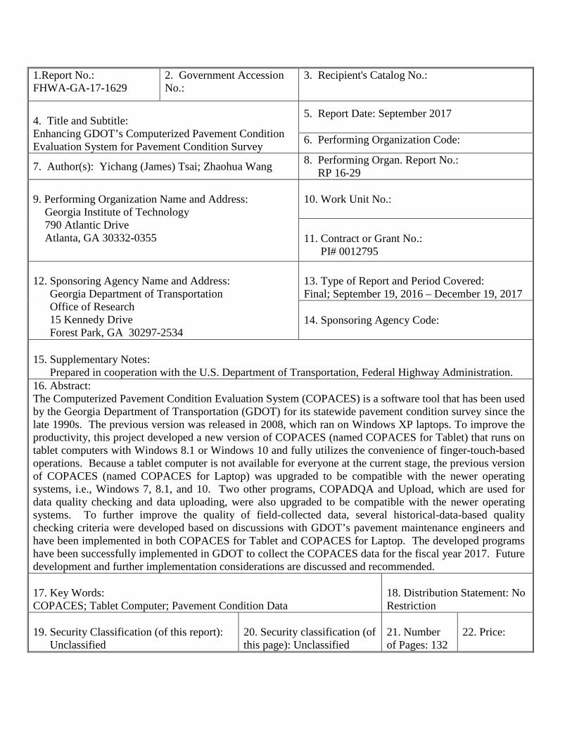
1.Report No.: FHWA-GA-17-1629
2. Government Accession No.:
3. Recipient's Catalog No.:
4. Title and Subtitle: Enhancing GDOT’s Computerized Pavement Condition Evaluation System for Pavement Condition Survey
5. Report Date: September 2017 6. Performing Organization Code:
7. Author(s): Yichang (James) Tsai; Zhaohua Wang 8. Performing Organ. Report No.: RP 16-29
9. Performing Organization Name and Address:
Georgia Institute of Technology 790 Atlantic Drive Atlanta, GA 30332-0355
10. Work Unit No.: 11. Contract or Grant No.: PI# 0012795
12. Sponsoring Agency Name and Address: Georgia Department of Transportation Office of Research 15 Kennedy Drive Forest Park, GA 30297-2534
13. Type of Report and Period Covered: Final; September 19, 2016 – December 19, 2017 14. Sponsoring Agency Code:
15. Supplementary Notes: Prepared in cooperation with the U.S. Department of Transportation, Federal Highway Administration. 16. Abstract: The Computerized Pavement Condition Evaluation System (COPACES) is a software tool that has been used by the Georgia Department of Transportation (GDOT) for its statewide pavement condition survey since the late 1990s. The previous version was released in 2008, which ran on Windows XP laptops. To improve the productivity, this project developed a new version of COPACES (named COPACES for Tablet) that runs on tablet computers with Windows 8.1 or Windows 10 and fully utilizes the convenience of finger-touch-based operations. Because a tablet computer is not available for everyone at the current stage, the previous version of COPACES (named COPACES for Laptop) was upgraded to be compatible with the newer operating systems, i.e., Windows 7, 8.1, and 10. Two other programs, COPADQA and Upload, which are used for data quality checking and data uploading, were also upgraded to be compatible with the newer operating systems. To further improve the quality of field-collected data, several historical-data-based quality checking criteria were developed based on discussions with GDOT’s pavement maintenance engineers and have been implemented in both COPACES for Tablet and COPACES for Laptop. The developed programs have been successfully implemented in GDOT to collect the COPACES data for the fiscal year 2017. Future development and further implementation considerations are discussed and recommended. 17. Key Words: COPACES; Tablet Computer; Pavement Condition Data
18. Distribution Statement: No Restriction
19. Security Classification (of this report): Unclassified
20. Security classification (of this page): Unclassified
21. Number of Pages: 132
22. Price:
GDOT Research Project No. 16-29
Final Report
ENHANCING GDOT’S COMPUTERIZED PAVEMENT CONDITION
EVALUATION SYSTEM FOR PAVEMENT CONDITION SURVEY
By
Yichang (James) Tsai, Ph.D., P.E.
Zhaohua Wang, Ph.D., P.E.
Georgia Institute of Technology
Contract with
Georgia Department of Transportation
In cooperation with
U.S. Department of Transportation
Federal Highway Administration
December 2017
The contents of this report reflect the views of the author(s) who is (are) responsible for the facts and the accuracy of the data presented herein. The contents do not necessarily reflect the official views or policies of the Georgia Department of Transportation or of the Federal Highway Administration. This report does not constitute a standard, specification, or regulation.

ii
TABLE OF CONTENTS
LIST OF TABLES vi
LIST OF FIGURES viii
ACRONYMS AND ABBREVIATIONS xii
EXECUTIVE SUMMARY xiv
ACKNOWLEDGEMENTS xvi
Chapter 1 INTRODUCTION 1
1. Research Background and Research Need .......................................................................... 1
2. Research Objectives ............................................................................................................. 3
3. Report Organization ............................................................................................................. 6
References ................................................................................................................................... 7
Chapter 2 COPACES FOR LAPTOP 9
1. System Architecture ............................................................................................................. 9
2. Update of Route and RC Lookup Tables ........................................................................... 11
3. Operation Flow .................................................................................................................. 20
3.1 COPACES User Profile .................................................................................. 21
3.2 Project Information ......................................................................................... 22
3.3 Pavement Condition Survey on Segments ...................................................... 24
3.4 Error Checking ............................................................................................... 25
iii
3.5 Submission of Completed COPACES Database File ..................................... 27
4. Automatic Software Update ............................................................................................... 28
Chapter 3 COPACES FOR TABLET 33
1. System Design ................................................................................................................... 33
1.1 Main Functions ............................................................................................... 34
1.2 Internal Data Storage ...................................................................................... 34
2. Operations of COPACES for Tablet .................................................................................. 36
2.1 COPACES User Profile .................................................................................. 36
2.2 Functions on Main Page ................................................................................. 37
2.3 Creating New Project ...................................................................................... 38
2.4 Creating New Segments ................................................................................. 41
2.5 Loading Data from Previous Year .................................................................. 45
2.6 Open Existing Project ..................................................................................... 46
2.7 Export Data ..................................................................................................... 48
3. Converting Survey Data to Access Database..................................................................... 50
4. Enhanced Field Data Quality Checking ............................................................................. 53
4.1 Quality Checking Criteria ............................................................................... 54
4.2 Operations on Enhanced Data Quality Checking ........................................... 55
5. Automatic Software Update ............................................................................................... 58
Chapter 4 CONCLUSIONS AND RECOMMENDATIONS 59

iv
Appendix I: List of state routes 1
Appendix II: User’s Guide for Installing COPACES for tablet on Windows 8.1 41
Appendix II: User’s Guide for Installing COPACES for tablet on Windows 10 45

v

vi
LIST OF TABLES
TABLE 2.1: List of Split Routes ...................................................................................... 12
TABLE 2.2: List of Routes in GAMS Only ..................................................................... 16
TABLE 2.3: List of Routes in GAMS Only ..................................................................... 17
TABLE 2.4: Data Dictionary of RC Lookup Table .......................................................... 18
TABLE 4.1: Summary of FY 2017 COPACES Data ....................................................... 60

vii
viii
LIST OF FIGURES
FIGURE 1.1: Major Programs for Pavement Management ................................................ 2
FIGURE 2.1: System Architecture of Four Programs ...................................................... 10
FIGURE 2.2: State Route Cross Several Counties ........................................................... 12
FIGURE 2.3: Operation Flow of Using COPACES for Laptop ....................................... 21
FIGURE 2.4: COPACES User Profile.............................................................................. 22
FIGURE 2.5: Project Information..................................................................................... 23
FIGURE 2.6: Pavement Condition Survey on Segment ................................................... 24
FIGURE 2.7: Error Checking ........................................................................................... 26
FIGURE 2.8: Data Transfer Function ............................................................................... 27
FIGURE 2.9: Confirmation on Data Completeness and Error Checking ......................... 28
FIGURE 2.10: Previous Software Delivery Process ........................................................ 29
FIGURE 2.11: Software Delivery Process with Automatic Update ................................. 31
FIGURE 3.1: Program Operation Diagram ...................................................................... 35
FIGURE 3.2: Internal Database File ................................................................................. 36
FIGURE 3.3: COPACES User Profile.............................................................................. 37
FIGURE 3.4: Layout of Functions on Main Page ............................................................ 37
ix
FIGURE 3.5: Creating New Project Page......................................................................... 38
FIGURE 3.6: Project Location Information ..................................................................... 39
FIGURE 3.7: Road Information ....................................................................................... 40
FIGURE 3.8: Segment Survey Page ................................................................................. 41
FIGURE 3.9: Segment Location Information ................................................................... 42
FIGURE 3.10: Distress Survey Example for Load Cracking ........................................... 43
FIGURE 3.11: Distress Survey Example for Rutting ....................................................... 44
FIGURE 3.12: Segment Navigation Bar .......................................................................... 45
FIGURE 3.13: Load Data Page ........................................................................................ 46
FIGURE 3.14: Open Existing Project Page ...................................................................... 47
FIGURE 3.15: List of Searched Projects .......................................................................... 48
FIGURE 3.16: Export Data Page ...................................................................................... 49
FIGURE 3.17: Export Data List View .............................................................................. 50
FIGURE 3.18: Export Result Example ............................................................................. 50
FIGURE 3.19: Menu Item for Importing Data from COPACES for Tablet .................... 51
FIGURE 3.20: Data Import Form ..................................................................................... 52
FIGURE 3.21: Selecting Source Data Folder ................................................................... 53
x
FIGURE 3.22: Collected Data Fails at Quality Checking in COPACES for Tablet ........ 56
FIGURE 3.23: Quality Checking Function in COPACES for Laptop ............................. 57
FIGURE 3.24: Table of All Questionable Surveys .......................................................... 57
FIGURE 4.1: COPACES Training in Macon ................................................................... 61

xi
xii
ACRONYMS AND ABBREVIATIONS
AADT Annual average daily traffic
COPACES Computerized Pavement Condition Evaluation System
CSV Comma-separated values
FY Fiscal year
GAMS Georgia Asset Management System
GDOT Georgia Department of Transportation
MR&R Maintenance, rehabilitation, and reconstruction
OIT Office of Information Technology
OM Office of Maintenance
OTD Office of Transportation Data
PACES Pavement Condition Evaluation System
RC Road characteristics

xiii

xiv
EXECUTIVE SUMMARY
The Computerized Pavement Condition Evaluation System (COPACES) has been an
indispensable tool for the Georgia Department of Transportation (GDOT) to annually
collect pavement condition distress data. The COPACES data is used by GDOT to make
informed decisions on statewide pavement maintenance, rehabilitation, and
reconstruction (MR&R).
To improve the productivity of field data collection, this project developed a new
program, COPACES for Tablet, that runs on tablet computers with Windows 8.1 or
Windows 10 and fully utilizes their convenience of finger–touch-based operations. Also,
the previous version of COPACES that was released in 2008 and ran on Windows XP
was upgraded to be compatible with the newer operating systems, i.e., Windows 7, 8.1,
and 10. Though it is out of the scope of this project, two other programs, COPADQA and
Upload, were also upgraded to be compatible with the newer operating systems because
GDOT needs them to check the district-level COPACES data quality and integrate it with
the central COPACES database.
To be consistent with GDOT’s GAMS (Georgia Asset Management System), the state
route lookup table in COPACES has been comprehensively cleaned up and updated.
Also, the road characteristics (RC) data in COPACES was updated using the most up-to-
date RC data provided by the Office of Information Technology.
To improve the efficiency of software installation and update, an approach to
automatically updating programs, including COPACES for Tablet, COPACES for Laptop,
COPADQA, and Upload, has been applied. The software setup packages are stored in

xv
GDOT’s web repository. Whenever an update is available, the software on a user’s
computer can be automatically updated.
Data quality is of the most importance in a data-driven pavement management system.
Thus, data quality checking has been rigorously implemented in the previous version of
COPACES. However, the historical data was not utilized for that purpose. In this
project, several historical-data-based quality checking criteria were developed based on
the discussions with GDOT’s pavement maintenance engineers. These criteria were
implemented in both COPACES for Tablet and COPACES for Laptop to enhance the
field-collected data quality. Thus, the accuracy of the decision-making on pavement
MR&R could also be improved.
The developed programs have been successfully implemented in GDOT to collect the
COPACES data for the fiscal year 2017. GDOT has used the data to select statewide
pavement maintenance projects and allocate funding.
Finally, future development and further implementation considerations are discussed and
recommended.

xvi
ACKNOWLEDGEMENTS
The work described in this final report was supported by the Georgia Department of
Transportation (GDOT) research project 16-29. We would like to thank Ms. Ernay
Robinson, Mr. Larry Barnes, Mr. David Sparks, Mr. Sam Wheeler, and Mr. Michael
Keene from the Office of Maintenance; Mr. Teague Buchanan, Mr. Donald Jordan, and
Mr. Keith Dickie from the Office of Information Technology; and Mr. David Jared and
Mr. Binh Bui from the Office of Research for their strong support and heavy involvement.
We would like to thank members of the research team at the Georgia Institute of
Technology for their diligent work.

xvii
1
CHAPTER 1 INTRODUCTION
1. Research Background and Research Need
The Computerized Pavement Condition Evaluation System (COPACES) and other
relative software tools have been used by the Georgia Department of Transportation
(GDOT) to conduct pavement condition survey, and manage and maintain its statewide
asphalt pavements since the late 1990s (RP 05-19: Tsai, et al. 2009; Tsai & Lai, 2001;
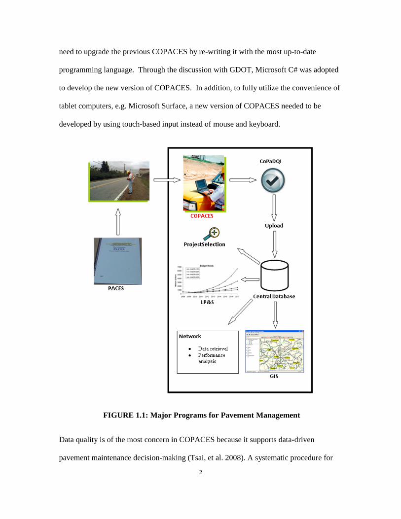
Tsai & Lai, 2002; Tsai, et al. 2008). It consists of three major components, including
data acquisition, data management, and decision support. FIGURE 1.1 shows the
programs to implement these three components.
As shown in FIGURE 1.1, COPACES is a laptop-based computer program used by the
Office of Maintenance (OM) in GDOT to conduct the statewide asphalt pavement
condition survey in accordance with GDOT’s Pavement Condition Evaluation System
(PACES) manual (GDOT, 2007), which is the impetus for the following data
management and decision support.
The previous version of COPACES (released in 2008) ran on a laptop with Windows XP.
To improve the productivity, OM has adopted tablet computers to gradually replace
laptops. More importantly, the previous version of COPACES was developed using
Microsoft Visual Basic 6.0, which has become obsolete and abandoned by Microsoft.
The supported operating system, Windows XP, was also obsolete. As a result, the
previous version of COPACES has some compatibility issues with the newer Windows
operating systems, e.g., Windows 7, Windows 8.1, and Windows 10. Thus, there was a
2
need to upgrade the previous COPACES by re-writing it with the most up-to-date
programming language. Through the discussion with GDOT, Microsoft C# was adopted
to develop the new version of COPACES. In addition, to fully utilize the convenience of
tablet computers, e.g. Microsoft Surface, a new version of COPACES needed to be
developed by using touch-based input instead of mouse and keyboard.
FIGURE 1.1: Major Programs for Pavement Management
Data quality is of the most concern in COPACES because it supports data-driven
pavement maintenance decision-making (Tsai, et al. 2008). A systematic procedure for

3
checking COPACES data quality has been identified by GDOT pavement maintenance
engineers to improve the quality of COAPCES data. Thus, there is a need to further
enhance the data quality checking capability for field data collection using COPACES.
2. Research Objectives
The objective of this proposed project is to enhance GDOT’s COPACES 1) to take full
advantage of tablet computers for more productive data input and 2) to implement more
rigorous in-field data quality checking.
The following are the originally proposed tasks:
1) Enhance COPACES by developing a tablet-based application;
2) Develop training materials and conducting training;
3) Enhance the field data quality checking for COPACES;
4) Summarize research findings and developing a final report.
Because OM started collecting COPACES data for the fiscal year (FY) 2017, the Georgia
Tech research team closely worked with the OM Liaison Engineers (who oversee the
statewide pavement condition survey and provide technical assistance to district and area
engineers) and other district engineers to facilitate the data collection using the new
version of COPACES. For this purpose, the following new tasks were added, though
they are out of the scope of the original task orders:
1) A tablet-based application using finger-touch as the main input method is called a
Windows Store App on Windows 8.1 or Windows 10. It is designed as a mobile
application that directly communicates with online services. For safety concerns,

4
the Windows Store App has limited capability to access local files stored on hard
drives. It cannot directly generate Microsoft Access database files as the previous
version of COPACES could do. As shown in FIGURE 1.1, the output from
COPACES will be used by COPADQA for district-level quality checking. Thus,
a mechanism is needed to convert the output from the tablet-based COPACES to
Microsoft Access database files. In addition, when OM started FY 2017 data
collection, not everyone had a tablet computer running on Windows 8.1 or
Windows 10. Instead, most of them were still using laptop computers running on
Windows 7. Thus, they must use laptop-based COPACES. As mentioned above,
the previous version of COPACES has some compatibility issues with Windows 7.
It must be rewritten using the new programming language, Microsoft C#. Thus,
two versions of COPACES (COPACES for Tablet and COPACES for Laptop)
were developed in this project. COPACES for Tablet focuses on field data
collection if a tablet computer is available. In the new version of COPACES for
Laptop, some new functions were added to convert the output from COPACES
for Tablet to Microsoft Access database files.
2) As shown in FIGURE 1.1, after COPACES data is collected, two other programs,
COPADQA (COPACES Data Quality Assurance Program) and Upload, are
needed before the data can be transferred and integrated into the central database
to support the statewide project selection and funding allocation. COPADQA is
responsible for performing district-level quality checking of the COPACES data
collected by area offices in each working district. It will also combine all the data
collected in each working district for uploading to the central database. The
5
Upload program is for uploading the collected COPACES data into the central
database. Since the previous versions (released in 2008) of these two programs
were also developed using Microsoft Visual Basic 6.0, they needed to be rewritten
using the most up-to-date programming language, Microsoft C#. To facilitate
OM’s ability to complete the FY 2017 COPACES data collection, the Georgia
Tech research team performed the system upgrade for COPADQA and Upload,
even though doing so was not in the original task orders.
3) A COPACES survey is conducted on projects that are defined by RCLINK, along
with starting and ending milepoints. During the project development, the Office
of Information Technology (OIT) requested the routes in COPACES comply with
the ones defined in GDOT’s GAMS (Georgia Asset Management System); thus,
the COPACES data can be conveniently migrated to the GAMS database. The
Georgia Tech research team closely worked with OIT to acquire the most up-to-
date projects from GAMS and converted them to the new version of COPACES,
COPADQA and Upload.
4) In COPACES, a user needs to input road characteristics (RC) data for each project,
such as AADT, truck percent, etc. However, most of the RC data is difficult to
extract in field. To solve this issue, a lookup table that contains the RC data for
each predefined route is embedded in the COPACES program. . The RC data is
currently collected and maintained by the Office of Transportation Data (OTD) in
GDOT. In this project, the Georgia Tech research team acquired the most up-to-
date RC data from OIT and converted it to a COPACES lookup table.
6
5) When OM started to use the new version of COPACES (both laptop and tablet
versions) to conduct FY 2017 data collection, it was found that the previous
software distribution process in GDOT was inefficient when problems were
encountered. In the previous software distribution process, when a user in an area
office encountered a problem, he reported it to the district engineer. Then, the
district engineer reported it to a Liaison Engineer, and then to the Georgia Tech
research team. After the problem was solved, a new setup package would be
developed and submitted to OM. OM would send the software to OIT and then to
each working district. The IT personnel in each working district would perform
the software update for each user in area offices. This process was very time-
consuming. More importantly, some users might forget to update the software,
which caused the problem of some of the versions of same software not being
consistent among different users. To solve this issue and make it more efficient
for OM to conduct the FY 2017 data collection, a new software distribution and
update mechanism were developed in which software setup packages are centrally
stored on OIT’s server. When any update is available, the software on a user’s
computer will be automatically updated.
3. Report Organization
This report is organized into four chapters. Chapter 1 introduces the project background,
need, objective, and tasks. Chapter 2 introduces the COPACES for Laptop program.
Chapter 3 presents the COPACES for Tablet program. Chapter 4 summarizes the project
7
implementation and offers recommendations for future development and further
implementation.
References
GDOT. “Pavement Condition Evaluation System.” Georgia Department of
Transportation, 2007.
Tsai, Y. and J. S Lai. “Utilization of Information Technology to Enhance Asphalt
Pavement Condition Evaluation Program.” The International Journal of Pavement
Engineering, Vol. 2(1), pp.17-32, 2001.
Tsai, Y. and J. S. Lai. “A Framework and Strategy for Implementing An IT-based
Pavement Management System.” Transportation Research Record: Journal of
Transportation Research Board, No. 1816, TRB, National Research Council,
Washington, D.C., 2002, pp. 56-64, 2002.
Tsai, Y., Wang, Z., and Purcell, R. “Improving GDOT’s Highway Pavement
Preservation”, Final Report, Georgia Department of Transportation, 2009.
Tsai, Y., Wu, Y., and Pitts, E. “Improving GDOT’s Annual Preventive Maintenance
Using a Collaborative Decision Support System.” 7th International Conference on
Managing Pavement Assets, 2008

8

9
CHAPTER 2 COPACES FOR LAPTOP
This chapter presents the development of COPACES for Laptop. The major functions of
this program are the same as the previous version of COPACES that was released in 2008.
However, the entire program was rewritten using the new programming language,
Microsoft C#. Some new functions were added to convert the output from COPACES
for Tablet to Microsoft Access database files that can be used by COPADQA. The
development of COPACES for Tablet will be presented in Chapter 3. In addition, the
embedded lookup tables for all state routes were updated to comply with GDOT’s GAMS.
RC data was also updated using the most up-to-date data provided by OIT.
1. System Architecture
In this project, four programs were developed: COPACES for Laptop, COPACES for
Tablet, COPADQA, and Upload. To reduce the resource use for system development,
this project did not change the entire system architecture, as shown in FIGURE 1.1.
Instead, only the previous COPACES program was replaced by COPACES for Laptop
and COPACES for Tablet to make it convenient for both Windows 7 users using laptops
and Windows 8.1/Windows 10 users using tablet computers. COPADQA and Upload
have the same functions as the previous versions that were released in 2008, but they
were rewritten using C# to be compatible with Windows 7 or newer Windows operating
systems. FIGURE 2.1 shows the relationship and information flow of these four
programs.
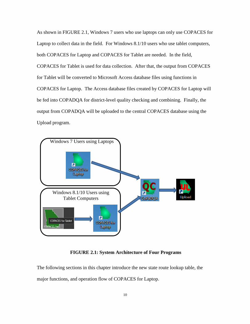
10
As shown in FIGURE 2.1, Windows 7 users who use laptops can only use COPACES for
Laptop to collect data in the field. For Windows 8.1/10 users who use tablet computers,
both COPACES for Laptop and COPACES for Tablet are needed. In the field,
COPACES for Tablet is used for data collection. After that, the output from COPACES
for Tablet will be converted to Microsoft Access database files using functions in
COPACES for Laptop. The Access database files created by COPACES for Laptop will
be fed into COPADQA for district-level quality checking and combining. Finally, the
output from COPADQA will be uploaded to the central COPACES database using the
Upload program.
FIGURE 2.1: System Architecture of Four Programs
The following sections in this chapter introduce the new state route lookup table, the
major functions, and operation flow of COPACES for Laptop.
Windows 7 Users using Laptops
Windows 8.1/10 Users using Tablet Computers
11
2. Update of Route and RC Lookup Tables
During the project development, OIT in GDOT requested that the state routes in
COPACES should be consistent with the ones defined in GDOT’s GAMS; thus,
COPACES data can be conveniently migrated to GAMS. After several meetings with
OIT, the Georgia Tech research team acquired the list of all the state routes defined by
RCLINK and milepoints.
The lookup table of all the state routes is important to make sure the spatial definition of
each COPACES project is consistent over time. In the central COPACES database, there
exists data back to FY 1986. Thus, after discussion with OM engineers, it was decided to
create a list of state routes that contains both the original routes and the updated routes
from GAMS (the complete list of state routes can be found in Appendix I). For this
purpose, a careful comparison between the existing and new state routes was performed.
The following differences were identified:
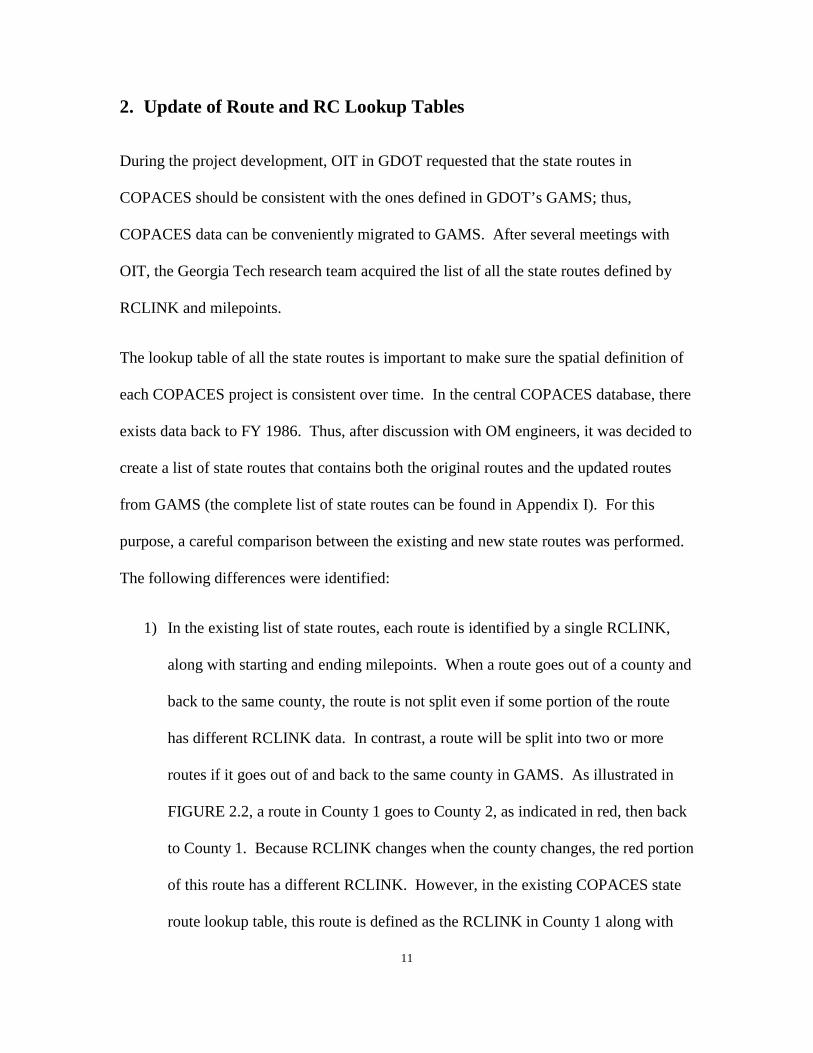
1) In the existing list of state routes, each route is identified by a single RCLINK,
along with starting and ending milepoints. When a route goes out of a county and
back to the same county, the route is not split even if some portion of the route
has different RCLINK data. In contrast, a route will be split into two or more
routes if it goes out of and back to the same county in GAMS. As illustrated in
FIGURE 2.2, a route in County 1 goes to County 2, as indicated in red, then back
to County 1. Because RCLINK changes when the county changes, the red portion
of this route has a different RCLINK. However, in the existing COPACES state
route lookup table, this route is defined as the RCLINK in County 1 along with

12
MP-1 and MP-4 as the starting and ending milepoint, respectively. The rater will
add the red portion of this route to the same project with different RCLINK data,
along with MP-2 and MP-3. In GAMS, this route is split into two routes, as
shown in FIGURE 2.2. If a route goes out of and back to the same county several
times, it will be split into more than two pieces. TABLE 2.1 lists all routes that
are split in GAMS.
FIGURE 2.2: State Route Cross Several Counties
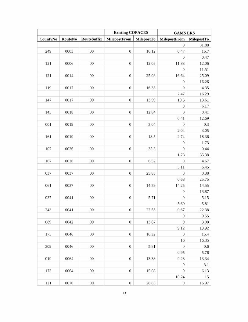
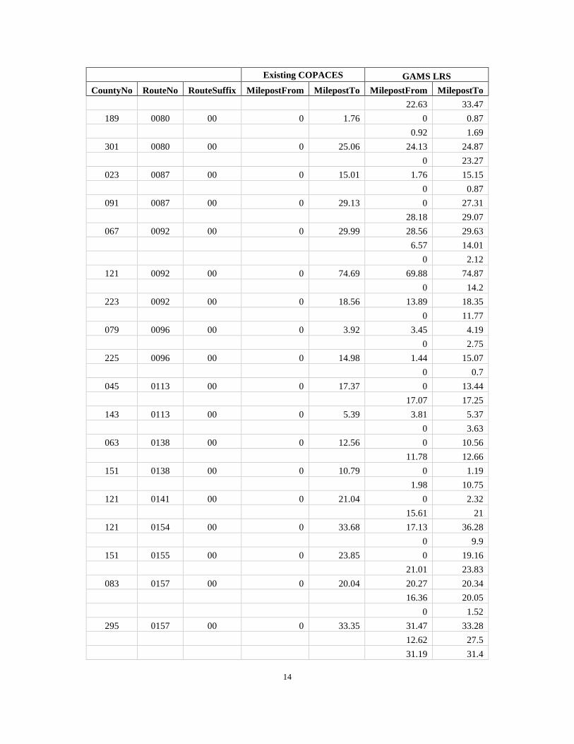
TABLE 2.1: List of Split Routes
Existing COPACES GAMS LRS
CountyNo RouteNo RouteSuffix MilepostFrom MilepostTo MilepostFrom MilepostTo 047 0001 00 0 9.99 0 1.36
8.23 9.65
243 0001 00 0 22.85 0 22.72
23.22 23.34
259 0001 00 0 23.15 0 0.54
0.62 23.12
295 0001 00 0 31.03 20.46 27.33
0 19.1
28.75 30.64
123 0002 00 0 26.24 0.89 26.25
0.57 0.75
213 0002 00 0 32.73 32.63 32.73
32.08 32.48
County 1 County 2
MP-1
MP-2
MP-3
MP-4 Existing COPACES
Starting: MP-1 Ending: MP-4 GAMS
Route 1 Starting: MP-1 Ending: MP-2
Route 2 Starting: MP-3 Starting: MP-4
13
Existing COPACES GAMS LRS
CountyNo RouteNo RouteSuffix MilepostFrom MilepostTo MilepostFrom MilepostTo
0 31.88
249 0003 00 0 16.12 0.47 15.7
0 0.47
121 0006 00 0 12.05 11.83 12.06
0 11.51
121 0014 00 0 25.08 16.64 25.09
0 16.26
119 0017 00 0 16.33 0 4.35
7.47 16.29
147 0017 00 0 13.59 10.5 13.61
0 6.17
145 0018 00 0 12.84 0 0.41
0.41 12.69
001 0019 00 0 3.04 0 0.3
2.04 3.05
161 0019 00 0 18.5 2.74 18.36
0 1.73
107 0026 00 0 35.3 0 0.44
1.78 35.38
167 0026 00 0 6.52 0 4.67
5.11 6.45
037 0037 00 0 25.85 0 0.38
0.68 25.75
061 0037 00 0 14.59 14.25 14.55
0 13.87
037 0041 00 0 5.71 0 5.15
5.69 5.81
243 0041 00 0 22.55 0.67 22.38
0 0.55
089 0042 00 0 13.87 0 3.08
9.12 13.92
175 0046 00 0 16.32 0 15.4
16 16.35
309 0046 00 0 5.81 0 0.6
0.95 5.76
019 0064 00 0 13.38 9.23 13.34
0 3.1
173 0064 00 0 15.08 0 6.13
10.24 15
121 0070 00 0 28.83 0 16.97
14
Existing COPACES GAMS LRS
CountyNo RouteNo RouteSuffix MilepostFrom MilepostTo MilepostFrom MilepostTo
22.63 33.47
189 0080 00 0 1.76 0 0.87
0.92 1.69
301 0080 00 0 25.06 24.13 24.87
0 23.27
023 0087 00 0 15.01 1.76 15.15
0 0.87
091 0087 00 0 29.13 0 27.31
28.18 29.07
067 0092 00 0 29.99 28.56 29.63
6.57 14.01
0 2.12
121 0092 00 0 74.69 69.88 74.87
0 14.2
223 0092 00 0 18.56 13.89 18.35
0 11.77
079 0096 00 0 3.92 3.45 4.19
0 2.75
225 0096 00 0 14.98 1.44 15.07
0 0.7
045 0113 00 0 17.37 0 13.44
17.07 17.25
143 0113 00 0 5.39 3.81 5.37
0 3.63
063 0138 00 0 12.56 0 10.56
11.78 12.66
151 0138 00 0 10.79 0 1.19
1.98 10.75
121 0141 00 0 21.04 0 2.32
15.61 21
121 0154 00 0 33.68 17.13 36.28
0 9.9
151 0155 00 0 23.85 0 19.16
21.01 23.83
083 0157 00 0 20.04 20.27 20.34
16.36 20.05
0 1.52
295 0157 00 0 33.35 31.47 33.28
12.62 27.5
31.19 31.4

15
Existing COPACES GAMS LRS
CountyNo RouteNo RouteSuffix MilepostFrom MilepostTo MilepostFrom MilepostTo
0 11.1
091 0165 00 0 29.48 0 26.71
27.99 29.42
107 0171 00 0 10.4 9.65 10.43
0 9.53
167 0171 00 0 13.4 0 0.12
0.9 13.33
299 0177 00 0 18.64 0 4.27
6.88 18.57
083 0189 00 0 15.15 0 2.22
2.75 15.03
295 0189 00 0 13.34 0 0.52
12.81 13.43
199 0190 00 0 7.95 0 3.66
7.78 8
159 0212 00 0 22.97 1.71 22.93
0 0.5
0.7 1.15
217 0212 00 0 16.71 15.46 15.66
16.11 16.67
0 14.96
197 0240 00 0 18.44 0.64 18.54
0 0.17
263 0240 00 0 3.12 0 2.55
2.73 3.2
137 0255 00 0 14.16 10.17 14.12
0 4.48
311 0255 00 0 15.68 9.98 15.68
0 5.54
061 0266 00 0 7.02 0 6.62
6.92 7.58
243 0266 00 0 11.27 0 0.3
0.97 11.63
107 0297 00 0 14.66 0 0.76
6.43 14.69
197 0355 00 0 17.7 2.17 17.67
0 1.37
063 0403 00 0 1.36 0 1.36
1.79 2.03
121 0403 00 0 31.27 0 13.39

16
Existing COPACES GAMS LRS
CountyNo RouteNo RouteSuffix MilepostFrom MilepostTo MilepostFrom MilepostTo
14.75 15.17
15.41 31.16
121 0407 00 0 62.66 60.62 62.66
53.03 54.69
0 13.22
20.82 26.71
177 0520 00 0 7.35 1.38 6.7
0 0.61
273 0520 00 0 23.83 0 22.43
23.04 23.81
2) After careful comparison, it was found that 19 routes from GAMS don’t exist in
the existing COPACES lookup table. In the meantime, 39 routes in the existing
COPACES lookup table were not found in GAMS. To maintain the data
consistency, all these routes are now added to COPACES for Laptop as well as the
other three programs that will be presented in the following chapters. These two
categories of routes are listed in TABLE 2.2 and TABLE 2.3, respectively.
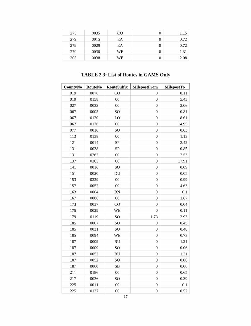
TABLE 2.2: List of Routes in GAMS Only
COUNTY RouteNo RouteSuffix MilepostFrom MilepostTo 015 0003 CO 0 4.77 015 0113 CO 0 0.35 015 1000 00 0 3.3 077 0016 NO 0 0.63 097 0008 CO 0 0.39 097 0154 00 0 5.64 141 0016 WE 0 0.05 143 0100 SP 0 0.9 151 0920 CO 0 0.2 151 0920 WE 0 0.27 151 0921 CO 0 0.05 173 0038 WE 0 1.29 185 0007 SB 0 0.45 199 0100 SO 0 0.12
17
275 0035 CO 0 1.15 279 0015 EA 0 0.72 279 0029 EA 0 0.72 279 0030 WE 0 1.31 305 0038 WE 0 2.08
TABLE 2.3: List of Routes in GAMS Only
CountyNo RouteNo RouteSuffix MilepostFrom MilepostTo 019 0076 CO 0 0.11 019 0158 00 0 5.43 027 0033 00 0 3.06 067 0005 SO 0 0.81 067 0120 LO 0 8.61 067 0176 00 0 14.95 077 0016 SO 0 0.63 113 0138 00 0 1.13 121 0014 SP 0 2.42 131 0038 SP 0 0.85 131 0262 00 0 7.53 137 0365 00 0 17.91 141 0016 SO 0 0.09 151 0020 DU 0 0.05 153 0329 00 0 0.99 157 0052 00 0 4.63 163 0004 BN 0 0.1 167 0086 00 0 1.67 173 0037 CO 0 0.04 175 0029 WE 0 0.11 179 0119 SO 1.73 2.93 185 0007 SO 0 0.45 185 0031 SO 0 0.48 185 0094 WE 0 0.73 187 0009 BU 0 1.21 187 0009 SO 0 0.06 187 0052 BU 0 1.21 187 0052 SO 0 0.06 187 0060 SB 0 0.06 211 0186 00 0 0.65 217 0036 SO 0 0.39 225 0011 00 0 0.1 225 0127 00 0 0.52

18
CountyNo RouteNo RouteSuffix MilepostFrom MilepostTo 235 0011 EA 0 0.28 245 0056 SP 0 6.58 269 0090 CO 0 0.07 273 0041 00 0 2.4 275 0035 BU 0 5.51 301 0223 00 0 0.7 319 0018 SP 0 0.65
Other than the state route data, the lookup table for RC data was also updated because the
traffic data, i.e., AADT and truck percent, was outdated in the existing COPACES
program. Working with OIT in GDOT, the Georgia Tech research team acquired all the
up-to-date RC data, which was converted to the lookup table in COPACES. TABLE 2.4
lists the definition of each field in the RC lookup table in COPACES.
TABLE 2.4: Data Dictionary of RC Lookup Table
Column Name Description ID An automatic number starting from 1
District A one-digit number indicating GDOT’s construction district where the inventory data is located. 1 1st District 2 2nd District 3 3rd District 4 4th District 5 5th District 6 6th District 7 7th District
RouteType It is a one-digit number. The following is the definition of each code. Route Type CODE State Route 1 County Road 2 City Street 3 Ramp 6 Private Road 7 Public Road Non Accepted Road 8 Collector-Distributor 9
RouteNo Four-digit number for each road. Example: SR 3 is 0003; CR 361 is 0361. RouteSuffix A two-digit number.
For State Route or County Road 00 (Numeric Zero Zero) None of the following NO NOrth SO SOuth
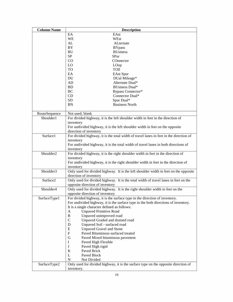
19
Column Name Description EA EAst WE WEst AL ALternate BY BYpass BU BUsiness SP SPur CO COnnector LO LOop TO TOll EA EAst Spur DU DUal Mileage* AD Alternate Dual* BD BUsiness Dual* BC Bypass Connector* CD Connector Dual* SD Spur Dual* BN Business North
RouteSequence Not used; blank Shoulder1 For divided highway, it is the left shoulder width in feet in the direction of
inventory For undivided highway, it is the left shoulder width in feet on the opposite direction of inventory
Surface1 For divided highway, it is the total width of travel lanes in feet in the direction of inventory For undivided highway, it is the total width of travel lanes in both directions of inventory
Shoulder2 For divided highway, it is the right shoulder width in feet in the direction of inventory For undivided highway, it is the right shoulder width in feet in the direction of inventory
Shoulder3 Only used for divided highway. It is the left shoulder width in feet on the opposite direction of inventory
Surface2 Only used for divided highway. It is the total width of travel lanes in feet on the opposite direction of inventory
Shoulder4 Only used for divided highway. It is the right shoulder width in feet on the opposite direction of inventory
SurfaceType1 For divided highway, it is the surface type in the direction of inventory. For undivided highway, it is the surface type in the both directions of inventory. It is a single character defined as follows: A Unpaved Primitive Road B Unpaved unimproved road C Unpaved Graded and drained road D Unpaved Soil - surfaced road E Unpaved Gravel and Stone F Paved Bituminous surfaced treated G Paved Mixed bituminous pavement I Paved High Flexible J Paved High rigid K Paved Brick L Paved Block N Not Divided
SurfaceType2 Only used for divided highway, it is the surface type on the opposite direction of inventory.

20
Column Name Description It is a single character defined as follows: A Unpaved Primitive Road B Unpaved unimproved road C Unpaved Graded and drained road D Unpaved Soil - surfaced road E Unpaved Gravel and Stone F Paved Bituminous surfaced treated G Paved Mixed bituminous pavement I Paved High Flexible J Paved High rigid K Paved Brick L Paved Block N Not Divided
AADT The current Average Annual Daily Traffic (AADT) for the route segment. STAA One character for designated truck route. The definitions are as follows:
A- Designated Access Routes for oversize trucks allowing single and twin trailers. B- Designated Access Routes for oversize trucks allowing single trailers only. C- Designated Access Routes for oversize trucks routes allowing twin trailers only. D- All Interstate Routes. E- Designated Local truck route. T- Federally Designated National Network Truck Routes other than Interstate
Truck Calculated percentage of truck volume on the highway system CountyNo County FIPS Code (three digits)
MilepostFrom The starting milepoint of inventory road segment MilepostTo The ending milepoint of inventory road segment
TL_R Number of Lanes in the direction of Inventory TL_L Number of Lanes on the opposite direction of inventory
Field23 Reserved; blank Field24 Reserved; blank Field25 Reserved; blank Field26 Reserved; blank Field27 Reserved; blank
3. Operation Flow
In this subsection, the system’s operational flow and some major functions are presented.
FIGURE 2.3 lists the major steps for operating COPACES for Laptop for Windows 7
users. The introduction of the data conversion from COPACES for Tablet will be
presented in the next chapter.
21
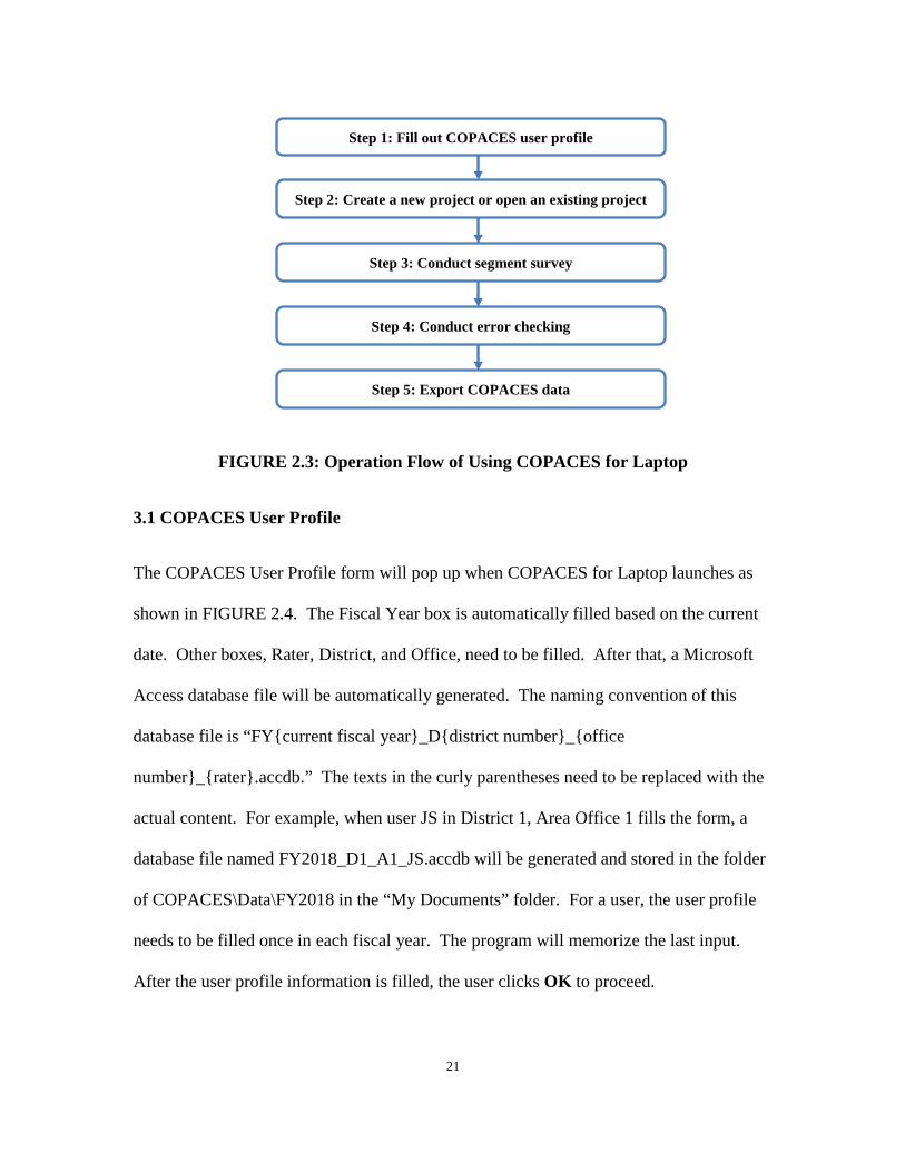
FIGURE 2.3: Operation Flow of Using COPACES for Laptop
3.1 COPACES User Profile
The COPACES User Profile form will pop up when COPACES for Laptop launches as
shown in FIGURE 2.4. The Fiscal Year box is automatically filled based on the current
date. Other boxes, Rater, District, and Office, need to be filled. After that, a Microsoft
Access database file will be automatically generated. The naming convention of this
database file is “FY{current fiscal year}_D{district number}_{office
number}_{rater}.accdb.” The texts in the curly parentheses need to be replaced with the
actual content. For example, when user JS in District 1, Area Office 1 fills the form, a
database file named FY2018_D1_A1_JS.accdb will be generated and stored in the folder
of COPACES\Data\FY2018 in the “My Documents” folder. For a user, the user profile
needs to be filled once in each fiscal year. The program will memorize the last input.
After the user profile information is filled, the user clicks OK to proceed.
Step 1: Fill out COPACES user profile
Step 2: Create a new project or open an existing project
Step 3: Conduct segment survey
Step 4: Conduct error checking
Step 5: Export COPACES data

22
FIGURE 2.4: COPACES User Profile
3.2 Project Information
COPACES data is organized by projects. As defined in GDOT’s PACES manual, “a
project is a length of a roadway with a common pavement section, similar structural
conditions, and logical beginning and ending points.” When a rater starts a pavement
condition survey, the information of the project needs to be filled.
As shown in FIGURE 2.5, two categories of project-related information need to be input:
location information and RC data. For a project location, all RCLINK-related
information, e.g., route type, route number, route suffix, and county name, along with the
starting and ending milepoints (it is shown as “Milepost” on the Project Information
form), is included. As shown in FIGURE 2.2, if a project goes out of the county, the
additional county name and milepoints need to be input. In COPACES for Laptop, a
project can cover up to three counties.
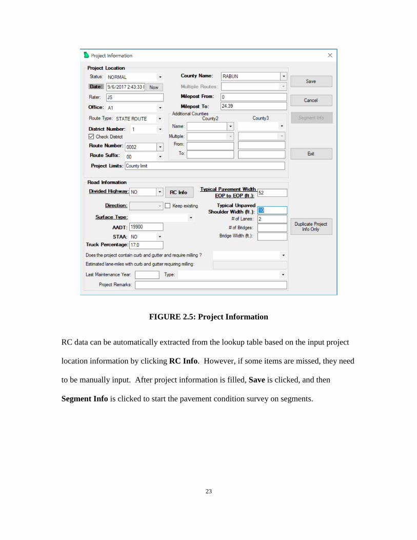
23
FIGURE 2.5: Project Information
RC data can be automatically extracted from the lookup table based on the input project
location information by clicking RC Info. However, if some items are missed, they need
to be manually input. After project information is filled, Save is clicked, and then
Segment Info is clicked to start the pavement condition survey on segments.

24
3.3 Pavement Condition Survey on Segments
For rating purposes, a project is divided into several segments, each of which is about
one-mile long except the beginning and ending ones. FIGURE 2.6 shows the survey
form for the first segment of the project defined in FIGURE 2.5.
FIGURE 2.6: Pavement Condition Survey on Segment
Based on GDOT’s PACES manual, cracking distress (load, block/transverse, and
reflection cracking) is only rated on a 100-foot sample location, which should represent
the majority of the cracking distresses found in the rating segment. As suggested by the
PACES manual, the 100-foot section is selected by a rater and can be located anywhere
within the rating segment. Normally, a rater should drive slowly, make two or three stops
within the first half of the rating segment, and look at the pavement from the car to
25
determine the type of cracking distress and the level of severity that are present. The
100-foot sample section can then be selected after the rater knows the overall pavement
condition. In the Sample Location box, a number between 0 and 9 can be input. For
example, 6 means the 100-foot sample location is selected between 0.6 ~ 0.7 miles of this
segment.
Based on the definitions in the PACES manual, ten types of distresses need to be input.
However, if a type of distress doesn’t exist, it should be left blank. The program will
perform real-time error checking when distress data is entered. For example, each % box
needs a number between 0 ~ 100. If the input is out of the range, an error message will
pop up. The real-time error checking significantly improves the data quality.
After the current segment survey is entered, Save is clicked and then Add to conduct the
survey on the next segment.
3.4 Error Checking
When a rater completes the entire pavement condition survey and is ready to submit the
data to a district engineer for district-level data quality checking using COPADQA, a
comprehensive error check should be performed. Unlike the real-time error check
introduced in Section 3.3, these error checking functions mainly focus on checking data
completeness and data consistency. FIGURE 2.7 shows functions for error checking:

26
FIGURE 2.7: Error Checking
1) List Non-Current FY Projects
This function checks if the current database file contains any projects that are not
in the current fiscal year. This could happen if a rater starts a pavement condition
survey using the data in the previous fiscal year. If the trip date is not updated by
clicking Now in FIGURE 2.5, the corresponding project would have an old date.
If any error is found using this function, it should be corrected before submission.
2) List Projects with No Segment
This function checks if there is any normal project in the current database without
a segment in it. The status of a project could be “Normal” or “Under
Construction,” which can be set using the Status box as shown in FIGURE 2.5.
For a normal project, there should be at least one segment in it. Otherwise, it
should be discarded or be added with a segment survey.
3) List UC Projects with Segments
This function checks if an under-construction project has any segments in it or not.
In GDOT, no pavement survey will be done on an under-construction project.
4) List Duplicated TripDate and RouteNo
27
In the database file, the trip date and route number of a project are used as a
combined primary key to identify a unique project. If there are two or more
projects that have the same trip date and route number, the uniqueness criteria
will be violated.
When all errors, if any, are corrected, the database file is ready to be submitted to a
district engineer. During the project development, it was found some raters forgot to
conduct the above error check, which caused running COPADQA for district-level data
quality checking and combining to fail. The database file had to be returned to the rater
for correction.
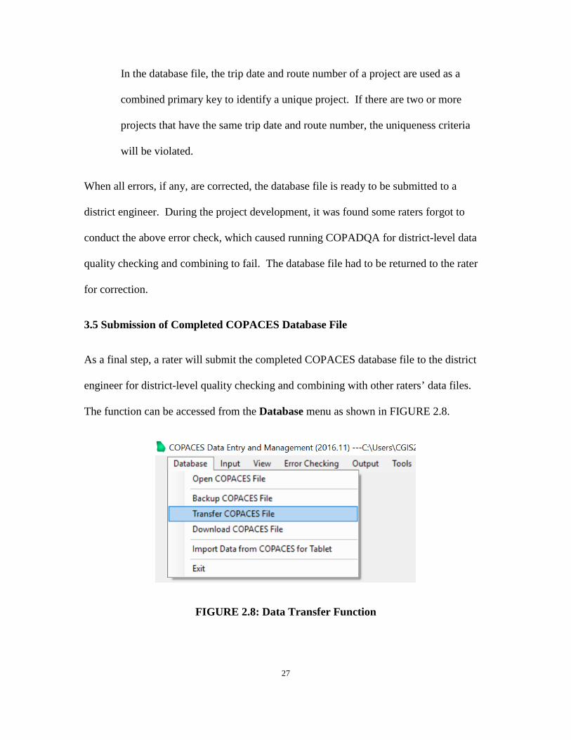
3.5 Submission of Completed COPACES Database File
As a final step, a rater will submit the completed COPACES database file to the district
engineer for district-level quality checking and combining with other raters’ data files.
The function can be accessed from the Database menu as shown in FIGURE 2.8.
FIGURE 2.8: Data Transfer Function

28
After the Transfer COPACES File menu item is clicked, a message box will pop up to
ask if the survey is completed and error checking is done. If the survey is incomplete or
error checking is not conducted, the database file should not be submitted.
FIGURE 2.9: Confirmation on Data Completeness and Error Checking
If Yes is confirmed in the above message box, the database file can be saved on a user-
designated drive and folder, which is ready to be submitted to the district engineer.
4. Automatic Software Update
Software delivery is an important process to make sure each user has the most up-to-date
version. The Georgia Tech research team started this project shortly before OM started
its FY 2017 COPACES data collection. Thus, the first version of COPACES for Laptop
was quickly completed for raters to collect data, which caused inevitable program bugs.
In addition, the change of state route and RC lookup tables also interrupted the use of the
first version of COPACES for Laptop. Each time the program needed to be modified, the
software delivery process had to be evaluated to ensure each user had the most up-to-date
version.
FIGURE 2.10 shows the original software delivery and feedback process. After a new
version of the software was ready, it would be submitted to OM. Then, it would be
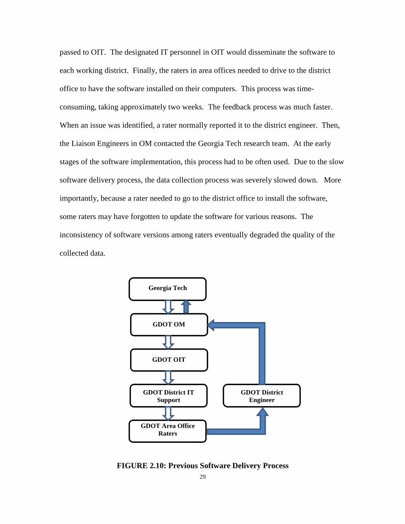
29
passed to OIT. The designated IT personnel in OIT would disseminate the software to
each working district. Finally, the raters in area offices needed to drive to the district
office to have the software installed on their computers. This process was time-
consuming, taking approximately two weeks. The feedback process was much faster.
When an issue was identified, a rater normally reported it to the district engineer. Then,
the Liaison Engineers in OM contacted the Georgia Tech research team. At the early
stages of the software implementation, this process had to be often used. Due to the slow
software delivery process, the data collection process was severely slowed down. More
importantly, because a rater needed to go to the district office to install the software,
some raters may have forgotten to update the software for various reasons. The
inconsistency of software versions among raters eventually degraded the quality of the
collected data.
FIGURE 2.10: Previous Software Delivery Process
Georgia Tech
GDOT OM
GDOT OIT
GDOT District IT Support
GDOT Area Office
Raters
GDOT District Engineer

30
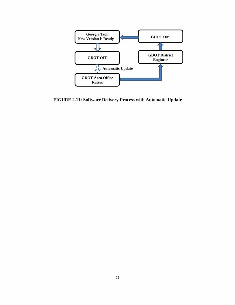
To solve the above issue, the Georgia Tech research team closely worked with OIT and
devised a solution using automatic update functions. First, the setup package of
COPACES for Laptop was developed using Microsoft ClickOnce; this Microsoft
technology enables a user to install and run a Windows-based smart client application by
downloading it from a web repository. Second, OIT helped to generate a web repository,
http://software.dot.ga.gov/COPACESLaptop/, to store the ClickOnce setup files. During
the first installation, the light-weight “setup.exe” file was sent to district offices for
installation. During the installation, the major program was downloaded from the web
repository, which makes the size of the setup.exe file very small (only 575KB). In future
software updates, there is no need to disseminate the setup file to district offices. After
GDOT OIT receives a software update, a designated IT person will replace the files in the
web repository using the new update. In the meantime, when a rater launches COPACES
for Laptop and the computer has access to the internet, the program will automatically
detect software updates and prompt the engineer to complete the software update process.
The above process is illustrated in FIGURE 2.11. In comparison with the process in
FIGURE 2.10, the four-step software delivery process was reduced to essentially one step
because the raters don’t need to ask for software updates because of the automatic update
functions (indicated by the dotted arrow in FIGURE 2.11.
31
FIGURE 2.11: Software Delivery Process with Automatic Update
Georgia Tech New Version is Ready
GDOT OM
GDOT OIT
GDOT Area Office Raters
GDOT District Engineer
Automatic Update

32
33
CHAPTER 3 COPACES FOR TABLET
Since the last release of COPACES in 2008, more easy-to-carry tablet computers have
become available. Compared to the use of a tablet computer, it is inconvenient to use a
laptop for collecting pavement condition data in the field. To improve the productivity of
a field pavement condition survey, the engineers in OM have gradually adopted tablet
computers. However, even though the original laptop-based COPACES program can run
on a tablet computer if the operating system is compatible, the user experience has been
poor because of the use of a keyboard and a touchpad on a smaller screen (the size of a
tablet computer screen is normally less than 12 inches). A user may operate a laptop-
based COPACES program using finger touch, but it is difficult because the controls and
buttons are designed for mouse and keyboard. Thus, to fully utilize the convenience and
productivity of a tablet computer, there is a need to develop a new COPACES program
that can be operated using finger touch. The current Windows operating system
(Windows 8.1 or Windows 10) provides two modes: the desktop mode and tablet mode.
Under the desktop mode, only the classic programs (like COPACES for Laptop) can run;
the program running the tablet mode uses different resources of the operating systems,
but it provides full capability of finger-touch operations. Based on discussions with the
engineers in OM, the new COPACES program (named COPACES for Tablet) is
designed to run in the tablet mode; an end user can operate it using finger touch.
1. System Design
This section introduces the system design of COPACES for Tablet.

34
1.1 Main Functions
COPACES for Tablet includes four main functions:
1) Creating New Project: In creating a new project page, a user can create a new
project and corresponding new segments in the corresponding district and area
offices.
2) Modifying Existing Project: A user can review and modify any existing project.
A user may also change a project’s key information, such as “route number,” but
it will lead to creating a new project, which is not recommended.
3) Loading Data from Previous Year: A user can import the data from previous
fiscal years as templates. These imported data are originally marked as “TODO”
items until they are edited and saved. In FY 2017, due to the changes in the state
route lookup table (see Chapter 2), no previous data should be used as templates.
Thus, each project will be surveyed from scratch.
4) Export Data: Under the tablet mode, the survey data cannot be exported and
saved as a Microsoft Access database file. As a remedy, COPACES for Tablet
exports survey data in csv format. However, as mentioned in Chapter 2, a user
needs to use COPACES for Laptop to convert it into an Access database file that
can be submitted to a district engineer.
FIGURE 3.1 shows the program operation diagram.
1.2 Internal Data Storage
COPACES for Tablet is a Windows Store application, built on the Windows 8.1
Development Toolkit (it can also run in Windows 10). It uses an SQLite database as an
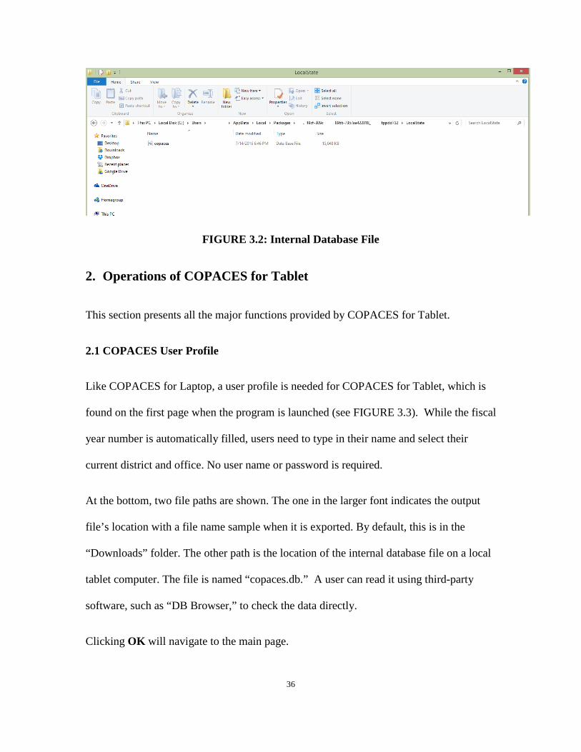
35
internal data storage format, stores data in local user app packages folder (FIGURE 3.2)
named “copaces.” A user may open this database file using other software to check the
data directly (e.g. DB Browser). The file path is also shown on the start page of the
program.
FIGURE 3.1: Program Operation Diagram
By default, this database contains 10 data tables inherited from the original COPACES
software that was released in 2008. These 10 data tables are “tblCounty,” “tblRoute,”
“tblpaces,” “tblRouteSuffix,” “tblRouteType,” “tblRCLink,” “tblPrjLocat,”
“tblPrjSurvey,” “tbSegInfo,” and “tblSegSurvey.”
36
FIGURE 3.2: Internal Database File
2. Operations of COPACES for Tablet
This section presents all the major functions provided by COPACES for Tablet.
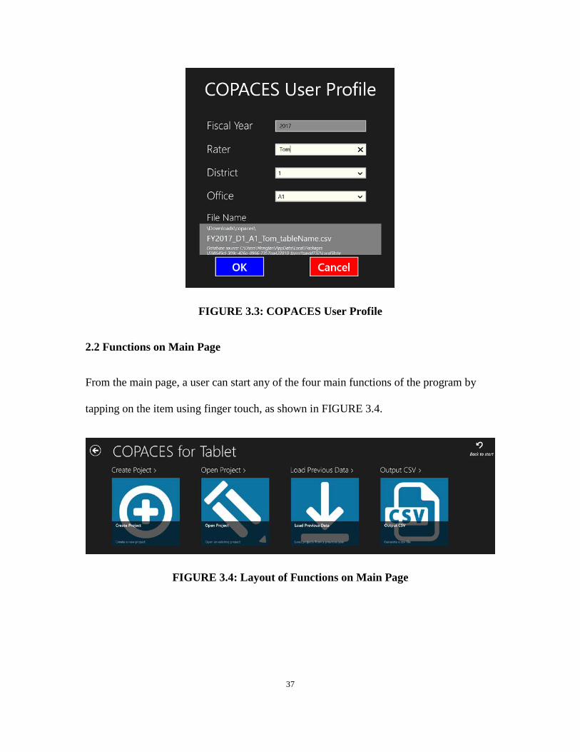
2.1 COPACES User Profile
Like COPACES for Laptop, a user profile is needed for COPACES for Tablet, which is
found on the first page when the program is launched (see FIGURE 3.3). While the fiscal
year number is automatically filled, users need to type in their name and select their
current district and office. No user name or password is required.
At the bottom, two file paths are shown. The one in the larger font indicates the output
file’s location with a file name sample when it is exported. By default, this is in the
“Downloads” folder. The other path is the location of the internal database file on a local
tablet computer. The file is named “copaces.db.” A user can read it using third-party
software, such as “DB Browser,” to check the data directly.
Clicking OK will navigate to the main page.
37
FIGURE 3.3: COPACES User Profile
2.2 Functions on Main Page
From the main page, a user can start any of the four main functions of the program by
tapping on the item using finger touch, as shown in FIGURE 3.4.
FIGURE 3.4: Layout of Functions on Main Page

38
2.3 Creating New Project
By clicking Create Project on the main page, a user is led to a new page, as shown in
FIGURE 3.5. On this page, a user can create a new project with a unique date and time.
This page is divided into two parts: “Project Location” and “Road Information.” A user
should fill in all necessary fields in the project location part before editing road
information.
FIGURE 3.5: Creating New Project Page
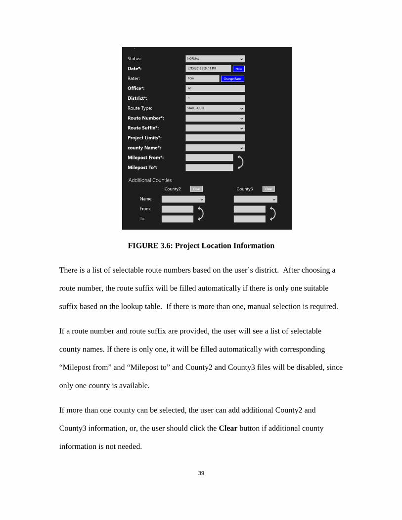
FIGURE 3.6 shows all the items for the project information. Once a new project page is
opened, several fields will be automatically filled. Date is always the current date . If
one wants to update it, NOW should be clicked on, and an updated date and time will be
filled. Rater, office and district are filled with the information the user has provided on
the start page, which is not editable. The Change Rater button is only used when a user
opens an existing project and the rater is not the user.
39
FIGURE 3.6: Project Location Information
There is a list of selectable route numbers based on the user’s district. After choosing a
route number, the route suffix will be filled automatically if there is only one suitable
suffix based on the lookup table. If there is more than one, manual selection is required.
If a route number and route suffix are provided, the user will see a list of selectable
county names. If there is only one, it will be filled automatically with corresponding
“Milepost from” and “Milepost to” and County2 and County3 files will be disabled, since
only one county is available.
If more than one county can be selected, the user can add additional County2 and
County3 information, or, the user should click the Clear button if additional county
information is not needed.

40
The From/To information for all counties will always be filled automatically once the
user selects the county name. By default, it will be 0 for “from” and a positive number for
“to.” If the user is conducting a survey from a negative direction, the user may click the
reverse symbol to reverse the from/to information.
FIGURE 3.7 shows all the fields for road information. The RC Info button needs to be
clicked before typing in any information. It will search the RC lookup table and try to fill
the form with available information. Then, a user can edit it if any field is incorrect or
missed. Direction is decided by milepost from/to information in the project location part
that has been just filled in.
FIGURE 3.7: Road Information
41
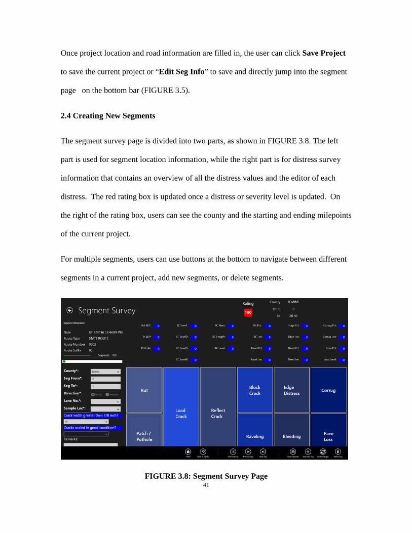
Once project location and road information are filled in, the user can click Save Project
to save the current project or “Edit Seg Info” to save and directly jump into the segment
page on the bottom bar (FIGURE 3.5).
2.4 Creating New Segments
The segment survey page is divided into two parts, as shown in FIGURE 3.8. The left
part is used for segment location information, while the right part is for distress survey
information that contains an overview of all the distress values and the editor of each
distress. The red rating box is updated once a distress or severity level is updated. On
the right of the rating box, users can see the county and the starting and ending milepoints
of the current project.
For multiple segments, users can use buttons at the bottom to navigate between different
segments in a current project, add new segments, or delete segments.
FIGURE 3.8: Segment Survey Page

42
FIGURE 3.9 shows all the fields for segment location information. When a user creates a
new segment, the county and starting and ending milepoints of this segment will be
automatically filled in ascending order. The value of “Seg To” will be the next integer of
the “Seg From” value. If the project direction is negative, the starting milepoint will be
greater than the ending one. The green bar shows the relative location of the current
segment in this project.
FIGURE 3.9: Segment Location Information

43
FIGURE 3.10 and FIGURE 3.11 show two examples (load cracking and rut) of the
pavement distress survey. The distress editor will display once a user taps on the
corresponding distress button, as shown in FIGURE 3.8. There are 10 types of distress
that should be filled in if the corresponding types of distresses occur and once the
segment information for the current segment is complete.
FIGURE 3.10: Distress Survey Example for Load Cracking
The upper half of the page shows an overview of all the distress values, while the lower
half functions as a distress editor. A user can tap on the corresponding distress button,
and the editor panel will display.
When editing, clicking on the input box, will display a green border, indicating this input
is focused, and any value changes will reflect this distress. Two input methods are
provided: number-board and slider. While slider can improve the speed of operation,
number-board is more convenient for accurate data input.
44
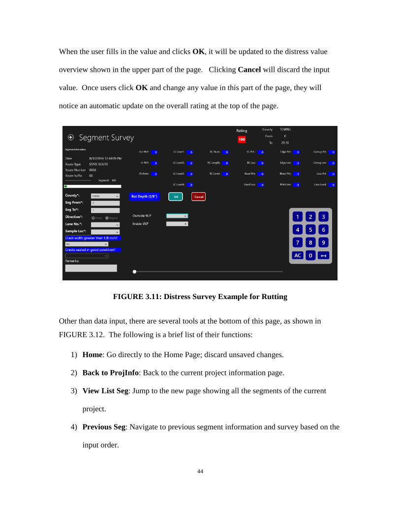
When the user fills in the value and clicks OK, it will be updated to the distress value
overview shown in the upper part of the page. Clicking Cancel will discard the input
value. Once users click OK and change any value in this part of the page, they will
notice an automatic update on the overall rating at the top of the page.
FIGURE 3.11: Distress Survey Example for Rutting
Other than data input, there are several tools at the bottom of this page, as shown in
FIGURE 3.12. The following is a brief list of their functions:
1) Home: Go directly to the Home Page; discard unsaved changes.
2) Back to ProjInfo: Back to the current project information page.
3) View List Seg: Jump to the new page showing all the segments of the current
project.
4) Previous Seg: Navigate to previous segment information and survey based on the
input order.
45
5) Previous Seg: Navigate to the next segment information and survey based on the
input order.
6) Save Segment: Save or update the current project.
7) Add New Seg: Add a new segment after current segment; note that this new
segment is not saved until save button is clicked.
8) Reset Changes: Discard unsaved changes of the current project and load the last
saved information; if the information has never been saved, load default
information.
9) Delete Seg: delete the current segment, and go back to the previous segment.
FIGURE 3.12: Segment Navigation Bar
2.5 Loading Data from Previous Year
When using the previous version of COPACES, a rater often started the survey for a new
fiscal year based on the previous year’s data. Thus, a rater does not need to re-enter the
project location and road information. In this new COPACES for Tablet version, this
function is also available by loading data from previous fiscal years and is provided on
the Load Data page, as shown in FIGURE 3.13.
The FY box contains a list of fiscal years covering all data on the local machine. Then,
the user can choose the district, office, and/or rater to filter the loaded data. Once a
search condition is set, the user may notice the checkmark is brighter. The unset
condition checkmark is relatively dark.

46
The ten most recent loaded records will be shown in the list of Latest loads to remind
users what data has been loaded before.
Once data is loaded and before it is edited and saved, users can find it on the “open
project” page as a “TO DO” item.
FIGURE 3.13: Load Data Page
2.6 Open Existing Project
The Open Project function on the main page (FIGURE 3.4) is used for opening or
editing any existing project and its corresponding segments and surveys. The first step is
to search projects based on the customized search conditions, as shown in FIGURE 3.14.
If a user wants to open a “TO DO” project, which is loaded from a previous year but has
not been edited or saved yet, the TO DO button needs to be clicked. If the target project
is a completed one, the Finished button should be clicked. Selecting other conditions
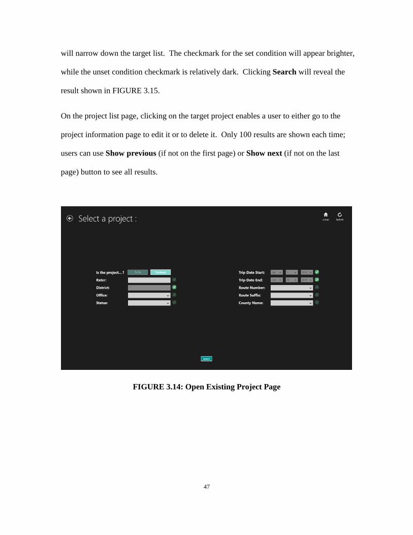
47
will narrow down the target list. The checkmark for the set condition will appear brighter,
while the unset condition checkmark is relatively dark. Clicking Search will reveal the
result shown in FIGURE 3.15.
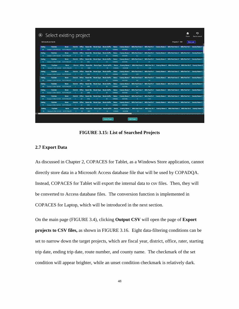
On the project list page, clicking on the target project enables a user to either go to the
project information page to edit it or to delete it. Only 100 results are shown each time;
users can use Show previous (if not on the first page) or Show next (if not on the last
page) button to see all results.
FIGURE 3.14: Open Existing Project Page
48
FIGURE 3.15: List of Searched Projects
2.7 Export Data
As discussed in Chapter 2, COPACES for Tablet, as a Windows Store application, cannot
directly store data in a Microsoft Access database file that will be used by COPADQA.
Instead, COPACES for Tablet will export the internal data to csv files. Then, they will
be converted to Access database files. The conversion function is implemented in
COPACES for Laptop, which will be introduced in the next section.
On the main page (FIGURE 3.4), clicking Output CSV will open the page of Export
projects to CSV files, as shown in FIGURE 3.16. Eight data-filtering conditions can be
set to narrow down the target projects, which are fiscal year, district, office, rater, starting
trip date, ending trip date, route number, and county name. The checkmark of the set
condition will appear brighter, while an unset condition checkmark is relatively dark.
49
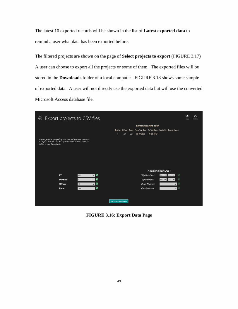
The latest 10 exported records will be shown in the list of Latest exported data to
remind a user what data has been exported before.
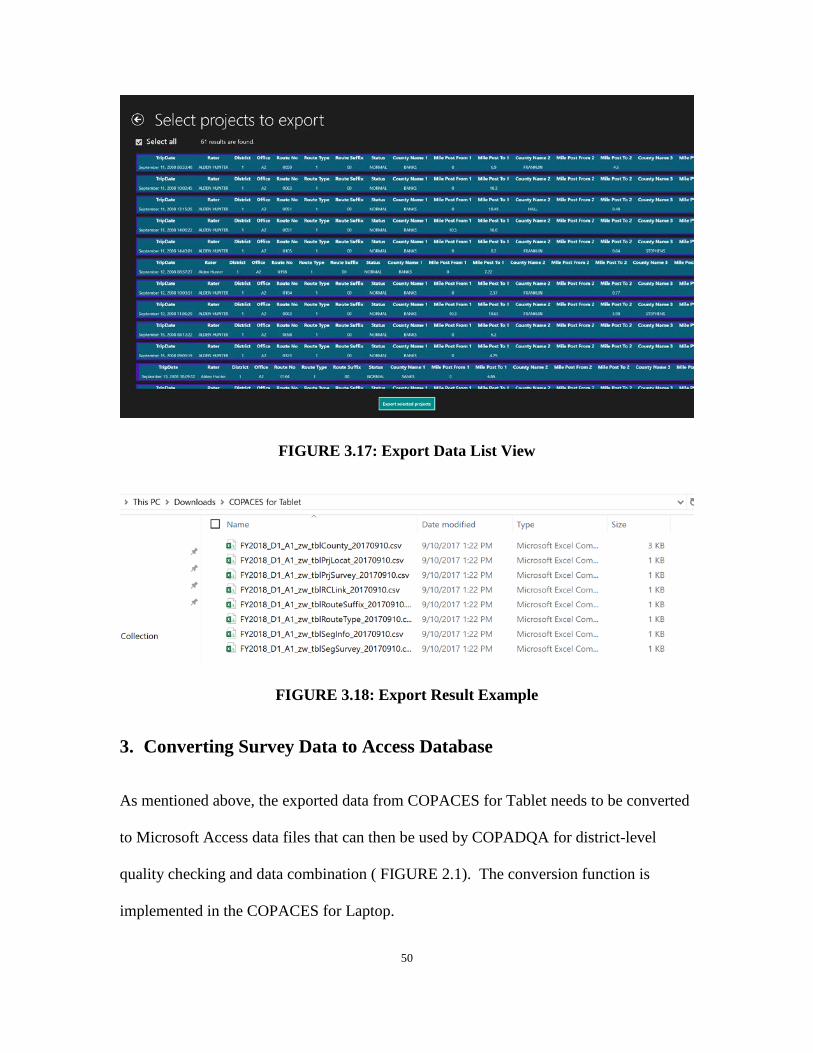
The filtered projects are shown on the page of Select projects to export (FIGURE 3.17)
A user can choose to export all the projects or some of them. The exported files will be
stored in the Downloads folder of a local computer. FIGURE 3.18 shows some sample
of exported data. A user will not directly use the exported data but will use the converted
Microsoft Access database file.
FIGURE 3.16: Export Data Page
50
FIGURE 3.17: Export Data List View
FIGURE 3.18: Export Result Example
3. Converting Survey Data to Access Database
As mentioned above, the exported data from COPACES for Tablet needs to be converted
to Microsoft Access data files that can then be used by COPADQA for district-level
quality checking and data combination ( FIGURE 2.1). The conversion function is
implemented in the COPACES for Laptop.

51
This function can be accessed from the menu item Import Data from COPACES for
Tablet, as shown in FIGURE 3.19, when COPACES for Laptop is launched. Clicking
this menu item will display the data import form, as shown in FIGURE 3.20.
FIGURE 3.19: Menu Item for Importing Data from COPACES for Tablet
The exported data from COPACES for Tablet is stored in the folder “COPACES for
Tablet” in the Downloads folder. However, for safety concerns, the Windows operating
system uses a special folder (see FIGURE 3.20) to represent “COPACES for Tablet,”
which is automatically generated by the operating system. Thus, the first time data is
imported, COPACES for Laptop does not know where the physical folder is and needs a
user to manually specify the folder location. This is done by, clicking Change Input
Data Folder. The Browse For Folder form appears, as shown in FIGURE 3.21. A user
can navigate to and select the “COPACES for Tablet” subfolder under the Downloads
folder. After that, COPACES for Laptop remembers this location, which will be
automatically used next time.
The next step is to select the date of the exported data from COPACES for Tablet. For
purposes of data safety, a user can periodically export data from COPACES for Tablet
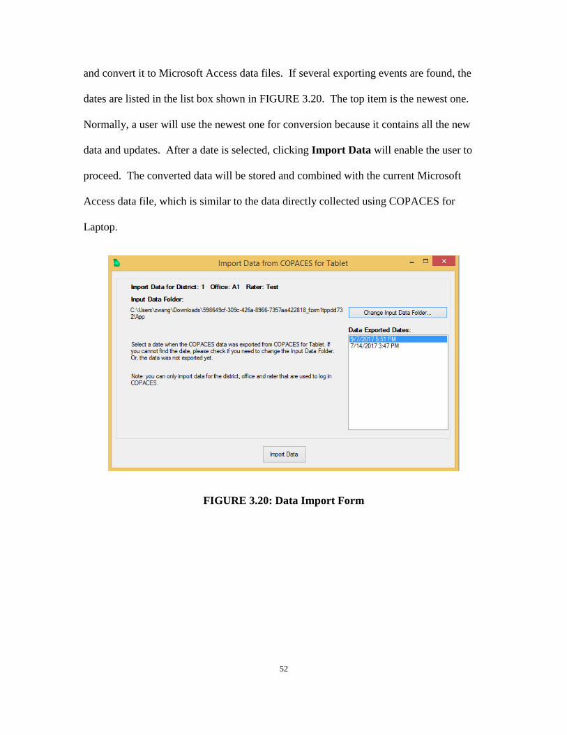
52
and convert it to Microsoft Access data files. If several exporting events are found, the
dates are listed in the list box shown in FIGURE 3.20. The top item is the newest one.
Normally, a user will use the newest one for conversion because it contains all the new
data and updates. After a date is selected, clicking Import Data will enable the user to
proceed. The converted data will be stored and combined with the current Microsoft
Access data file, which is similar to the data directly collected using COPACES for
Laptop.
FIGURE 3.20: Data Import Form

53
FIGURE 3.21: Selecting Source Data Folder
4. Enhanced Field Data Quality Checking
Data quality is the highest priority in a data-driven pavement management system. Due
to its importance, data quality checking has been rigorously implemented in the previous
version of COPACES. Since COPACES is used for field data collection, and its data
quality directly affects the effectiveness of pavement preservation, maintenance, and
rehabilitation decision-making, stricter data quality checking is desired. Comprehensive
field data quality checking can help improve data accuracy and save the re-survey effort
because quality issues can be identified and immediately solved in the field.
Based on the discussion with OM’s Liaison Engineers, several data quality checking
criteria were discussed and determined. Because COPACES for Tablet will be the major
tool for field data collection, the enhanced data quality check procedures are
implemented in this program. In the meantime, data conversion and management
functions are implemented in COPACES for Laptop.
54
4.1 Quality Checking Criteria
Based on the systematic procedures suggested by GDOT Liaison Engineers, the
following criteria for data quality checking are embedded in COPACES for Tablet.
• Criterion #1: Pavement condition rating checking Due to the deterioration of pavement surface conditions, the historical pavement
ratings can be used to evaluate the reasonableness of the current pavement rating.
Using this criterion, after the pavement condition data on a pavement project and /or
segment is completed, the automatically-calculated PACES rating will be compared
with the ones in previous years, such as the previous 3 years. If the current rating
falls within a ±1% variance of the previous ones, the survey engineer should re-check
the survey procedures and the selected sample section.
• Criterion #2: Sample section location checking
Due to the limited resource, the PACES survey only rates the major pavement
distresses, i.e., cracking distresses, on a selected 100-foot sample section for each
pavement segment. Locations of the sample sections are subjectively determined by
the rater in terms of their representativeness. Thus, the selected sample section
locations vary year by year. Under this criterion, the sample section locations for
each project will be compared with the ones in previous years. If more than 90% of
the segments have the same sample section locations as the ones in previous years,
the rater should re-check the survey procedures and make sure the selection of a
sample location is not based on the previous survey results.
55
• Criterion #3: Pavement distress data checking
Under this criterion, the surveyed distress data for each project will be checked
against the ones in previous years. If 70% of the segments in one project have the
same distress data (type and severity) as the ones in previous years, the rater should
re-check the survey procedures and make sure the distresses are correctly rated.
• Criterion #4: Pass/Fail test rules
Based on the above three levels of data quality checking, a rule will be set to
determine if the survey on a project passes or fails. For example, if Criterion #1 and
either Criteria #2 or #3 are triggered, the survey on this project will be considered
failed and need to be done again.
4.2 Operations on Enhanced Data Quality Checking
Note that the enhanced data quality checking will use the previous years’ COPACES
survey data. However, in the FY 2017 COPACES survey, a new state route lookup table
was used, as discussed in Chapter 2. Thus, all projects were surveyed from scratch
without the use of any previous year’s data. As a result, the enhanced data quality
checking procedures were not used in FY 2017 data collection, though they have been
implemented. The following discussion presents the functional operations.
The enhanced quality checking module is embedded in both COPACES for Tablet and
COPACES for Laptop. Data is shared between these two programs through the data
conversion procedure introduced in Section 3 of this chapter. The enhanced data quality
checking module in COPACES for Tablet serves as instant feedback for raters, whereas
56
COPACES for Laptop summarizes all questionable data for district engineers and/or
Liaison Engineers.
• Quality Checking in COPACES for Tablet
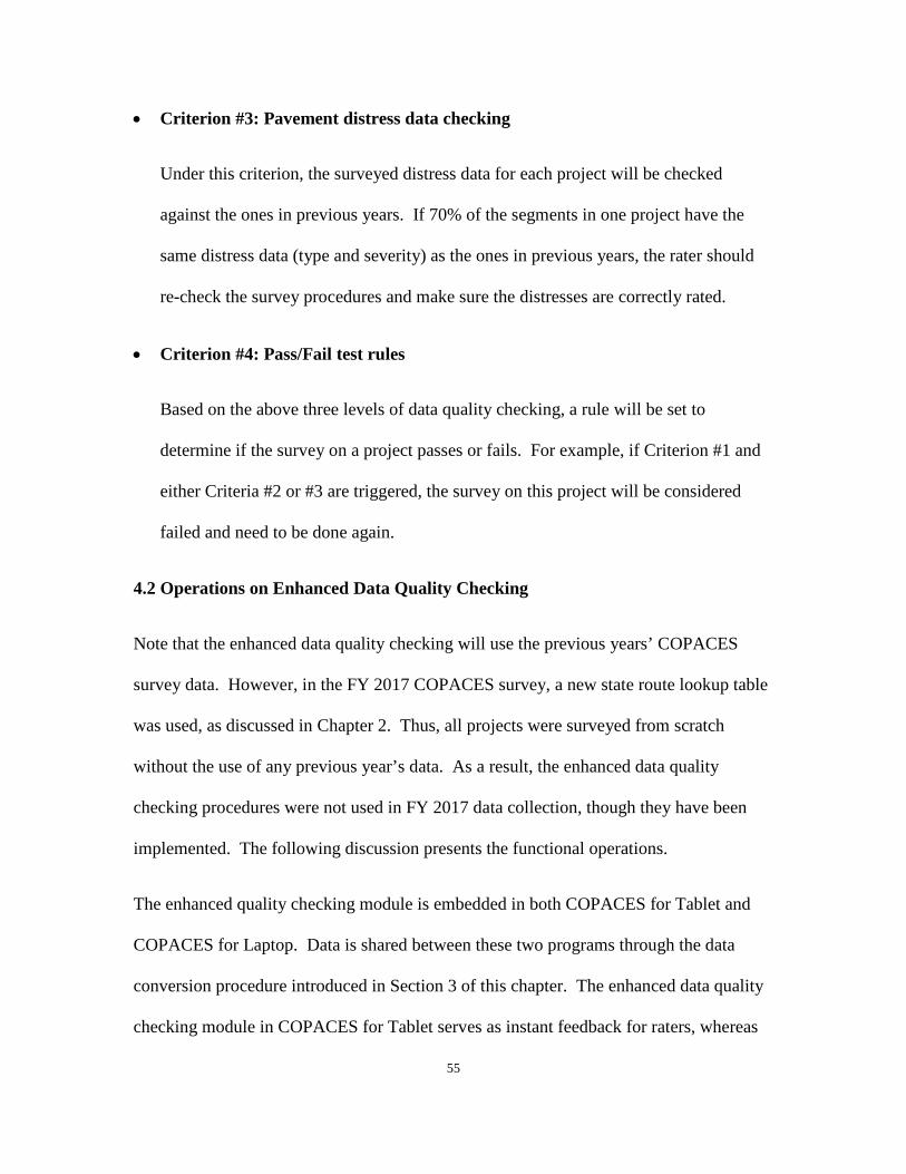
When a user finishes collecting data for a segment and attempts to save the results,
the quality checking module will be triggered once the user hits the Home or Back to
PrjInfo button to end the process. The module will check the data quality according
to the criteria listed above. If the collected data does not pass the quality check, a
message will display, as shown in FIGURE 3.22, suggesting a user return and check
or redo the survey.
FIGURE 3.22: Collected Data Fails at Quality Checking in COPACES for Tablet
However, the user can still choose to proceed and save the results, in which case the
quality checking module will record this questionable survey in an additional table
unless the issue has been resolved later. All questionable surveys, together with other
useful information, can be exported to csv files.

57
• Quality Checking in COPACES for Laptop
After the exported data from COPACES for Tablet is converted to Microsoft Access
database files (see Section 3 of this chapter), an additional function is added for error
checking, as shown in FIGURE 3.23. The table of all questionable surveys is
available in COPACES for Laptop, as shown in FIGURE 3.24.
For district engineers and/or Liaison Engineers, the list of questionable surveys can
be used to further verify the quality of the submitted data from raters in area offices.
If the data are unacceptable, a re-survey can be requested.
FIGURE 3.23: Quality Checking Function in COPACES for Laptop
FIGURE 3.24: Table of All Questionable Surveys
58
5. Automatic Software Update
As discussed in Chapter 2, to improve the efficiency of software delivery and software
update, a mechanism for automatic software update has been implemented for COPACES
for Laptop. Similarly, COPACES for Tablet can also be automatically updated.
After the setup files of COPACES for Tablet are submitted to GDOT’s OIT, they are
stored in a web repository, http://software.dot.ga.gov/COPACESTablet/. During the first
installation, a method of “sideloading” is used to install COPACES for Tablet on a tablet
computer. The operating system should be Windows 8.1 or Windows 10. Though the
best way is to publish COPACES for Tablet is in a Microsoft Store, GDOT has not
purchased the service for establishing a Microsoft Store for Business. The public Store is
not suitable for publishing COPACES for Tablet. Finally, based on the discussion with
GDOT’s OIT, COPACES for Tablet is installed using “sideloading.”
To implement an automatic update, a separate program, AutoUpdateCOPACESTablet,
was developed. The corresponding executable file, AutoUpdateCOPACESTablet.exe,
needs to be copied and stored on a local computer. When a new software update is
available, a user will be asked to update the program when COPACES for Tablet is
launched.
Due to the difference between Windows 8.1 and Windows 10, the sideloading methods
are also different. Appendix II and Appendix III include the procedures for installing
COPACES for Tablet on Windows 8.1 and Windows 10, respectively.

59
CHAPTER 4 CONCLUSIONS AND
RECOMMENDATIONS
Shortly after the Georgia Tech research team started this project, OM began to collect the
FY 2017 COPACES data. As discussed in Chapter 1, the previous version of COPACES
that was released in 2008 has compatibility issues with Windows 7, 8.1, and 10. Thus,
COPACES for Laptop was upgraded from the previous COPACES using the newer
programming language, Microsoft C#. In the meantime, the new COPACES for Tablet
was also developed to improve data collection efficiency by using tablet computers. Note
that COPACES for Laptop is not just a replica of the previous version but has new
functions that were developed to work with COPACES for Tablet. Since time was very
tight for this project, the Georgia Tech research team has closely worked with GDOT
OM and OIT to deploy, test, and refine both COPACES for Laptop and COPACES for
Tablet. A statewide training workshop was held in Macon on August 18, 2016.
OM’s Liaison Engineers played an important role in implementing COPACES for FY
2017 data collection. Even though a statewide training workshop was held, not all raters
fully understood the use of COPACES for Laptop or COPACES for Tablet. Constrained
by resources, the Georgia Tech research team cannot directly communicate with all raters.
Instead, intensive meetings were held between the Georgia Tech research team and OM’s
Liaison Engineers to test, refine, and improve the programs. In the meantime, the
reported issues from individual end users were collected by Liaison Engineers and
discussed/solved in the meetings.

60
When the COPACES data collection approached the end, district engineers started to
collect the COPACES data from raters in area offices. After that, COPADQA was used
to conduct district-level data quality checking and to combine all area office data in a
district into a single database file. Then, the combined files were submitted to Liaison
Engineers for transferring the data to the central COPACES database, which was done by
the Upload program. As discussed in Chapter 1 and Chapter 2, the previous version of
COPADQA and Upload have the compatibility issue with Windows 7, 8.1, and 10. Thus,
they needed to be rewritten using C#. Though it was out of the scope of this project, the
Georgia Tech research team rewrote these two programs to help OM complete the FY
2017 data collection. Since most of the functions are replicates of the previous versions,
they are not presented in this final report. However, automatic updates were
implemented for these two programs, like the one for COPACES for Laptop.
TABLE 4.1 summarizes the total numbers of projects and segments collected in 7
working districts.
TABLE 4.1: Summary of FY 2017 COPACES Data
Working District # of Projects # of Segments 1 536 3,818 2 671 4,666 3 630 4,215 4 631 4,423 5 761 5,157 6 542 3,291 7 238 1,380
The enhanced data quality checking model fully utilizes previous COPACES data and
provides more rigorous in-field data quality checking. The improved data quality will
further improve the accuracy of pavement condition deterioration modeling and also

61
improve the effectiveness of pavement preservation, maintenance, and rehabilitation
decision-making.
To prepare for the FY 2018 pavement condition data collection, a small-scale training
session was conducted in GDOT OM on October 17, 2017. The Assistant State
Maintenance Engineer, Liaison Engineers, and the Research Implementation Manager
from the Office of Research attended the training. After that, a statewide training session
was held in Macon on November 13, 2017, as shown in FIGURE 4.1. All field engineers
in area offices and district offices attended this training.
FIGURE 4.1: COPACES Training in Macon
The following points recommend future improvements and further implementation:
• The most convenient way for deploying a Windows Store application, e.g.,
COPACES for Tablet, is to use the Microsoft Store. Since more and more
applications are used on tablet computers, it is suggested a Microsoft Store for
Business in GDOT be implemented. Thus, all GDOT-owned applications can be

62
conveniently published in this store, and users in GDOT can also quickly download
and update the applications.
• The current operation flow for COPACES data transfer and data integration is not
very convenient or efficient due to the use of local database files. Currently, cloud
computing has been widely used for mobile data collection; in it, field-collected data
can be quickly transferred to cloud databases through a WiFi connection. If GDOT-
owned cloud services, e.g., cloud database and mobile services, are available, the
COPACES data transfer and data integration process could be significantly simplified.
In the meantime, the field-collected data could be transferred to OM’s general office
in real time.

Appendix - 1
APPENDIX I: LIST OF STATE ROUTES
District CountyNo CountyName RouteNo RouteSuffix MilepostFrom MilepostTo 1 011 BANKS 0015 00 0 19.2 1 011 BANKS 0051 00 0 18.56 1 011 BANKS 0052 00 0 5.12 1 011 BANKS 0059 00 0 6.85 1 011 BANKS 0063 00 0 10.61 1 011 BANKS 0098 00 0 6.22 1 011 BANKS 0105 00 0 10.02 1 011 BANKS 0164 00 0 6.87 1 011 BANKS 0184 00 0 2.39 1 011 BANKS 0198 00 0 7.26 1 011 BANKS 0323 00 0 4.81 1 011 BANKS 0326 00 0 5.95 1 011 BANKS 0403 00 0 6.47 1 013 BARROW 0008 00 0 18.35 1 013 BARROW 0011 00 0 12.88 1 013 BARROW 0053 00 0 12.98 1 013 BARROW 0081 00 0 6.37 1 013 BARROW 0082 00 0 10.63 1 013 BARROW 0124 00 0 3.48 1 013 BARROW 0211 00 0 24.47 1 013 BARROW 0316 00 0 15.79 1 013 BARROW 0324 00 0 0.76 1 013 BARROW 0330 00 0 1.52 1 013 BARROW 0403 00 0 2.4 1 059 CLARKE 0008 00 0 10.27 1 059 CLARKE 0010 00 0 17.32 1 059 CLARKE 0010 LO 0 15.08 1 059 CLARKE 0015 00 0 11.79 1 059 CLARKE 0015 AL 0 8.03 1 059 CLARKE 0024 00 0 0.67 1 059 CLARKE 0072 00 0 2.65 1 059 CLARKE 0422 00 0 15.08 1 085 DAWSON 0009 00 0 10.34 1 085 DAWSON 0009 WE 0 0.11 1 085 DAWSON 0052 00 0 10.12 1 085 DAWSON 0053 00 0 18.15 1 085 DAWSON 0053 WE 0 0.09 1 085 DAWSON 0136 00 0 26.81 1 085 DAWSON 0183 00 0 10.42
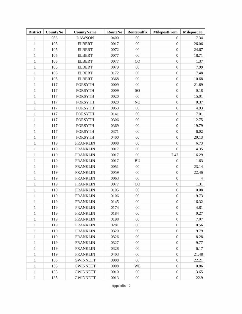
Appendix - 2
District CountyNo CountyName RouteNo RouteSuffix MilepostFrom MilepostTo 1 085 DAWSON 0400 00 0 7.34 1 105 ELBERT 0017 00 0 26.06 1 105 ELBERT 0072 00 0 24.67 1 105 ELBERT 0077 00 0 18.71 1 105 ELBERT 0077 CO 0 1.37 1 105 ELBERT 0079 00 0 7.99 1 105 ELBERT 0172 00 0 7.48 1 105 ELBERT 0368 00 0 10.68 1 117 FORSYTH 0009 00 0 21.69 1 117 FORSYTH 0009 SO 0 0.18 1 117 FORSYTH 0020 00 0 15.01 1 117 FORSYTH 0020 NO 0 0.37 1 117 FORSYTH 0053 00 0 4.93 1 117 FORSYTH 0141 00 0 7.01 1 117 FORSYTH 0306 00 0 12.75 1 117 FORSYTH 0369 00 0 19.79 1 117 FORSYTH 0371 00 0 6.02 1 117 FORSYTH 0400 00 0 20.13 1 119 FRANKLIN 0008 00 0 6.73 1 119 FRANKLIN 0017 00 0 4.35 1 119 FRANKLIN 0017 00 7.47 16.29 1 119 FRANKLIN 0017 BU 0 1.63 1 119 FRANKLIN 0051 00 0 23.14 1 119 FRANKLIN 0059 00 0 22.46 1 119 FRANKLIN 0063 00 0 4 1 119 FRANKLIN 0077 CO 0 1.31 1 119 FRANKLIN 0105 00 0 0.08 1 119 FRANKLIN 0106 00 0 19.73 1 119 FRANKLIN 0145 00 0 16.32 1 119 FRANKLIN 0174 00 0 4.81 1 119 FRANKLIN 0184 00 0 0.27 1 119 FRANKLIN 0198 00 0 7.07 1 119 FRANKLIN 0281 00 0 0.56 1 119 FRANKLIN 0320 00 0 9.79 1 119 FRANKLIN 0326 00 0 8.28 1 119 FRANKLIN 0327 00 0 9.77 1 119 FRANKLIN 0328 00 0 6.17 1 119 FRANKLIN 0403 00 0 21.48 1 135 GWINNETT 0008 00 0 22.21 1 135 GWINNETT 0008 WE 0 0.86 1 135 GWINNETT 0010 00 0 13.65 1 135 GWINNETT 0013 00 0 22.9
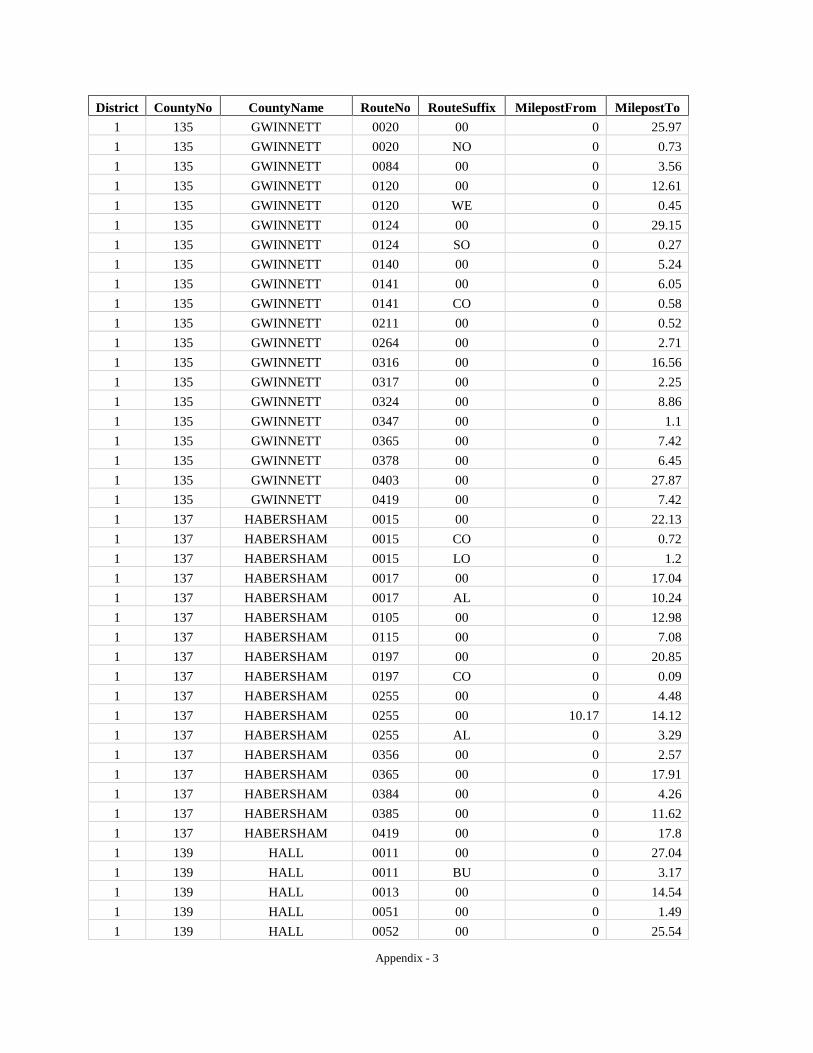
Appendix - 3
District CountyNo CountyName RouteNo RouteSuffix MilepostFrom MilepostTo 1 135 GWINNETT 0020 00 0 25.97 1 135 GWINNETT 0020 NO 0 0.73 1 135 GWINNETT 0084 00 0 3.56 1 135 GWINNETT 0120 00 0 12.61 1 135 GWINNETT 0120 WE 0 0.45 1 135 GWINNETT 0124 00 0 29.15 1 135 GWINNETT 0124 SO 0 0.27 1 135 GWINNETT 0140 00 0 5.24 1 135 GWINNETT 0141 00 0 6.05 1 135 GWINNETT 0141 CO 0 0.58 1 135 GWINNETT 0211 00 0 0.52 1 135 GWINNETT 0264 00 0 2.71 1 135 GWINNETT 0316 00 0 16.56 1 135 GWINNETT 0317 00 0 2.25 1 135 GWINNETT 0324 00 0 8.86 1 135 GWINNETT 0347 00 0 1.1 1 135 GWINNETT 0365 00 0 7.42 1 135 GWINNETT 0378 00 0 6.45 1 135 GWINNETT 0403 00 0 27.87 1 135 GWINNETT 0419 00 0 7.42 1 137 HABERSHAM 0015 00 0 22.13 1 137 HABERSHAM 0015 CO 0 0.72 1 137 HABERSHAM 0015 LO 0 1.2 1 137 HABERSHAM 0017 00 0 17.04 1 137 HABERSHAM 0017 AL 0 10.24 1 137 HABERSHAM 0105 00 0 12.98 1 137 HABERSHAM 0115 00 0 7.08 1 137 HABERSHAM 0197 00 0 20.85 1 137 HABERSHAM 0197 CO 0 0.09 1 137 HABERSHAM 0255 00 0 4.48 1 137 HABERSHAM 0255 00 10.17 14.12 1 137 HABERSHAM 0255 AL 0 3.29 1 137 HABERSHAM 0356 00 0 2.57 1 137 HABERSHAM 0365 00 0 17.91 1 137 HABERSHAM 0384 00 0 4.26 1 137 HABERSHAM 0385 00 0 11.62 1 137 HABERSHAM 0419 00 0 17.8 1 139 HALL 0011 00 0 27.04 1 139 HALL 0011 BU 0 3.17 1 139 HALL 0013 00 0 14.54 1 139 HALL 0051 00 0 1.49 1 139 HALL 0052 00 0 25.54
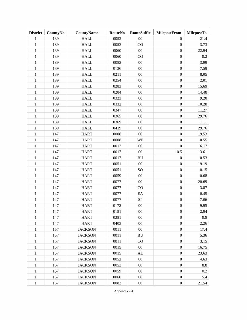
Appendix - 4
District CountyNo CountyName RouteNo RouteSuffix MilepostFrom MilepostTo 1 139 HALL 0053 00 0 21.4 1 139 HALL 0053 CO 0 3.73 1 139 HALL 0060 00 0 22.94 1 139 HALL 0060 CO 0 0.2 1 139 HALL 0082 00 0 3.99 1 139 HALL 0136 00 0 7.59 1 139 HALL 0211 00 0 8.05 1 139 HALL 0254 00 0 2.01 1 139 HALL 0283 00 0 15.69 1 139 HALL 0284 00 0 14.48 1 139 HALL 0323 00 0 9.28 1 139 HALL 0332 00 0 10.28 1 139 HALL 0347 00 0 11.27 1 139 HALL 0365 00 0 29.76 1 139 HALL 0369 00 0 11.1 1 139 HALL 0419 00 0 29.76 1 147 HART 0008 00 0 19.53 1 147 HART 0008 WE 0 0.55 1 147 HART 0017 00 0 6.17 1 147 HART 0017 00 10.5 13.61 1 147 HART 0017 BU 0 0.53 1 147 HART 0051 00 0 19.19 1 147 HART 0051 SO 0 0.15 1 147 HART 0059 00 0 0.68 1 147 HART 0077 00 0 20.69 1 147 HART 0077 CO 0 3.87 1 147 HART 0077 EA 0 0.45 1 147 HART 0077 SP 0 7.06 1 147 HART 0172 00 0 9.95 1 147 HART 0181 00 0 2.94 1 147 HART 0281 00 0 0.8 1 147 HART 0403 00 0 2.26 1 157 JACKSON 0011 00 0 17.4 1 157 JACKSON 0011 BU 0 5.36 1 157 JACKSON 0011 CO 0 3.15 1 157 JACKSON 0015 00 0 16.75 1 157 JACKSON 0015 AL 0 23.63 1 157 JACKSON 0052 00 0 4.63 1 157 JACKSON 0053 00 0 8.8 1 157 JACKSON 0059 00 0 0.2 1 157 JACKSON 0060 00 0 5.4 1 157 JACKSON 0082 00 0 21.54
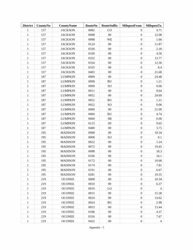
Appendix - 5
District CountyNo CountyName RouteNo RouteSuffix MilepostFrom MilepostTo 1 157 JACKSON 0082 CO 0 4.71 1 157 JACKSON 0098 00 0 12.08 1 157 JACKSON 0098 WE 0 1.66 1 157 JACKSON 0124 00 0 11.87 1 157 JACKSON 0326 00 0 2.18 1 157 JACKSON 0330 00 0 4.56 1 157 JACKSON 0332 00 0 13.77 1 157 JACKSON 0334 00 0 12.36 1 157 JACKSON 0335 00 0 8.4 1 157 JACKSON 0403 00 0 21.68 1 187 LUMPKIN 0009 00 0 24.48 1 187 LUMPKIN 0009 BU 0 1.21 1 187 LUMPKIN 0009 SO 0 0.06 1 187 LUMPKIN 0011 00 0 9.64 1 187 LUMPKIN 0052 00 0 24.69 1 187 LUMPKIN 0052 BU 0 1.21 1 187 LUMPKIN 0052 SO 0 0.06 1 187 LUMPKIN 0060 00 0 21.09 1 187 LUMPKIN 0060 BU 0 4.74 1 187 LUMPKIN 0060 SB 0 0.06 1 187 LUMPKIN 0115 00 0 9.65 1 187 LUMPKIN 0400 00 0 3.75 1 195 MADISON 0008 00 0 18.34 1 195 MADISON 0008 SO 0 0.1 1 195 MADISON 0022 00 0 1.24 1 195 MADISON 0072 00 0 19.45 1 195 MADISON 0098 00 0 18.3 1 195 MADISON 0106 00 0 16.1 1 195 MADISON 0172 00 0 10.68 1 195 MADISON 0174 00 0 7.81 1 195 MADISON 0191 00 0 6.67 1 195 MADISON 0281 00 0 10.55 1 219 OCONEE 0008 00 0 10.34 1 219 OCONEE 0010 00 0 6.37 1 219 OCONEE 0010 LO 0 4 1 219 OCONEE 0015 00 0 15.38 1 219 OCONEE 0024 00 0 14.62 1 219 OCONEE 0024 BU 0 2.98 1 219 OCONEE 0053 00 0 13.44 1 219 OCONEE 0186 00 0 4.37 1 219 OCONEE 0316 00 0 7.67 1 219 OCONEE 0422 00 0 4
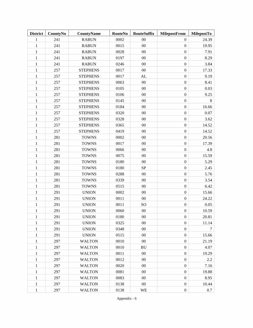
Appendix - 6
District CountyNo CountyName RouteNo RouteSuffix MilepostFrom MilepostTo 1 241 RABUN 0002 00 0 24.39 1 241 RABUN 0015 00 0 19.95 1 241 RABUN 0028 00 0 7.91 1 241 RABUN 0197 00 0 8.29 1 241 RABUN 0246 00 0 3.84 1 257 STEPHENS 0017 00 0 17.33 1 257 STEPHENS 0017 AL 0 9.19 1 257 STEPHENS 0063 00 0 8.41 1 257 STEPHENS 0105 00 0 0.03 1 257 STEPHENS 0106 00 0 9.25 1 257 STEPHENS 0145 00 0 8 1 257 STEPHENS 0184 00 0 16.66 1 257 STEPHENS 0320 00 0 0.07 1 257 STEPHENS 0328 00 0 3.62 1 257 STEPHENS 0365 00 0 14.52 1 257 STEPHENS 0419 00 0 14.52 1 281 TOWNS 0002 00 0 20.56 1 281 TOWNS 0017 00 0 17.39 1 281 TOWNS 0066 00 0 4.8 1 281 TOWNS 0075 00 0 15.59 1 281 TOWNS 0180 00 0 5.29 1 281 TOWNS 0180 SP 0 2.45 1 281 TOWNS 0288 00 0 5.76 1 281 TOWNS 0339 00 0 3.54 1 281 TOWNS 0515 00 0 6.42 1 291 UNION 0002 00 0 15.66 1 291 UNION 0011 00 0 24.22 1 291 UNION 0011 SO 0 0.05 1 291 UNION 0060 00 0 10.59 1 291 UNION 0180 00 0 20.81 1 291 UNION 0325 00 0 11.14 1 291 UNION 0348 00 0 7 1 291 UNION 0515 00 0 15.66 1 297 WALTON 0010 00 0 21.19 1 297 WALTON 0010 BU 0 4.07 1 297 WALTON 0011 00 0 19.29 1 297 WALTON 0012 00 0 2.2 1 297 WALTON 0020 00 0 7.16 1 297 WALTON 0081 00 0 19.88 1 297 WALTON 0083 00 0 8.95 1 297 WALTON 0138 00 0 10.44 1 297 WALTON 0138 WE 0 0.7

Appendix - 7
District CountyNo CountyName RouteNo RouteSuffix MilepostFrom MilepostTo 1 297 WALTON 0186 00 0 6.81 1 297 WALTON 0402 00 0 1.46 1 311 WHITE 0011 00 0 15.01 1 311 WHITE 0011 SO 0 0.04 1 311 WHITE 0017 00 0 15.25 1 311 WHITE 0075 00 0 17.82 1 311 WHITE 0075 AL 0 11.13 1 311 WHITE 0115 00 0 15.58 1 311 WHITE 0254 00 0 8.81 1 311 WHITE 0255 00 0 5.54 1 311 WHITE 0255 00 9.98 15.68 1 311 WHITE 0284 00 0 2.52 1 311 WHITE 0348 00 0 7.03 1 311 WHITE 0356 00 0 8.13 1 311 WHITE 0384 00 0 11.3 2 009 BALDWIN 0022 00 0 22.38 2 009 BALDWIN 0024 00 0 23.14 2 009 BALDWIN 0029 00 0 10.27 2 009 BALDWIN 0049 00 0 11.23 2 009 BALDWIN 0112 00 0 8.3 2 009 BALDWIN 0212 00 0 11.05 2 009 BALDWIN 0243 00 0 10.92 2 023 BLECKLEY 0026 00 0 18.63 2 023 BLECKLEY 0087 00 0 0.87 2 023 BLECKLEY 0087 00 1.76 15.15 2 023 BLECKLEY 0087 BU 0 4.16 2 023 BLECKLEY 0112 00 0 22.69 2 023 BLECKLEY 0126 00 0 7.47 2 023 BLECKLEY 0257 00 0 5.79 2 023 BLECKLEY 0278 00 0 7.93 2 023 BLECKLEY 0404 00 0 1.63 2 033 BURKE 0017 00 0 11.3 2 033 BURKE 0023 00 0 29.36 2 033 BURKE 0024 00 0 37.29 2 033 BURKE 0056 00 0 36.36 2 033 BURKE 0056 SP 0 6.68 2 033 BURKE 0078 00 0 0.74 2 033 BURKE 0080 00 0 29.76 2 033 BURKE 0088 00 0 4.27 2 033 BURKE 0121 00 0 22.56 2 033 BURKE 0121 BY 0 5.67 2 033 BURKE 0305 00 0 29.06
Appendix - 8
District CountyNo CountyName RouteNo RouteSuffix MilepostFrom MilepostTo 2 073 COLUMBIA 0010 00 0 6.89 2 073 COLUMBIA 0028 00 0 6.49 2 073 COLUMBIA 0047 00 0 24.54 2 073 COLUMBIA 0104 00 0 14.95 2 073 COLUMBIA 0150 00 0 14.37 2 073 COLUMBIA 0223 00 0 14.05 2 073 COLUMBIA 0232 00 0 13.79 2 073 COLUMBIA 0383 00 0 4.83 2 073 COLUMBIA 0388 00 0 4.54 2 073 COLUMBIA 0402 00 0 16.94 2 091 DODGE 0027 00 0 23.57 2 091 DODGE 0027 BU 0 3.92 2 091 DODGE 0030 00 0 13.1 2 091 DODGE 0031 00 0 2.05 2 091 DODGE 0046 00 0 10.93 2 091 DODGE 0046 CO 0 0.08 2 091 DODGE 0087 00 0 27.31 2 091 DODGE 0087 00 28.18 29.07 2 091 DODGE 0117 00 0 29.39 2 091 DODGE 0126 00 0 7.99 2 091 DODGE 0165 00 0 26.71 2 091 DODGE 0165 00 27.99 29.42 2 091 DODGE 0230 00 0 4.95 2 091 DODGE 0257 00 0 12.26 2 107 EMANUEL 0004 00 0 40.05 2 107 EMANUEL 0004 BU 0 7.87 2 107 EMANUEL 0015 00 0 1.66 2 107 EMANUEL 0023 00 0 12.59 2 107 EMANUEL 0023 SP 0 0.09 2 107 EMANUEL 0026 00 0 0.44 2 107 EMANUEL 0026 00 1.78 35.38 2 107 EMANUEL 0046 00 0 12.34 2 107 EMANUEL 0056 00 0 28.19 2 107 EMANUEL 0057 00 0 27.11 2 107 EMANUEL 0078 00 0 1.66 2 107 EMANUEL 0086 00 0 11 2 107 EMANUEL 0121 00 0 5.22 2 107 EMANUEL 0171 00 0 9.53 2 107 EMANUEL 0171 00 9.65 10.43 2 107 EMANUEL 0192 00 0 30.23 2 107 EMANUEL 0297 00 0 0.76 2 107 EMANUEL 0297 00 6.43 14.69
Appendix - 9
District CountyNo CountyName RouteNo RouteSuffix MilepostFrom MilepostTo 2 107 EMANUEL 0404 00 0 10.07 2 125 GLASCOCK 0080 00 0 7.78 2 125 GLASCOCK 0102 00 0 15.15 2 125 GLASCOCK 0123 00 0 4.14 2 125 GLASCOCK 0171 00 0 13.83 2 125 GLASCOCK 0296 00 0 0.13 2 133 GREENE 0012 00 0 22.82 2 133 GREENE 0015 00 0 27.75 2 133 GREENE 0044 00 0 27.28 2 133 GREENE 0077 00 0 20.15 2 133 GREENE 0402 00 0 16.35 2 141 HANCOCK 0015 00 0 22.95 2 141 HANCOCK 0015 SO 0 0.09 2 141 HANCOCK 0016 00 0 24.23 2 141 HANCOCK 0016 SO 0 0.09 2 141 HANCOCK 0016 WE 0 0.05 2 141 HANCOCK 0022 00 0 26.71 2 141 HANCOCK 0022 SO 0 0.05 2 141 HANCOCK 0077 00 0 9.79 2 159 JASPER 0011 00 0 25.78 2 159 JASPER 0011 SO 0 0.1 2 159 JASPER 0016 00 0 18.15 2 159 JASPER 0016 WE 0 0.1 2 159 JASPER 0083 00 0 26.73 2 159 JASPER 0083 SO 0 0.1 2 159 JASPER 0142 00 0 13.85 2 159 JASPER 0212 00 0 0.5 2 159 JASPER 0212 00 0.7 1.15 2 159 JASPER 0212 00 1.71 22.93 2 159 JASPER 0212 WE 0 0.1 2 159 JASPER 0380 00 0 5.81 2 163 JEFFERSON 0004 00 0 35.62 2 163 JEFFERSON 0004 BN 0 0.1 2 163 JEFFERSON 0004 BU 0 12.72 2 163 JEFFERSON 0017 00 0 31.03 2 163 JEFFERSON 0024 00 0 16.22 2 163 JEFFERSON 0047 00 0 6.61 2 163 JEFFERSON 0078 00 0 15.92 2 163 JEFFERSON 0080 00 0 14.4 2 163 JEFFERSON 0088 00 0 27.55 2 163 JEFFERSON 0102 00 0 10 2 163 JEFFERSON 0171 00 0 30.3
Appendix - 10
District CountyNo CountyName RouteNo RouteSuffix MilepostFrom MilepostTo 2 163 JEFFERSON 0242 00 0 2.39 2 163 JEFFERSON 0296 00 0 15.86 2 165 JENKINS 0017 00 0 21.11 2 165 JENKINS 0017 BY 0 1.52 2 165 JENKINS 0021 00 0 8.19 2 165 JENKINS 0023 00 0 25.09 2 165 JENKINS 0067 00 0 16.27 2 165 JENKINS 0121 00 0 22.84 2 167 JOHNSON 0015 00 0 21.19 2 167 JOHNSON 0026 00 0 4.67 2 167 JOHNSON 0026 00 5.11 6.45 2 167 JOHNSON 0031 00 0 7.02 2 167 JOHNSON 0057 00 0 25.89 2 167 JOHNSON 0078 00 0 31.07 2 167 JOHNSON 0086 00 0 1.67 2 167 JOHNSON 0171 00 0 0.12 2 167 JOHNSON 0171 00 0.9 13.33 2 175 LAURENS 0019 00 0 40.21 2 175 LAURENS 0026 00 0 32.33 2 175 LAURENS 0026 WE 0 0.13 2 175 LAURENS 0029 00 0 27.9 2 175 LAURENS 0029 SO 0 0.13 2 175 LAURENS 0029 WE 0 0.11 2 175 LAURENS 0031 00 0 36.59 2 175 LAURENS 0046 00 0 15.4 2 175 LAURENS 0046 00 16 16.35 2 175 LAURENS 0086 00 0 9.65 2 175 LAURENS 0117 00 0 25.25 2 175 LAURENS 0126 00 0 21.64 2 175 LAURENS 0165 00 0 1.27 2 175 LAURENS 0199 00 0 14.22 2 175 LAURENS 0257 00 0 16.59 2 175 LAURENS 0278 00 0 3 2 175 LAURENS 0338 00 0 22.29 2 175 LAURENS 0404 00 0 31.82 2 181 LINCOLN 0043 00 0 18.3 2 181 LINCOLN 0043 CO 0 1.91 2 181 LINCOLN 0044 00 0 1.33 2 181 LINCOLN 0047 00 0 16.73 2 181 LINCOLN 0079 00 0 18.71 2 181 LINCOLN 0220 00 0 18.73 2 189 MCDUFFIE 0010 00 0 25.39
Appendix - 11
District CountyNo CountyName RouteNo RouteSuffix MilepostFrom MilepostTo 2 189 MCDUFFIE 0012 00 0 5.93 2 189 MCDUFFIE 0017 00 0 23.09 2 189 MCDUFFIE 0017 BY 0 7.39 2 189 MCDUFFIE 0043 00 0 7.4 2 189 MCDUFFIE 0047 00 0 6.19 2 189 MCDUFFIE 0080 00 0 0.87 2 189 MCDUFFIE 0080 00 0.92 1.69 2 189 MCDUFFIE 0150 00 0 10.95 2 189 MCDUFFIE 0223 00 0 6.85 2 189 MCDUFFIE 0402 00 0 11.9 2 211 MORGAN 0012 00 0 19.93 2 211 MORGAN 0024 00 0 20.51 2 211 MORGAN 0024 BY 0 4.22 2 211 MORGAN 0024 SP 0 0.38 2 211 MORGAN 0083 00 0 26.21 2 211 MORGAN 0186 00 0 0.65 2 211 MORGAN 0402 00 0 24.36 2 217 NEWTON 0011 00 0 13.06 2 217 NEWTON 0012 00 0 16.31 2 217 NEWTON 0012 WE 0 0.73 2 217 NEWTON 0020 00 0 3.32 2 217 NEWTON 0036 00 0 16.19 2 217 NEWTON 0036 SO 0 0.39 2 217 NEWTON 0081 00 0 18.44 2 217 NEWTON 0138 00 0 1.79 2 217 NEWTON 0142 00 0 16.49 2 217 NEWTON 0162 00 0 16.25 2 217 NEWTON 0162 CO 0 1.46 2 217 NEWTON 0212 00 0 14.96 2 217 NEWTON 0212 00 15.46 15.66 2 217 NEWTON 0212 00 16.11 16.67 2 217 NEWTON 0402 00 0 15.09 2 221 OGLETHORPE 0010 00 0 18.55 2 221 OGLETHORPE 0022 00 0 27.89 2 221 OGLETHORPE 0077 00 0 33.27 2 237 PUTNAM 0016 00 0 23.64 2 237 PUTNAM 0024 00 0 23.8 2 237 PUTNAM 0024 BU 0 3.8 2 237 PUTNAM 0044 00 0 22.39 2 237 PUTNAM 0142 00 0 5.89 2 237 PUTNAM 0212 00 0 9.07 2 245 RICHMOND 0004 00 0 25.31
Appendix - 12
District CountyNo CountyName RouteNo RouteSuffix MilepostFrom MilepostTo 2 245 RICHMOND 0010 00 0 18.12 2 245 RICHMOND 0028 00 0 11.29 2 245 RICHMOND 0056 00 0 14.6 2 245 RICHMOND 0056 SP 0 6.58 2 245 RICHMOND 0088 00 0 10.85 2 245 RICHMOND 0088 CO 0 0.04 2 245 RICHMOND 0104 00 0 7.34 2 245 RICHMOND 0104 CO 0 0.66 2 245 RICHMOND 0104 EA 0 0.66 2 245 RICHMOND 0121 00 0 19.24 2 245 RICHMOND 0223 00 0 0.25 2 245 RICHMOND 0232 00 0 0.72 2 245 RICHMOND 0383 00 0 2.61 2 245 RICHMOND 0402 00 0 6.6 2 245 RICHMOND 0415 00 0 15.4 2 265 TALIAFERRO 0012 00 0 12.47 2 265 TALIAFERRO 0022 00 0 21.94 2 265 TALIAFERRO 0044 00 0 2.52 2 265 TALIAFERRO 0047 00 0 10.89 2 265 TALIAFERRO 0402 00 0 10.16 2 283 TREUTLEN 0015 00 0 13.21 2 283 TREUTLEN 0029 00 0 11.33 2 283 TREUTLEN 0046 00 0 20.72 2 283 TREUTLEN 0056 00 0 15.76 2 283 TREUTLEN 0078 00 0 10.19 2 283 TREUTLEN 0086 00 0 17.72 2 283 TREUTLEN 0171 00 0 2.57 2 283 TREUTLEN 0199 00 0 7.75 2 283 TREUTLEN 0199 SP 0 3.52 2 283 TREUTLEN 0227 00 0 2.17 2 283 TREUTLEN 0297 00 0 5.67 2 283 TREUTLEN 0298 00 0 4.36 2 283 TREUTLEN 0404 00 0 18.43 2 301 WARREN 0012 00 0 19.13 2 301 WARREN 0012 BY 0 1.61 2 301 WARREN 0016 00 0 10.97 2 301 WARREN 0017 00 0 4.67 2 301 WARREN 0017 CO 0 7.31 2 301 WARREN 0080 00 0 23.27 2 301 WARREN 0080 00 24.13 24.87 2 301 WARREN 0080 AL 0 1.99 2 301 WARREN 0123 00 0 3.43
Appendix - 13
District CountyNo CountyName RouteNo RouteSuffix MilepostFrom MilepostTo 2 301 WARREN 0171 00 0 7.17 2 301 WARREN 0223 00 0 0.7 2 301 WARREN 0296 00 0 0.33 2 301 WARREN 0402 00 0 13.05 2 303 WASHINGTON 0015 00 0 30.81 2 303 WASHINGTON 0024 00 0 32.87 2 303 WASHINGTON 0024 SP 0 2.7 2 303 WASHINGTON 0057 00 0 2.95 2 303 WASHINGTON 0068 00 0 18.69 2 303 WASHINGTON 0088 00 0 10.57 2 303 WASHINGTON 0102 00 0 6.8 2 303 WASHINGTON 0231 00 0 20.56 2 303 WASHINGTON 0242 00 0 22.69 2 303 WASHINGTON 0242 SP 0 2.45 2 303 WASHINGTON 0272 00 0 15.39 2 317 WILKES 0010 00 0 26.81 2 317 WILKES 0010 BU 0 4.58 2 317 WILKES 0017 00 0 28.42 2 317 WILKES 0017 BU 0 2.75 2 317 WILKES 0044 00 0 26.68 2 317 WILKES 0044 SP 0 2.03 2 317 WILKES 0047 00 0 19.9 2 317 WILKES 0047 CO 0 0.11 2 317 WILKES 0080 00 0 6.97 2 319 WILKINSON 0018 00 0 11.78 2 319 WILKINSON 0018 SP 0 0.65 2 319 WILKINSON 0019 00 0 1.03 2 319 WILKINSON 0029 00 0 25.94 2 319 WILKINSON 0057 00 0 28.22 2 319 WILKINSON 0096 00 0 9.37 2 319 WILKINSON 0112 00 0 37.6 2 319 WILKINSON 0243 00 0 10.2 2 319 WILKINSON 1085 00 0 6.5 3 021 BIBB 0011 00 0 16.76 3 021 BIBB 0019 00 0 19.43 3 021 BIBB 0019 EA 0 1.03 3 021 BIBB 0022 00 0 19.78 3 021 BIBB 0049 00 0 18.07 3 021 BIBB 0057 00 0 1.32 3 021 BIBB 0074 00 0 13.36 3 021 BIBB 0087 00 0 19.68 3 021 BIBB 0087 CO 0 0.18
Appendix - 14
District CountyNo CountyName RouteNo RouteSuffix MilepostFrom MilepostTo 3 021 BIBB 0247 00 0 15.68 3 021 BIBB 0401 00 0 21.24 3 021 BIBB 0404 00 0 9.02 3 021 BIBB 0408 00 0 11.99 3 035 BUTTS 0016 00 0 17.43 3 035 BUTTS 0036 00 0 18.29 3 035 BUTTS 0042 00 0 15.43 3 035 BUTTS 0087 00 0 5.94 3 035 BUTTS 0401 00 0 5.43 3 053 CHATTAHOOCHEE 0001 00 0 14.83 3 053 CHATTAHOOCHEE 0026 00 0 8.35 3 053 CHATTAHOOCHEE 0355 00 0 0.8 3 053 CHATTAHOOCHEE 0520 00 0 16.13 3 077 COWETA 0014 00 0 27.74 3 077 COWETA 0014 SO 0 0.63 3 077 COWETA 0016 00 0 32.2 3 077 COWETA 0016 NO 0 0.63 3 077 COWETA 0016 SO 0 0.63 3 077 COWETA 0034 00 0 23.09 3 077 COWETA 0034 BY 0 6.04 3 077 COWETA 0034 WE 0 0.06 3 077 COWETA 0041 00 0 3.97 3 077 COWETA 0054 00 0 15.83 3 077 COWETA 0070 00 0 8.46 3 077 COWETA 0074 00 0 7.65 3 077 COWETA 0085 00 0 7.65 3 077 COWETA 0100 00 0 0.47 3 077 COWETA 0154 00 0 13.15 3 077 COWETA 0403 00 0 23.3 3 079 CRAWFORD 0007 00 0 21.06 3 079 CRAWFORD 0022 00 0 20.8 3 079 CRAWFORD 0042 00 0 24.74 3 079 CRAWFORD 0096 00 0 2.75 3 079 CRAWFORD 0096 00 3.45 4.19 3 079 CRAWFORD 0128 00 0 6.21 3 079 CRAWFORD 0401 00 0 0.14 3 093 DOOLY 0007 00 0 19.79 3 093 DOOLY 0027 00 0 25.14 3 093 DOOLY 0090 00 0 19.83 3 093 DOOLY 0215 00 0 11.4 3 093 DOOLY 0230 00 0 28.86 3 093 DOOLY 0230 CO 0 0.33
Appendix - 15
District CountyNo CountyName RouteNo RouteSuffix MilepostFrom MilepostTo 3 093 DOOLY 0257 00 0 7.26 3 093 DOOLY 0329 00 0 6.47 3 093 DOOLY 0401 00 0 18.28 3 113 FAYETTE 0054 00 0 15.33 3 113 FAYETTE 0054 WE 0 0.98 3 113 FAYETTE 0074 00 0 17.32 3 113 FAYETTE 0085 00 0 15.32 3 113 FAYETTE 0092 00 0 19.64 3 113 FAYETTE 0138 00 0 1.13 3 113 FAYETTE 0279 00 0 3.75 3 113 FAYETTE 0314 00 0 5.99 3 145 HARRIS 0001 00 0 20.86 3 145 HARRIS 0018 00 0 0.41 3 145 HARRIS 0018 00 0.41 12.69 3 145 HARRIS 0036 00 0 0.05 3 145 HARRIS 0085 00 0 16.48 3 145 HARRIS 0085 AL 0 3.94 3 145 HARRIS 0103 00 0 13.58 3 145 HARRIS 0116 00 0 23.41 3 145 HARRIS 0190 00 0 8.71 3 145 HARRIS 0208 00 0 9.69 3 145 HARRIS 0219 00 0 20.08 3 145 HARRIS 0315 00 0 24.25 3 145 HARRIS 0354 00 0 6.93 3 145 HARRIS 0403 00 0 1.5 3 145 HARRIS 0411 00 0 20.7 3 149 HEARD 0001 00 0 18.59 3 149 HEARD 0034 00 0 20.56 3 149 HEARD 0100 00 0 26.29 3 149 HEARD 0219 00 0 6.52 3 151 HENRY 0003 00 0 5.49 3 151 HENRY 0020 00 0 19.87 3 151 HENRY 0020 DU 0 0.05 3 151 HENRY 0020 EA 0 0.54 3 151 HENRY 0042 00 0 23.49 3 151 HENRY 0042 SO 0 1.22 3 151 HENRY 0081 00 0 24.29 3 151 HENRY 0081 WE 0 0.79 3 151 HENRY 0138 00 0 1.19 3 151 HENRY 0138 00 1.98 10.75 3 151 HENRY 0155 00 0 19.16 3 151 HENRY 0155 00 21.01 23.83

Appendix - 16
District CountyNo CountyName RouteNo RouteSuffix MilepostFrom MilepostTo 3 151 HENRY 0155 SO 0 0.57 3 151 HENRY 0401 00 0 20.62 3 151 HENRY 0413 00 0 0.63 3 151 HENRY 0920 CO 0 0.2 3 151 HENRY 0920 WE 0 0.27 3 151 HENRY 0921 CO 0 0.05 3 153 HOUSTON 0007 00 0 18.21 3 153 HOUSTON 0007 SP 0 0.33 3 153 HOUSTON 0011 00 0 29.14 3 153 HOUSTON 0011 BU 0 4.62 3 153 HOUSTON 0011 CO 0 2.8 3 153 HOUSTON 0026 00 0 14.91 3 153 HOUSTON 0049 00 0 1.48 3 153 HOUSTON 0096 00 0 11.12 3 153 HOUSTON 0127 00 0 15.38 3 153 HOUSTON 0224 00 0 14.07 3 153 HOUSTON 0247 00 0 21.99 3 153 HOUSTON 0247 CO 0 7.01 3 153 HOUSTON 0247 SP 0 3.17 3 153 HOUSTON 0329 00 0 0.99 3 153 HOUSTON 0401 00 0 16.9 3 169 JONES 0011 00 0 24.09 3 169 JONES 0018 00 0 25.07 3 169 JONES 0022 00 0 18.51 3 169 JONES 0044 00 0 14.62 3 169 JONES 0049 00 0 14.11 3 169 JONES 0057 00 0 2.37 3 171 LAMAR 0007 00 0 19.06 3 171 LAMAR 0018 00 0 13.93 3 171 LAMAR 0036 00 0 19.28 3 171 LAMAR 0109 00 0 0.78 3 171 LAMAR 0401 00 0 2.68 3 193 MACON 0026 00 0 24.72 3 193 MACON 0049 00 0 28.91 3 193 MACON 0090 00 0 20.7 3 193 MACON 0127 00 0 21.05 3 193 MACON 0128 00 0 17.84 3 193 MACON 0128 BY 0 1.86 3 193 MACON 0224 00 0 16.1 3 193 MACON 0240 00 0 7.74 3 193 MACON 0329 00 0 2.96 3 197 MARION 0026 00 0 16.43
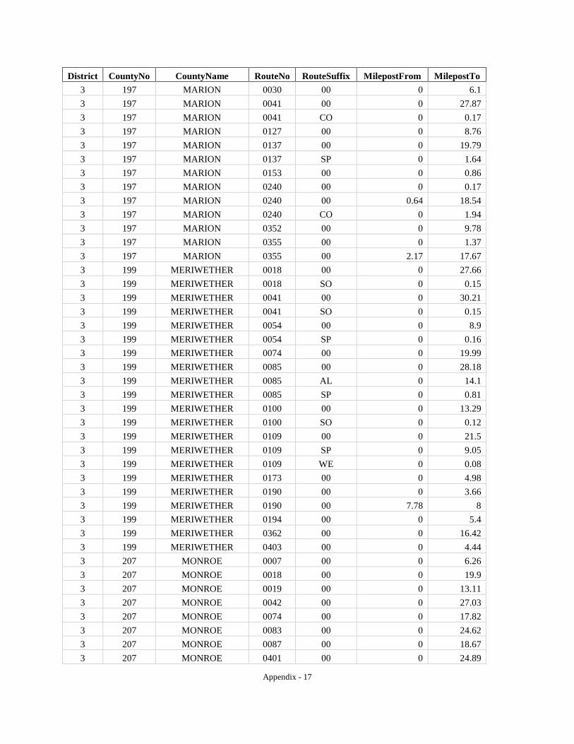
Appendix - 17
District CountyNo CountyName RouteNo RouteSuffix MilepostFrom MilepostTo 3 197 MARION 0030 00 0 6.1 3 197 MARION 0041 00 0 27.87 3 197 MARION 0041 CO 0 0.17 3 197 MARION 0127 00 0 8.76 3 197 MARION 0137 00 0 19.79 3 197 MARION 0137 SP 0 1.64 3 197 MARION 0153 00 0 0.86 3 197 MARION 0240 00 0 0.17 3 197 MARION 0240 00 0.64 18.54 3 197 MARION 0240 CO 0 1.94 3 197 MARION 0352 00 0 9.78 3 197 MARION 0355 00 0 1.37 3 197 MARION 0355 00 2.17 17.67 3 199 MERIWETHER 0018 00 0 27.66 3 199 MERIWETHER 0018 SO 0 0.15 3 199 MERIWETHER 0041 00 0 30.21 3 199 MERIWETHER 0041 SO 0 0.15 3 199 MERIWETHER 0054 00 0 8.9 3 199 MERIWETHER 0054 SP 0 0.16 3 199 MERIWETHER 0074 00 0 19.99 3 199 MERIWETHER 0085 00 0 28.18 3 199 MERIWETHER 0085 AL 0 14.1 3 199 MERIWETHER 0085 SP 0 0.81 3 199 MERIWETHER 0100 00 0 13.29 3 199 MERIWETHER 0100 SO 0 0.12 3 199 MERIWETHER 0109 00 0 21.5 3 199 MERIWETHER 0109 SP 0 9.05 3 199 MERIWETHER 0109 WE 0 0.08 3 199 MERIWETHER 0173 00 0 4.98 3 199 MERIWETHER 0190 00 0 3.66 3 199 MERIWETHER 0190 00 7.78 8 3 199 MERIWETHER 0194 00 0 5.4 3 199 MERIWETHER 0362 00 0 16.42 3 199 MERIWETHER 0403 00 0 4.44 3 207 MONROE 0007 00 0 6.26 3 207 MONROE 0018 00 0 19.9 3 207 MONROE 0019 00 0 13.11 3 207 MONROE 0042 00 0 27.03 3 207 MONROE 0074 00 0 17.82 3 207 MONROE 0083 00 0 24.62 3 207 MONROE 0087 00 0 18.67 3 207 MONROE 0401 00 0 24.89

Appendix - 18
District CountyNo CountyName RouteNo RouteSuffix MilepostFrom MilepostTo 3 207 MONROE 0408 00 0 3.94 3 215 MUSCOGEE 0001 00 0 19.7 3 215 MUSCOGEE 0022 00 0 21.79 3 215 MUSCOGEE 0022 CO 0 0.73 3 215 MUSCOGEE 0022 SP 0 10.31 3 215 MUSCOGEE 0085 00 0 14.71 3 215 MUSCOGEE 0219 00 0 8.65 3 215 MUSCOGEE 0411 00 0 14.94 3 215 MUSCOGEE 0520 00 0 7.74 3 225 PEACH 0007 00 0 11.34 3 225 PEACH 0007 CO 0 0.17 3 225 PEACH 0011 00 0 0.1 3 225 PEACH 0042 00 0 3.52 3 225 PEACH 0049 00 0 17.96 3 225 PEACH 0049 CO 0 4.73 3 225 PEACH 0096 00 0 0.7 3 225 PEACH 0096 00 1.44 15.07 3 225 PEACH 0127 00 0 0.52 3 225 PEACH 0247 CO 0 4.56 3 225 PEACH 0401 00 0 11.1 3 231 PIKE 0003 00 0 15.28 3 231 PIKE 0003 SO 0 0.87 3 231 PIKE 0007 00 0 3.32 3 231 PIKE 0018 00 0 22.02 3 231 PIKE 0074 00 0 2.09 3 231 PIKE 0109 00 0 18.9 3 231 PIKE 0362 00 0 9.44 3 235 PULASKI 0011 00 0 19.52 3 235 PULASKI 0011 BU 0 1.3 3 235 PULASKI 0011 EA 0 0.28 3 235 PULASKI 0026 00 0 13.19 3 235 PULASKI 0026 WE 0 0.77 3 235 PULASKI 0027 00 0 22.81 3 235 PULASKI 0027 WE 0 0.85 3 235 PULASKI 0112 00 0 17.43 3 235 PULASKI 0112 WE 0 0.85 3 235 PULASKI 0230 00 0 25.43 3 235 PULASKI 0230 WE 0 0.85 3 235 PULASKI 0247 00 0 5.78 3 235 PULASKI 0257 00 0 18.81 3 235 PULASKI 0257 WE 0 0.85 3 249 SCHLEY 0003 00 0 0.47
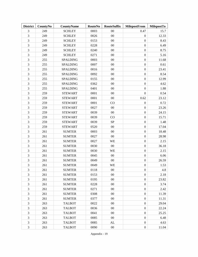
Appendix - 19
District CountyNo CountyName RouteNo RouteSuffix MilepostFrom MilepostTo 3 249 SCHLEY 0003 00 0.47 15.7 3 249 SCHLEY 0026 00 0 12.33 3 249 SCHLEY 0153 00 0 8.43 3 249 SCHLEY 0228 00 0 6.49 3 249 SCHLEY 0240 00 0 8.75 3 249 SCHLEY 0271 00 0 5.16 3 255 SPALDING 0003 00 0 11.68 3 255 SPALDING 0007 00 0 0.61 3 255 SPALDING 0016 00 0 23.41 3 255 SPALDING 0092 00 0 8.54 3 255 SPALDING 0155 00 0 12.99 3 255 SPALDING 0362 00 0 4.62 3 255 SPALDING 0401 00 0 1.88 3 259 STEWART 0001 00 0 0.54 3 259 STEWART 0001 00 0.62 23.12 3 259 STEWART 0001 CO 0 0.72 3 259 STEWART 0027 00 0 23.26 3 259 STEWART 0039 00 0 24.15 3 259 STEWART 0039 CO 0 15.71 3 259 STEWART 0039 SP 0 1.48 3 259 STEWART 0520 00 0 17.04 3 261 SUMTER 0003 00 0 18.48 3 261 SUMTER 0027 00 0 28.98 3 261 SUMTER 0027 WE 0 2.15 3 261 SUMTER 0030 00 0 36.18 3 261 SUMTER 0030 WE 0 2.15 3 261 SUMTER 0045 00 0 6.06 3 261 SUMTER 0049 00 0 26.59 3 261 SUMTER 0049 WE 0 1.53 3 261 SUMTER 0118 00 0 4.8 3 261 SUMTER 0153 00 0 2.18 3 261 SUMTER 0195 00 0 23.82 3 261 SUMTER 0228 00 0 3.74 3 261 SUMTER 0271 00 0 2.42 3 261 SUMTER 0308 00 0 11.39 3 261 SUMTER 0377 00 0 11.31 3 263 TALBOT 0022 00 0 29.04 3 263 TALBOT 0036 00 0 22.24 3 263 TALBOT 0041 00 0 25.25 3 263 TALBOT 0085 00 0 6.48 3 263 TALBOT 0085 AL 0 4.63 3 263 TALBOT 0090 00 0 11.04

Appendix - 20
District CountyNo CountyName RouteNo RouteSuffix MilepostFrom MilepostTo 3 263 TALBOT 0096 00 0 9.59 3 263 TALBOT 0116 00 0 7.27 3 263 TALBOT 0190 00 0 4.12 3 263 TALBOT 0208 00 0 21.42 3 263 TALBOT 0240 00 0 2.55 3 263 TALBOT 0240 00 2.73 3.2 3 263 TALBOT 0315 00 0 5.61 3 263 TALBOT 0355 00 0 2.14 3 269 TAYLOR 0003 00 0 26.78 3 269 TAYLOR 0003 SO 0 1.05 3 269 TAYLOR 0022 00 0 5.94 3 269 TAYLOR 0090 00 0 22.42 3 269 TAYLOR 0090 CO 0 0.07 3 269 TAYLOR 0096 00 0 24.96 3 269 TAYLOR 0127 00 0 20.51 3 269 TAYLOR 0128 00 0 11.13 3 269 TAYLOR 0137 00 0 27.46 3 269 TAYLOR 0137 WE 0 0.14 3 269 TAYLOR 0208 00 0 12.15 3 285 TROUP 0001 00 0 27.91 3 285 TROUP 0014 00 0 34.47 3 285 TROUP 0014 CO 0 1.12 3 285 TROUP 0014 SP 0 4.98 3 285 TROUP 0018 00 0 8.05 3 285 TROUP 0054 00 0 10.74 3 285 TROUP 0100 00 0 7.28 3 285 TROUP 0103 00 0 0.37 3 285 TROUP 0109 00 0 21.54 3 285 TROUP 0219 00 0 23.55 3 285 TROUP 0403 00 0 27.92 3 285 TROUP 0411 00 0 14.35 3 289 TWIGGS 0018 00 0 6.28 3 289 TWIGGS 0019 00 0 23.28 3 289 TWIGGS 0057 00 0 6.58 3 289 TWIGGS 0087 00 0 20.23 3 289 TWIGGS 0096 00 0 22.1 3 289 TWIGGS 0112 00 0 0.73 3 289 TWIGGS 0358 00 0 6.38 3 289 TWIGGS 0404 00 0 22.76 3 293 UPSON 0003 00 0 22.67 3 293 UPSON 0003 SO 0 1.83 3 293 UPSON 0022 00 0 4.54

Appendix - 21
District CountyNo CountyName RouteNo RouteSuffix MilepostFrom MilepostTo 3 293 UPSON 0036 00 0 19.1 3 293 UPSON 0036 WE 0 0.32 3 293 UPSON 0074 00 0 26.57 3 293 UPSON 0074 AL 0 1.49 3 293 UPSON 0074 WE 0 0.32 3 307 WEBSTER 0027 00 0 13.5 3 307 WEBSTER 0041 00 0 19.32 3 307 WEBSTER 0045 00 0 2.14 3 307 WEBSTER 0153 00 0 7.55 3 307 WEBSTER 0520 00 0 9.06 4 003 ATKINSON 0031 00 0 16.7 4 003 ATKINSON 0064 00 0 24.3 4 003 ATKINSON 0089 00 0 6.1 4 003 ATKINSON 0090 00 0 7 4 003 ATKINSON 0135 00 0 11.77 4 003 ATKINSON 0520 00 0 24.78 4 007 BAKER 0037 00 0 15.13 4 007 BAKER 0091 00 0 25.71 4 007 BAKER 0200 00 0 18.7 4 007 BAKER 0216 00 0 10.05 4 007 BAKER 0253 00 0 7.76 4 017 BEN HILL 0011 00 0 14.73 4 017 BEN HILL 0011 SO 0 1.53 4 017 BEN HILL 0090 00 0 24.31 4 017 BEN HILL 0090 SO 0 1.35 4 017 BEN HILL 0107 00 0 23.3 4 017 BEN HILL 0125 00 0 1.45 4 017 BEN HILL 0182 00 0 8.68 4 017 BEN HILL 0206 00 0 9.88 4 017 BEN HILL 0215 00 0 1.11 4 017 BEN HILL 0233 00 0 1.09 4 019 BERRIEN 0011 00 0 31.29 4 019 BERRIEN 0037 00 0 10.07 4 019 BERRIEN 0064 00 0 3.1 4 019 BERRIEN 0064 00 9.23 13.34 4 019 BERRIEN 0076 00 0 15.99 4 019 BERRIEN 0076 CO 0 0.11 4 019 BERRIEN 0125 00 0 26.85 4 019 BERRIEN 0135 00 0 11.08 4 019 BERRIEN 0158 00 0 5.43 4 019 BERRIEN 0168 00 0 13.22 4 019 BERRIEN 0520 00 0 16.68

Appendix - 22
District CountyNo CountyName RouteNo RouteSuffix MilepostFrom MilepostTo 4 027 BROOKS 0031 00 0 0.07 4 027 BROOKS 0033 00 0 3.06 4 027 BROOKS 0038 00 0 17.17 4 027 BROOKS 0076 00 0 30.46 4 027 BROOKS 0122 00 0 17.28 4 027 BROOKS 0133 00 0 20.1 4 027 BROOKS 0333 00 0 29.16 4 037 CALHOUN 0037 00 0 0.38 4 037 CALHOUN 0037 00 0.68 25.75 4 037 CALHOUN 0041 00 0 5.15 4 037 CALHOUN 0041 00 5.69 5.81 4 037 CALHOUN 0045 00 0 20.38 4 037 CALHOUN 0045 AL 0 0.38 4 037 CALHOUN 0055 00 0 10.08 4 037 CALHOUN 0062 00 0 18.52 4 037 CALHOUN 0216 00 0 14.44 4 037 CALHOUN 0234 00 0 5.7 4 061 CLAY 0001 00 0 8.53 4 061 CLAY 0037 00 0 13.87 4 061 CLAY 0037 00 14.25 14.55 4 061 CLAY 0039 00 0 22.98 4 061 CLAY 0266 00 0 6.62 4 061 CLAY 0266 00 6.92 7.58 4 069 COFFEE 0031 00 0 29 4 069 COFFEE 0031 SO 0 2.64 4 069 COFFEE 0032 00 0 28.96 4 069 COFFEE 0032 WE 0 1.11 4 069 COFFEE 0064 00 0 3.46 4 069 COFFEE 0090 00 0 3.85 4 069 COFFEE 0107 00 0 11.33 4 069 COFFEE 0135 00 0 24.37 4 069 COFFEE 0158 00 0 35.19 4 069 COFFEE 0206 00 0 15.83 4 069 COFFEE 0206 CO 0 4.46 4 069 COFFEE 0268 00 0 14.83 4 071 COLQUITT 0033 00 0 22.36 4 071 COLQUITT 0033 SO 0 1.68 4 071 COLQUITT 0035 00 0 26.84 4 071 COLQUITT 0037 00 0 29.93 4 071 COLQUITT 0037 WE 0 0.82 4 071 COLQUITT 0111 00 0 15.58 4 071 COLQUITT 0133 00 0 30.43
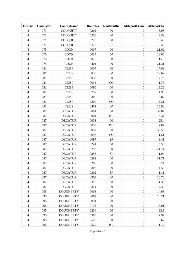
Appendix - 23
District CountyNo CountyName RouteNo RouteSuffix MilepostFrom MilepostTo 4 071 COLQUITT 0202 00 0 6.03 4 071 COLQUITT 0256 00 0 3.59 4 071 COLQUITT 0270 00 0 10.43 4 071 COLQUITT 0270 SP 0 0.35 4 075 COOK 0007 00 0 21.62 4 075 COOK 0037 00 0 13.86 4 075 COOK 0076 00 0 15.9 4 075 COOK 0401 00 0 21.31 4 081 CRISP 0007 00 0 17.02 4 081 CRISP 0030 00 0 19.62 4 081 CRISP 0033 00 0 7.78 4 081 CRISP 0033 CO 0 1.78 4 081 CRISP 0090 00 0 18.26 4 081 CRISP 0257 00 0 4.99 4 081 CRISP 0300 00 0 13.87 4 081 CRISP 0300 CO 0 3.31 4 081 CRISP 0401 00 0 15.93 4 087 DECATUR 0001 00 0 32.87 4 087 DECATUR 0001 BU 0 16.34 4 087 DECATUR 0038 00 0 25.4 4 087 DECATUR 0038 BU 0 2.82 4 087 DECATUR 0097 00 0 38.53 4 087 DECATUR 0097 CO 0 1.51 4 087 DECATUR 0097 SP 0 3.41 4 087 DECATUR 0241 00 0 5.56 4 087 DECATUR 0253 00 0 24.74 4 087 DECATUR 0253 SP 0 1.04 4 087 DECATUR 0262 00 0 31.71 4 087 DECATUR 0285 00 0 0.24 4 087 DECATUR 0302 00 0 4.56 4 087 DECATUR 0302 SP 0 1.11 4 087 DECATUR 0309 00 0 26.78 4 087 DECATUR 0310 00 0 14.36 4 087 DECATUR 0311 00 0 12.39 4 095 DOUGHERTY 0003 00 0 14.68 4 095 DOUGHERTY 0062 00 0 16.71 4 095 DOUGHERTY 0091 00 0 16.18 4 095 DOUGHERTY 0133 00 0 16.01 4 095 DOUGHERTY 0234 00 0 22.9 4 095 DOUGHERTY 0300 00 0 17.97 4 095 DOUGHERTY 0520 00 0 16.67 4 095 DOUGHERTY 0520 BU 0 11.9
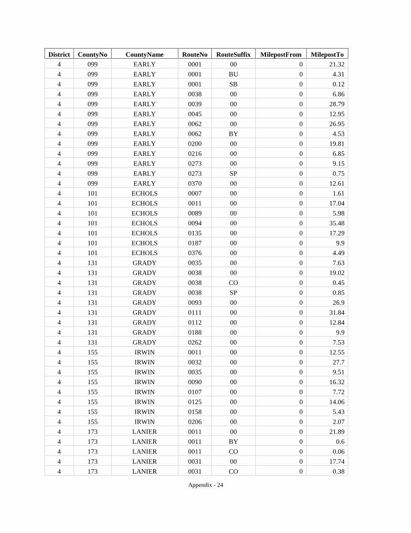
Appendix - 24
District CountyNo CountyName RouteNo RouteSuffix MilepostFrom MilepostTo 4 099 EARLY 0001 00 0 21.32 4 099 EARLY 0001 BU 0 4.31 4 099 EARLY 0001 SB 0 0.12 4 099 EARLY 0038 00 0 6.86 4 099 EARLY 0039 00 0 28.79 4 099 EARLY 0045 00 0 12.95 4 099 EARLY 0062 00 0 26.95 4 099 EARLY 0062 BY 0 4.53 4 099 EARLY 0200 00 0 19.81 4 099 EARLY 0216 00 0 6.85 4 099 EARLY 0273 00 0 9.15 4 099 EARLY 0273 SP 0 0.75 4 099 EARLY 0370 00 0 12.61 4 101 ECHOLS 0007 00 0 1.61 4 101 ECHOLS 0011 00 0 17.04 4 101 ECHOLS 0089 00 0 5.98 4 101 ECHOLS 0094 00 0 35.48 4 101 ECHOLS 0135 00 0 17.29 4 101 ECHOLS 0187 00 0 9.9 4 101 ECHOLS 0376 00 0 4.49 4 131 GRADY 0035 00 0 7.63 4 131 GRADY 0038 00 0 19.02 4 131 GRADY 0038 CO 0 0.45 4 131 GRADY 0038 SP 0 0.85 4 131 GRADY 0093 00 0 26.9 4 131 GRADY 0111 00 0 31.84 4 131 GRADY 0112 00 0 12.84 4 131 GRADY 0188 00 0 9.9 4 131 GRADY 0262 00 0 7.53 4 155 IRWIN 0011 00 0 12.55 4 155 IRWIN 0032 00 0 27.7 4 155 IRWIN 0035 00 0 9.51 4 155 IRWIN 0090 00 0 16.32 4 155 IRWIN 0107 00 0 7.72 4 155 IRWIN 0125 00 0 14.06 4 155 IRWIN 0158 00 0 5.43 4 155 IRWIN 0206 00 0 2.07 4 173 LANIER 0011 00 0 21.89 4 173 LANIER 0011 BY 0 0.6 4 173 LANIER 0011 CO 0 0.06 4 173 LANIER 0031 00 0 17.74 4 173 LANIER 0031 CO 0 0.38
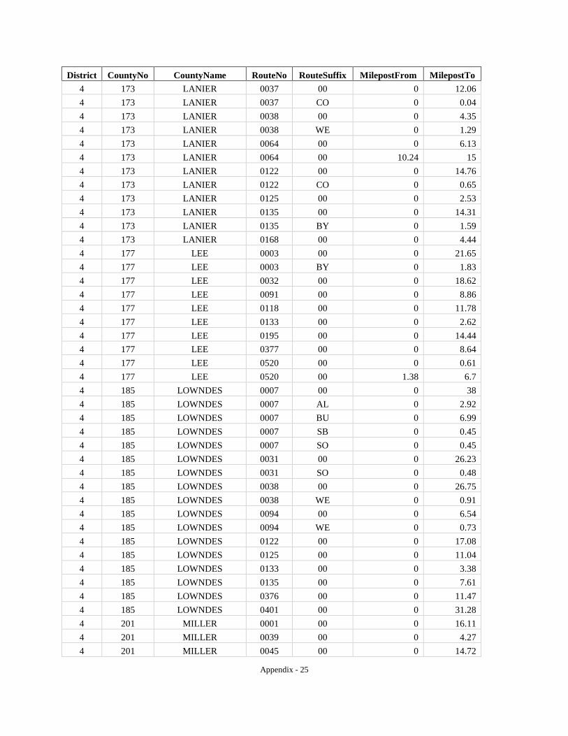
Appendix - 25
District CountyNo CountyName RouteNo RouteSuffix MilepostFrom MilepostTo 4 173 LANIER 0037 00 0 12.06 4 173 LANIER 0037 CO 0 0.04 4 173 LANIER 0038 00 0 4.35 4 173 LANIER 0038 WE 0 1.29 4 173 LANIER 0064 00 0 6.13 4 173 LANIER 0064 00 10.24 15 4 173 LANIER 0122 00 0 14.76 4 173 LANIER 0122 CO 0 0.65 4 173 LANIER 0125 00 0 2.53 4 173 LANIER 0135 00 0 14.31 4 173 LANIER 0135 BY 0 1.59 4 173 LANIER 0168 00 0 4.44 4 177 LEE 0003 00 0 21.65 4 177 LEE 0003 BY 0 1.83 4 177 LEE 0032 00 0 18.62 4 177 LEE 0091 00 0 8.86 4 177 LEE 0118 00 0 11.78 4 177 LEE 0133 00 0 2.62 4 177 LEE 0195 00 0 14.44 4 177 LEE 0377 00 0 8.64 4 177 LEE 0520 00 0 0.61 4 177 LEE 0520 00 1.38 6.7 4 185 LOWNDES 0007 00 0 38 4 185 LOWNDES 0007 AL 0 2.92 4 185 LOWNDES 0007 BU 0 6.99 4 185 LOWNDES 0007 SB 0 0.45 4 185 LOWNDES 0007 SO 0 0.45 4 185 LOWNDES 0031 00 0 26.23 4 185 LOWNDES 0031 SO 0 0.48 4 185 LOWNDES 0038 00 0 26.75 4 185 LOWNDES 0038 WE 0 0.91 4 185 LOWNDES 0094 00 0 6.54 4 185 LOWNDES 0094 WE 0 0.73 4 185 LOWNDES 0122 00 0 17.08 4 185 LOWNDES 0125 00 0 11.04 4 185 LOWNDES 0133 00 0 3.38 4 185 LOWNDES 0135 00 0 7.61 4 185 LOWNDES 0376 00 0 11.47 4 185 LOWNDES 0401 00 0 31.28 4 201 MILLER 0001 00 0 16.11 4 201 MILLER 0039 00 0 4.27 4 201 MILLER 0045 00 0 14.72

Appendix - 26
District CountyNo CountyName RouteNo RouteSuffix MilepostFrom MilepostTo 4 201 MILLER 0045 CO 0 0.1 4 201 MILLER 0045 SO 0 0.14 4 201 MILLER 0091 00 0 23.56 4 201 MILLER 0091 SO 0 0.14 4 201 MILLER 0091 SP 0 0.33 4 201 MILLER 0273 00 0 8.11 4 201 MILLER 0310 00 0 7.36 4 205 MITCHELL 0003 00 0 29.17 4 205 MITCHELL 0037 00 0 22.58 4 205 MITCHELL 0037 CO 0 0.28 4 205 MITCHELL 0065 00 0 17.28 4 205 MITCHELL 0093 00 0 33.94 4 205 MITCHELL 0097 00 0 18.73 4 205 MITCHELL 0111 00 0 3.81 4 205 MITCHELL 0112 00 0 28.39 4 205 MITCHELL 0262 00 0 12.74 4 205 MITCHELL 0270 00 0 2.27 4 205 MITCHELL 0300 00 0 29.17 4 205 MITCHELL 0311 00 0 11.44 4 239 QUITMAN 0027 00 0 10.05 4 239 QUITMAN 0039 00 0 16.66 4 239 QUITMAN 0050 00 0 15.49 4 243 RANDOLPH 0001 00 0 22.72 4 243 RANDOLPH 0001 00 23.22 23.34 4 243 RANDOLPH 0001 BU 0 3.33 4 243 RANDOLPH 0001 SB 0 0.09 4 243 RANDOLPH 0041 00 0 0.55 4 243 RANDOLPH 0041 00 0.67 22.38 4 243 RANDOLPH 0050 00 0 21.17 4 243 RANDOLPH 0050 WE 0 0.09 4 243 RANDOLPH 0216 00 0 9.01 4 243 RANDOLPH 0266 00 0 0.3 4 243 RANDOLPH 0266 00 0.97 11.63 4 253 SEMINOLE 0038 00 0 13.8 4 253 SEMINOLE 0039 00 0 20.96 4 253 SEMINOLE 0045 00 0 4.54 4 253 SEMINOLE 0091 00 0 11.36 4 253 SEMINOLE 0091 AL 0 1.85 4 253 SEMINOLE 0253 00 0 10.7 4 253 SEMINOLE 0285 00 0 13.74 4 253 SEMINOLE 0374 00 0 7.89 4 273 TERRELL 0032 00 0 9.69

Appendix - 27
District CountyNo CountyName RouteNo RouteSuffix MilepostFrom MilepostTo 4 273 TERRELL 0041 00 0 2.4 4 273 TERRELL 0045 00 0 27.24 4 273 TERRELL 0049 00 0 4.25 4 273 TERRELL 0050 00 0 9.34 4 273 TERRELL 0055 00 0 10.86 4 273 TERRELL 0118 00 0 10.4 4 273 TERRELL 0520 00 0 22.43 4 273 TERRELL 0520 00 23.04 23.81 4 275 THOMAS 0003 00 0 31.58 4 275 THOMAS 0003 AL 0 18.87 4 275 THOMAS 0033 00 0 18.12 4 275 THOMAS 0035 00 0 26.71 4 275 THOMAS 0035 BU 0 5.51 4 275 THOMAS 0035 CO 0 1.15 4 275 THOMAS 0038 00 0 26.15 4 275 THOMAS 0038 BU 0 4.88 4 275 THOMAS 0111 00 0 3.45 4 275 THOMAS 0122 00 0 14.95 4 275 THOMAS 0188 00 0 24.57 4 275 THOMAS 0202 00 0 9.53 4 275 THOMAS 0300 00 0 31.58 4 277 TIFT 0007 00 0 20.99 4 277 TIFT 0035 00 0 20.99 4 277 TIFT 0125 00 0 16.52 4 277 TIFT 0401 00 0 20.08 4 277 TIFT 0520 00 0 18.67 4 287 TURNER 0007 00 0 16.76 4 287 TURNER 0032 00 0 21.11 4 287 TURNER 0032 CO 0 0.03 4 287 TURNER 0090 00 0 9.53 4 287 TURNER 0107 00 0 10.86 4 287 TURNER 0112 00 0 23.41 4 287 TURNER 0159 00 0 12.35 4 287 TURNER 0401 00 0 16.82 4 315 WILCOX 0011 00 0 23.53 4 315 WILCOX 0030 00 0 20.55 4 315 WILCOX 0090 00 0 1.6 4 315 WILCOX 0112 00 0 20.39 4 315 WILCOX 0159 00 0 6.59 4 315 WILCOX 0215 00 0 26.04 4 315 WILCOX 0233 00 0 18.26 4 315 WILCOX 0257 00 0 3.43

Appendix - 28
District CountyNo CountyName RouteNo RouteSuffix MilepostFrom MilepostTo 4 321 WORTH 0032 00 0 14.33 4 321 WORTH 0033 00 0 33.1 4 321 WORTH 0112 00 0 23.45 4 321 WORTH 0133 00 0 10.32 4 321 WORTH 0256 00 0 17.35 4 321 WORTH 0300 00 0 15.02 4 321 WORTH 0313 00 0 22.23 4 321 WORTH 0520 00 0 20.2 5 001 APPLING 0004 00 0 21.14 5 001 APPLING 0015 00 0 32.86 5 001 APPLING 0019 00 0 0.3 5 001 APPLING 0019 00 2.04 3.05 5 001 APPLING 0027 00 0 24.78 5 001 APPLING 0121 00 0 26.26 5 001 APPLING 0144 00 0 15.56 5 001 APPLING 0169 00 0 2.69 5 001 APPLING 0203 00 0 10.79 5 005 BACON 0004 00 0 17.89 5 005 BACON 0004 AL 0 1.6 5 005 BACON 0019 00 0 6.67 5 005 BACON 0032 00 0 19.34 5 005 BACON 0203 00 0 12.8 5 025 BRANTLEY 0015 00 0 14.89 5 025 BRANTLEY 0023 00 0 20.11 5 025 BRANTLEY 0032 00 0 18.68 5 025 BRANTLEY 0110 00 0 16.17 5 025 BRANTLEY 0121 00 0 14.89 5 025 BRANTLEY 0520 00 0 27 5 029 BRYAN 0025 00 0 9.18 5 029 BRYAN 0026 00 0 5.85 5 029 BRYAN 0030 00 0 23.25 5 029 BRYAN 0067 00 0 7.48 5 029 BRYAN 0119 00 0 12.44 5 029 BRYAN 0144 00 0 24.24 5 029 BRYAN 0144 SP 0 3.98 5 029 BRYAN 0204 00 0 11.12 5 029 BRYAN 0404 00 0 9.06 5 029 BRYAN 0405 00 0 11.49 5 031 BULLOCH 0024 00 0 14.65 5 031 BULLOCH 0026 00 0 42.64 5 031 BULLOCH 0046 00 0 16.11 5 031 BULLOCH 0067 00 0 35.42
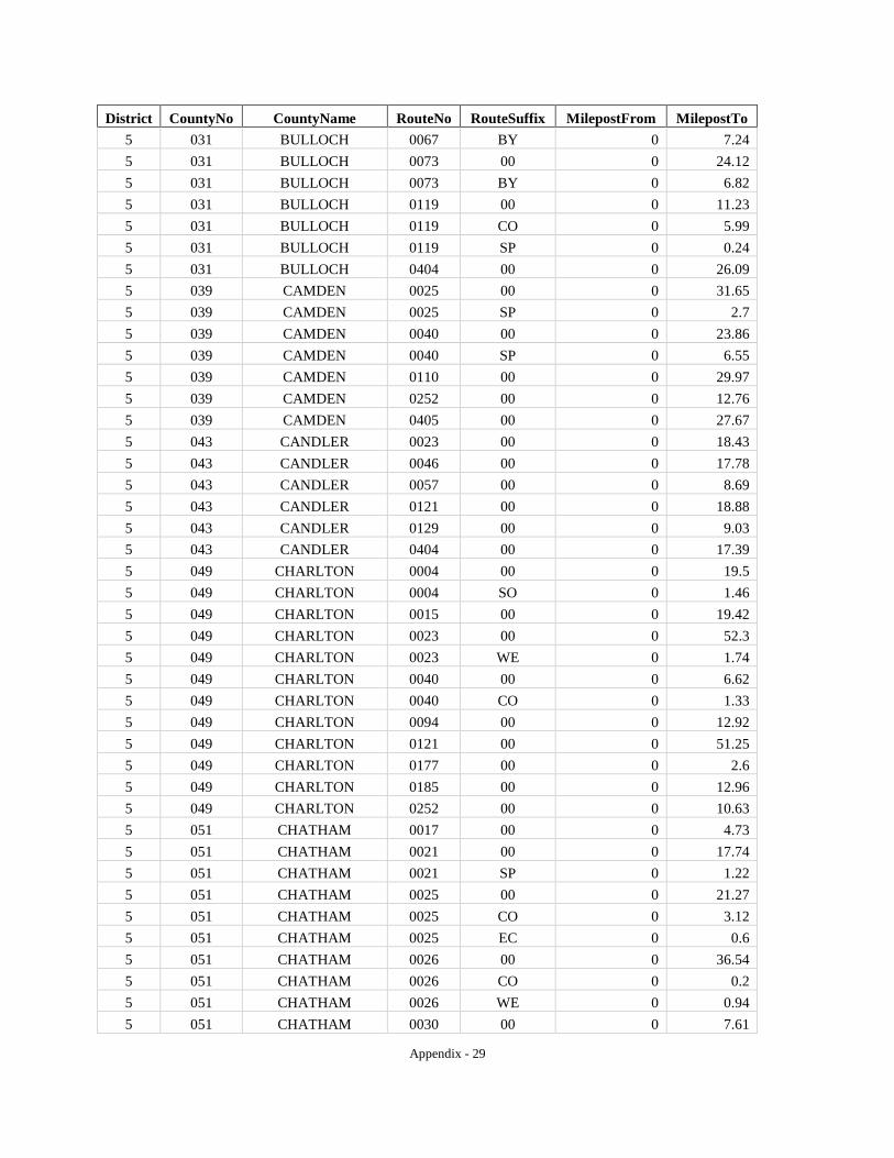
Appendix - 29
District CountyNo CountyName RouteNo RouteSuffix MilepostFrom MilepostTo 5 031 BULLOCH 0067 BY 0 7.24 5 031 BULLOCH 0073 00 0 24.12 5 031 BULLOCH 0073 BY 0 6.82 5 031 BULLOCH 0119 00 0 11.23 5 031 BULLOCH 0119 CO 0 5.99 5 031 BULLOCH 0119 SP 0 0.24 5 031 BULLOCH 0404 00 0 26.09 5 039 CAMDEN 0025 00 0 31.65 5 039 CAMDEN 0025 SP 0 2.7 5 039 CAMDEN 0040 00 0 23.86 5 039 CAMDEN 0040 SP 0 6.55 5 039 CAMDEN 0110 00 0 29.97 5 039 CAMDEN 0252 00 0 12.76 5 039 CAMDEN 0405 00 0 27.67 5 043 CANDLER 0023 00 0 18.43 5 043 CANDLER 0046 00 0 17.78 5 043 CANDLER 0057 00 0 8.69 5 043 CANDLER 0121 00 0 18.88 5 043 CANDLER 0129 00 0 9.03 5 043 CANDLER 0404 00 0 17.39 5 049 CHARLTON 0004 00 0 19.5 5 049 CHARLTON 0004 SO 0 1.46 5 049 CHARLTON 0015 00 0 19.42 5 049 CHARLTON 0023 00 0 52.3 5 049 CHARLTON 0023 WE 0 1.74 5 049 CHARLTON 0040 00 0 6.62 5 049 CHARLTON 0040 CO 0 1.33 5 049 CHARLTON 0094 00 0 12.92 5 049 CHARLTON 0121 00 0 51.25 5 049 CHARLTON 0177 00 0 2.6 5 049 CHARLTON 0185 00 0 12.96 5 049 CHARLTON 0252 00 0 10.63 5 051 CHATHAM 0017 00 0 4.73 5 051 CHATHAM 0021 00 0 17.74 5 051 CHATHAM 0021 SP 0 1.22 5 051 CHATHAM 0025 00 0 21.27 5 051 CHATHAM 0025 CO 0 3.12 5 051 CHATHAM 0025 EC 0 0.6 5 051 CHATHAM 0026 00 0 36.54 5 051 CHATHAM 0026 CO 0 0.2 5 051 CHATHAM 0026 WE 0 0.94 5 051 CHATHAM 0030 00 0 7.61
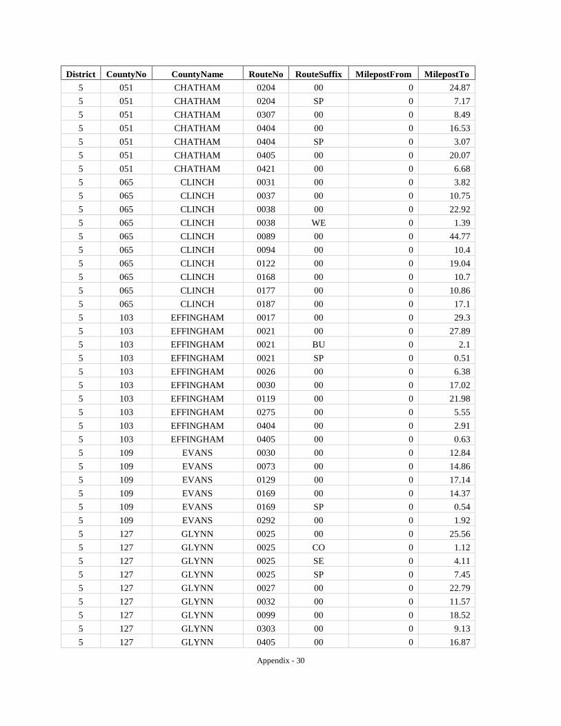
Appendix - 30
District CountyNo CountyName RouteNo RouteSuffix MilepostFrom MilepostTo 5 051 CHATHAM 0204 00 0 24.87 5 051 CHATHAM 0204 SP 0 7.17 5 051 CHATHAM 0307 00 0 8.49 5 051 CHATHAM 0404 00 0 16.53 5 051 CHATHAM 0404 SP 0 3.07 5 051 CHATHAM 0405 00 0 20.07 5 051 CHATHAM 0421 00 0 6.68 5 065 CLINCH 0031 00 0 3.82 5 065 CLINCH 0037 00 0 10.75 5 065 CLINCH 0038 00 0 22.92 5 065 CLINCH 0038 WE 0 1.39 5 065 CLINCH 0089 00 0 44.77 5 065 CLINCH 0094 00 0 10.4 5 065 CLINCH 0122 00 0 19.04 5 065 CLINCH 0168 00 0 10.7 5 065 CLINCH 0177 00 0 10.86 5 065 CLINCH 0187 00 0 17.1 5 103 EFFINGHAM 0017 00 0 29.3 5 103 EFFINGHAM 0021 00 0 27.89 5 103 EFFINGHAM 0021 BU 0 2.1 5 103 EFFINGHAM 0021 SP 0 0.51 5 103 EFFINGHAM 0026 00 0 6.38 5 103 EFFINGHAM 0030 00 0 17.02 5 103 EFFINGHAM 0119 00 0 21.98 5 103 EFFINGHAM 0275 00 0 5.55 5 103 EFFINGHAM 0404 00 0 2.91 5 103 EFFINGHAM 0405 00 0 0.63 5 109 EVANS 0030 00 0 12.84 5 109 EVANS 0073 00 0 14.86 5 109 EVANS 0129 00 0 17.14 5 109 EVANS 0169 00 0 14.37 5 109 EVANS 0169 SP 0 0.54 5 109 EVANS 0292 00 0 1.92 5 127 GLYNN 0025 00 0 25.56 5 127 GLYNN 0025 CO 0 1.12 5 127 GLYNN 0025 SE 0 4.11 5 127 GLYNN 0025 SP 0 7.45 5 127 GLYNN 0027 00 0 22.79 5 127 GLYNN 0032 00 0 11.57 5 127 GLYNN 0099 00 0 18.52 5 127 GLYNN 0303 00 0 9.13 5 127 GLYNN 0405 00 0 16.87
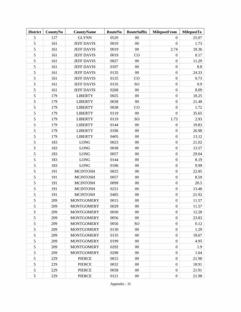
Appendix - 31
District CountyNo CountyName RouteNo RouteSuffix MilepostFrom MilepostTo 5 127 GLYNN 0520 00 0 25.07 5 161 JEFF DAVIS 0019 00 0 1.73 5 161 JEFF DAVIS 0019 00 2.74 18.36 5 161 JEFF DAVIS 0019 CO 0 0.17 5 161 JEFF DAVIS 0027 00 0 11.29 5 161 JEFF DAVIS 0107 00 0 8.8 5 161 JEFF DAVIS 0135 00 0 24.33 5 161 JEFF DAVIS 0135 CO 0 0.73 5 161 JEFF DAVIS 0135 SO 0 0.9 5 161 JEFF DAVIS 0268 00 0 8.09 5 179 LIBERTY 0025 00 0 18.25 5 179 LIBERTY 0038 00 0 21.48 5 179 LIBERTY 0038 CO 0 1.72 5 179 LIBERTY 0119 00 0 35.65 5 179 LIBERTY 0119 SO 1.73 2.93 5 179 LIBERTY 0144 00 0 19.83 5 179 LIBERTY 0196 00 0 26.98 5 179 LIBERTY 0405 00 0 13.12 5 183 LONG 0023 00 0 21.02 5 183 LONG 0038 00 0 13.57 5 183 LONG 0057 00 0 29.04 5 183 LONG 0144 00 0 8.19 5 183 LONG 0196 00 0 9.99 5 191 MCINTOSH 0025 00 0 22.85 5 191 MCINTOSH 0057 00 0 8.59 5 191 MCINTOSH 0099 00 0 20.5 5 191 MCINTOSH 0251 00 0 13.48 5 191 MCINTOSH 0405 00 0 21.92 5 209 MONTGOMERY 0015 00 0 11.57 5 209 MONTGOMERY 0029 00 0 11.57 5 209 MONTGOMERY 0030 00 0 12.28 5 209 MONTGOMERY 0056 00 0 23.83 5 209 MONTGOMERY 0056 SO 0 0.12 5 209 MONTGOMERY 0130 00 0 1.29 5 209 MONTGOMERY 0135 00 0 18.67 5 209 MONTGOMERY 0199 00 0 4.95 5 209 MONTGOMERY 0292 00 0 1.9 5 209 MONTGOMERY 0298 00 0 1.64 5 229 PIERCE 0015 00 0 21.98 5 229 PIERCE 0032 00 0 18.91 5 229 PIERCE 0038 00 0 21.91 5 229 PIERCE 0121 00 0 21.98

Appendix - 32
District CountyNo CountyName RouteNo RouteSuffix MilepostFrom MilepostTo 5 229 PIERCE 0203 00 0 12.1 5 251 SCREVEN 0017 00 0 24.05 5 251 SCREVEN 0021 00 0 30.56 5 251 SCREVEN 0021 BU 0 16.32 5 251 SCREVEN 0021 CO 0 0.03 5 251 SCREVEN 0021 SB 0 0.1 5 251 SCREVEN 0024 00 0 41.25 5 251 SCREVEN 0073 00 0 30.57 5 251 SCREVEN 0073 LO 0 3.02 5 251 SCREVEN 0073 SO 0 0.11 5 267 TATTNALL 0023 00 0 36.83 5 267 TATTNALL 0030 00 0 14.28 5 267 TATTNALL 0056 00 0 4.4 5 267 TATTNALL 0057 00 0 36.91 5 267 TATTNALL 0073 00 0 8.41 5 267 TATTNALL 0121 00 0 34.7 5 267 TATTNALL 0129 00 0 0.61 5 267 TATTNALL 0144 00 0 15.49 5 267 TATTNALL 0147 00 0 9.48 5 267 TATTNALL 0152 00 0 5.51 5 267 TATTNALL 0169 00 0 18.95 5 267 TATTNALL 0178 00 0 14.28 5 267 TATTNALL 0196 00 0 2.62 5 267 TATTNALL 0292 00 0 11.83 5 271 TELFAIR 0019 00 0 1.37 5 271 TELFAIR 0027 00 0 22.16 5 271 TELFAIR 0027 WE 0 1.01 5 271 TELFAIR 0030 00 0 12.31 5 271 TELFAIR 0031 00 0 21.43 5 271 TELFAIR 0117 00 0 34.58 5 271 TELFAIR 0132 00 0 18.6 5 271 TELFAIR 0149 00 0 18.51 5 271 TELFAIR 0149 CO 0 3.17 5 271 TELFAIR 0165 00 0 8.07 5 279 TOOMBS 0004 00 0 26.03 5 279 TOOMBS 0015 00 0 23.27 5 279 TOOMBS 0015 EA 0 0.72 5 279 TOOMBS 0029 00 0 11.28 5 279 TOOMBS 0029 EA 0 0.72 5 279 TOOMBS 0030 00 0 16.88 5 279 TOOMBS 0030 WE 0 1.31 5 279 TOOMBS 0056 00 0 17.27
Appendix - 33
District CountyNo CountyName RouteNo RouteSuffix MilepostFrom MilepostTo 5 279 TOOMBS 0086 00 0 13.16 5 279 TOOMBS 0130 00 0 10.95 5 279 TOOMBS 0147 00 0 9.71 5 279 TOOMBS 0152 00 0 8.26 5 279 TOOMBS 0178 00 0 15.14 5 279 TOOMBS 0292 00 0 15.33 5 279 TOOMBS 0297 00 0 9.04 5 279 TOOMBS 0298 00 0 0.58 5 299 WARE 0004 00 0 38.76 5 299 WARE 0004 BU 0 9.63 5 299 WARE 0038 00 0 21.87 5 299 WARE 0122 00 0 15.16 5 299 WARE 0158 00 0 9.87 5 299 WARE 0177 00 0 4.27 5 299 WARE 0177 00 6.88 18.57 5 299 WARE 0520 00 0 31.82 5 305 WAYNE 0023 00 0 23.38 5 305 WAYNE 0027 00 0 35.8 5 305 WAYNE 0038 00 0 20.72 5 305 WAYNE 0038 WE 0 2.08 5 305 WAYNE 0169 00 0 19.35 5 305 WAYNE 0203 00 0 11 5 309 WHEELER 0019 00 0 27.95 5 309 WHEELER 0030 00 0 17.56 5 309 WHEELER 0031 00 0 5.71 5 309 WHEELER 0046 00 0 0.6 5 309 WHEELER 0046 00 0.95 5.76 5 309 WHEELER 0126 00 0 17.84 5 309 WHEELER 0149 00 0 5.18 6 015 BARTOW 0003 00 0 27.96 6 015 BARTOW 0003 CO 0 4.77 6 015 BARTOW 0020 00 0 23.73 6 015 BARTOW 0020 SP 0 4.25 6 015 BARTOW 0061 00 0 26.82 6 015 BARTOW 0113 00 0 15.17 6 015 BARTOW 0113 CO 0 0.35 6 015 BARTOW 0140 00 0 22.6 6 015 BARTOW 0293 00 0 21.27 6 015 BARTOW 0293 CO 0 0.39 6 015 BARTOW 0401 00 0 29.94 6 015 BARTOW 1000 00 0 3.3 6 045 CARROLL 0001 00 0 21.52
Appendix - 34
District CountyNo CountyName RouteNo RouteSuffix MilepostFrom MilepostTo 6 045 CARROLL 0001 BU 0 0.79 6 045 CARROLL 0005 00 0 32.28 6 045 CARROLL 0008 00 0 8.39 6 045 CARROLL 0016 00 0 27.62 6 045 CARROLL 0061 00 0 13.11 6 045 CARROLL 0100 00 0 17.85 6 045 CARROLL 0101 00 0 6.32 6 045 CARROLL 0113 00 0 13.44 6 045 CARROLL 0113 00 17.07 17.25 6 045 CARROLL 0166 00 0 27.81 6 045 CARROLL 0166 CO 0 3.75 6 045 CARROLL 0274 00 0 1.17 6 045 CARROLL 0402 00 0 15.9 6 047 CATOOSA 0001 00 0 1.36 6 047 CATOOSA 0001 00 8.23 9.65 6 047 CATOOSA 0002 00 0 16.04 6 047 CATOOSA 0003 00 0 13.49 6 047 CATOOSA 0146 00 0 5.11 6 047 CATOOSA 0151 00 0 16.83 6 047 CATOOSA 0151 SP 0 0.23 6 047 CATOOSA 0401 00 0 13.41 6 055 CHATTOOGA 0001 00 0 18.67 6 055 CHATTOOGA 0048 00 0 12.61 6 055 CHATTOOGA 0100 00 0 14.84 6 055 CHATTOOGA 0114 00 0 12.74 6 055 CHATTOOGA 0157 00 0 6.71 6 055 CHATTOOGA 0337 00 0 12.78 6 057 CHEROKEE 0005 00 0 23.91 6 057 CHEROKEE 0005 BU 0 15.68 6 057 CHEROKEE 0005 CO 0 1.42 6 057 CHEROKEE 0020 00 0 25.89 6 057 CHEROKEE 0092 00 0 14.56 6 057 CHEROKEE 0108 00 0 15.7 6 057 CHEROKEE 0140 00 0 26.83 6 057 CHEROKEE 0369 00 0 4.76 6 057 CHEROKEE 0372 00 0 17.87 6 057 CHEROKEE 0401 00 0 2.12 6 057 CHEROKEE 0417 00 0 23.91 6 083 DADE 0058 00 0 22.75 6 083 DADE 0058 SO 0 0.07 6 083 DADE 0136 00 0 14.12 6 083 DADE 0157 00 0 1.52
Appendix - 35
District CountyNo CountyName RouteNo RouteSuffix MilepostFrom MilepostTo 6 083 DADE 0157 00 16.36 20.05 6 083 DADE 0157 00 20.27 20.34 6 083 DADE 0189 00 0 2.22 6 083 DADE 0189 00 2.75 15.03 6 083 DADE 0299 00 0 3.48 6 083 DADE 0301 00 0 10.31 6 083 DADE 0406 00 0 20.13 6 083 DADE 0406 CO 0 0.85 6 083 DADE 0409 00 0 4.1 6 111 FANNIN 0002 00 0 17.1 6 111 FANNIN 0005 00 0 14.38 6 111 FANNIN 0060 00 0 30.07 6 111 FANNIN 0060 SP 0 7.55 6 111 FANNIN 0515 00 0 17.1 6 115 FLOYD 0001 00 0 26.39 6 115 FLOYD 0001 LO 0 11.76 6 115 FLOYD 0020 00 0 27.36 6 115 FLOYD 0053 00 0 34.86 6 115 FLOYD 0100 00 0 18.33 6 115 FLOYD 0101 00 0 12.51 6 115 FLOYD 0140 00 0 10.3 6 115 FLOYD 0156 00 0 6.82 6 115 FLOYD 0293 00 0 8.46 6 123 GILMER 0002 00 0.57 0.75 6 123 GILMER 0002 00 0.89 26.25 6 123 GILMER 0005 00 0 22.29 6 123 GILMER 0052 00 0 28.02 6 123 GILMER 0136 00 0 5.18 6 123 GILMER 0282 00 0 13.06 6 123 GILMER 0382 00 0 11.64 6 123 GILMER 0515 00 0 22.29 6 129 GORDON 0003 00 0 15.73 6 129 GORDON 0053 00 0 27.48 6 129 GORDON 0053 SP 0 2.93 6 129 GORDON 0061 00 0 13.26 6 129 GORDON 0136 00 0 24 6 129 GORDON 0136 CO 0 9.78 6 129 GORDON 0156 00 0 27.54 6 129 GORDON 0225 00 0 8.35 6 129 GORDON 0401 00 0 15.65 6 143 HARALSON 0001 00 0 16 6 143 HARALSON 0001 BU 0 9

Appendix - 36
District CountyNo CountyName RouteNo RouteSuffix MilepostFrom MilepostTo 6 143 HARALSON 0008 00 0 19.16 6 143 HARALSON 0016 00 0 0.98 6 143 HARALSON 0100 00 0 18.1 6 143 HARALSON 0100 SP 0 0.9 6 143 HARALSON 0113 00 0 3.63 6 143 HARALSON 0113 00 3.81 5.37 6 143 HARALSON 0120 00 0 17.07 6 143 HARALSON 0402 00 0 9.6 6 213 MURRAY 0002 00 0 31.88 6 213 MURRAY 0002 00 32.08 32.48 6 213 MURRAY 0002 00 32.63 32.73 6 213 MURRAY 0052 00 0 19.69 6 213 MURRAY 0052 AL 0 5.36 6 213 MURRAY 0061 00 0 28.31 6 213 MURRAY 0136 00 0 2.79 6 213 MURRAY 0225 00 0 27.77 6 213 MURRAY 0282 00 0 6.85 6 213 MURRAY 0286 00 0 5.05 6 223 PAULDING 0006 00 0 16.7 6 223 PAULDING 0006 BU 0 6.03 6 223 PAULDING 0061 00 0 24.3 6 223 PAULDING 0092 00 0 11.77 6 223 PAULDING 0092 00 13.89 18.35 6 223 PAULDING 0101 00 0 11.47 6 223 PAULDING 0113 00 0 11.67 6 223 PAULDING 0120 00 0 22.06 6 223 PAULDING 0120 CO 0 7.39 6 223 PAULDING 0360 00 0 4.04 6 227 PICKENS 0005 00 0 15.22 6 227 PICKENS 0005 BU 0 0.47 6 227 PICKENS 0053 00 0 30.02 6 227 PICKENS 0053 BU 0 6.43 6 227 PICKENS 0108 00 0 6.53 6 227 PICKENS 0136 00 0 19.66 6 227 PICKENS 0136 CO 0 2.65 6 227 PICKENS 0372 00 0 0.47 6 227 PICKENS 0417 00 0 0.83 6 227 PICKENS 0515 00 0 14.39 6 233 POLK 0001 00 0 16.35 6 233 POLK 0001 BU 0 4.22 6 233 POLK 0006 00 0 29.32 6 233 POLK 0006 BU 0 3.22
Appendix - 37
District CountyNo CountyName RouteNo RouteSuffix MilepostFrom MilepostTo 6 233 POLK 0100 00 0 19.71 6 233 POLK 0101 00 0 13.25 6 233 POLK 0113 00 0 10.91 6 295 WALKER 0001 00 0 19.1 6 295 WALKER 0001 00 20.46 27.33 6 295 WALKER 0001 00 28.75 30.64 6 295 WALKER 0001 BU 0 3.34 6 295 WALKER 0002 00 0 4.33 6 295 WALKER 0095 00 0 7.78 6 295 WALKER 0136 00 0 36.25 6 295 WALKER 0151 00 0 14.74 6 295 WALKER 0157 00 0 11.1 6 295 WALKER 0157 00 12.62 27.5 6 295 WALKER 0157 00 31.19 31.4 6 295 WALKER 0157 00 31.47 33.28 6 295 WALKER 0189 00 0 0.52 6 295 WALKER 0189 00 12.81 13.43 6 295 WALKER 0193 00 0 27.14 6 295 WALKER 0201 00 0 3.24 6 295 WALKER 0337 00 0 9.94 6 295 WALKER 0341 00 0 15.49 6 313 WHITFIELD 0002 00 0 10.92 6 313 WHITFIELD 0003 00 0 27.27 6 313 WHITFIELD 0003 CO 0 0.67 6 313 WHITFIELD 0052 00 0 8.11 6 313 WHITFIELD 0071 00 0 13.56 6 313 WHITFIELD 0201 00 0 17.67 6 313 WHITFIELD 0286 00 0 5 6 313 WHITFIELD 0401 00 0 18.6 7 063 CLAYTON 0003 00 0 16.2 7 063 CLAYTON 0003 CO 0 1.15 7 063 CLAYTON 0006 00 0 0.32 7 063 CLAYTON 0014 00 0 0.4 7 063 CLAYTON 0042 00 0 6.95 7 063 CLAYTON 0054 00 0 13.38 7 063 CLAYTON 0054 CO 0 1.15 7 063 CLAYTON 0085 00 0 7.65 7 063 CLAYTON 0138 00 0 10.56 7 063 CLAYTON 0138 00 11.78 12.66 7 063 CLAYTON 0138 SP 0 0.53 7 063 CLAYTON 0139 00 0 6.28 7 063 CLAYTON 0314 00 0 4.76
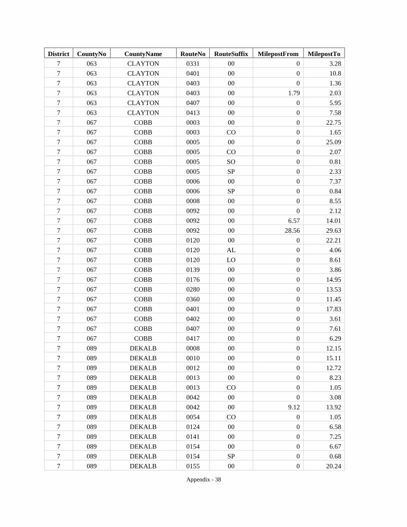
Appendix - 38
District CountyNo CountyName RouteNo RouteSuffix MilepostFrom MilepostTo 7 063 CLAYTON 0331 00 0 3.28 7 063 CLAYTON 0401 00 0 10.8 7 063 CLAYTON 0403 00 0 1.36 7 063 CLAYTON 0403 00 1.79 2.03 7 063 CLAYTON 0407 00 0 5.95 7 063 CLAYTON 0413 00 0 7.58 7 067 COBB 0003 00 0 22.75 7 067 COBB 0003 CO 0 1.65 7 067 COBB 0005 00 0 25.09 7 067 COBB 0005 CO 0 2.07 7 067 COBB 0005 SO 0 0.81 7 067 COBB 0005 SP 0 2.33 7 067 COBB 0006 00 0 7.37 7 067 COBB 0006 SP 0 0.84 7 067 COBB 0008 00 0 8.55 7 067 COBB 0092 00 0 2.12 7 067 COBB 0092 00 6.57 14.01 7 067 COBB 0092 00 28.56 29.63 7 067 COBB 0120 00 0 22.21 7 067 COBB 0120 AL 0 4.06 7 067 COBB 0120 LO 0 8.61 7 067 COBB 0139 00 0 3.86 7 067 COBB 0176 00 0 14.95 7 067 COBB 0280 00 0 13.53 7 067 COBB 0360 00 0 11.45 7 067 COBB 0401 00 0 17.83 7 067 COBB 0402 00 0 3.61 7 067 COBB 0407 00 0 7.61 7 067 COBB 0417 00 0 6.29 7 089 DEKALB 0008 00 0 12.15 7 089 DEKALB 0010 00 0 15.11 7 089 DEKALB 0012 00 0 12.72 7 089 DEKALB 0013 00 0 8.23 7 089 DEKALB 0013 CO 0 1.05 7 089 DEKALB 0042 00 0 3.08 7 089 DEKALB 0042 00 9.12 13.92 7 089 DEKALB 0054 CO 0 1.05 7 089 DEKALB 0124 00 0 6.58 7 089 DEKALB 0141 00 0 7.25 7 089 DEKALB 0154 00 0 6.67 7 089 DEKALB 0154 SP 0 0.68 7 089 DEKALB 0155 00 0 20.24
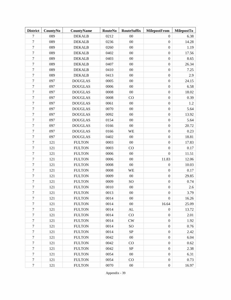
Appendix - 39
District CountyNo CountyName RouteNo RouteSuffix MilepostFrom MilepostTo 7 089 DEKALB 0212 00 0 6.38 7 089 DEKALB 0236 00 0 14.28 7 089 DEKALB 0260 00 0 1.19 7 089 DEKALB 0402 00 0 17.56 7 089 DEKALB 0403 00 0 8.65 7 089 DEKALB 0407 00 0 26.34 7 089 DEKALB 0410 00 0 7.25 7 089 DEKALB 0413 00 0 2.9 7 097 DOUGLAS 0005 00 0 24.15 7 097 DOUGLAS 0006 00 0 6.58 7 097 DOUGLAS 0008 00 0 18.02 7 097 DOUGLAS 0008 CO 0 0.39 7 097 DOUGLAS 0061 00 0 1.2 7 097 DOUGLAS 0070 00 0 5.64 7 097 DOUGLAS 0092 00 0 13.92 7 097 DOUGLAS 0154 00 0 5.64 7 097 DOUGLAS 0166 00 0 20.72 7 097 DOUGLAS 0166 WE 0 0.23 7 097 DOUGLAS 0402 00 0 18.81 7 121 FULTON 0003 00 0 17.83 7 121 FULTON 0003 CO 0 0.17 7 121 FULTON 0006 00 0 11.51 7 121 FULTON 0006 00 11.83 12.06 7 121 FULTON 0008 00 0 10.03 7 121 FULTON 0008 WE 0 0.17 7 121 FULTON 0009 00 0 29.85 7 121 FULTON 0009 SO 0 0.74 7 121 FULTON 0010 00 0 2.6 7 121 FULTON 0013 00 0 3.79 7 121 FULTON 0014 00 0 16.26 7 121 FULTON 0014 00 16.64 25.09 7 121 FULTON 0014 AL 0 13.72 7 121 FULTON 0014 CO 0 2.01 7 121 FULTON 0014 CW 0 1.92 7 121 FULTON 0014 SO 0 0.76 7 121 FULTON 0014 SP 0 2.42 7 121 FULTON 0042 00 0 6.04 7 121 FULTON 0042 CO 0 0.62 7 121 FULTON 0042 SP 0 2.38 7 121 FULTON 0054 00 0 6.31 7 121 FULTON 0054 CO 0 0.73 7 121 FULTON 0070 00 0 16.97

Appendix - 40
District CountyNo CountyName RouteNo RouteSuffix MilepostFrom MilepostTo 7 121 FULTON 0070 00 22.63 33.47 7 121 FULTON 0074 00 0 3.07 7 121 FULTON 0092 00 0 14.2 7 121 FULTON 0092 00 69.88 74.87 7 121 FULTON 0120 00 0 17.25 7 121 FULTON 0138 00 0 8.42 7 121 FULTON 0139 00 0 17.5 7 121 FULTON 0139 SO 0 0.76 7 121 FULTON 0140 00 0 13.83 7 121 FULTON 0141 00 0 2.32 7 121 FULTON 0141 00 15.61 21 7 121 FULTON 0141 CO 0 0.86 7 121 FULTON 0154 00 0 9.9 7 121 FULTON 0154 00 17.13 36.28 7 121 FULTON 0154 CO 0 0.26 7 121 FULTON 0166 00 0 15.06 7 121 FULTON 0236 00 0 1.14 7 121 FULTON 0236 WE 0 0.15 7 121 FULTON 0237 00 0 3.26 7 121 FULTON 0279 00 0 5.76 7 121 FULTON 0280 00 0 4.76 7 121 FULTON 0372 00 0 8.83 7 121 FULTON 0400 00 0 22.51 7 121 FULTON 0401 00 0 17.81 7 121 FULTON 0402 00 0 11.59 7 121 FULTON 0403 00 0 13.39 7 121 FULTON 0403 00 14.75 15.17 7 121 FULTON 0403 00 15.41 31.16 7 121 FULTON 0407 00 0 13.22 7 121 FULTON 0407 00 20.82 26.71 7 121 FULTON 0407 00 53.03 54.69 7 121 FULTON 0407 00 60.62 62.66 7 247 ROCKDALE 0012 00 0 8.58 7 247 ROCKDALE 0020 00 0 17.65 7 247 ROCKDALE 0138 00 0 17.71 7 247 ROCKDALE 0155 00 0 1.85 7 247 ROCKDALE 0162 00 0 2.16 7 247 ROCKDALE 0212 00 0 8.22 7 247 ROCKDALE 0402 00 0 8.58
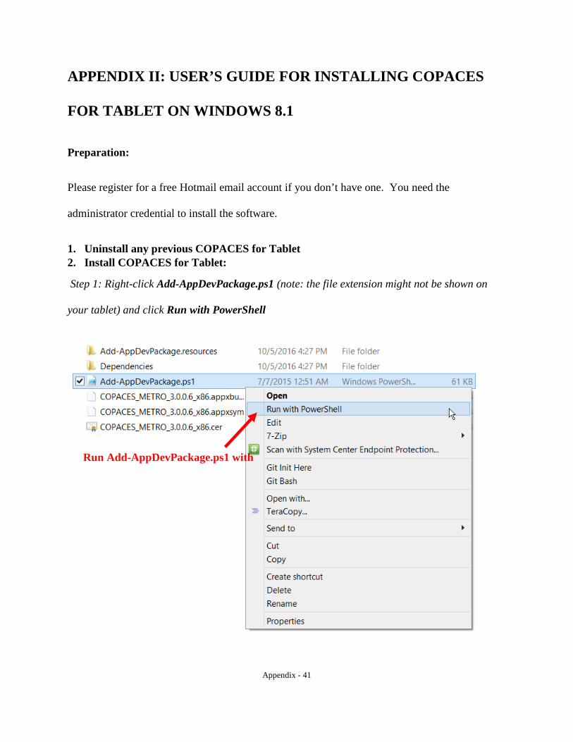
Appendix - 41
APPENDIX II: USER’S GUIDE FOR INSTALLING COPACES
FOR TABLET ON WINDOWS 8.1
Preparation:
Please register for a free Hotmail email account if you don’t have one. You need the
administrator credential to install the software.
1. Uninstall any previous COPACES for Tablet 2. Install COPACES for Tablet:
Step 1: Right-click Add-AppDevPackage.ps1 (note: the file extension might not be shown on
your tablet) and click Run with PowerShell
Run Add-AppDevPackage.ps1 with
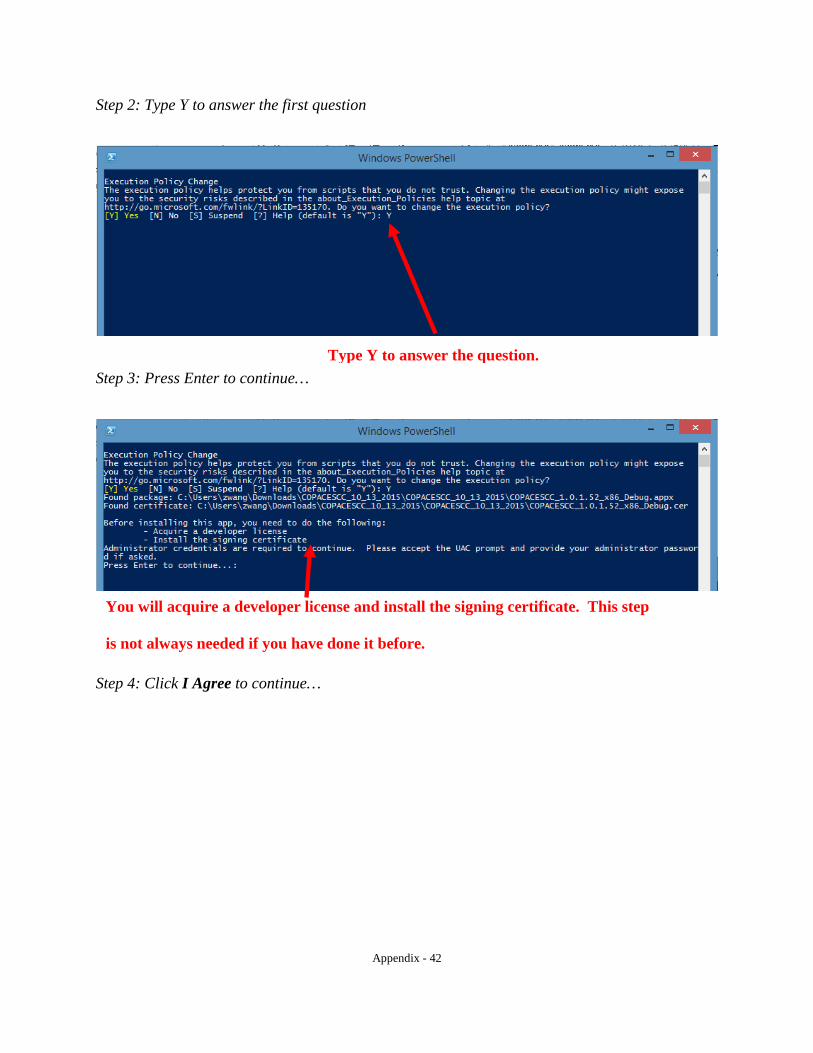
Appendix - 42
Step 2: Type Y to answer the first question
Step 3: Press Enter to continue…
Step 4: Click I Agree to continue…
Type Y to answer the question.
You will acquire a developer license and install the signing certificate. This step
is not always needed if you have done it before.
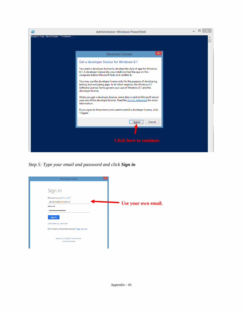
Appendix - 43
Step 5: Type your email and password and click Sign in
Click here to continue.
Use your own email.
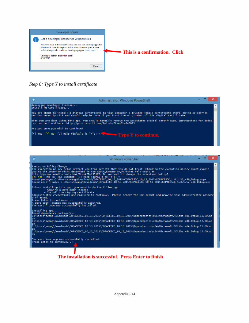
Appendix - 44
Step 6: Type Y to install certificate
This is a confirmation. Click
Type Y to continue.
The installation is successful. Press Enter to finish
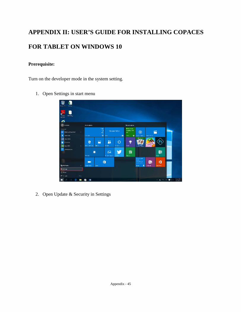
Appendix - 45
APPENDIX II: USER’S GUIDE FOR INSTALLING COPACES
FOR TABLET ON WINDOWS 10
Prerequisite:
Turn on the developer mode in the system setting.
1. Open Settings in start menu
2. Open Update & Security in Settings

Appendix - 46
3. In the “For Developers” section, select “Developer mode.” You will need to click “Yes” in the pop-up dialog window.
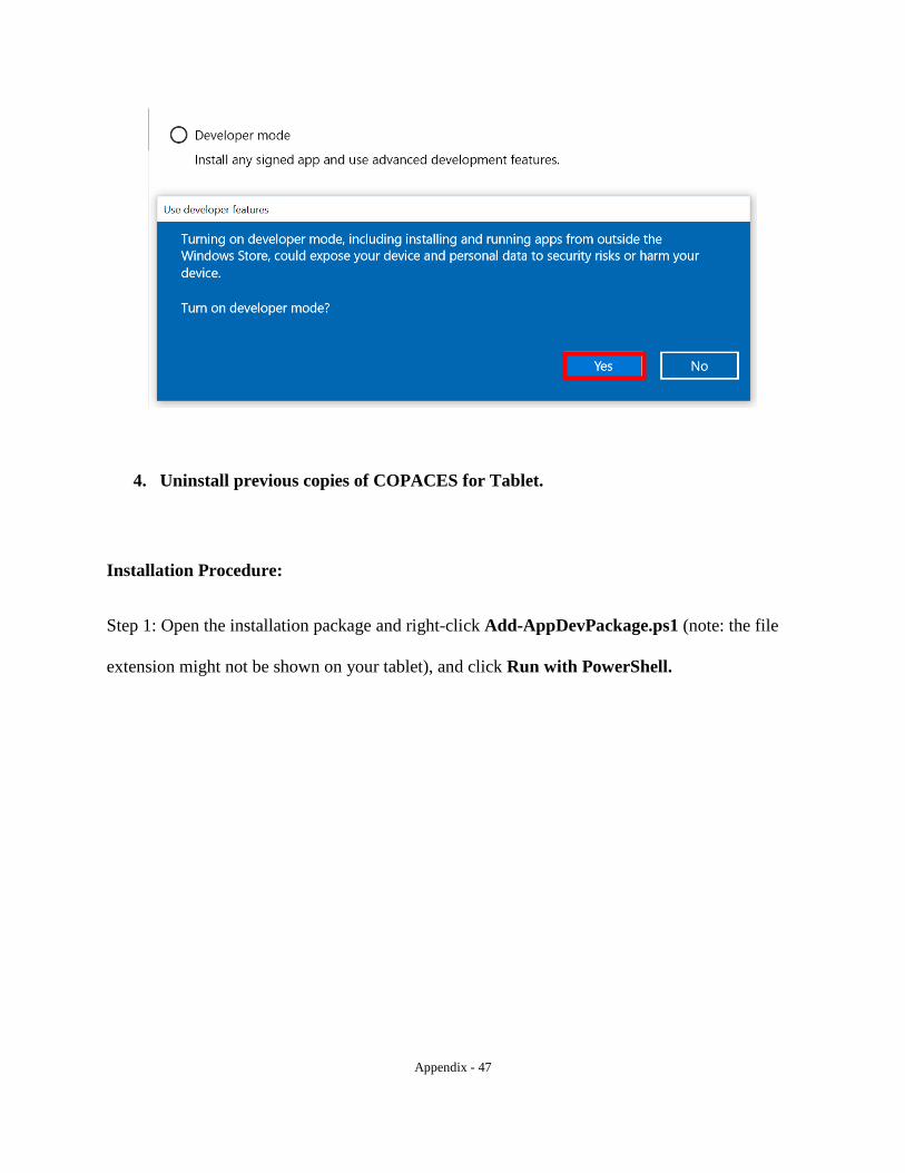
Appendix - 47
4. Uninstall previous copies of COPACES for Tablet.
Installation Procedure:
Step 1: Open the installation package and right-click Add-AppDevPackage.ps1 (note: the file
extension might not be shown on your tablet), and click Run with PowerShell.
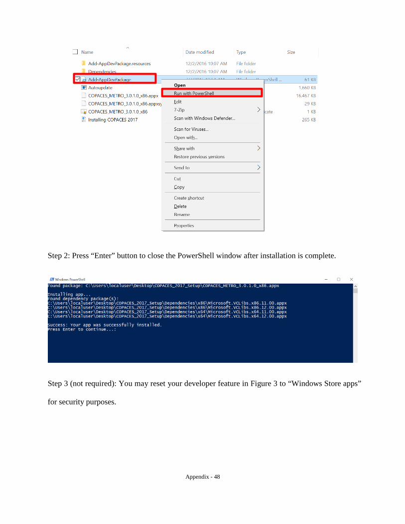
Appendix - 48
Step 2: Press “Enter” button to close the PowerShell window after installation is complete.
Step 3 (not required): You may reset your developer feature in Figure 3 to “Windows Store apps”
for security purposes.