enhancing water-food security and climate r esilience in v
TRANSCRIPT

Enhancing water-food security and climate resilience in volcanic island countries of the Pacific
Part I: Project Information
GEF ID10712
Project TypeFSP
Type of Trust FundGET
CBIT/NGI
CBIT NGI
Project TitleEnhancing water-food security and climate resilience in volcanic island countries of the Pacific
CountriesRegional, Fiji, Solomon Islands, Vanuatu
Agency(ies)FAO
Other Executing Partner(s) Executing Partner TypeSPC (The Pacific Community) and National Agencies Government

GEF Focal AreaInternational Waters
TaxonomyFocal Areas, International Waters, Freshwater, Aquifer, SIDS : Small Island Dev States, Influencing models, Transform policy and regulatory environments,Demonstrate innovative approache, Convene multi-stakeholder alliances, Strengthen institutional capacity and decision-making, Stakeholders, Civil Society, PrivateSector, Individuals/Entrepreneurs, Local Communities, Type of Engagement, Participation, Beneficiaries, Communications, Behavior change, Gender Equality, GenderMainstreaming, Gender-sensitive indicators, Gender results areas, Access to benefits and services, Participation and leadership, Knowledge Generation andExchange, Capacity Development, Awareness Raising, Access and control over natural resources, Integrated Programs, Food Systems, Land Use and Restoration,Landscape Restoration, Capacity, Knowledge and Research, Knowledge Generation, Knowledge Exchange
Rio MarkersClimate Change MitigationClimate Change Mitigation 0
Climate Change AdaptationClimate Change Adaptation 1
Duration60 In Months
Agency Fee($)570,000.00
Submission Date9/28/2020

A. Indicative Focal/Non-Focal Area Elements
Programming Directions Trust Fund GEF Amount($) Co-Fin Amount($)
IW-3-7 GET 6,000,000.00 23,400,000.00
Total Project Cost ($) 6,000,000.00 23,400,000.00
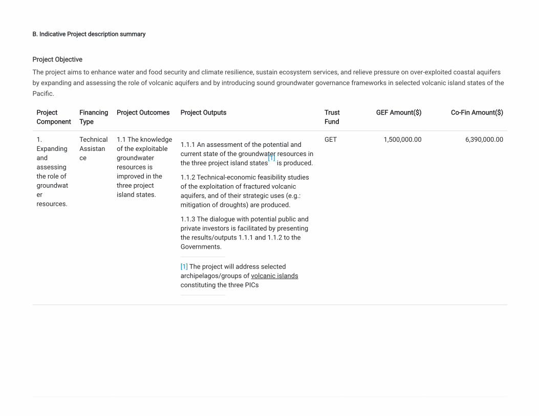
B. Indicative Project description summary
ProjectComponent
FinancingType
Project Outcomes Project Outputs TrustFund
GEF Amount($) Co-Fin Amount($)
1.Expandingandassessingthe role ofgroundwaterresources.
TechnicalAssistance
1.1 The knowledgeof the exploitablegroundwaterresources isimproved in thethree projectisland states.
1.1.1 An assessment of the potential andcurrent state of the groundwater resources inthe three project island states is produced.
1.1.2 Technical-economic feasibility studiesof the exploitation of fractured volcanicaquifers, and of their strategic uses (e.g.:mitigation of droughts) are produced.
1.1.3 The dialogue with potential public andprivate investors is facilitated by presentingthe results/outputs 1.1.1 and 1.1.2 to theGovernments.
[1] The project will address selectedarchipelagos/groups of volcanic islandsconstituting the three PICs
GET 1,500,000.00 6,390,000.00
Project Objective
The project aims to enhance water and food security and climate resilience, sustain ecosystem services, and relieve pressure on over-exploited coastal aquifersby expanding and assessing the role of volcanic aquifers and by introducing sound groundwater governance frameworks in selected volcanic island states of thePacific.
[1]

2.Introducingsoundgroundwatergovernanceframeworks.
TechnicalAssistance
2.1 Soundgroundwatergovernanceframeworks andpolicies areadopted.
2.1.1 Aquifer conceptual models aredeveloped in one selected “primary aquifers”in each of the project country.
2.1.2 Diagnostic analysis of the current statefor each primary aquifer and relevantcatchment area are developed (focusing onquantity-quality issues, climate variability andchange, groundwater uses and users, waternexus conflicts).
2.1.3 Aquifer Management Plans are draftedto complement Catchment Plans, andaddress groundwater issues where they exist.
GET 1,000,000.00 4,260,000.00
3. Tacklinghot-spots.
TechnicalAssistance
3.1 Groundwater isintegrated intoIWRM policies andpractices.
3.1.1 Groundwater and water resourcemonitoring systems to assess the impactsfrom competing groundwater uses and toimprove water resource management areinstalled in selected developed aquifers.
3.1.2 Land use management measures todemonstrate improved environmental andwater resources benefits and management inselected hot-spots are integrated into existingpractice.
3.1.3 Small-scale demonstrations ingroundwater utilization to address water andfood security are trialled in selected hot-spots.
3.1.4 Operational and management plans tohelp coordinate water drilling activities aredeveloped.
GET 2,414,286.00 9,050,000.00

4.Reinforcinginstitutional capacity.
TechnicalAssistance
4.1 Enhancednational capacitiesin groundwaterassessment,monitoring andmanagement.
4.1.1Strengthened capacities of water andland administrators, through training ingroundwater governance and legal aspects,and knowledge exchanges with similarcontexts in small volcanic islands of theMediterranean, the Atlantic, and theCaribbean.
4.1.2 Manuals and products for managinggroundwater in smallholder farming systemsare developed.
4.1.3 Project website and knowledgemanagement platform created.
4.1.4 Contribution to IWLEARN activities,including sharing of results globally focusingon SIDS (by using 1% of the IW funds in fullcoordination with the IWLEARN project).
GET 800,000.00 3,400,000.00
Sub Total ($) 5,714,286.00 23,100,000.00
Project Management Cost (PMC)
GET 285,714.00 300,000.00
Sub Total($) 285,714.00 300,000.00
Total Project Cost($) 6,000,000.00 23,400,000.00
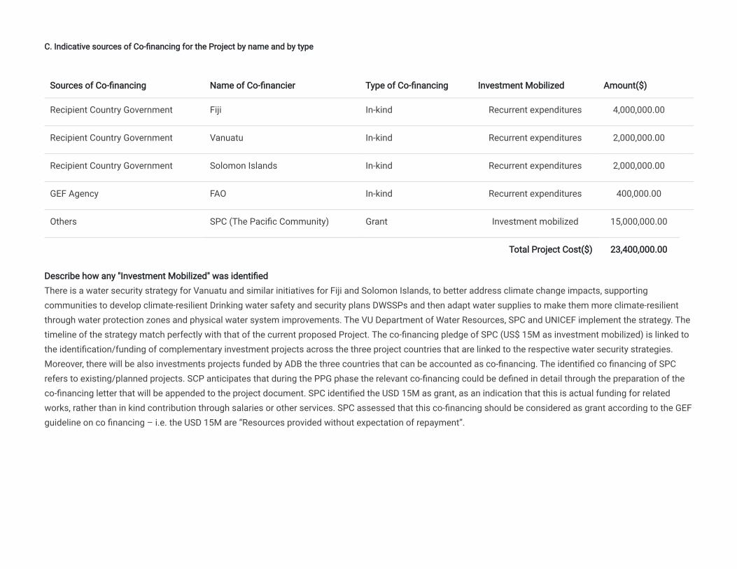
C. Indicative sources of Co-financing for the Project by name and by type
Sources of Co-financing Name of Co-financier Type of Co-financing Investment Mobilized Amount($)
Recipient Country Government Fiji In-kind Recurrent expenditures 4,000,000.00
Recipient Country Government Vanuatu In-kind Recurrent expenditures 2,000,000.00
Recipient Country Government Solomon Islands In-kind Recurrent expenditures 2,000,000.00
GEF Agency FAO In-kind Recurrent expenditures 400,000.00
Others SPC (The Pacific Community) Grant Investment mobilized 15,000,000.00
Total Project Cost($) 23,400,000.00
Describe how any "Investment Mobilized" was identifiedThere is a water security strategy for Vanuatu and similar initiatives for Fiji and Solomon Islands, to better address climate change impacts, supportingcommunities to develop climate-resilient Drinking water safety and security plans DWSSPs and then adapt water supplies to make them more climate-resilientthrough water protection zones and physical water system improvements. The VU Department of Water Resources, SPC and UNICEF implement the strategy. Thetimeline of the strategy match perfectly with that of the current proposed Project. The co-financing pledge of SPC (US$ 15M as investment mobilized) is linked tothe identification/funding of complementary investment projects across the three project countries that are linked to the respective water security strategies.Moreover, there will be also investments projects funded by ADB the three countries that can be accounted as co-financing. The identified co financing of SPCrefers to existing/planned projects. SCP anticipates that during the PPG phase the relevant co-financing could be defined in detail through the preparation of theco-financing letter that will be appended to the project document. SPC identified the USD 15M as grant, as an indication that this is actual funding for relatedworks, rather than in kind contribution through salaries or other services. SPC assessed that this co-financing should be considered as grant according to the GEFguideline on co financing – i.e. the USD 15M are “Resources provided without expectation of repayment”.

D. Indicative Trust Fund Resources Requested by Agency(ies), Country(ies), Focal Area and the Programming of Funds
Agency Trust Fund Country Focal Area Programming of Funds Amount($) Fee($) Total($)
FAO GET Regional International Waters NA 6,000,000 570,000 6,570,000.00
Total GEF Resources($) 6,000,000.00 570,000.00 6,570,000.00

E. Project Preparation Grant (PPG)
Agency Trust Fund Country Focal Area Programming of Funds Amount($) Fee($) Total($)
FAO GET Regional International Waters NA 150,000 14,250 164,250.00
Total Project Costs($) 150,000.00 14,250.00 164,250.00
PPG Required
PPG Amount ($)
150,000
PPG Agency Fee ($)
14,250

Core Indicators
Indicator 4 Area of landscapes under improved practices (hectares; excluding protected areas)
Ha (Expected at PIF)Ha (Expected at CEOEndorsement) Ha (Achieved at MTR) Ha (Achieved at TE)
2722470.00 0.00 0.00 0.00
Indicator 4.1 Area of landscapes under improved management to benefit biodiversity (hectares, qualitative assessment, non-certified)
Ha (Expected at PIF)Ha (Expected at CEOEndorsement) Ha (Achieved at MTR) Ha (Achieved at TE)
Indicator 4.2 Area of landscapes that meets national or international third party certification that incorporates biodiversity considerations (hectares)
Ha (Expected at PIF)Ha (Expected at CEOEndorsement) Ha (Achieved at MTR) Ha (Achieved at TE)

Type/Name of Third Party Certification
Indicator 4.3 Area of landscapes under sustainable land management in production systems
Ha (Expected at PIF)Ha (Expected at CEOEndorsement) Ha (Achieved at MTR) Ha (Achieved at TE)
2,722,470.00
Indicator 4.4 Area of High Conservation Value Forest (HCVF) loss avoided
Ha (Expected at PIF)Ha (Expected at CEOEndorsement) Ha (Achieved at MTR) Ha (Achieved at TE)
Documents (Please upload document(s) that justifies the HCVF)
Title Submitted
Indicator 11 Number of direct beneficiaries disaggregated by gender as co-benefit of GEF investment

Provide additional explanation on targets, other methodologies used, and other focal area specifics (i.e., Aichi targets in BD) including justificationwhere core indicator targets are not providedFor Indicator 4.3 - Area of landscapes under sustainable land management in production systems: The area of landscapes under improved practiceshas been calculated as the total land area of the project’s three target islands. As the specific pilot/hotspot areas are to be determined during PPG (atthe request of the countries) this number may need to be modified at the PPG stage.
Number (Expected atPIF)
Number (Expected at CEOEndorsement) Number (Achieved at MTR) Number (Achieved at TE)
Female 541,161
Male 563,103
Total 1104264 0 0 0

Part II. Project Justification
1a. Project Description
Background and context
The over 30,000 small islands of the Pacific vary greatly in their geological and geomorphological characteristics, as they include “high” mountainous volcanicand mixed lithology islands, and “low lying” atoll islands and uplifted limestone islands. High islands are larger, consisting mainly of volcanic rocks andgenerally forested with fertile soil and usually good availability of freshwater. In contrast, the low islands are small with limited freshwater resources and poorsoil. Of the 18 Pacific Island Countries and Territories (PICTs) five are in Melanesia, seven are in Polynesia and six are in Micronesia. The Melanesian countries(Fiji, New Caledonia, Papua New Guinea, Solomon Islands and Vanuatu) are extensions or parts of uplifted submerged ranges. The Polynesian andMicronesian islands are made up of archipelagos or groups of small islands consisting of a mixture of volcanic islands and small coral atoll islands (Samoa,Cook Islands, Federated States of Micronesia, French Polynesia, Guam, Palau, Samoa and Tonga) or consist only of atolls (Kiribati, Marshall Islands andTuvalu) or of small uplifted limestone islands which are the only non- archipelagic countries in the Pacific (Nauru, Niue).
Volcanic Pacific Island Countries (PICs) are generally characterized by heavy dependence on traditional agriculture, i.e.: subsistence smallholder systems, andsuffer from environmental degradation with often devastating effects, determining structural constraints for economic growth, human development andenvironmental sustainability. At the same time, these PICs possess unique characteristics that further exacerbate the problems associated withenvironmental degradation, given the small size of the countries (in terms of both physical area and economy), limited infrastructure, distance from largeinternational markets, high vulnerability to natural disasters, low level of human resource development, increasing urbanization, and vulnerable freshwaterresources. Small size - combined with diverse soil types, topography, climatic hazards, lack or in some cases archaic water and land use policies - limits thearea available for urban settlement, agriculture, mining, commercial forestry, tourism and other infrastructure, and creates intense competition between waterand land use options. Degradation has increased in the last 30 years largely due to the following main factors:
· Environmental: growing rainfall variability and frequency of extreme climatic extremes, sea level rise (SLR), decreasing water quality and quantity, limitedaccess to water, sanitation and hygiene (WASH) services.
· Economic: market forces, trade agreements, structural adjustments, national economic and land use policies, land and water tenure policies.
· Social: population dynamics and growth, urbanization, immigration, cultural changes and nutritional transitions.
More specifically, degradation is caused by deforestation and unsustainable land and water use, uncontrolled livestock grazing on fragile lands and poorlyplanned settlements in environmental and geohazard-sensitive areas. Annually, large amounts of valuable top-soil are eroded and washed into rivers and outto sea during heavy rains, severely damaging coastal ecosystems and coral reefs. Over time, the productivity of land for agriculture is being lost, in addition tothe productivity of coral reefs as they become blanketed by silt. This threatens food security as well as economic stability particularly on the islands withtourism-based economies (such as Fiji and Vanuatu). Siltation of rivers increases the flood risk in low-lying areas with loss of agricultural productivity. Droughtis a major natural hazard all PICs are facing, with agricultural drought presenting a particular problem for the leeward side of larger islands.

Alongside land resources, the economic and social well-being of volcanic Pacific small island countries are dependent upon the quality and quantity of theirfreshwater resources. However, the ability of small island countries to effectively develop and manage their water sectors is often constrained by their smallsize and limited human resource base. In many island countries, factors such as increasing demand for water, rainfall variability, storm water runoff,inadequate sanitation and waste disposal, threaten economic development and human health.
Groundwater, an important freshwater source in all PICs, is particularly abundant in volcanic islands (see Figure 1). Contrary to low lying islands wheregroundwater is only present in the form of highly vulnerable freshwater lenses floating over seawater, volcanic islands present a variety of aquifer types(coastal volcano-sedimentary, shallow and deep fractured volcanic). Exploitation of groundwater is however essentially concentrated along the more denselypopulated coastal areas, targeting highly vulnerable coastal aquifers. As well as direct infiltration, recharge of these coastal aquifers can take place at higherelevations in the volcanic edifices, where rainwater infiltrates fractured volcanic rocks, and the deep-reaching vertical faulting that characterize volcanicbodies. Recharge – albeit in principle abundant - is however being reduced by increasing runoff due to climatic factors and to deforestation with consequentsoil erosion. Soil erosion and increased sediment load in rivers result from human activities such as large scale clearing from mining and logging activities, aswell as impacts from traditional subsistence slash and burn farming, increasing urban development and residential housing. The principal threats to coastalgroundwater derive from contamination - sewage (poor sanitation), urban runoff, agro-chemicals and solid waste – and salinization due to bothoverexploitation and seawater intrusion. Groundwater quality was indeed identified in the 1997 Strategic Action Programme for International Waters of PacificIslands as being in particular risk because its loss or degradation is often irreversible. Another important threat to coastal aquifers and to soil productivity isthe increasing frequency and intensity of ‘wave-overtopping events’.
Water security: defined as “the availability of an acceptable quantity and quality of water for health, livelihoods,ecosystems and production, coupled with an acceptable level of water-related risks to people, environments and economies”. Water insecurity is perceived when it impairs human and environmental well-being, economic development, leading to often difficult cross-sector trade-offs.
Food security: defined as “all people, at all times have physical, social, and economic access to sufficient, safe,and nutritious food that meets their food preferences and dietary needs for an active and healthy life. Nutrition-sensitive approaches include improving access to land and to clean water resources and improved sanitation facilities; supporting the participation of vulnerable groups, including women, in policy and governance processes.
Climate resilience: defined as the capacity for a socio-ecological system to absorb stresses and maintain function in the face of external stresses imposed upon it by climate change and adapt, reorganize, and evolve into more desirable configurations that improve the sustainability of the system, leaving it better prepared for future climate change impacts.
Figure 1:

Volcanic islands are assumed to have a basal principal fractured aquifer with high potential productivity. This basal aquifer may be accessed directly by drilling through the volcanic hard rock, or via aquifers within volcanic sedimentary sequences fed by the basal aquifer. Extraction may also occur from other volcanic/sedimentary aquifers which are not connected to the basal aquifer. These sources of groundwater have in general not been assessed.
Severe droughts associated with ENSO can negatively impact food security, public health, and the economy. ENSO-driven droughts are commonplace in thePacific. Small rainwater storages and a reliance on water sources that have limited resilience can impact large portions of the population resulting in suddenwater shortages. During and after the historic 1997-1998 El Niño event, “severe drought” similarly impacted islands across the western Pacific. In 2015, thePacific Humanitarian Team estimated that ENSO-related droughts will place as many as 4.7 million people at risk in 13 countries (PNG, Fiji, Tonga, Palau,Vanuatu, Solomon Islands, New Caledonia, Tokelau, Samoa, Niue, Cook Islands, Marshall Islands, Federated States of Micronesia). This includes 2.4 millionpeople in PNG and the total populations of the remaining affected Pacific nations.
Floods are a significant hazard in volcanic Pacific Island countries, which are subjected to extreme precipitation intensities. Floods can result in loss of lifeand extensive property damage, especially when river floodplains have been settled and/or cultivated. In cyclone conditions the effects of floods are oftenexacerbated by high-intensity rain induced landslide and resulting debris which can obstruct river channels and create potentially hazardous temporary dams.In most situations the practical approach to managing flood hazard is to manage the landuse in those areas subject to flooding. Increasing flood hazard may

result if landuse controls are poorly enforced and these areas are allowed to become informal settlements. Landuse in river catchments (e.g. forestry,agriculture) can also have a significant effect on flooding risk. This range of factors points to the desirability of the full implementation of Integrated WaterResources Management concepts to assist with hazard management. As with the hazard of drought, it is possible to take advantage of flood warnings insome situations. Flood warning systems require near real-time data on precipitation rates and/or upstream water levels or flows. In the relatively small andsteep catchments encountered in Pacific Island countries telemetry systems are likely to be necessary to provide for timely flood warnings.
In conclusion, within the context of high volcanic PICs most aspects of water and food security are directly dependent on, and influenced by, the planning andutilization of land and freshwater resources along the ‘source to sea’ or ‘ridge to reef’ continuum. Ensuring the sustainability of groundwater supply isparamount for sustaining socio-economic development (including rural and agriculture-dependent livelihoods), enhancing resilience to climate change - one ofthe most severe developmental challenges facing all SIDS - and ensuring food security. Threats to food security for PICs are made even more urgent by thehigh transport costs of imported food due to the remoteness and reliance on sea freight. The ability to grow food to both support local consumption andexport markets requires resilience in the food sector through sustainable groundwater use and management. Similarly, groundwater discharge from volcanicaquifers as springs and baseflow is critical to maintain stream flow, and support the rich diversity of environmental services associated with these lanscapes.Better understanding of these natural assets, and their economic, social, and environmental importance, will be important in the future sustainabledevelopment of these groundwater resources.
Policy framework
The Boe Declaration on Regional Security signed at the Pacific Islands Forum in 2018, states that ‘climate change remains the single greatest threat to thelivelihoods, security and wellbeing of the peoples of the Pacific’. This was reiterated at the 2019 Pacific Islands Forum in the Kainaki II Statement where‘Leaders noted that escalating climate change impact is exacerbating the region’s vulnerabilities, weakening water security to a greater extent than foodsecurity’.
The Global Action Programme on Food Security and Nutrition in Small Island Developing States (GAP) is a tangible follow-up to the 2014 “SIDS AcceleratedModalities of Action (SAMOA) Pathway”, which highlights the need to ensure the sustainable management of the water resources required to promote the useof sustainable practices relating to agriculture, crops, livestock, forestry, fisheries and aquaculture to improve food and nutrition security in SIDS - and isaligned with the 2030 Agenda Sustainable Development and other internationally agreed frameworks for sustainable development.
PICs are experiencing particular constraints in meeting their SDG targets, as noted in the Mid-Term Review of the SAMOA Pathway, which calls for greaterinternational support and a “coherent and coordinated approach” from the international community to address persistent challenges faced by SIDS, includingdisproportionately high burdens of food/water insecurity, malnutrition, and Non-Communicable Diseases.
The Pacific Food and Nutrition Framework recognizes progress made under the Framework for Action on Food Security in the Pacific: Towards a Food SecurePacific (2011-2015) and aligns with relevant regional strategies and action plans, including the WHO Action Plan to Reduce the Double Burden of Malnutritionin the Western Pacific Region (2015-2020), WHO Western Pacific Regional Action Plan for the Prevention and Control of Non Communicable Diseases (2014-2020), NCD Roadmap (World Bank, 2014), Framework for Resilient Development in the Pacific (SPC, SPREP, PIFS, UNDP, UNISDR and USP, 2016), A New Songfor Coastal Fisheries (SPC, 2015), and United Nations Pacific Strategy 2018-2022. Other relevant strategies and initiatives include the Inter-Regional Initiativeon SIDS of the Food and Agriculture Organization.
1. Relevant GEF investments in Pacific SIDS

The conclusions and final recommendations of the GEF/UNEP project “Assessment of the groundwater systems of Small Island Developing States” – part ofthe larger “Transboundary Waters Assessment Program - TWAP” – published in 2016, highlighted the importance, and the fragility, of groundwater resourcesof small island states, in particular those of the Pacific:
“On many small islands, groundwater abstraction only occurs within small, thin, alluvial (or carbonate) aquifers along the coastlines. In many cases, theseaquifers may constitute the main groundwater supply for the island, as accessing the groundwater contained within more complex, albeit possibly highlyproductive, fractured volcanic formations at higher elevations poses significant challenge. ……The situation that emerges from this analysis calls forimmediate attention. In the absence of coordinated, sustained remedial national and international action, low-lying islands in the Pacific, highly dependent onscarce, polluted and growingly saline groundwater resources and impacted by climatic variability and change, face dramatic choices. In many mountainous islands, degradation of groundwater quality and growing demands are posing short-medium term threats to human health, and impairing the provision ofecosystem services of great economic relevance.”
The involvement of the GEF International Waters Focal Area in the protection of the freshwater resources of Pacific SIDS had started in 2000, many yearsbefore the TWAP assessment, with the approval of the project “Implementation of the Strategic Action Programme (SAP) of the Pacific Small IslandDeveloping States”[1], completed in 2005. The SAP addressed issues of concern related to both freshwater and coastal and oceanic living marine resources,and promoted integrated water and coastal resources management, and the ecosystem approach to fisheries. The SAP identified priority concerns including1) pollution, 2) longterm sustainable use of freshwater resources, 3) physical, ecological, and hydrological modification of critical habitats, 4) unsustainableexploitation of non-living resources. The root causes which threaten water resources, identified in the SAP, included deficiencies in management specificallywith regards to governance and understanding. The initial SAP project included the 14 PICs, Cook Islands, Federated States of Micronesia, Fiji, Kiribati,Marshall Islands, Nauru, Niue , Palau, Papua New Guinea, Samoa, Solomon Islands, Tonga,Tuvalu, and Vanutau. This project will continue this support withfocused investment in Fiji, Solomon Islands and Vanuatu to further strengthen the earlier investments from GEF under SAP, IWRM (GEF ID 2586), and R2R.
This SAP was the starting point and guiding framework of a long-lasting commitment of the GEF IW to Pacific SIDS - the “sentinels” of the global environment -which brought about a number of achievements, particularly in the field of IWRM, fisheries management and habitat protection through a series of regionalprojects and programs involving all 14 SIDS members of the GEF, and, more recently, projects targeting selected islands (see Table 1). One of these recentlyapproved projects (2018), responds to the TWAP recommendations being the first one with main focus on groundwater. It targets Palau, the Marshall Islands,and Tuvalu, all low-lying atolls exclusively relying on their fragile freshwater lenses.
In response to the request of Fiji, Solomon Islands, and Vanuatu – PICs characterized by the high percentage (> 80%) of population living in volcanic islands,and by the elevated number of households relying on agriculture - the present project expands GEF IW action in the Pacific by targeting for the first time thegroundwater resources contained in volcanic aquifers - less impacted by climatic variability and SLR. The present project will focus on addressing the SAPidentified root cause of management of groundwater resources in a high volcanic islands setting. Both governance and understanding will be strengthenedwith project support to establish governance framework mechanisms, which consider environmental, and social – economic considerations as well astechniques to provide evidenced based information for improved impact assessment, groundwater abstraction and allocation determination, and aquiferpotential. The project is designed to address the SAP identified root cause of management deficiencies, - with the aim of enhancing water-food security andresilience to climate change, in the three countries, whileand acknowledging the role of groundwater in sustaining environmental and spring flows, andto setan example for other volcanic or complex geology islands to follow.
Table 1: Previous and ongoing relevant GEF IW support to PICs 2015

Project Title
Countries Objective GEF ID GEFTF IA - EA Status
Implementation of the Pacific Islands Developing States SAP
Regional
(14 PICs)
In its first IW project with the PICs, GEF provided support for the process of discussions and negotiation between Pacific SIDSs, other coastal states of the Westernand Central Pacific Ocean (including Indonesia and the Philippines) and fishing states, on a new regional arrangement for the conservation, management and sustainable development of transboundary stocks of highly migratoryspecies and related species. Thefinal text of the Convention wasagreed in August 2001
530 $12m UNDP
SPREP
Completed
2005
Implementing Sustainable Integrated Water Resources and Wastewater Management in PICs (PAS)
Regional(14 PICs)
To improve water resources management and water use efficiency in Pacific Island Countries in order to balance overuse and conflicting uses of scarce freshwaterresources through policy and legislative reform and implementation of applicable and effective Integrated Water Resources Management (IWRM) and Water Use Efficiency (WUE) plans.
2586 $9m UNDP/UNEP
SOPAC
Completed2017
Ridge to Reef: Testing the Integration of Water, Land,Forest & CoastalManagement to Preserve Ecosystem Services, StoreCarbon, ImproveClimate Resilienc
Regional(14 PICs)
To test the mainstreaming of ‘ridge-to-reef’ (R2R), climate resilient approaches to integrated land,water, forest and coastal management in the PICs through strategic planning, capacity building and piloted local actions to sustain livelihoods and preserve ecosystem services
5404 $10.3m UNDP
SPC
Approved 2015
e and Sustain Livelihoods in Pacific Island Countries
The GEF’s work in land degradation has emphasized the need to take an integrated approach to sustainable land management while ensuring thesustainability of livelihoods. The projects on land degradation including land use planning have been financed not only from the Land Degradation Focal area,but also from the Biodiversity and Climate Change Adaptation areas. The GEF has now expanded this approach to include the United Nations Convention toCombat Desertification’s guiding principle of land degradation neutrality, defined as: “a state whereby the amount and quality of land resources necessary tosupport ecosystem function and services and enhance food security remain stable or increase within specified temporal and spatial scales and ecosystems”.GEF support to SIDS has evolved in the same way, seeking to ultimately halt and reverse land degradation, restore degraded ecosystems, and sustainablymanage resources. Sustainable land management with soil and water conservation is often combined with reduced use of pesticides and industrial fertilizers—or even organic production, thereby giving health benefits to the population while protecting biodiversity. Land degradation financing to SIDS in previousreplenishments has included single country-based projects and support to a global initiative where 15 SIDS identified land degradation neutrality baselines anddefined national land degradation neutrality targets.
2) Baseline scenario
Fiji
Fiji is an archipelago of more than 330 islands, 110 of which are permanently inhabited, and more than 500 islets, amounting to a total land area of about18,300 square kilometres. The climate in Fiji is tropical marine and warm year-round with minimal extremes.
Groundwater investigation in Fiji started in late 1960 in response to request from villages for sources of water. First drilling for groundwater boreholes wasconducted in 1971 – 1973 targeting the Nadi coastal aquifer. From 1978 – 1980 through British technical cooperation the development of the groundwaterbased Nadi – Lautoka water supply was further implemented. The Hydrogeology Unit of the Mineral Resources Department (MRD) is responsible for thegroundwater resources of the nation; including its monitoring and protection from over-extraction and contamination, playing a critical role in the developmentof the nation’s economy. MRD is responsible for providing an alternative water supply to all Fiji, especially to the disadvantaged communities living in remoteareas. In total there are more than 800 boreholes archived at MRD, and 20 – 30 strategic sites are regularly monitored. A Hydrometric survey is carried out ona monthly basis on selected boreholes to monitor fluctuations of groundwater levels associated with aquifer recharge through rainfall, evaporation rates,geology and vegetation types. Monitoring of groundwater levels is mainly carried out in areas where groundwater is used for public water supplies and areasprone to depletion due to over-pumping or contamination from underlying poor-quality water. The government has a mandate to monitor and manage thewater resources of Fiji sustainably. Monitoring data is used for the development of the “Draft Groundwater Resources Exploitation Policy” and “National WaterResources and Sanitation Policy” and hydrogeological reports. A groundwater monitoring report is developed every 5 years to consolidate all groundwaterdata and integrate groundwater and surface water data into a basin catchment analysis. Groundwater data are stored in a database that consists ofpackages to store water levels, electrical conductivity, temperate, water quality parameters (Cations & Anions). GIS software is used to assist in data analysis.
In Fiji there is currently no control, or licencing, of water well drilling in the private sector. The government does not maintain records on the private drillingcompanies, or a registry of bores drilled, and permits for groundwater exploration does not exist, which can result in issues over standardization of drillingtechniques and completion of boreholes. Ownership of groundwater remains doubtful as the law is unclear. As a consequence, conflicts arise between local

bottled water companies and other groundwater users.
Regular groundwater monitoring is hindered by difficult access to outer islands and extreme weather events. Lack of equipment able to transmit monitoringdata in real time is also limiting the collection of data. Ideally, telemetric monitoring systems would be implemented in Fiji.
Table 2 – Results of previous GEF IW investments in Fiji
Issues identifiedprior to IWRM project
· Vulnerability to floods and droughts.
· Water quality deterioration due to catchment development, forestry, agriculture, and the growth of urban areas.
· Commercial use of water and competition for resources, conflicting use of rivers and other sources, impacts of upstream industries on catchment areas and landowner demands are on the increase and current legislative instruments that are in urgent need of revision and updating.
· Responsibility for water resources is shared between Ministries and Departments based on the different uses and users of water.
· Although the National Water Committee has been established there needs to be a higher level coordinating mechanism that has the authority to support the development of water resource strategies and policies.
· Nadi Basin identified as the most urgent hotspot due to its vulnerability to flooding.
IWRM project results
· Establishment of the Nadi Basin Catchment Committee.
· Nadi Basin Integrated Flood Management Plan.
· Biophyisical survey of Nadi Basin catchment conducted.
· Construction of flood mitigation structures (retention dams).
Issues identifiedprior to R2R Program
· Capacity for watershed assessment, mapping, planning needs to be strengthened.
· Stress on vulnerable freshwater resources to be reduced through the development andimplementation of watershed management plans and the development of the enablingenvironment for the replication and scaling-up of best practices in watershed management planning.
R2R Program goals and results(still ongoing)
· Inter-ministerial Committee established.
· Development and adoption of a Waimanu River Integrated Watershed Management Plan.
· Priority measures identified and agreed for watershed management.
y g g
· Strengthening capacity for watershed assessment, mapping and planning.
· Reducing environmental stress targets on municipal waste and aquifer pollution, terrestrial and wetland habitats, catchment protection measures by implementation of priority measures and best practices reflected in the Watershed Management Plan.
· Developing the enabling environment for the replication and scaling-up of best practices in watershed management as set out in the Watershed Management Plan.
As shown in the table, focus of both IW projects is on introducing IWRM policies and practices, and on an intersectoral approach in the management of thetwo main river basins of Viti Levu, Nadi - severely impacted by recurring flood events - and Waimanu. While this work has been successful in building a soundknowledge and policy framework for surface waters and dependent ecosystems, groundwater resources, in spite of being a major source of high qualityfreshwater and of income (export of bottled water), have been only marginally addressed, both in terms of assessments and of governance.
Solomon Islands
Solomon Islands is a sovereign country consisting of six major islands and over 900 smaller islands. The country lies to the east of Papua New Guinea andnorthwest of Vanuatu and covers a land area of 28,400 square kilometres. The islands' ocean-equatorial climate is extremely humid throughout the year, witha mean temperature of 26.5 °C and few extremes of temperature or weather. The major islands are Guadalcanal (5 120 km²) where the capital Honiara islocated, Malaita (4 310 km²), Makira (San Cristobal) (3 190 km²), Santa Isabel (3 000 km²), Choiseul (2 970 km²) and New Georgia (2 037 km²). These islandsvary in length from 145 to 190 km and in width from 35 to 50 km.
Drinking and household use in both rural villages and in urban centres account for the largest water withdrawal in the country. There is limited agriculturalwater demand because most crops are rainfed. The industrial sector withdraws water for fish processing cannery, palm oil factory, mining operations andsome small manufacturing industries. Although the demands for industry are still relatively small there is considerable potential for future growth. On thelarger islands, surface water in the form of streams, springs or rivers is the main source of drinking water. Some communities on the higher volcanic islandsalso use groundwater for domestic purposes. The major users of groundwater resources (coastal aquifers) are the capital city Honiara and the GuadalcanalPlains. Approximately 20-30 percent of Honiara water supply is sourced from groundwater. Linked to recent volcanic activity, geothermal energy contained ingroundwater could be economically exploited both for direct uses of the heat (e.g: cold storage of agricultural products), and for electricity production.
In the Solomon Islands there are three different ministries taking care of water regulation aspects. The Solomon Islands Environment Act 1998 mandates thatpollution of the environment must be prevented and minimized. The Act regulates permits to discharge treated wastewater to the environment (Ministry ofEnvironment, Climate Change, Disaster Management and Meteorology). The River Waters Act 1969 for surface waters only regulates extraction from riversthrough a permit (Water Resource Division). The Environmental Health Act 1996 regulates activities to prevent pollution of water systems from resident andcommercial activities (Ministry of Health & Medical Services). However, there are no clear mandates under these Acts to collect groundwater data.Furthermore, groundwater extraction is not regulated.
Groundwater monitoring is currently needs-driven and limited to locations where logistics and issues are anticipated. Efforts are currently planned to expandgroundwater monitoring to more locations in the Solomon Islands. Parameters measured are water levels, temperature and electrical conductivity.Groundwater assessments and aquifer mapping in the Solomon Islands are needed to allow the sustainable managment of this potentially large resource, and

the effective monitoring of mining activities, groundwater pumping, and seawater intrusion. Mining activities can result in groundwater contamination in theform of heavy metals (e.g. arsenic, cyanide). Production boreholes which are drilled within residential areas can face contamination threats from septicsystems. Coastal aquifers can face salinity problems due to storm surges and sea level rise. Sea level rise, residential development and mining have beenidentified as the future threats to groundwater quality.
Table 3 – Results of previous GEF IW investments in the Solomon Islands
Issues identifiedprior to IWRM project
· Improper development practices such as logging and the traditional slash-and-burn method of farming have gradually destroyed the quality and capacity of rivers and streams.
· Threats to coastal aquifers due to human activities, saltwater intrusion, and sea level rise.
· High pumping costs associated to supplementing water supply with groundwater.
· Land tenure system (customary-owned) can cause complications in development (e.g.water resources are tied to land).
· Need for basic information for water resources assessment and protection.
· Integrated planning and management of watersheds and coastal areas is required.
· Water demand and supply management and provision of water treatment.
IWRM project results
· Produced a draft IWRM Policy and Plan, under a concurrent funding, and resulting in aNational WATSAN Policy and accompanying Implementation Plan prepared for government endorsement. This was a nationally implemented policy with lessons learnt from theproject.
· In terms of demand management, the project resulted in the reduction of water leakages and installation of water meters, both for supply mains and consumers, to monitor flow and non-revenue water at one the highest leakage areas of Honiara.
· Formulation of the Honiara Water Safety Plan after consultations, training and assessments of sources to consumers’ aspects of Honiara’s 5 main water sources.
· Formulation of Kovi/Kongulai Catchment Management Plan to support water resources conservation and developments in the catchment.
· Awareness raising on the IWRM approach to managing water supply for Honiara.
Issues identifiedprior to R2R Program
· Lacking monitoring programme for pollution and nutrients entering the Honiara Adjacent Coastal water.
· Identification of pollution sources and environmental impact.
· Lack of institutional and Civil Society awareness and capacity outreach.
R2R Program results
· Joint inter-ministerial Committee established in 2017.
· Functional technical committee comprised of Honiara City Council (HCC), Water Resources Division (Mines and Energy), Environment and Conservation Division (MECDM), National Public Health Lab (MHMS), Environment Health Division (MHMS), Ministry of Lands and housing, Solomon Islands National University (SINU).
· Site mapping and water and sediment quality monitoring program established along the Mataniko River and at the adjacent coastal sites.
Likewise in Fiji, previous IW work in the Solomon Islands has concentrated on introducing IWRM policies for basin management, with focus on the main islandof Guadalcanal, on expanding the scope of basin managment to the coastal areas and ecosystems, and on promoting a multi-sectoral approach to watermanagement. The specificities, potentialities and governance of groundwater have so far received little attention.
Vanuatu
Vanuatu is a country composed of about 80 islands of which only 65 are inhabited. The country has total area of 12 190 km. Only 12 islands are consideredsignificant in terms of their economy and population. The largest are Santo in Sanma province (4 010 km2), Malekula in Malampa province (2 069 km2), Efatein Shefa province (980 km2), and Erromango in Tafea province (975 km2). The capital city is Port Vila and is located on Efate island. Main islands are eithermountainous or steeply undulating, covered by tropical forest. The highest peak in the country, located on Santo island, is Mount Tabwemasana at 1 879 m.The climate is tropical, with about nine months of warm to hot rainy weather and the possibility of cyclones and three to four months of cooler, drier weathercharacterised by winds from the southeast. The distribution of water in the country varies with the topography of the island. The high raised volcanic islandshave rivers and streams and groundwater. Despite the high precipitation in the country, most of its territory does not have perennial streams, because of theislands size and rugged topography. River courses are short and the flows are short lived especially in dry periods. The only exception is on the main islandsnamely Efate, Malekula, Espiritu Santo and Pentecost. Vanuatu is ranked as the most vulnerable country globally to natural disasters, including droughts,floods, cyclones, earthquakes and volcanic activity, all which can impact on water and food security.
It is estimated that in many parts of Vanuatu there are substantial amounts of groundwater even during severe drought periods. In Vanuatu, both surfacewater and groundwater are used for domestic purposes. In urban areas the main water source are shallow coastal aquifers whereas in rural areas varioussources are used such as dug wells, springs, rivers and rainwater catchments. The urban and rural tourism industry is serviced by the same water supplies asdomestic users. Tourism is a fast growing sector, with resort development occurring across Vanuatu, while industry is not significantly developed.
The Department of Water Resources under the Ministry of Lands and Natural Resources has the overall responsibility to ensure the sustainable use of thenation’s water resources as mandated through the water resources management act and water supply act. The Water Resources Management team isresponsible for the monitoring, management and protection of groundwater and surface water resources. The DoWR has only 4 monitoring locations withinthe Tagabe catchment area (Port Vila), including 3 monitoring wells, and one production borehole. Overall, a general declining trend in groundwater levels hasbeen recorded. A similar trend is being observed in the river flows along that path of the river. Data records are incomplete and time frames monitored at eachlocation are highly variable. In general, there appears to be a cessation in monitoring between 2007 and 2014.
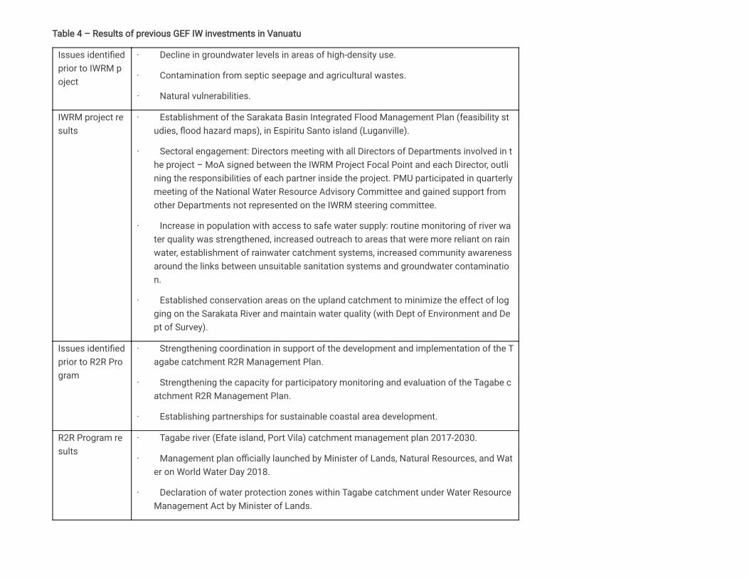
Table 4 – Results of previous GEF IW investments in Vanuatu
Issues identifiedprior to IWRM poject
· Decline in groundwater levels in areas of high-density use.
· Contamination from septic seepage and agricultural wastes.
· Natural vulnerabilities.
IWRM project results
· Establishment of the Sarakata Basin Integrated Flood Management Plan (feasibility studies, flood hazard maps), in Espiritu Santo island (Luganville).
· Sectoral engagement: Directors meeting with all Directors of Departments involved in the project – MoA signed between the IWRM Project Focal Point and each Director, outlining the responsibilities of each partner inside the project. PMU participated in quarterlymeeting of the National Water Resource Advisory Committee and gained support fromother Departments not represented on the IWRM steering committee.
· Increase in population with access to safe water supply: routine monitoring of river water quality was strengthened, increased outreach to areas that were more reliant on rainwater, establishment of rainwater catchment systems, increased community awarenessaround the links between unsuitable sanitation systems and groundwater contamination.
· Established conservation areas on the upland catchment to minimize the effect of logging on the Sarakata River and maintain water quality (with Dept of Environment and Dept of Survey).
Issues identifiedprior to R2R Program
· Strengthening coordination in support of the development and implementation of the Tagabe catchment R2R Management Plan.
· Strengthening the capacity for participatory monitoring and evaluation of the Tagabe catchment R2R Management Plan.
· Establishing partnerships for sustainable coastal area development.
R2R Program results
· Tagabe river (Efate island, Port Vila) catchment management plan 2017-2030.
· Management plan officially launched by Minister of Lands, Natural Resources, and Water on World Water Day 2018.
· Declaration of water protection zones within Tagabe catchment under Water ResourceManagement Act by Minister of Lands.

GEF IW investments in Vanuatu have been concentrated on the the two most critical basins supplying water to the main urban centers of Luganville and PortVila, to protect the quality and quantity of the catchments waters as the only current water source for both urban centers and the nearby settlements, and tocreate a sustainable multi-purpose land use management water catchment model to be replicated in other watersheds in Vanuatu. The groundwaterresources of these basins, as well as of the whole islands of Efate and Espiritu Santo, have not however been fully assessed, likewise the broader aspects ofthe governance, environmental and strategic uses of groundwater.
3) The proposed alternative scenario
As shown in the description of the baseline situation, substantial progress has been achieved, thanks also to the GEF IW investments in the past decade, in therationalization of water management policies and practices in the project island states. Three major achievements have to be highlighted:
(i) the adoption of the “river basin” as the coherent hydrological entity for surface water resources management,
(ii) the recognition of the need for a multi-sectoral, integrated approach to water management within the “source to sea” environmental continum embracingmountain ranges, alluvial plains, coastal areas and the continental shelf,
(iii) the realization of the existing and potential conflicts at the water nexus among competitive water uses and users.
Within this context however, and in spite of their critical and growing role in providing freshwater for domestic and agricultural uses and mitigating the impactsof climate change, only limited attention has been so far paid to groundwater resources, in terms of modern assessments of economically exploitablereserves, and of the management requirements for their sustainable use. With a long-term view to ensuring water and food security, it is the purpose of thepresent project to fill this gap, building on the aforementioned achievements and moving the main emphasis away from the highly vulnerable and often over-exploited coastal aquifers, to the aquifers present at various depths in the volcanic edifices that constitute the bulk of the geological structure of the majorislands in the three countries.
To do this, the project will adopt a three-pronged approach:
1 - Strive to produce an overall assessment of the aquifers present in the volcanic islands of the three countries, identifying those that are technically andeconomically exploitable;
2 - Promote the adoption – within the context of IWRM and of soil conservation policies, and in coordination with existing “Catchment Plans” - of soundgroundwater governance frameworks (developed by the GEF-FAO Global Groundwater Governance project), and of the “aquifer” as the correct groundwatermanagement hydrogeological unit;
3 - Implement “on the ground” actions to address groundwater related issues identified by the countries as requiring urgent attention, introducing innovativepractices and solutions while considering the Water-Energy-Food Nexus principles to ensure a more integrated and sustainable use of natural resources thatcan be applied and replicated at all scales.
Alongside these three main and mutually reinforcing lines of action, the project will contribute to institutional strengthening in the three countries, and to thedissemination of the results achieved and of the experiences gained within the Pacific region and beyond.
BOX 1: COVID-19 pandemic
As of September 2020 COVID-19 has had little direct impact on human health in Pacific Island States (PICs): W

As of September 2020, COVID-19 has had little direct impact on human health in Pacific Island States (PICs): WHO reports cases (32) only in Fiji. Nonetheless, given the extreme vulnerability of the islands’ population and economies, in particular the very high dependence on international tourism which has ceased, high attention will be paid in the design and implementation of the project in these fragile environments. PICs have health care systems with a limited capacity to deal with pandemics, making them especially vulnerable to the economic and social impacts of the coronavirus. Correlational analyses show that connectivity within and without PICs plays a central role in the spread of COVID-19 in Pacific SIDS. The continued entry of people was a significant factor forspread within countries. Efforts to prevent transmission by closing borders avoided/reduced transmission but also created significant economic hardship because many Pacific SIDS rely heavily on tourism and internationalexchange. Women in particular face special challenges in the face of threats such as the COVID-19 global pandemic. In fact unequal access to land tenure, financial resources, and decision-making power can create economic stress for entire households in times of crisis, leaving women disproportionately exposed to health and climate-related security risks.
The early design of the proposed project has taken steps to minimize the risks related to the COVID-19 global pandemic in the area of community health. While the project will not directly generate risks related to construction or hazardous materials, there is a risk that travel to or from areas where COVID-19 is prevalent could pose a risk to the islands’ population, and to project staff, consultants/contractors. The project detailed design will include active steps to mitigate this risk, including training on pandemic-related guidance for project staff and stakeholders during the inception phase, and the expansion of standard monitoring of project operations and ensurethat they are in conformity with FAO policies regarding travel, risk reduction, and other areas regarding the COVID-19 pandemic. The Project Manager will report on compliance to the Project Steering Committee and take anynecessary steps to protect the health of staff, consultants/contractors, and beneficiaries required by the situation.
It is now becoming apparent that the social and economic impacts of the present health emergency situation due to the COVID-19 pandemic will have negative effects on jobs and livelihoods in many sectors, including those related to freshwater resources. The project being proposed, by fostering the expansion of the use of groundwater resources and facilitating behavioral changes in the conservation of the integrity of freshwater ecosystems, and fostering environmentally sustainable water resources management the islands, will produce ancillarybenefits that will help alleviate and mitigate COVID-19 long-term impacts on people’s health and welfare, and open the way for new job opportunities in the water and environmental sectors (e.g.: surface and groundwater management, inland fisheries, biodiversity protection, tourism).
Potential impacts of COVID-19 on the project:
Short: While COVID-related travel restrictions remain in place, it will be difficult to provide direct international consultant support to the countries. However, SPC possesses a strong network of water specialists based in the Pacific region that can be utilsied to help develop and implement the full project. SPC experts can be supported by FAO country offices where necessary. This presents a big opportunity for local experts to play a more central/leading role in national development processes (supported remotely by experts where necessary).

Medium & Long term: COVID-related restrictions will have a continuing impact on the economies of the Pacific island countries long after a vaccine in developed and distributed. This may have an impact on government capacities/resources and their ability to fully engage in the project. However project resources, and both SPC and FAO supportive networks, will be fully utilized to ensure governments and communities are able to participate and benefit from project activities and outcomes.
COMPONENT 1: Expanding and assessing the role of groundwater resources.
The outcome that is expected to be achieved through this component is: “Improved country-wide knowledge of the exploitable groundwater resources”. Thisachievement could represent a turning point in the progress towards sustainability in these island countries. In fact, there is a concrete possibility that theresults of the assessments conducted under this Component will promote and enable the strategic utilization of the freshwater resources - possibly large,and not affected by climatic variations - present at economically reachable depths in fractured volcanic aquifers.
Assessments will cover major volcanic islands in the three archipelagos , and will be conducted through field reconnaissance surveys (volcanological,hydrogeological, hydrogeochemical) coupled with and supported by remote sensing. Building on existing geological knowledge, satellite imagery (e.g.:LANDSAT, SPOT, RADARSAT) processing and interpretation will be used to map lithological boundaries, structures, fracture densities, humid zones, and othergeological and morphological features of interest. In doing this, capacity in processing and interpretation of satellite imagery will be built in the countries. It isexpected that through remote sensing a wealth of new knowledge will be generated, and that areas with as yet untapped groundwater resources will beidentified. This information will drastically improve the overall ability of countries to understand, protect and exploit their groundwater resources, particularly incases of extreme climatic conditions, and guide in the design of monitoring networks.
This reconnaissance “aquifer mapping” effort will be followed by in depth studies of the technical and economic feasiblity of the exploitation of thegroundwater resources contained in the identified aquifers, in particular of the fractured volcanic ones (incuding the “basal” aquifer, and the vertical fissurezones). The feasibility studies will consider the costs of surface investigations, logistics and of boreholes drilling, including cost estimates of“directional/horizontal” well drilling, deemed particularly suited to intercept the water resources contained in multiple sub-vertical fracture zones. If feasible,pilot test holes will also be drilled.
This component will help address the understanding of groundwater potential at an island scale for development planning purposes and identify potentialenvironmental concerns including presence and importance of springs, for improved decision making, addressing management deficiencies identified in theStratgeic Action Programme (SAP) of the Pacific Small Island Developing States.
Finally, under this Component, the project will facilitate the dialogue between governments and public and private investors (e.g.: BOT schemes) on theexploitation of the most attractive “prospects” emerging from the feasibility assessments. An example of this may include the identification of developmentopportunities of groundwater resources for commercial ventures; including improved livestock farming, aquaculture, high value crop irrigation, and mineralwater bottling.
COMPONENT 2: Introducing sound groundwater governance frameworks
[2]

Any plan to manage groundwater must address aquifer systems as a whole. For this, management approachesmust address both the aquifer and the groundwater resources present within: in other words, both the container(the aquifer and its connected landscape) and its content (the availability, quality and use of groundwater). It is important that aquifer systems be preserved in good condition, so that recharge is optimized, storage is maximized and quality is not jeopardized. At the same time, groundwater resources should be managed to avoid serious long-term depletion and to minimize the risk of serious pollution.
A drastic improvement of groundwater management policies and practices will be needed in all three island countries if progess towards water and foodsecurity as well as climate resilience is to be achieved. In response to this critical need, this Component will strive to facilitate – as part of IWRM policies andin coordination with existing “Catchment Plans” - the adoption of “Aquifer Management Plans”, following the recommendations and methodologies of the“Groundwater Governance Project” (GEF/FAO/World Bank/UNESCO/ IAH), further supporting the implementation of key priority areas of the Strategic ActionProgramme (SAP) of the Pacific Small Islands Developing States, including sustainable exploitation of freshwater resources and maintain critical habitats,such as dry weather stream flows.
After the selection of a “priority aquifer” in each project country during the project preparation phase, the expected outcome will be achieved through severalsubsequent steps.
(i) Development of the conceptual model of the primary aquifers, and conduct of a diagnostic study of the current conditions and uses of thegroundwater resources contained in each aquifer and in the related catchment areas. The diagnostic will focus on quantity-quality issues, groundwater usesand users, and water and agriculture nexus conflicts. It is also aimed at enhancing the understanding and recognition of the interdependence between water,energy, food and ecosystems.
Following are the key features of the aquifer system to be taken into account when preparing the management plan:
· the degree of connectivity with surface water, which will indicate whether conjunctive management of surface and groundwater is essential to achievethe productive use and improved conservation of both resources.
· the determination of recharge estimates to provide guidance on the sustainable development of groundwater.
· aquifer susceptibility to irreversible degradation and groundwater vulnerability to pollution, which together will determine the urgency for action and thedegree and nature of regeneration that will be needed.
· future climatic scenarios to identify potential impacts to aquifer recharge and guide adaptation strategies for water security of communities.
· community focussed, culturally inclusive, GESI island based management plans and communications.
(ii) Developing participatory future scenarios of water-food security management with local communities - integrating the diagnostic results withinformation on current land use, customary practices, and the distribution of economic activities throughout the aquifer area. This multi-dimensional analysisshould result in a set of recommendations towards informed management of groundwater resources. A land use capability map or matrix relatinggroundwater vulnerability to pollution and the existing and planned land uses, will also be produced for the aquifer/catchment area.
[3]

(iii) Reaching consensus on aquifer services. A consultative, participatory process will be required to reach consensus on which aquifer services shouldbe prioritized. The priority services could include:
· water supply security for domestic, agricultural or other purposes
· guaranteed access for private users
· sustaining dependent ecosystems and dry weather river flows.
The consultative participatory process will facilitate dialogues between stakeholders and the public entity mandated to manage groundwater. Governancestructures developed and trialled during the national demonstration projects of the GEF IWRM will be adopted and expanded/improved to account for thelinkages with groundwater. During the consultations, particular attention will be devoted to informing stakeholders about the current state of the groundwaterresources including quality concerns and any related trends; the potential consequences and costs of ‘no management action’; and the options regardingmanagement measures.
(iv) Drafting of Aquifer Management Plans, as a complement of the broader Catchment Plans developed during the IWRM project, where they exist. Thefollowing are typical elements of groundwater management plans:
· A technically and economically sound array of demand-side and supply-side management measures to achieve re-balancing of groundwater withdrawalswith average recharge, such that the risk of irreversible damage to aquifers – such as salinization - and ecosystems is avoided;
· Prioritization of water uses on the basis of social and economic priorities;
· Identification of stakeholder roles and institutions and specification of how those roles will be factored in to planning and management, and howstakeholder institutions and gender equality will be supported;
· Planning for conjunctive surface and groundwater management measures and nature based solutions (e.g.: Managed Aquifer Recharge,);
· Pollution abatement or control measures in the aquifer recharge zone (erosion, deforestation) such that the risk of groundwater quality and quantitydeterioration is managed;
· Regulatory measures, economic incentives and policy changes to address groundwater management needs, balancing between top-down administrationand bottom-up stakeholder engagement participation;
· Working on the essential linkages to other sectors, be they land use planning, energy provision, trade or other policies.
It is expected that Aquifer Management Plans and the relevant diagnostic analysis prior to their development will play a key role in supporting governmentswith the drafting of water resources legislations and national groundwater exploitation policies. The Mineral Resources Department in Fiji, for example, hasbeen facing delays in the development of a national groundwater exploitation policy and has expressed the need for support in developing such policy,primarily to address conflicts over competing groundwater uses and the increasing interest in developing groundwater from the mineral water bottlingindustry. The Government of the Solomon Islands has recently endorsed the formulation of a new Water Resources Legislation to mandate theimplementation of the National Water and Sanitation Policy and its Implementation Plan, prepared during the GEF IWRM project, to replace the outdated,limited and ineffective River Waters Acts 1969 (Cap 135). The Water Resources Management Division is currently seeking assistance to develop this newlegislation, one of the country’s prioritized policy objectives. It is expected that the project outputs under Component 2 will strengthen these country efforts inensuring the timely delivery of these much-needed policy products.

COMPONENT 3: Tackling hot-spots
This Component, in addition to addressing and potentially resolving priority issues of concern related to groundwater, including groundwater productioninfrastructure for agricultural and drinking water purposes, will demonstrate on the ground ways to integrate groundwater governance principles andmethodologies within the context of IWRM policies and practices, and the root cause of governance deficiencies and information gaps limiting the sustainableexploitation of the groundwater resource or the contributing to the degradation of groundwater, as identified in the SAP. “Hot spots”, where countries areexperiencing serious development constraints due to increasing water scarcity or contamination, water nexus conflicts, lack of technical experience ingroundwater management and extraction, amongst others will be identified for specific technical interventions. To the extent possible and in consultation withthe project countries, “hot spots” will be targeted to the “primary aquifer” areas identified under Component 2, to to enhance overall project delivery.[4]
This Component consists of targeted on-the-ground interventions necessary to achieve the Outputs under Components 1 and 2 and other specific objectivesunder Component 3. These interventions include:
(i) The drilling of test holes and monitoring bores to support aquifer assessments and groundwater monitoring for improved aquifer management.The design of a suitable monitoring network of bores will be informed by the aquifer conceptual models developed under Component 2, by the diagnosticstudy conducted under Component 2 and by targeted geophysical investigations, under Component 3, to identify optimal drilling locations. Existing and newlydrilled monitoring bores will be equipped with suitable instrumentation to allow for telemetered monitoring of important groundwater parameters, includinggroundwater levels, salinity (Electrical Conductivity), temperature and pH. Groundwater monitoring networks will be coupled with rainfall and stream gauges toallow for a holistic monitoring approach that will provide insights into the surface water - groundwater interaction and the water balance in the project sites.Groundwater resources monitoring, in conjunction with surface water and rainfall monitoring, is expected to enhance water resources management andsupport the development of informed Aquifer Management Plans under Component 2.
(ii) The implementation of land use management measures will strengthen environmental and water resources sustainability and will thuscontribute in improved management of groundwater resources. Such measures may include land use mapping for the identification of potentially aquiferpolluting and land degrading activities, the fencing of selected sensitive areas for the protection of recharge areas and of stream water quality, and landcontouring to reduce land degradation and soil erosion. Land use management interventions will also serve to demonstrate the land use managementrecommendations incorporated in the Aquifer Management Plans, developed under Component 2.
(iii) The demonstration of small-scale groundwater development infrastructure to address agricultural and domestic water needs. Groundwaterproduction bores will be installed in optimal locations determined through the diagnostic analysis conducted under Component 2 and through targetedgeophysical investigations to provide additional freshwater supplies. This project Output aims to practically demonstrate the value of tapping into freshgroundwater supplies present in unexplored volcanic aquifers to address water supply issues, enhance agricultural activities, and strengthen water and foodsecurity.
(iv) The drafting of national operational plans to better coordinate the management and operation of drilling activities. Currently there is a lack ofcoordination in terms of prioritizing and undertaking drilling operations and maintaining of drilling equipment. The Department of Water Resources in Vanuatuhas expressed the need for support with the drafting of such management plans and the delivery of suitable training packages to enhance their capacity andresponse to the increased demand for groundwater drilling. It is expected that Fiji and Solomon Islands may be interested in a similar product. Drillerslicencing and a registry of drilled boreholes for groundwater exploration and development have also been identified by countries as an area for consideration,to improve regulation and management of groundwater resources

COMPONENT 4: Reinforcing institutional capacity
The purpose of this Component is to enhance the institutional capacities in groundwater assessment, management and monitoring in the three islandcountries, and beyond, in the high volcanic Pacific SIDS. Technical capacities will be strengthened through the participation of national staff from relevantministries in groundwater investigations, reconnaisance surveys, and remotely sensed data analysis conducted under the various project components.Institutional capacities in groundwater monitoring and management will be further developed through the active participation of stakeholders in thedevelopment of Aquifer Management Plans and their application. Capacities will be further developed on specific subjects through 1) ad hoc trainingsorganized at regional level replicating previous successful training models which also provided direct water security outcomes for communities in fragileareas, 2) knowledge exchanges at regional and global level (North-South and South-South Cooperation), 3) dissemination of project progress and resultswithin the Pacific communities and beyond, and 4) by actively participating in IW LEARN activities. It is expected that countries will develop experience noteson successfully integrating groundwater into IWRM and Water-Food Nexus policies and practices, for sharing during IW conferences and more broadly.
4) Alignment with GEF focal area strategies
The project objective is fully aligned with the third key objective of the GEF-7 International Waters focal area on “enhancing water security in freshwaterecosystems”. Through this objective, the proposed GEF investment will stimulate additional private sector investment and engagement towards reducingimpacts on over-exploited coastal aquifers through the delivery of alternate options on groundwater development. The proposed investment will furthercontribute in de-risking innovative approaches through suitable testing and piloting. The project components will support 1) information exchange and earlywarning through increased availability of sound data and information (Component 1), 2) national cooperation in groundwater basins through improved policyformulation processes (Component 2) and capacity building efforts (Component 4), and 3) investments in water and food security (Component 3). Water andfood security will be enhanced through piloting of innovative integrated catchment management and sustainable land management approaches to increasewater efficiency, reduce pressures on ecosystems, and improve aquifer recharge and surface/groundwater quality.
5) Incremental/additional cost reasoning and expected contributions from the baseline
The project will build on previous GEF investments in the three countries which have set the foundation for sustainable watershed governance and will helpdevelop new knowledge relevant for the protection and exploitation of volcanic aquifers and facilitate the updating of national water legislations and thedrafting of groundwater exploitation policies and implementation plans which the countries have indicated as being part of their current national priorities. The proposed GEF investment will build on the current momentum and ensure that technical assistance is provided and the much-needed legislations areproperly developed. In the absence of the proposed GEF investment, policy developments may not achieve their highest potential and it is even probable thatthe current efforts might stall. As a result, IWRM implementation and aquifer management will be weakened and existing conflicts between industrial,agriculture, and domestic water users will not be adequately addressed due to the lack of collaboration and evidence-based approaches. Through theproposed interventions and looking at the baseline scenario, the current investment is expected to contribute in placing volcanic island countries in a betterposition in terms of achieving water and food security.
6) Global environmental benefits
International Waters are defined, in accordance with GEF’s Operational Strategy, as oceans, large marine ecosystems, enclosed or semi-enclosed seas andestuaries as well as rivers, lakes, groundwater systems, and wetlands with transboundary drainage basins or common borders. For the purposes of the 1997Strategic Action Programme for International Waters of Pacific Islands, groundwater was considered as the non-living resource that all the Pacific Islandsshare. In this context, the proposed GEF investment will contribute in advancing transboundary cooperation of the shared groundwater resource by capturing,through Core Indicator 7, the commitment of countries to cooperatively manage this shared water system. Progress will be tracked through Sub-indicator 7.3

which rates the level of implementation of local and national reforms and the active participation of inter-ministerial committees. The level of engagement ofproject staff and country reps in the International Waters Learning Exchange and Resource Network (IW:LEARN) will be tracked through Sub-indicator 7.4,further contributing to Core Indicator 7.
The project is further expected to contribute to the total area of landscapes under improved practices (Core Indicator 4), including in the agricultural andpossibly forestry and extractive sectors, that lead to improved environmental conditions and for which management plans will be developed and endorsed.More specifically, the project deliverables will be linked to Sub-indicator 4.3 which captures the landscape area that is in production and whose soil and waterare managed in a sustainable manner.
Finally, as reflected in Core Indicator 11), the GEF investment is expected to benefit approximately 1.1 million people (51% male / 49% female), being the totalpopulation living in the two biggest islands in each project country where Component 1 will be focussed (official decision on islands to be made afterconsultation during national design meetings). The entire population of these islands will indirectly benefit from enhanced water security through new policiesand evidence-based information allowing sustainable water resources management. A smaller number of people will have more direct benefits, particularlythe population living in the target sites where on-the-ground interventions will be implemented. These sites which will be determined during the project designphase.
7) Innovation, sustainability and potential for scaling up
The project will build on the outcomes and lessons learned from previous GEF and other non-GEF investments as highlighted under the project descriptionsection, but is also expected to create an enhanced knowledge base and enabling environment for its longer term sustainability, replicability, and upscaling.Components 1 and 2 will support the development of an updated national level information baseline and governance framework which in turn will allow formore informed decision making and a more effective management of water resources.
More specifically, the proposed national reconnaissance mapping of major aquifer systems for the three countries, the assessment of their groundwaterdevelopment potential, and the drafting of technical-economical feasibility studies will help prioritizing the strategic use and development of the primaryidentified aquifers and encourage private and governmental investments, while taking environmental considerations into account. A particular innovationunder this major activity will be the ground-breaking combination of volcanology, remote sensing, spring mapping, and fracture analysis as part of thereconnaissance mapping of major volcanic aquifers. The diagnostic analysis of selected primary aquifers and the drafting of aquifer management plans willsupport land use planning and sustainable management of groundwater resources in areas with multiple competing users from different sectors.
The value of these investments and their replicability and upscaling potential will be demonstrated through their on-the-ground application in specific hot-spotareas, identified by the countries, under Component 3. The proposed “hard investments” under this Component will demonstrate new approaches and de-riskinnovations to groundwater management, integrated catchment management, and sustainable land management with the goal of enhancing water and foodsecurity. Examples of innovative applications include the use of telemetered processes for the monitoring of climatic and anthropogenic stresses ongroundwater in the identified hot-spot areas.
Previous successful models (trialed under the EU-funded “Building Safety and Resilience in the Pacific” project) on combining regional drilling trainingactivities with the development and construction of water supply bores for drought-prone communities and/or smallhold farmers will be adopted underComponent 4 to strengthen resilience capacities. These efforts will be coupled with the development of operational management policies of national drillingunits to ensure financial sustainability, equitable and transparent process in work scheduling, and standardization of drilling practices across the drillingindustry.

Micro-accreditation will be applied in the development of capacity in specific skills relevant for the country and participants needs. The micro accreditationapproach includes training in a modular or an abbreviated format targeting the specific needs of the countries, and the function. It has the advantage ofproviding participants with a formally recognized accreditation in a specific skill, e.g.: monitoring, rainfall analysis, drillers offsider, which is motivating to theparticipant, without the expense and time commitment of a fully accredited course.
In response to the current pandemic and the continuation of limited travel likely extending into the project implementation, a modified approach toimplementation will need to be considered. Greater use of remote guidance and communication using appropriate online platforms, engagement of incountryconsultants or project staff to undertake specific tasks and guide the incountry implementation, the need for inherent flexibility within the project to modify oradjust proposed activities to accommodate to the local situation, and the use of online training platforms are some of the approaches that will be required.Face to face meetings will be reduced and some of the costs for travel will be redirected to supporting these remote capacity building and communicationneeds. Maintaining motivation of the beneficiaries and support staff in the project areas will also be an important consideration, especially in the absence ofregular in country presence and physical contact. It is suggested that to counter this, increased engagement and ownership, through ensuring sharedoutcomes, and goals will be more important than ever. Conscious effort will be required during the project proposal development phase and theimplementation to promote and support the adoption of a common vision, increase local empowerement, and provide a mechanism for technical support andcommunication.
[1] The SAP was prepared and agreed upon by countries during the projet preparation phase (PDF-B) in 1997
[2] The selection of the islands will be part of the PPG phase.
[3] The reconstruction of the aquifer’s three dimensional geometry, geological characteristics, geographical scale and size of its storage reserve, which willdetermine, amongst others, how identifiable it will be for local stakeholders and how amenable it will be to self-regulation. Not a mathematical model.
[4] The final selection of the pilot projects, including that related to land degradation and utilizing additional LD funds in Vanuatu, will be made during the PPGPhase.

1b. Project Map and Coordinates
Please provide geo-referenced information and map where the project interventions will take place.
Fiji: -18.137917, 178.443862
Solomon Islands: -9.439603, 159.952162
Vanuatu: -17.723474, 168.329972

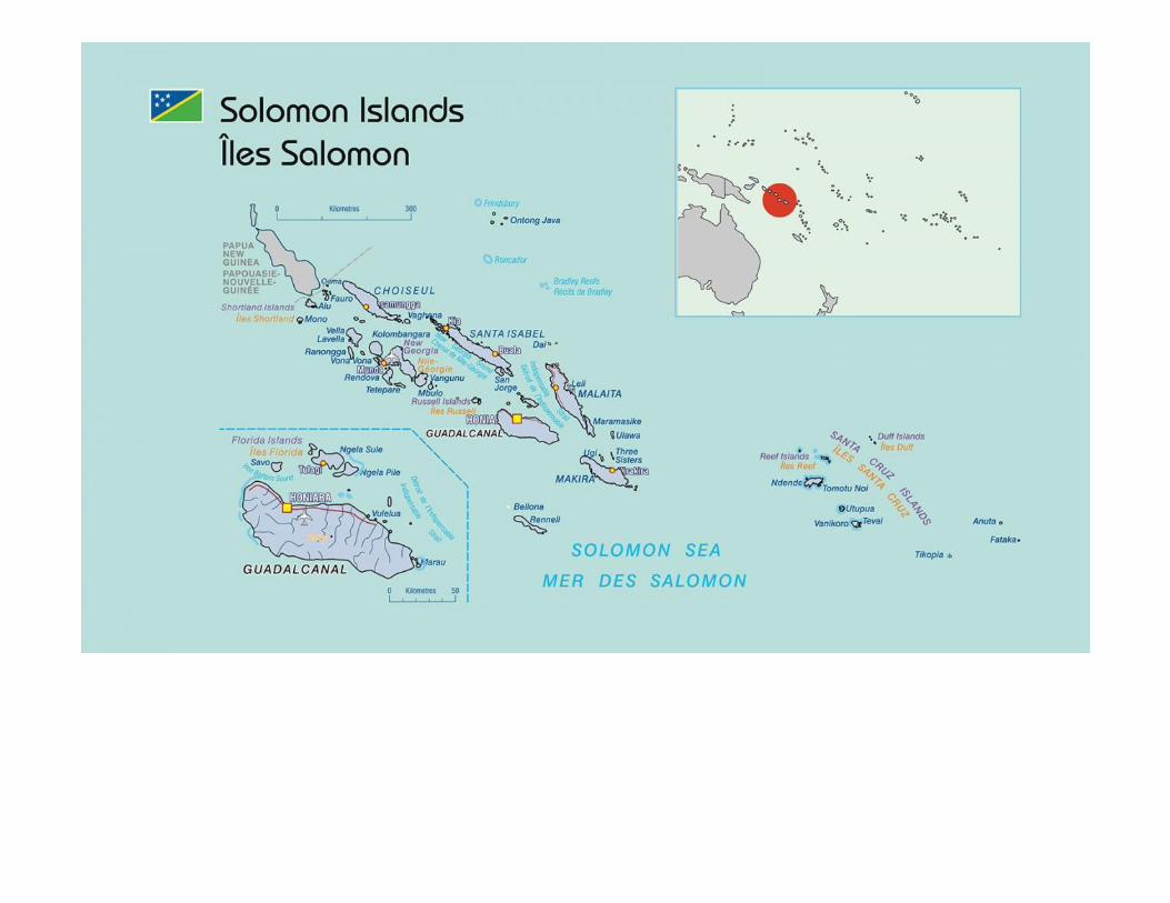
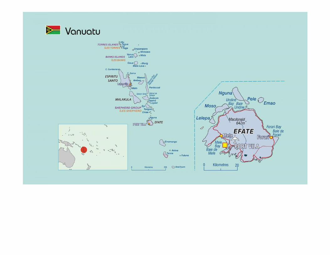

2. StakeholdersSelect the stakeholders that have participated in consultations during the project identification phase:
Indigenous Peoples and Local Communities
Civil Society Organizations
Private Sector Entities
If none of the above,please explain why: Yes
For the purpose of the PIF the following government departments and ministries have been targeted. Engagement of these government authorities hasfocused on the introduction and socialization of project objectives, and on ensuring that the project activities and outcomes are aligned with country needs.
Other key stakeholders such as the rural communities (including women, youth and vulnerable groups), private sectors, academics and other relevantgovernment agencies will be fully and inclusively engaged during the PPG stage for the purposes of identifying project sites, gender equality and socialinclusion issues, groundwater nexus and land use management challenges, that will inform the full project design. In addition, a Stakeholders InvolvementPlan to be implemented during the project will also be prepared.
In addition, provide indicative information on how stakeholders, including civil society and indigenous peoples, will be engaged in the project preparation, andtheir respective roles and means of engagement.
Agency Role
Fiji Ministry of Waterways and Environment
GEF operational focal point and currently responsible for a clean and healthy environment and the sustainable management of all water ways
Fiji Department of Mineral Resources
Coordination of groundwater resources assessment and development of groundwater resources for water supply and commercialuses
Fiji Department of Agriculture
Mandated to provide food and nutrition security, income and employment through a modernized and resilient agriculture sector.
Fiji Department of Water and Sewerage Coordination and regulation public and rural water supply aroundFiji
Vanuatu’s Department of Environmental Protection and Conservation
GEF Operational Focal Point and coordinates environmental management initiatives
Vanuatu’s Department of Water Resources Coordination and regulation of water and sanitation activities

Vanuatu s Department of Water Resources Coordination and regulation of water and sanitation activities
Vanuatu’s Department of Agriculture and Rural Development
Responsible for all agricultural activities and rural development
Vanuatu’s Department of Livestock Coordinate and manages livestock farming
Solomon’s Ministry of Environment, Climate Change, Disaster Management and Meteorology
GEF Focal Point and responsible for environmental management,coordination of climate change activities, disaster management and looks after meteorological services
Solomon’s Department of Agriculture Responsible for food and nutrition security through improved andinnovative farming practice
Solomon’s Department of Mines, Energy and Water.
Coordinates water permits, water supply and drilling and water governance
Bottled Water Industry - Fiji Commercial groundwater user industry body
Pastoral companies – Fiji,Vanuatu, Solomon Islands
Agriculture livestock companies in Fiji
Communities Communities in each of the selected hotspot sites using groundwater in each of the countries for primary and secondary purposes
Water Authorities Use of groundwater town water supply Fiji, Vanuatu, and SolomonIslands
Groundwater drilling Industry body for private drillers in Fiji, Solomon Isalnds and Vanuatu
Mining sector Use or abstraction of groundwater for mining or processing purposes

3. Gender Equality and Women's Empowerment
Briefly include below any gender dimensions relevant to the project, and any plans to address gender in project design (e.g. gender analysis).
Gender equality is central to the Food and Agriculture Organization of the United Nations’ (FAO’s) mandate to achieve food security for all by raising levels ofnutrition, improving agricultural productivity and natural resource management, and improving the lives of rural populations. FAO can achieve its goals only if itsimultaneously works towards gender equality and supports women’s diverse roles in agriculture and rural development. Gender equality is not only anessential means by which FAO can achieve its mandate, it is also a basic human right.
Consistent with relevant policies of the GEF and FAO, gender consideration will be a cross-cutting element in all the project components and activities. Thecommunity and stakeholder engagement work will be particularly centered on strengthening the participation of women youth and vulnerable groups, in waterresources management. A gender analysis will be undertaken during the project preparation phase to identify needs and roles of women and men in waterresources management. A Gender Equality and Social Inclusion Action Plan will be developed during the PPG and will be used to challenge traditional genderroles and encourage development of women’s skills and involvement in water management practices. Gender-related considerations and actions – based onthe collection of sex-disaggregated water data - will be explicitly incorporated in the formulation and implementation of the Aquifer Management Plans relatedto competing water users and land management.
Does the project expect to include any gender-responsive measures to address gender gaps or promote gender equality and women empowerment? Yes
closing gender gaps in access to and control over natural resources; Yes
improving women's participation and decision-making; and/or Yes
generating socio-economic benefits or services for women. Yes
Will the project’s results framework or logical framework include gender-sensitive indicators?
Yes

4. Private sector engagement
Will there be private sector engagement in the project?
Yes Please briefly explain the rationale behind your answer.
Considering the cross-cutting nature of water and the nature of investigations and infrastructural interventions planned for this project, properly designedengagement plans will be required to ensure the flow and exchange of relevant information and to encourage support and active engagement of all privatesector groups who may either benefit or be affected by the project activities and findings. Opportunities exist for private sector engagement, ideally throughindustry recognised bodies. An example of this may include the identification of development opportunities of groundwater resources for commercialventures; including improved livestock farming, aquaculture, high value crop irrigation, and mineral water bottling.
It will be essential that clear communication strategies, including participatory exercises and engagement plans, be established in an inclusive andcollaborative manner. These consultation activities will be designed to promote collaboration between private and public sectors, enhance relationshipsthrough information exchange during and beyond the project period, and importantly to safeguard the interests of the different sectors.
It is envisaged that the mapping of primary aquifers and the associated feasibility studies may also attract private investors for water supply or commercialdevelopment. It is expected that these new findings will provide a suitable platform for the national governments to either ramp up their investments ingroundwater development or to market the new information to attract private investors and generating further economic benefits.

5. Risks to Achieving Project Objectives
Indicate risks, including climate change, potential social and environmental risks that might prevent the Project objectives from being achieved, and, ifpossible, propose measures that address these risks to be further developed during the Project design (table format acceptable)
Risk Rating Mitigation
Lack of national and local buy-in for the development and adoptionof aquifer protection managementplans
Moderate Strong and effective communication with communities,private sectors and national agencies to be developed early in the project PPG to ensure shared understandingof the project directions and to demonstrate value and benefit of aquifer management plans.
Absorptive capacity for knowledgetransfer at the sub-national governance level is inadequate and unsustainable
Moderate Assess the absorptive capacity in the identified area before committing to any interventions; maximize opportunities to employ local staff in the activity.
Communication costs for telemetry are unreliable or unsustainable for application
Moderate Technology for telemetry via mobile network or satelliteis improving. Where communication options are unreliable alternate sustainable data transfer approaches will be developed in consultation with country and island.
Loss of land from groundwater drilling and installation of monitoringsystems
Low Minimal loss of land is expected however inclusive consultation with all stakeholders will be undertaken to haveconsensus around the restriction of land access aroundthese sites to optimize the benefits of these infrastructures and for their long-term protection.
Objections from private sectors Moderate Strong partnership agreement between project team, government authorities and private sectors will be established during the PPG stage
around potential benefits of the project and around datause, dissemination and security.
Delayed project deliveries during annual tropical cyclone seasons from November to April.
Moderate Ensure that proper planning is undertaken to allow the execution and progress of major activities outside the cyclone season.

Logistical challenges of implementing activities in remote areas becomes overwhelming
Moderate Build on lessons learnt about scheduling and logistics from previous projects; adopt flexible and back-up planning approaches such that alternatives (e.g. moving activities to a different location) can be prioritised if and when necessary.
Unable to establish monitoring boreholes due to difficulties of mobilizing conventional drilling rigs to remote locations
Moderate Options exist in regard to monitoring borehole construction and drill technology. Appropriate technology and construction techniques will be applied, albeit this may affect the number of monitoring bores that are able to be constructed.
Extended COVID-19 travel restrictions or emergence of similar scaleworld-wide pandemic
Moderate Strong in-country project teams will be established to ensure the timely progress of local and national activities.Online mode of communication will be strengthened toenhance the regional meetings and foster periodical financial reporting systems. Strong procurement and financial planning and support will also be required to ensurethe timely hiring of contractors and purchase of hard-infrastructures needed for project delivery.
Climate change High According to the STAP guidance’s on climate risk screenings, it is very likely that the project will be adversely affected by extreme weather events and where social impacts are likely to be irreversible, cumulative and/or unprecedented. The mitigation of some of these impacts isbeyond the scope of the proposed project, and the magnitude and/or spatial extent of the number of people affected is very large. To adapt the project to this reality, during the PPG stage a thorough analysis and mapping ofthe population and natural resources at highest exposure and vulnerability will be developed.
(Please refer to the Climate Risk Screening developed for the project)

6. Coordination
Outline the institutional structure of the project including monitoring and evaluation coordination at the project level. Describe possible coordination with otherrelevant GEF-financed projects and other initiatives.
The GEF Agency - The project GEF Implementing Agency - FAO – will be responsible for the correct project implementation vis a vis the GEF. FAO will provideproject oversight and quality assurance role involving FAO staff in Country Offices and at regional and headquarters levels. Project Assurance shall be totallyindependent of the Project Management function. The quality assurance role supports the SC and EA by carrying out objective and independent project

oversight and monitoring functions. This role ensures appropriate project management milestones are managed and completed. This is covered by the GEFAgency.
The Steering Committee - The Government nominated Representatives of the beneficiary countries, FAO and SPC will form the project’s Steering Committee(SC). The SC will meet periodically, and be responsible for taking corrective action as needed to ensure the project achieves the desired results. In order toensure FAO’s ultimate accountability, decisions should be made in accordance with standards that shall ensure management for development results, bestvalue money, fairness, integrity, transparency and effective international competition. The Beneficiary Representatives represent the interests of those who willultimately benefit from the project. The Beneficiary Representatives primary function within the is to ensure the realization of project results from theperspective of project beneficiaries and in accordance with the objectives of the project.
The Executing Agency - The Pacific Community (SPC) will be the Executing Agency (EA) for the project, based on the standard Operational PartnershipAgreement (OPA) to be signed between FAO and SPC. The EA has the authority to run the project following the guidance of, and within the constraints laiddown by, the Steering Committee (SC). The EA’s prime responsibility is to ensure that the project produces the results specified in the project document, to therequired standard of quality and within the specified constraints of time and cost. The Director of the Geoscience, Energy and Maritime Division will beultimately responsible to the SC for the project and will attend the project SC meetings. The EA’s role is to ensure that the project is focused throughout its lifecycle on achieving its objectives and delivering outputs that will contribute to higher level outcomes.
Project Management Unit – The EA will nominate a Project Manager/Chief Technical Advisor that will work full time for the duration of the project, and beresponsible for day to day execution of project activities and procurement, including coordination at the country/island level. She/he will act as Secretary ofthe SC meetings, responsible for providing the required documentation and support.
National Leads Agencies - Project activities at the national and island level, will be executed by the Government nominated Lead Agency under the oversightand coordination of the EA. Existing governance mechanisms will be involved in decision-making processes relevant for the project sites. Collaboration withlocal community groups, private sector, and local water committees will be valuable in ensuring successful implementation of proposed project interventions.Island communities will have the opportunity to participate in decision-making through meetings and focus-group discussions and through feedbackmechanisms. At the national level, participation in the RSC ensures the direct role of these target groups in governing and managing the project.

7. Consistency with National Priorities
Is the Project consistent with the National Strategies and plans or reports and assesments under relevant conventions
Yes If yes, which ones and how: NAPAs, NAPs, ASGM NAPs, MIAs, NBSAPs, NCs, TNAs, NCSAs, NIPs, PRSPs, NPFE, BURs, INDCs, etc
As previously described, the project links well with the SENDAI framework and a number of Sustainable Development Goals with a focus on water and foodsecurity and the 2017-2030 FRDP. As such the national strategic development plans in the three project countries have specific plans around water, food andnutrition and gender empowerment.
Fiji’s 2017-2036 national development strategy plan stresses the need to have a 100% of urban population to access clean and safe water and propersanitation by 2021 and for the rural and maritime areas by 2030. Linked to this water and sanitation vision are the following:
1. Allocation of resources for sustained maintenance and construction of new water treatment plants, rural water schemes, development of groundwatersources, setting up desalination plants in the maritime region, and distribution of water tanks in rural areas.
2. Use of innovative technologies will be adopted for industrial recycling, rainwater harvesting and storage, storm water and aquifer management and useof renewable energy for desalination plants.
3. Considerations to build climate resilient water infrastructure for all new projects.
4. Leak reduction programmes will continue so that piped water losses are significantly reduced, and other water conservation initiatives will be pursued
Further the Mineral Resources Department is currently developing a Groundwater Resources Development and Management Policy while the Department ofWater and Sewerage under the Ministry of Infrastructure is compiling the overarching “National Water Resources” policy.
Along with a strong gender equality and women empowerment strategy in Fiji’s NDP, a focus on food and nutrition security is also highlighted throughincreased local production that is climate-resilient and environmentally sustainable, raising farm efficiency and productivity, and developing more effectivedistribution systems.
The proposed project components are aligned with the Solomon Islands 2016-2035 national development strategy. Consistency exists with Objective 1“Sustained and inclusive economic growth” - Medium Term Strategy 3 “Expand and upgrade weather resilient infrastructure and utilities focused on access toproductive resources and markets and to essential services”, which specifically aims to
1. facilitate infrastructure development for efficient, effective and quality service delivery to rural communities in water supply and sanitation,
2. foster and enhance continuous reform at Solomon Islands Water Authority (SIWA),
3. ensure the water provided to all customers is sufficient and chemically safe to appropriate WHO standards,
4. preserve and properly manage water catchment forest areas,
5. enforce conservation, land use controls and proper water legislation and laws,

6. work with Government to secure perpetual access to critical water sources,
7. examine the need to upgrade and extend coverage of water supply and sanitation systems in urban, peri-urban and rural areas,
8. improve ongoing strategies and practices to deal with the significant non-revenue water lost through theft and leakage as well as significant debtincurred by many customers.
Consistency exists with Objective 1 - Medium Term Strategy 4 “Strengthen land reform and other programmes to encourage economic development in urban,rural and customary lands”, which specifically aims to
1. facilitate infrastructure development for an efficient, effective and quality service delivery to rural communities in water supply and sanitation and
2. protect natural resources, environment and conservation.
The project is fully aligned with Objective 2 “Poverty alleviated across the whole of the Solomon Islands, basic needs addressed and food security improved;benefits of development more equitably distributed” and particularly with Medium Term Strategy 5 “alleviate poverty, improve provision of basic needs andincrease food security” which aims to ensure availability of water and sanitation for all and implemented based on accessibility by gender and vulnerablegroups (links to MTS 7).
The project is aligned with Vanuatu’s 2016-2030 National Sustainable Development Plan’s three pillars of Society, Environment and Economy, and will addresssome of the specific objectives identified in the NDSP.. These include:
1. Society Goals
SOC 4. An inclusive society which upholds human dignity and where the rights of all Ni-Vanuatu including women, youth, the elderly and vulnerable groups aresupported, protected and promoted in our legislation and institutions; links to development and implementation of the GESI action plan and increasedengagement of women in water resource management.
SOC 6. A dynamic public sector with good governance principles and strong institutions delivering the support and services expected by all citizens ofVanuatu; links to the development of operational drilling practices, Component 3, and governance Component 2, as well as support for institutional capacity incomponent 4.
2. Environment goals
ENV 1. A nation that ensures our food and nutrition security needs are adequately met for all people through increasing sustainable food production systemsand improving household production; links to Component 3, development of groundwater resources for agriculture, and improved land management practices
ENV 3.A strong and resilient nation in the face of climate change and disaster risks posed by natural and man-made hazards; links to Component 3, and thepotential development of groundwater to communities for water supply.
ENV 4. A nation which utilizes and sustainably manages our land, water and natural resources; links to Component 2 Governance, and the development of landmanagement practices in Component 3.
3. Economy goals

ECO 2.2 Ensure all people have reliable access to safe drinking water and sanitation infrastructure; links to Component 3 drilling operations and alsoinfrastructure associated with construction of groundwater supply bores

8. Knowledge Management
Outline the Knowledge management approach for the Project, including, if any, plans for the Project to learn from other relevant Projects and initiatives, toassess and document in a user-friendly form, and share these experiences and expertise with relevant stakeholders.
The FAO vision is to embrace a culture of collaboration and continuous learning. The FAO Knowledge Strategy has a focused approach to cultivate andsystematically embrace knowledge sharing. The Knowledge Strategy aims to shift FAO from its traditional role as a knowledge provider to a one where itfacilitates access to, and flow of, information and knowledge. The Knowledge Sharing Team works like a comprehensive solutions provider. It builds on solidfoundations to strengthen individual staff, groups or communities and facilitates interactions among external partners and stakeholders. It delivers on theStrategy’s goals through the a number of activities and tools.
The multi-disciplinary assessment results will generate substantial information pertaining to the characterization, delineation, and diagnostic analysis of majorvolcanic aquifers within the three countries with suggested land use improvements and appropriate governance mechanisms and groundwater resourcesmanagement plans.
Packaging of data as visually appealing and informative products will be developed, with a focus to community and government stakeholders and wouldinclude the use of audio visual media, maps, conceptual diagrams, GIS database, website, as well as technical report products. Outreach of the availableinformation will be an important component of the work and will be achieved through workshops and consultation between key government stakeholders,community, and private sector bodies. Specific and appropriate knowledge products and processes will be developed to assist stakeholders in being engaged,and to assist with the transfer of information.
Where possible and appropriate the project will encourage peer to peer and south-south cooperation across countries, promoting the development of supportnetworks and knowledge exchange. This approach will build upon earlier successful learnings from projects which have been successful in encouragingknowledge transfer.
This project represents the first systematic attempt in the Pacific SIDS[1] to assess the freshwater potential of volcanic aquifers. The results of, and theknowledge gained by the project in this domain will be shared with other volcanic PICs and beyond through active contributions to IW LEARN, and through themeans provided by FAO’s knowledge management strategy.
[1] At global level, the only relevant examples are the Canary Islands, and Tobago in the Caribbean.
9. Environmental and Social Safeguard (ESS) Risks
Provide information on the identified environmental and social risks and potential impacts associated with the project/program based on yourorganization's ESS systems and procedures

Overall Project/Program Risk Classification*
PIF CEO Endorsement/Approval MTR TE
Low
Measures to address identified risks and impacts
Provide preliminary information on the types and levels of risk classifications/ratings of any identified environmental and social risks and potentialimpacts associated with the project (considering the GEF ESS Minimum Standards) and describe measures to address these risks during theproject design.
1. At Project level, FAO applies a risk management process focused specifically on individual Project risks, with the purpose of:1. Identifying, assessing and managing social and environmental risks and potential project impacts;2. Adopting a hierarchy of mitigation measures;3. Promoting sustainable food and farming systems.
2. FAO has nine (9) social and environmental standards that must be met by any Project funded or approved by the Organization. The following table gives anoverview on the assessement of these 9 standards for the propose project:
SAFEGUARD TRIGGER QUESTIONS APPLICABLE?ESS 1: Natural Resource Management
Would this project: 1) result in the degradation (biological or physical) of soils or undermine sustainable land management practices? or 2) include the development of a large irrigation scheme, dam construction, use of waste water or affect the quality of water? or 3) reduce the adaptivecapacity to climate change or increase GHG emissions significantly? or 4) result in any changesto existing tenure rights (formal and informal) of individuals, communities or others to land, fishery and forest resources?
NO
ESS 2: Biodiversity, ecosystems and natural habitats
Would this project be executed in or around protected areas or natural habitats, decrease the biodiversity or alter the ecosystem functionality, use alien species, or use genetic resources?
NO
ESS 3: Plant Genetic Resources for Food and Agriculture
Would this project: 1) introduce crops and varieties previously not grown, and/or; 2) provide seeds/planting material for cultivation, and/or; 3) involve the importing or transfer of seeds and orplanting material for cultivation or research and development; 4) supply or use modern biotechnologies or their products in crop production, and/or 5) establish or manage planted forests? NO

ESS 4: Animal - Livestock and Aquatic - Genetic Resources for Food and Agriculture
Would this project introduce non-native or non-locally adapted species, breeds, genotypes or other genetic material to an area or production system, or modify in any way the surrounding habitat or production system used by existing genetic resources? NO
ESS 5: Pest and Pesticide Management
Would this project: 1) result in the direct or indirect procurement, supply or use of pesticides: oncrops, livestock, aquaculture, forestry, household; or as seed/crop treatment in field or storage;or through input supply programmes including voucher schemes; or for small demonstration and research purposes; or for strategic stocks (locust) and emergencies; or causing adverse effects to health and/or environment; or 2) result in an increased use of pesticides in the project areaas a result of production intensification; or 3) result in the management or disposal of pesticidewaste and pesticide contaminated materials; or 4) result in violations of the Code of Conduct?
NO
ESS 6: Involuntary displacement and resettlement
Would this project permanently or temporarily remove people from their homes or means of production/livelihood or restrict their access to their means of livelihood? NO
ESS 7: Decent work Would this project affect the current or future employment situation of the rural poor, and in particular the labor productivity, employability, labor conditions and rights at work of self-employed rural producers and other rural workers? NO
ESS 8: Gender equality Could this project risk be overlooking existing gender inequalities in the participation of men and women in decision-making and/or in their differential access to productive resources, services and markets?
NO
ESS 9: Indigenous Peoples and Cultural Heritage
Would this project: 1) have indigenous peoples living outside the project area where activities will take place; or 2) have indigenous peoples living in the project area where activities will take place; or 3) adversely or seriously affect indigenous peoples' rights, lands, natural resources, territories, livelihoods, knowledge, social fabric, traditions, governance systems, and culture or heritage (physical and non-physical or intangible) inside and/or outside the project area; or 4) be located in an area where cultural resources exist?
NO
3. Based on the answers provided in the Environmental and Social Screening Checklist, the application of these standards for the proposed project allowsconcluding that the proposed action is classified as LOW risk
Supporting Documents
Upload available ESS supporting documents.
Title Submitted
Pacific Islands PIF Review Yellow-Marked
Pacific Islands - Climate Risk Screening Summary
ToC PICs1-LPG
FAO ESS Screening Checklist-Pacific
Risk Certification

Part III: Approval/Endorsement By GEF Operational Focal Point(S) And Gef Agency(ies)
A. RECORD OF ENDORSEMENT OF GEF OPERATIONAL FOCAL POINT (S) ON BEHALF OF THE GOVERNMENT(S): (Please attach the Operational Focal Point endorsement letterwith this template).
Name Position Ministry Date
DonnaKalfatak
Director and GEF Operational Focal Point Vanuatu Department of Environmental Protection and Conservation 9/9/2020
Chanel Iroi Deputy Secretary and GEF Operational Focal PointSolomon Islands
Ministry of Environment, Climate Change, Disaster Management andMetereology
9/17/2020
JoshuaWycliff
Permanent Secretary and GEF Operational Focal Point,Fiji
Ministry of Waterways and Environment 9/28/2020

ANNEX A: Project Map and Geographic Coordinates
Please provide geo-referenced information and map where the project intervention takes place
Fiji: -18.137917, 178.443862
Solomon Islands: -9.439603, 159.952162
Vanuatu: -17.723474, 168.329972

