enviornmental urban design design technolagy …
TRANSCRIPT

1
ENVIORNMENTAL URBAN DESIGN
DESIGN TECHNOLAGY PROTFOLIO BY DYLAN JOWETT|MR LANGER|3873 WORDS

2
CONTENTS EXTERNAL RESEARCH
1. District Map…….………………………………………………………………………………………………………………………………………………………………………………………………………… pg.3
2. Neighborhood Map…….……………………………………………………………………………………………………..……………………………………………………………………………………… pg.3
3. Streetscape Map…….…………………………………………………………………………………………………….…………………………………………………………………………………………… pg.3
4. Site Map…….……………………………………………………………………………………………………………………………………………………………………………………………………………… pg.3
5. Site Analysis…….………………………………………………………………………………………………………………………………………………………………………………………………………… pg.4
EMPATHETIC RESEARCH
1. Observations………………………………………………………………………………………..…………………………………………………………………………………………………………………… pg.5
a. Personal Mannerisums……………………………………………………………………………………………..……………………………………………………………………………………… pg.5
b. Pedestrian Interaction……………………………………………………………………………………………..……………………………………………………………………………….……… pg.5
c. Biodivercity………………………………………………………………………………………..………………………………………………………………………….……………………………….… pg.5
d. Recreational Facilities………………………………………………………..…..………………………………………………………………………………………………………………………… pg.5
DESIGN PROPOSAL
1. Design Problem………………………………………………………………………………………………………………………………………………………………………………………………………… pg.6
2. Design Brief…………………………………………………………………………….……………………………………………………………………………………………..…………………………………. pg.6
3. Specification…………………………………………………………………….……………………………………………………………………………….……………………………………………………... pg.6
a. Constraints and Considerations………………………………….…………………………………………………………………….……………………………………………………………….. pg.6-7
4. Evaluation Criteria for Success………………………………………………………………………………………………………………..………………………………………………………………… pg.7
IDEATION
1. Presentation Sketch.………………………………………………………….……………………………………………………………………………….……………………………………………………... pg.8
APPENDIX
1. Government Extracts Of The Belconnen Area …………………………………………………………………………………………………………………………………………………….…… pg.9
a. Strategic Planning…………………………………………………………………………………………………………………………………………………………..……………………………….. pg.9
b. The Statement of Planning Intent………………………………………………………………………………………………………………………………………..…………………………… pg.9
c. ACT Planning Strategy………………………………………………….……………………………………………………………………………………………………….………………….……… pg.9
d. Planning History………………………………………………………………..…………………………………………………………………………………………………….……………….……… pg.9
e. Demographic……………………………………………………………………………………………………………………………………………………………………………….…………….……. pg.9
f. Population………………………………………………….…………………………………………………………………………………………………………………….……………….…….……… pg.9
g. Environment and Ecology………………………………………………….……………………………………………………………………………………………………………...…….……… pg.10
h. Areas of Ecological Significance………………………………………………….…………………………………………………………………..……………………………………….……… pg.10
i. Lake Ginnindera………………………………………………….………………………………………………………………………………………………………………….…………….….……… pg.10
j. Habitat………………………………………………….……………………………………………………………………………………………………………………….……………………….……… pg.10
k. Environmental sustainability………………………………………………….……………………………………………………………………………………………………………..………… pg.10-11
i. Climate change………………………………………………………………………………………………………………………………………………………………………….…….……….… pg.10
ii. Resources consumption…………………………………………………………………………………………..……………………………………………………………………….………… pg.10
iii. Buildings………………………………………………………………………………………………………………………………………………………………………………………….……….… pg.10
iv. Urban planning and design………………………………………………………………………………………………………………………………………….………………….….……… pg.10
v. Reduce city heat and increase amenity in outdoor spaces for healthy living…………………………………………………………………………………….………… pg.10
vi. Reduce city heat and achieve cooler buildings……………………………………………………..………………………………………………………………………….………… pg.10
vii. Intense rain events………………………………………………………………………………………………………………………………………………………………………….…………. pg.10
viii. Reduce the risk of bushfire in urban areas……………………………………………………………………………………………………………………………………….………… pg.10-11
2. Photographic Study………………………………………………….………………………………………………….…………………………………………………………………………….….….….… pg.12-13
3. Referencing………………………………………………….……………………………..………………………………………………………………………………………………………………….……… pg.13
3
EXTERNAL RESEARCH INSTRUCTOR MAPS
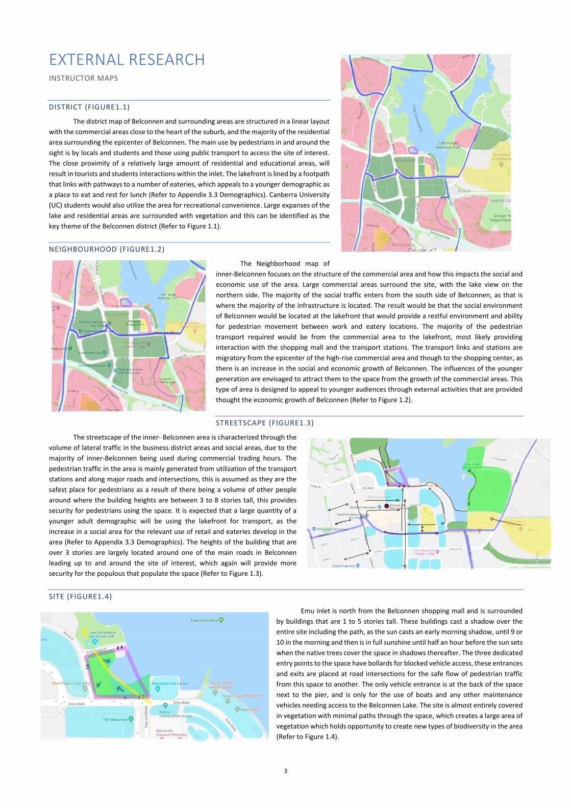
DISTRICT (FIGURE1.1)
The district map of Belconnen and surrounding areas are structured in a linear layout
with the commercial areas close to the heart of the suburb, and the majority of the residential
area surrounding the epicenter of Belconnen. The main use by pedestrians in and around the
sight is by locals and students and those using public transport to access the site of interest.
The close proximity of a relatively large amount of residential and educational areas, will
result in tourists and students interactions within the inlet. The lakefront is lined by a footpath
that links with pathways to a number of eateries, which appeals to a younger demographic as
a place to eat and rest for lunch (Refer to Appendix 3.3 Demographics). Canberra University
(UC) students would also utilize the area for recreational convenience. Large expanses of the
lake and residential areas are surrounded with vegetation and this can be identified as the
key theme of the Belconnen district (Refer to Figure 1.1).
NEIGHBOURHOOD (FIGURE1.2)
The Neighborhood map of
inner-Belconnen focuses on the structure of the commercial area and how this impacts the social and
economic use of the area. Large commercial areas surround the site, with the lake view on the
northern side. The majority of the social traffic enters from the south side of Belconnen, as that is
where the majority of the infrastructure is located. The result would be that the social environment
of Belconnen would be located at the lakefront that would provide a restful environment and ability
for pedestrian movement between work and eatery locations. The majority of the pedestrian
transport required would be from the commercial area to the lakefront, most likely providing
interaction with the shopping mall and the transport stations. The transport links and stations are
migratory from the epicenter of the high-rise commercial area and though to the shopping center, as
there is an increase in the social and economic growth of Belconnen. The influences of the younger
generation are envisaged to attract them to the space from the growth of the commercial areas. This
type of area is designed to appeal to younger audiences through external activities that are provided
thought the economic growth of Belconnen (Refer to Figure 1.2).
STREETSCAPE (FIGURE1.3)
The streetscape of the inner- Belconnen area is characterized through the
volume of lateral traffic in the business district areas and social areas, due to the
majority of inner-Belconnen being used during commercial trading hours. The
pedestrian traffic in the area is mainly generated from utilization of the transport
stations and along major roads and intersections, this is assumed as they are the
safest place for pedestrians as a result of there being a volume of other people
around where the building heights are between 3 to 8 stories tall, this provides
security for pedestrians using the space. It is expected that a large quantity of a
younger adult demographic will be using the lakefront for transport, as the
increase in a social area for the relevant use of retail and eateries develop in the
area (Refer to Appendix 3.3 Demographics). The heights of the building that are
over 3 stories are largely located around one of the main roads in Belconnen
leading up to and around the site of interest, which again will provide more
security for the populous that populate the space (Refer to Figure 1.3).
SITE (FIGURE1.4)
Emu inlet is north from the Belconnen shopping mall and is surrounded
by buildings that are 1 to 5 stories tall. These buildings cast a shadow over the
entire site including the path, as the sun casts an early morning shadow, until 9 or
10 in the morning and then is in full sunshine until half an hour before the sun sets
when the native trees cover the space in shadows thereafter. The three dedicated
entry points to the space have bollards for blocked vehicle access, these entrances
and exits are placed at road intersections for the safe flow of pedestrian traffic
from this space to another. The only vehicle entrance is at the back of the space
next to the pier, and is only for the use of boats and any other maintenance
vehicles needing access to the Belconnen Lake. The site is almost entirely covered
in vegetation with minimal paths through the space, which creates a large area of
vegetation which holds opportunity to create new types of biodiversity in the area
(Refer to Figure 1.4).

4
SITE ANALYSIS (FIGURE 1.5 TO 1.7)
From site analysis, an understanding of pedestrian
movement, vegetation and biodiversity together with the common
use of the space by the public has been determined. The majority of
the pedestrian movement was though the center of the space with
rarely any other external interaction between the public. The creation
of more direct paths were made by pedestrians to get between point
a to point b quicker than the current minimalistic path (Refer to Figure
1.5). The majority of the types of people who were using the space
were individuals by themselves, the next common occurrence was
where people were either walking through the center or around the
outside of the space in pairs. Of equal use was that of those in the
trades and cyclist passing thought space, it was used the least by
groups of more than two people and those running thought the
space. The most physical interaction with the space only occurred
when pair and groups of pedestrians were within the space, as they
would sit down and rest while having a conversation using, mainly the
seating provided. The common age of pedestrians that used the space
was between 14 to 62 years, however those who engaged with the
space ranged in age of between 14 to 33 years.
Elevation within the space is utilized with walls and ledges
that can be used as seating for pairs to groups of people, however
this is located on the outside of the spaces opposite the inner-ring of
the space. The elevation provides privacy and security to the space
due to its separation from the vehicle traffic, which occurs around
the outside of the space. The overall change in elevation is 5 meters
within the space (Refer to Figure 1.6), (this is represented within the
contour map), due to the steepness of the site this would need to be
dealt with in the space ensuring there are safe ledge heights and
ramp angles for pedestrians to use whilst interacting with the space.
The edge of the lake is the lowest part of the space which can create
hazards for cyclists and those with disabilities that might misjudge
the incline of the space (Refer to Figure 1.6.2) and although unlikely
a pedestrian could fall into the large body of water. While the
elevation may be problematic it also provides greater depth and
details to the space for the ideation process.
Vegetation contained within the space are native eucalyptus trees
and short grass that covers the rest of the space except for the concrete
paths. The spaces biodiversity mainly consists of birds being the fauna and
trees and shrubbery as the flora (Refer to Figure 1.7). There were 5 different
species of birds that where interacting within the space as their natural
habitat, using the grass, trees and the bayside dock for shelter and
sustenance (Refer to Appendix 3.9.2 Habitat Connectivity). The different
species of birds interact with various points around the lake including the
inlet. Only the main path has lighting within the space, which is beside the
lake so at night it would prompt people not go near the waters edge, since
the lake would be in darkness and out of sight, the unlit areas do not provide
comfort for a user interacting with the space at night. The lack of lighting
doesn’t emphasize the multiple paths that can be taken to get to point b
quicker but doesn’t highlight the necessary changes in elevation that might
cause someone to trip up from the angle of elevation of the path. The site
analysis provides greater insight into the interaction of the user and the
foreseeable problems that could occur within this space.
Figure 1.5 Site Analysis Map
Figure 1.6.1 Site Elevation Map
Figure 1.6.2 Site Cross Section Elevation Map

5
EMPATHETIC RESEARCH OBSERVATIONS (FIGURE 1.9.1 TO 1.9.3)
From observing and conducting a site analysis extra information was obtained that clarified how emu inlet is used by the general public, together with the positive and negative environmental impacts the site encompasses. The use of the space by the general public was mainly as a transport route from one destination to the other, but other factors affecting the publics decision to act within the space may exist as the observations where made between the hours of two to three in the afternoon on an extremely cold and windy afternoon, which may have discouraged people from spending long periods of time outside or from spending any time outside what so ever. Non the less, the function of individuals using the space was as a transport route to enable movement between eateries and the commercial or residential areas of Belconnen (Refer to Figure 1.9.1). Pairs interacting with the space would sometimes stop on a bench and sit down or stand and take in the scenery of the natural beauty of the site, having a conversation with each other within the space and after a short time, they would move onto another activity. The cause of this may be due to time pressure activities, for example if they were taking a late break off work or simply needed to access another building for their personal purposes. When a group of people interacted with the space, they would find a location where they could all sit down to converse with each other, as a result they would be there for a considerably longer time than that of any pairs or individuals who interacted with the space. It can be concluded that groups of people are there to spend time with each other more than anyone else who occupies the space. A large portion of the individuals and pairs, who used the space, didn’t directly use the space but rather moved around the outside path of the site. This was interesting, as they opted to have more intimacy and privacy whilst sacrificing the most direct rough to their destination.
PERSONAL MANNERISMS
The mannerisms of the majority of people who used the space who weren’t in a group found the quickest route to the destination that they were heading to. They would generally make their own paths, as there was such a large area to cross, however this could be due to the oppressive weather at the time, or just the lack of optimised paths that are within the space as there is only one main path. The other reoccurring theme of the pedestrian users who were using the path, was that they would stick to the very edge of the paths on the respective sides as if they were driving lanes, which was most commonly observed in individual users of the space, as they would have a three-meter wide path but only walk on the very outside edge of the path. This could be due to the feeling of being lost in the space (as it is quite wide) and the very edges of the paths provide the users a subconscious guidance on the direction to follow (Refer to Figure 1.9.2).
PEDESTRIAN INTERACTION
Cyclists only used the space to ride through as it was a more direct route for them to get to their destination, and the wide paths and acute inclines of the paths were particularly easy for a cyclist to use, as they use it for extremely short periods of time. This type of design can put the pedestrian traffic at danger, if the paths were not wide enough for the combined use of cyclists and pedestrians. The runners on the path used it as a part of a running track that follows all-round the outside of Lake Ginninderra, and would appear from observation they would run anticlockwise around the lake. This may be due to the design of the park as the other side of the lake allows them to more easily take rest stops, or maybe that is where they start their run from as there is a large free car park in the John King Memorial park. When there were multiple people using the space at once, in the majority in circumstances the people would try to avoid any social interaction with anybody else, which may simply be a result of the external factor being the climate of the day or a deeper inclination in
regards to personal space, cultural identity and the communities normality.
BIODIVERSITY
The biodiversity of the site, for the most part, contained eucalyptus, Ulmus and Platanus trees round the outside of the space which enclosed the space, with shorter grass covering the exposed areas of soil. The majority of the space consists of the bay, this was implemented into the site as it’s the main focus an inlet, as the land is connected to the lake to allow link between aquatic and terrestrial habitats (Refer to Appendix 3.9.2 Habitat Connectivity). The native wildlife that inhabit the space include several types of bird species, most of the birds are ducks and the Eurasian Coot with a large majority crowding around the bay side and moving between the lake (Refer to appendix 3.9 Environment and Ecology)(Refer to Figure 1.9.3). It would appear likely that the birds migrate often from once side of the lake to the other to obtain a constant food source and rotating the grounds that they feed on in the total ecosystem. The smaller birds mainly lived in the tall trees as it provides shelter away from the larger predatory birds that survive feeding on the grass and soil of the space and moving two and from the dock.
RECREATIONAL FACILITIES
There are minimal recreational facilities provided to the public within Emu Inlet, the only facility that is capable for holding furniture scattered around the space which has no connection to the paths that are provided in the space. This was obvious as the only benches used by a pedestrian were the seating beside paths. Further, there were no form of rubbish bins in the inlet resulting in people littering in the space which would become caught in the surrounding vegetation, the habitat in which the birds would be living (Refer to Appendix 3.9.2 Habitat Connectivity). This potentially could cause a large threat to the native wildlife inhabiting the space. These small inconsistencies within the space, makes the space become less inviting to the public, and increases the maintenance needs of the site. Effecting the
attraction of the site to the general public, as it’s not clean or appealing and there become less emphasis to uphold the overall attraction of a space.
Figure 1.9.1 Pedestrian Interaction
Figure 1.9.2 Pedestrian Mannerisms
Figure 1.9.3 Environmental Interaction
6
DESIGN PROPOSAL
DESIGN PROBLEM
Of most interest from the analysis of the empathetic data collated from the instructor maps, site analysis and the site observations was to discover the personal, physical and psychological interactions with the space. The instructor maps provided insight into the wider demographic of people who interacted with the space, due to the large commercial area surrounding the south of the site and on the opposing side of the site was lake Ginninderra and the John Knight memorial park which provides a natural interconnection with the centre of Belconnen via the shoreline. The majority of the infrastructure surrounding the site is a commercial area, with the exception of the public transport system and retail-shopping infrastructure nearby. It was observed that main demographic of people that interacted with the space were commercial workers and young adults, that commuted from other parts of Canberra via the public transport system to the Belconnen retail-shopping centre and food venues. The majority of the pedestrian traffic was produced from the Belconnen shopping mall and eateries along the foreshore of Lake Ginninderra, which causes the sight to be heavily used by pedestrians, who are moving between the built infrastructures to the Lake front. The surrounding buildings are generally over 3 stories tall with an average footpath size of 2 meters wide underneath the taller buildings. The main roads that enclose the space only have 3 pedestrian crossings to move from the space to the rest of Belconnen, this does restrict the amount of pedestrian traffic that can inhabit the site. As a result of limited access to the space and the large paths, it tends only to be sought after if a path is the best fit for that individual, as there is nothing objectively important nor attractive for people to cause interaction with the space for extended periods of time. The site analysis further provides insight into the common use of the space by the current demographic that occupy the space. Predominantly the use of the space by pedestrians is to create a short cut route to their destination. This reflects the psychological ideals of the user, as they don’t appear to have the desire to actively use the space in a social or comforting manner. This diminishes or eliminates the communal feeling to the space, in turn providing less security to people who are actively using services around the site, as there is no particular social demographic who relate to the site. This could be due to the fact of the site not containing seating or specific areas for social interactions, which is further influenced by the external features of the space. The activities that occurred within the space include the fitness action was running, cycling and has enough room for a fitness group to practice group activities on the larger grassed areas. The implications of a large change in elevation within the space impacted with the form of ramps or stairs and the overall scale of the space could become a barrier to people who may potentially interact within the space, due to the pathways not being structured correctly to cohesively move from varying levels of the site. The biodiversity of the park doesn’t inhibit the park, as it is one of the features of it that contributes to the identity of the inlet, which provides a perfect environment for aquatic wildlife that migrate between each side of the lake. The current vegetation provides shelter from the outside elements, including from the north-westerly winds, again providing a more pleasant experience for the users of the space. The priority of the site is the transport of pedestrians from their start to their destination, within the space, whereas there should be a journey from the entry to the exiting of the space, to provide a pedestrian with a positive experience that they can share with others. From the personal observation of the space of how pedestrians interacted with it, and how long they occupied the space when undertaking particular activities, I concluded a large amount of them had no guidance for their movement leaving it to the individual to personally interpret where their path would take them. The maintenance of the site I considered to be poor, due to the types of materials at the site together with the site being mainly organic which requires high maintenance to keep at its best, also the absence of any type of waste collection resulted in litter on the ground more often around the thicker vegetation where it would get caught though mostly would be unseen by the public. Taking into account the mannerisms of the pedestrians, who would stick to the edge of a path even if there were no reason to do so signified them being uncomfortable with the environment, whereas the cyclist and runners needed that openness for movement. Improvements would include the implementation of more recreational and other facilities to meet the needs of people for example some form of sheltered seating, easy access and movement with an area for personal involvement within the site community, which would contribute to make central Belconnen a safer place.
DESIGN BRIEF
The problem that’s identified from the empathetic research, is the inability for social interaction to occur within emu inlet, as the current arrangement of
the facility does not invite social interaction within the community. This occurs from the lack of interconnection within the space, as it only provides one
passage of pedestrian movement even though it is such a large space, further an individual has no situational guidance for social interaction. As there is
limited social interaction within and around this space this creates instability in the community, which in turn means there is no sub-society to provide
security for other pedestrians in the area. Design elements that could resolve some of these issues are to create specific areas for younger adults and
current students to socialize in an intriguing and socially attractive place to spend more time with other people. The linking of the heart of the space to
more socially inclusive spaces for groups, pairs and individuals will create greater cohesion of the site, it would become more accessible to the public and
become a more popular site for the general public. The experience of the space can be dramatically improved if the site had an overall theme, ideally an
extension of the Ginninderra Lakeview and surrounding parks in the Belconnen area, which would be an extension of the already current environment and
embracement of the current biodiversity. The overall security of the place would increase accordingly for the community, as there would be a central
community hub that would be used by university students, commercial workers and the general public from surrounding areas improving the community’s
quality of life with positive environmental impacts.
SPECIFICATIONS
Constraints Considerations
The site must allow for movement of pedestrians. That the site can have multiple pedestrian movement routes to gain greater access for the general public.
The site mush allows for social interaction to occur. The design of the site is made to portray a particular theme that is incorporated into the current and historical uses of the site.
There must be street furniture for the general public to use. The design is structured an such a way to suggest for more social interaction within the space.
There must be satisfactory lighting at the site for night time use. To provide security within and around the space to make the Belconnen community more safe.
There must be the sufficient facilities for the general public. The site can incorporate designs that do not need regular maintenance.
The site must have adequate facilities for the disabled, (wheelchair use) to use the space.
Provide under seat or at edge wall lighting on the paths.
7
CRITERIA TO EVALUATE SUCCESS
As previously identified, the predominant problem with emu inlet is that it is almost exclusively used for pedestrian movement, meaning there is no
community due to the absence of social interactions that should occur, this is all due to the lack of current facilities to provide social human interaction. In
turn this creates an insecure community and place to live, as a result of the absence the general public who may stop any wrong actions from occurring.
Active social spaces can provide the environment to ensure untoward behavior does not occur within the community of people, this will be a result of the
movement of people through the space and the constant social presence and lighting around and in the inlet.
The parameters need to be able to evaluate if the environmental design was successful and solved the current issues of the social space design. The procedures to achieved the desired outcome of the design would be to; seek an evaluation of the final product from the intended demographic of people who would or might use the space from the design implementation; let the consumers of the space provide input into the intended functionality of the design element to be implemented into the site; once the deign was implemented to initialize a use case survey for the people who either use the site or live around the site to determine how it impacts the community; and, conducting final observations of the spaces new demographic as a result of the design implementation and the use of external devices and research from prior design to collate information to improve environmental centred design and improvements to the quality of life. These are the methods and parameters to evaluate whether the environmental design implementation successfully solved the issues of the prior social space design.
The foot pathing is at consistent width for at least management of two way pedestrian traffic.
Provide multiple areas for individual or group interactivity.
That the scale of the site must be fit to regulation human scale. To retain the natural grasses and trees that are already planted in the site and preserving the biodiversity of the site.
The site reaches OHS standards for the dangers of elevation change and the risks of open bodies of water.
Providing edges and line of site as guidance for pedestrian use.
Signs directing the general public on surrounding important sites and facilities at the access points of the site.
Providing interconnection of the space though foot path layout and directness routes to the access points.
8
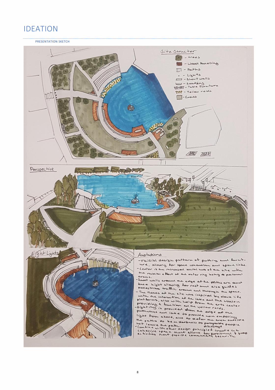
IDEATION
PRESENTATION SKETCH