environmental impact analysis process document
TRANSCRIPT

Environmental Impact Analysis Process Document
FONPA and Supporting AF Form 813
Title: Demo Consolidate Vehicle Operations to Building 52
MacDill Air Force Base, Florida

Finding of No Practicable Alternative

FINDING OF NO PRACTICABLE ALTERNATIVE DEMOLISH AND CONSOLIDATE VEHICLE OPERATIONS
MACDILL AIR FORCE BASE, FLORIDA Agency: United States Air Force (USAF), Headquarters, Air Mobility Command Background: Pursuant to the provisions of Executive Order 11988 and AFI 32-7064, paragraph 4.3, the U.S. Air Force conducted an assessment of the potential environmental consequences associated with implementation of the following Proposed Action: demolish and consolidate vehicle operations. The Proposed Action was found to fit within a Categorical Exclusion (32 Code of Federal Regulations (CFR) Part 989, Appendix B, paragraphs A2.3.8 and A2.3.11); therefore further environmental analysis under National Environmental Policy Act of 1969 (NEPA) was not required (see attached AF Form 813). This Finding of No Practicable Alternative (FONPA) summarizes the alternatives considered and explains why the project was designed and sited as proposed. The Tampa Tribune published a request for public comment on 16 April 2015, and the Air Force placed a copy of the Draft Air Force Form 813 and Draft FONPA in the public library for review. No comments were received during the public comment period ending 14 May 2015. Proposed Action: The Proposed Action includes four components: 1) Interior renovation of Building 52; 2) construct a new ~138,000 ft2 vehicle parking area and a ~4,200 ft2 drive-thru wash rack within the parking area; 3) demolition of three vehicle operations facilities (Building 119 {vehicle detailing shed}, Building 175 {administrative facility}, Building 178 {vehicle wash rack}), and removal of leased modular facility; and 4) conversion of the current vehicle operations parking area to a 88,158 ft2 general use parking lot. Alternatives: Three alternatives to implementation of the Proposed Action were considered during the environmental impact analysis process. One was eliminated from further analysis and two were carried forward for analysis. The first alternative involved constructing a new vehicle operations facility in its current location. This alternative does not meet the need for the action. The second alternative involved constructing a new Logistics Readiness Complex and would construct a 32,132 ft2 facility, 293,878 ft2 of impervious surface that included the demolition of Buildings 119, 175, 178, 500, and 510. The last alternative is the No Action Alternative, which would result in the demolition and consolidation of vehicle operations not being completed. The vehicle operations flight would continue to operate from their existing facilities with no change in current operations. Vital customer service functions at MacDill would continue to operate in old, inefficient, cramped spaces. Floodplains: The proposed demolition and consolidation of vehicle operations will be completed in the 100-year coastal floodplain. Executive Order 11988, Floodplain Management, as amended on 30 January 2015 by EO 13690, Establishing a Federal Risk Management Standard and a
Process for Further Soliciting and Considering Stakeholder Input, seeks to avoid construction of facilities or structures within the floodplains “to reduce the risk of flood loss, to minimize the impact of floods on human safety, health and welfare, and to restore and preserve the natural and beneficial values served by floodplains”. The project would not construct within the floodplain a facility that is occupied by personnel which would in turn jeopardize human safety, health and welfare. The vehicle operations parking area, parking lot, and wash rack would not be required to be elevated above the 100-year floodplain since the new wash rack can withstand submersion, has sufficient openings, and would not be damaged by flooding and the parking areas are solely used for storage. The MacDill Real Property manager determined the replacement cost (market value) for Building 52 is $4,250,259. The estimated cost to renovate Building 52 is approximately $1,937,679 which is approximately 46% of the market value of Building 52; repair costs to correct existing violations add another $279,021 to the total project cost. Therefore, the renovation of
Page 2 of 2
Building 52 is not considered a substantial improvement and is not required to be elevated above the 100-year floodplain. In addition, the project would not negatively impact the natural and beneficial value of the floodplain since the Proposed Action would flow into a new adequately sized stormwater management system to compensate for any added impervious surfaces. Similar to the function of a floodplain, these stormwater management systems collect, store, and treat stormwater runoff from the site and allow it to slowly infiltrate back into the ground following a storm event. Florida Coastal Zone Management: In accordance with the Federal Coastal Zone Management Act (CZMA) and the Florida CZMA, this Federal action must be consistent “to the maximum extent practicable” with the Florida Coastal Management Program (CMP) or a Negative Determination found. The Air Force has determined the project has no coastal effects, prepared a Negative Determination, and the State of Florida has concurred with this determination. FINDING OF NO PRACTICABLE ALTERNATIVE: Considering the information contained herein (including the attached AF Form 813), in accordance with EO 11988, and pursuant to the authority delegated to me, I find that there is no practicable alternative to completing the proposed project within the 100-year coastal floodplain. The Proposed Action, as designed, includes all practicable measures to minimize harm to and within the coastal floodplain. _____________ ROWAYNE A. SCHATZ, JR. DATE Major General, USAF Vice Commander, Air Mobility Command

Supporting AF Form 813

-REQUEST FOR ENVIRONMENTAL IMPACT ANALYSIS Report Control Symbol
RCS: 2015103
INSTRUCTIONS: Section I to be completed by Proponent. Sections II and III to be completed by Environmental Planning Function. Continue on separate sheets as necessary. Reference appropriate item number(s).
SECTION I – PROPONENT INFORMATION LOG ID#: 15-0005 1. TO (Environmental Planning Function) 2. FROM (Proponent Organization and functional address symbol) 2a. TELEPHONE NO.
6 CES/CEV 6 CES/DD 813-828-2718
3. TITLE OF PROPOSED ACTION
Demo Consolidate Vehicle Operations Bldg 52
4. PURPOSE AND NEED FOR ACTION (Identify decision to be made and need date)
(see attached)
5. DESCRIPTION OF ACTION AND ALTERNATIVES (DOPAA) (Provide sufficient details for evaluation of the total action)
(see attached)
6. PROPONENT APPROVAL (Name and Grade) 6a. SIGNATURE 6b. DATE
ROBERT D. MOORE, GS-13 \\ ELECTRONICALLY SIGNED \\ 3/19/2015
SECTION II – PRELIMINARY ENVIRONMENTAL SURVEY (Check appropriate box and describe potential
environmental effects including cumulative effects) (+=positive effect; 0=no effect; - = adverse effect; U=unknown effect) + 0 - U
7. AIR INSTALLATION COMPATIBLE USE ZONE/LAND USE (Noise, accident potential, encroachment, etc.) X
8. AIR QUALITY (Emissions, attainment status, state implementation plan, etc.) X
9. WATER RESOURCES (Quality, quantity, source, etc.) X
10. SAFETY AND OCCUPATIONAL HEALTH (Asbestos/radiation/chemical exposure, explosives safety quantity distance, bird/wildlife aircraft hazard, etc.)
X
11. HAZARDOUS MATERIALS/WASTE (Use/storage/generation, solid waste, etc.) X
12. BIOLOGICAL RESOURCES (Wetlands/floodplains, threatened or endangered species, etc.) X
13. CULTURAL RESOURCES (Native American burial sites, archaeological, historical, etc.) X
14. GEOLOGY AND SOILS (Topography, minerals, geothermal, Installation Restoration Program, seismicity, etc.) X
15. SOCIOECONOMIC (Employment/population projections, school and local fiscal impacts, etc.) X
16. OTHER (Potential impacts not addressed above.) X
SECTION III – ENVIRONMENTAL ANALYSIS DETERMINATION
17. X PROPOSED ACTION QUALIFIES FOR CATEGORICAL EXCLUSION (CATEX) #__A.2.3.11_______; OR
PROPOSED ACTION DOES NOT QUALIFY FOR A CATEX; FURTHER ENVIRONMENTAL ANALYSIS IS REQUIRED.
18. REMARKS
MacDill AFB is located in an attainment area for all the criteria pollutants and no conformity determination under the Clean Air Act is required. CATEX A2.3.8 - Performing interior and exterior construction within the 5-foot line of a building without changing the land use of the existing building. The interior renovations of Building 52 qualify for this CATEX. CATEX A2.3.11 - actions similar to other actions which have been determined to have insignificant impact in a similar setting as established in an environmental impact statement (EIS) or an EA resulting in a Finding of No Significant Impact (FONSI). 2013 Installation Development Environmental Assessment, FONSI/FONPA Signed 18 April 2013, construction project I1, Construct Logistics Readiness Complex. The new vehicle parking area, washrack, and demolition of 119, 175, & 178 qualify for this CATEX. 19. ENVIRONMENTAL PLANNING FUNCTION CERTIFICATION (Name and Grade)
ROBERT B. HUGHES, GS-14 Director, 6th Civil Engineer Squadron
19 a. SIGNATURE 19 b. DATE
AF FORM 813, 19990901 (EF-V1) THIS FORM CONSOLIDATES AF FORMS 813 AND 814. PAGE OF PAGE(S)

4.0 PURPOSE AND NEED FOR ACTION 4.1 PURPOSE: The purpose of the Proposed Action is to renovate Building 52 for the 6th Logistics Readiness Squadron (6 LRS) Vehicle Operations Flight, construct a new vehicle parking area and washrack, and demolish existing inadequate vehicle operations facilities. The 6 LRS Vehicle Operations currently operates in Buildings 119, 175, 178, and leased modular Building 3175. In addition, the current Vehicle Operations area would be converted to a parking lot. 4.2 NEED FOR ACTION: MacDill needs a Vehicle Operations Flight operating out of facilities that meet current Air Mobility Command (AMC) and Air Force standards. Existing vehicle operations facility was rated the worst in AMC over five years ago and no major upgrades have been accomplished to date. Vehicle Operations are operating in substandard facilities with space deficiencies augmented by a leased modular building. The existing location of the 6 LRS Vehicle Operations Flight is incompatible with the base general development plan and limits movement of the fleet due to high concentrated traffic in these areas.
5.0 DESCRIPTION OF PROPOSED ACTION AND ALTERNATIVES 5.1 The Proposed Action includes four components; 1) Interior renovation of Building 52; 2) construct a new ~460 ft by ~300 ft (~138,000 ft2) vehicle parking area and an ~82 feet by ~50 feet (~4,200 ft2) wash rack within the parking area; 3) demolition of three vehicle operations facilities, Building 119 (924 square feet [ft2]), Building 175 (2,000 ft2), Building 178 (1,600 ft2), and removal of a leased modular Building 3175 (2,715 ft2); and, 4) conversion of current (existing) vehicle operations parking area to a 88,158 ft2 general use parking lot. The conversion of the current (existing) vehicle operations parking area would not add any additional impervious surface. The proposed new washrack would be constructed within the proposed new vehicle parking area; therefore, no additional impervious surface would be needed for the washrack. The Proposed Action is located in the 100-year floodplain. 5.2 The entire site proposed for construction/renovation is in an area of the base adjacent to the south aircraft parking apron that is highly developed. The location for the proposed new 6 LRS Vehicle Operations area, as well as, the location of the buildings proposed for demolition is presented in Figures 1 and 2. The proposed location of the vehicle operations and demolition area overlain against existing base constraints is presented in Figure 3. The demolition site plan for the existing vehicle operations area is presented in Figure 4. The site plan for the conversion of the existing vehicle operations area to a general use parking lot is presented in Figure 5. The site plan for the new vehicle operations area parking area and wash rack is presented in Figure 6. The land use surrounding the Proposed Action is a mix of industrial, aircraft operations and maintenance, and administrative. 5.3 Proposed Action:
5.3.1 The Proposed Action would renovate and repair the interior of Building 52. The interior would be reconfigured to meet the needs of the vehicle operations flight. Repairs and upgrades to the air conditioning, plumbing, electrical, fire detection, and communications would be made. The renovated building would comply with DoD minimum antiterrorism construction standards. Prior to any renovations, an asbestos National Emissions Standards for Hazardous Air Pollutants (NESHAP) and lead-based paint (LBP) screening would be completed for Building 52. The contractor shall provide notification to the Environmental Protection Commission of Hillsborough County and hire a qualified environmental abatement

AF Form 813 (continued) Demo/Consolidate Vehicle Operations Bldg 52
Page 3 of 14
subcontractor to remove and dispose of any asbestos containing building material found in the respective facilities in accordance with applicable Federal and state regulations. The same environmental firm shall perform environmental monitoring during the abatement work in accordance with military, Environmental Protection Agency, and all other applicable environmental regulations. All waste disposal manifests shall be turned over to the government upon completion of the demolition work. 5.3.2 The National Floodplain Insurance Program (NFIP) and MacDill AFB’s Floodplain Management Plan (FPMP) requires that all new construction and substantial improvements be elevated above the 100-year floodplain. A substantial improvement, as defined in 44 CFR 59.1, is any reconstruction, rehabilitation, addition, or other improvement of a structure, the cost of which equals or exceeds 50 percent of the market value of the structure before the “start of construction” of the improvement. The term does not, however, include any project for improvement of a structure to correct existing violations of state or local health, sanitary, or safety code specifications which have been identified by the local code enforcement official and which are the minimum necessary to assure safe living conditions. The MacDill Real Property manager determined the replacement cost (market value) for Building 52 is $4,250,259. The estimated cost to renovate Building 52 is approximately $1,937,679 which is approximately 46% of the market value of Building 52; repair costs to correct existing violations adds another $279,021 to the total project cost. Therefore, the renovation of Building 52 is not considered a substantial improvement and is not required to be elevated above the 100-year floodplain. 5.3.3 A new ~138,000 ft2 vehicle parking area and a ~4,200 ft2 wash rack with an oil water separator would be constructed southeast of Building 52 between Marina Bay Drive and south aircraft parking apron as shown in Figure 6. The new wash rack would be located within the new vehicle parking area.
5.3.3.1 The new vehicle parking area would be graded using heavy equipment to remove any vegetation and create a smooth surface. Additional subbase material would be delivered and prepared using heavy equipment. The pavement area would be graded for proper stormwater collection and treatment. Concrete curbing would be constructed by setting forms by hand, placing concrete within the forms, letting the concrete set up, and then removing the forms. Once a solid, smooth subbase and curbing is prepared, hot asphaltic concrete would be placed across the area proposed for paving. The asphaltic concrete would be placed using heavy equipment and then compacted and smoothed using a roller compactor. 5.3.3.2 The new wash rack would be a pre-engineered metal building with concrete flooring and would include two wash bays and one vehicle detailing bay. The Proposed Action would result in construction of a non-residential structure in the floodplain that would not be permanently manned which would not be subject to damage from floodwaters. The facility is a drive-thru vehicle wash rack with floor drains in the wash bays. The proposed wash rack facility design includes sufficiently sized openings to allow the equalization of hydrostatic pressure on exterior walls should a flood event occur. The oil water separator will be a simple gravity design with baffles and a sealing lid. By design the oils and sludge are trapped in the separator and can only be removed by opening the lid.

AF Form 813 (continued) Demo/Consolidate Vehicle Operations Bldg 52
Page 4 of 14
5.3.3.3 The vehicle wash area would consist of a curbed, concave concrete slab with a center drain. The water and detergent used during vehicle washing would be contained on the concrete slab and drain to the base sanitary sewer system for treatment at the base wastewater treatment plant (WWTP). The vehicle wash area would also have a roof that completely covers the concrete slab in the washing area to reduce the potential for stormwater to enter the sanitary sewer system. The vehicle wash rack facility would include the installation of an oil water separator. Vehicle washing may result in the removal of oil, grease, and residual fuels from the vehicle which would enter an oil water separator which would be connected to the sanitary sewer system and flow to the base wastewater treatment plant. No modification to the base’s National Pollution Discharge Elimination System (NPDES) industrial permit would be required with construction of the new vehicle wash rack. 5.3.3.4 The potable water line installation to the wash rack would include the installation of a backflow prevention device. The sanitary sewer system installation to the wash rack would include a lift station downstream of the oil water separator. Backflow prevention devices and lift stations meet the requirements for floodproofing the facility. 5.3.3.5 To compensate for the increased impervious surfaces, management of the additional stormwater would be required. As a part of the construction, a new stormwater detention basin would be constructed to accommodate additional stormwater during periods of heavy rainfall. The base water program manager evaluated the project and determined that a new Environmental Resource Permit (ERP) would be needed to account for the additional impervious surface. The new parking areas would be designed to manage stormwater runoff in accordance with the local Southwest Florida Water Management District (SWFWMD) rules through construction of a dry retention basin(s). The dry retention basin design retains stormwater and allows it to percolate into the soil to avoid potentially harmful discharges to surface water bodies. A skimmer would be installed at the overflow point to prevent trash from leaving the stormwater retention basin.
5.3.4 Demolition of Buildings 119, 175, and 178 5.3.4.1 Building 119 is a 924 ft2 metal vehicle parking shed that would be demolished as part of the Proposed Action. The facility was constructed in 1982. The December 2012 Brief Evaluation of Cold War Facilities for MacDill AFB determined Facility 119 is not eligible for the National Register of Historic Places (NRHP). On 6 February 2013, the Florida State Historic Preservation Office (SHPO) agreed with the determination. 5.3.4.2 Building 175 is a 2,000 ft2 administrative vehicle operations facility that would be demolished as part of the Proposed Action. The facility was constructed in 1989. The December 2012 Brief Evaluation of Cold War Facilities for MacDill AFB determined Facility 175 is not eligible for the NRHP. On 6 February 2013, the SHPO agreed with the determination. 5.3.4.3 Building 178 is a 1,600 ft2 metal vehicle wash rack that would be demolished as part of the Proposed Action. The facility was constructed in 1990. This facility was constructed after the Cold War period (1989). 5.3.4.4 Demolition and site preparation would be accomplished by equipment such as front-end loaders, bulldozers and track-hoes. Prior to disturbing the various sites, a silt

AF Form 813 (continued) Demo/Consolidate Vehicle Operations Bldg 52
Page 5 of 14
fence would be installed around the construction and demolition sites to reduce erosion resulting from wind and surface water runoff. Demolition would be accomplished by physically knocking down the existing concrete block structure and supporting infrastructure. The ‘wet demolition’ method would be used to suppress the release of dust and other particle matter during demolition. The rubble generated during demolition would be loaded into roll-off dumpsters and hauled off base for disposal at a certified construction and demolition debris landfill in the local area. Prior to initiating any demolition activities, the contractor shall perform a comprehensive asbestos National Emissions Standard for Hazardous Air Pollutants (NESHAP) demolition survey of buildings 119, 175, and 178 and LBP screening of all facilities. The contractor shall provide notification to the Environmental Protection Commission of Hillsborough County and hire a qualified environmental abatement subcontractor to remove and dispose of any asbestos containing building material found in the respective facilities in accordance with applicable Federal and state regulations. The same environmental firm shall perform environmental monitoring during the abatement work in accordance with military, Environmental Protection Agency, and all other applicable environmental regulations. Based on generator knowledge (40 CFR 262.11), the demolition debris for the facilities would not fail the Toxicity Characterization Leaching Procedure (TCLP) test and, hence, will not be regulated as a hazardous waste. Therefore, material containing lead-based paint can be disposed as construction demolition debris with no further management required, provided that the painted surfaces are not stripped or sand-blasted prior to removal. All waste disposal manifests shall be turned over to the government upon completion of the demolition work.
5.3.5 After removal of leased modular Building 3175, fence removal, and the demolition of Buildings 119, 175, and 178, the old vehicle operations area would be converted to a general use parking lot. The conversion of the current (existing) vehicle operations area would not add any additional impervious surface. The areas where the demolition occurred would be prepped for placement of asphalt and the rest of the area would be milled. Additional subbase material would be delivered and prepared using heavy equipment. The pavement area would be graded for proper stormwater collection and treatment. Concrete curbing would be constructed by setting forms by hand, placing concrete within the forms, letting the concrete set up, and then removing the forms. Once a solid, smooth subbase and curbing is prepared, hot asphaltic concrete would be placed across the area proposed for paving. The asphaltic concrete would be placed using heavy equipment and then compacted and smoothed using a roller compactor. 5.3.6 Disturbance of vegetation and surface soils associated with demolition and new construction creates the potential for erosion by wind and surface water runoff. Prior to disturbing the construction site, silt fence would be installed around the entire area of construction. All construction activities would employ best management practices to prevent erosion of surface soils and sediment runoff. If needed, the construction contractor would secure and comply with the conditions of a National Pollutant Discharge Elimination System (NPDES) Construction Generic Permit (CGP) through use of erosion control techniques such as silt fencing, sediment traps, and application of water sprays. Prior to submitting the Notice of Intent (NOI) to obtain coverage under the CGP, contractor must prepare a Storm Water Pollution Prevention Plan (SWPPP) and submit it to Base Environmental for approval. Once construction is complete and landscaping has been installed, any remaining disturbed areas of the site would be covered with a layer of sod.

AF Form 813 (continued) Demo/Consolidate Vehicle Operations Bldg 52
Page 6 of 14
5.4 Alternatives Considered But Eliminated From Further Study – The Environmental Impact Analysis Process requires the Air Force to analyze reasonable alternatives to the Proposed Action and the No Action Alternative. Reasonable alternatives are those that “meet the underlying purpose and need for the Proposed Action and that would cause a reasonable person to inquire further before choosing a particular course of action.” Alternatives may be eliminated from detailed analysis based on operational, technical, or environmental standards that are applicable to the project. Additionally, Executive Order 11990, Floodplain Management, requires the consideration of practicable alternatives to avoid adverse effects and incompatible development in the floodplain. Practicable alternatives are those that are capable of being done within existing constraints and include consideration of pertinent factors including the environment, community welfare, cost, and available technology. Two alternatives to the Proposed Action were initially considered but eliminated from further study as unreasonable and/or impracticable. The alternatives are described below:
5.4.1 An alternative location for this has been proposed on the site currently occupied by LRS vehicle operations, which is on the northeastern portion of the installation between North Boundary Boulevard and Bayshore Boulevard at the current location of Buildings 119, 175, 178, and 3175. This alternative would require a phased approach to the construction and demolition (C&D) component. Vehicle operations would have to temporarily relocate to the LRS vehicle maintenance compound. The demolition of Buildings 119, 175, 178, and 3175 would occur next and then the new vehicle operations facilities would be constructed in this area. This location is situated within the 100-year floodplain, and is adjacent to an historic district and an ERP site. This alternative would meet the current space requirements. However, this alternative does not meet the need described in Section 4.2 with respect to the existing location of Vehicle Operations being incompatible with the base general development plan and limits movement of the fleet due to high concentrated traffic in these areas. Therefore, this is not a reasonable or practicable alternative. No other unconstrained sites are available outside of the floodplain on MacDill AFB.
5.5 Description of Alternatives Two alternatives to the Proposed Action were considered to determine whether they met the underlying purpose and need for the Proposed Action. The alternatives are 1) Construct Logistics Readiness Complex and 2) the No Action alternative are summarized below.
5.5.1 This Alternative would construct a Logistics Readiness Complex, a 32,132 ft2 facility that included the demolition of Buildings 119, 175, 178, 500, and 510. This project consists of constructing a 32,132-ft2 facility, properly designed and centrally located, to consolidate vehicle maintenance, transportation, administrative, and operational functions adjacent to the Supply Warehouse (Building 49). The Logistics Readiness Complex would also add approximately 293,878 ft2 of impervious surface (parking lots). A drainage ditch exists around Building 49 and out towards the flightline, where it splits into two ditches. Marina Bay Drive would cross these two ditches. The existing 26,600-ft2 roadway would be straightened and new culverts constructed to cross the two ditches, and would increase impervious surfaces by 9,100 ft2. The new facility would include anti-terrorism/force protection (AT/FP) measures, parking lot, and communication infrastructure. The estimated cost for the entire project including construction of the new facility, parking, landscaping and stormwater management systems, and the
AF Form 813 (continued) Demo/Consolidate Vehicle Operations Bldg 52
Page 7 of 14
demolition is $12M. This project would be considered a Military Construction (MILCON) project and under the current fiscal climate is not likely to be funded. This project would have more environmental impacts than the Proposed Action including impacting two major drainage ditches. This is not the preferred alternative. 5.5.2 The No Action Alternative would not renovate Building 52 for the 6th Logistics Readiness Squadron (6 LRS) Vehicle Operations Flight, construct new vehicle parking area and washrack, and demolish existing inadequate vehicle operations facilities. The Vehicle Operations Flight would continue to operate from their existing facilities with no change in current operations. Vital customer service functions at MacDill would continue to operate in old, inefficient, cramped spaces. MacDill’s ability to provide excellent customer service will continue to be hindered by these substandard facilities. Current facilities are inefficient and expensive to maintain and operate, which puts additional pressure on an already constrained facility operations budget. This is not the preferred alternative.
6.0 SUPPORTING DOCUMENTATION 6.1 MacDill Air Force Base completed an Installation Development Environmental Assessment (IDEA) in April 2013. The IDEA’s installation-wide approach to environmental impact analysis ensures that substantial restrictions to base development projects are identified early and avoided. The IDEA used a constraints based approach to compile information on eleven (11) different resource areas; noise, land use, air quality, geological resources, water resources, biological resources, cultural resources, socioeconomic and environmental justice, infrastructure, hazardous materials and waste, and safety; to examine the potential environmental effects the future development of MacDill Air Force Base would have on these resources. The IDEA evaluated all base development projects programmed for the five year planning period between 2012 and 2017 by grouping those projects into five categories; (1) demolition, (2) construction, (3) infrastructure improvement, (4) natural infrastructure management, and (5) strategic sustainability performance projects. These five categories were selected because they allow grouping of initiatives by the generally common elements of the activity and the nature of the potential environmental impacts. The IDEA determined the projects evaluated in the IDEA would not individually or cumulatively have a significant impact on the environment and a Finding of No Significant Impact/Finding of No Practicable Alternative (FONSI/FONPA) was signed by AMC/A7 on 24 April 2013. 6.2 The Air Force Environmental Impact Analysis Process uses the AF Form 813 to narrow and focus issues on potential environmental impacts and to document certain categorical exclusion (CATEX) determinations. CATEXs define those categories of actions that do not individually or cumulatively have the potential for significant effects on the environment. Actions that usually do not require additional environmental analysis include those that have minimal adverse effects on the environment; do not result in any significant change to the existing environment; do not have any significant cumulative environmental impacts; or those actions that are similar to actions that have previously been assessed and found to have no significant environmental impacts. CATEXs are described in Appendix B to 32 Code of Federal Regulations Part 989. 6.3 The MacDill AFB Environmental Planning Function (6 CES/CEIE) has determined that the interior renovations of Building 52 portion of the Proposed Action qualifies for exclusion from further analysis under CATEX A2.3.8. CATEX A2.3.8 exempts from further environmental

AF Form 813 (continued) Demo/Consolidate Vehicle Operations Bldg 52
Page 8 of 14
analysis "Performing interior and exterior construction within the 5-foot line of a building without changing the land use of the existing building." 6.4 6 CES/CEIE has determined the demolition of Buildings 119, 175, and 178, and the construction of a new vehicle parking area and washrack portion of the Proposed Action qualifies for exclusion from further environmental analysis under CATEX A2.3.11. CATEX A2.3.11 exempts from further environmental analysis “actions similar to other actions which have been determined to have an insignificant impact in a similar setting as established in an Environmental Impact Statement or Environmental Assessment resulting in a Finding of No Significant Impact.” The demolition of Buildings 119, 175, and 178 were specifically analyzed in the IDEA construction project C2, Construct Logistics Readiness Complex and environmental conditions and impacts have not changed since the preparation of the IDEA. The MacDill Environmental Planning Function has determined the new vehicle parking area and washrack portion of the Proposed Action are sufficiently similar to the IDEA construction project C2, Construct Logistics Readiness Complex and would occur in a similar environmental setting based on the following observations: The IDEA evaluated the construction of the Logistics Readiness Complex, a 32,132 ft2 facility that included the demolition of Buildings 119, 175, 178, 500, and 510. The proposed Logistics Readiness Complex would have added approximately 293,878 ft2 of impervious surface. The construction activities required for the Proposed Action are considered similar, although on a much smaller scale, to the construction techniques used for the IDEA Logistics Readiness Complex project, and are being accomplished in a similar environmental setting. Similarities include both projects being constructed in a developed portion of the base with maintained grassy areas and adding impervious surface. Additional similarities are identified in the subsequent Sections below. The locations of the Construct Logistics Readiness Complex and the new vehicle parking area and washrack portion of the Proposed Action overlain against existing base constraints are presented in Figure 3 which demonstrates the similarity of the environmental constraints. The location of Bldg 52 is approximately 500 ft southwest of the Construct Logistics Readiness Complex project. The IDEA examined the following resource areas: noise, land use, air quality, geological resources, water resources, biological resources, cultural resources, socioeconomic and environmental justice, infrastructure, hazardous materials and waste, and safety; to evaluate the potential environmental effects the infrastructure improvements on MacDill Air Force Base would have on these resources. A discussion of the resource areas analyzed for the IDEA as they relate to the construct vehicle parking area and washrack portion of the Proposed Action follows.
6.4.1 Noise: Similar to the Logistics Readiness Complex, short-term moderate adverse effects on noise levels would be expected from the construction activities of the Proposed Action. The noise emanating from the proposed construction of the vehicle parking area and washrack would be localized, short-term, and intermittent during operation of construction equipment, as would the construction of the Logistics Readiness Complex. Construction noise varies depending on the type of construction being done, the area that the construction would occur in, and the distance from the source. The construction of the Proposed Action would be expected to result in the noise levels similar to the Construct Logistics Readiness Complex but for a much shorter duration and less intense. The Proposed Action is expected to be constructed in approximately six months and the Construct Logistics Readiness Complex construction was expected to require eighteen months for completion. The Construct Logistics Readiness Complex construction would have required a greater variety and more equipment than the

AF Form 813 (continued) Demo/Consolidate Vehicle Operations Bldg 52
Page 9 of 14
Proposed Action. The following tables present the occupied facilities that would be expected to have temporary noise impacts associated with Proposed Action.
Table 1 - Potential Noise Impacts from the construction of vehicle parking area and washrack
Temporary Noise Impacted Facility/Use Distance from Proposed Action (feet)
Estimated Combined Noise Level
Bldg 49, Logistics Readiness Squadron Bldg 847, SOCOM & CENTCOM Deployment Cells ~300 75-80 dBA
Bldg 90, Air Passenger Terminal & Alternate Command Post ~400 72-76 dBA
Bldg 79, Joint Communication Support Element ~500 66-74 dBA
The Proposed Action is not anticipated to create additional operational noise that would impact adjacent land uses. The adjacent receptors would probably experience noise impacts from construction and/or construction-related vehicles. The magnitude of these impacts would be directly related to the proximity of the occupants and workers to the construction site. In addition, the impacts vary according to the activity occurring on any particular day, and impacts would cease when construction is completed. Given the proximity to these facilities, impacts from construction noise are unavoidable. However, construction noise is short-term and only occurs during the daylight hours. Construction equipment would be used only as necessary and would be maintained to the manufacture’s specifications to minimize noise impacts. It is not anticipated that the short-term increase in ambient noise levels from the Proposed Action would cause significant adverse impacts on the surrounding populations. Once the proposed projects are completed, the ambient noise level would return to its normal level. No long-term impacts on the ambient noise level would occur as a result of the Proposed Action.
6.4.2 Land Use: Similar to the Construct Logistics Readiness Complex, no adverse effects on land use would be expected from the Proposed Action. The land use would not change. 6.4.3 Air Quality: Insignificant short-term minor intermittent impacts to air quality would be expected to result from the construction and demolition activities. These impacts would result from vehicle emissions from heavy equipment, as well as, fugitive dust generated by construction activities. The IDEA calculated the emissions for the criteria pollutants that would result from construction of the Construct Logistics Readiness Complex. The calculated emissions for the Construct Logistics Readiness Complex and Proposed Action are provided in the following table. MacDill AFB is in attainment for all criteria pollutants, so the General Conformity Rule does not apply. Furthermore, the criteria pollutants generated by the Demo/Consolidate Vehicle Operations Bldg 52 would not exceed 10 percent of Hillsborough County emissions values.
Table 2 – Estimated Emissions from the construction of vehicle parking area and washrack
Proposed Project NOx (tpy)
VOC (tpy)
CO (tpy)
SOx (tpy)
PM10 (tpy)
PM2.5 (tpy)
CO2
(tpy)
Logistics Readiness Complex 7.110 1.231 5.626 0.563 19.716 2.495 1,007.682
Proposed Action 3.011 0.415 2.029 0.238 4.887 0.691 409.880
10% of Hillsborough County Emissions 5,635 3,579 20,156 1,908 1,754 431 22,600,000*
AF Form 813 (continued) Demo/Consolidate Vehicle Operations Bldg 52
Page 10 of 14
6.4.4 Geological Resources: Similar to the Construct Logistics Readiness Complex, short-term minor adverse effects would be expected from grading, excavating, and grooming of the soil. Impacts on previously undisturbed soils would be expected to be minimal because these portions of MacDill AFB have historically been intensely used. Grading, excavation and recontouring of soil materials would adhere to all Federal, state, and local regulations. Similar to the Construct Logistics Readiness Complex, the Proposed Action is located near or adjacent to a clean-up site. The Proposed Action was evaluated for the potential for impacts to and/or from documented hazardous waste clean-up sites (both Environmental Restoration Account {ERA} and non-ERA funded sites) at MacDill AFB. There are two Environmental Restoration Program (ERP) sites (57 and TU/US-C500) located adjacent to the Proposed Action and contact with contaminated media is not expected with this project (See Figure 3). The Construct Logistics Readiness Complex is also located adjacent to ERP sites 57 and TU/US-C500. If soil contamination is discovered during site preparation, construction activities would be halted until coordination with the MacDill ERP office could be completed to determine the appropriate management strategy for the site. If contaminated soil is encountered, it may be placed back where it was excavated from. If there is not enough space in the excavation area to replace all the removed soil, it must be hauled off site for treatment and disposal at the contractor’s expense. The contaminated soil may not be placed on another area of the site. Therefore, no significant impacts on soils would be expected from the Proposed Action.
6.4.4.1 Site 57 (former pumphouse 72) is located just north of the proposed vehicle parking area and washrack portion of the Proposed Action. Site 57, the Flightline Fueling System, historically consisted of four pumphouses (Pumphouses 72, 75, 76, and 77), 30 refueling pits, six defueling pits, and a jet fuel pipeline that connected all of the units. Pumphouse 72 and associated Fuel Pits were taken out of service and demolished in 1997. Contamination at the site is consistent with the Mixed Product Analytical Group, as defined in Chapter 62-770, FAC. The site is considered Low Risk and is currently under contaminated soil removal. 6.4.4.2 TU/US-C500 is considered Low Risk and is currently approved for MNA. Groundwater contaminants of concern for TU/US-C500 include BTEX, isopropylbenzene, vinyl chloride, naphthalene, and TRPH. Soil contaminates of concern for TU/US-C500 include PAHs and TRPH.
6.4.5 Water Resources: Similar to the Construct Logistics Readiness Complex project, the proposed construction project would have the potential to result in minor adverse impacts on the underlying surficial aquifer and receiving surface water bodies as a result of runoff from the construction, but adherence to the practices in the existing installation Stormwater Pollution Prevention Plan (SWPPP), Hazardous Waste Management Plan, and Spill Prevention Control and Countermeasures Plan would minimize the potential for adverse effects. To reduce the adverse effects associated with groundbreaking activities, best management practices (BMPs) in accordance with MacDill’s SWPPP would be implemented. BMPs for erosion and sedimentation control include the use of silt fence, hay bailing stormwater inlets, and installing sod on any disturbed areas upon completion of the Repair Fire Suppression System Hangars 1, 2, and 3.

AF Form 813 (continued) Demo/Consolidate Vehicle Operations Bldg 52
Page 11 of 14
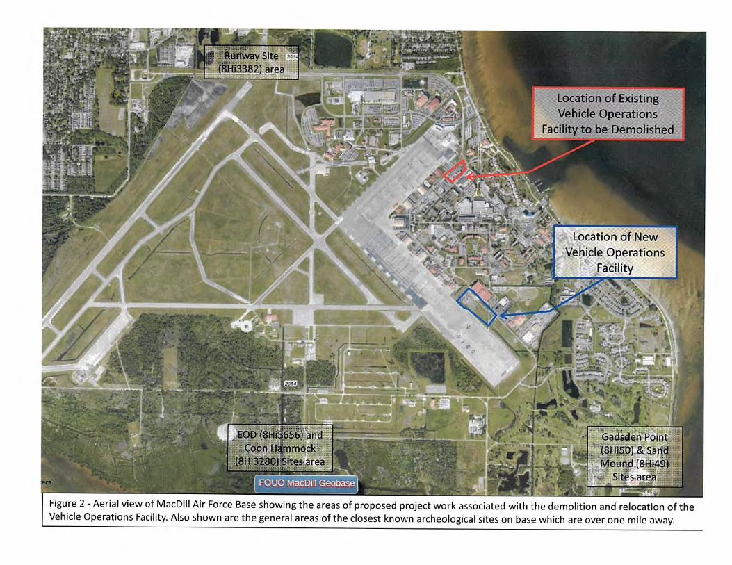
To compensate for the increased impervious surfaces, management of the additional stormwater would be required. A new stormwater retention basin within the project site would be constructed to accept the additional stormwater. The base water program manager evaluated the project and determined that a new Environmental Resource Permit from the Southwest Florida Water Management District would be needed since the Proposed Action adds approximately 138,000 ft2. Similar to the Construct Logistics Readiness Complex, the Proposed Action is within the 100-year coastal floodplain; consequently, compliance with Executive Order (EO) 11988 is required. The vehicle parking area and washrack are solely used for storage and not permanently occupied; the lot would not be required to be elevated above the 100-year floodplain. 6.4.6 Biological Resources: Similar to the Construct Logistics Readiness Complex, the Proposed Action would have short-term direct minor impacts on vegetation and wildlife as a result of disturbance associated with construction. The use of BMPs to reduce soil and storm water runoff would limit the intensity, duration, and extent of impacts on vegetation. The proposed construct vehicle parking area and washrack is considered to be improved grounds that receive routine mowing. The proposed construct vehicle parking area and washrack area is not suitable habitat for most species. According to the 2012 MacDill AFB Threatened and Endangered Species Study, there are no known state or federally listed animal or plant species in the proposed area. A site survey by the MacDill AFB Natural Resources Manager in March 2015 confirmed that there are no known state or federally listed animal or plant species in the proposed area. Non-listed species in the area would be habituated to frequent disturbances and would be expected to recover quickly once construction noise and disturbances have ceased. Therefore, no adverse effects would result from project activities. 6.4.7 Cultural Resources: Similar to the Construct Logistics Readiness Complex project, no adverse effects on architectural or archeological resources would be expected from the construction of the Proposed Action. The Seminole Tribe of Florida and the Miccosukee Tribe of Indians of Florida were both consulted during the Environmental Impact Analysis Process for the Demolish/Consolidate Vehicle Operations Bldg 52. The Miccosukee Tribe of Indians of Florida did not express any concerns about the proposed Demolish/Consolidate Vehicle Operations Bldg 52 project. On 29 July 2015 the Seminole Tribe of Florida requested that consultation continue for the Demolish/Consolidate Vehicle Operations Bldg 52 project and on 30 September 2015, they requested that the proposed site be evaluated according to the Florida Division of Historical Resources Module 3 standards, which may involve conducting a Cultural Resource Assessment Survey. MacDill AFB completed a Cultural Resources Assessment Survey of the five acre for the Demolish/Consolidate Vehicle Operations Bldg 52 project in December 2015. No archaeological resources were found during the survey. The final Cultural Resource Assessment Survey report was submitted to the Seminole Tribe of Florida on 29 December 2016. On 3 February 2016, the Seminole Tribe of Florida had no objections to the findings of the Cultural Resources Assessment Survey. They requested to be informed in the event that any archaeological, historical, or burial resources are inadvertently discovered during construction work for the project. Correspondence between MacDill AFB and each tribe is attached. If artifacts, concentrations of shell, or unique soil conditions are discovered during construction, construction activity in the vicinity of the discovery shall cease until the MacDill Cultural Resources Manager has assessed the situation and consulted with the State Historic

AF Form 813 (continued) Demo/Consolidate Vehicle Operations Bldg 52
Page 12 of 14
Preservation Office (SHPO), Seminole Tribe of Florida, and Miccosukee Tribe of Indians of Florida, as described in MacDill’s Standard Operating Procedure for Inadvertent Discovery. Therefore, no impacts to Cultural Resources are expected to result from project activities. 6.4.8 Socioeconomics and Environmental Justice: Similar to the Construct Logistics Readiness Complex project, short-term, negligible, beneficial effects on socioeconomic resources would be expected from the site preparation and construction of the Demolish/Consolidate Vehicle Operations Bldg 52. It is assumed that equipment and supplies necessary to complete the proposed activities would be obtained locally, and local contractors would be used. The demand for workers as part of the construction would be minor and would not outstrip the local supply of workers. The proposed preparation and construction activities would occur entirely on MacDill AFB, and it would not adversely effect on- or off-installation residents. Therefore, no environmental justice issues would be anticipated. No long-term effects on socioeconomic resources are expected to result from the proposed construction of the garage. 6.4.9 Infrastructure: Long-term negligible adverse effects on MacDill AFB’s infrastructure would be expected. Negligible adverse effects on solid waste would be expected as a result of the minimal generation of solid waste during construction activities. Similar to the Construct Logistics Readiness Complex, the Demolish/Consolidate Vehicle Operations Bldg 52 would involve the addition of ~138,000 ft2 of impervious surface, which would result in long-term, minor adverse effects on stormwater management. Stormwater runoff from the parking area would be conveyed to a new stormwater retention basin that would be constructed to handle the runoff. 6.4.10 Hazardous Materials and Waste: Similar to the construction of the Construct Logistics Readiness Complex, short-term, negligible, adverse effects associated with hazardous materials and waste would be expected from this project. The Proposed Action would result in a short-term increase in the use of hazardous materials and petroleum products due to construction activities. Contractors would be responsible for the management of these materials, which would be handled in accordance with the MacDill AFB Hazardous Waste Management Plan, Federal, state, and USAF regulations. 6.4.11 Safety: Similar to the construction of the Construct Logistics Readiness Complex, short-term minor adverse effects on safety would be expected as a result of increased risk associated with construction-type activities. Construction activities would be accomplished in accordance with Federal, state, and local regulations to minimize hazards associated with hazardous materials, wastes, and substances. Therefore, no adverse effects would result from project activities.
6.5 Information gathered during this environmental analysis confirms that the Demolish/Consolidate Vehicle Operations Bldg 52 project would have no effects or negligible effects on the eleven resource areas evaluated.
7.0 COASTAL ZONE MANAGEMENT ACT COMPLIANCE: 7.1 The Federal Coastal Zone Management Act (CZMA) creates a state-Federal partnership to ensure the protection of coastal resources. The Federal CZMA requires each Federal agency activity, within or outside the coastal zone, which affects any land or water use or natural resources of the coastal zone, to be carried out in a manner that is consistent, to the maximum extent

AF Form 813 (continued) Demo/Consolidate Vehicle Operations Bldg 52
Page 13 of 14
practicable, with the enforceable policies of the Florida Coastal Management Program (CMP) of 1981. The Florida CMP presumes that “direct Federal activities” will directly affect the coastal zone. According to the Florida CMP, “direct Federal activities” are those that “are conducted or supported by or on behalf of a Federal agency in the exercise of its statutory responsibilities, including development projects.” 7.2 The Federal CZMA requires Federal agencies carrying out activities subject to the Act to provide a “negative determination” to the relevant state agency. The Federal regulations implementing the Act then require the state agency to inform the Federal agency of its agreement or disagreement with the Federal agency’s negative determination. Therefore, the Proposed Action and the Alternative to the Proposed Action analyzed in this AF Form 813 require the Air Force to submit a negative determination to the relevant Florida agency and requires a response from the State of Florida of either agreement or disagreement with that determination. 7.3 The AF Form 813, Finding of No Practicable Alternative (FONPA), and negative determination were submitted to the Florida State Clearinghouse for review (see attached). Department staff did not object to the Air Force’s negative determination and agreed that the proposed action meets the requirements of 15 CFR 930.35 (see attached).
8.0 EXECUTIVE ORDER 11988 – FLOODPLAIN MANAGEMENT: 8.1 The location of the proposed project is in the 100-year coastal floodplain. 8.2 Executive Order 11988, Floodplain Management, seeks to avoid construction of facilities or structures within floodplains “to reduce the risk of flood loss, to minimize the impact of floods on human safety, health and welfare, and to restore and preserve the natural and beneficial values served by floodplains”. The project would not construct within the floodplain a facility that is occupied by personnel which would in turn jeopardize human safety, health and welfare. In addition, the project would not negatively impact the natural and beneficial value of the floodplain since storm water runoff from the Proposed Action would flow into a new stormwater management systems to compensate for any added impervious surfaces. 8.3 Information available from the Federal Emergency Management Agency (FEMA Maps dated 2008), shows that 80 percent (4,510 acres) of MacDill is within the 100-year floodplain. Residential, industrial, and institutional land uses on the Base are within the 100-year floodplain, along with most of the commercial and aviation support areas. The runway and airfield occupy approximately 80 percent of land mass outside the floodplain on MacDill AFB and is constrained from further development for safety reasons. Overall, approximately 3.9 percent of MacDill’s land mass is outside the 100-year floodplain and outside of the runway and airfield. However, most of the 3.9% of land outside of the 100-year floodplain is not developable. That land already has buildings, roads, sidewalks, drainage swales, stormwater detention basins, etc. Overall, there is 0.20% (11.51 acres) of MacDill outside of the 100-year floodplain that is "developable". 8.4 As discussed in Section 5.3.2, the Building 52 renovation and repair is not considered a substantial improvement and is not required to be elevated above the 100-year floodplain. The Proposed vehicle parking area and washrack would not be elevated above the 100-year floodplain, since they are solely used for parking and storage. The vehicle parking area and washrack are unoccupied facilities and would not result in adverse effects to human health or welfare, and would not create any additional safety risks. The wash rack facility, although subject to flooding, is not expected to sustain damage during a flood event. In addition, the project would not negatively
AF Form 813 (continued) Demo/Consolidate Vehicle Operations Bldg 52
Page 14 of 14
impact the natural and beneficial value of the floodplain since storm water runoff from the Proposed Action would flow into a new stormwater management system modified to compensate for any added impervious surfaces. Similar to the function of a floodplain, these stormwater management systems collect, store, and treat stormwater runoff from the site and allow it to slowly infiltrate back into the ground following a storm event. Therefore, although being completed in the floodplain, the Proposed Action would have insignificant impacts to the floodplain.
9.0 EXECUTIVE ORDER COMPLIANCE: 9.1 The Air Force complied with the E.O. 11988 requirement to prepare and circulate a notice containing an explanation of why the action is proposed to be located in the floodplain and the requirement to allow a brief comment period prior to taking action. Notice of the Proposed Action was published in the Tampa Tribune and on the MacDill AFB public web site on 14 April 2015. The Tampa Tribune is a local newspaper of general circulation and the advertisement was placed in a prominent section of the newspaper. The Notice advised the public that the comment period for the Proposed Action would run through 14 May 2015. The Notice advised the public that the Air Force invited public review and comment on the Draft AF Form 813, the Draft FONPA, and of the location where copies of the documents could be obtained. No comments were received during the comment period and no resources were committed or actions taken which would have an environmental impact or limit the choice of reasonable alternatives prior to expiration of the comment period. 9.2 The environmental analysis included in this AF Form 813 and the FONPA completes the environmental impact analysis process under Air Force instructions.

Public Notice


Supporting Documents
(If available or required)
Figures; ERP Information;
Tribal Consultation; Other

Figure 1 – General location of the Proposed new 6 LRS vehicle operations area and the location of the buildings proposed for demolition
Bldgs 119, 175, & 178 Proposed for demolition and area converted to
parking lot
IDEA Proposed Logistics Readiness
Complex
Proposed new vehicle parking area and
washrack
Proposed renovation of Bldg 52 for Vehicle
Operations
Conversion of existing vehicle operations parking area to
general use parking lot

Figure 2 – Aerial view of the general location of the Proposed new 6 LRS vehicle operations area and the location of the buildings proposed for demolition
Bldgs 119, 175, & 178 Proposed for demolition and area converted to
parking lot
IDEA Proposed Logistics Readiness
Complex
Proposed new vehicle parking area and
washrack
Proposed renovation of Bldg 52 for Vehicle
Operations
Conversion of existing vehicle operations parking area to
general use parking lot

Figure 3 – Map of the general location of the Proposed new 6 LRS vehicle operations area and the location of the buildings proposed for demolition overlain against existing base constraints
Bldgs 119, 175, & 178 Proposed for demolition and area converted to
parking lot
IDEA Proposed Logistics Readiness
Complex
Proposed new vehicle parking area and
washrack
Proposed renovation of Bldg 52 for Vehicle
Operations
Conversion of existing vehicle operations parking area to
general use parking lot

Figure 4 – Existing vehicle operations area demolition site plan

Figure 5 – Existing vehicle operations are conversion to a general parking lot

Figure 6 – New vehicle operations area site plan (Note: Keynotes on left side correspond to the plan on the left and keynotes on the right side correspond to the plan on the right)

Page 1 of 8
FEDERAL AGENCY COASTAL ZONE MANAGEMENT ACT (CZMA) NEGATIVE DETERMINATION
Introduction This document provides the State of Florida with the U.S. Air Force’s Negative Determination under CZMA Section 307 and 15 CFR Part 930.35. The information in this Negative Determination is provided pursuant to 15 CFR Section 930.35 (b). Pursuant to Section 307 of the Coastal Zone Management Act, 16 U.S.C. § 1456, as amended, its implementing regulations 15 CFR 930.35 this is a Federal Negative Determination for activities described below.
Proposed Federal agency action: The purpose of the Proposed Action is to renovate Building 52 for the 6th Logistics Readiness Squadron (6 LRS) Vehicle Operations Flight, construct new vehicle parking area and washrack, and demolish existing inadequate vehicle operations facilities. The Proposed Action consists of four components: 1) Interior renovation of Building 52; 2) construction of a new ~138,000 ft2 vehicle parking area and a ~4,200 ft2 wash rack within the parking area; 3) demolition of three vehicle operations facilities (Building 119 {vehicle detailing shed}, Building 175 {administrative facility}, Building 178 {vehicle washrack}), and removal of leased modular facility and; 4) conversion of current vehicle operations area to a parking lot. The Proposed Action is located within the 100-year floodplain.
Federal Review After review of the Florida Coastal Management Program and its enforceable policies, the U.S. Air Force has made a negative determination that this activity will have any affect on the state of Florida’s coastal zone or its resources.

Page 2 of 7
Figure 1 – Vicinity Map
MacDill AFB

Page 3 of 7
Figure 2 – Location Map of Proposed Action
General location of the Proposed Action – Demolish and Consolidate Vehicle Operations

Page 4 of 7
Florida Coastal Management Program Consistency Review
Statute Consistency Scope Chapter 161 Beach and
Shore Preservation The proposed project would not adversely affect beach and shore management, specifically as it pertains to: The Coastal Construction Permit Program. The Coastal Construction Control Line (CCCL)
Permit Program. The Coastal Zone Protection Program. All land
activities would occur on federal property.
Authorizes the Bureau of Beaches and Coastal Systems within DEP to regulate construction on or seaward of the states’ beaches.
Chapter 163, Part II Growth Policy; County and Municipal Planning; Land Development Regulation
All activities would occur on federal property. Requires local governments to prepare, adopt, and implement comprehensive plans that encourage the most appropriate use of land and natural resources in a manner consistent with the public interest.
Chapter 186 State and
Regional Planning All activities would occur on federal property. Details state-level planning requirements.
Requires the development of special statewide plans governing water use, land development, and transportation.
Chapter 252 Emergency
Management The proposed action would not increase the state’s vulnerability to natural disasters. Emergency response and evacuation procedures would not be impacted by the proposed action.
Provides for planning and implementation of the state’s response to, efforts to recover from, and the mitigation of natural and manmade disasters.
Chapter 253 State Lands All activities would occur on federal property. Addresses the state’s administration of public lands and property of this state and provides direction regarding the acquisition, disposal, and management of all state lands.
Chapter 258 State Parks
and Preserves
Recreational areas and aquatic preserves would not be affected by the proposed action.
Addresses administration and management of state parks and preserves.
Chapter 259 Land
Acquisition for
Conservation or Recreation
All activities would occur on federal property. Authorizes acquisition of environmentally endangered lands and outdoor recreation lands.
Page 5 of 7
Statute Consistency Scope Chapter 260 Florida Greenways and
Trails Act
Florida Greenways and Trails would not be affected. All activities would occur on federal property.
Authorizes acquisition of land to create a recreational trails system and to facilitate management of the system.
Chapter 267 Historical
Resources The Air Force and the Florida State Historic Preservation Officer have determined that MacDill has two areas with buildings potentially eligible for the National Register of Historic Places. The Proposed Action is located outside of the MacDill Field Historic District and the Staff Officers Historic District. Consultations between the Air Force and State Historic Preservation Officer was completed.
Addresses management and preservation of the state’s archaeological and historical resources.
Chapter 288 Commercial
Development and Capital
Improvements
The proposed action would occur on federal property. The proposed action is not anticipated to have any effect on future business opportunities on state lands, or the promotion of tourism in the region.
Provides the framework for promoting and developing the general business, trade, and tourism components of the state economy.
Chapter 334 Transportation
Administration
The proposed project would not have an impact on transportation.
Addresses the state’s policy concerning transportation administration.
Chapter 339 Transportation
Finance and Planning
The proposed project would have no effect on the finance and planning needs of the state’s transportation system.
Addresses the finance and planning needs of the state’s transportation system.
Chapter 373 Water
Resources Wetlands would not be disturbed, as there are no wetlands within the footprint of the proposed action. New impervious surface would be permitted through the South West Florida Water Management District, if needed. The proposed action would not significantly impact the floodplain
Addresses the state’s policy concerning water resources.
Page 6 of 7
Statute Consistency Scope Chapter 375 Multipurpose
Outdoor Recreation; Land
Acquisition, Management,
and Conservation
Opportunities for recreation on state lands would not be affected.
Develops comprehensive multipurpose outdoor recreation plan to document recreational supply and demand, describe current recreational opportunities, estimate need for additional recreational opportunities, and propose means to meet the identified needs.
Chapter 376 Pollutant
Discharge Prevention and Removal
The proposed action does not involve the transfer, storage, or transportation of pollutants.
Regulates transfer, storage, and transportation of pollutants, and cleanup of pollutant discharges.
Chapter 377 Energy
Resources Energy resource production, including oil and gas, and the transportation of oil and gas, would not be affected by the proposed action.
Addresses regulation, planning, and development of energy resources of the state.
Chapter 379 Fish and
Wildlife Conservation
There would be no impact to wildlife resources. No threatened or endangered species occur at or near the site of the proposed action. The proposed action would occur on already developed urban landscape.
Addresses the management of the wildlife resources of the state.
Chapter 380 Land and
Water Management The proposed action would occur on federally owned lands. Under the proposed action, development of state lands with regional (i.e. more than one county) impacts would not occur. Areas of Critical State Concern or areas with approved state resource management plans such as the Northwest Florida Coast would not be affected. Changes to coastal infrastructure such as bridge construction, capacity increases of existing coastal infrastructure, or use of state funds for infrastructure planning, designing or construction would not occur.
Establishes land and water management policies to guide and coordinate local decisions relating to growth and development.

Page 7 of 7
Statute Consistency Scope Chapter 381 Public Health,
General Provisions The proposed action does not involve the construction of an on-site sewage treatment and disposal system. If new connections to public drinking water system are necessary, coordination with MacDill’s Environmental Flight and Bioenvironmental Engineering Flight prior to construction would be required to ensure proper State of Florida permitting requirements are met.
Establishes public policy concerning the state’s public health system.
Chapter 388 Mosquito
Control The proposed action would not affect mosquito control efforts.
Addresses mosquito control effort in the state.
Chapter 403 Environmental
Control The proposed action would not affect ecological systems and water quality of state waters. All reasonable precautions will be taken to minimize fugitive particulate (dust) emissions during any ground disturbing/construction activities IAW Chapter 62-296 Florida Administrative Code (F.A.C. Rule 62-296).
Establishes public policy concerning environmental control in the state.
Chapter 553 Building and
Construction Standards
All activities would occur on federal property. The demolition and consolidation of vehicle operations will meet the Department of Defense and Air Force Unified Facilities Criteria.
Establishes the Florida Building Code and associated applications, permits, and inspections.
Chapter 582 Soil and Water
Conservation Impacts to soils would not be significant. Construction of the stormwater retention basin should not breach the soil/groundwater interface. Standard erosion control measures will be implemented during construction. If the project will “disturb” over one acre of soil and discharge storm water, then a “Generic Permit for Stormwater Discharge from Large and Small Construction Activities under 62-621.300(4)(a) FAC will be required. The proposed action is located within the 100-year coastal floodplain.
Provides for the control and prevention of soil erosion, and for the prevention of floodwater and sediment damages.
Chapter 597 Aquaculture The proposed action would not affect aquaculture efforts.
Enhance the growth of aquaculture, while protecting Florida's environment.

From: Stahl, ChrisTo: KIRKPATRICK, JASON W CTR USAF AMC 6 CES/CEIESubject: FW: State Clearance Letter for FL201604087588C - Demolish/Consolidate Vehicle Operations Building 52Date: Friday, April 8, 2016 3:35:42 PM
From: Stahl, Chris Sent: Friday, April 08, 2016 3:29 PMTo: 'KIRKPATRICK, JASON W CTR USAF AMC 6 CES/CEIE' <[email protected]>Cc: FLACH, MICHAEL G GS-12 USAF AMC 6 CES/CEIE <[email protected]>; HERR, WILLIAM E CTR USAF AMC 6 CES/CEIE <[email protected]>; RIDER, ANDREW W CTR USAF AMC 6 CES/CEP <[email protected]>Subject: State Clearance Letter for FL201604087588C - Demolish/Consolidate Vehicle Operations Building 52 Mr. Jason W. Kirkpatrick -6 CES/CEVN7621 Hillsborough Loop Drive MacDill AFB, Florida 33621-5207 RE: Department of the Air Force - Negative Determination - Demolish/Consolidate Vehicle Operations Building 52 at MacDill Air Force Base - Hillsborough County, Florida.SAI # FL201604087588C Dear Jason: Florida State Clearinghouse staff has reviewed the proposal under the following authorities: Presidential Executive Order 12372; § 403.061(42), Florida Statutes; the Coastal Zone Management Act, 16 U.S.C. §§ 1451-1464, as amended; and the National Environmental Policy Act, 42 U.S.C. §§ 4321-4347, as amended. The proposed construction project will require an Environmental Resource Permit from the Southwest Florida Water Management District (SWFWMD). The applicant should continue to work with permitting staff at the SWFWMD to resolve any issues. Based on the information contained in the submittal and minimal project impacts, the state has no objections to allocation of federal action and it is consistent with the Florida Coastal Management Program (FCMP). The state’s continued concurrence will be based on the activity’s compliance with FCMP authorities, including federal and state monitoring of the activity to ensure its continued conformance, and the adequate resolution of any issues identified during subsequent regulatory reviews. The state’s final concurrence of the project’s consistency with the FCMP will be determined during any environmental permitting process, in accordance with Section 373.428, Florida Statutes. Thank you for the opportunity to review the proposed plan. If you have any questions or need further assistance, please don’t hesitate to contact me at (850) 717-9076 or [email protected]. Yours sincerely,
Chris Stahl Chris Stahl, CoordinatorFlorida State ClearinghouseFlorida Department of Environmental Protection3900 Commonwealth Blvd, M.S. 47Tallahassee, FL 32399-3000ph. (850) 245-2169fax (850) [email protected]


July 29, 2015 Mr. Jason Kirkpatrick Contractor, IAP Worldwide Services Inc. 6th Civil Engineer Squadron 7621 Hillsborough Loop Dr. MacDill AFB, FL 33621 (813) 695-3206 [email protected] Subject: Consultation Requests: 11 Letters Regarding Upcoming Projects at MacDill AFB. THPO#: 0028679 - 0028690 The Tribal Historic Preservation Office of the Seminole Tribe of Florida (STOF-THPO) thanks you for consulting with the Tribe regarding the 11 Upcoming Projects at MacDill AFB. We appreciate your efforts to implement the new Air Force cultural resource regulations regarding Tribal consultation and compliance with Section 106/110 of the National Historic Preservation Act (NHPA). The THPO has reviewed each of the 11 proposed undertakings and would like to submit the following comments. In addition to project-specific comments, the final comment is intended to provide a framework for evaluating actions/situations that we feel warrant Tribal consultation under Section 106 of NHPA and other applicable legislation (i.e. NEPA, NAGPRA):
1) The STOF-THPO has no objection the following undertakings and does not wish to continue consultation
at this time. Please contact the STOF-THPO if any historical, archaeological, or burial resources are inadvertently encountered during the construction process.
o Maintenance Dredging of the Marina Channel and Basin o Construct a Fire Suppression System in Hangars 1 thru 3 o Construct New Sidewalks around Central Command Facility o Construct Drug Demand Reduction Facility o Construct Addition and Renovate Building 1066 for New Pass & ID Facility o Aerial Application of Pesticide for Mosquito Control and Vegetation Maintenance
2) The STOF-THPO respectfully requests that consultation continue for the following projects. Given the information provided, we recommend that a Cultural Resource Assessment Survey be performed within these APEs unless it can be demonstrated that the APEs have been extensively disturbed by prior activities:
o U.S. Army Reserve Helicopter Unit Bed Down (Primary Location only) o Construct an Active Shooter Training Facility o Clearing and Grading of Wooded Area to Remove Obstructions in Airfield Clear Zone
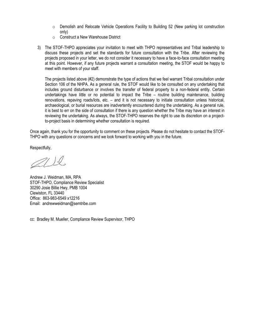
o Demolish and Relocate Vehicle Operations Facility to Building 52 (New parking lot construction only)
o Construct a New Warehouse District 3) The STOF-THPO appreciates your invitation to meet with THPO representatives and Tribal leadership to
discuss these projects and set the standards for future consultation with the Tribe. After reviewing the projects proposed in your letter, we do not consider it necessary to have a face-to-face consultation meeting at this point. However, if any future projects warrant a consultation meeting, the STOF would be happy to meet with members of your staff. The projects listed above (#2) demonstrate the type of actions that we feel warrant Tribal consultation under Section 106 of the NHPA. As a general rule, the STOF would like to be consulted on any undertaking that includes ground disturbance or involves the transfer of federal property to a non-federal entity. Certain undertakings have little or no potential to impact the Tribe – routine building maintenance, building renovations, repaving roads/lots, etc. – and it is not necessary to initiate consultation unless historical, archaeological, or burial resources are inadvertently encountered during the undertaking. As a general rule, it is best to err on the side of consultation if there is any question whether the Tribe may have an interest in reviewing the undertaking. As always, the STOF-THPO reserves the right to use its discretion on a project-to-project basis in determining whether consultation is required.
Once again, thank you for the opportunity to comment on these projects. Please do not hesitate to contact the STOF-THPO with any questions or concerns and we look forward to working with you in the future.
Respectfully,
Andrew J. Weidman, MA, RPA STOF-THPO, Compliance Review Specialist 30290 Josie Billie Hwy, PMB 1004 Clewiston, FL 33440 Office: 863-983-6549 x12216 Email: [email protected] cc: Bradley M. Mueller, Compliance Review Supervisor, THPO


ATTACHMENT 1
NPS Cultural Resources Reconnaissance, Dated 3 February 1986


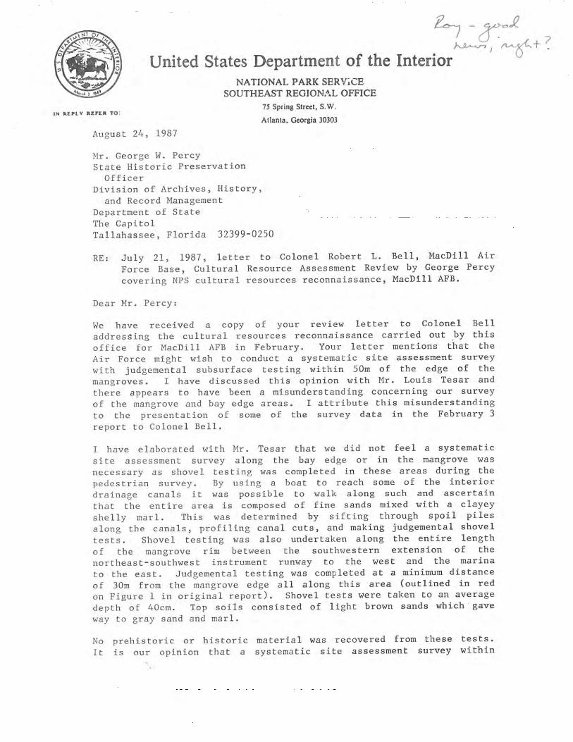
ATTACHMENT 2
NPS Letter to SHPO, Dated 24 August 1987


ATTACHMENT 3
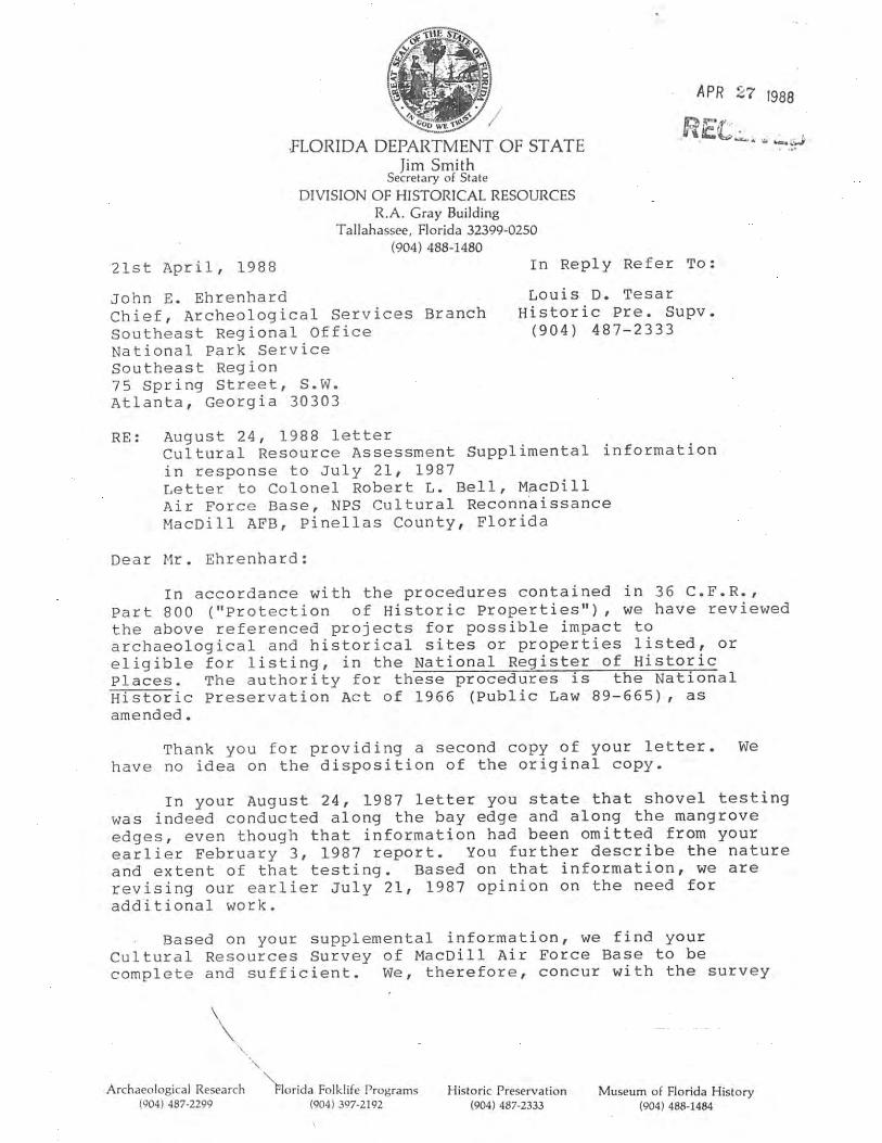
SHPO Letter to NPS, April 1987


September 30, 2015 Mr. Robert B. Hughes Director, 6th Civil Engineering Squadron 7621 Hillsborough Loop Dr. MacDill AFB, FL 33621 Subject: Consultation Requests: 11 Letters Regarding Upcoming Projects at MacDill Air Force Base THPO#: 0028679 – 0028690 Thank you for your thorough response to our July 29th, 2015 letter regarding eleven upcoming projects at MacDill Air Force Base (AFB). We agree that consultation has been completed on six of the eleven projects listed in our original letter. We are also aware of MacDill AFB’s previous efforts to identify cultural resources on the installation. It appears that many decisions regarding the possibility of current additional identification efforts rely on the 1986 evaluation which assessed 85 percent of the installation as disturbed and subjected the remaining 15 percent to a reconnaissance-level survey. However, it is unclear which areas of the installation fall within each category, as no clear map has been provided. Furthermore, it is not indicated whether the five projects we requested continued consultation on fall within the disturbed or undisturbed areas of the base. Because the methods employed in the 1986 survey correspond to a basic reconnaissance-level survey, we believe that the possibility of encountering previously unidentified archaeological/cultural resources within the undisturbed areas of MacDill AFB remains. This is demonstrated by the subsequent discovery of the NRHP-eligible Runway Site (8HI3382) during the 1988 Phase I Cultural Resource Assessment Survey. Your letter dated September 2nd, 2015 acknowledges that this possibility exists, although it is “very low”. As such, we believe that future undertakings in undisturbed areas that propose ground-disturbing activities should be evaluated according to Florida Division of Historical Resources Module 3 standards, which may involve conducting a Cultural Resource Assessment Survey. Again, thank you for contacting us regarding these projects and we look forward to working with you throughout the consultation process. Respectfully,
Andrew J. Weidman, MA, RPA

STOF-THPO, Compliance Review Section 30290 Josie Billie Hwy, PMB 1004 Clewiston, FL 33440 Office: 863-983-6549 x12216 Email: [email protected]


PHASE I ARCHAEOLOGICAL SURVEY OF THREE CONSTRUCTION SITES
AT MACDILL AIR FORCE BASE IN HILLSBOROUGH COUNTY, FLORIDA
Prepared by:
Florida’s First Choice in Cultural Resource Management
Archaeological Consultants, Inc.
8110 Blaikie Court, Suite A Sarasota, Florida 34240
(941) 379-6206 Toll Free: 1-800-735-9906
In association with:
Akima Facilities Management P.O. Box 6350
Tampa, Florida 33608-0350
December 2015

PHASE I ARCHAEOLOGICAL SURVEY OF THREE CONSTRUCTION SITES
AT MACDILL AIR FORCE BASE IN HILLSBOROUGH COUNTY, FLORIDA
Prepared by:
Archaeological Consultants, Inc. 8110 Blaikie Ct., Suite A
Sarasota, FL 34240
In association with:
Akima Facilities Management P.O. Box 6350
Tampa, Florida 33608-0350
December 2015

P15144/ MacDill AFB i
EXECUTIVE SUMMARY
Archaeological Consultants, Inc. (ACI) conducted a Phase I archaeological survey of three proposed construction parcels for Akima Facilities Management on behalf of MacDill Air Force Base (AFB). The three proposed project sites are the Shoot House parcel, the Construct Warehouse District parcel, and the Demo/Construct Vehicle Operations Facility parcel. This work was requested by the Seminole Tribe of Florida-Tribal Historic Preservation Office (STOF-THPO) during consultation with the tribe on all three projects. This survey was conducted in accordance with and in partial fulfillment of the U.S. Air Force Air Mobility Command obligations under the National Historic Preservation Act of 1966 (PL 96-515), as amended; the Archaeological and Historical Preservation Act of 1974 (PL 93-291), as amended; and the National Environmental Policy Act of 1969 (PL 90-190), among others. Fieldwork was carried out in accordance with the Florida Division of Historical Resources’ (FDHR) Cultural Resources Management Standards and Operational Manual, Module 3, Guidelines for Use by Historic Preservation Professionals, Section 2.0. In addition, the survey and report meet the specifications set forth in Chapter 1A-46, Florida Administrative Code (revised August 21, 2002).
A Research Design was prepared by ACI for approval prior to the initiation of field survey.
Background research findings, summarized in the Research Design, revealed that five previously recorded archaeological sites are located within MacDill AFB. None of these are located within or adjacent to any of the three proposed construction parcels. The Air Force determined that the 3-acre Shoot House construction parcel had a high archaeological potential, whereas the other two parcels had low archaeological potential. Systematic subsurface testing and surface reconnaissance was conducted within each of the parcels. No archaeological sites were discovered. The pre-contract site visit revealed an absence of historic resources within the three parcels, and thus, a historic structures survey was not conducted as part of this project.
In conclusion, based upon the results of background research and systematic archaeological
field survey, no archaeological sites or historic resources that are listed, eligible, or considered potentially eligible for inclusion in the NRHP will be affected by the proposed undertaking. No further archaeological investigations are recommended.
P15144/ MacDill AFB ii
TABLE OF CONTENTS
Page 1.0 INTRODUCTION ................................................................................................................ 1-1
1.1 Project Description ....................................................................................................... 1-1 1.2 Project Area of Potential Effects .................................................................................. 1-1 1.3 Purpose ......................................................................................................................... 1-1
2.0 ENVIRONMENTAL SETTING ......................................................................................... 2-1
2.1 Location and Setting ..................................................................................................... 2-1 2.2 Physiography and Geology ........................................................................................... 2-1 2.3 Soils and Vegetation ..................................................................................................... 2-1 2.4 Paleoenvironmental Considerations ............................................................................. 2-1
3.0 CULTURAL CHRONOLOGY ........................................................................................... 3-1
3.1 Paleoindian ................................................................................................................... 3-1 3.2 Archaic ......................................................................................................................... 3-3 3.3 Formative ...................................................................................................................... 3-5 3.4 Mississippian ................................................................................................................ 3-6 3.5 Colonialism ................................................................................................................... 3-7 3.6 Territorial and Statehood .............................................................................................. 3-8 3.7 Civil War and Aftermath ............................................................................................ 3-10 3.8 Twentieth Century ...................................................................................................... 3-12
4.0 BACKGROUND RESEARCH AND METHODS ............................................................ 4-1
4.1 Background Research ................................................................................................... 4-1 4.2 Field Methods ............................................................................................................... 4-4 4.3 Unexpected Discoveries ............................................................................................... 4-4 4.4 Analysis, Collections Management, and Curation ....................................................... 4-4
5.0 RESULTS AND RECOMMENDATIONS ........................................................................ 5-1
5.1 Archaeological Results ................................................................................................. 5-1 5.2 Conclusions and Recommendations ............................................................................. 5-8
6.0 REFERENCES CITED ....................................................................................................... 6-1

P15144/ MacDill AFB iii
LIST OF FIGURES, TABLES, AND PHOTOS
Page Figure Figure 1.1. Location of the three proposed MacDill AFB construction parcels. ............................... 1-2 Figure 2.1. Environmental setting of the three MacDill construction parcels. ................................... 2-2 Figure 3.1. Florida Archaeological Regions. ..................................................................................... 3-2 Figure 3.2. 1927 road and bridge map showing the Interbay Peninsula and Port Tampa City. ...... 3-13 Figure 3.3. 1938 aerial photograph of MacDill AFB (USDA 1938). .............................................. 3-15 Figure 3.4. 1982 aerial photograph of MacDill AFB (USDA 1982). ............................................... 3-17 Figure 4.1. Location of the five previously recorded archaeological sites within MacDill AFB. ...... 4-2 Figure 5.1. Location of the shovel tests within the Shoot House parcel. ........................................... 5-2 Figure 5.2. Location of the shovel tests within the Demo/Construct Vehicle Operations Facility
parcel. ............................................................................................................................... 5-5 Figure 5.3. Location of the shovel tests within the Construct Warehouse District parcel. ................ 5-7 Table Table 4.1. Previously recorded archaeological sites within MacDill AFB. ...................................... 4-1 Table 4.2. Cultural resources investigations proximate to the three MacDill construction parcels. . 4-3 Photo Photo 5.1. Existing conditions within the Shoot House parcel, looking northwest. ......................... 5-1 Photo 5.2. Existing conditions near the south boundary of the Shoot House parcel, looking
northwest. ......................................................................................................................... 5-3 Photo 5.3. Existing conditions within the Demo/Construct Vehicle Operations Facility parcel,
looking north. ................................................................................................................... 5-4 Photo 5.4. Existing conditions within the Demo/Construct Vehicle Operations Facility parcel,
including the location of utilities, looking southeast. ...................................................... 5-4 Photo 5.5. Existing conditions within the Construct Warehouse District parcel, looking northeast. .......................................................................................................................... 5-6 Photo 5.6. Eastern part of the Construct Warehouse District parcel showing sheds and marked
utility line, looking north. ................................................................................................ 5-8

1-1
P15144/MacDill AFB
1.0 INTRODUCTION
1.1 Project Description Three upcoming construction projects will require ground disturbance in areas of MacDill Air
Force Base (AFB) that may not have been historically disturbed by base development activities. A base-wide survey of the installation was completed in 1986 by the National Park Service (NPS). This survey effort determined that 85% of the installation had been disturbed historically and offered no potential for discovering previously unidentified archeological sites (Ehrenhard 1987). The 1986 NPS survey focused on the remaining 15% of the installation; completing a reconnaissance-level survey consisting of windshield surveys and pedestrian surveys with judgmental shovel testing. The three proposed project sites, the Shoot House parcel, the Construct Warehouse District parcel, and the Demo/Construct Vehicle Operations Facility parcel (Figure 1.1) are located within the 85% of the installation assessed as disturbed by the NPS. Consultation with the Seminole Tribe of Florida Tribal Historic Preservation Office (STOF-THPO) determined that this disturbed portion of the base may offer the potential for encountering previously unidentified archeological/cultural resources. The sites identified for this Phase I survey include three proposed facility construction sites, which are roughly five acres in area. A pre-bid visit to each proposed construction site indicated an absence of potential historic resources (buildings, structures, cemeteries, etc.). Therefore, historical/architectural field survey was not performed.
This cultural resource assessment survey (CRAS) was conducted in accordance with and in
partial fulfillment of the U.S. Air Force Air Mobility Command obligations under the National Historic Preservation Act of 1966 (PL 96-515), as amended; the Archaeological and Historical Preservation Act of 1974 (PL 93-291), as amended; and the National Environmental Policy Act of 1969 (PL 90-190), among others. Fieldwork was conducted in accordance with the Florida Division of Historical Resources’ (FDHR) Cultural Resources Management Standards and Operational Manual, Module 3, Guidelines for Use by Historic Preservation Professionals, Section 2.0. In addition, the survey and report meet the specifications set forth in Chapter 1A-46, Florida Administrative Code (revised August 21, 2002).
1.2 Project Area of Potential Effects The Area of Potential Effect (APE) for this project area is defined as the footprint of each
construction area; the Shoot House is 3.0 acres in size, the Demo/Construct Vehicle Operations Facility is 5.5 acres, and the Construct Warehouse District is 5.5 acres.
1.3 Purpose The goal of the Phase I archaeological survey of each proposed construction site was to
determine the presence or absence of archaeological/cultural sites in advance of the proposed ground disturbing activities. Any newly discovered cultural resources were assessed, to the extent possible, as to their eligibility for listing in the National Register of Historic Places (NRHP). Background research and preparation and approval of a Research Design preceded field survey. Such research served to provide an informed set of expectations concerning the kinds of cultural resources that might be expected within the project sites, as well as a basis for evaluating any newly discovered sites. The Research Design contained the results of background research and the proposed approach and methods for the Phase I archaeological survey, including procedures to address the discovery of human remains and pertinent research questions and guidelines for the evaluation of site significance.

Sources: Esri, HERE, DeLorme, USGS, Intermap, increment PCorp., NRCAN, Esri Japan, METI, Esri China (Hong Kong),Esri (Thailand), TomTom, MapmyIndia, © OpenStreetMapcontributors, and the GIS User Community
¹
0 0.5 1Miles
0 1 2Kilometers 2015
Shoot House parcel
Demo/Construct VehicleOperations Facility parcel
Construct WarehouseDistrict parcel
1-2
Figure 1.1. Location of the three MacDill AFB construction parcels, Hillsborough County.

2-1
P15144/MacDill AFB
2.0 ENVIRONMENTAL SETTING
2.1 Location and Setting The three proposed construction parcels are located in Township 30 South, Range 18 East in
Sections 21, 27, and 34 (United States Geological Survey [USGS] Port Tampa and Gibsonton 1982) (Figure 2.1). The general project area is situated on the Interbay Peninsula, which is bounded by Hillsborough Bay on the east, Old Tampa Bay to the west, and Tampa Bay to the south. The Shoot House parcel, is currently an overgrown field that previously was used as a wastewater spray field. The Demo/Construct Vehicle Operations Facility area is characterized by maintained lawn; it is located adjacent to an apron and several buildings. This parcel has been at least partially disturbed by utility line installation. The Construct Warehouse District area is grassed and contains a vehicle/equipment storage area. It has been disturbed, in part, by contaminated soil removal and placement of utilities.
2.2 Physiography and Geology The project area is located within the Mid-peninsula physiographic zone (White 1970), which
is characterized by gently rolling topography with a series of low hills and valleys paralleling the coast. MacDill AFB, situated within the Gulf Coastal Lowlands, contains nearly level land, roughly 2-3 meters (m) (5-10 (feet [ft]) above mean sea level. The lithology consists of the Hawthorn Group, Arcadia Formation, Tampa Member, which is surficially evidenced by limestone (Knapp 1980; Scott 2001; Scott et al. 2001).
2.3 Soils and Vegetation According to the U.S. Department of Agriculture (USDA) Soil Survey of Hillsborough
County, Florida, the project area occurs within the Urban land-Myakka-Smyrna soil association, which is characterized by nearly level, poorly drained soils of the flatwoods that have been modified for urban use (Doolittle et al. 1989). The proposed construction parcels are underlain by the poorly drained Myakka fine sand, Malabar fine sand, and Myakka-Urban land complex (Doolittle et al. 1989). Malabar sand occurs in low-lying sloughs and shallow depressions in the flatwoods. The native vegetation would have included cabbage palm, longleaf pine, and slash pine with an understory of broomsedge, bluestem, inkberry, maidencane, saw palmetto, and waxmyrtle. Myakka fine sand occurs on broad plains in the flatwoods. It supports longleaf and slash pine with an understory of gallberry, running oak, saw palmetto, pineland threeawn, and waxmyrtle. Based on the 1938 aerial photos, all three parcels were proximate to a seasonal wetland and/or slough (USDA 1938).
2.4 Paleoenvironmental Considerations The early environment of the region was different from that seen today. Sea levels were
lower, the climate was arid, and fresh water was scarce. An understanding of human ecology during the earliest periods of human occupation in Florida cannot be based on observations of the modern environment because of changes in water availability, botanical communities, and faunal resources. Aboriginal inhabitants would have developed cultural adaptations in response to the environmental changes taking place, which were then reflected in settlement patterns, site types, artifact forms, and subsistence economies.

2-2
Figure 2.1. Environmental setting of the three MacDill construc-tion parcels; Sections 21, 27 and 34 of Township 30 South, Range 18 East (USGS Port Tampa and Gibsonton, 1982).
Copyright:© 2013 National Geographic Society, i-cubed
¹
0 0.25 0.5Miles
0 0.5 1Kilometers
Shoot House parcel
Demo/Construct VehicleOperations Facility parcel
Construct WarehouseDistrict parcel

2-3
P15144/MacDill AFB
Due to the arid conditions between 16,500 and 12,500 years ago, the perched water aquifer and potable water supplies were absent (Dunbar 1981:95). Palynological studies conducted in Florida and Georgia suggest that between 13,000 and 5,000 years ago, this area was covered with an upland vegetation community of scrub oak and prairie (Watts 1969, 1971, 1975). The rise of sea level reduced xeric habitats over the next several millennia. Intermittent flow in the Hillsborough River some 8500 years ago was likely due to precipitation and surface runoff, and by 6000 years ago, the river probably began flowing due to spring discharge from the Floridan aquifer (Dunbar 1981:99).
Around 5000 years ago, a climatic event marking a brief return to Pleistocene climatic
conditions induced a change toward more open vegetation. Southern pine forests replaced the oak savannahs. Extensive marshes and swamps developed along the coasts and subtropical hardwood forests became established along the southern tip of Florida (Delcourt and Delcourt 1981). Northern Florida saw an increase in oak species, grasses, and sedges (Carbone 1983). At Lake Annie, in south central Florida, pollen cores were dominated by wax myrtle and pine. The assemblage suggests that by this time, a forest dominated by longleaf pine along with cypress swamps and bayheads existed in the area (Watts 1971, 1975). By about 3500 BCE (Before Common Era), surface water was plentiful in karst terrains and the level of the Floridan aquifer rose to 1.5 m (5 ft) above present levels. After this time, modern floral, climatic, and environmental conditions began to be established.

3-1
P15144/MacDill AFB
3.0 CULTURAL CHRONOLOGY
A discussion of the regional culture history is included to provide a framework within which
the local historical and archaeological records can be examined. Archaeological sites and historic features are not individual entities, but rather are part of once dynamic cultural systems. As a result, individual sites cannot be adequately examined or interpreted without reference to other sites and resources in the area.
In general, archaeologists summarize the culture history of an area (i.e., an archaeological
region) by outlining the sequence of archaeological cultures through time. These are defined largely in geographical terms but also reflect shared environmental and cultural factors. MacDill AFB is located in the Central Peninsular Gulf Coast archaeological region (Milanich 1994; Milanich and Fairbanks 1980). This region extends from just north of Tampa Bay southward to the northern portion of Charlotte Harbor (Figure 3.1). Within this zone, the Paleoindian, Archaic, Formative, and Mississippian stages have been defined based on unique sets of material culture traits such as stone tools and ceramics as well as subsistence, settlement, and burial patterns. These broad temporal units are further subdivided into culture phases or periods.
The local history of the region is divided into four broad periods based initially upon the
major governmental powers. The first period, Colonialism, occurred during the exploration and control of Florida by the Spanish and British from around 1513 until 1821. At that time, Florida became a territory of the U.S. and 21 years later became a State (Territorial and Statehood). The Civil War and Aftermath (1861-1899) period deals with the Civil War, the period of Reconstruction following the war, and the late 1800s, when the transportation systems were dramatically increased and development throughout the state expanded. The Twentieth Century period includes subperiods defined by important historic events such as the World Wars, the Boom of the 1920s, and the Depression. Each of these periods evidenced differential development and utilization of the region, thus effecting the historic site distribution.
3.1 Paleoindian The Paleoindian stage is the earliest known cultural manifestation in Florida, dating from
roughly 12,000 to 7500 BCE (Milanich 1994). Archaeological evidence for Paleoindians consists primarily of scattered finds of diagnostic lanceolate-shaped projectile points. The Florida peninsula at this time was quite different than today. In general, the climate was cooler and drier with vegetation typified by xerophytic species with scrub oak, pine, open grassy prairies, and savannas (Milanich 1994:40). When human populations were arriving in Florida, the sea levels were still as much as 40 to 60 m (130-200 ft) below present levels and coastal regions of Florida extended miles beyond present-day shorelines (Faught 2004). Thus, many sites have been inundated (Faught and Donoghue 1997).
The Paleoindian period has been sub-divided into three horizons based upon characteristic
tool forms (Austin 2001). Traditionally, it is believed that the Clovis Horizon (10,500-9000 BCE) represents the initial occupation of Florida and is defined based upon the presence of the fluted Clovis points. These are somewhat more common in north Florida. Research suggests that Suwannee and Simpson points may be contemporary with or predate Clovis (Dunbar 2006a; Stanford 1991). The Suwannee Horizon (9000-8500 BCE) is the best known of the three Paleoindian horizons. The lanceolate-shaped, unfluted Simpson and Suwannee projectile points are diagnostic of this time (Bullen 1975; Daniel and Wisenbaker 1987; Purdy 1981). The Suwannee tool kit includes a variety of scrapers, adzes, spokeshaves, unifacially retouched flakes, and blade-like flakes as well as bone and ivory foreshafts, pins, awls, daggers, anvils, and abraders (Austin 2001:23).
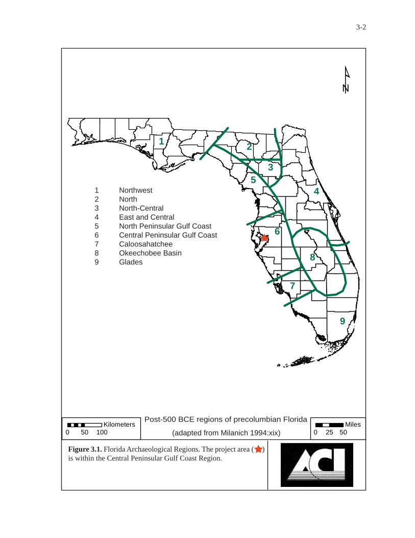
¹
0 50 100Kilometers
0 25 50Miles
12
3
45
6
7
8
9
Post-500 BCE regions of precolumbian Florida
(adapted from Milanich 1994:xix)
3-2
1 Northwest2 North3 North-Central4 East and Central5 North Peninsular Gulf Coast6 Central Peninsular Gulf Coast7 Caloosahatchee8 Okeechobee Basin9 Glades
Figure 3.1. Florida Archaeological Regions. The project area ( ) is within the Central Peninsular Gulf Coast Region.
3-3
P15144/MacDill AFB
Following the Suwannee Horizon is the Late Paleoindian Horizon (8500-8000 BCE). The smaller Tallahassee, Santa Fe, and Beaver Lake projectile points have traditionally been attributed to this horizon (Milanich 1994). However, many of these points have been recovered stratigraphically from late Archaic and early Woodland period components and thus, may not date to this period at all (Austin 2001; Farr 2006). Florida notched or pseudo-notched points, including the Union, Greenbriar, and Hardaway-like points may represent late Paleoindian types, but these types have not been recovered from datable contexts and their temporal placement remains uncertain (Dunbar 2006a:410).
Archaeologists hypothesize that Paleoindians lived in migratory bands and subsisted by
gathering and hunting, including the now-extinct Pleistocene megafauna. It is likely that these nomadic hunters traveled between permanent and semi-permanent sources of water, such as artesian springs, exploiting the available resources. These watering holes would have attracted the animals, thus providing food and drink. In addition to being tethered to water sources, most of the Paleoindian sites are close to good quality lithic resources. The settlement pattern consisted of the establishment of semi-permanent habitation areas and the movement of the resources from their sources of procurement to the residential locale by specialized task groups (Austin 2001:25).
Although the Paleoindian period is generally considered to have been cooler and drier, there
were major variations in the inland water tables resulting from large-scale environmental fluctuations. There have been two major theories as to why most Paleoindian materials have been recovered from inundated sites. The Oasis theory, put forth by Wilfred T. Neill, was that due to low water tables and scarcity of potable water, the Paleoindians and the game animals upon which they depended clustered around the few available water holes that were associated with sinkholes (Neill 1964). Whereas, Ben Waller postulated that the Paleoindians gathered around river-crossings to ambush the large Pleistocene animals as they crossed the rivers (Waller 1970). This implies periods of elevated water levels. Based on the research along the Aucilla and Wacissa Rivers, it appears that both theories are correct, depending upon what the local environmental conditions were at that time (Dunbar 2006b). As such, during the wetter periods, populations became more dispersed because the water resources were abundant and the animals they relied on could roam over a wider range.
Some of the information about this period has been derived from the underwater excavations
at two inland spring sites in Sarasota County: Little Salt Spring and Warm Mineral Springs (Clausen et al. 1979). Excavation at the Harney Flats Site in Hillsborough County has provided a rich body of data concerning Paleoindian life ways. Analysis indicates that this site was used as a quarry-related base camp with special use activity areas (Daniel and Wisenbaker 1987). It has been suggested that Paleoindian settlement may not have been related as much to seasonal changes as generally postulated for the succeeding Archaic period, but instead movement was perhaps related to the scheduling of tool-kit replacement, social needs, and the availability of water, among other factors (Daniel and Wisenbaker 1987:175). Investigations along the Aucilla and Wacissa Rivers, as well as other sites within the north Florida rivers, have provided important information on the Paleoindian period and how the aboriginals adapted to their environmental setting (Webb 2006). Studies of the Pleistocene faunal remains from these sites clearly demonstrate the importance of these animals not for food alone, but as the raw material for their bone tool industry (Dunbar and Webb 1996).
3.2 Archaic
Climatic changes occurred, resulting in the disappearance of the Pleistocene megafauna and the demise of the Paleoindian culture. The disappearance of the mammoths and mastodons resulted in a reduction of open grazing lands, and thus, the subsequent disappearance of grazers such as horse, bison, and camels. With the reduction of open habitat, the herd animals were replaced by the more
3-4
P15144/MacDill AFB
solitary, woodland browser: the white-tailed deer (Dunbar 2006a:426). The intertwined data of megafauna’ extinction and cultural change suggests a rapid and significant disruption in both faunal and floral assemblages. The Bolen people represent the first culture adapted to the Holocene environment (Carter and Dunbar 2006). This included a more specialized toolkit and the introduction of chipped-stone woodworking implements.
Due to a lack of excavated collections and the poor preservation of bone and other organic
materials in the upland sites, our knowledge of the Early Archaic artifact assemblage is limited (Carter and Dunbar 2006; Milanich 1994). Discoveries at the Page-Ladson, Little Salt Spring, and Windover sites indicate that bone and wood tools were used (Clausen et al. 1979; Doran 2002; Webb 2006). The archaeological record suggests a diffuse, yet well-scheduled, pattern of exploiting both coastal and interior resources. Because water sources were much more numerous and larger than previously, the Early Archaic peoples could sustain larger populations, occupy sites for longer periods, and perform activities requiring longer occupations at a specific locale (Milanich 1994:67).
Marked environmental changes, which occurred some 6500 years ago, had a profound
influence upon human settlement and subsistence practices. Among the landscape alterations were rises in sea and water table levels that resulted in the creation of more available surface water. In addition to changed hydrological conditions, this period is characterized by the spread of mesic forests and the beginnings of modern vegetation communities including pine forests and cypress swamps. Humans adapted to this changing environment and regional and local differences are reflected in the archaeological record (Russo 1994a, 1994b; Sassaman 2008).
The Middle Archaic archaeological record is better understood than the Early Archaic. The
material culture inventory included several stemmed, broad blade projectile point types including the Newnan, Levy, Marion, and Putnam types (Bullen 1975). Population growth, as evidenced by the increased number of Middle Archaic sites and accompanied by increased socio-cultural complexity, is assumed for this time (Milanich and Fairbanks 1980). Site types included large base camps, smaller special-use campsites, quarries, and burial areas. The most common sites are the smaller campsites, which were most likely used for hunting or served as special-use extractive sites for such activities as gathering nuts or other botanical materials. At quarry sites, aboriginal populations mined stone for their tools. They usually roughly shaped the stone prior to transporting it to another locale for finishing. Base camps are identified by their larger artifact assemblages and wider variety of tools.
During the Late Archaic period, population increased and became more sedentary. The
broad-bladed, stemmed projectile styles of the Middle Archaic continued to be made with the addition of Culbreath, Lafayette, Clay, and Westo point types (Bullen 1975). A greater reliance on marine resources is indicated in coastal areas. Subsistence strategies and technologies reflect the beginnings of an adaptation to these resources. Around 4000 years ago, evidence of fired clay pottery appears in Florida. The first ceramic types, tempered with fibers (Spanish moss or palmetto), are referred to as the Orange series. Initially, it was thought that they lacked decoration until about 1700 BCE, when they were decorated with geometric designs and punctations. Research has called this ceramic chronology into question; AMS dates from a series of incised Orange sherds from the middle St. Johns River Valley, have produced dates contemporaneous with the plain varieties (Sassaman 2003).
Milanich (1994:86-87) suggests that while there may be little difference between Middle and
Late Archaic populations, there are more Late Archaic sites and they were primarily located near wetlands. The abundant wetland resources allowed larger settlements to be maintained. It is likely that the change in settlement patterns was related to the environmental changes. By the end of the Middle Archaic, the climate closely resembled that of today; vegetation changed from those species which preferred moist conditions to pines and mixed forests (Watts and Hansen 1988). Sea levels

3-5
P15144/MacDill AFB
rose, inundating many sites located along the shoreline. The adaptation to this environment allowed for a wider variety of resources to be exploited and a wider variation in settlement patterns. No longer were the scarce waterholes dictating the location of sites. Shellfish, fish, and other food sources were now available from coastal and freshwater wetlands resulting in an increased population size.
The Late Archaic Transitional stage refers to that portion of the ceramic Archaic when sand
was mixed with the fibers as a tempering agent. The same settlement and subsistence patterns were being followed. It has been suggested that during this period there was a diffusion of cultural traits as a result of the movement of small groups (Bullen 1959, 1965). This resulted in the appearance of several different ceramic and lithic tool traditions, and the beginning of cultural regionalism.
3.3 Formative
The Formative stage is comprised of the Manasota and Weeden Island-related cultures (ca. 500 BCE to 800 CE [Common Era]). Settlement patterns consisted of permanent villages located along the coast with seasonal forays into the interior to hunt, gather, and collect those resources unavailable along the coast. Most Manasota sites are shell middens found on or near the shore where aboriginal villagers had easiest access to fish and shellfish (Milanich 1994). The subsistence economy focused on the coastal exploitation of maritime resources, supplemented by the hunting and gathering of inland resources (Luer and Almy 1982). Investigations at the Shaw’s Point, Fort Brook Midden, Yat Kitischee, and Myakkahatchee sites have provided a wealth of information on site formation, subsistence economies, and technology and their changes over time (Austin 1995; Austin et al. 1992; Luer et al. 1987; Schwadron 2002). The major villages were located along the shore with smaller sites being located up to 19-29 km (12-18 mi) inland. These inland sites, which probably served as seasonal villages or special-use campsites, were often located in the pine flatwoods on elevated lands proximate to a source of freshwater where a variety of resources could be exploited (Austin and Russo 1989; Luer and Almy 1982). Hardin and Piper (1984) suggest that some of the larger inland sites may actually be permanent or semi-permanent settlements as opposed to seasonal campsites.
Manasota is characterized by a wide range of material cultural traits such as a well-developed
shell and bone tool technology, sand tempered plain ceramics, and burials within shell middens (Luer and Almy 1982). Much of the shell and bone technology evolved out of the preceding Archaic period. Through time, the burial patterns became more elaborate, with burials being placed within sand burial mounds located near the villages and middens. The early burial patterns consisted of primary flexed burials in the shell middens, while later sites contained secondary burials within sand mounds.
Temporal placement within the Manasota period can be determined based upon diagnostic
ceramic rim and vessel forms (Luer and Almy 1982). The early forms (ca. 500 BCE to 400 CE) are characterized as flattened globular bowls with incurving rims and chamfered lips. Pot forms with rounded lips and inward curving rims were utilized from about 200 BCE until 700 CE. Deeper pot forms with straight sides and rounded lips were developed around 400 CE and continued into the Safety Harbor period. Simple bowls with outward curving rims and flattened lips were used from the end of the Late Weeden Island period (ca. 800 CE) into the Safety Harbor period. Vessel wall thickness decreased over time.
The lithic assemblage of the Manasota culture was scarce along the coast especially in the
more southern portions of the region where stone suitable for tool manufacture was absent. Projectile point types associated with the Manasota period include the Sarasota, Hernando, and Westo varieties (Luer and Almy 1982).
3-6
P15144/MacDill AFB
Influences from the Weeden Island “heartland,” located in north-central Florida, probably resulted in the changes in burial practices. These influences can also be seen in the increased variety of ceremonial ceramic types through time. The secular, sand tempered ware continued to be the dominant ceramic type. Manasota evolved into what is referred to as a Weeden Island-related culture. The subsistence and settlement patterns remained consistent. Hunting and gathering of the inland and coastal resources continued. Evidence of a widespread trade network is seen by the ceramic types and other exotic artifacts present within the burial mounds.
Ceremonialism and its expressions, such as the construction of complex burial mounds
containing exotic and elaborate grave offerings, reached their greatest development during this period. Similarly, the subsistence economy, divided between maritime and terrestrial animals and perhaps horticultural products, represents the maximum effective adjustment to the environment. Many Weeden Island-related sites consist of villages with associated mounds, as well as ceremonial/burial mound sites. The artifact assemblage is distinguished by the presence of Weeden Island ceramic types. These are among some of the finest ceramics in the Southeast; they are often thin, well-fired, burnished, and decorated with incising, punctations, complicated stamping, and animal effigies (Milanich 1994:211). Coastal sites are marked by the presence of shell middens, indicating a continued pattern of exploitation of marine and estuarine resources. Interaction between the inland farmer-gatherers and coastal hunter-gatherers may have developed into mutually beneficial exchange systems (Kohler 1991:98). This could account for the presence of non-locally made ceramics at some of the Weeden Island-related period sites. There is no definitive evidence for horticulture in the coastal area (Milanich 1994:215).
3.4 Mississippian The final aboriginal cultural manifestation in the Central Peninsular Gulf Coast region is
Safety Harbor, named for the type-site in Pinellas County. The presence of datable European artifacts (largely Spanish) in sites, along with radiocarbon dates from early Safety Harbor contexts associated with Englewood ceramics, provide the basis for dividing the Safety Harbor period into two pre-Columbian phases: Englewood (900-1000 CE) and Pinellas (1000-1500 CE) and two colonial period phases: Tatham (1500-1567 CE) and Bayview (1567-1725 CE) (Mitchem 1989). The Safety Harbor variant in Hillsborough, northern Manatee, Pinellas, and southern Pasco counties is identified as the Circum-Tampa Bay regional variant.
Although inland sites do occur, the Safety Harbor culture was primarily a coastal
phenomenon (Mitchem 1989, 2012). Large coastal towns or villages often had a temple mound, plaza, midden, and a burial mound associated with them. Although some maize agriculture may have been practiced by the Safety Harbor peoples, the coastal environment was not suitable for intensive maize agriculture (Luer and Almy 1981; Mitchem 2012). Away from the coastal plain, a more dispersed pattern of smaller settlements was evident and the burial mounds appear to have been located away from the habitation areas (Mitchem 1988, 1989).
Influences from the north led to the incorporation of some Mississippian traits by the late
Manasota peoples, which became the Safety Harbor culture. Most, Safety Harbor components are located on top of the earlier Manasota deposits and there is evidence of significant continuity from Manasota into Safety Harbor. However, in some areas, Manasota continued later than previously thought, while in other areas Englewood did not appear to have occurred at all (Austin et al. 2008). The lack of the diagnostic Englewood ceramics at many sites may indicate that the Englewood phase was skipped in the developmental sequence from Manasota to Safety Harbor (Mitchem 2012).

3-7
P15144/MacDill AFB
The primary difference between Manasota and Safety Harbor is the ceramic assemblage. The utilitarian ceramics include the Pasco (limestone tempered), Pinellas (laminated paste), and sand tempered plain varieties. The decorated ceramics, primarily recovered from burial mounds, include Englewood Incised, Sarasota Incised, Lemon Bay Incised, St. Johns Check Stamped, Safety Harbor, Incised, and Pinellas Incised (Willey 1949). The adoption of Mississippian traits such as jar and bottle forms, and the guilloche or loop design, are indicative of this period. However, unlike most Mississippi period ceramics, the use of mussel shell as the aplastic is not present (Mitchem 2012).
Trade between the Safety Harbor people and other Southeastern Mississippian cultures took
place. It is likely that marine whelks and conchs were traded with groups in the Southeast and Midwest. In turn, items such as copper and ground-stone artifacts made their way south. Based on Spanish accounts, the Safety Harbor culture had evolved into a chiefdom form of government, albeit minus the maize agriculture of other Mississippian period groups in the Southeast. This lack of agriculture was likely due to the extremely successful adaptation to the local environment and the lack of suitable soils for the production of maize. Mitchem notes that although contact with Mississippian people may have led to political and religious changes, there was not a compelling reason to change their lifestyle completely (Mitchem 2012:185).
3.5 Colonialism
The Timucuan Indians are the historic counterparts of the Safety Harbor people. In the Tampa Bay area they are referred to as the Tocobaga, extending from roughly Tarpon Springs southward to the Sarasota area (Bullen 1978). The Tocobaga consisted of a number of small chiefdoms whose leaders frequently waged war against each other. The most powerful chiefdom was Tocobaga, located at the head of Old Tampa Bay at the Safety Harbor site; other major chiefdoms included the Mocoço (at the mouth of the Alafia River) and Ucita (at the mouth of the Little Manatee River) (Hann 2003).
The cultural traditions of the native Floridians ended with the advent of European expeditions
to the New World. The initial events, authorized by the Spanish crown in the 1500s, ushered in devastating European contact. After Ponce de Leon’s landing near St. Augustine in 1513, Spanish explorations were confined to the west coast of Florida; Narvaéz is thought to have made shore in 1528 in St. Petersburg and de Soto’s 1539 landing is commemorated at De Soto Point on the south bank of the Manatee River. The Spaniards briefly established a fort and garrison at Tocobaga in the 1560s. In 1568, the Tocobaga killed all of the soldiers and when a Spanish supply ship arrived, the Tocobaga left and the Spanish burned the village (Hann 2003).
The area that now constitutes the State of Florida was ceded to England in 1763 after two
centuries of Spanish possession. England governed Florida until 1783 when the Treaty of Paris returned Florida to Spain; however, Spanish influence was nominal during this second period of ownership. Prior to the American colonial settlement of Florida, members of the Muskogean Creek, Yamassee, and Oconee tribes moved into Florida and repopulated the demographic vacuum created by the decimation of the original aboriginal inhabitants. These migrating groups of Native Americans became known as the Seminoles. They had an agriculturally based society, focusing upon cultivation of crops and the raising of horses and cattle. The material culture of the Seminoles remained similar to the Creeks, the dominant aboriginal pottery type being Chattahoochee Brushed. European trade goods, especially British, were common. The Creek settlement pattern included large villages located near rich agricultural fields and grazing lands.
Their early history can be divided into two basic periods: colonization (1716-1767) when the
initial movement of Creek towns into Florida occurred, and enterprise (1767-1821) which was an era

3-8
P15144/MacDill AFB
of prosperity under the British and Spanish rule prior to the American presence (Mahon and Weisman 1996). The Seminoles formed at various times loose confederacies for mutual protection against the new American Nation to the north (Tebeau 1980:72). The Seminoles crossed back and forth into Georgia and Alabama conducting raids and welcoming escaped slaves. This resulted in General Andrew Jackson’s invasion of Florida in 1818, which became known as the First Seminole War.
3.6 Territorial and Statehood
Florida became a United States territory in 1821 due to the war and the Adams-Onis Treaty of 1819. Settlement was slow and scattered at that time. Andrew Jackson, named provisional governor, divided the territory into St. Johns and Escambia Counties. At that time, St. Johns County encompassed all of Florida lying east of the Suwannee River, and Escambia County included the land lying to the west. In the first territorial census in 1825, 317 persons reportedly lived in South Florida; by 1830 that number had risen to 517 (Tebeau 1980:134).
Even though the First Seminole War was fought in north Florida, the Treaty of Moultrie Creek in 1823, at the end of the war, was to affect the settlement of all of south Florida. The Seminoles relinquished their claim to the whole peninsula in return for an approximately four million acre reservation south of Ocala and north of Charlotte Harbor (Covington 1958; Mahon 1985:50). The treaty satisfied neither the Indians nor the settlers. The inadequacy of the reservation, the desperate situation of the Seminoles, and the mounting demand of the settlers for their removal, produced another conflict.
In 1823, Gadsden County was created from St. John’s County, and the following year
Mosquito County was created out of Gadsden. This new county included all of the Tampa Bay area and reached south to Charlotte Harbor (Historic Tampa/Hillsborough County Preservation Board [HT/HCPB] 1980:7). In 1824, Cantonment (later Fort) Brooke was established on the south side of the mouth of the Hillsborough River in what is now downtown Tampa by Colonel George Mercer Brooke. Frontier families followed the soldiers and the settlement of the Tampa Bay area began. This caused some problems for the military as civilian settlements were not in accord with the Camp Moultrie agreement (Guthrie 1974:10). By 1830, the U.S. War Department found it necessary to establish a military reserve around Fort Brooke with boundaries extending 16 miles to the north, west, and east (Chamberlin 1968:43). Within the military reservation were a guardhouse, barracks, storehouse, powder magazine, and stables.
By the early 1830s, governmental policy shifted in terms of relocating the Seminoles to lands west of the Mississippi River. Outrage at this policy of forced relocation resulted in the Second Seminole War (1835-1842). Following this conflict, the Seminoles who remained in Florida were driven further south, clearing the way for homesteaders. Hillsborough County was established in 1834 by the Territorial Legislature of Florida; it reached north to Dade City and south to Charlotte Harbor, encompassing an area that today comprises Pasco, Polk, Manatee, Sarasota, DeSoto, Charlotte, Highlands, Hardee, Pinellas, and Hillsborough counties. Due to its isolated location, Hillsborough County was slow to develop. The Tampa Bay post office was closed at this time and reestablished as “Tampa” on September 13, 1834 (Bradbury and Hallock 1962). As settlement in the area increased, so did hostilities with Native Americans. The growing threat of Seminole invasion to the civilians near the fort propelled them to sign a petition asking for military protection. Only 25 men signed the petition showing the meager settlement in the area (Brown 1999:46).
By 1835, the Second Seminole War was underway, triggered by an attack on Major Francis
Langhorne Dade as he led a company of soldiers from Fort Brooke to Fort King (now Ocala). As part

3-9
P15144/MacDill AFB
of the effort to subdue Indian hostilities in Florida, military patrols moved into the wilderness in search of any Seminole concentrations. As the Second Seminole War escalated, attacks on isolated settlers and communities became more common. To combat this, the U.S. Army and Navy converged on southwest Florida attempting to seal off the southern portion of the Florida peninsula from the estimated 300 Seminoles remaining in the Big Cypress Swamp and Everglades (Covington 1958; Tebeau and Carson 1965).
In 1837, Fort Brooke became the headquarters for the Army of the South and the main
garrison for the Seminole wars. It also served as a haven for settlers who left their farms to seek protection from the warring Seminoles (Piper et al. 1982). Several other forts, including Fort Alabama (later Fort Foster), Fort Thonotosassa, and Fort Simmons were established during the Seminole War years (Bruton and Bailey 1984). Their uses varied from military garrisons to military supply depots; others were built to protect the nearby settlers during Indian uprisings.
The Second Seminole War ended in 1842 when the federal government withdrew troops from
Florida. Some of the battle-weary Seminoles were persuaded to emigrate to the Oklahoma Indian Reservation where the federal government had set aside land for their occupation. However, those who wished to remain were allowed to do so, but were pushed further south into the Everglades and Big Cypress Swamp. This area became the last stronghold for the Seminoles (Mahon 1985).
In 1840, the population of Hillsborough County was 452, with 360 of those residing at Fort
Brooke (HT/HCPB 1980). Encouraged by the passage of the Armed Occupation Act in 1842, designed to promote settlement and protect the Florida frontier, settlers moved south through Florida. The Act made available 200,000 acres outside the already developed regions south of Gainesville to the Peace River, barring coastal lands and those within a two-mile radius of a fort. It stipulated that any family or single man over 18 able to bear arms could earn title to 160 acres by erecting a habitable dwelling, cultivating at least five acres of land, and living on it for five years. During the nine-month period the law was in effect, 1184 permits were issued totaling some 189,440 acres (Covington 1961a:48).
In 1845, the State of Florida was admitted to the Union, and Tallahassee was selected as the
capital. To hasten settlement of central Florida, the U.S. government commenced the official surveys of public lands. In 1852, C.F. Hopkins surveyed Township 30 South, Range 18 East; no historic features were depicted on the Plat (State of Florida 1852b). The area around the three proposed construction parcels is described as third rate pine and palmetto, with mangrove marsh south of the Shoot House area (State of Florida 1852a:326-349).
Although the majority of Florida’s Seminoles had been deported to the western territories by
the end of Second Seminole War, a number of Seminoles remained in central and south Florida. In July 1849, an incident occurred at the Kennedy and Darling Store near Peas Creek (Peace River). A band of four Seminoles killed two men, and wounded William McCollough and his wife Nancy, before looting and burning the store. This incident created the “Indian Scare” of 1849 in central Florida and resulted in the federal government establishing a series of forts across the state (Brown 1991; Covington 1961b). In December 1855, the Third Seminole War, or the Billy Bowlegs War, started because of pressure placed on Native Americans remaining in Florida to migrate west. The war started when Seminole Chief Holatter-Micco, also known as Billy Bowlegs, and 30 warriors attacked an army camp killing four soldiers and wounding four others. The attack was in retaliation for damage done by several artillerymen to property belonging to Billy Bowlegs. This hostile action renewed state and federal interest in the final elimination of the Seminoles from Florida.

3-10
P15144/MacDill AFB
Military action was not decisive during the war; therefore, in 1858 the U.S. government resorted to monetary persuasion to induce the remaining Seminoles to migrate west. Chief Billy Bowlegs accepted $5000 for himself and $2500 for his lost cattle, each warrior received $500, and $100 was given to each woman and child. On May 4, 1858, the ship Grey Cloud set sail from Fort Myers with 123 Seminoles; stopping at Egmont Key, 41 captives and a Seminole woman guide were added to the group. On May 8, 1858, the Third Seminole War was declared over (Covington 1982).
Residents turned to citrus, tobacco, vegetables, and lumber to make their living. Cattle ranching served as one of the first important economic activities reported in the area. Mavericks left by the early Spanish explorers provided the source for the herds raised by the mid-eighteenth century “Cowkeeper” Seminoles. As the Seminoles were pushed further south during the wars, their cattle were either sold or left to roam. Settlers captured or bought the cattle and branded them for their own. By the late 1850s, the cattle industry of southwest Florida was developing on a significant scale. Hillsborough and Manatee Counties constituted Florida’s leading cattle production region. By 1860, Fort Brooke and Punta Rassa were major cattle shipping points for southwest Florida. During this period, Jacob Summerlin became the first cattle baron of southwestern Florida. Known as the “King of the Crackers,” Summerlin herds ranged from Ft. Meade to Ft. Myers (Covington 1957).
3.7 Civil War and Aftermath
In 1861, Florida followed South Carolina’s lead and seceded from the Union in a prelude to the American Civil War. Florida had much at stake in this war as evidenced in a report released from Tallahassee in June of 1861. It listed the value of land in Florida as $35,127,721 and the value of the slaves at $29,024,513 (Dunn 1989:59). Even though the coast of Florida, including the port of Tampa, experienced a naval blockade during the war, the interior of the state saw very little military action (Robinson 1928:43). Many male residents abandoned their farms and settlements to join the Union army at one of the coastal areas retained by the United States government or joined the Confederate cow cavalry. The cow cavalry provided one of the major contributions of the state to the Confederate war effort by supplying and protecting the transportation of beef to the government (Akerman 1976). It was estimated that three-quarters of the beef supplied to the Confederacy from Florida came from Brevard and Manatee Counties (Shofner 1995). Summerlin originally had a contract with the Confederate government to market thousands of head a year at eight dollars per head. However, by driving his cattle to Punta Rassa and shipping them to Cuba, he received 25 dollars per head (Grismer 1946:83). Salt works along the Gulf Coast also functioned as a major contributor to the efforts of the Confederacy (Lonn 1965). Union troops stationed at Punta Rassa conducted several raids into the Peace River Valley to seize cattle and destroy ranches. In response, Confederate supporters formed the Cattle Guard Battalion, consisting of nine companies under the command of Colonel Charles J. Mannerlyn. The lack of railway transport to other states, the federal embargo, and the enclaves of Union supports and Union troops holding key areas such as Jacksonville and Ft. Myers prevented an influx of finished materials. Additionally, federal gunboats blockaded the mouth of the larger rivers throughout the state preventing the shipment of raw materials. The war lasted until 1865.
In general, the Civil War years were marked by a deterioration of the local economy.
However, by the late 1870s, normalcy was restored. Population increased in eastern Hillsborough County, and during the 15 years following the Civil War, several villages developed into substantial communities. These included Cork and Shiloh, two miles to the south of Cork. Shiloh’s best years appear to have been in the early 1880s, prior to the construction of the railroad from Sanford to Tampa, which gave birth to Plant City. With the emergence of Plant City, Shiloh’s businesses and churches moved south. According to Bruton and Bailey (1984:58), all that remains of the Shiloh community today is the historic cemetery.

3-11
P15144/MacDill AFB
Immediately following the war, the South underwent a period of “Reconstruction” to prepare the Confederate states for readmission to the Union. The program was administered by the U.S. Congress, and on July 25, 1868, Florida officially returned to the Union (Tebeau 1980:251). Civilian activity slowly resumed a normal pace after recovery from wartime depression, and the population continued to expand. The 1866 Homestead Act was passed to encourage settlement. The act allowed freedmen and loyal United States citizens to receive 80-acre tracts in Florida and the other four public land states of the South. Former Confederates were not eligible to receive homesteads under the Act until 1876 when the lands were open to unrestricted sale (Tebeau 1980:266, 294). The Homestead Act encouraged growth and settlement during the Reconstruction era.
The post-war economic conditions of much of the rest of the South contributed to changes in
the economy of the Tampa Bay area and communities to the south along the Gulf Coast. Post-war cattle shipments to Cuba varied considerably with changes in Cuban demand and the institution of a duty. The net result of Reconstruction-period cattle shipping was the movement of ranges and cattlemen farther south, closer to Charlotte Harbor and the Caloosahatchee River (Brown 1991:199). An influx of poor farmers, coinciding with the southward movement of cattle ranches, made the economic stability of the area dependent upon reliable sources of overland freight transport (Mormino and Pizzo 1983:68). During the 1870s and 1880s, the economy boomed with a number of winter visitors seeking the favorable subtropical climate, and an increase of agricultural production with the introduction of truck farming of tomatoes, cucumbers, and beans, as well as experimentation with oranges and lemons. Cattle continued to play a major role in the inland areas.
The State of Florida faced a financial crisis involving title to public lands in the early 1880s. By Act of Congress in 1850, the federal government turned over to the states for drainage and reclamation all “swamp and overflow land.” Florida received approximately ten million acres. To manage that land and the five million acres the state had received on entering the Union, the Florida legislature created the Board of Trustees of the Internal Improvement Fund in 1851. In 1855, the legislature set up the trust fund in which state lands were to be held. The Fund became mired in debt after the Civil War, and under state law, no land could be sold until the debt was cleared. In 1881, the Trustees started searching for someone to buy enough state land to pay off the Fund’s debt to permit sale of the remaining millions of acres that it controlled.
By 1881, Hamilton Disston, a member of a prominent Pennsylvania saw manufacturing
family and friend of then Governor William Bloxham, had entered into agreement with the State of Florida to purchase four million acres of swamp and overflowed land for one million dollars. In exchange for this, he promised to drain and improve the land. Disston’s land holding company was the Florida Land and Improvement Company (FLIC). He and his associates also formed the Atlantic and Gulf Coast Canal and Okeechobee Land Company in 1881 (Davis 1939:205). This company was established as part of the drainage contract with the State. This contract provided one-half of the acreage that they could drain, reclaim, and make fit for cultivation. The Disston Purchase enabled the distribution of large land subsidies to railroad companies, inducing them to begin extensive construction. Disston and the railroad companies in turn sold smaller parcels of land to developers and private investors (Tebeau and Carson 1965:252). Disston sold half of his contract to the British Florida Land and Mortgage Company, headed by Sir Edward James Reed, in 1882 (Tischendorf 1954). This was done to cover the second payment on the Purchase since Disston’s assets had been tied up in the drainage contract. The FLIC obtained title to the lands that contained the Construct Warehouse District and Demo/Construct Vehicle Operations Facility parcels; the Shoot House parcel was within the lands purchased by Sydney J. Wailes (State of Florida n.d.:17-18).
The first significant influence on the growth of Hillsborough County as a whole was the
investment of capital in railroad construction during the 1880s. Such activity was encouraged by the

3-12
P15144/MacDill AFB
State of Florida, which granted sizeable amounts of land to the railroad companies. In general, railroad development increased access, stimulated commerce, and promoted tourism, thus resulting in population growth and economic prosperity. The South Florida Railroad constructed a line from Tampa to the southwest coast of the Interbay Peninsula at Black Point or Passage Point in 1887 (Florida Southern Railway Company 1888). The terminus became known as Port Tampa. This area became an important locus for marine commerce and shipbuilding. By 1891, 205 ships brought 136,000 tons of goods to the port. Cigar factories, two hotels, stores and residences for the railroad workers, hotel staff, and port workers were constructed (Woodfin n.d.).
The Spanish American War, in 1898, brought millions of dollars and many troops to Tampa.
Tampa was the United States’ nearest shipping point for the war effort in Cuba. Consequently, it was the designated departure point for the troops. Henry Plant’s Tampa Bay Hotel became the headquarters of the Army (Evans 1972). Port Tampa had been selected as the debarkation point for the War, and Teddy Roosevelt and his staff stayed in several houses at the Port (Woodfin n.d.). Troops began arriving in April of 1898 and by May of that year, they outnumbered residents two to one (Friedel 1985; Grismer 1950). By early June, an estimated 20,000 troops had shipped out to Cuba with thousands more waiting. However, the war ended on July 5, and by the end of August, the troops were gone and Tampa returned to normal.
3.8 Twentieth Century The turn of the century prompted optimism and an excitement over growth and development.
A north/south connector from Tampa to Miami significantly opened up the region. In 1915, a group of businesspersons met to discuss the feasibility of a cross-state highway from Tampa to Miami by way of Sarasota. A portion of this route, stretching from the Hillsborough county line to Sarasota, was constructed with the passage of a bond issue in 1911. This road was eventually designated as US 41, or the Tamiami Trail, but was not completed until 1928 (Scupholm 1997). Developers used propaganda promoting Florida as the eternal garden to attract tourists and new residents.
In 1917, the Tampa Southern Railroad was organized, and construction began a year later. It
was initially constructed to provide for transportation of agricultural produce and industrial goods from Manatee County to Tampa (Turner 2005). This line became part of the Atlantic Coast Line Railroad in the early 1920s, and by 1925, the line had been extended from Palmetto and Bradenton southward to Sarasota and Fort Myers (Turner 2003).
The great Florida Land Boom of the 1920s saw widespread development of towns and
highways. Several reasons prompted the boom, including the mild winters, the growing number of tourists, the larger use of the automobile, the completion of roads, the prosperity of the 1920s, and the promise by the state legislature never to pass state income or inheritance taxes. The 1927 Hillsborough County Road map shows several roads on the Interbay Peninsula as well as the location of Port Tampa City and the Atlantic Coast Line Railroad, which had been the Florida Southern Railroad (County Engineering Department 1927) (Figure 3.2).
Signs of growth were halted by the end of the Florida Land Boom and the Great Depression
hit Florida earlier than the rest of the nation. By 1926-27, the bottom fell out of the Florida real estate market. Massive freight car congestion from hundreds of cars loaded with building materials sitting idle in the railroad yards caused the Florida East Coast Railway to embargo all but perishable goods in August of 1925 (Curl 1986). The embargo spread to other railroads throughout the state, and, as a result, most construction halted.

3-13
P15144/MacDill AFB
Figure 3.2. 1927 road and bridge map showing the Interbay Peninsula and Port Tampa City.
The 1926 real estate economy in Florida was based upon such wild land speculations that
banks could not keep track of loans or property values (Eriksen 1994:172). By October, rumors were rampant in northern newspapers concerning fraudulent practices in the real estate market in south Florida. Confidence in the Florida real estate market quickly diminished and the investors could not sell lots (Curl 1986). To make the situation even worse, two hurricanes hit south Florida in 1926 and 1928. The 1928 hurricane created a flood of refugees fleeing northward. The following year, in 1929, the Mediterranean fruit fly invaded and paralyzed the citrus industry creating quarantines and inspections that further slowed an already sluggish industry.
The 1930s saw the closing of mines and mills and widespread unemployment. This included
the cigar industry of nearby Tampa, the area’s economic backbone for a half century, which was severely impacted. Several cigar factories closed, eleven cigar firms moved, and three merged into one (Campbell 1939). In the mid-1930s, the New Deal programs of Franklin D. Roosevelt’s administration were aimed at pulling the nation out of the Depression, and Hillsborough County did benefit from these with the Public Works Administration’s projects (Lowry 1974). In 1935, the southern portion of the Interbay Peninsula was purchased by the Army for an air base under the Wilcox National Air Defense Act of 1935. Tampa was selected because of the favorable climate, the lack of land access, obstruction free approach and safe place to jettison aircraft in the event of a crash landing, the well-developed infra-structure, and extensive lobbying (MacDill AFB 2003). Construction of the Army Air Field (AAF) began in November 1939, and four months later, troops were arriving from New York and Louisiana. A review of the aerial photographs available from the
3-14
P15144/MacDill AFB
Publication of Archival Library & Museum Materials (PALMM) revealed that in 1938, the Construct Warehouse District tract was in an area undergoing development (several dirt roads were in place), but the tract itself had no structures on it (Figure 3.3). The other two parcels were in the middle of open pineland. Numerous drainage ditches had been excavated across the peninsula and several road were in place (USDA 1938).
The new field became the center for training Black troops under a “separate but equal”
policy. The members were assigned to aviation squadrons, engineering companies, and ordnance units. MacDill AAF was officially activated on April 16, 1941, becoming the headquarters for the III Bomber Command and the III Fighter Command (Gerrell 1996). Throughout the war, the base was continually upgraded and expanded to accommodate the U.S.’s growing military role. This included the construction of hangars, runways, taxiways, housing, and recreational/service facilities (mess halls, theater, enlisted men’s club, chapels, bank, civilian cafeteria, library and laundry), among other structures such as offices, communication facilities, photo labs, warehouses, and control towers (MacDill AFB 2003).
The first mission of MacDill AAF was the transitional training of aircrews in the B-17 Flying
Fortress long-range bomber and in the B-26 Marauder medium-range bomber. During its first three years, the AAF housed the 29th, 44th, and 21st Bombardment Groups (Patterson et al. 1994). MacDill AAF served as a staging point for sending combat aircraft to the Far East because of the attack on Pearl Harbor. Project X was initially conducted from MacDill, but was later transferred to Morrison Field as it could have compromised MacDill’s training mission. Project X called for the servicing of aircraft and briefing crews for the flight to Australia in support of the Philippines (Wang et al. 1994).
The beginning of 1946 saw the Strategic Air Command (SAC) assume command of MacDill
AAF, with the 6th Air Division, the 311th Air Reconnaissance Wing, the 55th Reconnaissance Group, and the 307th Bombardment Wing being transferred to the base. During this time, MacDill introduced a modern assembly-line training program called Operational Training Units to respond to the need for more trained pilots. Two years later, the name was changed to MacDill Air Force Base after the official formation of the U.S. Air Force in 1947 (MacDill AFB 2003).
It was not until World War II that the local economy recovered, along with the rest of the state. Federal roads, channel building, and airfield construction for the wartime defense effort brought many workers into the Tampa area. As World War II ended, Hillsborough County, like most of Florida, experienced a population boom in the 1950s. According to the U.S. Census Bureau (USCB), Florida’s population increased from 1,897,414 in 1940 to 2,771,305 in 1950 (Forstall 1995). In 1949, Sen. Kenneth Wherry of Nebraska introduced a bill to help solve the family housing problem at military establishments because the military continued to expand with the threat of Communism (MacDill AFB 2003). After the war, car ownership increased, making the American public more mobile. Tourism, along with corporate investments, developed as one of the major industries for the Tampa Bay area. Many who had served at Florida’s military bases during World War II also returned with their families to live. As veterans returned, the trend in new housing focused on the development of small tract homes in new subdivisions.
In the 1960s, construction of I-75 and I-4 began, generating a spurt of activity that has
continued into the 21st century. Completion of I-275 provided convenient access within the metropolitan Tampa area. Throughout the last fifty years, commercial development, including tourist attractions such as Busch Gardens, restaurants, and hotels, have exploded along the interstate system, keeping tourism as a primary revenue source in Florida.

¹
0 0.25 0.5Miles
0 0.5 1Kilometers
Construct WarehouseDistrict
Demo/Construct VehicleOperations Facility
Shoot House
3-15
Figure 3.3. 1938 aerial photograph of the general area (USDA 1938).

3-16
P15144/MacDill AFB
MacDill AFB has also continued to expand and develop. No aerials are readily available from the 1950s, but by 1982, the Shoot House area was a planted field, and the other two parcels were adjacent to development areas (Figure 3.4) (USDA 1982). In 1961, the U.S. Strike Command headquarters was established at MacDill to coordinate the efforts of the different military branches when responding to global events that required military action. The AFB almost shut down in 1962 until the Cuban Missile Crisis began, which made clear just how important MacDill’s’ location was to protecting U.S. interests in the Caribbean (MacDill AFB 2003). Since then, MacDill AFB has continued to be a major training facility.
With the population explosion in Hillsborough County, the character of the area has changed
dramatically. By 1970, development of residential communities was well underway throughout the region. By 2010, the population of Hillsborough County totaled 1,229,226, making the county the fourth most populous in the state (USCB 2013). The largest employers are in the retail trade, services, and government sectors. Hillsborough, Hernando, Pasco, and Pinellas Counties have been designated as the Tampa-St. Petersburg-Clearwater Metropolitan Area. Most of the population is centered on Tampa Bay and the Gulf Coast, although the interior lands are increasingly becoming developed.
Between 1991 and 1993, MacDill AFB transferred over 100 F-16s to Luke AFB since the
Defense Base Closure and Realignment Commission directed them to cease all flying operations by 1991. However, the National Oceanic and Atmospheric Administration moved to MacDill in 1993 to utilize the runway, and since then, the base has become home to the 6th Air Base Wing, with a primary mission of supporting the U.S. Central Command and the U.S. Special Operations Command (MacDill AFB 2003). The 6th Air Mobility Wing is comprised of the 6th Operations Group, the 6th Maintenance Group, the 6th Mission Support Group and the 6th Medical Group. In addition to the 6th Air Mobility Wing, MacDill is also home to 28 mission partners, including U.S. Central Command and U.S. Special Operations Command. The presence of these two unified commands and other mission partners creates a unique multi-service community at MacDill, with all branches of the armed forces represented. So, although MacDill is an Air Force Base, it is also home to many soldiers, sailors, Marines and coast guardsman (6th Air Mobility Wing 2015).

¹
0 0.25 0.5Miles
0 0.5 1Kilometers
Construct WarehouseDistrict
Demo/Construct VehicleOperations Facility
Shoot House
3-17
Figure 3.4. 1982 aerial photograph of MacDill AFB (USDA 1938).

4-1
P15144/MacDill AFB
4.0 BACKGROUND RESEARCH AND METHODS
A Research Design, prepared prior to initiating fieldwork, delineated project goals and
strategies. It also summarized the results of background research, which served to generate an informed set of expectations concerning the kinds of sites which might be anticipated to occur within the three proposed construction parcels, and also provided a basis for evaluating any new sites discovered. Preliminary research consisted of a comprehensive review of archaeological and historical literature, records, and other documents and data pertaining to the project area. This included a review of the sites listed in the NRHP, the FMSF (October 2015 GIS update), published books and articles, and cultural resource survey reports. In addition to the FMSF, other data relative to the background research were obtained from the files of ACI.
4.1 Background Research There are five previously recorded archaeological sites within MacDill AFB (Table 4.1,
Figure 4.1). 8HI00049 and 8HI0050 were recorded by William Plowden in the early 1950s (FMSF). 8HI00049, a sand mound, was destroyed during construction of the golf course. It has not been evaluated in terms of NRHP eligibility by the State Historic Preservation Officer (SHPO). 8HI00050 is a shell midden and artifact scatter dating from the Manasota and Weeden Island periods. Phase II testing was conducted at the site in 1996. As a result, the SHPO determined this site eligible for listing in the NRHP (Gerrell 1996). Coon Creek Hammock was recorded during the reconnaissance survey conducted by the NPS (Ehrenhard 1987). It was not considered significant by the recorder, and has not been evaluated by the SHPO. 8HI03382, the MacDill AFB Runway Site, was recorded during the survey for a natural gas pipeline. Phase II testing resulted in the site being considered eligible for inclusion in the NRHP; the SHPO concurred (Chance 1988; Chance and Smith 1991). The EOD Site, 8HI05656, was recorded based on surface reconnaissance by Air Force personnel; Phase II testing of the site indicated that it was not eligible for listing in the NRHP (Gerrell 1996).
Table 4.1. Previously recorded archaeological sites within MacDill AFB.
FMSF # SITE NAME SITE TYPE CULTURE REFERENCE SHPO EVAL
8HI00049 NN Sand mound; destroyed
Indeterminate Ehrenhard 1987; FMSF
Not Evaluated
8HI00050 NN Shell mound; artifact scatter; historic refuse
Manasota, Weeden Island; 20th century
Brooks et al. 1983; Ehrenhard 1987; FMSF ; Gerrell 1996
Eligible
8HI03280 Coon Creek Hammock
shell midden; artifact scatter
Post-Archaic Ehrenhard 1987 Not Evaluated
8HI03382 MacDill AFB Runway
Artifact scatter Archaic Chance 1988; Chance and Smith 1991
Eligible
8HI05656 EOD Lithic scatter Late Archaic Gerrell 1996 Ineligible
In addition to the above-mentioned work, there have been numerous cultural resources investigations conducted within one mile of the three proposed construction parcels (Table 4.2). These include surveys for utilities and natural gas lines, transportation projects, cell towers, golf course improvements, and architectural surveys of MacDill AFB and surrounding neighborhoods. In addition, an integrated cultural resources management plan was prepared for MacDill AFB in 2006, effective through 2010 (engineering-environmental Management 2006).

4-2
Figure 4.1. Location of the five previously recorded archaeological sites within MacDill AFB (USGS Port Tampa and Gibsonton, 1982).
8HI03382
8HI05656
8HI032808HI00050
8HI00049
Copyright:© 2013 National Geographic Society, i-cubed
¹
0 0.25 0.5Miles
0 0.5 1Kilometers
Shoot House parcel
Demo/Construct VehicleOperations Facility parcel
Construct WarehouseDistrict parcel
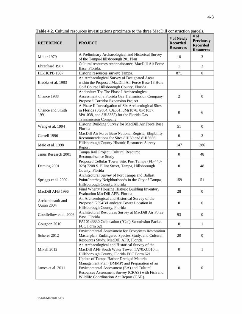
4-3
P15144/MacDill AFB
Table 4.2. Cultural resources investigations proximate to the three MacDill construction parcels.
REFERENCE PROJECT # of Newly Recorded Resources
# of Previously Recorded Resources
Miller 1979 A Preliminary Archaeological and Historical Survey of the Tampa-Hillsborough 201 Plan
10 3
Ehrenhard 1987 Cultural resources reconnaissance, MacDill Air Force Base, Florida.
1 2
HT/HCPB 1987 Historic resources survey: Tampa. 871 0
Brooks et al. 1983 An Archaeological Survey of Designated Areas within the Proposed MacDill Air Force Base 18 Hole Golf Course Hillsborough County, Florida
Chance 1988 Addendum To: The Phase I Archaeological Assessment of a Florida Gas Transmission Company Proposed Corridor Expansion Project
2 0
Chance and Smith 1991
A Phase II Investigation of Six Archaeological Sites in Florida (8Gu84, 8Ja551, 8Mr1878, 8Po1037, 8Po1038, and 8Hi3382) for the Florida Gas Transmission Company
0 6
Wang et al. 1994 Historic Building Survey for MacDill Air Force Base Florida
51 0
Gerrell 1996 MacDill Air Force Base National Register Eligibility Recommendations for Sites 8HI50 and 8HI5656
0 2
Maio et al. 1998 Hillsborough County Historic Resources Survey Report
147 286
Janus Research 2001 Tampa Rail Project, Cultural Resource Reconnaissance Study
0 48
Deming 2001 Proposed Cellular Tower Site: Port Tampa (FL-440-028) 7208 S. Elliot Street, Tampa, Hillsborough County, Florida
0 48
Spriggs et al. 2002 Architectural Survey of Port Tampa and Ballast Point/Interbay Neighborhoods in the City of Tampa, Hillsborough County, Florida
159 51
MacDill AFB 1996 Final Wherry Housing Historic Building Inventory Evaluation MacDill AFB, Florida
28 0
Archambeault and Quinn 2004
An Archaeological and Historical Survey of the Proposed G554B/Landcare Tower Location in Hillsborough County, Florida
0 0
Goodfellow et al. 2006 Architectural Resources Survey at MacDill Air Force Base, Florida
93 0
Gougeon 2010 FA10143830 Collocation ("Co") Submission Packet FCC Form 621
0 1
Scherer 2012 Environmental Assessment for Ecosystem Restoration Masterplan, Endangered Species Study, and Cultural Resources Study, MacDill AFB, Florida
20 0
Mikell 2012 An Archaeological and Historical Survey of the MacDill AFB South Water Tower TA70XC010 in Hillsborough County, Florida FCC Form 621
0 1
James et al. 2011
Update of Tampa Harbor Dredged Material Management Plan (DMMP) and Preparation of an Environmental Assessment (EA) and Cultural Resources Assessment Survey (CRAS) with Fish and Wildlife Coordination Act Report (CAR)
0 0

4-4
P15144/MacDill AFB
As archaeologists have long realized, aboriginal populations did not select their habitation sites and special activity areas in a random fashion. Rather, many environmental factors had a direct influence upon site location selection. Variables such as soil drainage, distance to freshwater, relative topography, and proximity to food and other resources, including stone and clay, have proven to be good site indicators, especially in the inland areas. The Air Force has determined that the Shoot House parcel has a high archaeological potential while the Construct Warehouse District and Demo/Construct Vehicle Operations Facility parcels have a low archaeological potential.
A review of the 19th century Federal surveyor’s data indicates that there was no development
of the property in 1852, when C.F. Hopkins surveyed the section lines of Township 30 South, Range 18 East (State of Florida 1852b). He described the area around the construction parcels as 3rd rate pine and palmetto, with mangrove marsh south of the Shoot House (State of Florida 1852a:326-349). The Construct Warehouse District and the Demo/Construct Vehicle Operations Facility areas were initially deeded to the Florida Land and Improvement Company (1882) and the Shoot House parcel was purchased by Sydney J. Wailes in 1885 (State of Florida n.d.:17-18). Based on these data, the potential for archaeological sites of the historic period appeared to be low in all proposed construction parcels.
4.2 Field Methods The archaeological field survey consisted of surface reconnaissance combined with
systematic and judgmental subsurface testing. In accordance with DHR standards, the high probability area (Shoot House parcel) was systematically tested at 25 m (82 ft) intervals. The other two parcels were considered to have low archaeological potential and were tested at 100 m (330 ft) intervals. Shovel tests were circular and measured 50 centimeters (cm) (20 inches [in]) in diameter by at least 1.0 m (39 in) in depth. The soil removed from the shovel tests was screened through 0.64 cm (0.25 in) mesh hardware cloth to assure the recovery of all artifacts.
The locations of all shovel tests was plotted on appropriate maps and following the recording
of relevant data such as environmental setting, stratigraphic profile, and artifact finds, all shovel tests were backfilled and the soil compacted to the extent that they do not present a tripping hazard. Recorded shovel test data included date, crew designation, parcel number, shovel test number, stratigraphy, depth of artifact recovery (if any), and local environmental setting. Shovel test locations were recorded with a Trimble Geo-XT.
4.3 Unexpected Discoveries
No human burial sites such as Indian mounds, lost historic and aboriginal cemeteries, or other unmarked burials or associated artifacts were inadvertently discovered during the field survey.
4.4 Analysis, Collections Management, and Curation Since no cultural materials were recovered, no laboratory analysis was needed. The field
notes, photos, and other project documentation will be maintained at ACI in Sarasota (P15144), unless the client requests otherwise.

5-1
P15144/MacDill AFB
5.0 RESULTS AND RECOMMENDATIONS
5.1 Archaeological Results Each of the three proposed construction sites was initially subjected to ground surface
reconnaissance. This was followed by systematic and judgmental shovel testing. To the extent possible, shovel tests were placed in pre-determined locations. Slight adjustments were made in the field to avoid marked utilities. No surface cultural materials were observed in any of the parcels, and all 38 shovel tests were devoid of cultural materials. Thus, no archaeological sites or isolated cultural materials are associated with the Shoot House, Demo/Construct Vehicle Operations Facility, and Construct Warehouse District parcels. A summary of findings for each area follows.
Shoot House Project Site: This 3.0-acre proposed construction parcel, historically used as an
irrigation spray field for the wastewater treatment plant, was identified as a high probability zone. Ground surface inspection indicated some irrigation equipment parts, but no aboriginal or historic cultural materials. The property has a ground cover of briars, weeds, and grasses, some Brazilian pepper, young palms and myrtle, as well as oaks and pines along the southern property boundary. The existing conditions are shown in Photo 5.1 and Photo 5.2. The parcel was subjected to systematic subsurface shovel testing at 25 m (82 ft) intervals along parallel transects spaced 25 m (82 ft) apart (Figure 5.1). Twenty-four shovel tests were excavated. As a result, no cultural materials were found. The typical stratigraphic profile is an upper zone of gray sand from 0-30 cm (0-12 in), underlain by successive strata of very light grayish tan sand between 30-60 cm (12-24 in) and dark brown sand at 60-100 cm (24-40 in). Water intrusion was observed at 90 cm (36 in). One shovel test was terminated at 50 cm (20 in) due to an obstruction, and nine tests were ended at 65-80 cm below surface (26-32 in) due to the presence of very compact, wet hardpan.
Photo 5.1. Existing conditions within the Shoot House parcel, looking northwest.

Source: Esri, DigitalGlobe, GeoEye, Earthstar Geographics,CNES/Airbus DS, USDA, USGS, AEX, Getmapping, Aerogrid,IGN, IGP, swisstopo, and the GIS User Community, Esri,HERE, DeLorme, MapmyIndia, © OpenStreetMap contributors
¹
0 100 200Feet
0 25 50Meters
5-2
Figure 5.1. Location of the shovel tests within the Shoot House parcel.

5-3
P15144/MacDill AFB
Photo 5.2. Existing conditions near the south boundary of the Shoot House parcel, looking
northwest. The Demo/Construct Vehicle Operations Facility Project Site: This approximately 5.6-
acre proposed construction parcel was considered to have a low potential for archaeological site occurrence. The property was reportedly never used, but appears to be disturbed as the result of underground electrical, gas, and cable line installations. It is now maintained lawn. The existing conditions are shown in Photo 5.3 and Photo 5.4. This parcel was systematically tested at 100 m (328 ft) intervals, supplemented with three judgmentally placed shovel tests (Figure 5.2). Of the total eight shovel tests (Figure 5.2), all yielded negative results. No surface cultural materials were observed. The typical stratigraphic profile consists of an upper zone of gravelly brown sandy fill from 0-25 (0-10 in), underlain by successive strata of mottled gray sand at 25-50 cm (10-20 in), very light gray sand at 50-80 cm (20-32 in), and brown sand at 80-100 cm (32-40 in). Three shovel tests were terminated prior to 100 cm below surface (40 in) due to impenetrable fill materials.
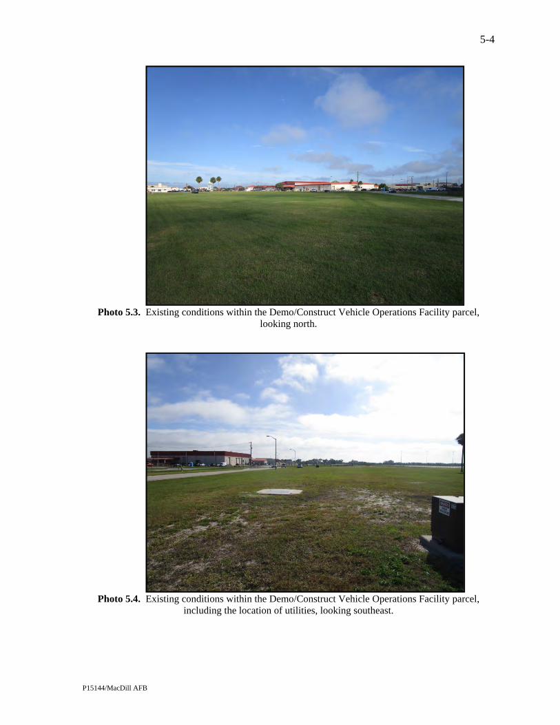
5-4
P15144/MacDill AFB
Photo 5.3. Existing conditions within the Demo/Construct Vehicle Operations Facility parcel,
looking north.
Photo 5.4. Existing conditions within the Demo/Construct Vehicle Operations Facility parcel,
including the location of utilities, looking southeast.
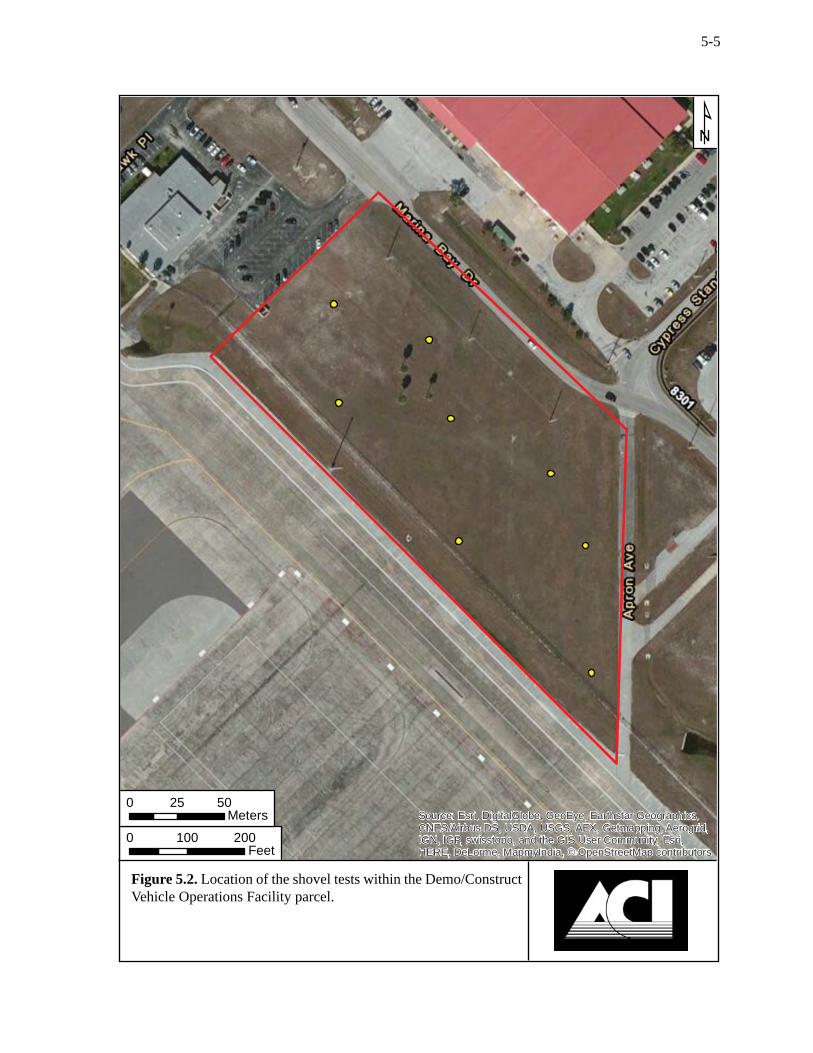
Source: Esri, DigitalGlobe, GeoEye, Earthstar Geographics,CNES/Airbus DS, USDA, USGS, AEX, Getmapping, Aerogrid,IGN, IGP, swisstopo, and the GIS User Community, Esri,HERE, DeLorme, MapmyIndia, © OpenStreetMap contributors
¹
0 100 200Feet
0 25 50Meters
5-5
Figure 5.2. Location of the shovel tests within the Demo/Construct Vehicle Operations Facility parcel.

5-6
P15144/MacDill AFB
The Construct Warehouse District Project Site: This proposed construction parcel, which measures approximately 5.5 acres, was considered to have a low archaeological site potential. This land has never been used, but has been disturbed by previous base activities and the installation of underground utilities, ditching, and the removal of contaminated soil in the eastern portion of the parcel. A paved road bisects the property. Most of the land is now maintained lawn and used for equipment storage. A metal open shed is located in the southeast part of the property. The existing conditions are shown in Photo 5.5 and Photo 5.6. Following ground surface inspection, which yielded negative results, this parcel was systematically tested at 100 m (328 ft) intervals, and supplemented by one judgmental test. The testing strategy was designed to avoid utilities and contaminated soil areas. The total six shovel tests (Figure 5.3) were devoid of cultural materials. The typical stratigraphic profile observed consisted of an upper zone of dark gray brown mottled sand from 0-40 cm (0-16 in), underlain by successive strata of light gray sand at 40-65 cm (16-26 in), and brown sand at 65-100 cm (26-40 in). Water intrusion was observed at 90 cm (36 in).
Photo 5.5. Existing conditions within the Construct Warehouse District parcel, looking northeast.

Source: Esri, DigitalGlobe, GeoEye, Earthstar Geographics,CNES/Airbus DS, USDA, USGS, AEX, Getmapping, Aerogrid,IGN, IGP, swisstopo, and the GIS User Community, Esri,HERE, DeLorme, MapmyIndia, © OpenStreetMap contributors
¹
0 100 200Feet
0 25 50Meters
5-7
Figure 5.3. Location of the shovel tests within the Construct Ware-house District parcel.

5-8
P15144/MacDill AFB
Photo 5.6. Eastern part of the Construct Warehouse District parcel showing sheds and marked utility
line (pink flagged pins), looking north.
5.2 Conclusions and Recommendations The background research revealed an absence of previously recorded archaeological sites and
historic resources within the three proposed construction parcels. No new archaeological sites were located during the field survey. Therefore, no archaeological sites or historic resources that are listed, eligible, or considered potentially eligible for listing in the NRHP will be affected by the proposed undertaking. No further archaeological investigations are recommended.

6-1
P15144/MacDill AFB
6.0 REFERENCES CITED
6th Air Mobility Wing 2015 Units. 6th Air Mobility Wing Public Affairs Office, Tampa. Accessed November 23,
2015. http://www.macdill.af.mil/units/index.asp. Akerman, Joe A. 1976 Florida Cowman: A History of Florida Cattle Raising. Florida Cattlemen's Association,
Kissimmee. Archambeault, Marie J. and Lisa N. Quinn 2004 An Archaeological and Historical Survey of the Proposed G554B/Landcare Tower
Location in Hillsborough County, Florida. Panamerican Consultants, Inc., Tampa. Austin, Robert J. 1995 Yat Kitischee: A Prehistoric Coastal Hamlet 100 B.C.-A.D. 1200. Janus Research, Inc.,
Tampa. 2001 Paleoindian and Archaic Archaeology in the Middle Hillsborough River Basin: A
Synthetic Overview. SEARCH, Jonesville. Austin, Robert J., Kenneth W. Hardin, Harry M. Piper, Jacquelyn G. Piper, and Barbara McCabe 1992 Archaeological Investigations at the Site of the Tampa Convention Center, Tampa
Florida. Volume 1: Prehistoric Resources, Including a Report on the Mitigative Excavation of a Prehistoric Aboriginal Cemetery. Janus Research, Inc., Tampa.
Austin, Robert J., Jeffrey M. Mitchem, Arlene Fradkin, John E. Foss, Shanna Drwiega, and Linda
Allred 2008 Bayshore Homes Archaeological Survey and National Register Evaluation. Central Gulf
Coast Archaeological Society, Pinellas Park. Austin, Robert J. and Michael Russo 1989 Limited Excavations at the Catfish Creek Site (8SO608), Sarasota, Florida. Janus
Research, Inc., Tampa. Bradbury, Alford G. and E. Storey Hallock 1962 A Chronology of Florida Post Offices. Handbook 2. The Florida Federation of Stamp
Clubs. Brooks, Mark J., Harry M. Piper, and Catherine B. Slusser 1983 An Archaeological Survey of Designated Areas within the Proposed MacDill Air Force
Base 18 Hole Golf Course, Hillsborough County, Florida. Janus Research, Inc., Tampa. Brown, Canter, Jr. 1991 Florida's Peace River Frontier. University of Central Florida Press, Orlando. 1999 Tampa Before the Civil War. Tampa Bay History Center, Tampa. Bruton, Quintilla Geer and David E. Bailey 1984 Plant City: Its Origins and History. Hunter Publishing Co., Winston-Salem. Bullen, Ripley P. 1959 The Transitional Period of Florida. Southeastern Archaeological Conference Newsletter
6(1):43-53.

6-2
P15144/MacDill AFB
Bullen, Ripley P. 1965 Florida's Prehistory. In Florida -- From Indian Trail to Space Age. Edited by C. W.
Tebeau and R. L. Carson, pp. 305-316. Southern Publishing Co., Delray Beach. 1975 A Guide to the Identification of Florida Projectile Points. Kendall Books, Gainesville. 1978 Tocobaga Indians and the Safety Harbor Culture. In Tacachale: Essays on the Indians of
Florida and Southeastern Georgia during the Historic Period. Edited by J. T. Milanich and S. Proctor, pp. 50-58. University of Florida Press, Gainesville.
Campbell, A. Stuart 1939 The Cigar Industry of Tampa, Florida. University of Florida. Bureau of Economics and
Business Research, Gainesville. Carbone, Victor 1983 Late Quaternary Environment in Florida and the Southeast. The Florida Anthropologist
36(1-2):3-17. Carter, Brinnen C. and James S. Dunbar 2006 Early Archaic Archaeology. In First Floridians and Last Mastodons: The Page-Ladson
Site in the Aucilla River. Edited by S. D. Webb, pp. 493-517. Springer, The Netherlands. Chamberlin, Donald L. 1968 Fort Brooke: A History. MA thesis, Florida State University, Tallahassee. Chance, Marsha A. 1988 Addendum To: The Phase I Archaeological Assessment of a Florida Gas Transmission
Company Proposed Corridor Expansion Project. On file, FDHR, Tallahassee. Chance, Marsha A. and Greg C. Smith 1991 A Phase II Investigation of Six Archaeological Sites in Florida (8Gu84, 8Ja551,
8Mr1878, 8Po1037, 8Po1038, and 8Hi3382) for the Florida Gas Transmission Company. On file, FDHR, Tallahassee.
Clausen, Carl J., A. D. Cohen, Cesare Emiliani, J. A. Holman, and J. J. Stipp 1979 Little Salt Spring, Florida: A Unique Underwater Site. Science 203(4381):609-614. County Engineering Department 1927 District Road & Bridge Map, Hillsborough County, Florida. Hillsborough County
Engineering Department, Tampa. Covington, James W. 1957 The Story of Southwestern Florida. Volume 1. Lewis Historical Publishing Company,
Inc., New York. 1958 Exploring the Ten Thousand Islands: 1838. Tequesta 18:7-13. 1961a The Armed Occupation Act of 1842. Florida Historical Quarterly 40(1):41-53. 1961b The Indian Scare of 1849. Tequesta 21:53-62. 1982 The Billy Bowlegs War 1855-1858: The Final Stand of the Seminoles Against the Whites.
The Mickler House Publishers, Chuluota. Curl, Donald W. 1986 Palm Beach County: An Illustrated History. Windsor Publications, Northridge, CA. Daniel, I. Randolph and Michael Wisenbaker 1987 Harney Flats: A Florida Paleo-Indian Site. Baywood Publishing Co., Inc., Farmingdale.

6-3
P15144/MacDill AFB
Davis, T. Frederick 1939 The Disston Land Purchase. Florida Historical Quarterly 17(3):200-210. Delcourt, Paul A. and Hazel R. Delcourt 1981 Vegetation Maps for Eastern North America: 40,000 yr B.P. to the Present. In Geobotony
II. Edited by R. C. Romans, pp. 123-165. Plenum Publishing Corp., New York. Deming, Joan 2001 Cultural Resource Reconnaissance Survey/Section 106 Review Proposed Cellular Tower
Site: Port Tampa (FL-440-028) 7208 S. Elliot Street, Tampa, Hillsborough County, Florida. ACI, Sarasota.
Doolittle, James A., Gregg Schellentrager, and Susan Ploetz 1989 Soil Survey of Hillsborough County, Florida. USDA, Soil Conservation Service,
Washington, D.C. Doran, Glen H., Ed. 2002 Windover: Multidisciplinary Investigations of an Early Archaic Florida Cemetery.
University Press of Florida, Gainesville. Dunbar, James S. 1981 The Effect of Geohydrology and Natural Resource Availability on Site Utilization at the
Fowler Bridge Mastodon Site (8Hi393c/uw) in Hillsborough County, Florida. In Report on Phase II Underwater Archaeological Testing at the Fowler Bridge Mastodon Site (8Hi393c/uw), Hillsborough County, Florida. Edited by J. Palmer, J. S. Dunbar and D. H. Clayton, pp. 63-106. Interstate 75 Highway Phase II Archaeological Report 5. FDHR, Tallahassee.
2006a Paleoindian Archaeology. In First Floridians and Last Mastodons: The Page-Ladson Site in the Aucilla River. Edited by S. D. Webb, pp. 403-435. Springer, The Netherlands.
2006b Paleoindian Land Use. In First Floridians and Last Mastodons: The Page-Ladson Site in the Aucilla River. Edited by S. D. Webb, pp. 525-544. Springer, The Netherlands.
Dunbar, James S. and S. David Webb 1996 Bone and Ivory Tools from Submerged Paleoindian Sites in Florida. In The Paleoindian
and Early Archaic Southeast. Edited by D. G. Anderson and K. E. Sassaman, pp. 331-353. University of Alabama Press, Tuscaloosa.
Dunn, Hampton 1989 Back Home: A History of Citrus County, Florida. Citrus County Historical Society,
Inverness. Ehrenhard, John E. 1987 Cultural Resources Reconnaissance, MacDill AFB, Florida. National Park Service,
Archaeological Services Division, Southeast Regional Office, Atlanta. engineering-environmental Management, Inc. 2006 Integrated Cultural Resources Management Plan, Fiscal Years 2006-2010, MacDill Air
Force Base, Florida. engineering-environmental Management, Inc., Denver. Eriksen, John M. 1994 Brevard County, A History to 1955. Florida Historical Society Press, Tampa.

6-4
P15144/MacDill AFB
Evans, Mary K. 1972 National Register of Historic Places Nomination of the Tampa Bay Hotel. FDHR,
Tallahassee. Farr, Grayal Earle 2006 A Reevaluation of Bullen's Typology for Preceramic Projectile Points. MA thesis,
Department of Anthropology, Florida State University, Tallahassee. Faught, Michael K. 2004 The Underwater Archaeology of Paleolandscapes, Apalachee Bay, Florida. American
Antiquity 69(2):275-289. Faught, Michael K. and Joseph F. Donoghue 1997 Marine Inundated Archaeological Sites and Paleofluvial Systems: Examples from a
Karst-controlled Continental Shelf Setting in Apalachee Bay, Northeastern Gulf of Mexico. Geoarchaeology 12:417-458.
Florida Southern Railway Company 1888 New Sectional Map of Eastern and Southern Portions of the State of Florida. Mathews-
Northup. Co., Buffalo, NY. http://fcit.usf.edu/florida/maps/pages/10900/f10928/f10928.htm. FMSF Various site file forms. On file, FDHR, Tallahassee. Forstall, Richard L. 1995 Population of Counties by Decennial Census. United States Census Bureau, Population
Division. Accessed www.census.gov/population/cencounts/fl190090.txt. Friedel, Frank 1985 The Splendid Little War. Bramhall House, New York. Gerrell, Philip R. 1996 MacDill Air Force Base National Register Eligibility Recommendations for Sites 8HI50
and 8HI5656. Geo-Marine, Inc., Plano, TX. Goodfellow, Sue, Dan Hart, and Alison Ross 2006 Architectural Resources Survey at MacDill Air Force Base, Florida. engineering-
environmental Management, Inc., Fairfax, VA. Gougeon, Ramie A. 2010 An Archaeological and Historical Survey of the MacDill AFB FA10143630 Collocation
in Hillsborough County, Florida. FCC Form 621. Panamerican Consultants, Inc., Tampa. Grismer, Karl H. 1946 The Story of Sarasota. Florida Grower Press, Tampa. 1950 Tampa: A History of the City of Tampa and the Tampa Bay Region of Florida. St.
Petersburg Printing Company, St. Petersburg. Guthrie, Sarah M. W. 1974 Land of Promise, Land of Change: An Examination of the Population of Hillsborough
County, Florida. MA thesis, Emory University, Atlanta.

6-5
P15144/MacDill AFB
Hann, John H. 2003 Indians of Central and South Florida 1513-1763. University Press of Florida,
Gainesville. Hardin, Kenneth W. and Harry M. Piper 1984 Manasota: Which Way to the Border? Paper presented at the Florida Academy of
Sciences, Boca Raton. HT/HCPB 1980 The Cultural Resources of the Unincorporated Portions of Hillsborough County: An
Inventory of the Built Environment. Historic Tampa/Hillsborough County Preservation Board, Tampa.
1987 Historic Resources Survey: Tampa. Historic Tampa/Hillsborough County Preservation Board, Tampa.
James, Stephen R., Jr., Michael K. Faught, and Andrew D.W. Lydecker 2011 Cultural Resource Assessment Survey (CRAS) for Operations and Maintenance
Dredging of Tampa Harbor. Panamerican Consultants, Inc., Memphis. Janus Research 2001 Tampa Rail Project Cultural Resource Reconnaissance Study. Janus Research, Inc.,
Tampa. Knapp, Michael S. 1980 Environmental Geology Series: Tampa Sheet. Map Series 97. Florida Department of
Natural Resources, Bureau of Geology, Tallahassee. Kohler, Timothy A. 1991 The Demise of Weeden Island and Post-Weeden Island Cultural Stability in Non-
Mississippianized Northern Florida. In Stability, Transformation, and Variations: the Late Woodland Southeast. Edited by M. S. Nassaney and C. R. Cobb, pp. 91-110. Plenum Press, New York.
Lonn, Ella 1965 Salt as a Factor in the Confederacy. University of Alabama Press, Tuscaloosa. Lowry, Charles B. 1974 The PWA in Tampa: A Case Study. Florida Historical Quarterly 52(4):363-380. Luer, George M. and Marion M. Almy 1981 Temple Mounds of the Tampa Bay Area. The Florida Anthropologist 34(3):127-155. 1982 A Definition of the Manasota Culture. The Florida Anthropologist 35(1):34-58. Luer, George M., Marion M. Almy, Dana Ste. Claire, and Robert J. Austin 1987 The Myakkahatchee Site (8SO397), A Large Multi-Period Inland from the Shore Site in
Sarasota County, Florida. The Florida Anthropologist 40(2):137-153. MacDill AFB 1996 Cultural Resources Management Plan, Natural and Cultural Resources Element, 6th Civil
Engineer Squadron (ACC). MacDill Air Force Base, Florida. 2003 Final Wherry Housing Historic Building Inventory Evaluation, MacDill AFB, Florida.
MacDill Air Force Base, Florida.

6-6
P15144/MacDill AFB
Mahon, John K. 1985 History of the Second Seminole War 1835-1842. University Press of Florida, Gainesville. Mahon, John K. and Brent R. Weisman 1996 Florida's Seminole and Miccosukee Peoples. In The New History of Florida. Edited by
M. Gannon, pp. 183-206. University Press of Florida, Gainesville. Maio, Teresa, Geoffrey Mohlman, and DeAnn Capanna 1998 Hillsborough County Historic Resources Report. Hillsborough County Planning and
Growth Management Department, Tampa. Mikell, Greg 2012 An Archaeological and Historical Survey of the MacDill AFB South Water Tower
TA70XCO10 in Hillsborough County Florida. FCC Form 620. Panamerican Consultants, Inc., Lakeland.
Milanich, Jerald T. 1994 Archaeology of Precolumbian Florida. University Press of Florida, Gainesville. Milanich, Jerald T. and Charles H. Fairbanks 1980 Florida Archaeology. Academic Press, New York. Miller, James J. 1979 A Preliminary Archaeological and Historical Survey of the Tampa-Hillsborough 201
Plan. On file, FDHR, Tallahassee. Mitchem, Jeffrey M. 1988 Some Alternative Interpretations of Safety Harbor Burial Mounds. Florida Scientist
51(2):100-107. 1989 Redefining Safety Harbor: Late Prehistoric/Protohistoric Archaeology in West
Peninsular Florida. Ph.D. dissertation, Department of Anthropology, University of Florida, Gainesville.
2012 Safety Harbor: Mississippian Influence in the Circum-Tampa Bay Region. In Late Prehistoric Florida: Archaeology at the Edge of the Mississippian World. Edited by K. Ashley and N. M. White, pp. 172-185. University Press of Florida, Gainesville.
Mormino, Gary and Tony Pizzo 1983 Tampa: the Treasure City. Continental Heritage Press, Tulsa. Neill, Wilfred T. 1964 The Association of Suwannee Points and Extinct Animals in Florida. The Florida
Anthropologist 17(3-4):17-32. Patterson, P.E., D.P. Stanley, and K.J. Johnson 1994 MacDill Air Force Base Cold War Material Culture Inventory. Mariah Associates, Inc.,
Albuquerque, NM. Piper, Harry M., Jacquelyn G. Piper, Kenneth W. Hardin, George R. Ballo, Mark M. Thomsen,
Daniel F. Belknap, and Curtis W. Wienker 1982 Archaeological Excavations at the Quad Block Site, 8HI998, Located at the Site of the
Old Fort Brooke Municipal Parking Garage, Tampa. Janus Research, Inc., Tampa. Purdy, Barbara A. 1981 Florida's Prehistoric Stone Tool Technology. University Press of Florida, Gainesville.

6-7
P15144/MacDill AFB
Robinson, Earnest L. 1928 History of Hillsborough County. The Record Company Printers, St. Augustine. Russo, Michael 1994a A Brief Introduction to the Study of Archaic Mounds in the Southeast. Southeastern
Archaeology 13(2):89-92. 1994b Why We Don't Believe in Archaic Ceremonial Mounds and Why We Should: The Case
from Florida. Southeastern Archaeology 13(2):93-108. Sassaman, Kenneth E. 2003 New AMS Dates on Orange Fiber-Tempered Pottery from the Middle St. Johns Valley
and Their Implications for Culture History in Northeast Florida. The Florida Anthropologist 56(1):5-13.
2008 The New Archaic, It Ain't What It Used to Be. The SAA Archaeological Record 8 (5): 6-8.
Scherer, Mathia 2012 Cultural Resources Study - Environmental Assessment for Ecosystem Restoration
Masterplan, Endangered Species Studies, and Cultural Resources Study, MacDill. AMEC Earth & Infrastructure, Inc., Louisville, KY.
Schwadron, Margo 2002 Archeological Investigations of De Soto National Memorial. SEAC Technical Reports 8.
Southeast Archeological Center, National Park Service, Tallahassee. Scott, Thomas M. 2001 Text to Accompany the Geologic Map of Florida. Open File Report 80. Florida
Geological Survey, Tallahassee. Scott, Thomas M., Kenneth M. Campbell, Frank R. Rupert, Jonathan D. Arthur, Thomas M.
Missimer, Jacqueline M. Lloyd, J. William Yon, and Joel G. Duncan 2001 Geologic Map of the State of Florida. Map Series 146. Florida Geological Survey,
Tallahassee. Scupholm, Carrie 1997 The Tamiami Trail: Connecting the East and West Coasts of the Sunshine State. The
Society for Commercial Archeology Journal 15(2):20-24. Shofner, Jerrell H. 1995 History of Brevard County. Volume 1. Brevard County Historical Commission, Stuart. Spriggs, Patricia H., Robin Bajkiewicz, and Lucy D. Jones 2002 Architectural Survey of Port Tampa and Ballast Point/Interbay Neighborhoods in the City
of Tampa, Hillsborough County, Florida. Panamerican Consultants, Inc., Tampa. Stanford, Dennis 1991 Clovis Origins and Adaptations: An Introductory Perspective. In Clovis: Origins and
Adaptations. Edited by R. Bonnichsen and K. L. Turnmire, pp. 1-14. Center for the Study of the First Americans, Corvallis, OR.
State of Florida, Department of Environmental Protection 1852a Field Notes. C. F. Hopkins. Volume 100. 1852b Plat. Township 30 South, Range 18 East. C. F. Hopkins. n.d. Tract Book. Volume 16.

6-8
P15144/MacDill AFB
Tebeau, Charlton W. 1980 A History of Florida. University of Miami Press, Coral Gables. Tebeau, Charlton W. and Ruby Leach Carson, Eds. 1965 Florida -- From Indian Trail to Space Age. Southern Publishing Co., Delray Beach. Tischendorf, A. P. 1954 Florida and the British Investor: 1880-1914. Florida Historical Quarterly 33(2):120-129. Turner, Gregg 2003 A Short History of Florida Railroads. Arcadia Publishing, Charleston, SC. 2005 Florida Railroads in the 1920s. Arcadia Publishing, Charleston, SC. USCB 2013 Florida Quick Facts. Accessed http://quickfacts.census.gov/qfd/states/12000.html. USDA 1938 Aerial Photograh - Nov 21 1938, BQF-1-65, 67, 122. On file, PALMM, Gainesville. 1982 Aerial Photograh - 1-12-82, 120567-182-29,54. On file, PALMM, Gainesville. Waller, Ben I. 1970 Some Occurrences of Paleo-Indian Projectile Points in Florida Waters. The Florida
Anthropologist 23(4):129-134. Wang, Charissa Y., Donald M. Durst, and Douglas A. Jacobs 1994 Historic Building Survey for MacDill Air Force Base Florida. Hardlines: Design &
Delineation, Columbus, OH. Watts, William A. 1969 A Pollen Diagram from Mud Lake, Marion County, North-Central Florida. Geological
Society of America Bulletin 80(4):631-642. 1971 Post Glacial and Interglacial Vegetational History of Southern Georgia and Central
Florida. Ecology 51:676-690. 1975 A Late Quaternary Record of Vegetation from Lake Annie, South-Central Florida.
Geology 3(6):344-346. Watts, William A. and Barbara C. S. Hansen 1988 Environments in Florida in the Late Wisconsin and Holocene. In Wet Site Archaeology.
Edited by B. A. Purdy, pp. 307-323. Telford Press, Caldwell. Webb, S. David, Ed. 2006 First Floridians and Last Mastodons: The Page-Ladson Site in the Aucilla River.
Springer, The Netherlands. White, William A. 1970 Geomorphology of the Florida Peninsula. Geological Bulletin 51. Florida Department of
Natural Resources, Bureau of Geology, Tallahassee. Willey, Gordon R. 1949 Archaeology of the Florida Gulf Coast. Smithsonian Miscellaneous Collections 113. 1982
Reprint. Florida Book Store, Gainesville. Woodfin, Michael n.d. Port Tampa. Ghosttowns.com. http://www.ghosttowns.com/states/fl/porttampa.html.

P15144/MacDill AFB
APPENDIX
Survey Log

CRAS Three Construction Sites MacDill AFB, Hillsborough Co.
Phase I Archaeological Survey of Three Construction Sites at MacDill Air
Force Base in Hillsborough County, Florida
ACI
2015 47
P15144, ACI, Sarasota.
Deming, Joan
Archaeological Consultants Inc Sarasota
MacDill AFB
Akima Facilities Management
PO Box 6350, Tampa, FL 33608-0350
Horvath, Elizabeth A. 12-8-2015
Hillsborough
PORT TAMPA 1982
GIBSONTON 1982
12-3-2015 12-7-2015 14.13

background research, systematic & judgmental subsurface testing (24 @ 25 m, x
@ 100m), 50 cm diameter, 1 m deep, 1/4" screen

MacDill AFB construction parcelsSections 21, 27 and 34 of Township 30 South, Range 18 EastUSGS Port Tampa and GibsontonHillsborough County
Copyright:© 2013 National Geographic Society, i-cubed
¹
0 0.25 0.5Miles
0 0.5 1Kilometers
Shoot House parcel
Demo/Construct VehicleOperations Facility parcel
Construct WarehouseDistrict parcel

February 3, 2016 Jason W. Kirkpatrick Contractor, IAP Worldwide Services Inc. 6th Civil Engineer Squadron 7621 Hillsborough Loop Dr. MacDill AFB, FL 33621 813-695-3206 Subject: Phase I Archaeological Survey of Three Construction Sites at MacDill Air Force Base, Hillsborough County, Florida THPO#: 0028679 Dear Mr. Kirkpatrick: Thank you for contacting the Seminole Tribe of Florida’s Tribal Historic Preservation Office (STOF-THPO) regarding the proposed construction at three sites on MacDill Air Force Base, Hillsborough County, Florida. This letter is to acknowledge that the STOF-THPO has reviewed the report technical report Phase I Archaeological Survey of Three Construction Sites at MacDill Air Force Base in Hillsborough County, Florida and has no objection to your finding of “no historic properties affected” at this time. However, the STOF-THPO would like to be informed in the event that any archaeological, historical, or burial resources are inadvertently discovered during execution of the undertaking. Thank you and we look forward to working with you in the future. Respectfully,
Andrew J. Weidman, MA, RPA STOF-THPO, Compliance Review Section 30290 Josie Billie Hwy, PMB 1004 Clewiston, FL 33440 Office: 863-983-6549 x12216 Email: [email protected]