environmental impact assessment - nra · environmental impact assessment for the proposed national...
TRANSCRIPT
ENVIRONMENTAL IMPACT ASSESSMENT
FOR THE PROPOSED
NATIONAL ROAD 3: KEEVERSFONTEIN TO WARDEN (DE BEERS PASS SECTION)
DEA ref. no. 12/12/20/1992
Heritage Specialist Report
Prepared for
Cave Klapwijk and Associates Box 11651 HATFIELD
0028
Prepared by
eThembeni Cultural Heritage
Box 20057 ASHBURTON
3213
On behalf of
N3 TOLL CONCESSION (PTY) LTD
10 June 2014
National Road 3: De Beers Pass Section Heritage Impact Assessment Specialist Report
10/06/2014
eThembeni Cultural Heritage i
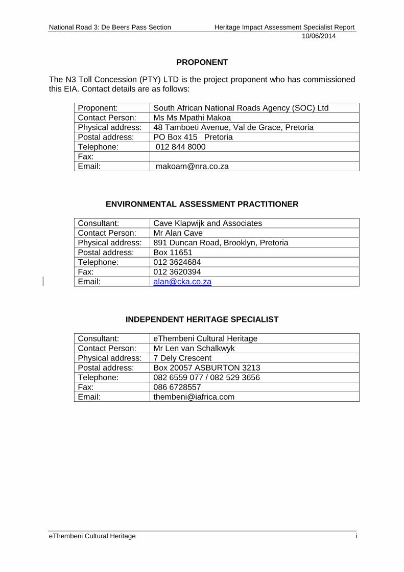
PROPONENT
The N3 Toll Concession (PTY) LTD is the project proponent who has commissioned this EIA. Contact details are as follows:
Proponent: South African National Roads Agency (SOC) Ltd
Contact Person: Ms Ms Mpathi Makoa
Physical address: 48 Tamboeti Avenue, Val de Grace, Pretoria
Postal address: PO Box 415 Pretoria
Telephone: 012 844 8000
Fax:
Email: [email protected]
ENVIRONMENTAL ASSESSMENT PRACTITIONER
Consultant: Cave Klapwijk and Associates
Contact Person: Mr Alan Cave
Physical address: 891 Duncan Road, Brooklyn, Pretoria
Postal address: Box 11651
Telephone: 012 3624684
Fax: 012 3620394
Email: [email protected]
INDEPENDENT HERITAGE SPECIALIST
Consultant: eThembeni Cultural Heritage
Contact Person: Mr Len van Schalkwyk
Physical address: 7 Dely Crescent
Postal address: Box 20057 ASBURTON 3213
Telephone: 082 6559 077 / 082 529 3656
Fax: 086 6728557
Email: [email protected]
National Road 3: De Beers Pass Section Heritage Impact Assessment Specialist Report
10/06/2014
eThembeni Cultural Heritage ii
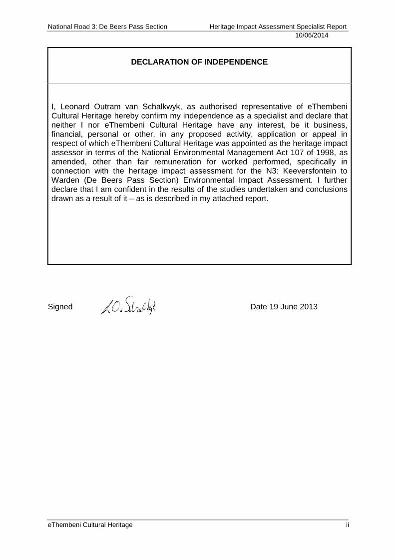
DECLARATION OF INDEPENDENCE
I, Leonard Outram van Schalkwyk, as authorised representative of eThembeni Cultural Heritage hereby confirm my independence as a specialist and declare that neither I nor eThembeni Cultural Heritage have any interest, be it business, financial, personal or other, in any proposed activity, application or appeal in respect of which eThembeni Cultural Heritage was appointed as the heritage impact assessor in terms of the National Environmental Management Act 107 of 1998, as amended, other than fair remuneration for worked performed, specifically in connection with the heritage impact assessment for the N3: Keeversfontein to Warden (De Beers Pass Section) Environmental Impact Assessment. I further declare that I am confident in the results of the studies undertaken and conclusions drawn as a result of it – as is described in my attached report.
Signed Date 19 June 2013
National Road 3: De Beers Pass Section Heritage Impact Assessment Specialist Report
10/06/2014
eThembeni Cultural Heritage iii
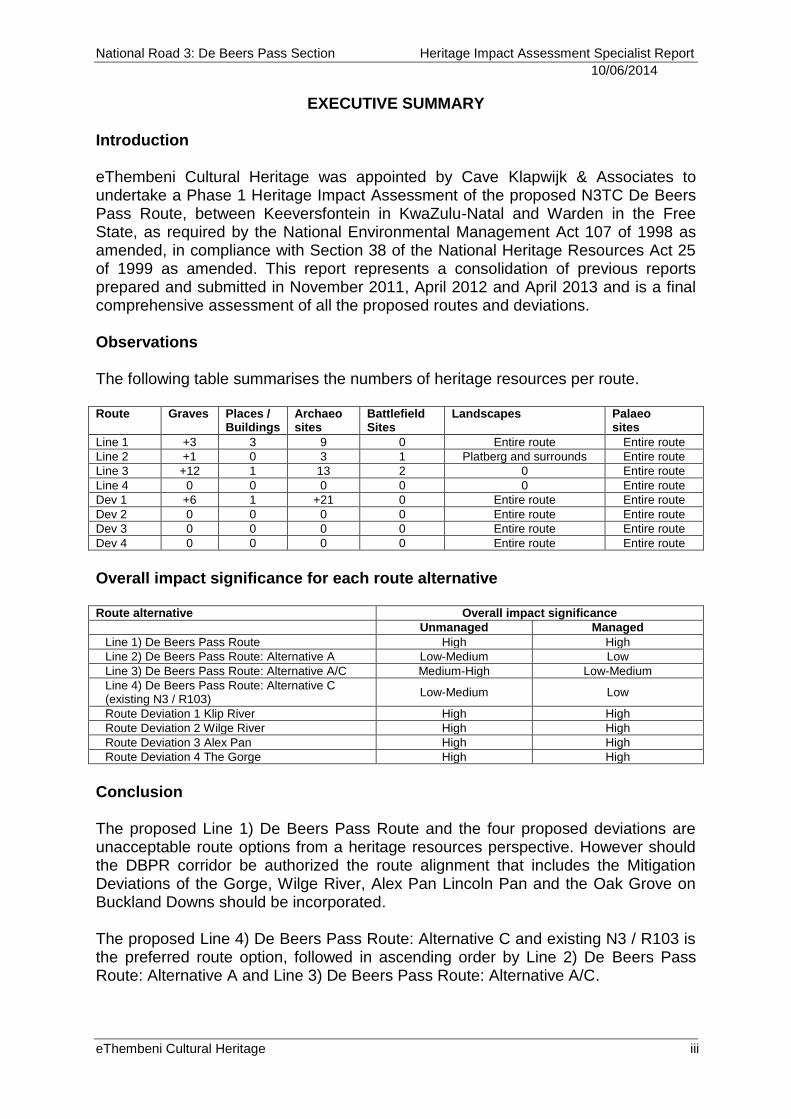
EXECUTIVE SUMMARY Introduction eThembeni Cultural Heritage was appointed by Cave Klapwijk & Associates to undertake a Phase 1 Heritage Impact Assessment of the proposed N3TC De Beers Pass Route, between Keeversfontein in KwaZulu-Natal and Warden in the Free State, as required by the National Environmental Management Act 107 of 1998 as amended, in compliance with Section 38 of the National Heritage Resources Act 25 of 1999 as amended. This report represents a consolidation of previous reports prepared and submitted in November 2011, April 2012 and April 2013 and is a final comprehensive assessment of all the proposed routes and deviations. Observations The following table summarises the numbers of heritage resources per route. Route Graves Places /
Buildings Archaeo sites
Battlefield Sites
Landscapes Palaeo sites
Line 1 +3 3 9 0 Entire route Entire route
Line 2 +1 0 3 1 Platberg and surrounds Entire route
Line 3 +12 1 13 2 0 Entire route
Line 4 0 0 0 0 0 Entire route
Dev 1 +6 1 +21 0 Entire route Entire route
Dev 2 0 0 0 0 Entire route Entire route
Dev 3 0 0 0 0 Entire route Entire route
Dev 4 0 0 0 0 Entire route Entire route
Overall impact significance for each route alternative Route alternative Overall impact significance
Unmanaged Managed
Line 1) De Beers Pass Route High High
Line 2) De Beers Pass Route: Alternative A Low-Medium Low
Line 3) De Beers Pass Route: Alternative A/C Medium-High Low-Medium
Line 4) De Beers Pass Route: Alternative C (existing N3 / R103)
Low-Medium Low
Route Deviation 1 Klip River High High
Route Deviation 2 Wilge River High High
Route Deviation 3 Alex Pan High High
Route Deviation 4 The Gorge High High
Conclusion The proposed Line 1) De Beers Pass Route and the four proposed deviations are unacceptable route options from a heritage resources perspective. However should the DBPR corridor be authorized the route alignment that includes the Mitigation Deviations of the Gorge, Wilge River, Alex Pan Lincoln Pan and the Oak Grove on Buckland Downs should be incorporated. The proposed Line 4) De Beers Pass Route: Alternative C and existing N3 / R103 is the preferred route option, followed in ascending order by Line 2) De Beers Pass Route: Alternative A and Line 3) De Beers Pass Route: Alternative A/C.
National Road 3: De Beers Pass Section Heritage Impact Assessment Specialist Report
10/06/2014
eThembeni Cultural Heritage iv
This report may be submitted to SAHRA and Amafa in fulfilment of the requirements of the NHRA. According to Section 38(4) of the NHRA the report shall be considered timeously by the Council which shall, after consultation with the person proposing the development, decide –
whether or not the development may proceed;
any limitations or conditions are to be applied to the development;
what general protections in terms of this Act apply, and what formal protections may be applied to such heritage resources;
whether compensatory action shall be required in respect of any heritage resources damaged or destroyed as a result of the development; and
whether the appointment of specialists is required as a condition of approval of the proposal.
National Road 3: De Beers Pass Section Heritage Impact Assessment Specialist Report
10/06/2014
eThembeni Cultural Heritage v
TABLE OF CONTENTS 1 INTRODUCTION 8
2 TERMS OF REFERENCE 8
3 PROJECT DESCRIPTION 10
4 RECEIVING ENVIRONMENT 17
4.1 Project location 17
4.2 Environmental description 17
5 CULTURAL CONTEXT OF THE STUDY AREA 19
5.1 Current socio-economic structure 19
5.2 Typical heritage resources 20
6 OBSERVATIONS 21
7 ASSESSMENT OF IMPACTS 18
8 IMPACT ASSESSMENT PER SECTION FOR EACH ROUTE
ALTERNATIVE 28
9 RECOMMENDED MITIGATION MEASURES 30
9.1 Traditional burial places: graves outside a formal cemetery 30
9.2 Archaeological sites 30
9.3 Places, buildings and structures > 60 years 30
9.4 Landscapes and natural features 31
9.5 Battlefields 31
9.6 Palaeontological sites 31
9.7 General 31
10 RECOMMENDED MONITORING 32
11 PROTOCOL FOR THE IDENTIFICATION, PROTECTION AND RECOVERY
OF HERITAGE RESOURCES DURING CONSTRUCTION AND OPERATION 32
12 TIME AND COST IMPLICATIONS OF PROPOSED MITIGATION 33
13 CONCLUSION 34
14 BIBLIOGRAPHY 35
APPENDIX A STATUTORY REQUIREMENTS 37
APPENDIX B ARCHAEOLOGICAL AND HISTORICAL CONTEXT OF THE
STUDY AREA 43
APPENDIX C METHODOLOGY 57
APPENDIX D LANDSCAPES 62
APPENDIX E SPECIALIST COMPETENCY 65
National Road 3: De Beers Pass Section Heritage Impact Assessment Specialist Report
10/06/2014
eThembeni Cultural Heritage vi
LIST OF FIGURES
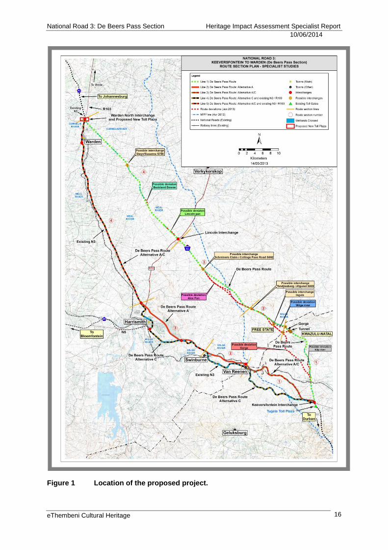
Figure 1 Location of the proposed project. 16
Figure 2 Line 1) De Beers Pass Route heritage sites (source: Google Earth).
23
Figure 3 Kidston and Gladstone Memorial. 23
Figure 4 Line 2) De Beers Pass Route: Alternatives A and A/C Section 1
heritage sites (source: Google Earth). 26
Figure 5 Line 2) De Beers Pass Route: Alternatives A and A/C Section 3
heritage sites (source: Google Earth). 26
Figure 6 Route Deviation 1 heritage sites (source: Google Earth). 29
Figure 7 Grave of Msibi family. 29
Figure 8 Archaeological site at Msonti Bush Camp, 30
Figure 9 Voortrekker wagon trail outspan and staging camp. 30
Figure 10 Part of Voortrekker wagon route over the escarpment. 31
Figure 11 Pitchers Rest dressed sandstone farmhouse. 31
Figure 12 Farming on Bosfontein, KwaZulu-Natal. 53
Figure 13 Cattle are moved from the KwaZulu-Natal lowlands in the
foreground to the Free State Highveld in summer. 54
Figure 14 Tandjiesberge and Nelson's kop near Pitchers Rest, Free State
(source: Google Earth). 54
Figure 15 Homestead in the shadow of Tandjiesberg, Free State (source:
Google Earth). 55
Figure 16 Nelson’s Kop, Free State (source: Google Earth). 55
Figure 17 Grasslands at the foot of Nelson’s Kop. 56
LIST OF TABLES
Table 1 Lithostratigraphy of the study area. 17
Table 2 Descriptions, locations and significance of all identified heritage
resources: Line 1) De Beers Pass Route. 21
Table 3 Descriptions, locations and significance of all identified heritage
resources: Line 2) De Beers Pass Route: Alternative A and Line 3) De
Beers Pass Route: Alternative A/C. 24
Table 4 Descriptions, locations and significance of all identified heritage
resources: Line 4) De Beers Pass Route: Alternative C and existing N3 /
R103. 27
Table 5 Descriptions, locations and significance of all identified heritage
resources: Route Deviation 1 (Possible Gorge Deviation on map). 27
Table 6 Descriptions, locations and significance of all identified heritage
resources: Route Deviation 2 (Possible Deviation Alex Pan on map). 32
Table 7 Descriptions, locations and significance of all identified heritage
resources: Route Deviation 3 (Possible Deviation Lincoln Pan on map). 32
National Road 3: De Beers Pass Section Heritage Impact Assessment Specialist Report
10/06/2014
eThembeni Cultural Heritage vii
Table 8 Descriptions, locations and significance of all identified heritage
resources: Route Deviation 4 (Possible Deviation Buckland Downs on
map). 33
Table 9 Assessment of impacts on identified heritage resources: Line 1) De
Beers Pass Route. 20
Table 10 Assessment of impacts on identified heritage resources: Line 2) De
Beers Pass Route Alternative A. 21
Table 11 Assessment of impacts on identified heritage resources: Line 3) De
Beers Pass Route: Alternative A/C. 21
Table 12 Assessment of impacts on identified heritage resources: Line 4) De
Beers Pass Route: Alternative C and existing N3 / R103. 22
Table 13 Assessment of impacts on identified heritage resources: Route
Deviation 1. 22
Table 14 Assessment of impacts on identified heritage resources: Route
Deviation 2. 23
Table 15 Assessment of impacts on identified heritage resources: Route
Deviation 3. 23
Table 16 Assessment of impacts on identified heritage resources: Route
Deviation 4. 23
Table 17 Impact assessment summary for construction phase. 24
Table 18 Impact assessment summary for operation phase. 27
Table 19 Impact assessment summary for decommissioning phase. 27
Table 20 Overall impact significance for each route alternative. 29
Table 21 Time implications of heritage resource mitigation. 33
National Road 3: De Beers Pass Section Heritage Impact Assessment Specialist Report
10/06/2014
eThembeni Cultural Heritage 8
1 INTRODUCTION
eThembeni Cultural Heritage was appointed by Cave Klapwijk & Associates to undertake a Phase 1 Heritage Impact Assessment (HIA) of the proposed N3TC De Beers Pass Route (DBPR), between Keeversfontein in KwaZulu-Natal and Warden in the Free State, as required by the National Environmental Management Act 107 of 1998 as amended (NEMA), in compliance with Section 38 of the National Heritage Resources Act 25 of 1999 as amended (NHRA) (refer to Appendix A). South Africa’s heritage resources are both rich and widely diverse, encompassing sites from all periods of human history. Resources may be tangible, such as buildings and archaeological artefacts, or intangible, such as landscapes and living heritage. Their significance is based upon their aesthetic, architectural, historical, scientific, social, spiritual, linguistic, economic or technological values; their representation of a particular time period; their rarity; and their sphere of influence. The integrity and significance of heritage resources can be jeopardized by natural processes (e.g. erosion) and human activities (e.g. development). In the case of human activities, a range of legislation exists to ensure the timeous identification and effective management of heritage resources for present and future generations. This report represents a consolidation of previous reports prepared and submitted in November 2011, April 2012 and April 2013 and is a final comprehensive Phase 1 HIA of all the proposed routes and deviations.
2 TERMS OF REFERENCE
A Phase 1 HIA must address the following key aspects:
the identification and mapping of all heritage resources in the area affected;
an assessment of the significance of such resources in terms of heritage assessment criteria set out in regulations;
an assessment of the impact of the development on heritage resources;
an evaluation of the impact of the development on heritage resources relative to the sustainable social and economic benefits to be derived from the development;
the results of consultation with communities affected by the proposed development and other interested parties regarding the impact of the development on heritage resources;
if heritage resources will be adversely affected by the proposed development, the consideration of alternatives; and
plans for mitigation of any adverse effects during and after completion of the proposed development.
National Road 3: De Beers Pass Section Heritage Impact Assessment Specialist Report
10/06/2014
eThembeni Cultural Heritage
9
Additional information requested by the client included the following:
Details of the person who prepared the report; and the expertise of that person to carry out the specialist study or specialised process.
A declaration that the person and company is independent.
An introduction that presents a brief background to the study and an appreciation of the requirements stated in the specific terms of reference for the study.
Details of the approach to the study, where activities performed and methods used are presented.
A description of any assumptions made and any uncertainties or gaps in knowledge.
A list and brief description of the key laws, policies, guidelines and planning documents that pertain to that particular specialist field and an explanation of the relevant implications and requirements for the project and/or project proponent.
A description of the affected environment and the study area to provide a context to the study.
Descriptions of proposed actions and alternatives of development and operation of the project that could affect the prevailing environment, and the risks that these actions and alternatives present.
A description of the impacts of actions and alternatives, defined according to the specified criteria (Refer to Appendix C).
A description of any consultation process that was undertaken during the course of carrying out the study.
A summary and copies of any comments received during any consultation process.
An estimation of the time frames required to implement mitigation measures; and
Justification for the selection of a preferred route(s).
National Road 3: De Beers Pass Section Heritage Impact Assessment Specialist Report
10/06/2014
eThembeni Cultural Heritage
10
3 PROJECT DESCRIPTION1
Following a public tender process, the South African National Roads Agency Ltd (SANRAL) appointed the N3 Toll Concession (Pty) Ltd (N3TC) as the concessionaire responsible for the design, construction, financing, operating and maintenance of a portion of National Route 3 from Cedara in KwaZulu-Natal to the Heidelberg South Interchange in Gauteng as a Toll Highway with developments and associated facilities. This 415 kilometre section of the N3 is referred to as the N3 Toll Route. The concession is for a thirty year period that commenced on 2 November 1999. Included in the Concession Contract is the requirement to construct a new route known as the De Beers Pass Route (DBPR), between Keeversfontein and Warden. Completion of the DBPR has a completion date, linked to the annual average daily traffic (AADT) on the portion of the N3 between Keeversfontein and Harrismith. Based on the most recent AADT, the predicted commencement date of the project is 2014 and the construction period will be approximately 3.5 years. N3TC obtained environmental approval by means of a Record of Decision (ROD), issued by the Department of Environmental Affairs and Tourism, on 26 March 1999, authorising the construction and upgrading of the N3 Toll Road System from Heidelberg to Cedara, comprising the routes (i) Cedara to Heidelberg (via Van Reenen) and (ii) Keeversfontein to Warden (De Beers Pass Route). The ROD was issued subject to certain conditions. In order to comply with these conditions, N3TC embarked on an analysis process to compare alternative alignments with the DBPR. During this process, N3TC established through the use of new road design software, an alternative geometrically compliant route in the vicinity of the existing Van Reenen’s Pass, with various alternatives to re-join the DBPR at appropriate positions. A comparison of environmental impacts of the Alternative routes and the DBPR base case was then required.
1 Information provided by the client.
National Road 3: De Beers Pass Section Heritage Impact Assessment Specialist Report
10/06/2014
eThembeni Cultural Heritage
11
The route alignment alternatives and mitigation deviations which are included in this EIA process are as follows (Figure 1):
Line 1) De Beers Pass Route
Line 2) De Beers Pass Route: Alternative A
Line 3) De Beers Pass Route: Alternative A/C
Line 4) De Beers Pass Route: Alternative C (existing N3 / R103)
Route Deviation 1 (Klip River)
Route Deviation 2 (Wilge River)
Route Deviation 3 (Alex Pan)
Route Deviation 4 (The Gorge) The following section provides detailed descriptions of each route alignment alternative.
Line 1) De Beers Pass Route The De Beer’s Pass Route, which has been proclaimed, starts on the farm Keeversfontein in KwaZulu-Natal, where the dual-carriageway freeway section of the N3 ends and joins the R103 route between Ladysmith and Harrismith. The Tugela Toll Plaza is situated just before the interchange at the R103 and signifies the present end of the tolled N3 freeway section from the town of Estcourt. The N3 Toll road currently starts again at Warden North interchange in the Free State and continues through to Heidelberg in Gauteng Province. From the R103 interchange the De Beer’s Pass Route will continue the N3 as a dual-carriageway freeway northwards with the first 5.5 km incorporating a climbing lane on the north-bound carriageway for slow moving vehicles negotiating the initial climb from Keeversfontein. The route continues northwards for a further 5 km, crossing rolling terrain and the Klip River with its localised flood plain. Continuing northwards again, the alignment winds its way up the river valley for 5 km as the gradient increases to the maximum allowable of 5 %. After crossing the existing De Beer’s Pass provincial road D48, the alignment turns westwards onto a spur, climbing and winding along the watershed at maximum grade for a further 3 km before entering a 540 m long tunnel close to the top of the KwaZulu-Natal escarpment. On leaving the tunnel the alignment continues its climb at maximum gradient for a further half kilometre along the edge of a deep and steep sided gorge before the gradient eases to 1.7 % for a kilometre and then steepens again for a short distance to crest the escarpment. The climb up the KwaZulu-Natal escarpment is the most challenging portion of the new N3 route between Keeversfontein and Warden from the design and construction, and also the traffic operation perspective. However, the design has achieved curve radii greater than the required minimum of 700 m on the steepest section of the climb and greater than 1 500 m on the lower approaches to the escarpment. One exception exists at the crest of the escarpment as the alignment crosses the KwaZulu-Natal/Free State Border, where a sub-standard 600 m radius curve has been designed. This curve can however be increased to 700 m radius within the proclaimed road reserve at the final detail design stage.
National Road 3: De Beers Pass Section Heritage Impact Assessment Specialist Report
10/06/2014
eThembeni Cultural Heritage
12
In order to assist the free-flow of the varied traffic that will be using the route, a third lane to be used as a climbing lane for slow moving vehicles, has been added on the section with the long gradient up the escarpment of 11.46 km. The total altitude difference on the road between the start of the route at Keeversfontein and the crest of the escarpment is 593 m and this is achieved in a distance of 23.2 km with a total of 16.97 km of climbing lane required on the north-bound carriageway. From the KwaZulu-Natal/Free State Border the route alignment traverses the rolling to flat terrain of the Free State Highveld with long straights linked by large radius curves ranging generally between 2 500 m and 7 500 m. Gradients generally do not exceed 3.5 % on this 75 km section from the border to the town of Warden, with 4 % being reached on only three short sections that cross river valleys including the Meul and Cornelis Rivers. Once the route has crossed the KwaZulu-Natal/Free State Border the dual-carriageway freeway design gives way to a single carriageway four-lane highway standard roadway through to Warden where it connects with the existing four-lane N3 highway leading to the town of Villiers. A 120 km/h design standard has been achieved over the total length of this new route which will be between 98 and 99 km long once the final detail design has been completed. This compares favourably with the existing N3 route length of close to 113 km between Keeversfontein and Warden, and the saving in length contributes significantly to the economic viability of the new route. As a replacement for this section of the existing N3 route, the De Beer’s Pass route alignment meets all the criteria for a 120km/h design standard highway. Combined with the existing route there will be the additional benefit of having at least four traffic lanes in each direction available to road users between Keeversfontein and Warden which will satisfy capacity needs at least until the year 2041. Furthermore, should one of the routes up the escarpment be closed for any reason, another route will still be available to traffic. The DBPR has been divided into four sections for assessment and reporting purposes:
Section 1: From the Keeversfontein Interchange to the KwaZulu-Natal/Free State border;
Section 2: From the KwaZulu-Natal/Free State border to the possible Tandjiesberg Afgunst 5922 interchange;
Section 3: From the Afgunst 5922 road to the proposed Lincoln Interchange; and
Section 4: From the proposed Lincoln Interchange to the Warden North Interchange.
National Road 3: De Beers Pass Section Heritage Impact Assessment Specialist Report
10/06/2014
eThembeni Cultural Heritage
13
Line 2) De Beers Pass Route: Alternative A (Red Route) This route up the escarpment starts just north of the Tugela Toll Plaza and runs for a short distance almost parallel to and east of the existing N3 Van Reenen’s Pass. The route then follows the landform ridges and reaches the crest of the escarpment through a saddle immediately south of Van Reenen Village. Just north of Van Reenen village an interchange will connect with the existing N3. The route continues in a north westerly direction to intersect the existing N3 in the Swinburne area. The route will then deviate to the north and connect with the existing N3 at an interchange before continuing across the slopes of Platberg Mountain to an interchange north of Harrismith near 42nd Hill. From this point the route will follow the existing N3 closely to Warden, where a Toll Plaza is proposed. The Wilge River is crossed at Swinburne and the Meul and Cornelis Rivers will be crossed at the same points they are crossed by the existing N3. The DBPR Alternative A will consist of a roadway as follows:
Keeversfontein to the Free State – KwaZulu-Natal border (Van Reenen Village). A new dual carriageway with two lanes in each direction as well as surfaced shoulders;
Van Reenen to 42nd Hill. A new four lane undivided carriageway, two lanes in each direction as well as surfaced shoulders;
42nd Hill to Warden. The existing four lane undivided N3 will be widened to provide surfaced shoulders. Short sections will be reconstructed to ensure crests and sags meet Highway standards. All current access roads will be accommodated by a series of service roads linking to the new N3 at Interchanges.
The existing N3 between Keeversfontein and Van Reenen (Van Reenen’s Pass) will remain as a National Road with two lanes in each direction. This section will therefore provide 8 lanes and therefore be an alternative route should one of the routes have a blockage. Detailed design will determine to which side the existing road is widened. The total length of this route is approximately 105.7 km. The distance saving compared to the existing N3 is 6.9 km. Alternative A has been divided into the following sections for assessment and reporting purposes:
Section 1: Tugela Toll Plaza to Van Reenen;
Section 2: Van Reenen to Swinburne;
Section 3: Swinburne to 42nd Hill; and
Section 3: 42nd Hill to Warden North. The Alternative A route has eight interchanges planned in addition to the existing ones at Keeversfontein, Warden South and Warden North, making a total of eleven on this route. Included in the new interchanges are a Diamond at Van Reenen, a Par-Clo (Partial Clover) at Swinburne North and a Diamond at Harrismith North. The existing interchange at Keeversfontein will have a south-bound diamond off-ramp and a north-bound diamond on-ramp added while the current arrangement at Warden North interchange will remain unchanged.
National Road 3: De Beers Pass Section Heritage Impact Assessment Specialist Report
10/06/2014
eThembeni Cultural Heritage
14
Line 3) De Beers Pass Route: Alternative A/C The Alternative A/C route has 10 interchanges planned in addition to the existing ones at Keeversfontein, Harrismith South, Harrismith North, Warden South and Warden North, making a total of 15 on this route. Included in the new interchanges are a Diamond at Van Reenen, a Par-Clo at Swinburne north and a Diamond at the top of 42nd Hill. As with the Alternative A route, the existing interchange at Keeversfontein will have a south-bound diamond off-ramp and a north-bound diamond on-ramp added while the current arrangement at Warden North interchange will remain unchanged.
Line 4) De Beers Pass Route: Alternative C (existing N3 / R103) (Brown Route)
This is the existing alignment of the National Road 3 from Keeversfontein (Tugela Plaza) going up the escarpment along the Van Reenen Pass to the village of Van Reenen at the border of KwaZulu-Natal and the Free State. The route follows the rolling terrain past Swinburne at the Wilge River and on towards Harrismith. From Harrismith to Warden the road is generally straight along the flat plateau of the Free State Highveld. The DBPR Alternative C will consist of a roadway as follows:
Keeversfontein to the Free State – KwaZulu-Natal border (Van Reenen Village). The existing N3 will be widened to provide a dual carriageway with three lanes in each direction as well as surfaced shoulders;
Van Reenen to Harrismith South. The existing four lane undivided N3 will be widened to provide surfaced shoulders. Short sections will be reconstructed to ensure crests and sags meet Highway standards;
Harrismith South to 42nd Hill. The existing four lane undivided N3 will be widened to provide six lanes undivided as well as surfaced shoulders;
42nd Hill to Warden. The existing four lane undivided N3 will be widened to provide surfaced shoulders. Short sections will be reconstructed to ensure crests and sags meet Highway standards;
All current access roads will be accommodated by a series of service roads linking to the new N3 at Interchanges.
The total length of this route is approximately 111.7km. The distance saving compared to the existing N3 is 0.9 km. Alternative C has been divided into the same four sections as Alternative A for assessment and reporting purposes, as follows:
Section 1: Tugela Toll Plaza to Van Reenen;
Section 2: Can Reenen to Swinburne;
Section 3: Swinburne to 42nd Hill; and
Section 3: 42nd Hill to Warden North.
National Road 3: De Beers Pass Section Heritage Impact Assessment Specialist Report
10/06/2014
eThembeni Cultural Heritage
15
The Alternative C route has 14 interchanges planned in addition to the existing ones at Keeversfontein, Harrismith South, Harrismith North, Warden South and Warden North, making a total of 19 on this route. Included in the new interchanges are a Par-Clo at Van Reenen, a Par-Clo at Swinburne north and a Diamond at the top of 42nd Hill. The existing half diamond interchange at Keeversfontein will be completely re-configured with free-flow directional ramps in all directions between the N3 highway and the R103 route. As with the Alternative A route, the current arrangement at Warden North interchange will remain unchanged.
National Road 3: De Beers Pass Section Heritage Impact Assessment Specialist Report
10/06/2014
eThembeni Cultural Heritage
16
Figure 1 Location of the proposed project.
National Road 3: De Beers Pass Section Heritage Impact Assessment Specialist Report
10/06/2014
eThembeni Cultural Heritage
17
4 RECEIVING ENVIRONMENT
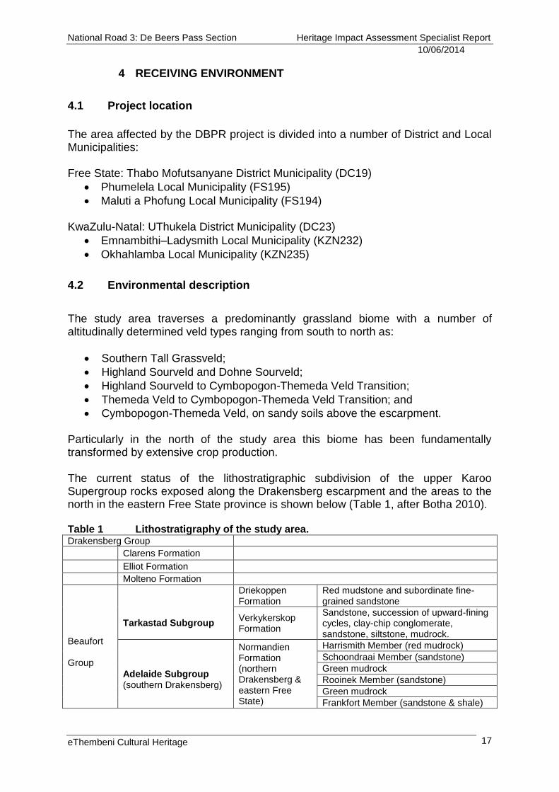
4.1 Project location
The area affected by the DBPR project is divided into a number of District and Local Municipalities: Free State: Thabo Mofutsanyane District Municipality (DC19)
Phumelela Local Municipality (FS195)
Maluti a Phofung Local Municipality (FS194) KwaZulu-Natal: UThukela District Municipality (DC23)
Emnambithi–Ladysmith Local Municipality (KZN232)
Okhahlamba Local Municipality (KZN235)
4.2 Environmental description
The study area traverses a predominantly grassland biome with a number of altitudinally determined veld types ranging from south to north as:
Southern Tall Grassveld;
Highland Sourveld and Dohne Sourveld;
Highland Sourveld to Cymbopogon-Themeda Veld Transition;
Themeda Veld to Cymbopogon-Themeda Veld Transition; and
Cymbopogon-Themeda Veld, on sandy soils above the escarpment. Particularly in the north of the study area this biome has been fundamentally transformed by extensive crop production. The current status of the lithostratigraphic subdivision of the upper Karoo Supergroup rocks exposed along the Drakensberg escarpment and the areas to the north in the eastern Free State province is shown below (Table 1, after Botha 2010). Table 1 Lithostratigraphy of the study area. Drakensberg Group
Clarens Formation
Elliot Formation
Molteno Formation
Beaufort Group
Tarkastad Subgroup
Driekoppen Formation
Red mudstone and subordinate fine-grained sandstone
Verkykerskop Formation
Sandstone, succession of upward-fining cycles, clay-chip conglomerate, sandstone, siltstone, mudrock.
Adelaide Subgroup (southern Drakensberg)
Normandien Formation (northern Drakensberg & eastern Free State)
Harrismith Member (red mudrock)
Schoondraai Member (sandstone)
Green mudrock
Rooinek Member (sandstone)
Green mudrock
Frankfort Member (sandstone & shale)
National Road 3: De Beers Pass Section Heritage Impact Assessment Specialist Report
10/06/2014
eThembeni Cultural Heritage
18
The Beaufort Group in the northern part of the main Karoo basin has been subdivided into two units of “Subgroup” status; the lower Adelaide and the upper Tarkastad lithostratigraphic Subgroups. In the northern Drakensberg and eastern Free State region the Beaufort Group thins and some of the lower formations that occur in the Karoo region pinch out. Here the succession is subdivided into the lower Normandien Formation (comprising alternating green shales and sandstone units), overlain by the Tarkastad Subgroup (comprising the Verkykerskop sandstone Formation) and the overlying red mudstone of the Driekoppen Formation. It is this lithostratigraphic sequence that gives rise to the spectacular landscape of steeply rising escarpments and the mesa and butte topography of the study area. The Beaufort Group as a whole is known to be palaeontologically rich and recent finds at the Ingula/Braamhoek Pump Scheme have yielded Permian and Triassic fossils of universal scientific significance. Any severe in-cutting for road construction within the study area will expose the palaeontologically sensitive Permian Extinction Zone of the Beaufort Group (G. Groenewald pers. comm.) This is discussed in detail in Appendix H.
Below the escarpment the two principal drainage basins are those of the Sandspruit and Klip (Mdaka) Rivers, both of which ultimately flow into the uThukela River. Above the escarpment the Meul and Cornelis Rivers are tributaries of the upper Wilge River catchment. The mature state of these Highveld rivers, and their extensive associated wetlands, provide a major inflow of water into the Vaal River system. Together with the numerous farm dams and impoundments constructed in the area this provides a high trophic and habitat-diverse environment for avifauna and contributes significantly to unique scenic heritage value of the area.
National Road 3: De Beers Pass Section Heritage Impact Assessment Specialist Report
10/06/2014
eThembeni Cultural Heritage
19
5 CULTURAL CONTEXT OF THE STUDY AREA
This section summarises the history and current socio-cultural context of the study area. Readers are referred to the bibliography section for primary sources.
5.1 Current socio-economic structure
The principal urban centres of the study area comprise the hamlets of Van Reenen and Swinburne and the towns of Warden and Harrismith. They all lie immediately adjacent to the existing N3 and provide a wide range of facilities and services to travellers, tourists and the transport industry alike.
Harrismith was founded in 1849 and named in honour of British Governor Sir Harry Smith, who tried to persuade disillusioned Voortrekkers not to abandon Natal after its establishment as a Crown Colony in 1848. The town is one of the oldest in the Free State and it was established due to its strategic position on the transport route between Natal and the goldfields of the Witwatersrand and the diamond fields of Kimberley. Consequently it was used as a major base by the British during and after the Anglo Boer War. A blockhouse, detention barracks and a military cemetery attest to their presence at the turn of the 20th century. Very fine examples of characteristic Free State dressed-sandstone buildings, both public and private, still adorn the town. Harrismith, with its landmark Platberg, today serves as a tourist gateway to the south eastern Free State, KwaZulu-Natal and the UKhahlamba and Maluti Drakensberg Mountains. The town’s industrial and commercial sectors render it a major service centre to neighbouring and outlying farming communities and it is also an important crossroads in South Africa’s land trade routes. Warden is named for a previous Harrismith magistrate, Charles Warden, and has one of the largest Dutch Reformed churches in South Africa, with seating for 1750 people. Warden, and both Swinburne and Van Reenen, serve as important travel and transport service centres along the N3. Outside of the urban nodes the study area is one of contrasting intensive crop production (predominantly maize, beans, soya, sorghum and sunflowers) and extensive range raised livestock production. To the east of Harrismith, towards the Tandjiesberg, De Beers Pass and Normandien, the steeper and more broken topography above the escarpment, and seasonally harsher climatic conditions, render the area primarily suited to cattle production. This has resulted in an agrarian landscape little transformed after more than a century and half of subsistence and commercial agricultural activity.
National Road 3: De Beers Pass Section Heritage Impact Assessment Specialist Report
10/06/2014
eThembeni Cultural Heritage
20
5.2 Typical heritage resources
Appendix B contains a detailed description of the archaeological context of the study area, with a summary provided here, along with a précis of the historical period. Transient Later Stone Age hunter-gatherer bands traversed this seasonally harsh Highveld environment in the spring and summer in search of flowering colonies of geophytes for staple food and following migratory game and birds for the hunt. Archaeological evidence of these practices is found in numerous sandstone shelters and overhangs throughout the study area. Some shelters contain rock paintings which evidence of hunter-gatherer social relations and cosmology. Food and stone tool residues, charcoal and ash from hearth fires and bedding material comprise some of the content of these cultural deposits that span the last 8000 years. From around the 15th century mixed-farming communities of both Nguni and Sotho-speaking origins began to settle in the upper reaches of the larger river drainage basins. The ubiquitous circular and lobed stone walled settlements within the study area are the archaeological evidence of these first farmers.
Much of this way of life was severely disrupted during the difaqane at the end of the 18th and beginning of the 19th centuries as villages and entire communities were forced to flee the depredations of both raiding armies and desperate bands of starving and deposed tribes people. Limited resettlement occurred later in the 19th century as some people returned to their natal homes and the dispossessed took opportunistic advantage of a depopulated landscape. However, this was short lived, as both Voortrekkers and British colonists began to stake out and take title of farms after 1850, and most tribespeople were further dispossessed of land, becoming labour tenants within commercial farming ventures. The homesteads and associated agricultural infrastructure and expansion of these commercial farming ventures represent the changing face of this agrarian landscape over the last 150 years.
National Road 3: De Beers Pass Section Heritage Impact Assessment Specialist Report
10/06/2014
eThembeni Cultural Heritage
21
6 OBSERVATIONS
No development activities associated with the proposed project had begun at the time of our field visits, in accordance with heritage legislation. We assessed the following heritage resource types for all the route alternatives:
Places, buildings and structures older than 60 years
Historical settlements and townscapes
Landscapes and natural features
Geological sites of scientific or cultural importance
Palaeontological sites2
Archaeological sites
Traditional burial places
Battlefields The following tables provide the descriptions, locations and heritage significance of all identified heritage resources for the various lines and deviations, including proposed interchanges, with illustrative maps and photographs where appropriate. Table 2 Descriptions, locations and significance of all identified heritage resources: Line 1) De Beers Pass Route. Site no
Description Location Significance
Traditional burial places: graves outside a formal cemetery
A1 Stone packed traditional burial place Section 4 (Lincoln) 28° 4'58.20"S 29°12'18.12"E All human remains have high
heritage significance at all levels for their spiritual, social and cultural values.
A2 Wessels’ family graveyard incepted before 1890
Section 3 (Somersvlakte) 28°11'10.68"S 29°19'44.16"E
A3 Historical “veepos” and labourers residence with attendant graves
Cited in Anderson (1996); no co-ordinates
Places, buildings and structures >60 years
A4
Grove of oak trees planted by Sir Percy Fitzpatrick c.1910-1920 in the layout of the Union Jack. Associated with historical farmstead.
Section 4 (Buckland Downs) 27°58'0.24"S 29° 8'04.02"E
Medium heritage significance at all levels for its aesthetic, social and historical values, given its association with a person of national stature who established the place as a socio-political statement post Union after he beat General Smuts for election to the Pretoria East constituency and subsequently to the Union Legislature in 1910.
A5 Historical farm precinct Section 3 (Somersvlakte) 28°11'10.68"S 29°19'44.16"E
Medium heritage significance at the local level for its aesthetic, architectural and historical values.
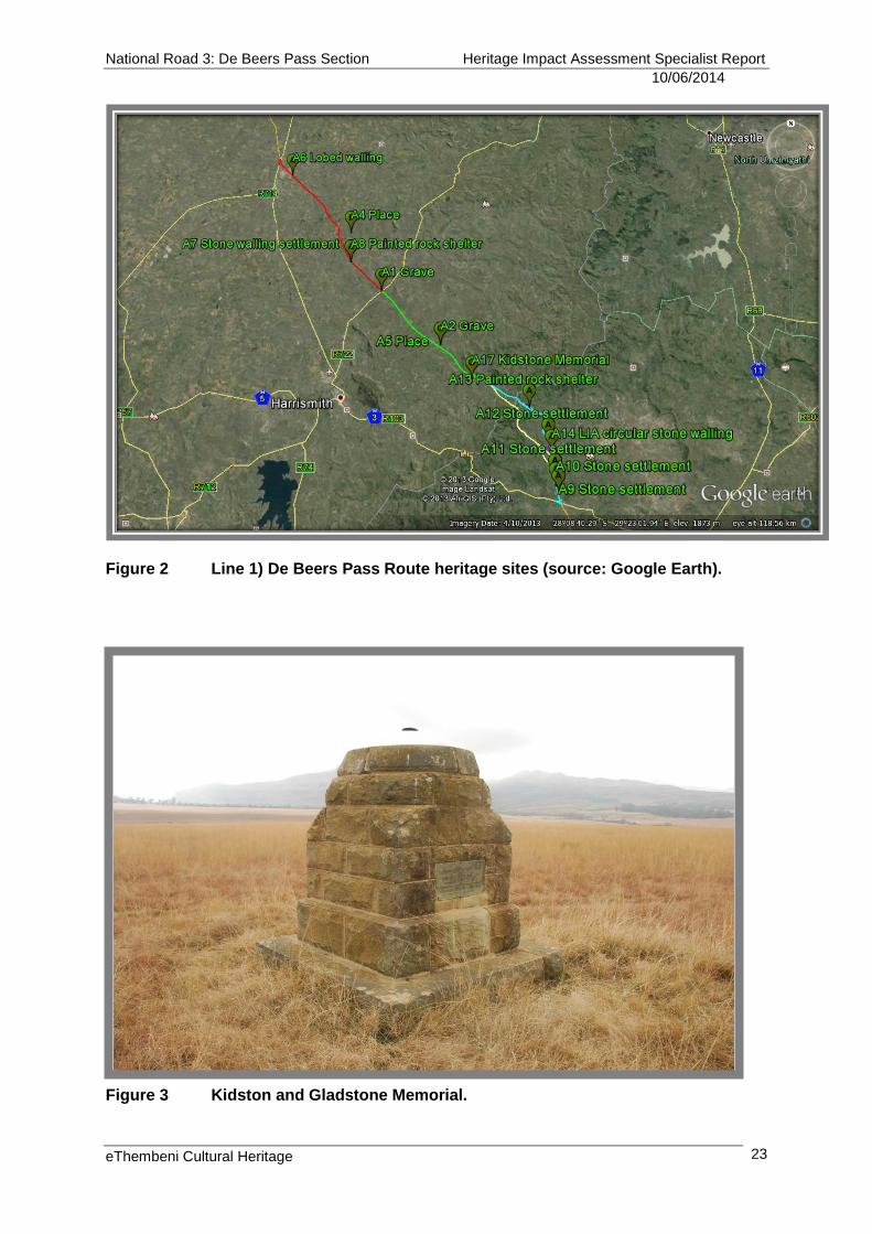
A17 Kidston and Gladstone Memorial (see Appendix B and Figure 3)
Section 2 28°14'54.07"S 29°23'31.88"E
Low heritage significance at the local level for its aesthetic and historical values.
2 The Palaeontological Impact Assessment Report for this project will be loaded onto SAHRIS as part of the submission of this HIA.
National Road 3: De Beers Pass Section Heritage Impact Assessment Specialist Report
10/06/2014
eThembeni Cultural Heritage
22
Archaeological sites
A6 Lobed stone-walled structures Section 4 (Langpunt) 27°50'31.08"S 28°59'50.16"E
Low heritage significance at the local and regional levels for their scientific and historical values, unless graves are present, in which case they have high heritage significance at all levels. For impact assessment purposes we have assumed the latter.
A7 Circular stone-walled settlement complex Section 4 (Meulrivier) 28° 1'34.80"S 29° 8'15.00"E
A8 Rock shelter with paintings and archaeological deposit
Section 4 (Meulrivier) 28° 1'34.80"S 29° 8'15.00"E
High heritage significance at all levels for its aesthetic, scientific and historical values.
A9 Circular and lobed stone-walled settlement of c.30 hut circles
Section 1 (Keeversfontein) 28°26'24.00"S 29°33'23.00"E
High heritage significance at all levels for their spiritual, social and cultural values, due to presence of ancestral graves.
A10 Circular and lobed stone-walled settlement with four discrete byres
Section 1 (Keeversfontein) 28°25'46.00"S 29°33'06.00"E
A11 Circular and lobed stone-walled settlement
Section 1 (Keeversfontein) 28°24'55.00"S 29°33'03.00"E
Medium heritage significance at provincial level for its scientific and historical values (see Iron Age section in Appendix B).
A12 Extensive LIA and Historical stone-walled settlements
Section 1 (Welkom / Maritz Drift) 28°21'21.00"S 29°32'26.00"E
High heritage significance at provincial level for its scientific and historical values (see Iron Age section in Appendix B).
A13 Rock shelter with paintings
Section 1 (Welkom 1310) 28°17'50.00"S 29°30'20.00"E
Low heritage significance at all levels for its aesthetic, scientific and historical values, given the poor state of preservation of the paintings and the lack of archaeological deposits. Records of the Natal Museum indicate that the paintings do not merit rescue or preservation.
A14 LIA stone walling Section 1 28°22'30.28"S 29°32'46.84"E
Low heritage significance at the local and regional levels for scientific and historical values.
Landscapes and natural features
A15
Historical landscape of the Free State and KwaZulu-Natal (see Appendix B)
All Sections Keeversfontein to Warden
High heritage significance at all levels for its aesthetic, social, scientific and historical values, given its agrarian nature with extremely limited infrastructure; the untransformed nature of the landscape over most of the proposed route; its spectacular mesa and butte topography; the significance of its ecology and biodiversity; and its association with the early black and colonial farming history of the region. For both current residents and visitors alike it has, due to its relative isolation and wildness, a strong “sense of place” (see Appendix D).
Palaeontological sites
A16 Significant fossil bearing deposits within the Permian Extinction Zone
All Sections Throughout the proposed route
Medium to high heritage significance at all levels for their scientific value.
National Road 3: De Beers Pass Section Heritage Impact Assessment Specialist Report
10/06/2014
eThembeni Cultural Heritage
23
Figure 2 Line 1) De Beers Pass Route heritage sites (source: Google Earth).
Figure 3 Kidston and Gladstone Memorial.
National Road 3: De Beers Pass Section Heritage Impact Assessment Specialist Report
10/06/2014
eThembeni Cultural Heritage
24
Table 3 Descriptions, locations and significance of all identified heritage resources: Line 2) De Beers Pass Route: Alternative A and Line 3) De Beers Pass Route: Alternative A/C. Site no
Description Location Significance
Traditional burial places: graves outside a formal cemetery
All human remains have high heritage significance at all levels for their spiritual, social and cultural values.
C1 Stone packed traditional burial place Section 1 28°26'22.32"S 29°31'17.22"E
C2 Stone packed traditional burial place Section 1 28°26'22.74"S 29°31'17.34"E
C3 Stone packed traditional burial place Section 1 28°25'30.00"S 29°30'24.00"E
C4 Grave Section 1 28°25'29.70"S 29°30'21.90"E
C5 Stone packed traditional burial place Section 1 28°25'28.44"S 29°30'24.06"E
C6 Stone packed traditional burial place Section1 28°25'16.56"S 29°30'24.12"E
C7 Stone packed traditional burial place Section 1 28°25'17.10"S 29°30'24.66"E
C8 Stone packed traditional burial places Section 1 28°25'11.58"S 29°30'33.06"E
C9 Stone packed traditional burial place Section 1 28°25'10.02"S 29°30'31.32"E
C10 Stone packed traditional burial place Section 1 28°25'07.20"S 29°30'29.46"E
C11 Stone packed traditional burial place Section 1 28°24'42.06"S 29°30'08.22"E
C12 Stone packed traditional burial place Section 1 28°24'12.30"S 29°29'12.84"E
C13 Stone packed traditional burial places Section 3 28°15'45.50"S 29° 9'19.60"E
Places, buildings and structures >60 years
C14 Ruins of historical farmhouse Section 1 28°26'21.00"S 29°31'16.98"E
Low heritage significance at the local level for its historical value.
Archaeological sites
C15 Iron Age stone walling Section 1 28°26'11.94"S 29°31'17.34"E
High heritage significance at provincial level for their scientific and historical values, and for their association with ancestral graves (see Iron Age section in Appendix B).
C16 Iron Age stone walling Section 1 28°25'51.72"S 29°31'01.68"E
C17 Iron Age stone walling Section 1 28°25'41.64"S 29°30'52.08"E
C18 Iron Age stone walling Section 1 28°25'29.40"S 29°30'22.80"E
C19 Iron Age stone walling Section 1 28°25'16.20"S 29°30'23.58"E
C20 Iron Age stone walling Section 1 28°25'11.46"S 29°30'32.76"E
C21 Iron Age stone walling Section 1 28°25'06.18"S 29°30'28.74"E
C22 Iron Age stone walling Section 1 28°24'42.48"S 29°30'07.56"E
C23 Iron Age stone walling Section 1 28°24'41.22"S 29°30'05.10"E
C24 Iron Age stone walling Section 1 28°24'45.78"S 29°30'09.78"E
C25 Iron Age stone walling Section 1 28°24'46.74"S 29°30'12.12"E
C26 Iron Age stone walling Section 1 28°24'53.82"S 29°30'15.78"E
C27 Iron Age stone walling Section 1 28°24'53.34"S 29°30'28.80"E
National Road 3: De Beers Pass Section Heritage Impact Assessment Specialist Report
10/06/2014
eThembeni Cultural Heritage
25
C28 Type V stone-walled settlement cluster with associated graves
Section 3 a.28°15'45.37"S 29° 9'15.84"E b.28°15'47.97"S 29° 9'16.50"E c.28°16'39.51"S 29° 9'19.29"E
Medium heritage significance at provincial level for their scientific and historical values (see Iron Age section in Appendix B).
C29 Type V stone-walled settlement cluster Section 3 28°16'18.06"S 29° 9'10.85"E
C30 Two circular stone-walled livestock byres Section 3 28°16'27.25"S 29° 9'31.52"E
Battlefields
C31 Blockhouse, stables and detention barracks (ABW)
Section 3 28°16'56.34"S 29° 9'38.40"E
Medium heritage significance at provincial and national levels for their social, scientific and historical values (see Colonial period section in Appendix B).
C32 Field hospital and HQ of OFS Commando during the Siege of Ladysmith (ABW 1889-1901)
Section 1 28°24'19.92"S 29°29'29.16"E
Medium heritage significance at provincial and national levels for their social, scientific and historical values (see Colonial period section in Appendix B).
C33
Alternative Route A – “greenfield” sections Section 1 Keeversfontein to van Reenen
Medium heritage significance at the local and regional levels for its aesthetic, social, scientific and historical values, given its agrarian nature and association with both the ABW and the early settlement of black farming communities in the region (see Appendices B and D).
Landscapes and natural features
C34 Platberg and the Botanical Gardens with dams, canals and water furrows of early water supply to Harrismith
Section 3 28°16'43.50"S 29° 9'1.50"E
Medium heritage significance at the local level for its aesthetic, social, scientific and historical values, given its association with and contribution to the sense of place of the town of Harrismith; its association with the ABW; its ecological importance; and its recreational use (see Appendix D).
Palaeontological sites
C35 Significant fossil bearing deposits within the Permian Extinction Zone
All Sections Throughout the proposed route
Medium to high heritage significance at all levels for their scientific value.
National Road 3: De Beers Pass Section Heritage Impact Assessment Specialist Report
10/06/2014
eThembeni Cultural Heritage
26
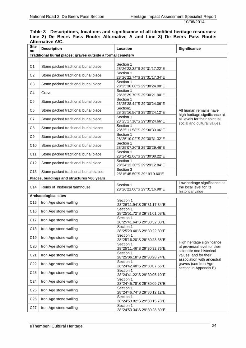
Figure 4 Line 2) De Beers Pass Route: Alternatives A and A/C Section 1 heritage sites (source: Google Earth).
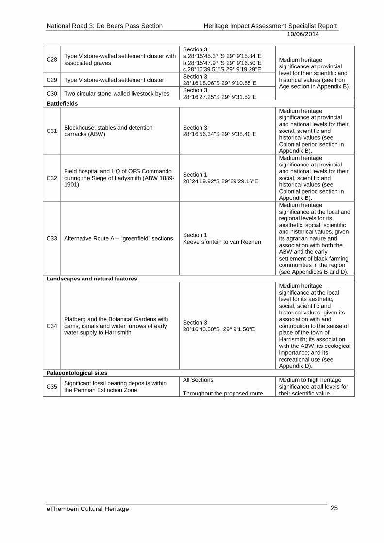
Figure 5 Line 2) De Beers Pass Route: Alternatives A and A/C Section 3 heritage sites (source: Google Earth).
National Road 3: De Beers Pass Section Heritage Impact Assessment Specialist Report
10/06/2014
eThembeni Cultural Heritage
27
Table 4 Descriptions, locations and significance of all identified heritage resources: Line 4) De Beers Pass Route: Alternative C and existing N3 / R103. Site no
Description Location Significance
Traditional burial places: graves outside a formal cemetery
None identified
Places, buildings and structures >60 years
None identified
Archaeological sites
None identified
Battlefields
None identified
Landscapes and natural features
None identified
Palaeontological sites
P1 Significant fossil bearing deposits within the Permian Extinction Zone
Throughout the proposed route Medium to high heritage significance at all levels for their scientific value.
Table 5 Descriptions, locations and significance of all identified heritage resources: Route Deviation 1 (Possible Gorge Deviation on map). Site no
Description Location Significance
Traditional burial places: graves outside a formal cemetery
D1 Abandoned homestead with probable graves
28°22'29.43"S 29°31'41.11"E
All human remains have high heritage significance at all levels for their spiritual, social and cultural values.
D2 Stonepacked grave 28°19'14.37"S 29°28'52.31"E
D3 Stonepacked grave 28°19'19.60"S 29°28'53.07"E
D4 Stonepacked grave 28°19'19.50"S 29°28'52.37"E
D5 Stonepacked grave of Msibi family (Figure 7)
28°18'53.63"S 29°29'09.43"E
D6 Stonepacked grave of Msibi family 28°18'51.29"S 29°29'12.15"E
Archaeological sites
D7 LIA circular stone walling 28°22'50.98"S 29°32'28.60"E
Medium heritage significance at provincial level for their scientific and historical values (see Iron Age section in Appendix B).
D8 LIA circular stone walling 28°22'37.77"S 29°32'46.46"E
D9 LIA circular stone walling 28°22'36.63"S 29°32'26.88"E
D10 LIA circular stone walling 28°22'33.26"S 29°32'24.12"E
D11 LIA circular stone walling 28°22'30.77"S 29°32'39.27"E
D12 LIA circular stone walling 28°22'28.23"S 29°32'43.82"E
D13 LIA circular stone walling 28°22'27.97"S 29°32'22.96"E
D14 LIA circular stone walling 28°22'27.24"S 29°32'10.40"E
D15 LIA circular stone walling 28°22'25.13"S 29°32'25.60"E
D16 LIA circular stone walling 28°22'23.70"S 29°32'30.89"E
D17 LIA circular stone walling 28°22'20.26"S 29°32'28.79"E
D18 LIA circular stone walling 28°22'21.19"S 29°32'25.16"E
D19 LIA circular stone walling 28°22'20.21"S 29°32'22.79"E
D20 LIA circular stone walling 28°22'16.58"S 29°32'02.47"E
D21 LIA circular stone walling 28°21'59.17"S 29°31'30.39"E
D22 LIA circular stone walling 28°21'57.07"S 29°31'35.77"E
D23 LIA circular stone walling 28°19'48.71"S 29°28'54.41"E
D24 Probable Voortrekker sawpit 28°19'50.56"S 29°28'56.33"E
Low heritage significance at local, regional and provincial levels for its historical value.
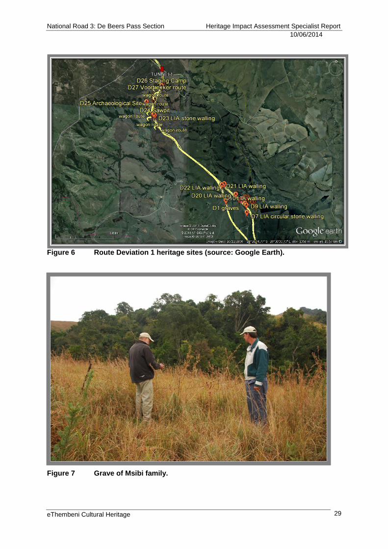
D25 Archaeological site at Msonti Bush camp (Figure 8)
28°19'25.76"S 29°28'37.10"E
Low to medium heritage significance at local, regional and provincial levels for its scientific value.
National Road 3: De Beers Pass Section Heritage Impact Assessment Specialist Report
10/06/2014
eThembeni Cultural Heritage
28
D26 Voortrekker wagon trail outspan and staging camp (Figure 9)
28°18'53.99"S 29°29'9.00"E
Low to medium heritage significance at local, regional and provincial levels for its historical value.
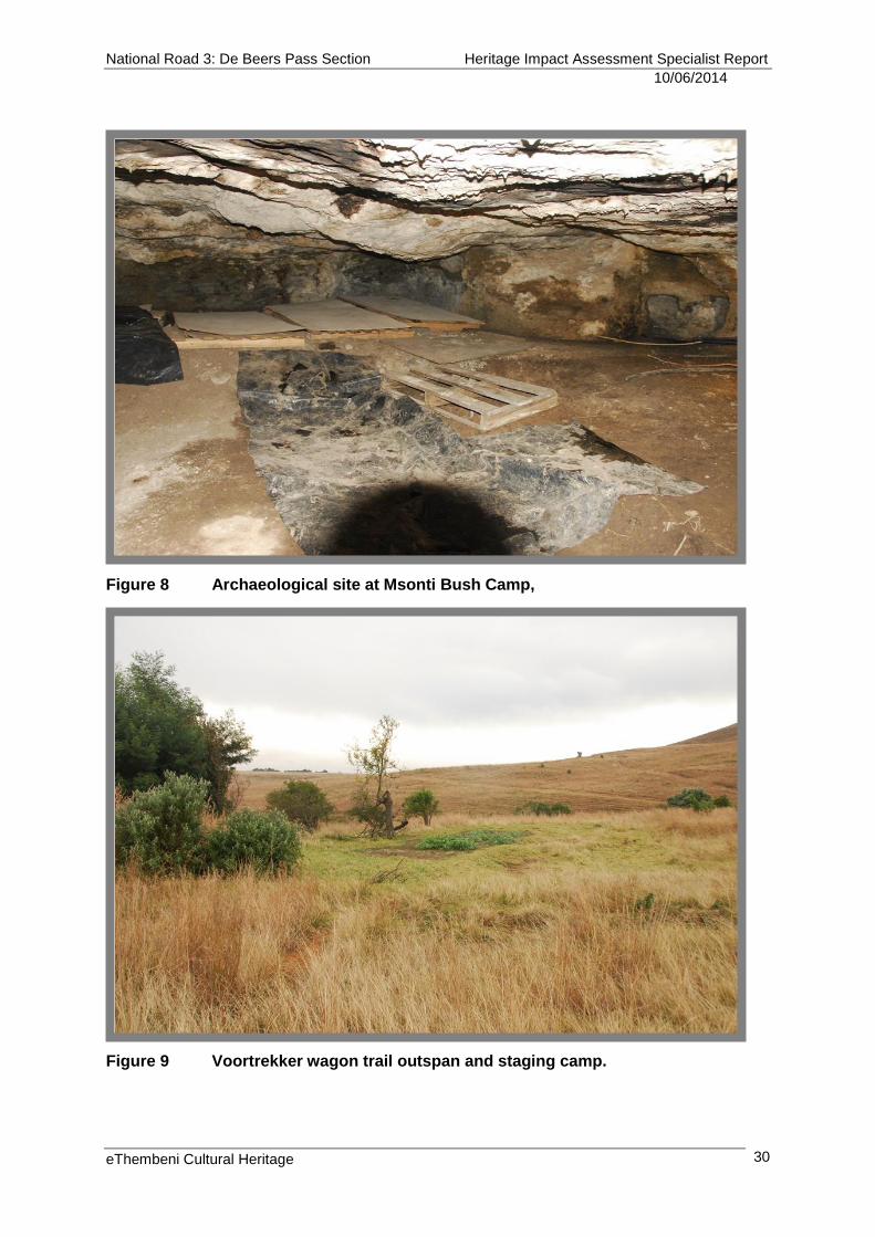
D27 Part of Voortrekker wagon route over the escarpment (Figure 10)
28°18'56.03"S 29°29'5.97"E And further southwards
Medium to high heritage significance at local, regional and provincial levels for its historical value.
Places, buildings and structures > 60 years
D28 Pitchers Rest farmstead with buildings > 60 years (Figure 11)
28°16'20.21"S 29°26'39.63"E
Low to medium heritage significance at local, regional and provincial levels for its aesthetic and historical values.
Landscapes and natural features
D29
Historical landscape of the Free State and KwaZulu-Natal (see Appendix B)
Keeversfontein to Warden
High heritage significance at all levels for its aesthetic, social, scientific and historical values, given its agrarian nature with extremely limited infrastructure; the untransformed nature of the landscape over most of the proposed route; its spectacular mesa and butte topography; the significance of its ecology and biodiversity; and its association with the early black and colonial farming history of the region. For both current residents and visitors alike it has, due to its relative isolation and wildness, a strong “sense of place” (see Appendix D).
Palaeontological sites
D30 Significant fossil bearing deposits within the Permian Extinction Zone
Throughout the proposed route Medium to high heritage significance at all levels for their scientific value.
National Road 3: De Beers Pass Section Heritage Impact Assessment Specialist Report
10/06/2014
eThembeni Cultural Heritage
29
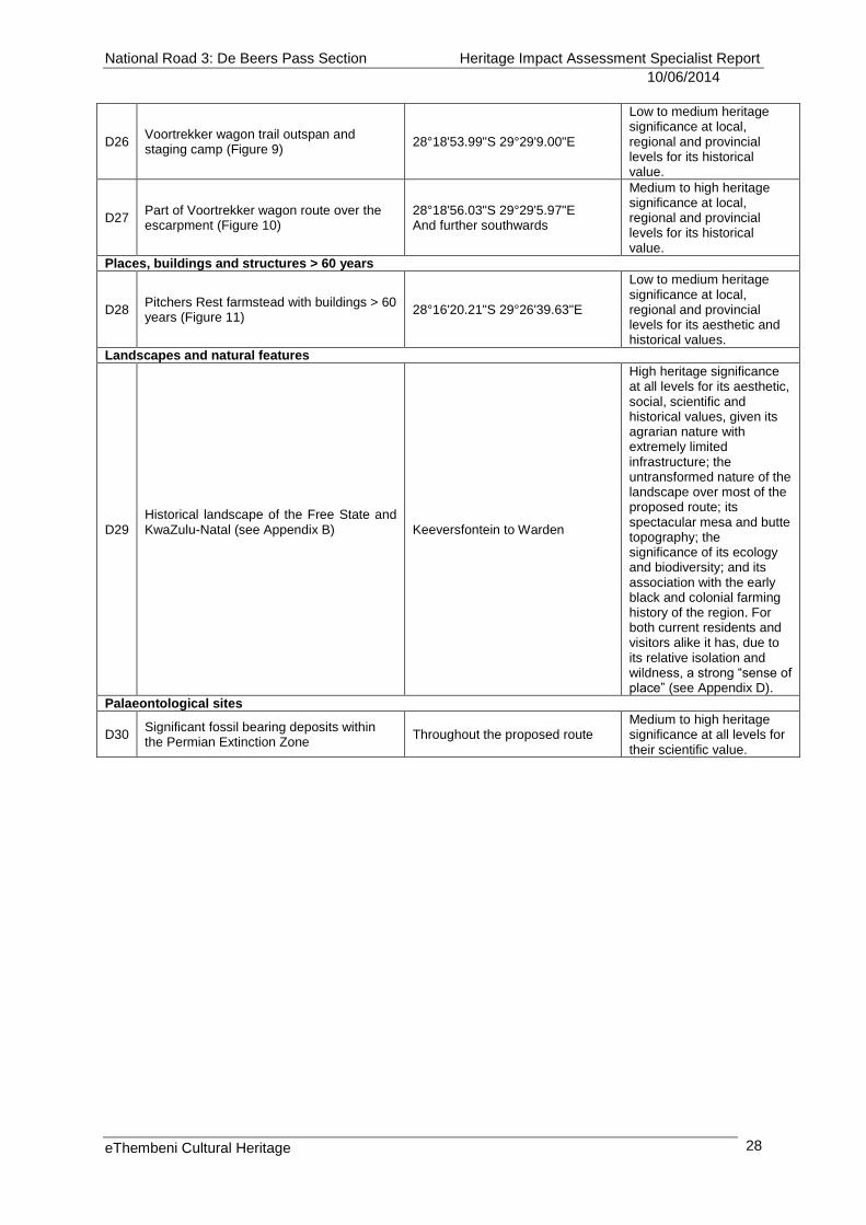
Figure 6 Route Deviation 1 heritage sites (source: Google Earth).
Figure 7 Grave of Msibi family.
National Road 3: De Beers Pass Section Heritage Impact Assessment Specialist Report
10/06/2014
eThembeni Cultural Heritage
30
Figure 8 Archaeological site at Msonti Bush Camp,
Figure 9 Voortrekker wagon trail outspan and staging camp.
National Road 3: De Beers Pass Section Heritage Impact Assessment Specialist Report
10/06/2014
eThembeni Cultural Heritage
31
Figure 10 Part of Voortrekker wagon route over the escarpment.
Figure 11 Pitchers Rest dressed sandstone farmhouse.
National Road 3: De Beers Pass Section Heritage Impact Assessment Specialist Report
10/06/2014
eThembeni Cultural Heritage
32
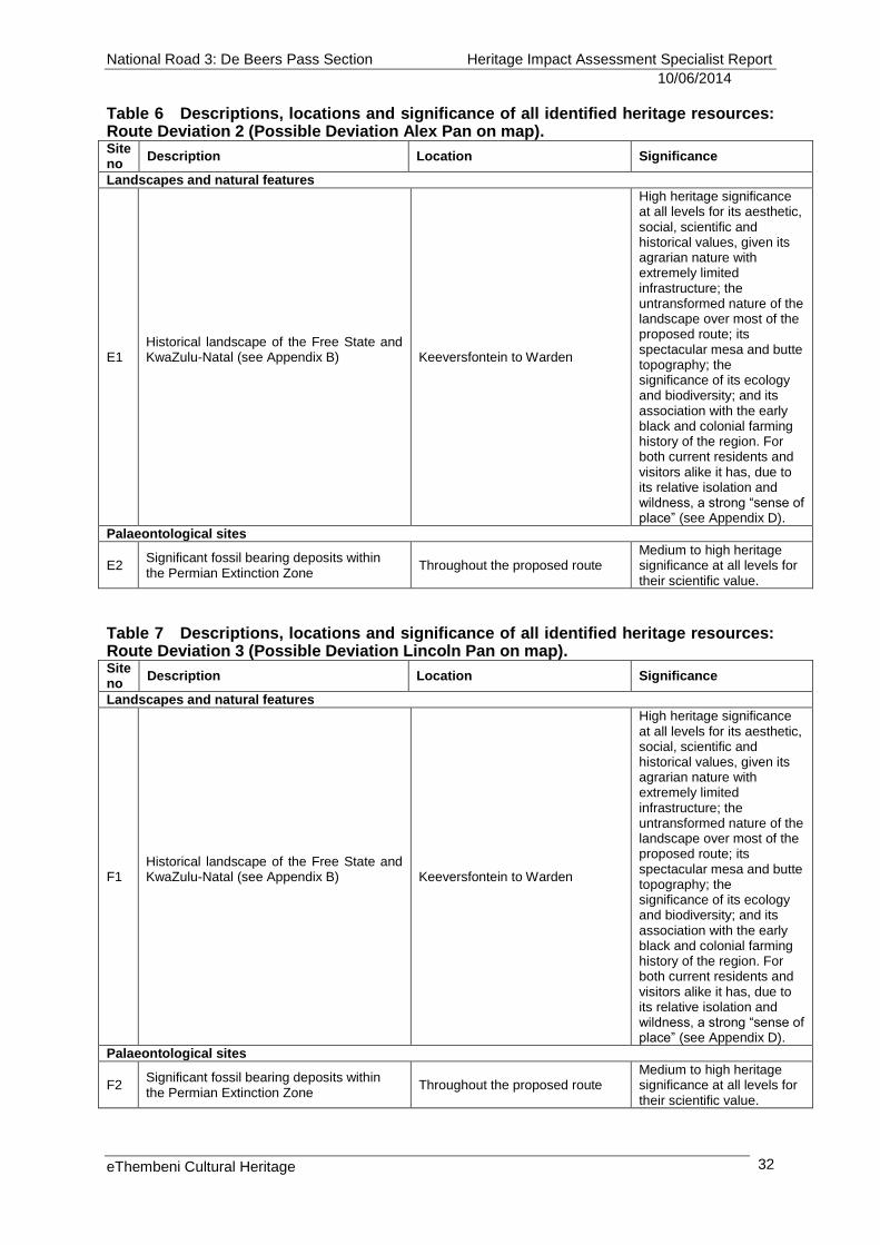
Table 6 Descriptions, locations and significance of all identified heritage resources: Route Deviation 2 (Possible Deviation Alex Pan on map). Site no
Description Location Significance
Landscapes and natural features
E1
Historical landscape of the Free State and KwaZulu-Natal (see Appendix B)
Keeversfontein to Warden
High heritage significance at all levels for its aesthetic, social, scientific and historical values, given its agrarian nature with extremely limited infrastructure; the untransformed nature of the landscape over most of the proposed route; its spectacular mesa and butte topography; the significance of its ecology and biodiversity; and its association with the early black and colonial farming history of the region. For both current residents and visitors alike it has, due to its relative isolation and wildness, a strong “sense of place” (see Appendix D).
Palaeontological sites
E2 Significant fossil bearing deposits within the Permian Extinction Zone
Throughout the proposed route Medium to high heritage significance at all levels for their scientific value.
Table 7 Descriptions, locations and significance of all identified heritage resources: Route Deviation 3 (Possible Deviation Lincoln Pan on map). Site no
Description Location Significance
Landscapes and natural features
F1
Historical landscape of the Free State and KwaZulu-Natal (see Appendix B)
Keeversfontein to Warden
High heritage significance at all levels for its aesthetic, social, scientific and historical values, given its agrarian nature with extremely limited infrastructure; the untransformed nature of the landscape over most of the proposed route; its spectacular mesa and butte topography; the significance of its ecology and biodiversity; and its association with the early black and colonial farming history of the region. For both current residents and visitors alike it has, due to its relative isolation and wildness, a strong “sense of place” (see Appendix D).
Palaeontological sites
F2 Significant fossil bearing deposits within the Permian Extinction Zone
Throughout the proposed route Medium to high heritage significance at all levels for their scientific value.
National Road 3: De Beers Pass Section Heritage Impact Assessment Specialist Report
10/06/2014
eThembeni Cultural Heritage
33
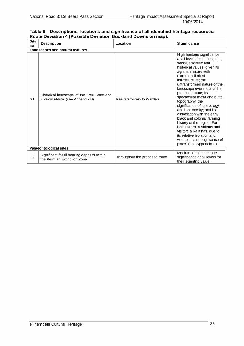
Table 8 Descriptions, locations and significance of all identified heritage resources: Route Deviation 4 (Possible Deviation Buckland Downs on map). Site no
Description Location Significance
Landscapes and natural features
G1
Historical landscape of the Free State and KwaZulu-Natal (see Appendix B)
Keeversfontein to Warden
High heritage significance at all levels for its aesthetic, social, scientific and historical values, given its agrarian nature with extremely limited infrastructure; the untransformed nature of the landscape over most of the proposed route; its spectacular mesa and butte topography; the significance of its ecology and biodiversity; and its association with the early black and colonial farming history of the region. For both current residents and visitors alike it has, due to its relative isolation and wildness, a strong “sense of place” (see Appendix D).
Palaeontological sites
G2 Significant fossil bearing deposits within the Permian Extinction Zone
Throughout the proposed route Medium to high heritage significance at all levels for their scientific value.
National Road 3: De Beers Pass Section Heritage Impact Assessment Specialist Report
20/11/2013
eThembeni Cultural Heritage 18
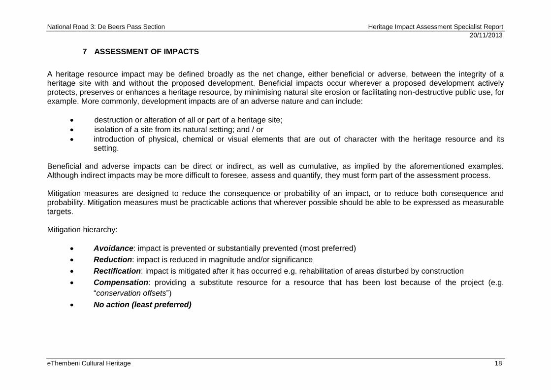
7 ASSESSMENT OF IMPACTS
A heritage resource impact may be defined broadly as the net change, either beneficial or adverse, between the integrity of a heritage site with and without the proposed development. Beneficial impacts occur wherever a proposed development actively protects, preserves or enhances a heritage resource, by minimising natural site erosion or facilitating non-destructive public use, for example. More commonly, development impacts are of an adverse nature and can include:
destruction or alteration of all or part of a heritage site;
isolation of a site from its natural setting; and / or
introduction of physical, chemical or visual elements that are out of character with the heritage resource and its setting.
Beneficial and adverse impacts can be direct or indirect, as well as cumulative, as implied by the aforementioned examples. Although indirect impacts may be more difficult to foresee, assess and quantify, they must form part of the assessment process. Mitigation measures are designed to reduce the consequence or probability of an impact, or to reduce both consequence and probability. Mitigation measures must be practicable actions that wherever possible should be able to be expressed as measurable targets. Mitigation hierarchy:
Avoidance: impact is prevented or substantially prevented (most preferred)
Reduction: impact is reduced in magnitude and/or significance
Rectification: impact is mitigated after it has occurred e.g. rehabilitation of areas disturbed by construction
Compensation: providing a substitute resource for a resource that has been lost because of the project (e.g.
“conservation offsets”)
No action (least preferred)
National Road 3: De Beers Pass Section Heritage Impact Assessment Specialist Report
10/06/2014
eThembeni Cultural Heritage 19
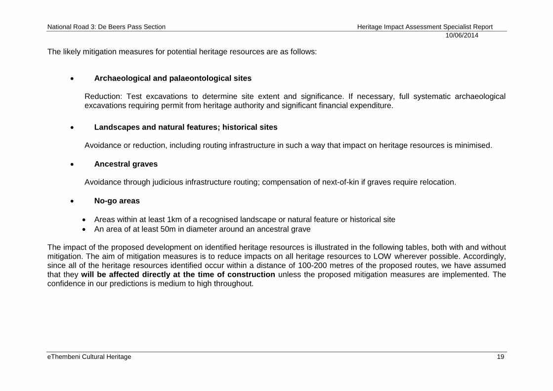
The likely mitigation measures for potential heritage resources are as follows:
Archaeological and palaeontological sites Reduction: Test excavations to determine site extent and significance. If necessary, full systematic archaeological excavations requiring permit from heritage authority and significant financial expenditure.
Landscapes and natural features; historical sites Avoidance or reduction, including routing infrastructure in such a way that impact on heritage resources is minimised.
Ancestral graves Avoidance through judicious infrastructure routing; compensation of next-of-kin if graves require relocation.
No-go areas
Areas within at least 1km of a recognised landscape or natural feature or historical site
An area of at least 50m in diameter around an ancestral grave
The impact of the proposed development on identified heritage resources is illustrated in the following tables, both with and without mitigation. The aim of mitigation measures is to reduce impacts on all heritage resources to LOW wherever possible. Accordingly, since all of the heritage resources identified occur within a distance of 100-200 metres of the proposed routes, we have assumed that they will be affected directly at the time of construction unless the proposed mitigation measures are implemented. The confidence in our predictions is medium to high throughout.
National Road 3: De Beers Pass Section Heritage Impact Assessment Specialist Report
10/06/2014
eThembeni Cultural Heritage 20
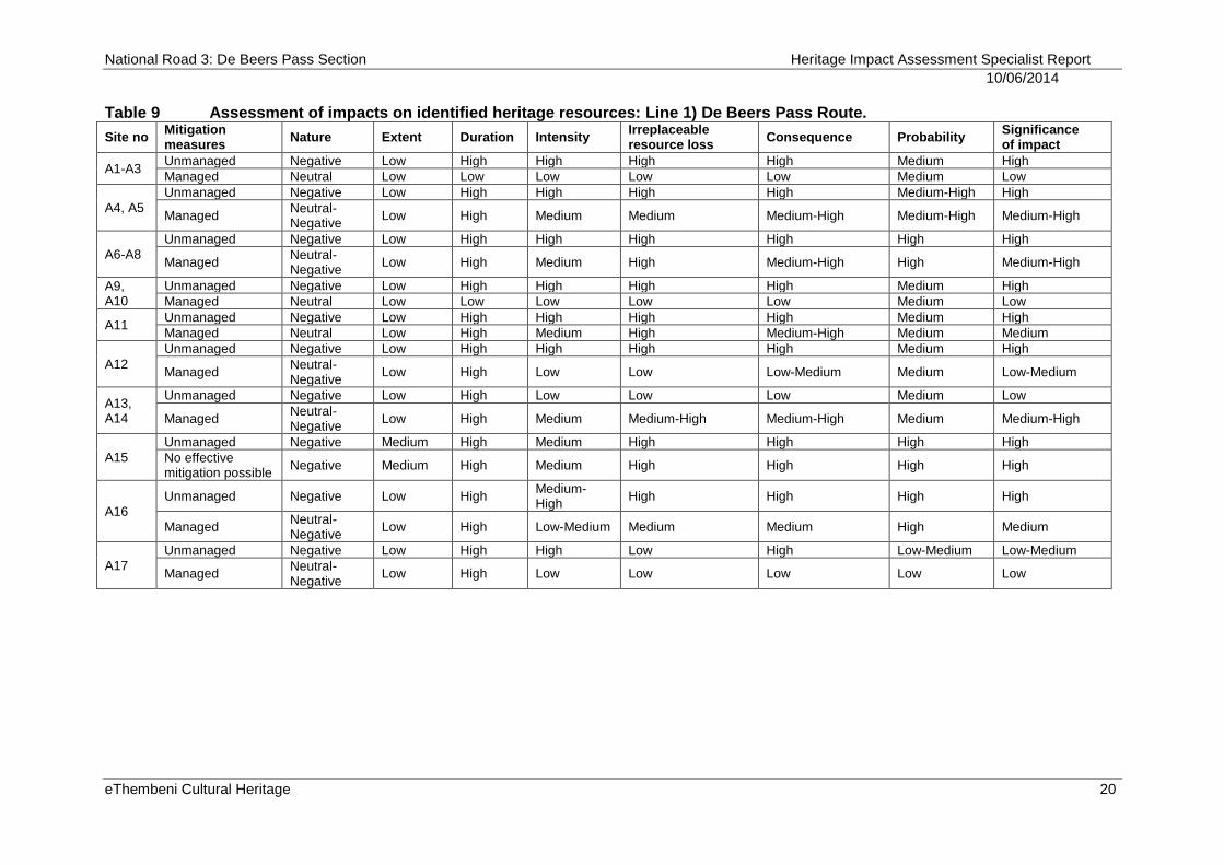
Table 9 Assessment of impacts on identified heritage resources: Line 1) De Beers Pass Route.
Site no Mitigation measures
Nature Extent Duration Intensity Irreplaceable resource loss
Consequence Probability Significance of impact
A1-A3 Unmanaged Negative Low High High High High Medium High
Managed Neutral Low Low Low Low Low Medium Low
A4, A5
Unmanaged Negative Low High High High High Medium-High High
Managed Neutral-Negative
Low High Medium Medium Medium-High Medium-High Medium-High
A6-A8
Unmanaged Negative Low High High High High High High
Managed Neutral-Negative
Low High Medium High Medium-High High Medium-High
A9, A10
Unmanaged Negative Low High High High High Medium High
Managed Neutral Low Low Low Low Low Medium Low
A11 Unmanaged Negative Low High High High High Medium High
Managed Neutral Low High Medium High Medium-High Medium Medium
A12
Unmanaged Negative Low High High High High Medium High
Managed Neutral-Negative
Low High Low Low Low-Medium Medium Low-Medium
A13, A14
Unmanaged Negative Low High Low Low Low Medium Low
Managed Neutral-Negative
Low High Medium Medium-High Medium-High Medium Medium-High
A15
Unmanaged Negative Medium High Medium High High High High
No effective mitigation possible
Negative Medium High Medium High High High High
A16
Unmanaged Negative Low High Medium-High
High High High High
Managed Neutral-Negative
Low High Low-Medium Medium Medium High Medium
A17
Unmanaged Negative Low High High Low High Low-Medium Low-Medium
Managed Neutral-Negative
Low High Low Low Low Low Low
National Road 3: De Beers Pass Section Heritage Impact Assessment Specialist Report
10/06/2014
eThembeni Cultural Heritage 21
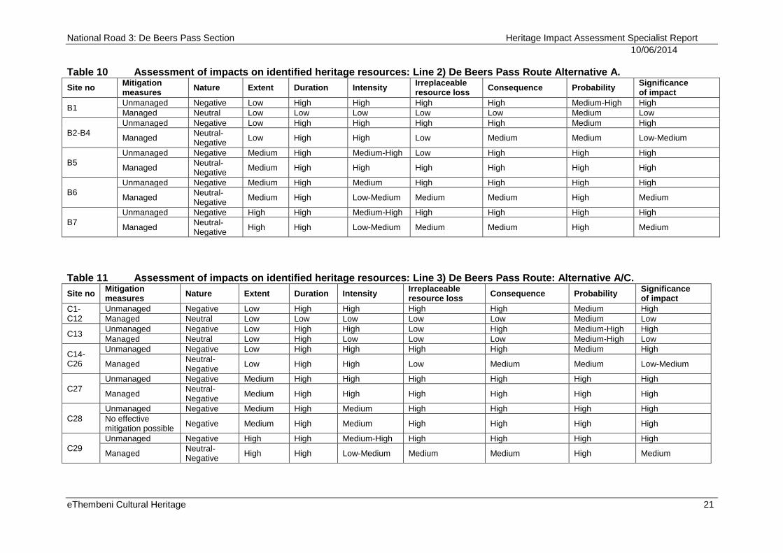
Table 10 Assessment of impacts on identified heritage resources: Line 2) De Beers Pass Route Alternative A.
Site no Mitigation measures
Nature Extent Duration Intensity Irreplaceable resource loss
Consequence Probability Significance of impact
B1 Unmanaged Negative Low High High High High Medium-High High
Managed Neutral Low Low Low Low Low Medium Low
B2-B4
Unmanaged Negative Low High High High High Medium High
Managed Neutral-Negative
Low High High Low Medium Medium Low-Medium
B5
Unmanaged Negative Medium High Medium-High Low High High High
Managed Neutral-Negative
Medium High High High High High High
B6
Unmanaged Negative Medium High Medium High High High High
Managed Neutral-Negative
Medium High Low-Medium Medium Medium High Medium
B7
Unmanaged Negative High High Medium-High High High High High
Managed Neutral-Negative
High High Low-Medium Medium Medium High Medium
Table 11 Assessment of impacts on identified heritage resources: Line 3) De Beers Pass Route: Alternative A/C.
Site no Mitigation measures
Nature Extent Duration Intensity Irreplaceable resource loss
Consequence Probability Significance of impact
C1-C12
Unmanaged Negative Low High High High High Medium High
Managed Neutral Low Low Low Low Low Medium Low
C13 Unmanaged Negative Low High High Low High Medium-High High
Managed Neutral Low High Low Low Low Medium-High Low
C14-C26
Unmanaged Negative Low High High High High Medium High
Managed Neutral-Negative
Low High High Low Medium Medium Low-Medium
C27
Unmanaged Negative Medium High High High High High High
Managed Neutral-Negative
Medium High High High High High High
C28
Unmanaged Negative Medium High Medium High High High High
No effective mitigation possible
Negative Medium High Medium High High High High
C29
Unmanaged Negative High High Medium-High High High High High
Managed Neutral-Negative
High High Low-Medium Medium Medium High Medium
National Road 3: De Beers Pass Section Heritage Impact Assessment Specialist Report
10/06/2014
eThembeni Cultural Heritage 22
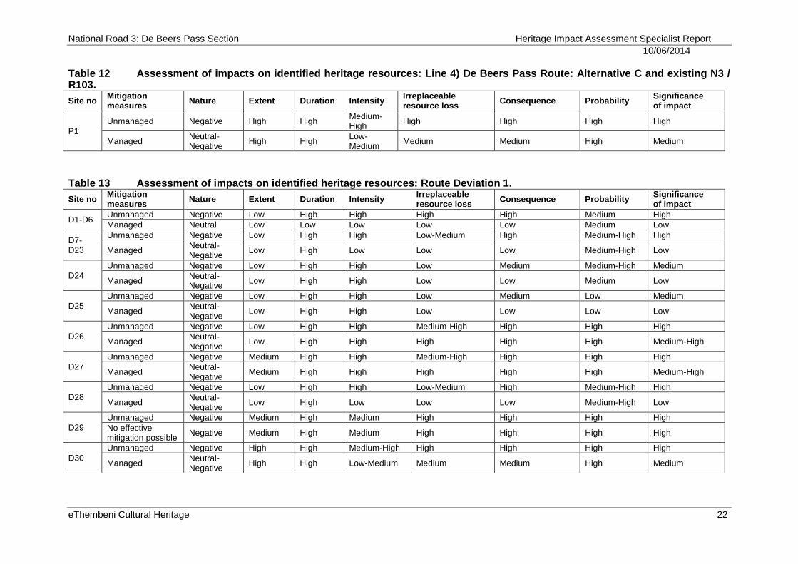
Table 12 Assessment of impacts on identified heritage resources: Line 4) De Beers Pass Route: Alternative C and existing N3 / R103.
Site no Mitigation measures
Nature Extent Duration Intensity Irreplaceable resource loss
Consequence Probability Significance of impact
P1
Unmanaged Negative High High Medium-High
High High High High
Managed Neutral-Negative
High High Low-Medium
Medium Medium High Medium
Table 13 Assessment of impacts on identified heritage resources: Route Deviation 1.
Site no Mitigation measures
Nature Extent Duration Intensity Irreplaceable resource loss
Consequence Probability Significance of impact
D1-D6 Unmanaged Negative Low High High High High Medium High
Managed Neutral Low Low Low Low Low Medium Low
D7-D23
Unmanaged Negative Low High High Low-Medium High Medium-High High
Managed Neutral-Negative
Low High Low Low Low Medium-High Low
D24
Unmanaged Negative Low High High Low Medium Medium-High Medium
Managed Neutral-Negative
Low High High Low Low Medium Low
D25
Unmanaged Negative Low High High Low Medium Low Medium
Managed Neutral-Negative
Low High High Low Low Low Low
D26
Unmanaged Negative Low High High Medium-High High High High
Managed Neutral-Negative
Low High High High High High Medium-High
D27
Unmanaged Negative Medium High High Medium-High High High High
Managed Neutral-Negative
Medium High High High High High Medium-High
D28
Unmanaged Negative Low High High Low-Medium High Medium-High High
Managed Neutral-Negative
Low High Low Low Low Medium-High Low
D29
Unmanaged Negative Medium High Medium High High High High
No effective mitigation possible
Negative Medium High Medium High High High High
D30
Unmanaged Negative High High Medium-High High High High High
Managed Neutral-Negative
High High Low-Medium Medium Medium High Medium
National Road 3: De Beers Pass Section Heritage Impact Assessment Specialist Report
10/06/2014
eThembeni Cultural Heritage 23
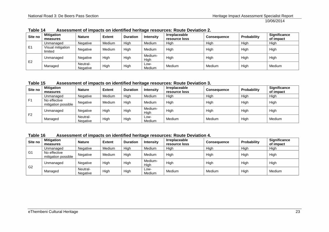
Table 14 Assessment of impacts on identified heritage resources: Route Deviation 2.
Site no Mitigation measures
Nature Extent Duration Intensity Irreplaceable resource loss
Consequence Probability Significance of impact
E1
Unmanaged Negative Medium High Medium High High High High
Visual mitigation limited
Negative Medium High Medium High High High High
E2
Unmanaged Negative High High Medium-High
High High High High
Managed Neutral-Negative
High High Low-Medium
Medium Medium High Medium
Table 15 Assessment of impacts on identified heritage resources: Route Deviation 3.
Site no Mitigation measures
Nature Extent Duration Intensity Irreplaceable resource loss
Consequence Probability Significance of impact
F1
Unmanaged Negative Medium High Medium High High High High
No effective mitigation possible
Negative Medium High Medium High High High High
F2
Unmanaged Negative High High Medium-High
High High High High
Managed Neutral-Negative
High High Low-Medium
Medium Medium High Medium
Table 16 Assessment of impacts on identified heritage resources: Route Deviation 4.
Site no Mitigation measures
Nature Extent Duration Intensity Irreplaceable resource loss
Consequence Probability Significance of impact
G1
Unmanaged Negative Medium High Medium High High High High
No effective mitigation possible
Negative Medium High Medium High High High High
G2
Unmanaged Negative High High Medium-High
High High High High
Managed Neutral-Negative
High High Low-Medium
Medium Medium High Medium
National Road 3: De Beers Pass Section Heritage Impact Assessment Specialist Report
20/11/2013
eThembeni Cultural Heritage 24
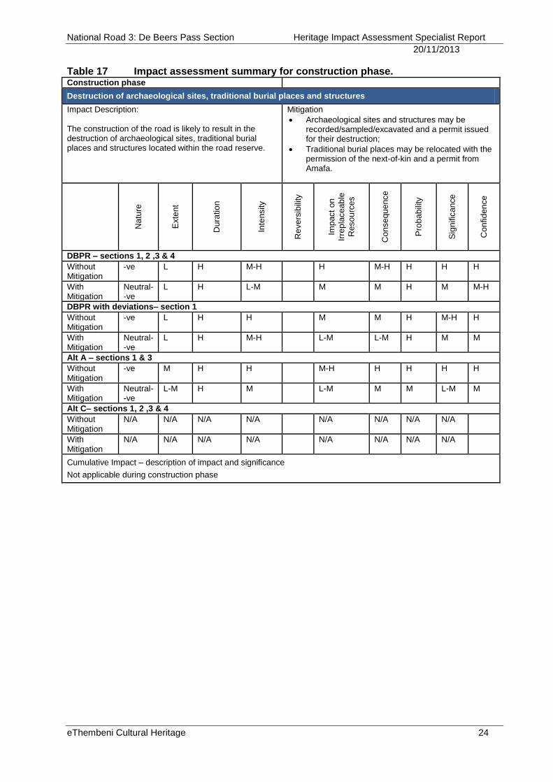
Table 17 Impact assessment summary for construction phase. Construction phase
Destruction of archaeological sites, traditional burial places and structures
Impact Description: The construction of the road is likely to result in the destruction of archaeological sites, traditional burial places and structures located within the road reserve.
Mitigation
Archaeological sites and structures may be recorded/sampled/excavated and a permit issued for their destruction;
Traditional burial places may be relocated with the permission of the next-of-kin and a permit from Amafa.
Na
ture
Exte
nt
Du
ratio
n
Inte
nsity
Re
ve
rsib
ility
Imp
act
on
Irre
pla
ce
ab
le
Re
so
urc
es
Co
nse
qu
ence
Pro
ba
bili
ty
Sig
nific
an
ce
Co
nfid
en
ce
DBPR – sections 1, 2 ,3 & 4
Without Mitigation
-ve L H M-H H M-H H H H
With Mitigation
Neutral--ve
L H L-M M M H M M-H
DBPR with deviations– section 1
Without Mitigation
-ve L H H M M H M-H H
With Mitigation
Neutral- -ve
L H M-H L-M L-M H M M
Alt A – sections 1 & 3
Without Mitigation
-ve M H H M-H H H H H
With Mitigation
Neutral--ve
L-M H M L-M M M L-M M
Alt C– sections 1, 2 ,3 & 4
Without Mitigation
N/A N/A N/A N/A N/A N/A N/A N/A
With Mitigation
N/A N/A N/A N/A N/A N/A N/A N/A
Cumulative Impact – description of impact and significance
Not applicable during construction phase
National Road 3: De Beers Pass Section Heritage Impact Assessment Specialist Report
10/06/2014
eThembeni Cultural Heritage 25
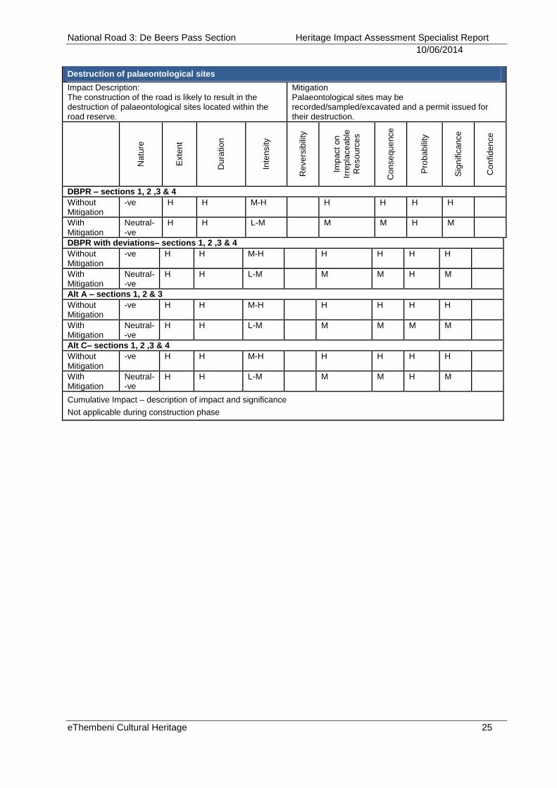
Destruction of palaeontological sites
Impact Description: The construction of the road is likely to result in the destruction of palaeontological sites located within the road reserve.
Mitigation Palaeontological sites may be recorded/sampled/excavated and a permit issued for their destruction.
Na
ture
Exte
nt
Du
ratio
n
Inte
nsity
Re
ve
rsib
ility
Imp
act
on
Irre
pla
ce
ab
le
Re
so
urc
es
Co
nse
qu
ence
Pro
ba
bili
ty
Sig
nific
an
ce
Co
nfid
en
ce
DBPR – sections 1, 2 ,3 & 4
Without Mitigation
-ve H H M-H H H H H
With Mitigation
Neutral- -ve
H H L-M M M H M
DBPR with deviations– sections 1, 2 ,3 & 4
Without Mitigation
-ve H H M-H H H H H
With Mitigation
Neutral- -ve
H H L-M M M H M
Alt A – sections 1, 2 & 3
Without Mitigation
-ve H H M-H H H H H
With Mitigation
Neutral- -ve
H H L-M M M M M
Alt C– sections 1, 2 ,3 & 4
Without Mitigation
-ve H H M-H H H H H
With Mitigation
Neutral- -ve
H H L-M M M H M
Cumulative Impact – description of impact and significance
Not applicable during construction phase
National Road 3: De Beers Pass Section Heritage Impact Assessment Specialist Report
10/06/2014
eThembeni Cultural Heritage 26
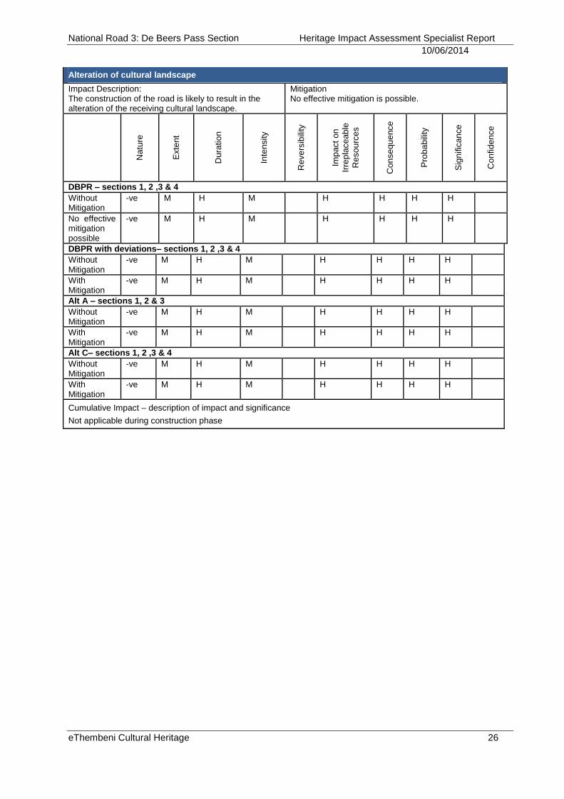
Alteration of cultural landscape
Impact Description: The construction of the road is likely to result in the alteration of the receiving cultural landscape.
Mitigation No effective mitigation is possible.
Na
ture
Exte
nt
Du
ratio
n
Inte
nsity
Re
ve
rsib
ility
Imp
act
on
Irre
pla
ce
ab
le
Re
so
urc
es
Co
nse
qu
ence
Pro
ba
bili
ty
Sig
nific
an
ce
Co
nfid
en
ce
DBPR – sections 1, 2 ,3 & 4
Without Mitigation
-ve M H M H H H H
No effective mitigation possible
-ve M H M H H H H
DBPR with deviations– sections 1, 2 ,3 & 4
Without Mitigation
-ve M H M H H H H
With Mitigation
-ve M H M H H H H
Alt A – sections 1, 2 & 3
Without Mitigation
-ve M H M H H H H
With Mitigation
-ve M H M H H H H
Alt C– sections 1, 2 ,3 & 4
Without Mitigation
-ve M H M H H H H
With Mitigation
-ve M H M H H H H
Cumulative Impact – description of impact and significance
Not applicable during construction phase
National Road 3: De Beers Pass Section Heritage Impact Assessment Specialist Report
10/06/2014
eThembeni Cultural Heritage 27
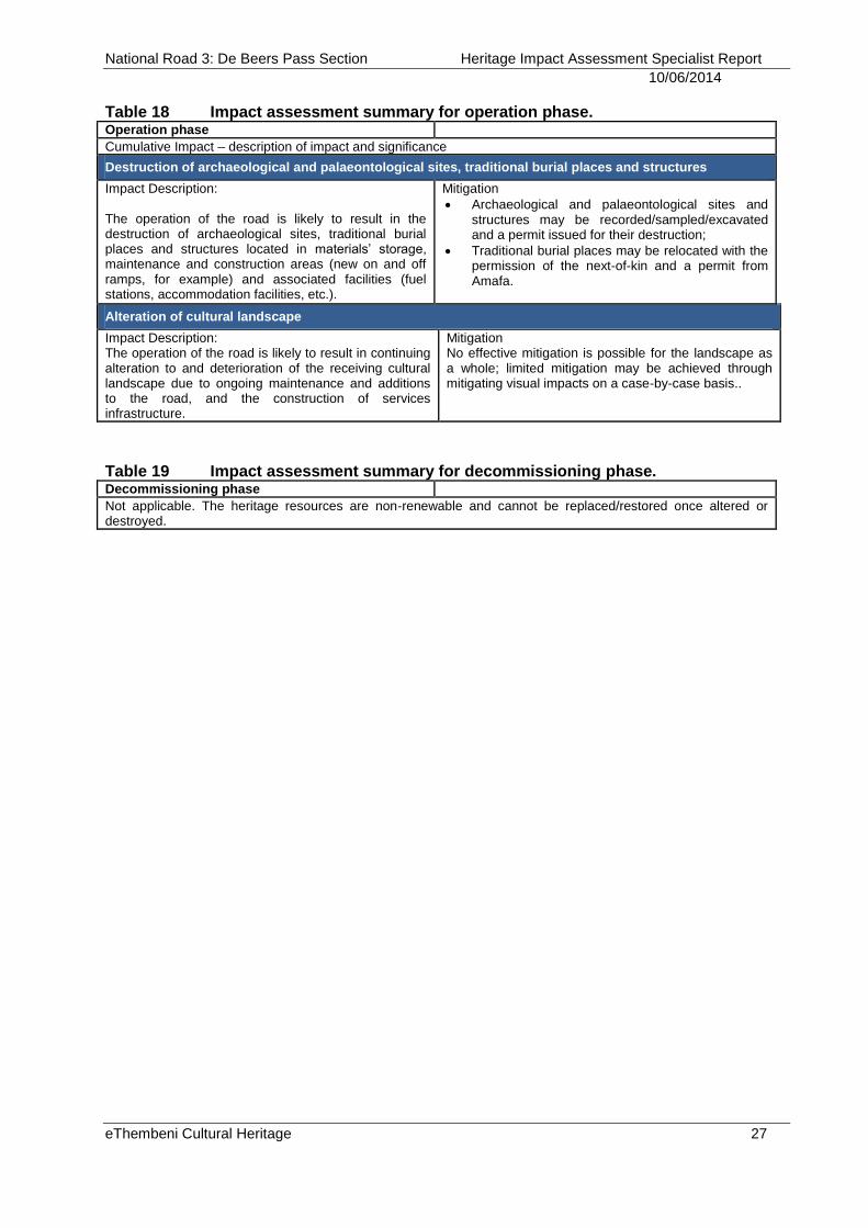
Table 18 Impact assessment summary for operation phase. Operation phase
Cumulative Impact – description of impact and significance
Destruction of archaeological and palaeontological sites, traditional burial places and structures
Impact Description: The operation of the road is likely to result in the destruction of archaeological sites, traditional burial places and structures located in materials’ storage, maintenance and construction areas (new on and off ramps, for example) and associated facilities (fuel stations, accommodation facilities, etc.).
Mitigation
Archaeological and palaeontological sites and structures may be recorded/sampled/excavated and a permit issued for their destruction;
Traditional burial places may be relocated with the permission of the next-of-kin and a permit from Amafa.
Alteration of cultural landscape
Impact Description: The operation of the road is likely to result in continuing alteration to and deterioration of the receiving cultural landscape due to ongoing maintenance and additions to the road, and the construction of services infrastructure.
Mitigation No effective mitigation is possible for the landscape as a whole; limited mitigation may be achieved through mitigating visual impacts on a case-by-case basis..
Table 19 Impact assessment summary for decommissioning phase. Decommissioning phase
Not applicable. The heritage resources are non-renewable and cannot be replaced/restored once altered or destroyed.
National Road 3: De Beers Pass Section Heritage Impact Assessment Specialist Report
10/06/2014
eThembeni Cultural Heritage 28
8 IMPACT ASSESSMENT PER SECTION FOR EACH ROUTE
ALTERNATIVE
This comparative analysis of each route alternative is informed fundamentally by the fact that no meaningful mitigation measures exist to reduce to acceptable levels the inevitable impacts on the cultural and natural landscape traversed by the proposed Line 1) De Beers Pass Route and the four proposed deviations. Whilst the Maluti-A-Phofung Local Municipality IDP (2011/2012)3 is biased to the demographics and service delivery requirements of Harrismith and communities adjacent to and west of the existing N3, it has as stated objectives (LED 2&3) the expansion of the tourism and agricultural sectors in the region. Notwithstanding these objectives the tourism strategy within the Spatial Development Framework (SDF)4 recognises that tourism zones are areas that have a high environmental quality or cultural/historic heritage. Many of these zones incorporate environmentally sensitive areas and thus a cautious approach is advocated to avoid negative impacts on these environments. The SDF further advocates that valuable agricultural land should preferably be preserved for agricultural productivity. Not only will productive agricultural land be lost directly to road construction, but associated impacts (including livestock theft, soil and water pollution and land fragmentation) will restrict landowners’ abilities to produce food economically. The SDF is thus based upon a bioregional planning approach to achieve continuity in the landscape and to maintain important natural areas and ecological processes. However, due to its relative isolation, the cultural and natural landscape of the study area has been afforded little formal protection for listed sites, proclaimed natural and heritage conservancies, or proclaimed scenic routes. While the identification of some specific areas for conservation has occurred (primarily avifauna), their placement within a supportive planning framework to ensure integrated natural and cultural landscape conservation, is sorely lacking. It is within this void that the very essence of the DBPR cultural landscape is at risk. The construction of a national freeway along the DBPR alignment will result in an irreversible transformation of the interwoven fabric of this landscape for which little meaningful mitigation is possible. Such linear landscape fragmentation will cumulatively have negative ecological, hydrological, biophysical, socio-economic and sensory impacts to the detriment of its wild, remote and agrarian character. Construction of the proposed Line 1) De Beers Pass Route and any of the four proposed deviations will destroy the high potential of this spectacular landscape for tourism development with concomitant loss of benefits to all levels of society. The area will become a commercial conduit that attracts supporting infrastructure, including fuel stations, truck stops and services and electrical transmission lines.
3 http://www.map.fs.gov.za/documents/FINAL%20%20IDP%202012-2013%20doc.pdf
4 Maluti-a-Phofung LM SDF 2010: Chapter 5
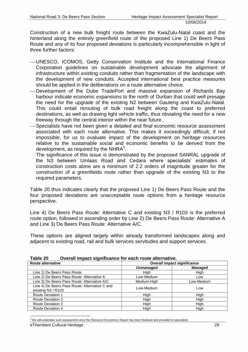
National Road 3: De Beers Pass Section Heritage Impact Assessment Specialist Report
10/06/2014
eThembeni Cultural Heritage 29
Construction of a new bulk freight route between the KwaZulu-Natal coast and the hinterland along the entirely greenfield route of the proposed Line 1) De Beers Pass Route and any of its four proposed deviations is particularly incomprehensible in light of three further factors:
UNESCO, ICOMOS, Getty Conservation Institute and the International Finance Corporation guidelines on sustainable development advocate the alignment of infrastructure within existing conduits rather than fragmentation of the landscape with the development of new conduits. Accepted international best practice measures should be applied in the deliberations on a route alternative choice.
Development of the Dube TradePort and massive expansion of Richards Bay harbour indicate economic expansions to the north of Durban that could well presage the need for the upgrade of the existing N2 between Gauteng and KwaZulu-Natal. This could entail rerouting of bulk road freight along the coast to preferred destinations, as well as drawing light vehicle traffic, thus obviating the need for a new freeway through the central interior within the near future.
Specialists have not been given a detailed and final economic resource assessment associated with each route alternative. This makes it exceedingly difficult, if not impossible, for us to evaluate impact of the development on heritage resources relative to the sustainable social and economic benefits to be derived from the development, as required by the NHRA5. The significance of this issue is demonstrated by the proposed SANRAL upgrade of the N3 between Umlaas Road and Cedara where specialists’ estimates of construction costs alone are a minimum of 2.2 orders of magnitude greater for the construction of a greenfields route rather than upgrade of the existing N3 to the required parameters.
Table 20 thus indicates clearly that the proposed Line 1) De Beers Pass Route and the four proposed deviations are unacceptable route options from a heritage resource perspective. Line 4) De Beers Pass Route: Alternative C and existing N3 / R103 is the preferred route option, followed in ascending order by Line 2) De Beers Pass Route: Alternative A and Line 3) De Beers Pass Route: Alternative A/C. These options are aligned largely within already transformed landscapes along and adjacent to existing road, rail and bulk services servitudes and support services. Table 20 Overall impact significance for each route alternative. Route alternative Overall impact significance
Unmanaged Managed
Line 1) De Beers Pass Route High High
Line 2) De Beers Pass Route: Alternative A Low-Medium Low
Line 3) De Beers Pass Route: Alternative A/C Medium-High Low-Medium
Line 4) De Beers Pass Route: Alternative C and existing N3 / R103
Low-Medium Low
Route Deviation 1 High High
Route Deviation 2 High High
Route Deviation 3 High High
Route Deviation 4 High High
5 We will undertake such assessment once the Resource Economics Report has been finalised and provided to specialists.
National Road 3: De Beers Pass Section Heritage Impact Assessment Specialist Report
10/06/2014
eThembeni Cultural Heritage 30
9 RECOMMENDED MITIGATION MEASURES
9.1 Traditional burial places: graves outside a formal cemetery
No human remains may be altered in any way without the permission of the next-of-kin and a permit from SAHRA or Amafa. If construction activities are allowed within an area containing graves these must be demarcated as stipulated by a heritage practitioner. If construction activities are allowed in an area with no direct impact on any graves present, the graves must be recorded in the relevant SANRAL databases and Environmental Management Plans to ensure that they are managed appropriately during all future road construction and maintenance activities. 9.2 Archaeological sites
Archaeological sites may not be altered in any way without a permit from SAHRA or Amafa. If any archaeological site will be affected directly by the proposed project, an archaeologist must be appointed to undertake adequate aboveground and subsurface investigations and recording of the site(s), under the auspices of a permit from the relevant heritage authority. If construction activities are permitted in the area (with no direct impact on sites) all archaeological sites must be demarcated adequately for the entire duration of construction. The demarcated area must extend for a radius of at least 50 metres from the site, as determined by a heritage practitioner prior to construction. All archaeological sites must be recorded in the relevant SANRAL databases and Environmental Management Plans to ensure that they are managed appropriately during all future road construction and maintenance activities. 9.3 Places, buildings and structures > 60 years
No such resources may be altered in any way without a permit from SAHRA or Amafa. If any such resource will be affected directly by the proposed project, an archaeologist must be appointed to undertake adequate aboveground and subsurface investigations and recording of the site(s), under the auspices of a permit from the relevant heritage authority. If construction activities are permitted in the area (with no direct impact on sites) all structures must be demarcated adequately for the entire duration of construction. The demarcated area must extend for a radius of at least 50 metres from the site, as determined by a heritage practitioner prior to construction. All such structures must be recorded in the relevant SANRAL databases and Environmental Management Plans to ensure that they are managed appropriately during all future road construction and maintenance activities.
National Road 3: De Beers Pass Section Heritage Impact Assessment Specialist Report
10/06/2014
eThembeni Cultural Heritage 31
9.4 Landscapes and natural features
No meaningful mitigation measures exist to reduce to acceptable levels the inevitable impacts on the cultural and natural landscape traversed by the proposed Line 1) De Beers Pass Route and the four proposed deviations. The deviations only lessen the indirect impacts on discrete heritage resources, such as at Buckland Downs, and the overall impacts on landscapes and natural features remain unchanged. If Line 2) De Beers Pass Route: Alternative A is selected as the preferred route, consideration should be given to aligning it to the east of Platberg before rejoining the existing N3 alignment north of Harrismith. 9.5 Battlefields
No battlefield sites or remains may be altered in any way without a permit from SAHRA or Amafa. If any battlefield site will be affected directly by the proposed project, a heritage specialist must be appointed to undertake adequate aboveground and subsurface investigations and recording of the site(s), under the auspices of a permit from the relevant heritage authority. If construction activities are permitted in an area with no direct impact on sites all battlefield sites or remains must be demarcated adequately for the entire duration of construction, as determined by a heritage practitioner. Such sites must be recorded in the relevant SANRAL databases and Environmental Management Plans to ensure that they are managed appropriately during all future road construction and maintenance activities.
9.6 Palaeontological sites
All proposed route alignment options could expose significant fossil bearing deposits within the Permian Extinction Zone (Appendix G). A palaeontologist with experience of the Permian Extinction Zone should be appointed to do a physical traverse of the final route selected before commencement of excavations for road foundations. The palaeontologist must be permitted by the relevant heritage authority to collect fossils from the Dicynodon lacerticeps, Lystrosaurus and Cynognathus assemblage zones. All fossils discovered during excavation for road foundations must be recorded and rescued. The palaeontologist may be required to monitor excavations for the road foundations. 9.7 General
Heritage specialists must undertake a ‘walk-through’ of the entire final road alignment and all construction areas, including contractors’ camps and access roads, prior to the start of any construction activities, to identify all heritage resources and make recommendations for their management during and after construction.
National Road 3: De Beers Pass Section Heritage Impact Assessment Specialist Report
10/06/2014
eThembeni Cultural Heritage 32
10 RECOMMENDED MONITORING
Heritage specialists must ensure that all heritage resources are:
Identified and demarcated adequately prior to the start of any construction activities;
Brought to the attention of relevant project staff, including construction workers;
Inspected on at least a monthly basis, with reports submitted to the relevant heritage authority and the project management team.
11 PROTOCOL FOR THE IDENTIFICATION, PROTECTION AND RECOVERY OF HERITAGE RESOURCES DURING CONSTRUCTION AND OPERATION
It is possible that sub-surface heritage resources could be encountered during the construction phase of this project. The Environmental Control Officer and all other persons responsible for site management and excavation should be aware that indicators of sub-surface sites could include:
Ash deposits (unnaturally grey appearance of soil compared to the surrounding substrate);
Bone concentrations, either animal or human;
Ceramic fragments, including potsherds;
Stone concentrations that appear to be formally arranged (may indicate the presence of an underlying burial, or represent building/structural remains); and
Fossilised remains of fauna and flora, including trees. In the event that such indicator(s) of heritage resources are identified, the following actions should be taken immediately:
All construction within a radius of at least 20m of the indicator should cease. This distance should be increased at the discretion of supervisory staff if heavy machinery or explosives could cause further disturbance to the suspected heritage resource.
This area must be marked using clearly visible means, such as barrier tape, and all personnel should be informed that it is a no-go area.
A guard should be appointed to enforce this no-go area if there is any possibility that it could be violated, whether intentionally or inadvertently, by construction staff or members of the public.
No measures should be taken to cover up the suspected heritage resource with soil, or to collect any remains such as bone or stone.
If a heritage practitioner has been appointed to monitor the project, s/he should be contacted and a site inspection arranged as soon as possible.
If no heritage practitioner has been appointed to monitor the project, the relevant staff member of SAHRA/Amafa should be contacted. The responsible person and her/his contact details should be known to the Resident Engineer and/or Environmental Control Officer prior to the start of construction activities.
National Road 3: De Beers Pass Section Heritage Impact Assessment Specialist Report
10/06/2014
eThembeni Cultural Heritage 33
The South African Police Services should be notified by a SAHRA/Amafa staff member or an independent heritage practitioner if human remains are identified. No SAPS official may disturb or exhume such remains, whether of recent origin or not.
All parties concerned should respect the potentially sensitive and confidential nature of the heritage resources, particularly human remains, and refrain from making public statements until a mutually agreed time.
Any extension of the project beyond its current footprint involving vegetation and/or earth clearance should be subject to prior assessment by a qualified heritage practitioner, taking into account all information gathered during this initial HIA.
12 TIME AND COST IMPLICATIONS OF PROPOSED MITIGATION
The following estimates should be regarded as conservative. Certain mitigation measures may proceed concurrently. Table 21 Time implications of heritage resource mitigation. Mitigation Start
Exhumation and reinterment of traditional burial places
24 months pre-construction
Recording of architectural sites 6 months pre-construction
Recording and/or excavation of archaeological sites
24 months pre-construction
Recording of battlefield sites 6 months pre-construction
Engineering an in-cut route to minimise the visual effect of the road past Platberg
Design phase
Palaeontological Impact Assessment including fieldwork and monitoring
6 months pre-construction and during construction
Physical assessment of final selected route and monitoring
6 months pre-construction and during construction
National Road 3: De Beers Pass Section Heritage Impact Assessment Specialist Report
10/06/2014
eThembeni Cultural Heritage 34
13 CONCLUSION
The proposed Line 1) De Beers Pass Route and the four proposed deviations are unacceptable route options from a heritage resources perspective. However should the DBPR corridor be authorized the route alignment that includes the mitigation deviations of the Gorge, Wilge River, Alex Pan Lincoln Pan and the Oak Grove on Buckland Downs should be incorporated. The proposed Line 4) De Beers Pass Route: Alternative C and existing N3 / R103 is the preferred route option, followed in ascending order by Line 2) De Beers Pass Route: Alternative A and Line 3) De Beers Pass Route: Alternative A/C. This report may be submitted to SAHRA and Amafa in fulfilment of the requirements of the NHRA. According to Section 38(4) of the NHRA the report shall be considered timeously by the Council which shall, after consultation with the person proposing the development, decide –
whether or not the development may proceed;
any limitations or conditions are to be applied to the development;
what general protections in terms of this Act apply, and what formal protections may be applied to such heritage resources;
whether compensatory action shall be required in respect of any heritage resources damaged or destroyed as a result of the development; and
whether the appointment of specialists is required as a condition of approval of the proposal.
Relevant staff members may be contacted at the SAHRA Cape Town head office (Dr Mariagrazia Galimberti telephone 021 462 4502; [email protected]) and Ms Bernadet Pawandiwa at Amafa’s Pietermaritzburg office (telephone 033 3946 543). If permission is granted for development to proceed, the client is reminded that the Act requires that a developer cease all work immediately and follow the protocol in Section 12 should any heritage resources be discovered during the course of development activities.
National Road 3: De Beers Pass Section Heritage Impact Assessment Specialist Report
10/06/2014
eThembeni Cultural Heritage 35
14 BIBLIOGRAPHY
Aldenderfer, M. S. and Hale-Pierce, C.A. 1984. The Small-Scale Archaeological Survey Revisited. American Archaeology 4(1):4-5.
Anderson, A. 1996. Potential impact on the archaeological sites along the proposed N3 Toll Road. Institute for Cultural Resource Management, Natal Museum, Pietermaritzburg.
Botha, G.A. 2010. Synthesis of the current lithostratigraphic subdivision of the Beaufort Group with reference to the context of the Cathkin area in the Drakensberg foothills. Unpublished Memo. Council for Geoscience, KwaZulu-Natal Unit, Pietermaritzburg.
Bryant, A. T. 1965. Olden Times in Zululand and Natal: [facsimile reprint of 1929 original]. C. Struik.
Deacon, J. 1984. Later Stone Age people and their descendants in southern Africa. In
Klein, R.G. (ed). Southern Africa prehistory and paleoenvironments. Rotterdam:
A.A. Balkema.
Deacon, J. 1996. Archaeology for Planners, Developers and Local Authorities. National Monuments Council. Publication no. PO21E.
Deacon, J. 1997. Report: Workshop on Standards for the Assessment of Significance and Research Priorities for Contract Archaeology. In: Newsletter No. 49, Sept.1998. South African Association of Archaeology.
Dreyer, J. 2001. Thomas Arbousset and Francois Daumas in the Free State: tracing the exploratory tour of 1836. Southern African Humanities 13: 61-96.
Groenewald, G.H. 1989. Stratigrafie en sedimentologie van die Groep Beaufort in die Noordoos-Vrystaat. Bulletin 96, Geological Survey of South Africa, 62 pp.
Groenewald, G.H. 1996. Sedimentology and Paleontology of the Tarkastadsub-Group, Karoo Super Group of South Africa. Unpublished PhD Thesis. University of Port Elizabeth.
Huffman, T.N. 2002. Regionality in the Iron Age: the case of the Sotho-Tswana. Southern African Humanities 14: 1-22.
King, T.F. 1978. The Archaeological Survey: Its Methods and Uses. Interagency Archaeological Services, Department of the Interior, Washington, D.C.
McManamon, F.P. 1984. Discovering Sites Unseen. In Advances in Archaeological Method and Theory 8:223-292, M.B. Schiffer, ed. Academic Press, New York.
Maggs, T. 1975. Faunal remains and hunting patterns from the Iron Age of the Southern Highveld. Annals of the Natal Museum 22 (2): 449-54.
Maggs, T. 1976. Iron Age Communities of the Southern Highveld. Pietermaritzburg. Mazel, A. D. 1982. Evidence for pre-Later Stone Age occupation of the Natal
Drakensberg. Annals of the Natal Museum 25 (1): 61-5. Mazel, A. D. 1984. Diamond 1 and Clarke's Shelter: report on excavations in the
northern Drakensberg, Natal, South Africa. Annals of the Natal Museum 26 (1): 25-70.
Mazel, A. D. 1986. Mgede Shelter. A mid- and late Holocene observation in the western Biggarsberg, Thukela Basin, Natal, South Africa. Annals of the Natal Museum 27: 357-387.
Mitchell, P.J. 1997. Holocene Later Stone Age Hunter-Gatherers South of the Limpopo
River, Ca. 10,000–2000 B.P. Journal of World Prehistory 11 (4): 359-424.
National Road 3: De Beers Pass Section Heritage Impact Assessment Specialist Report
10/06/2014
eThembeni Cultural Heritage 36
Mitchell, P. 2002. The archaeology of southern Africa. Cambridge: Cambridge
University Press.
Mitchell, P. and Whitelaw, G. 2005. The archaeology of southernmost Africa from c. 2000 BP to the early 1800s: a review of recent research. Journal of African History 46: 209-241.
Rightmire, G.P. & Deacon, H.J. 1991. Comparative studies of Late Pleistocene human
remains from Klasies River Mouth, South Africa. Journal of Human Evolution 20:
131-156.
Schiffer, M. B., Sullivan A.P., and Klinger T.C. 1978. The Design of Archaeological
Surveys. World Archaeology 10:1-28.
Singer, R. & Wymer, J. 1982. The Middle Stone Age at Klasies River Mouth in South
Africa. Chicago: University of Chicago Press.
Whitelaw, G. 1991. Precolonial iron production around Durban and in southern Natal.
Natal Museum Journal of Humanities 3: 29-39.
Whitelaw, G. 1997. What Da Gama missed on his way to Sofala. Natalia 27: 30-41.
Whitelaw, G. 2009. An Iron Age fishing tale. Southern African Humanities 21: 195-212.
Zubrow, E.B.A. 1984. Small-Scale Surveys: A Problem for Quality Control. American
Archeology 4(1):16-27.
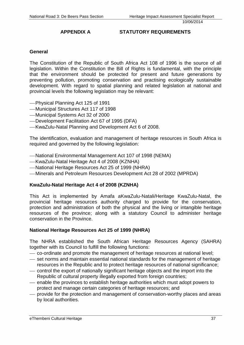
National Road 3: De Beers Pass Section Heritage Impact Assessment Specialist Report
10/06/2014
eThembeni Cultural Heritage 37
APPENDIX A STATUTORY REQUIREMENTS
General The Constitution of the Republic of South Africa Act 108 of 1996 is the source of all legislation. Within the Constitution the Bill of Rights is fundamental, with the principle that the environment should be protected for present and future generations by preventing pollution, promoting conservation and practising ecologically sustainable development. With regard to spatial planning and related legislation at national and provincial levels the following legislation may be relevant:
Physical Planning Act 125 of 1991
Municipal Structures Act 117 of 1998
Municipal Systems Act 32 of 2000
Development Facilitation Act 67 of 1995 (DFA)
KwaZulu-Natal Planning and Development Act 6 of 2008. The identification, evaluation and management of heritage resources in South Africa is required and governed by the following legislation:
National Environmental Management Act 107 of 1998 (NEMA)
KwaZulu-Natal Heritage Act 4 of 2008 (KZNHA)
National Heritage Resources Act 25 of 1999 (NHRA)
Minerals and Petroleum Resources Development Act 28 of 2002 (MPRDA) KwaZulu-Natal Heritage Act 4 of 2008 (KZNHA) This Act is implemented by Amafa aKwaZulu-Natali/Heritage KwaZulu-Natal, the provincial heritage resources authority charged to provide for the conservation, protection and administration of both the physical and the living or intangible heritage resources of the province; along with a statutory Council to administer heritage conservation in the Province. National Heritage Resources Act 25 of 1999 (NHRA) The NHRA established the South African Heritage Resources Agency (SAHRA) together with its Council to fulfill the following functions:
co-ordinate and promote the management of heritage resources at national level;
set norms and maintain essential national standards for the management of heritage resources in the Republic and to protect heritage resources of national significance;
control the export of nationally significant heritage objects and the import into the Republic of cultural property illegally exported from foreign countries;
enable the provinces to establish heritage authorities which must adopt powers to protect and manage certain categories of heritage resources; and
provide for the protection and management of conservation-worthy places and areas by local authorities.
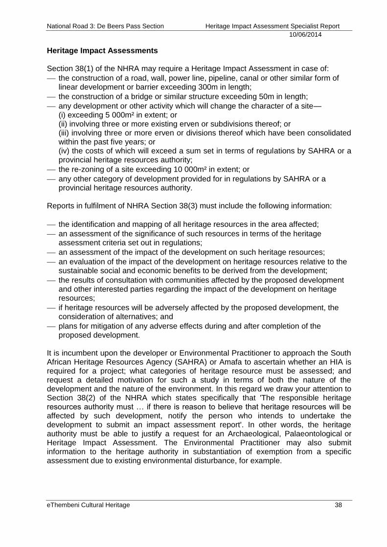
National Road 3: De Beers Pass Section Heritage Impact Assessment Specialist Report
10/06/2014
eThembeni Cultural Heritage 38
Heritage Impact Assessments Section 38(1) of the NHRA may require a Heritage Impact Assessment in case of:
the construction of a road, wall, power line, pipeline, canal or other similar form of linear development or barrier exceeding 300m in length;
the construction of a bridge or similar structure exceeding 50m in length;
any development or other activity which will change the character of a site— (i) exceeding 5 000m² in extent; or (ii) involving three or more existing erven or subdivisions thereof; or (iii) involving three or more erven or divisions thereof which have been consolidated within the past five years; or (iv) the costs of which will exceed a sum set in terms of regulations by SAHRA or a provincial heritage resources authority;
the re-zoning of a site exceeding 10 000m² in extent; or
any other category of development provided for in regulations by SAHRA or a provincial heritage resources authority.
Reports in fulfilment of NHRA Section 38(3) must include the following information:
the identification and mapping of all heritage resources in the area affected;
an assessment of the significance of such resources in terms of the heritage assessment criteria set out in regulations;
an assessment of the impact of the development on such heritage resources;
an evaluation of the impact of the development on heritage resources relative to the sustainable social and economic benefits to be derived from the development;
the results of consultation with communities affected by the proposed development and other interested parties regarding the impact of the development on heritage resources;
if heritage resources will be adversely affected by the proposed development, the consideration of alternatives; and
plans for mitigation of any adverse effects during and after completion of the proposed development.
It is incumbent upon the developer or Environmental Practitioner to approach the South African Heritage Resources Agency (SAHRA) or Amafa to ascertain whether an HIA is required for a project; what categories of heritage resource must be assessed; and request a detailed motivation for such a study in terms of both the nature of the development and the nature of the environment. In this regard we draw your attention to Section 38(2) of the NHRA which states specifically that 'The responsible heritage resources authority must … if there is reason to believe that heritage resources will be affected by such development, notify the person who intends to undertake the development to submit an impact assessment report'. In other words, the heritage authority must be able to justify a request for an Archaeological, Palaeontological or Heritage Impact Assessment. The Environmental Practitioner may also submit information to the heritage authority in substantiation of exemption from a specific assessment due to existing environmental disturbance, for example.
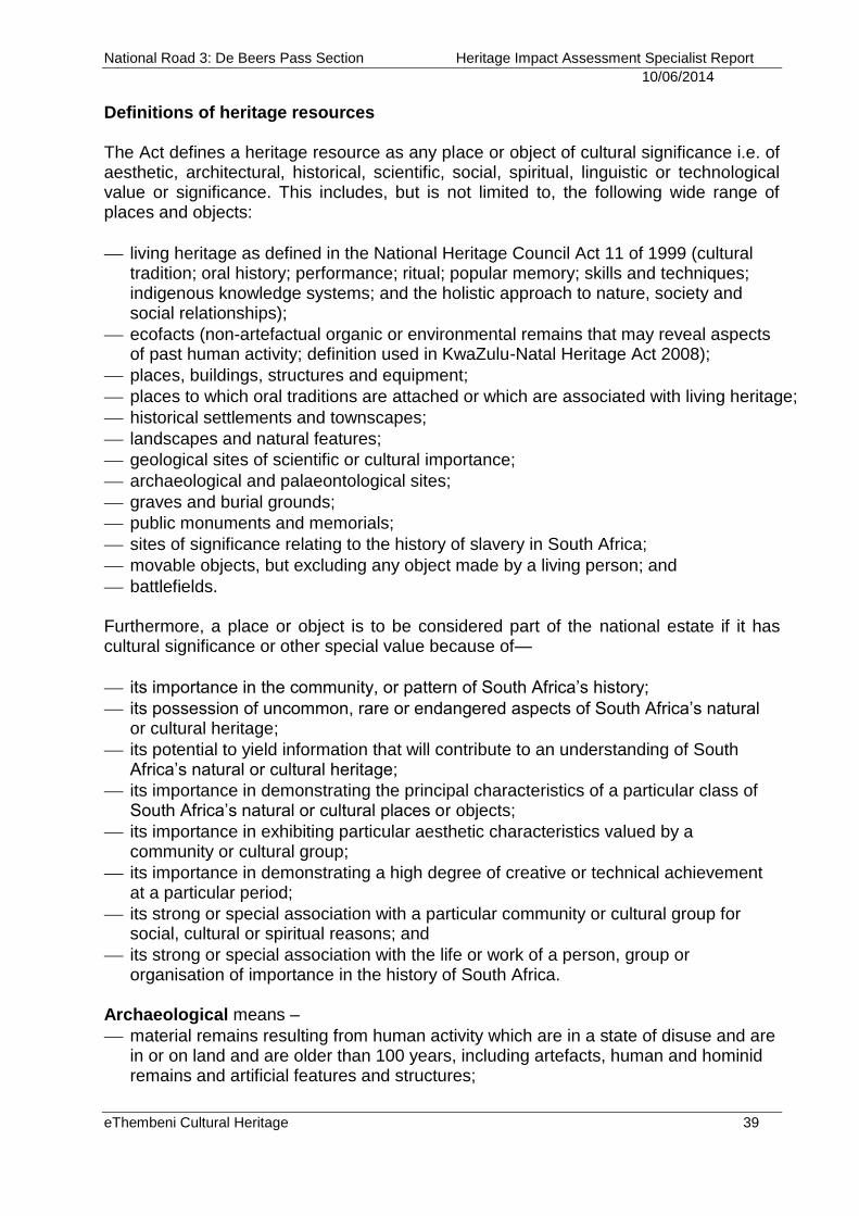
National Road 3: De Beers Pass Section Heritage Impact Assessment Specialist Report
10/06/2014
eThembeni Cultural Heritage 39
Definitions of heritage resources The Act defines a heritage resource as any place or object of cultural significance i.e. of aesthetic, architectural, historical, scientific, social, spiritual, linguistic or technological value or significance. This includes, but is not limited to, the following wide range of places and objects:
living heritage as defined in the National Heritage Council Act 11 of 1999 (cultural tradition; oral history; performance; ritual; popular memory; skills and techniques; indigenous knowledge systems; and the holistic approach to nature, society and social relationships);
ecofacts (non-artefactual organic or environmental remains that may reveal aspects of past human activity; definition used in KwaZulu-Natal Heritage Act 2008);
places, buildings, structures and equipment;
places to which oral traditions are attached or which are associated with living heritage;
historical settlements and townscapes;
landscapes and natural features;
geological sites of scientific or cultural importance;
archaeological and palaeontological sites;
graves and burial grounds;
public monuments and memorials;
sites of significance relating to the history of slavery in South Africa;
movable objects, but excluding any object made by a living person; and
battlefields. Furthermore, a place or object is to be considered part of the national estate if it has cultural significance or other special value because of—
its importance in the community, or pattern of South Africa’s history;
its possession of uncommon, rare or endangered aspects of South Africa’s natural or cultural heritage;
its potential to yield information that will contribute to an understanding of South Africa’s natural or cultural heritage;
its importance in demonstrating the principal characteristics of a particular class of South Africa’s natural or cultural places or objects;
its importance in exhibiting particular aesthetic characteristics valued by a community or cultural group;
its importance in demonstrating a high degree of creative or technical achievement at a particular period;
its strong or special association with a particular community or cultural group for social, cultural or spiritual reasons; and
its strong or special association with the life or work of a person, group or organisation of importance in the history of South Africa.
Archaeological means –
material remains resulting from human activity which are in a state of disuse and are in or on land and are older than 100 years, including artefacts, human and hominid remains and artificial features and structures;
National Road 3: De Beers Pass Section Heritage Impact Assessment Specialist Report
10/06/2014
eThembeni Cultural Heritage 40
rock art, being any form of painting, engraving or other graphic representation on a fixed rock surface or loose rock or stone, which was executed by human agency and is older than 100 years including any area within 10m of such representation;
wrecks, being any vessel or aircraft, or any part thereof, which was wrecked in South Africa, whether on land, in the internal waters, the territorial waters or in the culture zone of the Republic, as defined respectively in sections 3, 4 and 6 of the Maritime Zones Act 15 of 1994, and any cargo, debris or artefacts found or associated therewith, which is older than 60 years or which SAHRA considers to be worthy of conservation;
features, structures and artefacts associated with military history which are older than 75 years and the sites on which they are found.
Palaeontological means any fossilised remains or fossil trace of animals or plants which lived in the geological past, other than fossil fuels or fossiliferous rock intended for industrial use, and any site which contains such fossilised remains or trace. A place is defined as:
a site, area or region;
a building or other structure which may include equipment, furniture, fittings and articles associated with or connected with such building or other structure;
a group of buildings or other structures which may include equipment, furniture, fittings and articles associated with or connected with such group of buildings or other structures;
an open space, including a public square, street or park; and
in relation to the management of a place, includes the immediate surroundings of a place.
Public monuments and memorials means all monuments and memorials:
erected on land belonging to any branch of central, provincial or local government, or on land belonging to any organisation funded by or established in terms of the legislation of such a branch of government; or
which were paid for by public subscription, government funds, or a public-spirited or military organisation, and are on land belonging to any private individual.
Structures means any building, works, device or other facility made by people and which is fixed to land, and includes any fixtures, fittings and equipment associated therewith. Management of Graves and Burial Grounds
Definitions Grave The NHRA defines a grave as a place of interment and includes the contents, headstone or other marker of such a place, and any other structure on or associated with such a place. The KwaZulu-Natal Cemeteries and Crematoria Act 12 of 1996 defines a grave as an excavation in which human remains have been intentionally placed for the purposes of burial, but excludes any such excavation where all human remains have been removed.
National Road 3: De Beers Pass Section Heritage Impact Assessment Specialist Report
10/06/2014
eThembeni Cultural Heritage 41
Burial ground The term ‘burial ground’ does not appear to have a legal definition. In common usage the term is used for management purposes to describe two or more graves that are grouped closely enough to be managed as a single entity. Cemetery The KwaZulu-Natal Cemeteries and Crematoria Act 1996 defines a cemetery as any place
(a) where human remains are buried in an orderly, systematic and pre-planned manner in identifiable burial plots;
(b) which is intended to be permanently set aside for and used only for the purposes of the burial of human remains.
Protection of graves and cemeteries No person may damage, alter, exhume, or remove from its original position any grave, as defined above, without permission from the relevant heritage or health authority.
Procedures required for permission to disinter and rebury graves The procedure for consultation regarding burial grounds and graves (Section 36 of the NHRA) is applicable to all graves located outside a formal cemetery administrated by a local authority. The following extract from this legislation is applicable to this policy document:
SAHRA or Amafa may not issue a permit for any alteration to or disinterment or reburial of a grave unless it is satisfied that the applicant has, in accordance with regulations made by the responsible heritage resources authority—
(a) made a concerted effort to contact and consult communities and individuals who by tradition have an interest in such grave or burial ground; and
(b) reached agreements with such communities and individuals regarding the future of such grave or burial ground.
Any person who in the course of development or any other activity discovers the location of a grave, the existence of which was previously unknown, must immediately cease such activity and report the discovery to the responsible heritage resources authority which must, in co-operation with the South African Police Services and in accordance with regulations of the responsible heritage resources authority—
(a) carry out an investigation for the purpose of obtaining information on whether or not such grave is protected in terms of this Act or is of significance to any community; and (b) if such grave is protected or is of significance, assist any person who or community which is a direct descendant to make arrangements for the exhumation and re-interment of the contents of such grave or, in the absence of such person or community, make any such arrangements as it deems fit.
National Road 3: De Beers Pass Section Heritage Impact Assessment Specialist Report
10/06/2014
eThembeni Cultural Heritage 42
The Vermillion Accord on Human Remains6
Adopted in 1989 at WAC Inter-Congress, South Dakota, USA
1. Respect for the mortal remains of the dead shall be accorded to all, irrespective of origin, race, religion, nationality, custom and tradition. 2. Respect for the wishes of the dead concerning disposition shall be accorded whenever possible, reasonable and lawful, when they are known or can be reasonably inferred. 3. Respect for the wishes of the local community and of relatives or guardians of the dead shall be accorded whenever possible, reasonable and lawful. 4. Respect for the scientific research value of skeletal, mummified and other human remains (including fossil hominids) shall be accorded when such value is demonstrated to exist. 5. Agreement on the disposition of fossil, skeletal, mummified and other remains shall be reached by negotiation on the basis of mutual respect for the legitimate concerns of communities for the proper disposition of their ancestors, as well as the legitimate concerns of science and education. 6. The express recognition that the concerns of various ethnic groups, as well as those of science are legitimate and to be respected, will permit acceptable agreements to be reached and honoured.
6 http://www.worldarchaeologicalcongress.org/
National Road 3: De Beers Pass Section Heritage Impact Assessment Specialist Report
10/06/2014
eThembeni Cultural Heritage 43
APPENDIX B ARCHAEOLOGICAL AND HISTORICAL CONTEXT OF THE
STUDY AREA
In archaeological terms South Africa’s prehistory has been divided into a series of phases based on broad patterns of technology. The primary distinction is between a reliance on chipped and flaked stone implements (the Stone Age), the ability to work iron (the Iron Age) and the Colonial Period, characterised by the advent of writing and in southern Africa primarily associated with the first European travellers (Mitchell 2002). Spanning a large proportion of human history, the Stone Age in Southern Africa is further divided into the Early Stone Age, or Paleolithic Period (about 2 500 000–150 000 years ago), the Middle Stone Age, or Mesolithic Period (about 500 000–30 000 years ago), and the Late Stone Age, or Neolithic Period (about 30 000–2 000 years ago). The simple stone tools found with australopithecine fossil bones fall into the earliest part of the Early Stone Age. The Stone Age7 o Early Stone Age Most Early Stone Age sites in South Africa can probably be connected with the hominin species known as Homo erectus. Simply modified stones, hand axes, scraping tools, and other bifacial artifacts had a wide variety of purposes, including butchering animal carcasses, scraping hides, and digging for plant foods. Most South African archaeological sites from this period are the remains of open camps, often by the sides of rivers and lakes, although some are rock shelters, such as Montagu Cave in the Cape region.
o Middle Stone Age The long episode of cultural and physical evolution gave way to a period of more rapid change about 120 000 years ago. Hand axes and large bifacial stone tools were replaced by stone flakes and blades that were fashioned into scrapers, spear points, and parts for hafted, composite implements. This technological stage, now known as the Middle Stone Age, is represented by numerous sites in South Africa.
Open camps and rock overhangs were used for shelter. Day-to-day debris has survived to provide some evidence of early ways of life, although plant foods have rarely been preserved. Middle Stone Age bands hunted medium-sized and large prey, including antelope and zebra, although they tended to avoid the largest and most dangerous animals, such as the elephant and the rhinoceros. They also ate seabirds and marine mammals that could be found along the shore and sometimes collected tortoises and ostrich eggs in large quantities. The Middle Stone Age is perhaps most significant as the time period during which the first modern humans, Homo sapiens sapiens, emerged between 120 000 and 30 000 years ago. The Klasies River cave complex, located on the southern Cape coast contains the oldest remains of anatomically modern humans in the world, dating to around 110 000 years ago (Singer & Wymer 1982; Rightmire & Deacon 1991). Humans were anatomically modern by 110 000 years ago but only developed into culturally
7 http://www.britannica.com; article authored by Colin J. Bundy, Julian R. D. Cobbing, Martin Hall and Leonard Monteath Thompson.

National Road 3: De Beers Pass Section Heritage Impact Assessment Specialist Report
10/06/2014
eThembeni Cultural Heritage 44
modern behaving humans between 80 000 and 70 000 years ago, during cultural phases known as the Still Bay and Howieson’s Poort time periods or stone tool traditions.
o The Late Stone Age
Basic toolmaking techniques began to undergo additional change about 40 000 years ago. Small finely worked stone implements known as microliths became more common, while the heavier scrapers and points of the Middle Stone Age appeared less frequently. Archaeologists refer to this technological stage as the Later Stone Age or LSA, which can be divided into four broad temporal units directly associated with climatic, technological and subsistence changes (Deacon 1984):
1. Late Pleistocene microlithic assemblages (40‐12 000 years ago);
2. Terminal Pleistocene / early Holocene non‐microlithic (macrolithic) assemblages
(12‐8 000 years ago);
3. Holocene microlithic assemblages (8 000 years ago to the Colonial Period); and 4. Holocene assemblages with pottery (2 000 years ago to the Historic Period) closely associated with the arrival of pastoralist communities into South Africa (Mitchell 1997; 2002).
Animals were trapped and hunted with spears and arrows on which were mounted well-crafted stone blades. Bands moved with the seasons as they followed game into higher lands in the spring and early summer months, when plant foods could also be found. When available, rock overhangs became shelters; otherwise, windbreaks were built. Shellfish, crayfish, seals, and seabirds were also important sources of food, as were fish caught on lines, with spears, in traps, and possibly with nets. Elements of material culture characteristic of the LSA that reflect cultural modernity have been summarised as follows (Deacon 1984):
Symbolic and representational art (paintings and engravings);
Items of personal adornment such as decorated ostrich eggshell, decorated bone tools and beads, pendants and amulets of ostrich eggshell, marine and freshwater shells;
Specialized hunting and fishing equipment in the form of bows and arrows, fish hooks and sinkers;
A greater variety of specialized tools including bone needles and awls and bone skin-working tools;
Specialized food gathering tools and containers such as bored stone digging stick weights, carrying bags of leather and netting, ostrich eggshell water containers, tortoiseshell bowls and scoops and later pottery and stone bowls;
Formal burial of the dead in graves, sometimes covered with painted stones or grindstones and accompanied by grave goods;
The miniaturization of selected stone tools linked to the practice of hafting for composite tools production; and
A characteristic range of specialized tools designed for making some of the items listed above.
National Road 3: De Beers Pass Section Heritage Impact Assessment Specialist Report
10/06/2014
eThembeni Cultural Heritage 45
Iron Age8 Archaeological evidence shows that Bantu-speaking agriculturists first settled in southern Africa around AD 300. Bantu-speakers originated in the vicinity of modem Cameroon from where they began to move eastwards and southwards, some time after 400 BC, skirting around the equatorial forest. An extremely rapid spread throughout much of sub-equatorial Africa followed: dating shows that the earliest communities in Tanzania and South Africa are separated in time by only 200 years, despite the 3 000 km distance between the two regions. It seems likely that the speed of the spread was a consequence of agriculturists deliberately seeking iron ore sources and particular combinations of soil and climate suitable for the cultivation of their crops. The earliest agricultural sites in KwaZulu-Natal date to between AD 400 and 550. All are situated close to sources of iron ore, and within 15 km of the coast. Current evidence suggests it may have been too dry further inland at this time for successful cultivation. From 650 onwards, however, climatic conditions improved and agriculturists expanded into the valleys of KwaZulu-Natal, where they settled close to rivers in savanna or bushveld environments. There is a considerable body of information available about these early agriculturists. Seed remains show that they cultivated finger millet, bulrush millet, sorghum and probably the African melon. It seems likely that they also planted African groundnuts and cowpeas, though direct evidence for these plants is lacking from the earlier periods. Faunal remains indicate that they kept sheep, cattle, goats, chickens and dogs, with cattle and sheep providing most of the meat. Men hunted, perhaps with dogs, but hunted animals made only a limited contribution to the diet in the region. Metal production was a key activity since it provided the tools of cultivation and hunting. The evidence indicates that people who worked metal lived in almost every village, even those that were considerable distances from ore sources. Large-scale excavations in recent years have provided data indicating that first-millennium agriculturist society was patrilineal and that men used cattle as bridewealth in exchange for wives. On a political level, society was organised into chiefdoms that, in our region, may have had up to three hierarchical levels. The villages of chiefs tended to be larger than others, with several livestock enclosures, and some were occupied continuously for lengthy periods. Social forces of the time resulted in the concentration of unusual items on these sites. These include artefacts that originated from great distances, ivory items (which as early as AD 700 appear to have been a symbol of chieftainship), and initiation paraphernalia. This particular way of life came to an end around AD 1000, for reasons that we do not yet fully understand. There was a radical change in the decorative style of agriculturist ceramics at this time, while the preferred village locations of the last four centuries were abandoned in favour of sites along the coastal littoral. In general, sites dating to between 1050 and 1250 are smaller than most earlier agriculturist settlements. It is tempting to see in this change the origin of the Nguni settlement pattern. Indeed, some archaeologists have suggested that the changes were a result of the movement into the
8 Much of this section derives from Maggs (1976), Huffman (2002) and Mitchell and Whitelaw (2005), including direct extracts. See
also Whitelaw (1991, 1997, 2009).
National Road 3: De Beers Pass Section Heritage Impact Assessment Specialist Report
10/06/2014
eThembeni Cultural Heritage 46
region of people who were directly ancestral to the Nguni-speakers of today. Others prefer to see the change as the product of social and cultural restructuring within resident agriculturist communities. Whatever the case, it seems likely that this new pattern of settlement was in some way influenced by a changing climate, for there is evidence of increasing aridity from about AD 900. A new pattern of economic inter-dependence evolved that is substantially different from that of earlier centuries, and is one that continued into the colonial period nearly 500 years later. No traces of Early Iron Age occupation (during the first millennium CE) have yet been discovered on the Highveld or in the Free State. The first farmers to colonize the higher altitude grasslands of South Africa's interior did so in the 14th century in KwaZulu-Natal. In doing so they opened up possibilities for greater economic specialization and interdependence, not least because of the impossibility of smelting iron where suitable fuel was lacking. Lack of timber encouraged the adoption of stone as a building material in the Free State, as it did in the interior grasslands of KwaZulu-Natal. These parallels may, indeed, reflect real historical connections between Nguni and the Free State Sotho. Tree-ring data indicate that rainfall in KwaZulu-Natal fell dramatically between 1320 and 1340 following the onset of the Little Ice Age, remaining lower for the rest of the fourteenth century than for the next 600 years. This must have threatened the resource base of farming communities and the resultant stress was probably at least partly responsible for forcing Moor Park communities in the KwaZulu-Natal grasslands to construct settlements on defendable hilltops. Aridity and outbreaks of violence may also have encouraged some people to cross the Drakensberg, a possibility echoed perhaps in those oral traditions that give the Sotho-speaking Fokeng an Nguni origin and one borne out by similarities between their pottery and that of the Blackburn sequence. This interpretation is consistent with dates previously obtained by Maggs from Ntsuanatsatsi in the northeastern Free State, although these remain isolated and early. A comprehensive survey of relevant radiocarbon dates argues instead that the expansion of farming communities into the highveld grasslands began as recently as 1640, taking advantage of a wetter, warmer climate with more regular summer rains. Any interpretation must, however, accommodate the antiquity with which the Fokeng are regarded in the oral traditions of most other highveld groups and the origin of Fokeng pottery, which is different from that of pottery associated with other highveld Sotho communities. While the warmer conditions which set in on the highveld after 1420 will undoubtedly have facilitated cereal cultivation, stable isotope analysis of human remains nevertheless shows that people living in the Grassland Biome depended more heavily on animal products than their counterparts in savanna environments to the north. Further fieldwork that might investigate such differences, and more securely establish the antiquity of farming settlement on the highveld, is sorely needed; other than Maggs's pioneering work of a generation ago, there have been only limited excavations of sites near Winburg, in the north-eastern Free State and in the former Qwaqwa homeland.
National Road 3: De Beers Pass Section Heritage Impact Assessment Specialist Report
10/06/2014
eThembeni Cultural Heritage 47
These early farming communities built numerous stone walled settlements throughout the southern Highveld of the Free State and in the highland grasslands of KwaZulu-Natal. In the Free State these sites are associated with the predecessors of the Sotho-Tswana. Oral traditions clearly identify the 15th to 16th century settlement at Ntsuanatsatsi as a capital of the Fokeng, and this identification has been accepted for some time (Maggs 1976). According to Bryant (1929), the Fokeng were originally MboNguni. Although this view may be extreme, ceramic features such as applique decoration indicate Nguni interaction. In KwaZulu-Natal stone-walled settlements may date to the Moor Park period (14th century); the later Langa / Dlamini immigration along the eastern escarpment and the establishment of the Zizi chiefdom in the 1600s; and / or to the 18th-19th century Mfecane period. In summary, from around the 15th century mixed-farming communities of both Nguni and Sotho-speaking origins began to settle the study area along the middle reaches of the larger river drainage basins. The ubiquitous circular and lobed stone walled settlements within the study area are the archaeological evidence of these first farmers. These settlements do not occur randomly across the grasslands but are located in a regular juxtaposition of east to north-east aspect, in the protective lee of a hill or mountain with access to perennial water, a surface supply of rocks for building and colluvial soils for agriculture. Cattle were subjected to seasonal transhumance, moving with young men across the grassland biome between stock posts, in search of sweet-veld or at least palatable grazing. South facing and scarp slopes were eschewed for settlement but provided invaluable resources in the form of wood for fuel, roof laths, ox yokes and sledges. These more wooded slopes further were a source of fruit and medicinal plants. Dolerite ridges and hilltops were avoided for fear of lightning strikes. The Late Iron Age archaeology and history of black farming settlement along the eastern escarpment is under-researched and poorly documented, although it is alluded to in recorded oral histories (Bryant ibid). The stone-walled settlements are thus of considerable research value and are monuments to the expansion of African societies into the Highveld regions of the sub-continent (Whitelaw pers. comm.). Colonial period
The Orange Free State (Dutch: Oranje-Vrijstaat) was an independent Boer republic in southern Africa during the second half of the 19th century, and later a British colony and a province of the Union of South Africa. It is the historical precursor to the present-day Free State province. Extending between the Orange and Vaal rivers, its borders were determined by Britain in 1848 when the region was proclaimed as the Orange River Sovereignty, with the seat of “British Resident” in Bloemfontein. Primary sources concerning events in the Free State during the 17th, 18th and early 19th centuries are limited, which led Dreyer (2001) to explore the tour by Thomas Arbousset and Francois Daumas in the Free State in 1836. The tour lasted from 13 March to 11 May 1836, during which time a distance of approximately 700 kilometres was covered on the Free State part of the journey. The missionaries’ descriptions of the diversity of layout patterns in the Free State suggest that independent groups occupied the different
National Road 3: De Beers Pass Section Heritage Impact Assessment Specialist Report
10/06/2014
eThembeni Cultural Heritage 48
settlements. Archaeologists and historians generally accept that the occupants of these stone-walled sites were the ancestors of the present day Basotho peoples. The wanderings of 14 and 15 April 1836 are somewhat vaguely described, with only mention of ‘the Sekua’, until a little stream which they named Cocong (Gnu) was reached on 16 April 1836. As they travelled further the following streams were crossed: the Tikue (Sand), the Enta (Nta or Vals), the Chacal, the Cocong and the Enketuane (Nketoane or Liebenbergsvleispruit), a tributary of the Namagari (Namahadi or Wilge River). Additionally mentioned, were ‘three little mountains’, one of which was Intsuanatsatsi (Ntsuanatsatsi) near the Noka Tlou (Rietspruit). Many litakus (stone ruins) were situated at Intsuanatsatsi. It is not clear whether the party actually reached the mountain, or viewed it from a distance. The other two mountains mentioned were possibly Peme (Leeukop) and another prominent mountain Sefate (Verkykerskop) about 17 kilometres to the east (Dreyer 2001). The country north of the Orange River was first visited by Europeans towards the close of the 18th century9. Their observations were of a dispersed resident population of predominantly Batswana people, but in the valleys of the Orange and Vaal Rivers pastoral herder groups of Koranna and other Khoekhoen clans were encountered. Bushmen hunter-gatherers inhabited the Maloti and Drakensberg ranges and the more arid lands to the west. Early in the 19th century Griqua clans established themselves north of the Orange. Between 1817 and 1831, the country was subjected to persistent raiding campaigns by both Khoekhoen bands and the renegade chief Mzilikazi and his Matabele. As a consequence, large areas of the countryside were depopulated. By the early 19th century the few Europeans who had crossed the Orange had been chiefly hunters or missionaries. By 1824 Trekboers (farmers of Dutch, French Huguenot and German descent) began to settle the country north of the Orange River. They were followed in 1836 by the first parties of the Great Trek. These Boer emigrants left the Cape Colony motivated by their desire to escape British sovereignty. When Boer families first reached the area they discovered that it had been recently devastated by Mzilikazi’s Matabele. The Boers were however soon in conflict with Mzilikazi's raiding parties, who attacked Boer hunters who crossed the Vaal without seeking permission from their chieftain. Reprisals followed, and in November 1837 Mzilikazi and his troops were defeated by the Boers who thereupon fled northward. In the meantime another party of emigrants had settled at Thaba'nchu, where the Wesleyans had established a mission station amongst the Barolong. The emigrants were sympathetically received by Moroka, the chief of the Barolong, and the Boers maintained uniformly friendly relations with them. In December 1836 the emigrants beyond the Orange River drew up in general assembly an elementary republican form of government. Dissensions however speedily arose among the emigrants, whose numbers were constantly added to, and Retief, Potgieter and other leaders crossed the Drakensberg and entered Natal. Those that remained were divided into several parties intensely jealous of one another.
9 www.south-africa-info.com/free-state/history.htm
National Road 3: De Beers Pass Section Heritage Impact Assessment Specialist Report
10/06/2014
eThembeni Cultural Heritage 49
Meanwhile, a new power had arisen along the upper Orange and in the valley of the Caledon. Moshoeshoe, a Batswana chief, had welded together a number of scattered and broken clans which had sought refuge in that mountainous region, and had formed of them the Basotho nation. In 1833 he had welcomed as workers among his people a band of French Protestant missionaries, and as the Boer immigrants began to settle in his neighborhood he decided to seek support from the British at the Cape. A treaty was concluded in 1843 with Moshoeshoe, placing him under British protection. A similar treaty was made with the Griqua chief, Adam Kok III. The treaties gave great offence to the Boers, who refused to acknowledge the sovereignty of the native chiefs. The effect of these treaties was to precipitate tensions between all three parties. The year in which the treaty with Moshoeshoe was made several large parties of Boers recrossed the Drakensberg into the country north of the Orange, refusing to remain in Natal when it became a British colony. During their stay there they had inflicted a severe defeat on the Zulus under Dingane (1838), which, following on the flight of Mzilikazi, greatly strengthened the position of Moshoeshoe. However, his increasing power was perceived as a threat by the emigrant farmers. In 1847 Sir Harry Smith became governor of the Cape. He recognized the failure of the attempt to govern along the lines of the treaties with the Griquas and Basutos, and on the 3rd of February 1848 he issued a proclamation declaring British sovereignty over the country between the Orange and the Vaal eastward to the Drakensberg. The justness of Sir Harry Smith's measures and his popularity among the Boers gained considerable support for his policy, but the Republican Party, headed by Andries Pretorius, did not submit without a struggle. They were, however, defeated by British colonial troops in an engagement at Boomplaats in August 1848. There upon Pretorius, with those most bitterly opposed to British rule, retreated across the Vaal. In 1849 a nominated legislative council was created, a high court established and other steps taken for the orderly government of the country, which was officially styled the Orange River Sovereignty. The British Resident had, however, no force sufficient to maintain his authority, and Moshoeshoe and all the neighboring clans became involved in hostilities with one another and with the immigrant Europeans. At that time there were some 15,000 Europeans in the country, many of them recent emigrants from the Cape Colony. There were among them numbers of farmers and tradesmen of British descent. The majority of the whites still wished for the continuance of British rule provided that it was effective and that the Sovereignty was guarded against its enemies. However, following continuing Boer agitation, a convention allowing the independence of the country was signed at Bloemfontein on the 23rd of February 1854. A Boer government assumed office and the republican flag was raised. The country was declared a republic and named the Orange Free State. The powerful Basotho chieftaincy under Moshoeshoe on their southern and eastern flank remained a perennial concern, particularly with regards to cattle raiding. Disputes over territory between the Basotho and the Boers continued as a low level counter insurgency war on both sides that was to prevail for thirty years. Moshoeshoe was finally defeated in 1867 and Basutoland became a British Protectorate in 1868. The borders between the Orange Free State and Basutoland were defined at the conclusion of the treaty of Aliwal North on 12 February 1869.
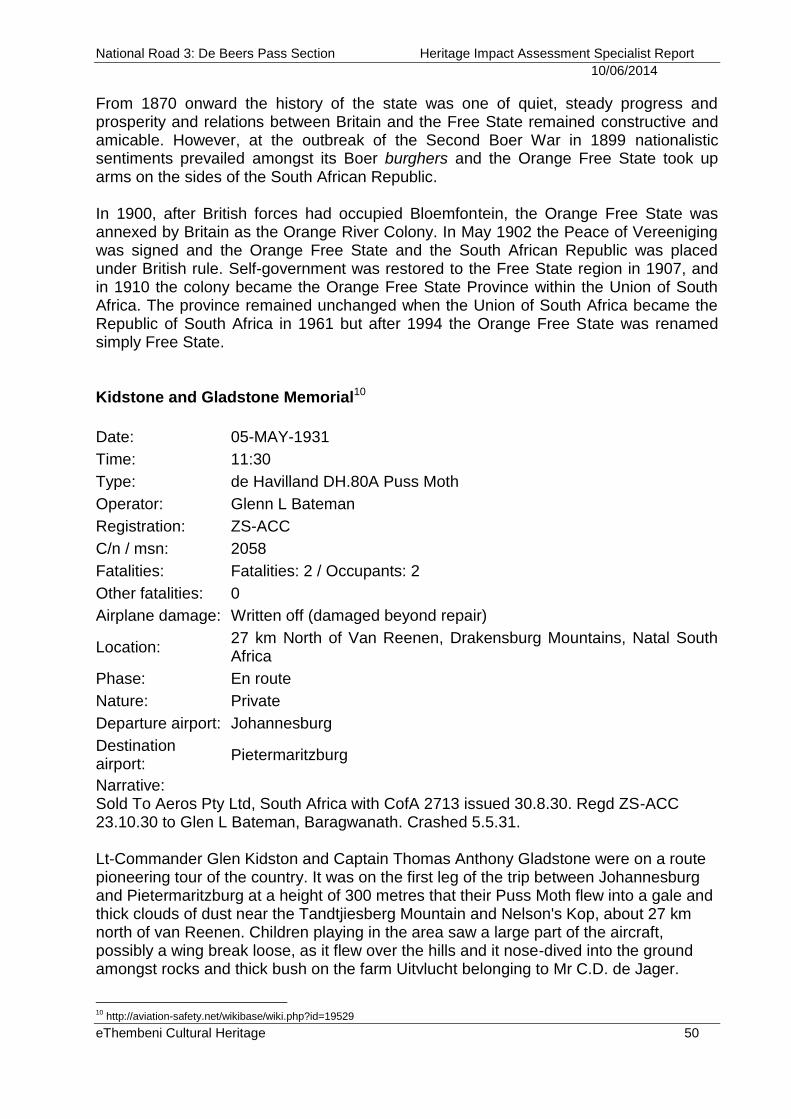
National Road 3: De Beers Pass Section Heritage Impact Assessment Specialist Report
10/06/2014
eThembeni Cultural Heritage 50
From 1870 onward the history of the state was one of quiet, steady progress and prosperity and relations between Britain and the Free State remained constructive and amicable. However, at the outbreak of the Second Boer War in 1899 nationalistic sentiments prevailed amongst its Boer burghers and the Orange Free State took up arms on the sides of the South African Republic. In 1900, after British forces had occupied Bloemfontein, the Orange Free State was annexed by Britain as the Orange River Colony. In May 1902 the Peace of Vereeniging was signed and the Orange Free State and the South African Republic was placed under British rule. Self-government was restored to the Free State region in 1907, and in 1910 the colony became the Orange Free State Province within the Union of South Africa. The province remained unchanged when the Union of South Africa became the Republic of South Africa in 1961 but after 1994 the Orange Free State was renamed simply Free State. Kidstone and Gladstone Memorial10
Date: 05-MAY-1931
Time: 11:30
Type: de Havilland DH.80A Puss Moth
Operator: Glenn L Bateman
Registration: ZS-ACC
C/n / msn: 2058
Fatalities: Fatalities: 2 / Occupants: 2
Other fatalities: 0
Airplane damage: Written off (damaged beyond repair)
Location: 27 km North of Van Reenen, Drakensburg Mountains, Natal South Africa
Phase: En route
Nature: Private
Departure airport: Johannesburg
Destination airport:
Pietermaritzburg
Narrative: Sold To Aeros Pty Ltd, South Africa with CofA 2713 issued 30.8.30. Regd ZS-ACC 23.10.30 to Glen L Bateman, Baragwanath. Crashed 5.5.31. Lt-Commander Glen Kidston and Captain Thomas Anthony Gladstone were on a route pioneering tour of the country. It was on the first leg of the trip between Johannesburg and Pietermaritzburg at a height of 300 metres that their Puss Moth flew into a gale and thick clouds of dust near the Tandtjiesberg Mountain and Nelson's Kop, about 27 km north of van Reenen. Children playing in the area saw a large part of the aircraft, possibly a wing break loose, as it flew over the hills and it nose-dived into the ground amongst rocks and thick bush on the farm Uitvlucht belonging to Mr C.D. de Jager.
10
http://aviation-safety.net/wikibase/wiki.php?id=19529
National Road 3: De Beers Pass Section Heritage Impact Assessment Specialist Report
10/06/2014
eThembeni Cultural Heritage 51
Inspection of the crash site confirmed that a wing had indeed broken free and had landed some 183m from the main wreckage. A sandstone memorial was erected to the specifications of the parents of Lt-Commander Kidston near to the crash site and stands 2.7m tall and has a stainless steel dome reflector. It stands in the exact centre of the outline of a light aircraft laid out in sandstone and the wingspan measures 31m by 31m tip to tail. The memorial is east of Harrismith and 15km from the hamlet of Swinburne on the Kiesbeen Road. Sources: Fields of Air by James Byrom http://www.dehavilland.ukf.net/p020.htm http://www.goldenyears.ukf.net/reg_ZS-.htm http://www.dehavilland.co.za/DH80A_Puss_Moth.html http://www.ab-ix.co.uk/zs-aaa.pdf Historical landscape of the Free State and KwaZulu-Natal The historical landscape of the eastern interior of South Africa has been shaped largely by the activities of farmers over the past 500 years. As described in the Iron Age section above, from around the 15th century mixed-farming communities of both Nguni and Sotho-speaking origins began to settle the area along the middle reaches of the larger river drainage basins. The ubiquitous circular and lobed stone walled settlements in this region are the archaeological evidence of these first farmers. These settlements do not occur randomly across the grasslands but are located in a regular juxtaposition of east to north-east aspect, in the protective lee of a hill or mountain with access to perennial water, a surface supply of rocks for building and colluvial soils for agriculture. Cattle were subjected to seasonal transhumance, moving with young men across the grassland biome between stock posts, in search of sweet-veld or at least palatable grazing. South facing and scarp slopes were eschewed for settlement but provided invaluable resources in the form of wood for fuel, roof laths, ox yokes and sledges. These more wooded slopes further were a source of fruit and medicinal plants. Dolerite ridges and hilltops were avoided for fear of lightning strikes. The Late Iron Age archaeology and history of black farming settlement along the eastern escarpment is under-researched and poorly documented, although it is alluded to in recorded oral histories. The stone-walled settlements are thus of considerable research value and are monuments to the expansion of African societies into the Highveld regions of the sub-continent. European farming in the region was heralded by the arrival of wagonloads of Voortrekker families on their trek from the Cape to the interior in the late 1830s. In particular, it was Gerrit Maritz and his party who are associated with this historic landscape11. Natal had always been Maritz’s aim. At Suikerbosrand, just north of the Vaal River, he turned east and south towards the Drakensberg Mountains. The Berg presented a formidable barrier, but the trekkers removed the wagons’ back wheels,
11
http://magazine.getaway.co.za/archive/wagon-maker-woema-tracking-gerrit-maritz-life-story/
National Road 3: De Beers Pass Section Heritage Impact Assessment Specialist Report
10/06/2014
eThembeni Cultural Heritage 52
attached large logs to the undercarriage and eased down the slope of what is now De Beer’s Pass. After crossing the Drakensberg, Maritz’s party travelled another 130 kilometres to the Bushmans River, a tributary of the uThukela near present-day Estcourt, where he joined up with Piet Retief’s trek. Maritz had become increasingly ill in Natal (reports suggest it was due to complications from gall stones) and was emotionally strong during this time. He comforted the mourning survivors of Retief’s trek and encouraged the remaining men with his plans for revenge. But Gerrit Maritz would never see those plans fulfilled. He died on 23 September 1838, three months before the Battle of Blood River took place, in his laager, Sooilaer (‘sooi’ after the mudwalls he used as water furrows and fortifications), on the banks of the Little uThukela River. Maritz’s exploits live on in the name of the parent farm Maritz Drift. Indeed, a perusal of the history of some of the parent farms first granted to European farmers in the area reveals the historic depth of farming in the area:
Maritz Drift 1169 Whole of 7991ac granted to Hendrik Stephanus de Beer on 1.6.1852 (perhaps the person for whom De Beers Pass is named?). Sub A of 5624ac sold to A de Lange on 10.2.1853. Rem of Maritz Drift of 2367ac sold to Emil Wilhelm van Zweil on 14 8.1868.
Paarde Kraal 1979 Whole of 3002ac granted to Christoffel J Lombaard on 1 .7.1858.
Qwaggas Drift 1258 Whole of 8119ac granted to John Combrink on 1.11.1852.
Brinley 4346 Whole of 3067 granted to Gideon Jacobus Petrus van der Schyff on 31.7.1865.
Nooitgedacht 1326 Whole of 7400acres granted to Hendrik Oostwald Howell on 1.6.1853.
Trek Boer 1002 ¼ share Rem of 38115 square foot transferred from J Wessels to Marthinus Kemp Wessels, Johanna Wilhelmina Cronje and Herbert Douglas Wessels.
Bramhoek 1220 Whole of 8036ac 2rds granted to Frederik George Scheepers on 1.10.1852.
Welkom 1310 Whole of 7650ac granted to Solomon Gerhardus Maritz on 1.2.1853. Salomon Gerhardus Maritz12 was born on 29 May 1821 at Bosjesmansrivier, Uitenhage, in the Cape Province of South Africa. His father was Johannes Stephanus Maritz and his mother Magdalena Salomina Du Preez. SG Maritz married Isabella Elizabeth Bester on 10 May 1852 and their children were Paul Michiel (born 4 September 1849 in
12
http://www.thewebsurfer.co.za/f69.htm
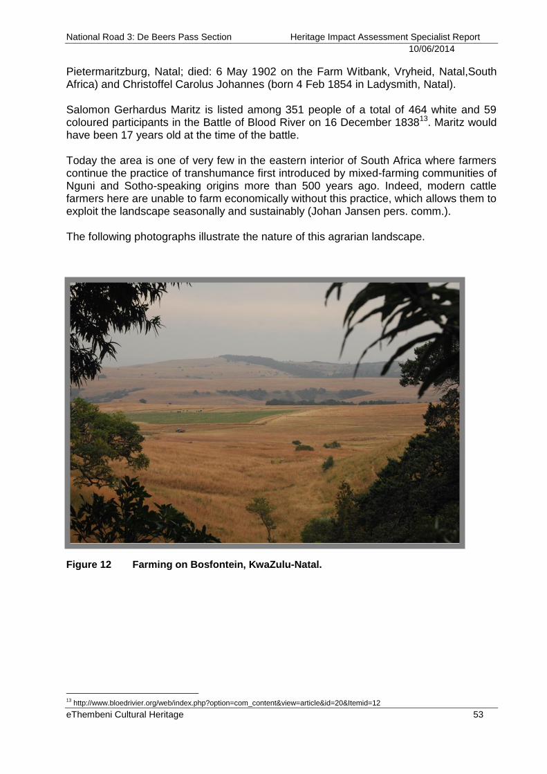
National Road 3: De Beers Pass Section Heritage Impact Assessment Specialist Report
10/06/2014
eThembeni Cultural Heritage 53
Pietermaritzburg, Natal; died: 6 May 1902 on the Farm Witbank, Vryheid, Natal,South Africa) and Christoffel Carolus Johannes (born 4 Feb 1854 in Ladysmith, Natal). Salomon Gerhardus Maritz is listed among 351 people of a total of 464 white and 59 coloured participants in the Battle of Blood River on 16 December 183813. Maritz would have been 17 years old at the time of the battle. Today the area is one of very few in the eastern interior of South Africa where farmers continue the practice of transhumance first introduced by mixed-farming communities of Nguni and Sotho-speaking origins more than 500 years ago. Indeed, modern cattle farmers here are unable to farm economically without this practice, which allows them to exploit the landscape seasonally and sustainably (Johan Jansen pers. comm.). The following photographs illustrate the nature of this agrarian landscape.
Figure 12 Farming on Bosfontein, KwaZulu-Natal.
13
http://www.bloedrivier.org/web/index.php?option=com_content&view=article&id=20&Itemid=12
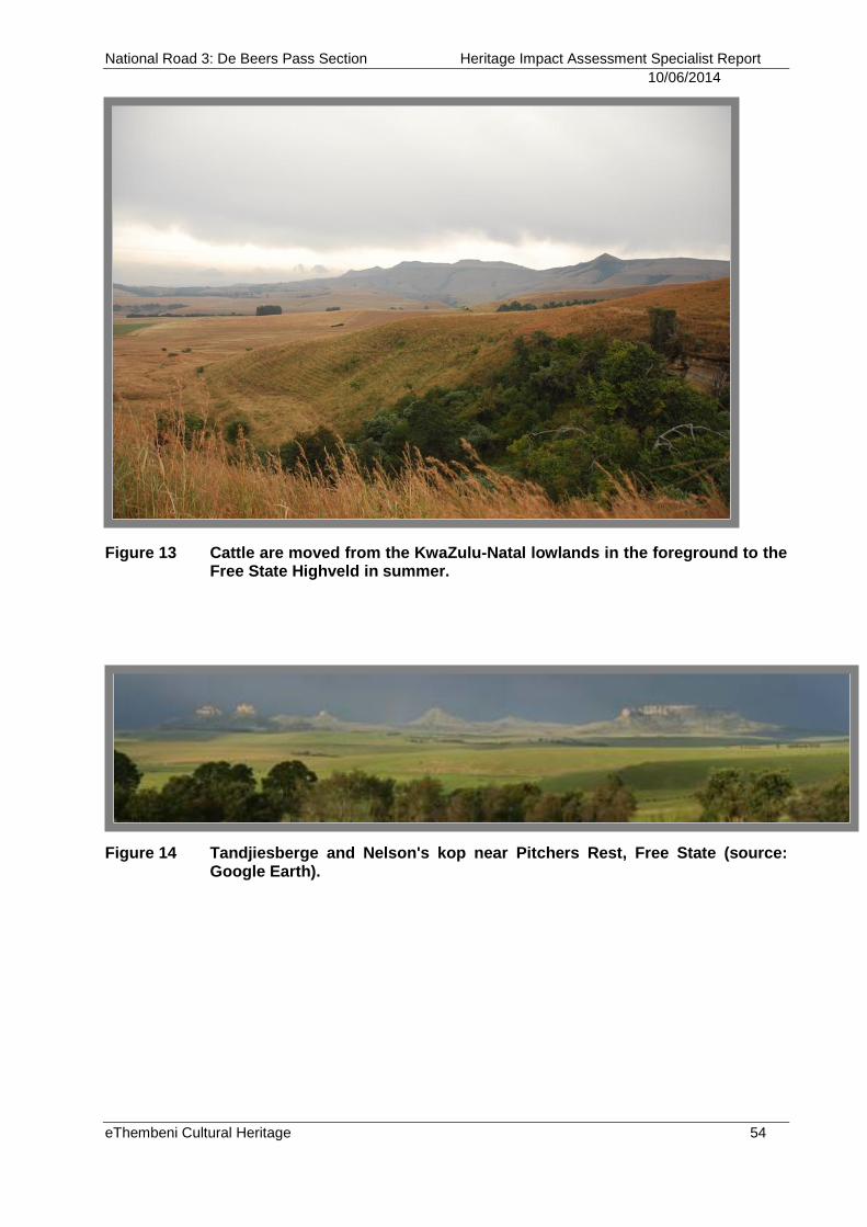
National Road 3: De Beers Pass Section Heritage Impact Assessment Specialist Report
10/06/2014
eThembeni Cultural Heritage 54
Figure 13 Cattle are moved from the KwaZulu-Natal lowlands in the foreground to the Free State Highveld in summer.
Figure 14 Tandjiesberge and Nelson's kop near Pitchers Rest, Free State (source: Google Earth).
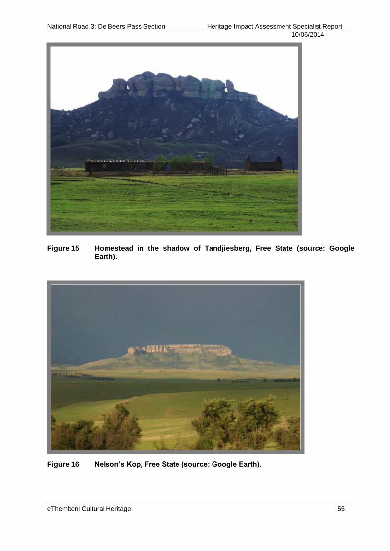
National Road 3: De Beers Pass Section Heritage Impact Assessment Specialist Report
10/06/2014
eThembeni Cultural Heritage 55
Figure 15 Homestead in the shadow of Tandjiesberg, Free State (source: Google Earth).
Figure 16 Nelson’s Kop, Free State (source: Google Earth).
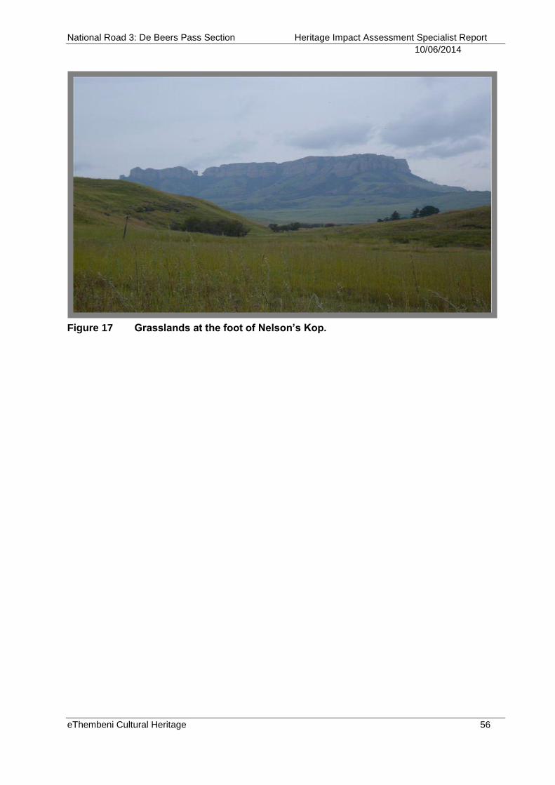
National Road 3: De Beers Pass Section Heritage Impact Assessment Specialist Report
10/06/2014
eThembeni Cultural Heritage 56
Figure 17 Grasslands at the foot of Nelson’s Kop.
National Road 3: De Beers Pass Section Heritage Impact Assessment Specialist Report
10/06/2014
eThembeni Cultural Heritage 57
APPENDIX C METHODOLOGY
Site survey eThembeni staff members inspected the area on 19 September 2007, 28 to 30 October 2008, 17 to 19 August 2010, 24 to 25 January 2011, 14 to 16 February 2011, 14 to 16 March 2011, 03 to 05 June and 28 to 29 July 2011 and May 2013. We completed controlled-exclusive surface surveys, where ‘sufficient information exists on an area to make solid and defensible assumptions and judgements about where [heritage resource] sites may and may not be’ and ‘an inspection of the surface of the ground, wherever this surface is visible, is made, with no substantial attempt to clear brush, turf, deadfall, leaves or other material that may cover the surface and with no attempt to look beneath the surface beyond the inspection of rodent burrows, cut banks and other exposures that are observed by accident’ (King 1978; see bibliography for other references informing methodological approach). We assessed an area within approximately 80 metres of existing road alignments, and 200 metres of the proposed alignments in “greenfield” areas. We have been conservative in our estimates of possible impacts on and significance of heritage resources and have consistently erred on the side of caution. Photographs were taken with a Panasonic Lumix DMC FX07 camera and a representative selection is included in this report. Geographic coordinates were obtained using a handheld Garmin GPSMAP 62S global positioning unit set at WGS 84. Database and literature review Archaeological site data was obtained from the Natal Museum and SAHRIS. A concise account of the pre and postcolonial history of the broader study area was compiled from sources including those listed in the bibliography. The current socio-economic context is based on field observations and experience. Assessment of heritage resource value and significance Heritage resources are significant only to the extent that they have public value, as implicitly demonstrated by the following guidelines for determining site significance developed by the South African Heritage Resources Agency and utilised during this assessment. Type of Significance Historical Value: It is important in the community, or pattern of history
Importance in the evolution of cultural landscapes and settlement patterns.
Importance in exhibiting density, richness or diversity of cultural features illustrating the human occupation and evolution of the nation, Province, region or locality.
Importance as an example for technical, creative, design or artistic excellence, innovation or achievement in a particular period
It has strong or special association with the life or work of a person, group or organisation of importance in history
Importance for close associations with individuals, groups or organisations whose life, works or activities have been significant within the history of the nation, Province, region or community.
National Road 3: De Beers Pass Section Heritage Impact Assessment Specialist Report
10/06/2014
eThembeni Cultural Heritage 58
Importance for a direct link to the history of slavery in South Africa.
Aesthetic Value: It is important in exhibiting particular aesthetic characteristics valued by a community or cultural group
Importance to a community for aesthetic characteristics held in high esteem or otherwise valued by the community.
Importance for its creative, design or artistic excellence, innovation or achievement.
Importance for its contribution to the aesthetic values of the setting demonstrated by a landmark quality or having impact on important vistas or otherwise contributing to the identified aesthetic qualities of the cultural environs or the natural landscape within which it is located.
In the case of an historic precinct, importance for the aesthetic character created by the individual components which collectively form a significant streetscape, townscape or cultural environment.
Scientific Value: It has potential to yield information that will contribute to an understanding of natural or cultural heritage
Importance for information contributing to a wider understanding of natural or cultural history by virtue of its use as a research site, teaching site, type locality, reference or benchmark site.
Importance for information contributing to a wider understanding of the origin of the universe or of the development of the earth.
Importance for information contributing to a wider understanding of the origin of life; the development of plant or animal species, or the biological or cultural development of hominid or human species.
Importance for its potential to yield information contributing to a wider understanding of the history of human occupation of the nation, Province, region or locality.
It is important in demonstrating a high degree of creative or technical achievement at a particular period.
Importance for its technical innovation or achievement.
Social Value: It has strong or special association with a particular community or cultural group for social, cultural or spiritual reasons
Importance as a place highly valued by a community or cultural group for reasons of social, cultural, religious, spiritual, symbolic, aesthetic or educational associations.
Importance in contributing to a community’s sense of place.
Degrees of Significance Rarity: It possesses uncommon, rare or endangered aspects of natural or cultural heritage
Importance for rare, endangered or uncommon structures, landscapes or phenomena.
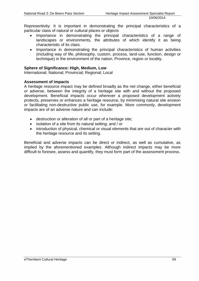
National Road 3: De Beers Pass Section Heritage Impact Assessment Specialist Report
10/06/2014
eThembeni Cultural Heritage 59
Representivity: It is important in demonstrating the principal characteristics of a particular class of natural or cultural places or objects
Importance in demonstrating the principal characteristics of a range of landscapes or environments, the attributes of which identify it as being characteristic of its class.
Importance in demonstrating the principal characteristics of human activities (including way of life, philosophy, custom, process, land-use, function, design or technique) in the environment of the nation, Province, region or locality.
Sphere of Significance: High, Medium, Low International; National; Provincial; Regional; Local Assessment of impacts A heritage resource impact may be defined broadly as the net change, either beneficial or adverse, between the integrity of a heritage site with and without the proposed development. Beneficial impacts occur wherever a proposed development actively protects, preserves or enhances a heritage resource, by minimising natural site erosion or facilitating non-destructive public use, for example. More commonly, development impacts are of an adverse nature and can include:
destruction or alteration of all or part of a heritage site;
isolation of a site from its natural setting; and / or
introduction of physical, chemical or visual elements that are out of character with the heritage resource and its setting.
Beneficial and adverse impacts can be direct or indirect, as well as cumulative, as implied by the aforementioned examples. Although indirect impacts may be more difficult to foresee, assess and quantify, they must form part of the assessment process.
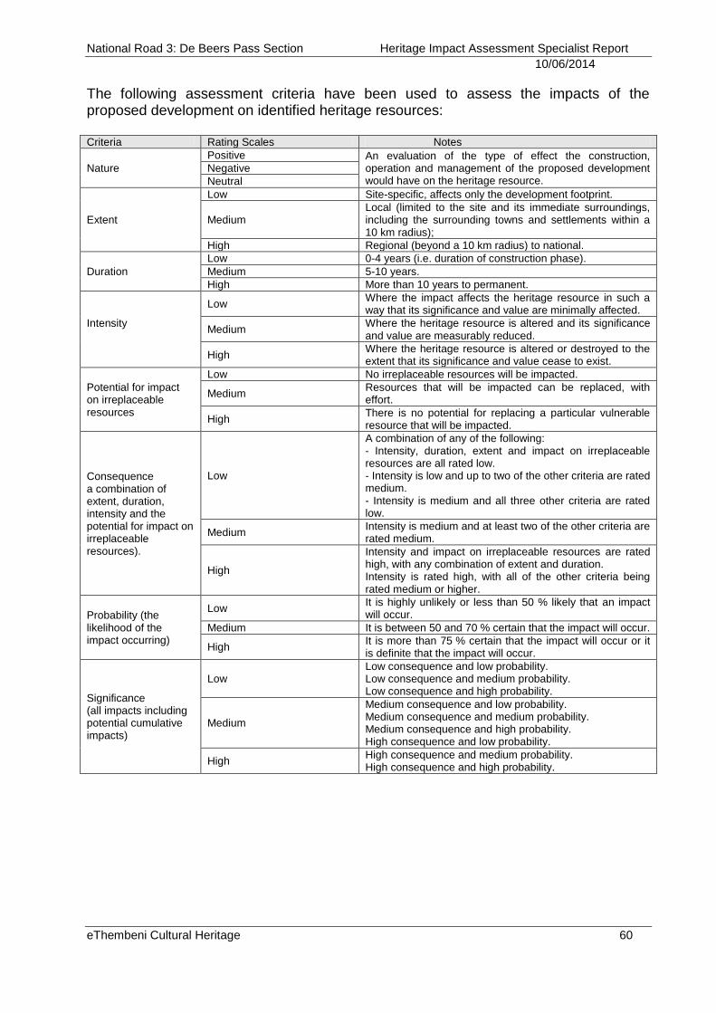
National Road 3: De Beers Pass Section Heritage Impact Assessment Specialist Report
10/06/2014
eThembeni Cultural Heritage 60
The following assessment criteria have been used to assess the impacts of the proposed development on identified heritage resources: Criteria Rating Scales Notes
Nature
Positive An evaluation of the type of effect the construction, operation and management of the proposed development would have on the heritage resource.
Negative
Neutral
Extent
Low Site-specific, affects only the development footprint.
Medium Local (limited to the site and its immediate surroundings, including the surrounding towns and settlements within a 10 km radius);
High Regional (beyond a 10 km radius) to national.
Duration
Low 0-4 years (i.e. duration of construction phase).
Medium 5-10 years.
High More than 10 years to permanent.
Intensity
Low Where the impact affects the heritage resource in such a way that its significance and value are minimally affected.
Medium Where the heritage resource is altered and its significance and value are measurably reduced.
High Where the heritage resource is altered or destroyed to the extent that its significance and value cease to exist.
Potential for impact on irreplaceable resources
Low No irreplaceable resources will be impacted.
Medium Resources that will be impacted can be replaced, with effort.
High There is no potential for replacing a particular vulnerable resource that will be impacted.
Consequence a combination of extent, duration, intensity and the potential for impact on irreplaceable resources).
Low
A combination of any of the following: - Intensity, duration, extent and impact on irreplaceable resources are all rated low. - Intensity is low and up to two of the other criteria are rated medium. - Intensity is medium and all three other criteria are rated low.
Medium Intensity is medium and at least two of the other criteria are rated medium.
High
Intensity and impact on irreplaceable resources are rated high, with any combination of extent and duration. Intensity is rated high, with all of the other criteria being rated medium or higher.
Probability (the likelihood of the impact occurring)
Low It is highly unlikely or less than 50 % likely that an impact will occur.
Medium It is between 50 and 70 % certain that the impact will occur.
High It is more than 75 % certain that the impact will occur or it is definite that the impact will occur.
Significance (all impacts including potential cumulative impacts)
Low Low consequence and low probability. Low consequence and medium probability. Low consequence and high probability.
Medium
Medium consequence and low probability. Medium consequence and medium probability. Medium consequence and high probability. High consequence and low probability.
High High consequence and medium probability. High consequence and high probability.
National Road 3: De Beers Pass Section Heritage Impact Assessment Specialist Report
10/06/2014
eThembeni Cultural Heritage 61
Assumptions and limitations of this heritage impact assessment
The description of the proposed project, provided by the client, is accurate.
The public consultation process undertaken as part of the Environmental Impact Assessment is sufficient and adequate and does not require repetition as part of the HIA. However, we did speak to landowners where possible.
Soil surface visibility was moderate overall. Heritage resources might be present below the surface or in areas of dense vegetation and we remind the client that the Act requires that a developer cease all work immediately and follow the protocol in Section 11 should any heritage resources be discovered during the course of development activities.
No subsurface investigation (including excavations or sampling) were undertaken, since a permit from SAHRA or Amafa is required to disturb a heritage resource.
A key concept in the management of heritage resources is that of non-renewability: damage to or destruction of most resources, including that caused by bona fide research endeavours, cannot be reversed or undone. Accordingly, management recommendations for heritage resources in the context of development are as conservative as possible.
Human sciences are necessarily both subjective and objective in nature. eThembeni staff members strive to manage heritage resources to the highest standards in accordance with national and international best practice, but recognise that their opinions might differ from those of other heritage practitioners.
Staff members involved in this project have no vested interest in it; are qualified to undertake the tasks as described in the terms of reference (see Appendix E); and comply at all times with the Codes of Ethics and Conduct of ASAPA.
eThembeni staff members take no personal or professional responsibility for the misuse of the information contained in this report, but take all reasonable measures to prevent such misuse.
National Road 3: De Beers Pass Section Heritage Impact Assessment Specialist Report
10/06/2014
eThembeni Cultural Heritage 62
APPENDIX D LANDSCAPES
Cultural landscapes have been defined by the UNESCO World Heritage Committee as distinct geographical areas or properties uniquely representing the combined work of nature and of man. This concept has been adapted and developed within international heritage arenas as part of an international effort to reconcile one of the most pervasive dualisms in Western thought - that of nature and culture. The World Heritage Committee has identified and adopted three categories of cultural landscape.
The most easily identifiable is the clearly defined landscape designed and created intentionally by man. This embraces garden and parkland landscapes constructed for aesthetic reasons which are often (but not always) associated with religious or other monumental buildings and ensembles. The second category is the organically evolved landscape. This results from an initial social, economic, administrative, and/or religious imperative and has developed its present form by association with and in response to its natural environment. Such landscapes reflect that process of evolution in their form and component features. They fall into two sub-categories:
A relict (or fossil) landscape is one in which an evolutionary process came to an end at some time in the past, either abruptly or over a period. Its significant distinguishing features are, however, still visible in material form.
Continuing landscape is one which retains an active social role in contemporary society closely associated with the traditional way of life, and in which the evolutionary process is still in progress. At the same time it exhibits significant material evidence of its evolution over time.
The final category is the associative cultural landscape. The inclusion of such landscapes on the World Heritage List is justifiable by virtue of the powerful religious, artistic or cultural associations of the natural element rather than material cultural evidence, which may be insignificant or even absent.
Within academia, any system of interaction between human activity and natural habitat is regarded as a cultural landscape. In a sense this understanding is broader than the definition applied within UNESCO, including, as it does, almost the whole of the world's occupied surface, plus almost all the uses, ecologies, interactions, practices, beliefs, concepts, and traditions of people living within cultural landscapes.
National Road 3: De Beers Pass Section Heritage Impact Assessment Specialist Report
10/06/2014
eThembeni Cultural Heritage 63
Sense of place14
Tuan (1980, 199015) has argued that a place comes into existence when humans give meaning to a part of the larger, undifferentiated space. Whenever a location is identified or given a name, it is separated from the undefined space that surrounds it. Some places, however, have been given stronger meanings, names or definitions by society than others, and are said to have a strong ‘sense of place’.
Such places have a strong identity and character that is deeply felt by local inhabitants and by many visitors. Sense of place is a social phenomenon that exists independently of any one individual's perceptions or experiences, yet is dependent on human engagement for its existence. Such a feeling may be derived from the natural environment, but is more often made up of a mix of natural and cultural features in the landscape, and generally includes the people who occupy the place. The sense of place may be strongly enhanced by the place being written about by poets, novelists and historians, or portrayed in art or music, and more recently, through modes of codification aimed at protecting, preserving and enhancing places felt to be of value (such as UNESCO World Heritage Sites, British ‘Areas of Outstanding Natural Beauty’ and American ‘National Historic Landmarks’). In South Africa legislation permits the creation and protection of various landscapes, including Natural Heritage Sites, conservancies, Protected Areas and Heritage Areas.
Places that lack a sense of place are sometimes referred to as ‘placeless’ or ‘inauthentic’. Placeless landscapes are those that have no special relationship to the places in which they are located; they could be anywhere. Roadside strip shopping malls, fuel stations and convenience stores, fast food chains, and chain department stores are often cited as examples of placeless landscape elements. Even historic sites or districts that have been heavily commercialized for tourism and new housing estates are considered as having lost their sense of place.
Spirit of place16
Spirit of place refers to the unique, distinctive and cherished aspects of a place; often those celebrated by artists and writers, but also those cherished in folk tales, festivals and celebrations. It is thus as much in the invisible, intangible weave of culture (stories, art, memories, beliefs, histories, etc.) as it is the tangible physical aspects of a place (monuments, boundaries, rivers, woods, architectural style, rural craft styles, pathways, views, and so on) or its interpersonal aspects (the presence of relatives, friends and kindred spirits, and the like).
Often the term is applied to a rural or a relatively unspoiled or regenerated place — whereas the very similar term sense of place would tend to be more domestic, urban, or suburban in tone. For instance, one could logically apply 'sense of place' to an urban high street; noting the architecture, the width of the roads and pavements, the plantings,
14
http://en.wikipedia.org/ 15
Tuan, Yi-Fu (1980). Landscapes of Fear. Oxford: Basil Blackwell. Tuan, Yi Fu. 1990. Topophilia: A Study of Environmental Perception, Attitudes and Values. New York: Columbia University Press. 16
http://en.wikipedia.org/wiki/Spirit_of_place
National Road 3: De Beers Pass Section Heritage Impact Assessment Specialist Report
10/06/2014
eThembeni Cultural Heritage 64
the style of the shop-fronts, the street furniture, and so on, but one could not really talk about the 'spirit of place' of such an essentially urban and commercial environment. It must be noted, however, that an urban area that looks faceless or neglected to an adult may have deep meaning in children's street culture.
The Roman term for spirit of place was genius loci, by which it is sometimes still referred. This has often been historically envisaged as a guardian animal or a small supernatural being (puck, fairy, elf, and the like) or a ghost. These beliefs have, for the most part, been discarded in the modern world; however a new layer of less-embodied superstition on the subject has arisen around ley lines, feng shui and similar concepts.
Many indigenous and tribal cultures around the world are deeply concerned with spirits of place in their landscape. Spirits of place are explicitly recognized by some of the worlds main religions: Shinto has its Kami which may incorporate spirits of place; Christianity has spirits of place in the Angelic Choirs of Dominions and Principalities;and Hinduism, Vajrayana and Bonpo traditions. The numinous spirits of places in Asia are still honored today in city pillar shrines, outdoor spirit houses and indoor household and business shrines.
National Road 3: De Beers Pass Section Heritage Impact Assessment Specialist Report
10/06/2014
eThembeni Cultural Heritage 65
APPENDIX E SPECIALIST COMPETENCY
Len van Schalkwyk is accredited by the Cultural Resources Management section of ASAPA to undertake Heritage Impact Assessments in South Africa. He currently serves on the ASAPA Council. Mr van Schalkwyk has a master’s degree in archaeology (specialising in the history of early farmers in southern Africa) from the University of Cape Town and 25 years’ experience in heritage management. He has worked on projects as diverse as the establishment of the Ondini Cultural Museum in Ulundi, the cultural management of Chobe National Park in Botswana, various archaeological excavations (notably the Iron Age site of Ndondondwane in the Thukela Valley) and oral history recording projects. He was part of the writing team that produced the KwaZulu-Natal Heritage Act 1997. He has worked with many rural communities to establish integrated heritage and land use plans and speaks good Zulu. Mr van Schalkwyk left his position as assistant director of Amafa aKwaZulu-Natali, the provincial heritage management authority, to start eThembeni in partnership with Elizabeth Wahl, who was head of archaeology at Amafa at the time. Over the past decade they have undertaken almost 1000 heritage impact assessments throughout South Africa, as well as in Mozambique. Elizabeth Wahl has a BA Honours in African Studies from the University of Cape Town and has completed various Masters courses in Heritage and Tourism at the University of KwaZulu-Natal. She is currently studying for an MPhil in the Conservation of the Built Environment at UCT, and is also a member of ASAPA. Ms Wahl was an excavator and logistical coordinator for Glasgow University Archaeological Research Division’s heritage programme at Isandlwana Battlefield; has undertaken numerous rock painting surveys in the uKhahlamba/Drakensberg Mountains, northern KwaZulu-Natal, the Cederberg and the Koue Bokkeveld in the Cape Province; and was the principal excavator of Scorpion Shelter in the Cape Province, and Lenjane and Crystal Shelters in KwaZulu-Natal. Ms Wahl compiled the first cultural landscape management plan for the Mnweni Valley, northern uKhahlamba/Drakensberg, and undertook an assessment of and made recommendations for heritage resource databases and organisational capacity in parts of Lesotho and South Africa for the Global Environment Facility of the World Bank for the Maloti Drakensberg Transfrontier Conservation and Development Area. She developed the first cultural heritage management plan for the uKhahlamba Drakensberg Park World Heritage Site, following UNESCO recommendations for rock art management in southern Africa.