environmental impact assessment for rumichaca … · environmental impact assessment for rumichaca...
TRANSCRIPT
ENVIRONMENTAL IMPACT ASSESSMENT FOR RUMICHACA - PASTO'S DUAL
CARRIAGE WAY PROJECT, PEDREGAL - CATAMBUCO SPAN, FU. 4 AND FU. 5.1, CONCESSION CONTRACT UNDER PUBLIC-PRIVATE PARTNERSHIP SCHEME (PPP)
NUMBER 15, FROM 2015.
Géminis Consultores Ambientales SAS
Chapter 2. GENERAL CONSIDERATIONS
ENVIRONMENTAL IMPACT ASSESSMENT
CSH-4-AM-AM-EIA2-G-G-0013-7
March, 2017
Page 1
San Juan de Pasto, March 2017
TABLE OF CONTENTS 2. GENERAL CONSIDERATIONS ............................................................................................................ 5
2.1 Background...................................................................................................................................... 9 2.1.1. Justification 9 2.1.2. Background for the Rumichaca - Pasto Dual Carriageway Project ......... 11 2.1.3. Preliminary studies 13 2.1.4. Lifting of closures 14 2.1.5. Proceedings before Entities 14 2.1.6. Proceedings for the identification of areas for the National System for Protected Areas (SINAP), the Regional System for Protected Areas (SIRAP), and others 29 2.1.7. Strategic ecosystems and sensitive environmental areas ............... 32 2.1.8. Certifications 33 2.1.9. Exploitation of material sources 37 2.1.10. Administrative act related to the study permit for the collection of wildlife specimens 37 2.1.5. Implications of the project with other projects in the region ........ 38
2.2. Scope ............................................................................................................................................... 41 2.2.1. Scope 42 2.2.2 Limitations and/or restrictions 43 2.2.2. Information gaps 43
2.3. Methodology ................................................................................................................................ 44 2.3.1. Definition of project's area of influence 46 2.3.2. Characterization of Area of Influence 47 2.3.2.1. Abiotic Component 47
ENVIRONMENTAL IMPACT ASSESSMENT
CSH-4-AM-AM-EIA2-G-G-0013-7
March, 2017
Page 2
o Post-field Phase 63 2.3.2.2. Biotic Component 99 2.3.2.3. Socioeconomic Component 174 2.3.2.4. Environmental Zoning 183 2.3.2.5. Cartography work 184
2.4. Consultant information............................................................................................................... 190
TABLES' INDEX
Table 2.1. Functional Units for Rumichaca - Pasto's Dual Carriageway Project, Pedregal - Catambuco Span, Concession contact under PPP Scheme Number 15, from 2015 .............. 7 Table 2.2 Licensing file which is the responsibility of ANLA, on projects taking place in the province of Nariño................................................................................................................................. 21 Table 2.3 Licensing file which is the responsibility of ANLA, on Infrastructure projects taking place in Nariño .................................................................................................................................. 26 Table 2.4 Classification of slope ranges ............................................................................................... 52 Table 2.5 GOD system valuation table .................................................................................................. 57 Table 2.6 Analysis units by component used to obtain geotechnical information for the project ................................................................................................................................................................ 59 Table 2.7. Geological Units ......................................................................................................................... 59 Table 2.8. Soil texture .................................................................................................................................. 60 Table 2.9. Terrain slopes ............................................................................................................................ 61 Table .2.10 Topography .............................................................................................................................. 61 Table 2.11 Hydrological regime and characteristic flows from the main currents ........... 66 Table 2.12 Water monitoring methodology ....................................................................................... 73 Table 2.13 Meteorological stations in the assessment area ........................................................ 75 Table 2.14 Proposed coordinates for the location of air quality stations .............................. 77 Table 2.15 General characteristics of assessed parameters. ....................................................... 78 Table 2.16 Hi-Vol PST Technical specifications ................................................................................ 80 Table 2.17 Hi-Vol PM10 technical specifications. ............................................................................ 81 Table 2.18 Technical specifications for the 3-gases sampler. ..................................................... 84
ENVIRONMENTAL IMPACT ASSESSMENT
CSH-4-AM-AM-EIA2-G-G-0013-7
March, 2017
Page 3
Table 2.19 Technical specifications for the 3-gases sampler. ..................................................... 90 Table 2.20 Noise omission assessment ................................................................................................ 94 Table 2.21 Environmental emission assessment ............................................................................. 95 Table 2.22 Sonometer characteristics .................................................................................................. 96 Table 2.23 Noise descriptors .................................................................................................................... 98 Table 2.24 Analysis of statistical values ............................................................................................... 98 Table 2.25 date to be recorded for epiphytes sampling land plots. ...................................... 123 Table 2.26 Covers to be sampled per functional unit .................................................................. 133 Table 2.27 Cover area and proportion, functional unit four (UF4) ....................................... 139 Table 2.28 Cover area and proportion, functional unit five (UF5.1) ..................................... 142 Table 2.29 Geographical distribution of applied surveys in each municipality part of UF4 and UF5.1 ....................................................................................................................................................... 143 Table 2.30 Sampling effort per method ............................................................................................ 159 Table 2.31 Companies responsible for sampling analysis......................................................... 165 Table 2.32. Territorial Units at the Socioeconomic Area of Influence .................................. 178 Table 2.33. Below, proposed stages and dates for the pre-consultation process with indigenous councils from Montaña de Fuego and Catambuco ................................................ 182 Table 2.34. Below, proposed stages and dates for the pre-consultation process with indigenous councils from Catambuco ................................................................................................ 183 Table 2.35. Consultant and group of professionals ...................................................................... 190
FIGURES' INDEX Figure 2.1. Location of Rumichaca-Pasto's Dual Carriageway Project, ...................................... 8 Figure 2.2. Sampling scheme for the quick inventory methodology ..................................... 102 Figure 2.3. Sample collection of land vegetation ........................................................................... 109 Figure 2.4. Sample collection of land vegetation ........................................................................... 110 Figure 2.5. Epiphyte characterization land plot scheme. ........................................................... 115 Figure 2.6. Vertical stratification of phorophytes. ........................................................................ 116 Figure 2.7information gathering form model to be used for forestry species .................. 129 Figure 2.8. Vegetation cover map, current use of soil with distribution of wildlife species for Pedregal-Catambuco's FU4. Sampling Points .......................................................................... 136 Figure 2.9 Vegetation cover map, current use of soil with distribution of wildlife species for Pedregal-Catambuco's FU5. Sampling points .......................................................................... 137 Figure 2.10. Mist nets and components ............................................................................................ 150

ENVIRONMENTAL IMPACT ASSESSMENT
CSH-4-AM-AM-EIA2-G-G-0013-7
March, 2017
Page 4
Figure 2.11. Sampling grid ...................................................................................................................... 154 Figure 2.12 Pre-field phase activities ................................................................................................. 167 Figure 2.13 Field stage activities ......................................................................................................... 168 Figure 22..14 F-54 Format. Registering points taken in the field – GPS .............................. 187 Figure 2.15 Organization and content of GDB for base cartography .................................... 188 Figure 2.16 Organization and content of GDB for thematic cartography ........................... 189
PHOTOGRAPHS' INDEX
Photograph 2.1 High-volume sampler (Hi-Vol) for PST. ............................................................... 81 Photograph 2.2 High-volume sampler (Hi-Vol) for PM10. ........................................................... 82 Photograph 2.3 3-gases sampler ............................................................................................................. 85 Photograph 2.4 CO2 measurement equipment................................................................................. 88 Photograph 2.5 NO" measurement equipment for fixed sources.............................................. 89 Photograph 2.6 Sonometer Sound Pro SE/DL ................................................................................... 93 Photograph 2.7 QC-10 Calibrator ........................................................................................................... 94 Photograph 2.8. Methodology to identify and record nonvascular epiphytes on phorophytes.................................................................................................................................................. 117 Photograph 2.9. Methodology to gather nonvascular epiphytes ............................................ 118 Photograph 2.10. Methodology to gather vascular epiphytes ................................................. 119 Photograph 2.11. Gathering of vascular epiphytes samples .................................................... 120 Photograph 2.12. Readying of vascular epiphytes samples taken in the field .................. 120 Photograph 2.13. Methodology to collect lithophytes on talusses ....................................... 122 Photograph 2.14. Taxonomic determination of samples, equipment and working material ............................................................................................................................................................................ 123 Photograph 2.15 Artificialized Territories (AAN) ........................................................................ 134 Photograph 2.16. Agricultural Territories (AAB) ......................................................................... 134 Photograph 2.17. Semi-natural areas and forests (AME) .......................................................... 135 Photograph 2.18 Pan shot of assessment sampling area UF4, Pedregal-Catambuco span Coordinates (1.068251; -77.418839) ................................................................................................ 138 Photograph 2.19 Pan shot of main covers in the assessment area, UF4 sampling point. Coordinates (1.068304; -77.417643) ................................................................................................ 140 Photograph 2.20 Pan shot of RUMICHACA - PASTO's DUAL CARRIAGE WAY PROJECT, PEDREGAL - CATAMBUCO SPAN, sampling point for FU5. Coordinates (1,132397; -77,352368) .................................................................................................................................................... 141
ENVIRONMENTAL IMPACT ASSESSMENT
CSH-4-AM-AM-EIA2-G-G-0013-7
March, 2017
Page 5
Photograph 2.21 Pan shot of main covers in the assessment area, UF5 sampling point. Pedregal-Catambuco Span, Coordinates (1,132397; -77,352368) ........................................ 142 Photograph 2.22 . Free search for herpetofauna........................................................................... 148 Photograph 2.23. Herpetological hook used to search for herpetofauna and catch snakes ............................................................................................................................................................................ 149 Photograph 2.24. Bird captured by mist net ................................................................................... 151 Photograph 2.25. Deployment of Sherman traps to capture a small mammals ............... 153 Photograph 2.26. Deployment of Tomahawk trap to capture small and midsized mammals ........................................................................................................................................................ 155 Photograph 2.27 Camera traps deployed in the assessment area ......................................... 156 Photograph 2.28. Surveys with local inhabitants ......................................................................... 156 Photograph 2.29 Sacrificing, preparing and preserving herpetofauna ............................... 158 Photograph 2.30 Mamalian fauna sacrifice and preservation ................................................. 159 Photograph 2.31 Methodology used for water macro-invertebrates ................................... 169 Photograph 2.32 Methodology used for fish. .................................................................................. 170 Photograph 2.33 Methodology used for Plankton ........................................................................ 172 Photograph 2.34 Periphyton Methodology ..................................................................................... 173
2. GENERAL CONSIDERATIONS The Environment Ministry is created by means of law 99, from 1993. This law is also issued to reorganize the Public Sector Institutions charged with managing and preserving the environment and renewable natural resources, as well as organizing the Environmental National System (SINA). Other dispositions are also decreed by means of this law.
ENVIRONMENTAL IMPACT ASSESSMENT
CSH-4-AM-AM-EIA2-G-G-0013-7
March, 2017
Page 6
Decree 2041 from 2014 governs Section VIII, related to Environmental Licenses, of law 99, from 1993. The Environment and Sustainable Development Ministry issued a sole decree regulating the environment and sustainable development sector, Decree 1076, from 2015. Rumichaca - Pasto's dual carriageway project, Pedregal - Catambuco Span, Concession contact under PPP SCHEME NUMBER 15, from 2015, requires an Environmental License issued by the Environmental License National Authority (ANLA) for its execution, as established by Decree 2041, from 2014. Therefore, the Environmental Impact Assessment for Rumichaca - Pasto's Dual Carriageway Project, Pedregal - Catambuco Span, Concession Contract Under Public-Private Partnership Scheme (PPP) NUMBER 15, FROM 2015, is submitted before ANLA, which is structured and based on the current and valid terms of reference in order to produce the Environmental Impact Assessment related to the construction of roads and/or tunnels, including the access ramps, as established by resolution 0751, from March 26, 2015. The Dual Carriageway Project, Rumichaca - Pasto, Road Concession, is considered a fourth Generation concession, under the scheme of Public–Private Partnership projects (PPP), pursuant to concession contracts stipulated by Law 80, from 1993, by means of which the general contracting statute for the Civil Service is issued, Article 32, Item 4, which in turn allows the use of private capital in processes which aim to provide public goods and their related services, pursuant to article 2, law 1508 from 2012. The road span taken into consideration for this assessment shall be executed in the province of Nariño, starting from the settlement of Pilcuan, kilometer marker 00+000, at coordinates N 606679,90- E 957013,40, up to Catambuco, at kilometer marker 37+959, at coordinates N 623684,62- E 977560,70; reporting a length of 37.96 km, its last 60 meters (m.) Corresponding to an access ramp at the township of Catambuco, where work to reposition it will take place. Rumichaca - Pasto's Dual Carriageway Project, Pedregal - Catambuco Span, Concession Contract Under Public-Private Partnership Scheme (PPP) Number 15, is divided into two functional units (UF), based on designs carried out beforehand ANI, pursuant to recommendations from National Advisory on Politics, Economics, and Social Issues (CONPES) 3820, to apply a functional unit structure to second wave projects, as
ENVIRONMENTAL IMPACT ASSESSMENT
CSH-4-AM-AM-EIA2-G-G-0013-7
March, 2017
Page 7
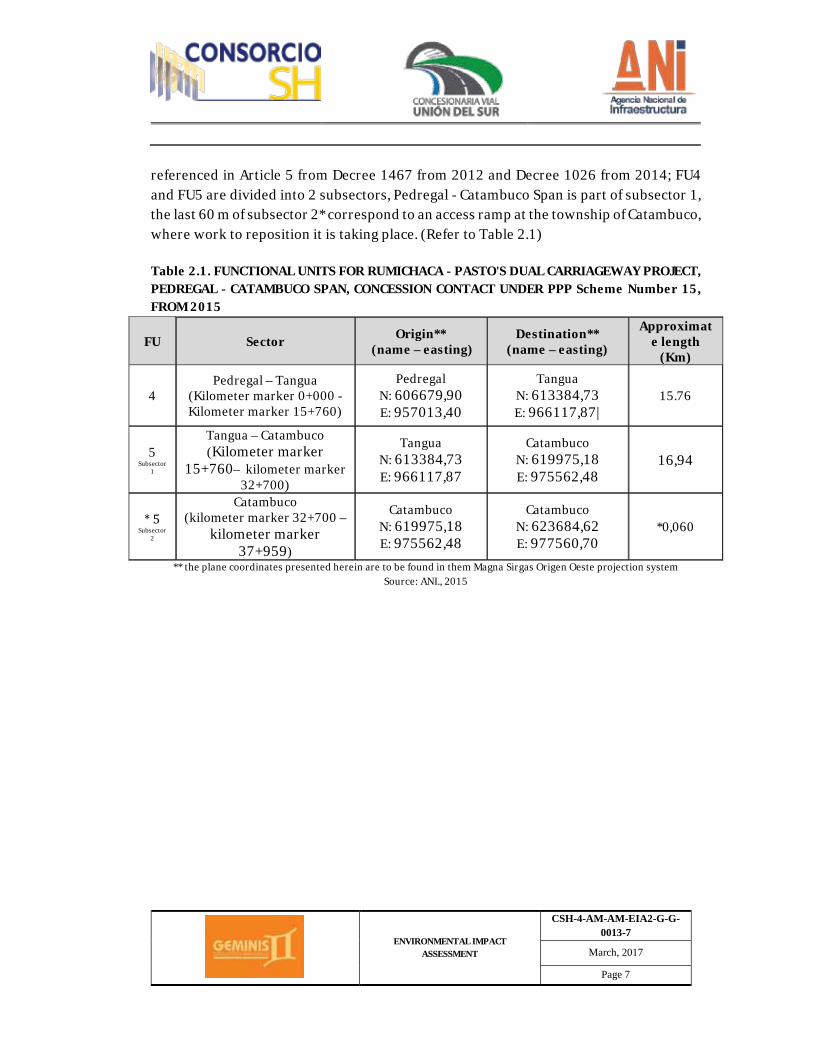
referenced in Article 5 from Decree 1467 from 2012 and Decree 1026 from 2014; FU4 and FU5 are divided into 2 subsectors, Pedregal - Catambuco Span is part of subsector 1, the last 60 m of subsector 2* correspond to an access ramp at the township of Catambuco, where work to reposition it is taking place. (Refer to Table 2.1) Table 2.1. FUNCTIONAL UNITS FOR RUMICHACA - PASTO'S DUAL CARRIAGEWAY PROJECT, PEDREGAL - CATAMBUCO SPAN, CONCESSION CONTACT UNDER PPP Scheme Number 15, FROM 2015
FU Sector Origin** (name – easting)
Destination** (name – easting)
Approximate length
(Km)
4 Pedregal – Tangua
(Kilometer marker 0+000 -Kilometer marker 15+760)
Pedregal N: 606679,90 E: 957013,40
Tangua N: 613384,73 E: 966117,87|
15.76
5 Subsector
1
Tangua – Catambuco (Kilometer marker
15+760– kilometer marker 32+700)
Tangua N: 613384,73 E: 966117,87
Catambuco N: 619975,18 E: 975562,48
16,94
* 5 Subsector
2
Catambuco (kilometer marker 32+700 –
kilometer marker 37+959)
Catambuco N: 619975,18 E: 975562,48
Catambuco N: 623684,62 E: 977560,70
*0,060
** the plane coordinates presented herein are to be found in them Magna Sirgas Origen Oeste projection system Source: ANI., 2015
ENVIRONMENTAL IMPACT ASSESSMENT
CSH-4-AM-AM-EIA2-G-G-0013-7
March, 2017
Page 8
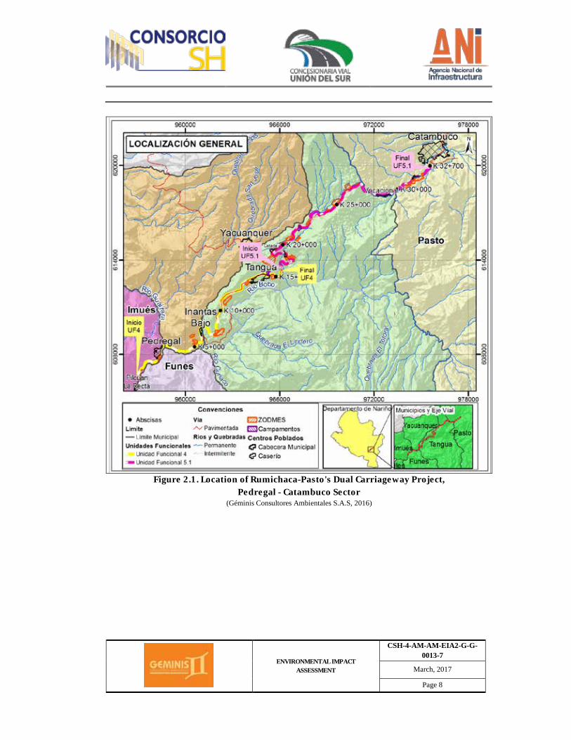
Figure 2.1. Location of Rumichaca-Pasto's Dual Carriageway Project,
Pedregal - Catambuco Sector (Géminis Consultores Ambientales S.A.S, 2016)
ENVIRONMENTAL IMPACT ASSESSMENT
CSH-4-AM-AM-EIA2-G-G-0013-7
March, 2017
Page 9
2.1 Background
2.1.1. Justification Transportation infrastructure has been acknowledged as a growth strategy as it is a means to generate employment and revitalize the economy through its links with connecting activities. This activity also increases productivity, strengthens competitiveness in international markets, improves availability, quality and price of goods and services, reduces transportation costs and generates social and regional impact. By acknowledging the aforementioned facts, the National Development Plan (PND) 2010 – 2014, Prosperity for All, defines transportation policy elements aiming to assist integral planning processes and the development of programs which provide an answer to the productive and sectorial initiatives through regional integration and the adoption of new and improved financing mechanisms. Based on the guidelines emanating from the National Advisory on Politics, Economics, and Social Issues (CONPES) documents, the National Infrastructure Agency (ANI) is going ahead with the structuring of a group of projects which cover the connectivity needs of the country, as identified through several sector-related planning exercises, and aligned to the formulation of the Transportation Master Plan, led by DNP in 2010. This plan established the improvement needs of around 4800 km of roads, pavement needs of 3500 km and the enhancement to dual carriageways of about 3200 km of roads. Additionally, it identified the need to implement mechanisms to integrally maintain roads, in the mid and long-term for the entire national road network. Rumichaca - Pasto's Dual Carriageway Project, Pedregal - Catambuco Span, Concession Contract Under Public-Private Partnership Scheme (PPP) NUMBER 15, FROM 2015, is structured within the corridors that comprise the Second Wave group from the Fourth-Generation Road Concession program being undertaken in the provinces of Atlántico, Bolívar, Boyacá, Casanare, Cauca, Cundinamarca, Huila, Meta, Nariño, Putumayo, Santander, Sucre and Tolima. The general purpose behind such projects is to develop primary roads under geometric, speed and safety specifications that ensure mobility and connectivity amongst them, such roads will also help promote productive sectors within the impacted areas.
ENVIRONMENTAL IMPACT ASSESSMENT
CSH-4-AM-AM-EIA2-G-G-0013-7
March, 2017
Page 10
Taking into consideration its objectives, the fourth-generation road concession program contributes to the development of regions with touristic, agrarian, mining and energy generation potential, such as the areas being impacted by the Neiva-Girardot, Santana-Neiva, Villavicencio-Yopal and Bucaramanga-Barrancabermeja projects. Such projects are also impacting areas with a high agrarian and touristic vocation by means of projects such as Rumichaca-Pasto, Popayán-Santander de Quilichao, Puerta de Hierro-Palmar and Transversal de Sisga. Rumichaca-Pasto's project, besides connecting the main cities in the southern part of the country, constitutes an international axis which brings together Colombia and Ecuador, enabling commercial exchange and improving the living conditions of the region's inhabitants. The existing road between Rumichaca - Pasto, whose length has been estimated, from origin to destination, to be 83.5 km, consists of a single, bidirectional, carriageway, comprising two lanes with a width of 3.65 m and a road shoulder which goes from 0.50 and 1.00 m approximately, on a terrain that is rugged and undulating. The municipalities around the existing road corridor are: Ipiales, Contadero, Iles, Imués, Tangua, Yacuanquer and Pasto. The construction of the second carriageway between Pedregal and Pasto is part of Route 25, coded by the National Road Institute (INVIAS) in the national road network as "Regional Nariño". Rumichaca - Pasto's Dual Carriageway Project, Pedregal - Catambuco Span, Concession Contract Under Public-Private Partnership Scheme (PPP) NUMBER 15, FROM 2015, has a main purpose, which is to turn the existing infrastructure into a dual carriageway with high specifications, which not only improves the speed and safety conditions of its users, but also contributes to the productive and social development of the region, as well as improving the means of communication in the country's southeastern area, between Cali, Popayán, Pasto and our border with Ecuador.
ENVIRONMENTAL IMPACT ASSESSMENT
CSH-4-AM-AM-EIA2-G-G-0013-7
March, 2017
Page 11
2.1.2. Background for the Rumichaca - Pasto Dual Carriageway Project Therefore, based on the PND from 2010 – 2014, prosperity for all, which incentivizes the participation of the private sector in the development of both productive and social infrastructure required by the country, law 1508 from 2012 was issued, as well as its regulating decrees 1467 and 2294 from 2012; 1610 from 2013; and 1553 and 2043 from 2014, by means of which the legal regime for Public–Private Partnerships (PPP) is established, the organic budgetary standards are dictated and applicable development tools for the PPPs are defined under a new regulatory framework which details the selection and contracting procedures for private investors. The aforementioned governs the Fourth-Generation Road Concession Program (4G) and provides the highest national authority for economic and social planning, The National Advisory on Politics, Economics, and Social Issues (CONPES) with guidelines, to formulate COMPES document number 3760 from 2013, as follows: "Road projects under the scheme of Public–Private Partnerships: Fourth-Generation Road Concessions". As part of the management activities for the Rumichaca - Pasto's Dual Carriageway Project, Pedregal - Catambuco Span, Concession Contract Under Public-Private Partnership Scheme (PPP) NUMBER 15, FROM 2015, before the concession contract is signed, ANI, by means of communication identified with serial number 4120-E1-25764, from June 20, 2013, requested from ANLA that a NDA file be opened and the terms of the production of an environmental impact assessment be issued; as it was argued that an Environmental Alternative Diagnosis (DAA) was not required, reason why an official opinion from the entity was requested. (Refer to Appendix 2.1.2.a.) On this regard, ANLA, by means of official document dated September 8, 2016, based on technical opinion 3377 from August 6, 2013, produced an opinion on the unnecessary DAA; which dictated that ANI was responsible for the submittal of the referred Project's Environmental Impact Assessment. (Refer to Appendix 2.1.2.a.) CONPES document 3760 from 2013 sets forth policy guidelines for the 4G program, which shall be used while structuring, contracting and executing road corridor projects, pursuant to principles stipulated by Law 1508 from 2012, which focuses on a greater maturity of the preliminary technical, environmental, social, legal and financial studies for each project; the disbursement of public resources being dependent on infrastructure availability and compliance to service levels and quality standards; improved risk
ENVIRONMENTAL IMPACT ASSESSMENT
CSH-4-AM-AM-EIA2-G-G-0013-7
March, 2017
Page 12
identification, distribution and retribution criteria; and the incorporation of new legal tools for the alternative resolution of conflicts as provided by law; amongst other aspects. Subsequently, by means of CONPES document 3820 from 2014, which modifies policy guidelines related to risks for the fourth-generation road concession program (4G), which aims to foster private participation in project development, facilitate its financing and carry on with competitive bidding processes, the eight second wave, fourth-generation road concession projects, were introduced to the National Advisory on Politics, Economics, and Social Issues (CONPES), these projects are governed by the guidelines established in CONPES document 3760 from 2013 and by other regulations such as Law 1508 from 2012. The projects are the responsibility of the Transportation Ministry, through the National Infrastructure Agency (ANI). Pursuant to Law 1508 from 2012, CONPES document 3808 from 2014, which regulates the Primary Balance Goal and the Indebtedness Level of the Nonfinancial Public Sector for 2015, an annual level to commit future income for PPP projects was defined for years 2015 (0.05% of GDP), 2016 (0.10% of GDP), and for 2017 – 2019 (0.35%) and 2020 – 2045 (0.4%). Taking this context into consideration, pursuant to Decree 1610 from 2013, and based on the recommendation from the Economic and Fiscal Policy Council (CONFIS), CONPES approved the assignment of the quota for future income for PPP projects in the Transportation sector. Under that agreement framework established in conjunction with ANI, aiming to fulfill the execution of road projects, the Development Projects Financing Fund (FONADE), undertook the process of contracting specialized consultants in order to structure four groups of roads (Center – South, Center – West, Center – East, and North); as a result, contract number 2121825 was signed between FONADE and Temporary Joint Venture EM&A-TVA-CINC- PEYCO-ICEACSA (U.T), whose objective is to integrally structure the road projects for Group number 2, Center – West, which contemplates an investment worth 1.6 billion pesos (ANI, 2015), Corridors: 1. Ibagué – La Paila, 2. Buga – Buenaventura, 3. Santander de Quilichao – Chachagüí 4. Rumichaca - Pasto
ENVIRONMENTAL IMPACT ASSESSMENT
CSH-4-AM-AM-EIA2-G-G-0013-7
March, 2017
Page 13
Pursuant to management report from 2015, on Granting Private Initiative Road Projects, ANI by means of resolution number 1309 from July 24, 2015, ordered the granting of public tender number VJ-VE-IP-LP-014-2013, under the PPP scheme, whose objective was to grant the concession contract in order to undertake definitive studies and designs, financing, environmental, property and social management, construction, improvement, rehabilitation, operation, maintenance and unwinding of the dual carriageway between Rumichaca and Pasto, to the Plural Ownership Structure 4G, which comprises SACYR CONCESIONES COLOMBIA S.A.S, holding tax ID number 900.595.161-5 holding 60% of shares and HERDOIZA CRESPO CONSTRUCCIONES COLOMBIA S.A.S, holding tax ID number 900.815.680-1, with 40% of shares. Granting took place for an amount worth $1.203.151.816.293 pesos, on December 31, 2013. (ANI 2015). (Refer to Appendix 2.1.2.b.) Pursuant to the foregoing, ANI, through Concession Contract under PPP scheme number 15, from September 11, 2015, granted to Concesionaria Vial Unión del Sur S.A.S. the production of studies and designs, environmental, property and social management for Rumichaca - Pasto's dual carriageway project, within which Rumichaca - Pasto's Dual Carriageway Project, Pedregal - Catambuco Span, Concession Contract Under Public-Private Partnership Scheme (PPP) Number 15, FROM 2015, WILL BE EXECUTED (Refer to Appendix 2.1.2.c1. and 2.1.c2.) Concesionaria Vial Unión del Sur S.A.S., by means of Consultora Géminis Consultores SAS, partnership holding tax ID number 900.065.324-5, produced this Environmental Impact Assessment (EIA).
2.1.3. Preliminary studies The only preliminary studies applicable to the road project which is being subjected to this EIA are as follows: engineering designs which are cited in the descriptions along this document and other content of this EIA. This section is also utilized to explain the genesis of the so-called "functional units – FU" The "Functional Units FU" are sections in which this project will be divided into because of the "Restructuring" process. The definition of UF is derived from the managing strategies used to organize and execute road projects, based on technical, administrative and contractual needs established by the Transportation Ministry, by the National
ENVIRONMENTAL IMPACT ASSESSMENT
CSH-4-AM-AM-EIA2-G-G-0013-7
March, 2017
Page 14
Infrastructure Agency (ANI), by the Structuring Agent of the Road Project and/or by the Concessionary. Social and environmental criteria are not considered or, at least, are not the main basis to define the Functional Units. Therefore, the definition of Functional Units 4 and 5.1 for Rumichaca - Pasto's road project addressed in this EIA, is not deduced from environmental characteristics. They are addressed in the technical and social-environmental characterization introduced in chapter 3, 4, 5, 6 and 7 of this EIA, including descriptions and comparisons requested by the Terms of Reference established by Resolution 751–2015.
2.1.4. Lifting of closures - To achieve lifting of closures, Concesionaria Vial Unión Del Sur S.A.S., requested from
the MADS Forest, Biodiversity and Ecosystems Services Office that a file and a lifting of closures process be open. (Refer to Appendix 2.1.5.a.) On the request, MADS Forest, Biodiversity and Ecosystems Services Office issued decree number 391 from August 9, 2016, file ATV 0451, allowing the lifting closures. (Refer to Appendix 2.1.5.b.)
2.1.5. Proceedings before Entities
- Request of cartographic information to the Planning offices, Regional Autonomous Corporations (CAR) with jurisdiction over the project's area of influence.
- Acquisition of satellite imagery and/or updated aerial photographs, besides
completing the corresponding interpretation on the scale of presentation of the study.
· Review of secondary information
- Collection and review of information from mayor's offices from the municipalities
through which the project will go (land use schemes, development plans, environmental sustainment plans and water resources quality, recent local studies, etc.)
ENVIRONMENTAL IMPACT ASSESSMENT
CSH-4-AM-AM-EIA2-G-G-0013-7
March, 2017
Page 15
- To characterize the abiotic and biotic environments, secondary information from regional and national government institutions was analyzed, including information from the Environment and Sustainable Development Ministry, National Parks, Regional Autonomous Corporations (CAR), Environmental Offices, amongst others. Furthermore, the templates necessary to collect the information were formulated in this phase.
- Information collection from project design studies at a feasibility level (profile of the
road corridor, areas to be used as disposal zones for debris and excavation materials (ZODMES), camp areas, concrete plans, and other project support facilities).
- Regarding the project's area of influence, Law 2, Article 1, Item b was revised, as it
produces a decree on the development of forestry, soil, water and wildlife protection areas and calls them "Forestry Protecting Areas, as mentioned by decree 2278 from 1953, the Central Forestry Preservation Areas, which should compromise the following general boundaries: A 15 km area to the west and another 15 km area to the east of the water channel split at the Central Mountain Range, from Cerro Bordoncillo, approximately 20 km east of Pasto, up to Cerro de Los Prados, north of Sonsón."
- Before the production of the EIA, the Concessionary managed certifications requests
based on the presence or not of special handling areas, national, regional and/or municipal preservation and conservation areas before government entities such as CORPONARIÑO, municipal mayor's offices, the Special Administrative Unit from the Natural National Parks (UAESPNN) and the Colombian Association Network of Natural Reserves from the Civil Society (RESNATUR).
· Reporting initiation of activities to ANLA
Consultora Géminis Consultores Ambientales SAS, by means of communication marked with serial number 2016010909-1-000 from March 2, 2016, made available to ANLA the national form used to a state initiation of activities. (Refer to Appendix 2.1.4.) For the prospecting phase of the Preventive Archaeology Project, which is part of the Design and Construction phase of Rumichaca - Pasto’s Road Corridor, in its prospecting stages:
ENVIRONMENTAL IMPACT ASSESSMENT
CSH-4-AM-AM-EIA2-G-G-0013-7
March, 2017
Page 16
· The Anthropology Museum from Atlántico University (MAUA), by means of communication number 1943 from December 23, 2015, requested from the Colombian Anthropology and History Institute (ICANH), a license for Archaeological Intervention. (Refer to Appendix 2.1.6.a.) On this regard, ICANH, by means of communication number 130 – 2258 from May 24, 2016, answering the request from the Archaeological Museum from Atlántico University, led by its director, as pertaining to the authorization to intervene archaeological heritage sites, as pertaining to the Archaeological Reconnaissance in Functional Units 4 and 5 for Rumichaca - Pasto's Road Project, produces technical and academic requirements for its approval. (Refer to Appendix 2.1.6.b.)
· MAUA, by means of communication number 2716 from June 7, 2016, sends to ICANH all requirements requested by the entity to get authorization to intervene archaeological heritage sites in Functional Units 4 and 5 of Rumichaca - Pasto´s road project. (Refer to Appendix 2.1.6.c.) On this regard, ICANH, by means of communication number 130 – 2796 from June 20, 2016 – Authorization 5835, authorizes MAUA the archaeological intervention for functional units 4 and 5 of Rumichaca - Pasto's road project. (Refer to Appendix 2.1.6.d.)
- On other information of interest pertaining to the EIA studies, Road Concessionary
Unión Del Sur S.A.S. requested information from:
1. The Gov.'s office of Nariño.
ü By means of communication submitted on January 19, 2016, reported on the
presence of a group of specialists, starting January 2016, in the area where information collection will take place. Furthermore, it requested, through a different communication, information related to official cartography,
ENVIRONMENTAL IMPACT ASSESSMENT
CSH-4-AM-AM-EIA2-G-G-0013-7
March, 2017
Page 17
provincial statistics, provincial projects, planning and management documents. (Refer to Appendix 2.1.6.e.)
ü By means of communication submitted on January 2016, pertaining to
Management of Cultural Projects In this regard, the Gov.'s office of Nariño, by means of communication with serial number DACN0022-16, from February 10, 2016, provided data related to the population and the management of cultural projects for some municipalities in the province of Nariño. (Refer to Appendix 2.1.6.f.)
2. Mayor's offices which received information about the presence of the group of
specialists in the area where information collection would take place from January 2016. Furthermore, requested information, amongst others, about the management to be given to water resources, municipal projects, planning documents, social and economic aspects from:
ü Mayor's office from Yacuanquer, by means of communication submitted on
January 19, 2016 (refer to appendix 2.1.6.g.) ü Mayor's office from Tangua, by means of communication submitted on
January 19, 2016 (Refer to Appendix 2.1.6.h.) ü Pasto's Mayor's Office, by means of communication with serial number
2016000000498, from January 21, 2016. (Refer to Appendix 2.1.6.i.)
- On the Shapes for SFF Galeras, information requested through communication with serial number 20156270000582, from December 14, 2015, Colombian Natural National Parks (PNNC), by means of communication number 20166270000021, from January 14, 2016, gives an answer to Road Concessionary Unión del Sur. (Refer to Appendix 2.1.6.j.)
- Regarding official cartography, provincial statistics, provincial projects, planning and
management documents, and others, Géminis Consultores Ambientales S.A.S. requested information from: · Yacuanquer's Municipal Mayor's Office – communication submitted on April 22,
2016. (Refer to Appendix 2.1.6.k.)
ENVIRONMENTAL IMPACT ASSESSMENT
CSH-4-AM-AM-EIA2-G-G-0013-7
March, 2017
Page 18
· Pasto's Mayor's Office - communication number 1557 from April 27, 2016. (Refer to Appendix 2.1.6.l.)
- Regarding discharge permits, CORPONARIÑO:
· Answering to communication number 185 from 2016, in which Road
Concessionary Unión Del Sur S.A.S. requested information from the municipalities of Pasto, Tangua and Yacuanquer, amongst others, CORPONARIÑO handed over the corresponding data through communication (110) 92 from February 22, 2016. (Refer to Appendix 2.1.6.m1.)
· Answering communication with internal serial number 5835 from August 2016,
in which Géminis Consultores Ambientales SAS requested information related to proceedings, an answer was given by means of communication (110) 693, dated September 7, 2016. (Refer to Appendix 2.1.6.m2.)
- On other information of interest pertaining to the EIA studies, consulting company
Géminis Consultores Ambientales S.A.S. request information from:
· Nariño's Regional Autonomous Corporation - CORPONARIÑO, regarding: ü Possible water catchment points for industrial use, amongst others, at Cebadal
settlement, the municipality of Tangua, information about environmental permits held by the crushing plant located at the Township of San Juan, on the road heading to the municipality of Puerres Nariño - submitted on March 17, 2016; (Refer to Appendix 2.1.6.n.).
ü Land Use Plans and Basin Management - POMCA, river concessions and programs – submitted May 10, 2016; (Refer to Appendix 2.1.6.ñ.).
ü Environmental licenses, license modifications or licenses being processed,
amongst others, for the municipalities of Pasto, Yacuanquer, Tangua, in the province of Nariño - submitted (Right to Petition) May 27, 2016. (Refer to Appendix 2.1.6.o.)
ü Submitted January 19, 2016:
ENVIRONMENTAL IMPACT ASSESSMENT
CSH-4-AM-AM-EIA2-G-G-0013-7
March, 2017
Page 19
§ Water concessions and PUEAA § Projects, plans or programs for hydrographic basin management. § Location and status of municipal and township aqueducts. § Public utility companies authorized to sell water for domestic and
industrial use. § Quarries authorized to purchase construction materials. § Atmospheric emissions permits.
(Refer to Appendix 2.1.6.p1.)
· National Mining Agency (ANM), regarding: ü Mines or quarries legalized by CORPONARIÑO and non-active mining titles
related to the extraction of materials, amongst others, in the municipalities of Yacuanquer, Tangua and Pasto - communication number 20169080003712, submitted April 18, 2016. (Refer to Appendix 2.1.6.q.)
In this regard, the National Mining Agency, through communication number 20169080001961, from April 28, 2016, produced a table listing projects and title status based on the Colombian mining registry. By means of communication number 20162200176221, from May 16, 2016, it also reported mining titles which have been suspended or terminated. (Refer to Appendix 2.1.6.r. and 2.1.6.s.)
ü Legalized mines and quarries, amongst others, in the municipality of Pasto,
human settlements around Briceño Bajo, Genoy and others, communication number 20169080006372, from June 29, 2016. (Refer to Appendix 2.1.6.t.) In this regard, ANM answered back with a graphic report on titles and valid mining requests. (Refer to Chapter 3 of this Environmental Impact Assessments, Appendix 3.2.1.6 and GDB/cartografía/PDF/código/ EIADCRP_PC_007).
· Pasto's Municipal Health Office, regarding risk maps on soil use and users of water resources in the settlements around the Township of Catambuco, municipality of Pasto - communication number 0902 from May 24, 2016. (Refer to Appendix 2.1.6.u.)
ENVIRONMENTAL IMPACT ASSESSMENT
CSH-4-AM-AM-EIA2-G-G-0013-7
March, 2017
Page 20
· Nariño's Provincial Health Institute, on risk maps, soil uses and users of water
sources, amongst others, for the municipalities of Tangua and Yacuanquer - submitted on May 11 and June 7, 2016. (Refer to Appendix 2.1.6.w.)
· EMAS Pasto S.A. E.S.P., on utilities, amongst others, for the municipalities of
Tangua, Yacuanquer and Pasto - communication number 2016-606-000404-2, from May 11, 2016. (Refer to Appendix 2.1.6.x.)
In this regard, EMAS, through communication number 20164000002541, reported on the utilities provided to the relevant municipalities. (Refer to Appendix 2.1.6.y.)
- On environmental licensing in the province of Nariño, concessionary Unión Vial del
Sur SAS, by means of communication number 2016049987-1-000, requested information from the national environmental license authority (ANLA).
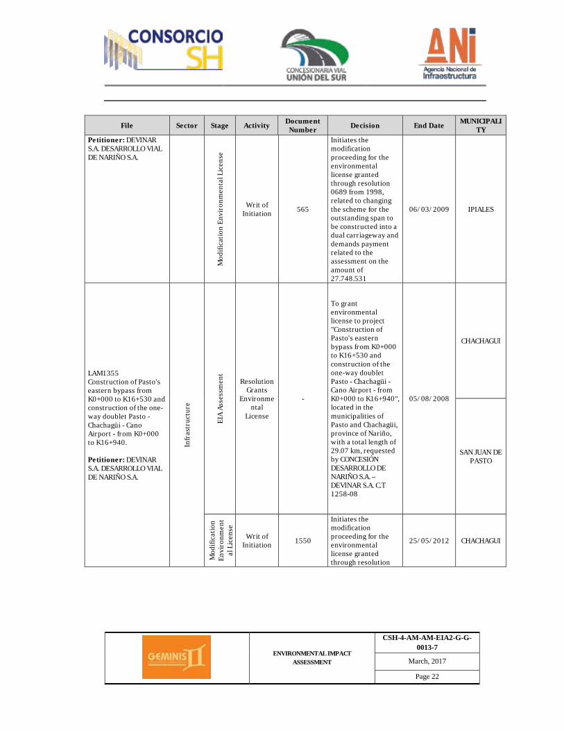
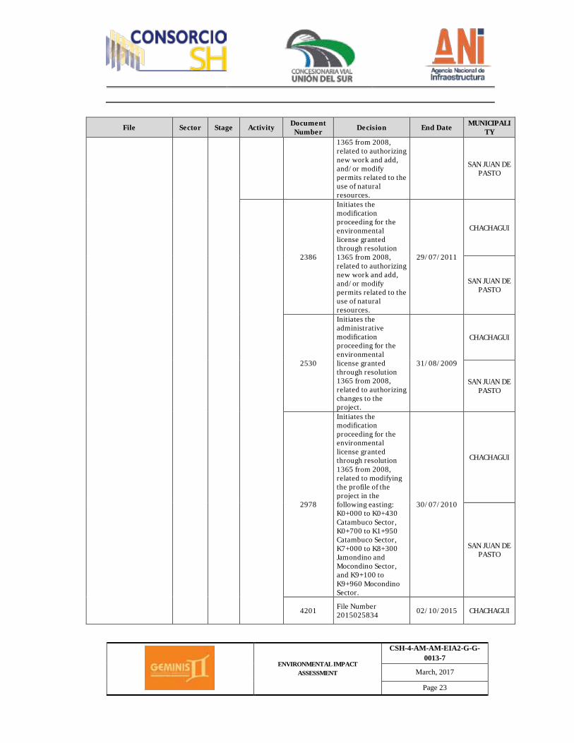
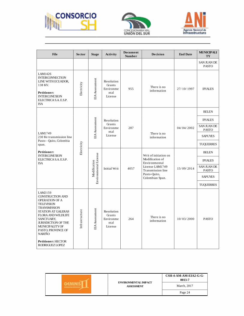
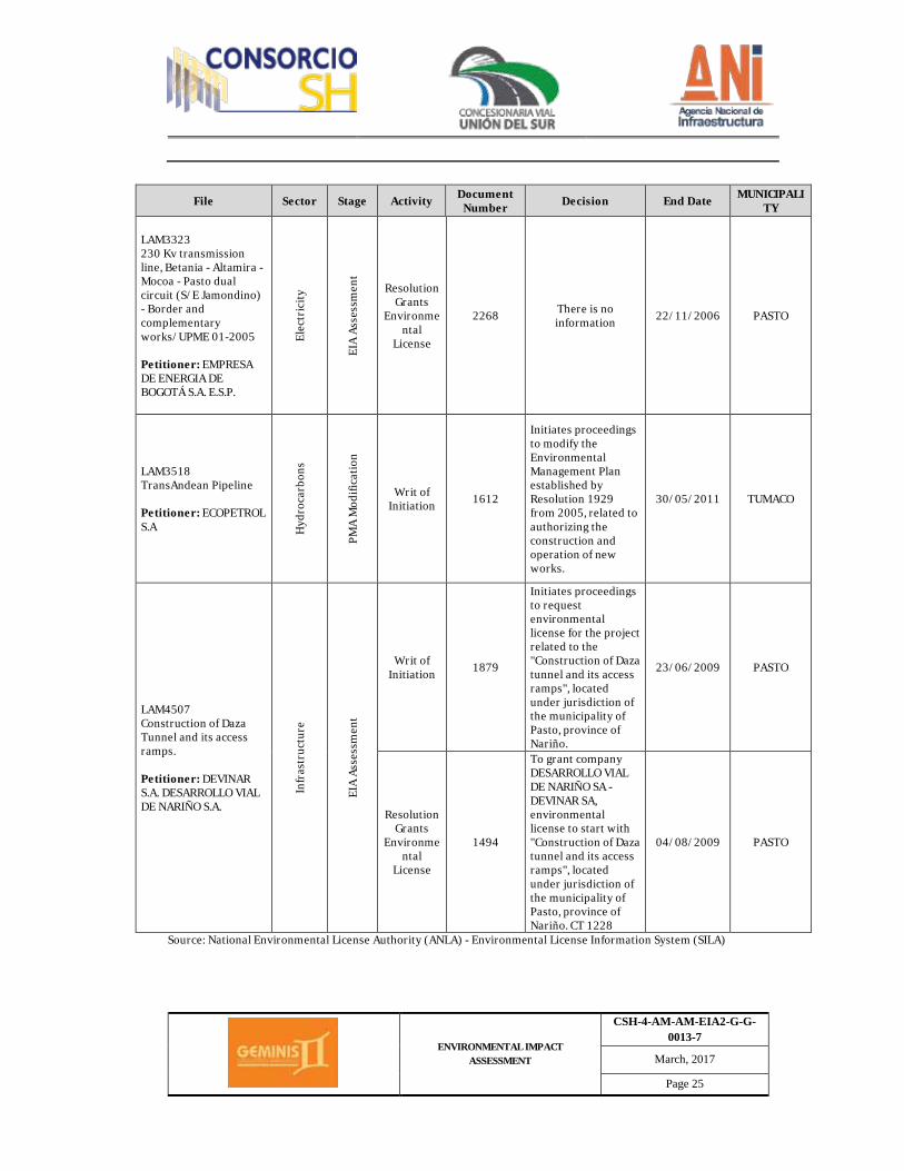
Regarding ANLA, communication number (4.6) 2016049987-2-001, submittal number 728-16, from September 9, 2016, produced a list of licensing files which are its responsibility, in the energy, infrastructure and hydrocarbons sector, taken from the Environmental License Information System (SILA), which are presented in table 2.2. (Refer to Appendix 2.1.6.z1. and 2.1.6.z2.)
ENVIRONMENTAL IMPACT ASSESSMENT
CSH-4-AM-AM-EIA2-G-G-0013-7
March, 2017
Page 21
Table 2.2 Licensing file which is the responsibility of ANLA, on projects taking place in the province of Nariño.
File Sector Stage Activity Document Number Decision End Date MUNICIPALI
TY
LAM0098 PASTO TUMACO INTERCONNECTION Petitioner: NARIÑO's POWER STATION CEDIMAR E.S.P
Elec
tric
ity
EIA
Asse
ssm
ent Resolution
Grants Environme
ntal License
318
There is no information
29/10/1991
PASTO
TUMACO
LAM0207 RUMICHACA PASTO ENCANO ROAD Petitioner: National Road Institute - INVIAS In
fras
truc
ture
EIA
Asse
ssm
ent
Resolution Grants
Environmental
License
340 There is no information 13/10/1994 PASTO
LAM0469 PAVING OF PASTO SANDONA CEBADAL ROAD Petitioner: National Road Institute - INVIAS
Infr
astr
uctu
re
EIA
Asse
ssm
ent
Resolution Grants
Environmental
License
519 There is no information 23/05/1996 SAN JUAN DE
PASTO
LAM0739 REHABILITATION OF PEDREGAL - TÚQUERREZ ROAD Petitioner: National Road Institute - INVIAS
Infr
astr
uctu
re
EIA
Asse
ssm
ent
Resolution Grants
Environmental
License
0894
There is no information
08/10/1997
IMUES
TUQUERRES
LAM1315 IPIALES BYPASS (RUMICHACA - PASTO ROAD). In
fras
truc
tur
e EIA
Asse
ssm
ent Resolution
Grants Environme
ntal License
0689 There is no information 29/07/1998 IPIALES
ENVIRONMENTAL IMPACT ASSESSMENT
CSH-4-AM-AM-EIA2-G-G-0013-7
March, 2017
Page 22
File Sector Stage Activity Document Number Decision End Date MUNICIPALI
TY Petitioner: DEVINAR S.A. DESARROLLO VIAL DE NARIÑO S.A.
Mod
ifica
tion
Envi
ronm
enta
l Lic
ense
Writ of Initiation 565
Initiates the modification proceeding for the environmental license granted through resolution 0689 from 1998, related to changing the scheme for the outstanding span to be constructed into a dual carriageway and demands payment related to the assessment on the amount of 27.748.531
06/03/2009 IPIALES
LAM1355 Construction of Pasto's eastern bypass from K0+000 to K16+530 and construction of the one-way doublet Pasto - Chachagüi - Cano Airport - from K0+000 to K16+940. Petitioner: DEVINAR S.A. DESARROLLO VIAL DE NARIÑO S.A.
Infr
astr
uctu
re
EIA
Asse
ssm
ent
Resolution Grants
Environmental
License
-
To grant environmental license to project "Construction of Pasto's eastern bypass from K0+000 to K16+530 and construction of the one-way doublet Pasto - Chachagüi - Cano Airport - from K0+000 to K16+940", located in the municipalities of Pasto and Chachagüi, province of Nariño, with a total length of 29.07 km, requested by CONCESIÓN DESARROLLO DE NARIÑO S.A. – DEVINAR S.A. C.T 1258-08
05/08/2008
CHACHAGUI
SAN JUAN DE PASTO
Mod
ifica
tion
Envi
ronm
ent
al L
icen
se
Writ of Initiation 1550
Initiates the modification proceeding for the environmental license granted through resolution
25/05/2012 CHACHAGUI
ENVIRONMENTAL IMPACT ASSESSMENT
CSH-4-AM-AM-EIA2-G-G-0013-7
March, 2017
Page 23
File Sector Stage Activity Document Number Decision End Date MUNICIPALI
TY 1365 from 2008, related to authorizing new work and add, and/or modify permits related to the use of natural resources.
SAN JUAN DE PASTO
2386
Initiates the modification proceeding for the environmental license granted through resolution 1365 from 2008, related to authorizing new work and add, and/or modify permits related to the use of natural resources.
29/07/2011
CHACHAGUI
SAN JUAN DE PASTO
2530
Initiates the administrative modification proceeding for the environmental license granted through resolution 1365 from 2008, related to authorizing changes to the project.
31/08/2009
CHACHAGUI
SAN JUAN DE PASTO
2978
Initiates the modification proceeding for the environmental license granted through resolution 1365 from 2008, related to modifying the profile of the project in the following easting: K0+000 to K0+430 Catambuco Sector, K0+700 to K1+950 Catambuco Sector, K7+000 to K8+300 Jamondino and Mocondino Sector, and K9+100 to K9+960 Mocondino Sector.
30/07/2010
CHACHAGUI
SAN JUAN DE PASTO
4201 File Number 2015025834 02/10/2015 CHACHAGUI
ENVIRONMENTAL IMPACT ASSESSMENT
CSH-4-AM-AM-EIA2-G-G-0013-7
March, 2017
Page 24
File Sector Stage Activity Document Number Decision End Date MUNICIPALI
TY
SAN JUAN DE PASTO
LAM1426 INTERCONNECTION LINE WITH ECUADOR, 138 KV. Petitioner: INTERCONEXION ELECTRICA S.A. E.S.P. ISA
Elec
tric
ity
EIA
Asse
ssm
ent
Resolution Grants
Environmental
License
955 There is no information 27/10/1997 IPIALES
LAM1749 230 Kv transmission line Pasto - Quito, Colombia span. Petitioner: INTERCONEXION ELECTRICA S.A. E.S.P. ISA
Elec
tric
ity
EIA
Asse
ssm
ent
Resolution Grants
Environmental
License
287
There is no information
04/04/2002
BELEN
IPIALES
SAN JUAN DE PASTO
SAPUYES
TUQUERRES
Mod
ifica
tion
Envi
ronm
enta
l Lic
ense
Initial Writ 4057
Writ of initiation on Modification of Environmental License LAM1749 Transmission line Pasto-Quito, Colombian Span.
15/09/2014
BELEN
IPIALES
SAN JUAN DE PASTO
SAPUYES
TUQUERRES
LAM2159 CONSTRUCTION AND OPERATION OF A TELEVISION TRANSMISSION STATION AT GALERAS FLORA AND WILDLIFE SANCTUARY, JURISDICTION OF THE MUNICIPALITY OF PASTO, PROVINCE OF NARIÑO Petitioner: HECTOR RODRIGUEZ LOPEZ
Infr
astr
uctu
re
EIA
Asse
ssm
ent
Resolution Grants
Environmental
License
264 There is no information 10/03/2000 PASTO
ENVIRONMENTAL IMPACT ASSESSMENT
CSH-4-AM-AM-EIA2-G-G-0013-7
March, 2017
Page 25
File Sector Stage Activity Document Number Decision End Date MUNICIPALI
TY
LAM3323 230 Kv transmission line, Betania - Altamira - Mocoa - Pasto dual circuit (S/E Jamondino) - Border and complementary works/UPME 01-2005 Petitioner: EMPRESA DE ENERGIA DE BOGOTÁ S.A. E.S.P.
Elec
tric
ity
EIA
Asse
ssm
ent
Resolution Grants
Environmental
License
2268 There is no information 22/11/2006 PASTO
LAM3518 TransAndean Pipeline Petitioner: ECOPETROL S.A H
ydro
carb
ons
PMA
Mod
ifica
tion
Writ of Initiation 1612
Initiates proceedings to modify the Environmental Management Plan established by Resolution 1929 from 2005, related to authorizing the construction and operation of new works.
30/05/2011 TUMACO
LAM4507 Construction of Daza Tunnel and its access ramps. Petitioner: DEVINAR S.A. DESARROLLO VIAL DE NARIÑO S.A.
Infr
astr
uctu
re
EIA
Asse
ssm
ent
Writ of Initiation 1879
Initiates proceedings to request environmental license for the project related to the "Construction of Daza tunnel and its access ramps", located under jurisdiction of the municipality of Pasto, province of Nariño.
23/06/2009 PASTO
Resolution Grants
Environmental
License
1494
To grant company DESARROLLO VIAL DE NARIÑO SA - DEVINAR SA, environmental license to start with "Construction of Daza tunnel and its access ramps", located under jurisdiction of the municipality of Pasto, province of Nariño. CT 1228
04/08/2009 PASTO
Source: National Environmental License Authority (ANLA) - Environmental License Information System (SILA)
ENVIRONMENTAL IMPACT ASSESSMENT
CSH-4-AM-AM-EIA2-G-G-0013-7
March, 2017
Page 26
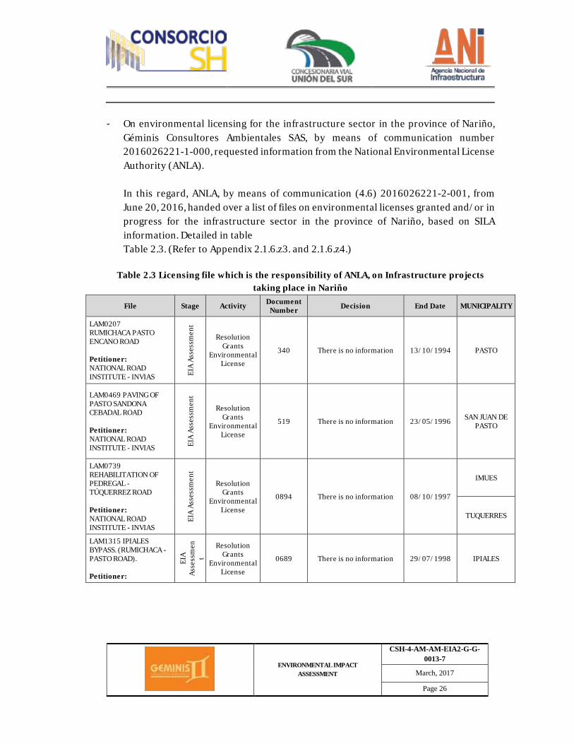
- On environmental licensing for the infrastructure sector in the province of Nariño, Géminis Consultores Ambientales SAS, by means of communication number 2016026221-1-000, requested information from the National Environmental License Authority (ANLA).
In this regard, ANLA, by means of communication (4.6) 2016026221-2-001, from June 20, 2016, handed over a list of files on environmental licenses granted and/or in progress for the infrastructure sector in the province of Nariño, based on SILA information. Detailed in table Table 2.3. (Refer to Appendix 2.1.6.z3. and 2.1.6.z4.)
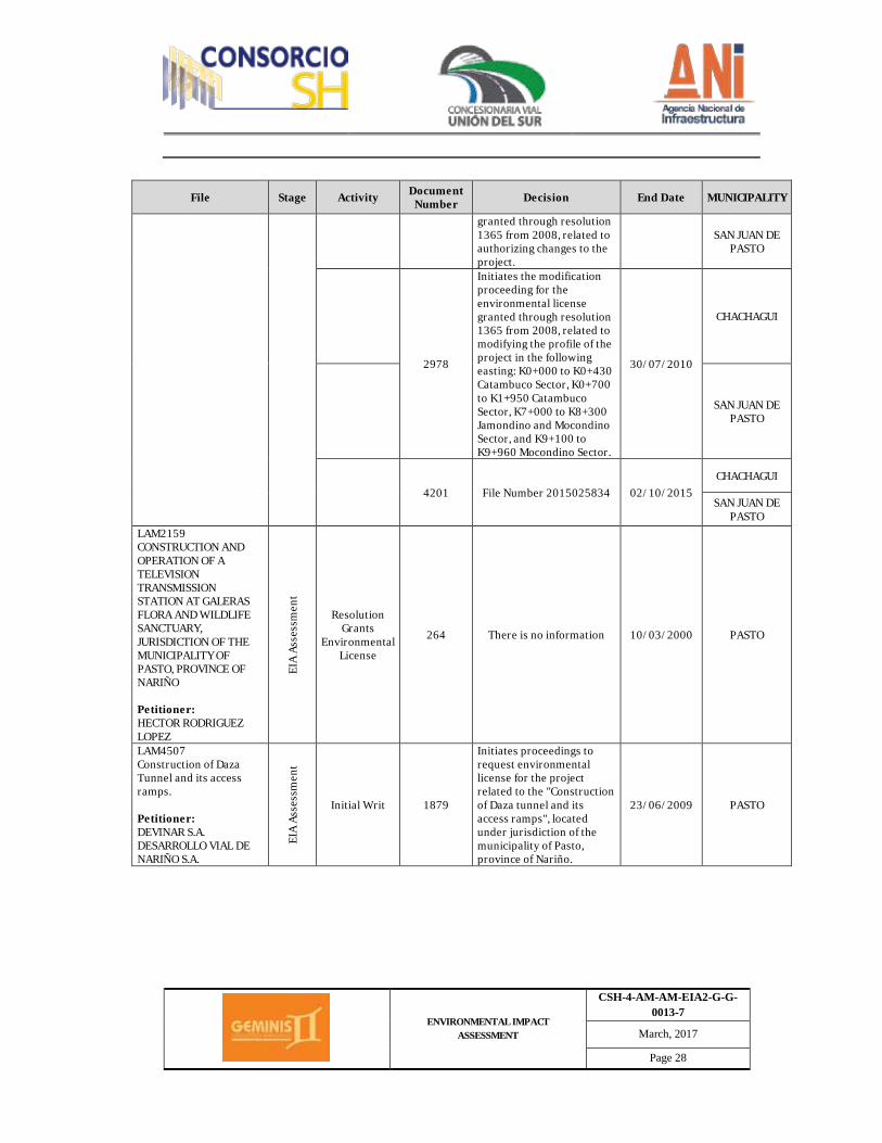
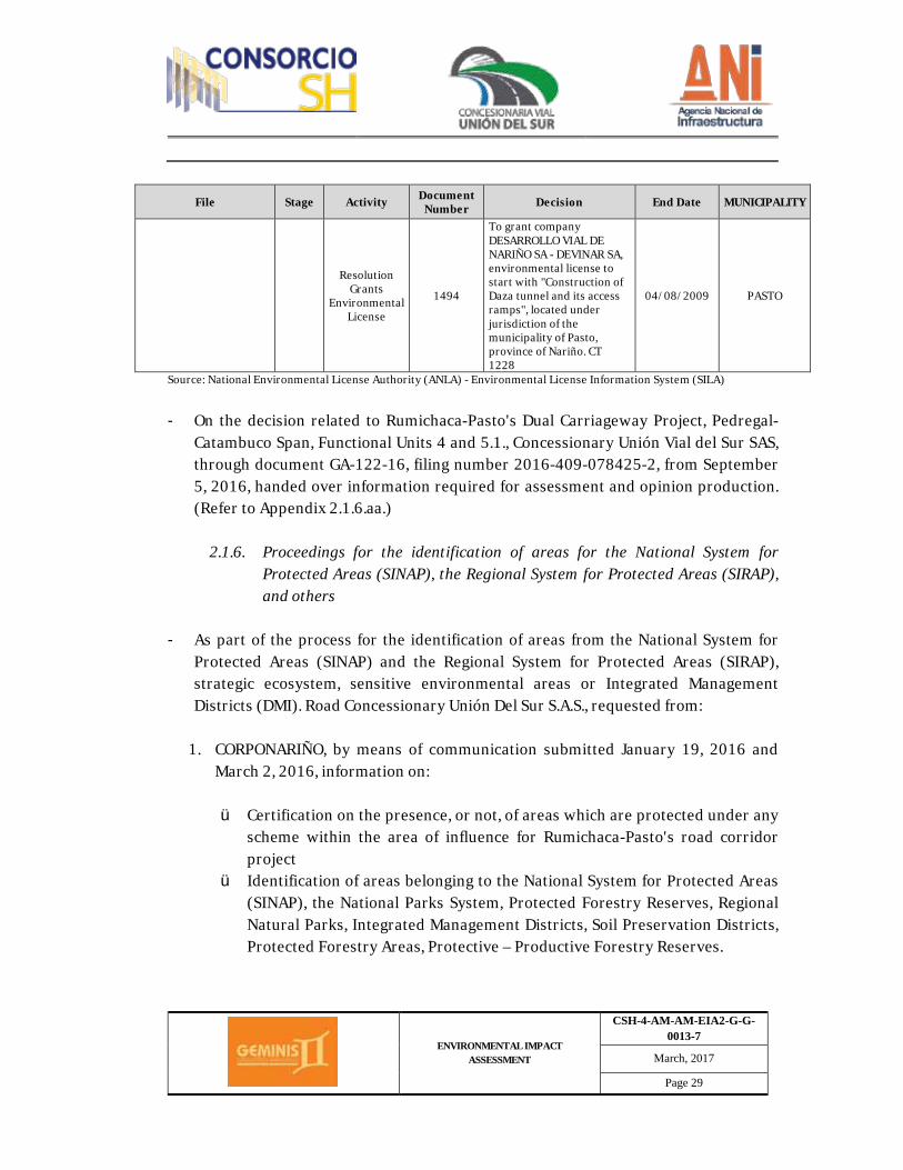
Table 2.3 Licensing file which is the responsibility of ANLA, on Infrastructure projects
taking place in Nariño
File Stage Activity Document Number Decision End Date MUNICIPALITY
LAM0207 RUMICHACA PASTO ENCANO ROAD Petitioner: NATIONAL ROAD INSTITUTE - INVIAS EI
A As
sess
men
t
Resolution Grants
Environmental License
340 There is no information 13/10/1994 PASTO
LAM0469 PAVING OF PASTO SANDONA CEBADAL ROAD Petitioner: NATIONAL ROAD INSTITUTE - INVIAS EI
A As
sess
men
t
Resolution Grants
Environmental License
519 There is no information 23/05/1996 SAN JUAN DE PASTO
LAM0739 REHABILITATION OF PEDREGAL - TÚQUERREZ ROAD Petitioner: NATIONAL ROAD INSTITUTE - INVIAS
EIA
Asse
ssm
ent
Resolution Grants
Environmental License
0894 There is no information 08/10/1997
IMUES
TUQUERRES
LAM1315 IPIALES BYPASS. (RUMICHACA - PASTO ROAD). Petitioner:
EIA
Asse
ssm
ent
Resolution Grants
Environmental License
0689 There is no information 29/07/1998 IPIALES

ENVIRONMENTAL IMPACT ASSESSMENT
CSH-4-AM-AM-EIA2-G-G-0013-7
March, 2017
Page 27
File Stage Activity Document Number Decision End Date MUNICIPALITY
DEVINAR S.A. DESARROLLO VIAL DE NARIÑO S.A.
Mod
ifica
tion
Envi
ronm
enta
l Li
cens
e Initial Writ 565
Initiates the modification proceeding for the environmental license granted through resolution 0689 from 1998, related to changing the scheme for the outstanding span to be constructed into a dual carriageway and demands payment related to the assessment on the amount of 27.748.531
06/03/2009
LAM1355 Construction of Pasto's eastern bypass from K0+000 to K16+530 and Construction of the one-way doublet Pasto - Chachagüi - Cano Airport - from K0+000 to K16+940. Petitioner: DEVINAR S.A. DESARROLLO VIAL DE NARIÑO S.A.
EIA
Asse
ssm
ent
Resolution Grants
Environmental License
To grant environmental license to project "Construction of Pasto's eastern bypass from K0+000 to K16+530 and construction of the one-way doublet Pasto - Chachagüi - Cano Airport - from K0+000 to K16+940", located in the municipalities of Pasto and Chachagüi, province of Nariño, with a total length of 29.07 km, requested by CONCESIÓN DESARROLLO DE NARIÑO S.A. – DEVINAR S.A. C.T 1258-08
05/08/2008
CHACHAGUI
SAN JUAN DE PASTO
Mod
ifica
tion
Envi
ronm
enta
l Lic
ense
Initial Writ 1550
Initiates the modification proceeding for the environmental license granted through resolution 1365 from 2008, related to authorizing new work and add, and/or modify permits related to the use of natural resources.
25/05/2012
CHACHAGUI
SAN JUAN DE PASTO
2386
Initiates the modification proceeding for the environmental license granted through resolution 1365 from 2008, related to authorizing new work and add, and/or modify permits related to the use of natural resources.
29/07/2011
CHACHAGUI
SAN JUAN DE PASTO
2530 Initiates the administrative modification proceeding for the environmental license
31/08/2009 CHACHAGUI
ENVIRONMENTAL IMPACT ASSESSMENT
CSH-4-AM-AM-EIA2-G-G-0013-7
March, 2017
Page 28
File Stage Activity Document Number Decision End Date MUNICIPALITY
granted through resolution 1365 from 2008, related to authorizing changes to the project.
SAN JUAN DE PASTO
2978
Initiates the modification proceeding for the environmental license granted through resolution 1365 from 2008, related to modifying the profile of the project in the following easting: K0+000 to K0+430 Catambuco Sector, K0+700 to K1+950 Catambuco Sector, K7+000 to K8+300 Jamondino and Mocondino Sector, and K9+100 to K9+960 Mocondino Sector.
30/07/2010
CHACHAGUI
SAN JUAN DE PASTO
4201 File Number 2015025834 02/10/2015 CHACHAGUI
SAN JUAN DE PASTO
LAM2159 CONSTRUCTION AND OPERATION OF A TELEVISION TRANSMISSION STATION AT GALERAS FLORA AND WILDLIFE SANCTUARY, JURISDICTION OF THE MUNICIPALITY OF PASTO, PROVINCE OF NARIÑO Petitioner: HECTOR RODRIGUEZ LOPEZ
EIA
Asse
ssm
ent
Resolution Grants
Environmental License
264 There is no information 10/03/2000 PASTO
LAM4507 Construction of Daza Tunnel and its access ramps. Petitioner: DEVINAR S.A. DESARROLLO VIAL DE NARIÑO S.A.
EIA
Asse
ssm
ent
Initial Writ 1879
Initiates proceedings to request environmental license for the project related to the "Construction of Daza tunnel and its access ramps", located under jurisdiction of the municipality of Pasto, province of Nariño.
23/06/2009 PASTO
ENVIRONMENTAL IMPACT ASSESSMENT
CSH-4-AM-AM-EIA2-G-G-0013-7
March, 2017
Page 29
File Stage Activity Document Number Decision End Date MUNICIPALITY
Resolution Grants
Environmental License
1494
To grant company DESARROLLO VIAL DE NARIÑO SA - DEVINAR SA, environmental license to start with "Construction of Daza tunnel and its access ramps", located under jurisdiction of the municipality of Pasto, province of Nariño. CT 1228
04/08/2009 PASTO
Source: National Environmental License Authority (ANLA) - Environmental License Information System (SILA)
- On the decision related to Rumichaca-Pasto's Dual Carriageway Project, Pedregal-
Catambuco Span, Functional Units 4 and 5.1., Concessionary Unión Vial del Sur SAS, through document GA-122-16, filing number 2016-409-078425-2, from September 5, 2016, handed over information required for assessment and opinion production. (Refer to Appendix 2.1.6.aa.)
2.1.6. Proceedings for the identification of areas for the National System for Protected Areas (SINAP), the Regional System for Protected Areas (SIRAP), and others
- As part of the process for the identification of areas from the National System for
Protected Areas (SINAP) and the Regional System for Protected Areas (SIRAP), strategic ecosystem, sensitive environmental areas or Integrated Management Districts (DMI). Road Concessionary Unión Del Sur S.A.S., requested from:
1. CORPONARIÑO, by means of communication submitted January 19, 2016 and
March 2, 2016, information on:
ü Certification on the presence, or not, of areas which are protected under any scheme within the area of influence for Rumichaca-Pasto's road corridor project
ü Identification of areas belonging to the National System for Protected Areas (SINAP), the National Parks System, Protected Forestry Reserves, Regional Natural Parks, Integrated Management Districts, Soil Preservation Districts, Protected Forestry Areas, Protective – Productive Forestry Reserves.
ENVIRONMENTAL IMPACT ASSESSMENT
CSH-4-AM-AM-EIA2-G-G-0013-7
March, 2017
Page 30
ü Certification of the presence, or otherwise, of areas belonging to sensitive ecosystems, moorland areas, special management areas (marshes, swamps, wetlands) or any other kind of environmental restrictions which may overlap with the area chosen for the development of the dual carriageway project.
ü Flora and wildlife species, which under the jurisdiction of the province of Nariño, are considered as endemic or endangered, or any other species which are covered by any restriction.
ü Projects, plans or programs which are undergoing and related to management and preservation of biodiversity.
ü Ethnobotanist, ethnozoology studies and endemic species preservation areas. (Refer to Appendix 2.1.6.p1. and 2.1.6.p2.)
In this regard, CORPONARIÑO, by means of document 120 7024, from September 15, 2016, produced an opinion stating that Rumichaca-Pasto's road corridor was not in areas declared protected and/or National Forestry Reserves. (Refer to Appendix 2.1.6.p3.)
2. Mayor's offices, on management and conservation of flora and wildlife: ü Mayor's office from Yacuanquer, by means of communication submitted on
January 19, 2016 (refer to appendix 2.1.6.g.).
ü Mayor's office from Tangua, by means of communication submitted on January 19, 2016 (Refer to Appendix 2.1.6.h1.) In this regard, Tangua's Mayor's Office, by means of communication number 838 – 16, from September 30, reported the existence of SINAP protected areas in the municipality, Galeras' Flora and Wildlife Sanctuary. (Refer to Appendix 2.1.6.h2.)
ü Pasto's Mayor's Office, by means of communication with serial number 2016000000498, from January 21, 2016. (Refer to Appendix 2.1.6.i.)
3. The Colombian Association Network of Natural Reserves from the Civil Society
(RESNATUR), by means of communication dated January 18, 2016, information on
ENVIRONMENTAL IMPACT ASSESSMENT
CSH-4-AM-AM-EIA2-G-G-0013-7
March, 2017
Page 31
the identification, location, demarcation and description of forestry reserve areas, sensitive ecosystems and/or strategic to protected species. (Refer to Appendix 2.1.7.a.)
4. The Forest, Biodiversity and Eco-systemic Services Office from MADS, by means of communication filed with number 4120-E1-1445, from January 20, 2016, provided information on the identification, location, demarcation and description of forestry reserve areas, sensitive ecosystems and/or strategic to protected species for the project area. (Refer to Appendix 2.1.7.b.)
5. PNNC's Assistant Manager's Office for Protected Areas requested:
ü By means of communication with filing number 2016-460-000135-2, from
January 20, 2016, information on the identification, demarcation and regulation of protected areas. (Refer to Appendix 2.1.7.c.),
ü By means of communication with filing number 2016-460-006674-2, right to petition, certification on the existence of SINAP protected areas.
In this regard, the PNNC's Assistant Manager's Office for Protected Areas, through document R PNNC 20162400054221, filed with number 721-16, from September 3, 2016, determined that there are no protected areas in the project's area of intervention. (Refer to Appendix 2.1.7.d.)
6. Pasto's Mayor's Office, by means of communication filed with number (1901)
201600011568, provided information on POT, protected areas. (Refer to Appendix 2.1.7.e.)
In this regard, Pasto's Mayor's Office provided information by means of document 1510/0324-2016, including agreement 004 from April 14, 2015, by means of which the Land Use Plan for the municipality of Pasto, 2015-2027, Pasto Territorio Con-Sentido, is detailed. (Refer to Appendix 2.1.7.f1. and 2.1.7.f2.)
7. The Environmental Ministry, by means of communication with filing number E1-
2016-022611, provided information on certification of existence, or otherwise, of SINAP protected areas.
ENVIRONMENTAL IMPACT ASSESSMENT
CSH-4-AM-AM-EIA2-G-G-0013-7
March, 2017
Page 32
In this regard, the Environmental Ministry, with document filed with outgoing serial number 1-E2-2016-021486, filed with number 720-16, from September 3, 2016, expressed that the request was being forwarded to PNNC. (Refer to Appendix 2.1.7.g.).
8. Nariño's Gov.'s office, by means of documents filed with number 10141, from
August 25, 2016, on the existence, or otherwise, of SINAP protected areas.
In this regard, the infrastructure office from Nariño’s Gov.'s office, through document Dsimd-909-16, filed with number 707–16, from September 1, 2016, reported on forwarding this request to CORPONARIÑO and PNNC. (Refer to Appendix 2.1.7.h.)
2.1.7. Strategic ecosystems and sensitive environmental areas
By means of analyzing secondary information, the presence of forestry preservation areas, as stipulated by Law 2 from 1959, is hereby discarded in influence of the dual carriageway project, Pedregal-Catambuco sector. By analyzing secondary information, it is also safe to state that there are no protected areas related to the national system, there are no strategic areas or ecosystems nor are there any sensitive or protected areas in the aforementioned area. The preliminary verification is done using the Tremactos Colombia tool, overlapping the project's areas of influence with information from the Natural National Park System, the Municipality's local protected area system, information from Galeras civil society reserves, National Protected Forestry Areas Reserves and Regional Protected Areas (refer to description in Chapter 5: Characterization of Area of Influence, item 5.2.1.3 Ecosystems in strategic, sensitive and/or protected areas). In this regard, and aiming to validate the information available, it was requested before the Environmental and Sustainable Development Ministry - MADS, Colombian National Parks, as well as regional environmental authorities such as CORPONARIÑO, Pasto's Mayor's office, the Gov.'s office of Nariño, Mayor's offices of Tangua, Yacuanquer and Imués, information related to the existence, or otherwise, of protected areas and strategic ecosystems in the area of influence for Rumichaca-Pasto's dual carriageway project. The
ENVIRONMENTAL IMPACT ASSESSMENT
CSH-4-AM-AM-EIA2-G-G-0013-7
March, 2017
Page 33
answer was that the area of interest does not overlap with any known category acknowledged by the environmental authorities, based on the sole national registry for protected areas (RUNAP), regulated by decree 1076 from 2015, article 2.2.2.1.3.3 "Sole Registry for Protected Areas SINAP" Refer to Appendix 5.2.1.5-a, 5.2.1.5-b, 5.2.1.5-c, 5.2.1.5-d). Additionally, the municipality of Imues expresses the presence of areas related to the riparian corridor of river Guaitara and other sources, therefore, these areas were quantified in relation to the project's area of intervention for all municipalities involved, so they are taken into consideration in ecological compensation processes. Even though there are no protected areas per se, natural ecosystems corresponding to riparian forests have been identified, as well as dense brush land and open rocky grassland. On the other hand, close to the project's area of influence, the following have been identified: Bobo-Buesquillo river reserve, Galeras civil society reserve, Galeras Flora and Wildlife Sanctuary, Ovejas-Tauso protected area, Tabano-Campanero protected area, Divina Pastora protected area and Morasurco protected area.
2.1.8. Certifications All necessary proceedings before government entities where fulfilled during the management process leading to the acquisition of certifications required for the licensing of Rumichaca - Pasto's Dual Carriageway Project, Pedregal - Catambuco Span, Concession contact under PPP SCHEME NUMBER 15, from 2015. In this regard, Road Concessionary Unión Del Sur S.A.S., requested certifications from: 1. Ministry of the Interior: On the presence, or otherwise, of ethnic communities in
the project's area:
- UF4, located under the jurisdiction of the municipalities of Imués, Tangua and Yanquanquer - with filing number EXTMII6-0005055, from February 10, 2016. (Refer to Appendix 2.1.8.a.)

ENVIRONMENTAL IMPACT ASSESSMENT
CSH-4-AM-AM-EIA2-G-G-0013-7
March, 2017
Page 34
- UF5, Subsector 1, located under the jurisdiction of the municipalities of Pasto,
Tangua and Yanquanquer - with filing number EXTMII6-0005056, from February 10, 2016. (Refer to Appendix 2.1.8.b.)
In this regard, the Ministry of Interior, issued certification 110 from February 22, 2016 and 111 from February 22, 2016 (Refer to Appendix 2.1.8.c. and 2.1.8.d.), which are listed below: ü Certification 110
There is no recorded presence of black communities, minorities and RON in "RUMICHACA-PASTO's CONCESSION PROJECT UNDER PPP SCHEME NUMBER 15 FROM SEPTEMBER 11, 2015 - FUNCTIONAL UNIT 4, located under the jurisdiction of the municipalities of Imués, Tangua and Yacuanquer.
There is no recorded presence of black communities, Afro-Colombian communities, Raizal communities or Palenqueras in the area of "RUMICHACA-PASTO's CONCESSION PROJECT UNDER PPP SCHEME No. 15, FROM SEPTEMBER 11, 2015 - FUNCTIONAL UNIT 4, located under the jurisdiction of the municipalities of Imués, Tangua and Yacuanquer.
ü Certification 111
There is no recorded presence of black communities, minorities and RON around "RUMICHACA-PASTO's CONCESSION PROJECT UNDER PPP SCHEME No. 15, FROM SEPTEMBER 11, 2015 - FUNCTIONAL UNIT 5, SUB-SPAN 1, located under the jurisdiction of the municipalities of Pasto and Tangua
There is no recorded presence of black communities, Afro-Colombian communities, Raizal communities or Palenqueras around "RUMICHACA-PASTO's CONCESSION PROJECT UNDER PPP SCHEME No. 15, FROM SEPTEMBER 11, 2015 - FUNCTIONAL UNIT 4, located under the jurisdiction of the municipalities of Pasto and Tangua
There is no recorded presence of black communities, minorities and RON in "RUMICHACA-PASTO's CONCESSION PROJECT UNDER PPP SCHEME No. 15,
ENVIRONMENTAL IMPACT ASSESSMENT
CSH-4-AM-AM-EIA2-G-G-0013-7
March, 2017
Page 35
FROM SEPTEMBER 11, 2015 - FUNCTIONAL UNIT 4, located under the jurisdiction of the municipalities of Imués,
After the issue of certifications 110 and 111, Road Concessionary Unión Del Sur SAS, reported to the Ministry of Interior, through communication filed on April 25, 2016, the possible presence of indigenous communities around Montaña de Fuego, Catambuco and the community of Obonuco, belonging to the Quillacingas tribe. (Refer to Appendix 2.1.8.e.) In this regard, the Ministry of Interior, through resolutions 22 and 23 from 2016,
partially revokes administrative acts (Certifications) number 111 and 110, respectively (refer to Appendix 2.1.8.f and 2.1.8.g), modifying the aforementioned as listed below:
ü Modification resolution 23 pertaining to Certification 110
There is no recorded presence of black communities, Afro-Colombian communities, Raizal communities or Palenqueras around "RUMICHACA-PASTO's CONCESSION PROJECT UNDER PPP SCHEME No. 15, FROM SEPTEMBER 11, 2015 - FUNCTIONAL UNIT 4, located under the jurisdiction of the municipalities of Imués, Tangua and Yacuanquer.
The presence of Montaña de Fuego municipal Council is recorded around "RUMICHACA-PASTO's CONCESSION PROJECT UNDER PPP SCHEME No. 15 FROM SEPTEMBER 11, 2015 - FUNCTIONAL UNIT 4, located under the jurisdiction of the municipalities of Imués, Tangua and Yacuanquer.
ü Modification resolution 22 pertaining to Certification 111
There is no recorded presence of black communities, Afro-Colombian communities, Raizal communities or Palenqueras in the area of "RUMICHACA-PASTO's CONCESSION PROJECT UNDER PPP SCHEME No. 15, FROM SEPTEMBER 11, 2015 - FUNCTIONAL UNIT 4, located under the jurisdiction of the municipalities of Pasto and Tangua The presence of indigenous communities at Montaña de Fuego municipal Council and Catambuco Indigenous Council is recorded around "RUMICHACA-PASTO's CONCESSION PROJECT UNDER PPP SCHEME No. 15, FROM SEPTEMBER 11, 2015
ENVIRONMENTAL IMPACT ASSESSMENT
CSH-4-AM-AM-EIA2-G-G-0013-7
March, 2017
Page 36
- FUNCTIONAL UNIT 5, SUB-SPAN 1, located under the jurisdiction of the municipalities of Pasto and Tangua.
Based on the foregoing, resolution 22 and 23, the Ministry of Interior points out that, if it is decided to go ahead with project execution, the initiation of the relevant process, as indicated by article 330, law 21, Articles 6 and 7, from the Political Constitution of 1991 should be requested before the Pre-Consultation Office. Other Laws to consider are Law 99 from 1993 and article 76 from Presidential Guideline 01 from 2010.
2. Culture Ministry:
· The existence and location of historic and cultural interest sites deemed national or global heritage, through communication MC08425E2016, from May 6, 2016. (Refer to Appendix 2.1.8.h.)
In this regard, the culture ministry, through document 411 - 2016, MC0604652016, with filing number 327 – 16 from May 27, 2016, indicated that: "...according to the latest of cultural interest sites (BIC), the project is in the area of influence of Rumichaca - Pasto span of the Qhapaq Ñan, Andean Road System, in its seventh section, Guapuscal, in the Township of Guapuscal Bajo, municipality of Funes. Based on the foregoing, any intervention to be undertaken shall be previously approved by the heritage office...". (Refer to Appendix 2.1.8.i.) Regarding the aforementioned, the culture ministry through resolution 3317 from October 25, 2013, declared that, Rumichaca - Pasto span of the Qhapaq Ñan, Andean Road System, located in municipalities within the province of Nariño, was a cultural interest site of a national nature. Its area of influence is also determined. (Refer to Appendix 2.1.8.i)
· As for the consultation carried out by Road Concessionary Union Vial del Sur,
pertaining to Qhapaq Ñan Andean Road System, relating to the preventive archaeological process, through communication number MC16372E2016, the Ministry, by means of communication 410 – 2016, filed August 24, 2016, reported that the technical information sent reporting the profile for Rumichaca - Pasto's road project does not impact the Andean Road System. This information is part of the files sent to UNESCO. (Refer to Appendix 2.1.8.k.)
ENVIRONMENTAL IMPACT ASSESSMENT
CSH-4-AM-AM-EIA2-G-G-0013-7
March, 2017
Page 37
3. Colombian Natural National Parks (PNNC): On the existence, or otherwise, of SINAP protected areas, and their corresponding location in the area of project intervention, through communication 2016-460-000135, from January 20, 2016 and right to petition 2016-460-006674-2..
In this regard, the office of the Assistant Director of Protected Areas, by means of communication number 20162400054221, with filing number 721 from August 29, 2016, indicated that the project's area of interest does not overlap with any category recognized by the environmental authorities in the Sole National Protected Areas Registry (RUNAP). (Refer to Appendix 2.1.8.l.)
4. Incoder: On the existence of ethnic territories in the project's area of influence,
through communication filed with number 20161145060, from June 28, 2016. In this regard, the Territory National Agency, through communication number 20162104522, filed with number 747 – 16, from September 9, 2016, reported that to answer to the request it is necessary to forward the requisition to the Pre-Consultation Office from the Ministry of Interior. (Refer to Appendix 2.1.8.m.).
5. Regional Land Restitution Office – Nariño: On certification related to macro and micro focalized areas and/or requests to enter the registry for dispossessed or forcibly abandoned land for land located in the area of influence of the project, from Road Concessionary Unión del Sur S.A.S., by means of communication SA 011 – 16, with filing number DTNP1-201602492, from August 29, 2016. (Refer to Appendix 2.1.8.n.).
2.1.9. Exploitation of material sources Rumichaca-Pasto dual carriageway project, Ipiales - Catambuco span, contemplates the acquisition of material sources through third parties who have a mining – environmental permit for such purpose.
2.1.10. Administrative act related to the study permit for the collection of wildlife specimens
ANLA, by means of resolution 1023 from August 20, 2015, grants Géminis Consultores SAS, partnership holding tax ID number 900.065.324-5, "Study Permit to Collect Wildlife Specimens representing Biological Diversity aiming to produce environmental studies”,
ENVIRONMENTAL IMPACT ASSESSMENT
CSH-4-AM-AM-EIA2-G-G-0013-7
March, 2017
Page 38
file IDB458-00, answering to request based on decree 3016 from December 27, 2013, submitted by Géminis Consultores SAS, by means of communication number 2015020763-1-000, from April 20, 2015. (Refer to Appendix 2.1.10.)
2.1.5. Implications of the project with other projects in the region Complying with decree from the environmental sector, number 1076, article 2.2.2.3.6.4, corresponding to project overlap, which determines that: : "the competent environmental authority has the ability to grant environmental licenses to projects whose areas overlap with other licensed projects, as long as the interested party for the project to be licensed demonstrates that both projects can coexist and identifies the individual management activities and individual responsibilities as pertaining to the environmental impacts generated in the overlapping area..."; Road Concessionary Union Vial Sur is currently undertaking the process to approach the companies charged with projects that are already licensed or in the process of getting a license in the province of Nariño, pursuant to information obtained from SILA, that may overlap with Rumichaca-Pasto's dual carriageway project, concession contract under PPP SCHEME NUMBER 15, from 2015, aiming to establish project coexistence. Request processes have also been initiated with the following institutions: - INVIAS, in order to get communication sent to ANLA, indicating that Rumichaca-
Pasto's Dual Carriageway Project could coexist with the following projects:
· Road recovery for Pasto-Rumichaca Span, file ANLA LAM 0207, "Rumichaca-Pasto-Encano Road, filed August 18, 2016 and subsequently filed before ANI with number 2016-409-072451-2, from August 19, 2016. (Refer to Appendix 2.1.11.a.)
· Road paving, file ANLA LAM 0469, filed August 18, 2016 and subsequently filed before ANI with number 2016-409-072448-2, from August 19, 2016. (Refer to Appendix 2.1.11.b.)
· Road rehabilitation, road Pedregal-Tuquerres, file ANLA LAM 0739, filed August
19, 2016, filing number 74096 and subsequently filed before ANI with number 2016-409-072450-2, from August 19, 2016. (Refer to Appendix 2.1.11.c.),
ENVIRONMENTAL IMPACT ASSESSMENT
CSH-4-AM-AM-EIA2-G-G-0013-7
March, 2017
Page 39
· Road recovery for Pasto-Rumichaca Span, file ANLA LAM 0207, filing number 74094, from August 18, 2016 and subsequently filed before ANI with number 2016-409-072451-2, from August 19, 2016. (Refer to Appendix 2.1.11d1.)
In this regard, INVIAS, by means of communication SMA 41718, filing number 741-16, from September 8, 2016, indicated that no contract is being executed in the area of influence for spans or sectors Pedregal-Tuquerres, Pasto-Encano, Pasto Sandona Cebadal, and that, as of now, contract 1529, from 2015, related to Improvement and Social Management is being executed. This contract also has Property management and Environmental components related to Galeras Bypass road, which does not require an environmental license. It also suggests that files LAM 0739 and LAM 0207 should be revised even though they appear to be filed, as well as LAM 0469 which has a closure request pending on it, according to ANLA. (Refer to Appendix 2.1.11.d2.)
- Empresa de Energía de Bogotá S.A. E.S.P., in order to get communication sent to ANLA, indicating that Rumichaca-Pasto's Dual Carriageway Project could coexist with the following projects:
· 230 Kv transmission line, Betania - Altamira - Mocoa - Pasto dual circuit (S/E Jamondino) - Border and complementary works, file ANLA LAM 3323, filing number EEB-08567-2016-E, from August 19, 2016 and subsequently filed before ANI 2016-409-072454-2, from August 19, 2016. (Refer to Appendix 2.1.11.e.)
· Trans-Andean Pipeline from the municipality of Orito, Province of Putumayo to Tumaco's Port, file ANLA LAM 3518, filed EEB-08568-2016-E, from August 19, 2016 and subsequently filed before ANI with number 2016-409-072453-2, from August 19, 2016. (Refer to Appendix 2.1.11.f.)
- DEVINAR S.A., in order to get communication sent to ANLA, indicating that
Rumichaca-Pasto's Dual Carriageway Project could coexist with the following projects:
· Construction of Pasto's Eastern Bypass from K0+000 to K16+530 and
construction of one-way doublet Pasto – Chachagüi – Cano Airport, from K0+000 to K16+940, file ANLA LAM 1355, filed on 19 August 2016, and subsequently
ENVIRONMENTAL IMPACT ASSESSMENT
CSH-4-AM-AM-EIA2-G-G-0013-7
March, 2017
Page 40
filed before ANI, 2016-409-072431-2 from 19 august, 2016. (Refer to Appendix 2.1.11.g1.). In this regard, DEVINAR, through communication 3445-2016, with filing number 710-16, from September 1, 2016, reported that by means of resolution 1487, from November 20, 2015, ANLA had authorized granting of environmental license for the project that aimed to build Pasto's Eastern Bypass from K0+000 to K16+530 and the construction of the one-way doublet Pasto – Chachagüi – Cano Airport, from K0+000 to K16+940. (Refer to Appendix 2.1.11.g2.).
· Construction of Daza Tunnel and its access ramps, file ANLA LAM 4507, filed August 19, 2016 and subsequently filed before ANI 2016-409-072428-2, from August 19, 2016. (Refer to Appendix 2.1.11.h1.) In this regard, DEVINAR, through communication 3444-2016, with filing number 708-16, from September 1, 2016, reported that by means of resolution 1488, from November 20, 2015, ANLA had authorized granting of environmental license for the project that aimed to build Daza Tunnel and its access ramps. (Refer to Appendix 2.1.11.h2.)
- Hector Rodríguez López, in order to get communication sent to ANLA, indicating that the following projects could coexist: Rumichaca-Pasto's Dual Carriageway Project construction and Galeras Station, File ANLA LAM 2159, filed August 19, 2016 and subsequently filed before ANI, 2016-409-072430-2 from August 19, 2016. (Refer to Appendix 2.1.11.i.)
- Centrales Eléctricas de Nariño S.A. E.S.P., in order to get communication sent to ANLA,
indicating that Rumichaca-Pasto's Dual Carriageway Project could coexist with the following projects:
· Interconnection Power Line Pasto - Tumaco, file ANLA LAM 0098, filed August 19,
2016 and subsequently filed before ANI, 2016-409-072433-2, from August 19, 2016. (Refer to Appendix 2.1.11.j.)
ENVIRONMENTAL IMPACT ASSESSMENT
CSH-4-AM-AM-EIA2-G-G-0013-7
March, 2017
Page 41
· Interconnection Power Line Pasto - Tumaco (PLADEICOP), file ANLA LAM 0098, filed August 19, 2016 and subsequently filed before ANI, 2016-409-072434-2, from August 19, 2016. (Refer to Appendix 2.1.11.k.)
· Interconnection Power Line Pasto - Tumaco (PLADEICOP), file ANLA LAM 0098, filed August 19, 2016 and subsequently filed before ANI, 2016-409-072435-2, from August 19, 2016. (Refer to Appendix 2.1.11.l.)
In this regard, CEDENAR, by means of communication number 40691, filed October 3, 2016, concludes that the Interconnection Power Line Pasto - Tumaco may coexist with Rumichaca-Pasto's Dual Carriageway Project. (Refer to Appendix 2.1.11.m.)
Likewise, Géminis Consultores Ambientales SAS, requested information from: - CORPONARIÑO, through communication (right to petition) filed May 27, 2016, on
overlapping projects. (Refer to Appendix 2.1.9.n.).
- ANLA, by means of communication 2016022704-1-000, from May 6, 2016, on overlapping environmental licenses, relationships and/or interactions to be considered within EIA documentation and possible environmental liabilities in the area. (Refer to Appendix 2.1.11.o.)
2.2. Scope Pursuant to stipulations from Decree 2041, from 2014, regarding acquisition of environmental license: "The environmental license is an authorization granted by the competent Environmental Authority allowing the execution of a project, work or activity, which pursuant to law and regulations may produce grave damage to natural and renewable resources or the environment, or introduce considerable modifications to the landscape." The Environmental Impact Assessment (EIA) herein is submitted before the Environmental License National Authority (ANLA) to get an Environmental License for Rumichaca-Pasto's Dual Carriageway Project, Pedregal-Catambuco Span, Concession Contract Under PPP Scheme Number 15, from 2015, abiding by considerations from Resolution 0751, from March 2015, and based on the terms of reference pertaining to the project, pursuant to decree 2041, from 2014. This EIA was developed within the

ENVIRONMENTAL IMPACT ASSESSMENT
CSH-4-AM-AM-EIA2-G-G-0013-7
March, 2017
Page 42
framework of sustainable development and based on the application of best environmental practices. The technical and scientific information presented herein is based on methodologies defined by the Environmental and Sustainable Development Ministry (MADS). This EIA describes the different aspects related to the abiotic, biotic, socioeconomic aspects associated to the project. As well as GIS data associated to the project.
2.2.1. Scope The scope of this EIA is as follows: - Project description, its location, technical characteristics, activities to be undertaken
in its different construction stages, construction, abandonment and final restoration.
- Description of inputs, materials and resources needed for the execution of the different project stages.
- characterization of the project's area of influence, as pertaining to the abiotic, biotic and socioeconomic components.
- Environmental zoning for the area where the project will be undertaken, based on
environmental and social importance levels.
- Description natural resources use and/or leverage which shall be required for project execution, as well as information needed to request environmental permits, permits to catch surface water, forestry leverage, lifting of closures and others.
- Identification and assessment of environmental and socioeconomic impacts for the
project's area of influence.
- Definition of exclusion, restriction and intervention areas.
- Environmental and economic assessment for project's environmental impacts.
ENVIRONMENTAL IMPACT ASSESSMENT
CSH-4-AM-AM-EIA2-G-G-0013-7
March, 2017
Page 43
- Formulation of Environmental Management Plan (PMA), its programs and implementation costs.
- Identification of endogenous and exogenous risks and threats for the project to
formulate contingency plans for the execution stages.
- Formulation of strategies for the prevention, mitigation, correction and/or compensation of negative impacts that may influence the environment and/or the communities during project development and operation.
- Formulation of monitoring, follow-up and assessment plans for the abiotic, biotic and
socioeconomic components.
- Formulation of the dismantling, abandonment and restoration plans; - Formulation of the 1% investment plan.
2.2.2 Limitations and/or restrictions There are no restrictions regarding characterization of abiotic and biotic components. At a socioeconomic level, there is certification for ethnic communities as follows: Indigenous Township Council at Montaña de Fuego, which has been recently formed and is registered before Tangua's Mayor's Office by means of Record of Appointment 001, from January 21, 2016; this community is certified by means of Resolution number 22, from August 1, 2016, which is undergoing a reconfiguration process in terms of its territory and culture. As well as Catambuco Council, certified by means of Resolution number 23, from August 1, 2016. The aforementioned makes it possible to determine that the Environmental Impact Assessment is subject to the Pre-Consultation Process.
2.2.2. Information gaps Regarding the biotic component, for the water component, a dry season characterization took place as the fieldwork was undertaken during this period; nevertheless, the information corresponding to the rainy season will be produced before construction is
ENVIRONMENTAL IMPACT ASSESSMENT
CSH-4-AM-AM-EIA2-G-G-0013-7
March, 2017
Page 44
initiated, according to the terms of reference adopted through Resolution 0751, from March 26, 2015, item 5.2.1.2. Meaning that the information related to chapter 5.2.1.2 (Water ecosystems) corresponds to monitoring efforts carried out during the dry season alone.
2.3. Methodology The EIA for the execution of Rumichaca-Pasto's Dual Carriageway Project, Pedregal - Catambuco Span, Concession Contract under PPP SCHEME NUMBER 15 from 2015, CONTAINS HIGH LEVEL SCIENTIFIC AND TECHNICAL INFORMATION ON THE ABIOTIC, BIOTIC AND SOCIOECONOMIC COMPONENTS, BASED ON ASSESSMENTS CARRIED OUT BEFOREHAND, AS WELL AS PRIMARY INFORMATION COLLECTED IN THE FIELD AND SECONDARY INFORMATION FROM GOVERNMENT AND PRIVATE INSTITUTIONS, ALL RELATED TO THE MAIN ELEMENTS ADDRESSED BY THE PROJECT. The guidelines established in the documents below were followed to formulate the document herein:
- Environmental Assessment General Methodology (2010) Adopted by the
Environmental and Sustainable Development Ministry (MADS) by means of resolution 1503, from August 4, 2010 and compiled in decree 1076, from May 2015 (MADS).
- EIA terms of reference for roads, tunnels and access ramps construction, adopted by MADS by means of Resolution 0751, from March 26, 2015.
- Resolution 1415, from August 17, 2012, through which the "Geographical Storage
Model (Geodatabase)" is updated and modified. - Decree 1900, from June 12, 2006, by means of which Article's 43 paragraph, from Law
99, from 1993, is regulated. - Biodiversity Loss Compensation Handbook issued through resolution 1517, from
August 2012. - Decree 1076, from May 26, 2015, by means of which a regulating decree is issued for
the environmental and sustainable development sector.

ENVIRONMENTAL IMPACT ASSESSMENT
CSH-4-AM-AM-EIA2-G-G-0013-7
March, 2017
Page 45
To fulfill the EIA requirements, methodologies to collect, automate and analyze primary and secondary information were defined beforehand for social and environmental components comprised within the project. The information used for the development of this EIA was gathered between January and December 2016 - Methodology to assess vehicle mobility in project area. Traffic evolution analysis for
Rumichaca-Pasto's road was undertaken based on traffic data from INVIAS, based on throughflow levels for the span, and throughflow information from ANI taken at El Placer tollbooths, as well as information processed during fieldwork which took place in 2015. Modeling work took place for the road network as well as traffic simulation, applying the transportation planning tool TRANSCAD 6.0, utilized to generate mathematical models to define traffic mobility relationships in the environment that comprises Rumichaca-Pasto road. The method contemplates traffic offer and demand, as well as vehicle types and mobility trends (local, regional and national and the impact from the border with Ecuador). As established by the Transportation Ministry, a matrix is assigned for A-B-C distribution (cars, buses and trucks). The User Equilibrium algorithm is applied with a Multiclass procedure, whose iterative process leads to a convergent solution in which no traveler (vehicle) can improve its travel time by changing routes, defining the definitive mobility scheme. This methodology, broadly acknowledged and recognized in road projects, involves essential traffic variables such as travel time, time values in mobility, operation costs and tollbooth costs. Times are estimated by TRANSCAD by applying BPR functions (from the "Bureau of Public Roads") to the traffic intensity/capacity ratio. Solutions are sought, simultaneously, in order to improve road safety and mobility through pedestrian infrastructure, signage and "the execution of small population variables taking into consideration the difficulties related to implementing a second carriageway adjacent to the current one in several urban spans (township of San Juan, municipality of Ipiales, Pilcuán, El Pedregal and Alberto Quijano educational
ENVIRONMENTAL IMPACT ASSESSMENT
CSH-4-AM-AM-EIA2-G-G-0013-7
March, 2017
Page 46
institution in the municipality of Tangua), due to the lack of room in between the existing buildings. The aforementioned aims to improve traffic flow and speed, reduce accidents due to pedestrian traffic interference, traffic emanating from the townships and long-haul traffic, avoid expropriation of numerous housing units and allow a global improvement in the quality of life in the existing households".
2.3.1. Definition of project's area of influence
The following was taken into consideration for the definition of the project's area of influence: - Terms of reference M-M-INA-02, Version number 2, which were adopted by the
Environmental License National Authority (ANLA), through resolution 751, from March 26, 2015.
- The methodology for the presentation of environmental assessments (MAVDT, 2010).
Taking the aforementioned into consideration, the determination of the area of influence for the different components was based on analysis units such as: water basins, ecosystems, territorial units and environmental impacts that could be generated by the project. For this assessment, the areas of influence by component were defined taking into consideration the different characteristics from the project areas and the identification of impacts to be generated throughout the different project stages. So, the analysis was used to generate irregular polygons, which demarcate the area of influence as follows: - Abiotic Component. Several components were grouped together for this component
in order to define the area of influence as follows:
· For the geographical component, the geology, geomorphology, soil and geotechnical components were grouped together based on impact generated on them.
ENVIRONMENTAL IMPACT ASSESSMENT
CSH-4-AM-AM-EIA2-G-G-0013-7
March, 2017
Page 47
· For the hydrology component, the area of influence was defined based on hydrographic micro-basins and ground water.
· For the atmospheric component, the area of influence was defined based on the dispersion model produced by the assessment.
- Biotic Component. The border setting exercise for ecosystems, aiming to define the
project's direct area of influence was done at the level of vegetation cover associated to the project. The border setting exercise based on vegetation cover was undertaken taking into consideration connectivity factors and its use as natural habitat by associated wildlife communities.
- Socioeconomic Component The area of influence for this component was defined
based on the major territorial units (municipalities) and minor ones (settlements/neighborhoods), which are directly and indirectly impacted by the project, taking into consideration that these are the formal territorial divisions established within the territorial land use. Once the official cartography information was queried upon for the municipalities and once the field work was carried out, along with several meetings with the work team, taking into consideration information collected and maps produced in conjunction with the communities, the territory that constitutes the area of influence (Province, Municipalities and Settlements/Neighborhoods, the latter considered the minimum analysis unit) on which the project has an impact was defined. Apart from the foregoing, in the different socialization meetings at the beginning of the process there was no objection from the municipal authorities related to the defined social area of influence. Talking about ethnic communities, the legally constituted territory was fundamentally taken into consideration as well as the territory occupied by them.
2.3.2. Characterization of Area of Influence
2.3.2.1. Abiotic Component According to the requirements from the terms of reference adopted through resolution 751 from 2015, the abiotic component comprises geology, geomorphology, landscape,
ENVIRONMENTAL IMPACT ASSESSMENT
CSH-4-AM-AM-EIA2-G-G-0013-7
March, 2017
Page 48
soil and land use, hydrology, water quality, water uses and users, hydrogeology, geotechnics and atmosphere. The information corresponding to geology, geomorphology, hydrology, hydrogeology and geotechnics are assessments done at a feasibility level, which were supplied by the designer under the terms of reference indicated by Géminis Consultores Ambientales SAS, therefore covering requirements established by the Environmental Authority. Regarding soil and land use in the area of influence, a soil map was produced including agrological classification based on existing information, cross-referenced with the definition of covers through the interpretation of satellite imagery and field verification. Furthermore, current and potential use was identified (considering POT, PBOT and EOT). In situ agrological characterization was undertaken as an essential element aiming to provide data on applicable compensations. Below, the methodology specifications for each abiotic component: - Geology The production of the geological assessment was undertaken by means of reviewing, updating and complementing regional geological studies, interpreting remote imagery and detailed field reconnaissance in the project area, at a 1:10.000 scale. For the regional component, secondary information collected from public entities such as the Hydrology and Weather Institute was analyzed, as well as assessments from the Colombian Environmental Assessment Institute (IDEAM), Agustín Codazzi Geographical Institute (IGAC) and the Colombian Geological Service. Such information comprises topographic, geological, geomorphological and hydrogeological assessments produced specifically for the project area. Regional geological information corresponding to the "Geology of plate 429 Pasto, 447 Ipiales and 448 Monopamba, 1:100.000 scale, produced by the Colombian Geological Service – 1995" Detailed analysis comprised the interpretation of remote imagery, characterizing geological data: contact determination, identification of faults, identification of systematic discontinuities (strata, foliation), characterization of materials present in the area, outcrops present on the road and waterways or springs transects, all defined
ENVIRONMENTAL IMPACT ASSESSMENT
CSH-4-AM-AM-EIA2-G-G-0013-7
March, 2017
Page 49
beforehand. Such data was analyzed in the office, it was jointly analyzed in conjunction with the area's geological component. The production of illustrative profiles for the identification of projected alignments was taken into consideration, as well as prospected geological conditions in homogenous spans, along the life span of the project, as established by resolutions. Field work was undertaken, taking into consideration the following activities: - Gathering of geological data from rocky outcrops, contact determination,
identification and characterization of materials present in the area of influence. - Detailed description on the lithologic column and weathering profiles, identifying the
following aspects, amongst others: fracturing index on the rock block, soil thickness and weathered rock, and lithological description of the obtained column, as well as recent deposits with an anthropic and fluvial origin.
On the other hand, in order to analyze the geological threats, official information databases were queried upon, specifically from the Colombian Geological Service 2010 – national map on threats related to mass removal for Colombia, as well as municipal plans for risk management and seismic risk national maps (INGEOMINAS, 2010). o Pre-field Phase The first stage of the assessment comprised the collection of existing bibliographic information from geological reports, cartographic assessments and satellite imagery, provided by Google Earth, on the areas related to the project, as duly accredited. This phase was essentially a regional geological analysis, supported mainly on the information provided by the Colombian Geological Service by means of plate 429, corresponding to Pasto (1:100.000 scale) and their corresponding logs. Likewise, historical reports were sought for the assessment area, including geological threats and the corresponding threat map, at the Colombian Geological Service. As for the field work program, topographic maps were used for this stage, including regional geology, aerial photographs and a digital elevation model aiming to ensure an efficient data collection in order to verify and complement the existing geological data.
ENVIRONMENTAL IMPACT ASSESSMENT
CSH-4-AM-AM-EIA2-G-G-0013-7
March, 2017
Page 50
o Field Phase In order to verify and complement the existing geological data, geological information was raised throughout the road corridor. This information gathering was done from different stations, as new geological outcrops were found along the road, formation structural data was taken, as well as a detailed description of the present lithology (grain size distribution, porosity, mineral composition, etc.). This detailed information served as a basis for the development of a local geological model to complement the regional, already existing, geological model. Besides the obtained stratigraphic data and structural geological information, there was emphasis on the collection of geo-morphological information and the erosion/weathering estate of the present formations. Likewise, unstable areas within the assessment area were analyzed, based on prior reports. Mass removal processes were corroborated and defined as they may have an impact on the road. o Post-field Phase This phase was used to process the data collected in the field, synthesis was also performed. Bibliographic information from the estate just prior to the assessment was used, as well as available maps. The information collected was used to produce a detailed geological map for the different geological formations in the road corridor, geological profiles which go through the road, highlighting the structural aspects. A detailed geological report for the work area was also produced. - Geomorphology Geomorphology corresponds to the identification of physical changes based on topography, the landscape or topography forming or transforming processes and the relationship between the different environmental agents and the different rock types in the assessment area. All the different geodynamics and weather processes were considered as developers of geoforms in the area of influence, such processes include: the structural component, topography, hillside inclination, drain type and density. In order to describe geomorphological units, information related to structures and mineral deposits from the different geological units was collected, aiming to have a
ENVIRONMENTAL IMPACT ASSESSMENT
CSH-4-AM-AM-EIA2-G-G-0013-7
March, 2017
Page 51
systematic assessment on the origin and development of all topographic forms on the ground, as well as agents, processes and development states of such geoforms. On the same token, we sought to identify the homogeneous edapho-genetic environment, meaning, the land surface in which a high similitude of factors which form soil are identified, such as weather, parental materials, time, organisms and topography, which translates into a similitude potential for existing soils. This information was complemented with a field phase, in which transects where carried out. This transects were determined based on a free mapping system, using a density that enabled the establishment of boundaries between units and the variation between them. Observations were carried out at strategic geoform sites (hilltops, hillsides, valleys, amongst others) or at slope variations, thus determining geo-morphological units taken into consideration the established boundaries based on photo interpretation. A scale of 1:10.000 was used. This information enabled us to obtain: - Slopes based on the domains established within GDB. - Active erosion areas (sheet erosion, linear erosion, gullies, scars, cracks, channels,
furrows, amongst others). - Active sedimentation areas (slope cones, active alluvial fans, sedimentation lobes,
active sedimentation bars, relative subsidence deltas and areas with sediment accumulation).
- Cartography on active and latent mass removal processes (falls, landslides, flows) and their relationship to the project, at a 1:10.000 scale.
o Pre-field Phase The first stage of the geo-morphological assessment had to do with the compilation of existing bibliographical information, cartographic assessments, remote sensoring and geology from the areas related to the project, information available from the Colombian Geological Service. An integral analysis was essential to this phase in order to establish geo-morphological units present in the area, as well as their origin and development through geological time.
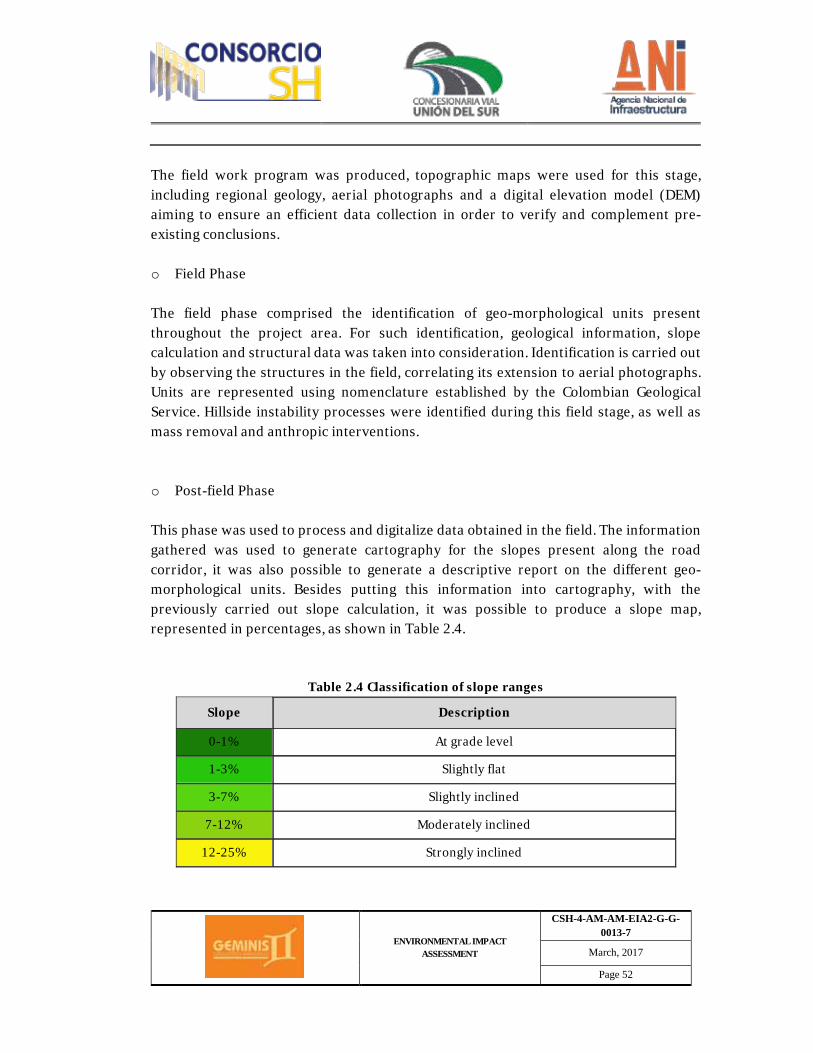
ENVIRONMENTAL IMPACT ASSESSMENT
CSH-4-AM-AM-EIA2-G-G-0013-7
March, 2017
Page 52
The field work program was produced, topographic maps were used for this stage, including regional geology, aerial photographs and a digital elevation model (DEM) aiming to ensure an efficient data collection in order to verify and complement pre-existing conclusions. o Field Phase The field phase comprised the identification of geo-morphological units present throughout the project area. For such identification, geological information, slope calculation and structural data was taken into consideration. Identification is carried out by observing the structures in the field, correlating its extension to aerial photographs. Units are represented using nomenclature established by the Colombian Geological Service. Hillside instability processes were identified during this field stage, as well as mass removal and anthropic interventions. o Post-field Phase This phase was used to process and digitalize data obtained in the field. The information gathered was used to generate cartography for the slopes present along the road corridor, it was also possible to generate a descriptive report on the different geo-morphological units. Besides putting this information into cartography, with the previously carried out slope calculation, it was possible to produce a slope map, represented in percentages, as shown in Table 2.4.
Table 2.4 Classification of slope ranges
Slope Description
0-1% At grade level
1-3% Slightly flat
3-7% Slightly inclined
7-12% Moderately inclined
12-25% Strongly inclined
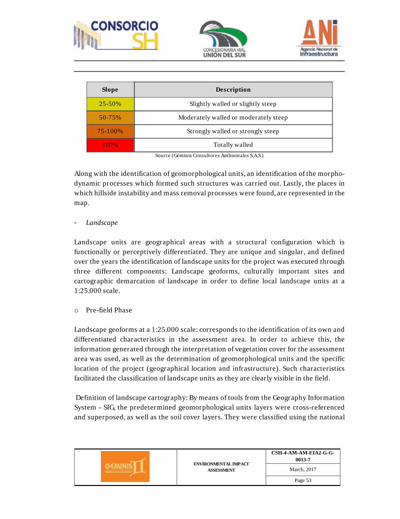
ENVIRONMENTAL IMPACT ASSESSMENT
CSH-4-AM-AM-EIA2-G-G-0013-7
March, 2017
Page 53
Slope Description
25-50% Slightly walled or slightly steep
50-75% Moderately walled or moderately steep
75-100% Strongly walled or strongly steep
100% Totally walled Source (Géminis Consultores Ambientales S.A.S.)
Along with the identification of geomorphological units, an identification of the morpho-dynamic processes which formed such structures was carried out. Lastly, the places in which hillside instability and mass removal processes were found, are represented in the map. - Landscape Landscape units are geographical areas with a structural configuration which is functionally or perceptively differentiated. They are unique and singular, and defined over the years the identification of landscape units for the project was executed through three different components: Landscape geoforms, culturally important sites and cartographic demarcation of landscape in order to define local landscape units at a 1:25.000 scale. o Pre-field Phase Landscape geoforms at a 1:25.000 scale: corresponds to the identification of its own and differentiated characteristics in the assessment area. In order to achieve this, the information generated through the interpretation of vegetation cover for the assessment area was used, as well as the determination of geomorphological units and the specific location of the project (geographical location and infrastructure). Such characteristics facilitated the classification of landscape units as they are clearly visible in the field. Definition of landscape cartography: By means of tools from the Geography Information System - SIG, the predetermined geomorphological units layers were cross-referenced and superposed, as well as the soil cover layers. They were classified using the national
ENVIRONMENTAL IMPACT ASSESSMENT
CSH-4-AM-AM-EIA2-G-G-0013-7
March, 2017
Page 54
soil cover nomenclature, which uses CORINE LAND COVER methodology, adapted for Colombia back in 2010. Because of this cross-referencing work, a map of the landscape units for the assessment area was obtained and used as a basis to produce the landscape sites which have cultural interest, as identified by the communities. To describe the landscape units, we started by looking for information related to the geological structures and the mineral deposits for the different geological units, aiming to have a systematic assessment on the origin and development of all topography forms on land, as well as the agents, processes and states of development for such geoforms. We sought to identify the homogenous edaphogenetic environment, meaning the land surface in which a high similitude of factors which form soil are identified, such as weather, parental materials, time, organisms and topography, which translates into a similitude potential for existing soils and physiographic landscapes. Basic cartography and aerial photographs were also revised. o Field Phase To complement and corroborate information obtained, a field observation phase was also undertaken in order to identify the land surface forms, aiming to acknowledge the action of endogenous and exogenous forces which enable the modeling of the environment, aiming to generate a landscape analysis and component analysis, the identification of land covers and soil uses, the size of the land plots and the deterioration or erosion symptoms in the area. All these elements help to achieve a first look into the edapho-genetic environments which describe and determine the soil types in the area. Additionally, participative workshops were held in order to hear from the community about communal landscape points in their territory. This activity was carried out using talking maps and subsequent field visits with community leaders. Different components were assessed at the different sites, including: vegetation, presence of water, presence of infrastructure, amongst others. o Post-field Phase
ENVIRONMENTAL IMPACT ASSESSMENT
CSH-4-AM-AM-EIA2-G-G-0013-7
March, 2017
Page 55
Once the physical elements of the landscape were identified at a cartography level, and information was corroborated in the field, the landscape quality analysis was carried out assessing the different elements comprised within the landscape. Additional to the aforementioned, landscape workshops were also held with the community to analyze the relevant characteristics trying to define the territory's landscape quality. - Hydrogeology Regarding the conceptual hydrogeological model for the project's area of influence, this work contemplated an analysis on secondary information from the Colombian geological Service, information matched against available primary information. Hydrogeological characterization of materials present in the area was carried out by means of reviewing, updating and complementing existing parameters, determining the presence of groundwater, movement of groundwater, determination of position of piezometric levels in aquifers, preliminary hydrogeological and hydraulic characterization of aquifers, analysis of fluvial network and underground drainage that may take place from and to water courses. An inventory of groundwater benchmarks present in the assessment area was carried out (springs, wells and cisterns). The information collected was processed in the office. This activity contemplated assessment on the intrinsic vulnerability to contamination of aquifers. It was used to represent the intrinsic characteristics of a water body and determine the vulnerability of an aquifer to a contaminating agent. o Field Phase The first stage of the hydrogeological assessment had to do with the collection of existing bibliographical information related to the geology in the area and the potential from this units to a store and convey water. Furthermore, hydrological maps were produced to observe existing draining patterns and use them to determine possible water charge and discharge spots. Based on available bibliography, it was possible to define regional aquifers and their properties, as well as charge and discharge points.
ENVIRONMENTAL IMPACT ASSESSMENT
CSH-4-AM-AM-EIA2-G-G-0013-7
March, 2017
Page 56
o Field Phase The field phase was used to identify and describe the geological units that may behave as active aquifers. This was achieved through the analysis of grain distribution, porosity, permeability, water quality and groundwater flow direction, in order to determine possible hydraulic connections and identify charge and discharge points. Fieldwork data was used to determine two hydrogeological units which have their own characteristics and properties. This information was used to generate a conceptual hydrogeological model of the area. This phase also incorporated the generation of an inventory of groundwater points, which includes wells, cisterns and springs. This inventory was completed with field logs, which include geo-referencing work, the use given to each one of the points and the estimated number of users who use the point as a water source, along with the vulnerability level of the aquifer to contamination. o Post-field Phase. This phase corresponds to the production of the conceptual hydrogeological model, for which all information from aquifers detected during the field phase was integrated. The model corresponds to an approximate description of the hydrogeological conditions of the assessment area, in which two hydrogeological units were identified, mainly differentiated by porosity and lithology types. Flow direction for free aquifers present in the area of influence coincide with topography previously observed, which is introduced in the maps. Water points identified in the field are presented in the report as follows: · ID number. · Plane coordinates (MAGNA SIRGAS). · Water point type.

ENVIRONMENTAL IMPACT ASSESSMENT
CSH-4-AM-AM-EIA2-G-G-0013-7
March, 2017
Page 57
· Hydrogeological unit. · Photographic record. lastly, to evaluate intrinsic aquifer vulnerability, every single one of the following parameters was assessed quantitatively: lithology in the non-saturated area, confinement conditions and depth of the water table. Every single one of the aforementioned parameters was qualified using GOD indexation system, Foster (1987), as follows: Parameter G: Refers to the confinement condition of the more superficial aquifer, and establishes the following categories: not confined, not confined–covered, semi-confined, confined, free-flowing without presence of aquifer. Parameter O: This parameter includes global characterization of the saturated area for free aquifers, or for that of the confinement states, for confined aquifers. The lithological nature is assessed, as well as the degree of consolidation and rock fracturing. Parameter D: Depth of water table level for free aquifers, or roof for semi-confined or confined type aquifers. Table 2.5 shows valuations for GOD parameters.
Table 2.5 GOD system valuation table Occurrence of groundwater "G"
None 0 Free Flowing 0.1
Confined 0.2 Semi-confined 0.3
Not Confined (covered) 0.5 Free 1
Predominant lithology on aquifer "O"
Non-consolidated Consolidated (Porous rocks) Consolidated (Massive rocks) Weighting
Clays 0.4
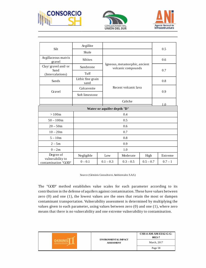
ENVIRONMENTAL IMPACT ASSESSMENT
CSH-4-AM-AM-EIA2-G-G-0013-7
March, 2017
Page 58
Source (Géminis Consultores Ambientales S.A.S.)
The "GOD" method establishes value scales for each parameter according to its contribution in the defense of aquifers against contamination. These have values between zero (0) and one (1), the lowest values are the ones that retain the most or dampen contaminant transportation. Vulnerability assessment is determined by multiplying the values given to each parameter, using values between zero (0) and one (1), where zero means that there is no vulnerability and one extreme vulnerability to contamination.
Silt Argillite
0.5 Shale
Argillaceous matrix gravel Siltites
Igneous, metamorphic, ancient volcanic compounds
0.6
Clay/gravel and/or Sand
(Intercalations)
Sandstone 0.7
Tuff
Sands Lithic fine grain sand
Recent volcanic lava
0.8
Gravel Calcarenite
0.9 Soft limestone
Caliche 1.0
Other hard limestone Water or aquifer depth "D"
> 100m 0.4
50 – 100m 0.5
20 – 50m 0.6
10 – 20m 0.7
5 – 10m 0.8
2 – 5m 0.9
0 – 2m 1.0 Degree of
vulnerability to contamination "GOD"
Negligible Low Moderate High Extreme
0 – 0.1 0.1 – 0.3 0.3 – 0.5 0.5 – 0.7 0.7 – 1
ENVIRONMENTAL IMPACT ASSESSMENT
CSH-4-AM-AM-EIA2-G-G-0013-7
March, 2017
Page 59
It is worth clarifying that the "GOD" methodology aims to assess the more superficial aquifers or the most superficial part of the relevant aquifers, as it is considered that the characteristics of a non-saturated area are the ones that ultimately determine the degree of protection, as they are the most susceptible to negative impacts from a contaminating agent, and once contaminated, this process could be induced easily to deeper areas (INGEOMINAS, 2003). - Geotechnical information To complete zoning and geotechnical cartography for the project, geological information was used as a basis, as well as edaphological, geomorphological, hydrogeological, hydrological, weather and seismic information generated for the project area. Units taken into consideration for every component are described in Table 2.6
Table 2.6 Analysis units by component used to obtain geotechnical information for the project
COMPONENT Analysis units
Geology Geological unit,
Edaphology Soil, Slope
Geomorphology Geomorphological unit
Meteorology Weather Zoning
Seismic threat Threat (Géminis Consultores Ambientales S.A.S, 2016)
The classification of each unit in order to obtain geotechnical zoning was carried out by component, following the descriptions listed in the corresponding tables. Geology: geotechnical stability of the area by means of information supplied by formation or geological unit, as shown in Table 2.7
Table 2.7. Geological Units
Geological Unit Description Stability Classification
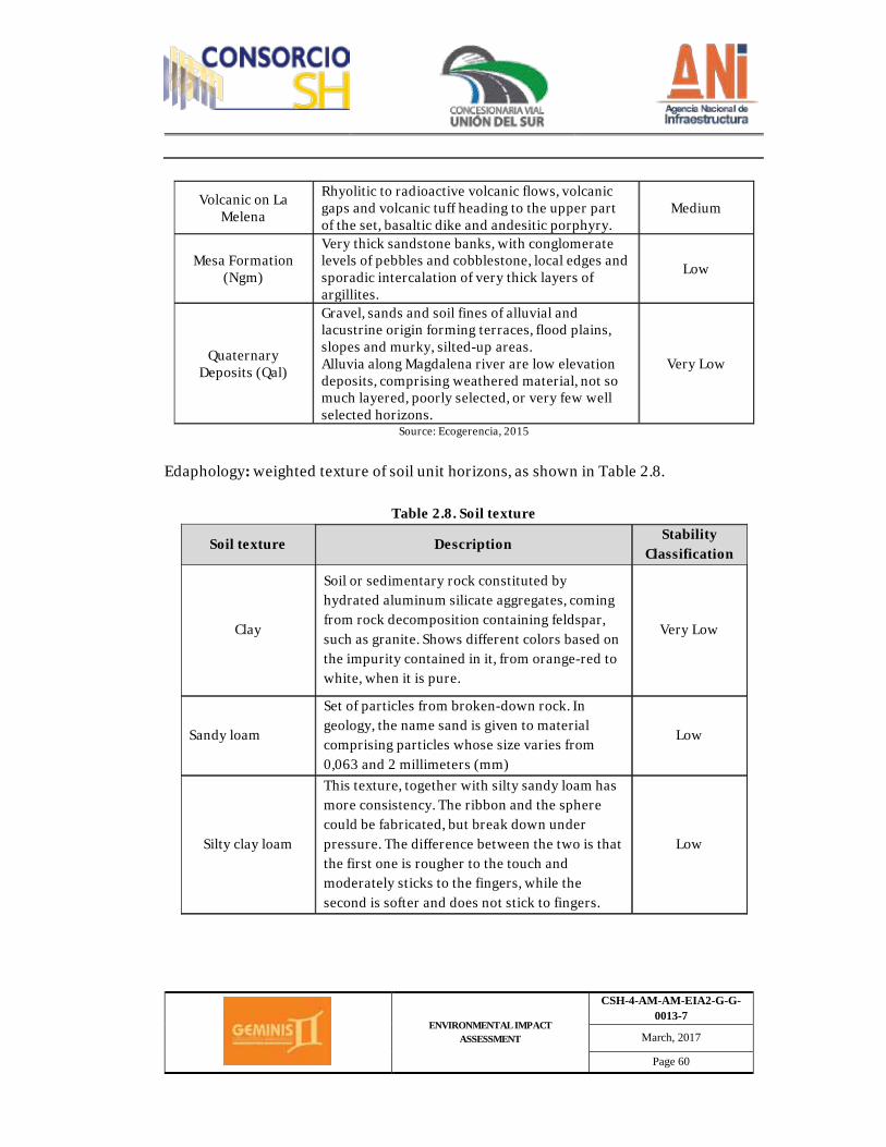
ENVIRONMENTAL IMPACT ASSESSMENT
CSH-4-AM-AM-EIA2-G-G-0013-7
March, 2017
Page 60
Volcanic on La Melena
Rhyolitic to radioactive volcanic flows, volcanic gaps and volcanic tuff heading to the upper part of the set, basaltic dike and andesitic porphyry.
Medium
Mesa Formation (Ngm)
Very thick sandstone banks, with conglomerate levels of pebbles and cobblestone, local edges and sporadic intercalation of very thick layers of argillites.
Low
Quaternary Deposits (Qal)
Gravel, sands and soil fines of alluvial and lacustrine origin forming terraces, flood plains, slopes and murky, silted-up areas. Alluvia along Magdalena river are low elevation deposits, comprising weathered material, not so much layered, poorly selected, or very few well selected horizons.
Very Low
Source: Ecogerencia, 2015
Edaphology: weighted texture of soil unit horizons, as shown in Table 2.8.
Table 2.8. Soil texture
Soil texture Description Stability
Classification
Clay
Soil or sedimentary rock constituted by hydrated aluminum silicate aggregates, coming from rock decomposition containing feldspar, such as granite. Shows different colors based on the impurity contained in it, from orange-red to white, when it is pure.
Very Low
Sandy loam
Set of particles from broken-down rock. In geology, the name sand is given to material comprising particles whose size varies from 0,063 and 2 millimeters (mm)
Low
Silty clay loam
This texture, together with silty sandy loam has more consistency. The ribbon and the sphere could be fabricated, but break down under pressure. The difference between the two is that the first one is rougher to the touch and moderately sticks to the fingers, while the second is softer and does not stick to fingers.
Low
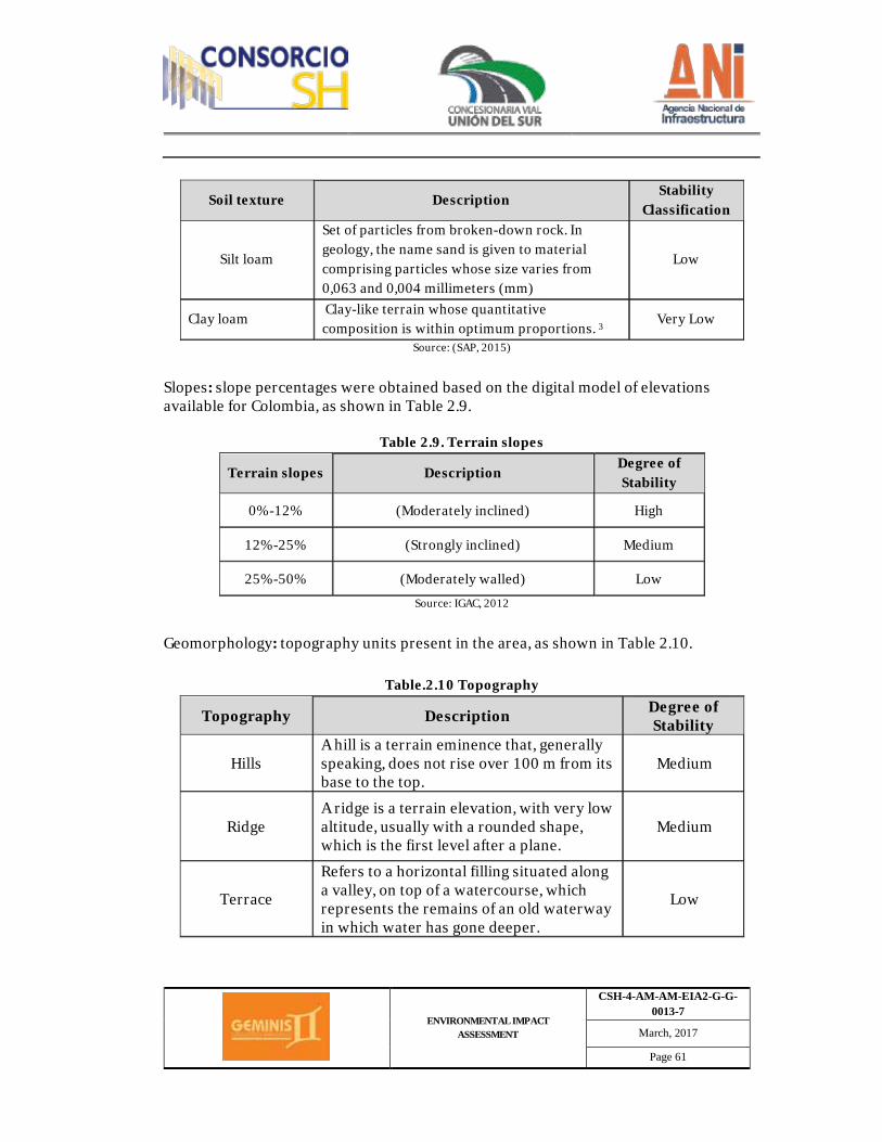
ENVIRONMENTAL IMPACT ASSESSMENT
CSH-4-AM-AM-EIA2-G-G-0013-7
March, 2017
Page 61
Soil texture Description Stability
Classification
Silt loam
Set of particles from broken-down rock. In geology, the name sand is given to material comprising particles whose size varies from 0,063 and 0,004 millimeters (mm)
Low
Clay loam Clay-like terrain whose quantitative composition is within optimum proportions. 3
Very Low
Source: (SAP, 2015)
Slopes: slope percentages were obtained based on the digital model of elevations available for Colombia, as shown in Table 2.9.
Table 2.9. Terrain slopes
Terrain slopes Description Degree of Stability
0%-12% (Moderately inclined) High
12%-25% (Strongly inclined) Medium
25%-50% (Moderately walled) Low Source: IGAC, 2012
Geomorphology: topography units present in the area, as shown in Table 2.10.
Table.2.10 Topography
Topography Description Degree of Stability
Hills A hill is a terrain eminence that, generally speaking, does not rise over 100 m from its base to the top.
Medium
Ridge A ridge is a terrain elevation, with very low altitude, usually with a rounded shape, which is the first level after a plane.
Medium
Terrace
Refers to a horizontal filling situated along a valley, on top of a watercourse, which represents the remains of an old waterway in which water has gone deeper.
Low
ENVIRONMENTAL IMPACT ASSESSMENT
CSH-4-AM-AM-EIA2-G-G-0013-7
March, 2017
Page 62
Topography Description Degree of Stability
Little valley
Refers to a plane in between mountains or elevations. Refers to a depression on the surface in between two were checks, with an incline and elongated shape.
Low
(Géminis Consultores Ambientales S.A.S., 2016) o Pre-field Phase. Existing information was verified during this stage in order to produce an initial geotechnical diagnosis of the road corridor. It was observed that part of it runs through the existing road. The existing cuts assessment was planned for these spans, as well as the current state and all singularities that may have an impact on the profile. The information collected and included in the base project, which serves as a basis for the geotechnical characterization of the terrain, comes from four different campaigns: - Campaign carried out by DEVINAR concession, 2008. - Two additional campaigns carried out by Geotecnia Andina, March 2013. - Complementary campaign for the bidding phase, carried out by GEOSOLUCIONES
SAS, April and May 2015. Likewise, geological, geomorphological, edaphological and structural geology information was collected to subsequently complement the information collected through fieldwork to define geotechnical zoning and characterization. o Field Phase The exploration plans had a proposal to execute probing, shafts, dynamic penetrations and seismic profiles. This research aimed to learn the nature and main characteristics of excavated materials, their recycling and support conditions for backfilling, as well as foundation conditions for structures and walls. Furthermore, the reuse assessment for excavated materials, for the first 17 kilometers where cuts are re-excavated, are taken from the current taluses, samples were taken in sacks for the existing taluses.
ENVIRONMENTAL IMPACT ASSESSMENT
CSH-4-AM-AM-EIA2-G-G-0013-7
March, 2017
Page 63
Both the research carried out and the environmental characteristics were taken into consideration to assign the prospecting plan, especially the existence of cuts close or similar to the ones to be performed, re-excavation of taluses. Furthermore, prospecting work has been carried out for the assessment regarding ZODMES and material sources. For the cut taluses on the current road, from infrastructure close to the profile, and natural taluses, information has been raised to assess the natural characteristics and material stability. After carrying out a detailed assessment on the inventory and on the geological observation points, it is possible to obtain stable cut taluses, as well as more frequent erosion processes, implemented protection and/or sustainment measures and their validation, existence of water flows, etc. Likewise, it is also possible to obtain cut resistance parameters for rock joints and the sustainment means which are more frequently used for rock cutting in the existing road, as well as infrastructure close to the profile. o Post-field Phase For this phase of the assessment, geotechnical information collected in the field was co-related to information previously acquired through geology, structural geology, geomorphology, slopes and soil. This enabled the generation of geotechnical zoning that, in turn, allows geological classification of materials and geotechnical characterization, defining parameters for cut resistance and deformation, data which is subsequently represented from a cryptography standpoint. Likewise, the stability levels assessment was carried out using the limit balance method, in which the basic safety factor recommended by the Colombian Seismic Resistant Construction Standard is used as an input. - Soils Secondary information was analyzed for this assessment based on methodologies and first-hand information generated by Agustín Codazzi Geographical Institute, on soil classification and terrain zoning in the province of Nariño, from 2004.
ENVIRONMENTAL IMPACT ASSESSMENT
CSH-4-AM-AM-EIA2-G-G-0013-7
March, 2017
Page 64
IGAC information was verified in the field for each identified agrological class in areas representative of the geo-morphological units, including uncovered profiles; based on the aforementioned, a check list was produced on the characteristics pertaining to each agrological class and soil classification: "Soil validation form". (Refer to Appendix 2.3.2.1.a.) Information collection was done at a taxonomic level, by subgroup, with its corresponding cartography phases. The cartography units employed where associations, combined associations, undifferentiated groups and clusters. o Current soil use Current use characterization was acquired based on photo interpretation on soil cover and subsequent corroboration in the field by means of transects and sites chosen for corroboration of pedologic content, current use was identified for each cover, recording information in the field form, including corresponding geo-referenced photograph. Classification was carried out following methodology employed for zoning work on areas with soil use conflicts in Colombia. o Agrological Classification and Potential Land Use Soil classification based on potential use, use aptitude or use capabilities is an interpretation based on the combined effects of weather and the nonmodifiable characteristics of geo-forms and soils, regarding use limitations, production capabilities, deterioration risks and handling requirements. In the first instance, an inventory of the limitation factors was produced based on the information collected during soil reconnaissance, subsequently, a description on each land classification unit per use capacity was produced for the assessment area, following guidelines from methodology used for the eight agrological classes, known as Land Classification per Use Capacity. o Soil Use Conflicts
ENVIRONMENTAL IMPACT ASSESSMENT
CSH-4-AM-AM-EIA2-G-G-0013-7
March, 2017
Page 65
Knowing the balance between the current use and the potential use of soil, enabled the identification of the way in which land is being employed in the country and establish a relationship between society and the environment, by defining criteria that supports future sustainable development and land use initiatives. Classification of soil use conflicts allowed for the establishment of three main types: Soils with use conflicts because of overuse, soils with use as established by the basic land use plan (POT), as well as a list of use conflicts pertaining to the project. The aforementioned was developed according to methodology set forth by IGAC. - Hydrology o Hydrological characterization of AID The hydrological description for the area to be assessed for Rumichaca - Pasto's Dual Carriageway Project, Pedregal - Catambuco Span, Concession Contract Under Public-Private Partnership Scheme (PPP) NUMBER 15, FROM 2015, in the province of Nariño, includes hydrological characterization undertaken based on the information available from Agustín Codazzi Geographical Institute (IGAC), Nariño's Regional Autonomous Corporation (CORPONARIÑO), the Hydrology, Weather and Assessments Institute (IDEAM) and Cartography supplied by the Geographical Information System (SIG), as well as fieldwork and reconnaissance. Based on collected cartography, the main surface water bodies were identified, basins, sub basins and micro-basins were outlined, pursuant to sectorization units defined by watersheds. The characterization of the area of influence was developed by means of analyzing lentic and lotic systems, as well as draining patterns at a regional level, and the hydrological regime, including characteristic flows for the main currents. Additionally, analysis on the type and distribution of draining networks was contemplated, including lentic systems, permanent and intermittent, description and location of hydrographic networks and identification of fluvial dynamics; the hydrological regime was also included, taking into consideration characteristic flows of the currents to be intervened. o Hydrological regime and characteristic flows from the main currents

ENVIRONMENTAL IMPACT ASSESSMENT
CSH-4-AM-AM-EIA2-G-G-0013-7
March, 2017
Page 66
Six (6) meteorological monitoring stations were taken as a reference for the hydrological assessment. The stations were managed by IDEAM, close to the project, recording data since 1996. Table 2.11 lists information on the stations queried upon, it includes the station code, category or type of station, municipality where it is located, its coordinates and altitude.
Table 2.11 Hydrological regime and characteristic flows from the main currents
Code Name Municipality Type* Elevation M.A.S.L.
Plane coordinates magna sirgas easting origin
East North
52055010 San Luis Airport
Aldana SP 2961 933187.55 586544.21
52057040 Carlosama Cuaspud
(Carlosama) LG 2920 932281.36 585116.01
52055200 Funes Funes CO 2181 959007.265 602811.103
52050100 Gualmatan Gualmatán PM 2830 943914.47 592025.53
52050090 Imues Imués PM 2550 953025.359 608454.35
52057010 Pilcuan Imués LG 1780 956002.267 604752.699 Source SP: Synoptic Station, AM: Agro-meteorological Station, PM: Rain Gauging Station, CO: Weather Station, ME: Special
Weather Station, LG: Limnological, CP: Main Weather Station Source: (Géminis Consultores Ambientales S.A.S, 2016)
o Water uses analysis The process to determine water uses and users for the water resources in the area of influence for the project started by requesting information from Yacuanquer and Pasto Mayor's offices, as well as Nariño's Regional Autonomous Corporation (CORPONARIÑO), aiming to establish a baseline related to the current and potential uses of the main water sources and other water replenishment systems; this secondary information enabled us to quantify the number of recorded users by municipality.
ENVIRONMENTAL IMPACT ASSESSMENT
CSH-4-AM-AM-EIA2-G-G-0013-7
March, 2017
Page 67
Subsequently, a visit was carried out to the area of interest, where a co-relation between secondary information and additional information was performed by means of inquiries with communities settled upstream and downstream the road's profile. Such information was related to the water provision system and sources available to them, which allowed for the identification of characteristic sources, their location, uses (domestic, irrigation, industrial, livestock, others) and people getting water from them. o Rainfall For the analysis of rainfall, as a first instance, the stations closest to the assessment area were selected and they should have records which are equal to or greater than 50 years. The maximum annual rainfall values were collected in a recording period of 24 hours and a frequency analysis was also carried out getting the maximum daily rainfall values corresponding to different return periods. (2, 5, 10, 20, 25 and 50 years). To achieve the aforementioned, historical data was adjusted to the Gumbel and Log-Pearson Type III probability distributions, the accuracy of this statistical adjustments was checked by means of the Kolmogorov-Smirnov test. Lastly, the most unfavorable maximum rainfall value was chosen for each station out of all the volumes obtained from every single one of the methods, as long as the adjustment was acceptable according to the Kolmogorov-Smirnov test, trying to make sure that the value selected for each case is always on the safe side. o Water Sampling The physiochemical, microbiological and Hydro-biological characterization assessment for Rumichaca - Pasto's Dual Carriageway Project, Pedregal - Catambuco Span, Concession contact under PPP SCHEME NUMBER 15, from 2015, WAS DONE BY MEANS OF SPECIFIC SAMPLING DURING ELEVEN (11) DAYS. The determining parameters were as follows: pH, temperature, DBO, DQO, Greases and Oils, total suspended solids, conductivity, turbidity, actual color, dissolved oxygen, nitrogen, phosphorus, alkalinity, toughness, phenols, arsenic, barium, cadmium, zinc,

ENVIRONMENTAL IMPACT ASSESSMENT
CSH-4-AM-AM-EIA2-G-G-0013-7
March, 2017
Page 68
copper, chrome, mercury, nickel, silver, lead, selenium, alkalinity, total coliforms and E. coli. The determined hydro-biological parameters were as follows: Phytoplankton, zooplankton, macrophytes, periphyton, benthos, ichthyofauna. o Equipment and materials The equipment and material required when taking simple and as specific samples, mixed and integrated samples, were: · Portable measurement equipment: multiparameter and dissolved oxygen. · GPS. · Flowmeter. · Photographic camera. · Fridge to keep the temperature close to 4°C. · Washing jar with distilled water. · Adhesive tape or masking tape, adhesive. Plastic test probe, 500 ml. · Plastic bucket with dewatering valve, 5 to 10 m. · Plastic tube for sample homogenization. · Tape measure. · Rope · Timer. · Distilled water · Absorbing paper. · Gloves. · Labels. · Verification instructions for portable equipment: multiparameter and dissolved
oxygen. o Selection of sampling site To find out the quality of a receptor body such as a river or any other surface current, it was necessary to, at least, have two sampling points: one upstream and the other one downstream from the juncture point, where the mix is complete. The selection of such
ENVIRONMENTAL IMPACT ASSESSMENT
CSH-4-AM-AM-EIA2-G-G-0013-7
March, 2017
Page 69
points shall depend on the objectives and scope of the characterization effort established by the client. Sample taking depended on the nature of the water to be analyzed, as follows: for rivers, the sample was taken as far as possible from the riverbank, trying not to get material from the riverbed and avoiding areas where the water didn't move. o Sampling control and vigilance Sample representativeness and integrity was guaranteed from the very moment it was taken until results were reported. The following are the steps taken to control samples: ü Sample identification Samples were identified by means of adhesive labels on containers before sampling, providing the following information: - Client/OT: the name of the client shall be written down or that of the work order (OT). - Sample origin: waste water, surface water, etc. - Sample type: simple, mixed or integrated. - Sample identification: identification of place where sample was taken. - Date: date sample was taken. - Analysis to be performed: parameters to be analyzed shall be noted. If they are more
than three parameters, the word several shall be used. - Preservation: preservation means used shall be indicated on the container - Responsible: name of the person that takes the sample ü Field forms Field forms are used to record the information collected in the field, which included: sample identification, sample origin, sample type, date and collection time, field measurements and signature of sample responsible person. ü Chain of custody Samples went into the laboratory under their corresponding chain of custody, which recorded the following information: sampling date, laboratory identification number
ENVIRONMENTAL IMPACT ASSESSMENT
CSH-4-AM-AM-EIA2-G-G-0013-7
March, 2017
Page 70
(ID), field responsible person, number of vessels handed over to the laboratory by sampling point, sample type, sample origin, signature – time – date from person who delivers to laboratory, signature – time – date from person who receives at laboratory and signature – time – date from person who assigns identification number. ü Handing sample over to laboratory Samples were handed over to laboratory once they were completed, as soon as it was possible to cover the distance from sampling site, guaranteeing sample conservation and maintaining a constant temperature (4°C). ü Sample reception and registering Samples were inspected at the laboratory to verify their conditions and information on label, by crosschecking with information on the chain of custody form. Subsequently an identification code was assigned (ID) and the sample was preserved for later analysis. o Sampling Methods Water body monitoring was carried out following two different methods: manual and automatic: § Manual sampling: used for easy access sites and/or sites in which it was easy to take
samples.
This kind of sampling method enabled us to observe physical characteristics such as: floating elements, color, smell, flow increase or decrease, etc.
§ Automatic sampling: Automatic sampling was carried out on difficult access sites and/or places where it was difficult to take samples. An automatic sampler was available.
This kind of sampling method allows for more precision, even though installation complexity, calibration and handling is more time-consuming.
ü Flow measurement
ENVIRONMENTAL IMPACT ASSESSMENT
CSH-4-AM-AM-EIA2-G-G-0013-7
March, 2017
Page 71
Once the sampling site is inspected, the method to estimate flow is determined; the most practical way to estimate was adopted, depending on discharge type and, in some cases, the sampling site was subject to changes. The most popular methods where: Ø Manual volumetric measurement
Flow measurement was carried out in a manual manner using a timer and a volumetric flask. The flask was flushed two or three times and a random sample volume was taken. The time elapsed was measured from the moment in which the flask was introduced into the discharge until it was removed from it. The ratio of these two values enabled us to get the flow in that moment of time. Special care was taken when taking the sample and measuring time, as it is a simultaneous process where time begins to be measured when the flask is introduced into the discharge and it is to be stopped when the flask is removed from it. The volumetric flask had the required the dimensions and enough capacity to guarantee that the entire water flow measured at that moment in time went in, avoiding any water loss, aiming to ensure accurate measurement. The formula applied to flow calculation was as follows: 𝑄𝑄 = 𝑉𝑉
𝑡𝑡
Where: Q= Flow. V= Volume. t= Time Ø Speed measurement using pinwheel
A pinwheel is a device comprising several propellers which rotate when they have contact with the water currents, the number of revolutions is proportional to the speed of the current. For this measuring devices, the water speed and revolutions ratio is based on the following formula:
ENVIRONMENTAL IMPACT ASSESSMENT
CSH-4-AM-AM-EIA2-G-G-0013-7
March, 2017
Page 72
𝑄𝑄 = 𝑉𝑉 × 𝐴𝐴
Where: Q= Flow. V= Speed. A= Area of cross-cutting section.
𝐴𝐴 = 𝑊𝑊 × �� 𝐻𝐻𝐻𝐻� /𝑛𝑛
Where: W= Channel width, m. Hi= Depth of each vertical, m. n= Number of measurement points or verticals Speed is determined based on the pinwheel equation as follows: V= a+bnV=water speed in m/s, a and b equipment calibration constants and n= # of revolutions/s. Ø Flow measurement with flowmeter in open channels
Flow measurement in open channels was applied to surface water (rivers, ravines, etc.); where volumetric measurement or discharge measurement was not applicable. Flow measurement in open channels included the following criterion:
· Criteria related to the width of the water body: 0 m < A < 4 meters; reading was taken from five sections 4 meters < A < 40 meters; reading was taken from ten sections A > 40 meters; reading taken from twenty sections A corresponds to the width of the water body
ENVIRONMENTAL IMPACT ASSESSMENT
CSH-4-AM-AM-EIA2-G-G-0013-7
March, 2017
Page 73
· Criteria related to the water layer:
0 meters < H < 0.6 meters; speed measurement at 0.6H 0.6 meters < H < 1 meters; speed measurement at 0.2H and 0.8H 1 meter < H < 3 meters; speed measurement at 0.2H, 0.6H and 0.8H H > 3 meters; speed measurement at 0.2H, 0.4H, 0.6H and 0.8H Where H is the water layer depth. Sampling was taken in a manual form. Temperature, pH, conductivity and dissolved oxygen parameters were analyzed in situ by means of portable equipment. During the entire monitoring effort, it was guaranteed that protocol and specifications for surface water monitoring where met, as pertaining to sampling, vessel filling, preservation, storage, packaging and transportation to laboratory. Results from such analysis enabled us to establish water conditions within a determined timeframe and place. Table 2.12, shows the water monitoring methodology
Table 2.12 Water monitoring methodology
STAGE ACTIVITIES ACHEIVEMENT
PHASE I. PRIOR TO MONITORING
Implementation of workplan - Activities' schedule - Sampling Resource Allotment - Location of sampling points
Project variable identification aiming to decrease setbacks in the field.
Preparation of sampling material
- Material organization (flasks,
packaging, equipment, fridges, ice, stationery)
Availability of sufficient and suitable materials to collect each sample
PHASE II. FIELD MONITORING
ENVIRONMENTAL IMPACT ASSESSMENT
CSH-4-AM-AM-EIA2-G-G-0013-7
March, 2017
Page 74
STAGE ACTIVITIES ACHEIVEMENT
Location of sampling points - Area reconnaissance
To have clarity on every single one of the sampling parameters and locations
Sample taking
- Organization of materials - Filling of vessels according to
sampling parameters - In situ measurement - Labeling - Processing of chain of
custody per point - Refrigeration of samples - Storage
Fulfill 100% of requested sampling
Sending to laboratory
- Packaging of fridges which contain samples and their corresponding chain of custody
Get samples to laboratory within times stipulated by IDEAM's sampling protocol.
Source: Laboratorios ASOAM S.A.S.
- Atmospheric component The atmospheric component includes variables such as meteorology, emission sources, air quality and noise
o Meteorology To determine climate behavior in the assessment area, weather stations were selected employing the following criterion: - Geographical proximity: stations near the project area where identified and
especially located, in order to determine the distance to the specific area. - Representativeness, homogeneous distribution throughout the assessment area and
station type: a representativeness assessment was carried out on the project area, based on station type, which enabled us to discard the stations which record a very low number of weather parameters (rainfall and pluviographs).
- Time series duration: the stations preselected in the point above were subject to a time series analysis, discarding the stations that were suspended or the ones that had a very short registration time.
ENVIRONMENTAL IMPACT ASSESSMENT
CSH-4-AM-AM-EIA2-G-G-0013-7
March, 2017
Page 75
- IDEAM Stations were employed for the area's weather analysis, listed in Table 2.13, which describes the main characteristics of each station.
Table 2.13 Meteorological stations in the assessment area
SP: Main Synoptic Station, AM: Agro-meteorological Station, LG: Water level measuring Station, PM: Rain Gauging Station, CO: Ordinary Weather Station, CP: Main Weather Station
Source: IDEAM 2016
According to the different variables from the weather analysis and assessment area, all the variables from each station correspond to monthly parameters from the last 30 years. 1984 to 2014. whether parameters to be assessed, reported by the weather stations operated by IDEAM, are: - Temperature - Atmospheric Pressure - Rainfall - Relative humidity - Sunshine - Cloudiness - Evaporation
o Emission source and air quality Ø Valid regulations and legislation: Decree 1076 from May 26, 2015: "By means of
which the sole decree regulating the Environmental and Sustainable Development Sector is issued". The purpose of this decree is to collect and rationalize regulations which govern the sector and have legal instruments to
CODE NAME MUNICIPALITY TYPE* ELEVATION m.a.s.l.
GEOGRAPHICAL COORDINATES
LENGTH LATITUDE 52055040 Botana Pasto AM 2820 977596,783 620034,667 52045010 Obonuco Pasto AM 2710 975237,610 624236,710 52057010 Pilcuán Imués LG 2550 953087,191 608426,705 52055090 Sindagua Tangua CP 2800 965331,117 614175,231 52050080 Tangua Tangua PM 2420 965108,364 612737,762
ENVIRONMENTAL IMPACT ASSESSMENT
CSH-4-AM-AM-EIA2-G-G-0013-7
March, 2017
Page 76
regulate it. This is the basic need that generated this Sole Sectorial Regulatory Decree.
Ø Resolution 650 from March 29, 2010, modified by resolution 2154 from
November 2, 2010. "By means of which the air quality monitoring and follow-up protocol is adopted". This protocol establishes guidelines, methodologies and procedures necessary to undertake air-quality monitoring and follow-up activities in the national territory. This protocol comprises the following two handbooks, which are an integral part of the resolution herein: * Air-quality Vigilance Systems Design Handbook * Air-quality Vigilance Systems Operation Handbook.
Ø Resolution 610 from March 24, 2010: "By means of which an Air Quality or Emission Levels Standard is established". This resolution establishes the air quality or emissions levels standard aiming to ensure a healthy environment and minimize risks related to human health that may be caused by contaminant concentration in the air.
ü General monitoring information Monitoring work was carried out by Servicios de Ingeniería y Ambiente S.A.S – SERAMBIENTE, company duly certified through resolution IDEAM 1556 from August 14, 2015. (Refer to Appendix 2.3.2.1.b.) Monitoring work was carried out in the assessment area to determine air quality, atmospheric contaminant concentration levels were determined for particles smaller than 10 µ (PM10), sulfur oxide (SOx), nitrogen oxide (NOx) and carbon monoxide (CO). The results enabled us to know the current conditions and characteristics of the air quality and the main emission sources contributing to atmospheric contamination. The PM10 monitors were obtained based on high-volume equipment for particulate material (Hi-Vol) by means of a gravimetric analysis. NOx and SOx results were obtained based on RAC equipment (three gases), with a spectrophotometric analysis method.
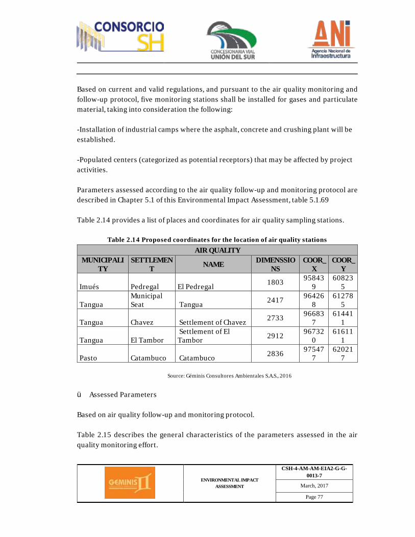
ENVIRONMENTAL IMPACT ASSESSMENT
CSH-4-AM-AM-EIA2-G-G-0013-7
March, 2017
Page 77
Based on current and valid regulations, and pursuant to the air quality monitoring and follow-up protocol, five monitoring stations shall be installed for gases and particulate material, taking into consideration the following: -Installation of industrial camps where the asphalt, concrete and crushing plant will be established. -Populated centers (categorized as potential receptors) that may be affected by project activities. Parameters assessed according to the air quality follow-up and monitoring protocol are described in Chapter 5.1 of this Environmental Impact Assessment, table 5.1.69 Table 2.14 provides a list of places and coordinates for air quality sampling stations.
Table 2.14 Proposed coordinates for the location of air quality stations AIR QUALITY
MUNICIPALITY
SETTLEMENT NAME DIMENSSIO
NS COOR_
X COOR_
Y
Imués Pedregal El Pedregal 1803 958439
608235
Tangua Municipal Seat Tangua 2417 96426
8 61278
5
Tangua Chavez Settlement of Chavez 2733 966837
614411
Tangua El Tambor Settlement of El Tambor 2912 96732
0 61611
1
Pasto Catambuco Catambuco 2836 975477
620217
Source: Géminis Consultores Ambientales S.A.S., 2016
ü Assessed Parameters Based on air quality follow-up and monitoring protocol. Table 2.15 describes the general characteristics of the parameters assessed in the air quality monitoring effort.
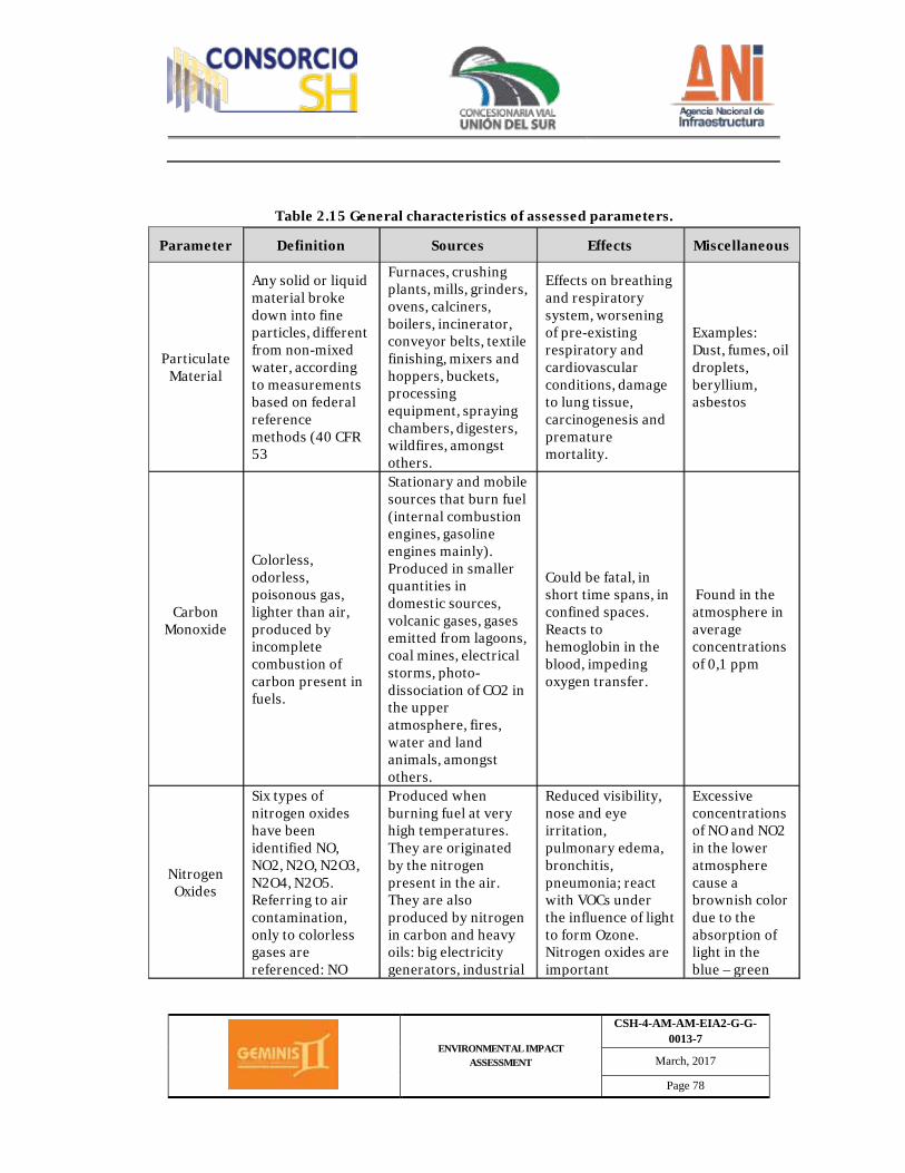
ENVIRONMENTAL IMPACT ASSESSMENT
CSH-4-AM-AM-EIA2-G-G-0013-7
March, 2017
Page 78
Table 2.15 General characteristics of assessed parameters.
Parameter Definition Sources Effects Miscellaneous
Particulate Material
Any solid or liquid material broke down into fine particles, different from non-mixed water, according to measurements based on federal reference methods (40 CFR 53
Furnaces, crushing plants, mills, grinders, ovens, calciners, boilers, incinerator, conveyor belts, textile finishing, mixers and hoppers, buckets, processing equipment, spraying chambers, digesters, wildfires, amongst others.
Effects on breathing and respiratory system, worsening of pre-existing respiratory and cardiovascular conditions, damage to lung tissue, carcinogenesis and premature mortality.
Examples: Dust, fumes, oil droplets, beryllium, asbestos
Carbon Monoxide
Colorless, odorless, poisonous gas, lighter than air, produced by incomplete combustion of carbon present in fuels.
Stationary and mobile sources that burn fuel (internal combustion engines, gasoline engines mainly). Produced in smaller quantities in domestic sources, volcanic gases, gases emitted from lagoons, coal mines, electrical storms, photo-dissociation of CO2 in the upper atmosphere, fires, water and land animals, amongst others.
Could be fatal, in short time spans, in confined spaces. Reacts to hemoglobin in the blood, impeding oxygen transfer.
Found in the atmosphere in average concentrations of 0,1 ppm
Nitrogen Oxides
Six types of nitrogen oxides have been identified NO, NO2, N2O, N2O3, N2O4, N2O5. Referring to air contamination, only to colorless gases are referenced: NO
Produced when burning fuel at very high temperatures. They are originated by the nitrogen present in the air. They are also produced by nitrogen in carbon and heavy oils: big electricity generators, industrial
Reduced visibility, nose and eye irritation, pulmonary edema, bronchitis, pneumonia; react with VOCs under the influence of light to form Ozone. Nitrogen oxides are important
Excessive concentrations of NO and NO2 in the lower atmosphere cause a brownish color due to the absorption of light in the blue – green
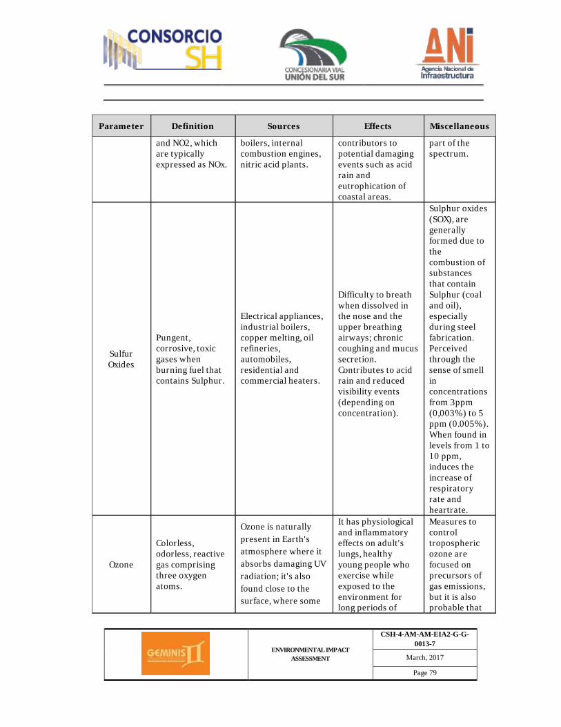
ENVIRONMENTAL IMPACT ASSESSMENT
CSH-4-AM-AM-EIA2-G-G-0013-7
March, 2017
Page 79
Parameter Definition Sources Effects Miscellaneous
and NO2, which are typically expressed as NOx.
boilers, internal combustion engines, nitric acid plants.
contributors to potential damaging events such as acid rain and eutrophication of coastal areas.
part of the spectrum.
Sulfur Oxides
Pungent, corrosive, toxic gases when burning fuel that contains Sulphur.
Electrical appliances, industrial boilers, copper melting, oil refineries, automobiles, residential and commercial heaters.
Difficulty to breath when dissolved in the nose and the upper breathing airways; chronic coughing and mucus secretion. Contributes to acid rain and reduced visibility events (depending on concentration).
Sulphur oxides (SOX), are generally formed due to the combustion of substances that contain Sulphur (coal and oil), especially during steel fabrication. Perceived through the sense of smell in concentrations from 3ppm (0,003%) to 5 ppm (0.005%). When found in levels from 1 to 10 ppm, induces the increase of respiratory rate and heartrate.
Ozone
Colorless, odorless, reactive gas comprising three oxygen atoms.
Ozone is naturally present in Earth's atmosphere where it absorbs damaging UV radiation; it's also found close to the surface, where some
It has physiological and inflammatory effects on adult's lungs, healthy young people who exercise while exposed to the environment for long periods of
Measures to control tropospheric ozone are focused on precursors of gas emissions, but it is also probable that
ENVIRONMENTAL IMPACT ASSESSMENT
CSH-4-AM-AM-EIA2-G-G-0013-7
March, 2017
Page 80
Parameter Definition Sources Effects Miscellaneous
contaminants react to the presence of sunlight, originating this gas. The main contaminants involved in these reactions are nitrogen oxides (NOX) and volatile organic components (VOCs). Carbon monoxide (CO) is also a participant of the reactions that form ozone. Sunny days, with a relatively slow wind, favor the formation of ozone.
time; effects on the health of children. The most exposed groups are children, adults with strong outdoors activities, as well as people with asthma and other respiratory ailments.
they will control the levels and effects of several other contaminants.
Source: Resolution 2154 Clean Air Follow-up and Monitoring Protocol.
ü Instrumentation and measurement type Ø Total Suspended Particles (TSP) and Breathable (PM10).
Sampling of total suspended particles (PST) and breathable (PM10) was carried out through a high volume sampler (Hi-Vol), which essentially comprises a suction motor, a filter carrier, a flow measurement device, a timer and a protective enclosure, as shown in Photograph 2.1 and Photograph 2.2, Table 2.16 and Table 2.17, provide a list of the technical specifications for the high-volume samplers for PST and PM10, respectively.
Table 2.16 Hi-Vol PST Technical specifications
Specifications Value
Power 0.6 hp Max. Speed Maximum speed 18250 rpm
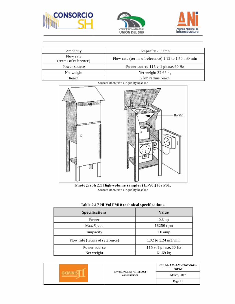
ENVIRONMENTAL IMPACT ASSESSMENT
CSH-4-AM-AM-EIA2-G-G-0013-7
March, 2017
Page 81
Ampacity Ampacity 7.0 amp Flow rate
(terms of reference) Flow rate (terms of reference) 1.12 to 1.70 m3/min
Power source Power source 115 v, 1 phase, 60 Hz Net weight Net weight 32.66 kg
Reach 2 km radius reach Source: Monteria's air quality baseline
Photograph 2.1 High-volume sampler (Hi-Vol) for PST.
Source: Monteria's air quality baseline
Table 2.17 Hi-Vol PM10 technical specifications.
Specifications Value
Power 0.6 hp Max. Speed 18250 rpm
Ampacity 7.0 amp
Flow rate (terms of reference) 1.02 to 1.24 m3/min
Power source 115 v, 1 phase, 60 Hz Net weight 61.69 kg

ENVIRONMENTAL IMPACT ASSESSMENT
CSH-4-AM-AM-EIA2-G-G-0013-7
March, 2017
Page 82
Scope 2 km radius Source: Monteria's air quality baseline
Photograph 2.2 High-volume sampler (Hi-Vol) for PM10.
Source: Monteria's air quality baseline
The reference method (American Public Health Association, World Meteorological Organization and Environmental Protection Agency), allows the measurement of total suspended particles (PST) and breathable (PM10) present in the air by means of a high-volume (Hi-Vol) sampler adequately installed, which performs suction by means of a fiber glass filter (PST) or quartz (PM10) filter on a determined amount of air (between 1.12 and 1.70 m3/min to PST reference conditions and 1.02 and 1.24 m3/min to actual PM10 conditions), within a protective enclosure, during a 24 hours sampling period. The measurement process is nondestructive and the sample could be subject to subsequent physical and chemical analysis. the speed of the sampled air and the geometry of the sampler allow for the collection of particles up to 50 µm (aerodynamic diameter) for the PST Hi-Vols, depending on wind
ENVIRONMENTAL IMPACT ASSESSMENT
CSH-4-AM-AM-EIA2-G-G-0013-7
March, 2017
Page 83
speed and direction, and up to 10 µm for PM10 Hi-Vols, after having separated them inertially into one or more fractions. Filters used must have a minimum collection efficiency of 99% for 0.30 μm particles. For this method, filter is weighted at the laboratory under controlled humidity and temperature conditions before and after use, in order to determine net weight gain (mass). The total volume of sampled air, corrected to reference conditions (101.325 kPa 25°C), is determined based on the flow of air that was sucked in and the sampling time. The concentration of total suspended particles in the environment air is calculated by dividing the mass of collected particles in the filter by the sampled air volume. It is expressed in micrograms by cubic meter (μg/m3). The calculation to get PST and PM10 concentration for every site of interest, requires the initial and final weight of the filters and the total volume of sampled air. This last parameter is calculated as the product of the flow rate to reference conditions (25°C and 101.33 kPa) for every day of measurement and the actual sampling time. The equation used to calculate suspended particle concentrations in μg/m3 is introduced below. Therefore:
· m and b, slope and intercept of the Hi-Vol equipment calibration curve. · I, indication of sampler flow, feet3/min. · Q (std), Average sampling flow to reference conditions, m3/min · V (std), Total air sample in normal volume units, m3 std · t, Net sampling time, min. · Wf, Final weight of exposed filter, g. · Wi, Initial weight of clean filter, g. · PST, Mass concentration of suspended particles in the air, μg/m3.
Parameters m and b found through calibration, which are used to calculate the standard average sampling flow through the following equation:
𝑄𝑄(𝑠𝑠𝑠𝑠𝑠𝑠) = [𝐼𝐼 − 𝑏𝑏]1𝑚𝑚
the total air sampling volume is:

ENVIRONMENTAL IMPACT ASSESSMENT
CSH-4-AM-AM-EIA2-G-G-0013-7
March, 2017
Page 84
𝑉𝑉𝑠𝑠𝑡𝑡𝑠𝑠 = 𝑄𝑄𝑠𝑠𝑡𝑡𝑠𝑠(𝑠𝑠) PST concentration is determined by means of:
𝑃𝑃𝑃𝑃𝑃𝑃 =�𝑊𝑊𝑓𝑓 − 𝑊𝑊𝑖𝑖�106
𝑉𝑉𝑠𝑠𝑡𝑡𝑠𝑠
· Sulfur Dioxide
Air samples for NOx and SOx are taken simultaneously to the one related to particles by means of the Andersen-type sampling train, using the vacuum pump to make the air go through a bubbler with absorbent solutions for a 24-hour period. Done using a sampler called 3-gases, which comprises a suction motor, a manifold, a bubbler, a flow measuring device (critical orifice), a refrigeration/heating thermoelectric system, a timer and a protective enclosure, as shown in Photograph 2.3 and Table 2.18, in which the 3-gases sampler technical specifications are listed.
Table 2.18 Technical specifications for the 3-gases sampler.
Specifications Value
Power 0.17 hp Ampacity 3.7 amp
Flow rate (actual conditions) 0.20 ± 0.02 L/min
Power source 115 v, 60 Hz Net weight 15 kg
Source: Monteria's air quality baseline
The reference method is applied during the determination of Sulphur dioxide (SO2) in the environment's air, by means of the pararosaniline wet process analytical technique (American Public Health Association and Environmental Protection Agency).

ENVIRONMENTAL IMPACT ASSESSMENT
CSH-4-AM-AM-EIA2-G-G-0013-7
March, 2017
Page 85
Photograph 2.3 3-gases sampler
Source: Monteria's air quality baseline
In this method, Sulphur dioxide is absorbed from the air in TCM solution, with a 0.04 molar concentration (M), obtaining a stable compound: "monochlorosulfonatomercurate", which is resistant to O2 oxidation from the air. Once formed, this compound resists air oxidation and is stable in the presence of strong oxidants (for example, ozone and nitrogen oxides). The compound reacts to pararosaniline and formaldehyde, forming a pararosaniline methyl sulfonic acid, with a very intense color, whose chromatic intensity could be measured in a spectrophotometer to 548 nm and is directly proportional to the amount of sulfur dioxide (SO2) collected. The total volume of sampled air, corrected to reference conditions, is determined based on the flow and sampling time. SO2 concentration in the air is expressed in micrograms by cubic meter to reference conditions (μg/m3).
ENVIRONMENTAL IMPACT ASSESSMENT
CSH-4-AM-AM-EIA2-G-G-0013-7
March, 2017
Page 86
The concentration interval for measurement is that of 25 μg/m3 to reference conditions, could be reduced to 5 μg/m3 when analyzing bigger aliquots The concentration of sulfur dioxide in the air is calculated as follows:
𝜇𝜇𝜇𝜇𝑃𝑃𝜇𝜇2/𝑚𝑚3 = �(𝐴𝐴 − 𝐴𝐴0)𝐵𝐵𝐵𝐵103
𝑉𝑉 �𝑉𝑉𝑏𝑏
𝑉𝑉𝑎𝑎
Where:
- A – Ao = Absorbance is corrected by the target in the spectrophotometer - Bx = Reciprocal of the spectrophotometer's calibration curve slope - V = Volume of sampled air, ml - Vb = Volume of the absorbing solution, ml - Va = Volume of aliquot analyzed in the spectrophotometer, ml
· Nitrogen Dioxide
Monitoring of Nitrogen Dioxide (NO2) is done using a sampler called 3-gases, which comprises a suction motor, a manifold, a bubbler, a flow measuring device (critical orifice), a refrigeration/heating thermoelectric system, a timer and a protective enclosure, as shown in Photograph 2.3 and Table 2.16 PST Hi-Vol Technical Specifications, in which the 3-gases sampler technical specifications are listed. The sodium arsenite method provides a measure of the mass concentration of nitrogen dioxide in the air (American Public Health Association and Environmental Protection Agency). The method is based on the fact that nitrogen dioxide is absorbed from the air in a sodium hydroxide and sodium arsenite solution to form a stable sodium nitrate solution. The nitrite ion produced during sampling is determined colorimetrically by reaction of the absorbing agent exposed to phosphoric acid, sulfanilamide and dihydrochloride of naphthylenediamine N-1. The method is applicable to sample collection in the field for a 24-hour period and subsequent laboratory analysis. The total volume of sampled air, corrected to reference conditions, is determined based on the flow and sampling time. SO2 concentration in the air is expressed in micrograms
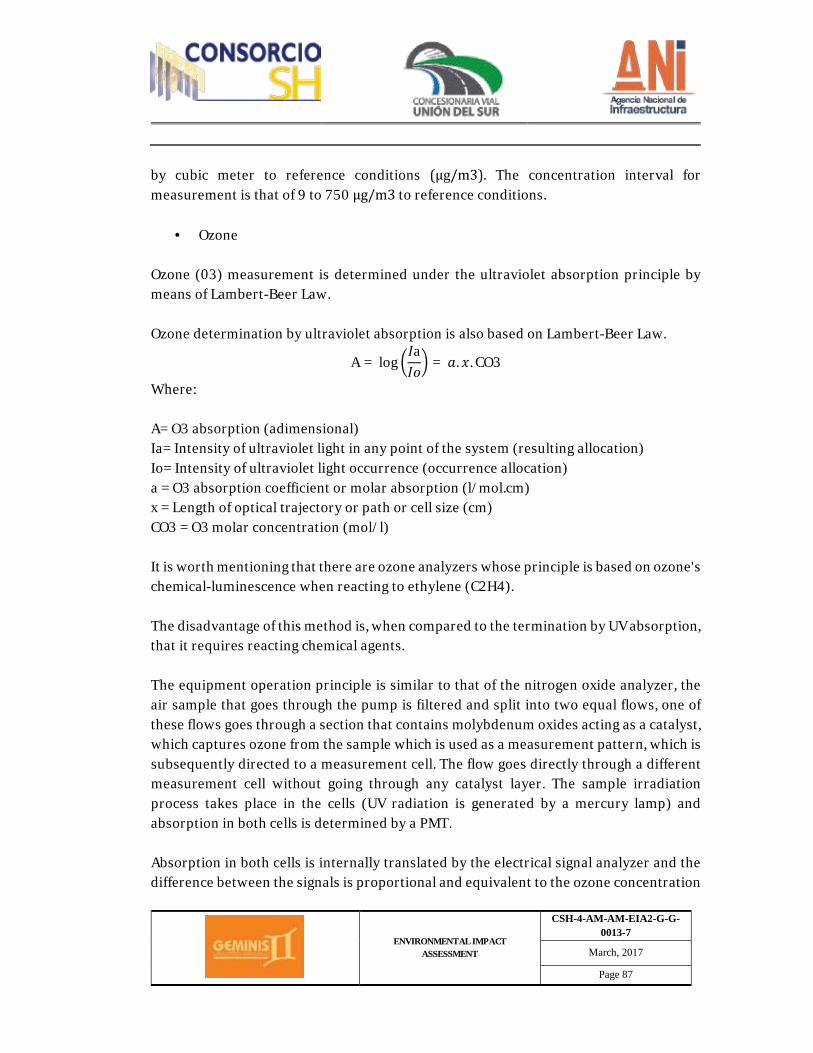
ENVIRONMENTAL IMPACT ASSESSMENT
CSH-4-AM-AM-EIA2-G-G-0013-7
March, 2017
Page 87
by cubic meter to reference conditions (μg/m3). The concentration interval for measurement is that of 9 to 750 μg/m3 to reference conditions.
· Ozone Ozone (03) measurement is determined under the ultraviolet absorption principle by means of Lambert-Beer Law. Ozone determination by ultraviolet absorption is also based on Lambert-Beer Law.
A = log �𝐼𝐼a𝐼𝐼𝐼𝐼
� = 𝑎𝑎. 𝐵𝐵. CO3
Where: A= O3 absorption (adimensional) Ia= Intensity of ultraviolet light in any point of the system (resulting allocation) Io= Intensity of ultraviolet light occurrence (occurrence allocation) a = O3 absorption coefficient or molar absorption (l/mol.cm) x = Length of optical trajectory or path or cell size (cm) CO3 = O3 molar concentration (mol/l) It is worth mentioning that there are ozone analyzers whose principle is based on ozone's chemical-luminescence when reacting to ethylene (C2H4). The disadvantage of this method is, when compared to the termination by UV absorption, that it requires reacting chemical agents. The equipment operation principle is similar to that of the nitrogen oxide analyzer, the air sample that goes through the pump is filtered and split into two equal flows, one of these flows goes through a section that contains molybdenum oxides acting as a catalyst, which captures ozone from the sample which is used as a measurement pattern, which is subsequently directed to a measurement cell. The flow goes directly through a different measurement cell without going through any catalyst layer. The sample irradiation process takes place in the cells (UV radiation is generated by a mercury lamp) and absorption in both cells is determined by a PMT. Absorption in both cells is internally translated by the electrical signal analyzer and the difference between the signals is proportional and equivalent to the ozone concentration
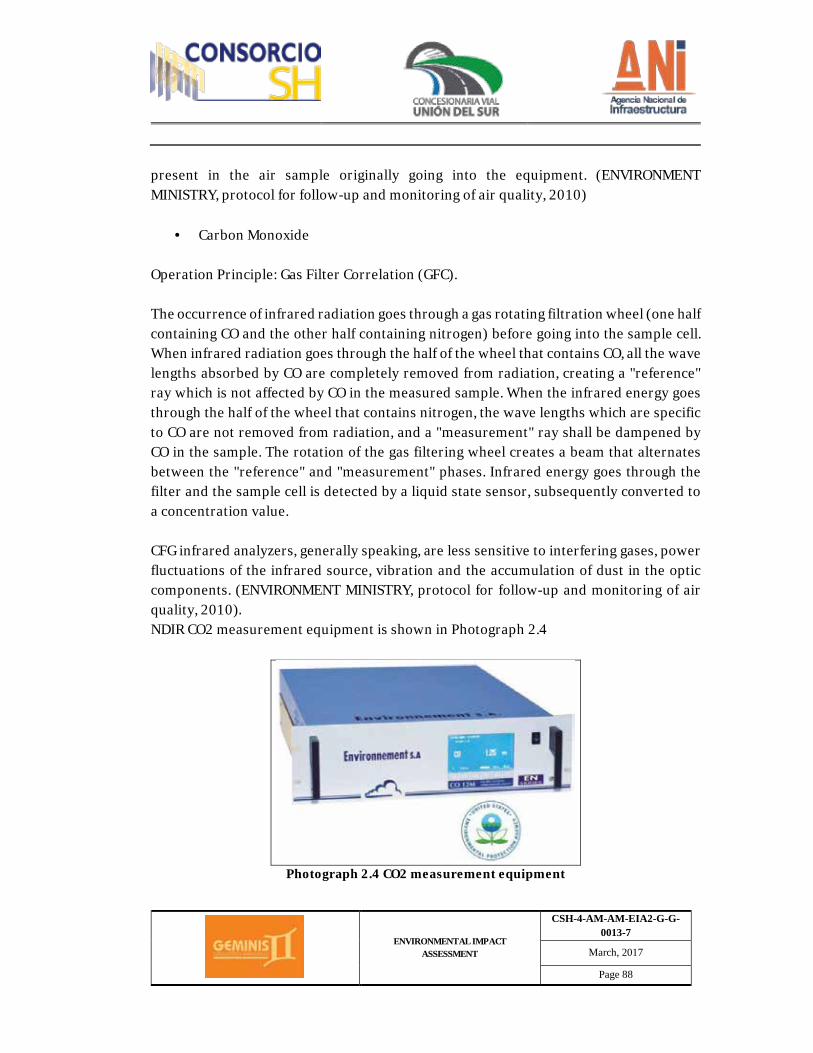
ENVIRONMENTAL IMPACT ASSESSMENT
CSH-4-AM-AM-EIA2-G-G-0013-7
March, 2017
Page 88
present in the air sample originally going into the equipment. (ENVIRONMENT MINISTRY, protocol for follow-up and monitoring of air quality, 2010)
· Carbon Monoxide Operation Principle: Gas Filter Correlation (GFC). The occurrence of infrared radiation goes through a gas rotating filtration wheel (one half containing CO and the other half containing nitrogen) before going into the sample cell. When infrared radiation goes through the half of the wheel that contains CO, all the wave lengths absorbed by CO are completely removed from radiation, creating a "reference" ray which is not affected by CO in the measured sample. When the infrared energy goes through the half of the wheel that contains nitrogen, the wave lengths which are specific to CO are not removed from radiation, and a "measurement" ray shall be dampened by CO in the sample. The rotation of the gas filtering wheel creates a beam that alternates between the "reference" and "measurement" phases. Infrared energy goes through the filter and the sample cell is detected by a liquid state sensor, subsequently converted to a concentration value. CFG infrared analyzers, generally speaking, are less sensitive to interfering gases, power fluctuations of the infrared source, vibration and the accumulation of dust in the optic components. (ENVIRONMENT MINISTRY, protocol for follow-up and monitoring of air quality, 2010). NDIR CO2 measurement equipment is shown in Photograph 2.4
Photograph 2.4 CO2 measurement equipment
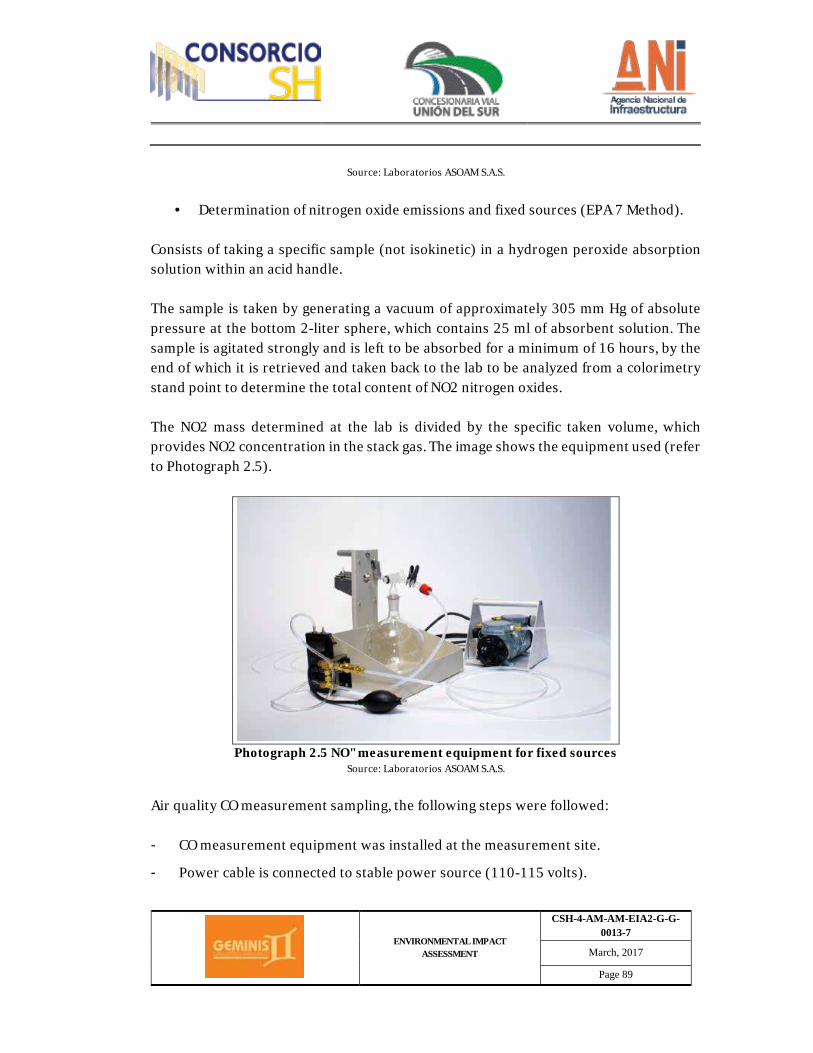
ENVIRONMENTAL IMPACT ASSESSMENT
CSH-4-AM-AM-EIA2-G-G-0013-7
March, 2017
Page 89
Source: Laboratorios ASOAM S.A.S.
· Determination of nitrogen oxide emissions and fixed sources (EPA 7 Method).
Consists of taking a specific sample (not isokinetic) in a hydrogen peroxide absorption solution within an acid handle. The sample is taken by generating a vacuum of approximately 305 mm Hg of absolute pressure at the bottom 2-liter sphere, which contains 25 ml of absorbent solution. The sample is agitated strongly and is left to be absorbed for a minimum of 16 hours, by the end of which it is retrieved and taken back to the lab to be analyzed from a colorimetry stand point to determine the total content of NO2 nitrogen oxides. The NO2 mass determined at the lab is divided by the specific taken volume, which provides NO2 concentration in the stack gas. The image shows the equipment used (refer to Photograph 2.5).
Photograph 2.5 NO" measurement equipment for fixed sources
Source: Laboratorios ASOAM S.A.S.
Air quality CO measurement sampling, the following steps were followed: - CO measurement equipment was installed at the measurement site.
- Power cable is connected to stable power source (110-115 volts).
ENVIRONMENTAL IMPACT ASSESSMENT
CSH-4-AM-AM-EIA2-G-G-0013-7
March, 2017
Page 90
- Once CO equipment was on, 10 to 15 minutes went by before equipment was a stabilized.
- Carbon monoxide measurement initiated, taking readings directly from the equipment screen every hour, measurement was for 8 continued hours.
- Carbon monoxide field data was recorded.
- Weekly data was downloaded for continuous monitoring efforts.
ü Instrumentation and measurement type
· Gas monitoring (SO2, NO2 y O3) Sulphur dioxide sampling (SO2) was carried out by means of a piece of equipment called 3-gas sampler, which comprises a suction motor, a manifold, a bubbler, a flow measuring device (critical orifice), a refrigeration/heating thermoelectric system, a timer and a protective enclosure, as shown in Photograph 2.3 and Table 2.19, in which the 3-gases sampler technical specifications are listed.
Table 2.19 Technical specifications for the 3-gases sampler.
Specifications Value
Power 0.17 hp Ampacity 3.7 amp
Flow rate (actual conditions) 0.20 ± 0.02 L/min Power source 115 v, 60 Hz
Net weight 15 kg Source: Monteria's air quality baseline
Sulphur dioxide (SO2), nitrogen dioxide (NO2) and ozone (O3) are monitored by means of the three-gas analyzer, instrument which utilizes a wet and chemical gas absorption system. Sucked air goes through an inverted protection cone, which is in turn connected to a probe. Subsequently, the air goes through a glass flute which is divided into two or three outlets which are connected to the tubes containing the absorption reaction agents, by means of flexible hoses.
ENVIRONMENTAL IMPACT ASSESSMENT
CSH-4-AM-AM-EIA2-G-G-0013-7
March, 2017
Page 91
The contamination gas is absorbed by the selected reaction agents while the rest of the sample goes through the wet trap (one for every reactive agent) and the final filter (to remove particles), followed by a critical orifice, which regulates flow, which in turn is connected to a vacuum pump. The purpose behind his double trap is to avoid clogging at the critical orifice and contamination of vacuum pump. o Noise Monitoring work was carried out by Servicios de Ingeniería y Ambiente S.A.S – SERAMBIENTE, company duly certified through resolution IDEAM 1556 from August 14, 2015. (Refer to Appendix 2.3.2.1.b.). This assessment corresponds to an environmental noise emission characterization effort. Monitoring took place in day and night shifts, taking five, three-minute measurements per point, with nine minute intervals distributed within an hour. Pursuant to stipulations from resolutions 627 from 2006, environmental noise measurement is to be carried out with a sonometer located in five different positions, each having a microphone orientation pointing to a fixed reference point, as follows: North, South, East, West and vertical heading upwards, on a tripod, 4 meters above ground. With a 4 m radius without any interference or obstacle; in order to prevent wind interference, the microphone to be used was equipped with a windscreen. ü Valid regulations and legislation
Ø Resolution 8321 from 1983: Resolution 8321 from 1993, issued by the Health
Ministry, is the first Colombian regulation which establishes standards on hearing protection and preservation, aiming to foster the well-being of the people and protect them against noise emissions.
Ø Resolution 627 from April 07, 2006: "By means of which a national standard is
established on noise and environmental noise emissions". A national standard is set forth for the entire Colombian territory and the maximum allowed levels are set.
ü Measurement requirements
ENVIRONMENTAL IMPACT ASSESSMENT
CSH-4-AM-AM-EIA2-G-G-0013-7
March, 2017
Page 92
The following general conditions were taken into consideration as a minimum for measurement efforts: Ø Instrumentation
Noise intensity assessments were carried out with Class 2 sound meters, pursuant to standard IEC 61672- 1:2002. Therefore, SOUND PRO SE/DL integrating sonometers were employed along with 1/1 and 1/3 frequency analyzers, real-time data logging was also utilized by means of QUEST SUITE PRO II software, used to program the equipment, carryout retrieval, analysis and data graphics (Refer to Photograph 2.6). Verification or adjustment of sonometer calibration was carried out with calibration equipment that met IEC 60942:2003 standards. It was verified that the calibration equipment met standard IEC 60942:2003 and that sonometer met IEC 61672-1:2002 standards, as per sonometer class (1 and 2 class sonometer), this was done every two years following international and/or national tracing patterns. Once measurement was finalized, the sonometer's calibration was verified based on sonometer's class (class 1 or 2), corroborating that the difference between the initial adjustment and the final verification was no greater than that of the equipment's accuracy; whenever the difference was greater, measurement was repeated. It is necessary that the sonometers' acoustic and electronic calibration certificates are valid according to times specified within the protocol. A copy of the technical report is attached.

ENVIRONMENTAL IMPACT ASSESSMENT
CSH-4-AM-AM-EIA2-G-G-0013-7
March, 2017
Page 93
Photograph 2.6 Sonometer Sound Pro SE/DL
Source: Laboratorios ASOAM S.A.S.
Ø Calibration
Before completing noise measurements, sonometer calibration was verified according to manufacturer's instructions, using a calibrator, recording the last calibration adjustment date. Using QC 10 (pistonphones) calibrators for type 2 and QC 20 (pistonphones) calibrators for type 2 for verification of calibration parameters and dosimeters, according to standards and international methods. Microphones, extension cables, windscreens, batteries and all line accessories, portable computers, tripods and specialized software for data processing (Referred to photograph 2.7).
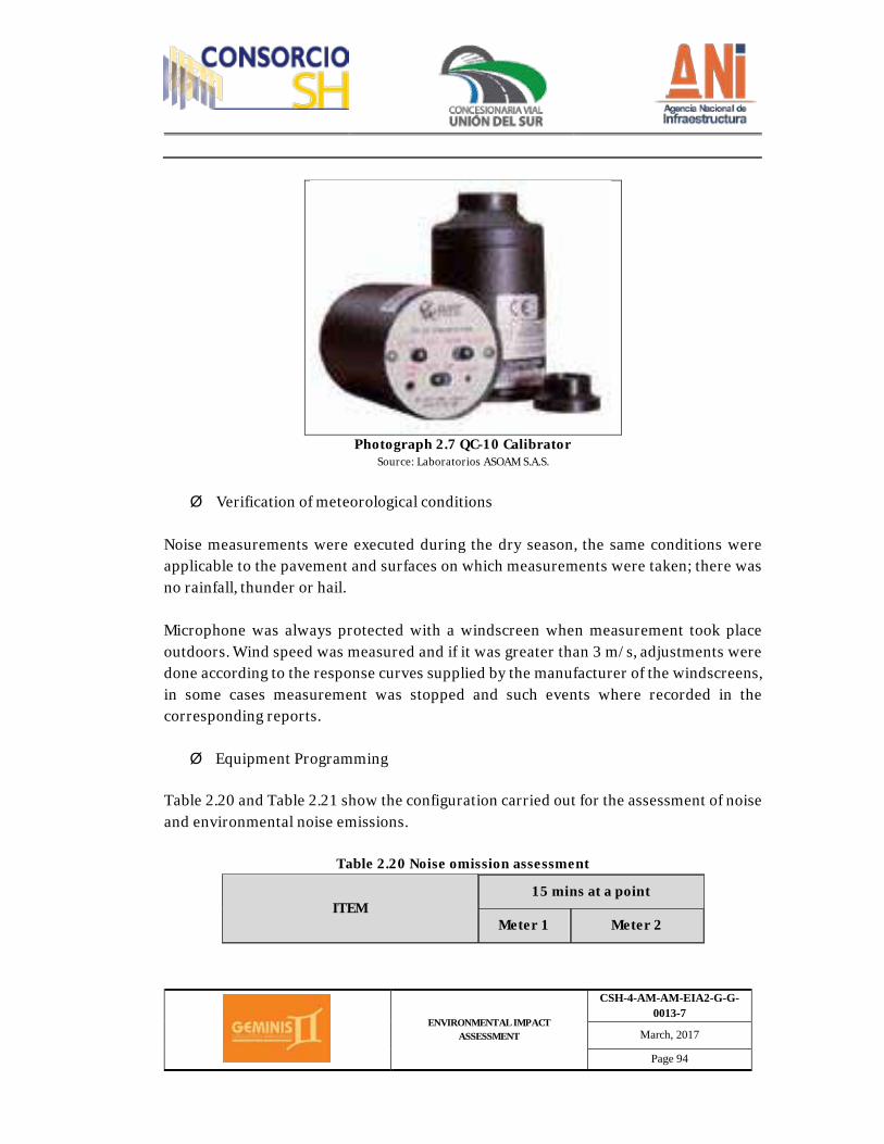
ENVIRONMENTAL IMPACT ASSESSMENT
CSH-4-AM-AM-EIA2-G-G-0013-7
March, 2017
Page 94
Photograph 2.7 QC-10 Calibrator
Source: Laboratorios ASOAM S.A.S.
Ø Verification of meteorological conditions
Noise measurements were executed during the dry season, the same conditions were applicable to the pavement and surfaces on which measurements were taken; there was no rainfall, thunder or hail. Microphone was always protected with a windscreen when measurement took place outdoors. Wind speed was measured and if it was greater than 3 m/s, adjustments were done according to the response curves supplied by the manufacturer of the windscreens, in some cases measurement was stopped and such events where recorded in the corresponding reports. Ø Equipment Programming
Table 2.20 and Table 2.21 show the configuration carried out for the assessment of noise and environmental noise emissions.
Table 2.20 Noise omission assessment
ITEM 15 mins at a point
Meter 1 Meter 2
ENVIRONMENTAL IMPACT ASSESSMENT
CSH-4-AM-AM-EIA2-G-G-0013-7
March, 2017
Page 95
Recording time 1 min 1 min
Weighting curve A A
Exchange index 3 dB 5 dB
Response slow Impulse
Leq AT dB(A) x 1/3 of Octave ON
L Max dB(A) ON
L Peak dB(A) ON
L Min dB(A) ON
L 10 ON
L 90 ON
Assessment time 15 min
Source: Laboratorios ASOAM S.A.S
Table 2.21 Environmental emission assessment
ITEM 15 mins at a point
Meter 1 Meter 2
Recording time 1 min 1 min
Weighting curve A A
Exchange index 3 dB 5 dB
Response slow Impulse
Leq AT dB(A) x 1/3 of Octave ON

ENVIRONMENTAL IMPACT ASSESSMENT
CSH-4-AM-AM-EIA2-G-G-0013-7
March, 2017
Page 96
ITEM 15 mins at a point
Meter 1 Meter 2
L Max dB(A) ON
L Peak dB(A) ON
L Min dB(A) ON
L 10 ON
L 90 ON
Source: Laboratorios ASOAM S.A.S
The equipment to carry out this measurement consists of a Type II automatic integrated timer, measurements were carried out applying a frequency weighting filter (dbA) and a time weighting filter (Slow, response, slow), with a detachable microphone and windscreen, according to the following characteristics (refer to Table 2.22).
Table 2.22 Sonometer characteristics
Sonometer
Reference Description
Range 40 – 100 dB
Response Slow - Impulse (to find factor K values)
Weighting scale A
Integration 1 s
Microphone Class 2, detachable with pre-polarized
condenser.
Temperature interval 18 a 25 °C
Operation humidity 20 to 80%
Protective device Windscreen
Source: Laboratorios ASOAM S.A.S
ENVIRONMENTAL IMPACT ASSESSMENT
CSH-4-AM-AM-EIA2-G-G-0013-7
March, 2017
Page 97
Before completing noise measurements, the correct working order of the sonometers was verified. An acoustic calibrator was used with a type 1 precision sonometer, with an output frequency of 1000 Hz and 114 dB, and a dispersion below 1%. Once measurement was finalized, the sonometer's calibration was verified, corroborating that the difference between the initial adjustment and the final verification was no greater than that of the equipment's accuracy. If the difference was greater, the measurement was repeated. It is necessary that the sonometers' acoustic and electronic calibration certificates are valid according to timelines specified within the protocol. A copy of the aforementioned is to be attached to the technical report. Ø Procedure
Five (5) sampling points were selected for this monitoring effort within the assessment area. Two (2) measurements took place in each of such points during one (1) working day and one (1) during a nonworking day. Measurements were carried out during previously established periods, at nighttime and daytime. Readings were carried out at an approximate height of 4 m over the floor and in case of facades, obstacles or walls, the point was located at a distance of 4 m, measured horizontally from the side. Every measurement process was carried out for periods of approximately 15 minutes of information capture to represent the sound levels in a measurement time unit interval which should amount to one (1) hour. It was necessary to take five measurements for this measurement process, every single one of them with a different microphone orientation: North, South, East, West and vertical pointing upwards. Ø Information Processing
The information monitored in the field was downloaded through QuestSuite Professional specialized software; which extracts the data to subsequently process it through spreadsheets that enable the calculation of equivalent values for the daytime and nighttime, as well as the corresponding analysis.
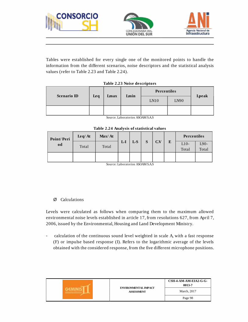
ENVIRONMENTAL IMPACT ASSESSMENT
CSH-4-AM-AM-EIA2-G-G-0013-7
March, 2017
Page 98
Tables were established for every single one of the monitored points to handle the information from the different scenarios, noise descriptors and the statistical analysis values (refer to Table 2.23 and Table 2.24).
Table 2.23 Noise descriptors
Scenario ID Leq Lmax Lmin Percentiles
Lpeak LN10 LN90
Source. Laboratorios ASOAM S.A.S
Table 2.24 Analysis of statistical values
Point/Period
Leq/At Max/At L-I L-S S C.V E
Percentiles
Total Total L10-Total
L90-Total
Source: Laboratorios ASOAM S.A.S
Ø Calculations
Levels were calculated as follows when comparing them to the maximum allowed environmental noise levels established in article 17, from resolutions 627, from April 7, 2006, issued by the Environmental, Housing and Land Development Ministry. - calculation of the continuous sound level weighted in scale A, with a fast response
(F) or impulse based response (I). Refers to the logarithmic average of the levels obtained with the considered response, from the five different microphone positions.
ENVIRONMENTAL IMPACT ASSESSMENT
CSH-4-AM-AM-EIA2-G-G-0013-7
March, 2017
Page 99
- Level of equivalent continuous sound pressure with weighting filter A, for the daytime. Overall, different time intervals, the continuous equivalent sound pressure with weighting filter A, daytime.
- Level of equivalent continuous sound pressure with weighting filter A, for the
nighttime. Overall, different time intervals, the continuous equivalent sound pressure with weighting filter A, nighttime.
- Level of corrected equivalent continuous sound pressure with weighting filter A, for
the daytime. Overall, different time intervals, the corrected continuous equivalent sound pressure with weighting filter A, daytime.
- Level of corrected equivalent continuous sound pressure with weighting filter A, for
the nighttime. Overall, different time intervals, the corrected continuous equivalent sound pressure with weighting filter A, nighttime. (Environmental Ministry, resolution 627 from 2006).
- Information uncertainty The level of uncertainty for the information related to the abiotic component is about 6%, which corresponds to secondary information taken from documents which are up to five years old, including land-use plans, which have not been updated; as well as information from POMCA, PORH and PUEEA. Information reliability is greater than 90%, as most of the primary information corresponds to the fieldwork which was carried out by environmental professionals, pursuant to previously established methodology and protocols. Likewise, laboratory results are highly reliable as they were carried out by accredited companies with high experience on abiotic components. They are all accredited by IDEAM.
2.3.2.2. Biotic Component Following the terms of reference established by resolution 0751 from 2015, information requirements are assessed and defined aiming to comply with the aforementioned terms. Because of the foregoing, a field work plan (schedule) and corresponding methodologies was produced.
ENVIRONMENTAL IMPACT ASSESSMENT
CSH-4-AM-AM-EIA2-G-G-0013-7
March, 2017
Page 100
- Flora o Inventory of forest species An inventory was carried out per identified vegetation cover, establishing sampling plots, leaving aside those covers in which no tree-like or bush-like component was identified, meaning that, industrialized territories, or territories with monoculture, clean pastures or weed, industrial, commercial areas, communication networks, mining extraction areas and/or rock outcrops, were not considered. ü Pre-field Phase Secondary information related to land ecosystems in the area of influence for the project was revised, analyzing its direct relationship with the forestry component, by means of the following activities: • Collection and review of information requested from Mayor's offices from the
municipalities through which the project will go (Land use schemes, Development plans, environmental sustainment plans and water resources quality, recent local studies, etc.).
• Information was queried upon online (webpages), regional and national information
(environmental ministry, national parks, Nariño’s regional autonomous corporation), on the strategic importance of critical ecosystems located within the area of influence of the project.
• Information collection from project design studies at a feasibility level (profile of the
road corridor, areas to be used as disposal zones for debris and excavation materials (ZODMES), camp areas, concrete plants, and other projects related infrastructure).
• Forms to raise and collect field information were also filled in. additionally, the following information was taken into consideration before collecting field data:
ENVIRONMENTAL IMPACT ASSESSMENT
CSH-4-AM-AM-EIA2-G-G-0013-7
March, 2017
Page 101
• Project's base information: Activity type (construction and enhancement), geographical location (province, municipality, township, neighborhood, sector), areas (of influence and intervention).
• Key areas and sites to undertake sampling work by means of visits; with the assistance
of aerial imagery. • Areas to be subject to cartography according to the terms of reference.
IGAC plates were also identified at a 1:25.000 scale and basic geo-database from IGAC at a 1:100.000 scale which are part of the area's cartographic database. ü Field Phase Ø Cover identification
The areas subject to verification in the assessment area were identified with the assistance of the associated cartographic database (road network, settlements, hydrographic network), as well as the preliminary interpretation of covers. This enabled us to confirm the presence of vegetation types and the characteristics of its components. Ø Floral composition
The determination of the floral composition was carried out by means of field visits in transects parallel to the roads (to the left and right), throughout the different functional units and existing vegetation covers (except urban areas). Ø Forestry inventory methodology for plots of land
As established by the Gentry methodology (1995)The forestry inventory was carried out by establishing land plots based on existing vegetation sizes, the size of the sampling units was determined based on factors such as: tree distribution spatial pattern, size categories for sampled trees, diversity of assessed vegetation species. (CRUZ, 2003). In this regard, land plot sizing was carried out based on the strata of the forestry individuals present in the area, meaning, for old-growth species, land plots sized 100 x 10 meters were established, for mid-growth species, land plots sized 10 x 10 meters were
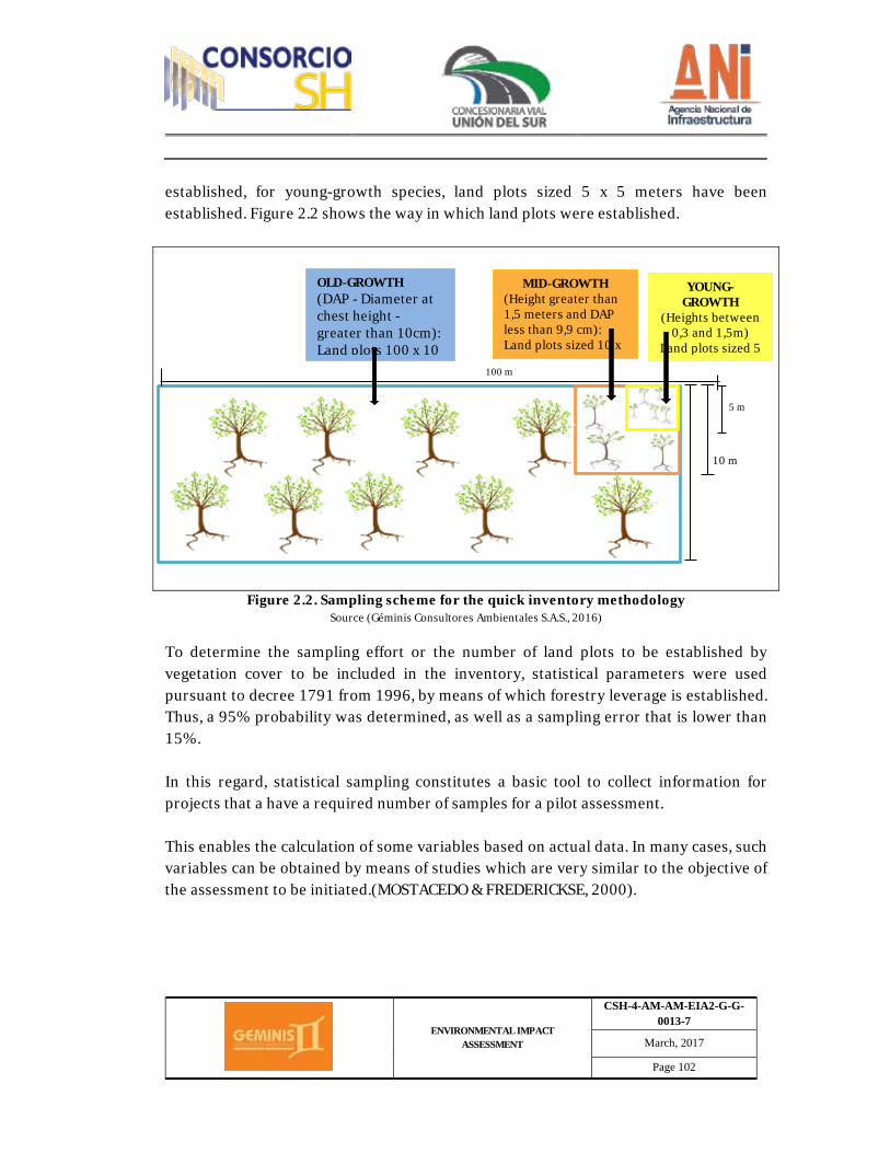
ENVIRONMENTAL IMPACT ASSESSMENT
CSH-4-AM-AM-EIA2-G-G-0013-7
March, 2017
Page 102
established, for young-growth species, land plots sized 5 x 5 meters have been established. Figure 2.2 shows the way in which land plots were established.
Figure 2.2. Sampling scheme for the quick inventory methodology Source (Géminis Consultores Ambientales S.A.S., 2016)
To determine the sampling effort or the number of land plots to be established by vegetation cover to be included in the inventory, statistical parameters were used pursuant to decree 1791 from 1996, by means of which forestry leverage is established. Thus, a 95% probability was determined, as well as a sampling error that is lower than 15%. In this regard, statistical sampling constitutes a basic tool to collect information for projects that a have a required number of samples for a pilot assessment. This enables the calculation of some variables based on actual data. In many cases, such variables can be obtained by means of studies which are very similar to the objective of the assessment to be initiated.(MOSTACEDO & FREDERICKSE, 2000).
10 m
5 m
OLD-GROWTH (DAP - Diameter at chest height - greater than 10cm): Land plots 100 x 10
MID-GROWTH (Height greater than 1,5 meters and DAP less than 9,9 cm): Land plots sized 10 x
YOUNG-GROWTH
(Heights between 0,3 and 1,5m)
Land plots sized 5
100 m
ENVIRONMENTAL IMPACT ASSESSMENT
CSH-4-AM-AM-EIA2-G-G-0013-7
March, 2017
Page 103
Ø Inventory Type
It has been considered that sample distribution is fundamental for a simple random inventory to achieve reliable results, a small, properly distributed, sample is more efficient than a badly distributed big sized sample. A simple random sampling effort was used for the forestry inventory, which is described below:
Simple random inventory sample was directly taken from the stock for this type of design, based on randomness requirements, complying to probability laws, producing high reliability results by being impartial and consistent.
In this regard, for the selection of the sample the total effective area was divided into land plots taking into consideration sampling size (a). Every stock unit was assigned a number. The sample (n) was chosen randomly, using a table with random numbers. Formulas and data used for calculation parameters was developed as shown below: Forest area (A): Corresponds to the total forest area by vegetation cover it you need, expressed in hectares. Land plot size a (a): For old growth of species, land plots sized 100 x 10 meters (0,1ha) were it used; for mid growth species, land plots sized 10 x 10 meters were used, for young-growth species, land plots sized 5 x 5 meters were used. Stock size (N): This is calculated by measuring the forest area in hectares (A) and the area or size of the land plots in hectares also (a), as shown in the following equation:
N= A/a
ENVIRONMENTAL IMPACT ASSESSMENT
CSH-4-AM-AM-EIA2-G-G-0013-7
March, 2017
Page 104
The sample: As mentioned before, due to the extension of the present vegetation cover, only a part of a set called sampling design is selected for the assessment, which represents an entire universe. All selection methods should provide equal opportunities of choosing any individual within a stock. Average (X): It refers to measuring a central trend, defined as follows:
Where: Xi= value observed in a i-th unit of the sample n= number of units of the sample (sample size)
Standard deviation (S): Refers to a measurement that characterizes individual dispersion regarding the average. Provides an idea regarding individuals within a sample, helps us determine if individuals are close to the average or disseminated. Defined as:
Coefficient of variation (CV%) Refers to a measurement that expresses the standard deviation as an average percentage:
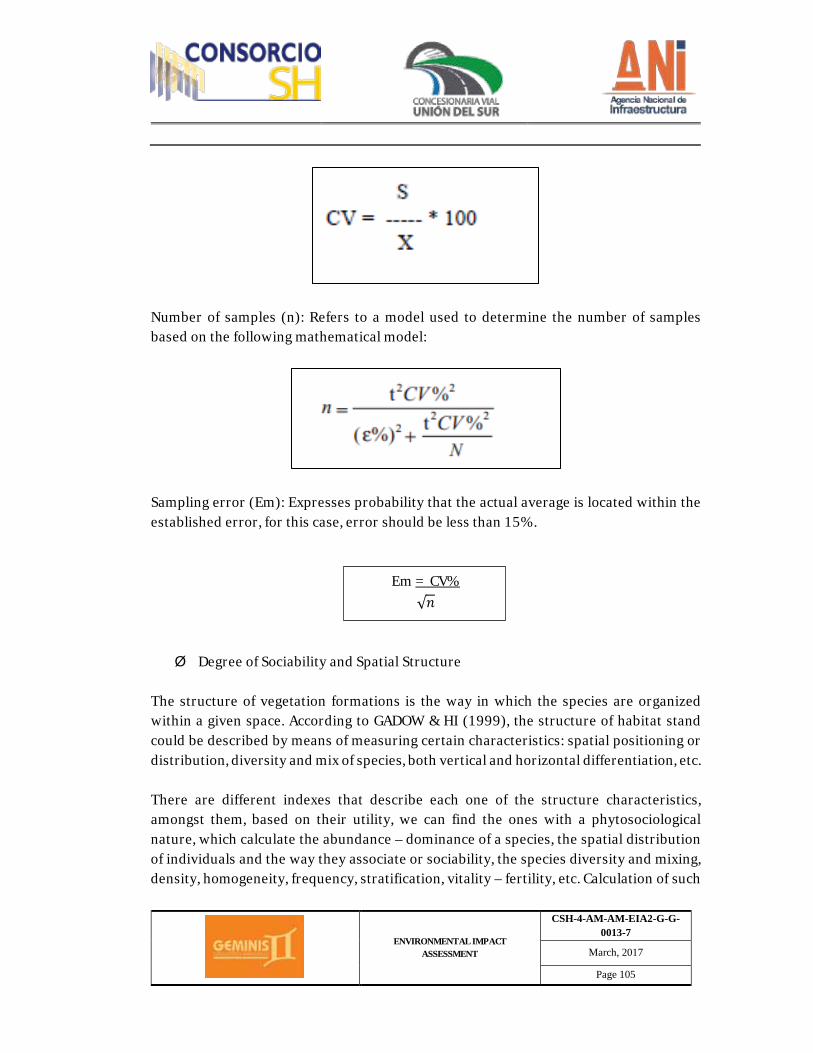
ENVIRONMENTAL IMPACT ASSESSMENT
CSH-4-AM-AM-EIA2-G-G-0013-7
March, 2017
Page 105
Number of samples (n): Refers to a model used to determine the number of samples based on the following mathematical model:
Sampling error (Em): Expresses probability that the actual average is located within the established error, for this case, error should be less than 15%.
Em = CV% √𝑛𝑛
Ø Degree of Sociability and Spatial Structure The structure of vegetation formations is the way in which the species are organized within a given space. According to GADOW & HI (1999), the structure of habitat stand could be described by means of measuring certain characteristics: spatial positioning or distribution, diversity and mix of species, both vertical and horizontal differentiation, etc. There are different indexes that describe each one of the structure characteristics, amongst them, based on their utility, we can find the ones with a phytosociological nature, which calculate the abundance – dominance of a species, the spatial distribution of individuals and the way they associate or sociability, the species diversity and mixing, density, homogeneity, frequency, stratification, vitality – fertility, etc. Calculation of such
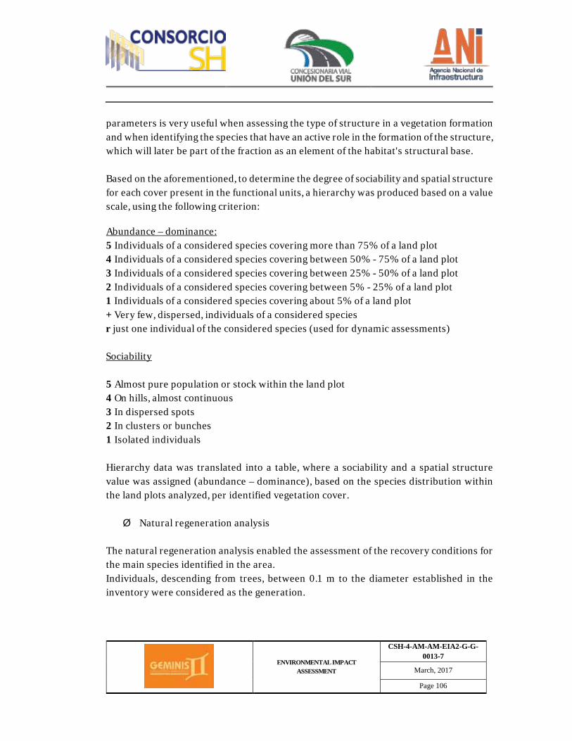
ENVIRONMENTAL IMPACT ASSESSMENT
CSH-4-AM-AM-EIA2-G-G-0013-7
March, 2017
Page 106
parameters is very useful when assessing the type of structure in a vegetation formation and when identifying the species that have an active role in the formation of the structure, which will later be part of the fraction as an element of the habitat's structural base. Based on the aforementioned, to determine the degree of sociability and spatial structure for each cover present in the functional units, a hierarchy was produced based on a value scale, using the following criterion: Abundance – dominance: 5 Individuals of a considered species covering more than 75% of a land plot 4 Individuals of a considered species covering between 50% - 75% of a land plot 3 Individuals of a considered species covering between 25% - 50% of a land plot 2 Individuals of a considered species covering between 5% - 25% of a land plot 1 Individuals of a considered species covering about 5% of a land plot + Very few, dispersed, individuals of a considered species r just one individual of the considered species (used for dynamic assessments) Sociability 5 Almost pure population or stock within the land plot 4 On hills, almost continuous 3 In dispersed spots 2 In clusters or bunches 1 Isolated individuals Hierarchy data was translated into a table, where a sociability and a spatial structure value was assigned (abundance – dominance), based on the species distribution within the land plots analyzed, per identified vegetation cover. Ø Natural regeneration analysis
The natural regeneration analysis enabled the assessment of the recovery conditions for the main species identified in the area. Individuals, descending from trees, between 0.1 m to the diameter established in the inventory were considered as the generation.
ENVIRONMENTAL IMPACT ASSESSMENT
CSH-4-AM-AM-EIA2-G-G-0013-7
March, 2017
Page 107
In this regard, individuals taken for analysis are within the ranges established by Hosokawa (1986), meaning, three different category sizes, as follows:
I. from 0,1m to 0,99 m height II. from 1,0 to 1,9 m height III. from 2,0 m to 4,9 cm DAP
Ø Gathering of field information
the gathering of field information was performed taking into consideration methodology from Álvarez et al. (2006),Who suggests, amongst other things, the following data: ü Locale ü Geographical coordinates (WGS84) and Plane coordinates (Magna Sirgas,
Easting) ü Altitude ü Area's vegetation cover ü Additional notes (Slope, presence or not of water bodies, amongst others)
Gathered information was recorded for all vegetation cover units, establishing sampling land plots. The inventory information for every land plot was recorded taking the following variables into consideration: ü Common name ü Scientific name ü Circumference at chest height (CAP) ü Height (m) ü Tree top height (m) ü Physical and phytosanitary state ü Tree top density
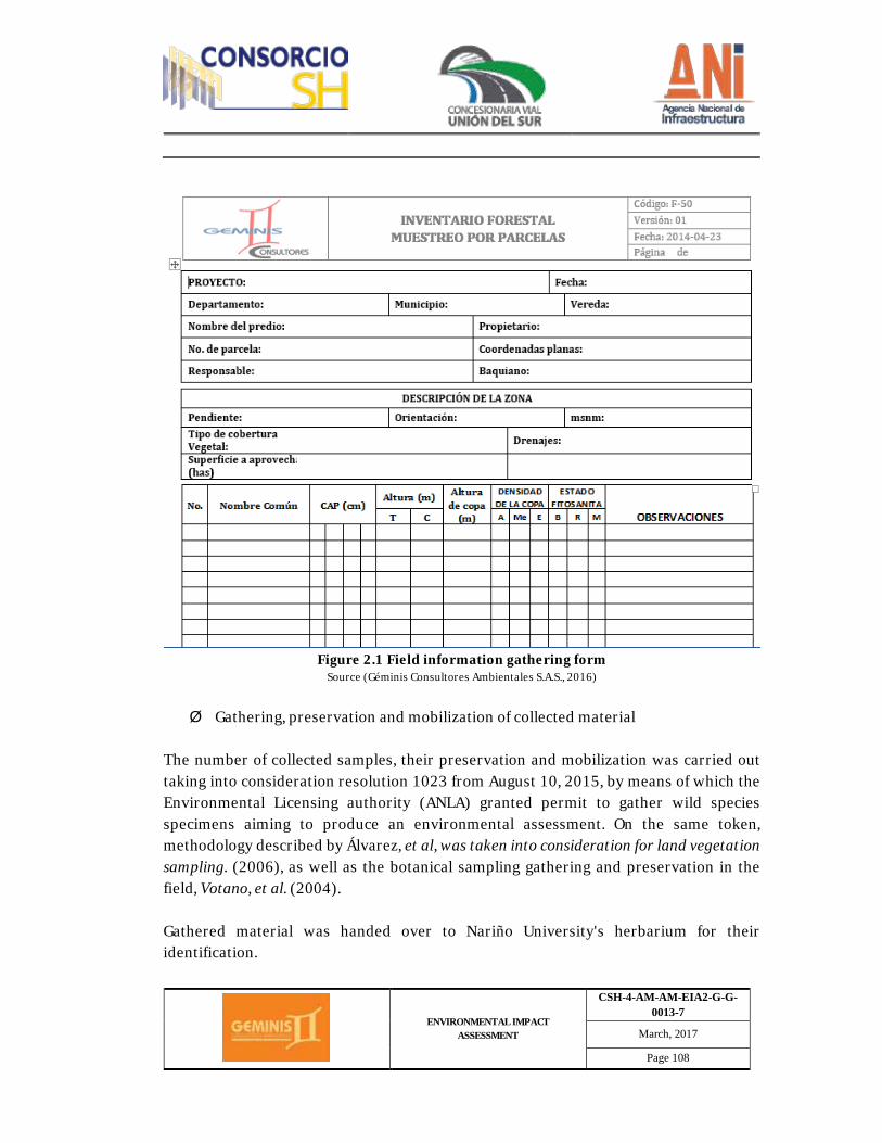
ENVIRONMENTAL IMPACT ASSESSMENT
CSH-4-AM-AM-EIA2-G-G-0013-7
March, 2017
Page 108
Figure 2.1 Field information gathering form
Source (Géminis Consultores Ambientales S.A.S., 2016)
Ø Gathering, preservation and mobilization of collected material
The number of collected samples, their preservation and mobilization was carried out taking into consideration resolution 1023 from August 10, 2015, by means of which the Environmental Licensing authority (ANLA) granted permit to gather wild species specimens aiming to produce an environmental assessment. On the same token, methodology described by Álvarez, et al, was taken into consideration for land vegetation sampling. (2006), as well as the botanical sampling gathering and preservation in the field, Votano, et al. (2004). Gathered material was handed over to Nariño University's herbarium for their identification.
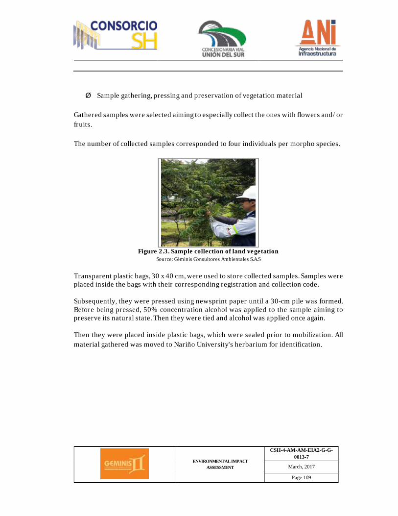
ENVIRONMENTAL IMPACT ASSESSMENT
CSH-4-AM-AM-EIA2-G-G-0013-7
March, 2017
Page 109
Ø Sample gathering, pressing and preservation of vegetation material
Gathered samples were selected aiming to especially collect the ones with flowers and/or fruits. The number of collected samples corresponded to four individuals per morpho species.
Figure 2.3. Sample collection of land vegetation
Source: Géminis Consultores Ambientales S.A.S
Transparent plastic bags, 30 x 40 cm, were used to store collected samples. Samples were placed inside the bags with their corresponding registration and collection code. Subsequently, they were pressed using newsprint paper until a 30-cm pile was formed. Before being pressed, 50% concentration alcohol was applied to the sample aiming to preserve its natural state. Then they were tied and alcohol was applied once again. Then they were placed inside plastic bags, which were sealed prior to mobilization. All material gathered was moved to Nariño University's herbarium for identification.
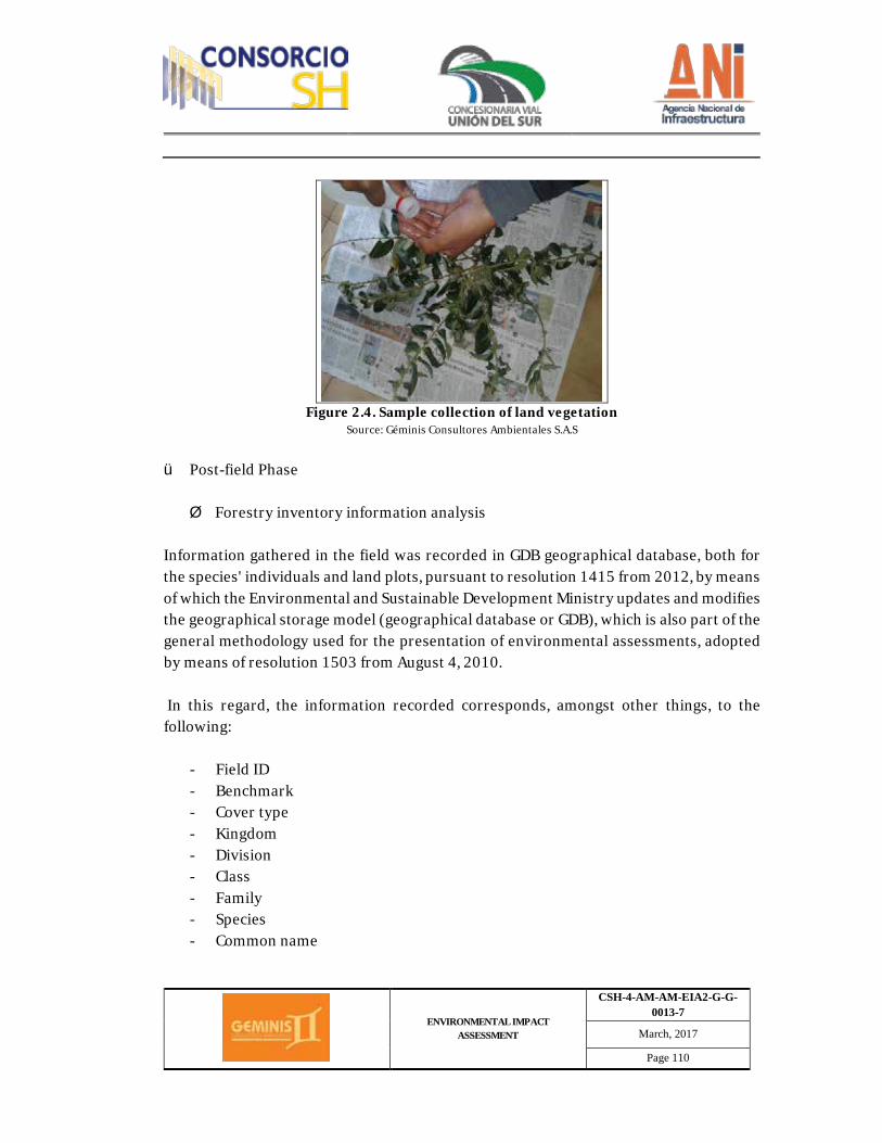
ENVIRONMENTAL IMPACT ASSESSMENT
CSH-4-AM-AM-EIA2-G-G-0013-7
March, 2017
Page 110
Figure 2.4. Sample collection of land vegetation
Source: Géminis Consultores Ambientales S.A.S
ü Post-field Phase Ø Forestry inventory information analysis
Information gathered in the field was recorded in GDB geographical database, both for the species' individuals and land plots, pursuant to resolution 1415 from 2012, by means of which the Environmental and Sustainable Development Ministry updates and modifies the geographical storage model (geographical database or GDB), which is also part of the general methodology used for the presentation of environmental assessments, adopted by means of resolution 1503 from August 4, 2010. In this regard, the information recorded corresponds, amongst other things, to the following:
- Field ID - Benchmark - Cover type - Kingdom - Division - Class - Family - Species - Common name
ENVIRONMENTAL IMPACT ASSESSMENT
CSH-4-AM-AM-EIA2-G-G-0013-7
March, 2017
Page 111
- CIT Category - UICN Category - Closures - IVI - Uses
On the same note, aiming to organize gathered information, data on individuals and species identified was tabulated, taking into consideration the following:
· Number of individuals: Correspond to the total number of individuals from every stratum which are part of the inventory in the assessment area.
· Number of species and families. Once a species was identified, the total number of species identified in the assessment site was determined, as well as the taxonomic families to which they correspond.
Ø Horizontal Structure
The following was taken into consideration to determine the horizontally structure of the identified forest vegetation: Abundance: defined as the number of individuals per species identified in the assessment area. Absolute abundance: defined as the total number of individuals by species, accounted for in the inventory. Aa = Number of individuals by species Relative abundance: refers to the percentage ratio in which each species participates, matched against the total number of trees. Calculation uses the following equation: Ar = Ai/At * 100 Where:
ENVIRONMENTAL IMPACT ASSESSMENT
CSH-4-AM-AM-EIA2-G-G-0013-7
March, 2017
Page 112
Ai = Number of individuals by species At = Total number of individuals in the sampled area Dominance: Also referred to as the degree of coverage of the species or horizontal expansion, refers to the expression of the space occupied by individuals, dominance could be absolute and relative. Absolute dominance: Defined by the summation of individual basal areas, expressed in a square meter. Relative dominance: Determined by the ratio between the basal area of a species and the total summation of the absolute dominance of all species recorded in the inventory. Calculated with the following formula: Dr = Gi/Gt Where: Gt =Total sampling basal area, in square meters. Frequency: Corresponds to the number of land plots in which individuals from a species are present. Absolute frequency: corresponds to the summation of the frequencies of all the species present in the sample. Relative frequency: Determined by the frequency of a species with reference to the total frequency of all species recorded in the inventory. Calculated with the following formula: Fr= (Fs/Fa)*100 Where: Fs: Absolute frequency of the species Fa: Absolute frequency of all species
ENVIRONMENTAL IMPACT ASSESSMENT
CSH-4-AM-AM-EIA2-G-G-0013-7
March, 2017
Page 113
Ø Richness and diversity of species
The biodiversity calculation was carried out based on the ecosystems' abundance index. This was the way in which the spatial location of the different species was identified. The following are some of the indexes that will be used to analyze land vegetation: Menhinick Index: Dmn= S/ √N Margalef Index: Dmg= S-1/ Ln N Where: S= Number of species N= Number of individuals Shannon - Weaver Index: H= - ∑Pi log2 Pi Where: Pi= Proportion or probability of species i with respects to the total number of individuals ni/N. Bit is the measurement unit, which represents the resolution of a probability alternative. Simpson Index:
D= ∑Pi 2 o D= ((∑〖ni(ni-1))/(N(N -1))) The Simpson index is used to quantify the diversity of species based on the dominance in the inventory area, understanding that a smaller dominance is related to a more equitable distribution. Importance Value Index (IVI) IVI: Relative abundance + relative dominance + relative frequency Ø Volume Estimation
ENVIRONMENTAL IMPACT ASSESSMENT
CSH-4-AM-AM-EIA2-G-G-0013-7
March, 2017
Page 114
The ratio used to calculate the total volume and commercial volume in the land vegetation sampling effort, was as follows:
V=AB(m^2 )*H(m)*Ff*N Where: AB=π/4*〖DAP〗^2 H=total height or commercial height Ff=Form Factor (0,7) N=Number of tree shafts o Epiphytes Inventory ü Pre-field phase By checking information from virtual reference collection (Colombian National Herbarium-COL, Neotropical Herbarium Specimens - COL, Neotropical Herbarium Specimens - The Field Museum, New York Botanical Garden and Tropics - Missouri Botanical Garden), national and international databases (CITES, UICN, SIB), regional autonomous corporations, land use plans from municipalities and regional species lists, a preliminary list of possible epiphyte species was produced for the project area of influence, including vulnerability levels. ü Field Phase The field phase was carried out by means of the following sampling efforts: Ø Phorophytes selection
For the assessment of epiphytes, both vascular and nonvascular within the relevant phorophytes, the "Rapid and Representative Analysis Protocol on Epiphyte Diversity" was used (RRED-analysis) as proposed by Gradstein and collaborators (2003) This was the methodology used to complete sampling on phorophytes with a DAP greater or equal to 10 cm, located within the land plots previously established, which had dimensions of 10 x 100 m or transects based on the sampling needs (Figure 2.5).
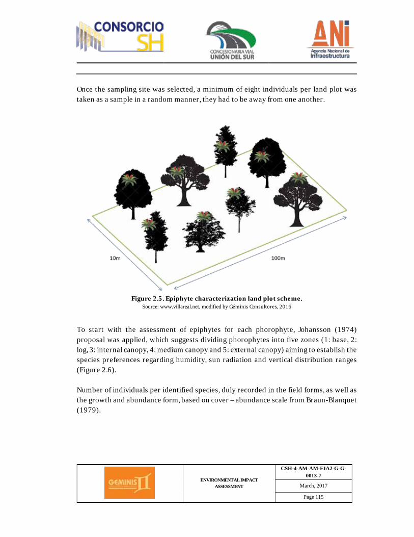
ENVIRONMENTAL IMPACT ASSESSMENT
CSH-4-AM-AM-EIA2-G-G-0013-7
March, 2017
Page 115
Once the sampling site was selected, a minimum of eight individuals per land plot was taken as a sample in a random manner, they had to be away from one another.
Figure 2.5. Epiphyte characterization land plot scheme.
Source: www.villareal.net, modified by Géminis Consultores, 2016
To start with the assessment of epiphytes for each phorophyte, Johansson (1974) proposal was applied, which suggests dividing phorophytes into five zones (1: base, 2: log, 3: internal canopy, 4: medium canopy and 5: external canopy) aiming to establish the species preferences regarding humidity, sun radiation and vertical distribution ranges (Figure 2.6). Number of individuals per identified species, duly recorded in the field forms, as well as the growth and abundance form, based on cover – abundance scale from Braun-Blanquet (1979).
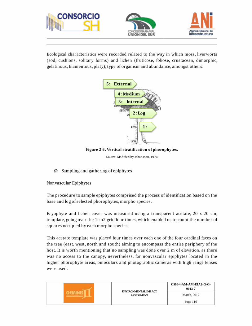
ENVIRONMENTAL IMPACT ASSESSMENT
CSH-4-AM-AM-EIA2-G-G-0013-7
March, 2017
Page 116
Ecological characteristics were recorded related to the way in which moss, liverworts (sod, cushions, solitary forms) and lichen (fruticose, foliose, crustacean, dimorphic, gelatinous, filamentous, platy), type of organism and abundance, amongst others.
Figure 2.6. Vertical stratification of phorophytes.
Source: Modified by Johansson, 1974
Ø Sampling and gathering of epiphytes
Nonvascular Epiphytes The procedure to sample epiphytes comprised the process of identification based on the base and log of selected phorophytes, morpho species. Bryophyte and lichen cover was measured using a transparent acetate, 20 x 20 cm, template, going over the 1cm2 grid four times, which enabled us to count the number of squares occupied by each morpho species. This acetate template was placed four times over each one of the four cardinal faces on the tree (east, west, north and south) aiming to encompass the entire periphery of the host. It is worth mentioning that no sampling was done over 2 m of elevation, as there was no access to the canopy, nevertheless, for nonvascular epiphytes located in the higher phorophyte areas, binoculars and photographic cameras with high range lenses were used.
1:
2: Log
3: Internal
4: Medium
5: External
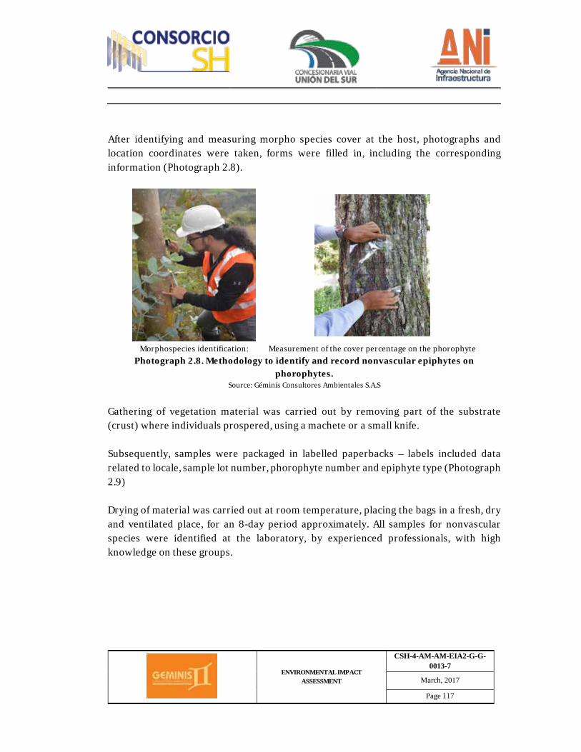
ENVIRONMENTAL IMPACT ASSESSMENT
CSH-4-AM-AM-EIA2-G-G-0013-7
March, 2017
Page 117
After identifying and measuring morpho species cover at the host, photographs and location coordinates were taken, forms were filled in, including the corresponding information (Photograph 2.8).
Morphospecies identification: Measurement of the cover percentage on the phorophyte
Photograph 2.8. Methodology to identify and record nonvascular epiphytes on phorophytes.
Source: Géminis Consultores Ambientales S.A.S
Gathering of vegetation material was carried out by removing part of the substrate (crust) where individuals prospered, using a machete or a small knife. Subsequently, samples were packaged in labelled paperbacks – labels included data related to locale, sample lot number, phorophyte number and epiphyte type (Photograph 2.9) Drying of material was carried out at room temperature, placing the bags in a fresh, dry and ventilated place, for an 8-day period approximately. All samples for nonvascular species were identified at the laboratory, by experienced professionals, with high knowledge on these groups.
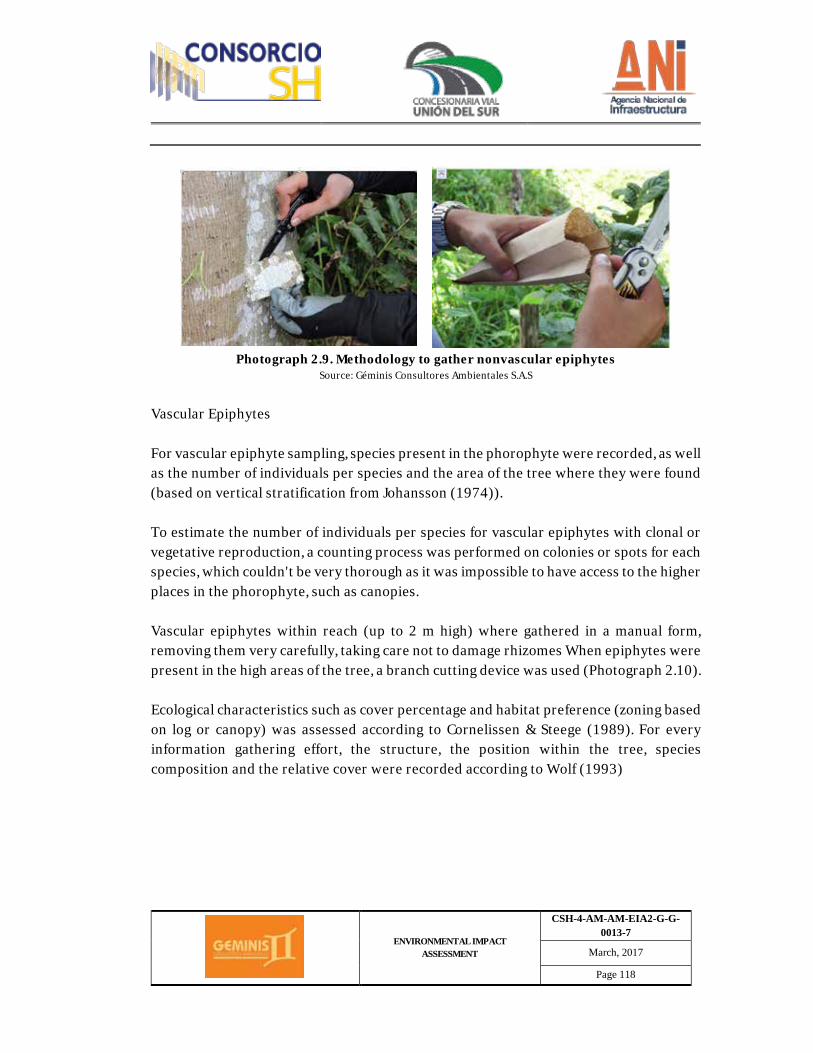
ENVIRONMENTAL IMPACT ASSESSMENT
CSH-4-AM-AM-EIA2-G-G-0013-7
March, 2017
Page 118
Photograph 2.9. Methodology to gather nonvascular epiphytes
Source: Géminis Consultores Ambientales S.A.S
Vascular Epiphytes For vascular epiphyte sampling, species present in the phorophyte were recorded, as well as the number of individuals per species and the area of the tree where they were found (based on vertical stratification from Johansson (1974)). To estimate the number of individuals per species for vascular epiphytes with clonal or vegetative reproduction, a counting process was performed on colonies or spots for each species, which couldn't be very thorough as it was impossible to have access to the higher places in the phorophyte, such as canopies. Vascular epiphytes within reach (up to 2 m high) where gathered in a manual form, removing them very carefully, taking care not to damage rhizomes When epiphytes were present in the high areas of the tree, a branch cutting device was used (Photograph 2.10). Ecological characteristics such as cover percentage and habitat preference (zoning based on log or canopy) was assessed according to Cornelissen & Steege (1989). For every information gathering effort, the structure, the position within the tree, species composition and the relative cover were recorded according to Wolf (1993)
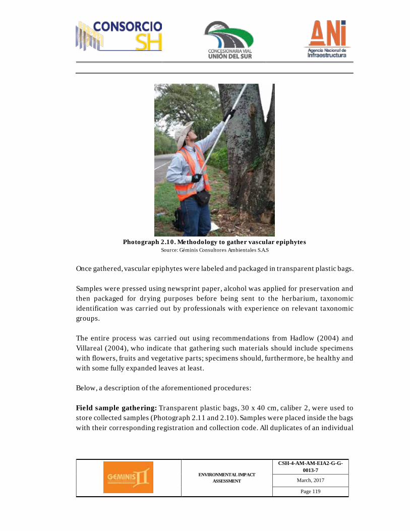
ENVIRONMENTAL IMPACT ASSESSMENT
CSH-4-AM-AM-EIA2-G-G-0013-7
March, 2017
Page 119
Photograph 2.10. Methodology to gather vascular epiphytes
Source: Géminis Consultores Ambientales S.A.S
Once gathered, vascular epiphytes were labeled and packaged in transparent plastic bags. Samples were pressed using newsprint paper, alcohol was applied for preservation and then packaged for drying purposes before being sent to the herbarium, taxonomic identification was carried out by professionals with experience on relevant taxonomic groups. The entire process was carried out using recommendations from Hadlow (2004) and Villareal (2004), who indicate that gathering such materials should include specimens with flowers, fruits and vegetative parts; specimens should, furthermore, be healthy and with some fully expanded leaves at least. Below, a description of the aforementioned procedures: Field sample gathering: Transparent plastic bags, 30 x 40 cm, caliber 2, were used to store collected samples (Photograph 2.11 and 2.10). Samples were placed inside the bags with their corresponding registration and collection code. All duplicates of an individual
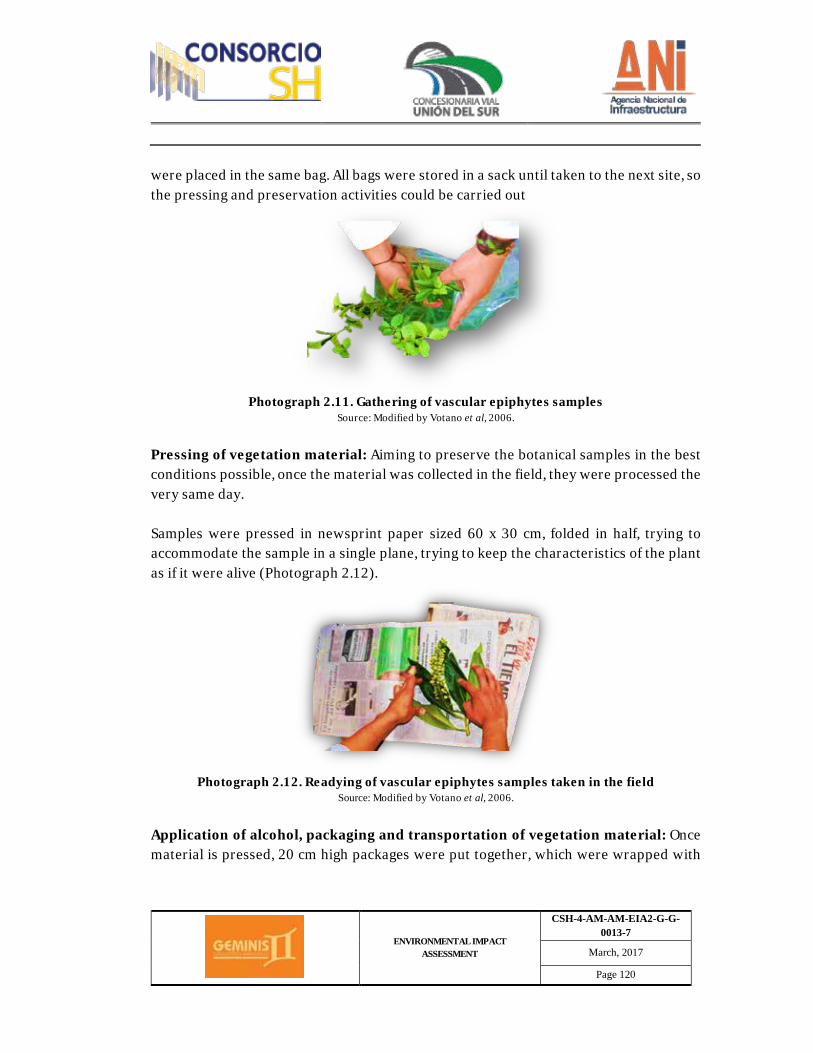
ENVIRONMENTAL IMPACT ASSESSMENT
CSH-4-AM-AM-EIA2-G-G-0013-7
March, 2017
Page 120
were placed in the same bag. All bags were stored in a sack until taken to the next site, so the pressing and preservation activities could be carried out
Photograph 2.11. Gathering of vascular epiphytes samples
Source: Modified by Votano et al, 2006.
Pressing of vegetation material: Aiming to preserve the botanical samples in the best conditions possible, once the material was collected in the field, they were processed the very same day. Samples were pressed in newsprint paper sized 60 x 30 cm, folded in half, trying to accommodate the sample in a single plane, trying to keep the characteristics of the plant as if it were alive (Photograph 2.12).
Photograph 2.12. Readying of vascular epiphytes samples taken in the field
Source: Modified by Votano et al, 2006.
Application of alcohol, packaging and transportation of vegetation material: Once material is pressed, 20 cm high packages were put together, which were wrapped with
ENVIRONMENTAL IMPACT ASSESSMENT
CSH-4-AM-AM-EIA2-G-G-0013-7
March, 2017
Page 121
three double sheets of newsprint paper, in a way that one of the two sides of the package was exposed. The package was secured with a cross knot, as tight as possible, subsequently the package was placed into a caliber 4 plastic bag. Abundant amounts of 75% alcohol was applied, pouring it from the side of the package that was open. The bag containing the material and the alcohol was sealed with a double knot, using nylon rope and industrial tape. Ø Methodology for the characterization of lithophytes and land species
Bromelia, orchids, bryophytes and lichen species which were found thriving on the floor, on any substrate different to that of a living tree's crust (epiphytes), where recorded by means of land plots sized 5 x 5 m. Land plots were geo-referenced, labeled with a code and demarcated by means of a rope. Even though most of the land plots were located on taluses, some of them were located within land plots used for forestry characterization, based on the existence, or not, of forbidden species as per resolution 0213, pertaining to lifeforms different to epiphytes. All bromelia, orchid, bryophyte and lichen species identified within the 5 x 5 m land plot were accounted for in terms of the vascular species individuals, an estimation of the cover percentage and the nonvascular species abundance was also carried out. The collection procedure for lithophytes and land species were the same as the ones described for epiphytes. Nonvascular lithophytes were removed, along with a little bit of its substrate, with the help of a small knife or machete. On the same token, vascular species found in high places were removed from taluses using a branch cutting device, taking special care not to damage the roots (Photograph 2.13).
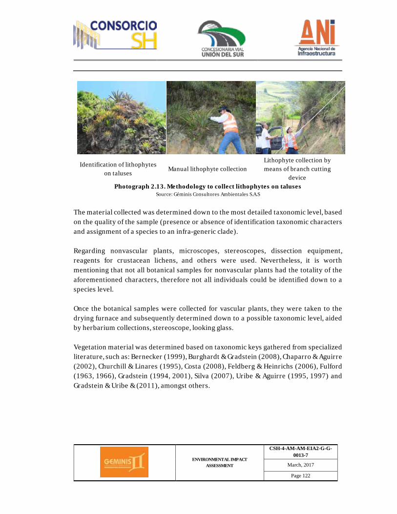
ENVIRONMENTAL IMPACT ASSESSMENT
CSH-4-AM-AM-EIA2-G-G-0013-7
March, 2017
Page 122
Identification of lithophytes on taluses
Manual lithophyte collection Lithophyte collection by means of branch cutting
device Photograph 2.13. Methodology to collect lithophytes on taluses
Source: Géminis Consultores Ambientales S.A.S
The material collected was determined down to the most detailed taxonomic level, based on the quality of the sample (presence or absence of identification taxonomic characters and assignment of a species to an infra-generic clade). Regarding nonvascular plants, microscopes, stereoscopes, dissection equipment, reagents for crustacean lichens, and others were used. Nevertheless, it is worth mentioning that not all botanical samples for nonvascular plants had the totality of the aforementioned characters, therefore not all individuals could be identified down to a species level. Once the botanical samples were collected for vascular plants, they were taken to the drying furnace and subsequently determined down to a possible taxonomic level, aided by herbarium collections, stereoscope, looking glass. Vegetation material was determined based on taxonomic keys gathered from specialized literature, such as: Bernecker (1999), Burghardt & Gradstein (2008), Chaparro & Aguirre (2002), Churchill & Linares (1995), Costa (2008), Feldberg & Heinrichs (2006), Fulford (1963, 1966), Gradstein (1994, 2001), Silva (2007), Uribe & Aguirre (1995, 1997) and Gradstein & Uribe & (2011), amongst others.
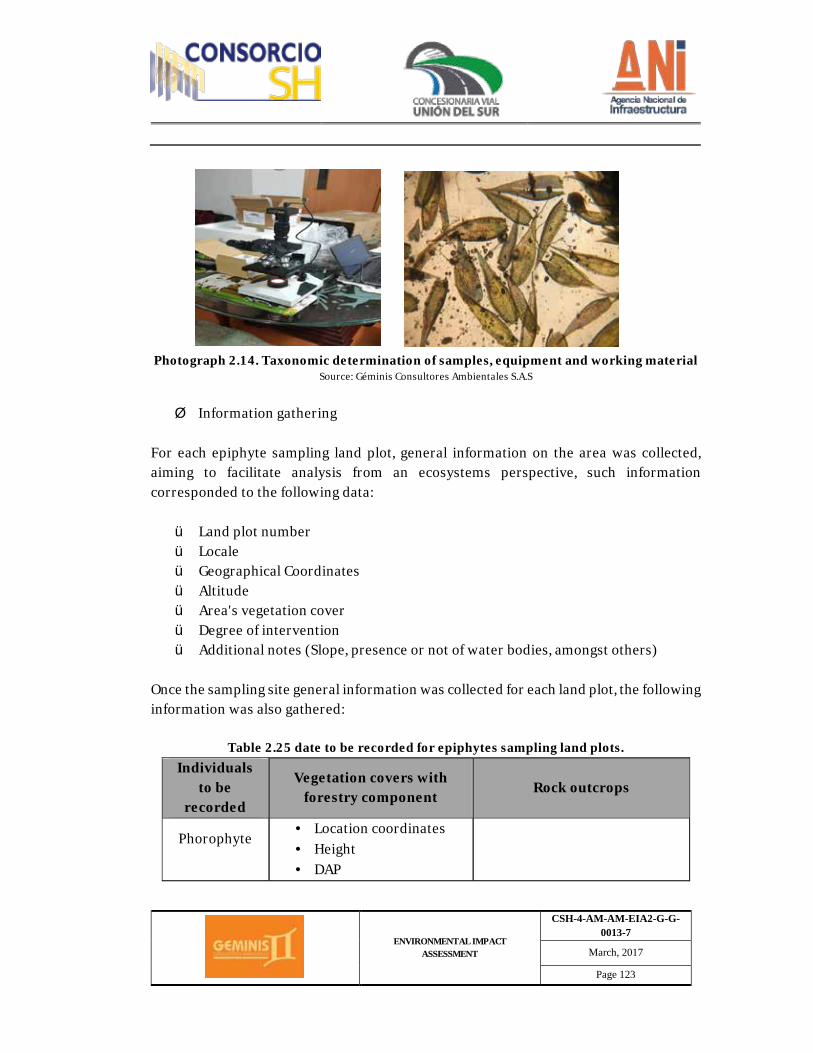
ENVIRONMENTAL IMPACT ASSESSMENT
CSH-4-AM-AM-EIA2-G-G-0013-7
March, 2017
Page 123
Photograph 2.14. Taxonomic determination of samples, equipment and working material Source: Géminis Consultores Ambientales S.A.S
Ø Information gathering
For each epiphyte sampling land plot, general information on the area was collected, aiming to facilitate analysis from an ecosystems perspective, such information corresponded to the following data: ü Land plot number ü Locale ü Geographical Coordinates ü Altitude ü Area's vegetation cover ü Degree of intervention ü Additional notes (Slope, presence or not of water bodies, amongst others)
Once the sampling site general information was collected for each land plot, the following information was also gathered:
Table 2.25 date to be recorded for epiphytes sampling land plots. Individuals
to be recorded
Vegetation covers with forestry component Rock outcrops
Phorophyte
· Location coordinates · Height · DAP

ENVIRONMENTAL IMPACT ASSESSMENT
CSH-4-AM-AM-EIA2-G-G-0013-7
March, 2017
Page 124
Individuals to be
recorded
Vegetation covers with forestry component
Rock outcrops
· Common name · Scientific name
Vascular epiphytes
· Common name or collection number
· Scientific name · Number of individuals · Phorophyte ecological
unit
· Common name or collection number
· Scientific name · Number of individuals
Nonvascular epiphytes
· Common name or collection number
· Scientific name · Phorophyte ecological
unit · Life form · Growth type
· Common name or collection number
· Scientific name · Life form · Growth type · Cover percentage
Source (Géminis Consultores Ambientales S.A.S., 2016)
Ø Gathering, mobilization and preservation
To achieve adequate taxonomic identification of vascular and nonvascular epiphytes, detailed observation was carried out by means of a looking glass and photographic records. The following procedure was followed in cases where it was necessary to collect epiphyte specimens: Vascular epiphytes gathering To achieve adequate taxonomic identification of vascular epiphytes, specimen collection was carried out for each vertical land plot.
ENVIRONMENTAL IMPACT ASSESSMENT
CSH-4-AM-AM-EIA2-G-G-0013-7
March, 2017
Page 125
Field identification was taken down to morpho species level, meaning, morphological characteristics where employed to indicate that a group of specimens or individuals belong to the same species type. Branch cutting equipment, mowing equipment and other techniques relevant to each group where employed (bromelia, orchids, etc.). Nonvascular epiphytes gathering Nonvascular epiphytes were classified down to morpho species level. Gathering was done by employing a chisel (for crustacean forms on rock) and small knives. Subsequently, the maximum possible category was determined by means of detail observations through the stereoscope and photographic records. Preservation For vascular epiphytes specimens from the collected bromelia groups, land vegetation gathering parameters were used, nevertheless, the selection of the vegetation tissue to be collected corresponded to two outer sheets and two inner sheets from the bromelia. A maximum of four botanical samples were collected per morpho species, pursuant to collection resolution 1023/2015. For nonvascular epiphyte specimens, scraping on the occupied area was the method used for each species, avoiding damage to their morphological structures. Each sample was stored in Kraft paper bags, labeled with a consecutive number, sealed with masking tape, leaving a moderate amount of air within. Mobilization Vascular and nonvascular epiphyte samples were mobilized using paper bags. Epiphytes collected in Kraft paper bags were stored in a joint manner, in a transparent bag.
ENVIRONMENTAL IMPACT ASSESSMENT
CSH-4-AM-AM-EIA2-G-G-0013-7
March, 2017
Page 126
This is the way they were transported to the herbarium at Nariño University, to be discarded or included in the collection. Information acquired in the field for epiphyte sampling was digitalized in Excel, this tool was used to complete data analysis to determine the main parameters to define the ecological state of epiphytes, based on the parameters assessed by Alzate et al. (2000). Relative abundance (Ar) was calculated for the ecological units, for each strata and land plot relative frequency was calculated (FrP). Graphics on the percentage results of the composition were generated in order to describe qualitative diversity of epiphytes. Shannon-Wiener (Krebs 1998) diversity indexes were calculated aiming to determine epiphytes diversity, taking into consideration relative abundance from each group of individuals. Regarding floral similitude qualitative quantification for the assessment, the Jaccard and Sorensen similitude coefficient was considered, which is based on the presence/absence of species (Krebs 1998). ü Post-field Phase Ø Analysis of epiphyte inventory information
Information acquired in the field for epiphyte sampling was digitalized in Excel, this tool was used to complete data analysis to determine the main parameters to define the ecological state of epiphytes in the assessment area, based on the parameters assessed by Alzate et al.(2000). The Importance Value Index (IVI) was calculated for the epiphytes community based on the following parameters:
IVI=FRE+FRT+Ar Where:
ENVIRONMENTAL IMPACT ASSESSMENT
CSH-4-AM-AM-EIA2-G-G-0013-7
March, 2017
Page 127
FrE= (Number of ecological units where the species was found/total number of stratums)*100 FrP= (Number of land plots where the species was found/total number of land plots)*100 Ar= (Number of the species individuals or specimens/ number of total individuals or specimens)*100 Relative abundance (Ar) was calculated for the ecological units, for each strata and land plot relative frequency was calculated (FrP). Graphics on the percentage results of the composition were generated to describe qualitative diversity of epiphytes. Shannon-Wiener (Krebs 1998) diversity indexes were calculated aiming to determine epiphytes diversity, taking into consideration relative abundance from each group of individuals. Regarding floral similitude qualitative quantification for the assessment, the Jaccard and Sorensen similitude coefficient was considered, which is based on the presence/absence of species (Krebs 1998). Ø Floral composition information gathering methodology
The determination of the floral composition was carried out by means of field visits to linear transects parallel to the road, within the area of intervention, except artificial terrain. The area of intervention was determined based on the right of way and chamfers established in project design. The length of the transects was equal to that of the road corridor. - Data gathering methodology related to the main uses of species. Secondary information was gathered for the main uses of forestry species identified within the road corridor, enabling the formulation of a semi structured survey.
ENVIRONMENTAL IMPACT ASSESSMENT
CSH-4-AM-AM-EIA2-G-G-0013-7
March, 2017
Page 128
- Lifting of closures methodologies ü Pre-field Phase Closures established at a national, regional, CITES and UICN level, as well as the ones established based on resolution 192 from 2014 and agreements 0316 from 1974 where reviewed as pertaining to secondary information.
ü Field Phase Forestry species: For the case of forestry species, identification of individuals located in the area of intervention was carried out, height, DAP and phytosanitary parameters were recorded for all trees considered old-growth, mid-growth and young-growth. - Methodology for the collection of forestry specimens and land ecosystems: Collection of forestry specimens and epiphytes was carried out taking into consideration resolution 1023 from August 20, 2015, by means of which the Environmental Licensing National Authority "granted permit to collect wildlife species specimens as pertaining to biological diversity, aiming to produce an environmental assessment, amongst other determinations, to GÉMINIS CONSULTORES AMBIENTALES SAS".
ü Field Phase Aiming to determine forestry species with a high ecological, commercial and cultural value for the communities in the direct area of influence of the road corridor, as established by resolution 0751 from 2015: To "describe the main use given by the communities to the most Omportant species”, semi-structured interviews were applied, identifying 8 main uses. These were determined based on the anthropogenic intervention characteristics.
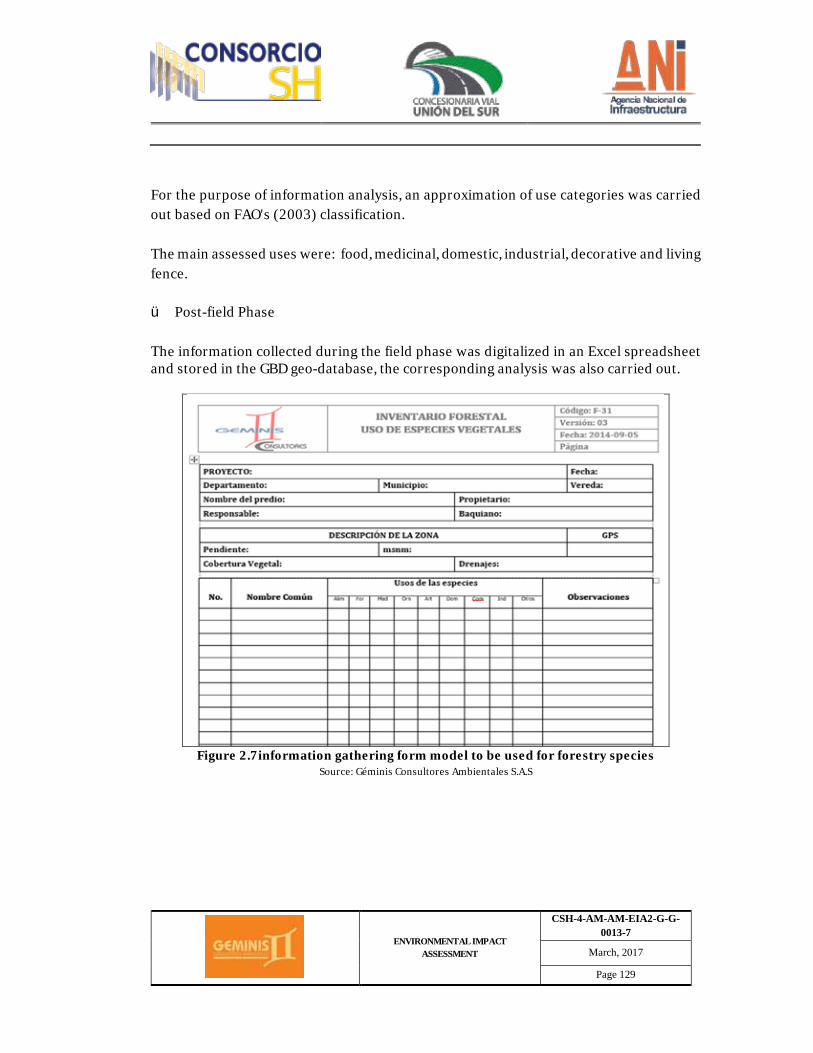
ENVIRONMENTAL IMPACT ASSESSMENT
CSH-4-AM-AM-EIA2-G-G-0013-7
March, 2017
Page 129
For the purpose of information analysis, an approximation of use categories was carried out based on FAO's (2003) classification. The main assessed uses were: food, medicinal, domestic, industrial, decorative and living fence.
ü Post-field Phase The information collected during the field phase was digitalized in an Excel spreadsheet and stored in the GBD geo-database, the corresponding analysis was also carried out.
Figure 2.7information gathering form model to be used for forestry species
Source: Géminis Consultores Ambientales S.A.S
ENVIRONMENTAL IMPACT ASSESSMENT
CSH-4-AM-AM-EIA2-G-G-0013-7
March, 2017
Page 130
- Analysis methodology for land ecosystems and fragmentation A natural land ecosystem and secondary vegetation map was generated for the project's area of influence, based on vegetation covers and the current use of soil, at a minimum scale of 1:25.000. The ecosystems map and its legend nomenclature was generated based on the methodological scheme from the Colombian continental, coastal and marine map (IDEAM, IGAC, IAvH, Invemar, I. Sinchi and IIAP. 2007). Likewise, natural ecosystems and secondary vegetation were identified and described. The following criterion where followed, amongst others, for the description:
- A size and landscape context was established for each natural ecosystem fragment and secondary vegetation.
- A buffer between 625 y 500 m around the fragment was taken into consideration for its calculation.
- The connectivity values will oscillate between 0 and 1 (values close to 1 represent a better landscape context). Module A: Data Preparation shall be employed for specialization and valuation, from the tool called Equivalent Formula Mapping - Ma.F.E. v 1.01 (León et al, 2010) for ArcGIS 9.3.
The identification of rarity, representativeness within the national system of protected areas, the remanence or potential of loss in the national context, was all carried out according to the national list on rates of compensation because of biodiversity loss. Likewise, natural protected areas, public or private conservation/protection initiatives, soil protection, international protection regime areas, amongst other areas/initiatives present in the project's area of influence were identified, demarcated and described. o Wildlife
ENVIRONMENTAL IMPACT ASSESSMENT
CSH-4-AM-AM-EIA2-G-G-0013-7
March, 2017
Page 131
To characterize wildlife, sampling work was done on the most representative wildlife groups, as well as on their habitats according to each type of cover present on site. The work was carried out in three different phases; pre-field phase, field phase and post-field phase.
ü Pre-field Phase To start with, during the pre-field phase, a bibliographical review was carried out on the different wildlife groups (amphibians, reptiles, birds and mammals), aiming to obtain information on species reported in the region, encompassing elevation ranges that go between 1700 and 3100 m.a.s.l. Secondary information collection was carried out during this phase, done by means of reviewing scientific literature found in databases from different magazines and scientific databases such as the Biodiversity Information System (SIB), Scientific Information Systems (EBSCOhost, ScienceDirect and REDALYC), the Colombian Biological Log (SCIELO), amongst other biologically important magazines. Likewise, publications from different national museums in the country was also used, as well as online scientific collections and catalogs, like the one from the National Colombian University, Nariño University and other specialized publications for each wildlife group. To determine potential amphibian species, the information collected from updated Colombian amphibian lists was utilized. (Ruiz-Carranza, 1996; Acosta-Galvis A. , 2000; Acosta-Galvis A. R., 2012; Acosta-Galvis, 2013), electronic databases also, such as the one from the Colombian National Biodiversity System (SIB, 2015), the Colombian List of Amphibians (Acosta-Galvis A. R., 2016), the red list of endangered species (IUCN, 2015), amongst others, the possible presence of 21 amphibian species was identified for the area, all belonging to the Anura order, which represents about 3% of all recorded species at a national level. The updated Colombian reptiles list was used to determine potential reptile species. (Castaño-Mora, 2002; Cardona Cogollo & Urbina Cardona, 2008; Castaño , Cardenas , & Castro - Herrera, 2002), amongst others, as well as electronic databases also, such as the one from the Colombian National Biodiversity System (SIB, 2015), the red list of endangered species (IUCN, 2015), reptiles database (Uetz P. &., 2015), the species that
ENVIRONMENTAL IMPACT ASSESSMENT
CSH-4-AM-AM-EIA2-G-G-0013-7
March, 2017
Page 132
could be potentially present in the area corresponding to RUMICHACA - PASTO's DUAL CARRIAGE WAY PROJECT, PEDREGAL - CATAMBUCO SPAN To determine potential bird species, a list was produced aiming to learn about the diversity of species present in the area of influence and assess environmental impact related to the project. Regarding project's birdlife, it was possible to compile secondary information from research carried out by regional environmental entities (Corponariño) and GAICA association from the year 2009, related to places close to the project's area of influence. In a complementary fashion, information obtained from Nariño's birdlife checklist was also analyzed(Calderón, 2011) Two documental pieces were analyzed in order to determine potential mammal species: (Ramírez-Chaves & Noguera Urbano, 2010) and (Solari S., 2013.)The first piece provides a list of mammal species for the province of Nariño and the second includes an updated assessment on the distribution of Colombian mammal species. These assessments are the product of an effort to gather information available from natural museums in Columbia, expeditions and specialized field work. Based on these bibliographical reviews, it is now assumed that about 16.3% of the total species recorded in Colombia are present in the area of influence of the project, and 40.6% of the total species recorded in Nariño. Regarding non-flying mammals, 46 species have been recorded, representing 18% of the 255 species reported in Colombia; regarding flying mammals, 28 species out of 198 reported in Colombia are present in the area, representing 14% of them. The hierarchy of the mammal species documented in the area comprise the following: 10 orders, 23 families, 57 genres and 74 species. The most abundant mammalian fauna in the area of influence include chiroptera (28 species), followed by rodents (17 species) and carnivores (14 species). Ø Report on tremarctos
Tremarctos report 3.0 was also taken into consideration (report from March 21, 2016), generated by Conservation International – Colombia, with support from the National Road Institute (INVIAS), General Controllership of the Republic and Netherlands Embassy.
ENVIRONMENTAL IMPACT ASSESSMENT
CSH-4-AM-AM-EIA2-G-G-0013-7
March, 2017
Page 133
The red book on endangered species were also queried upon aiming to identify them (Rueda Almonacid J.V., 2004; Castaño-Mora, 2002; Renjifo, 2014; Rodriguez-M., 2006), the following were also used as sources: resolution 0192 from 2014, environmental and sustainable development ministry (MADS 2014), the red list of endangered species from IUCN and the list of endangered species from CITES Characterization of wildlife was carried out in the field phase, by means of sampling the most representative wildlife groups (amphibians, reptiles, birds, mammals) applying the relevant methodology guidelines for each group, taking into consideration techniques suggested by the General Methodology for Environmental Assessment Submittal. (ZAPATA P., Jorge., Amanda., & (Texts)., 2010) and under permission from ANLA resolution 1023, from August 20, 2015. Selection of sampling points The different vegetation cover units identified in the area of influence were taken into consideration for the selection of sampling sites and to analyze the wildlife communities associated to the assessment area, considering wildlife mobility, both horizontal and vertical, as well as their habitat and microhabitat preferences. (Refer to Table 2.26.)
Table 2.26 Covers to be sampled per functional unit
Functional unit
Size Continental
waters Semi-natural forests and
areas
Artificialized Territories
Agricultural Territory
FU4
Area (ha) 20,890077 157,597081 79,914489 488,633035
% 2,79639989 21,096354 10,6975608 65,4096854
FU5
Area (ha)
31,949316 77,543882 1077,08805
%
2,6925519 6,53506719 90,7723808 Source (Géminis Consultores Ambientales S.A.S.)
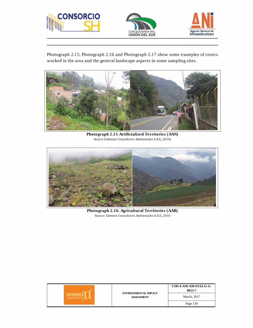
ENVIRONMENTAL IMPACT ASSESSMENT
CSH-4-AM-AM-EIA2-G-G-0013-7
March, 2017
Page 134
Photograph 2.15, Photograph 2.16 and Photograph 2.17 show some examples of covers worked in the area and the general landscape aspects in some sampling sites.
Photograph 2.15 Artificialized Territories (AAN)
Source (Géminis Consultores Ambientales S.A.S., 2016)
Photograph 2.16. Agricultural Territories (AAB)
Source: Géminis Consultores Ambientales S.A.S., 2016
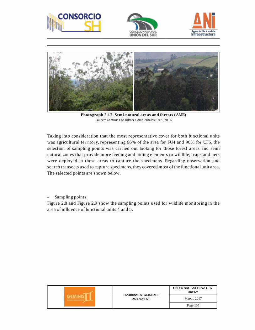
ENVIRONMENTAL IMPACT ASSESSMENT
CSH-4-AM-AM-EIA2-G-G-0013-7
March, 2017
Page 135
Photograph 2.17. Semi-natural areas and forests (AME)
Source: Géminis Consultores Ambientales S.A.S., 2016
Taking into consideration that the most representative cover for both functional units was agricultural territory, representing 66% of the area for FU4 and 90% for UF5, the selection of sampling points was carried out looking for those forest areas and semi natural zones that provide more feeding and hiding elements to wildlife; traps and nets were deployed in these areas to capture the specimens. Regarding observation and search transects used to capture specimens, they covered most of the functional unit area. The selected points are shown below. - Sampling points Figure 2.8 and Figure 2.9 show the sampling points used for wildlife monitoring in the area of influence of functional units 4 and 5.

ENVIRONMENTAL IMPACT ASSESSMENT
CSH-4-AM-AM-EIA2-G-G-0013-7
March, 2017
Page 136
Figure 2.8. Vegetation cover map, current use of soil with distribution of wildlife species for Pedregal-Catambuco's FU4. Sampling Points
Source (Géminis Consultores Ambientales)
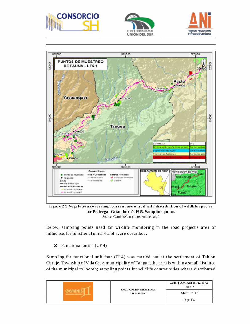
ENVIRONMENTAL IMPACT ASSESSMENT
CSH-4-AM-AM-EIA2-G-G-0013-7
March, 2017
Page 137
Figure 2.9 Vegetation cover map, current use of soil with distribution of wildlife species
for Pedregal-Catambuco's FU5. Sampling points Source (Géminis Consultores Ambientales)
Below, sampling points used for wildlife monitoring in the road project's area of influence, for functional units 4 and 5, are described. Ø Functional unit 4 (UF 4)
Sampling for functional unit four (FU4) was carried out at the settlement of Tablón Obraje, Township of Villa Cruz, municipality of Tangua, the area is within a small distance of the municipal tollbooth; sampling points for wildlife communities where distributed
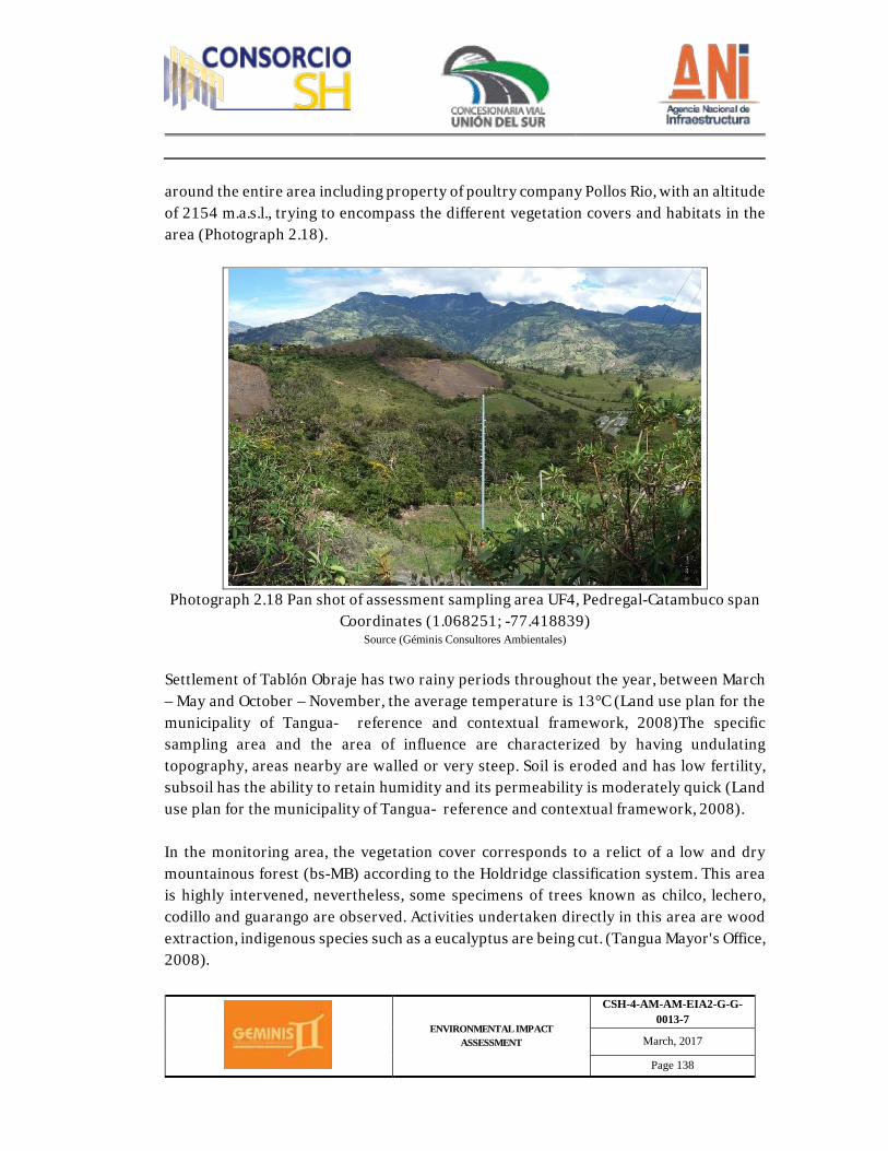
ENVIRONMENTAL IMPACT ASSESSMENT
CSH-4-AM-AM-EIA2-G-G-0013-7
March, 2017
Page 138
around the entire area including property of poultry company Pollos Rio, with an altitude of 2154 m.a.s.l., trying to encompass the different vegetation covers and habitats in the area (Photograph 2.18).
Photograph 2.18 Pan shot of assessment sampling area UF4, Pedregal-Catambuco span
Coordinates (1.068251; -77.418839) Source (Géminis Consultores Ambientales)
Settlement of Tablón Obraje has two rainy periods throughout the year, between March – May and October – November, the average temperature is 13°C (Land use plan for the municipality of Tangua- reference and contextual framework, 2008)The specific sampling area and the area of influence are characterized by having undulating topography, areas nearby are walled or very steep. Soil is eroded and has low fertility, subsoil has the ability to retain humidity and its permeability is moderately quick (Land use plan for the municipality of Tangua- reference and contextual framework, 2008). In the monitoring area, the vegetation cover corresponds to a relict of a low and dry mountainous forest (bs-MB) according to the Holdridge classification system. This area is highly intervened, nevertheless, some specimens of trees known as chilco, lechero, codillo and guarango are observed. Activities undertaken directly in this area are wood extraction, indigenous species such as a eucalyptus are being cut. (Tangua Mayor's Office, 2008).
ENVIRONMENTAL IMPACT ASSESSMENT
CSH-4-AM-AM-EIA2-G-G-0013-7
March, 2017
Page 139
Covers identified and worked for functional unit four (FU4) were as follows: agricultural territory represented 65% of the area, followed by forests and semi natural areas with 21%. Lastly, artificialized territories represented 10% of the area, continental waters represented 2.7%. Refer to table 2.27. A detailed description of each cover is available from item 5.2.1.1 Continental ecosystems, land covers. A brief description is included below.
Table 2.27 Cover area and proportion, functional unit four (UF4)
Functional unit Size
Continental waters
Semi-natural forests and areas
Artificialized Territories
Agricultural Territory
FU4
Area (ha) 20,890077 157,597081 79,914489 488,633035
% 2,79639989 21,096354 10,6975608 65,4096854
Source (Géminis Consultores Ambientales)
· Semi-natural areas and forests This vegetation cover has protection, conservation
and extraction purposes, its relevance is related to soil fixing, especially hillsides, the conservation and protection of water sources and the regulation of runoff water going to springs and rivers. Some vegetation species found in this area are commonly known as: Encenillo, La Fragua, Motilón, Sindaya, Pelotillo, chaquilulo, moquillo and cerote. Some forests have also been planted for protection and production purposes, eucalyptus and pines are used for commercial and energy production purposes, there is no well-defined shrub-like or herbaceous strata.(Development plan 2012-2015 Municipality of Tangua, 2012), Refer to pan shot of main covers (Photograph 2.19).
· Agricultural Territory: Corresponds to vegetation used in the agricultural sector, such as potato, which is continuously found in rotation with grass and field beans, carrots or olluco crops, amongst others. (Development plan 2012-2015 Municipality of Tangua, 2012). Refer to pan shot of main covers (Photograph 2.19).
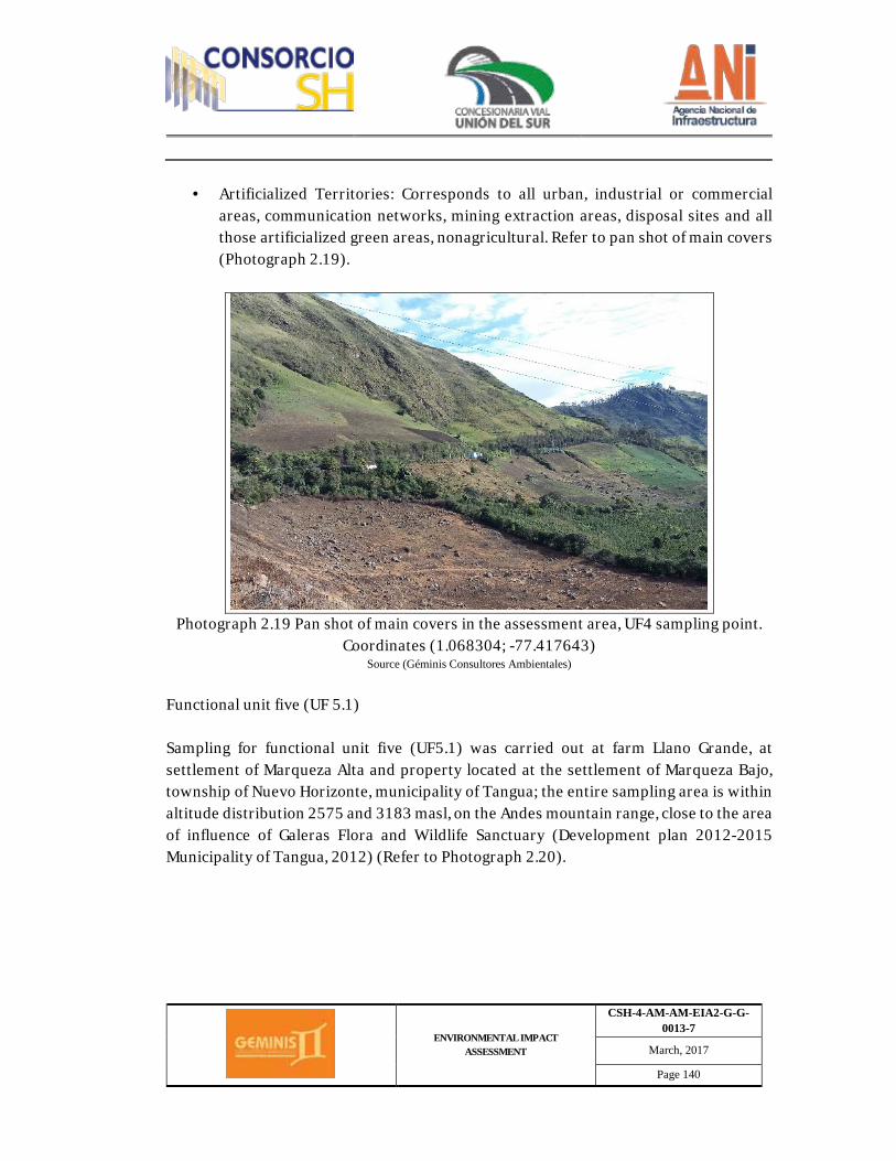
ENVIRONMENTAL IMPACT ASSESSMENT
CSH-4-AM-AM-EIA2-G-G-0013-7
March, 2017
Page 140
· Artificialized Territories: Corresponds to all urban, industrial or commercial areas, communication networks, mining extraction areas, disposal sites and all those artificialized green areas, nonagricultural. Refer to pan shot of main covers (Photograph 2.19).
Photograph 2.19 Pan shot of main covers in the assessment area, UF4 sampling point.
Coordinates (1.068304; -77.417643) Source (Géminis Consultores Ambientales)
Functional unit five (UF 5.1) Sampling for functional unit five (UF5.1) was carried out at farm Llano Grande, at settlement of Marqueza Alta and property located at the settlement of Marqueza Bajo, township of Nuevo Horizonte, municipality of Tangua; the entire sampling area is within altitude distribution 2575 and 3183 masl, on the Andes mountain range, close to the area of influence of Galeras Flora and Wildlife Sanctuary (Development plan 2012-2015 Municipality of Tangua, 2012) (Refer to Photograph 2.20).
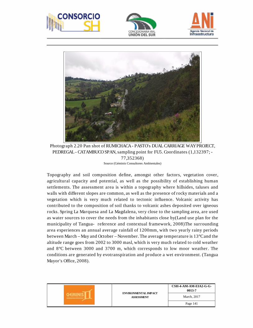
ENVIRONMENTAL IMPACT ASSESSMENT
CSH-4-AM-AM-EIA2-G-G-0013-7
March, 2017
Page 141
Photograph 2.20 Pan shot of RUMICHACA - PASTO's DUAL CARRIAGE WAY PROJECT,
PEDREGAL - CATAMBUCO SPAN, sampling point for FU5. Coordinates (1,132397; -77,352368)
Source (Géminis Consultores Ambientales)
Topography and soil composition define, amongst other factors, vegetation cover, agricultural capacity and potential, as well as the possibility of establishing human settlements. The assessment area is within a topography where hillsides, taluses and walls with different slopes are common, as well as the presence of rocky materials and a vegetation which is very much related to tectonic influence. Volcanic activity has contributed to the composition of soil thanks to volcanic ashes deposited over igneous rocks. Spring La Marquesa and La Magdalena, very close to the sampling area, are used as water sources to cover the needs from the inhabitants close by(Land use plan for the municipality of Tangua- reference and contextual framework, 2008)The surrounding area experiences an annual average rainfall of 1200mm, with two yearly rainy periods between March – May and October – November. The average temperature is 13°C and the altitude range goes from 2002 to 3000 masl, which is very much related to cold weather and 8°C between 3000 and 3700 m, which corresponds to low moor weather. The conditions are generated by evotranspiration and produce a wet environment. (Tangua Mayor's Office, 2008).
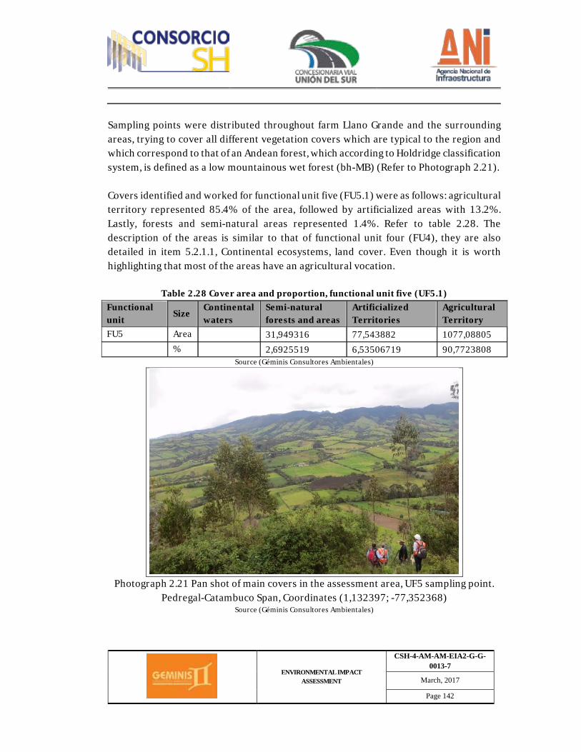
ENVIRONMENTAL IMPACT ASSESSMENT
CSH-4-AM-AM-EIA2-G-G-0013-7
March, 2017
Page 142
Sampling points were distributed throughout farm Llano Grande and the surrounding areas, trying to cover all different vegetation covers which are typical to the region and which correspond to that of an Andean forest, which according to Holdridge classification system, is defined as a low mountainous wet forest (bh-MB) (Refer to Photograph 2.21). Covers identified and worked for functional unit five (FU5.1) were as follows: agricultural territory represented 85.4% of the area, followed by artificialized areas with 13.2%. Lastly, forests and semi-natural areas represented 1.4%. Refer to table 2.28. The description of the areas is similar to that of functional unit four (FU4), they are also detailed in item 5.2.1.1, Continental ecosystems, land cover. Even though it is worth highlighting that most of the areas have an agricultural vocation.
Table 2.28 Cover area and proportion, functional unit five (UF5.1) Functional unit Size Continental
waters Semi-natural forests and areas
Artificialized Territories
Agricultural Territory
FU5 Area 31,949316 77,543882 1077,08805 % 2,6925519 6,53506719 90,7723808
Source (Géminis Consultores Ambientales)
Photograph 2.21 Pan shot of main covers in the assessment area, UF5 sampling point.
Pedregal-Catambuco Span, Coordinates (1,132397; -77,352368) Source (Géminis Consultores Ambientales)
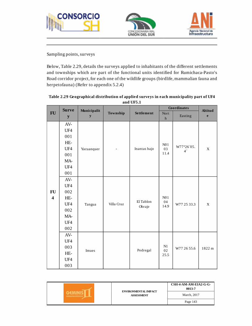
ENVIRONMENTAL IMPACT ASSESSMENT
CSH-4-AM-AM-EIA2-G-G-0013-7
March, 2017
Page 143
Sampling points, surveys Below, Table 2.29, details the surveys applied to inhabitants of the different settlements and townships which are part of the functional units identified for Rumichaca-Pasto's Road corridor project, for each one of the wildlife groups (birdlife, mammalian fauna and herpetofauna) (Refer to appendix 5.2.4)
Table 2.29 Geographical distribution of applied surveys in each municipality part of UF4 and UF5.1
FU Surve
y Municipalit
y Township Settlement
Coordinates Altitud
e North
Easting
FU4
AV-UF4 001 HE-UF4 001 MA-UF4 001
Yacuanquer - Inantas bajo N01 03
11.4
W77°26´05.4´ X
AV-UF4 002 HE-UF4 002 MA-UF4 002
Tangua Villa Cruz El Tablon Obraje
N01 04
14.9
W77 25 33.3 X
AV-UF4 003 HE-UF4 003
Imues Pedregal N1 02
25.5
W77 26 55.6
1822 m
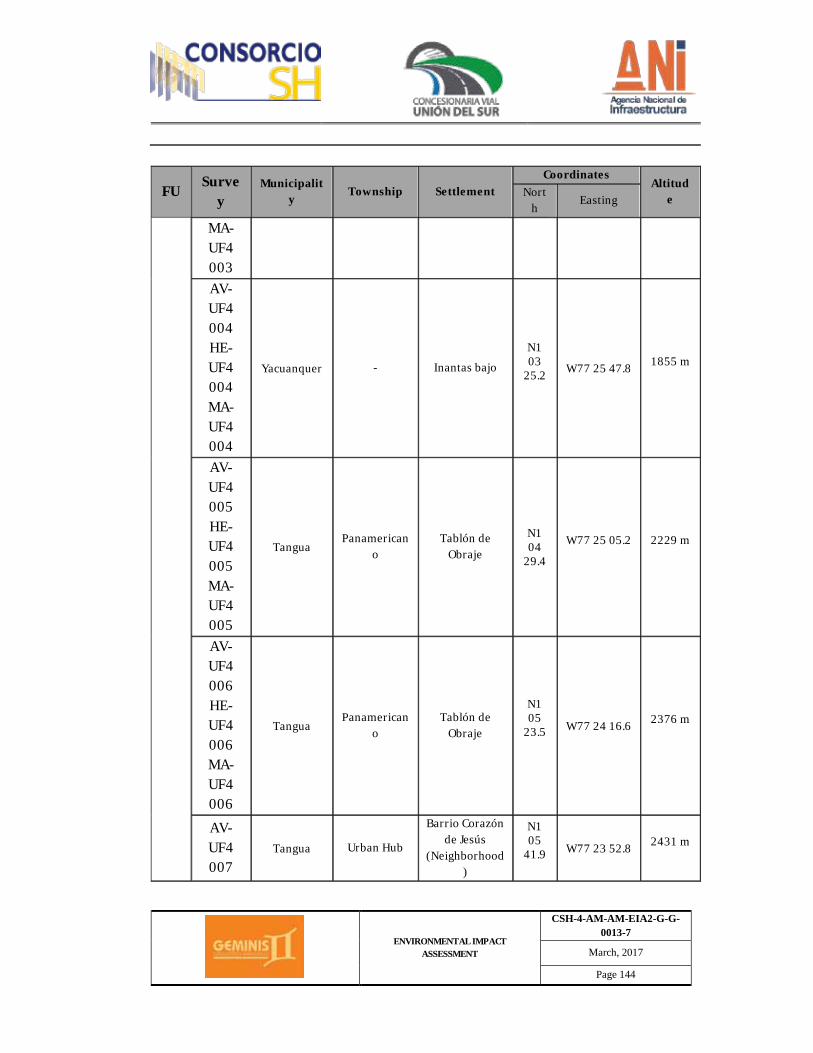
ENVIRONMENTAL IMPACT ASSESSMENT
CSH-4-AM-AM-EIA2-G-G-0013-7
March, 2017
Page 144
FU Survey
Municipality Township Settlement
Coordinates Altitud
e North
Easting
MA-UF4 003 AV-UF4 004 HE-UF4 004 MA-UF4 004
Yacuanquer - Inantas bajo
N1 03
25.2
W77 25 47.8 1855 m
AV-UF4 005 HE-UF4 005 MA-UF4 005
Tangua Panamerican
o Tablón de
Obraje
N1 04
29.4
W77 25 05.2
2229 m
AV-UF4 006 HE-UF4 006 MA-UF4 006
Tangua Panamerican
o Tablón de
Obraje
N1 05
23.5
W77 24 16.6 2376 m
AV-UF4 007
Tangua Urban Hub
Barrio Corazón de Jesús
(Neighborhood)
N1 05
41.9
W77 23 52.8 2431 m

ENVIRONMENTAL IMPACT ASSESSMENT
CSH-4-AM-AM-EIA2-G-G-0013-7
March, 2017
Page 145
FU Survey
Municipality Township Settlement
Coordinates Altitud
e North
Easting
HE-UF4 007 MA-UF4 007 AV-UF4 008 HE-UF4 008 MA-UF4 008
Tangua Urban Hub Barrio Fatima
N1 05
49.7
W77 23 35.9 2461 m
FU5
AV-UF5.1 001 HE-
UF5.1 001 MA-
UF5.1 001
Tangua Panamericano
Chaves
N1 06
28.5
W77 22 45.7 2693 m
AV-UF5.1 002 HE-
UF5.1 002 MA-
UF5.1 002
Tangua Panamericano
Chaves N1 06
28.0 W77 22 47.8 2693 m
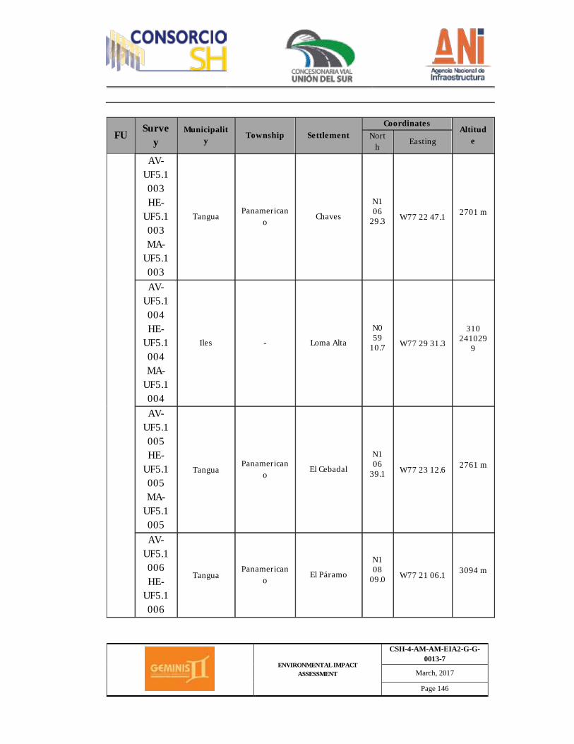
ENVIRONMENTAL IMPACT ASSESSMENT
CSH-4-AM-AM-EIA2-G-G-0013-7
March, 2017
Page 146
FU Survey
Municipality Township Settlement
Coordinates Altitud
e North
Easting
AV-UF5.1 003 HE-
UF5.1 003 MA-
UF5.1 003
Tangua Panamerican
o Chaves
N1 06
29.3
W77 22 47.1 2701 m
AV-UF5.1 004 HE-
UF5.1 004 MA-
UF5.1 004
Iles - Loma Alta
N0 59
10.7
W77 29 31.3
310 241029
9
AV-UF5.1 005 HE-
UF5.1 005 MA-
UF5.1 005
Tangua Panamerican
o El Cebadal
N1 06
39.1
W77 23 12.6 2761 m
AV-UF5.1 006 HE-
UF5.1 006
Tangua Panamerican
o El Páramo
N1 08
09.0
W77 21 06.1 3094 m
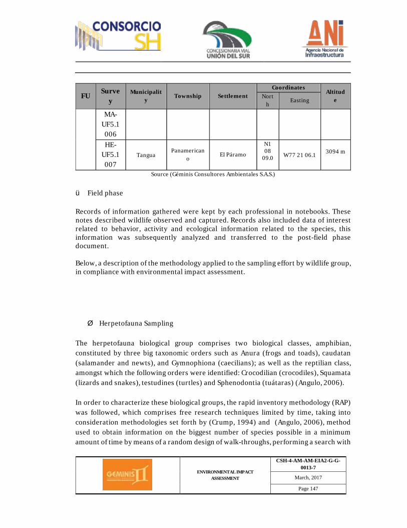
ENVIRONMENTAL IMPACT ASSESSMENT
CSH-4-AM-AM-EIA2-G-G-0013-7
March, 2017
Page 147
FU Survey
Municipality Township Settlement
Coordinates Altitud
e North
Easting
MA-UF5.1 006 HE-
UF5.1 007
Tangua Panamerican
o El Páramo
N1 08
09.0
W77 21 06.1 3094 m
Source (Géminis Consultores Ambientales S.A.S.) ü Field phase Records of information gathered were kept by each professional in notebooks. These notes described wildlife observed and captured. Records also included data of interest related to behavior, activity and ecological information related to the species, this information was subsequently analyzed and transferred to the post-field phase document. Below, a description of the methodology applied to the sampling effort by wildlife group, in compliance with environmental impact assessment. Ø Herpetofauna Sampling
The herpetofauna biological group comprises two biological classes, amphibian, constituted by three big taxonomic orders such as Anura (frogs and toads), caudatan (salamander and newts), and Gymnophiona (caecilians); as well as the reptilian class, amongst which the following orders were identified: Crocodilian (crocodiles), Squamata (lizards and snakes), testudines (turtles) and Sphenodontia (tuátaras) (Angulo, 2006). In order to characterize these biological groups, the rapid inventory methodology (RAP) was followed, which comprises free research techniques limited by time, taking into consideration methodologies set forth by (Crump, 1994) and (Angulo, 2006), method used to obtain information on the biggest number of species possible in a minimum amount of time by means of a random design of walk-throughs, performing a search with
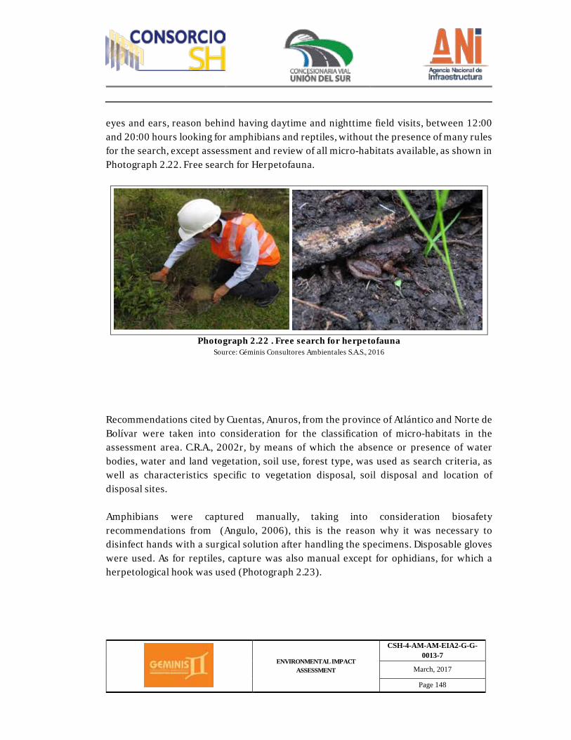
ENVIRONMENTAL IMPACT ASSESSMENT
CSH-4-AM-AM-EIA2-G-G-0013-7
March, 2017
Page 148
eyes and ears, reason behind having daytime and nighttime field visits, between 12:00 and 20:00 hours looking for amphibians and reptiles, without the presence of many rules for the search, except assessment and review of all micro-habitats available, as shown in Photograph 2.22. Free search for Herpetofauna.
Photograph 2.22 . Free search for herpetofauna
Source: Géminis Consultores Ambientales S.A.S., 2016
Recommendations cited by Cuentas, Anuros, from the province of Atlántico and Norte de Bolívar were taken into consideration for the classification of micro-habitats in the assessment area. C.R.A., 2002r, by means of which the absence or presence of water bodies, water and land vegetation, soil use, forest type, was used as search criteria, as well as characteristics specific to vegetation disposal, soil disposal and location of disposal sites. Amphibians were captured manually, taking into consideration biosafety recommendations from (Angulo, 2006), this is the reason why it was necessary to disinfect hands with a surgical solution after handling the specimens. Disposable gloves were used. As for reptiles, capture was also manual except for ophidians, for which a herpetological hook was used (Photograph 2.23).
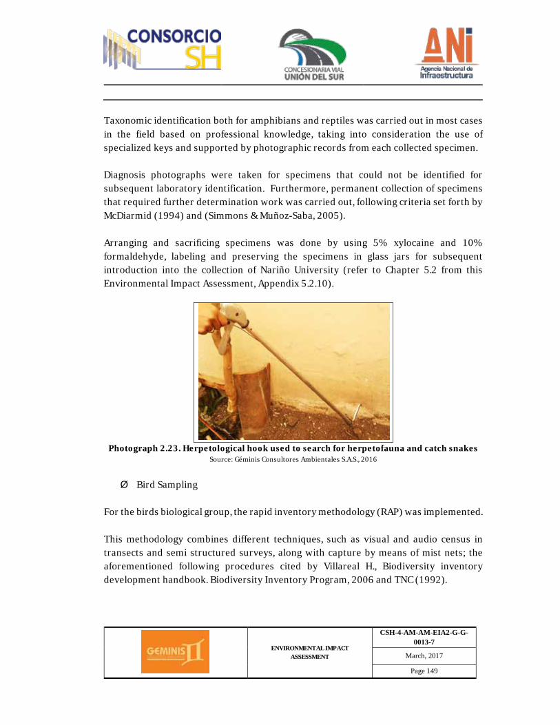
ENVIRONMENTAL IMPACT ASSESSMENT
CSH-4-AM-AM-EIA2-G-G-0013-7
March, 2017
Page 149
Taxonomic identification both for amphibians and reptiles was carried out in most cases in the field based on professional knowledge, taking into consideration the use of specialized keys and supported by photographic records from each collected specimen. Diagnosis photographs were taken for specimens that could not be identified for subsequent laboratory identification. Furthermore, permanent collection of specimens that required further determination work was carried out, following criteria set forth by McDiarmid (1994) and (Simmons & Muñoz-Saba, 2005). Arranging and sacrificing specimens was done by using 5% xylocaine and 10% formaldehyde, labeling and preserving the specimens in glass jars for subsequent introduction into the collection of Nariño University (refer to Chapter 5.2 from this Environmental Impact Assessment, Appendix 5.2.10).
Photograph 2.23. Herpetological hook used to search for herpetofauna and catch snakes
Source: Géminis Consultores Ambientales S.A.S., 2016
Ø Bird Sampling
For the birds biological group, the rapid inventory methodology (RAP) was implemented. This methodology combines different techniques, such as visual and audio census in transects and semi structured surveys, along with capture by means of mist nets; the aforementioned following procedures cited by Villareal H., Biodiversity inventory development handbook. Biodiversity Inventory Program, 2006 and TNC (1992).
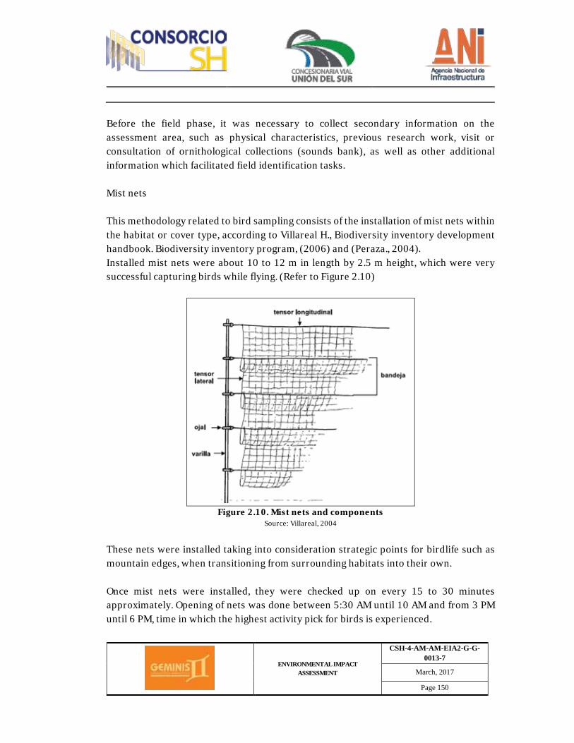
ENVIRONMENTAL IMPACT ASSESSMENT
CSH-4-AM-AM-EIA2-G-G-0013-7
March, 2017
Page 150
Before the field phase, it was necessary to collect secondary information on the assessment area, such as physical characteristics, previous research work, visit or consultation of ornithological collections (sounds bank), as well as other additional information which facilitated field identification tasks. Mist nets This methodology related to bird sampling consists of the installation of mist nets within the habitat or cover type, according to Villareal H., Biodiversity inventory development handbook. Biodiversity inventory program, (2006) and (Peraza., 2004). Installed mist nets were about 10 to 12 m in length by 2.5 m height, which were very successful capturing birds while flying. (Refer to Figure 2.10)
Figure 2.10. Mist nets and components
Source: Villareal, 2004
These nets were installed taking into consideration strategic points for birdlife such as mountain edges, when transitioning from surrounding habitats into their own. Once mist nets were installed, they were checked up on every 15 to 30 minutes approximately. Opening of nets was done between 5:30 AM until 10 AM and from 3 PM until 6 PM, time in which the highest activity pick for birds is experienced.
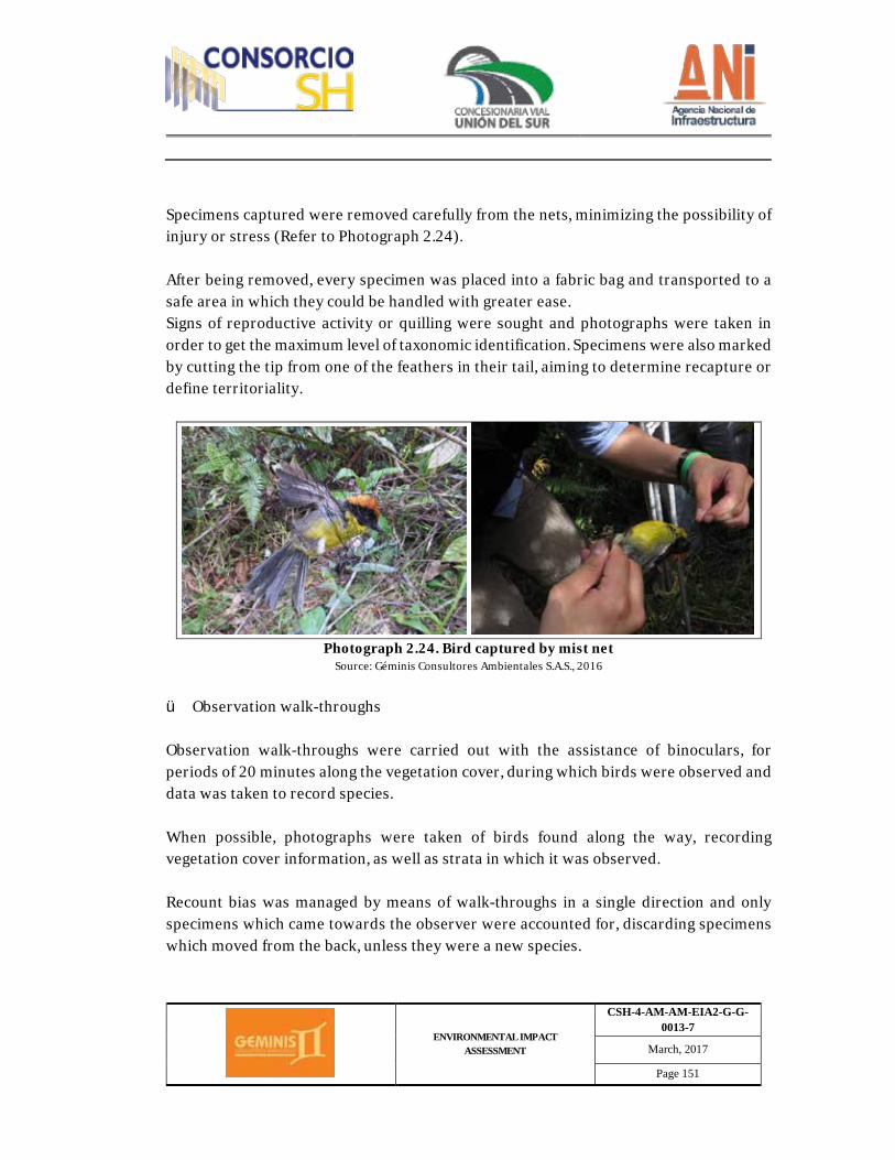
ENVIRONMENTAL IMPACT ASSESSMENT
CSH-4-AM-AM-EIA2-G-G-0013-7
March, 2017
Page 151
Specimens captured were removed carefully from the nets, minimizing the possibility of injury or stress (Refer to Photograph 2.24). After being removed, every specimen was placed into a fabric bag and transported to a safe area in which they could be handled with greater ease. Signs of reproductive activity or quilling were sought and photographs were taken in order to get the maximum level of taxonomic identification. Specimens were also marked by cutting the tip from one of the feathers in their tail, aiming to determine recapture or define territoriality.
Photograph 2.24. Bird captured by mist net
Source: Géminis Consultores Ambientales S.A.S., 2016
ü Observation walk-throughs Observation walk-throughs were carried out with the assistance of binoculars, for periods of 20 minutes along the vegetation cover, during which birds were observed and data was taken to record species. When possible, photographs were taken of birds found along the way, recording vegetation cover information, as well as strata in which it was observed. Recount bias was managed by means of walk-throughs in a single direction and only specimens which came towards the observer were accounted for, discarding specimens which moved from the back, unless they were a new species.
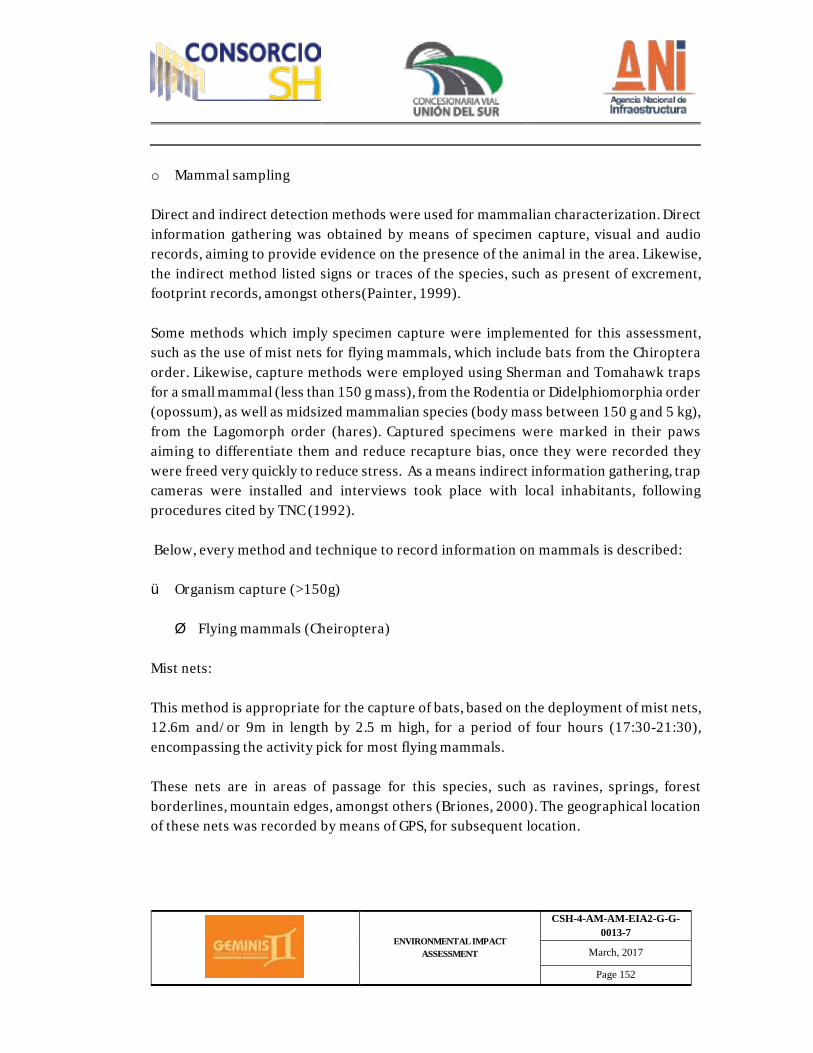
ENVIRONMENTAL IMPACT ASSESSMENT
CSH-4-AM-AM-EIA2-G-G-0013-7
March, 2017
Page 152
o Mammal sampling Direct and indirect detection methods were used for mammalian characterization. Direct information gathering was obtained by means of specimen capture, visual and audio records, aiming to provide evidence on the presence of the animal in the area. Likewise, the indirect method listed signs or traces of the species, such as present of excrement, footprint records, amongst others(Painter, 1999). Some methods which imply specimen capture were implemented for this assessment, such as the use of mist nets for flying mammals, which include bats from the Chiroptera order. Likewise, capture methods were employed using Sherman and Tomahawk traps for a small mammal (less than 150 g mass), from the Rodentia or Didelphiomorphia order (opossum), as well as midsized mammalian species (body mass between 150 g and 5 kg), from the Lagomorph order (hares). Captured specimens were marked in their paws aiming to differentiate them and reduce recapture bias, once they were recorded they were freed very quickly to reduce stress. As a means indirect information gathering, trap cameras were installed and interviews took place with local inhabitants, following procedures cited by TNC (1992). Below, every method and technique to record information on mammals is described: ü Organism capture (>150g) Ø Flying mammals (Cheiroptera)
Mist nets: This method is appropriate for the capture of bats, based on the deployment of mist nets, 12.6m and/or 9m in length by 2.5 m high, for a period of four hours (17:30-21:30), encompassing the activity pick for most flying mammals. These nets are in areas of passage for this species, such as ravines, springs, forest borderlines, mountain edges, amongst others (Briones, 2000). The geographical location of these nets was recorded by means of GPS, for subsequent location.
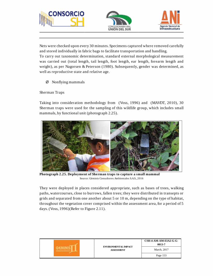
ENVIRONMENTAL IMPACT ASSESSMENT
CSH-4-AM-AM-EIA2-G-G-0013-7
March, 2017
Page 153
Nets were checked upon every 30 minutes. Specimens captured where removed carefully and stored individually in fabric bags to facilitate transportation and handling. To carry out taxonomic determination, standard external morphological measurement was carried out (total length, tail length, foot length, ear length, forearm length and weight), as per Nagorsen & Peterson (1980). Subsequently, gender was determined, as well as reproductive state and relative age. Ø Nonflying mammals
Sherman Traps Taking into consideration methodology from (Voss, 1996) and (MAVDT, 2010), 30 Sherman traps were used for the sampling of this wildlife group, which includes small mammals, by functional unit (photograph 2.25).
Photograph 2.25. Deployment of Sherman traps to capture a small mammal
Source: Géminis Consultores Ambientales S.A.S., 2016
They were deployed in places considered appropriate, such as bases of trees, walking paths, watercourses, close to burrows, fallen trees; they were distributed in transepts or grids and separated from one another about 5 or 10 m, depending on the type of habitat, throughout the vegetation cover comprised within the assessment area, for a period of 5 days. (Voss, 1996)(Refer to Figure 2.11).

ENVIRONMENTAL IMPACT ASSESSMENT
CSH-4-AM-AM-EIA2-G-G-0013-7
March, 2017
Page 154
Figure 2.11. Sampling grid
Source: Géminis Consultores Ambientales S.A.S. 2015
Bait was placed in the traps when deployed and then checked upon daily. Material used as bait included oil-based sardines and a mixture of oatmeal, peanut butter and/or other flavor-giving components. Captured specimens were measured and photographed for subsequent determination. Tomahawk Traps This kind of trap was used to capture midsized mammals, as shown in Photograph 2.26. The deployment process, bait placing and trap checking follows the same methodology used for small mammals, with Sherman traps.
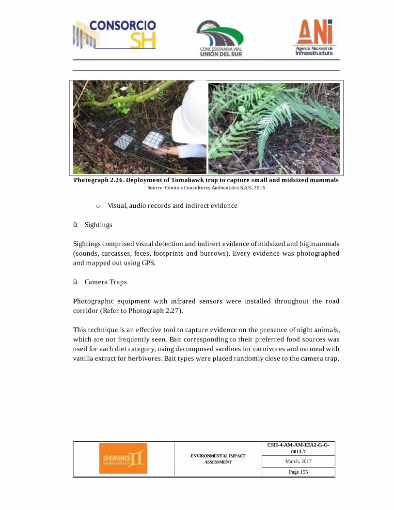
ENVIRONMENTAL IMPACT ASSESSMENT
CSH-4-AM-AM-EIA2-G-G-0013-7
March, 2017
Page 155
Photograph 2.26. Deployment of Tomahawk trap to capture small and midsized mammals
Source: Géminis Consultores Ambientales S.A.S., 2016
o Visual, audio records and indirect evidence
ü Sightings Sightings comprised visual detection and indirect evidence of midsized and big mammals (sounds, carcasses, feces, footprints and burrows). Every evidence was photographed and mapped out using GPS. ü Camera Traps Photographic equipment with infrared sensors were installed throughout the road corridor (Refer to Photograph 2.27). This technique is an effective tool to capture evidence on the presence of night animals, which are not frequently seen. Bait corresponding to their preferred food sources was used for each diet category, using decomposed sardines for carnivores and oatmeal with vanilla extract for herbivores. Bait types were placed randomly close to the camera trap.
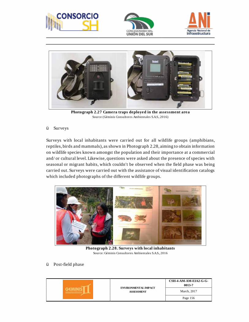
ENVIRONMENTAL IMPACT ASSESSMENT
CSH-4-AM-AM-EIA2-G-G-0013-7
March, 2017
Page 156
Photograph 2.27 Camera traps deployed in the assessment area
Source (Géminis Consultores Ambientales S.A.S., 2016)
ü Surveys Surveys with local inhabitants were carried out for all wildlife groups (amphibians, reptiles, birds and mammals), as shown in Photograph 2.28, aiming to obtain information on wildlife species known amongst the population and their importance at a commercial and/or cultural level. Likewise, questions were asked about the presence of species with seasonal or migrant habits, which couldn't be observed when the field phase was being carried out. Surveys were carried out with the assistance of visual identification catalogs which included photographs of the different wildlife groups.
Photograph 2.28. Surveys with local inhabitants
Source: Géminis Consultores Ambientales S.A.S., 2016
ü Post-field phase
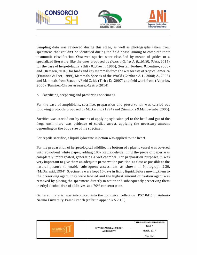
ENVIRONMENTAL IMPACT ASSESSMENT
CSH-4-AM-AM-EIA2-G-G-0013-7
March, 2017
Page 157
Sampling data was reviewed during this stage, as well as photographs taken from specimens that couldn't be identified during the field phase, aiming to complete their taxonomic classification. Observed species were classified by means of guides or a specialized literature, like the ones proposed by (Acosta-Galvis A. R., 2016), (Uetz, 2015)
for the case of herpetofauna; (Hilty & Brown., 1986), (Restall, Rodner, & Lentino, 2006) and (Remsen, 2016), for birds and key mammals from the wet forests of tropical America (Emmons & Feer, 1999), Mammals Species of the World (Gardner A. L., 2008; A., 2005) and Mammals from Ecuador. Field Guide (Tirira D. , 2007) and field work from (Alberico, 2000) (Ramírez-Chaves & Suárez-Castro, 2014). o Sacrificing, preparing and preserving specimens. For the case of amphibians, sacrifice, preparation and preservation was carried out following protocols proposed by McDiarmid (1994) and (Simmons & Muñoz-Saba, 2005). Sacrifice was carried out by means of applying xylocaine gel to the head and gut of the frogs until there was evidence of cardiac arrest, applying the necessary amount depending on the body size of the specimen. For reptile sacrifice, a liquid xylocaine injection was applied to the heart. For the preparation of herpetological wildlife, the bottom of a plastic vessel was covered with absorbent white paper, adding 10% formaldehyde, until the piece of paper was completely impregnated, generating a wet chamber. For preparation purposes, it was very important to give them an adequate preservation position, as close as possible to the natural posture to enable subsequent assessment, as shown in Photograph 2.29, (McDiarmid, 1994). Specimens were kept 10 days in fixing liquid. Before moving them to the preserving agent, they were labeled and the highest amount of fixation agent was removed by placing the specimens directly in water and subsequently preserving them in ethyl alcohol, free of additives, at a 70% concentration. Gathered material was introduced into the zoological collection (PSO 041) of Antonio Nariño University, Pasto Branch (refer to appendix 5.2.10.)
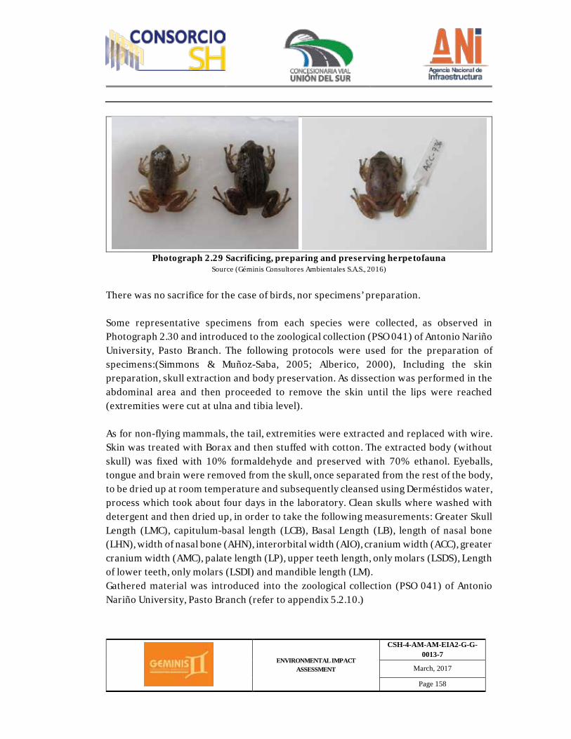
ENVIRONMENTAL IMPACT ASSESSMENT
CSH-4-AM-AM-EIA2-G-G-0013-7
March, 2017
Page 158
Photograph 2.29 Sacrificing, preparing and preserving herpetofauna
Source (Géminis Consultores Ambientales S.A.S., 2016)
There was no sacrifice for the case of birds, nor specimens’ preparation. Some representative specimens from each species were collected, as observed in Photograph 2.30 and introduced to the zoological collection (PSO 041) of Antonio Nariño University, Pasto Branch. The following protocols were used for the preparation of specimens:(Simmons & Muñoz-Saba, 2005; Alberico, 2000), Including the skin preparation, skull extraction and body preservation. As dissection was performed in the abdominal area and then proceeded to remove the skin until the lips were reached (extremities were cut at ulna and tibia level). As for non-flying mammals, the tail, extremities were extracted and replaced with wire. Skin was treated with Borax and then stuffed with cotton. The extracted body (without skull) was fixed with 10% formaldehyde and preserved with 70% ethanol. Eyeballs, tongue and brain were removed from the skull, once separated from the rest of the body, to be dried up at room temperature and subsequently cleansed using Derméstidos water, process which took about four days in the laboratory. Clean skulls where washed with detergent and then dried up, in order to take the following measurements: Greater Skull Length (LMC), capitulum-basal length (LCB), Basal Length (LB), length of nasal bone (LHN), width of nasal bone (AHN), interorbital width (AIO), cranium width (ACC), greater cranium width (AMC), palate length (LP), upper teeth length, only molars (LSDS), Length of lower teeth, only molars (LSDI) and mandible length (LM). Gathered material was introduced into the zoological collection (PSO 041) of Antonio Nariño University, Pasto Branch (refer to appendix 5.2.10.)
ENVIRONMENTAL IMPACT ASSESSMENT
CSH-4-AM-AM-EIA2-G-G-0013-7
March, 2017
Page 159
Photograph 2.30 Mammalian fauna sacrifice and preservation
Source (Géminis Consultores Ambientales S.A.S., 2016)
Based on information obtained from the field, the following analysis where carried out: ü Sampling effort: Sampling representativeness: The determination of each sampling effort executed per method carried out during the field phase is detailed in Table 2.30 below.
Table 2.30 Sampling effort per method Sampling effort per method and capture success
Mist nets
EM = ∑RxT Where: R= number of open nets by site T= number of hours nets remained open Capture rate: E=(n/EM)*100 Where n is the total number of specimens caught
Observation transects
EM= h*d Where: h= Total visual/audio detection hours d= total distanced walked Capture success: E=(n/EM)*100 Where n is the number of observations or records.
Free herpetofauna observation EM=∑(t*H)
ENVIRONMENTAL IMPACT ASSESSMENT
CSH-4-AM-AM-EIA2-G-G-0013-7
March, 2017
Page 160
Sampling effort per method and capture success Where t= Number of hours to complete a walk H= Number of observers completing sampling work Capture success: E=(n/EM)*100 Where n is the number of observations or records.
Sherman Traps
EM= t*n Where: t= Number of active traps n= Number of sampling nights Capture success: E=(n/EM)*100 Where n is the number of specimens or individuals captured
Sampling Representativeness
Where: E (S)= Number of species found in the n size of the sample N= Total number of specimens in the sample n= Standardized sample size Ni = Number of specimens in the i-th species
This species accumulation curves were carried out using the rarefaction method, through the EstimateS program1
(Géminis Consultores Ambientales S.A.S, 2016) Observation transects: The sampling effort was measured in terms of total detection hours (visual and audio), based on the number of field observations. Capture success was determined by dividing the number of observations or records by the sampling effort. Sampling representativeness: This was assessed by means of species accumulation curves and comparisons with maximum expected richness values, based on the obs and Chao1 functions. This species accumulation curves were carried out using the rarefaction method, through the EstimateS program (Colwell, Version 9.1.0. 2013). These estimators based themselves mainly on the number of species from a sample which are only represented by one or two specimens, in the case of abundance (they were deemed 1COLWELL, R. K.EstimateS: statistical estimation of species richness and shared species from samples. [Computer program].Version 8.2.0.s.l.:1994-2010].
( )å --=
nNnNNSE i1)(
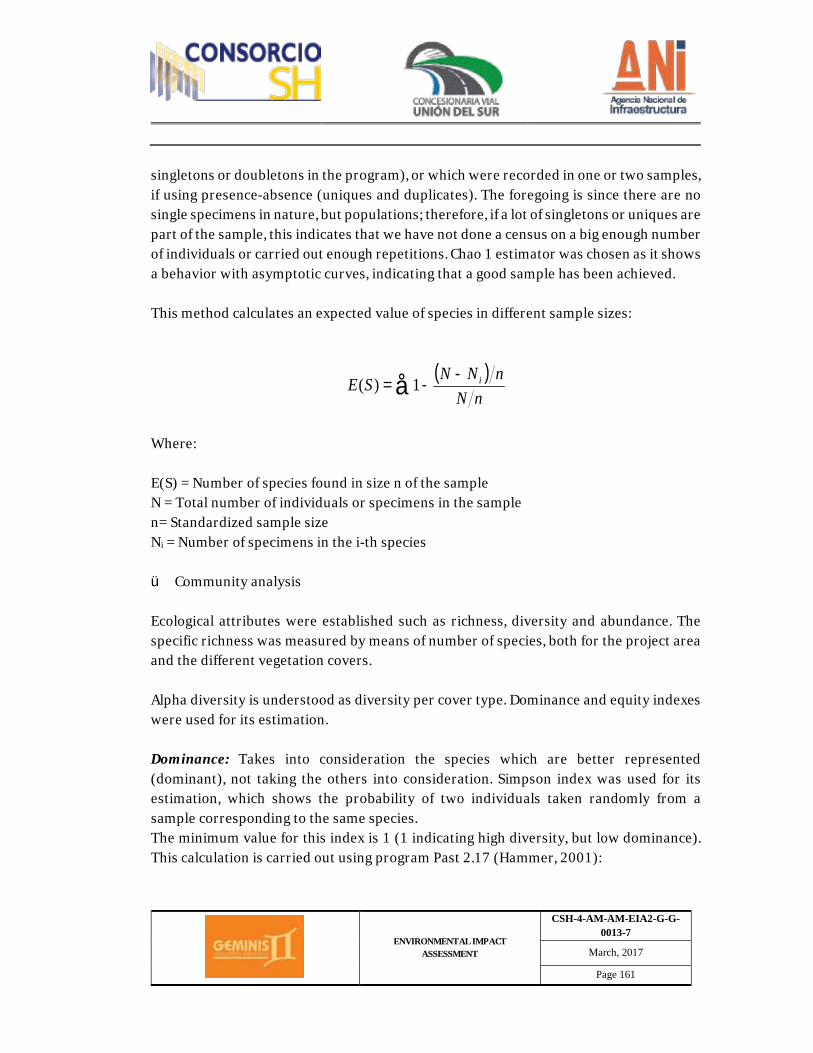
ENVIRONMENTAL IMPACT ASSESSMENT
CSH-4-AM-AM-EIA2-G-G-0013-7
March, 2017
Page 161
singletons or doubletons in the program), or which were recorded in one or two samples, if using presence-absence (uniques and duplicates). The foregoing is since there are no single specimens in nature, but populations; therefore, if a lot of singletons or uniques are part of the sample, this indicates that we have not done a census on a big enough number of individuals or carried out enough repetitions. Chao 1 estimator was chosen as it shows a behavior with asymptotic curves, indicating that a good sample has been achieved. This method calculates an expected value of species in different sample sizes:
Where: E(S) = Number of species found in size n of the sample N = Total number of individuals or specimens in the sample n= Standardized sample size Ni = Number of specimens in the i-th species ü Community analysis Ecological attributes were established such as richness, diversity and abundance. The specific richness was measured by means of number of species, both for the project area and the different vegetation covers. Alpha diversity is understood as diversity per cover type. Dominance and equity indexes were used for its estimation. Dominance: Takes into consideration the species which are better represented (dominant), not taking the others into consideration. Simpson index was used for its estimation, which shows the probability of two individuals taken randomly from a sample corresponding to the same species. The minimum value for this index is 1 (1 indicating high diversity, but low dominance). This calculation is carried out using program Past 2.17 (Hammer, 2001):
( )å --=
nNnNNSE i1)(
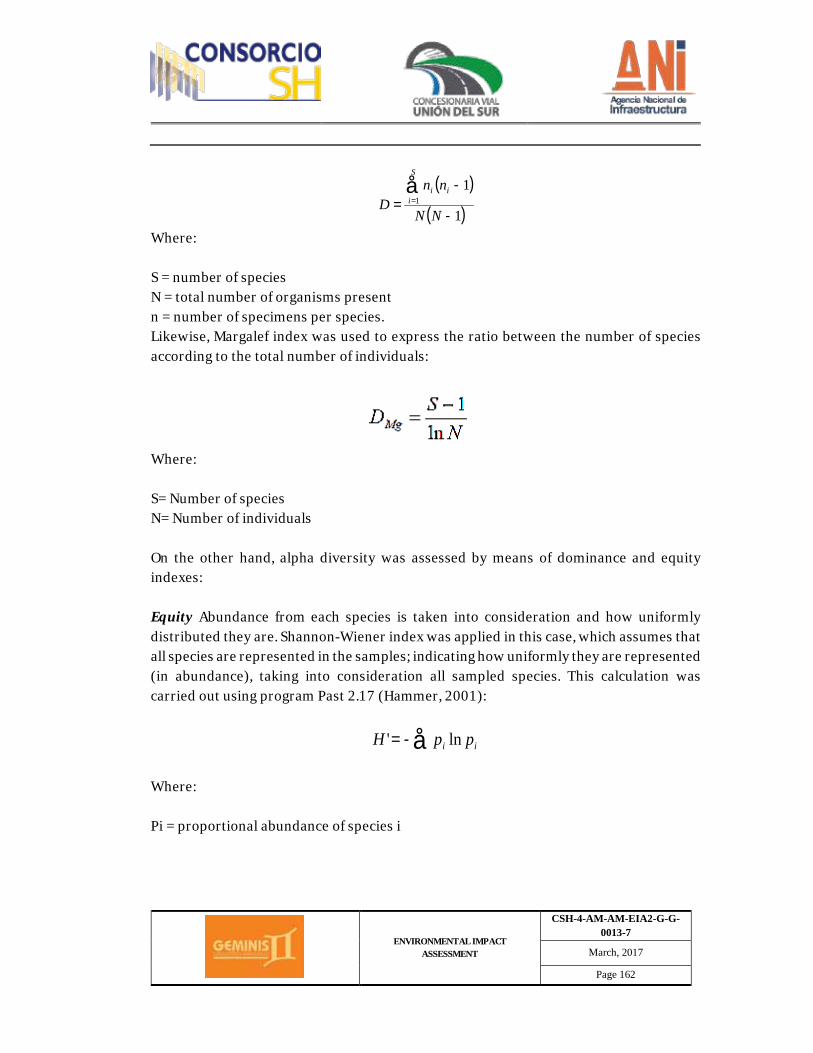
ENVIRONMENTAL IMPACT ASSESSMENT
CSH-4-AM-AM-EIA2-G-G-0013-7
March, 2017
Page 162
Where: S = number of species N = total number of organisms present n = number of specimens per species. Likewise, Margalef index was used to express the ratio between the number of species according to the total number of individuals:
Where: S= Number of species N= Number of individuals On the other hand, alpha diversity was assessed by means of dominance and equity indexes: Equity Abundance from each species is taken into consideration and how uniformly distributed they are. Shannon-Wiener index was applied in this case, which assumes that all species are represented in the samples; indicating how uniformly they are represented (in abundance), taking into consideration all sampled species. This calculation was carried out using program Past 2.17 (Hammer, 2001):
Where: Pi = proportional abundance of species i
( )
( )1
11
-
-=
å=
NN
nnD
S
iii
å-= ii ppH ln'
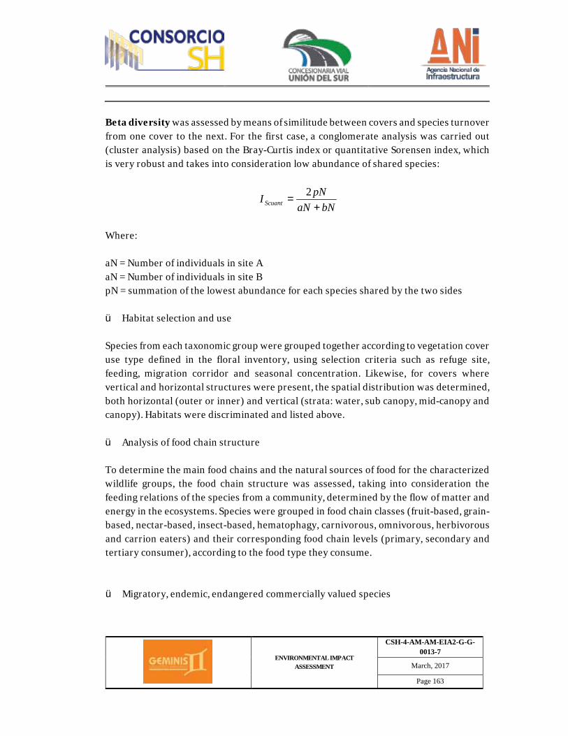
ENVIRONMENTAL IMPACT ASSESSMENT
CSH-4-AM-AM-EIA2-G-G-0013-7
March, 2017
Page 163
Beta diversity was assessed by means of similitude between covers and species turnover from one cover to the next. For the first case, a conglomerate analysis was carried out (cluster analysis) based on the Bray-Curtis index or quantitative Sorensen index, which is very robust and takes into consideration low abundance of shared species:
Where: aN = Number of individuals in site A aN = Number of individuals in site B pN = summation of the lowest abundance for each species shared by the two sides ü Habitat selection and use Species from each taxonomic group were grouped together according to vegetation cover use type defined in the floral inventory, using selection criteria such as refuge site, feeding, migration corridor and seasonal concentration. Likewise, for covers where vertical and horizontal structures were present, the spatial distribution was determined, both horizontal (outer or inner) and vertical (strata: water, sub canopy, mid-canopy and canopy). Habitats were discriminated and listed above. ü Analysis of food chain structure To determine the main food chains and the natural sources of food for the characterized wildlife groups, the food chain structure was assessed, taking into consideration the feeding relations of the species from a community, determined by the flow of matter and energy in the ecosystems. Species were grouped in food chain classes (fruit-based, grain-based, nectar-based, insect-based, hematophagy, carnivorous, omnivorous, herbivorous and carrion eaters) and their corresponding food chain levels (primary, secondary and tertiary consumer), according to the food type they consume. ü Migratory, endemic, endangered commercially valued species
bNaNpNI Scuant +
=2
ENVIRONMENTAL IMPACT ASSESSMENT
CSH-4-AM-AM-EIA2-G-G-0013-7
March, 2017
Page 164
To establish endangerment category for species, Resolution 0192 from 2014, from the Environmental and Sustainable Development Ministry (MDAS) was taken into consideration, which establishes a list of wild endangered species from the Colombian biological diversity to be found in the national territory. The determination of commercially valued species was taken based on the International Convention on Wild Fauna and Flora Species (CITES), 2013. Additionally, the red list of endangered species was also queried upon, according to the International Union for the Conservation of Nature (IUCN), version 2014.4, this list establishes the state of population for an endangered category according to the increase or decrease of the species' specimens; the series of red books identifies the species with a greater risk of extinction in the country, certain measures are established for the management and conservation of such species also. It was also determined if a given species was registered at any of the endemic centers in Columbia. On the same token, taking into consideration that the groups that have migratory species are only down to freshwater mammals, chiroptera and birds, the Colombian migratory species list was queried upon, as well as the plan for conservation of Colombian migratory birds. o Hydro-biological Communities The hydrobiological assessment depends on the characteristics of the water body to be analyzed, sampling was carried out for the communities in the same sampling stations used to assess water physicochemical quality. There were no methodologies to assess continental hydro-biological resources. Standard Methods for the Examination of Water and Wastewater were used. The location of the stations corresponds to the objectives of the assessment and the different variables present in the environment of the water body to be analyzed, such as tributaries, discharges, environmental gradients. To define the number of replicas (samples per station) the following was taken into consideration: Type of community to be assessed, number of micro-habitats present and
ENVIRONMENTAL IMPACT ASSESSMENT
CSH-4-AM-AM-EIA2-G-G-0013-7
March, 2017
Page 165
diversity found during sampling. Personnel responsible for sampling had professional biology, ecology, marine biology training to identify sampled specimens in situ. The structure of the population was assessed by means of diversity and abundance analysis on the organisms present in the area. Known diversity indexes were used such as Margalef richness index, Shannon and Weaber, amongst others. This data was complemented with a classification and ordering analysis, by means of affinity and dissimilarity indexes such as Jaccard affinity index and Bray-Curtis similarity index, amongst others (Ramírez A. and Viña G. 1998). A bio-indication analysis was carried out in a quantitative manner, based on relative abundance of genres found. These results were correlated to physicochemical analysis and contamination indexes. It is worth clarifying that sampling was carried out during the rainy season, therefore, and aiming to complement the analysis with dry season information, monitoring was carried out during the dry season before construction activities were initiated. ü Company responsible for assessment Monitoring and analysis work was carried out by Servicios de Ingeniería y Ambiente SAS laboratories, SGS COLOMBIA SA laboratories, ANTEK SA and ChemiLab SAS, all accredited by IDEAM. The companies responsible for each one of the analysis are detailed in Table 2.31, which includes corresponding accreditation resolutions.
Table 2.31 Companies responsible for sampling analysis
Laboratory Parameter Accreditation
resolution Analysis method
SERAMBIENTE S.A.S.
DBO5 Resolution 2191, 2015.
SM-5210 B DQO SM-5220 D Total Suspended Solids
SM-2540 D
Grease and oil SM-5520 D Alkalinity SM-2320 B
ENVIRONMENTAL IMPACT ASSESSMENT
CSH-4-AM-AM-EIA2-G-G-0013-7
March, 2017
Page 166
Laboratory Parameter Accreditation
resolution Analysis method
Total Hardness SM-2340 C Total Coliforms SM-9221 B Thermotolerant Coliforms
SM-9221 E
E. Coli SM-9221 G Conductivity Thermometric SM 2550 B Dissolved Oxygen Thermometric SM 2550 B Temperature Thermometric SM 2550 B pH Electrometric SM 4500 HB Hydro biological Aquatic Macroinvertebrates
Fish Phytoplankton Zooplankton Periphyton Aquatic plants
ANTEK S.A.
Turbidity
Resolution 3653 from 2014
SM 2130 B
Actual Color SM 2120 C Total nitrogen SM 4500-Norg C SM 4500-
NH3 Total Phosphorus SM 4500-P E Total Phenols SM 5530 B - SM 5530 C Zinc SM 3030 E - SM 3111B /SM
3050B – SM 3120B SGS COLOMBIA S.A
Turbidity Resolution 899 from 2015 EPA 200.8
SM 2130 B Heavy Metals
ChemiLab S.A.S Arsenic Resolution 2016 from 2014.
EPA 7062, SM 3114 C
ü Pre-field phase Figure 2.12 shows steps followed during this phase, aiming to determine monitoring points and tests to be carried out for each.
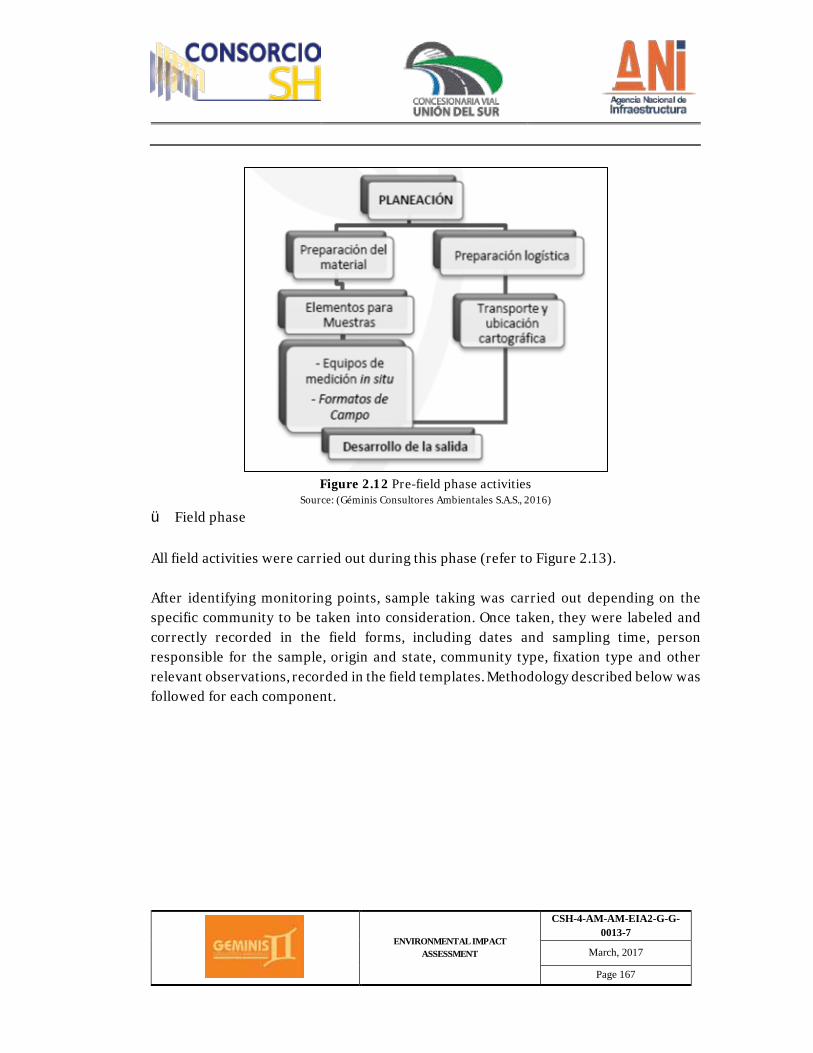
ENVIRONMENTAL IMPACT ASSESSMENT
CSH-4-AM-AM-EIA2-G-G-0013-7
March, 2017
Page 167
Figure 2.12 Pre-field phase activities
Source: (Géminis Consultores Ambientales S.A.S., 2016)
ü Field phase All field activities were carried out during this phase (refer to Figure 2.13). After identifying monitoring points, sample taking was carried out depending on the specific community to be taken into consideration. Once taken, they were labeled and correctly recorded in the field forms, including dates and sampling time, person responsible for the sample, origin and state, community type, fixation type and other relevant observations, recorded in the field templates. Methodology described below was followed for each component.
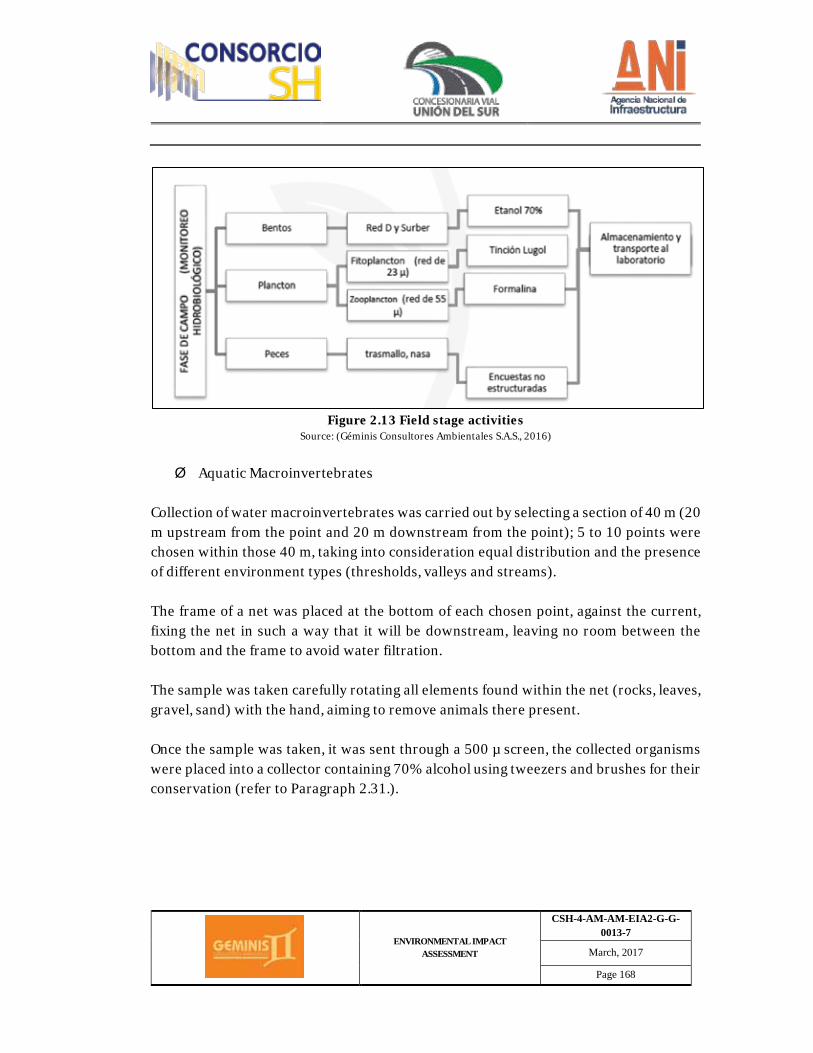
ENVIRONMENTAL IMPACT ASSESSMENT
CSH-4-AM-AM-EIA2-G-G-0013-7
March, 2017
Page 168
Figure 2.13 Field stage activities
Source: (Géminis Consultores Ambientales S.A.S., 2016)
Ø Aquatic Macroinvertebrates
Collection of water macroinvertebrates was carried out by selecting a section of 40 m (20 m upstream from the point and 20 m downstream from the point); 5 to 10 points were chosen within those 40 m, taking into consideration equal distribution and the presence of different environment types (thresholds, valleys and streams). The frame of a net was placed at the bottom of each chosen point, against the current, fixing the net in such a way that it will be downstream, leaving no room between the bottom and the frame to avoid water filtration. The sample was taken carefully rotating all elements found within the net (rocks, leaves, gravel, sand) with the hand, aiming to remove animals there present. Once the sample was taken, it was sent through a 500 µ screen, the collected organisms were placed into a collector containing 70% alcohol using tweezers and brushes for their conservation (refer to Paragraph 2.31.).
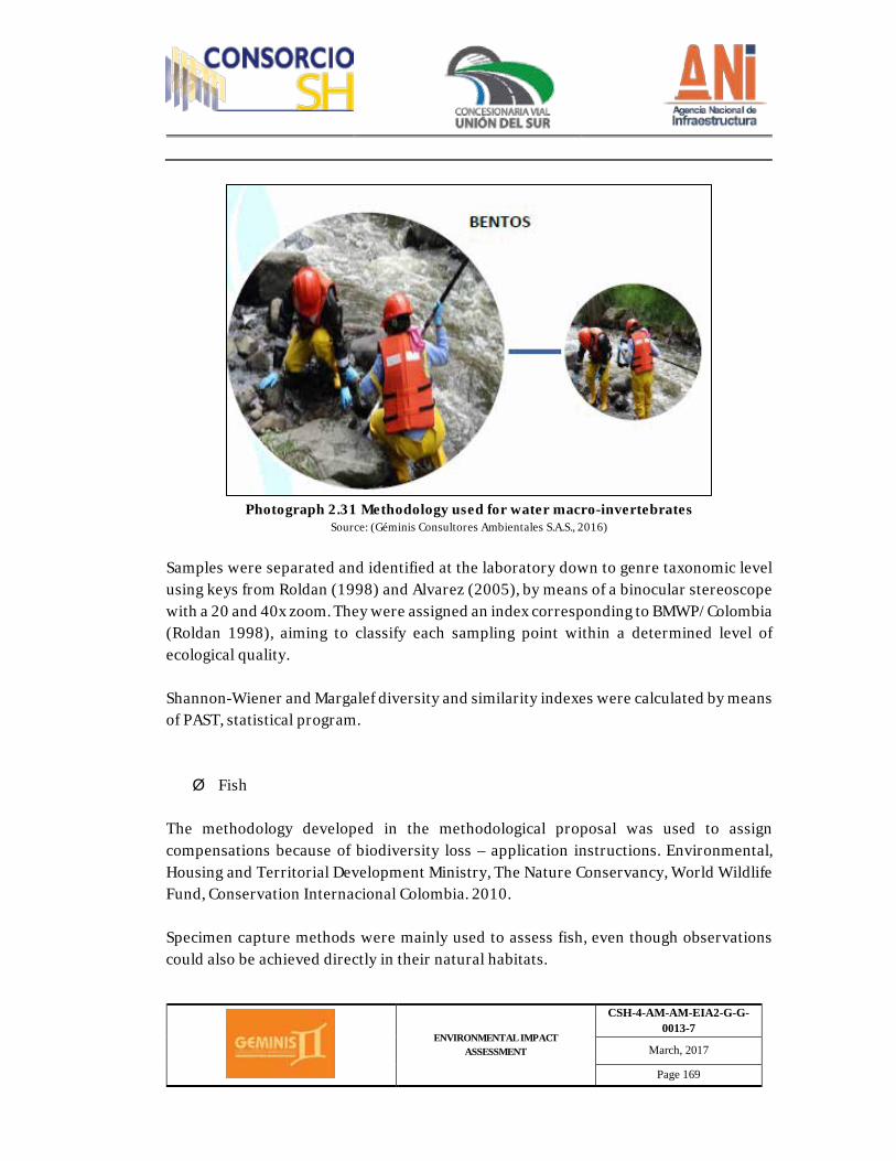
ENVIRONMENTAL IMPACT ASSESSMENT
CSH-4-AM-AM-EIA2-G-G-0013-7
March, 2017
Page 169
Photograph 2.31 Methodology used for water macro-invertebrates
Source: (Géminis Consultores Ambientales S.A.S., 2016)
Samples were separated and identified at the laboratory down to genre taxonomic level using keys from Roldan (1998) and Alvarez (2005), by means of a binocular stereoscope with a 20 and 40x zoom. They were assigned an index corresponding to BMWP/Colombia (Roldan 1998), aiming to classify each sampling point within a determined level of ecological quality. Shannon-Wiener and Margalef diversity and similarity indexes were calculated by means of PAST, statistical program. Ø Fish
The methodology developed in the methodological proposal was used to assign compensations because of biodiversity loss – application instructions. Environmental, Housing and Territorial Development Ministry, The Nature Conservancy, World Wildlife Fund, Conservation Internacional Colombia. 2010. Specimen capture methods were mainly used to assess fish, even though observations could also be achieved directly in their natural habitats.
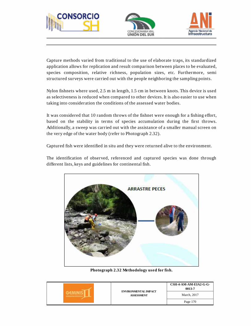
ENVIRONMENTAL IMPACT ASSESSMENT
CSH-4-AM-AM-EIA2-G-G-0013-7
March, 2017
Page 170
Capture methods varied from traditional to the use of elaborate traps, its standardized application allows for replication and result comparison between places to be evaluated, species composition, relative richness, population sizes, etc. Furthermore, semi structured surveys were carried out with the people neighboring the sampling points. Nylon fishnets where used, 2.5 m in length, 1.5 cm in between knots. This device is used as selectiveness is reduced when compared to other devices. It is also easier to use when taking into consideration the conditions of the assessed water bodies. It was considered that 10 random throws of the fishnet were enough for a fishing effort, based on the stability in terms of species accumulation during the first throws. Additionally, a sweep was carried out with the assistance of a smaller manual screen on the very edge of the water body (refer to Photograph 2.32). Captured fish were identified in situ and they were returned alive to the environment. The identification of observed, referenced and captured species was done through different lists, keys and guidelines for continental fish.
Photograph 2.32 Methodology used for fish.
ENVIRONMENTAL IMPACT ASSESSMENT
CSH-4-AM-AM-EIA2-G-G-0013-7
March, 2017
Page 171
Source: (Géminis Consultores Ambientales S.A.S., 2016)
Ø Plankton
Phytoplankton Phytoplankton was obtained in the field by filtering a volume of 60 L with a 23μm mesh, taking water from a superficial level (20 – 50 cm from the surface). Material was a stored in opaque plastic jars of approximately 150 mL, preserving the material with a lugol solution, 0.3 mL per each 100 mL of sample. Samples were preserved in a dark and fresh place. In cases deemed necessary, samples were directly taken with opaque 2L jars. Phytoplankton counting and identification was carried out by means of microscope on a Sedgewick-Rafter camera, employing iconography and specialized descriptions. Zooplankton Zooplankton collection was carried out by means of filtering 60 L of liquid through a 55μm mesh; samples were placed into 150 L opaque plastic jars and fixed it with 5% formaldehyde (final concentration) (5 mL per 100ml of sample), buffered with borax. In cases deemed necessary, samples were directly taken with opaque 2L jars. (refer to Photograph 2.33). Zooplankton counting and identification was carried out by means of microscope on a Sedgewick-Rafter camera, employing iconography and specialized descriptions.
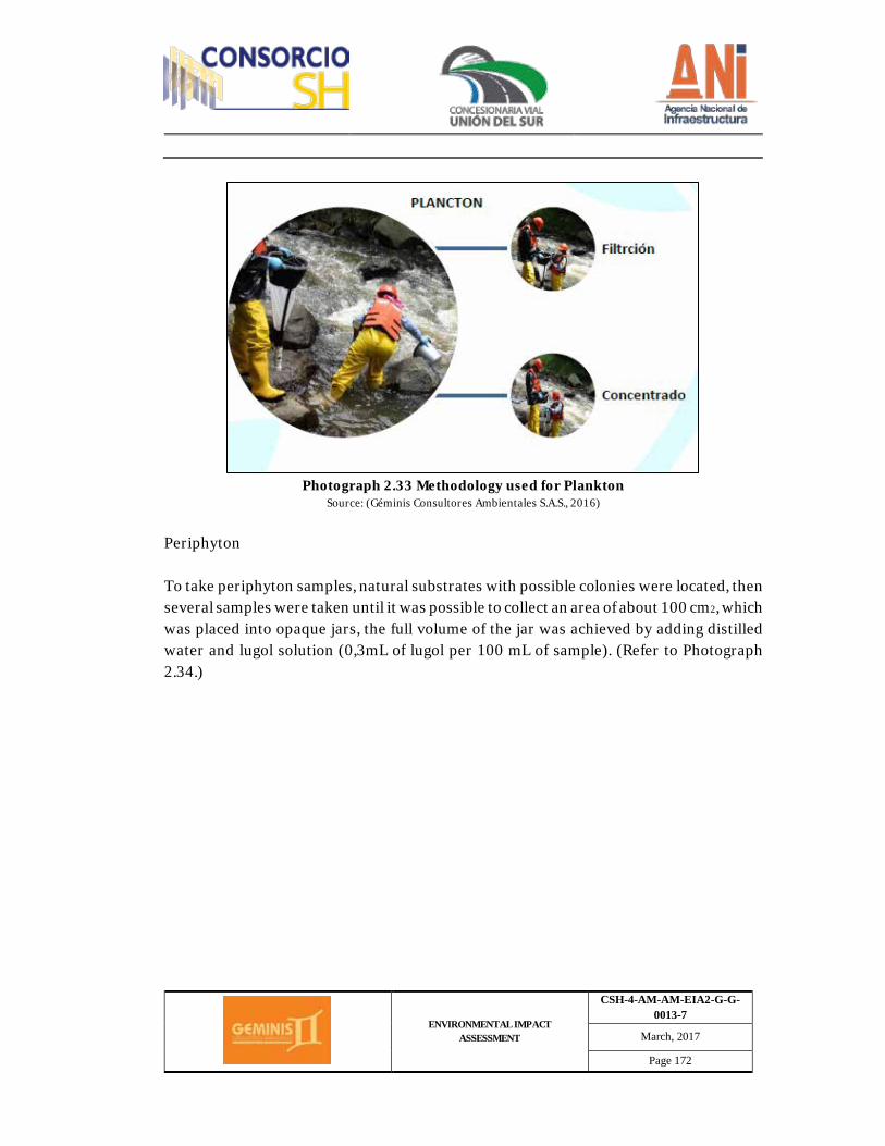
ENVIRONMENTAL IMPACT ASSESSMENT
CSH-4-AM-AM-EIA2-G-G-0013-7
March, 2017
Page 172
Photograph 2.33 Methodology used for Plankton
Source: (Géminis Consultores Ambientales S.A.S., 2016)
Periphyton To take periphyton samples, natural substrates with possible colonies were located, then several samples were taken until it was possible to collect an area of about 100 cm2, which was placed into opaque jars, the full volume of the jar was achieved by adding distilled water and lugol solution (0,3mL of lugol per 100 mL of sample). (Refer to Photograph 2.34.)

ENVIRONMENTAL IMPACT ASSESSMENT
CSH-4-AM-AM-EIA2-G-G-0013-7
March, 2017
Page 173
. Photograph 2.34 Periphyton Methodology Source: (Géminis Consultores Ambientales S.A.S., 2016)
Identification and counting was carried out with an optical microscope, a Sedgwick-Rafter camera, iconography and taxonomic descriptions proposed by (Ortega, 1984), (Ramírez, 2000), (Streble & Krauter, 1987), (Parra et. Al., 1982), (Bourrely, 1966), (Bourrely, 1968), (Bourrely, 1970). Quantification of individuals was obtained by means of formula proposed by (Hauer & Lambert, 2007), where density is expressed by means of the number of individuals per surface area (cm2) ( = //) Aquatic plants Field assessments for macrophytes initiated with the location of development areas and the selection of assessment stations. As there is no presence of lentic systems, no determination for this group was necessary. ü Comparative analysis between functional units
ENVIRONMENTAL IMPACT ASSESSMENT
CSH-4-AM-AM-EIA2-G-G-0013-7
March, 2017
Page 174
The analysis carried out was comparative and descriptive, when the wildlife composition was established for each functional unit, FU4 and FU5, regarding each assessment group: Herpetofauna, birds, mammals and hydro-biological communities. ü Information uncertainty For the land ecosystem component, regarding wildlife, inaccuracy of information was reduced to a minimum as extensive field work was carried out by means of professionals specialized in each analyzed group (amphibians and reptiles, birds and mammals), using standard methodologies and clearly defined timetables to carry out monitoring work in order to determine all aspects necessary for the field phase and laboratory phase. as a result, we obtained an analysis on the structure composition and vulnerability, together with the determination of trophic groups, ecological aspects and use for each wildlife group. Another aspect to take into consideration regarding information uncertainty are the proposed wildlife passages, which were identified and prioritized based on natural covers and records from the different identified groups, based on ethology from each species, different variables were taken into consideration for each species.
2.3.2.3. Socioeconomic Component A participatory methodology was chosen to approach the socioeconomic component, including all players identified in the area of influence, incorporating primary information obtained through interviews, approaches and communications with the people, and of course, revision of documents to consolidate secondary information, which provided identification elements for each component of the socioeconomic realm. This methodology responds to the need of carrying out a participatory process, where the knowledge that the community has on the territory, worldview, culture, economy, social relationships and other aspects, were incorporated into the elements analyzed for the assessment. To maintain a documentary structure, a methodology including pre-field, field and post-field work for the socioeconomic component was introduced, addressing all assessment stages.
ENVIRONMENTAL IMPACT ASSESSMENT
CSH-4-AM-AM-EIA2-G-G-0013-7
March, 2017
Page 175
- Pre-field Phase - Socioeconomic baseline The construction of the socioeconomic baseline was based on the analysis of secondary information obtained through documents and current official reports from the major territorial units in the area of influence, such as land planning instruments (POT, EOT, municipal development plans, sectorial plans). At the regional level, documents such as provincial development plans, annual statistical information, POMCAS, were used; at a national level, the general census from the national statistical and administrative department (DANE), IGAC information, as well as information from different academies and research institutions, were used, amongst others. The analysis of the official secondary information related to the presence of social and/or communal organizations, ethnic communities in the area of influence of the project was carried out. In order to obtain information for the characterization of the smaller territorial units, walk-throughs in the area of influence were performed to obtain field information by means of the design and application of tools and instruments such as settlement templates (refer to Appendix 5.3 a) , socioeconomic and land ownership records (refer to Appendix 5.3 b) Likewise, as part of the methodology developed in the meetings and workshops, the social cartography was completed by collecting significant elements related to the knowledge of the settlement inhabitants in the area of influence. On the other hand, pre-field activities aiming to develop a participative socialization process for the assessment comprised the gathering of input information for the construction of a leaders’ database, specially from the Communal Committees from smaller territorial units, as these are the basis that drive and enable the assessment. Likewise, an institutional representatives’ database for major territorial units was constructed. Once the contact information for leaders and representatives was obtained, telephone and personal communication was established to set a date, time and place for the socialization meetings, after explaining the purpose behind them and formalizing their purpose by means of invitation letters. It is important to note that it was necessary to establish visits to some settlements to supplement the information on community leaders, since not all the information provided by Mayor's offices was updated and/or complete; conditions and logistical
ENVIRONMENTAL IMPACT ASSESSMENT
CSH-4-AM-AM-EIA2-G-G-0013-7
March, 2017
Page 176
requirements were also verified in the field, aiming to guarantee optimum conditions for assessment completion. Institutional notice letters were sent to the corresponding territorial entities, and the ones to be sent to the communities were delivered personally to the leaders of the Community Committees to guarantee a wide participation of the communities within the area of influence. Notices were complemented by the distribution of flyers, placement of posters in strategic places in the different settlements, and megaphone advertising prior to each meeting. To undertake socializations, a slide presentation was designed including information corresponding to the socialization moments at the beginning of the EIA (refer to Appendix 5.3.1ppt1)
- Field phase The socioeconomic component activities carried out in the field were performed based on the development of socializations, collection of primary information for the construction of the socioeconomic baseline of the major and minor territorial units, characterization of the social units susceptible to compensations, identification of mobility conditions, as well as impacts identification. Below, methodology per aspect is introduced: Initially, the identification of the social players by typology, within the area of influence of the project was carried out in order to establish the first approaches by means of visits, telephone calls and written requests, aiming to define appropriate spaces to establish links of trust with the communities and publicize the presence of Road Concessionary Union de Sur and its dual carriageway project. Once all identified actors were notified as to the development of the project, socialization days were scheduled in two (2) different instances: (i) information on the initiation of the Environmental Impact Studies (EIA) and (iii) presentation of the results of the EIA. These socializations were carried out independently for the institutional players and the communities of the area of influence. All the meetings held have the necessary supporting documentation, including: notifications, meeting minutes, attendance lists and photographic records, which account for the development and application of
ENVIRONMENTAL IMPACT ASSESSMENT
CSH-4-AM-AM-EIA2-G-G-0013-7
March, 2017
Page 177
participation guidelines, submitted as part of this EIA, in accordance with the terms of reference from MADS, provided in resolution 0751, from March 26, 2015. In this regard, the aim of the design and development of the socialization process was make public the technical characteristics of the project, its scope, activities, and environmental implications, as well as the components, stages, areas of influence and scope of the Environmental Impact Assessment (EIA). On the same token, the purpose of the socializations was to get from the different actors, all concerns and observations to be taken into account for the decision making process related to the development of the project; another important part was the socialization of the assessment results, which enabled us to answer all concerns brought forward by the community, as well as reviewing the area of influence of the project, impacts, environmental zoning and established management measures, amongst other aspects which are part of the assessment. The methodological procedure set out below was put together at the time of notifications, socializations and information analysis. o Definition of project's area of influence for the socioeconomic component The main criteria used to define the area of influence of the socioeconomic component was the delimitation of the larger territorial units (municipal level), and the smaller territorial units (settlement level) in the rural areas; neighborhoods in urban areas, as the minimum unit of analysis. The identification of municipalities and minimum analysis units in the area of influence was carried out with the assistance of SIG, who by overlapping road infrastructure design pertaining to the project, from Pedregal to Catambuco, with cartographic information on the administrative and political division supplied by different territorial entities, was able to come up with the major and minor territorial units that will be influenced by the project, as well as linking this information to the areas of influence determined for other purposes. Nevertheless, during the primary information gathering process some inconsistencies were identified in the official cartographic information on the settlement boundaries and the acknowledgment from communities regarding their territories, for example, official information georeferences Vocacional township and the community is deemed as
ENVIRONMENTAL IMPACT ASSESSMENT
CSH-4-AM-AM-EIA2-G-G-0013-7
March, 2017
Page 178
inhabitants of settlement Cubijan Bajo. This situation could be taking place as official cartographic information is not updated and therefore reflects no rural territory changes, this is all related to social dynamics that have been taking place during the last few years. Nevertheless, existing official information was used for these assessments as well as data provided by municipal administrations on their territorial units.
Regarding identification of ethnic communities, a request was submitted to the Ministry of Interior complying to article 76 from law 99, from 1993, as well as Law 21 from 1991, Law 70 from 1993 and decree 1320 from 1999, which responded to our request by certifying the existence of ethnic communities being acknowledged by the government (Montaña de Fuego Ethnic Council and Catambuco Ethnic Council), by means of resolution 22 and 23 from 2016, Ministry of Interior, therefore the development of this component is subject to decisions from the Pre-consultation Office from the aforementioned ministry. Refer to Appendix: 5.3.5c (RESOLUTION 23_Montaña Fuego FU4 and Certification 22_FU5.1 Catambuco) o Socialization with institutional players and organized base communities Socializations related to the initiation of the EIA were carried out with institutional players first, as well as government and municipal authorities; subsequently, meetings took place with settlement communities and social organizations from the minor territorial units comprised within the area of influence for the dual carriageway project, Pilcuan-Catambuco settlement. Dialogue opportunities, exchange experiences and expectations sharing sessions were experienced and the participatory EIA was kicked off; institutional organizations included CORPONARIÑO, Nariño's Gov.'s office, Mayor's offices from the four different major territorial units within the area of influence (Imués, Yacuanquer, Tangua y Pasto), as well as the 29 minor territorial units listed in Table 2.32.
Table 2.32. Territorial Units at the Socioeconomic Area of Influence Functional
unit Municipality Settlement
FU 4
Imués El Pedregal
Settlement of Pilcuán Urban hub of C. Pedregal
Yacuanquer Inantas Bajo Inantas Alto
Tangua Cocha Verde
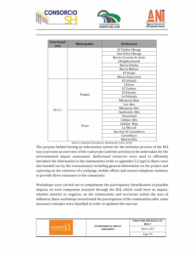
ENVIRONMENTAL IMPACT ASSESSMENT
CSH-4-AM-AM-EIA2-G-G-0013-7
March, 2017
Page 179
Functional unit Municipality Settlement
El Tablón Obrage San Pedro Obrage
Barrio Corazón de Jesús (Neighborhood)
Barrio Fátima Barrio Bolívar
El Vergel Buena Esperanza
FU 5.1
Tangua
El Cebadal Chávez
El Tambor El Páramo La Palizada
Marqueza Bajo Los Ajos
Marqueza Alto
Pasto
Gualmatán Alto Vocacional
Cubijan Alto Cubijan Bajo
La Merced San José de Catambuco
Catambuco Huertecillas
Source: (Géminis Consultores Ambientales S.A.S., 2016)
The purpose behind having an information system for the initiation process of the EIA was to present an overview of the road project and the activities to be undertaken for the environmental impact assessment. Audiovisual resources were used to efficiently introduce the information to the communities (refer to appendix 5.3.1ppt1); flyers were also handed out by the concessionary including general information on the project and reporting on the existence of a webpage, mobile offices and contact telephone numbers to provide direct assistance to the community. Workshops were carried out to complement the participatory identification of possible impacts on each component assessed through the EIA, which could have an impact, whether positive or negative, on the communities and territories within the area of influence; these workshops incentivized the participation of the communities after some necessary concepts were classified in order to optimize the exercise.
ENVIRONMENTAL IMPACT ASSESSMENT
CSH-4-AM-AM-EIA2-G-G-0013-7
March, 2017
Page 180
Three working groups were available, each of them to debate the assigned component: biotic, abiotic - (physical) and socioeconomic, each group was assigned color-coded templates for each component aiming to compile its impact identified for the project. After the debate, every group made a presentation on their conclusions for the rest of the people to analyze them, complement them or modify them. Participants placed their color-coded templates on a board located in the room for every component and the results were written down in the meeting minutes corresponding to the participatory exercise with the community. Just like the EIA initiation meetings, the meetings to socialize the results of the assessment involved the same social players, therefore having the participation of municipal and regional authorities mentioned above, and of course, inhabitants of the minor territorial units from the area of influence. The objective of these socialization meetings was to introduce EIA results for the abiotic, biotic and socioeconomic components, emphasizing on identified impacts and environmental management measures established by this study. Different dissemination means were used, such as PowerPoint presentations (refer to appendix 5.3.1ppt1), flyers handed out by the concessionary with information specific to the project, as well as a permanent webpage available to provide data, including mobile offices and contact telephone numbers available to the community directly. Characterization of minor territorial units was carried out based on official secondary information which was complemented by means of interviews held with community leaders, direct observation by professionals during walk-throughs, filling-in of settlement templates and the production of social cartography for each settlement and neighborhood comprised within the area of influence. The information was used to identify in a graphical and textual manner all social components: historical milestones, population dynamics, utility coverage and quality, educational services, health services and the corresponding infrastructure, media outlets and existing communication means, road infrastructure, economic activities, institutional presence and communal organization. Cultural and communal importance sites were geo-referenced. Vehicle mobility analysis was also carried out. Traffic levels were established as per requirements from the Transportation Ministry. This information was modeled with TRANSCAD 6.0. User Equilibrium and Bureau of Public Roads analysis were carried out
ENVIRONMENTAL IMPACT ASSESSMENT
CSH-4-AM-AM-EIA2-G-G-0013-7
March, 2017
Page 181
as explained at the beginning of item 2.3 and detailed in appendix 2.3 – Traffic. Specific analysis was carried out on pedestrian mobility and light vehicle mobility. To identify vehicle, pedestrian and livestock mobility, measurements were carried out at the main access points at municipalities and settlements within the area of influence of the project, which consisted of a specific counting during three (3) different time periods, for a period of two (2) days, one during a weekday and the other one during the weekend (Sunday). This methodology cross-references analytical aspects related to traffic from the Transportation Ministry (pertaining to categories A – B – C, automobiles – buses – trucks) with other vehicle types, providing more precision on the mobility behavior at special sites, at specific locations and rural areas. - Post-field Phase Once primary information was gathered in the field, collected data was digitalized and geo-referenced for each element contributing to the socioeconomic component (participation and socialization with communities, demographics, spatial, economic, cultural and political organization data, development trends and population to be compensated), following guidelines established in the terms of reference. - Pre-Consultation Regarding pre-consultation, the methodology follows Law 99 from 1993, and article 69 and 76 which establish the participation mechanisms for indigenous and black communities regarding the environmental component. Other existing standards related to this matter were also followed, such as decree 1320 from July 13, 1998, issued by the Ministry of Interior, ruling 004 from 2009 from the Constitutional Court, amongst others. This methodology shall be widely disseminated by means of a document which supplements this environmental assessment, once the consultation process is finalized. Below the proposal from the concessionary is outlined in a general manner, providing some detail on the methodology by means of which the pre-consultation process is currently being undertaken: The methodological process established for the development of pre-consultation starts with a request for a certification on the presence of ethnic communities in the project
ENVIRONMENTAL IMPACT ASSESSMENT
CSH-4-AM-AM-EIA2-G-G-0013-7
March, 2017
Page 182
area from the Ministry of Interior, once this is obtained, approaches with certified indigenous councils are initiated according to Law 99 from 1993, in order to report the existence of the project and the need to a start pre-consultation. Based on guidelines established by Presidential Order number 10 and standards which regulate the pre-consultation process in the country, the Ministry of Interior, by means of its pre-consultation office, notifies the indigenous communities to participate in the pre-consultation process within the framework set out for Rumichaca – Pasto's road project, aiming to start with the pre-consultation meetings. Taking into consideration that the Ministry of Interior is the institution responsible for pre-consultations in the country, once the first meeting took place, where all concerns related to the purpose and objective of the pre-consultation process were clarified, these meetings kept on happening in order to formally constitute the pre-consultation process before the corresponding Councils; after a ritual ceremony took place with the Council's authorities. The Pre-consultation Office from the ministry of interior was charged with presenting the legal and regulatory aspects of the project, as well as the different consultation stages. Subsequently, technical professionals from the concessionary presented the project in detail and the methodological path of the project was jointly agreed upon so it could be executed within the framework of the consultation. All this work was related to the construction of the baseline for the territories, the identification of impacts and management measures, formulation of agreements and protocol setting; this work was accompanied by the institution guaranteeing transparency and appropriate development of the processes, who in this case is the Ministry of Interior, ministry also charged with coordinating the process. Below, proposed stages and dates for the pre-consultation process with indigenous councils from Montaña de Fuego and Catambuco are presented Table 2.33. Below, proposed stages and dates for the pre-consultation process with indigenous councils from Montaña de Fuego and Catambuco
STAGE PROPOSED DATE Pre-Consultation October 10, 2016 Kickoff October 26, 2016 Construction of baseline and characterization (Enterprise and community)
from October 11, 2016 To November 25, 2016
ENVIRONMENTAL IMPACT ASSESSMENT
CSH-4-AM-AM-EIA2-G-G-0013-7
March, 2017
Page 183
Workshop to identify impacts and management measures
November 30, 2016 December 1, 2016
Agreement formulation December 9 and 10, 2016 Protocols setting December 20, 2016 (tentative)
Source: (Géminis Consultores Ambientales S.A.S., 2016)
Table 2.34. Below, proposed stages and dates for the pre-consultation process with indigenous councils from Catambuco
STAGE PROPOSED DATE Pre-consultation and Kickoff October 11, 2016 Construction of baseline and characterization (Enterprise and community)
from November 1 to November 23, 2016
Workshop to identify impacts and management measures November 24, 2016 (tentative)
Agreement formulation December 6, 2016 (tentative) Protocols setting December 7, 2016 (tentative)
Source: (Géminis Consultores Ambientales S.A.S., 2016)
Nevertheless, these dates are subject to changes that may be generated due to the progress related to the methodological path or other external factors that may be experienced.
2.3.2.4. Environmental Zoning Based on the environmental characterization for the area of influence and taking into consideration current legislation, an analysis was carried out aiming to determine environmental zoning and using geographical information systems (SIG), in order to have the ability to overlap layers of data with information from the different assessment areas (abiotic, biotic and socioeconomic components). Environmental sensibility of the area was taken into consideration for environmental zoning, this was the result of the elements identified during the characterization effort, such as especially important ecological units, environmental recovery areas, risk areas, economical production areas and socially important areas. Subsequently, intermediate maps were generated for the abiotic, biotic and socioeconomic components, in which areas are identified with different degrees of
ENVIRONMENTAL IMPACT ASSESSMENT
CSH-4-AM-AM-EIA2-G-G-0013-7
March, 2017
Page 184
environmental sensibility. Finally, by means of SIG, overlapping of intermediate maps was performed in order to obtain environmental zoning for the area of influence. Environmental zoning and impact assessment was completed by means of a qualitative and quantitative analysis aiming to group all units into management areas, based on stipulations from the General Methodology for the Presentation of Environmental Assessments (2015), for example: - Exclusion areas Refer to areas that cannot be intervened or affected by project activities. Exclusion areas are related to criteria such as fragility, vulnerability, social – environmental functionality of the area, recovery abilities of the components to be affected and areas being protected by legal aspects or local government decisions. Furthermore, this category includes areas identified in the assessment with a high degree of vulnerability or environmental and social risk, which cannot be intervened.
- Areas of intervention with restrictions This refers to areas where special handling must be considered as well as restrictions, based on the activities, project phases and social – environmental sensibility. Each area is identified by specifying the kind of restriction applying on it and actions or technology required to protect it. There are three main categories (high, medium and low).
- Intervention Area Refers to the places where the project could be undertaken by means of social-environmental management according to the activities and project phases, as there are no restrictions related to biotic, abiotic or socioeconomic components.
2.3.2.5. Cartography work To comply with the data model established by the national licensing authority (ANLA), information was organized into two geo-databases (GDB) using a *.mbd or *.gdb format; one for base cartography and the other one for theme cartography. These files contain
ENVIRONMENTAL IMPACT ASSESSMENT
CSH-4-AM-AM-EIA2-G-G-0013-7
March, 2017
Page 185
vector-type information, referring to a point, line and polygon, and raster-type information when referring to orthophotos, satellite imagery, digital models for elevation, amongst others. This spatial data structure was set forth by component taking into consideration the specifications from ANLA, pursuant to resolution 1415 from 17 August 2012, by means of which the geographical storage model (Geodatabase) is updated and modified, this is so in the general methodology for the presentation of environmental assessments, adopted by means of resolution 1503 from August 4, 2010. Furthermore, metadata was also included pursuant to resolution 1415 from August 17, 2012, which modifies and updates the presentation model for the aforementioned information. As for graphical outputs, their design was based on characteristics recommended by the General Methodology for the Presentation of Environmental Assessments. The main characteristics for the structure and organization of cartographic information are as follows: - Information gathering and analysis Data from different government entities was reviewed at this stage, including information from Agustín Codazzi Geographical Institute (IGAC), Mayor's offices from different municipalities, the Hydrology, Meteorology and Environmental Assessment Institute (IDEAM), the Colombian Rural Development Institute (INCODER), ANLA, CORPONARIÑO, amongst others. This was the basis to produce the database with the information required for the work at hand. The distribution of topographic plates from IGAC was carried out for Rumichaca-Pasto's Road corridor, for which the following where identified: 429IIC, 429IIIB, 429IIIC, 429IIID, 429IVA, 447IID, 448IA, 448IB and 448IC. It is worth mentioning that each GDB is at a 1:25.000 scale, which do not contemplate settlement, municipal or provincial limits, thus the need to use other information sources such as land use plans (EOT) or development plans from municipalities in the project's area of influence. - Coordinates system
ENVIRONMENTAL IMPACT ASSESSMENT
CSH-4-AM-AM-EIA2-G-G-0013-7
March, 2017
Page 186
The coordinate system was established based on geographical information standards pursuant to resolution 068 from January 28, 2005, by means of which a single datum is adopted: The National Geocentric Reference Framework (Res. 068, 2005). Rumichaca-Pasto road corridor, because of its location to the southwest of Colombia, is covered by the MAGNA Sirgas system, with an Easting coordinates origin, which has the following parameters: Coordinates origin Magna Colombia West Zone EPSG Code: 3115 Projection: Transversal Mercator Origin X: 1’000.000 Origin Y: 1’000.000 Gauge length: -77,07750791666666 Origin Latitude: 4,59620042 Unit: Meter It is important to mention that the Bogota datum files were projected once again so they could take into consideration established reference parameters. - Edition and generation of cartographic information Information pertaining to thematic cartography, such as geology, geomorphology, soil, hydrology, water quality, hydrogeology, geotechnics, atmosphere, weather, continental ecosystems, socioeconomic information, landscape, threats, environmental zoning and risk; was produced based on specific assessments and information collected in the field, taking into consideration different methodologies per area, as well as capture and output requirements established by the terms of reference. Edition and generation of cartography was carried out by means of different processes, amongst which we can find edition, digitalization and generation of feature class, using several methods to gather information; which include tables, GPS points taken in the field, adjusted raster files and data supplied by municipal planning offices and CORPONARIÑO. GPS referencing points is backed up by the F-54 format as shown in the figure.
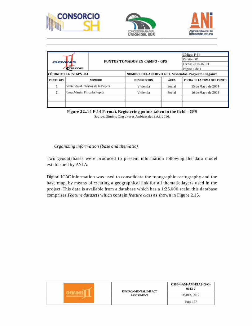
ENVIRONMENTAL IMPACT ASSESSMENT
CSH-4-AM-AM-EIA2-G-G-0013-7
March, 2017
Page 187
Figure 22..14 F-54 Format. Registering points taken in the field – GPS
Source: Géminis Consultores Ambientales S.A.S, 2016.
Organizing information (base and thematic) Two geodatabases were produced to present information following the data model established by ANLA: Digital IGAC information was used to consolidate the topographic cartography and the base map, by means of creating a geographical link for all thematic layers used in the project. This data is available from a database which has a 1:25.000 scale; this database comprises Feature datasets which contain feature class as shown in Figure 2.15.
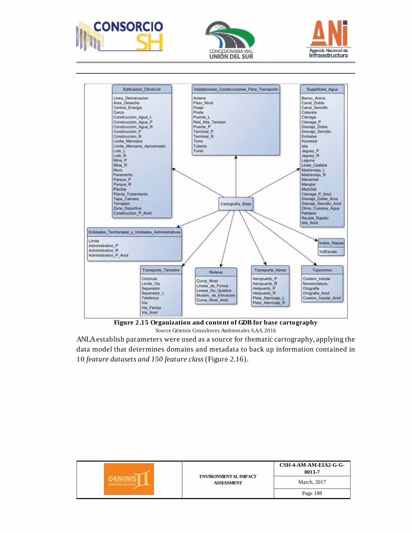
ENVIRONMENTAL IMPACT ASSESSMENT
CSH-4-AM-AM-EIA2-G-G-0013-7
March, 2017
Page 188
Figure 2.15 Organization and content of GDB for base cartography
Source Géminis Consultores Ambientales S.A.S, 2016
ANLA establish parameters were used as a source for thematic cartography, applying the data model that determines domains and metadata to back up information contained in 10 feature datasets and 150 feature class (Figure 2.16).
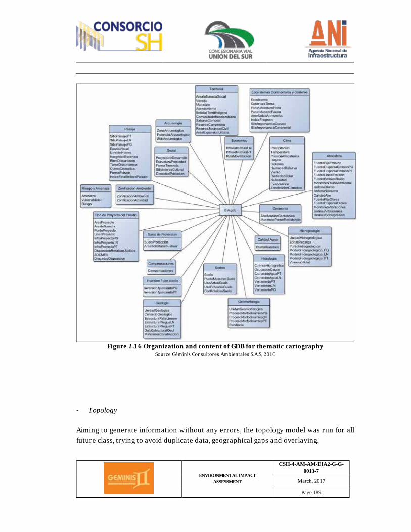
ENVIRONMENTAL IMPACT ASSESSMENT
CSH-4-AM-AM-EIA2-G-G-0013-7
March, 2017
Page 189
Figure 2.16 Organization and content of GDB for thematic cartography
Source Géminis Consultores Ambientales S.A.S, 2016
- Topology Aiming to generate information without any errors, the topology model was run for all future class, trying to avoid duplicate data, geographical gaps and overlaying.
ENVIRONMENTAL IMPACT ASSESSMENT
CSH-4-AM-AM-EIA2-G-G-0013-7
March, 2017
Page 190
- Geographical outputs Several templates for attached maps, letter-sized outputs and maps used in the field were designed taking into consideration the General Methodology for the Presentation of Environmental Assessments. Some of the graphical outputs include line attributes, points and polygons, which are complemented by satellite imagery and orthophotos; this allows for better location and interpretation of geographical characteristics. On the other hand, formats available for maps include *.jpg, *.pdf and *.mxd. - Metadata The basis for the consolidation of this item comes from the metadata template included in ANLA's GDB model, pursuant to resolution 1415 from 2012. This information was gathered in .xlsx and .xml formats, taking into consideration ISO 19115 standards. Such information was generated for each feature class and pursuant to previously established coding. 2.4. Consultant information Consultores Géminis S.A.S., partnership holding tax ID. number 900.065.324-5, with its group of professionals and technicians specializing in environmental, social, engineering and other areas, provided consultancy for the development and production of this Environmental Impact Assessment, fulfilling resolution 0751 from March 26, 2015, by means of which terms of reference are adopted to process an Environmental License for the projects related to the Construction of Roads and/or access tunnels. Table 2.35 lists the group of professional Environmental Consultants responsible for the Environmental Impact Assessment.
Table 2.35. Consultant and group of professionals
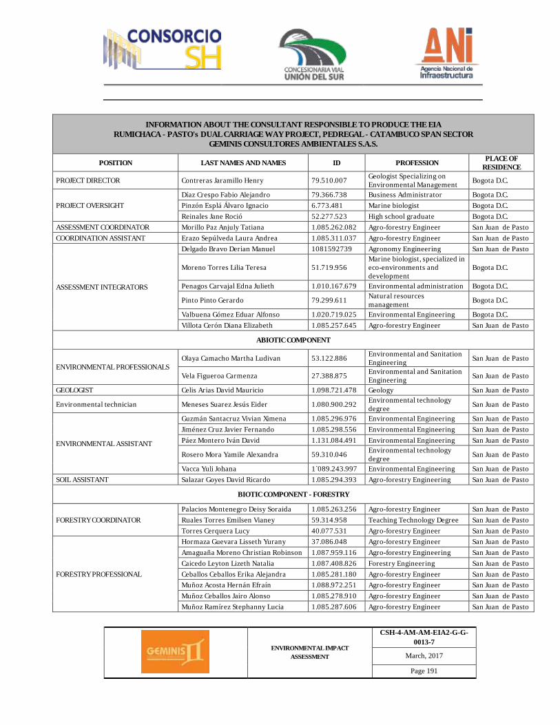
ENVIRONMENTAL IMPACT ASSESSMENT
CSH-4-AM-AM-EIA2-G-G-0013-7
March, 2017
Page 191
INFORMATION ABOUT THE CONSULTANT RESPONSIBLE TO PRODUCE THE EIA RUMICHACA - PASTO's DUAL CARRIAGE WAY PROJECT, PEDREGAL - CATAMBUCO SPAN SECTOR
GEMINIS CONSULTORES AMBIENTALES S.A.S.
POSITION LAST NAMES AND NAMES ID PROFESSION PLACE OF RESIDENCE
PROJECT DIRECTOR Contreras Jaramillo Henry 79.510.007 Geologist Specializing on Environmental Management Bogota D.C.
PROJECT OVERSIGHT Díaz Crespo Fabio Alejandro 79.366.738 Business Administrator Bogota D.C. Pinzón Esplá Álvaro Ignacio 6.773.481 Marine biologist Bogota D.C. Reinales Jane Roció 52.277.523 High school graduate Bogota D.C.
ASSESSMENT COORDINATOR Morillo Paz Anjuly Tatiana 1.085.262.082 Agro-forestry Engineer San Juan de Pasto COORDINATION ASSISTANT Erazo Sepúlveda Laura Andrea 1.085.311.037 Agro-forestry Engineer San Juan de Pasto
ASSESSMENT INTEGRATORS
Delgado Bravo Derian Manuel 1081592739 Agronomy Engineering San Juan de Pasto
Moreno Torres Lilia Teresa 51.719.956 Marine biologist, specialized in eco-environments and development
Bogota D.C.
Penagos Carvajal Edna Julieth 1.010.167.679 Environmental administration Bogota D.C.
Pinto Pinto Gerardo 79.299.611 Natural resources management Bogota D.C.
Valbuena Gómez Eduar Alfonso 1.020.719.025 Environmental Engineering Bogota D.C. Villota Cerón Diana Elizabeth 1.085.257.645 Agro-forestry Engineer San Juan de Pasto
ABIOTIC COMPONENT
ENVIRONMENTAL PROFESSIONALS Olaya Camacho Martha Ludivan 53.122.886 Environmental and Sanitation
Engineering San Juan de Pasto
Vela Figueroa Carmenza 27.388.875 Environmental and Sanitation Engineering San Juan de Pasto
GEOLOGIST Celis Arias David Mauricio 1.098.721.478 Geology San Juan de Pasto
Environmental technician Meneses Suarez Jesús Eider 1.080.900.292 Environmental technology degree San Juan de Pasto
ENVIRONMENTAL ASSISTANT
Guzmán Santacruz Vivian Ximena 1.085.296.976 Environmental Engineering San Juan de Pasto Jiménez Cruz Javier Fernando 1.085.298.556 Environmental Engineering San Juan de Pasto Páez Montero Iván David 1.131.084.491 Environmental Engineering San Juan de Pasto
Rosero Mora Yamile Alexandra 59.310.046 Environmental technology degree San Juan de Pasto
Vacca Yuli Johana 1`089.243.997 Environmental Engineering San Juan de Pasto SOIL ASSISTANT Salazar Goyes David Ricardo 1.085.294.393 Agro-forestry Engineering San Juan de Pasto
BIOTIC COMPONENT - FORESTRY
FORESTRY COORDINATOR Palacios Montenegro Deisy Soraida 1.085.263.256 Agro-forestry Engineer San Juan de Pasto Ruales Torres Emilsen Vianey 59.314.958 Teaching Technology Degree San Juan de Pasto Torres Cerquera Lucy 40.077.531 Agro-forestry Engineer San Juan de Pasto
FORESTRY PROFESSIONAL
Hormaza Guevara Lisseth Yurany 37.086.048 Agro-forestry Engineer San Juan de Pasto Amaguaña Moreno Christian Robinson 1.087.959.116 Agro-forestry Engineering San Juan de Pasto Caicedo Leyton Lizeth Natalia 1.087.408.826 Forestry Engineering San Juan de Pasto Ceballos Ceballos Erika Alejandra 1.085.281.180 Agro-forestry Engineer San Juan de Pasto Muñoz Acosta Hernán Efraín 1.088.972.251 Agro-forestry Engineer San Juan de Pasto Muñoz Ceballos Jairo Alonso 1.085.278.910 Agro-forestry Engineer San Juan de Pasto Muñoz Ramírez Stephanny Lucia 1.085.287.606 Agro-forestry Engineer San Juan de Pasto
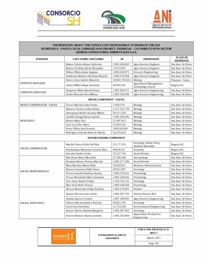
ENVIRONMENTAL IMPACT ASSESSMENT
CSH-4-AM-AM-EIA2-G-G-0013-7
March, 2017
Page 192
INFORMATION ABOUT THE CONSULTANT RESPONSIBLE TO PRODUCE THE EIA RUMICHACA - PASTO's DUAL CARRIAGE WAY PROJECT, PEDREGAL - CATAMBUCO SPAN SECTOR
GEMINIS CONSULTORES AMBIENTALES S.A.S.
POSITION LAST NAMES AND NAMES ID PROFESSION PLACE OF RESIDENCE
Ramos Tulcán Johana Catherine 1.085.284.663 Agro-forestry Engineer San Juan de Pasto Rosero Córdoba David Alexander 13.072.097 Agro-forestry Engineer San Juan de Pasto Villota Villota Jaime Augusto 1.085.283.973 Forestry Engineering San Juan de Pasto Zambrano Romero Christian Ricardo 1.085.276.964 Agro-forestry Engineer San Juan de Pasto
EPIPHYTE BIOLOGIST Forero Cano Andrés Mauricio 10.601.703.653 Biology Popayan - Cauca
Gómez Millan Diego Armando 80.926.341 Agricultural Management Technology Course Bogota D.C.
FORESTRY ASSISTANT Naspiran Villota Harold Jonny 1.087.959.377 Agro-forestry Engineering San Juan de Pasto Ocaña Alvarado Sara Milena 1.085.294.546 Agro-forestry Engineering San Juan de Pasto
BIOTIC COMPONENT - FAUNA
BIOTIC COORDINATOR - FAUNA Torres Martínez John Fredy 7.438.179 Biology San Juan de Pasto
BIOLOGISTS
Almario Vacuiro Leidy Johana 1.117.523.729 Biology San Juan de Pasto Astorquiza Onofre Juranny Milena 59.311.550 Biology San Juan de Pasto Castillo Chingal Karen Lizeeth 1.085.286.282 Biology San Juan de Pasto Rosero Mora Yuri 37.087.813 Biology San Juan de Pasto Caro Cruz Flor Alicia 52.834.191 Biology San Juan de Pasto Pérez Villota José Ernesto 1085262036 Biology San Juan de Pasto Rodríguez Caicedo Roberth Adrián 52.076.610 Biology San Juan de Pasto
SOCIOECONOMIC COMPONENT
SOCIAL COORDINATOR Murillo Tinoco Erika Del Pilar 52.177.323 Sociology. Public Policy
Analisys Specialist Bogota D.C.
Palomenque Manyoma Carmen Elisa 66918123 Economy Bogota D.C. Parrado Gamba Carlos 79.127.745 Social Worker Bogota D.C.
SOCIAL PROFESSIONALS
Díaz Erazo Betty Mercedes 27.296.366 Antropology San Juan de Pasto Enríquez Rivera Viviana Marcela 1.085.277.386 Social Worker San Juan de Pasto Meza Bastidas María Nelly 59.828.627 Business Administration San Juan de Pasto Riascos Casanova Dally Nancy 59.831.097 Sociology San Juan de Pasto Torres Caicedo Estefany Susana 1.085.270.431 Psychology San Juan de Pasto Torres Hernández Mery Estefanía 1.085.258.842 Psychology San Juan de Pasto Toro Arias Andrés Felipe 1´053.765.131 Sociology San Juan de Pasto Díaz Vivas Ruth Viviana 1.085.246.050 Psychology San Juan de Pasto
SOCIAL ASSISTANTS
Álvarez Benavides Felipe Esteban 1.085.275.901 Student San Juan de Pasto
Apraez Narvaez Luis Carlos 1.085.297.763 Natural Science B.A. San Juan de Pasto
Arizala Guerrero Leiner 1.087.189.695 Agro-forestry Engineering San Juan de Pasto Cabrera Barona Sandra Patricia 59.821.193 Sociology San Juan de Pasto Coral Coral Jerónimo 12.752.038 Environmental Engineering San Juan de Pasto Duarte Chávez Daniela Margarita 1.085.287.963 Sociology San Juan de Pasto
Fuertes Romero Karina Leonela 1.085.265.844 Aquaculture Production Engineering San Juan de Pasto
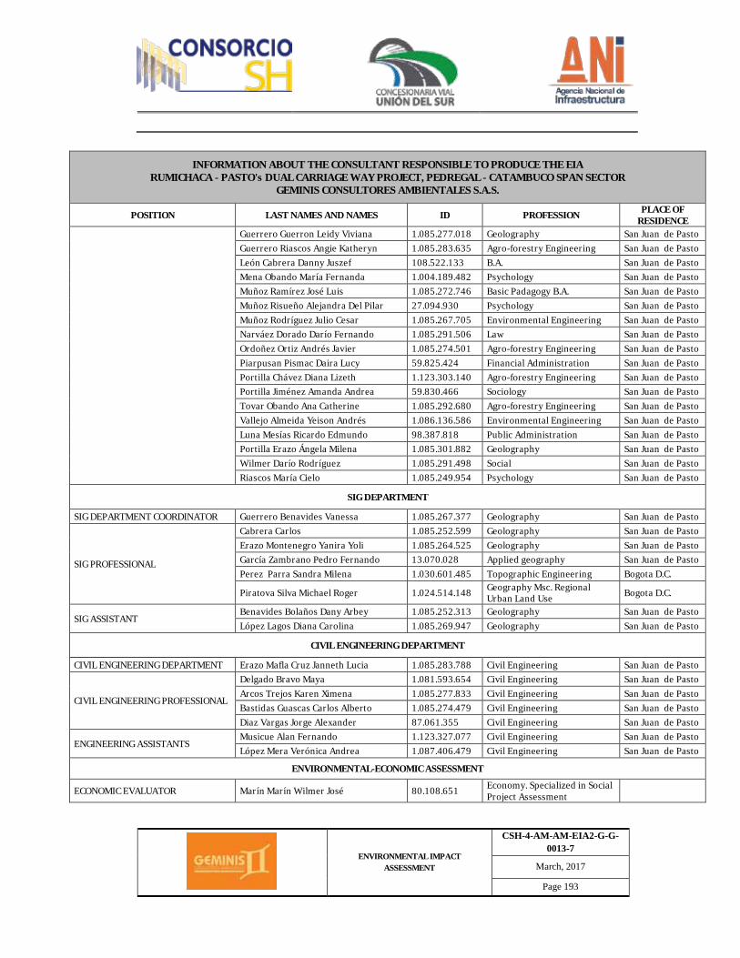
ENVIRONMENTAL IMPACT ASSESSMENT
CSH-4-AM-AM-EIA2-G-G-0013-7
March, 2017
Page 193
INFORMATION ABOUT THE CONSULTANT RESPONSIBLE TO PRODUCE THE EIA RUMICHACA - PASTO's DUAL CARRIAGE WAY PROJECT, PEDREGAL - CATAMBUCO SPAN SECTOR
GEMINIS CONSULTORES AMBIENTALES S.A.S.
POSITION LAST NAMES AND NAMES ID PROFESSION PLACE OF RESIDENCE
Guerrero Guerron Leidy Viviana 1.085.277.018 Geolography San Juan de Pasto Guerrero Riascos Angie Katheryn 1.085.283.635 Agro-forestry Engineering San Juan de Pasto León Cabrera Danny Juszef 108.522.133 B.A. San Juan de Pasto Mena Obando María Fernanda 1.004.189.482 Psychology San Juan de Pasto Muñoz Ramírez José Luis 1.085.272.746 Basic Padagogy B.A. San Juan de Pasto Muñoz Risueño Alejandra Del Pilar 27.094.930 Psychology San Juan de Pasto Muñoz Rodríguez Julio Cesar 1.085.267.705 Environmental Engineering San Juan de Pasto Narváez Dorado Darío Fernando 1.085.291.506 Law San Juan de Pasto Ordoñez Ortiz Andrés Javier 1.085.274.501 Agro-forestry Engineering San Juan de Pasto Piarpusan Pismac Daira Lucy 59.825.424 Financial Administration San Juan de Pasto Portilla Chávez Diana Lizeth 1.123.303.140 Agro-forestry Engineering San Juan de Pasto Portilla Jiménez Amanda Andrea 59.830.466 Sociology San Juan de Pasto Tovar Obando Ana Catherine 1.085.292.680 Agro-forestry Engineering San Juan de Pasto Vallejo Almeida Yeison Andrés 1.086.136.586 Environmental Engineering San Juan de Pasto Luna Mesías Ricardo Edmundo 98.387.818 Public Administration San Juan de Pasto Portilla Erazo Ángela Milena 1.085.301.882 Geolography San Juan de Pasto Wilmer Darío Rodríguez 1.085.291.498 Social San Juan de Pasto Riascos María Cielo 1.085.249.954 Psychology San Juan de Pasto
SIG DEPARTMENT
SIG DEPARTMENT COORDINATOR Guerrero Benavides Vanessa 1.085.267.377 Geolography San Juan de Pasto
SIG PROFESSIONAL
Cabrera Carlos 1.085.252.599 Geolography San Juan de Pasto Erazo Montenegro Yanira Yoli 1.085.264.525 Geolography San Juan de Pasto García Zambrano Pedro Fernando 13.070.028 Applied geography San Juan de Pasto Perez Parra Sandra Milena 1.030.601.485 Topographic Engineering Bogota D.C.
Piratova Silva Michael Roger 1.024.514.148 Geography Msc. Regional Urban Land Use Bogota D.C.
SIG ASSISTANT Benavides Bolaños Dany Arbey 1.085.252.313 Geolography San Juan de Pasto López Lagos Diana Carolina 1.085.269.947 Geolography San Juan de Pasto
CIVIL ENGINEERING DEPARTMENT
CIVIL ENGINEERING DEPARTMENT Erazo Mafla Cruz Janneth Lucia 1.085.283.788 Civil Engineering San Juan de Pasto
CIVIL ENGINEERING PROFESSIONAL
Delgado Bravo Maya 1.081.593.654 Civil Engineering San Juan de Pasto Arcos Trejos Karen Ximena 1.085.277.833 Civil Engineering San Juan de Pasto Bastidas Guascas Carlos Alberto 1.085.274.479 Civil Engineering San Juan de Pasto Diaz Vargas Jorge Alexander 87.061.355 Civil Engineering San Juan de Pasto
ENGINEERING ASSISTANTS Musicue Alan Fernando 1.123.327.077 Civil Engineering San Juan de Pasto López Mera Verónica Andrea 1.087.406.479 Civil Engineering San Juan de Pasto
ENVIRONMENTAL-ECONOMIC ASSESSMENT
ECONOMIC EVALUATOR Marín Marín Wilmer José 80.108.651 Economy. Specialized in Social Project Assessment
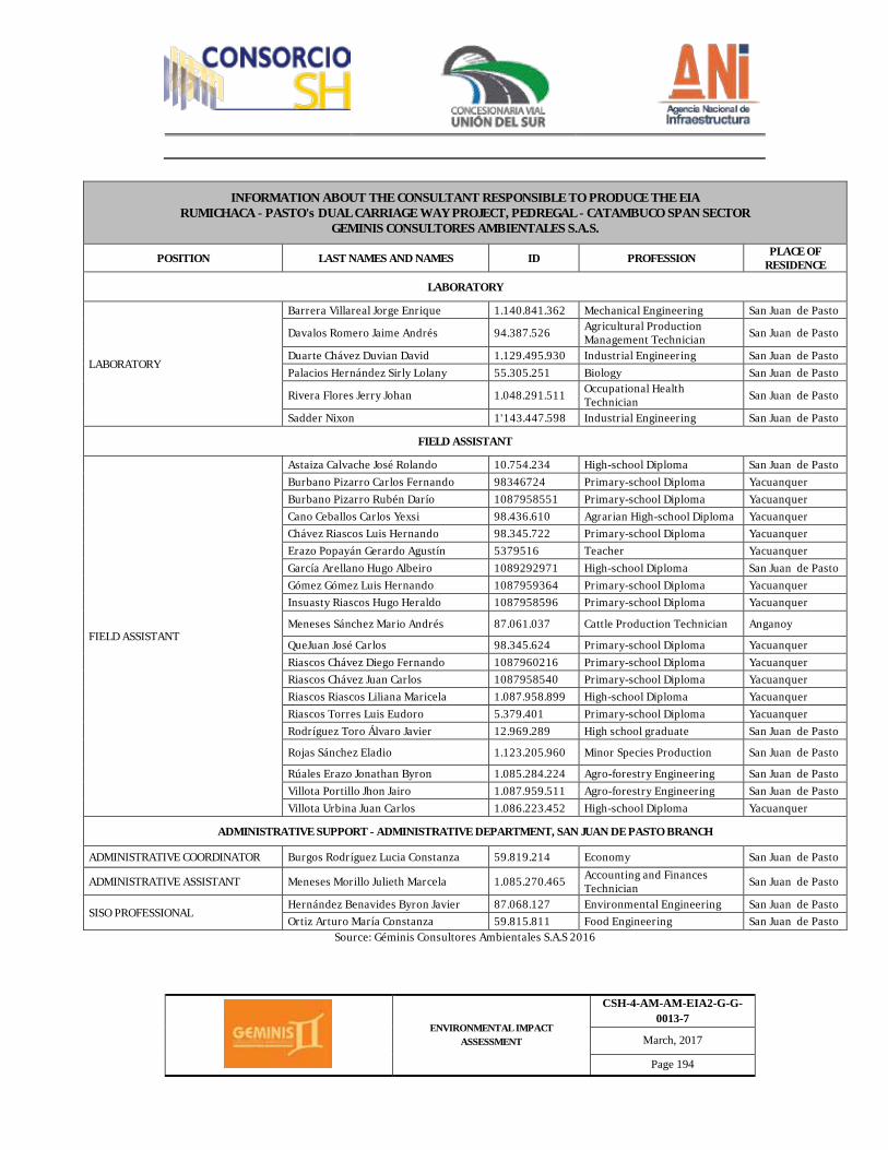
ENVIRONMENTAL IMPACT ASSESSMENT
CSH-4-AM-AM-EIA2-G-G-0013-7
March, 2017
Page 194
INFORMATION ABOUT THE CONSULTANT RESPONSIBLE TO PRODUCE THE EIA RUMICHACA - PASTO's DUAL CARRIAGE WAY PROJECT, PEDREGAL - CATAMBUCO SPAN SECTOR
GEMINIS CONSULTORES AMBIENTALES S.A.S.
POSITION LAST NAMES AND NAMES ID PROFESSION PLACE OF RESIDENCE
LABORATORY
LABORATORY
Barrera Villareal Jorge Enrique 1.140.841.362 Mechanical Engineering San Juan de Pasto
Davalos Romero Jaime Andrés 94.387.526 Agricultural Production Management Technician San Juan de Pasto
Duarte Chávez Duvian David 1.129.495.930 Industrial Engineering San Juan de Pasto Palacios Hernández Sirly Lolany 55.305.251 Biology San Juan de Pasto
Rivera Flores Jerry Johan 1.048.291.511 Occupational Health Technician San Juan de Pasto
Sadder Nixon 1'143.447.598 Industrial Engineering San Juan de Pasto
FIELD ASSISTANT
FIELD ASSISTANT
Astaiza Calvache José Rolando 10.754.234 High-school Diploma San Juan de Pasto Burbano Pizarro Carlos Fernando 98346724 Primary-school Diploma Yacuanquer Burbano Pizarro Rubén Darío 1087958551 Primary-school Diploma Yacuanquer Cano Ceballos Carlos Yexsi 98.436.610 Agrarian High-school Diploma Yacuanquer Chávez Riascos Luis Hernando 98.345.722 Primary-school Diploma Yacuanquer Erazo Popayán Gerardo Agustín 5379516 Teacher Yacuanquer García Arellano Hugo Albeiro 1089292971 High-school Diploma San Juan de Pasto Gómez Gómez Luis Hernando 1087959364 Primary-school Diploma Yacuanquer Insuasty Riascos Hugo Heraldo 1087958596 Primary-school Diploma Yacuanquer
Meneses Sánchez Mario Andrés 87.061.037 Cattle Production Technician Anganoy
QueJuan José Carlos 98.345.624 Primary-school Diploma Yacuanquer Riascos Chávez Diego Fernando 1087960216 Primary-school Diploma Yacuanquer Riascos Chávez Juan Carlos 1087958540 Primary-school Diploma Yacuanquer Riascos Riascos Liliana Maricela 1.087.958.899 High-school Diploma Yacuanquer Riascos Torres Luis Eudoro 5.379.401 Primary-school Diploma Yacuanquer Rodríguez Toro Álvaro Javier 12.969.289 High school graduate San Juan de Pasto
Rojas Sánchez Eladio 1.123.205.960 Minor Species Production San Juan de Pasto
Rúales Erazo Jonathan Byron 1.085.284.224 Agro-forestry Engineering San Juan de Pasto Villota Portillo Jhon Jairo 1.087.959.511 Agro-forestry Engineering San Juan de Pasto Villota Urbina Juan Carlos 1.086.223.452 High-school Diploma Yacuanquer
ADMINISTRATIVE SUPPORT - ADMINISTRATIVE DEPARTMENT, SAN JUAN DE PASTO BRANCH
ADMINISTRATIVE COORDINATOR Burgos Rodríguez Lucia Constanza 59.819.214 Economy San Juan de Pasto
ADMINISTRATIVE ASSISTANT Meneses Morillo Julieth Marcela 1.085.270.465 Accounting and Finances Technician San Juan de Pasto
SISO PROFESSIONAL Hernández Benavides Byron Javier 87.068.127 Environmental Engineering San Juan de Pasto Ortiz Arturo María Constanza 59.815.811 Food Engineering San Juan de Pasto
Source: Géminis Consultores Ambientales S.A.S 2016

ENVIRONMENTAL IMPACT ASSESSMENT
CSH-4-AM-AM-EIA2-G-G-0013-7
March, 2017
Page 195