environmental impact assessment: reference of the ... · environmental impact assessment: reference...
TRANSCRIPT
Environmental impact assessment: reference of the Environmental studies developed, EIS documents.
Dates of the studies, of the public consultation, of the environmental approval. Please provide a copy
of the Non-Technical Summaries (NTS) produced as part of the EIA process.
Name of the Project: Environmental and Social Impact Assessment of works for upgrading E-60 East-West Highway
section between Zemo Osiauri-Chumateleti (km 126 to km 143);
Dates of the Public Consultations: Terms of Reference - 12.11.2014; ESIA draft - 25.05.2015 (in Khashuri
municipality) and 27.05.2015 (in Tbilisi);
Environmental Studies developed:
Methodology:
The ESIA process consisted of six main activities that are common to most ESIA studies conducted to
international standards comprising the following:
1 Collection of baseline data describing the existing environment impact (physical, biological and anthropogenic aspects) within the area of the proposed project; desk studies and field surveys conducted to address important gaps in the existing data, update of information on topics and areas where significant negative impacts are expected.
2 Identification of impacts, assessment of their significance and development of mitigation measures (avoidance of impacts is preferred over mitigation by both Bank safeguards and Roads Department policy.)
3 Analysis of alternatives in terms of location, technology, design and operation, including the "zero" alternative.
4 Development of the environmental management plan (EMP) according to the World Bank OP 4.01 Annex C.
5 Stakeholder consultation and disclosure (conducted according to national law and the World Bank policy). 6 Drafting of the ESIA report.
Botanical and faunistic surveys
The assignment consisted of a review of primary and secondary data (government and consultant reports, etc.).
Botanical and fauna surveys were made. Field works were performed by biodiversity team (botanists and fauna
specialists) in November – December 2014.
The objective of the botanical study was to identify plant communities within the section of interest, reveal
sensitive populations and, if found, provide quantitative characteristics thereof. With consideration of expected
direct and indirect impact, the corridor of 100 m on each side of the centreline was surveyed. The method of
survey was walkover.
The main types of plants, as well as composition, distribution, dominant species, biome sensitivity and
commercial value of plants were assessed. The presence of endemic, rare and other protected species in the
project impact zone was identified.
Fauna field survey was organised with the purpose of verifying the data obtained from the literature on the
animal species composition and areas of occurrence. A simple methodology of surveying animal footprints,
droppings and dwellings was applied to collect information on key species of mammals and birds.
Negative impacts of road construction and operation were evaluated according to the main principles indicated
in the Law on the Wildlife, the Law on the Red List and the Red Book of Georgia. Along with the national
legislation/ regulations, international requirements (the EBRD policy and the World Bank operation procedures),
and the EU Directives to which Georgia is a party were taken into account.
Soil pollution
Evaluation of adverse impacts on soil and soil pollution was performed according to the Georgian laws and
regulations (the law applicable to the largest extent is the Law on the Soil Protection, 1994 (amended in 1997 and
2002).
For identification of the background quality of the soil along the road samples were collected (10 December
2014). Taking into account that the area is mostly rural and no significant sources of pollution, except for the
road itself are available, four average samples were collected. The samples were collected from the sampling
depth of 0-10cm. The total amount of soil collected from one site was 1 kg. Prior to sampling, the sampling spots
were cleared of grass and stones. Samples were collected in plastic bags, labelled and delivered to the lab for
testing. The samples are dried, averaged and sieved.
Table 5.1. Methods of soil analysis
Cu, Zn, Pb, Ni, Co,
Co, Cd
ISO 11047, ISO 11466 - Aqua Regia extract Determination of Cu, Mn, Fe, Mn, Co, Pb,
Cd, Ni, Zn, Cr, Ni. Al
As ISO 2590 - General method for the determination of arsenic – Silver
diethildithiocarbamate photometric method
The sample analysis revealed that concentration of all metals is below relevant maximum allowable
concentrations adopted in the EU.
Water sampling
Water from Suramula River was sampled for identification of the background water quality. The samples were
collected in 1.5-liter capacity plastic bottles. 1 litter glass bottles were used for Total Petroleum Hydrocarbon
analysis of water. Samples were labelled and delivered to the lab the same day. Analyses were performed in
compliance with the ISO and EPA standards.
Table 5.2. Methods of surface water analysis
Parameter Method Parameter Method
pH ISO 10523-2008 Mg GOST 23268.5-1978
Conductivity ISO7888:1985 Na ISO 9964-3-1990
Cl GOST 23268.17-1978 DO ISO 5814-72
HCO3 GOST 23268.1-91 Total N ISO 7890-82
SO4 ISO 9280-1990 Total P ISO 6878-04
K ISO 9964-3-1993 TPH EPA 418.1-1997
Ca GOST 23268.5-1978
Samples were analyzed by Gamma lab.
Air Pollution
Long-term pollution levels were calculated using modelling software CALRoads View. It is an air dispersion-
modelling package for predicting air quality impacts of pollutants near roadways. CALRoads View combines the
following mobile source air dispersion models into one integrated graphical inter-face: CALINE4, CAL3QHC,
and CAL3QHCR. Combining features of these models enables predicting concentrations of carbon monoxide
(CO), nitrogen dioxide (NO2), particulate matter (PM) and other pollutants near roadways and highways.
Options are available for modelling near intersections, parking lots, elevated or depressed freeways, and canyons.
It is also possible to evaluate air pollution caused by both moving and idling vehicles and to estimate the length
of queues formed by idling vehicles at controlled crossings. CALRoads View can process up to a year of hourly
meteorological data, but if the data is missing, it is recommended to use the worst-case scenario, which is
described by the worst-case wind direction.
Five scenarios were evaluated for Zemo Osiauri – Chumateleti road section:
• Modelling of CO, NO₂ and PM dispersion using forecasted traffic data, assuming that the project was
not implemented and the road was not upgraded (the "zero" alternative);
• Modelling of CO, NO₂ and PM dispersion using forecasted traffic data, assuming that the Alternative
A1,A 2, A3 or A4 was implemented;
• In addition to meteorological conditions in air pollution modelling, the main parameters are emission
factors.
All the five scenarios for Zemo Osiauri – Chumateleti road section were modelled using the same forecasted
traffic flow data for 2037 year (according to Traffic Analysis, prepared by PYUNGHWA Engineering Consultants
and included in Update of Feasibility Studies for E-60 Highway Section from Zemo Osiauri to Argveta and
Undertaking Detailed Design for E-60 Highway Section from Zemo Osiauri to Chumateleti, 2014). Emission
factors were estimated considering traffic fleet composition, type of road and speed. Traffic fleet composition was
assumed to be the same for all scenarios, but speed limits were different as it is expected to have 100 km/h (hilly
terrain) and 80 km/h (mountainous terrain) speed limit on the upgraded road (alternatives A1, A2, 3 and A4) and
80 km/h (60 km/h in settlements) for both types of vehicles on the existing road, if the project is not
implemented.
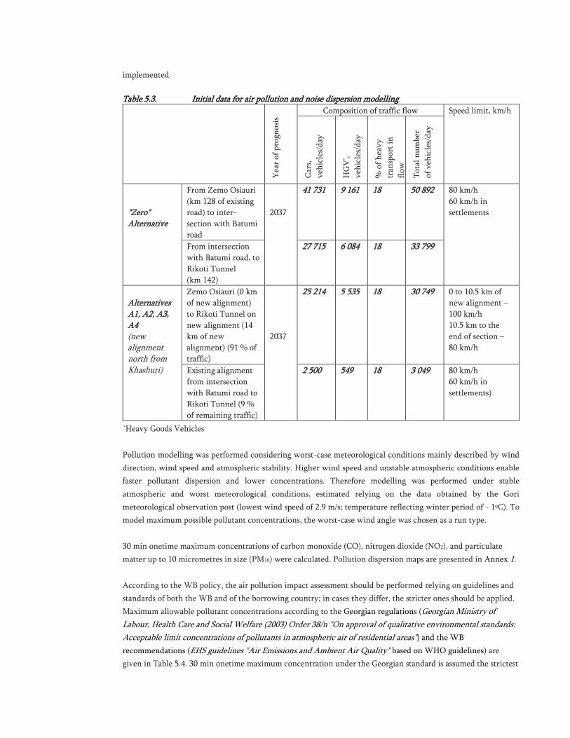
Table 5.3. Initial data for air pollution and noise dispersion modelling
Yea
r of
pro
gnos
is Composition of traffic flow Speed limit, km/h
Car
s,
veh
icle
s/d
ay
HG
V* ,
veh
icle
s/d
ay
% o
f h
eavy
tran
spor
t in
flow
Tot
al n
um
ber
of v
ehic
les/
day
"Zero" Alternative
From Zemo Osiauri
(km 128 of existing
road) to inter-
section with Batumi
road
2037
41 731 9 161 18 50 892 80 km/h
60 km/h in
settlements
From intersection
with Batumi road, to
Rikoti Tunnel
(km 142)
27 715 6 084 18 33 799
Alternatives A1, A2, A3, A4 (new alignment north from Khashuri)
Zemo Osiauri (0 km
of new alignment)
to Rikoti Tunnel on
new alignment (14
km of new
alignment) (91 % of
traffic)
2037
25 214 5 535 18 30 749 0 to 10.5 km of
new alignment –
100 km/h
10.5 km to the
end of section –
80 km/h
Existing alignment
from intersection
with Batumi road to
Rikoti Tunnel (9 %
of remaining traffic)
2 500 549 18 3 049 80 km/h
60 km/h in
settlements)
*Heavy Goods Vehicles
Pollution modelling was performed considering worst-case meteorological conditions mainly described by wind
direction, wind speed and atmospheric stability. Higher wind speed and unstable atmospheric conditions enable
faster pollutant dispersion and lower concentrations. Therefore modelling was performed under stable
atmospheric and worst meteorological conditions, estimated relying on the data obtained by the Gori
meteorological observation post (lowest wind speed of 2.9 m/s; temperature reflecting winter period of - 1ºC). To
model maximum possible pollutant concentrations, the worst-case wind angle was chosen as a run type.
30 min onetime maximum concentrations of carbon monoxide (CO), nitrogen dioxide (NO2), and particulate
matter up to 10 micrometres in size (PM10) were calculated. Pollution dispersion maps are presented in Annex 1.
According to the WB policy, the air pollution impact assessment should be performed relying on guidelines and
standards of both the WB and of the borrowing country; in cases they differ, the stricter ones should be applied.
Maximum allowable pollutant concentrations according to the Georgian regulations (Georgian Ministry of
Labour, Health Care and Social Welfare (2003) Order 38/n "On approval of qualitative environmental standards:
Acceptable limit concentrations of pollutants in atmospheric air of residential areas") and the WB
recommendations (EHS guidelines "Air Emissions and Ambient Air Quality" based on WHO guidelines) are
given in Table 5.4. 30 min onetime maximum concentration under the Georgian standard is assumed the strictest
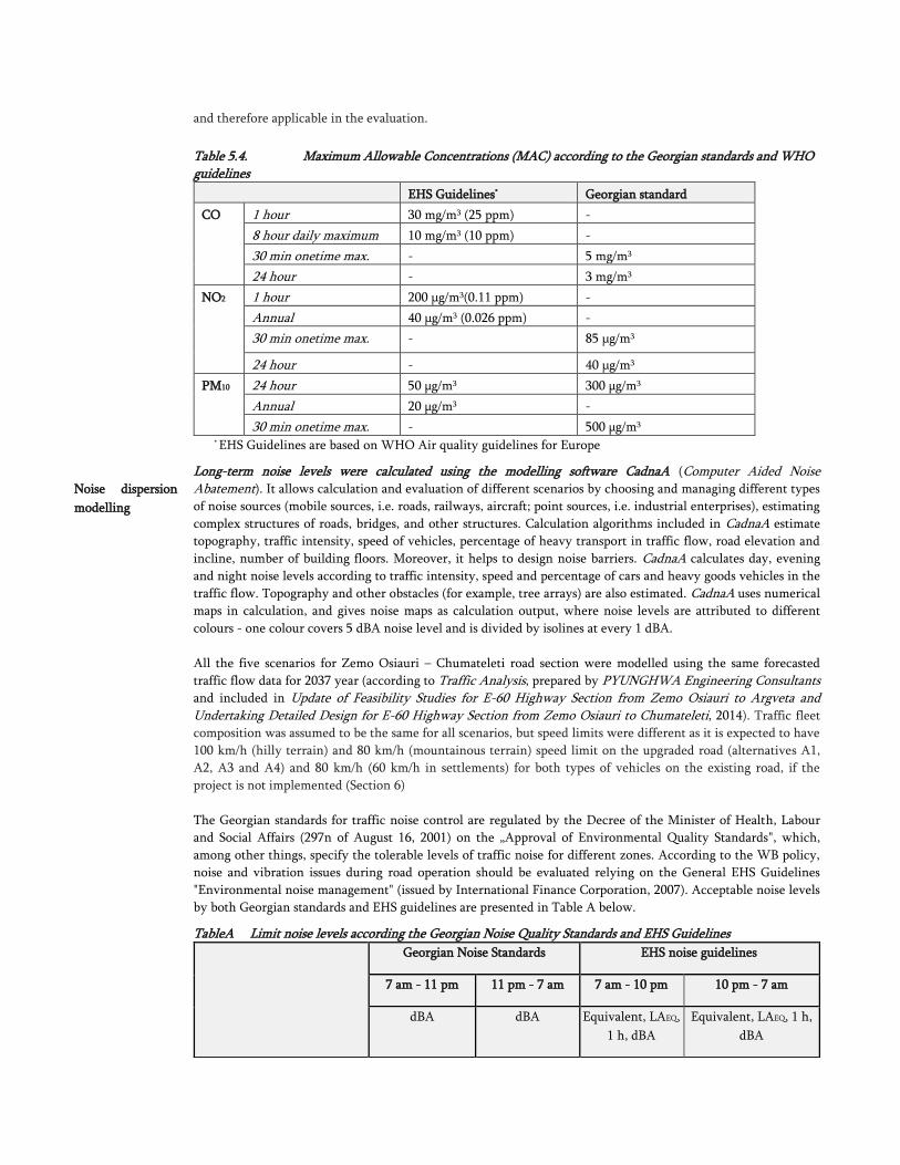
and therefore applicable in the evaluation.
Table 5.4. Maximum Allowable Concentrations (MAC) according to the Georgian standards and WHO guidelines
EHS Guidelines* Georgian standard
CO 1 hour 30 mg/m3 (25 ppm) -
8 hour daily maximum 10 mg/m3 (10 ppm) -
30 min onetime max. - 5 mg/m3
24 hour - 3 mg/m3
NO2 1 hour 200 μg/m3(0.11 ppm) -
Annual 40 μg/m3 (0.026 ppm) -
30 min onetime max. - 85 μg/m3
24 hour - 40 μg/m3
PM10 24 hour 50 µg/m3 300 µg/m3
Annual 20 µg/m3 -
30 min onetime max. - 500 µg/m3 * EHS Guidelines are based on WHO Air quality guidelines for Europe
Noise dispersion
modelling
Long-term noise levels were calculated using the modelling software CadnaA (Computer Aided Noise Abatement). It allows calculation and evaluation of different scenarios by choosing and managing different types
of noise sources (mobile sources, i.e. roads, railways, aircraft; point sources, i.e. industrial enterprises), estimating
complex structures of roads, bridges, and other structures. Calculation algorithms included in CadnaA estimate
topography, traffic intensity, speed of vehicles, percentage of heavy transport in traffic flow, road elevation and
incline, number of building floors. Moreover, it helps to design noise barriers. CadnaA calculates day, evening
and night noise levels according to traffic intensity, speed and percentage of cars and heavy goods vehicles in the
traffic flow. Topography and other obstacles (for example, tree arrays) are also estimated. CadnaA uses numerical
maps in calculation, and gives noise maps as calculation output, where noise levels are attributed to different
colours - one colour covers 5 dBA noise level and is divided by isolines at every 1 dBA.
All the five scenarios for Zemo Osiauri – Chumateleti road section were modelled using the same forecasted
traffic flow data for 2037 year (according to Traffic Analysis, prepared by PYUNGHWA Engineering Consultants and included in Update of Feasibility Studies for E-60 Highway Section from Zemo Osiauri to Argveta and Undertaking Detailed Design for E-60 Highway Section from Zemo Osiauri to Chumateleti, 2014). Traffic fleet
composition was assumed to be the same for all scenarios, but speed limits were different as it is expected to have
100 km/h (hilly terrain) and 80 km/h (mountainous terrain) speed limit on the upgraded road (alternatives A1,
A2, A3 and A4) and 80 km/h (60 km/h in settlements) for both types of vehicles on the existing road, if the
project is not implemented (Section 6)
The Georgian standards for traffic noise control are regulated by the Decree of the Minister of Health, Labour
and Social Affairs (297n of August 16, 2001) on the „Approval of Environmental Quality Standards", which,
among other things, specify the tolerable levels of traffic noise for different zones. According to the WB policy,
noise and vibration issues during road operation should be evaluated relying on the General EHS Guidelines
"Environmental noise management" (issued by International Finance Corporation, 2007). Acceptable noise levels
by both Georgian standards and EHS guidelines are presented in Table A below.
TableA Limit noise levels according the Georgian Noise Quality Standards and EHS Guidelines
Georgian Noise Standards EHS noise guidelines
7 am - 11 pm 11 pm - 7 am 7 am - 10 pm 10 pm - 7 am
dBA dBA Equivalent, LAEQ,
1 h, dBA
Equivalent, LAEQ, 1 h,
dBA
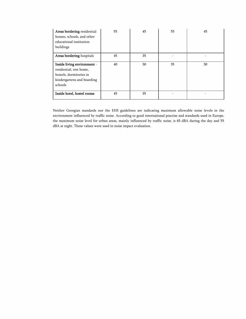
Areas bordering residential
houses, schools, and other
educational institution
buildings
55 45 55 45
Areas bordering hospitals 45 35 - -
Inside living environment -
residential, rest home,
hostels, dormitories in
kindergartens and boarding
schools
40 30 35 30
Inside hotel, hostel rooms 45 35 - -
Neither Georgian standards nor the EHS guidelines are indicating maximum allowable noise levels in the
environment influenced by traffic noise. According to good international practise and standards used in Europe,
the maximum noise level for urban areas, mainly influenced by traffic noise, is 65 dBA during the day and 55
dBA at night. These values were used in noise impact evaluation.
Methodology for analysis (Ranking) of alternatives
The project alternatives have been assessed using a methodology that transforms qualitative assessments in
quantitative numbers, which are then summed up in a final score that expresses the overall impact of each
alternatives and allows their comparison.
In order to encompass potential impacts 7 different components have been selected and analyzed. These
components were: landscape, soil, air quality, noise, water environment, biodiversity, geotechnical risks,
resettlement (physical, economical resettlement) needs and infrastructure. Rank was assigned to each
component:
Impact on landscape 15
Impact on soil 5
Impact on air quality 5
Noise 10
Impact on biodiversity 15
Impact on water 10
Geotechnical risks 15
Resettlement 20
Impact on infrastructure 5
TOTAL 100
These ranking criteria have been differentiated in order to reflect the peculiarity of the areas interested by the
project. The criteria are key questions, to which closed answers and scores are associated. A score is ascribed to each
answer:
No or negligible impact 0
Medium impact 0.3
Medium impact 0.5
High impact 1
For each criterion, a score is obtained by multiplying the component rank (based on potential impact) by the
score of the criterion (criterion score). The final score value for alternative is obtained as a sum of the component
scores. Alternative that shows the lowest score
Non-Technical Summary:
Introduction
The Government of Georgia is conducting a program to upgrade the major roads of the country, managed by the Roads
Department (RD) of the Ministry of Regional Development and Infrastructure (MRDI). The program aims to improve
transportation and transit of goods to surrounding countries, which is a significant and growing contributor to GDP.
Transport of goods into and through Georgia has increased over the past 10-15 years as markets have expanded
following the breakup of the Soviet Union, and Georgia is now a major transit country. Almost two-thirds of goods in
Georgia are transported by road, and haulage by domestic and international truck companies is very evident on the
country’s highways. However many roads are poorly equipped to cope with the volume of traffic and the proportion of
heavy vehicles, and factors such as insufficient dual carriageways, routing through inhabited areas and inadequate
maintenance and repair, hinder throughputs and increase transit times. This creates difficulties for haulage companies
and their clients, truck drivers, Georgian motorists and local residents.
The main target of the program for upgrading major roads in Georgia is the E-60 East-West highway (EWH) - the
main route from neighbouring Azerbaijan and Russia, also connecting to Turkey and Armenia. For planning purposes,
the EWH has been divided into sections of various lengths. The World Bank is providing series of loans to the
Government of Georgia for upgrading this highway through East West Highway Improvement Projects (EWHIPs).
Two projects of these series are now completed covering the highway section between Agaiani and Ruisi. EWHIP-3
and EWHIP-4 are under implementation covering the section between Ruisi and Agara. East-West Highway Corridor
Improvement Project (EWHCIP) is under preparation. The project will finance upgrading of the highway from Zemo
Osiauri through Chumateleti (shortly before Rikoti tunnel, which takes the East-West Highway from East Georgia to
the West.
This Environmental and Social Impact Assessment (ESIA) was carried out for works planned in Zemo Osiauri-
Chumateleti section of the Highway. According to the terms of reference (ToR), the present ESIA report includes an
Environmental Management Plan (EMP).
Technical and
Environmental
Standards
Technical design of the highway improvement meets the Trans-European Motorway (TEM) standards. The project
will be implemented in compliance with the Georgian legislation and environmental standards, as well as the World
Bank’s safeguard policies. The project triggers World Bank OP/BP 4.01 Environmental Assessment, OP/BP 4.11
Physical Cultural Resources, OP/BP 4.12 Involuntary Resettlement; and OP/BP 4.20 Gender and Development.
Objective of the
ESIA
Objective of the ESIA is to identify expected environmental and social impacts and risks of the project on construction
and operation stages, to recommend measures for their mitigation, and to develop a plan for monitoring environmental
compliance during construction and operation of the section under consideration.
Environmental
Screening
The proposed works for the improvement of the EWH between Zemo Osiauri and Chumateleti include construction of
a four-line section of the motor road with a range of bridges and tunnel on a new alignment bypassing Khashuri.
According to the Georgian law, the proposed project is subject to environmental expertise and environmental
permitting. Road works of the described scope and scale fall under Category A for environmental assessment purposes,
requiring the conduct of a full scale ESIA and development of an EMP.
Public
Participation
The Bank policies and the Georgian legislation require meaningful public participation and involvement in the process
of ESIA and environmental management planning. The main principles of public consultation include:
› Conduct of at least two public consultation meetings for environmental Category A activities – on the ToR and
scope of an environmental assessment, and on its draft report;
› Disclosure of the draft ESIA report to the public through the convenient media in a national language;
› Announcement of the venue and time of stakeholder consultation meetings through central and local means of
public communication;
› Invitation for written comments/questions on the draft ESIA; and
› Incorporation of public feedback into the ESIA report and re-disclosure of the finalized document.
RD carried out the initial consultations on the environmental implications of the proposed project and the scope of the
forthcoming ESIA at the early stage of its preparation. A stakeholder meeting was held on November 12, 2014 at the
office of RD in Tbilisi. Information about terms of reference, alternatives under consideration, and the ESIA procedure
and permitting issues were discussed.
Meetings and interviews with local community have been carried out as a part of the ESIA process.
Two meetings meeting (in Khasuri and Roads Department office in Tbilisi) to present findings of the ESIA process
were held on May 25 and May 27, 2015 respectively.
The draft ESIA report will be posted on the web page of the MRDI. Hard copies of the document will be made
available at the offices of Khashuri local self-governments located within the project implementation area, RD and the
office of scientific research firm Gamma.
RD will organize a public consultation meeting to discuss the draft ESIA report as well as the draft Resettlement
Action Plan (RAP). The meeting will be scheduled between the 50th and 60th day after disclosure of the draft
document. Members of the communities in the project area, including elected officials, as well as representatives of
the local small and medium businesses and other stakeholders will be invited. RD will seek questions and comments
from the stakeholders and will incorporate received feedback into the ESIA report, as appropriate.
Sensitive
Environmental
Receptors and
Potential
Impacts
The Zemo Osiauri-Chumateleti section passes through rolling and hilly terrain. Most challenging sections were
identified through a comprehensive assessment of a wider corridor of EWH’s possible alignment between Zemo
Osiauri and Chumateleti. The landslide areas are scattered in the entire area. Other issues to consider include a pine
forest plantation, river Suramula, a residential area and a cemetery.
The main environmental impacts are expected at the construction phase and come from clearing of the right-of-way
(RoW), establishment/operation of work camps and temporary access roads, operation/servicing of construction
machinery, earth works works near waterway, construction of overpass bridges and tunnels.
Clearing of the RoW will be required in the new route sections. Establishment of construction camps and access roads
is associated with generation of solid waste and wastewater, compression of soil, and noise related nuisance. Parking,
operating and servicing of construction machinery will carry the risk of operational spills of oils and lubricants (i.e. the
risk of soil pollution) and generation of noise, vibration, dust, and emissions. It is expected that the construction
material will be purchased from suppliers licensed to operate quarries. License for use of natural resources - in case the
contractor decides to use own quarries - will be obtained by the contractor from the National Environment Agency of
the Ministry of Environment and Natural Resources Protection (MENRP). Construction works will also have
implications for the occupational health and safety of workers/personnel.
Impacts of the new road during its operation phase are less diverse. Environmental aspects of the highway operation
will be air pollution from automobile emissions, and pollution of soil with litter and drainage from the highway as well
as water pollution with liquid/powder cargo and/or fuel and lubricants from the cars as a result of traffic accidents on
the road section and runoff from the road. Project design brings the risks of negative impacts on environment to the
feasible minimum. Provision for road safety and control over the traffic regulation will contribute to managing risks of
accidents. Installation of noise barriers is not required. Diversion of the traffic from Surami-Rikoti section will affect
businesses (shops, petrol stations, restaurants) and vendors along the road. Finally, traffic safety will be an important
issue with health, social, and environmental implications.
Project
Alternatives
Various alternatives of the highway alignment carry different levels of environmental risks, which has been critical in
environmental analysis of project alternatives.
No “showstoppers” have been identified during ESIA and the anticipated impacts can be managed by application of
adequate construction standards and good environmental practices. Nonetheless, a “do-nothing” option was
considered as one of the project alternatives. While it has no environmental and social impacts resulting from
construction works, operating the highway in its current poor condition has negative environmental and social
impacts from traffic jams, noise, low speed, and high emission. In the future with consideration of increase traffic
flow, the situation will worsen. On the global scale, under the "do-nothing" scenario, local communities would lose
opportunity of benefiting from all positive effects associated with the highway improvement, including profits
resulting from increased cargo turnover and tourism. Therefore, as the potential positive impacts of the project surpass
its possible negative impacts, the “do-nothing” option was discarded.
Out of the four alternative alignments (eight different vertical alignment options) two were discarded due to the
anticipated significant negative impacts. An alternative alignment with minimum impact on pine plantations and
residential area, avoiding the sensitive areas such as pine forest, cemetery, landslide sites and minimum impact on
water environment has been selected as preferred option and was analysed in depth.
Project
Description
The EWH section to be constructed under the project will connect Zemo Osiauri with Chumateleti. This will be a
completely new section of the highway, bypassing Khashuri. The total road length will be 13.80km, maximum radius
of curve – 700m. A central reservation will separate two pairs of the highway lanes. Paved shoulders will be provided
for breakdown and emergency use. Surface water drains, safety barriers, lighting and signage will be arranged for safe
operation of the upgraded section of the highway. Total width of the road will be 26.50m. The cross section parameters
will comply with those of the previous sections of the highway, viz.: number of lanes – 4; lane width 3.75; carriageway
width - 2x7.50m, width of shoulder - 3.75m (3 paved and 0.75m unpaved) and median width including barriers – 4m.
The design speed of 100km/h and 80km/h is applied. The project includes 11 bridges (km126-km136) and 3 tunnels
within the last 3 kilometres of the road. The new section runs through agricultural lands and coniferous plantations (so
called Narvani forest), pass over Surami-Tsotskhnara local road, several residential buildings in village Urtkva,
Shukghele stream.
Based on experience gained from the implementation of other similar road projects, it may be assumed that the
construction may involve a total workforce of about 200. Out of these workers 60% to 70 % may be local workforce,
which could be hired as semi-skilled or unskilled workers during the construction period.
Land acquisition needs are being studied by resettlement specialists of the design company Pyunghwa Engineering Consultants. Their report will be submitted separately. Summary of the land acquisition document will be
incorporated in the final version of the ESIA report.
Environmental
Impact
Assessment
Methodology
The ESIA process included the following activities (i) determination of the scope of the work; (ii) collection of the
detailed baseline data; (iii) assessment of expected impacts; (iv) outlining of mitigation measures; and (v) development
of environmental management and monitoring plans.
The ESIA process was a combination of desk work and field work, comprising literature review, data collection from
various agencies, visual observation (flora and fauna survey) and fact finding along the RoW, noise and air modelling
and analysis of the collected information. Results of engineering-geological and topographic survey and technical
information related to the design were considered. Impacts of the project activities to be implemented outside the
RoW - such as construction camps, temporary access roads, and car stationing area - have been considered as well. On
the initial stage of the ESIA, spatial boundaries of the study area were defined to allow identification and assessment of
the expected impacts and to enable comparative assessment of project alternatives in a given environment
Environmental
Baseline
The ESIA report presents information about the physical, biological, and socio-economic characteristics of the
environment alongside the project alignment. The purpose of this description is to establish environmental baseline, to
identify potential sensitivities, and to suggest adequate response through measures that are appropriate to avoid,
minimize, or mitigate potential adverse impacts.
The new section of the highway passes through rural areas, where industrial pollution of environment is insignificant.
No polluting or noise-intensive industries exist in the region nowadays. Physical environment around the subject
section of the highway is not rich in biodiversity (species composition is meant). There are no designated protected
areas near the project site. Critical habitatsfor Imeretian oak (Quercus Imeretina, Georgian Red List VU category species), chestnut (Castanea sativa, Georgian Red List VU category species), field elm (Ulmus minor, Georgian Red List protected species) and orchids (Dactylorhiza romana subsp.georgica, Dactylorhiza urvileana, Caphalanthere damasonium, species protected under CITES) which are registered within the broader project area, are bypassed by the
selected alignment.. Small groves, ravines, Shukghele stream and Suramula River, which are crossed by the new
alignment and fall under the project’s direct impact zone, are ranked as sensitive receptors.
The baseline studies included the following components:
› Climate and meteorology;
› Geology, geomorphology;
› Hydrology, hydrogeology;
› Soils, landscape and land use;
› Air quality and noise;
› Seismic conditions and hazardous processes;
› Habitats, flora and fauna;
› Historical and archaeological sites; and
› Social environment.
Risks of the construction phase include impact on surface water, vegetation and soil, disturbance of terrestrial wildlife,
noise and emissions, physical relocation of five households, agricultural land take, and disruption of economic activity
for several roadside traders. Keeping in mind the landslide risks in the area, this issue was carefully studied by the
engineering team. The highway design has been developed so to bypass these sites as far as feasible, and mitigation
measures have been suggested for the sensitive sections. All risks, including technical, environmental and social, were
carefully examined in order to develop a safe and less damaging alterative. The risks related to the selected alternative
are moderate. Most environmental impacts are manageable through the developed technical solutions,
implementation of relevant mitigation measures and adherence to conventional good construction practice.
Research of the social baseline revealed several sensitive human aspects of the project implementation such as land
alienation, relocation, and impact on the roadside businesses caused by diversion of the traffic flow to the new
alignment. Subsistence of the majority of affected households considerably depends on the land plots and small
businesses the ownership and use of which will be altered in the course of the project implementation. This finding
emphasizes the importance of diligent planning and timely provision of adequate compensation and restoration of
livelihoods by developing and implementing of a Resettlement Action Plan (RAP) in accordance with the guiding
principles provided in the Resettlement Policy Framework (RFP) of EWHCIP.
Expected
Impacts and
Mitigation
Taking into account the location and sensitivity of human settlements and environmental receptors, the following
mitigation measures were developed to mitigate the main risks associated with the project implementation:
› Impact on vegetative cover, fauna and habitats: Clearing of the RoW for the new alignment will imply removal
of vegetation, including cutting of trees. Loss of vegetation will be kept at the possible minimum. Removal of
trees for project needs will not cause functional damage to the ecosystem, however compensatory tree planting
will be carried out within the EWH corridor at the ratio of 1:3 (except for the trees cleared from the private land
plots). Selection of species for planting will be based on the natural composition of local flora. Clearance from the
National Forestry Agency will be obtained authorizing tree felling in the forested areas which are registered with
the State Forest Fund. Greening of the construction sites along the RoW, as well as maintenance of the re-
planted areas for three years will be included in the contractor works. RD will be responsible for further
maintenance of plantations. Re-cultivation of disturbed areas, including re-planting, will enable to mitigate
disturbance of animal species. The selected alignment does not affect any critical habitat.
› Disturbance of local communities: Movement of construction machinery, location of the temporary work camps,
and temporary storage of construction materials and waste will be planned to avoid or minimize barriers for a
free movement of the local population. Deterioration of the air quality near populated areas will be controlled
through oversight on the technical condition of construction machinery. Operation of engines in idle regime will
be discouraged. Operation of construction machinery will be limited to the regular working hours. Local roads, if
affected by movement of construction machinery and heavy vehicles, will be restored to the original condition or
improved, as feasible, before contractor leaves the work site.
› Operation of work camps and access roads: Work camps and temporary access roads will be located preferably in
the already transformed areas to minimize landscape and ecosystem degradation. The camps will be organized to
have designated areas for storage of materials and waste, and will be equipped with septic tanks. Offsite
maintenance/servicing and fuelling of machinery will be encouraged. In case not feasible, the areas designated
for fuelling/servicing of machinery will be provided with ground lining and barriers preventing release of
spillage. Similar precautions will be taken at the areas allocated for storing of hazardous substances. After
completion of works contractor will be obliged to remove all temporary facilities from the site, clean up and
restore the area to the original state to the extent possible under the circumstances.
› Air pollution: Air pollution can appear during earthworks, gravel crashing, concrete mixing, and transportation
in case of improper maintenance and operation of equipment, inadequate storage of fine-grained materials, and
movement of vehicles on unpaved or dusty surfaces. To reduce generation of dust and emissions, construction
equipment will be maintained in good working condition and mixing equipment will be sealed. Concrete mixing
plants will be installed at least 300 m away from settlements windward. Speed limits will be set for construction
vehicles and all loose material will be covered with tarpaulins when transported off-site with trucks. A wheel-
washing facility will be provided and ensured that it is used by all vehicles before leaving all sites. All unpaved
roads and significant areas of uncovered soil will be sprinkled during working hours in dry weather conditions.
› Operation of construction machinery: Technical condition of the construction machinery will be checked on
regular basis to minimize air pollution from exhaust, and soil pollution from leakage of fuel/oil. The risk of
operational and emergency spills of fuel and lubricants will be mitigated by designation of special parking and

servicing sites, to be located away from waterways and other sensitive environmental receptors. The sites will be
equipped with wastewater/spill capturing and treatment facilities.
› Impact on soil: Excavation works may cause loss of topsoil and trigger erosion if not properly managed. These
impacts will be mitigated by removal and storage of topsoil separately for its use for later reinstatement of the
area. Landscape restoration will be carried out to ensure stabilization of slopes. This would include seeding of
grass and planting trees depending on location. Discharge of untreated waste water will be prohibited.
› Impact on surface water: The selected alternative alignment ensures minimum impact on surface water. No
works will be carried out in waterways. However keeping in mind that the new alignment crosses ravines and
the Shuaghele stream, which is a source of water supply to Surami settlement, special attention will be paid to
operations in these sections of the road. Technical condition of machinery operated near/in the waterway will be
checked on daily basis to avoid leakage and operational spills of fuel and lubricants. No stockpiling of
construction materials and waste will be allowed in or nearby the waterways. According to the design drainage
ditches will carry filters installed on both sides of the carriageway (including bridge) enabling to avoid surface
water pollution with runoff from the road or in case of road accidents during operation.
› Accumulation of construction waste: Temporary storage of waste will be organized by separating construction
debris, tunnelling spoil, household solid waste, and hazardous waste. The latter, comprising used filters, tires, and
lubricants from machinery, will be kept in a closed and isolated storage. Transportation of waste from the
construction sites will follow a time- bound schedule. Hazardous waste will be removed/utilized by licensed
contractors. Formal instructions will be obtained from local authorities for the final disposal of inert waste. Sites
for temporary storage of excess material will be agreed with local municipalities. Sites for permanent disposal of
excess material – such of soil, rock and other non-hazardous materials – will be recommended by local
municipalities and cleared by the MENRP. Solid waste and household garbage will be disposed to the closest
municipal landfill in Khashuri under agreement with Solid Waste Management Company. Volumes of disposable
waste will be minimized to the extent possible through re-cycling/reuse and back-filling as feasible.
› Operation of quarries and borrow pits: Purchase of inert construction materials will be allowed only from the
licensed legal and/or physical bodies. Contractor may also hold or wish to obtain a resource use license and
operate own quarries. Opening of new borrow pits will be avoided if those already in operation can be used
instead. Operation of quarries and borrow pits, as well as extraction of gravel from river terraces, will be carried
out in accordance with the conditions of a license issued by the National Environment Agency of MENRP.
Contractor will be responsible to develop, agree and strictly adhere to quarry/borrow pit operation and re-
cultivation plan. Disturbed area must be re-cultivated after completion of material extraction activities.
Performance of license holders will be subject to inspection by the Department of Environment Protection
Oversight of the MENRP.
› Works near historical, cultural, and archaeological sites: All known historical and cultural monuments along the
RoW were identified during the ESIA. The Highway alignment will not cause physical or aesthetical damage to
these monuments. To avoid any damage to potential archaeological sites, chance find procedure will be enforced.
If an artefact is encountered by a works contractor, all activities on site will be immediately taken on hold and
cultural heritage protection authority will be urgently notified. Works will resume only upon receipt of written
communication from the latter.
› Occupational health and safety: Work camps will be established and operated to ensure the maintenance of
adequate hygiene and sanitation. Emissions, discharges and wastes generated by work camps will be controlled
by the Department of Environment Protection Oversight. Workers and other personnel will be provided with
personal protection equipment and gear. They will receive training on the safety rules and course of action in
case of emergencies. Workers who operate heavy machinery must be licensed and insured.
Environmental
Management
Plan
This ESIA report includes the EMP with a full set of the proposed mitigation measures, as summarized above, and
monitoring indicators. It also describes the role of the RD in overseeing adherence of construction works to the
recommended mitigation measures and identifies the needs for the RD’s technical and institutional capacity building
for ensuring full environmental compliance of the project.
A supervision consultant will be hired by the RD to provide technical control and quality assurance of civil works.
Environmental monitoring will be an integral part of the consultant’s assignment and information on the compliance
with the EMP will be included into the supervisor’s regular reporting to the RD. The RD will have an overall

responsibility for applying due environmental diligence. This will include ensuring quality of the supervision
consultant’s performance, site inspections, timely response to any issues identified by the consultant or by the RD
inspectors, and record keeping on all environmental aspects of the project implementation. Various units of the
MENRP will perform monitoring and control of key environmental parameters within the project area as part of their
general mandate and annual work plans. The Ministry will also exercise oversight on the adherence to the terms of
environmental permit to be issued for the designed works on EWH.
Before commencement of works, the selected contractor will be asked to develop and to have agreed by the RD and
the World Bank a works organisation plan, waste management plan (including spoil disposal), traffic management
plan, health and safety plan, re-cultivation plan (including borrow pits/quarries (if any) and other disturbed areas) and
emergency response plan as listed in technical specifications for bidders. The contractor will also develop and have
agreed by the client a plan of greening and landscape reinstatement at a relevant stage of contract implementation.
Operation of
the Highway
The improvement of the EWH aims at minimizing the need of interventions during its operation and maintenance.
Ensuring safe and good environmental performance will be a high priority at the operations stage and will comply
with the requirements of the national legislation and the best international practices.
Traffic related noise modelling carried out for operation stage of the project showed that noise level in the residential
areas will not exceed allowable limits. Noise mitigation measures at the operation stage are not required.
RD, through an outsourcing arrangement, will permanently maintain and, in a longer term, improve greening along
the RoW. Regular collection of solid waste along the highway will be organized by contractor identified by the RD.
State technical control of the EWH through regular oversight and inspection by RD will be provided.