environmental impact statement 2014 summary of …eisdocs.dsdip.qld.gov.au/sunshine coast airport...
TRANSCRIPT

SunShine CoaSt airport expanSion projeCt EnvironmEntal impact StatEmEnt 2014
Summary of major findingS
SEPTEMBER 2014

1summary of major findings
Introduction ......................................................................................................................................................................................................................2
About the Environmental Impact Statement ........................................................................................................................................................3
About this Summary of Major Findings .................................................................................................................................................................5
How you can be involved ............................................................................................................................................................................................5
About the impact assessment process .................................................................................................................................................................6
Abbreviations ..................................................................................................................................................................................................................7
Volume A: Background to the Project Background ..........................................................................................................8Need for the Project ........................................................................................10Options and Alternatives ...............................................................................12Project Construction .......................................................................................14Planning and Legislation ...............................................................................15Stakeholder Engagement .............................................................................16The Environmental Impact Assessment Process................................17
Volume B: Airport and Surrounds Overview ...............................................................................................................17Land use - Airport and Surrounds ............................................................19Geology, Soils and Groundwater ..............................................................19Coastal Processes ..........................................................................................20Flooding ...............................................................................................................20Surface Water and Hydrology ...................................................................22Terrestrial Flora .................................................................................................22Terrestrial Fauna ...............................................................................................24Aquatic Ecology ...............................................................................................24Marine Ecology ................................................................................................26Cultural Heritage (Indigenous and non-Indigenous) ........................ 27Social Impact .................................................................................................... 27Surface Transport ..........................................................................................29Noise and Vibration ........................................................................................30Air Quality and Greenhouse Gas Emissions .......................................30Landscape and Visual ....................................................................................31Climate Change ................................................................................................31
Volume C: Dredging and Dredge Movements Overview ..............................................................................................................32Introduction ........................................................................................................32Marine Geology................................................................................................32Coastal Processes and Water Quality ....................................................34Marine Ecology ................................................................................................34Shipping Traffic ................................................................................................36Other Considerations .....................................................................................36
Volume D: Airspace and Aircraft Related Noise Overview .............................................................................................................. 37Airspace Architecture and Modes of Operation ................................ 37Aircraft Noise .....................................................................................................40Air Quality and Greenhouse Gas Emissions .......................................42Social and Visual Impacts ...........................................................................43
Volume E: Impact Summary and Management FrameworkOverview ..............................................................................................................44Key Commitments ..........................................................................................45
SuMMarY oF Major FinDinGS
TaBlE of conTEnTS
© Sunshine Coast Regional Council 2014.
www.sunshinecoast.qld.gov.au | [email protected] 07 5475 7272 | F 07 5475 7277 Locked Bag 72 Sunshine Coast Mail Centre Qld 4560
Acknowledgements: Council wishes to thank all contributors and stakeholders involved in the development of this document.
Disclaimer: Information contained in this document is based on available information at the time of writing. All figures and diagrams are indicative only and should be referred to as such. While the Sunshine Coast Regional Council has exercised reasonable care in preparing this document it does not warrant or represent that it is accurate or complete. Council or its officers accept no responsibility for any loss occasioned to any person acting or refraining from acting in reliance upon any material contained in this document.
Google Earth maps have been used throughout this document.

2 SUNSHINE COAST AIRPORT EXPANSION PROJECT
introDUction
Sunshine Coast airport (SCa) is owned and operated by Sunshine Coast Council (SCC). SCC is proposing to develop a new main runway at SCa.
the existing main runway (rWY 18/36) was first opened in 1961 and has been instrumental in the development of the Sunshine Coast economy over the past 50 years.
the challenge for SCC is to ensure the airport can support a growing Sunshine Coast economy. as identified in the 2007 SCa Master plan, the current runway infrastructure, due to its length and width (1,800 m x 30 m) constrains airline services that are available to Sunshine Coast residents.
Further, the continued airline operation on runway 18/36 is dependent on an ongoing exemption from CaSa to allow Boeing 737 and airbus a320 aircraft as operated by Virgin, jetstar, air new Zealand and tigerair to operate on a 30 m wide rather than a 45 m wide runway.
in adopting the 2007 SCa Master plan, SCC determined that the preferred option for the future of SCa was to develop a new, fully compliant main runway of 2,450 m x 45 m, aligned in a south-east to north-west direction.
an environmental impact Statement (eiS) has been prepared to examine the social, environmental and economic impacts of the proposed airport expansion project (the project).
this document provides a summary of the history of the project, the eiS process and the results of the studies undertaken to satisfy the eiS terms of reference (tor) as drafted by both the Commonwealth and Queensland Governments.
the project, if approved, will provide a platform from which SCa can continue to attract new airlines and new services with flow-on economic, social and environmental benefits extending across the entire Sunshine Coast community.
project benefits
Social
• reduction of around 5,000 dwellings within areas of high aircraft noise
• Stimulation of diversification in employment opportunities on the Sunshine Coast, assisting in the retention of the 19 – 34 age population demographic.
Economic
• enhances connections between Sunshine Coast businesses and the global economy
• Contributes $4.1 billion to Gross regional product between 2020 and 2040
• Generates 1,538 direct and 693 indirect full time jobs by 2040
• Supports the ongoing development of the Sunshine Coast
• Facilitates an uplift in the export freight direct from the Sunshine Coast
• Facilitates direct access to all national and international destinations in australia, South east asia and the Western pacific
• provides infrastructure to complement the development of the Maroochydore principal activity Centre, Sunshine Coast university hospital and ongoing urban development.
Environmental
• Designed to minimise impacts on the site, adjoining lands and flora and fauna
• Significant improvements in noise outcomes
• reduces the need for private vehicle travel to Brisbane airport to access aviation services.
Operational/Regulatory
• is fully compliant with international standards
• is better aligned to prevailing winds enhancing aircraft performance and reducing potential diversions
• Most aircraft will be able to operate at full capacity
• new destinations are accessible.
SuMMarY oF Major FinDinGS
InTRoDUcTIon
Sunshine Coast Airport 2014
Summary of EiS impact assessment outcome
As a result of the location and design of the Project and the implementation of effective mitigation strategies to manage identified impacts, the overall impact of the Project during construction and once operational was assessed as being, in the main, moderate adverse to negligible, with few residual effects.
Residual impacts predominantly remain for effects of the Project on terrestrial fauna and flora, however, offsets in line with best practice have been identified.
While noise impacts are a key issue associated with runway developments, the impact assessment indicates that the overall noise impact on nearby communities will be reduced with the new runway, with over 5,000 less dwellings impacted in 2040 compared to the current situation.

3summary of major findings
aboUt thE EnvironmEntal impact StatEmEnt
the eiS is undertaken pursuant to the Commonwealth Environment Protection and Biodiversity Conservation Act, 1999 (epBC act) and the State Development and Public Works Organisation Act, 1971 (SDpWo act).
the eiS process comprises two aspects: one is being led by the State Government under a bilateral agreement between the Queensland and australian Governments; the other is being led by the australian Government.
Both levels of government will be involved in the eiS assessment process and before making a decision will consider feedback from the community and other interested parties received during a 30 business-day public notification period.
the purpose of the eiS is to:
• provide public information on the need for the project, alternatives and options
• present the likely effects of the project on the natural, social and economic environment
• Demonstrate the positive benefits of the project
• Demonstrate how any negative environmental and social impacts can be avoided, managed or mitigated – including proposed offsets.
the eiS has been undertaken in accordance with the tor published by the Queensland office of the Coordinator- General.
Between 2012 and 2014, SCa has worked with over 20 qualified technical consultant teams to undertake a range of studies and investigations required under the tor.
the eiS is divided into five volumes:
• Volume a: Background to the project
• Volume B: airport and Surrounds
• Volume C: Dredging and Dredge Movements
• Volume D: airspace and aircraft noise
• Volume e: impact Summary and environmental Management Framework.
volUmE a: background to
the project
a1 Introduction
a2 Need for the Project
a3 Options and Alternatives
a4 Project Description
a5 Project Construction
a6 Planning and Legislation Review
a7 Stakeholder Engagement
a8 Sustainability
a9 Environmental Impact Assessment Process
volUmE b: airport and Surrounds
b1 Introduction
b2 Land Use & Tenure
b3 Geology, Soils and Groundwater
b4 Coastal Processes
b5 Flooding
b6 Surface Water and Hydrology
b7 Terrestrial Flora
b8 Terrestrial Fauna
b9 Aquatic Ecology
b10 Marine Ecology
b11 Indigenous Cultural Heritage and Native Title
b12 Non-Indigenous Cultural Heritage
b13 Social Impact
b14 Surface Transport
b15 Noise and Vibration
b16 Air Quality and Green House Gas Emissions
b17 Landscape and Visual
b18 Climate Change
volUmE c: Dredging and
Dredge movements
c1 Introduction
c2 Marine Geology
c3 Coastal Processes & Water Quality
c4 Marine Ecology
c5 Shipping Traffic
c6 Other Considerations
volUmE D: airspace and aircraft noise
D1 Introduction
D2 Airspace Architecture and Modes of Operation
D3 Aircraft Noise
D4 Air Quality and Green House Gas Emissions
D5 Social & Visual Impacts
volUmE E: impact Summary and management
Framework
E1 Introduction
E2 Matters of National Environmental Significance
E3 Environmental Management Plan
E4 Dredge Management Plan
E5 Airspace Management Plan
E6 Risk Management Plan
E7 Summary of Benefits, Impacts, Commitments and Conclusion
Structure of the Environmental impact Statement for the Sunshine coast airport Expansion project

4 SUNSHINE COAST AIRPORT EXPANSION PROJECT
SuMMarY oF Major FinDinGS
InTRoDUcTIon
B737
-800
3,90
0 km
A320
/A32
14,
200
km
B777
-200
6,
100
km
B777
-300
6,60
0 km
A330
-200
/300
9,00
0 km
B787
-800
14,5
00 k
mA3
5014
,350
km
Los
Ange
les
USA
Hono
lulu
USA
Abu
Dhab
iUn
ited
Arab
Em
irate
sDuba
iUn
ited
Arab
Em
irate
sM
umba
iIn
dia
Kual
a Lu
mpu
rM
alay
sia
Sing
apor
eSi
ngap
ore De
npas
arIn
done
sia
Man
ilaPh
ilippi
nes
Taip
eiTa
iwanSe
oul
Sout
h Ko
rea
Osak
aJa
pan
Toky
o Ja
pan
Hong
Kon
gCh
ina
Guan
gzho
uCh
ina
Bang
kok
Thai
land
Auck
land
New
Zea
land
Norf
olk
Isla
nd A
ustra
lia
Port
Mor
esby
Papu
a Ne
w G
uine
aHo
niar
aSo
lom
on Is
land
sEs
pirit
u Sa
nto
Vanu
atu
Port
Vila
Vanu
atu
Naur
a Na
uru
Nadi
Fiji
Apia
Sam
oa
Noum
ea N
ew C
aled
onia
Wel
lingt
on N
ew Z
eala
nd
AUST
RALI
A
Mel
bour
ne
Adel
aide
Pert
h
Darw
in
Hoba
rt
Sydn
ey
Chris
tchu
rch
New
Zea
land
Dune
din
New
Zea
land
Quee
nsto
wn
New
Zea
land
SUNS
HINE
COA
ST
Pot
entia
l des
tinat
ions
fro
m S
unsh
ine
Coa
st A
irpo
rt w
ith a
new
Run
way
13/
31
Futu
re p
oten
tial d
estin
atio
nsC
urre
nt d
estin
atio
ns

5summary of major findings
aboUt thiS SUmmary oF major FinDingS
this Summary of Major Findings provides an overview of the major chapters that make up the eiS. For the purposes of this summary, major findings have been contained to the most significant.if you wish to understand the full details of each chapter, we recommend you view the relevant chapter or chapters in the eiS. information on where to view the eiS and other support tools can be found in the next section.
SUpporting inFormation
in addition to this summary booklet, other tools have been developed to assist you to understand the eiS. these items are available free of charge and include:
coordinator-general website
the eiS, divided into chapters, is available on the website of the office of the Coordinator-General, alongside a wide range of fact sheets and other information. Visit www. haveyoursay.dsdip.qld.gov.au/coordinatorgeneral/SCAexpansion to download the eiS and to make a submission.
aircraft noise information booklet
this document has been developed to allow the community to explore and understand the projected changes to airspace and flight paths arising from the project and resulting aircraft noise. the booklet is available online at www. sunshinecoastairport.com.au or in hard copy by emailing the SCa information team at info@ SCAexpansion.com.authis booklet is further supported by an online web-based information tool, which allows you to look at the proposed new flight paths and learn about expected noise impacts. the tool can be accessed by visiting: www. sunshinecoastairport.com.au/aircraftnoisetool
hoW yoU can bE involvED
the public notification process 29 September – 13 november 2014
the eiS will be on public display for 30 business days between 29 September and 13 november, during which time the office of the Coordinator-General for the Queensland Government invites written comment on the project. Written, emailed, online and faxed submissions can be received by the office of the Coordinator-General, up to and including the last day of the public notification period, being thursday 13 november 2014.
Where to view a copy of the EiS
Download the complete eiS from: • office of the Coordinator-General website at
www. haveyoursay.dsdip.qld.gov.au/coordinatorgeneral/SCAexpansion
• order a free copy of the eiS and supporting documents on DVD or purchase a printed copy by emailing info@ SCAexpansion.com.au or call the SCa expansion project information line on 1800 210 755
• the eiS is also available for viewing on the Commonwealth Department of the environment website.
View a printed copy between Wednesday 1 october and thursday 13 november 2014 at:
• Sunshine Coast Council Customer Service areas at: — Caloundra: 1 omrah avenue, Caloundra — Maroochydore: 10 First avenue, Maroochydore — nambour: Cnr Currie and Bury Streets, nambour
• Sunshine Coast airport Management office, 10 electra Lane, Marcoola
• Sunshine Coast Council Libraries • noosa Shire Council, 9 pelican Street, tewantin • noosa Shire Council Libraries • Bribie island Library • State Library of Queensland, Cultural Centre,
Stanley place, South Bank, Brisbane • national Library of australia, parkes place West,
Canberra • Department of the environment, john Gorton Building,
parkes, Canberra.
how to make a submission
Submissions can only be made via the office of the coordinator-general
Visit www. haveyoursay.dsdip.qld.gov.au/coordinatorgeneral/SCAexpansion to download the eiS and to make a submission.
if you have special communication needs and wish to make a submission, email the eiS project Manager at [email protected] to make alternative arrangements.
how to send your submission
online submissions via the office of the Coordinator-General website are preferred. alternatively, you may also send submissions via:
1. email: [email protected]
2. post: eiS project Manager Sunshine Coast airport expansion project Coordinated project Delivery office of the Coordinator-General po Box 15517 CitY eaSt QLD 4002 australia
3 Fax: +61 7 3452 7486
Deadline
Submissions must be received by: 5pm thursday 13 november 2014.
the next Steps
Following the formal public notification period, SCa will review public feedback gathered by the office of the Coordinator-General and will respond appropriately. the eiS will then be lodged with the office of the Coordinator-General and the Minister for the environment for approval determination.

6 SUNSHINE COAST AIRPORT EXPANSION PROJECT
SuMMarY oF Major FinDinGS
InTRoDUcTIon
aboUt thE impact aSSESSmEnt procESS (REFER SCA EIS: VoluME A, CHAPtER A9 – ENVIRoNMENtAl IMPACt ASSESSMENt PRoCESS)
Volumes B, C and D of the eiS present the core of the impact assessment for the project. to enable a valid comparison to be made of the significance of impacts, a generally consistent approach has been taken to the assessment of each technical matter. the process involved:
• understanding the conditions today (baseline)
• assessing the potential impacts of the project
• Determining if mitigation is required to manage any identified impacts
• Describing any residual impacts that might exist after mitigation.
Summary of EiS impact assessment outcome
As a result of the location and design of the Project and the implementation of effective mitigation strategies to manage identified impacts, the overall impact of the Project during construction and once operational was assessed as being, in the main, moderate to negligible, with few residual effects. Residual impacts predominantly remain for effects of the Project on terrestrial fauna and flora, however, offsets in line with best practice have been identified.
While noise impacts are a key issue associated with runway developments, the impact assessment indicates that the overall noise impact on nearby communities will be reduced with the new runway, with over 5,000 less dwellings impacted in 2040 compared to the Do Minimum.
uniform criteria to describe the expected level of impact of various aspects of the project were developed for the eiS and they are shown in the tables that follow:
Significance criteria
Very high these impacts are considered critical to the decision making process. they tend to be permanent, or irreversible, or otherwise long term, and can occur over large scale areas. these effects are generally but not exclusively associated with sites and features of and/or the impacts of national importance. typically, mitigation measures are unlikely to remove such effects.
high these impacts are likely to be of importance in the decision making process. they tend to be permanent, or otherwise long to medium term, and can occur over large or medium scale areas. environmental receptors are high to moderately sensitive, and/or the impacts are of State significance.
Moderate these impacts are relevant to decision making, particularly for determination of environmental management requirements. these impacts tend to range from short to long term, and occur over medium scale areas or focused within a localised area. environmental receptors are moderately sensitive, and/or the impacts are of regional or local significance.
Minor these impacts are recognisable, but acceptable within the decision making process. they are still important in the determination of environmental management requirements. these impacts tend to be short term, or temporary and at the local scale.
negligible Minimal change to the existing situation. this could include for example impacts which are beneath levels of detection, impacts that are within the normal bounds of variation or impacts that are within the margin of forecasting error.
Beneficial the effects of the project can also be beneficial – using the same scale, negligible, minor, moderate, high, very high.
the assessment also requires consideration of the duration of the impact, which is outlined in the table below:
relative duration of environmental effects
temporary Days to months
Short term up to 1 year
Medium term From 1 to 5 years
Long term From 5 to 50 years
permanent / irreversible in excess of 50 years

7summary of major findings
AEP annual exceedance probability
ANEC australian noise exposure Concept
ANEF australian noise exposure Forecast
ARFFS aviation rescue and Fire Fighting Services
ASS acid Sulphate Soil
AtC air traffic Control
BCR Benefit Cost ratio
CASA Civil aviation Safety authority
CHMP Cultural heritage Management plan
CoG Coordinator-General
DMP Dredge Management plan
EIS environmental impact Statement
EMP environmental Management plan
EPBC Act Environment Protection and Biodiversity Conservation Act 1999
FNA Fly neighbourly agreement
FtE Full time equivalent
FY Financial Year
GA General aviation
GHG Greenhouse Gas
GRP Gross regional product
ICAo international Civil aviation organisation
MBSES Moreton Bay Sand extraction Study
MNES Matters of national environmental Significance
MSQ Maritime Safety Queensland
NICH non-indigenous cultural heritage
NPV net present Value
the Project Sunshine Coast airport expansion project
PSA public Safety area
RE regional ecosystems
RHM regional harbour Master
RPt regular public transport
RWY runway
SCA Sunshine Coast airport
SCC Sunshine Coast Council
SDPWo Act State Development and Public Works Organisation Act 1971
SEQ South east Queensland
SPP State planning policy
toR terms of reference
abbrEviationS USED in thiS SUmmary oF major FinDingS
over the following pages, major chapters of the eiS have been summarised under the headings of Scope and Major Findings. throughout the pages a number of abbreviations are used including those listed below.
With a change of orientation for the main runway Air New Zealand would be able to operate without its current load constraint on the service between Sunshine Coast and Auckland
8 SUNSHINE COAST AIRPORT EXPANSION PROJECT
SuMMarY oF Major FinDinGS
chaPTER SUMMaRIES
volUmE abacKgroUnD to thE projEct
ovErviEW
Volume a of the eiS primarily sets the scene for the proposed project, describing the background, the reasons a new main runway at SCa is considered necessary and outlining the legislative environment in which approvals are being sought. Volume a includes the following chapters:
• a1: introduction
• a2: need for the project
• a3: options and alternatives
• a4: project description
• a5: project construction
• a6: planning and legislation review
• a7: Stakeholder engagement
• a8: Sustainability
• a9: environmental impact assessment process
introDUction (REFER SCA EIS: VoluME A, CHAPtER A1 – INtRoDuCtIoN)
Scope
SCa is located on South east Queensland’s (SeQ) Sunshine Coast, at Marcoola, mid-way between Caloundra and noosa. it occupies approximately 443 ha of relatively flat, low-lying land and is located 5 km north of the regional centre of Maroochydore.
in 1958 the Queensland Government set aside 300 acres of Crown Land for an airport for the Sunshine Coast and in august 1961 the new facility opened.
SCa, is owned and operated by SCC, and is wholly responsible for the management of the terminal building, car parking, internal roads and aviation infrastructure, including the current main north-south runway (rWY 18/36) and a cross-runway (rWY 12/30).
the prospect for a change of orientation for the airport’s main runway has been discussed since the early 1980s. the length and width of the existing runway were recognised as constraints to growth in passenger numbers, destinations and freight capacity.
the proposed project includes:
• a new 2,450 m long x 45 m wide main Code e runway aligned to the north-west/south-east (rWY 13/31)
• two end taxiway loops and navigation aids
• expansion of the apron at the existing terminal
• Staged expansion of the existing terminal
• a combined new air traffic Control tower and aviation rescue and Fire Fighting station, access road and utilities.
if the project is approved, this would lead to:
• use of the existing rWY 18/36 for a small percentage of General aviation (Ga) (light aircraft) only
• Closure of the existing secondary runway (rWY 12/30)
• relocation of navigational aids
• revised flight paths.
A change of orientation for the main runway has been considered since the early 80sPlanning Timeline
1960
1970
1980
1990
2000
2010
2020
1961 Maroochy Aerodrome opens RWY 18/36 and RWY 12/30
1983 RWY
13/31 identified as
future option
2006 Preliminary Draft Master Plan RWY 13/31 and alternative runway/ airport locations
2007 Master Plan adopted New RWY 13/31
2008 ATC tower siting study 2010 Master Plan Implementation Project RWY 13/31 and RWY 18/36 extension options
2012 Expansion Project EIS RWY 13/31, Do Nothing and Do Minimum options
2000 Maroochy Plan RWY 18/36 and RWY 13/31
2014 Sunshine Coast Planning Scheme RWY 18/36 and RWY 13/31
Sunshine Coast Airport opens in 1961

9summary of major findings
An artist’s impression of the proposed Sunshine Coast Airport Expansion Project

10 SUNSHINE COAST AIRPORT EXPANSION PROJECT
SuMMarY oF Major FinDinGS
chaPTER SUMMaRIES
nEED For thE projEct (REFER SCA EIS: VoluME A, CHAPtER A2 – NEED FoR tHE PRojECt)
Scope
Development of the new runway is a key objective of the SCa Master plan 2007 and a strategic priority for SCC due to the expected flow-on benefits to the community and regional economy.
growth in passenger numbers
the number of passengers using SCa has grown from 100,150 in 1992/93 to 790,002 in 2012/13. passengers were at their highest level in 2011/12 at 908,851.
Factors that have affected aviation growth in the past and could affect growth in the future at the airport include:
• economic growth including population, employment, income and exchange rates
• airline services including changes in capacity, fares, and strategies for service at the airport
• airline competition
• passenger characteristics including purpose for travel, and origins and destinations
• tourism patterns including changes in tourism infrastructure and marketing
• events including natural disasters, economic crises, and investments.
For the purpose of assessing the need for the project, including its expected economic benefits, three scenarios were created to forecast passenger and aircraft movement growth, being:
• Baseline
• Conservative
• Best-case.
the findings show passenger numbers increasing between 2012 and 2050 at a rate of between 2.6 per cent (conservative) and 5.3 per cent (best-case).
over the same period aircraft movements are projected to increase by between 2.1 per cent and 4.9 per cent.
Economic assessment
the key project costs and benefits of the proposed project, along with the economic evaluation measures, are summarised below:
Project costs
runway construction $174 million
terminal and building works $6 million
owner’s costs (inc. detail design, project management, royalties etc.)
$53 million
Contingency $58 million
escalation $56 million
total project turn-out cost (2020$) $347 million
Economic benefits
Based on the economic assessment, the project will deliver a net economic benefit under all forecast scenarios. importantly, the assessment showed the project has a positive benefit cost ratio of 2.45:1, demonstrating the project to be a viable and valuable investment for the future.
Construction phase
During construction the direct and flow-on benefit to the Sunshine Coast region is estimated to be $109 million, with the Queensland Gross State product increasing by $193 million.
Operating phase
the total Gross regional product across the Sunshine Coast region from the ongoing operation of the project is expected to rise from $29 million in 2020 to $312 million in 2040.
2020 2025 2030 2035 2040
total Sunshine Coast Gross regional product
$29m $126m $222m $267m $312m
the project is expected to increase the total Gross regional product across the Sunshine Coast region by $4.1 billion over the period 2020 to 2040.
Local producers are an important part of the Sunshine Coast economy
Tourism would be a major beneficiary of the increased capacity the Project would offer

11summary of major findings
Employment
Sunshine Coast employment created by the project during construction will peak at 247 direct and flow-on Fte positions, with a total of 816 Fte being created over the construction period to 2020. For Queensland, these numbers will rise to 287 and nearly 1,250 Fte respectively.
Construction phase
employment across the Sunshine Coast region during the construction phase, including direct and flow-on jobs, is summarised in the following table.
2014 2015 2016 2017 2018 2019 2020
Full time person years equivalent jobs (Fte)
52 52 163 247 138 150 14
Operating phase
total (direct plus flow-on) employment in the Sunshine Coast region from the ongoing operation of the project is expected to rise from 242 direct and flow-on Fte positions in 2020 to 2,231 Fte in 2040 as summarised in the following table.
2020 2025 2030 2035 2040
total (direct plus flow-on) employment in the Sunshine Coast region
242 1,000 1,757 1,994 2,231
at the state level, direct and indirect employment is expected to increase from 252 Fte in 2020 to 2,295 by 2040.
the project would boost the region’s total employment by 2 per cent based on 2011-12 workforce numbers.
other benefits arising from the project
• Key driver in economic diversification
• Greater access to national and international destinations
• improved capacity to operate in poor weather conditions
• over 5,000 fewer dwellings impacted in 2040 compared to the Do Minimum option
• achieve CaSa compliance.
A new Aerospace precinct is under construction at Sunshine Coast Airport providing job opportunities and economic diversification
The Project would deliver flow-on benefits to Sunshine Coast retailers

12 SUNSHINE COAST AIRPORT EXPANSION PROJECT
SuMMarY oF Major FinDinGS
chaPTER SUMMaRIES
optionS anD altErnativES (REFER SCA EIS: VoluME A, CHAPtER A3 – oPtIoNS AND AltERNAtIVES)
Scope
recognising the limitations of the existing main runway, the need for a new, longer runway at SCa was flagged over 30 years ago in 1983, as outlined earlier in this document.
Most recently, the proposed change to the direction of the main runway was highlighted in the Sunshine Coast planning Scheme 2014.
During the master planning process a number of alternatives and options were explored and these were further investigated as part of the Master plan implementation project.
that process determined a 2,450 m runway on a 13/31 alignment would provide the greatest scope for expanded destinations, facilitate new and emerging aircraft technology and provide for more passengers into and out of the Sunshine Coast, while minimising the impact of aircraft noise on surrounding properties.
a key driver for the project is that regular public transport (rpt) jet services currently operate under an exemption on the existing main runway which is 30 m wide rather than the 45 m typically required by the Civil aviation Safety authority (CaSa). the exemption runs until February 2015.
if SCa can show it has made substantial progress towards upgrading its runway facilities the exemption may be renewed through to 2018.
the CaSa exemption is not guaranteed into the future and without the exemption or a wider runway, SCa would only be able to handle smaller Code 3C aircraft, such as the Fokker 50 (50 passengers), Fokker 100 (100 passengers) or Bombardier Q400 (80 passengers).
these aircraft have limited capacity to service distant destinations or large passenger numbers. this would result in SCa becoming a smaller regional airport with no international markets and higher costs for travellers.
runway options and alternatives
the eiS considered the following runway options and alternatives:
1. the ‘Do nothing’ option where a new runway would not be developed
2. ‘Do Minimum’ work including to the existing main runway (widening)
3. new runway 13/31 (original option)
4. new runway 13/31 (eiS option)
Option 1: Do nothing
this option was investigated and discounted because it carried the risk of having current operational exemptions revoked at some time in the future. this would severely reduce the capacity and viability of the airport.
this option was also inconsistent with SCC’s objectives to grow the region’s economy through increased access to domestic and international destinations.
Option 2: Do minimum
under this option, SCa would upgrade the 18/36 runway to achieve CaSa compliance for runway widths.
Works, costing between $70 m and $80 m, would include:
• Widening the runway to 45 m
• extending the runway 60 m beyond the ends of the existing strip
• increasing the runway safety area at both ends.
this option was investigated and discounted because this expenditure would just maintain access to the existing limited, mainly east coast, domestic markets. in addition, it was not consistent with SCC objectives to support the region’s economy through stimulus to tourism and commercial activities that extended destinations would provide.
Option 3: New Runway 13/31(original option)
the preliminary design of the proposed new runway was prepared as part of the Master plan implementation project, which informed the initial advice Statement (iaS) and epBC act referrals. this option was taken into the eiS process and comprised a new Code e 2,450 m long 45 m wide runway with a full parallel taxiway system and rapid exit taxiways and a new terminal precinct.
During the eiS process more detailed investigations identified key issues which influenced the project including:
• poor ground conditions at the north-west end of the site
• potential flood impacts
• project staging requirements.
a value engineering exercise, taking on board these issues, determined a revised design, which shifted the proposed runway 310 m to the south-east along the same alignment. this simplified the project and provided benefits in both construction time and cost.
Option 4: New runway 13/31 (EIS option)
the option taken forward to be assessed in the eiS is that described on page 8 of this summary.
the key differences from option 3 include:
• reduced amounts of bulk fill required from 3.7 M m3 down to 1.1 M m3
• reduced environmental impacts, dredging and land disturbance
• extended use of the existing terminal to at least 2040 through ongoing upgrades
• Simplification of runway system, while still achieving forecasts in passenger numbers and proposed destinations
• Meets program for opening in 2020 (subject to finance)
• reduced construction time and cost.

13summary of major findings
construction fill options and alternatives
in addition to the options and alternatives for the runway itself, the project looked at options for the supply of fill needed for construction.
the project requires two types of fill. the first is pavement fill, which is used to provide structural fill for the sub-base and base course of the runway, apron and taxiways. approximately 137,500 m3 consisting of fine crushed rock is required.
the second type of fill is known as bulk fill, which is used to surcharge the site in locations where there are poor underlying ground conditions and to achieve flood immunity. this type of fill constitutes the subgrade for the pavement. approximately 1.1 M m3 of bulk fill is required for the project.
Pavement fill options
a number of suitable quarry sources (with existing approvals) have been identified in the eiS. the actual quarry would be selected based on environmental and economic considerations when the runway is constructed.
Bulk fill options
Due to volumes required (1.1 M m3), a number of terrestrial and marine based sources were considered.
Terrestrial
the terrestrial fill options considered included the sourcing of bulk fill material from a number of existing quarries and potential sand extraction sites around the Sunshine Coast.
the terrestrial sand extraction sites were discounted as those with the potential to produce the necessary volume had not yet been the subject of environmental approvals, nor were they in a production phase of their development.
Marine
three marine sand supply options were explored: Spitfire realignment Channel and Middle Banks in Moreton Bay, and the Maroochy river.
the Maroochy river option was discounted as the sand is likely to contain silts and clays. additionally, the need to obtain separate environmental approvals for sand extraction from the river would have added delays to the project.
Both the Spitfire realignment Channel and Middle Banks options had advantages in terms of known quantities and qualities of sand and, importantly, had both been the subject of previous sand extraction approvals.
the Spitfire realignment Channel was the preferred marine option as not only is it closer to the project site, but also had the added advantage of contributing to the channel realignment project already commenced by port of Brisbane pty Ltd.
Preferred option
Marine sand was preferred over terrestrial fill as marine sand can be hydraulically placed, offers a faster construction program than terrestrial fill and reduces truck movements with associated health, environmental, traffic and road maintenance benefits.
also, sand is the preferred type of fill for the runway, apron and taxiway construction as it reduces the risk of future settlement, pavement failure and high future maintenance costs.
additional benefits include:
• it keeps dredging within an existing sand extraction area that has been approved for dredging in the past
• environmental impacts compared to other sites are well understood and minor in nature
• has secondary benefits to maritime navigation through channel deepening
• provides greater certainty to SCC of a secure, suitable sand supply
• the sand extraction area is not located within the Moreton Bay ramsar Site or within designated Fish habitat areas
• the sand extraction area is located within the General use Zone of the Moreton Bay Marine park
• the sand extraction area is not a key location for commercial or recreational fishing activities.
the environmental and cumulative impacts associated with securing sand from the Spitfire Channel are assessed in the eiS in Volume a.
The proposed sand extraction area at Spitfire Realignment Channel
MORETONISLAND
BRIBIEISLAND
CALOUNDRA
MOOLOOLABA
MAROOCHYDORE
MARCOOLASUNSHINE
COASTAIRPORT SITE

14 SUNSHINE COAST AIRPORT EXPANSION PROJECT
projEct conStrUction (REFER SCA EIS: VoluME A, CHAPtER A5 – PRojECt CoNStRuCtIoN)
Scope
this chapter of the eiS outlines the construction stages and how the proposed new runway would be built.
Staging construction
if approved, construction of the project would take approximately five years. Construction work would be divided into four main packages as shown in the table below.
construction package
year 1 year 2 year 3 year 4 year 5
1 2 3 4 1 2 3 4 1 2 3 4 1 2 3 4 1 2 3 4
package 1: civil works
package 2: dredging and reclamation
package 3: runway, taxiways and aprons
package 4: building works
commissioning
Note: Blue indicates dredging and sand delivery phase
Construction activities are summarised below.
Early civil works:
• upgrade of Finland road and establishment of a site construction compound
• Site clearing and topsoil stock piling as required
• excavation of major drains, including the northern and western perimeter drains
• treatment of acid sulphate soils (aSS) as required
• relocation of some navigation aids and helicopter training pads.
Dredging and sand placement:
• Construction of the perimeter bund and polishing pond
• preparation of the reclamation area and installation of the site liner
• installation of the sand delivery pipeline and booster pump, if required
• extracting and shipping sand from the Spitfire realignment Channel to a pump-out site between 500 m and 1,000 m off Marcoola Beach
• pumping a sand and seawater mixture to the project site
• treating the seawater before discharging it to the Marcoola drain
• a 12 month settlement period for the north-west end of the runway
• Compaction and trimming of the sand platform.
Pavement construction:
• Final trimming and compaction of the sand platform
• placement and compaction of the fine crushed rock base course
• Laying and grooving the sealing layer of asphalt
• installation of power cables, airfield lighting and navigation aids
• testing and commissioning of the new runway.
Workforce
it is anticipated that the workforce would be primarily local, and no on-site worker accommodation is proposed.
typical construction hours would be between 7.00am and 6.00pm Monday to Friday, with some seasonal adjustment to account for reduced daylight hours in winter. however, there will be some periods when 24 hour and night works are required.
Deliveries of plant and materials may occur outside the normal operating hours because of transport constraints imposed for low loader or wide load truck movements.
Delivery of sand to the site from the dredge vessel would occur on a 24/7 basis for a period of between 14–33 weeks during winter. the actual duration for dredging would be subject to the choice of dredge vessel.
SuMMarY oF Major FinDinGS
chaPTER SUMMaRIES
15summary of major findings
planning anD lEgiSlation (REFER SCA EIS: VoluME A, CHAPtER A6 –PlANNING AND lEGISlAtIoN)
the eiS is undertaken pursuant to the Commonwealth Environment Protection and Biodiversity Conservation Act, 1999 (epBC act) and the Queensland State Development and Public Works Organisation Act, 1971.
the Commonwealth Minister for the environment has determined that the project is likely to have a significant impact upon matters of national environmental significance (MneS), requiring approval under the Environment Protection and Biodiversity Conservation Act 1999 (Cwlth) before it can proceed (epBC 2011/5823). the relevant MneS are Wetlands of international importance (sections 16 and 17B), Listed threatened species and communities (sections 18 and 18a) and Listed migratory species (sections 20 and 20a).
the eiS process is being led by the State Government pursuant to the bilateral agreement between the State and Commonwealth Governments. the Commonwealth Minister for the environment will rely on the outcomes of
the Queensland Coordinator-General’s impact assessment process, including any public submissions, in making a decision.
a separate referral (2011/6104) has been made under section 160 of the epBC act by the Civil aviation Safety authority and airservices australia for the implementation of a plan for aviation airspace management at the Sunshine Coast airport. the Minister has decided that the section 160 referral would be assessed by eiS. impacts relevant to section 160 of the epBC act will be assessed by the australian Government in parallel with the process under part 4 of the State Development and Public Works Organisation Act 1971.
in addition to the eiS approval at Commonwealth and State levels, other state and local government environmental and planning approvals and permits will be required and have been identified for all aspects of the project.
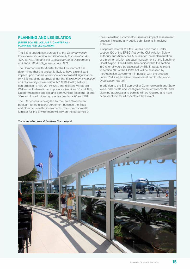
The observation area at Sunshine Coast Airport

16 SUNSHINE COAST AIRPORT EXPANSION PROJECT
SuMMarY oF Major FinDinGS
chaPTER SUMMaRIES
StaKEholDEr EngagEmEnt (REFER SCA EIS: VoluME A, CHAPtER A7 –StAkEHolDER ENGAGEMENt)
Scope
Stakeholder engagement for the project has been a priority during the preparation of the eiS. the tor established for the eiS set a requirement to engage with communities located within a 40 km radius of the project.
a major component of the eiS preparation throughout 2012 – 2014 has been centred on ensuring stakeholders from across the Sunshine Coast are informed of the airport’s expansion plans.
Starting in 2006 with the SCa Master plan being subjected to a formal public exhibition period, where the community was invited to view and comment on long-term plans, the airport has been diligent in providing updates and seeking input as planning for the project has progressed.
activities undertaken during the preparation of the eiS have included:
• Briefings for all levels of government
• Briefings for community and special interest groups
• establishment of a dedicated project enquiry telephone number and email address
• online information via SCC and SCa website and social media channels
• Community newsletter and survey
• advertising (print and online)
• Media releases
• Fact sheets.
public notification period
activities during the public notification period (Monday 29 September – thursday 13 November 2014) will include:
• advertisement of the public notification period by the office of the Coordinator-General
• General local area advertising
• availability of this Summary of Major Findings of the eiS
• public displays at Sunshine Coast venues
• information kiosks at regional shopping centres
• Briefings for government, industry, special interest and community groups
• information supporting the eiS posted to the SCa website
• Fact sheets that summarise the eiS key findings
• use of the 1800 210 755 free call information line and enquiry email address ([email protected]).
The SCA team engaged with stakeholders within a 40 km radius of the airport
SCA has met with a number of community groups to discuss the Project

17summary of major findings
thE EnvironmEntal impact aSSESSmEnt procESS (REFER SCA EIS: VoluME A, CHAPtER A9 – ENVIRoNMENtAl IMPACt ASSESSMENt PRoCESS)
Scope
this chapter summarises the environmental impact assessment process for the eiS.
impact assessment method
Volumes B, C and D cover a wide range of technical disciplines and topics within the eiS. to allow a valid comparison to be made of the significance of the impacts, a consistent approach has been applied to each technical matter.
eiS chapters generally follow the layout below:
• introduction
• Methodology
• Limitations and assumptions
• policy context and legislative framework
• existing conditions (baseline)
• impact assessment, including mitigation measures
• Summary.
all of the mitigation and management measures are outlined in Volume e within the following:
• environmental Management plan
• Dredge Management plan
• airspace Management plan
• risk Management plan.
relationship to other projects and cumulative impacts
Chapter a9 also outlines how the project relates to other major infrastructure and urban development projects underway or being planned.
volUmE bairport anD SUrroUnDS
ovErviEW
Volume B of the eiS reports on the investigations and findings associated with the project as they relate to the airport site and surrounding land and waters, including the pump-out site off Marcoola Beach.
the volume outlines the conditions and potential impacts from the project across a broad range of environmental, social and economic matters, including:
• B1: introduction
• B2: Land use and tenure
• B3: Geology, soils and groundwater
• B4: Coastal processes
• B5: Flooding
• B6: Surface water and hydrology
• B7: terrestrial flora
• B8: terrestrial fauna
• B9: aquatic ecology
• B10: Marine ecology
• B11: indigenous cultural heritage and native title
• B12: non-indigenous cultural heritage
• B13: Social impact
• B14: Surface transport
• B15: noise and vibration
• B16: air quality and greenhouse gas emissions
• B17: Landscape and visual
• B18: Climate change
the following information is a summary of the scope and major findings relevant to each chapter.
Mitigation measures and monitoring recommendations associated with the topics within Volume B are included in Volume e.
For more detailed information on each of the chapters, please refer to the chapters within Volume B in the eiS.
AIRPORT AND SURROUNDS
Volume
BSUNSHINE COAST AIRPORT EXPANSION PROJECT | ENvIRONmENTAl ImPACT STATEmENT B1-79

18 SUNSHINE COAST AIRPORT EXPANSION PROJECT
SuMMarY oF Major FinDinGS
chaPTER SUMMaRIES
19 July 2014 \\aubne1fp003\projects\projects\60248594\6. draft docs\6.1 reports\rescope reports\001_project description\project description images rev f_20140619.docx 2 of 13
Figure 4.5a: Existing development at SCA
Runway 18/36
Terminal & apron
Runway 12/30
Former cane farmland
Mt Coolum National Park
General aviation
Mt Coolum National Park
Commercial area
Car park
Sunshine Coast Aerospace precinct (currently under construction)
Helipads
Non-directional beacon (NDB)
VHF omnidirectional radio range
Fuel farm
ARFFS station
ATC tower
Existing development at SCA

19summary of major findings
lanD USE – airport anD SUrroUnDS (REFER SCA EIS: VoluME B, CHAPtER B2 – lAND uSE AND tENuRE)
Scope
the project is consistent with land use planning for the area and is included in the Sunshine Coast planning Scheme 2014.
the majority of the 443 ha site has been cleared for airport purposes or, is being cultivated for sugar cane farming, or contains native vegetation (approximately 90 ha). observations found the site is generally moderately well drained with the presence of predominantly sandy surface soil across the majority of the area.
the airport is surrounded by a wide range of land uses including residential, national parks, farming and some industry.
the area under investigation for the eiS includes the airport land, the areas immediately adjacent to the airport, and the surrounding communities. Chapter B2 examines the land tenure, land use and zoning within this area.
gEology, SoilS anD groUnDWatEr (REFER SCA EIS: VoluME B, CHAPtER B3 – GEoloGY, SoIlS AND GRouNDWAtER)
Scope
Geotechnical, acid sulphate soil (aSS), contaminated land, erosion, land resource and groundwater investigations were undertaken for the eiS.
major findings
• the runway site will require filling for the purpose of building up the platform upon which the runway would be built and compacting underlying soft clays in a small proportion of the runway site
• Specifically, the north-western end of the proposed runway site comprises 2.5 m of soft clay requiring 1 m of additional surcharge (sand fill) as a preload, for about 12 months
• the current site conditions are considered to be of a relatively low erosion risk with the ground surface generally being low-lying
• aSS are proposed to be treated on site and is considered a negligible risk to surrounding waterways and ecosystems
• Waterways and ecosystems would be protected from impacts of runoff during clearing and construction through compliance with erosion and sediment control measures
• the site is of no significant agricultural value and development would not result in a reduction in the agricultural value of the surrounding area. the site does not comprise an area of strategic cropping land
• Groundwater levels across the site range from 0.2 m to 3.4 m below ground level and reflect a shallow groundwater system
• Coffee rock is present at depths between 0.5 m and 5 m below ground level across the project area. there is groundwater above the coffee rock that is semi-perched
• Groundwater is generally fresher than brackish in both the perched and sub-surface aquifers, with groundwater quality in the sub-surface aquifer moderately acidic
• Mitigation inherent in the project design includes the placement of a high quality liner on the site ahead of sand filling to reduce saline tailwater inflow to groundwater
• in addition, a cut-off wall would be built north of the proposed northern perimeter drain to prevent drawdown of water to the drain from nearby ecosystems
• as a result of these mitigation measures, modelling has shown that salt water intrusion into groundwater is limited to levels acceptable for maintaining ecosystem health
• the south-west side of the site would have groundwater impacts of negligible significance
• all work would be managed through implementation of the environmental Management plan (eMp), refer Volume e of the eiS.
The existing main runway at SCA

20 SUNSHINE COAST AIRPORT EXPANSION PROJECT
SuMMarY oF Major FinDinGS
chaPTER SUMMaRIES
coaStal procESSES (REFER SCA EIS: VoluME B, CHAPtER B4 – CoAStAl PRoCESSES)
Scope
investigations were undertaken to determine the potential impact on Marcoola Beach and nearshore areas associated with the temporary pipeline and pumping of dredge material to the project site.
major findings
• the project would require temporary modification of a 20 m wide corridor through a dune at Marcoola Beach to allow the construction and operation of a temporary sand delivery pipeline
• the pipeline, to run perpendicular to the beach, would be in place for between three to six months, subject to the size of dredge to be used for the transport of sand
• the assembly and disassembly of the pipeline is expected to take approximately two to three weeks each time and would require a section of the beach to be closed and access directed for public safety reasons
• any disturbance to the beach below mean high water level as a result of the pipeline would be temporary with recovery under natural coastal processes
• the pipeline on the seabed and beach may create a minor barrier and could cause sand to accumulate. this is expected to be temporary and manual relocation of accumulated sand would be undertaken, if required
• During sand pumping some sand may be spilled at the off-shore dredge pump-out site, with a negligible impact on coastal processes. if a spill is excessive, it will be redredged and pumped to the project site
• all work would be managed under the Dredge Management plan (DMp), refer Volume e of the eiS.
FlooDing (REFER SCA EIS: VoluME B, CHAPtER B5 – FlooDING)
Scope
the project is located in the floodplain of the Maroochy river, therefore the flood characteristics of the area and potential impacts from the project were investigated.
a number of flood events were modelled, including the 2, 5, 10, 20, 50 and 100 year average recurrence interval (ari) events and a 2050 climate change scenario, to determine the current flooding depths, durations and flow velocities, and potential impacts caused by the project.
major Findings
• the Maroochy river floodplain is a key factor in the flood characteristics of the site. the project site and surrounding areas, including Marcoola, flood relatively frequently. the flood prone nature of the area is reflected in the Sunshine Coast planning Scheme 2014 defined flood level
• Major drainage infrastructure is proposed as part of the project to effectively manage stormwater runoff and flood flows at the project site
• new infrastructure includes the northern perimeter drain, which directs overland flow from north of rWY 13/31 north into Marcoola drain
• additionally, in a major flood the proposed western perimeter drain will improve the flow of floodwaters around the end of rWY 13/31 into the southern perimeter drain
• the new runway has been designed to be immune from a 2100 climate change scenario consisting of a 100 year ari flood event with a 20 per cent increase in rainfall intensity and a 0.8 m sea level rise
• in all modelled events, except the 100 year ari event, the modelling indicates the project will have a negligible increase in flood levels of less than 10 mm in developed areas
• in the 100-year ari event, the modelling indicates that an area of Marcoola north of rWY 18/36 would experience a small increase in peak flood levels of less than 18.5 mm. this area currently experiences flood depths of between 0.25 to 0.8 m during the 100-year ari event
• up to 15 dwellings on 14 properties within the affected area have existing floor levels that may be affected by the increase in depth of up to 18.5 mm in the 100-year ari event. the owners of the affected properties will be contacted during the public notification for the eiS to conduct detailed surveys and to establish whether or not property-specific mitigation measures are required.

21summary of major findings
Existing peak flood depth and extent for the 100-year ARI flood

22 SUNSHINE COAST AIRPORT EXPANSION PROJECT
SuMMarY oF Major FinDinGS
chaPTER SUMMaRIES
SUrFacE WatEr anD hyDrology (REFER SCA EIS: VoluME B, CHAPtER B6 – SuRFACE WAtER AND HYDRoloGY)
Scope
a detailed review relating to water quality within the Maroochy river and associated waterways, was undertaken for the eiS.
major findings • in terms of baseline water quality in the Maroochy river
and surrounding waterways, water quality data collected under the healthy Waterways program shows turbidity is routinely elevated
• in the Maroochy river salinity decreases from the river mouth heading upstream. at the Marcoola drain, salinities range from 0 to near ocean water salinity levels, where it joins the Maroochy river
• During construction, the main impacts addressed relate to tailwater discharge, which is proposed to flow into the northern perimeter drain and then the Marcoola drain.
• the Marcoola drain would be used as a mixing zone before tailwater enters the Maroochy river
• any changes to sediment, turbidity and salinity as a result of construction would be short-term and minor
• tailwater impacts do not result in water quality objectives being exceeded in the surrounding area
• once the runway is operational, changes in hydrology and water quality are expected to be minor
• Water quality impacts are almost entirely restricted to the Marcoola drain
• overall, impacts on the Maroochy river and surrounding waterways are expected to be negligible to minor.
tErrEStrial Flora (REFER SCA EIS: VoluME B, CHAPtER B7 – tERREStRIAl FloRA)
ScopeDetailed field surveys and desktop studies were undertaken to reach a comprehensive understanding of the flora located on and around the airport site.
approximately 27 per cent of the study area is mapped as containing remnant regional ecosystems. a further 2 per cent is mapped as containing regrowth vegetation, with the remaining 71 per cent mapped as non-vegetated.
major findings
• the only threatened species observed during field surveys is a population of Mt emu She-oak, listed as threatened under the epBC act, which is located in remnant heathland adjacent to Finland road
• the project will result in a loss of approximately 4.41 ha of Mt emu She-oak habitat. at the time of survey this represented approximately 500 plants or five per cent of the Finland road population
• there will be no direct impacts on the northern or southern sections of Mt Coolum national park as a result of the project
• exotic plant species and declared pest plants were observed to be common on the edges of areas of remnant vegetation, within the foredune area, and within areas of melaleuca/slash pine regrowth
• Clearing would result in a loss of 56 ha of remnant communities and of this, 50 ha would be cleared and permanently replaced by airport infrastructure
• 5.8 ha would be transitioned to dwarf heath in the airside areas for operational and safety requirements
• Clearing associated with the dredge pipeline construction compound and access area would impact 0.9 ha of sedgeland, 1.7 ha of melaleuca open forest and 0.2 ha of foredune vegetation. these areas would be rehabilitated on completion of the works
• it is proposed to translocate, by a proven tiling method, the 4.41 ha of Mt emu She-oak to a site north of the new runway on SCa-owned land as offset for the loss of the affected population
• the residual risk to the Mt emu She-oak population is expected to be moderate adverse
• there will be a minor residual impact on remnant vegetation, which is proposed to be compensated for through the rehabilitation of a SCC-owned off-site property at palmview
• Clearing of vegetation will reduce current levels of ecological connectivity between the northern and southern sections of Mt Coolum national park, resulting in a minor residual impact. this will be partially mitigated by the estalishment of a vegetated corridor along the western site boundary.
Casuarina open forest was found in the Project study area

23summary of major findings
Job No
225480-00
Coordinate System
Scale at A4
Level 4, 108 Wickham StreetFortitude Valley, QLD 4006Tel +61 (7)3023 6000 Fax +61 (7)3023 6023www.arup.com
© Arup
1:26,424
Map Title
Job Title
Sunshine Coast Airport Expansion Project
Regional Ecosystem mappingVegetation communities
Client
Sunshine Coast Airport
0 400 800 1,200
Meters
©Copyright Information
Issue Date By Appd
D1 SXJ LOM LOM
Chkd
[Map Status
Final
J:\2
2500
0\22
5480
\Wor
k\R
epor
t\Fig
ures
and
App
endi
ces\
Figu
re_2
.2.1
c_R
E_c
omm
uniti
es.m
xd
GDA 1994 MGA Zone 5630/01/2014
Project area
Study area
Paperbark wetland/open forest
Closed/wet heath
Sedgeland
Banksia woodland
Foredune complex
Coastal She-oak open forest
Mangrove forest/shubland
Saltpan
Eucalypt open forest
Sout
h M
aroo
chy
Riv
er
Figure No
2.2.1c
Regional Ecosystem vegetation community mapping

24 SUNSHINE COAST AIRPORT EXPANSION PROJECT
SuMMarY oF Major FinDinGS
chaPTER SUMMaRIES
tErrEStrial FaUna (REFER SCA EIS: VoluME B, CHAPtER B8 –tERREStRIAl FAuNA)
Scope
extensive field surveys and desktop studies were undertaken to reach a comprehensive understanding of the fauna and related habitats located on and around the airport site.
major findings
• the project would result in the loss of 1.67 ha of Wallum Sedgefrog habitat (epBC act listed species) and 60.6 ha of state-listed acid frog habitat.
• the provision of offset habitats within the project area for Wallum Sedgefrog is proposed to compensate for the loss of this habitat
• State-listed acid frog habitat would be offset by the rehabilitation of a SCC-owned property at palmview
• as part of the eiS, Ground parrot surveys were undertaken on a monthly basis for a period of 12 months, providing previously unknown information about this secretive bird
• the Ground parrot population at the airport site comprises approximately 14 to 16 birds
• it appears that the airport provides suitable habitat for Ground parrots due to SCa’s management regime of trimming wallum heath, preventing the emergence of a tree canopy
• in addition, it is considered that the maintenance of the perimeter fence around their on-airport habitat restricts predator access, assisting in survival rates
• While the project would result in a loss of 7.78 ha of wallum heath, the area lost is not the area most regularly used by the birds
• nevertheless, to mitigate the loss of Ground parrot habitat, it is proposed to manage 5.84 ha adjacent to the northern boundary of the site on SCa-owned land in a manner expected to encourage Ground parrot use. additionally, the offset area for the Wallum Sedgefrog would also provide suitable habitat for the Ground parrot
• no historic or active flying fox camps occur on the project site
• however, the project will affect food sources for the Grey-headed Flying-fox, including eucalypts and malaleucas, that occur on the site
• it is proposed to compensate for the loss of foraging habitat through the rehabilitation of a SCC-owned property at palmview
• no koala habitat exists on the project site and no koalas have been observed
• other mitigation in the form of funding a Ground parrot recovery plan and ongoing research is also proposed.
aqUatic Ecology (REFER SCA EIS: VoluME B, CHAPtER B9 – AQuAtIC EColoGY)
Scope
this chapter considers the environmental values associated with freshwater ecosystems and the associated aquatic flora and fauna communities on the project site during the construction and operational phases of the project.
Field studies were undertaken in accordance with a range of industry protocols and standards.
major findings
• Waterways within the SCa site are typically highly modified, channelised and in some cases, concrete lined
• aquatic communities and values within the project area are highly disturbed, of relatively low value and provide little connectivity to high value aquatic habitat
• all of the waterways on site were relatively small, starting either from within or near the airport site, providing no connectivity to higher value waterways or aquatic communities upstream
• there will be a loss of the aquatic habitat and riparian vegetation that lies in the footprint of the project. While this is unavoidable, the low conservation value of this habitat and vegetation limits the magnitude of the impact
• Low conservation value of both habitats and aquatic flora and fauna within the waterways of the project area, specific mitigation or offset strategies are not considered necessary
• the impacts of the project on aquatic ecology are considered negligible at a local/regional scale
• the comprehensive environmental Management plan developed for the project is considered sufficient to maintain or improve the status of aquatic habitat at the site.
Wallum sedgefrog (courtesy: Mark Sanders Ecosmart Ecology)

25summary of major findings
The study area for an assessment of the environmental values are associated with freshwater ecosystems and aquatic flora and fauna at SCA
SUNSHINE COAST AIRPORT - 6613130198 - Airport Expansion EIS Chapter LOCATION DIAGRAM
AMEC does not guarantee the accuracy or completeness of the map and does not make any warranty about the data.AMEC is not under any liability to the user for any loss or damage (including consequential loss or damage) which the user may suffer resulting from the use of this map.
Path
: F:\T
empW
R\S
unsh
ineC
oast
Airp
ort\G
IS\A
ME
C_A
3_P
ortra
it_10
.1.m
xd
_̂
_̂
_̂
_̂
_̂
_̂
_̂
l
l
l
l
l
l
l
Sunshine
Motorway
David Low Way
AQ07
AQ02
AQ01
AQ08
AQ03
AQ04
AQ06
(A3) GCS GDA 1994
1:12,500
LEGEND
PROJECT OVERVIEW
WORK REQUEST NUMBER:
DATA SOURCES:Physical Road Network © State of Queensland 2010Service Layer Credits: Source: Esri, DigitalGlobe, GeoEye, i-cubed, EarthstarGeographics, CNES/Airbus DS, USDA, USGS, AEX, Getmapping, Aerogrid, IGN,IGP, swisstopo, and the GIS User CommunityCopyright:© 2013 DeLorme
ISSUE DATE03/07/2014
17/10/13
AUTHORJH
JH
QA CHECKTH
TH
APPROVEDTH
TH
0 100 200
Metres
¹MAP REV.
0
A
REVISION NOTEIssued for Use
Issued for Review
l
Flow direction
_̂ Sites
Project area

26 SUNSHINE COAST AIRPORT EXPANSION PROJECT
SuMMarY oF Major FinDinGS
chaPTER SUMMaRIES
marinE Ecology (REFER SCA EIS: VoluME B, CHAPtER B10 – MARINE EColoGY)
Scope
the Marine ecology chapter describes the existing marine flora, fauna and habitat values within and adjacent to areas of SCa that have the potential to be affected by the project, including dredging and sand placement, as well as associated tailwater.
major findings
• it was identified that processes associated with the construction and operation of the project, while temporary in nature, might affect local marine ecology if not managed appropriately.
• to minimise disturbance to marine habitats, in the ocean or in tidal waters on or near the project site, the project design incorporates:
— placement of the temporary pipeline on the surface of the seabed, rather than buried
— a tailwater discharge outlet that minimises scouring of local tributaries
— Selection of a dredge that minimises the potential for excessive sand spillage at the pump-out site
— Minimising the length of time for beach works and the extent of beach area affected by pipeline assembly and operation
— protection of marine plants at Marcoola drain during the construction of the tailwater discharge outlet.
• to protect marine megafauna, such as turtles, strategies to avoid contact and minimise exposure to light and noise will be implemented including:
— all dredge pipeline construction works on Marcoola Beach will be undertaken outside turtle nesting season (november to March) as far as practicable
— engagement with turtle nest monitoring groups to investigate past and likely future sites prior to commencing work
• a comprehensive assessment of the potential impacts and mitigation measures result in negligible to low impacts on the marine environment.
Typical marine habitats in the vicinity of SCA

27summary of major findings
cUltUral hEritagE (REFER SCA EIS: VoluME B, CHAPtER B11 – INDIGENouS CultuRAl HERItAGE AND NAtIVE tItlE; CHAPtER B12 – NoN-INDIGENouS CultuRAl HERItAGE)
Scope
the eiS cultural heritage chapters identify and describe the nature and significance of sites of indigenous and non-indigenous cultural value within and around the project area and how the project may affect these sites and values.
major findings – indigenous cultural heritage
• Following an initial assessment of indigenous cultural heritage in the project area, it was apparent that indigenous cultural heritage issues could arise during the course of the project
• in addition, part 7 of the Aboriginal Cultural Heritage Act 2003 requires the development and approval of a Cultural heritage Management plan (ChMp) with the relevant aboriginal party(ies) if a project is conducting an eiS
• ChMps will be developed in consultation with aboriginal parties, including the Kabi Kabi aboriginal people and any other parties who have claim to offshore areas
• the development of management measures within any ChMp will be informed by surveys conducted by the aboriginal party/ies.
• these surveys will identify any areas of indigenous cultural heritage significance and the likelihood of project activities having an impact
• the ChMp will include any necessary mitigation measures.
major findings – non-indigenous cultural heritage
• register, database searches and field surveys revealed the project area does not contain any registered non-indigenous cultural heritage (niCh) places.
Social impact (REFER SCA EIS: VoluME B, CHAPtER B13 – SoCIAl IMPACt)
this chapter considers how the project, during construction and once operational might affect the local community.
any potential social and environmental impacts associated with flight paths and aircraft noise are outlined in Volume D, Chapters D3 and D.
major findings
• the project is seen as a key catalytic project for the future growth and development of the region
• the project is expected to contribute to the overall economic diversification and growth of the region
• the project would not have an immediate, direct impact on the settlement pattern or characteristics of the local area
• over time, it is expected that SCa and its new main runway alignment would influence the future development of areas close to the airport
• no additional properties need to be acquired by SCC for the project
• the project would improve access to jet and turbo-prop services for both domestic and international services allowing more people to more easily access the region
• the Marcoola beachfront and Coastal pathway would be temporarily impacted by construction activities related to the dredge pipeline, however a short detour is to be provided during this brief period.

28 SUNSHINE COAST AIRPORT EXPANSION PROJECT
SuMMarY oF Major FinDinGS
chaPTER SUMMaRIES
Suburbs in close proximity to SCA

29summary of major findings
SUrFacE tranSport (REFER SCA EIS: VoluME B, CHAPtER B14 SuRFACE tRANSPoRt)
Scope
the effect of the project on the surrounding transport network has been considered. the purpose of this chapter is to evaluate the future performance of the surrounding road network, including David Low Way, airport Drive and Sunshine Motorway.
the implications of traffic during the construction of the project, as well as the operation of the airport beyond 2020 were considered.
major findings
• traffic generated by the project, either during construction or once operational, has minimal impact on the performance of local intersections
• the primary cause for any reduced operational performance at local intersections is predicted growth in background, rather than project-related traffic
• Finland road, which will be a major access route during the construction of the project, will be upgraded as part of the package 1 construction works
• to improve traffic operations, signals will be installed at the David Low Way/Finland road intersection
• During construction, heavy vehicle movements are expected to occur predominantly in daylight hours, although there may be occasional night time deliveries
• an initial road use Management plan is included in the eiS. it sets out strategies for informing the community about any road-related changes that may occur during the construction of the project
• the number of light and heavy vehicle trips expected to occur during the peak construction year (2018) is shown in the table below.
• the number of light and heavy vehicle trips expected to occur in the opening year (2020) is shown in the second table below.
the traffic generated as a result of the construction and operation of the new runway and upgraded airport terminal building is expected to have minimal impact on the operational performance of the surrounding road network.
Total construction traffic generation (2018)
Design peak hour
in out
light vehicle heavy vehicle light vehicle heavy vehicle
aM 14 16 0 16
Midday 0 16 0 16
pM 0 16 70 16
Daily 70 55 70 55
Total operations traffic generation – opening year (2020)
Design peak hour in out
light vehicle heavy vehicle light vehicle heavy vehicle
aM 27 1 43 1
Midday 42 1 93 1
pM 0 1 50 1
Daily 510 3 650 4

30 SUNSHINE COAST AIRPORT EXPANSION PROJECT
SuMMarY oF Major FinDinGS
chaPTER SUMMaRIES
noiSE anD vibration (REFER SCA EIS: VoluME B, CHAPtER B15 –NoISE AND VIBRAtIoN)
Scope
an assessment of changes to terrestrial (on-ground) noise as a consequence of the project has been undertaken.
major findings
terrestrial noise investigations included monitoring at 12 locations on and surrounding the airport to provide an understanding of the baseline noise environment (not including aircraft noise which is considered in Chapter D3).
• Construction noise was considered for all packages of work during the four year construction period. While most construction for the project will be carried out in the day, there are short periods where night works will be required
• houses surrounding and closest to the airport were identified as the sensitive receptors to noise impacts
• the other sensitive receptor identified on site was the Ground parrot population within the airport
• to assess impacts on residential sensitive receptors, noise goals were developed from best practice Queensland guidance
• Mitigation for construction noise impacts inherent in design include significant acoustic attenuation around the booster pump (which would operate for around 14 weeks depending on the size of dredge) and temporary noise barriers in place for the same duration
• Construction noise was modelled and exceedances of noise goals were predicted on only three occasions in the four year construction period at Keith royal Drive
• operational noise was also considered including ground running of aircraft, aircraft noise while stationary at the terminal, helicopter engine run-up/down and low level hovering and general plant noise from the existing and future terminal. overall no significant change in operational noise is predicted
• With respect to vibration during construction, no impact is predicted against best practice guidance to the nearest residences
• predicted increases in traffic noise along Finland road (currently a quiet rural road with 14 residences) will be expected as this will be the main construction access to the project site
• regular communication ahead of some construction activities will be provided to noise affected residents in Finland road and on Keith royal Drive
• Mitigation and management measures for noise during construction and operation, including proposed working hours are provided in Chapter e3, the project eMp.
air qUality anD grEEnhoUSE gaS EmiSSionS (REFER SCA EIS: VoluME B, CHAPtER B16 – AIR QuAlItY AND GREENHouSE GAS EMISSIoNS)
Scope
the potential impacts on air quality and greenhouse gas (GhG) emissions have been assessed for the construction, the operational phase of the project and for changes in road traffic associated with the development.
emissions from aircraft are considered separately in Chapter D4, air Quality and Greenhouse Gas emissions.
Current air quality data and meteorological conditions were factored into this assessment.
major findings
• During construction, air quality will be monitored and activities that could give rise to dust, which could affect air quality, particularly for properties located to the east of the construction site, will be managed through regular watering and shielding
• any GhG emissions during construction will be well below the national Greenhouse and energy reporting threshold
• once operational, emissions are expected to remain below the national Greenhouse and energy reporting threshold
• traffic associated with the airport contributes to only a small proportion of overall traffic emissions in the area. in the future this will grow, however, the total emissions are expected to be very low
• GhG emissions from construction were estimated as part of the project. the largest source of GhG emissions (70 per cent of the total) comes from that embedded within aggregates and dredged sand for construction. these are Scope 3 emissions.
• the remaining, approximately 30 per cent of (Scope 1 and 2) GhG emissions come from fuel usage during construction
• During construction of the project impacts related to air quality and GhG emissions are expected to be generally low, with dust being managed under the environmental Management plan
• impacts during operation are expected to be low with no mitigation strategies required
• SCa is committed to environmental management, including its use of energy and GhG emissions, and is involved in the ecoBiz program and the airports Council international airport Carbon accreditation scheme
• potential measures to further minimise the emissions of GhG from airport operations include:
— the use of appropriate building materials and the choice of energy efficient options for lighting, air-conditioning and other equipment/devices within the terminal
— integration of any new section of terminal into the existing Building Management System to ensure that energy associated with lighting and air-conditioning is optimised.

31summary of major findings
lanDScapE anD viSUal (REFER SCA EIS: VoluME B, CHAPtER B17 – lANDSCAPE AND VISuAl)
Scope
this chapter assesses the visual impact of the project during construction and operation from 10 vantage points representing the major views to the airport.
it considers the existing visual conditions of the airport site and the surrounding study area and how those conditions might change during the day and night as a result of the construction and operation of the project.
refer to Chapter B17 for the list of vantage points and a view-based assessment of potential visual impacts.
major findings
• Views of the airport would be mainly from locations directly adjacent to the site or distant ridgelines
• the character of the airport runway and surrounds is visually similar to surrounding landscape (former caneland landscapes)
• the visual impact of the project is reduced by the fact that it is an existing fully operational airport
• Construction activity, including associated lighting, is likely to be seen from vantage points around the airport, although this would be temporary
• During operation, the proposed change of orientation of the main runway and flight paths will result in aircraft being visible in locations that currently may not see aircraft
• While new airfield lighting will be installed, the directional nature of the lighting will minimise impacts
• at 55 m tall, the proposed new air traffic Control tower will be visible from the majority of the identified vantage points. the final tower height will be determined by airservices australia, and may be less than 55 m
• Visual impacts during temporary construction activity are expected to be minor to high
• in an operational sense, given the airport has been in its current location since 1961, visual impacts are, in the main, negligible or minor.
climatE changE (REFER SCA EIS: VoluME B, CHAPtER B18 – ClIMAtE CHANGE)
Scope
to ensure the airport is prepared for climate conditions and natural hazards that may affect the design, construction and operation of SCa, the eiS has considered potential climate change consequences such as increased temperatures, sea level rises, bushfire risk and extreme events.
major findings
• the new runway is designed to be immune to a 100 year flood scenario in 2100 incorporating climate change
• the geographic setting and location of the airport on low-lying land increases its exposure to impacts from coastal climate change and flooding (as a result of more intense rainfall and storm events)
• as large areas of the airport are cleared, grassed and maintained for aviation navigational safety purposes, there is lower exposure to risks such as bushfire damage to existing and future infrastructure
• a range of mitigation measures are proposed.
View to the airport from David Low Way
View to the airport from surrounding high-rise development

32 SUNSHINE COAST AIRPORT EXPANSION PROJECT
SuMMarY oF Major FinDinGS
chaPTER SUMMaRIES
volUmE cDrEDging anD DrEDgE movEmEntS
ovErviEW
this volume of the eiS reports on the investigations and environmental issues involving the extraction of sand from the Spitfire realignment Channel in northern Moreton Bay, specifically:
• C1: introduction
• C2: Marine Geology
• C3: Coastal processes and Water Quality
• C4: Marine ecology
• C5: Shipping traffic
• C6: other Considerations (such as cultural heritage, social impacts and visual impacts).
the following information is a summary of the scope, major findings and overall conclusions relevant to each chapter.
Mitigation measures and monitoring recommendations associated with the topics within Volume C are included in Volume e.
For more detailed information on each of the chapters, please refer to the chapters within Volume C in the eiS.
introDUction (REFER SCA EIS: VoluME C, CHAPtER C1 – INtRoDuCtIoN)
SCa needs around 1.1 M m3 of clean sand for construction of the new runway. it is proposed that the sand would be sourced from the Spitfire realignment Channel using a dredge and transported to a pump-out site located between 500 m and 1,000 m offshore from Marcoola Beach. the sand would be hydraulically pumped ashore via a pipeline.
the preferred sand extraction area, the Spitfire realignment Channel, is located in Moreton Bay 8 km east of Woorim on Bribie island and 8 km west of Bulwer. it is a previously approved dredging site for the port of Brisbane pty Ltd (pBpL) that has an existing allocation of 15 M m3 that has not yet been dredged.
a 1.1. M m3 allocation would provide a 300 m wide channel to an average depth of approximately -11.55 m chart datum. the final level will depend on any prior dredging undertaken by pBpL and the quality of sand in the footprint.
to develop a combined sand extraction area of 16.1 M m3 (i.e. pBpL’s 15 M m3 allocation and 1.1 M m3 for the project), the base of the realignment would need to extend to approximately -17.05 m chart datum.
the dredge vessel and operations
the dredge vessel used for the project would be determined following the appointment of the dredging contractor, but it is likely it would be a medium-sized trailing suction hopper dredger. Material is stored in the on-board hopper compartment before being transported to the pump-out site offshore from Marcoola. the capacity of the hopper is most likely to be between 8,000 and 10,000 m3.
Dredging is most likely to occur around the clock and during most weather conditions for about 14 weeks, subject to the choice of dredge. typically, the dredger and a tug supporting the operations at the pump-out site would stop work one day a fortnight to refuel, undertake maintenance, and take on supplies. it is estimated that the process to extract and deliver the sand would take 7 to 10 hours (excluding delays), resulting in 2 to 3.5 cycles per day.
existing shipping channels would be used in port-controlled waters with the final navigation route to be determined in consultation with the contractor and Maritime Safety Queensland (MSQ) / regional harbour Master (rhM).
the appointed contractor would be required to follow the Dredge Management plan (DMp) outlined in Volume e of the eiS.
marinE gEology (REFER SCA EIS: VoluME C, CHAPtER C2 – MARINE GEoloGY)
Scope
the quality of the 1.1 M m3 of sand is important to the airport development and therefore, as part of the eiS, assessment was undertaken to judge the suitability of the Spitfire realignment Channel sand for use as fill to build the new runway.
the investigation included analysis of previous studies undertaken by the Queensland Government, including the Moreton Bay Sand extraction Study 2002, port of Brisbane and Brisbane airport, among others, to understand the proposed dredge site’s depth, assess the silt and clay content of sand, understand potential for contamination and the presence of acid sulphate soils.
major Findings
• the Spitfire realignment Channel is located within the northern tidal delta, which is known to comprise predominantly clean fine to medium-grained marine sand
• average depth of sand extends well below -18 m chart datum
• the sand is mostly durable, inert material that would provide a solid base for the new runway
• there is no indication of aSS and negligible likelihood of contamination being in the Spitfire realignment Channel
• During the detailed design, additional investigations will be undertaken to confirm the findings of the eiS.
DREDGING AND DREDGE MOVEMENTS
VOLUME
CC1-3SUNSHINE COAST AIRPORT EXPANSION PROJECT | ENVIRONMENTAL IMPACT STATEMENT

33summary of major findings
Caloundra
Moreton Isl.
Maroochydore
Sand extraction area
Fairway beacon
Point Cartwright
Indicative navigation route for the dredge vessel between Moreton Bay and the pump-out site off Marcoola Beach
Reclamation area
Booster pump stationPipe under David Low Way and dunes
Floating pipe
Submerged pipe
Above ground pipe
Proposed sand delivery pipeline alignment from Marcoola Beach to the airport

34 SUNSHINE COAST AIRPORT EXPANSION PROJECT
SuMMarY oF Major FinDinGS
chaPTER SUMMaRIES
coaStal procESSES anD WatEr qUality (REFER SCA EIS: VoluME C, CHAPtER C3 – CoAStAl PRoCESSES AND WAtER QuAlItY)
Scope
the eiS considered existing physical coastal processes in and around the Spitfire realignment Channel, such as waves, currents and tides, Moreton Bay shorelines and potential impacts on water quality associated with dredge vessel operations.
to draw conclusions, research has built on previous assessments and studies including the Moreton Bay Sand extraction Study and investigations by the port of Brisbane, as the SCa work represents a deepening of the port’s existing approved dredge footprint.
major findings
• Current conditions in the area generally comply with established water quality objectives except during times when there is a medium to large rainfall event
• the activity is not expected to impact the overall flushing and circulation patterns within Moreton Bay and any extraction site impacts are not likely to be of significance
• tidal regimes have not been changed by previous dredging activity and proposed work is not predicted to alter hydrodynamics within Moreton Bay
• there are no cases where the speed or direction of currents have been significantly altered by previous dredging at surrounding shoreline locations
• any changes in the speed and direction of currents would be restricted to the sand extraction area
• the operation of the dredger during dredging will create a dredge plume. this has been modelled to understand any implications for benthic fauna and the Marine national park Zone 03 immediately north of the Spitfire realignment Channel
• the impact to water quality and environmental values as a result of the dredge plume is predicted to be minor adverse due to a temporary non-compliance with water quality objectives
• Mitigation measures have been included within the Dredge Management plan (Chapter e3) to alleviate any temporary water quality impacts.
marinE Ecology (REFER SCA EIS: VoluME C, CHAPtER C4 – MARINE EColoGY)
Scope
the Moreton Bay Marine ecology chapter describes the existing marine flora, fauna and habitat values at the Spitfire realignment Channel. to inform the eiS research, desktop assessments and field surveys were undertaken looking at seabed habitat and flora and fauna found on the seabed.
major findings
• the dredge footprint is not located within the Moreton Bay ramsar Site or within designated Fish habitat areas
• the dredge footprint is located within the General use Zone of the Moreton Bay Marine park
• there are sparse communities of benthic fauna – macroinvertebrates – that are relatively robust and well adapted to the dynamic environment
• historically, the benthic fauna within extraction footprints has shown a reasonable resilience to dredging-related disturbances
• Benthic flora occurs as sparse, isolated patches that comprises seagrass (Halophila ovalis) and some macroalgae
• there were instances where marine mammals, reptiles, fish and seabirds were observed passing through the extraction area
• threatened, migratory and protected fauna do not use the sand extraction area for foraging or to reproduce
• the sand extraction area is not a key location for commercial or recreational fishing activities
• With the use of recommended mitigation measures, there would be a low level of impact on the overall marine ecology of the sand extraction area
• the project is not expected to adversely affect Moreton Bay ramsar site or values
• it is not expected to cause detectable biological effects in the nearby Marine national park Zone
• the project is not considered to pose a notable risk in terms of marine pest introductions or dispersal
• Mitigation measures have been included within the Dredge Management plan (Chapter e3) to manage any identified impacts.

35summary of major findings
Common species observed around Spitfire Banks: White rope ascidians (Eudistoma elongatum) (A); heart urchin Echinocardium cordatum (B); small cerianthid anemone (C); red algae Hypnea spinella (D); benthic micro-algae and a black crinoid (E); sea star Luidia maculata (F); sparse Halophila ovalis over fine to medium sand (G) dense H. ovalis over sand, shell grit and rubble (H)

36 SUNSHINE COAST AIRPORT EXPANSION PROJECT
SuMMarY oF Major FinDinGS
chaPTER SUMMaRIES
Shipping traFFic (REFER SCA EIS: VoluME C, CHAPtER C5 – SHIPPING tRAFFIC)
Scope
the port of Brisbane is located at the mouth of the Brisbane river and is managed and developed by the port of Brisbane pty Ltd. MSQ, through the authority of the rhM, has jurisdiction over the safe movement of all shipping within the Brisbane area.
it is anticipated that a single dredge vessel would be used for extraction and delivery of the sand to the site. operation of the dredge vessel would be supported by at least one tug, predominantly based at the pump-out site.
major findings:
• initial consultation with MSQ and the rhM identified no issues of particular concern from a shipping perspective
• the dredge vessel’s movements are expected to cause minimal delays to other ships at the port
• the dredge vessel would not be carrying hazardous cargo nor increase risks to shipping safety
• the dredge vessel would operate in accordance with the port procedures and directions from rhM, and therefore is not expected to affect the safety of other shipping operations
• there would be negligible impacts on recreational craft within Moreton Bay
• at the pump-out site it would be necessary to have some restrictions on recreational craft to ensure the safe operation of the dredge vessel and control of the floating pipeline
• a temporary exclusion zone may be required at this location during the works with approval from MSQ and the rhM.
othEr conSiDErationS (REFER EIS: VoluME C, CHAPtER C6 – otHER CoNSIDERAtIoNS)
Scope
as a part of the review of the proposed dredging in Moreton Bay, a number of other factors that may arise as a consequence of dredging were investigated, including:
• non-indigenous and indigenous cultural heritage • Visual and social impacts.
major findings – non-indigenous and indigenous cultural heritage
• no known significant non-indigenous cultural heritage sites, i.e. shipwrecks, within Moreton Bay would be impacted by the dredge operation
• archaeological studies revealed indigenous people occupied the area that later became Moreton Bay during the pleistocene period when sea levels were lower and the coastline was up to 40 km east of where it is today
• SCa would be required to develop a Cultural heritage Management plan (ChMp) with relevant aboriginal party(ies) and this process would continue after the finalisation of the eiS
• all potential impacts would be assessed and mitigation measures developed as part of the ChMp.
major findings – social and visual impact assessment
• the dredge would add one ship to existing traffic using the shipping channel and is not expected to have a significant impact on other shipping traffic in the area
• the dredge would travel on a route agreed with the rhM between the Spitfire realignment Channel and the pump-out site, taking into account the importance of reducing any impact on commercial and recreational activities
• Dredge movements within the shipping channel would be visible from the beach, albeit on the horizon and in clear conditions
• at night, lights may also be visible from the beach, albeit on the horizon and in clear conditions.
Views from Marcoola Beach will not be impeded by the proposed dredging activity

37summary of major findings
volUmE DairSpacE anD aircraFt noiSE
ovErviEW
Volume D of the eiS, summarises changes arising from new flight paths, community exposure to aircraft noise, land use and air quality within a 40 km radius of SCa included in the following chapters:
• D1: introduction
• D2: airspace architecture and Modes of operation
• D3: aircraft noise
• D4: air Quality and Greenhouse Gas emissions
• D5: Social and Visual impacts
the following information is a summary of the scope and major findings of each chapter. Mitigation measures and monitoring recommendations associated with the topics within Volume D are included in Volume e.
For more detailed information on each of the chapters, please refer to the chapters within Volume D in the eiS.
airSpacE architEctUrE anD moDES oF opEration (REFER SCA EIS: VoluME D, CHAPtER D2 –AIRSPACE ARCHItECtuRE AND MoDES oF oPERAtIoN)
Scope
to understand potential airspace changes resulting from the new runway orientation (13/31), existing operations were reviewed along with forecasting to predict future traffic volumes and aircraft types.
in consultation with airservices australia and the CaSa, flight path and airspace options for the proposed new runway were developed and assessed with a view to maximising the efficiency of the airspace network while minimising noise impacts for local communities.
airservices australia and CaSa have agreed and confirmed in principle that the proposed new flight paths and airspace changes meet their planning requirements.
however, before any flight path changes can be introduced, airservices australia would be required to complete an additional Safety Case and environmental assessment, which must be approved by the australian Government. this would not take place until just prior to opening of the proposed new runway.
Future developments in aircraft technology and changes to the Brisbane basin air traffic management network may also influence the approved flight paths introduced at SCa.
Weather
Weather conditions have a major influence on airport operations, determining the direction of runway use, flight procedures and which flight paths would be used for arrivals and departures.
Critical factors considered by pilots and air traffic control include wind direction and speed, as well as rain and visibility.
the proposed new runway has been designed with a north-west/south-east alignment to best suit local topographical and prevailing weather conditions. this would reduce the number of times services are disrupted due to cross-winds.
Existing flight paths
operating procedures and flight paths at SCa are designed to minimise the impact of aircraft noise on the community as much as possible. Currently, where possible, jet aircraft land from the south on rWY 36 and depart to the south, taking off from rWY 18. aircraft are also kept over water for as long as possible.
Flight paths for the current north-south runway alignment result in commercial jet and Ga traffic operating over populated areas to the south of SCa, such as Maroochydore, Buderim, Mooloolaba and Buddina. as these traffic levels grow in the future, the noise impact from these flights would continue to increase.
this situation would be alleviated with the proposed new runway alignment, which would allow aircraft approaching from and departing to the south to remain over water and keep away from the main population areas north and south of the airport.
volume of aircraft traffic
an aircraft movement is defined as a single landing or take-off event. in the year ending june 2012, SCa recorded a total of 91,029 aircraft movements.
Aircraft movements 2012
type of aircraft operations 2012 movements
Commercial rpt aircraft 5,559
General aviation fixed wing (including charter) 25,168
helicopters 60,302
the forecast traffic movements for the years 2020, 2030 (10 years after opening) and 2040 (eiS assessment horizon) are shown below.
Forecast aircraft movements 2020 – 2040
type of aircraft operations 2020 2030 2040
Commercial aircraft (rpt) 8,900 13,660 18,210
General aviation fixed wing (including charter) 29,370 35,630 35,630
helicopters 70,390 85,390 85,390
AirspAce And AircrAft relAted noise
Volume
DSUNSHINE COAST AIRPORT EXPANSION PROJECT | ENvIRONmENTAl ImPACT STATEmENT D1-161

38 SUNSHINE COAST AIRPORT EXPANSION PROJECT
SuMMarY oF Major FinDinGS
chaPTER SUMMaRIES
Steady growth of commercial traffic is expected in the following areas: • Growth in commercial flights to and from Sydney
and Melbourne • expansion of commercial flights to other domestic capital
city markets • Growth in narrow-body jet services • introduction of wide-body jet services to asia, the Middle
east and the uSa • Growth of commercial charter services, and the
introduction of commercial services, to northern resource sector markets.
Future flight paths
the eiS considers flight paths within 40 km of SCa which can be separated into three principal groups.
1. outer joining Routes – these are the high-level sections of flight paths where arriving and departing aircraft join the upper airspace system. While some of these flight paths are within 40 km, aircraft altitudes at these points are generally very high. in most cases aircraft operating in these areas will be very hard to see and unlikely to be heard. the broader Brisbane basin traffic flow determines the location of the outer joining routes.
2. Primary Approach and Departure Corridor – this is the main flight path aligned with the proposed new runway. Large commercial jet aircraft need to line up with the runway at some distance from touchdown in order to prepare for landing and avoid last minute turns. this distance depends on the type of aircraft and the type of approach procedure being followed.
For instrument flight procedures where an aircraft is following an instrument landing system or certain types of Global positioning System (GpS) based navigation procedures this distance is typically around 10 nautical miles (nm) or approximately 20 km.
Similarly, aircraft departing will typically fly straight ahead until reaching a safe altitude and turning to join a route to their destination. the primary approach and departure corridor extends up to 15 nm or approximately 30 km in each direction along the runway.
the location of the primary corridor is fixed by the runway alignment.
3. Secondary Approach and Departure Corridor – this is a secondary corridor that has been established to provide an efficient second flight path for aircraft arriving from, and departing to southern destinations such as Sydney and Melbourne.
this corridor provides a shorter flight path for arriving aircraft able to carry out some types of advanced GpS based instrument approach procedures which can accommodate turns, as well as providing a suitable flight path for aircraft making visual approaches.
aircraft arriving from the south to rWY 13 will use the secondary corridor to save the extra flying distance and time which would otherwise be required if they were to arrive via an outer joining route to the primary approach corridor in the north.
in some instances air traffic Control (atC) will also split air traffic between the primary and secondary corridors to avoid traffic conflicts.
New flight paths for the proposed SCA Runway 13/31

39summary of major findings
Similarly, aircraft departing to southern destinations will be able to use the secondary corridor to begin heading in the right direction when required to depart initially to the north from rWY 31.
the location of the secondary corridor has been carefully chosen as the best available option that minimises the noise impact to population areas while still providing an operationally safe flight path for aircraft.
proposed modes of operation
When completed, it is proposed the new runway would become the primary runway for all traffic. the existing rWY 18/36 would remain in service, but would no longer be
used by commercial jet traffic, rather it would become the alternate runway for a small percentage of Ga traffic, when weather conditions dictate.
the current operating runway modes are shown below as are the three basic modes of operation for the proposed new runway.
it is forecast that 23 per cent of arrivals to the airport will approach from the south-east (rWY 31), while the balance will approach from the north-west (rWY 13).
it is also forecast that 77 per cent of departures from rWY 13/31 will be to the south-east (rWY 13), with the balance taking off to the north-west (rWY 31).
“18” mode “36” mode “reciprocal” mode
Existing runway operating modes at SCA
Runway operating modes at SCA with the proposed runway 13/31
“13” Mode
Marcoola Marcoola MarcoolaN
Over open land Over open land
CrossRunway18/36
CrossRunway18/36
CrossRunway12/30
Main Runway13/31 Main Runway
13/31 Main Runway13/31
Over coast Over coast
Maroochydore (over land) Maroochydore (over land) Over coast
RPTGA
18
18
13 3136
36
3131
13
13
“31” Mode “Reciprocal” Mode“13” mode “31” mode “reciprocal” mode
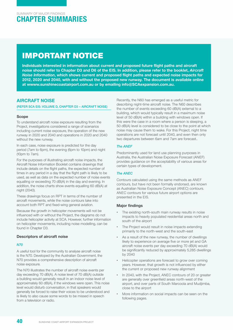
40 SUNSHINE COAST AIRPORT EXPANSION PROJECT
SuMMarY oF Major FinDinGS
chaPTER SUMMaRIES
aircraFt noiSE (REFER SCA EIS: VoluME D, CHAPtER D3 – AIRCRAFt NoISE)
Scopeto understand aircraft noise exposure resulting from the project, investigations considered a range of scenarios including current noise exposure, the operation of the new runway in 2020 and 2040 and operations in 2020 and 2040 without the new runway.
in each case, noise exposure is predicted for the day period (7am to 6pm), the evening (6pm to 10pm) and night (10pm to 7am).
For the purposes of illustrating aircraft noise impacts, the aircraft noise information Booklet contains drawings that include details on the flight paths, the expected number of times in any period in a day that the flight path is likely to be used, as well as data on the expected number of noise events equalling or exceeding 70 dB(a) in the day and evening. in addition, the noise charts show events equalling 60 dB(a) at night (2040).
these drawings focus on rpt in terms of the number of aircraft movements, while the noise contours take into account both rpt and fixed-wing general aviation.
Because the growth in helicopter movements will not be influenced with or without the project, the diagrams do not include helicopter activity at SCa. however, further information on helicopter movements, including noise modelling, can be found in Chapter D3.
Descriptors of aircraft noise
N70
a useful tool for the community to analyse aircraft noise is the n70. Developed by the australian Government, the n70 provides a comprehensive description of aircraft noise exposure.
the n70 illustrates the number of aircraft noise events per day exceeding 70 dB(a). a noise level of 70 dB(a) outside a building would generally result in an indoor noise level of approximately 60 dB(a), if the windows were open. this noise level would disturb conversation, in that speakers would generally be forced to raise their voices to be understood and is likely to also cause some words to be missed in speech from a television or radio.
recently, the n60 has emerged as a useful metric for describing night-time aircraft noise. the n60 describes the number of events exceeding 60 dB(a) external to a building, which would typically result in a maximum noise level of 50 dB(a) within a building with windows open. if this were the case in a room where a person is sleeping, a 50 dB(a) level is considered to be close to the point at which noise may cause them to wake. For this project, night time operations are not forecast until 2040, and even then only two departures between 6am and 7am are forecast..
The ANEF
predominantly used for land use planning purposes in australia, the australian noise exposure Forecast (aneF) provides guidance on the acceptability of various areas for certain types of development.
The ANEC
Contours calculated using the same methods as aneF contours, but have not been formally endorsed, are known as australian noise exposure Concept (aneC) contours. aneC contours for various future airport options are presented in the eiS.
major findings
• the existing north-south main runway results in noise impacts to heavily populated residential areas north and south of the airport
• the project would result in noise impacts extending primarily to the north-west and the south-east
• as a result of the new runway, the number of dwellings likely to experience on average five or more jet and Ga aircraft noise events per day exceeding 70 dB(a) would be significantly reduced by approximately 5,285 dwellings by 2040
• helicopter operations are forecast to grow over coming years. however, that growth is not influenced by either the current or proposed new runway alignment
• in 2040, with the project, aneC contours of 20 or greater are generally over greenfield areas north-west of the airport, and over parts of South Marcoola and Mudjimba, close to the airport
• More information on social impacts can be seen on the following pages.
IMPORTANT NOTICEindividuals interested in information about current and proposed future flight paths and aircraft noise should refer to chapter D3 and D6 of the EiS. in addition, please refer to the booklet, Aircraft Noise Information, which shows current and proposed flight paths and expected noise impacts for 2012, 2020 and 2040, with and without the proposed new runway. the document is available online at wwww.sunshinecoastairport.com.au or by emailing [email protected].
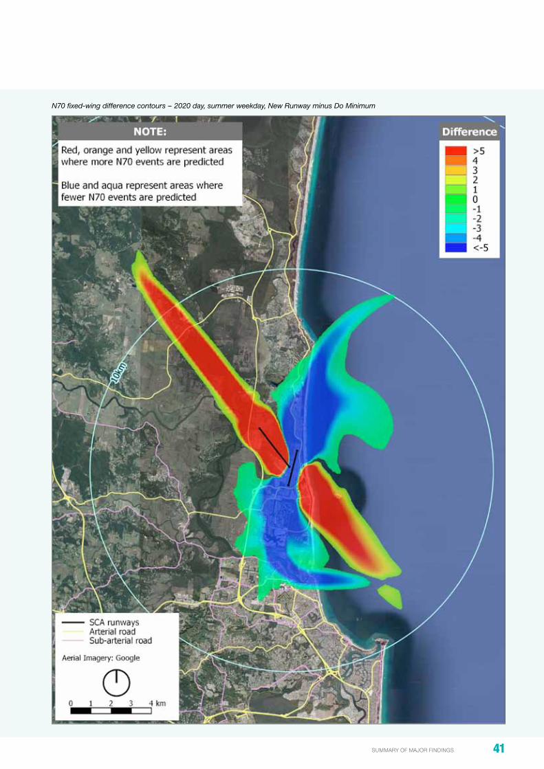
41summary of major findings
N70 fixed-wing difference contours – 2020 day, summer weekday, New Runway minus Do Minimum

42 SUNSHINE COAST AIRPORT EXPANSION PROJECT
SuMMarY oF Major FinDinGS
chaPTER SUMMaRIES
air qUality anD grEEnhoUSE gaS EmiSSionS (REFER SCA EIS: VoluME D, CHAPtER D4 – AIR QuAlItY AND GREENHouSE GAS EMISSIoNS)
Scope
to understand changes in air quality and Green house Gas (GhG) emissions resulting from the project, the eiS considered current and predicted air traffic levels in 2020, 2030 and 2040. Commercial, general aviation and helicopter traffic were all taken into account.
existing air quality conditions are understood through the Department of environment and heritage protection’s ambient air quality monitoring data and through an analysis of SCa’s and local industry operations in the area.
major findings
• SCa pollutant levels in 2040 are well below the environmental protection (air) policy air quality objectives and therefore have a minor or negligible impact on the community’s health and wellbeing and the health and biodiversity of surrounding ecosystems
• the potential impacts on air quality due to aircraft operations related to the project were considered for current and predicted air traffic levels
• the maximum significance level was found to be minor due to the 1-hour average concentration of no2
• all other pollutants were found to have a negligible potential for impact
• GhG emissions from aircraft operations are under the direct control of individual airlines and, as such, fall under the Scope 3 Carbon accounting category, however, these were assessed as part of the project.
Community facilities located within 5 km of SCA (from SCC Social Infrastructure Strategy 2011 and other sources)

43summary of major findings
Social impactS (REFER SCA EIS: VoluME D, CHAPtER D5 – SoCIAl AND VISuAl IMPACtS)
Scope
this chapter investigates the social impacts of the project to a 40 km radius of SCa. it considers the change in operating procedures and flight paths associated with the proposed new runway, including likely noise and health impacts.
major findings
• Currently, 4,428 dwellings are impacted by five or more 70 dB(a) noise events a day
• the new runway (2020) would result in more than 3,500 fewer dwellings experiencing five or more 70 dB(a) noise events, benefitting homes and businesses in suburbs including: — Buddina — Buderim — Maroochydore — Minyama — Mooloolaba — Mountain Creek — Mt Coolum — north Marcoola — pacific paradise — Sippy Downs — twin Waters — Warana — Yaroomba
(a full list of suburbs benefitting from the proposed new runway is included in Chapter D6 of the eiS)
• areas to the north and south of the existing rWY 18/36 would experience a decrease in n70 noise events
• as a result of the new runway, aircraft are likely to be seen and heard in places not previously experiencing these events. however, it should be noted that the n70 contour for operations in 2020, 2030 and 2040 extend only a short distance from the airport
• there will be increases in peak noise experienced at some locations in Mudjimba as a result of the overflight of rpt aircraft
• there are a small number of newly affected dwellings in the Yandina Creek area that would experience a small number of n70 noise events once the new runway is operational
• the project would reduce aircraft noise on identified noise-sensitive receivers located around the airport (including residences, education facilities, hospitals and health care facilities, libraries, nursing homes, churches and childcare centres)
• in 2040 there is a 73 per cent reduction (5,285 fewer dwellings) in the number of dwellings affected by frequent noise events (five or more 70 dB(a) noise events on a summer weekday day)
• in 2040 there is a 27 per cent reduction (540 fewer dwellings) in the aneF/aneC 20 or more contour
• no night flights (between 10pm and 7am) are forecast for 2020 or 2030 and only two flights between 6am and 7am are forecast for 2040
• the project is considered to have a negligible impact on the health of local communities as a result of the change in noise.
Difference between 2020 and 2040 Do minimum and 2020 New Runway N70 (five or more events) summer weekday day
SuburbDifference between 2020 Do minimum
and 2020 new runwayDifference between 2040 Do minimum
and 2040 new runway
Bli Bli 1 additional dwelling impacted 1 additional dwelling impacted
Marcoola 678 fewer dwellings impacted 713 fewer dwellings impacted
Maroochydore 1,158 fewer dwellings impacted 2,056 fewer dwellings impacted
Mt Coolum 246 fewer dwellings impacted 518 fewer dwellings impacted
Mudjimba 181 fewer dwellings impacted 114 fewer dwellings impacted
pacific paradise 475 fewer dwellings impacted 698 fewer dwellings impacted
twin Waters 788 fewer dwellings impacted 1,170 fewer dwellings impacted
Yandina Creek 8 additional dwellings impacted 26 additional dwellings impacted
Yaroomba 5 fewer dwellings impacted 43 fewer dwellings impacted
reduced impact 3,531 fewer dwellings impacted 5,312 fewer dwellings impacted
additional impact 9 additional dwellings impacted 27 additional dwellings impacted

44 SUNSHINE COAST AIRPORT EXPANSION PROJECT
SuMMarY oF Major FinDinGS
chaPTER SUMMaRIES
volUmE Eimpact SUmmary anD managEmEnt FramEWorK
ovErviEW
Volume e of the eiS includes management plans through which environmental, dredging, airspace and community aspects of the project will be managed.
Chapters within Volume e are:
• e1: introduction
• e2: Matters of national environmental Significance
• e3: environmental Management plan
• e4: Dredge Management plan
• e5: airspace Management plan
• e6: risk Management plan
• e7: Summary of Benefits, impacts, Commitments and Conclusion
the eiS management framework is summarised in the following table.
EiS management Framework
part b: airport and Surrounds
part c: Dredging and Dredge movements
part D: airspace and aircraft related noise
Environmental management plan (E3)Addressing civil construction and operational issues for: • erosion and Sediment control • acid Sulphate soils
and contaminated land management
• Vegetation management • Fauna management • Flooding and surface
hydrology • Groundwater • Water quality • air quality • noise and vibration • Waster and material
management • traffic and transport • Cultural heritage
Dredge management plan (E4)Addressing dredging and related construction issues for: • Marine water quality and
benthic ecology • Marine megafauna • tailwater management • Groundwater management • terrestrial ecology (pipeline) • navigation and maritime safety • Vessel wastewater
management • Ballast water and marine pests • Vessel waste management • Fuel management • noise and air quality • Cultural heritage
airspace management plan (E5)Addressing runway operational issues associated with: • airspace • Flight tracks • runway modes of operation • noise management measures
Risk Management Plan (E6) (whole of project-scale)

45summary of major findings
management plans and approvals
• the eMp, DMp, aMp will be implemented and complied with
• all necessary permits and approvals will be sought and complied with
• ChMp’s will be completed in a timely manner and complied with
• the WhMa will continue to be managed by SCa.
Ecology
• offsetting 4.41 ha of Mt emu she-oak on airport land
• Compensating for loss of 55 ha of broadleaved paperbark forest, heathland regional ecosystem and state listed acid frogs through rehabilitation of a site at palmview
• offsetting 1.67 ha within the WhMa
• on-site compensation of 5.84 ha for Ground parrot on airport land
• indirect offsets will involve contribution to ground parrot research
• Construction of the airside perimeter fence will be staged to ensure the ground parrot habitat (existing and proposed) is maintained at all times.
Flooding and groundwater
• Groundwater mitigation including a high quality liner and cut off wall will be provided to mitigate saline tailwater
• Site specific mitigation will be negotiated with individual property owners if warranted following additional detailed survey
• Work with Council, State and Commonwealth agencies to make sure that the impacts of the runway are recognised in a regional climate change strategy.
construction
• During dredging the booster pump will be mitigated for noise including a temporary barrier
• Finland road will be upgraded, the intersection signalised with David Low Way and used by construction traffic during daylight hours as much as possible
• Safe, convenient pedestrian and emergency vehicle access will be maintained during pipeline construction and sand delivery
• the dune will be rehabilitated once the sand delivery works are complete.
aircraft noise
• all rpt jet traffic would be on rWY 13/31 not 18/36
• the Community aviation Forum will be expanded include representatives from newly noise affected areas.
community engagement
• Commit to ongoing community engagement throughout the construction phase and into the operational phase of the new runway.
KEy commitmEntS

SUnShinE coaSt airport ExpanSion projEct Locked Bag 72 Sunshine Coast Mail Centre Qld 4560
FrEE call: 1800 210 755
Facsimile: 07 5453 1511 email: [email protected]
www.sunshinecoastairport.com.au