environmental safeguard monitoring report · this environmental safeguard monitoring report is a...
TRANSCRIPT
Environmental Safeguard Monitoring Report Rehabilitation of West Tarum Canal Package 1 January – June 2015
INO: Loan 2500-2501- Integrated Citarum Water
Resources Management Program Project 1
Prepared by Project Coordination Management Unit, Balai Besar Wilayah Sungai Citarum,
Ministry of Public Works for the Directorate General of Water Resources Ministry of Public
Works Republic of Indonesia and the Asian Development Bank.
NOTES
(i) The fiscal year (FY) of the Government of Indonesia ends on 31 December. FY before a calendar year denotes the year in which the fiscal year ends, e.g., FY2011 ends on 31 December 2011.
(ii) In this report, "$" refers to US dollars. This environmental safeguard monitoring report is a document of the borrower. The views expressed herein do not necessarily represent those of ADB's Board of Directors, Management, or staff, and may be preliminary in nature. In preparing any country program or strategy, financing any project, or by making any designation of or reference to a particular territory or geographic area in this document, the Asian Development Bank does not intend to make any judgments as to the legal or other status of any territory or area.
i
CONTENTS
Pages
I Introduction ............................................................................................................. I - 1
1.1 Background ......................................................................................................... I - 1
1.2 Objectives ........................................................................................................... I - 1
II Project Description ................................................................................................... II - 1
2.1 Executing Agencies ............................................................................................ II - 1
2.1.1 Project Proponent .................................................................................. II - 1
2.1.2 EIA Compiler .......................................................................................... II - 1
2.1.3 Contractor ................................................................................................ II - 1
2.2 General Project Features .................................................................................... II - 1
2.2.1 Overviews of WTC (Section BTB 0 – 45) .............................................. II - 1
2.2.2 Project Location of Package 1 ................................................................ II - 3
2.2.3 Phases of Activities of Package 1: .......................................................... II - 3
2.3 Project Implementation Schedule of Package 1 ................................................ II - 7
2.4 Schedule of Implementation of Environmental Management and Monitoring Plans
. ........................................................................................................................... II - 9
III Implementation of Environmental Management and Monitoring Plans ................ III - 1
3.1 Physical Works Progress .................................................................................... III - 1
3.2 Evaluation on Environmental Management and Monitoring Implementation .... III - 1
IV Conclusion ................................................................................................................ IV – 1
V Supervision Notes .................................................................................................... V – 1
ii
FIGURES
Pages
Figure 2.2.1. Location Map of WTC Rehabilitation Project ................................................... II – 4
Figure 2.2.2. Location Map of WTC Rehabilitation Project – Package 1 (1) ........................ II – 5
Figure 2.2.2. Location Map of WTC Rehabilitation Project – Package 1 (2) ........................ II – 6
Figure 2.3.1. Detail Works Schedule of Package 1 .............................................................. II – 8
Figure 2.4.1. Schedule of Environmental Management and Monitoring Implementations .. II – 9
Figure 3.1.1. Physical Progress (S Curve) in June 2015 ...................................................... III – 2
iii
APPENDICES
Appendix A:
Matrix of Environmental Management Plans (EMaP) and Implementations (EMaI) of Package 1
(January – June 2015)
Appendix B:
Matrix of Environmental Monitoring Plans (EMoP) and Implementations (EMoI) of Package 1
(January – June 2015)
Appendix C:
Appendix C1a. Sampling Location Maps
Appendix C1b. Sampling Photos
Appendix C1c. Sampling Parameters
Appendix C2. River Water Quality Test Result
Appendix C3. Groundwater Quality Test Result
Appendix C4. Sediment Quality Test Result
Appendix C5. Air Ambient Quality and Noise Test Result
Appendix C6. Vibration Test Result
Appendix C7. Plankton and Benthos Test Result
Appendix C8. The Code of Conduct in Sacna Basuki JO - Package 1
Appendix C9. Base Camp a t BTB 4a
Appendix C10. Sand Preparation
Appendix C11. Heavy Vehicles Mobilization
Appendix C12. Re Installation Water Pipes Post Dredging Works Completed
Appendix C13. Sediment Disposal
Appendix C14. Dusty Road Watering
Appendix C15. Spilled Sediment Cleaning
Appendix C16. Traffic Control and Traffic Signs Installation
Appendix C17. Sheet Piles Driving of Partition Wall at Muara Cibeet (B.Tb 22)
Appendix C18. Rehabilitation of Existing Road at B.Tb 21a - B.Tb 21
I-1
I. INTRODUCTION
1.1 Background
West Tarum Canal (WTC) is an infrastructure to drain the water from the Curug weir to irrigation service area and various water uses both domestic and industrial residing in the districts of Kab. Karawang, Kab Bekasi, Bekasi City and Jakarta. The WTC condition now presently suffering from sedimentation and polluted by wastes resulting a decrease the quantity and quality.
Based Project Preparation Report ICWRMP - Integrated Citarum Water Resources Management Project (TA 4381-INO), the WTC current carrying capacity particularly between the Curug weir – Bekasi, has decreased between 73 to 81.7% comparing the design capacity. It therefore is required a rehabilitation to restore the capacity.
The WTC rehabilitation activities planned throughout the 54.4 km with a total volume of 1,682,198 m3 dredged material. The other activities include improving the channel slope, cross drain rehabilitation, construction of new drainage channels, erection of sheet pile and installation wall parapet, the construction of a new siphon Cibeet, rehabilitation road inspection, construction of new bridges, rehabilitation of the existing bridges, construction of fences and hydro mechanical works.
The WTC rehabilitation activities are predicted to have significant impacts on the environment, so that based on Government Regulation No. 27 of 2012 on Environmental Permits, and referring to the Regulation of the Minister of Environment No. 05 of 2012 (on the type of business that must be assessed by EIA) so that the WTC rehabilitation need to be assessed by an Environmental Impact Assessment Study (EIA).
In accordance with the recommendations issued by the Government of West Java No. 660.1 / 191 / BPLHDs dated January 14, 2013 on Action Plan of Rehabilitation of WTC which states that the WTC rehabilitation activities is feasible in terms of environmental aspects on the conditions that the documents along with the Environmental Management and Monitoring Plans shall be implemented and complied with fully by the proponent for all phases of the activities, as well as it used as a reference in the further management and environmental monitoring.
1.2. Objectives of Implementation of Environmental Management and Monitoring Plans
The objective of implementation of environmental management and monitoring is to reduce or even negate the negative impacts arising from the rehabilitation of WTC. This is in accordance with the mandate contained in the EIA document of WTC Rehabilitation 2012 stating that the proponent is required to implement the Environmental Management and Monitoring Plans in all phases of activity and reported in the form of monthly progress reports to the relevant agencies.
II ‐ 1
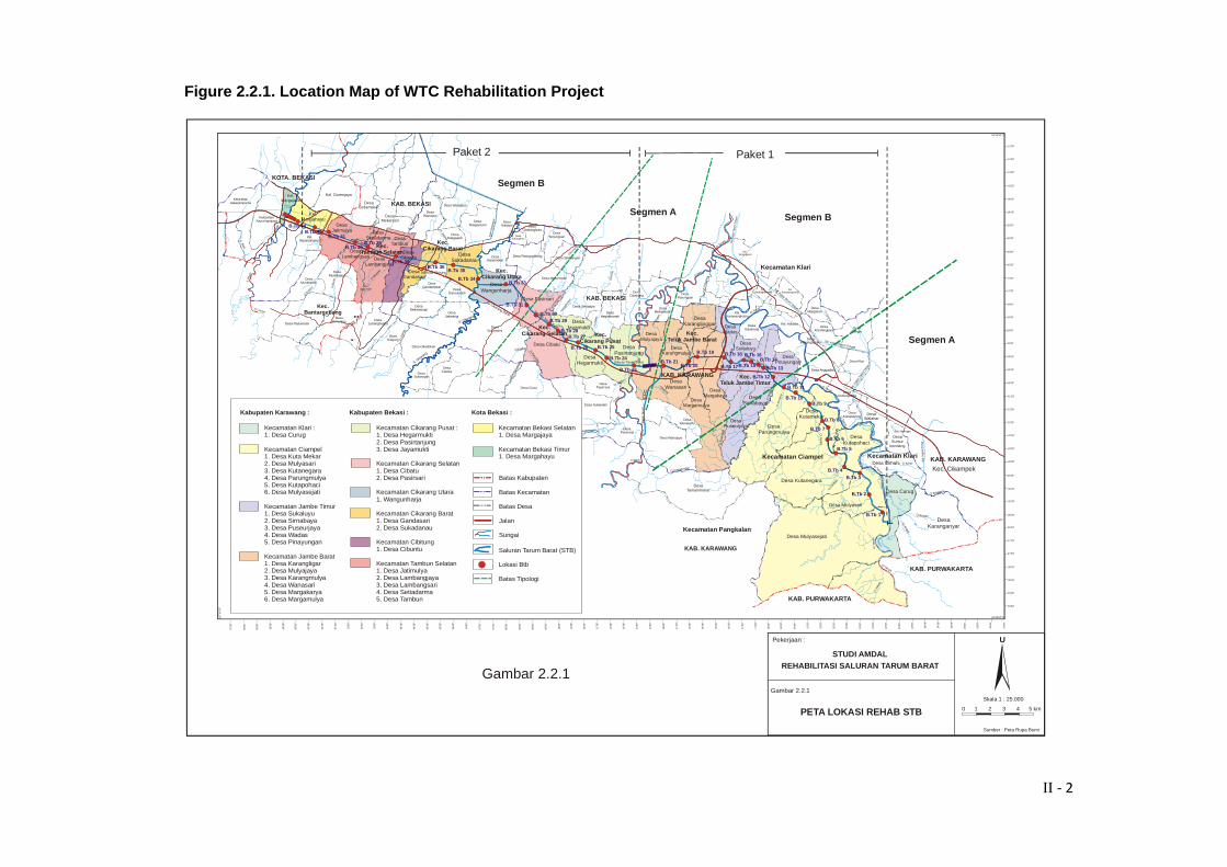
II. PROJECT DESCRIPTION 2.1. Executing Agencies 2.1.1. Project Proponent: Name : Ministry of Public Works Directorate General of Water Resources Balai Besar Wilayah Sungai Citarum Address : Jl. Inspeksi Cidurian STA 5600 Soekarno Hatta Bandung 40 292 Phone: 022-756073 2.1.2. EIA Compiler Name : PT Widya Cipta Buana Address : Jl. Venus Barat No. 15 Komplek Rukan Metro Margahayu Raya Bandung Phone: 022-7568445 2.1.3. The Contractor Name : Sacna-Basuki JO Paket-1 Address : Head office: Lina Building, Jl. HR Rasuna Said Kav B-7, Jakarta Selatan Telepon: 021-5255401 (6 Channels) Project office: Perumahan Teluk Jambe Blok H No14 Karawang 2.2. General Project Features 2.2.1. Overview of WTC (Section: BTB 0 - BTB 45) The whole of WTC rehabilitation site extends from the Curug weir to Siphon Bekasi which stretches from BTB 0 to BTB 45 (Figure 2.2.1). The technical data are as follows: Source : S Citarum Intake : hydraulic pump station at the Curug weir (17 units), the total capacity of 82.5 m3 / sec. Total channel length : 68.3 km Surface channel width : 19.3 - 56.7 m Channel base width : 9.0 to 39.5 m The slope : 1 / 3.5; 1 / 3.0; 1/2.5; and 1/20
II ‐ 2
Figure 2.2.1. Location Map of WTC Rehabilitation Project
AT
Saluran Tarum Barat
S. Cikarang
Saluran Tarum Barat
Cikadu
Cile
mah
aban
g
Ci B
eet
Ci Beet
Ci Jambe
Ci Bee
t
Ciketing
Ci Reundeu
Ci Leu
mah
aban
g
Cibeur
eum
Cipeg
adun
gan
Cib
inon
g
Ci D
ana s
Raw
a P
alal
a nga
n
Ci A
yang
K. Malang
K. Sadang
K. U
lu
Irig
asi T
aru
m
Ci Beet
Ci Pamingkis
Ci R
angg
on
Ci Tarum
Ci Tarum
Ci Pagadungan
Ci K
irinj
ing
Situ Waringin
Ci Konci
Ci Tarum
Ci Gem
bol
Ci Jam
b e
Ci Am
pel
Ci H
iang
Ci Balukbuk
Ci Beu
reum
SituCibeureum
Ci S
adan
g
K. Kambang
K. S
reng
seng
K. J
ambe
Ci B
i tung
Ci Pue
teuy
S. B
ekas
i
K. B
aru
Desa Curug
Kecamatan Klari
Desa Mulyasari
Kecamatan Ciampel
Desa Kutanegara
Desa Kutapohaci
Desa Kutamekar
Desa Parungmulya
Desa Mulyasejati
KAB. PURWAKARTA
Desa Puseurjaya
Desa Sirnabaya
Desa Pinayungan
Desa Sukaluyu
Desa Wadas
Desa Karanglinggar
Desa Margakaya
Desa Margamulya
Desa Karangmulya
Desa Wanasari
Desa Mulyajaya
Desa Pasirtanjung
Desa Cibatu
Desa Jayamukti
Desa Pasirsari
DesaWangunharja
DesaSukadanau
DesaJatimulya
DesaLambangsari Desa
Lambangjaya
DesaCibuntu
DesaTambun
DesaSetiadarma
DesaGandasari
KAB. PURWAKARTA
Sal
. Irig
asi
Tim
ur
Kec. CikampekDesa Cimahi
Ci Bungur
Desa Karanganyar
Ci T
arum
DesaSumur
kondang
DesaWalahar
Ci Tarum
Ci Tarum
Ci S
ubah
DesaTamanmekar
Kecamatan Pangkalan
KAB. KARAWANG
DesaSukaharja
DesaWarungbambu
Kec. Teluk Jambe Timur
Ci K
idan
gjat
i
DesaMekarmulya
DesaParungsari
K. K
alen
laes
Kec. Teluk Jambe Barat
Kec. Cikarang Pusat
KAB. BEKASI
Kec. Cikarang Utara
Kel. Durenjaya
DesaSetiamekar
DesaMekarsari
Sal.
Iriga
si Ta
rum T
imur
Desa Anggadita
Desa Klari
DesaKiarapayung
DesaKondangjaya
DesaBengle
Ci Lam
aran
DesaMargasari
Kel. Adiarsa
Sal. Irigasi Tarum Tengah
Sal. Irigasi Tarum Tengah
Sal
. Irig
asi T
arum
Ten
gah
Kel.Karawangkulon
Kel.Karawangwetan
Kel.Karangpawitan
Kecamatan Klari
Kel.Tanjungpura
Ci Tarum
DesaHegarmanah
DesaCipayung
Desa Wanakerta
Desa Wanajaya
DesaGandamekar
DesaDanauindah
DesaMekarwangi
DesaJatiwangi
DesaSukaresmi
DesaPasirranji
DesaPasirranji
Desa Sukamahi
Desa Cicau
Desa Cikedokan
DesaLubangbuaya
DesaTelajung
KAB. BEKASI
KOTA. BEKASI
DesaSukasejati
DesaCiantra
S. Cika
rang
DesaMustikasari
DesaMustikajaya
Kec. Bantargebang
Desa Padurenan
Ci Leungsi
S. B
e kas
i
DesaCimuning
KelurahanJakasampurna
KelurahanKayuringinjaya
Desa Setrajaya
Desa Mekarmukti
DesaTelagaasih
DesaWanasari
Desa Wanajaya
DesaTelagamurni
DesaKalijaya
DesaHarjamekar
Desa Pasirgombong Desa Simpangan
DesaKarangbaru
DesaCikarangkota
DesaTanjungsariKel.
Sepanjangjaya
Kec. Cikarang Selatan
Ci K
aran
g
KAB. KARAWANG
Kel.Margahayu
Kel.Margajaya
DesaGintungkerta
Desa Hegarmukti
Tol Cikarang Barat
Kec. Cikarang Barat
Tol Road Cibitung
0 1 2 3 4 5 km
U
Sumber : Peta Rupa Bumi
PETA LOKASI REHAB STB
22’00”
21’30”
21’00”
20’30”
20’00”
19’30”
19’00”
18’30”
18’00”
17’30”
17’00”
16’30”
16’00”
15’30”
15’00”
14’30”
14’00”
13’30”
13’00”
12’30”
12’00”
06 15’30’’SO
00’0
0”
00’3
0”
01’0
0”
01’3
0”
02’0
0”
02’3
0”
03’0
0”
03’3
0”
04’0
0”
04’3
0”
05’0
0”
05’3
0”
06’0
0”
06’3
0”
07’0
0”
07’3
0”
08’0
0”
08’3
0”
09’0
0”
09’3
0”
10’0
0”
10’3
0”
11’0
0”
11’3
0”
12’0
0”
12’3
0”
13’0
0”
13’3
0”
14’0
0”
14’3
0”
15’0
0”
15’3
0”
16’0
0”
16’3
0”
17’0
0”
17’3
0”
18’0
0”
18’3
0”
19’0
0”
19’3
0”
20’0
0”
20’3
0”
21’0
0”
21’3
0”
22’0
0”
22’3
0”
23’0
0”
23’3
0”
24’0
0”
24’3
0”
25’0
0”
25’3
0”
26’0
0”
26’3
0”
27’0
0”
107
57’0
0”O
57’3
0”
58’0
0”
58’3
0”
59’0
0”
06 30’00’’SO
29’30”
29’00”
28’30”
28’00”
27’30”
27’00”
26’30”
26’00”
25’30”
25’00”
24’30”
24’00”
23’30”
23’00”
22’30”
59’3
0”
Pekerjaan :
Gambar 2.2.1
Kecamatan Klari :1. Desa Curug
Kecamatan Ciampel1. Desa Kuta Mekar2. Desa Mulyasari3. Desa Kutanegara4. Desa Parungmulya5. Desa Kutapohaci6. Desa Mulyasejati
Kecamatan Jambe Timur1. Desa Sukaluyu2. Desa Sirnabaya3. Desa Puseurjaya4. Desa Wadas5. Desa Pinayungan
Kecamatan Jambe Barat1. Desa Karangligar2. Desa Mulyajaya3. Desa Karangmulya4. Desa Wanasari5. Desa Margakarya6. Desa Margamulya
Kabupaten Karawang :
Kecamatan Cikarang Pusat :1. Desa Hegarmukti2. Desa Pasirtanjung3. Desa Jayamukti
Kecamatan Cikarang Selatan1. Desa Cibatu2. Desa Pasirsari
Kecamatan Cikarang Utara1. Wangunharja
Kecamatan Cikarang Barat1. Desa Gandasari2. Desa Sukadanau
Kecamatan Cibitung 1. Desa Cibuntu
Kecamatan Tambun Selatan1. Desa Jatimulya 2. Desa Lambangjaya3. Desa Lambangsari4. Desa Setiadarma5. Desa Tambun
Kabupaten Bekasi :
Kecamatan Bekasi Selatan1. Desa Margajaya
Kecamatan Bekasi Timur1. Desa Margahayu
Kota Bekasi :
Batas Kabupaten
Batas Kecamatan
Batas Desa
Jalan
Sungai
Saluran Tarum Barat (STB)
Lokasi Btb
Batas Tipologi
B.Tb 1
B.Tb 2
B.Tb 3
B.Tb 4
B.Tb 5
B.Tb 6
B.Tb 7
B.Tb 8
B.Tb 9B.Tb 10
B.Tb 11
B.Tb 12
B.Tb 13
B.Tb 14B.Tb 15
B.Tb 16Saluran Tarum BaratB.Tb 17
B.Tb 18
KAB. KARAWANG
B.Tb 19
B.Tb 20B.Tb 21
B.Tb 23
B.Tb 24
B.Tb 25B.Tb 26
B.Tb 27B.Tb 28
B.Tb 29B.Tb 30
B.Tb 31
B.Tb 33B.Tb 34
B.Tb 35B.Tb 36
B.Tb 38
B.Tb 39B.Tb 40
B.Tb 41
B.Tb 44
Kec. Tambun Selatan
B.Tb 43
CFC
Segmen A
Segmen B
Segmen B
Segmen A
STUDI AMDALREHABILITASI SALURAN TARUM BARAT
Skala 1 : 25.000
Gambar 2.2.1
Paket 1Paket 2
II ‐ 3
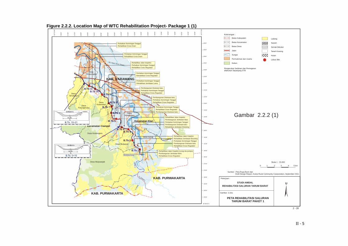
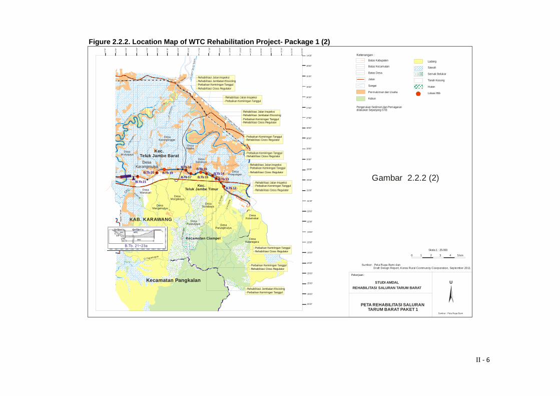
Channel base elevation : El.25,14 (Curug weir) and El. 14.13 (Siphon Panjaitan) Designed water depth : 1.7 to 3.42 m Designed discharge : 12.5 to 82.0 m3 / sec Flow rate : +/- 0.7 m / sec Road inspection width (right) : 3 m Embankment width (left) : 3 m 2.2.2. Project Location of Package 1 WTC rehabilitation activities of Package 1 originated from the Curug weir (BTB 0) to the BTB 23 (Cibeet) with a total length of 26.2 km (Figure 2.2.2. 1-2). The administrative area of rehabilitation works of WTC Package 1 includes: 4 sub districts (Kecamatan) and 18 villages (desa) in Kabupaten Karawang, namely as follows:
a) Kecamatan Klari: 1). Desa Curug
b) Kecamatan Ciampel:
1) Desa Kuta Mekar 2) Desa Mulyasari 3) Desa Kutanegara 4) Desa Parung Mulya 5) Desa Kutapohaci 6) Desa Mulya Sejati
c) Kecamatan Teluk Jambe Barat:
1) Desa Karang Ligar 2) Desa Mulya Jaya 3) Desa Karang Mulya 4) Desa Wanasari 5) Desa Margakaya 6) Desa Marga Mulya
d) Kecamatan Teluk Jambe Timur:
1) Desa Sukaluyu 2) Desa Sirnabaya 3) Desa Peuser Jaya 4) Desa Wadas 5) Desa Pinayungan
2.2.3. Phases of Activities of Package 1: The phases and types of major activities of rehabilitation work of WTC -Package 1 is as follows: A. Pre-Construction Phase: 1. Land acquisition and asset compensation; 2. Socialization of WTC rehabilitation;
II ‐ 4
B. Construction Phase: 1. Worker Recruitment; 2. Mobilization of Heavy Equipment and Materials; 3. Dredging and Sediment Transportation; 4. Improvement of Slope Embankment; 5. Construction of New Drainage Channel; 6. Rehabilitation Cross Drain; 7. Sheet Piles Installation; 8. Construction of Siphon Cibeet; 9. Inspection Road Rehabilitation; 10. Construction of New Bridge; 11. Rehabilitation of Old Bridge; 12. Rehabilitation of cross drain regulator; 13. Fence construction along the channel; 14. Hydro mechanical works; 15. Demobilization of worker; 16. Demobilization of Heavy Equipment. C. Post-Construction Phase: 1. Operation and Maintenance;
II ‐ 5
Figure 2.2.2. Location Map of WTC Rehabilitation Project- Package 1 (1)
S. Citarum
Ci K
irinj
ing
Situ Waringin
Ci Konci
S. Citarum
Ci Gem
bol
Ci A
mpel
Ci H
iang
Ci BalukbukDesa Curug
Kecamatan Klari
Desa Mulyasari
Kecamatan Ciampel
Desa Kutanegara
Desa Parungmulya
Desa Mulyasejati
KAB. PURWAKARTA
Desa Pinayungan
KAB. PURWAKARTA
Sa l
. Irig
asi T
imu
r
Ci Bungur
Ci T
arum
S. Citarum
Ci Tarum
Ci S
ubah
Sal.
Iriga
si T
arum
Tim
ur
B.Tb 1
B.Tb 2
B.Tb 3B.Tb 4
B.Tb 5
Desa Kutapohaci
Desa Kutamekar
B.Tb 7
B.Tb 9B.Tb 10
B.Tb 11
22’00”
21’30”
21’00”
20’30”
20’00”
19’30”
19’00”
18’30”
18’00”
18’0
0”
18’3
0”
19’0
0”
19’3
0”
20’0
0”
20’3
0”
21’
00”
21’3
0”
22’0
0”
22’3
0”
23’0
0”
23’3
0”
24’0
0”
24’3
0”
25’0
0”
25’3
0”
26’0
0”
26’3
0”
06 30’00’’SO
29’30”
29’00”
28’30”
28’00”
27’30”
27’00”
26’30”
26’00”
25’30”
25’00”
24’30”
23’30”
23’00”
22’30”
KAB. KARAWANG
Desa Sirnabaya
24’00”
16’3
0”
17’0
0”
17’3
0”
107
16’
00”
O
107
27’
00”
O
0 1 2 3 4 5 km
Ci Ja m
be
Bendung Curug
- Perbaikan Kemiringan Tanggul-
Rehabilitasi Cross DrainCi Lam
aran
- Perbaikan Kemiringan Tanggul
-
Rehabilitasi Cross Drain
- Rehabilitas Jalan Inspeksi
- Perbaikan Kemiringan Tanggul- Rehabilitas Cross Regulator
Sal. Irigasi Tarum Tengah
- Perbaikan Kemiringan Tanggul
-
Rehabilitasi Cross Regulator
- Perbaikan Kemiringan Tanggul
-
Rehabilitasi Jembatan Lama
B.Tb 8
- Pembangunan Drainase baru
-
Perbaikan Kemiringan Tanggul- Rehabilitasi Cross Regulator
B.Tb 6
- Pembangunan Drainase baru
-
Perbaikan Kemiringan Tanggul- Rehabilitasi Cross Regulator
-
- Rehabilitasi Cross Regulator- Pembangunan Drainase baru
Perbaikan Kemiringan Tanggul
- Rehabilitasi Jalan Inspeksi
- Pembangunan Jembatan Baru
-
Perbaikan Kemiringan Tanggul- Pembangunan Drainase baru
- Rehabilitasi Jembatan Eksisting
- Rehabilitasi Jalan Inspeksi
- -
Rehabilitasi Jembatan EksistingPerbaikan Kemiringan Tanggul
- Pembangunan Drainase baru- Rehabilitasi Cross Regulator
- Rehabilitasi Jalan Inspeksi (curug-sta pompa)- Pembangunan Jembatan Baru
- Rehabilitasi Cross Regulator
Batas Kabupaten
Batas Kecamatan
Batas Desa
Jalan
Sungai
Permukiman dan Usaha
Kebun
Keterangan :
Ladang
Sawah
Semak Belukar
Tanah Kosong
Hutan
Lokasi Btb
PETA REHABILITASI SALURAN TARUM BARAT PAKET 1
U
Pekerjaan :
Gambar 2.10a
Pengerukan Sedimen dan Pemagarandilakukan Sepanjang STB
STUDI AMDALREHABILITASI SALURAN TARUM BARAT
B.Tb 1
B.Tb. 0~10
B.Tb. 10~21
Skala 1 : 25.000
Sumber : Peta Rupa Bumi dan Draft Design Report, Korea Rural Community Coorporation, September 2011
2 - 28
Gambar 2.2.2 (1)
II ‐ 6
Figure 2.2.2. Location Map of WTC Rehabilitation Project- Package 1 (2)
Ci B
eet
Ci Beet
Ciketing
Irig
asi T
arum
Ci R
angg
onCi Tarum
Ci Pagadungan
Ci K
i rin
jing
Desa Parungmulya
Desa Puseurjaya
Desa Sirnabaya
Desa Pinayungan
Desa Sukaluyu
Desa Wadas
Desa Karanglinggar
Desa Margakaya
Desa Margamulya
Desa Karangmulya
Desa Wanasari
Desa Mulyajaya
Ci S
uba
h
Kecamatan Pangkalan
Kec. Teluk Jambe Timur
Ci K
idan
gja
ti
K. K
alen
laes
Kec. Teluk Jambe Barat
Sal. Iri gas i Tarum Tengah
Sa
l. Ir
iga
si T
aru
m T
en
ga
h
Ci Taru
m
KAB. KARAWANG
B.Tb 14B.Tb 15
B.Tb 16
B.Tb 17
B.Tb 18
B.Tb 19B.Tb 20
B.Tb 21
13
’30
”
14
’00
”
14
’30
”
15
’00
”
15
’30
”
16
’00
”
16
’30
”
17
’00
”
17
’30
”
18
’00
”
18
’30
”
19
’00
”
21’30”
21’00”
20’30”
20’00”
19’30”
19’00”
18’30”
18’00”
17’30”
17’00”
16’30”
16’00”
15’30”
15’00”
14’30”
26’30”
26’00”
25’30”
25’00”
24’30”
24’00”
23’30”
23’00”
22’30”
Kecamatan Ciampel Desa Kutanegara
Desa Kutamekar
22’00”
19
’30
”
20
’00
”
20
’30
”
21
’00
”
21
’30
”
22
’00
”
12
’30
”
12
’00
”
U
Sumber : Peta Rupa Bumi
Pekerjaan :
Batas Kabupaten
Batas Kecamatan
Batas Desa
Jalan
Sungai
Permukiman dan Usaha
Kebun
Keterangan :
Ladang
Sawah
Semak Belukar
Tanah Kosong
Hutan
Lokasi Btb
Pengerukan Sedimen dan Pemagarandilakukan Sepanjang STB
- Rehabilitasi Jalan Inspeksi- Rehabilitasi Jembatan Eksisting- Perbaikan Kemiringan Tanggul- Rehabilitasi Cross Regulator
- Rehabilitasi Jalan Inspeksi- Perbaikan Kemiringan Tanggul
- Rehabilitasi Jalan Inspeksi- Rehabilitasi Jembatan Eksisting- Perbaikan Kemiringan Tanggul- Rehabilitasi Cross Regulator
- Perbaikan Kemiringan Tanggul- Rehabilitasi Cross Regulator
- Perbaikan Kemiringan Tanggul- Rehabilitasi Cross Regulator
- - Perbaikan Kemiringan Tanggul
-
Rehabilitasi Jalan Inspeksi
Rehabilitasi Cross Regulator
- - Perbaikan Kemiringan TanggulRehabilitasi Jembatan Eksisting
- - Perbaikan Kemiringan Tanggul
-
Rehabilitasi Jalan Inspeksi
Rehabilitasi Cross Regulator
- Perbaikan Kemiringan Tanggul- Rehabilitasi Cross Regulator
Saluran Tarum Barat
- Perbaikan Kemiringan Tanggul- Rehabilitasi Cross Regulator
B.Tb 13
B.Tb 12
STUDI AMDAL
REHABILITASI SALURAN TARUM BARAT
CFC
B.Tb. 21~23a
PETA REHABILITASI SALURAN TARUM BARAT PAKET 1
0 1 2 3 4 5 km
Skala 1 : 25.000
Sumber : Peta Rupa Bumi dan Draft Design Report, Korea Rural Community Coorporat ion, September 2011
Gambar 2.2.2 (2)
II ‐ 7
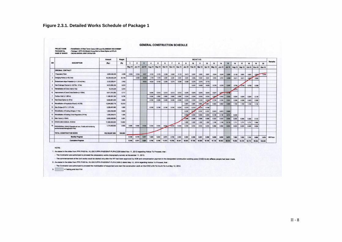
2.3. Project Implementation Schedule of Package 1 Implementation of WTC rehabilitation activities of Package 1 will last for 20 calendar months. The detailed implementation schedule of Package 1 is presented in Figure 2.3.1.
II ‐ 8
Figure 2.3.1. Detailed Works Schedule of Package 1
II ‐ 9
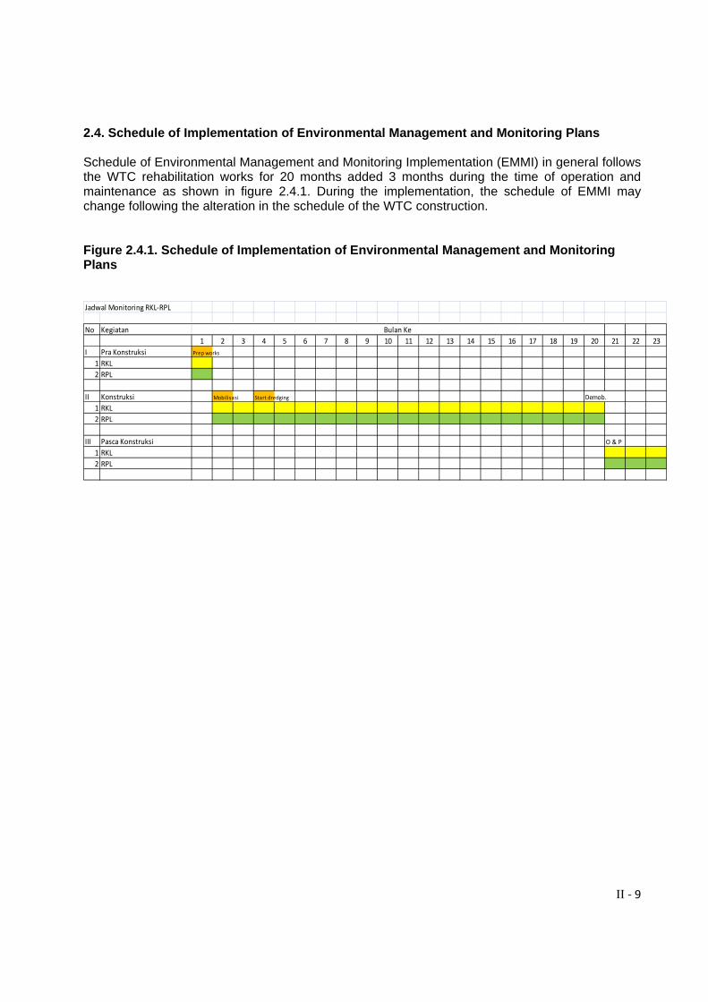
2.4. Schedule of Implementation of Environmental Management and Monitoring Plans Schedule of Environmental Management and Monitoring Implementation (EMMI) in general follows the WTC rehabilitation works for 20 months added 3 months during the time of operation and maintenance as shown in figure 2.4.1. During the implementation, the schedule of EMMI may change following the alteration in the schedule of the WTC construction. Figure 2.4.1. Schedule of Implementation of Environmental Management and Monitoring Plans Jadwal Monitoring RKL‐RPL
No Kegiatan
1 2 3 4 5 6 7 8 9 10 11 12 13 14 15 16 17 18 19 20 21 22 23
I Pra Konstruksi Prep works
1 RKL
2 RPL
II Konstruksi Mobilisasi Start dredging Demob.
1 RKL
2 RPL
III Pasca Konstruksi O & P1 RKL
2 RPL
Bulan Ke
III ‐ 1
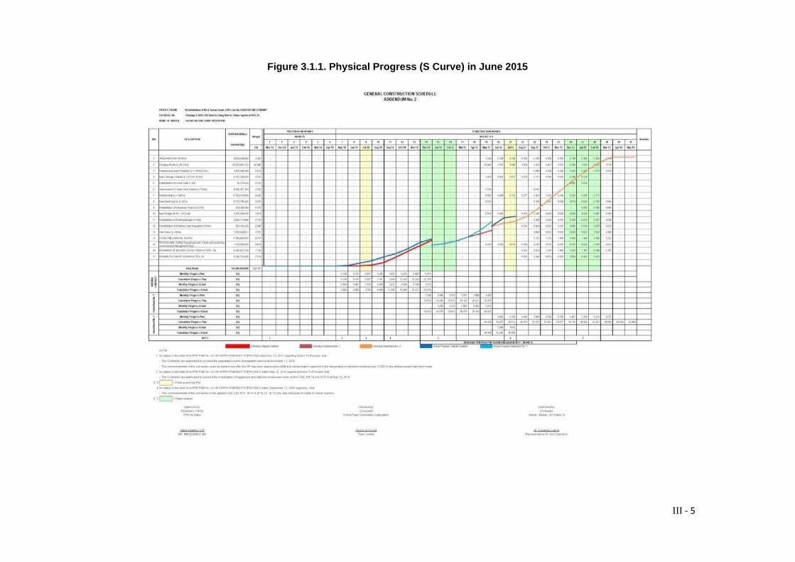
III. IMPLEMENTATION OF ENVIRONMENTAL MANAGEMENT AND MONITORING PLANS 3.1. Physical Works Progress Period : January – June 2015 Sections : BTB : 0 – 10; 19d – 19f; 21 – 21a; 23 – 23 a. Cumulative Works Progress : 43,445% (see Figure 3.1.1.) (Incl. Addendum 2) Major works have been carried out during the month of January to June 2015 is as follows:
1. Dredging works: BTB: 0 – 10; 19d – 19f; 21 – 21a; 23 – 23 a. 2. Sheet Pile Installation: partition wall at Muara Cibeet (BTB 23a -23); CCSP retaining wall
(BTB 23a); Siphon protection wall at B.TB 23a. 3. CCSP Demolition and Concrete works: caping beam at BTB 23a; New bridge at B.TB 1
and B.TB 3b; 3.2. Evaluation on Environmental Management and Monitoring Implementation (EMMI) EMMI is separated into three phases respectively Pre-Construction Phase, Construction Phase and Post-Construction Phase. The EMMI are monthly recorded in matrix forms while the six monthly EMMI are summarized from the monthly records and presented respectively in Appendix A for the environmental management and Appendix B for the environmental monitoring one. Data supported on EMMI of each activity is presented in the form of photos, data laboratory analysis and documents or informations presented respectively in Appendix C. A. Pre-Construction Phase a. Source of Impact / Activities: Compensation of Assets Predicted Impact: Anxiety due to job loss Environmental Management: Socialization had been completely done during pre construction works on May 26, 2014 at Kecamatan Ciampel Office, Karawang. There was no any environmental management action regarding this impact. Further action is to establish coordination with each related desas prior to execute the works. b. Source of Impact / Activity: Plan of the WTC Rehabilitation Predicted Impact: The environmental potential impacts of physical, chemical and biological Environmental Management:
III ‐ 2
First observation on the initial environmental conditions that has been carried out in the pre-construction phase is continued periodically during 6 months within the construction phase. This second sampling is intended to monitor the environmental impacts after the rehabilitation works of Package 1 has lasted for 12 months. Sampling was conducted at three points, namely the Curug weir (BTB 1), Pinayungan/Peruri (BTB 11) and Cibeet (BTB 23) on 15 – 16 January 2015 (Appendix C1 a – c). The parameters observed are as follows: 1. Water Quality: surface water of WTC (21 Parameters / Class II) and ground water (wells) near the disposal area (24 parameters); 2. Quality of sediment (7 parameters: As, Cd, Cr, Hg, Pb, Zn, Ba); 3. Air Quality Ambient (5 parameters: SO2, NOx, TSP, Co, Pb); 4. Noise; 5. Vibration Sampling and analysis conducted by an accredited laboratory of PT Bina Lab, Bandung, which is the same lab who has carried out of EIA of WTC in 2012. Environmental Monitoring Results of laboratory analysis are as follows: Results of water quality analysis on 21 parameters showed that in general the water quality at the point of sampling WTC Curug, Peruri, and Cibeet still meet the quality standard of Class II according to Regulation No. 82/2001. However, there are some parameters that indicate the value exceeds the threshold of class II, namely oil and grease at points of Curug / A2 and Cibeet / A4, respectively 2.70 mg / l and 5.75 mg / l (Quality Standard of Class II: 1 mg / l). Phenol at point of Cibeet showed value 0.10 figures mg / l which exceeded the quality standard of Class II: 0.001mg / l. Furthermore, phosphate demonstrates the value exceeded the quality standard of Class II (BM: 0.2 mg / l) in all observation points with the value respectively 0:51 mg / l (Curug), 0:50 mg / l (Peruri) and 0.60 mg / l (Cibeet). The pollutant source is estimated from domestic waste (toilet waste / soaps) and agriculture (phosphate fertilizer) (Appendix C2). 2. The quality of ground water (well water) Ground water samples were taken from wells pump at Curug village around 300-400 m away from the disposal area. The pump is actively used for dayly purposes including drinking water sources. No any well water samples can be collected from other points due to there is no wells or groundwater sources found. Total parameters analyzed are 22 consisting of 6 physical parameters and 16 chemical parameters. The bacteriological parameters analysis failed because of damage to the sample. The analysis shows that the well water is fit to use as a source of clean water according to the Permenkes No. 416 / Menkes / Per / IX / 1990 concerning water quality requirements (Appendix C3). 3. Quality of sediments Result of analysis shows that the sediment quality meets the quality standards according to the Decree of the Head BAPEDAL No 3 / BAPEDAL / 09/95 on the TCLP quality standards
III ‐ 3
(Appendix C4). This shows that there is no any excessive accumulation of heavy metals in the river sediment. 4. The ambient air quality and noise Results of analysis of the 5 parameters of the air quality ambient (SO2, NO2, TSP, CO and Pb) in the three sampling sites, waterfall, Peruri / Pinayungan and Cibeet shows that all parameters still below the quality standards required by Regulation No. 41 of 1999 on Ambent air quality. Similarly, the noise level indicates the value 58.05 dba that below the quality standards according to the quality standard of 70 dba noise LH Decree No. Kep.48 / MENLH / VI / 1996 (Appendix C5). 5. Vibration Results of analysis of vibrations that occur at three locations Curug (0.32mm / sec), Peruri / Pinayungan (0.42 mm / sec) and Cibeet 0:18 mm / sec) shows that the vibration levels are below the threshold levels (<2 mm / sec) according to regulation of Kepmen LH No. Kep.49 / MNLH / XI / 1996 - Appendix II: Category A (Appendix C6). At the time of testing there was no sheet piling works at the location. 6. Plankton and Benthos Sampling of plankton and benthos parameters performed at three points, namely the Curug, Peruri / Pinayungan and Cibeet. However, due to the damage of the sample at the point Peruri / Pinayungan, then the evaluation carried out only at the point of the Curug and Cibeet only. The analysis shows that the condition of plankton (phytoplankton and zooplankton) has Diversivity index (H ') of the Shannon and Wiener, respectively 1,741 and 1,392 which means it categorized as moderate diversity. While the Simpson dominance index (D) has a value of 0793 and 0600 for respectively at Curug and Cibeet points. This indicated that the dominance of species categorized into moderate (Appendix C7a). Result of benthos analysis indicated that the diversity index of Shannon and Wiener (H ') is in the low category for both of sampling points with the value respectively 0.393 (Curug) and 0.56 (Cibeet). Instead, the results of Simpson dominance index (D) shows a high value for both locations where the dominance species at Curug site is Terebia sp and Melanoides at Cibeet (Appendix C7b). B. Construction Phase a. Source of Impact / Activity: Labor Mobilization Predicted Impacts: 1) Employment opportunities and income generation 2) Anxiety due to fail working on the project Environmental Management: Local manpower recruitment for various positions follows to the needs of project. Local people is firstly prioritized. Recruitment can be directly by project or collaborating with groups of local community groups (such as Karang Taruna (Youth Groups and local NGOs) to carry out certain
III ‐ 4
tasks (such as: security, cleaning spills mud, watering, traffic control). Indirectly, the sub contractors can also recruited local people around the project sites. Environmental Monitoring:
Before the project performing, first recruitment of local workers as: 44 people and 3 pieces of a memorandum of understanding with a NGO in Mulyasari and 2 NGOs / community groups in Mulyasejati. Until June 2015 there is no any addition of the local workforce. The last addition of local labor occurred in November / December 2014, namely 40 people consisting of direct recruitment by project: 20 people and indirectly recruited by sub contractor: 20 people. The monitoring indicates that there were no any complaints from residents because fail to work on the project. Recruitment of local workforce brings positive impact to the increase income of local people.
III ‐ 5
Figure 3.1.1. Physical Progress (S Curve) in June 2015
III ‐ 6
b. Source of Impact / Activity: Operational of Base Camp The operation of the base camp is categorized a routine dayly activity. Occupants in the base camp amounted to only 15-20 people. Infact the base camp is usually used as a place of rest and to store project materials. There is only steel works activity. Therefore, the operation of base camp impacts assumed minimal (not significant). Predicted Impacts: 1. Safety and environment; 2. Conflict between labours; 3. Solid waste and toilet waste; Environmental Management: 1. Safety and environment To ensure the safety of the workers who do the work at the base camp activities required to comply with company/project order that refers to the safety procedure (K3) such as the use of helmet, boots, gloves, etc. according to the type of work. In addition, employees must maintain the environment and are prohibited from activities that can pollute the environment. In addition, the company provides insurance of Jamsostek to protect the employees. (Appendix C8). 2. Conflict between labors Workers who living in the base camp is obliged to obey the project/company order mainly for mutual respect, tolerance, and cooperative with each other. Base camp dwellers are not allowed to use drugs and alcohol as well as activities that disrupt public order. 3. Solid and toilet wastes To maintain the environmental, the base camp is facilitated by 6 units of toilet- bathrooms sanitized with septic tanks. The solid waste is contained in the 4 units of garbage bins (vol. 70 L / unit) as well as the land hole 1 x 1.5 x 1 m3 for stockpiling garbage (Appendix C9). Burning is done regularly to avoid accumulation of garbage. 4. Spilled diesel / fuels Preparation of the sand heap for initial countermeasures on spilled fuel and lubricants against risk of fire or environmental contamination (Appendix C10). It also provided a small fire extinguisher to preliminary against fire. Environmental Monitoring: 1. Safety and environment; The monitoring result showns that the accidents do not occur particularly in the base camp area. Also, there is no any pollution taking place the environment. The insurance of Jamsotek has been provided to cover the employees. 2. Conflict between labors
III ‐ 7
The relationship between workers in the base camp managed well. 3. Solid and toilet wastes Sanitation system functions well. So far there is not found an excessive solid and toilet wastes polluted the area. 4. Spilled diesel / fuels In case of spilled fuel (diesel) has been covered by sand to avoid fires and reduce pollution into the soil. c. Source of Impact / Activity: Mobilization of Heavy Vehicles Prediction Impact: 1. Declining in air quality; 2. Noise; 3. Disruption of traffic flows; 4. Damage to roads; 5. Traffic accidents. Environmental Management: Heavy equipments were mobilized to the site gradually according to the needs of the project. Mobilization of heavy equipment such as excavators, bulldozers and cranes by trailer transport that also carrying out a traffic management to avoid traffic congestion (Appendix C11). Mobilization of heavy equipment is temporary so that environmental impacts, such as noise, air pollution, congestion and accident as well as road damages is assumed minimal. Environmental Monitoring: The traffic was managed well during heavy vehicles mobilization, so there was no any congestion found seriuously. Air pollution and noise also assumed minimal with no any complaints indicated from local residents. Total number of heavy equipment mobilized up to December 2014 as follows: 1. Excavator Standard : 4 units, 2. Excavator long arm : 2 units, 3. Dump truck (5 m3) : 49 units, 4. Bulldozer : 1 unit, 5. Phonton : 6 units, 6. Piling Crane : 2 unit, Mobilization of heavy equipment from BTB to other BTB taken place in short distance but a traffic arrangement has been made to avoid both of congestions and accidents. Another mobilization was transportation of regular sheet piles which were transported at night time to avoid traffic jams.
III ‐ 8
d. Source of Impact / Activity: Dredging Works and Temporary Sediment Storage Predicted Impacts: 1. Increased turbidity; 2. Anxiety of water users due to increased turbidity; 3. Disruption of public access to the water of WTC; 4. Piles of solid wastes (sludge and garbages). Environmental Management: 1. Increased turbidity Firstly in August 2014, silt curtain was installed to reduce turbidity caused by the dredging works. However, the installation of silt curtain was complained by field officers of PJT2 because it impedes the flow and leads to accumulation of water hyacinth. Reinstallation of the silt curtain in October 2015 was done but not useful due to be again protested and removed by PJT2 officer. After several reinstallation silt curtain always raised a conflict with PJT2 field officers, it finally was decided to cancel using silt curtain in reducing turbidity. Also, decreasing high turbiditiy by silt curtain is considered not so significant. Finally, the using of silt curtain was discontinued. This issue was already reported to the supervising consultant and has been officially reported to the project manager (BBWSC). 2. Anxiety of water users due to increased turbidity; In general, socialization regarding excavation works in the WTC has been submitted to the community and local authorities as well as the companies of water users. They realized to the impact of increasing in turbidity. Before excavation works perform in certain segments, the contractor coordinated with local authorities and local communities. The people do not use the WTC water when dredging works by disconnecting the pipe, and set it back after the water becomes clear again after the dredging is completed. So far there was no any complaint yet from the water users (PAM/PDAM) related to turbidity occured. 3. Disruption of public access to the WTC water People has been aware that water uptaking from WTC will be terminated during the excavation. The people living surrounding the dredging points will take their pipes out from the river during dredging works, and reinstalling them when the dredging completed (Appendix C12). They will store the water prior to the dredging works started for bathing and toilet uses. Or they will collect the water from their neighbor who still having acces to the WTC water or those have ground water pumping (shaloow well). While, their drinking water met from purchasing refill water. 4. Piles of solid wastes (sludge and garbages) The sediment placed at the the riverbank as temporary shelters which also functioning for dewatering process before dumped to the disposal area. No much garbage included in the dredged material but only water hyacinths which will discharge it together with the sediment to disposal area (Appendix C13).
III ‐ 9
Environmental Monitoring: 1. Increased turbidity The use of silt curtain is considered to be not useful for reducing turbidity, although no any complaints from local people. The silt curtain installation has also raised technical problem with the flow maintenance. In addition, the people do not use WTC water during a dredging time, but will reinstall the pipes when dredging has been terminated. The turbidity will be soon reduced when dredging stopped.
2. Anxiety of water users due to increased turbidity; There was any no complaint yet from the water users (PAM/PDAM) related to turbidity occured. The people have been realized that the dredging work will interrupt them taking the WTC water. 3. Disruption of public access to the WTC water The people will disconnect the pipes when dredging works taking place. They will reinstall it after the water becomes clear after the dredging is completed. Daily water needs for bathing - toilets fulfilled by storing the water prior to the dredging works perform or joint with the neighbors who having shallow well/groundwater pumping. The clean water for cooking and drinking are usually gained by buying from refill water shops. 4. Piles of solid wastes (sludge and garbages) There was no any pile of solid wastes (sediments and garbages) in the temporary shelters that causing uncomfort environment. The dredged materials can be managed well to transport to disposal area. e. Source of Impact / Activity: Sediment Transport to Disposal Area Predicted Impacts: 1. Decline in air quality due to dust pollution (dried sediment); 2. Decrease aesthetics because of sediment spills; 3. Noise due to the passing sediments trucks; 4. Disruption of traffic flow (jammed). 5. Damage to roads and bridges; 6. Health problems (dust allergy) Environmental Management: 1. Decline in air quality due to dust pollution
Watering has been applied to the roads that are not asphalt paved to avoid dust pollution when passed by trucks carrying sediment. Watering is usually done 1 time per day if there is no any rain, depending on drying conditions. Usually, sediment is transported to the disposal area still under moist conditions and carried well so that the sediment does not scatter in the way which potentially generating dust when it is dried. In some cases if the sediment scattered in the way it, then, was cleaned up by water spraying (Appendix C 14).
III ‐ 10
2. Decrease aesthetics because sediment spills
The sediment is transported following the truck capacity (5M3) to avoid sediment spill on the way that leads to uncomfort aesthetics. The spilled sediment, if any, was clean up by water spraying. If necessary, the sediment is transported by plastic bags (Appendix C15). 3. Noise due to the passing dump trucks
The operation of the dump trucks is about 8 -10 hours from at 8.00 -17.00 with carrying frequency: 20 - 25 times/day/truck (depends on the distance between dredging point and disposal area) so that interference of noise assuming not significant. Up to June 2015, total dump truck operated: 49 units. 4. Disorders traffic flow (jammed)
Traffic control during transport of sediment was applied to control traffic flow, especially in the narrow streets and crowded. Traffic and project signs have been installed to give alert the drivers (Appendix C16). 5. Damage to roads and bridges
The medium dump truck capacity of 5 M3 (equivalent with 8 tons max) was selected to follow to the existing road and bridge class of III A. The damaged existing roads have been repaired in order to transport the sediment to the disposal area well. The operation of dump trcuks has been limited by operation hours at 8.00 – 17.00 with frequency about 20 – 25 times/day/truck. The contractor will be responsible for the damaged infrastructures affected by sediment transportation. 6. Health problems (dust allergy)
To avoid health problems because of dust pollution, the dust has been minimized by watering the roads during transporting to disposal area particularly along the unpaved roads. The spilled sediments have been also clean up by water spraying. Environmental Monitoring: 1. The decline in air quality due to dust pollution
Transporting the sediment is adequately managed so that there is no any significant spilled sediment scattered on the roads that lead to dust when dried. Watering performed routine on unpaved asphalt and dusty roads when the day is quite dry. 2. Decrease aesthetics because sediment spills Sediment transportation is managed well to avoid aesthetics nuisances (if necessary using plastic bags) so spills on the road is assuming minimal. 3. Noise due to the passing trucks sediment.
III ‐ 11
Limitation in trucks operation hours: 8 – 10 hours from 8.00 – 17.00 with carrying frequency: 20 – 25 times/day/truck. The operation of dump trucks does not generate noise that disturbing the people (No any noise complaints from people). 4. Disruption of traffic flow (jammed). Traffic jam have been minimized by traffic operators to control the traffics during sediment transportation, in particular along the crowded roads. Project signs installed to give alert the drivers. 5. Damage to roads and bridges. The medium dump trucks with capacity of 5 M3 (8 tons max) have been selected to carry sediment following the existing road and bridge class of IIIA. No any roads/bridges damages found because of sediment transportation. 6. Health problems (dust allergy) Dust has been minimized by watering roads. Transport sediment is adequately managed to control the sediment scattered during transporting to disposal area. f. Cibeet Siphon Construction There has been no activity g. Sheet pile erection and parapet development Predictied Impacts: 1. Noise 2. Impaired vibration 3. Water pollution/turbidity Environmental Management: Coordinations with officials and local residents has been carried out to inform annoyances regarding noise and vibration. Contractor will monitor the effects when sheet pile erecting. When the vibrations occured too high and it has caused some damages, then, the erection will be terminated. If the damages occurred, it will be repaired by the contractor. While the sheet piles erection for both slope protection and bridge foundation have not caused increasing turbidity. Environmental Monitoring: The erection carried out safely without any significant nuisances such as noise and impaired vibration to the local resident. In addition, the houses around the right side of WTC are mostly semi-permanent buildings which are relatively resistant to vibration effects. The erection impact on turbidity is considered very minimal.
III ‐ 12
h. Inspection Roads Rehabilitions
Environmental Management: No specific management to cope with traffic disruption because of road rehabilitation at BTB 21a -21 BTB is due to a macadam road that not used by public. Rehabilitation has been done by overlaying of limestones and corals. Environmental Monitoring: There was no any traffic disturbance because the road is not passed by public transport, except for the locals. i. Fence construction There has been no activity. j. Operation and Maintenance (permanent fencing and water uptake ban STB) There has been no activity.
IV‐1
IV. CONCLUSSIONS
Based on the results of the implementation of management and monitoring in January - June 2015 it can be concluded as follows:
Major works have been carried out during the month of January to June 2015 is as follows: 1. Dredging works: BTB: 0 – 10; 19d – 19f; 21 – 21a; 23 – 23 a. 2. Sheet Pile Installation: partition wall at Muara Cibeet (BTB 23a -23); CCSP retaining
wall (BTB 23a); Siphon protection wall at B.TB 23a. 3. CCSP Demolition and Concrete works: caping beam at BTB 23a; New bridge at
B.TB 1 and B.TB 3b;
The silt curtain no longer used to reduce turbidity due to not effective. Furthermore, there is no specific management related to the impact of water turbidity due to excavation works. There has been no any complaints indicated from water users/local people related to turbidity;
Traffic management is always applied when transporting sediment and mobilization of heavy vehicles to avoid congestion and traffic accidents;
Transportation of sediment runs well which not causing sludge spills that can ruin the
aesthetics of street and causing dust when dried;
In case of spills mud on the road then do the cleaning by water spraying. Watering is also performed on the damaged road (unpaved) and potentially dust if there is no rain;
Piles erection in Muara Cibeet at B.Tb 23a did not result in vibration and noise that
annoying surrounding people. The density of buildings around the site is low and generally semi-permanent type.
V‐1
V. SUPERVISION NOTES
Environmental issues that need to be followed up by the contractor, as follows:
1. Monitoring the impact of vibrations of houses around due to the piles erection; Recommendation:
Monitoring the impact of vibration on houses when erection; Improvements returned if found damage
Action:
Monitoring the impact of vibration on houses around have been done. There were not reveal any damages.
2. Monitoring the availability of alternative water sources (groundwater) along the project site; Recommendation:
Conduct observations for alternative water sources (groundwater) along the project site (WTC);
Action:
It has been observed and found several alternative water sources (groundwater pumping) along the project site (WTC) that used by local people.
3. Cleaning spills mud. Recommendation:
Clean up the spilled sludge in places in particular where the sludge directly transported (without dewatering);
Action:
Clean up the spilled sludge by spraying water.
Appendix A
Matrix of Environmental Management Plans (EMaP) and Implementations (EMaI) of Package 1 (January – June 2015)
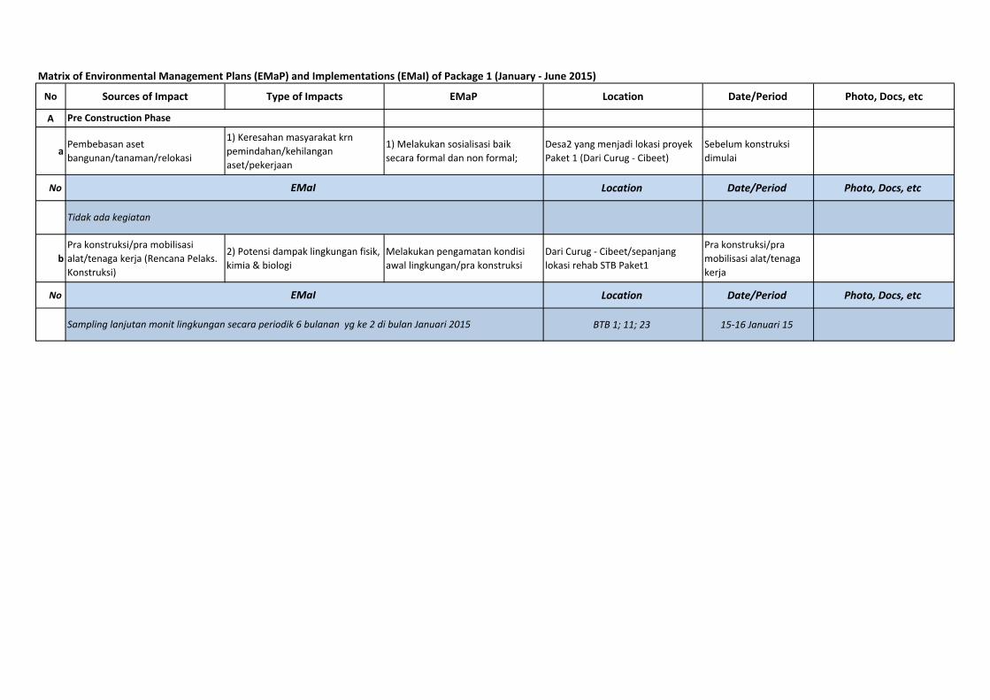
Matrix of Environmental Management Plans (EMaP) and Implementations (EMaI) of Package 1 (January ‐ June 2015)
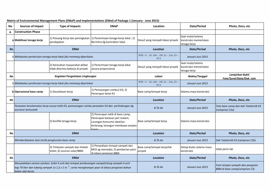
No Sources of Impact Type of Impacts EMaP Location Date/Period Photo, Docs, etc
A
aPembebasan aset bangunan/tanaman/relokasi
1) Keresahan masyarakat krn pemindahan/kehilangan aset/pekerjaan
1) Melakukan sosialisasi baik secara formal dan non formal;
Desa2 yang menjadi lokasi proyek Paket 1 (Dari Curug ‐ Cibeet)
Sebelum konstruksi dimulai
No Location Date/Period Photo, Docs, etc
b
Pra konstruksi/pra mobilisasi alat/tenaga kerja (Rencana Pelaks. Konstruksi)
2) Potensi dampak lingkungan fisik, kimia & biologi
Melakukan pengamatan kondisi awal lingkungan/pra konstruksi
Dari Curug ‐ Cibeet/sepanjang lokasi rehab STB Paket1
Pra konstruksi/pra mobilisasi alat/tenaga kerja
No Location Date/Period Photo, Docs, etc
BTB 1; 11; 23 15‐16 Januari 15
Pre Construction Phase
EMaI
Tidak ada kegiatan
EMaI
Sampling lanjutan monit lingkungan secara periodik 6 bulanan yg ke 2 di bulan Januari 2015
Matrix of Environmental Management Plans (EMaP) and Implementations (EMaI) of Package 1 (January ‐ June 2015)
No Sources of Impact Type of Impacts EMaP Location Date/Period Photo, Docs, etc
A Construction Phase
a Mobilisasi tenaga kerja1) Peluang Kerja dan peningkatan pendapatan
1) Penerimaan tenaga kerja lokal ; 2) Bermitra dg kontraktor lokal Desa2 yang menjadi lokasi proyek
Saat mulai/selama konstruksi memerlukan tenaga kerja
No Location Date/Period Photo, Docs, etc
1BTB : 0 – 10; 19d – 19f; 21 – 21a; 23 –
23 aJanuari‐Juni 2015
2) Keresahan masyarakat akibat tidak diterima bekerja di proyek
1) Penerimaan tenaga kerja lokal secara proporsional
Desa2 yang menjadi lokasi proyekSaat mulai/selama konstruksi memerlukan tenaga kerja
No Lokasi Waktu/TanggalLampirkan Bukti
Foto/Surat/Data/Dok. Lain
1BTB : 0 – 10; 19d – 19f; 21 – 21a; 23 –
23 aJanuari‐Juni 2015
b Operasional base camp 1) Kecelakaan kerja 1) Pemasangan rambu2 K3; 2) Penerapan ketat K3
Base camp/tempat kerja Selama masa konstruksi
No Location Date/Period Photo, Docs, etc
B.Tb 4a Januari‐Juni 2015 Foto base camp dan dok Tatatertib K3 (Lampiran C2a)
2) Konflik tenaga kerja
2) Penerapan tatib di base camp; Penerapan batasan jam malam; Larangan konsumsi obat2an terlarang; larangan membawa senjata tajam
Base camp/tempat kerja Selama masa konstruksi
No Location Date/Period Photo, Docs, etc
B.Tb 4a Januari‐Juni 2015 Dok Tatatertib K3 (Lampiran C2b)
3) Timbulan sampah dan limbah toilet; 4) ceceran solar/BBM
1) Penyediaan tempat sampah dan MCK yg memadai; 2) pemberian pasir di lokasi pengisian BBM
Base camp/tempat kerja/lok proyek
Setiap bulan selama masa konstruksi tidak perlu lab
No Location Date/Period Photo, Docs, etc
B.Tb 4a Januari‐Juni 2015 Foto tempat sampah dan pengisian BBM di base camp(Lampiran C3)
EMaI
Kegiatan Pengelolaan Lingkungan
EMaI
Melakukan perekrutan tenaga kerja lokal jika memang diperlukan
Penaatan keselamatan kerja sesuai tatib K3, pemasangan rambu penaatan K3 dan perlindungan dg asuransi Jamsostek
EMaI
Menyediakan sarana sanitasi: toilet 4 unit dan tempat pembuangan sampah/tong sampah 4 unit kap 70 liter dan lubang sampah 1x 1,5 x 1 m 3
; serta menghampar pasir di lokasi pengisian bahan bakar alat berat.
EMaI
Memberlakukan tata tertib penghunian base camp
Melakukan perekrutan tenaga kerja lokal jika memang diperlukan

Matrix of Environmental Management Plans (EMaP) and Implementations (EMaI) of Package 1 (January ‐ June 2015)
No Sources of Impact Type of Impacts EMaP Location Date/Period Photo, Docs, etc
B Construction Phase
cMobilisasi kendaraan/alat berat
1) Penurunan kualitas udara1) Penyiraman berkala pd jalan2 berdebu; 2) Pengaturan jadwal kendaraan proyek; 3) Cek kelaikan kendaran/uji emisi bila perlu
Jalan2 yg dilalui kendaraan proyek Selama masa konstruksi
No Location Date/Period Photo, Docs, etc
BTB : 0 – 10; 19d – 19f; 21 – 21a; 23 – 23 a
Januari‐Juni 2015 Foto pengaturan lalu lintas
2) Kebisingan1) Pengaturan vol. kendaraan proyek; 2) Test kebisingan berkala; 3) Mob kendaraan/pengangkutan max. jam 6 sore
Jalan2 yg dilalui kendaraan proyek Selama masa konstruksi
No Location Date/Period Photo, Docs, etc
BTB : 0 – 10; 19d – 19f; 21 – 21a; 23 – 23 a Januari‐Juni 2015
3) Gangguan arus lalin/macet
1) Pengaturan vol. kendaraan proyek; 2) Pemasangan rambu lalin; 3) Menggunakan petugas pengatur lalin
Jalan2 yg dilalui kendaraan proyek Selama masa konstruksi
No Location Date/Period Photo, Docs, etc
BTB : 0 – 10; 19d – 19f; 21 – 21a; 23 – 23 a Januari‐Juni 2015
4) Kerusakan jalan dan fasilitas umum (jembatan dll)
1) Penggunaan kendaraan dan muatan tidak melebihi kapasitas jalan; 2) Perbaikan kembali jalan2 dan fas umum yg rusak
Jalan2 yg dilalui kendaraan proyek Selama masa konstruksi
No Location Date/Period Photo, Docs, etc
BTB : 0 – 10; 19d – 19f; 21 – 21a; 23 – 23 a Januari‐Juni 2015
5) Kecelakaan lalin1) Pengaturan vol. kendaraan proyek; 2) Pemasangan rambu lalin; 3) Menggunakan petugas pengatur lalin
Jalan2 yg dilalui kendaraan proyek Selama masa konstruksi
No Location Date/Period Photo, Docs, etc
BTB : 0 – 10; 19d – 19f; 21 – 21a; 23 – 23 a
Januari‐Juni 2015 Foto Pengaturan lalin/rambu proyek
EMaI
Mobilisasi alat barat tidak melebhi kapasitas jalan. Jalan setempat merupakan jalan kelas II dengan maks tonase sebesar 10 ton. Jika ada kerusakan jalan akibat mob alat berat akan diperbaiki oleh kontraktor.
EMaI
Pengaturan lalu lintas dan pemasangan rambu2 proyek
EMaI
Mob alat berat bersifat sesaat/tidak menerus sehingga tidak menyebabkan pencemaran udara. Jalan di sekitar proyek relatif telah beraspal/beton semua shg tdk berdebu. Hanya sebagian kecil terdapat jalan yang terkelupas aspalnya dan berdebu (BTB 0 ‐ 2).
EMaI
Koordinasi dengan masyarakat dan aparat setempat terkait mobilisasi alat utk pengerukan STB. Kebisingan bersifat setempat dan sementara shg tidak diperlukan pengelolaan khusus
EMaI
Pengaturan lalu lintas saat mobilisasi alat berat.
Matrix of Environmental Management Plans (EMaP) and Implementations (EMaI) of Package 1 (January ‐ June 2015)
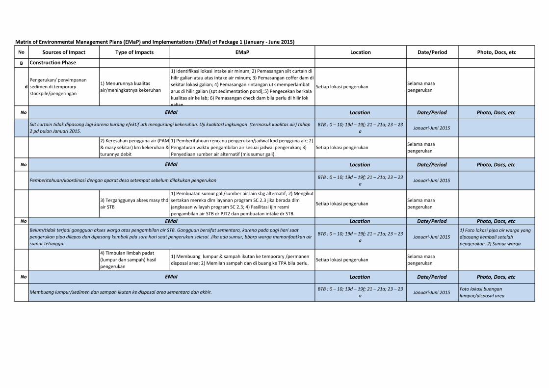
No Sources of Impact Type of Impacts EMaP Location Date/Period Photo, Docs, etc
B Construction Phase
d
Pengerukan/ penyimpanan sedimen di temporary stockpile/pengeringan
1) Menurunnya kualitas air/meningkatnya kekeruhan
1) Identifikasi lokasi intake air minum; 2) Pemasangan silt curtain di hilir galian atau atas intake air minum; 3) Pemasangan coffer dam di sekitar lokasi galian; 4) Pemasangan rintangan utk memperlambat arus di hilir galian (spt sedimentation pond); 5) Pengecekan berkala kualitas air ke lab; 6) Pemasangan check dam bila perlu di hilir lok galian
Setiap lokasi pengerukanSelama masa pengerukan
No Location Date/Period Photo, Docs, etc
BTB : 0 – 10; 19d – 19f; 21 – 21a; 23 – 23 a
Januari‐Juni 2015
2) Keresahan pengguna air (PAM & masy sekitar) krn kekeruhan & turunnya debit
1) Pemberitahuan rencana pengerukan/jadwal kpd pengguna air; 2) Pengaturan waktu pengambilan air sesuai jadwal pengerukan; 3) Penyediaan sumber air alternatif (mis sumur gali).
Setiap lokasi pengerukanSelama masa pengerukan
No Location Date/Period Photo, Docs, etc
BTB : 0 – 10; 19d – 19f; 21 – 21a; 23 – 23 a
Januari‐Juni 2015
3) Terganggunya akses masy thd air STB
1) Pembuatan sumur gali/sumber air lain sbg alternatif; 2) Mengikut sertakan mereka dlm layanan program SC 2.3 jika berada dlm jangkauan wilayah program SC 2.3; 4) Fasilitasi ijin resmi pengambilan air STB dr PJT2 dan pembuatan intake dr STB.
Setiap lokasi pengerukanSelama masa pengerukan
No Location Date/Period Photo, Docs, etc
BTB : 0 – 10; 19d – 19f; 21 – 21a; 23 – 23 a
Januari‐Juni 20151) Foto lokasi pipa air warga yang dipasang kembali setelah pengerukan. 2) Sumur warga
4) Timbulan limbah padat (lumpur dan sampah) hasil pengerukan
1) Membuang lumpur & sampah ikutan ke temporary /permanen disposal area; 2) Memilah sampah dan di buang ke TPA bila perlu.
Setiap lokasi pengerukanSelama masa pengerukan
No Location Date/Period Photo, Docs, etc
BTB : 0 – 10; 19d – 19f; 21 – 21a; 23 – 23 a
Januari‐Juni 2015Foto lokasi buangan lumpur/disposal area
EMaI
Membuang lumpur/sedimen dan sampah ikutan ke disposal area sementara dan akhir.
Belum/tidak terjadi gangguan akses warga atas pengambilan air STB. Gangguan bersifat sementara, karena pada pagi hari saat pengerukan pipa dilepas dan dipasang kembali pda sore hari saat pengerukan selesai. Jika ada sumur, bbbrp warga memanfaatkan air sumur tetangga.
EMaI
Silt curtain tidak dipasang lagi karena kurang efektif utk mengurangi kekeruhan. Uji kualitasl ingkungan (termasuk kualitas air) tahap 2 pd bulan Januari 2015.
EMaI
Pemberitahuan/koordinasi dengan aparat desa setempat sebelum dilakukan pengerukan
EMaI
Matrix of Environmental Management Plans (EMaP) and Implementations (EMaI) of Package 1 (January ‐ June 2015)
No Sources of Impact Type of Impacts EMaP Location Date/Period Photo, Docs, etc
B Construction Phase
ePengangkutan sedimen ke disposal area
1) Penurunanan kualitas udara krn debu (bila sedimen kering)
1) Penyiraman berkala pd jalan2 berdebu; 2) Pengaturan jadwal kendaraan proyek; 3) Penggunaan masker bila perlu
Jalan2 yg dilalui kendaraan proyek Selama masa konstruksi
No Location Date/Period Photo, Docs, etc
BTB : 0 – 10; 19d – 19f; 21 – 21a; 23 – 23 a Januari‐Juni 2015 Lampiran C6a
2) Penurunan estetika akibat ceceran lumpur di jalan
1) Penyiraman berkala pd jalan2 berdebu; 2) Pengaturan jadwal kendaraan proyek.
Jalan2 yg dilalui kendaraan proyek Selama masa konstruksi
No Location Date/Period Photo, Docs, etc
BTB : 0 – 10; 19d – 19f; 21 – 21a; 23 – 23 a Januari‐Juni 2015 Lampiran C6b
3) Kebisingan1) Pengaturan vol. kendaraan proyek; 2) Test kebisingan berkala; 3) Pelaksanaan jam kerja/pancang/pengangkutan max. jam 6 sore
Jalan2 yg dilalui kendaraan proyek Selama masa konstruksi
No Location Date/Period Photo, Docs, etc
BTB : 0 – 10; 19d – 19f; 21 – 21a; 23 – 23 a Januari‐Juni 2015 __
4) Gangguan arus lalin/macet
1) Pengaturan vol. kendaraan proyek; 2) Pemasangan rambu lalin; 3) Menggunakan pengatur lalin
Jalan2 yg dilalui kendaraan proyek Selama masa konstruksi
No Location Date/Period Photo, Docs, etc
BTB : 0 – 10; 19d – 19f; 21 – 21a; 23 – 23 a
Januari‐Juni 2015 Foto pengaturan jalan dan rambu2 proyek
EMaI
1) Pengaturan lalu lintas dilakukan pada saat truk/alat berat melalui jalan‐jalan tertentu/sempit agar tdk menyebabkan kemacetan lalu lintas. 2) Pemasangan rambu‐rambu proyek
EMaI
1) Jumlah kendaraan pengangkut sedimen terbatas ( 49 unit) shg tidak menyebakan kebisingan nyata; 2) Pengaturan jam operasional jam 8 ‐ 17; 3) Frek angkutan: ± 25 kali perhari ( ± 10 jam)/truk
EMaI
Pada jalan tak beraspal/terkelupas aspalnya dan berdebu dilakukan penyiraman. Frekuensi penyiraman: 1 x/hari jika kondisi kering/tidak hujan.(Jika kondisi basah/hujan maka tidak diadakan penyiraman)
EMaI
Pengangkutan sedimen dilakukan dg baik agar tidak tercecer di jalan yg mengakibatkan kotor jalanan dan juga dilakukan penyiraman pd jalan berdebu/tak beraspal. Jika terjadi ceceran sedimen dilakukan pembersihan jalan.
Matrix of Environmental Management Plans (EMaP) and Implementations (EMaI) of Package 1 (January ‐ June 2015)
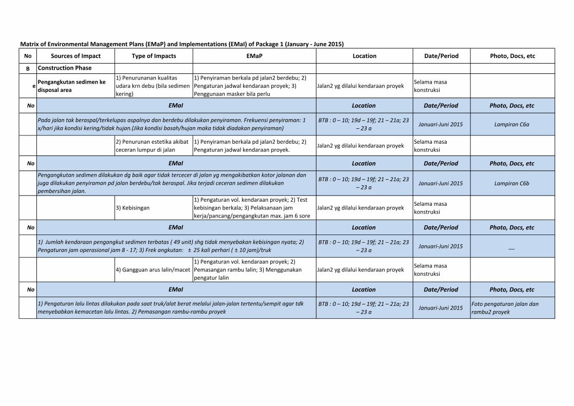
No Sources of Impact Type of Impacts EMaP Location Date/Period Photo, Docs, etc
B Construction Phase
e5) Kerusakan jalan dan fasilitas umum (jembatan dll)
1) Penggunaan kendaraan dan muatan tidak melebihi kapasitas jalan; 2) Perbaikan kembali jalan2 dan fasilitas umum yg rusak Jalan2 yg dilalui kendaraan proyek Selama masa konstruksi
No Location Date/Period Photo, Docs, etc
BTB : 0 – 10; 19d – 19f; 21 – 21a; 23 – 23 a
Januari‐Juni 2015 Foto perbaikan jalan(Lampiran C8)
6) Gangguan kesehatan/sesak/alergi karena debu
1) Monitor adanya penderita sesak/alergi; 2) Pengobatan bagi penderita sesak/alergi
Jalan2 yg dilalui kendaraan proyek Selama masa konstruksi
No Location Date/Period Photo, Docs, etc
BTB : 0 – 10; 19d – 19f; 21 – 21a; 23 – 23 a Januari‐Juni 2015 Lampiran C6a
fPembangunan siphon Cibeet/pemancangan
1) Kebisingan
1) Pemberitahuan renc pemancangan kpd aparat & penddk sekitar; 2) Isolasi lok proyek dg pagar solid (seng); 3) Penggunaan vibro hammer yg rendah bising; 4) Penggunaan tutup telinga bg pekerja proyek; 5) Test kebisingan berkala; 6) Pemancangan maks jam 5 sore
BTB 23, desa Pasirtanjung dan sekitarnya
Selama konstruksi siphon Cibeet
No Location Date/Period Photo, Docs, etc
2) Gangguan getaran1) Pemberitahuan rencana pemancangan kpd aparat setempat & penduduk sekitar; 2) Perbaikan infrastruktur (rumah) yg rusak akibat getaran
BTB 23, desa Pasirtanjung dan sekitarnya
Selama konstruksi siphon Cibeet
No Location Date/Period Photo, Docs, etc
3) Gangguan kualitas air (kekeruhan)
1) Pemasangan silt curtain di hilir lokasi pemancangan/galian 2) Pemasangan cofer dam disekitar galian/pemancangan 3)Pengecekan berkala kualitas air ke lab.
BTB 23, desa Pasirtanjung dan sekitarnya
Selama konstruksi siphon Cibeet
No Location Date/Period Photo, Docs, etcEMaI
Belum ada kegiatan
EMaI
1) Tonase muatan dibatasi sesuai kapasitas truk dan jalan agar tidak menimbulkan kerusakan jalan dan jembatan; 2) Perbaikan jalan dilakukan bagi jalan eksisting yg rusak agar transportasi sedimen ke disposal area lancar.
EMaI
Belum ada kegiatan
EMaI
Belum ada kegiatan
EMaI
1) Penyiraman pada jalan berdebu dan mengusahakan tidak ada ceceran lumpur pada jalan beraspal agar tidak menimbulkan polusi debu (bila kering) yg dapat mengganggu kesehatan warga. 2) Monitoring terhadap keluhan kesehatan warga (sesak) (bila ada) akibat gangguan debu.
Matrix of Environmental Management Plans (EMaP) and Implementations (EMaI) of Package 1 (January ‐ June 2015)
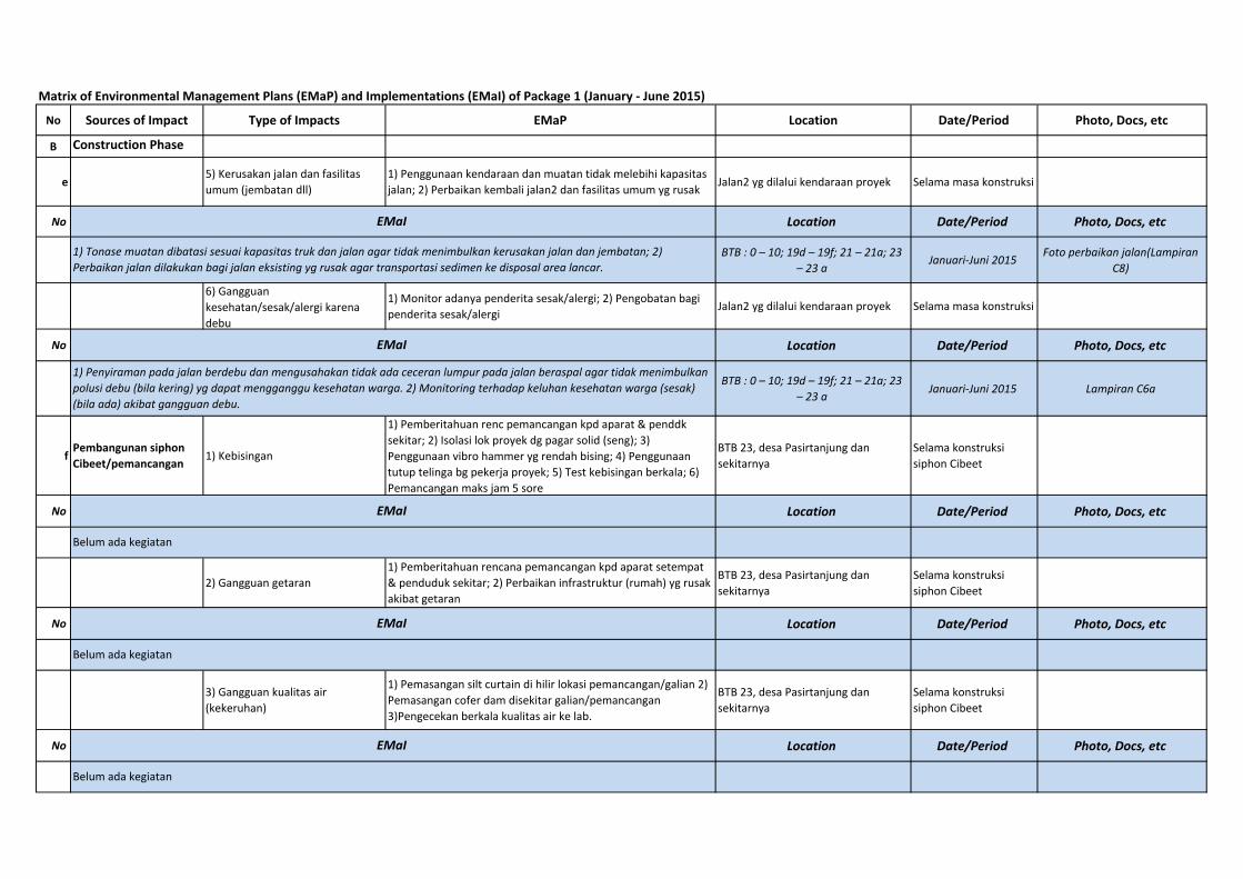
No Sources of Impact Type of Impacts EMaP Location Date/Period Photo, Docs, etc
B Construction Phase
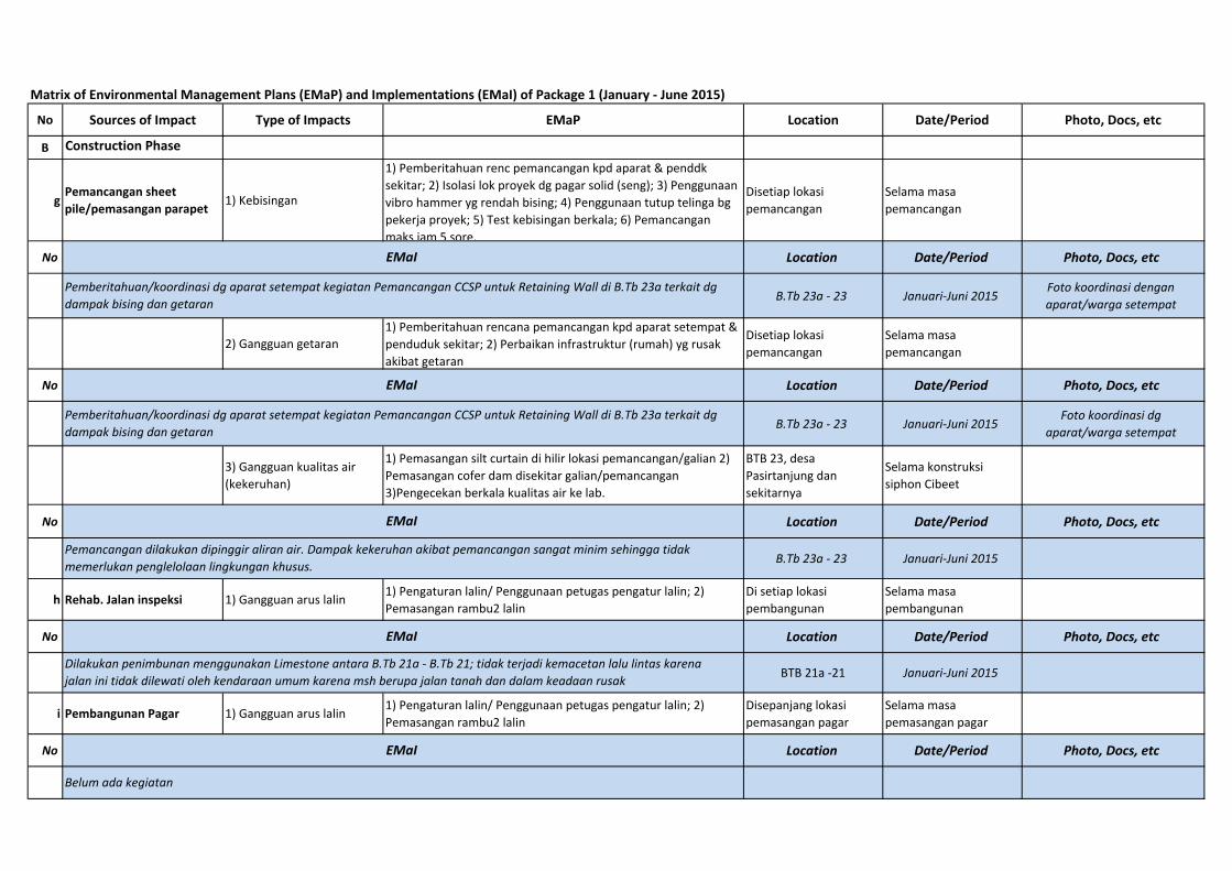
gPemancangan sheet pile/pemasangan parapet 1) Kebisingan
1) Pemberitahuan renc pemancangan kpd aparat & penddk sekitar; 2) Isolasi lok proyek dg pagar solid (seng); 3) Penggunaan vibro hammer yg rendah bising; 4) Penggunaan tutup telinga bg pekerja proyek; 5) Test kebisingan berkala; 6) Pemancangan maks jam 5 sore.
Disetiap lokasi pemancangan
Selama masa pemancangan
No Location Date/Period Photo, Docs, etc
B.Tb 23a ‐ 23 Januari‐Juni 2015Foto koordinasi dengan aparat/warga setempat
2) Gangguan getaran1) Pemberitahuan rencana pemancangan kpd aparat setempat & penduduk sekitar; 2) Perbaikan infrastruktur (rumah) yg rusak akibat getaran
Disetiap lokasi pemancangan
Selama masa pemancangan
No Location Date/Period Photo, Docs, etc
B.Tb 23a ‐ 23 Januari‐Juni 2015Foto koordinasi dg
aparat/warga setempat
3) Gangguan kualitas air (kekeruhan)
1) Pemasangan silt curtain di hilir lokasi pemancangan/galian 2) Pemasangan cofer dam disekitar galian/pemancangan 3)Pengecekan berkala kualitas air ke lab.
BTB 23, desa Pasirtanjung dan sekitarnya
Selama konstruksi siphon Cibeet
No Location Date/Period Photo, Docs, etc
B.Tb 23a ‐ 23 Januari‐Juni 2015
h Rehab. Jalan inspeksi 1) Gangguan arus lalin 1) Pengaturan lalin/ Penggunaan petugas pengatur lalin; 2) Pemasangan rambu2 lalin
Di setiap lokasi pembangunan
Selama masa pembangunan
No Location Date/Period Photo, Docs, etc
BTB 21a ‐21 Januari‐Juni 2015
i Pembangunan Pagar 1) Gangguan arus lalin 1) Pengaturan lalin/ Penggunaan petugas pengatur lalin; 2) Pemasangan rambu2 lalin
Disepanjang lokasi pemasangan pagar
Selama masa pemasangan pagar
No Location Date/Period Photo, Docs, etc
EMaI
Dilakukan penimbunan menggunakan Limestone antara B.Tb 21a ‐ B.Tb 21; tidak terjadi kemacetan lalu lintas karena jalan ini tidak dilewati oleh kendaraan umum karena msh berupa jalan tanah dan dalam keadaan rusak
EMaI
Belum ada kegiatan
EMaI
Pemberitahuan/koordinasi dg aparat setempat kegiatan Pemancangan CCSP untuk Retaining Wall di B.Tb 23a terkait dg dampak bising dan getaran
EMaI
Pemberitahuan/koordinasi dg aparat setempat kegiatan Pemancangan CCSP untuk Retaining Wall di B.Tb 23a terkait dg dampak bising dan getaran
EMaI
Pemancangan dilakukan dipinggir aliran air. Dampak kekeruhan akibat pemancangan sangat minim sehingga tidak memerlukan penglelolaan lingkungan khusus.
Matrix of Environmental Management Plans (EMaP) and Implementations (EMaI) of Package 1 (January ‐ June 2015)
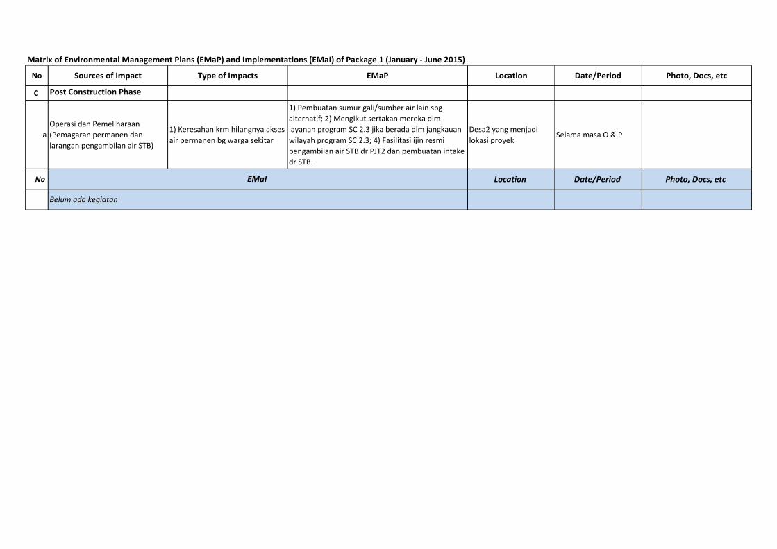
No Sources of Impact Type of Impacts EMaP Location Date/Period Photo, Docs, etc
C Post Construction Phase
a
Operasi dan Pemeliharaan (Pemagaran permanen dan larangan pengambilan air STB)
1) Keresahan krm hilangnya akses air permanen bg warga sekitar
1) Pembuatan sumur gali/sumber air lain sbg alternatif; 2) Mengikut sertakan mereka dlm layanan program SC 2.3 jika berada dlm jangkauan wilayah program SC 2.3; 4) Fasilitasi ijin resmi pengambilan air STB dr PJT2 dan pembuatan intake dr STB.
Desa2 yang menjadi lokasi proyek
Selama masa O & P
No Location Date/Period Photo, Docs, etcEMaI
Belum ada kegiatan
Appendix B
Matrix of Environmental Monitoring Plans (EMoP) and Implementations (EMoI) of Package 1 (January – June 2015)
Matrix of Environmental Monitoring Plans (EMoP) and Implementations (EMoI) of Package 1 (January ‐ June 2015)
No Sources of Impact Type of Impacts EMoP Location Date/Period Photo, Docs, etc
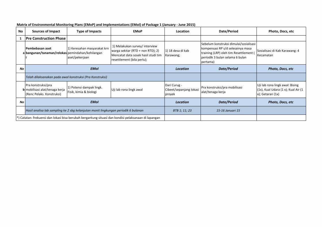
1 Pre Construction Phase
a
Pembebasan aset bangunan/tanaman/relokas
i
1) Keresahan masyarakat krn pemindahan/kehilangan aset/pekerjaan
1) Melakukan survey/ interview warga sekitar (RTD + non RTD); 2) Mencatat data sosek hasil studi tim resettlement (bila perlu);
1) 18 desa di kab Karawang;
Sebelum konstruksi dimulai/sosialisasi kompensasi RP s/d selesainya masa training (LRP) oleh tim Resettlement ( periodik 3 bulan selama 6 bulan pertama)
Sosialisasi di Kab Karawang: 4 Kecamatan
No Location Date/Period Photo, Docs, etc
b
Pra konstruksi/pra mobilisasi alat/tenaga kerja (Renc Pelaks. Konstruksi)
1) Potensi dampak lingk. Fisik, kimia & biologi
Uji lab rona lingk awalDari Curug ‐ Cibeet/sepanjang lokasi proyek
Pra konstruksi/pra mobilisasi alat/tenaga kerja
Uji lab rona lingk awal: Bising (1x), Kual Udara (1 x); Kual Air (1 x); Getaran (1x)
No Location Date/Period Photo, Docs, etc
BTB 1; 11; 23 15‐16 Januari 15
*) Catatan: frekuensi dan lokasi bisa berubah bergantung situasi dan kondisi pelaksanaan di lapangan
EMoI
Telah dilaksanakan pada awal konstruksi (Pra Konstruksi)
EMoI
Hasil analisa lab sampling ke 2 sbg kelanjutan monit lingkungan periodik 6 bulanan
Matrix of Environmental Monitoring Plans (EMoP) and Implementations (EMoI) of Package 1 (January ‐ June 2015)
No Sources of Impact Type of Impacts EMoP Location Date/Period Photo, Docs, etc
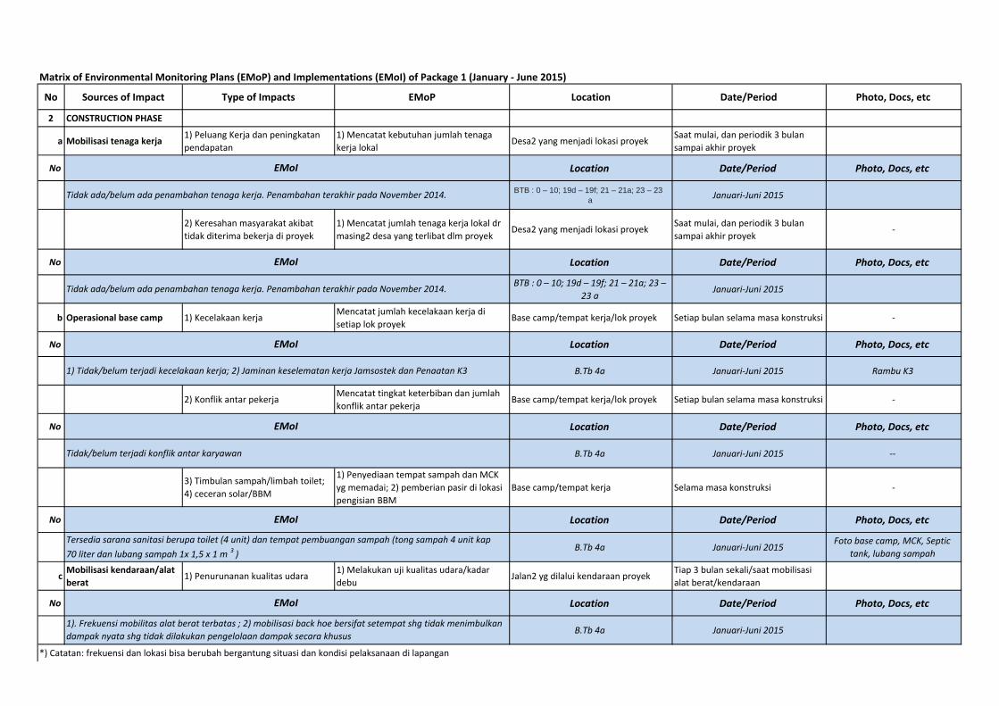
2 CONSTRUCTION PHASE
a Mobilisasi tenaga kerja 1) Peluang Kerja dan peningkatan pendapatan
1) Mencatat kebutuhan jumlah tenaga kerja lokal
Desa2 yang menjadi lokasi proyek Saat mulai, dan periodik 3 bulan sampai akhir proyek
No Location Date/Period Photo, Docs, etc
BTB : 0 – 10; 19d – 19f; 21 – 21a; 23 – 23 a Januari‐Juni 2015
2) Keresahan masyarakat akibat tidak diterima bekerja di proyek
1) Mencatat jumlah tenaga kerja lokal dr masing2 desa yang terlibat dlm proyek
Desa2 yang menjadi lokasi proyek Saat mulai, dan periodik 3 bulan sampai akhir proyek
‐
No Location Date/Period Photo, Docs, etc
BTB : 0 – 10; 19d – 19f; 21 – 21a; 23 – 23 a
Januari‐Juni 2015
b Operasional base camp 1) Kecelakaan kerja Mencatat jumlah kecelakaan kerja di setiap lok proyek
Base camp/tempat kerja/lok proyek Setiap bulan selama masa konstruksi ‐
No Location Date/Period Photo, Docs, etc
B.Tb 4a Januari‐Juni 2015 Rambu K3
2) Konflik antar pekerja Mencatat tingkat keterbiban dan jumlah konflik antar pekerja
Base camp/tempat kerja/lok proyek Setiap bulan selama masa konstruksi ‐
No Location Date/Period Photo, Docs, etc
B.Tb 4a Januari‐Juni 2015 ‐‐
3) Timbulan sampah/limbah toilet; 4) ceceran solar/BBM
1) Penyediaan tempat sampah dan MCK yg memadai; 2) pemberian pasir di lokasi pengisian BBM
Base camp/tempat kerja Selama masa konstruksi ‐
No Location Date/Period Photo, Docs, etc
B.Tb 4a Januari‐Juni 2015Foto base camp, MCK, Septic
tank, lubang sampah
cMobilisasi kendaraan/alat berat
1) Penurunanan kualitas udara 1) Melakukan uji kualitas udara/kadar debu
Jalan2 yg dilalui kendaraan proyek Tiap 3 bulan sekali/saat mobilisasi alat berat/kendaraan
No Location Date/Period Photo, Docs, etc
B.Tb 4a Januari‐Juni 2015
*) Catatan: frekuensi dan lokasi bisa berubah bergantung situasi dan kondisi pelaksanaan di lapangan
EMoI
1). Frekuensi mobilitas alat berat terbatas ; 2) mobilisasi back hoe bersifat setempat shg tidak menimbulkan dampak nyata shg tidak dilakukan pengelolaan dampak secara khusus
Tidak ada/belum ada penambahan tenaga kerja. Penambahan terakhir pada November 2014.
EMoI
EMoI
EMoI
EMoI
Tidak ada/belum ada penambahan tenaga kerja. Penambahan terakhir pada November 2014.
1) Tidak/belum terjadi kecelakaan kerja; 2) Jaminan keselematan kerja Jamsostek dan Penaatan K3
Tidak/belum terjadi konflik antar karyawan
EMoI
Tersedia sarana sanitasi berupa toilet (4 unit) dan tempat pembuangan sampah (tong sampah 4 unit kap 70 liter dan lubang sampah 1x 1,5 x 1 m 3
)
Matrix of Environmental Monitoring Plans (EMoP) and Implementations (EMoI) of Package 1 (January ‐ June 2015)
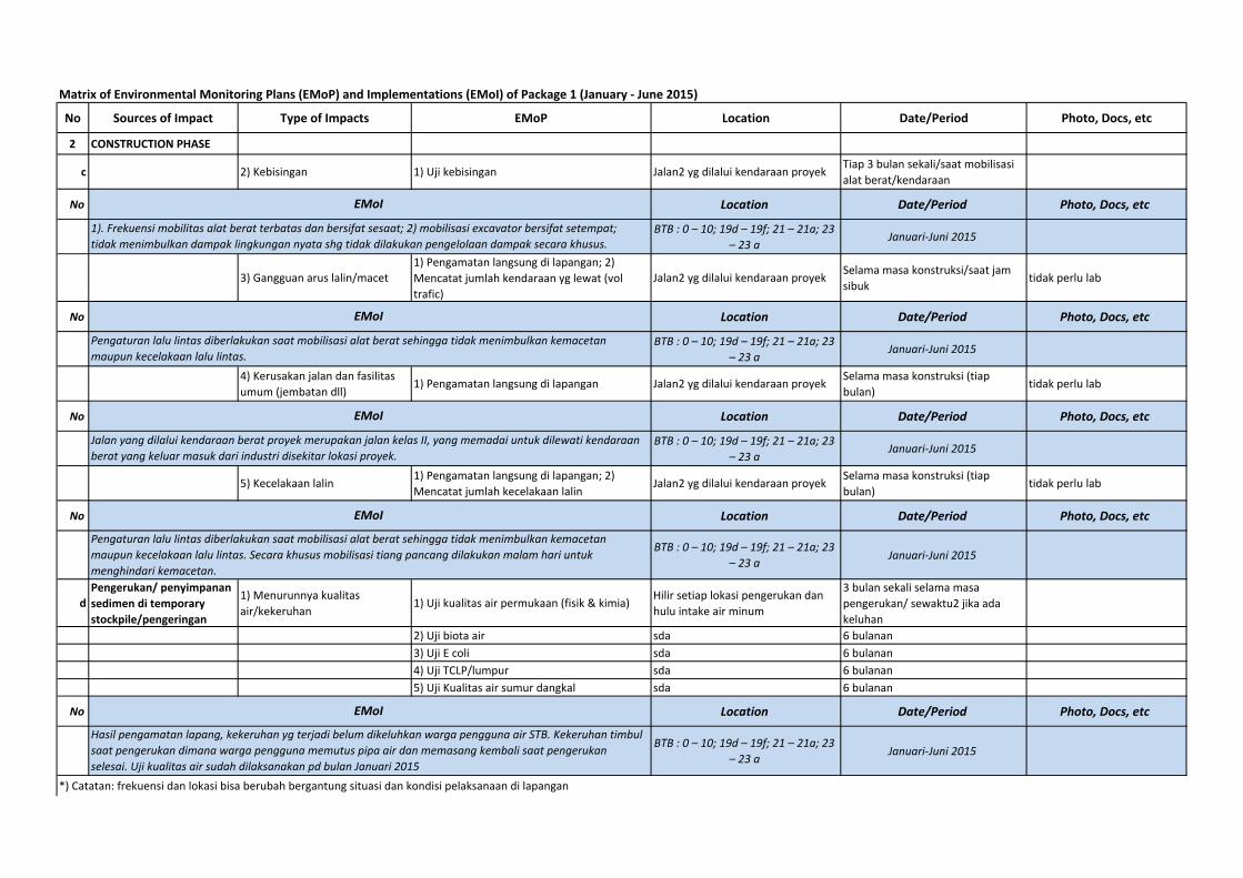
No Sources of Impact Type of Impacts EMoP Location Date/Period Photo, Docs, etc
2 CONSTRUCTION PHASE
c 2) Kebisingan 1) Uji kebisingan Jalan2 yg dilalui kendaraan proyek Tiap 3 bulan sekali/saat mobilisasi alat berat/kendaraan
No Location Date/Period Photo, Docs, etc
BTB : 0 – 10; 19d – 19f; 21 – 21a; 23 – 23 a
Januari‐Juni 2015
3) Gangguan arus lalin/macet
1) Pengamatan langsung di lapangan; 2) Mencatat jumlah kendaraan yg lewat (vol trafic)
Jalan2 yg dilalui kendaraan proyek Selama masa konstruksi/saat jam sibuk
tidak perlu lab
No Location Date/Period Photo, Docs, etc
BTB : 0 – 10; 19d – 19f; 21 – 21a; 23 – 23 a
Januari‐Juni 2015
4) Kerusakan jalan dan fasilitas umum (jembatan dll)
1) Pengamatan langsung di lapangan Jalan2 yg dilalui kendaraan proyek Selama masa konstruksi (tiap bulan)
tidak perlu lab
No Location Date/Period Photo, Docs, etc
BTB : 0 – 10; 19d – 19f; 21 – 21a; 23 – 23 a
Januari‐Juni 2015
5) Kecelakaan lalin 1) Pengamatan langsung di lapangan; 2) Mencatat jumlah kecelakaan lalin
Jalan2 yg dilalui kendaraan proyek Selama masa konstruksi (tiap bulan)
tidak perlu lab
No Location Date/Period Photo, Docs, etc
BTB : 0 – 10; 19d – 19f; 21 – 21a; 23 – 23 a Januari‐Juni 2015
d
Pengerukan/ penyimpanan sedimen di temporary stockpile/pengeringan
1) Menurunnya kualitas air/kekeruhan
1) Uji kualitas air permukaan (fisik & kimia)Hilir setiap lokasi pengerukan dan hulu intake air minum
3 bulan sekali selama masa pengerukan/ sewaktu2 jika ada keluhan
2) Uji biota air sda 6 bulanan3) Uji E coli sda 6 bulanan4) Uji TCLP/lumpur sda 6 bulanan5) Uji Kualitas air sumur dangkal sda 6 bulanan
No Location Date/Period Photo, Docs, etc
BTB : 0 – 10; 19d – 19f; 21 – 21a; 23 – 23 a Januari‐Juni 2015
*) Catatan: frekuensi dan lokasi bisa berubah bergantung situasi dan kondisi pelaksanaan di lapangan
Hasil pengamatan lapang, kekeruhan yg terjadi belum dikeluhkan warga pengguna air STB. Kekeruhan timbul saat pengerukan dimana warga pengguna memutus pipa air dan memasang kembali saat pengerukan selesai. Uji kualitas air sudah dilaksanakan pd bulan Januari 2015
EMoI
Pengaturan lalu lintas diberlakukan saat mobilisasi alat berat sehingga tidak menimbulkan kemacetan maupun kecelakaan lalu lintas. Secara khusus mobilisasi tiang pancang dilakukan malam hari untuk menghindari kemacetan.
EMoI
1). Frekuensi mobilitas alat berat terbatas dan bersifat sesaat; 2) mobilisasi excavator bersifat setempat; tidak menimbulkan dampak lingkungan nyata shg tidak dilakukan pengelolaan dampak secara khusus.
EMoI
Pengaturan lalu lintas diberlakukan saat mobilisasi alat berat sehingga tidak menimbulkan kemacetan maupun kecelakaan lalu lintas.
EMoI
Jalan yang dilalui kendaraan berat proyek merupakan jalan kelas II, yang memadai untuk dilewati kendaraan berat yang keluar masuk dari industri disekitar lokasi proyek.
EMoI
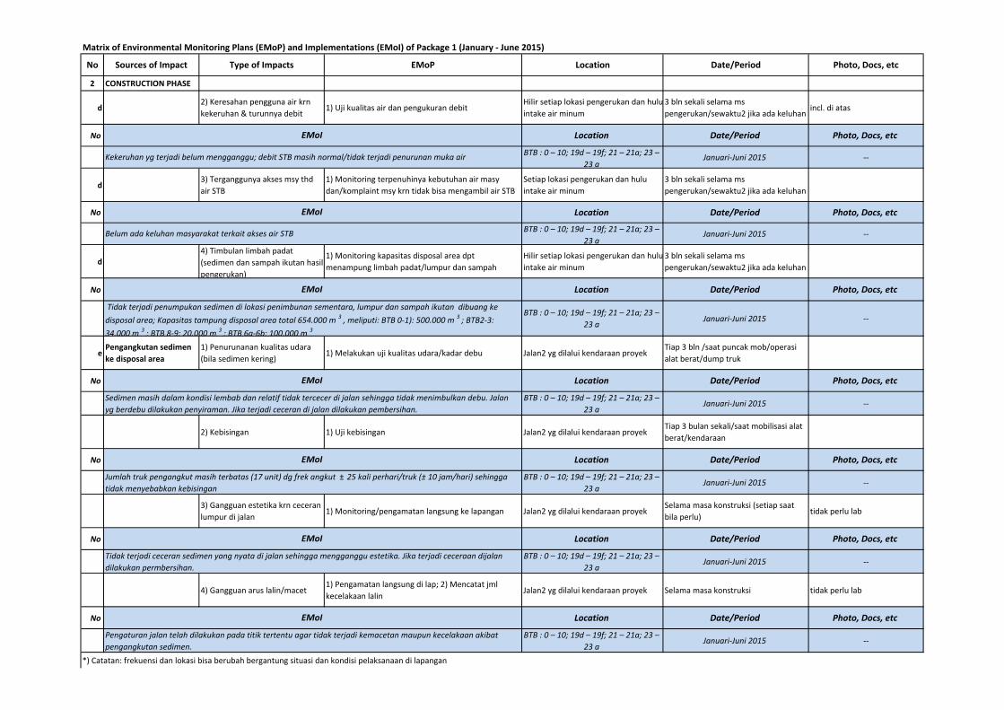
Matrix of Environmental Monitoring Plans (EMoP) and Implementations (EMoI) of Package 1 (January ‐ June 2015)
No Sources of Impact Type of Impacts EMoP Location Date/Period Photo, Docs, etc
2 CONSTRUCTION PHASE
d2) Keresahan pengguna air krn kekeruhan & turunnya debit
1) Uji kualitas air dan pengukuran debitHilir setiap lokasi pengerukan dan huluintake air minum
3 bln sekali selama ms pengerukan/sewaktu2 jika ada keluhan
incl. di atas
No Location Date/Period Photo, Docs, etc
BTB : 0 – 10; 19d – 19f; 21 – 21a; 23 – 23 a
Januari‐Juni 2015 ‐‐
d3) Terganggunya akses msy thd air STB
1) Monitoring terpenuhinya kebutuhan air masy dan/komplaint msy krn tidak bisa mengambil air STB
Setiap lokasi pengerukan dan hulu intake air minum
3 bln sekali selama ms pengerukan/sewaktu2 jika ada keluhan
No Location Date/Period Photo, Docs, etc
BTB : 0 – 10; 19d – 19f; 21 – 21a; 23 – 23 a
Januari‐Juni 2015 ‐‐
d
4) Timbulan limbah padat (sedimen dan sampah ikutan hasil pengerukan)
1) Monitoring kapasitas disposal area dpt menampung limbah padat/lumpur dan sampah
Hilir setiap lokasi pengerukan dan huluintake air minum
3 bln sekali selama ms pengerukan/sewaktu2 jika ada keluhan
No Location Date/Period Photo, Docs, etc
BTB : 0 – 10; 19d – 19f; 21 – 21a; 23 – 23 a
Januari‐Juni 2015 ‐‐
ePengangkutan sedimen ke disposal area
1) Penurunanan kualitas udara (bila sedimen kering)
1) Melakukan uji kualitas udara/kadar debu Jalan2 yg dilalui kendaraan proyekTiap 3 bln /saat puncak mob/operasi alat berat/dump truk
No Location Date/Period Photo, Docs, etc
BTB : 0 – 10; 19d – 19f; 21 – 21a; 23 – 23 a
Januari‐Juni 2015 ‐‐
2) Kebisingan 1) Uji kebisingan Jalan2 yg dilalui kendaraan proyekTiap 3 bulan sekali/saat mobilisasi alat berat/kendaraan
No Location Date/Period Photo, Docs, etc
BTB : 0 – 10; 19d – 19f; 21 – 21a; 23 – 23 a
Januari‐Juni 2015 ‐‐
3) Gangguan estetika krn ceceran lumpur di jalan
1) Monitoring/pengamatan langsung ke lapangan Jalan2 yg dilalui kendaraan proyekSelama masa konstruksi (setiap saat bila perlu)
tidak perlu lab
No Location Date/Period Photo, Docs, etc
BTB : 0 – 10; 19d – 19f; 21 – 21a; 23 – 23 a
Januari‐Juni 2015 ‐‐
4) Gangguan arus lalin/macet1) Pengamatan langsung di lap; 2) Mencatat jml kecelakaan lalin
Jalan2 yg dilalui kendaraan proyek Selama masa konstruksi tidak perlu lab
No Location Date/Period Photo, Docs, etc
BTB : 0 – 10; 19d – 19f; 21 – 21a; 23 – 23 a
Januari‐Juni 2015 ‐‐
*) Catatan: frekuensi dan lokasi bisa berubah bergantung situasi dan kondisi pelaksanaan di lapangan
EMoI
Tidak terjadi ceceran sedimen yang nyata di jalan sehingga mengganggu estetika. Jika terjadi ceceraan dijalan dilakukan permbersihan.
EMoI
Pengaturan jalan telah dilakukan pada titik tertentu agar tidak terjadi kemacetan maupun kecelakaan akibat pengangkutan sedimen.
EMoI
Kekeruhan yg terjadi belum mengganggu; debit STB masih normal/tidak terjadi penurunan muka air
EMoI
Sedimen masih dalam kondisi lembab dan relatif tidak tercecer di jalan sehingga tidak menimbulkan debu. Jalan yg berdebu dilakukan penyiraman. Jika terjadi ceceran di jalan dilakukan pembersihan.
EMoI
Jumlah truk pengangkut masih terbatas (17 unit) dg frek angkut ± 25 kali perhari/truk (± 10 jam/hari) sehingga tidak menyebabkan kebisingan
EMoI
Belum ada keluhan masyarakat terkait akses air STB
EMoI
Tidak terjadi penumpukan sedimen di lokasi penimbunan sementara, lumpur dan sampah ikutan dibuang ke disposal area; Kapasitas tampung disposal area total 654.000 m 3
, meliputi: BTB 0‐1): 500.000 m 3; BTB2‐3:
34.000 m3; BTB 8‐9: 20.000 m 3
; BTB 6a‐6b: 100.000 m 3
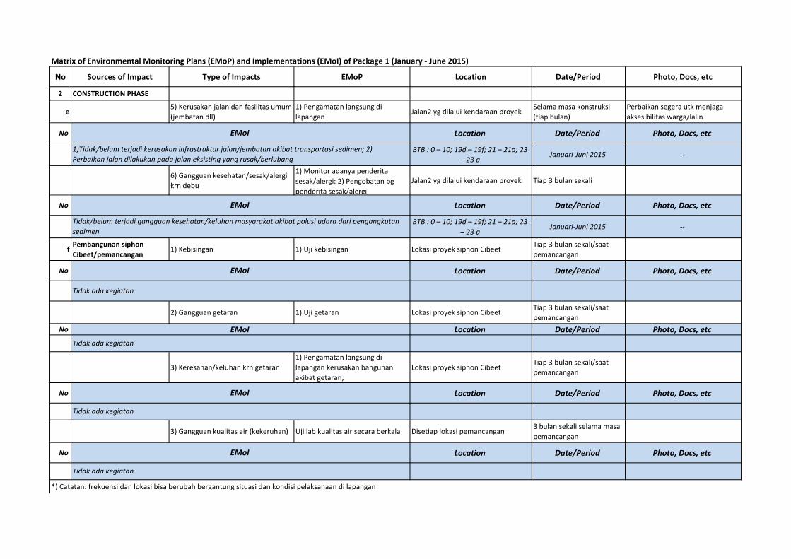
Matrix of Environmental Monitoring Plans (EMoP) and Implementations (EMoI) of Package 1 (January ‐ June 2015)
No Sources of Impact Type of Impacts EMoP Location Date/Period Photo, Docs, etc
2 CONSTRUCTION PHASE
e5) Kerusakan jalan dan fasilitas umum (jembatan dll)
1) Pengamatan langsung di lapangan
Jalan2 yg dilalui kendaraan proyek Selama masa konstruksi (tiap bulan)
Perbaikan segera utk menjaga aksesibilitas warga/lalin
No Location Date/Period Photo, Docs, etc
BTB : 0 – 10; 19d – 19f; 21 – 21a; 23 – 23 a
Januari‐Juni 2015 ‐‐
6) Gangguan kesehatan/sesak/alergi krn debu
1) Monitor adanya penderita sesak/alergi; 2) Pengobatan bg penderita sesak/alergi
Jalan2 yg dilalui kendaraan proyek Tiap 3 bulan sekali
No Location Date/Period Photo, Docs, etc
BTB : 0 – 10; 19d – 19f; 21 – 21a; 23 – 23 a
Januari‐Juni 2015 ‐‐
fPembangunan siphon Cibeet/pemancangan
1) Kebisingan 1) Uji kebisingan Lokasi proyek siphon Cibeet Tiap 3 bulan sekali/saat pemancangan
No Location Date/Period Photo, Docs, etc
2) Gangguan getaran 1) Uji getaran Lokasi proyek siphon Cibeet Tiap 3 bulan sekali/saat pemancangan
No Location Date/Period Photo, Docs, etc
3) Keresahan/keluhan krn getaran1) Pengamatan langsung di lapangan kerusakan bangunan akibat getaran;
Lokasi proyek siphon CibeetTiap 3 bulan sekali/saat pemancangan
No Location Date/Period Photo, Docs, etc
3) Gangguan kualitas air (kekeruhan) Uji lab kualitas air secara berkala Disetiap lokasi pemancangan3 bulan sekali selama masa pemancangan
No Location Date/Period Photo, Docs, etc
*) Catatan: frekuensi dan lokasi bisa berubah bergantung situasi dan kondisi pelaksanaan di lapangan
EMoI
1)Tidak/belum terjadi kerusakan infrastruktur jalan/jembatan akibat transportasi sedimen; 2) Perbaikan jalan dilakukan pada jalan eksisting yang rusak/berlubang
EMoI
Tidak ada kegiatan
EMoI
Tidak/belum terjadi gangguan kesehatan/keluhan masyarakat akibat polusi udara dari pengangkutan sedimen
EMoI
Tidak ada kegiatan
EMoI
Tidak ada kegiatan
EMoI
Tidak ada kegiatan
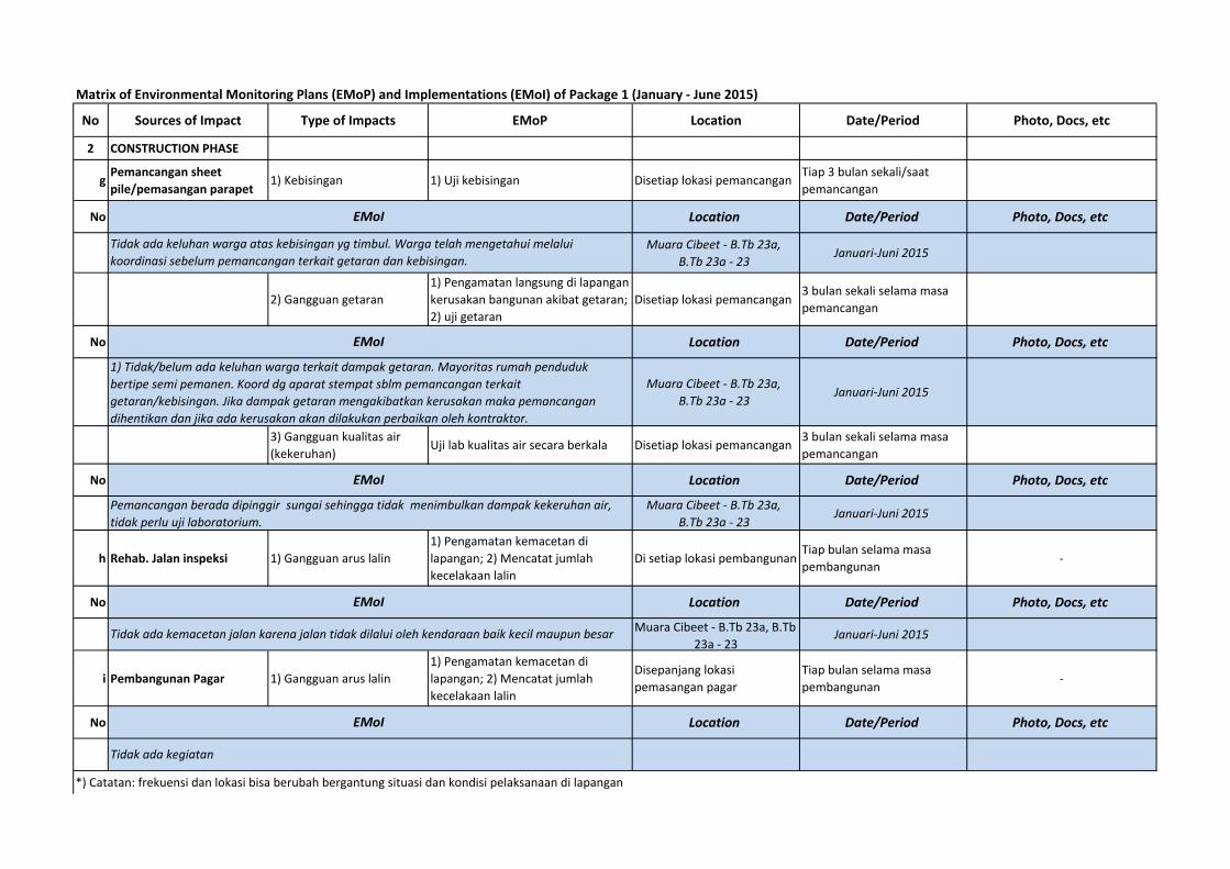
Matrix of Environmental Monitoring Plans (EMoP) and Implementations (EMoI) of Package 1 (January ‐ June 2015)
No Sources of Impact Type of Impacts EMoP Location Date/Period Photo, Docs, etc
2 CONSTRUCTION PHASE
gPemancangan sheet pile/pemasangan parapet
1) Kebisingan 1) Uji kebisingan Disetiap lokasi pemancanganTiap 3 bulan sekali/saat pemancangan
No Location Date/Period Photo, Docs, etc
Muara Cibeet ‐ B.Tb 23a, B.Tb 23a ‐ 23
Januari‐Juni 2015
2) Gangguan getaran1) Pengamatan langsung di lapangan kerusakan bangunan akibat getaran; 2) uji getaran
Disetiap lokasi pemancangan3 bulan sekali selama masa pemancangan
No Location Date/Period Photo, Docs, etc
Muara Cibeet ‐ B.Tb 23a, B.Tb 23a ‐ 23
Januari‐Juni 2015
3) Gangguan kualitas air (kekeruhan)
Uji lab kualitas air secara berkala Disetiap lokasi pemancangan3 bulan sekali selama masa pemancangan
No Location Date/Period Photo, Docs, etc
Muara Cibeet ‐ B.Tb 23a, B.Tb 23a ‐ 23
Januari‐Juni 2015
h Rehab. Jalan inspeksi 1) Gangguan arus lalin1) Pengamatan kemacetan di lapangan; 2) Mencatat jumlah kecelakaan lalin
Di setiap lokasi pembangunanTiap bulan selama masa pembangunan
‐
No Location Date/Period Photo, Docs, etc
Muara Cibeet ‐ B.Tb 23a, B.Tb 23a ‐ 23
Januari‐Juni 2015
i Pembangunan Pagar 1) Gangguan arus lalin1) Pengamatan kemacetan di lapangan; 2) Mencatat jumlah kecelakaan lalin
Disepanjang lokasi pemasangan pagar
Tiap bulan selama masa pembangunan
‐
No Location Date/Period Photo, Docs, etc
*) Catatan: frekuensi dan lokasi bisa berubah bergantung situasi dan kondisi pelaksanaan di lapangan
EMoI
Tidak ada kegiatan
EMoI
Tidak ada keluhan warga atas kebisingan yg timbul. Warga telah mengetahui melalui koordinasi sebelum pemancangan terkait getaran dan kebisingan.
EMoI
1) Tidak/belum ada keluhan warga terkait dampak getaran. Mayoritas rumah penduduk bertipe semi pemanen. Koord dg aparat stempat sblm pemancangan terkait getaran/kebisingan. Jika dampak getaran mengakibatkan kerusakan maka pemancangan dihentikan dan jika ada kerusakan akan dilakukan perbaikan oleh kontraktor.
EMoI
Tidak ada kemacetan jalan karena jalan tidak dilalui oleh kendaraan baik kecil maupun besar
EMoI
Pemancangan berada dipinggir sungai sehingga tidak menimbulkan dampak kekeruhan air, tidak perlu uji laboratorium.
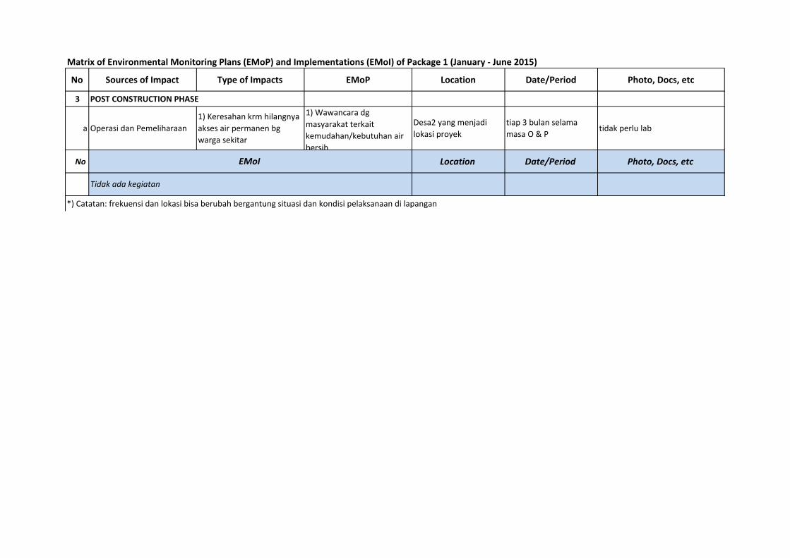
Matrix of Environmental Monitoring Plans (EMoP) and Implementations (EMoI) of Package 1 (January ‐ June 2015)
No Sources of Impact Type of Impacts EMoP Location Date/Period Photo, Docs, etc
3 POST CONSTRUCTION PHASE
a Operasi dan Pemeliharaan
1) Keresahan krm hilangnya akses air permanen bg warga sekitar
1) Wawancara dg masyarakat terkait kemudahan/kebutuhan air bersih
Desa2 yang menjadi lokasi proyek
tiap 3 bulan selama masa O & P
tidak perlu lab
No Location Date/Period Photo, Docs, etc
*) Catatan: frekuensi dan lokasi bisa berubah bergantung situasi dan kondisi pelaksanaan di lapangan
Tidak ada kegiatan
EMoI

Appendix C1a. Sampling Location Maps
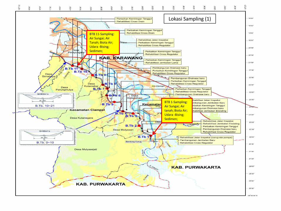
Lokasi Sampling (1)
BTB 1-Sampling:
Air Sungai; Air
tanah; Biota Air;
Udara -Bising;
Sedimen;
BTB 11-Sampling:
Air Sungai; Air
Tanah; Biota Air;
Udara -Bising;
Sedimen;
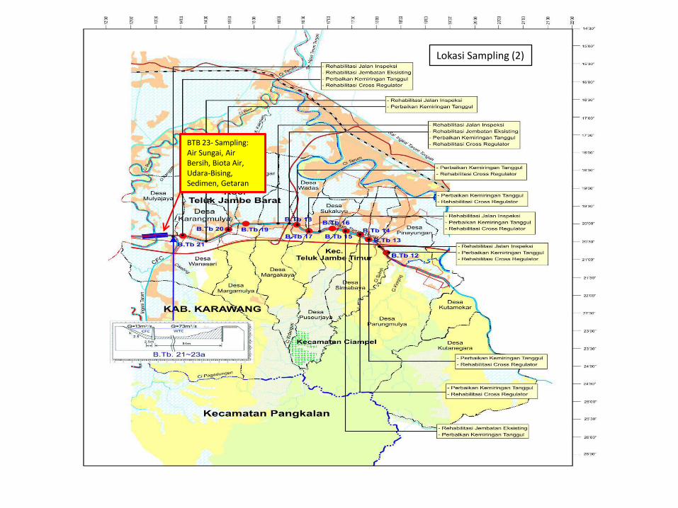
BTB 23- Sampling:
Air Sungai, Air
Bersih, Biota Air,
Udara-Bising,
Sedimen, Getaran
Lokasi Sampling (2)

Appendix C1b. Sampling Photos
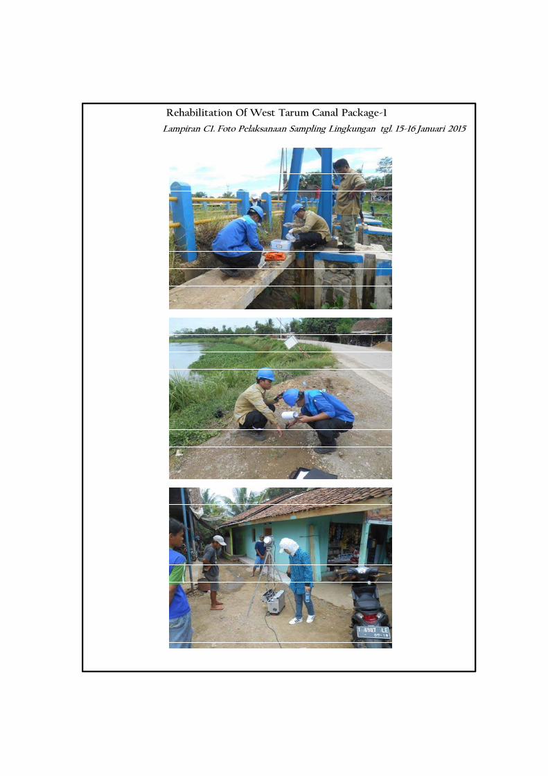
Rehabilitation Of West Tarum Canal Package-1
Lampiran C1. Foto Pelaksanaan Sampling Lingkungan tgl. 15-16 Januari 2015
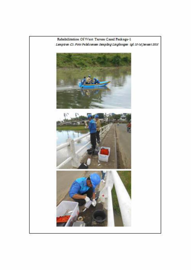

Appendix C1c. Sampling Parameters
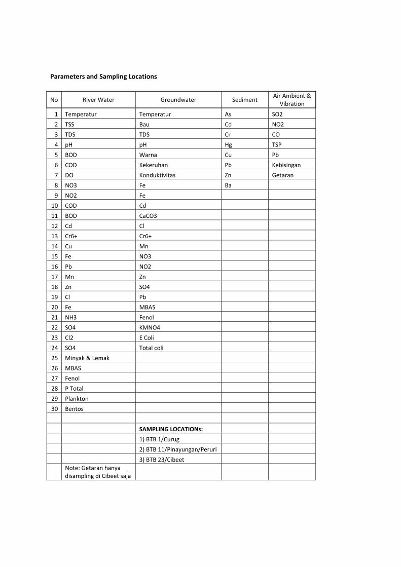
Parameters and Sampling Locations
No River Water Groundwater Sediment Air Ambient & Vibration
1 Temperatur Temperatur As SO2 2 TSS Bau Cd NO2 3 TDS TDS Cr CO 4 pH pH Hg TSP 5 BOD Warna Cu Pb 6 COD Kekeruhan Pb Kebisingan 7 DO Konduktivitas Zn Getaran 8 NO3 Fe Ba 9 NO2 Fe
10 COD Cd 11 BOD CaCO3 12 Cd Cl 13 Cr6+ Cr6+ 14 Cu Mn 15 Fe NO3 16 Pb NO2 17 Mn Zn 18 Zn SO4 19 Cl Pb 20 Fe MBAS 21 NH3 Fenol 22 SO4 KMNO4 23 Cl2 E Coli 24 SO4 Total coli 25 Minyak & Lemak 26 MBAS 27 Fenol 28 P Total 29 Plankton 30 Bentos SAMPLING LOCATIONs: 1) BTB 1/Curug 2) BTB 11/Pinayungan/Peruri 3) BTB 23/Cibeet
Note: Getaran hanya disampling di Cibeet saja

Appendix C2. River Water Quality Test Result
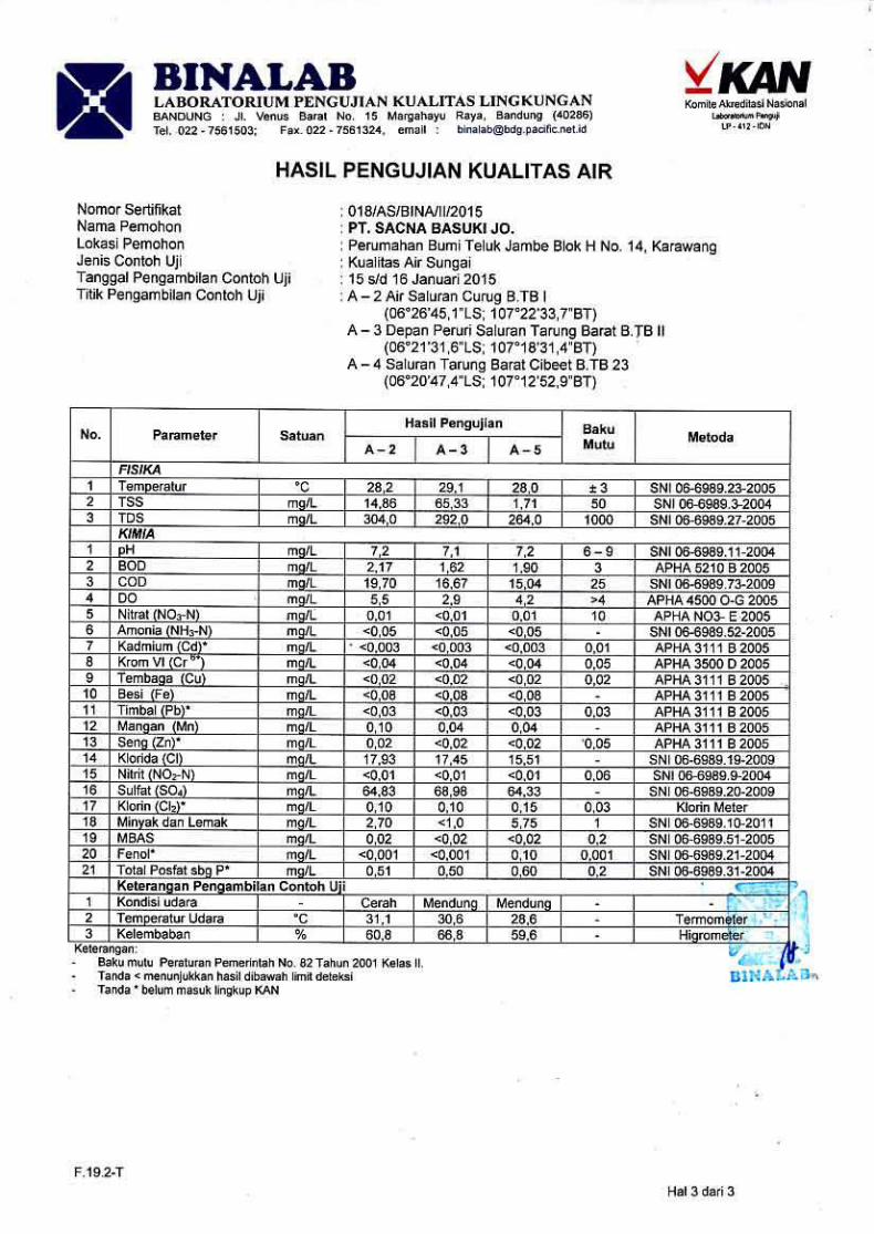

Appendix C3. Groundwater Quality Test Result
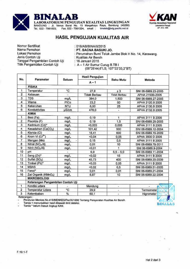

Appendix C4. Sediment Quality Test Result
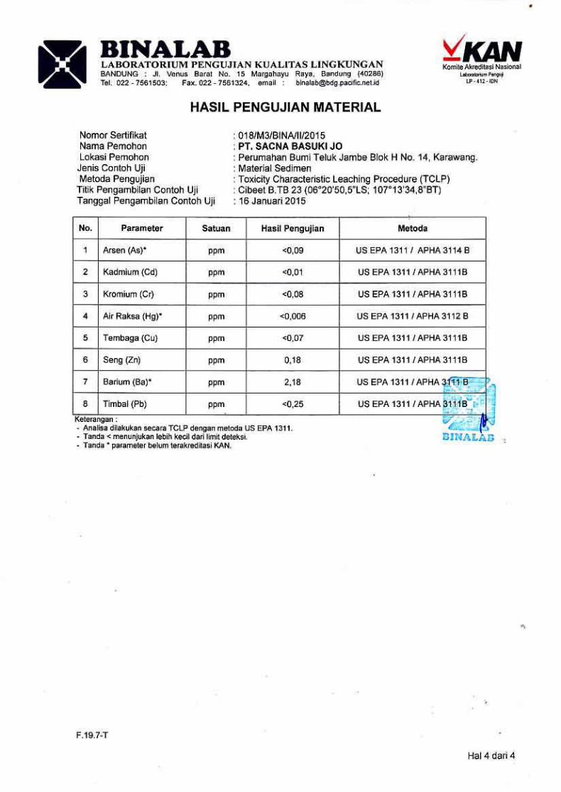
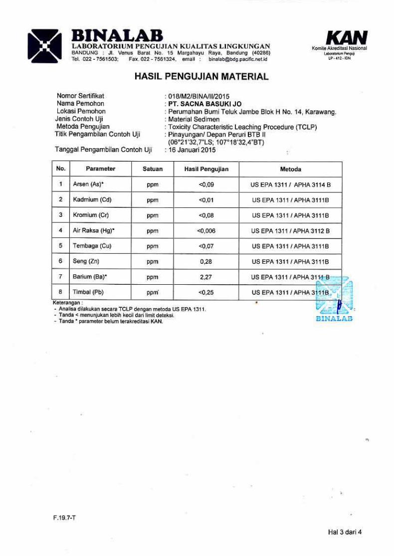
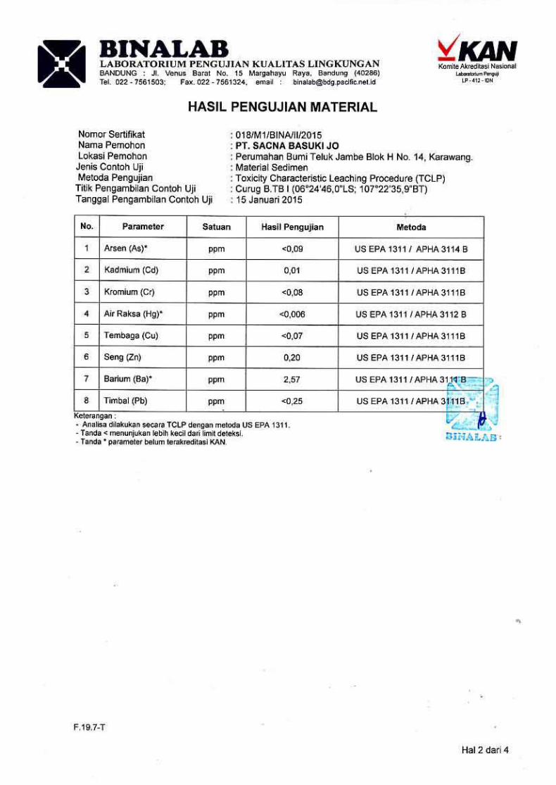
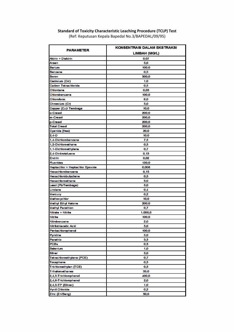
Standard of Toxicity Characteristic Leaching Procedure (TCLP) Test (Ref: Keputusan Kepala Bapedal No.3/BAPEDAL/09/95)

Appendix C5. Air Ambient Quality and Noise Test Result
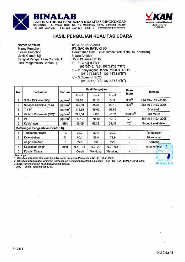

Appendix C6. Vibration Test Result
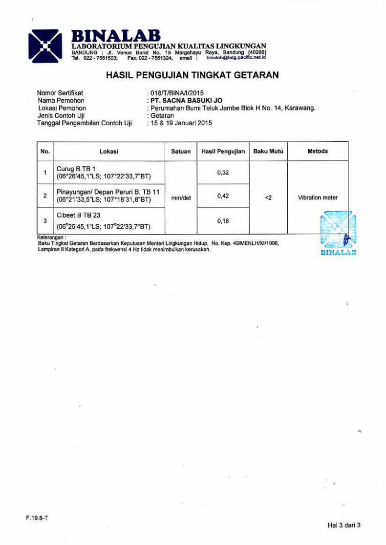

Appendix C7. Plankton and Benthos Test Result
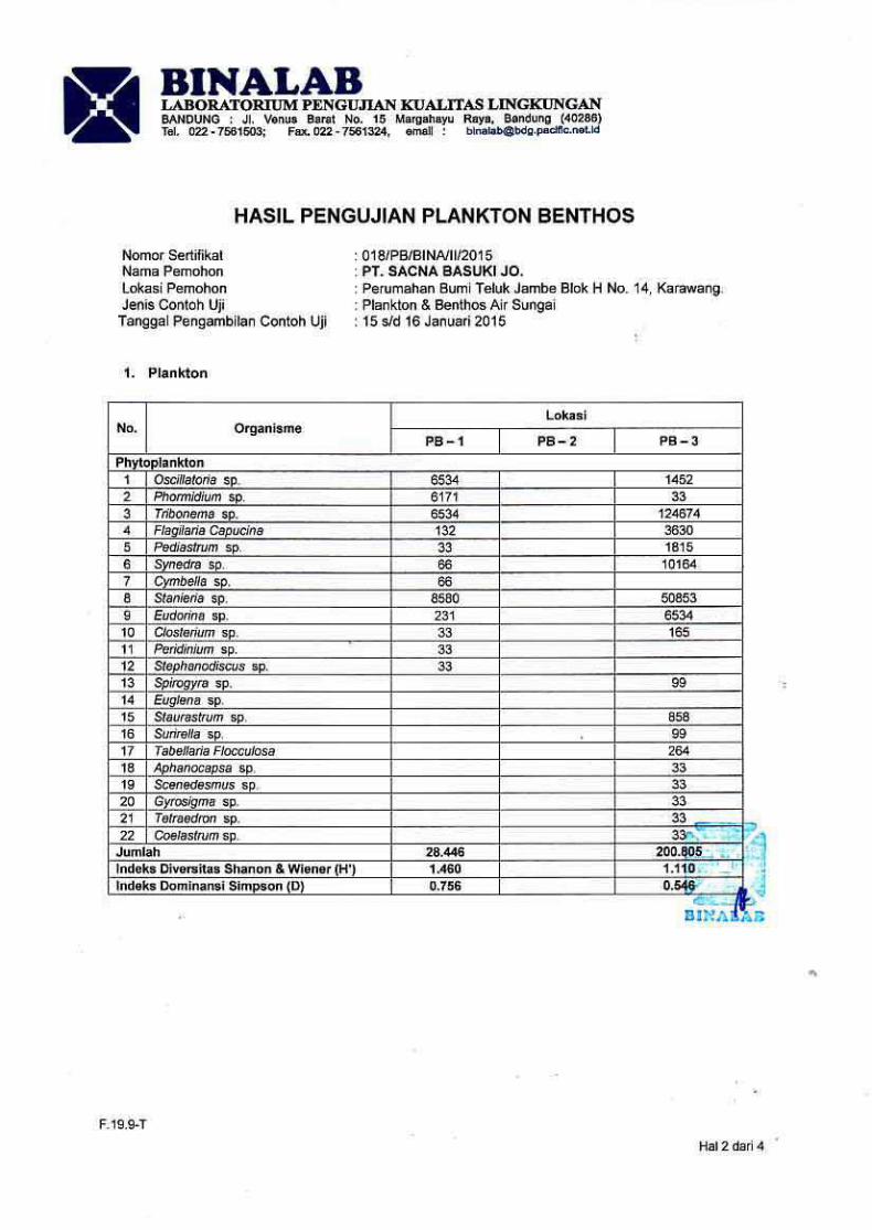
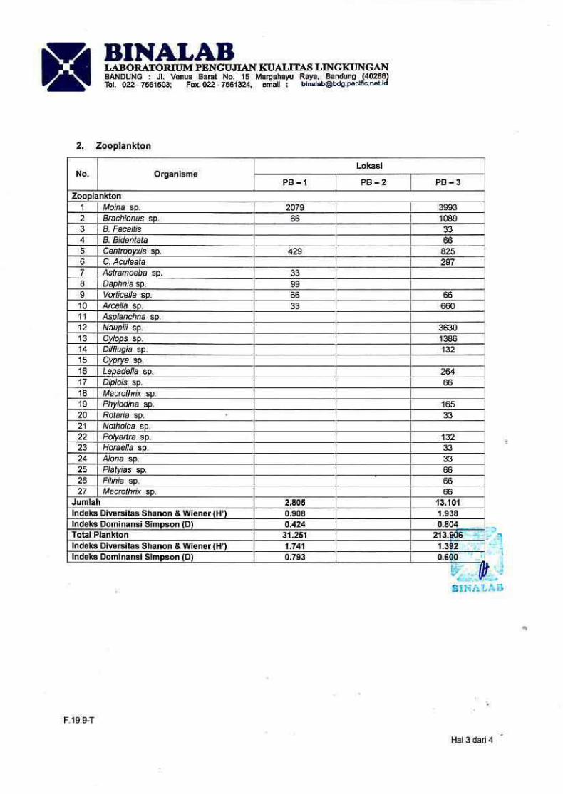
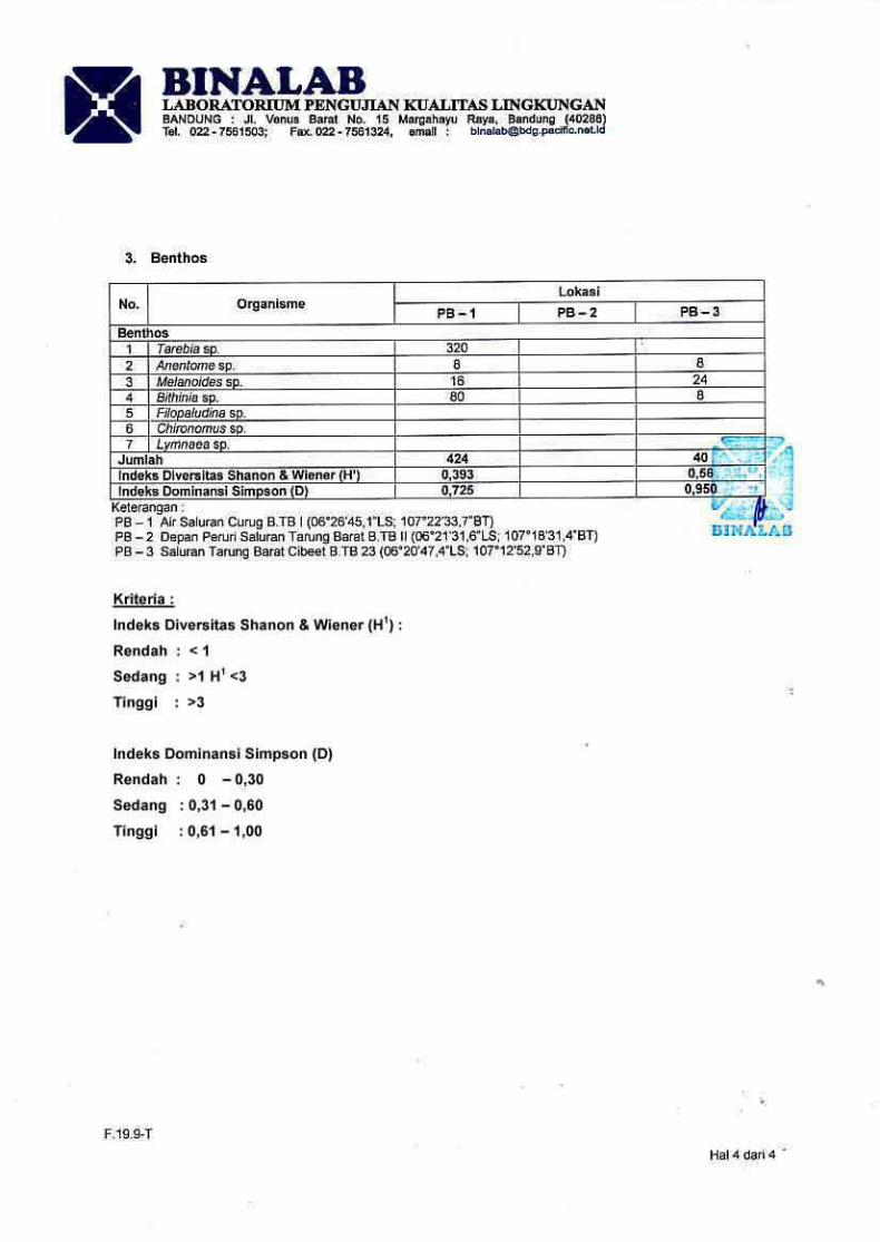
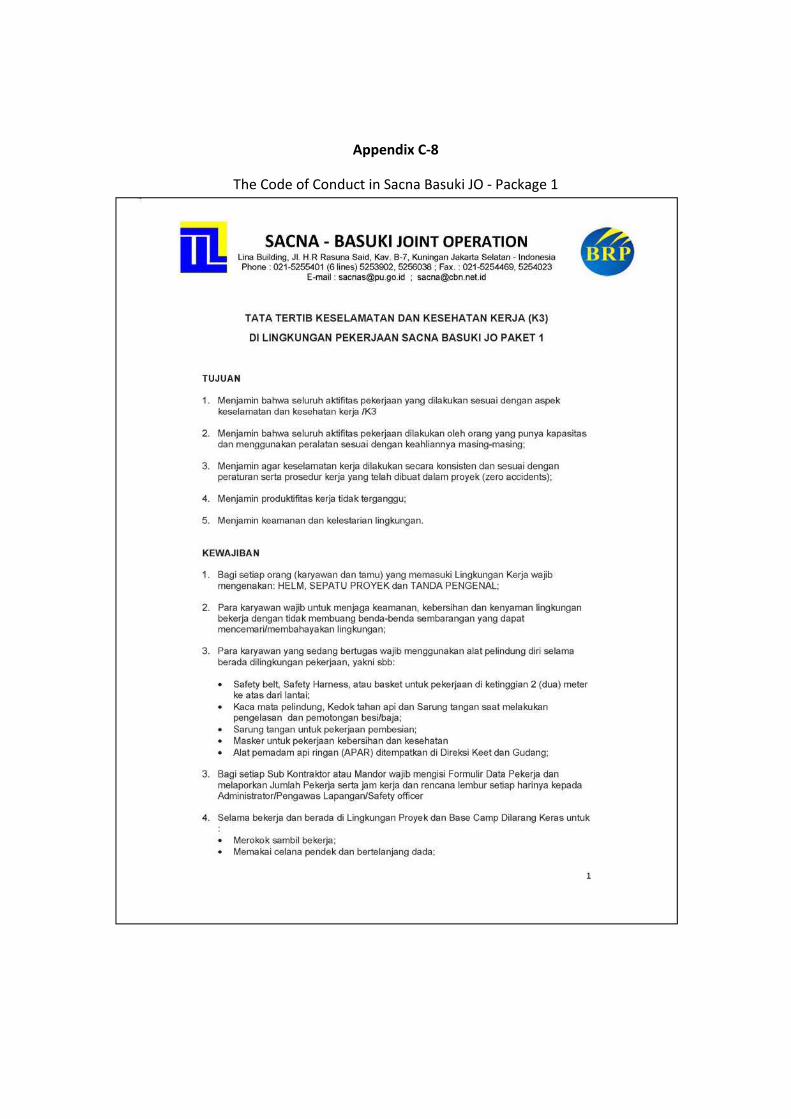
Appendix C‐8
The Code of Conduct in Sacna Basuki JO ‐ Package 1
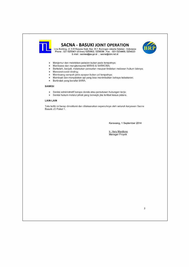
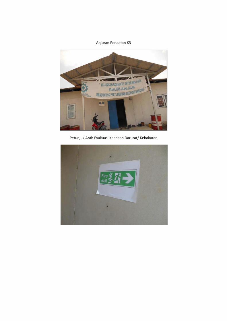
Anjuran Penaatan K3
Petunjuk Arah Evakuasi Keadaan Darurat/ Kebakaran
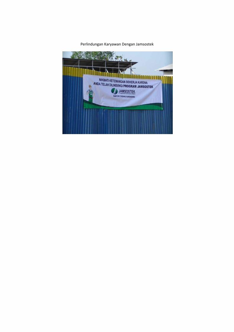
Perlindungan Karyawan Dengan Jamsostek
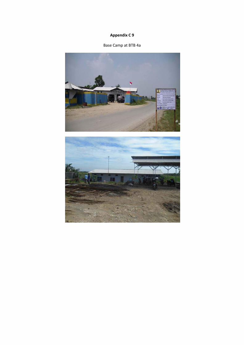
Appendix C 9
Base Camp at BTB 4a
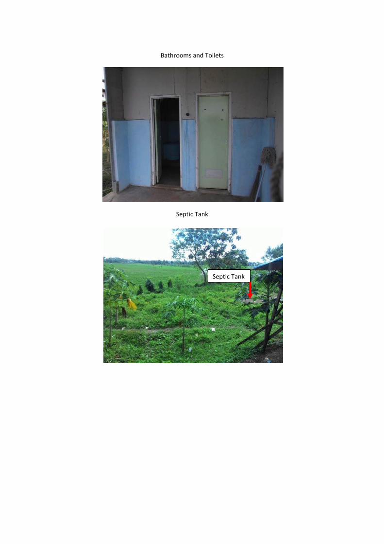
Bathrooms and Toilets
Septic Tank
Septic Tank
Lubang Tanah
Septic Tank
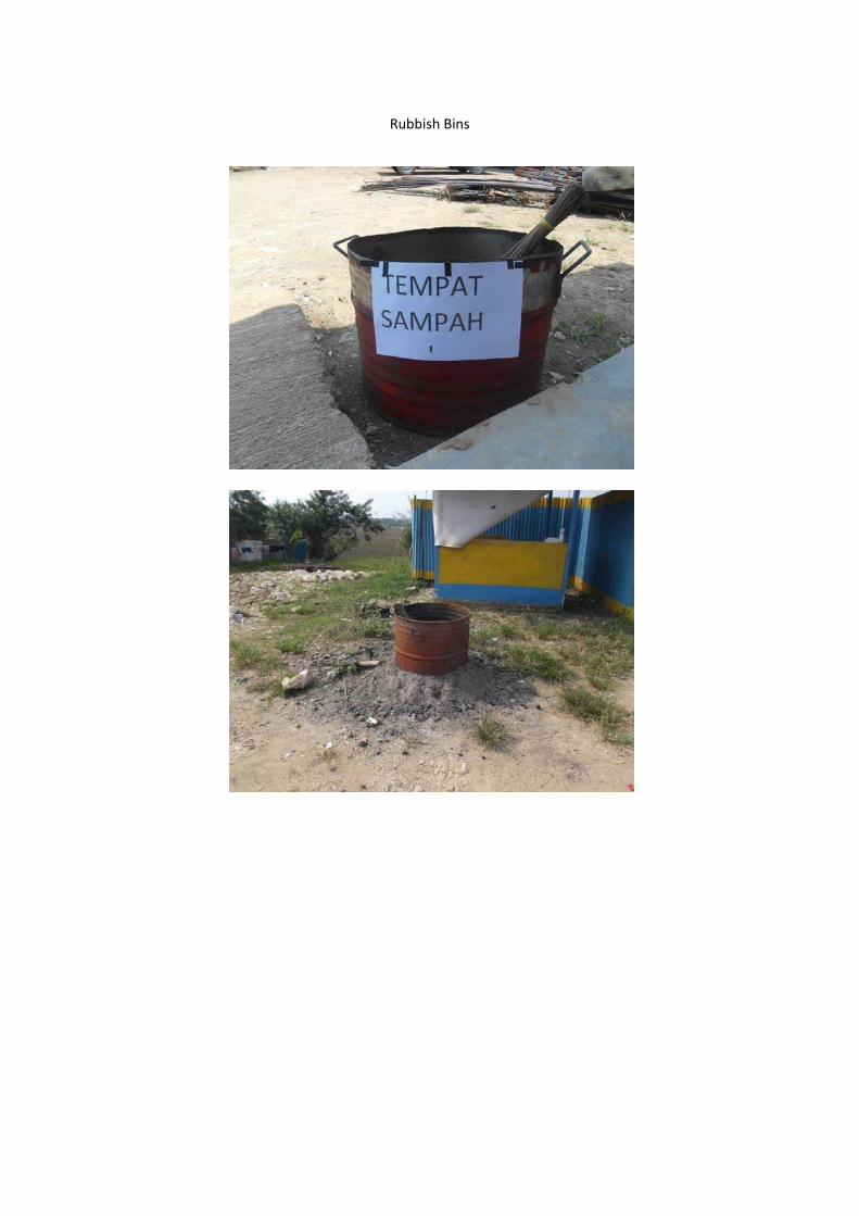
Rubbish Bins
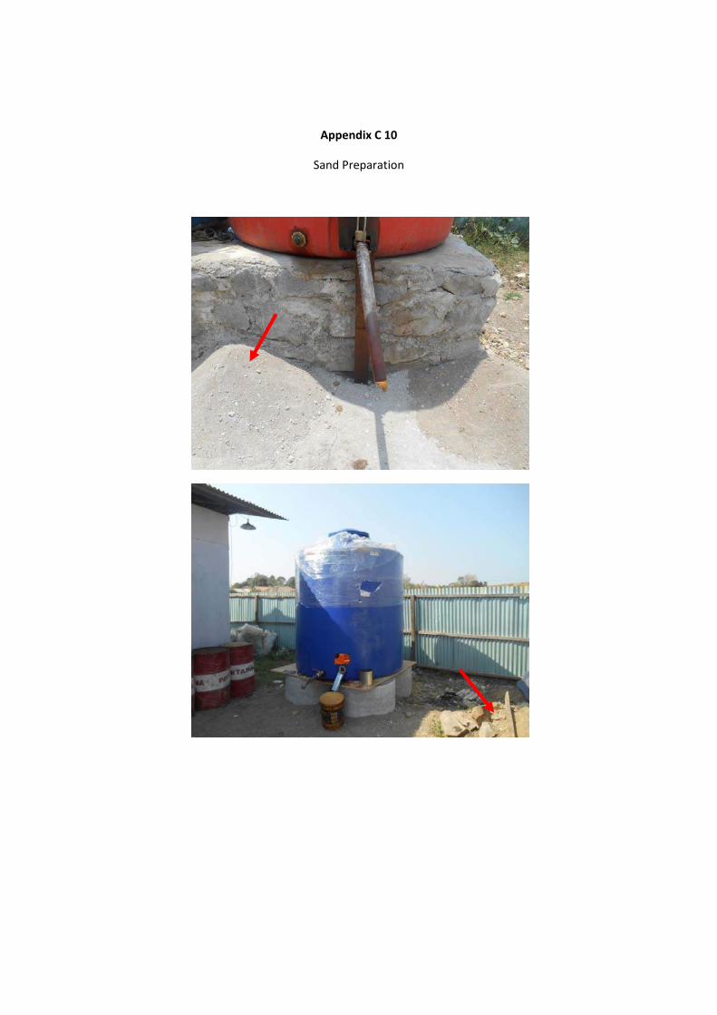
Appendix C 10
Sand Preparation
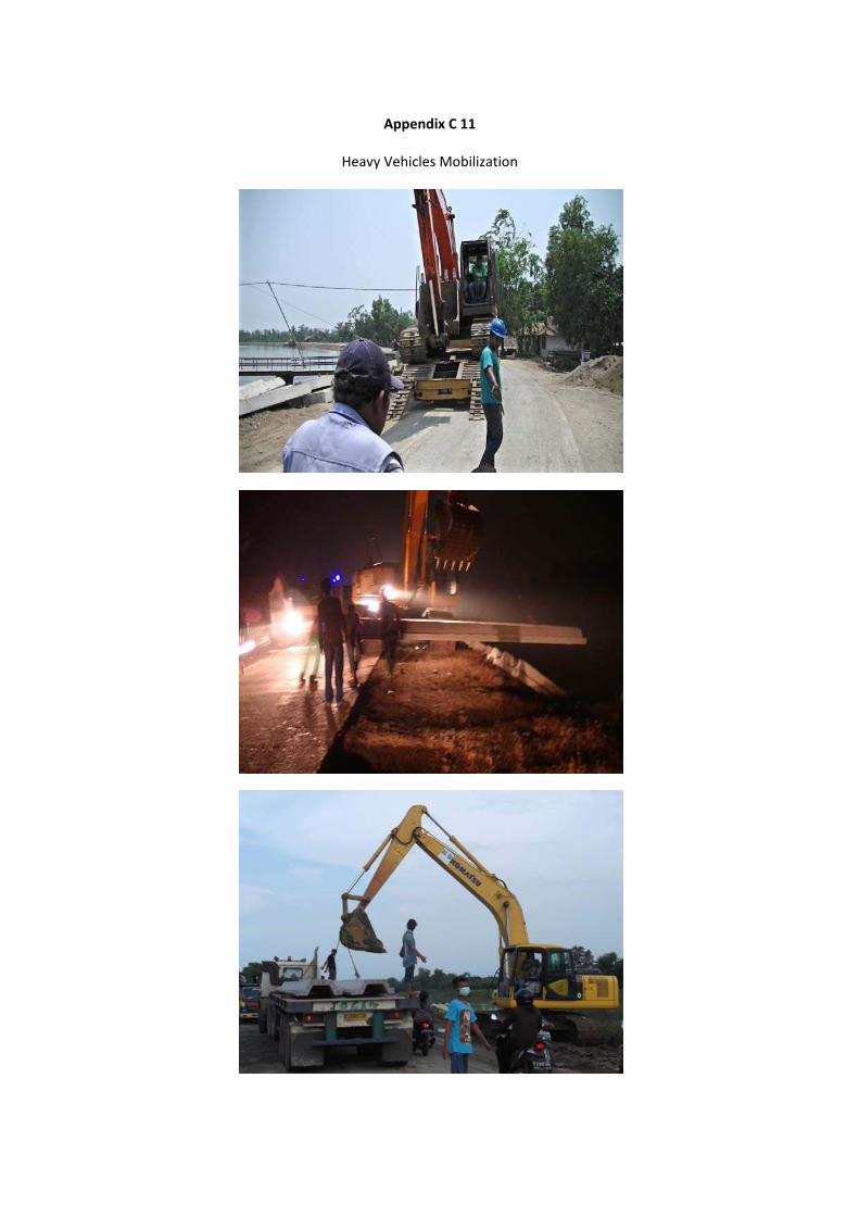
Appendix C 11
Heavy Vehicles Mobilization
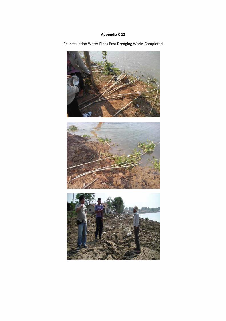
Appendix C 12
Re Installation Water Pipes Post Dredging Works Completed
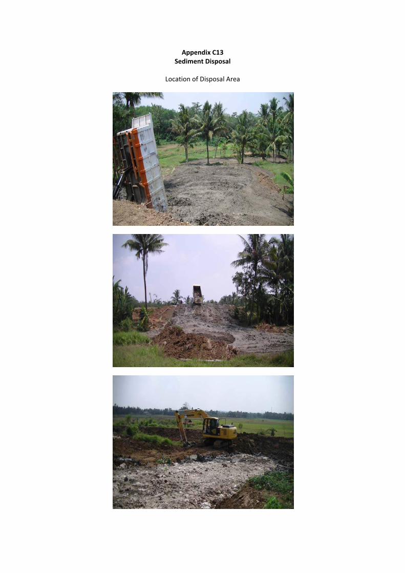
Appendix C13 Sediment Disposal
Location of Disposal Area
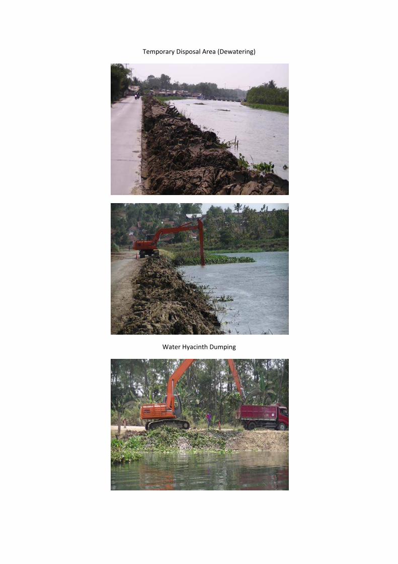
Temporary Disposal Area (Dewatering)
Water Hyacinth Dumping
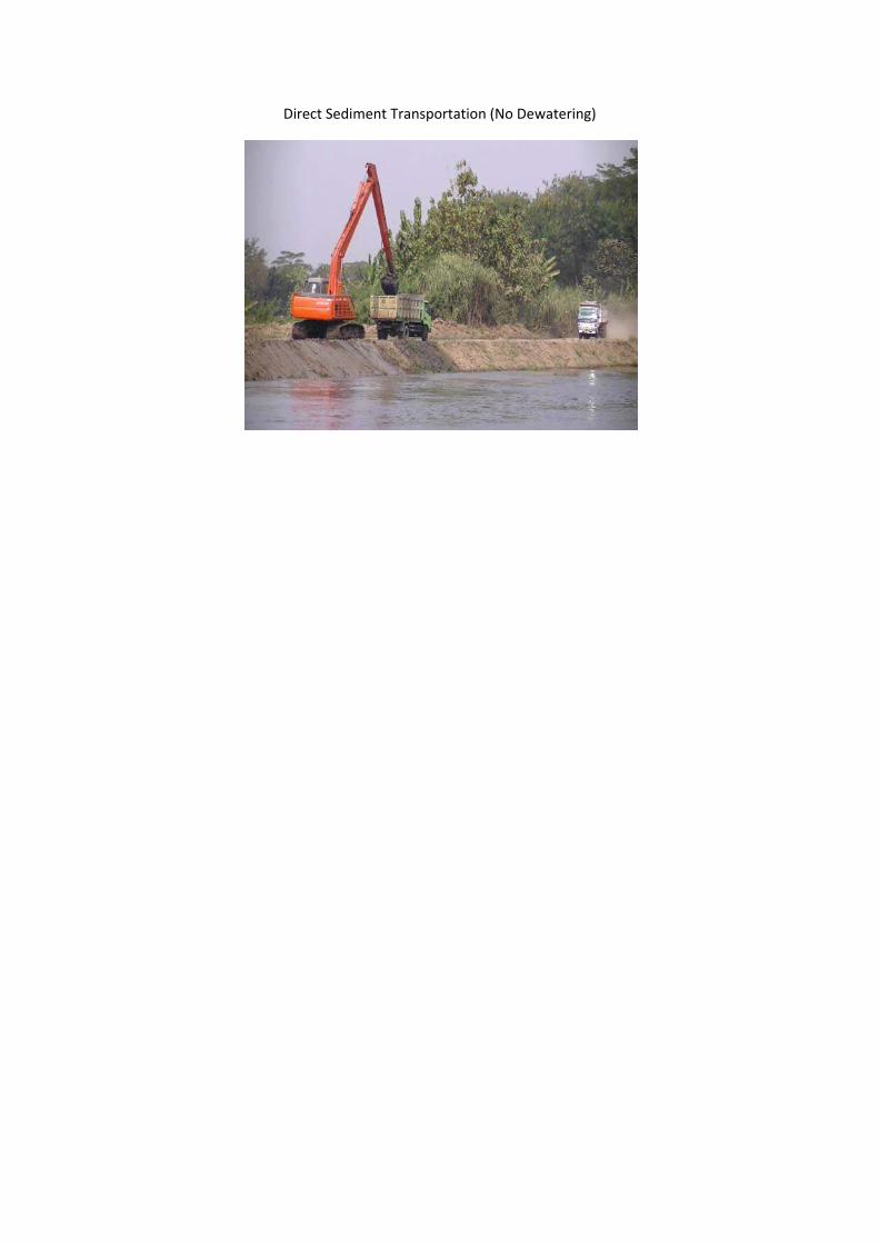
Direct Sediment Transportation (No Dewatering)
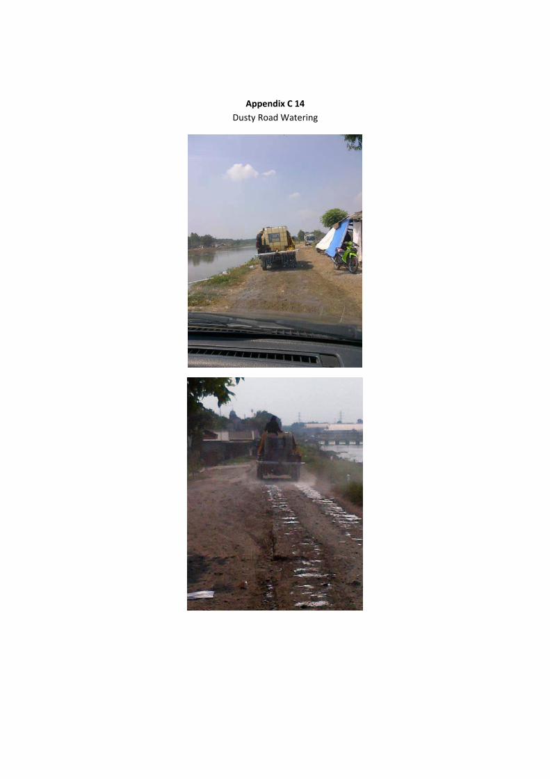
Appendix C 14 Dusty Road Watering
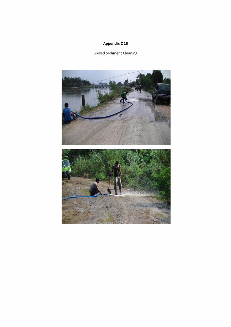
Appendix C 15
Spilled Sediment Cleaning
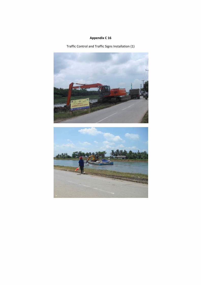
Appendix C 16
Traffic Control and Traffic Signs Installation (1)
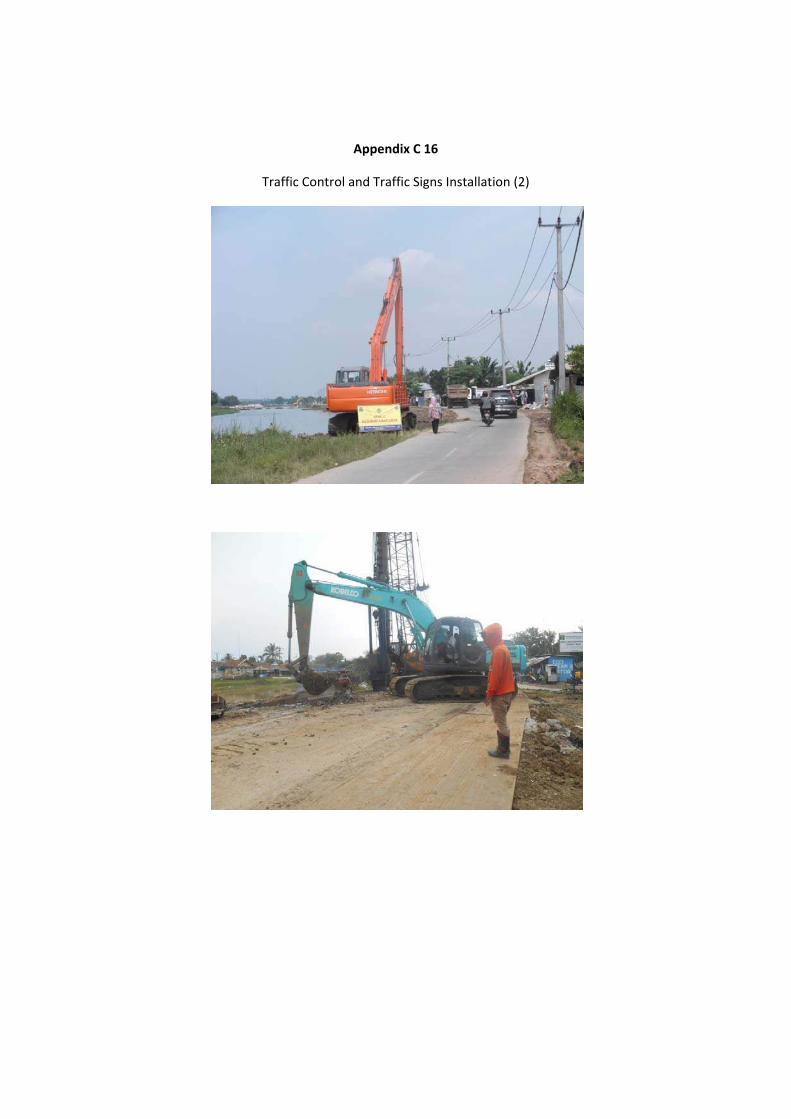
Appendix C 16
Traffic Control and Traffic Signs Installation (2)
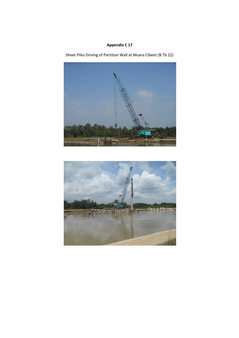
Appendix C 17
Sheet Piles Driving of Partition Wall at Muara Cibeet (B.Tb 22)
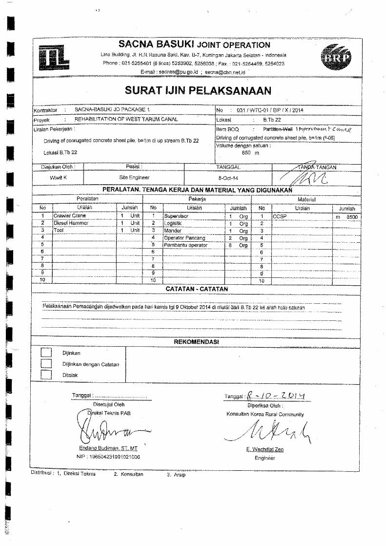
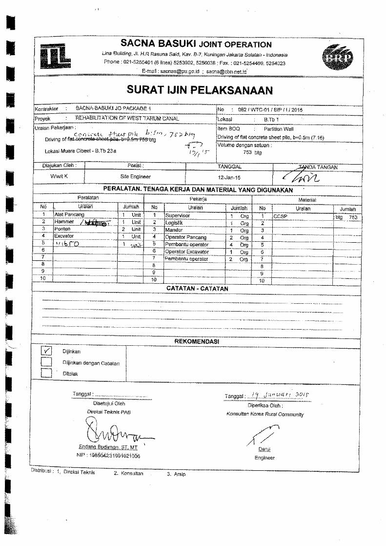
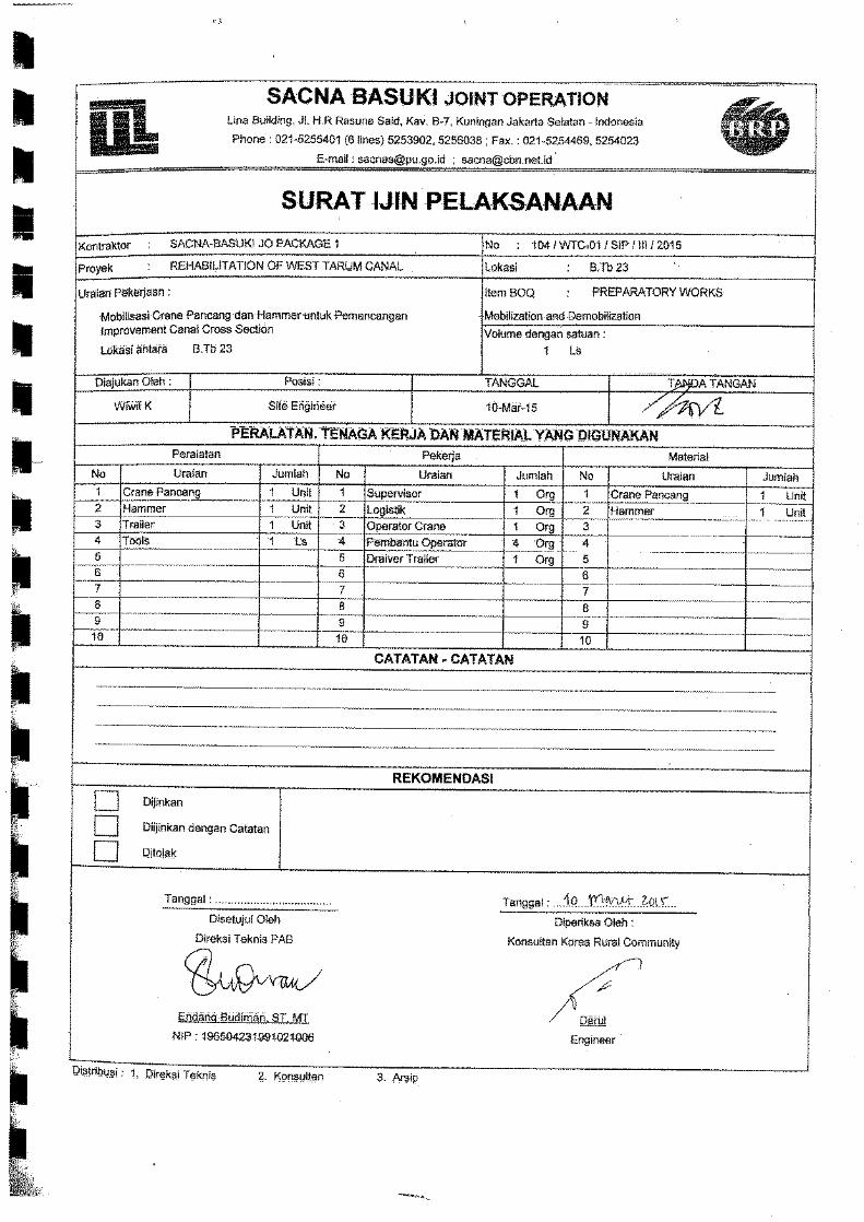
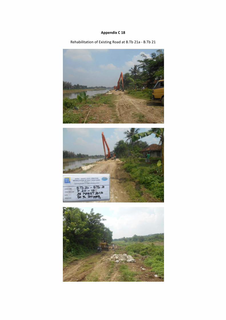
Appendix C 18
Rehabilitation of Existing Road at B.Tb 21a ‐ B.Tb 21