environmental scoping statement - pdf.usaid.govpdf.usaid.gov/pdf_docs/pdacr359.pdf · environmental...
TRANSCRIPT

ENVIRONMENTAL SCOPING STATEMENT IRRIGATION REHABILITATION PROGRAM

Irrigation Rehabilitation ProgramEnvironmental Scoping Statement
April 2010 Page 1-2
1.0 INTRODUCTION 1.1 General The Maximizing Agricultural Revenue and Key Enterprises in Targeted Sites Activity (MARKETS) is funded by the United States Agency for International Development (USAID) and implemented by Chemonics International Inc and partners from July 2005 through December 2010. MARKETS expands economic opportunities in the Nigerian agricultural sector by increasing agricultural productivity, enhancing value-added processing, and increasing commercialization through private-sector led growth and development. Although Nigeria is rapidly urbanizing, a majority of Nigerians still live in rural areas, and agriculture forms the basis of their livelihoods. Over the past 40 years, agriculture has declined by almost every measure – share of GDP, value of exports, productivity. The poor performance of the agricultural sector has been caused by inconsistent policies and the use of low-input, low-output technologies. Post-harvest losses are high, appropriate processing and value adding technologies are unavailable, a commercial orientation is lacking, and market information and linkages are weak. Under MARKETS, Nigerian farmers and entrepreneurs are being assisted to increase their productivity, diversify their output as a risk-management strategy, add value to the commodities they produce, increase their incomes and gain better access to input and output markets through the private sector. The approach is environmentally sustainable and counters the potentially harmful effects on soil fertility, land degradation, and biodiversity. To leverage greater impact and reach a larger number of beneficiaries, MARKETS employs a commodity value chain approach, identifying selected commodities and product chains that can benefit from proven technological packages, increased value addition through improvements in storage, processing and commercialization, supported by policy reform to make these changes sustainable. 1.2 Irrigation Needs The objective of this particular assignment is to develop irrigation within the 2010 MARKETS work plan. Bringing more land under irrigated agriculture will contribute to improving the sustainable food security of Nigeria. Irrigation may also contribute directly to the following MARKETS performance indicators:
Indicator 1: Clients networked Indicator 2: New jobs created Indicator 3: Gross revenue generated by clients Indicator 4: Net income by producer groups Indicator 5: Increased productivity of commodities Indicator 9: Number of additional hectares under improved technologies or management practices.

Irrigation Rehabilitation ProgramEnvironmental Scoping Statement
April 2010 Page 1-3
Following an examination of functioning of irrigation systems throughout Nigeria, the need to properly invest resources in the irrigation sector became evident. Certain patterns are discerned: (a) poor infrastructure condition due to lack of proper maintenance, (b) insufficient support and resources for suitable operations and maintenance of infrastructure, and (c) weak stakeholder ownership and participation and unclear roles and responsibilities. Infrastructure rehabilitation needs to be complemented with targeted training in operations and maintenance, support to effectively engage stakeholders and nurture healthy interactions, and building the capacity of farmers through water user associations. These elements will provide a holistic approach to addressing the most urgent issues in the irrigation sector. Chemonics hopes to structure this intervention as a pilot program for potential replication at other irrigation project sites in the near future. 1.3 The Bakolori Irrigation Project Chemonics has decided to implement a pilot program at the Bakolori Irrigation Project (BIP) in Zamfara State (see Exhibit 1-1). This irrigation project, which is managed by the Sokoto Rima River Basin Development Authority (SRBDA), was substantially completed in 1983. The localities of Talata Mafara, Maradum, and Bakura hold all 23,000 hectares of this project. Almost 65% of the land was irrigated by sprinkler systems. Gravity fed surface irrigation is used in the remaining 8,000 hectares. The site, which hosts approximately 22,000 farmers, is located 110 km southeast from Sokoto City. The components of the gravity fed system include: • a 15 km-long concrete lined supply canal, • two main canals totaling 45 km of length, • secondary canals totaling 200 km of length, • tertiary canals totaling 300 km of length, and • field ditches totaling 400 km of length, among other elements. The BIP has fallen into a state of disrepair over the last 15 years. Accordingly, many parts of the BIP are non-functioning, such as the sprinkler-fed areas, or are not functioning at full capacity. As such, many components of the BIP require rehabilitation. Various components are illustrated below as exhibits 1-2 to 1-5. 1.4 Project Framework It is suggested that four components be undertaken to help kick-start improvements within the BIP, each of which will address a defined need, and each of which will generate more information that will be valuable in future work in the Nigerian irrigation sector. The four components also reflect the areas of highest priority-needs for effecting improvements to the irrigation sector in Nigeria. These four components are: 1) A maintenance module 2) An institutional strengthening module 3) A capacity building module; and 4) An “outreach” module.

Irrigation Rehabilitation ProgramEnvironmental Scoping Statement
April 2010 Page 1-4
The Scoping Study will focus on the impacts associated with the maintenance module as the other three components are not anticipated to result in any significant negative environmental or social impacts. Comments will however be made during the environmental assessment process as to potential capacity building components and institutional strengthening that may help the project become more sustainable.
Exhibit 1-1: Location of BIP
1.5 USAID Environmental Requirements USAID proposes to fund the Irrigation Rehabilitation Program. Activities identified for such funding are subject to the Environmental Procedures established by Title 22 of the U.S. Code of Federal Regulations, Part 216 (22 CFR 216). Pursuant to those Procedures, actions that have a potential for significant impact within a country require the preparation of an Environmental Assessment (EA) and subsequent approval of the EA and its recommendations to avoid or otherwise mitigate potential adverse impacts. The Procedures identify 11 classes of actions as having an inherent potential for significant environmental effect, including “Programs of river basin development and Irrigation or water management projects, including dams and impoundments”1
The initial component of the EA process is preparation of a Scoping Study. The objective of this Scoping Statement is to summarize the results of a scoping process that has been conducted to identify significant environmental issues related specifically to the Irrigation
1: 22 CFR 216 – Agency Environmental Procedures, Paragraph 216.2(d)(1)

Irrigation Rehabilitation ProgramEnvironmental Scoping Statement
April 2010 Page 1-5
Rehabilitation Program. Once completed, the Scoping Study will be submitted to USAID for review before the next phase of the EA procedure. 1.6 Scoping Objectives As required by 22 CFR 216.3(a)(4), the objectives of this Scoping Statement are the following: • A determination of the scope and significance of issues to be analyzed in the EA or
Impact Statement, including direct and indirect effects of the project on the environment.
• Identification and elimination from detailed study of the issues that are not significant or have been covered by earlier environmental review, or approved design considerations, narrowing the discussion of these issues to a brief presentation of why they will not have a significant effect on the environment.
• A description of: o The timing of the preparation of environmental analyses, including phasing if
appropriate o Variations required in the format of the EA o the tentative planning and decision-making schedule
• A description of how the analysis will be conducted and the disciplines that will participate in the analysis.
These written statements shall be reviewed and approved by the Bureau Environmental Officer.
Exhibit 1-2: 15km supply canal Exhibit 1-3: Dividing point for the two main canals

Irrigation Rehabilitation ProgramEnvironmental Scoping Statement
April 2010 Page 1-6
Exhibit 1.-4: Secondary Canal Exhibit 1-5: Drainage ditch

Irrigation Rehabilitation ProgramEnvironmental Scoping Statement
April 2010 Page 1-7
2.0 PROJECT DESCRIPTION 2.1 General As stated in the introduction, the BIP has fallen into a general state of disrepair. There are multiple failures within the system, most notably the complete non-functioning hydro-electric power station at Bakolori Dam and the failed sprinkler irrigation system which originally covered 15,000 hectares of the BIP. The gravity fed irrigation system is the only portion of the project that could be considered any kind of success, but still this area is suffering from years of neglect and lack of maintenance. Initial studies undertaken by the consultant revealed a number of activities that stakeholders considered important actions to help rehabilitate the gravity fed area of the BIP. The two most important activities were felt to be the rehabilitation of a failed dike close to G-Rice area, and the de-silting of the drainage ditches across the gravity fed areas. Due to time constraints, and after consultation with the Bakolori Irrigation Project Management Office (BIPMO) and SRRBDA, it was felt that the de-silting activity was the best option and would have a greater overall impact to the gravity fed area of the BIP. Since the project began in the late 1970’s limited de-silting of the drainage ditches has occurred. This has led to the levels of the silt continuously rising. The levels of silt and the vegetation within them have now, in some locations, led to the drainage ditches becoming indistinguishable from the adjacent farmland. This has led to farmers cropping these additional lands. However, this is not the intended purpose of the drainage ditches. The main issue resulting from the silted drainage ditches is the fact that there is no longer an adequate drainage system to ensure that excess water is removed from the system. Currently, at numerous locations around the gravity fed areas drainage ditches are full with silt, excess water from the irrigation canals has nowhere to go and accordingly this water overtops the drainage ditches and inundates adjacent lands. This inundation is destroying crops and reducing the land available for cropping. The non-functioning drainage ditches also affect crop-yields in those areas where cropping is taking place, by keeping root-zones of crops too moist, and thereby reducing the ability of the crop to flourish. Accordingly, as part of the maintenance module the services of a subcontractor are required to rehabilitate targeted drainage ditches in the BIP. 2.1 Project Description The Subcontractor shall rehabilitate, repair and clean to be identified drain networks located in the BIP. These infrastructure rehabilitation activities are expected to start early May. This intervention will improve irrigation management practices and soil conditions. Furthermore, drainage rehabilitation shall increase the per hectare yields of the crops raised in these areas. Draining excess water from farm land will help farmers in the processes of weeding and harvesting, make possible double (and even triple in some locations) cultivation per year, facilitate machinery access to farm lands, and help control malaria.

Irrigation Rehabilitation ProgramEnvironmental Scoping Statement
April 2010 Page 1-8
The drains will be cleared of silt, debris, brush, vegetation, weeds, trees and other growth until the water leading into the drainage area is able to flow and continue moving through the drain without any blockage or obstruction. The Subcontractor shall load and haul all spoils and materials to the designated disposal site in the intake location of performance.
Irrigation Rehabilitation ProgramEnvironmental Scoping Statement
April 2010 Page 1-9
3.0 SCOPING ACTIVITIES To determine the scope and significance of issues to be assessed in the EA, including both direct and indirect effects, Chemonics and their team of Consultants has used their experience of similar projects in Nigeria and also undertaken a program of consultation in the affected area with relevant stakeholders to include: • Farmers within the command area • Livestock Herders • Local Traditional Rulers • Market Stall Holders • Water Users Association (WUA) • Irrigation project staff • State government participants in the project area Chemonics sent a team of environmental specialists into the project area for three weeks to make detailed observations of the site. This site assessment coupled with the stakeholder consultation program allows for the appropriate level of scoping being undertaken herewith. Further consultation will also be undertaken at the EA stage of the project. Farmers - A number of consultations were undertaken in the field with farmers between the 1st and 10th of April 2010. These sessions were informal and involved groups of between five and ten farmers. Some key data from the farmers included the following: • The farmers interviewed were both land owners and leasers of government land. All
of those farmers leasing government land also owned land. • Farm sizes ranged from 0.15 hectares to 2.56 hectares. Some farmers owned multiple
plots. Rice is the dominant crop in the BIP with all farmers interviewed currently growing this crop. Yields of rice were around 75 bags (75kg per bag) per hectare, or 5,600 kgs per hectare. Farmers sold the rice for between 4,000 and 5,000 naira per sack, or around 337,000 Naira per cropping season per hectare.
• Most farmers only crop once a year, blaming poor water management from the irrigation system on their inability to crop more than once.
• Most land is inherited with little available for purchase, comments were made that a 0.64 hectare plot of land could fetch around 500,000 naira on the open market.
• Both fertilizer and pesticides were applied, although there was very little knowledge of the pesticide types or how to apply it correctly. Stem Borer and Quelea Birds were acknowledged as the main pests.
• Little or no extension services were provided in the project area; however, all of the farmers were members of the Water Users Association (WUA).
• Women were only involved in winnowing activities and played no other part in the agricultural process.
• Most farmers complained about livestock herders who often affected their land with uncontrolled grazing.
• They also commented that cattle often caused destruction of embankments around the canals while feeding.

Irrigation Rehabilitation ProgramEnvironmental Scoping Statement
April 2010 Page 1-10
Asked about the environmental affects of the project, all farmers agreed that they were happy to suffer any form of inconvenience during project works for the sake of overall improvement of the irrigation system. Even farmers who are currently cropping in the silted drains were happy to see their crops removed if it meant that the drains would be de-silted. Livestock Holders – Livestock herders were interviewed in the field, however, it should be noted that not all of the livestock herders wanted to be interviewed. There is a distinction between two types of herders that should be made. First there are herders who manage cattle within the irrigation system for other cattle owners (Farmers owning livestock), then there are the Fulani, nomadic cattle herders who do not have any affiliation with the BIP, they graze their cattle outside of the irrigation system during the wet season and then move into the BIP during the dry season due to the availability of water there. All of the cattle farmers used the drainage ditches as grazing areas. When informed of the intention to rehabilitate the drainage ditches they commented that this may disrupt the cattle grazing patterns. Accordingly, it is recommended that the issue of cattle grazing locations be assessed further at the EA stage of the project. Market Users – Consultation was undertaken with farmers and produce sellers in Talata Mafara market on Tuesday 6th April. Tuesdays are the main market days in Talata Mafara. Consultations with a farmer who was selling his rice indicated that the price of rice in the market was around 5,500 per sack. This indicates that there is a slight rise in price from purchasing from the farmer at the farm gate compared with at the market, this is probably attributed to the mark up that middle men make when buying from farmers and selling at the market. The farmer noted that prices were lower this year. As a farmer he was glad that the BIP was undergoing the rehabilitation but had no comment to make on the specific activity of drainage ditch clearance. Water Users Association (WUA) – Most farmers in the BIP are members of the WUA. A membership fee of 20 is charged to join the association, followed by monthly fees of 50 naira. The WUA is a formative organization and as such is not fully functional. The meeting with the WUA involved the Executive Chairman, the Executive Secretary and various Chairmen at the intake level. The EIA will discuss the full functions and responsibilities of the WUA. The WUA members do not include fishermen or livestock herders, but they hope to include these parties in the scheme soon. The primary objective of the WUA is to help sustain the BIP by providing a range of services to the farmers; however, the range of services is not entirely clear at this stage. When asked to comment on the project all of those present agreed that the project was extremely important, they did however think that rehabilitation of the dike in the G-Rice area was the most important task. Regarding environmental impacts, none of the WUA could think of any potential negative project impacts. We asked if they were concerned about potential construction activities affecting their crops, but the general consensus was that this was part and parcel of the maintenance activities, and as such they would not complain about such impacts. Bakolori Irrigation Project Management Office (BIPMO) – Numerous discussions were held with the BIPMO over a period of two weeks in early April. A whole range of

Irrigation Rehabilitation ProgramEnvironmental Scoping Statement
April 2010 Page 1-11
topics were discussed from land tenure, pesticide use, crop yields, structure of the BIPMO, farming attitudes, history of the BIP, etc. The BIPMO has recently been re-organized in the last three months, and as such, many of the staff are currently still coming to terms with the scale of the job in front of them. This project forms one of many interventions that the BIP is planning and as such they are trying to cope with these issues at the same time as the general management of the BIP. The BIPMO were extremely enthusiastic about the project and could only emphasize the positive impacts the project will have in the BIP. They felt that it was an excellent start for them as a newly restructured organization to show the farmers that the BIP would not be neglected anymore and that they intend to rehabilitate the BIP into a fully functioning, sustainable system. The BIPMO were aware that there may be some short term construction related impacts. They were also aware that the EA may put additional responsibilities in their hands during rehabilitation and operation of the drainage ditches. However, they are more than willing to take on these responsibilities. Their capacity to do so however maybe limited. This issue and other institutional arrangements need to be assessed further at the EA stage of the project. Traditional Rulers – Consultation with the Traditional Ruler of Birnin Tudu was undertaken in the second week of April. Birnin Tudu lies at the heart of the BIP and was a scene of many troubles during the initial construction of the BIP in the late 1970’s mainly relating to resettlement issues. In addition, the village sits adjacent to one of the seven or so borrow pits proposed to store the excavated silt from the drainage ditches. The purpose of the consultation was to assess what impacts they thought filling of the borrow pit may have on their village. They were very happy that we had taken the time to meet with them and discuss this issue, but in general were not too concerned about the potential impacts of the project as they believed the project was in the general interest of the farmers of the BIP. They commented that almost everyone in the village was engaged in agricultural activities and that it was the main economic activity in the village. As such, repairing the drainage ditches was an important activity for them. Currently there was no economic purpose to the borrow pit, they claimed that it did fill with water in the rainy season, but there had been no cases of animals or people drowning in the pit. They stated that mosquitoes in the water filled pit were problematic and that they had no way of treating malaria in the village. They asked that if the borrow pit was filled that the land be turned over to the village so they may expand the borders of the village which is currently constrained due to the surrounding agricultural land uses.

Irrigation Rehabilitation ProgramEnvironmental Scoping Statement
April 2010 Page 1-12
4.0 SIGNIFICANT ISSUES TO BE ADDRESSED IN THE EA 4.1 General The following section outlines the existing socio-environmental conditions in the vicinity of the Project and identifies the potential significant issues to be addressed in the EA. The environmental criteria have been laid out following USAID guidelines: • Physical Resources, including;
o Topography o Soils o Seismic and Geological Characteristics o Hydrology o Air Quality and Climate
• Natural Biological Resources, including; o Flora o Fauna o Protected Areas
• Other Environmental Concerns Noted by 22 CFR 216, including; o Land Use and Development Policies & Controls o Use of Natural/Depletable Resources o Urban Quality/Design of the Built Environment o Historic and Cultural Resources
• Additional Environmental Concerns Noted for Consideration, including; o Socio-economic characteristics o Agriculture o Public Health and Safety o Waste Management o Animal Issues o Noise o Other Infrastructure Systems
Physical Resources - Topography Existing Conditions – The project site is nearly level to gently undulating and lies at an elevation of around 320 meters above mean sea level. The slope varies from 0 to 0.6%. No unusual topographic conditions or issues have been identified at this stage of the project.
Potential Impacts Impacts Avoided or Otherwise Mitigated by Measures
Incorporated in the Project
Aspects Requiring Further Analysis at the
EA Stage Yes Insufficient
Data The project works are limited to removal of sediment from the drains, accordingly no significant impacts to topography have been identified.
None
Irrigation Rehabilitation ProgramEnvironmental Scoping Statement
April 2010 Page 1-13
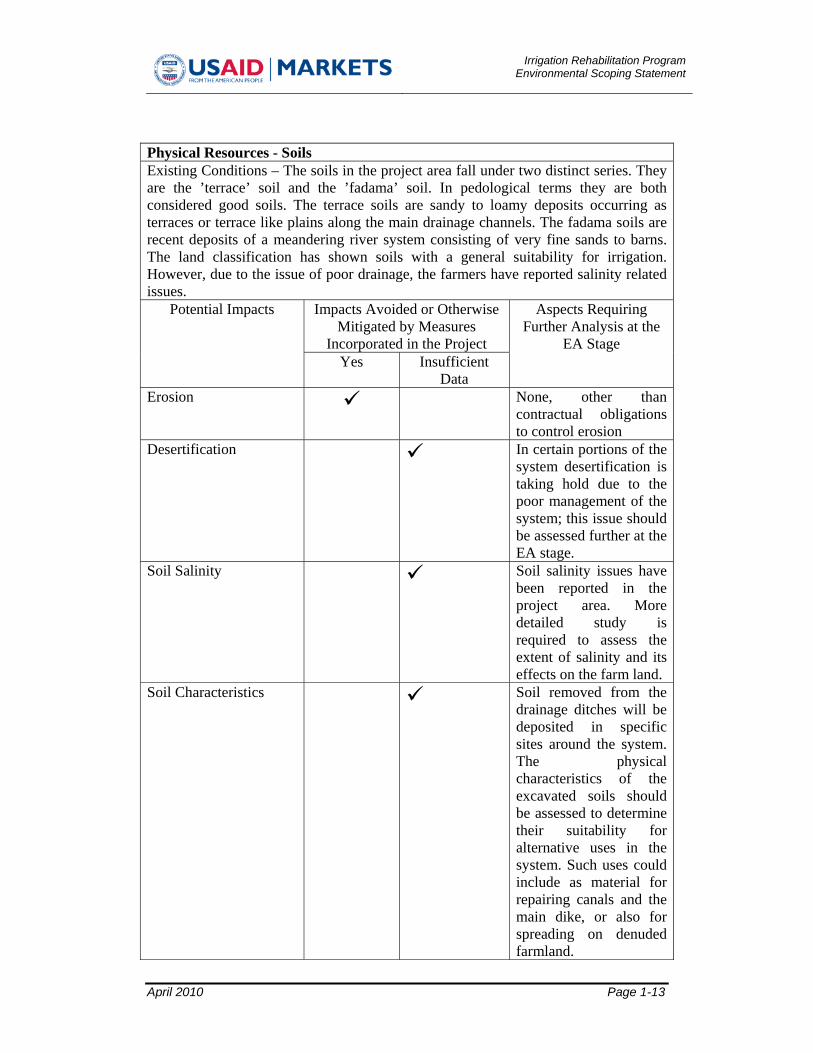
Physical Resources - Soils Existing Conditions – The soils in the project area fall under two distinct series. They are the ’terrace’ soil and the ’fadama’ soil. In pedological terms they are both considered good soils. The terrace soils are sandy to loamy deposits occurring as terraces or terrace like plains along the main drainage channels. The fadama soils are recent deposits of a meandering river system consisting of very fine sands to barns. The land classification has shown soils with a general suitability for irrigation. However, due to the issue of poor drainage, the farmers have reported salinity related issues.
Potential Impacts Impacts Avoided or Otherwise Mitigated by Measures
Incorporated in the Project
Aspects Requiring Further Analysis at the
EA Stage Yes Insufficient
Data Erosion None, other than
contractual obligations to control erosion
Desertification In certain portions of the system desertification is taking hold due to the poor management of the system; this issue should be assessed further at the EA stage.
Soil Salinity Soil salinity issues have been reported in the project area. More detailed study is required to assess the extent of salinity and its effects on the farm land.
Soil Characteristics Soil removed from the drainage ditches will be deposited in specific sites around the system. The physical characteristics of the excavated soils should be assessed to determine their suitability for alternative uses in the system. Such uses could include as material for repairing canals and the main dike, or also for spreading on denuded farmland.

Irrigation Rehabilitation ProgramEnvironmental Scoping Statement
April 2010 Page 1-14
Physical Resources – Geology and Seismic Conditions Existing Conditions – The project area lies on the border of an area composed of igneous and metamorphic rocks overlain by more recent sedimentary rocks.
Potential Impacts Impacts Avoided or Otherwise Mitigated by Measures
Incorporated in the Project
Aspects Requiring Further Analysis at the
EA Stage Yes Insufficient
Data Excavation of materials from the drainage ditches is unlikely to have any significant effects on geology as only sediment is being removed to previous levels.
None
Physical Resources - Hydrology Existing Conditions – In general groundwater occurs at between 1.5 and 2 meters below the surface of the site. The groundwater table has risen over the past 25 years due to the irrigation activities; as such it is assumed that there is a plentiful supply of groundwater. Farmers use tubewell irrigation in areas not supplied by the gravity fed system. Groundwater is also used in the local villages for water supply. There are two surface water courses in the project area, the Sokoto River and the Bobo River. They are both part of the Sokoto-Rima river basin. The rivers provide water to farmland outside of the irrigation system, and to a limited extent within it. It was noted that use of fertilizer in the irrigation system may have led to nitrification of the waters in the Sokoto River. The Bakolori reservoir is the primary water source for the irrigation system and has a capacity of approximately 450 million cubic meters. The water is conveyed into the system via a 15km long supply canal.
Potential Impacts Impacts Avoided or Otherwise Mitigated by Measures
Incorporated in the Project
Aspects Requiring Further Analysis at the
EA Stage Yes Insufficient
Data Water Quality Use of inorganic
fertilizer maybe increasing the nitrogen load in the Sokoto River. This issue should be addressed further at the EA stage.

Irrigation Rehabilitation ProgramEnvironmental Scoping Statement
April 2010 Page 1-15
Surface water The flow of the Sokoto river is regulated by the Bakolori Dam. The flow remains constant throughout the year allowing farmers to irrigate their fields with the water from the River. The Bobo river also flows through the system. The exact hydrological patterns of the rivers should be assessed at the EA stage.
Ground water Impacts to groundwater should be mitigated by contractual provisions included within the EA.
Flood and Inundation The flood and inundation characteristics of the project are complex and require further study to assess their current impacts on the project.
Physical Resources – Air Quality and Climate Existing Conditions – The project area has a typical tropical climate which is marked by two prominent seasons. The rainy season extends generally from June to October while the dry season occurs between November and May. Average temperatures reach around 28 degrees Celsius. Rainfall averages around 700 mm per annum.
Potential Impacts Impacts Avoided or Otherwise Mitigated by Measures
Incorporated in the Project
Aspects Requiring Further Analysis at the
EA Stage Yes Insufficient
Data Construction related dust and emissions
No additional analysis is required, contractual obligations to control impacts in the EA are however required.
Irrigation Rehabilitation ProgramEnvironmental Scoping Statement
April 2010 Page 1-16
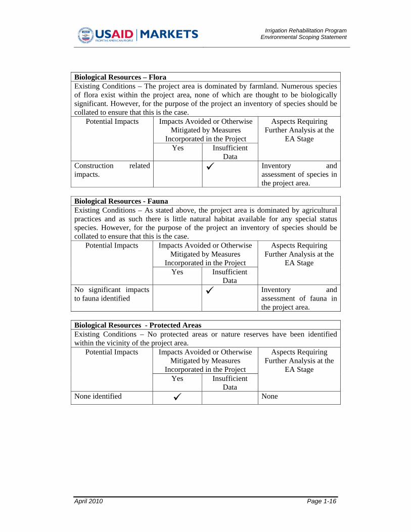
Biological Resources – Flora Existing Conditions – The project area is dominated by farmland. Numerous species of flora exist within the project area, none of which are thought to be biologically significant. However, for the purpose of the project an inventory of species should be collated to ensure that this is the case.
Potential Impacts Impacts Avoided or Otherwise Mitigated by Measures
Incorporated in the Project
Aspects Requiring Further Analysis at the
EA Stage Yes Insufficient
Data Construction related impacts.
Inventory and assessment of species in the project area.
Biological Resources - Fauna Existing Conditions – As stated above, the project area is dominated by agricultural practices and as such there is little natural habitat available for any special status species. However, for the purpose of the project an inventory of species should be collated to ensure that this is the case.
Potential Impacts Impacts Avoided or Otherwise Mitigated by Measures
Incorporated in the Project
Aspects Requiring Further Analysis at the
EA Stage Yes Insufficient
Data No significant impacts to fauna identified
Inventory and assessment of fauna in the project area.
Biological Resources - Protected Areas Existing Conditions – No protected areas or nature reserves have been identified within the vicinity of the project area.
Potential Impacts Impacts Avoided or Otherwise Mitigated by Measures
Incorporated in the Project
Aspects Requiring Further Analysis at the
EA Stage Yes Insufficient
Data None identified None

Irrigation Rehabilitation ProgramEnvironmental Scoping Statement
April 2010 Page 1-17
Other Environmental Concerns Noted by 22 CFR 216 - Land Use and Development Policies & Controls Existing Conditions – Land tenure issues in the project area are relatively straightforward. The land is either owned by the farmer or rented from the government. According to the farmers very little land is ever put up for sale with most land passed on via inheritance. There is little government owned land available for rental, as such it is difficult for anyone to enter the system for the first time. It has been reported that farmers are not happy with the land tenure system although initial consultations with the farmers did not reveal why this was the case.
Potential Impacts Impacts Avoided or Otherwise Mitigated by Measures
Incorporated in the Project
Aspects Requiring Further Analysis at the
EA Stage Yes Insufficient
Data Land tenure Although land tenure is
perceived as relatively straightforward, some farmers are still not happy with the process; the EA should address this issue further.
Other Environmental Concerns Noted by 22 CFR 216 - Use of Natural/Depletable Resources Existing Conditions – The primary sources of fuel in the area are wood and diesel. Fuel wood is gradually being depleted across the project area. Diesel shortages can also occur in the region. However, given the relatively straightforward rehabilitation activities forming the project the use of any of these resources is unlikely to be significant.
Potential Impacts Impacts Avoided or Otherwise Mitigated by Measures
Incorporated in the Project
Aspects Requiring Further Analysis at the
EA Stage Yes Insufficient
Data None identified None

Irrigation Rehabilitation ProgramEnvironmental Scoping Statement
April 2010 Page 1-18
Other Environmental Concerns Noted by 22 CFR 216 - Urban Quality/Design of the Built Environment Existing Conditions – There are a few urban areas within the irrigation system, they include Rini, Birni N’Tudu, Yarkofoji, Madochi, Dankaiwa, Dankadou and Bakaru. Talata Mafara is located on the fringes of the project area, but not within it. The villages mentioned above mainly comprise low rise buildings constructed from a mix of earth, sand and other organic material. None of these buildings are of any notable architectural importance.
Potential Impacts Impacts Avoided or Otherwise Mitigated by Measures
Incorporated in the Project
Aspects Requiring Further Analysis at the
EA Stage Yes Insufficient
Data The project will have no negative impacts to urban quality.
None
Other Environmental Concerns Noted by 22 CFR 216 - Historic and Cultural Resources Existing Conditions – Reportedly there are cultural resources of significance in a small village close to L-Rice. No other historical or cultural resources have been identified within the project area. Nonetheless, chance finds could occur.
Potential Impacts Impacts Avoided or Otherwise Mitigated by Measures
Incorporated in the Project
Aspects Requiring Further Analysis at the
EA Stage Yes Insufficient
Data Impacts to cultural resources close to L-Rice
This issue should be investigated further at the EA stage.
Chance finds None, other than specification of chance find procedures.

Irrigation Rehabilitation ProgramEnvironmental Scoping Statement
April 2010 Page 1-19
Additional Environmental Concerns Noted for Consideration - Socio-economic characteristics Existing Conditions – The project area is dominated by agricultural practices. Thus farming is the main employer and generates almost all of the project area’s income. There are approximately 35,000 farmers actively working the entire BIP system supported by another 80,000 or so labourers. Farm size ranges between 0.15 hectares and 2.56 hectares, most farmers own their land, although a number also lease around 1,000 hectares of government controlled land. Incomes are low in the project area, average salaries range between 400 and 500 naira per day. The population is predominantly Hausa.
Potential Impacts Impacts Avoided or Otherwise Mitigated by Measures
Incorporated in the Project
Aspects Requiring Further Analysis at the
EA Stage Yes Insufficient
DataThe project should have an overwhelmingly beneficial impact to the project area in terms of improving the quality of agricultural land
It is worthwhile examining the socio-economic benefits in more detail at the EA stage to understand the full benefits of the project to the local population.
Short term construction impacts
None, other than incorporation of mitigation measures in contractual documents to ensure that the economic and social activities are not disturbed by the project during the works period.

Irrigation Rehabilitation ProgramEnvironmental Scoping Statement
April 2010 Page 1-20
Additional Environmental Concerns Noted for Consideration – Agriculture Existing Conditions – Agricultural practices in the project area can be divided into crop farming and livestock farming. Limited amounts of fish farming are also occurring in the project area, but not of a significant level. Crop farming is limited by the poor maintenance of the BIP and also by the poor water management which is limiting the farmers to one cropping season. The impacts of the project upon the crop farmers are overwhelmingly beneficial although there may also be some short term negative impacts to agricultural activities during the rehabilitation phase. Livestock farmers currently graze their cattle in the areas to be rehabilitated, thus these farmers may lose grazing areas and be forced into smaller parcels of grazing area or into crop land. This could lead to social tension in the area between livestock farmers and crop farmers.
Potential Impacts Impacts Avoided or Otherwise Mitigated by Measures
Incorporated in the Project
Aspects Requiring Further Analysis at the
EA Stage Yes Insufficient
Data Construction impacts None, apart from a
thorough management plan indicating how these issues will be mitigated and managed.
Loss of grazing locations
Alternative arrangements for cattle grazing should be assessed.
Additional Environmental Concerns Noted for Consideration - Public Health and Safety Existing Conditions – There are few health clinics within the BIP, for any serious health conditions people must travel to the hospital in Talata Mafara. Malaria is a key health concern in the BIP. Mosquitoes breed within the stagnant waters of the drainage ditches.
Potential Impacts Impacts Avoided or Otherwise Mitigated by Measures
Incorporated in the Project
Aspects Requiring Further Analysis at the
EA Stage Yes Insufficient
Data Construction safety None apart from
incorporation of construction safety measures in the EA.

Irrigation Rehabilitation ProgramEnvironmental Scoping Statement
April 2010 Page 1-21
Health impacts The project is anticipated to have significant health benefits in terms of the reduction of breeding areas for vector borne disease such as malaria.
STDs An STD awareness program should be established as part of the EA process to prevent sexually transmitted diseases being spread by construction workers.
Additional Environmental Concerns Noted for Consideration - Waste Management Existing Conditions – There is no organized solid or liquid waste management in the project area. However, it should be noted that due to the dominance of basic agricultural practices in the area no large volumes of solid or liquid waste is produced apart from the small urban areas dotted around the irrigation system.
Potential Impacts Impacts Avoided or Otherwise Mitigated by Measures
Incorporated in the Project
Aspects Requiring Further Analysis at the
EA Stage Yes Insufficient
Data Mis-management of solid and liquid waste.
None, apart from contractual provisions to ensure good waste management practice.
Additional Environmental Concerns Noted for Consideration - Noise Existing Conditions – Noise levels in the project area are low. There are few sensitive receptors in the project area.
Potential Impacts Impacts Avoided or Otherwise Mitigated by Measures
Incorporated in the Project
Aspects Requiring Further Analysis at the
EA Stage Yes Insufficient
Data Construction related noise.
None other than the incorporation of noise mitigation measures in contract provisions.

Irrigation Rehabilitation ProgramEnvironmental Scoping Statement
April 2010 Page 1-22
Additional Environmental Concerns Noted for Consideration - Other Infrastructure Systems Existing Conditions – Electricity transmission lines cross the project area within the proximity of the drainage ditches. In addition, the project area is made up of a complex pattern of irrigation channels and access roads.
Potential Impacts Impacts Avoided or Otherwise Mitigated by Measures
Incorporated in the Project
Aspects Requiring Further Analysis at the
EA Stage Yes Insufficient
Data Impacts to transmission lines
None other than incorporation of mitigation measures in contract provisions.
Impacts to irrigation channels caused by construction machinery.
The potential locations should be identified where this activity could cause impacts.
Impacts to roads including blocking access routes.
The potential locations should be identified where this activity could cause impacts.
4.2 Alternatives Considered 4.2.1 No Action. The “No Action” Alternative in this instance is defined as a decision not to undertake the proposed clearing of the drainage ditches. The “No Action” Alternative would result in the continued deterioration of the gravity fed area of the BIP, thereby severely impeding the economic recovery of the Project Area. All positive benefits would be foregone. The relatively minor, less than significant environmental impacts (such as noise and short-term air quality impacts due to rehabilitation activities) and inconveniences would be avoided in the short-run. In the long-run, however, the steadily declining state of the irrigation system and the farmland would severely hamper the farming practices in the project area. In light of these considerations, the “No Action” Alternative is deemed to be neither prudent nor in the best interest of the Bakolori area or those with an interest in, and attempting to assist restoration of, Bakolori’s well being. 4.2.2 Site Alternatives. Several potential projects sites have been assessed in addition to the Bakolori Project. These sites included: • Lower Anambra Irrigation Project (LAIP) at Omor • Tada-Shonga Irrigation Project in Ilorin • Kano River irrigation project in Kano. Lower Anambra Irrigation Project (LAIP). This project has the greatest potential especially in rice production. The project is capable of producing the largest rice in one single location in Nigeria, and also requires minimum cost and the shortest period among

Irrigation Rehabilitation ProgramEnvironmental Scoping Statement
April 2010 Page 1-23
the four potential interventions. If rice production is the priority of the intervention, then this project stands out. Tada-Shonga Irrigation Project. This project also focuses on rice production. The land is very fertile as a Niger River flood plain and therefore capable of yielding rice at a very high rate. Intervention on this Project promises good result. The work involved could be carried out within the one year period if properly planned and work starts well before the rains come down heavily. Kano River Irrigation Project. This irrigation project is well developed but has very large dilapidation due to non maintenance. Most of the structures in this project require rehabilitation to obtain substantial increase in yield. The farmers are into mix cropping but with good education, emphasis could be narrowed to the required crops. These well damaged structures can be conveniently rehabilitated within the one year period with good planning and tremendous yield is assured. Considering the constraints faced by the irrigation intervention of the USAID/MARKETS Program, the BIP was selected for this pilot undertaking as being the most efficacious. The recently changed management of the Irrigation Project, the enthusiastic support of the River Basin Development Authority, and the newly initiated interactions among the key stakeholders of the Project (the BIP, the State of Zamfara, and the WUAs), all mitigated in favor of the selection of this site, as having the best potential for significant impacts for this short-term intervention. 4.2.3 Design Alternatives. The rehabilitation works will restore the drainage system to its original design. No additional design alternatives are therefore required for study. 4.2.4 Technological Alternatives. The preliminary study of the Project identified numerous potential technological interventions, the three key alternatives considered included: 1. Provide rehabilitation of the drainage at the existing gravity system areas to free the
farm land from water-logging and flooding 2. Rebuild the washed-away portions of the dyke to prevent water logging and flooding
of farm land 3. Convert part of the sprinkler system to surface system that will make more farming
areas available to farmers. Due to time and budget constraints, the first option - rehabilitation of the drainage system - was considered to represent the best technological intervention.

Irrigation Rehabilitation ProgramEnvironmental Scoping Statement
April 2010 Page 1-24
5.0 ISSUES TO BE ELIMINATED FROM THE EA PROCESS Based upon assessments to date the following issues are believed not to warrant further investigation at the EA stage: • Topography • Seismic and Geological Characteristics • Use of Natural/Depletable Resources • Urban Quality/Design of the Built Environment

Irrigation Rehabilitation ProgramEnvironmental Scoping Statement
April 2010 Page 1-25
6.0 ISSUES TO RECEIVE FURTHER CONSIDERATION DURING THE EA PROCESS The following additional areas of consideration require confirmation as to impact and mitigation requirements, if such are found to be required. • Soils • Hydrology • Air Quality and Climate • Flora • Fauna • Protected Areas • Land Use and Development Policies & Controls • Historic and Cultural Resources • Socio-economic characteristics • Agriculture • Public Health and Safety • Waste Management • Animal Issues • Noise • Other Infrastructure Systems

Irrigation Rehabilitation ProgramEnvironmental Scoping Statement
April 2010 Page 1-26
7.0 THE PROPOSED APPROACH TO ADDRESS SIGNIFICANT ISSUES 7.1 The timing of the preparation of environmental analysis The EA aims to be completed in April 2010 prior to the start of construction and in time for mitigation measures to be adopted for contractual documentation. 7.2 Variations required in the format of the Environmental Assessment No variations in the format of the EA are anticipated or required as a result of the scoping process. 7.3 A description of how the analysis will be conducted and the disciplines that will participate in the analysis. The EA shall follow the guidelines set by USAID for Environmental Assessment. Broadly the EA will contain the following sections: Summary of Findings: This section will provide a summary of overall finding of the
Environmental Assessment. Section 1.0: Introduction - The section provides introductory information including
location maps and an explanation of the need for the project. Section 2.0: Environmental laws, policy and procedures - This section describes in
detail the regulatory requirement for which the project should follow Section 3.0: Project Description and alternatives - This Section presents technical
details of the proposed Project and alternatives considered. Section 4.0: Scoping Statement – a summary of the scoping process including public
consultation. Section 5.0: Affected Environment – a detailed description of the baseline conditions
of the project, this should include all of the significant issues identified in the scoping process.
Section 6.0: Project Environmental Impacts / Affected Environment – a detailed assessment of the potential project related impacts and the proposed mitigation. This data should also be summarized in a matrix format. Detailed mitigation should be provided to ensure that all impacts are managed appropriately in line with USAID regulations and best practice.
Section 7.0: Environmental Mitigation and Monitoring Plan – The plan will include mitigation, monitoring, responsibilities, costs and capacity building requirements.
Section 8.0: Conclusions and Recommendations – a summary of the findings of the EA.
The EA will be conducted by a local team of environmental experts and international environmental experts who shall gather data, from both existing studies and from the field.