environmental setting of upper wainganga valley...
TRANSCRIPT

10
Environmental Setting of Upper Wainganga Valley (Gondia District)
In the scheme of geographical regionalization of Maharashtra, Upper Wainganga
valley stands out as a zone of physical as well as cultural transitions. Upper Wainganga
valley forms a part of Wardha-Wainganga basin which further constitutes the Vidarbha
Plain (Singh 1971). Wainganga basin is enclosed by higher lands from the three sides
which carve out a distinct regional entity separated from the hilly Satpura on the north,
the Maharashtra Plateau on the west and Chhattisgarh basin on the east (Singh 1971).
The formations from the archaean to pre-Cambrian are exposed here in eastern
part of Maharashtra (Dixit 1986). Politically and administratively, Upper Wainganga
valley constitutes mainly of Gondia district.
Gondia district is situated between 20° 39' to 21°38' N and 79° 27' to 80°42' E.
The district is located in the north-eastern part of the state and is bordered by the states
of Chhattisgarh and Madhya Pradesh from east and north respectively and Bhandara
district and Chandrapur district of Maharashtra to the west and south. Gondia is one of
the districts of Maharashtra which is located in midst of forests, is known as rice bowl
and is the center of timber trade other forest produce (Dixit 1986:192). In ancient
times, this region was ruled over by Gond kings who ordered for the collection of lakh
from palas tree and gum from babul tree. Since, gum is called “Gond' in Hindi; it is
from here that the name of the district must have been derived (Bhandara district
gazetteer 1979).
Administrative History and Creation of Gondia District
Under the command of Bhosle Kingdom, the present Gondia district was known
as Bhandara and it was a part of Nagpur tertiary. The Wainganga Prant covering most the
area of upper Wainganga valley occupied the north-eastern part of the district. In 1818
the area of the Prant Wainganga was put under the Regency administration.
Subsequently, northern area of Prant Wainganga was divided into Lanji territory and
southern and eastern parts of the Prant Wainganga and this new district was called
Bhandara. In 1881, the district had only three talukas- Tiroda, Sakoli and Bhandara in the
north, south and west respectively. In first half of twentieth century, Tiroda taluka was

11
renamed as Gondia and it headquarter was transferred from Tiroda to Gondia. In 1956
under the ‘States Reorganization Programme’ the district was transferred from Madhya
Pradesh to the then Bombay State and thereafter to Maharashtra State. The Gondia
district was created out of Bhandara district on 1 May 1999. Currently it comprises
Gondia, Tiroda, Goregaon, Amgaon, Salekasa, Deori, and Arjuni (Morgaon) talukas (Fig
2.1). Geographic area of the district is 4, 84,312 sq. m and area under forest is 11,879 sq.
hectares. Gondia is principle trade center and its market specializes in rice, oilseeds,
pulses and wheat (Deshpande 1971).
Map 2.1 Map of Gondia district

12
Drainage System of the Region
The entire Upper Wainganga region is drained by a network of Wainganga
river and its first, second and third order tributaries which together constitute the
fluvial system of this region. Wainganga is the principal river and it traverses the
entire length of the Vidarbha plain. Its origin lies about 12 km from Mundara village
in Seoni district in the southern slopes of the Satpura ranges of Madhya Pradesh, at an
elevation of 640 m above the MSL (Dixit 1986).
The total length of this river is 754 km up to its confluence with Godavari. In
the beginning, it flows for a length of about 275 km in Seoni and Balaghat districts of
Madhya Pradesh. Further it flows for a distance of about 479 km in Bhandara,
Chandrapur, and Gadchiroli districts of Maharashtra. This river presents an aspect of
senility in its profile (Singh 1971). It flows north-south in the Balaghat district and
then enters into Gondia district on north-western border. Between the confluences of
the Bagh and the -Bawanthadi, in the northern part of the Gondia district, the bed is
not too wide, hence, instead of plain, it is called Upper Wainganga valley.
Downstream of Bawanthadi confluence, the river widens to almost a kilometer off
Tumsar and to almost two kilometers close to the southern limits of the Bhandara
district.
The river flows in a granite gneissic terrain with a very ancient topography and
encounters in its course the metamorphic Dharwars in Gondia and Bhandara district
which is the principle iron bearing deposit in the area (Dixit 1986). The bed of the
river is generally broad and sandy, interspersed with occasional rock barriers and
boulders. The river has developed extensive flood plain with meanders and low
alluvial flats and meander terraces. The river comes along with lot of sand, silt and
heavy alluviums here. The channel of the river swings by graceful meanders resulting
in steep eroded banks on the outer side and shallow shelving and depositional inner
banks.

13
Map 2.2 Area of Upper Wainganga Valley
Over most of its course, the river has developed high outer banks, 15 to 20 m.
high. On the inner and less high banks, alluvial flats are quite prominent and liability
to flooding is also greater; as a consequence, villagers avoid the inner banks and stick
to the higher outer banks. During the hot weather, the flow of the channel is confined
to the eroded outer bank. The initial reaches of the river basin and the left part of the
basin comprises mostly forest area having rural population. Wainganga river receives
numerous tributaries on either banks. The main tributaries viz. Bagh, Chulband,
Garhvi, Kobragarhi and Kathani drain into the main river on the left bank, while
Kanhan, Andhari, Wardha and Peddavagu join Wainganga at its right bank.
Major Tributaries of the Wainganga River
Bagh is the main tributary of the river Wainganga. It is interesting to note that
there are two Bagh rivers and both are tributaries of Wainganga. They are known as

14
Main Bagh and lesser Balaghat Bagh. The main Bagh originates from the Chichgarh
plateau, and flows north on granitic landscape. Most of its tributaries join on the right
bank. The river joins Wainganga on its left bank near the village Birsola. Lesser
Balaghat Bagh which rises in the hills of Khairagarh, joins main Bagh in the east of
village Sarkartola. The Kuadhas river rising in the Darekasa hills which flows within
the district, is a sub tributary of Bagh. One of the tributaries of main Bagh viz. Pangoli
river originates from Tumsar hill of Gondia district. The river Pangoli has a perennial
source of water and it floods during the rainy season. The Satbahni river rising in
Chinchewada hills and flowing through Deori, along with Pangoli river, join the main
Bagh on its left bank.
Bawanthadi is another principle affluent of Wainganga river. It rises in
Madhya Pradesh in Kurai plateau of Seoni district. The River runs east for a distance
of 48 km before falling into Wainganga. Though small and seasonal in its upper
course, the river after entering the Gondia district, is fed by numerous hill torrents and
nullas which make her perennial. The river has low banks and hence, in floods, it
overflows the banks. Quick sands also occur in many parts of its bed. Comparably
small Bodalkasa river drains the overflow of the Bodalkasa tank westwards to join the
Wainganga on its left bank just downstream of the confluence of the Ambagad river.
Before its confluence with the main stream, it is met by an affluent, the Chorkhambara
river which is the main supportive water flow of Bodalkasa river.
Chulband another important river of the region and a tributary of Wainganga
originates from joint hill complex of Salegaon Dalli and Palasgaon hill. The river
generally flow south, parallel to Wainganga. The river has an overall length of 114
km. It drains the overflow of the Nawegaon and Seoni tanks. The Garhvinadi, also
known as the Itiadoh nadi, rises in the granitic plateau of Chichgarh in the south-
eastern part of Sakolitahsil and flows west in a deep and narrow valley before it finally
joins Wainganga river. Another important river Son rises in Lutna village on Baihar
plateau. Gold washing was carried out in the upper reaches of the Son river due to
which it derived its name (Bhandara district gazetteer 1979).
15
The Bodalkasa river originates from the same name tank at Tiroda taluka and
joins Wainganga on its left bank. The river also receives water from plenty of small
nullas and seasonal water sources. The river is joined by Chorkhambara river which
drains the overflow of Chorkhambara tank before its confluence with Wainganga. The
Garhvi river originates from south-eastern part of Gondia from a granitic surface in
Chichgarh Plateau in Deori taluka. This perennial river flows amidst deep and narrow
valleys in its upper riches. Downstream, it cuts the quartzite formation of Navegaon
hills.
Tanks
Earlier district of Bhandara was called the ' lake district' of Maharashtra, which
is well justified by the fact that there were as many as 580 large and 13,758 small and
medium sized tanks, scattered all over the district (Bhandara district gazetteer1979).
Every village of Gondia possesses more than four tanks all around the village. These
tanks are generally distributed along the bank of major rivers of the district such as
Wainganga, Chulband, Bawanthadi and Bagh. It is on these tanks that the prosperity
of villages depends. And a glance at the size and condition of these tanks gives one a
correct impression about the prosperity of a village. The best lands of the village
generally lie immediately below the tank, commanding water flow from the tank. The
poorest lands are at the farthest end of the tank canals and at higher levels on the
flanks. The tank beds during the dry season are occupied by quick yielding crops,
especially vegetables to make use of the best silts of the tank bed. There are broadly
two types of tank- first is tank with big size and perennial water supply located usually
on a depression in foothills. One such big tank, Bodalkasa tank, is located south-
southwest of Gaikhuri range in a breach on the north-east to south-west running spurs.
This perennial tank of an extremely irregular shape like the letter 'G' has a
circumference of 30 km. The overflow empties into the Bodalkasa river and finally
into the Wainganga. Another such big tank, the Chorkhambara tank having
circumference of 22 km, is situated 10 km southwest of Bodalkasa tank on the steep
western flanks of the same spur of the Gaikhuri range. The overflow enters the
Wainganga through the Chorkhambara river. Second types of tanks are smaller in size

16
and are located around the village. In absence of perennial water supply, these tanks
dry out in summer.
Geology and Geomorphology
In the Wainganga valley, some of the earliest known rocks of the earth are
exposed. The schistose gneisses of the archaean with island of archaean granite flanked
by Dharwarian schists are the principal formations in the area of study (Singh 1971;
Wadia 1957; Dixit 1986). The geneiss-granite complex of archaeans has accumulated in
their tectonic depressions the sediments that later metamorphosed into Dharwarian rocks.
There are occasional patches of Cuddappahs and Vindhyans, the latter however are
highly localized and not very significant. Lithologically, Dharwarian formations in
Madhya Pradesh and Nagpur region have been identified as Sausar series. The Sausar
series consists of granualites, calciphyres, mica sillimanite quartz, schist, hornblende
schist along with highly characteristic metalliferous deposits like the ores of magnesium
and iron. It is largely of aqueous sedimentation but subsequently it has been
metamorphosed and invaded by plutonic rock masses. The archaeans, the dharwars and
the Vindhyas exposed in this region are like a museum of a whole sequence of rocks from
the archaean to Cambrian (Dixit 1986).
The rocks underlying Upper Wainganga valley form a part of above lithology.
However certain district wise variations are evident. In the greater area of Wainganga
valley local representative of Dharwars are distinguished as outcrops of Chilpi and
Gondite series (Wadia 1957). These rocks include a great thickness of highly
disturbed slates and phyllites with quartzite and basic trappean intrusions. This is
different in case of Gondia district. Rare and sporadic occurrences of the Vindhyans in
parts of the region and the basic traps at the higher elevations of the Ambagad range
are the only geological horizons outcropping in the Gondia district. The Dharwars
belong to two suites; the more highly metamorphosed rocks of the Sausar series occur
in the north-west, mainly in the Bawanthadi valley and consist of calc-granulites,
marbles and manganese bearing gondites, tourmaline-garnet-biotitic.schists, gneisses
and quartzite. The other, covering a larger part of Gondia district in the south and east
belongs to the Sakoli series comprising predominantly argillaceous and siliceous rocks
17
with a high proportion of chlorites, but lacking in lime rocks. The former rocks in the
district have generally an N-NE and S-SW strike and are often intruded by granites
and quartz. The boundary between the two belts has been drawn more or less in a
north-east-south-west direction, not far from the town of Tiroda and two km. north-
west of Bhandara, the Sakoli series being to its south-east and the Sausar series to its
north-west. Parts of the region, steadily opening out into a broad valley southwards in
the west-central parts of the district are separated from tributary valley basins by
intervening hill ranges that also act as water-partings between the lesser streams of the
district. The highest elevation mainly lies in the south-eastern tracts that form an
undulating plateau dotted with residual smoothly rounded hills (Bhandara district
gazetteer 1979).
Alluvium is developed all along major river courses such as Bagh, Chulbandh
and Gadhvi. Laterites are distributed all over the district. Metamorphic rocks like
various granites, gneiss, schists, phylites are also exposed throughout the district. The
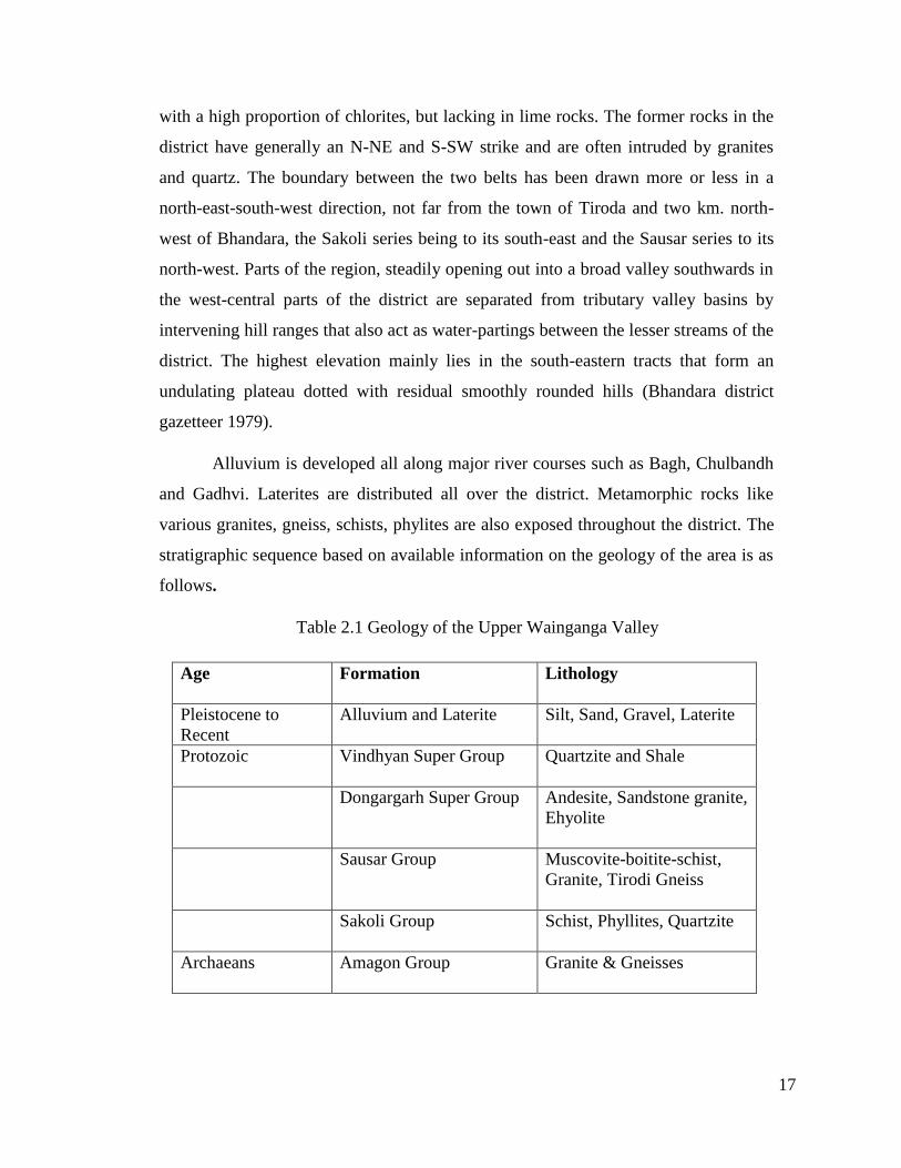
stratigraphic sequence based on available information on the geology of the area is as
follows.
Table 2.1 Geology of the Upper Wainganga Valley
Age Formation Lithology
Pleistocene to
Recent
Alluvium and Laterite Silt, Sand, Gravel, Laterite
Protozoic Vindhyan Super Group Quartzite and Shale
Dongargarh Super Group Andesite, Sandstone granite,
Ehyolite
Sausar Group Muscovite-boitite-schist,
Granite, Tirodi Gneiss
Sakoli Group Schist, Phyllites, Quartzite
Archaeans Amagon Group Granite & Gneisses

18
Geomorphologically, the region can be divided into two- first part includes the
north-western, north-eastern, south-eastern and central parts which have structural units
like hills and ridges. Whereas, second incorporates northern, north-central, west-central,
south and south-west portions having undulating topography over denudational units like
pediments and fluvial units. The physical milieu of the region is characterized by forest
covered, rugged and unhealthy terrain (Singh 1971). Moreover, the rapid fluvial erosion
has reduced the land considerably leaving a number of isolated hills. Rocky surfaces are
often devoid of thick soil cover and account for more than half of the forest cover of
Maharashtra state.
Topographical Features of the Region
The Wainganga and its major tributaries like Bagh, Bawanthadi occupies most of
the area of the district chiefly in the north-western side. Low hills are found at a few
places within the district. These hills spread in a group or in isolation at varying heights.
Maikal (Darekasa) hill lies at eastern end of the district on the border of Maharashtra and
Chhattisgarh. The elevation of these hills is higher than the western hills. These are
predominantly occupied by dense forest cover. Gondia Bagh and Balaghat Bagh rivers
flow over these hills. Few natural caves of various sizes are also found in these hills.
Towards the west of Darekasa hill, Ambagad hill is situated. This is an extreme outlier of
the Satpura ranges running with W-N and E-SE trend, separating Valley of Bawanthadi
River with Wainganga. The average elevation of Ambagad hill is 200 meter with a width
of 3 km and overall length of 30 km. To the east of Chichgarh plateau a group of hills
known as Navegaon, Palasgaon and Pratapgarh hills are located. Navegaon and
Pratapgarh hills rise to the highest elevation of the region. Chichgad hills situated at
southern part of the district represent a higher elevation than Palasgaon hills. North-
western part of the district is occupied by Wainganga and its tributaries- Bagh and
Chulband rivers. This area is significantly noteworthy since long periods of
circumdenudation have resulted in the river valleys being carved out over the Archaean,
gneiss and schist. The Sausar rock beds west of the Wainganga and the Sakoli rock beds
to the east and south stand up boldly in relief as resistant hill-masses (Bhandara District
Gazetteer 1979).
19
Soils
The characteristics and distribution of soils in Upper Wainganga region are
influenced essentially by the nature and intensity of weathering and the mode and
rapidity of fluvial transport on the plateau. Kali, kanhar, sihar, morand, khardi and
bardi are the main types of soils that are found in this region. The area under kali is
not very extensive and it occurs in form of regional pockets in Tiroda taluka. Kanhar
denotes a very rich alluvial soil. Sihar is a reddish-yellow soil formed mainly of the
detritus of the crystalline rock. It cracks very little in hot weather. Morand soil is very
sticky and retentive of moisture and bears a double crop. Morand class II and Sihar,
cover altogether one third of the total cultivated area in the region Very inferior type
of sihar is known as Khardi. Kanhar and first class morand soils are chiefly found in
the plains and along the Wainganga river. In the valleys of the Wainganga River, the
soil consists of sandy loam of varying quality which is very suitable for the cultivation
of rice. Both Morand class II and Sihar soils are utilized for cultivation of rice; but the
sihar is perhaps prominently the rice soil while Morand especially, where it is purest,
grows jowar, wheat and linseed. Soils derived from granitic decomposition are
generally light and with their low productivity are suitable only for kharif crops like
paddy and jowar (Singh 1971).
Minerals
Upper Wainganga plain occupies a pride position in the mineral map of India.
Minerals of the region include coal, manganese, limestone, chromite, bauxite and iron ore
(Singh 1971). Associated with the Lower Gondawana, coal occurs in the eastern part of
the region in Kamptee, Umrer, Bander and Wardha valley. Mangenese occurs in Nagpur
and Bhandara in a belt that continues into the adjoining Chhindwada and Balaghat
districts. The Manganese reserves of the area are one of the largest in the country.
Limestone deposits are largely confined to Nagpur and Bhandara districts. Here,
crystalline Limestone and Marbles also occur in the Sauser series of Archaeans which are
generally silicious dolomitic and occasionally magniferous. Copper is discovered from
the deposits at Malajkhand and it is regarded as one of the largest deposits in the country.

20
Map 2.3 Mineral map of Vidarbha
The Land use Pattern of the Region
The major land use categories in district include buildup land and agricultural
land that comprises of generally kharif, rabi and double crop system in the region.
Forest cover comprises of deciduous forests, degraded forests, forest blanks and recent
plantations. Deciduous forest largely spreads out in the region in the east of the Gondia
district. Waste land with or without scrub and barren rocky/stony waste can also be found
in the region.
Table 2.2 The Land use pattern of the region.
Land use/Land Cover
Category Area in Ha. Percentage to the total
Geographical area
Built up land 1155 1.36
Agricultural land 1,98,750 41.19

21
Forest Land 1,36,175 35.05
Waste Land 17,511 4.51
Water bodies 34,619 8.91
Total 5,88,209 100.00
Climate and Rainfall
Wainganga valley is an area of climatic contrast in terms of climate and rainfall as
seen against whole of Maharashtra. Wainganga basin lies in the medium rainfall zone of
900 mm to 1600 mm. There is a progressive increase in the amount of annual rainfall that
changes the landscape and the cropping pattern (Singh 1971). In the eastern part of
Vidarbha, the rains are heavier and more prolonged than in the western part and evenly
distributed during the entire monsoon period (Singh 1971). The eastern rainy part of the
region accounts for more than 60% of the total forest area (Singh 1971).
Most of the rainfall is received during the south west monsoon from June to
October owing largely to summer monsoons though some rain is received during the
retreat of SW monsoon associated with cyclonic storms in early winter. In winter, the
minimum temperature varies from 7°
C to 13°C. Maximum temperature varies from
39° C to 47° during summer. The month of May is the hottest month and the
December is the coldest one. In contrast to the diurnal heating, the cooling in night is
slow. Therefore, higher temperatures both during the day and night prevail in
Wainganga basin (Singh, 1971).
Flora
The Upper Wainganga valley is highly rich in terms of forest cover. Two national
Tiger projects and Sanctuary in the region itself speak about the strategic importance of
forests here. The region falls under the broad variety of the southern dry deciduous forest
and incorporates two main sub types. First type includes the teak forest and second type
is mixed forest. The usual teak includes sag, halda, tinsa, shisham, mahua, roham, khair,
dikamali, garahi. The mixed forest includes three types.

22
i) Superior quality of mixed forests.
ii) Medium quality of mixed forests.
iii) Poor quality of mixed forests.
The mixed forest is mostly occupied as reserve forest and entire protected forest
area. Tropical deciduous forests of Wainganga valley are the main source of timber and
support paper industries of the region (Singh, 1971). Rich forest cover supports a lot of
economic activities. Teek wood is utilized for timber, tendu leaves for bidis, mahuwa for
liquor, palas for propagation of lac, kadai or dhaora for making of gum. The area of
study also has semi moist mixed deciduous forest occurring on the hill slopes and valley
on the well-drained alluvium soil and dry mixed deciduous forest occurring on stony and
rocky surface. However because of thick forest cover and rocky terrain, very little land is
under cultivation producing mainly rice and jowar as cereal crops and orange and cotton
as cash crops (Singh, 1971).
Fauna
Well clad forests occurring almost all over the region offer adequate cover for
protection for wild life and foliage as a principal feed. Tiger (Felis tigris),
(Semnopithecus entellus), panther (Felis pardus), jungle cat (Felis Chaus), hyaena
(Hyaena struatam), jackal (Canis aureus), fox (Vulpes bengalensis), wild dog (Red
dogs), bear (Ursus vel melursus ursinus), wild pig (Sus scrofa fel cristatus), hare (Lepus
ruficandants), bison (Bos vel gavaeus gaurus), sambhar (Rusa aristotelis), chital (Axis
maculatus), barking deer (Cervalus muntjac), black buck (Antelope bezoartica), chinkara
(Gazella bennettii) abound in rich forest cover of Upper Wainganga valley. The forest
offers habitat to numerous bird species like golden orioles, blue roller, king fisher, wood
peckers, little green fly catcher, jungle fowl, painted and rock sand grouses, grey
partridge, green pigeon, jungle quail and a variety of doves and snakes.
Tribal of the Region
Tribals of the region are basically living in the eastern half area of the district. The
Gonds and Govaris are the most prominent tribes living in the valley. The Gonds of the

23
district are sub-divided into Raj Gonds and Dhur Gonds. Govari is another major tribe
also known as Gond-Govari. Due to its connection with Ahirs, it is considered as low
branch of Gonds. The Gond mainly speaks Gondi, a dialect belonging to the Dravidian
language (Pathak 2009). The Govaries themselves says that the Gond and Govaries are
the descendants of one of two brothers who accidently eat a flesh of cow. The Govaris
are fond of tattoos; men commonly have a dot between eyebrows and females wear lines
of dots usually long at the center and short on either side.
The dead are buried in Govari society. On returning from funeral, they offer food
to the spirit which is placed outside the deceased’s house. They eat the food only after the
cow touches the food which is offered to the spirit. This ritual called utran and it is
conducted by a bhagat (Pathak 2009). However, it is observed that the tribals in Gondia
district do not practice the customs related to death ceremony which are followed by their
counterparts living in deep forest in south and east part of the district.
Occupation of the People
The population of the district is mainly involved in agricultural and related
activities. Gondia district has a fertile land and it receives heavy rainfall of 1597 mm
as compared to adjacent regions. As a result, the agriculture flourishes in the region.
Besides, monsoon, rivers, tanks, ponds and wells act as an important source of
irrigation. Availability of tanks at every village can also be taken to indicate fishing as
a supplemented occupation besides agriculture. Still traditional way of fish catching is
followed in the district. Bidi making, rice milling, lac bangle making and tasar silk
weaving are also wide-spread rural occupations of the valley. A soapstone quarry is
worked at Kaneri and stone cups and jars are made of it. The Gonds in the villages
around Gond Umri and Chikhli make soft matting out of sukhwasa grasses. Thus we
see that the inhabitants of upper Wainganga valley make full use of available
resources for their occupation.
Food Habits of the People
Rice is the staple food of the region and it is abundantly cultivated all around the
district. A distinct food habit variation was also noticed within the region. It was

24
observed that wheat and jowars chapatti and bhakri were more common in the southern
part of the region whereas rice was eaten more in the rest of the district. The vegetables
are planted in backside of the houses for personal usage. Fish, prawns, chicken and meat
are enjoyed as non-vegetarian food items generally brought from weekly market.
The Villages and House Pattern
The villages of the Gondia district are situated close to each other within the
radius of 3 to 5 km. The villages are generally small in size and are neat and clean. They
are concentrated at a place surrounded by agricultural land. Small settlements called Tola
or Toli lie on the roadways or near the cultivation land. They consist of few houses
generally of the same cast. The houses are big in size with a courtyard at the center
surrounded by rooms with tilted and thatched walls painted from both sides. The cattle
are essential component of the house. They are tied in a room constructed on the either
side of the entrance. Storage of wood is also a necessary requirement of the house which
is arranged under a single roof. Grain is kept in round bamboo-work receptacles called
dholas, supported on wooden posts with thatched covers. Those meant for seed-grains are
often located outside the house and are only opened when sowing time comes while those
for food are kept inside the house and the requisite amount of grain is allowed to run out
daily from a hole in the side. Nowadays, the houses are using cement and brick for
construction. Even in villages also single or double storied houses are easily noticeable.
Agricultural Pattern
The population of the Gondia district mainly depends upon agricultural activity.
Well drained flat topography and various means of irrigation in upper Wainganga valley
make it a dependable agricultural zone where the rice crop seldom fails (Dixit 1986).
The south west monsoon from June to October brings fruitful heavy rains to the Upper
Wainganga Valley. Kharip and rabi are the main agricultural seasons in the region
nonetheless, more cultivation is observed in kahrip as compared to rabi crop. Rice is
generally drilled in the field by the end of June. Rice and tur are the largest cultivated
crop in kharip season. The chief rabi crops are wheat, jowar, linseed, gram and lac. Black
gram, horse gram and green gram are the important pulses grown in the district. As many
as 70 different varieties of rice are recognized here with slight difference in the method of

25
cultivation of each. Transplantation and broadcast sowing are the two important methods
of cultivating rice in the region. In transplantation method, the seed is sown in one place
and the seedling after it has grown a little is transplanted to another place. The field
where rice is transplanted needs to be leveled so that the low embankment receives equal
amount of water. In case of broadcast rice cultivation, the soil is generally ploughed
before arrival of monsoon. The seeds are sown by hand. Planting of wheat and gram
commences from the last week of September to mid-October and it is harvested during
February to March (Bhandara District gazetteer 1979). In addition to rice, wheat and
gram, a variety of vegetables, fruits and condiment crops like brinjals, chillies, tomatoes,
beans, cauliflowers and tamarind are planted in July and picking starts during September
to February.
It is this varied but favorable geographical setting that made upper Wainganga
valley an area of attraction for the early Iron Age settlers.