epping forest district council - efdclocalplan.org · epping forest district council epping forest...
TRANSCRIPT
Epping Forest District Council Epping Forest District Local Plan Report on Site Selection
Issue | September 2016
This report takes into account the particular instructions and requirements of our client.
It is not intended for and should not be relied upon by any third party and no responsibility is undertaken to any third party. Job number 248921-01
Ove Arup & Partners Ltd 13 Fitzroy Street London W1T 4BQ United Kingdom www.arup.com
Epping Forest District Council Epping Forest District Local Plan Report on Site Selection
| Issue | September 2016
Contents
Page
1 Introduction 1
1.1 Purpose of the Report 1
1.2 Structure of this Report 1
2 Sites for Residential Development 2
2.1 Epping Forest District’s Housing Needs 2
2.2 Overview of Site Selection Methodology 3
2.3 Relationship with Housing Market Area Strategic Sites 5
2.4 Identifying Sites for Assessment 8
2.5 Stage 1: Major Policy Constraints 10
2.6 Stage 2: Quantitative and Qualitative Assessment 12
2.7 Stage 3: Identify Candidate Preferred Sites 13
2.8 Stage 4: Deliverability 23
3 Site Selection for Traveller Sites 34
3.1 Existing Traveller Provision in the District 34
3.2 Traveller Housing Needs 35
3.3 Overview of Traveller Site Selection Methodology 38
3.4 Stage 1: Identifying Sites for Consideration 40
3.5 Stage 2: Site Availability 44
3.6 Stage 3 Major Policy Constraints 45
3.7 Stage 4 Quantitative and Qualitative Assessment 45
3.8 Stage 5 Identify Candidate Preferred Traveller Sites 46
3.9 Stage 6: Deliverability 50
4 Employment Sites 55
4.1 Employment Need 55
4.2 Overview of Site Selection Methodology 56
4.3 Stage 1: Major Policy Constraints 56
4.4 Stage 2: Quantitative and Qualitative Assessment 57
4.5 Next Steps 58
Epping Forest District Council Epping Forest District Local Plan Report on Site Selection
| Issue | September 2016
Appendices
Appendix A
Residential and Employment Site Selection Methodology
Appendix B
Assessment of Residential Sites
B1 Assessment of Residential Sites
B1.1 Overview of Assessment of Residential Sites
B1.2 Identifying Sites for Assessment
B1.2.1 Residential and Employment Sites Discounted from the Assessment
B1.2.2 Justification for ‘Split Sites’
B1.3 Results of Stage 1 Assessment
B1.4 Stage 2 Assessment
B1.4.1 Detailed Methodology for Stage 2 Assessment
B1.4.2 Results of Stage 2 Assessment
B1.4.3 Summary of Community Choices Feedback
B1.5 Stage 3 Assessment
B1.5.1 Categorising Sites for Further Assessment
B1.5.2 Results of Identifying Sites for Further Testing
B1.5.3 Detailed Methodology for More Detailed Assessment for Housing Sites
B1.6 Stage 4 Assessment
B1.6.1 Land promoter/developer survey
B1.6.2 Detailed Methodology for Deliverability Assessment
B1.6.3 Mineral Safeguarding Assessment
B1.6.4 Results of Stage 3 Capacity and Stage 4 Deliverability Assessments
B1.6.5 Results of Identifying Sites for Allocation
B1.6.6 Housing Trajectory
Appendix C
Settlement Proformas
C1 Introduction
C2 Town Proformas
C2.1 Chipping Ongar
C2.2 Epping
C2.3 Loughton
C2.4 Waltham Abbey
C3 Villages and Hamlets
Epping Forest District Council Epping Forest District Local Plan Report on Site Selection
| Issue | September 2016
C3.1 Buckhurst Hill
C3.2 Chigwell
C3.3 North Weald Bassett
C3.4 Roydon
C3.5 Theydon Bois
C3.6 Nazeing
C3.7 Thornwood
C3.8 Sewardstone
C4 Evidence Sources
C4.1 Evidence used for all topic areas
C4.2 Housing
C4.3 Economic Development
C4.4 Town Centres
C4.5 Transport
C4.6 Environment
C4.7 Landscape
C4.8 Green Belt
C4.9 Heritage & Townscape
C4.10 Community Facilities
Appendix D
Traveller Site Selection Methodology
Appendix E
Assessment of Traveller Sites
E1 Assessment of Traveller Sites
E1.1 Overview of Assessment of Traveller Sites
E1.2 Results of Stage 1 Assessment
E1.2.1 Narrowing Broad Locations to Sites
E1.2.2 Stage 1A Assessment of Traveller Sites
E1.2.3 Stage 1B Assessment of Traveller Sites
E1.3 Results of Stage 2 Assessment
E1.4 Results of Stage 3 Assessment
E1.5 Stage 4 Assessment
E1.6 Stage 5 Assessment
E1.6.1 Results of Identifying Sites for Further Testing
E1.7 Stage 6 Assessment
E1.7.1 Land promoter/developer survey
E1.7.2 Results of Stage 5 Capacity and Stage 6 Deliverability Assessments
E1.7.3 Results of Identifying Sites for Allocation
E1.7.4 Pitch Trajectory

Epping Forest District Council Epping Forest District Local Plan Report on Site Selection
| Issue | September 2016
Appendix F
Assessment of Employment Sites
F1 Assessment of Employment Sites
F1.1 Overview of Assessment of Employment Sites
F1.2 Results of Stage 1 Assessment
F1.3 Stage 2 Assessment
Epping Forest District Council Epping Forest District Local Plan Report on Site Selection
| Issue | September 2016
Page 1
1 Introduction
1.1 Purpose of the Report The adopted Local Plan for the District is the 1998 Local Plan. Some of these policies are still in force. In 2006 the Council adopted the Local Plan Alterations which replaced parts of the 1998 Local Plan. The Council is currently preparing a new Local Plan for Epping Forest District, which will cover the period up to 2033.
The new Local Plan must allocate sufficient land in appropriate locations to meet housing, traveller and employment needs over the Plan period. As part of the evidence base for the emerging Local Plan, residential (including Traveller) and employment sites have been assessed based on detailed methodologies that provide a framework for the identification of appropriate sites for allocation. This Report provides further details of both of the methodologies developed and the resulting assessment.
1.2 Structure of this Report This Report is structured as follows:
• Chapter 2: provides a summary of the site selection process followed to identify residential sites for allocation in the Council’s Draft Local Plan. This chapter is supplemented by Appendices A, B and C which present the SSM, the detailed findings of the assessment and the settlement proformas which identify the aspirations for places within the District.
• Chapter 3: contains a summary of the site selection process followed to identify traveller sites for allocation in the Council’s Draft Local Plan. This chapter is supplemented by Appendices D and E which present the TSSM and the detailed findings of the assessment.
• Chapter 4: presents the work completed to-date to identify employment sites to meet the District’s employment need. This chapter is supplemented by Appendix F which presents the detailed findings of the assessment.
Epping Forest District Council Epping Forest District Local Plan Report on Site Selection
| Issue | September 2016
Page 2
2 Sites for Residential Development This chapter contains an introduction to the District’s housing needs, provides an overview of the methodology developed to guide the selection of residential sites in the Epping Forest District Council’s Draft Local Plan and presents the findings of the site selection process.
2.1 Epping Forest District’s Housing Needs Epping Forest District Council (‘the Council’) is located in a Housing Market Area with three other local authorities: East Herts, Harlow and Uttlesford District Councils. The Council has worked closely with East Herts, Harlow and Uttlesford District Councils to prepare a Strategic Housing Market Assessment (SHMA). The most recent SHMA, which was published in 2015 identified an objectively assessed housing need for 46,100 additional homes across the Housing Market Area over the Local Plan period (2011-2033). The SHMA identified that for Epping Forest District this equated to approximately 11,300 new homes over the Plan period.
Since the publication of the 2015 SHMA, the Office of National Statistics and Department for Communities and Local Government have issued further population and household projections (in June and July 2016). The local authorities have undertaken some checking of the objectively assessed housing need in the light of the new projections and this has indicated that the objectively assessed need for the Housing Market Area is now approximately 54,000 homes. However, given infrastructure constraints, as well as environmental and policy designations the local authorities have concluded that to provide for the full objectively assessed housing need based on the July 2016 projections would result in Local Plans which did not fully accord with other policies set out in the National Planning Policy Framework (NPPF). Technical assessment1 has shown that the maximum quantum of growth that can be accommodated over the Plan period is around 51,000 homes for the Housing Market Area.
Taking this into account the Draft Memorandum of Understanding on the ’Distribution of Objectively Assessed Need Across the West Essex/East Hertfordshire Housing Market Area’ identifies a need for Epping Forest District to accommodate approximately 11,400 new homes.
To identify the preferred distribution of growth across the Housing Market Area, the local authorities undertook some joint spatial optioneering work. Six options were tested which varied the spatial distribution of development across the four authorities to enable the implications of growth to be better understood. In particular, the options varied in terms of the level of development located in and around Harlow, the Housing Market Area’s key urban centre. The transport modelling undertaken to date demonstrates that growth of between 14,000 and 17,000 new homes in and around Harlow can be accommodated provided that the
1 Refer to Sustainability Appraisal for the Strategic Spatial Options for the West Essex and East Hertfordshire Housing Market Area (AECOM, 2016).
Epping Forest District Council Epping Forest District Local Plan Report on Site Selection
| Issue | September 2016
Page 3
mitigation measures set out in the Highways and Transportation Infrastructure Memorandum of Understanding are delivered during the Plan period.
In order to understand the most appropriate sites in and around Harlow to accommodate this level of growth a strategic sites assessment has been undertaken2 which indicates that sufficient suitable strategic sites are available in and around Harlow to deliver the figure of circa 16,100 homes (together with sites either already completed or granted planning permission as well as urban brownfield sites). To meet the figure of circa 16,100, some 3,900 homes would need to be provided within Epping Forest District, which would be delivered through five strategic sites (Latton Priory, Riddings Lane, West Sumners, West Katherines and East of Harlow). Further details on this site selection process and how it relates to the District level site selection is presented in Section 2.3.
Table 2.1 summarises the components of the land supply, which will be delivered to meet the Council’s objectively assessed housing need figure. Once completions, commitments, windfall development and the contribution from the strategic sites around Harlow are accounted for, there is a residual requirement of circa 4,550 homes for which land in the rest of the District needs to be found.
The components of housing land supply over the period 2011-2033 are as follows:
Number of homes required to be built 2011-2033 ~11,400
Homes built (completions) 2011-2016 up to 31 March 2016
1,173
Future supply: Sites with planning permission up to 31 March 2016 Windfall (35 dwellings per annum (2016 – 2033))
1,194 595
Total supply (completions plus future supply) 2,950
Homes met through strategic sites around Harlow 3,900
Remaining number of homes to be provided elsewhere in the District
~4,550 plus reserve sites
Table 2.1: Housing land supply
2.2 Overview of Site Selection Methodology The Local Plan must allocate sufficient land in appropriate locations to ensure land supply for the 15-year plan period. This is reflected in paragraph 157 of the NPPF, which states: “Crucially, Local Plans should ... allocate sites to promote development and flexible use of land, bringing forward new land where necessary, and provide detail on form, scale, access and quantum of development where appropriate" and "identify land where development would be inappropriate, for instance because of its environmental or historic significance”.
The portfolio of site allocations and/or broad locations to be included in the Local Plan for housing must meet the policy requirement within paragraph 47 of the
2 Refer to Harlow Strategic Sites assessment for West Essex and East Herts authorities (AECOM, 2016)
Epping Forest District Council Epping Forest District Local Plan Report on Site Selection
| Issue | September 2016
Page 4
NPPF, by which local planning authorities should: "identify… a supply of specific deliverable ... sites sufficient to provide five years [sic] worth of housing against their housing requirements with an additional buffer of 5% (moved forward from later in the plan period) to ensure choice and competition in the market for land..." and "identify a supply of specific, developable ... sites or broad locations for growth, for years 6-10 and, where possible, for years 11-15".
The NPPF also specifically addresses “using a proportionate evidence base” advising local planning authorities (paragraph 158) to ensure “... that their assessment of and strategies for housing, employment and other land uses are integrated, and they take full account of market and other economic signals” and that the Local Plan must be justified as “... the most appropriate strategy, when considered against the reasonable alternatives, based on proportionate evidence” (see paragraph 182). This is a key test of soundness and is fundamental to the site selection process.
Finally, paragraph 152 of the NPPF includes the following overarching policy advice: “Local planning authorities should seek opportunities to achieve each of the economic, social and environmental dimensions of sustainable development and net gains across all three. Significant adverse impacts on any of these dimensions should be avoided and, wherever possible, alternative options which reduce or eliminate such impacts should be pursued. Where adverse impacts are unavoidable, measures to mitigate the impact should be considered. Where adequate mitigation measures are not possible, compensatory measures may be appropriate”. Accordingly, the process of site selection must adhere to these principles and avoid significant social, environmental, or economic harm, within the context of other policies within the NPPF.
In response to the requirements of government policy and practice guidance contained within the NPPF and Planning Practice Guidance (PPG), respectively the Council working collaboratively with Arup have developed a Site Selection Methodology (SSM). The SSM was drafted in April 2016 and finalised in August 2016 following Counsel’s advice.
The purpose of the SSM is to ensure that an adequate evidence base is developed to support the proposed site allocations. In order for the site selection process to be adequate, the evidence base must be robust, assessments should be founded upon a cogent methodology, undertaken in a transparent manner and fully documented at key stages. Professional judgements require justification and site-selection decisions must be clearly explained.
The SSM explains the proposed methodology for identifying suitable sites for residential and employment development to meet identified needs. The most appropriate residential sites have been selected and included as proposed site allocations in the Epping Forest District Draft Local Plan, which will be subject to a six week formal consultation from 31 October to 12 December 2016. A related but separate methodology has been developed for identifying and selecting proposed site allocations for Traveller accommodation (TSSM), which is discussed further in Chapter 3 of this Report.
The SSM identifies five stages through which sites are sieved and subject to more detailed assessment at each stage in order to identify the proposed site allocations
Epping Forest District Council Epping Forest District Local Plan Report on Site Selection
| Issue | September 2016
Page 5
for residential and employment uses for the Draft Local Plan consultation. The five stages can be summarised as follows.
• Stage 1 Major Policy Constraints – identify sites which are subject to one or more of these constraints and therefore not considered to be suitable for development.
• Stage 2 Quantitative and Qualitative Assessment – undertake more detailed assessment of sites to understand their relative suitability for development.
• Stage 3 Identify Candidate Preferred Sites – identify those sites which are considered suitable for development and should be subject to further capacity and deliverability assessment. More detailed indicative capacity assessment is also undertaken for each site identified for further testing.
• Stage 4 Deliverability – understand the availability and achievability of sites to enable a decision to be made about which sites to allocate and to ensure that the Council can demonstrate a sufficient housing trajectory over the Plan period.
• Stage 5 Sustainability Appraisal/Habitats Regulation Assessment of Candidate Preferred Sites – establish the impact of the candidate Preferred Sites alone and in combination.
A full version of the SSM is provided at Appendix A.
The remainder of this chapter explains how the SSM has been applied and provides a summary of the results, with reference made to detailed appendices which provide further detail of the assessment undertaken and justification for key decisions made. This includes Appendix B1.1, which provides an overview of how each site proposed for residential development was assessed at each stage of the SSM. With the exception of Section 2.5, which explains the joint process followed for identifying residential and employment sites for consideration through the SSM, this chapter only addresses residential sites. The application of the SSM for employment sites is documented separately in Chapter 4.
It should also be noted that the results of Stage 5 of the SSM is documented under separate cover in the Interim Sustainability Appraisal Report for the Draft Local Plan (AECOM, 2016).
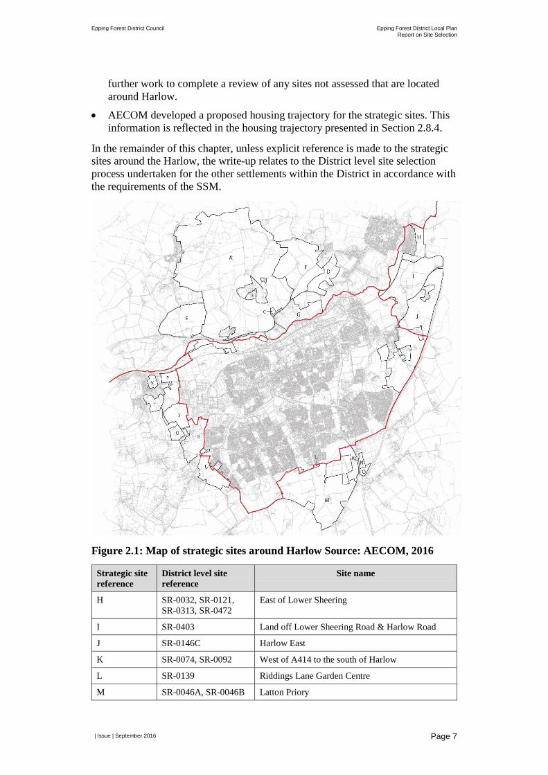
2.3 Relationship with Housing Market Area Strategic Sites
Paragraph 3.5 of the SSM summarises the relationship between the District level site selection process and strategic site work commissioned by the four local authorities for the Housing Market Area. The SSM states: “the Strategic Housing Market Area authorities have commissioned an assessment of the strategic sites in and around Harlow, including those sites in East Hertfordshire and Epping Forest Districts. The Council has worked with AECOM, the consultants appointed to undertake the strategic sites assessment, to align, where possible, the methodology, criteria and data sources for these two pieces of work. Section 4
Epping Forest District Council Epping Forest District Local Plan Report on Site Selection
| Issue | September 2016
Page 6
(below) identifies the stages at which the Council will either cross-check its assessment with, or rely upon the assessment undertaken by AECOM.”
In Section 4 there are two points where the SSM identifies a relationship with the AECOM work. This is at Stage 2 where the SSM states that the outcomes of the Stage 2 assessment will be cross-checked against AECOM’s work and at Stage 4 where the findings from the strategic site assessment will be used to inform the deliverability assessment.
At the time that the SSM was drafted, the intention was for the strategic sites work to be completed by the end of Stage 2 to enable the findings to be fed into the District level site selection work. However, the strategic sites work took longer to complete than anticipated and was undertaken in parallel with the District level site selection process3. In practice this has meant that:
• All of the strategic sites located within Epping Forest District have been considered through the District level site selection process. The locations of the strategic sites and the relationship between the strategic sites site references and District level site references are presented in Figure 2.1 and Table 2.2 respectively.
• The methodology, criteria and data sources have been aligned, where possible, for the proforma assessment undertaken for the strategic sites and for the SSM Stage 2 assessment.
• At SSM Stage 3, the judgements made in relation to the strategic sites were informed by AECOM’s assessment and recommendations (and where this is the case the write-up indicates this). The sites recommended for allocation by AECOM located in Epping Forest District will be consulted on as part of the Draft Local Plan.
• For a number of strategic sites, AECOM considered they were unsuitable as a strategic expansion site to Harlow, as they were judged not to be contiguous with the Harlow built-up area. However the assessment identified these sites might merit further consideration as part of the District level site assessment as they might be suitable freestanding sites or extensions to other settlements in the District. Where this is the case, the Council’s view of the suitability of these sites is documented in the write-up to Stage 3. Further detailed assessment including the Stage 4 deliverability assessment will be undertaken following the Draft Local Plan consultation.
• A small number of sites located around Harlow were not assessed by AECOM. This included sites that were judged not to be physically/ functionally linked to the strategic sites being considered in that assessment. The suitability of these sites was assessed as part of the SSM and a narrative is provided in the write-up to Stage 3. Additionally, some sites were not included in the strategic assessment although they were deemed by the District to be more closely aligned with the strategic sites. The Council will undertake
3 The results of the strategic sites work is documented in Harlow Strategic Sites assessment for West Essex and East Herts authorities (AECOM, 2016).
Epping Forest District Council Epping Forest District Local Plan Report on Site Selection
| Issue | September 2016
Page 7
further work to complete a review of any sites not assessed that are located around Harlow.
• AECOM developed a proposed housing trajectory for the strategic sites. This information is reflected in the housing trajectory presented in Section 2.8.4.
In the remainder of this chapter, unless explicit reference is made to the strategic sites around the Harlow, the write-up relates to the District level site selection process undertaken for the other settlements within the District in accordance with the requirements of the SSM.
Figure 2.1: Map of strategic sites around Harlow Source: AECOM, 2016
Strategic site reference
District level site reference
Site name
H SR-0032, SR-0121, SR-0313, SR-0472
East of Lower Sheering
I SR-0403 Land off Lower Sheering Road & Harlow Road
J SR-0146C Harlow East
K SR-0074, SR-0092 West of A414 to the south of Harlow
L SR-0139 Riddings Lane Garden Centre
M SR-0046A, SR-0046B Latton Priory
Epping Forest District Council Epping Forest District Local Plan Report on Site Selection
| Issue | September 2016
Page 8
Strategic site reference
District level site reference
Site name
N SR-0066 Land at Harlow Gateway South
O SR-0409 Land to North of Junction 7 of M11
P SR-0052A Land to West of Harlow/East of Roydon
Q SR-0009 Halls Green
R SR-0091, SR-0214 Land West of Katherines
S SR-0052A, SR-0052B Land West of Pinnacles
T SR-0306, SR-0890 Land to East of Epping Road, Roydon
U SR-0068 Land West of Sumners
V SR-0304 North of Harlow Road and East of High Street, Roydon
Table 2.2: Site references for strategic sites
2.4 Identifying Sites for Assessment In advance of undertaking Stage 1 of the SSM the sites to be subject to the SSM were identified. To do this, a filtering process was undertaken to sift out sites that had been identified through various sources but were considered unsuitable for assessment against the SSM.
The starting point for identifying sites that should be subject to the SSM was the Council’s Strategic Land Availability Assessment (SLAA) (Nathaniel Litchfield and Partners, 2016). In accordance with the requirements of paragraph 4.6 of the SSM, sites identified through the SLAA were reviewed against the following criteria to determine whether they should be subject to the SSM:
• Sites identified in the SLAA were filtered out from the SSM where they were identified in the SLAA as: a duplicate site; subject to extant planning permission4; being promoted for non-housing or employment (B Class) uses; subject to an existing continuing use; and/or located outside the boundary of Epping Forest District.
• Sites discounted at Stage A (strategic constraints)5 of the SLAA process were identified for re-assessment through the SSM to ensure alignment of approach with the major policy constraints identified at Stage 1 of the SSM.
• Sites greater than 0.2 hectares in area (promoted for residential or employment uses), or capable of delivering six or more dwellings were identified for assessment through the SSM. Sites proposed for residential use only needed to meet one of these criteria in order to be assessed through the SSM. Sites below
4 The Council continued to monitor the status of sites with regard to planning permission. Any sites identified in the SLAA/SSM and for which planning permission was granted up to and including 31 July 2016 have been removed from consideration through the SSM and are reflected in the existing supply figures presented in Table 2.1. 5 Further details of the strategic constraints are provided in the SLAA (2016).
Epping Forest District Council Epping Forest District Local Plan Report on Site Selection
| Issue | September 2016
Page 9
these thresholds were considered to constitute windfall development and therefore were not assessed.
• The SLAA identified primary and secondary uses for sites. Sites with a primary use which was non-residential or non-Class B uses were removed from consideration through the SSM unless the secondary use identified in the SLAA was either for residential or Class B employment uses. Appendix B1.1 identifies those sites where they have been assessed against their secondary use.
Additional sites were also identified for assessment through the SSM, which were not assessed through the SLAA. The Council holds a rolling ‘Call for Sites’. All Call for Sites submissions received by the Council up to and including 31 March 2016 were assessed through the SLAA. Additional Call for Sites submissions were received by the Council after this date. Submissions for sites for residential and employment B Class uses received by the Council by 17 May 2016 were assessed through the SSM. Any submissions received by the Council after this date will be assessed in accordance with the requirements of the SSM following the Draft Local Plan consultation.
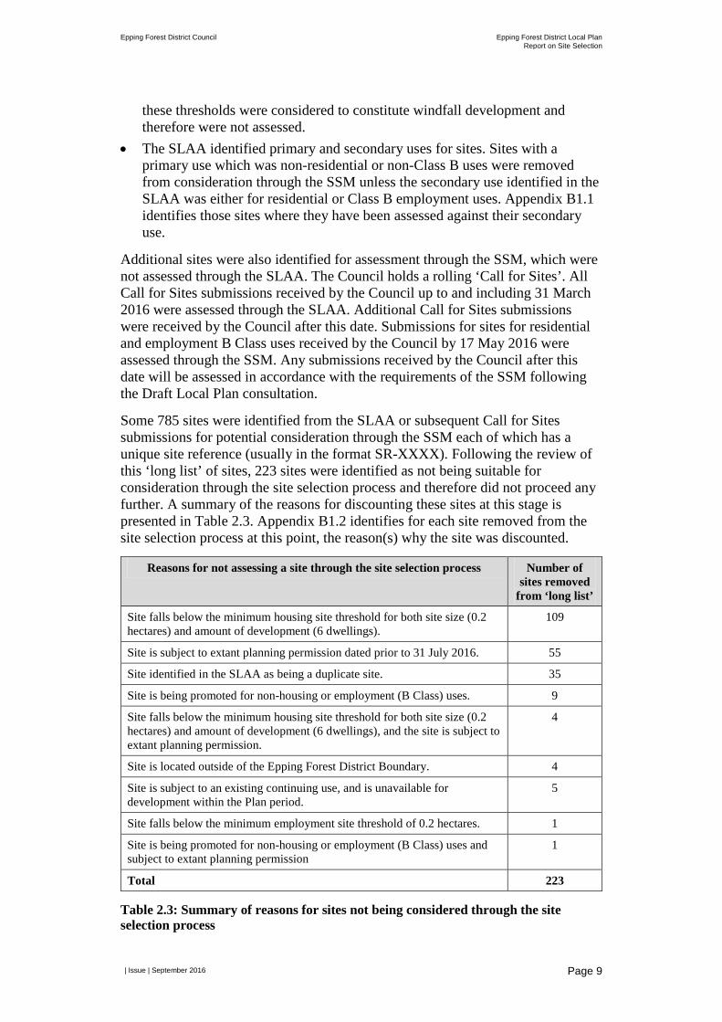
Some 785 sites were identified from the SLAA or subsequent Call for Sites submissions for potential consideration through the SSM each of which has a unique site reference (usually in the format SR-XXXX). Following the review of this ‘long list’ of sites, 223 sites were identified as not being suitable for consideration through the site selection process and therefore did not proceed any further. A summary of the reasons for discounting these sites at this stage is presented in Table 2.3. Appendix B1.2 identifies for each site removed from the site selection process at this point, the reason(s) why the site was discounted.
Reasons for not assessing a site through the site selection process Number of sites removed
from ‘long list’
Site falls below the minimum housing site threshold for both site size (0.2 hectares) and amount of development (6 dwellings).
109
Site is subject to extant planning permission dated prior to 31 July 2016. 55
Site identified in the SLAA as being a duplicate site. 35
Site is being promoted for non-housing or employment (B Class) uses. 9
Site falls below the minimum housing site threshold for both site size (0.2 hectares) and amount of development (6 dwellings), and the site is subject to extant planning permission.
4
Site is located outside of the Epping Forest District Boundary. 4
Site is subject to an existing continuing use, and is unavailable for development within the Plan period.
5
Site falls below the minimum employment site threshold of 0.2 hectares. 1
Site is being promoted for non-housing or employment (B Class) uses and subject to extant planning permission
1
Total 223
Table 2.3: Summary of reasons for sites not being considered through the site selection process
Epping Forest District Council Epping Forest District Local Plan Report on Site Selection
| Issue | September 2016
Page 10
Some 525 sites were identified for assessment for residential uses and 37 sites were identified for assessment for employment B Class uses.
In addition, when reviewing the sites which had been identified for assessment it become apparent that there were:
• A number of very large sites for which there were no detailed proposals and which could not be meaningfully assessed as defined. Such sites were identified and were sub-divided using existing natural features and boundaries. Where a large site was identified for sub-division but was promoted by a third party, a site was only divided where there was agreement from the site promoter. Appendix B1.2 identifies the sites which were split and the associated justification.
• A number of sites which comprised multiple parcels, which were not adjacent and therefore may potentially score differently if assessed as a single site through the SSM. Where this was the case, the parcels were assessed as individual sites. Appendix B1.1 identifies those sites where a multiple parcel site has been split.
• Sites identified through the SLAA, which overlapped with other sites. In such cases the indicative capacity of sites had been reduced to avoid double counting when the total number of suitable, available and achievable homes were summed together. However, for the purposes of site selection the assessment needed to assess each site individually for its full capacity. Therefore, the capacity of each site was reviewed and where a reduction had been applied in the SLAA due to overlapping sites this capacity was re-instated. If this adjustment was made, it is documented in the output of the site assessment undertaken at Stage 2 of the SSM.
2.5 Stage 1: Major Policy Constraints Paragraph 4.5 of the SSM states that “the purpose of Stage 1 will be to identify any sites that are subject to major policy constraints identified in the NPPF, or by reference to local considerations, such that development of the candidate site would likely cause significant social, environmental or economic harm in accordance with paragraph 152 of the NPPF.”
In developing the SSM, six major policy constraints were identified:
• Settlement buffer zones - sites were removed from further consideration where no part of the site was located within the settlement buffer zones (as identified in the Council’s Settlement Hierarchy Technical Paper (2015)).
• Flood Risk Zone 3b - sites were removed from consideration where the site was entirely located within Flood Risk Zone 3b.
• International sites for biodiversity – sites were removed from consideration where the site was entirely located within internationally designated sites of importance for biodiversity (Special Area of Conservation, Special Protection Area or RAMSAR).
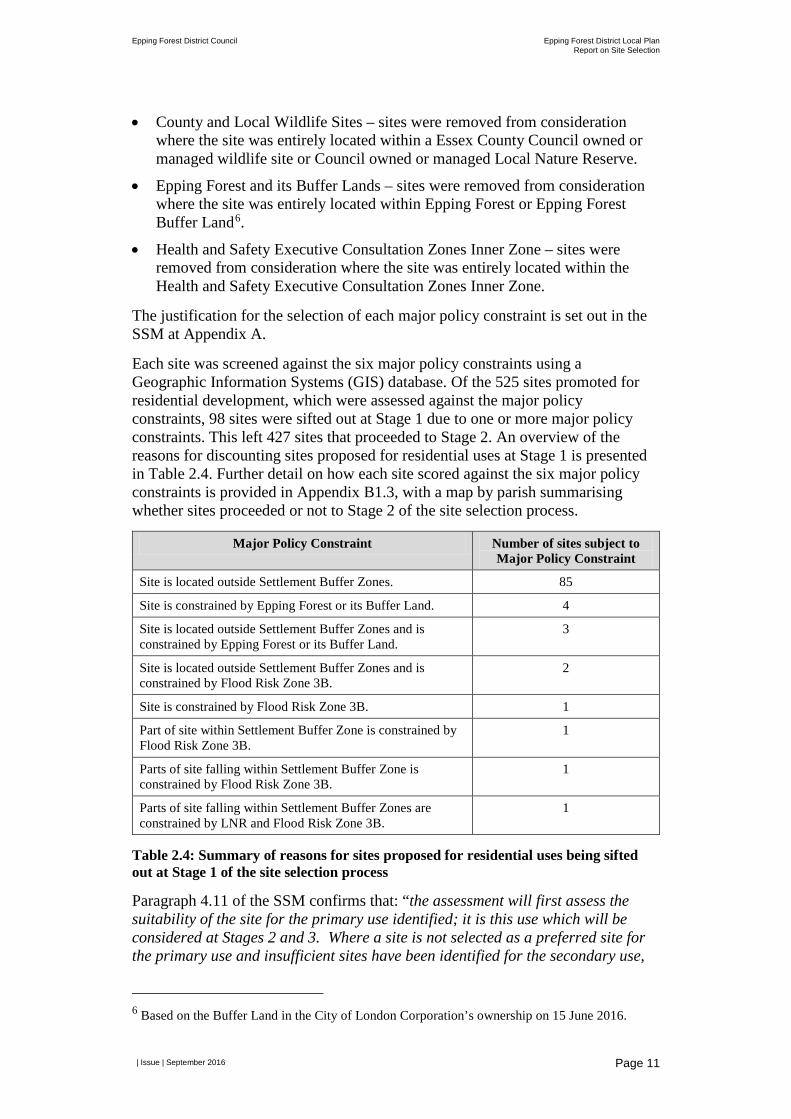
Epping Forest District Council Epping Forest District Local Plan Report on Site Selection
| Issue | September 2016
Page 11
• County and Local Wildlife Sites – sites were removed from consideration where the site was entirely located within a Essex County Council owned or managed wildlife site or Council owned or managed Local Nature Reserve.
• Epping Forest and its Buffer Lands – sites were removed from consideration where the site was entirely located within Epping Forest or Epping Forest Buffer Land6.
• Health and Safety Executive Consultation Zones Inner Zone – sites were removed from consideration where the site was entirely located within the Health and Safety Executive Consultation Zones Inner Zone.
The justification for the selection of each major policy constraint is set out in the SSM at Appendix A.
Each site was screened against the six major policy constraints using a Geographic Information Systems (GIS) database. Of the 525 sites promoted for residential development, which were assessed against the major policy constraints, 98 sites were sifted out at Stage 1 due to one or more major policy constraints. This left 427 sites that proceeded to Stage 2. An overview of the reasons for discounting sites proposed for residential uses at Stage 1 is presented in Table 2.4. Further detail on how each site scored against the six major policy constraints is provided in Appendix B1.3, with a map by parish summarising whether sites proceeded or not to Stage 2 of the site selection process.
Major Policy Constraint Number of sites subject to Major Policy Constraint
Site is located outside Settlement Buffer Zones. 85
Site is constrained by Epping Forest or its Buffer Land. 4
Site is located outside Settlement Buffer Zones and is constrained by Epping Forest or its Buffer Land.
3
Site is located outside Settlement Buffer Zones and is constrained by Flood Risk Zone 3B.
2
Site is constrained by Flood Risk Zone 3B. 1
Part of site within Settlement Buffer Zone is constrained by Flood Risk Zone 3B.
1
Parts of site falling within Settlement Buffer Zone is constrained by Flood Risk Zone 3B.
1
Parts of site falling within Settlement Buffer Zones are constrained by LNR and Flood Risk Zone 3B.
1
Table 2.4: Summary of reasons for sites proposed for residential uses being sifted out at Stage 1 of the site selection process
Paragraph 4.11 of the SSM confirms that: “the assessment will first assess the suitability of the site for the primary use identified; it is this use which will be considered at Stages 2 and 3. Where a site is not selected as a preferred site for the primary use and insufficient sites have been identified for the secondary use,
6 Based on the Buffer Land in the City of London Corporation’s ownership on 15 June 2016.

Epping Forest District Council Epping Forest District Local Plan Report on Site Selection
| Issue | September 2016
Page 12
the site will be re-assessed to consider its suitability for the secondary use. Sites will not be re-assessed in other circumstances.” Based on the assessment work completed to-date, there has not been a need to re-assess sites for the secondary use. Therefore, all results reported for the Stage 1 assessment relate to the primary use for each site.
2.6 Stage 2: Quantitative and Qualitative Assessment Paragraph 4.15 of the SSM states that “the purpose of Stage 2 will be to undertake more detailed quantitative and qualitative assessment of sites to identify the relative suitability of sites for housing or employment development.”
In order to do this 33 assessment criteria were identified, which were grouped into the following categories:
• Impact on environmental and heritage designations and biodiversity; • Value to Green Belt; • Accessibility by public transport and to services; • Efficient use of land; • Landscape and townscape impact; • Physical site constraints and site conditions.
Details of each criteria are provided in Appendix A of the SSM. For each criteria a 'Red-Amber-Green' (RAG) rating system was utilised using a scale of between three and five scores.
Each of 427 sites subject to Stage 2 were assessed against the aforementioned criteria. This assessment was completed using a combination of GIS analysis and planning judgement. Where a planning judgement was made an explanation was provided to justify the decision made. Further details of how the assessment was undertaken for each criteria is set out in Appendix B1.4.
Part way through the assessment process a moderation workshop was held on 7 June 2016 (as required by paragraph 4.21 of the SSM) to moderate the results, check that there is a level of agreement on judgements and regularise any apparently significant inconsistencies. Generally there was agreement on the way the SSM had been applied and resulting assessment. Minor comments were made which were incorporated into the assessment.
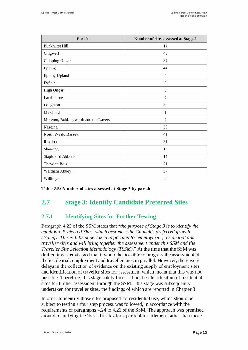
The output of Stage 2 is an assessment proforma for each site, which provides details of the site proposals and the assessment results for each criteria. The assessments are presented at Appendix B1.4 by parish. For each parish there is an overview map which identifies the sites within the parish that were assessed, followed by a proforma for each site which are presented in ascending order by site reference number. Table 2.5 provides an overview of the number of sites assessed in each parish.
Epping Forest District Council Epping Forest District Local Plan Report on Site Selection
| Issue | September 2016
Page 13
Parish Number of sites assessed at Stage 2
Buckhurst Hill 14
Chigwell 49
Chipping Ongar 34
Epping 44
Epping Upland 4
Fyfield 8
High Ongar 6
Lambourne 7
Loughton 39
Matching 1
Moreton, Bobbingworth and the Lavers 2
Nazeing 38
North Weald Bassett 41
Roydon 31
Sheering 13
Stapleford Abbotts 14
Theydon Bois 21
Waltham Abbey 57
Willingale 4
Table 2.5: Number of sites assessed at Stage 2 by parish
2.7 Stage 3: Identify Candidate Preferred Sites
2.7.1 Identifying Sites for Further Testing Paragraph 4.23 of the SSM states that “the purpose of Stage 3 is to identify the candidate Preferred Sites, which best meet the Council's preferred growth strategy. This will be undertaken in parallel for employment, residential and traveller sites and will bring together the assessment under this SSM and the Traveller Site Selection Methodology (TSSM).” At the time that the SSM was drafted it was envisaged that it would be possible to progress the assessment of the residential, employment and traveller sites in parallel. However, there were delays in the collection of evidence on the existing supply of employment sites and identification of traveller sites for assessment which meant that this was not possible. Therefore, this stage solely focussed on the identification of residential sites for further assessment through the SSM. This stage was subsequently undertaken for traveller sites, the findings of which are reported in Chapter 3.
In order to identify those sites proposed for residential use, which should be subject to testing a four step process was followed, in accordance with the requirements of paragraphs 4.24 to 4.26 of the SSM. The approach was premised around identifying the ‘best’ fit sites for a particular settlement rather than those
Epping Forest District Council Epping Forest District Local Plan Report on Site Selection
| Issue | September 2016
Page 14
sites which may be ‘best’ for the District overall. Therefore sites were considered on a settlement by settlement basis.
The first two steps were undertaken through a meeting of the Local Plan Officer Working Group on 13 and 14 June 2016.
Step 1: Based on the locations of the candidate sites within each settlement reasonable spatial options to accommodate growth were identified. Each option was assessed using planning judgement having regard to a range of factors including sustainable development principles set out in the NPPF, environmental constraints, local knowledge/initial officer evaluation of sites, feedback from the Community Choices consultation held in 2012 which sought views on the suitability of broad locations for growth in and around settlements and previous feedback from Members. In some settlements only a single option for accommodating growth was identified, while in other settlements the location of some sites was not considered to be a reasonable alternative and therefore sites were not identified within a spatial option. Where this is the case, this is justified in the write-up in Appendix B1.5.
For each spatial option identified a judgement was made about whether the option represented a more suitable or less suitable location for growth. Appendix B1.5 contains a map for each settlement which presents the spatial options identified and confirms whether each option was considered to be a more or less suitable location for growth. A table accompanies each map which provides the justification for the judgement reached.
Step 2: The sites located within each spatial option judged to be more suitable were then subject to more detailed consideration. If sites were located in spatial options judged to be a less suitable location for growth they were not considered further through the site selection process. When undertaking the more detailed consideration of sites located within more suitable spatial options regard was had to paragraph 4.25 of the SSM, which states that: “in general…those sites with the most dark green (++) and least red scores (--) are likely to be the most suitable [sites] for allocation. Paragraph 4.25 then goes on to say: “however, in common with all site selection/allocation processes, the identification of candidate Preferred Site will involve an element of planning judgement, the effect of which on outcomes cannot be prejudged. It should also be noted that in exercising planning judgement different weight may be given to each of the criteria reflecting the characteristics of the sites being assessed under the SSM. Where this is the case, the rationale for applying different weight to the criteria in relation to a particular site will be documented.”
Therefore, for each site considered regard was had to the findings of the Stage 2 assessment, local knowledge/initial officer evaluation of sites, feedback from the Community Choices consultation and previous Member feedback. Based on this assessment a judgment was made as to whether a site was considered suitable or not suitable for further testing. A justification for this judgement was documented with reference to the particular planning matters considered relevant to the site. The maps by settlement at Appendix B1.5 confirm whether a site has been judged to be suitable or unsuitable for further testing. The accompanying table provides a justification by site for the judgement made.
Epping Forest District Council Epping Forest District Local Plan Report on Site Selection
| Issue | September 2016
Page 15
In accordance with paragraph 4.30 of the SSM a ‘check and challenge’ workshop was held with Members on 18 June 2016. In the SSM it was envisaged that this workshop would be held once the candidate Preferred Sites had been identified. When carrying out this Stage of the SSM it was considered more appropriate to seek feedback at this point in the process (feedback was sought on the spatial options identified and the judgements made on the suitability of sites) to ensure that Member knowledge and feedback was taken into account before a final judgement was made as to which sites should progress for further assessment. Where appropriate, Member feedback is reflected in the judgements presented in the maps and tables in Appendix B1.5. Feedback was also sought from Members as part of Step 4; see below for further details.
Step 3: All sites which were judged to be suitable for allocation were then categorised against the hierarchy presented at paragraph 4.26 of the SSM. The principle of the hierarchy is that a sequential approach is applied to identifying those sites which should be further considered. The hierarchy is applied independently to each settlement and only to those sites identified as being suitable.
For ease of reference the hierarchy set out in paragraph 4.26 of the SSM has been repeated below:
• The sequential flood risk assessment – proposing land in Flood Zone 2 and 3 only where need cannot be met in Flood Zone 1;
• Sites located on previously developed land within settlements (the Green Belt boundaries were used as a proxy since more detailed settlement boundaries are not designated);
• Sites located on open space within settlements where such selection would not adversely affect open space provision within the settlement.
• Previously developed land within the Green Belt (in anticipation of the NPPF being updated to take account of the proposed changes published in December 2015).
• Greenfield/Green Belt land on the edge of settlements:
• Of least value to the Green Belt if the land meets other suitable criteria for development.
• Of greater value to the Green Belt if the land meets other suitable criteria for development.
• Of most value to the Green Belt if the land meets other suitable criteria for development.
• Agricultural land:
• Of Grade 4-5 if the land meets other suitable criteria for development.
• Of Grade 1-3 if the land meets other suitable criteria for development.
Therefore, for each site the Flood Risk Zone it is located in as well as the type of land the site is located on has been identified. This categorisation reflects the Stage 2 assessment findings for criteria 1.7 (flood risk), 4.1 (brownfield and

Epping Forest District Council Epping Forest District Local Plan Report on Site Selection
| Issue | September 2016
Page 16
greenfield land) and 4.2 (agricultural land). The results of this ranking for each site are presented in the settlement tables at Appendix B1.5 together with details of how the ranking was applied to each site.
Step 4: The total number of sites identified as potentially suitable for allocation (26,447 units) far exceeds the housing need figure to be met through site allocations away from Harlow (4,450 units plus reserve sites). Therefore a decision needed to be made about how many residential units should be taken forward for testing and the distribution of those residential units across the District. In addition, paragraph 4.29 of the SSM requires that consideration be given to as to whether broad locations (rather than site allocations) should be identified to deliver planned development in the latter stages of the Plan period. Given the large number of sites identified as potentially suitable for development it was agreed that site allocations should be identified to meet the District’s housing needs for the whole Plan period.
To assist in identifying which sites should be subject to further testing, sites were grouped into seven categories (based on the ranks applied at Step 3):
• Category 1 - sites located within flood zone 1 and on previously developed land within settlements.
• Category 2 - sites located within flood zone 1 and comprising land which is urban open space (both designated and non-designated).
• Category 3 - sites located within flood zone 1 and on land located on previously developed Green Belt land.
• Category 4 - sites located within flood zone 1 and on land of least value to the Green Belt adjacent to the settlement.
• Category 5 - sites located within flood zone 1 and on land of greater value to the Green Belt adjacent to the settlement.
• Category 6 - sites located within flood zone 1 and on land of most value to the Green Belt adjacent to the settlement.
• Category 7 – contains the remaining suitable sites, which includes:
• sites located within flood zone 1, which are Green Belt but not adjacent to the settlement;
• sites located within flood zone 1, which are not designated Green Belt but are designated agricultural land; and
• all other sites located in other flood zones (regardless of the type of land the site is located on).
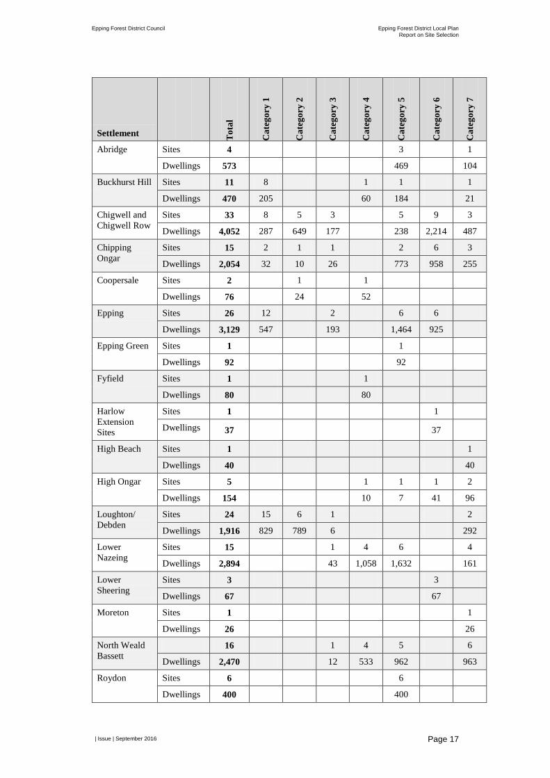
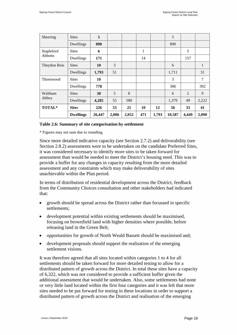
Table 2.6 identifies, by settlement, the number of sites and capacity of those sites located within each of the seven categories set out above.
Epping Forest District Council Epping Forest District Local Plan Report on Site Selection
| Issue | September 2016
Page 17
Settlement Tot
al
Cat
egor
y 1
Cat
egor
y 2
Cat
egor
y 3
Cat
egor
y 4
Cat
egor
y 5
Cat
egor
y 6
Cat
egor
y 7
Abridge Sites 4 3 1
Dwellings 573 469 104
Buckhurst Hill Sites 11 8 1 1 1
Dwellings 470 205 60 184 21
Chigwell and Chigwell Row
Sites 33 8 5 3 5 9 3
Dwellings 4,052 287 649 177 238 2,214 487
Chipping Ongar
Sites 15 2 1 1 2 6 3
Dwellings 2,054 32 10 26 773 958 255
Coopersale Sites 2 1 1
Dwellings 76 24 52
Epping Sites 26 12 2 6 6
Dwellings 3,129 547 193 1,464 925
Epping Green Sites 1 1
Dwellings 92 92
Fyfield Sites 1 1
Dwellings 80 80
Harlow Extension Sites
Sites 1 1
Dwellings 37 37
High Beach Sites 1 1
Dwellings 40 40
High Ongar Sites 5 1 1 1 2
Dwellings 154 10 7 41 96
Loughton/ Debden
Sites 24 15 6 1 2
Dwellings 1,916 829 789 6 292
Lower Nazeing
Sites 15 1 4 6 4
Dwellings 2,894 43 1,058 1,632 161
Lower Sheering
Sites 3 3
Dwellings 67 67
Moreton Sites 1 1
Dwellings 26 26
North Weald Bassett
16 1 4 5 6
Dwellings 2,470 12 533 962 963
Roydon Sites 6 6
Dwellings 400 400
Epping Forest District Council Epping Forest District Local Plan Report on Site Selection
| Issue | September 2016
Page 18
Sheering Sites 5 5
Dwellings 890 890
Stapleford Abbotts
Sites 6 1 5
Dwellings 171 14 157
Theydon Bois Sites 10 3 6 1
Dwellings 1,793 51 1,711 31
Thornwood Sites 10 3 7
Dwellings 778 386 392
Waltham Abbey
Sites 30 5 8 6 2 9
Dwellings 4,285 55 580 1,379 49 2,222
TOTAL* Sites 226 53 21 10 12 56 33 41
Dwellings 26,447 2,006 2,052 471 1,793 10,587 4,449 5,090
Table 2.6: Summary of site categorisation by settlement
* Figures may not sum due to rounding.
Since more detailed indicative capacity (see Section 2.7.2) and deliverability (see Section 2.8.2) assessments were to be undertaken on the candidate Preferred Sites, it was considered necessary to identify more sites to be taken forward for assessment than would be needed to meet the District’s housing need. This was to provide a buffer for any changes in capacity resulting from the more detailed assessment and any constraints which may make deliverability of sites unachievable within the Plan period.
In terms of distribution of residential development across the District, feedback from the Community Choices consultation and other stakeholders had indicated that:
• growth should be spread across the District rather than focussed in specific settlements;
• development potential within existing settlements should be maximised, focusing on brownfield land with higher densities where possible, before releasing land in the Green Belt;
• opportunities for growth of North Weald Bassett should be maximised and;
• development proposals should support the realisation of the emerging settlement visions.
It was therefore agreed that all sites located within categories 1 to 4 for all settlements should be taken forward for more detailed testing to allow for a distributed pattern of growth across the District. In total these sites have a capacity of 6,322, which was not considered to provide a sufficient buffer given the additional assessment that would be undertaken. Also, some settlements had none or very little land located within the first four categories and it was felt that more sites needed to be put forward for testing in these locations in order to support a distributed pattern of growth across the District and realisation of the emerging
Epping Forest District Council Epping Forest District Local Plan Report on Site Selection
| Issue | September 2016
Page 19
settlement visions7. Therefore, all sites located in Green Belt adjacent to the settlement (whether that be land of greater value or most value to the Green Belt) within the following settlements were identified for further testing:
• Chipping Ongar – to ensure sufficient sites were put forward for testing to support the settlement remaining self-sustaining, to ensure that sufficient homes are built to support existing services and to maximise the opportunities provided by the new secondary academy and capacity in the two primary schools.
• Epping – to provide sufficient choice of sites to enable the settlement to continue to grow at a rate that enables Epping to continue in its role as one of the main towns within the District.
• Lower Sheering – to enable sufficient sites to be put forward to meet local needs.
• North Weald Bassett – to enable sites identified in to the north of the Settlement as the preferred direction of growth in the North Weald Bassett Masterplan to be subject to more detailed testing.
• Roydon – to enable sufficient sites to be put forward to meet local needs.
• Sheering - to enable sufficient sites to be put forward to meet local needs.
• Theydon Bois – to enable sufficient sites to be considered to maximise existing sustainable transport links within the settlement.
• Waltham Abbey – to ensure sufficient sites are considered to provide a sustainable level of housing which supports regeneration of the settlement and retention of town centre services.
In total, this meant 152 sites with a capacity for 16,286 units were put forward for more detailed testing. The maps and tables in Appendix B1.5 identify those sites which were taken forward for further testing. During this step meetings were also held with Members to brief them on the sites that were proposed for further testing.
Paragraph 4.29 of the SSM requires that consideration be given to exceptional circumstances for sites located in the Green Belt. Given the sequential approach followed to identify sites for further testing, and that sites in the Green Belt were only identified for testing in order to meet the District’s housing need, at this point in the process it was considered that the approach adopted would support the case for exceptional circumstances should the remaining assessment work conclude release of the Green Belt was required.
7 The emerging settlements visions for places in the District are set out in Appendix C of this report.
Epping Forest District Council Epping Forest District Local Plan Report on Site Selection
| Issue | September 2016
Page 20
2.7.2 More Detailed Assessment for Housing Sites Paragraphs 4.31 to 4.33 of the SSM advise that: “the SLAA provides an indicative capacity for each site. This comprises a gross density taking account of any major site constraints… The density assumptions will be reviewed for all [candidate] Preferred Sites and updated as necessary…”.
In particular, the SSM identifies factors which the capacity assessment should seek to address:
• For larger sites in particular, there was a concern that using gross density may result in the capacity of the site being overstated once the need for internal roads and other infrastructure is taken into account.
• The Council is progressing work and a policy in the Draft Local Plan which may result in taking a more balanced view to the provision of car parking and to consider differential standards across the District rather than the universal application of the car parking standards currently adopted by Essex County Council. (As the detailed work had not been undertaken to inform the Draft Local Plan the Council will consider amendments to car parking standards through the development of a supplementary planning document. It was therefore determined that at the time of considering a site’s capacity no adjustment would be made based on car parking standards).
• Densities would benefit from a check in anticipation of the NPPF being updated to take account of the proposed changes published in December 2015 regarding support for higher densities at transport and commuter hubs.
• The appropriateness or ability of sites to accommodate mixed use development.
In addition, updated information was sought from land promoters/developers on their proposals for sites during June/July 2016 (refer to Section 2.8.1 for further details), which needed to be taken into account.
For the majority of the sites identified for further testing little masterplanning or site constraints work had been completed. Therefore, for each site the following assessment was undertaken in order to better understand the indicative net capacity of the site:
• Step 1: Reviewing site polygons – the site polygon is the boundary of the site. The site polygon was reviewed against any updated information submitted by the land promoter/developer. The site area was amended as necessary to reflect the updated information received.
• Step 2: Accounting for policy constraints, which affect the developable site area – sites were checked to identify the extent of land affected by the major policy constraints identified at Stage 1 and other non-major policy constraints. Where a major or non-major policy constraint intersected with part of a site, the affected area was removed from further consideration in the capacity assessment.
• Step 3: Establishing a baseline density for the site – the purpose of this step was to understand what might be a suitable baseline density for development.

Epping Forest District Council Epping Forest District Local Plan Report on Site Selection
| Issue | September 2016
Page 21
All sites started with a baseline density of 30 dwellings per hectare. The density could then be increased depending on the location of the settlement within the Council’s settlement hierarchy and the proximity of the site to both town centres and transport and commuter hubs.
• Step 4: Baseline density – this step confirmed the baseline density for the site based on the outcomes of Step 3.
• Step 5: Adjusting baseline density – this step either reduced or increased the proposed density of the site taking into account non-major policy constraints (e.g. proximity to a Listed Building etc.), the local setting of the site and the likelihood of the site accommodating a mix of uses. Where this assessment concluded that only part of the site was suitable for development a revised extent of the site was identified.
• Step 6: Gross to net density conversion – this step converted the gross site density to a net site density to account for on-site ancillary uses. Larger sites were assumed to require more land for ancillary uses, streets and other infrastructure, open space etc., which will reduce the developable capacity of the site.
• Step 7: Calculate site capacity – this step confirmed the indicative net capacity of the site, which included deducting the contribution of any existing residential dwellings located on-site or any extant planning permission.
Where additional information on site proposals had been submitted by the land promoter/developer (either historically or in response to the further information request) this was taken into account in the assessment. Further details of the methodology and how it was applied is presented in Appendix B1.5.
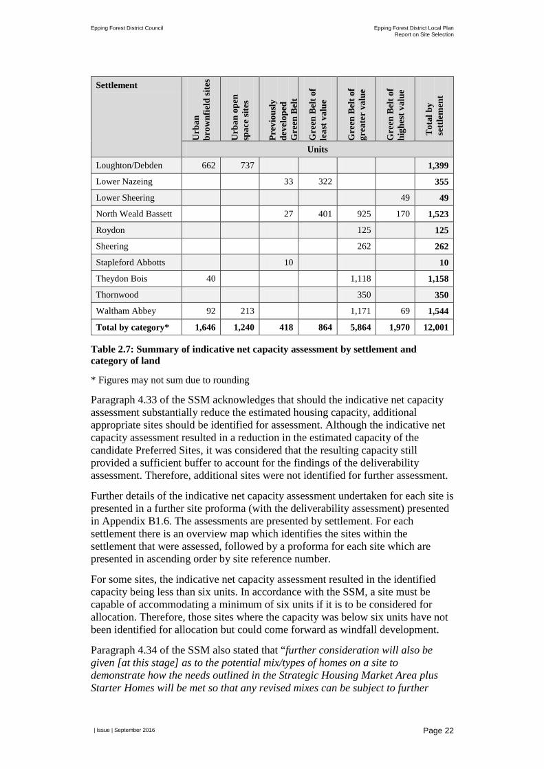
Overall the assessment of indicative net capacity resulted in a reduction in the number of homes which could be delivered through the 152 sites from 16,286 to 12,001. However, there is some variance between sites with the capacity increasing on some and decreasing on others. Table 2.7 provides a summary of the indicative net capacity of the 152 sites broken down by settlement and by the six categories identified in the previous section.
Settlement
Urb
an
brow
nfie
ld si
tes
Urb
an o
pen
spac
e si
tes
Prev
ious
ly
deve
lope
d G
reen
Bel
t
Gre
en B
elt o
f le
ast v
alue
Gre
en B
elt o
f gr
eate
r va
lue
Gre
en B
elt o
f hi
ghes
t val
ue
Tot
al b
y se
ttle
men
t
Units
Buckhurst Hill 120 30 150
Chigwell 279 260 124 663
Chipping Ongar 26 3 24 676 549 1,279
Coopersale 27 19 46
Epping 427 200 1,238 1,133 2,998
Fyfield 82 82
High Ongar 10 10
Epping Forest District Council Epping Forest District Local Plan Report on Site Selection
| Issue | September 2016
Page 22
Settlement
Urb
an
brow
nfie
ld si
tes
Urb
an o
pen
spac
e si
tes
Prev
ious
ly
deve
lope
d G
reen
Bel
t
Gre
en B
elt o
f le
ast v
alue
Gre
en B
elt o
f gr
eate
r va
lue
Gre
en B
elt o
f hi
ghes
t val
ue
Tot
al b
y se
ttle
men
t
Units
Loughton/Debden 662 737 1,399
Lower Nazeing 33 322 355
Lower Sheering 49 49
North Weald Bassett 27 401 925 170 1,523
Roydon 125 125
Sheering 262 262
Stapleford Abbotts 10 10
Theydon Bois 40 1,118 1,158
Thornwood 350 350
Waltham Abbey 92 213 1,171 69 1,544
Total by category* 1,646 1,240 418 864 5,864 1,970 12,001
Table 2.7: Summary of indicative net capacity assessment by settlement and category of land
* Figures may not sum due to rounding
Paragraph 4.33 of the SSM acknowledges that should the indicative net capacity assessment substantially reduce the estimated housing capacity, additional appropriate sites should be identified for assessment. Although the indicative net capacity assessment resulted in a reduction in the estimated capacity of the candidate Preferred Sites, it was considered that the resulting capacity still provided a sufficient buffer to account for the findings of the deliverability assessment. Therefore, additional sites were not identified for further assessment.
Further details of the indicative net capacity assessment undertaken for each site is presented in a further site proforma (with the deliverability assessment) presented in Appendix B1.6. The assessments are presented by settlement. For each settlement there is an overview map which identifies the sites within the settlement that were assessed, followed by a proforma for each site which are presented in ascending order by site reference number.
For some sites, the indicative net capacity assessment resulted in the identified capacity being less than six units. In accordance with the SSM, a site must be capable of accommodating a minimum of six units if it is to be considered for allocation. Therefore, those sites where the capacity was below six units have not been identified for allocation but could come forward as windfall development.
Paragraph 4.34 of the SSM also stated that “further consideration will also be given [at this stage] as to the potential mix/types of homes on a site to demonstrate how the needs outlined in the Strategic Housing Market Area plus Starter Homes will be met so that any revised mixes can be subject to further
Epping Forest District Council Epping Forest District Local Plan Report on Site Selection
| Issue | September 2016
Page 23
viability assessment.” The findings of this assessment are presented at Section 2.8.5 for the sites proposed for allocation.
2.8 Stage 4: Deliverability
2.8.1 Land Promoter/Developer Survey Paragraph 4.39 of the SSM states: “Information collected as part of the SLAA will be supplemented by updated information from promoters/developers/landowners, findings from the strategic sites assessment and further technical studies. As a minimum, a proforma will be sent to all sites promoters/developers/landowners (as appropriate), which proceed to Stage 2 to validate the information contained in the SLAA and to seek further, more detailed information on proposals.”
To ensure that data held on sites was accurate, in a consistent format and up-to-date, a survey was developed. This was distributed to promoters, developers and/or landowners in the form of an online survey. The survey also contained existing information held on the Council’s SLAA database and requested updates to this information where necessary, as well as responses to additional questions. The questions were developed in coordination with the Council, drawing on best practice from elsewhere and responding to the Council’s information requirements including those topics identified for assessment at Stage 4 of the SSM.
A series of questions were posed through the survey, a copy of which is provided at Appendix B1.6, which can be broadly grouped as follows:
• Contact information;
• Ownership and availability;
• Achievability;
• Land use, masterplanning and infrastructure;
• Site management;
• On-going engagement. Respondents were also provided with the opportunity to submit additional information to support their responses, including drawings, plans and any other relevant technical work undertaken to date. Invitations to complete the survey were issued electronically in a series of tranches to promoters, developers and/or landowners for all sites that proceeded to Stage 2, where contact information was available. In total, 311 proformas were issued at this stage (June 2016). Where up-to-date landownership information was not held by the Council or a ‘bounceback’ was received to the email address held by the Council and sites had proceeded to Stages 3 and 4, landownership searches were undertaken through HM Land Registry. Following this, an additional 21 proformas were distributed (July 2016). Respondents were provided a minimum of two weeks to respond to the survey. In total, 175 survey responses were received.
Epping Forest District Council Epping Forest District Local Plan Report on Site Selection
| Issue | September 2016
Page 24
2.8.2 Availability and Achievability Assessment Paragraph 4.38 of the SSM states that: “the purpose of Stage 4 is to consider the deliverability of the candidate Preferred Sites to inform the housing trajectory for the Plan. Stage 1, 2 and 3 considered the suitability of the site and, therefore, this stage focuses on whether a site is deliverable, specifically:
• Whether the site is available now, or is it likely to become available during the Local Plan period?
• Whether there is a reasonable prospect that development will be achievable within the appropriate timescales?”
The SSM provides an indication of the matters which will be subject to the availability and achievability assessment. In applying the SSM, the methodology for this assessment was further refined to include assessment against the following criteria:
• Availability: site ownership, existing uses, on-site restrictions and site availability. Information was also collected on proposed development phasing, which was not taken into account as part of the availability assessment but instead informed the housing trajectory.
• Achievability: site marketability, site viability, on-site physical and infrastructure constraints, impact on capacity of primary and secondary schools in the Planning Area and at individual primary and secondary schools, access to open space, access to health facilities and impact on mineral deposits.
• Cumulative achievability (in combination with traveller site allocations): cumulative loss of open space, cumulative impact on primary schools, cumulative impact on secondary schools, cumulative impact on green infrastructure network, cumulative impact on Sewage Treatment Works capacity and cumulative impact on Central Line capacity.
• Overview assessment of constraints: insurmountable constraints.
Further details on each criteria including how the assessment was undertaken are provided at Appendix B1.6. For each criteria a RAG rating system was utilised using a scale of three scores.
Each of 152 sites subject to Stage 4 were assessed against the availability, achievability and insurmountable constraints criteria. This assessment was completed using a combination of GIS analysis, information from the land promoter/developer survey or other information held by the Council and planning judgement. Where a planning judgement was made an explanation was provided to justify the decision made. If a site was identified for allocation (see Section 2.8.3 below) it was also assessed along with other residential and traveller sites identified in that settlement for the cumulative achievability of the proposals.
The availability and achievability assessment provided a more nuanced picture of the appropriateness of sites for allocation. Availability of sites in particular was an important issue given that the landownership information had not been identified for all sites assessed through the SLAA and even where landownership details

Epping Forest District Council Epping Forest District Local Plan Report on Site Selection
| Issue | September 2016
Page 25
were known, the timescale for the site being brought forward for development was not.
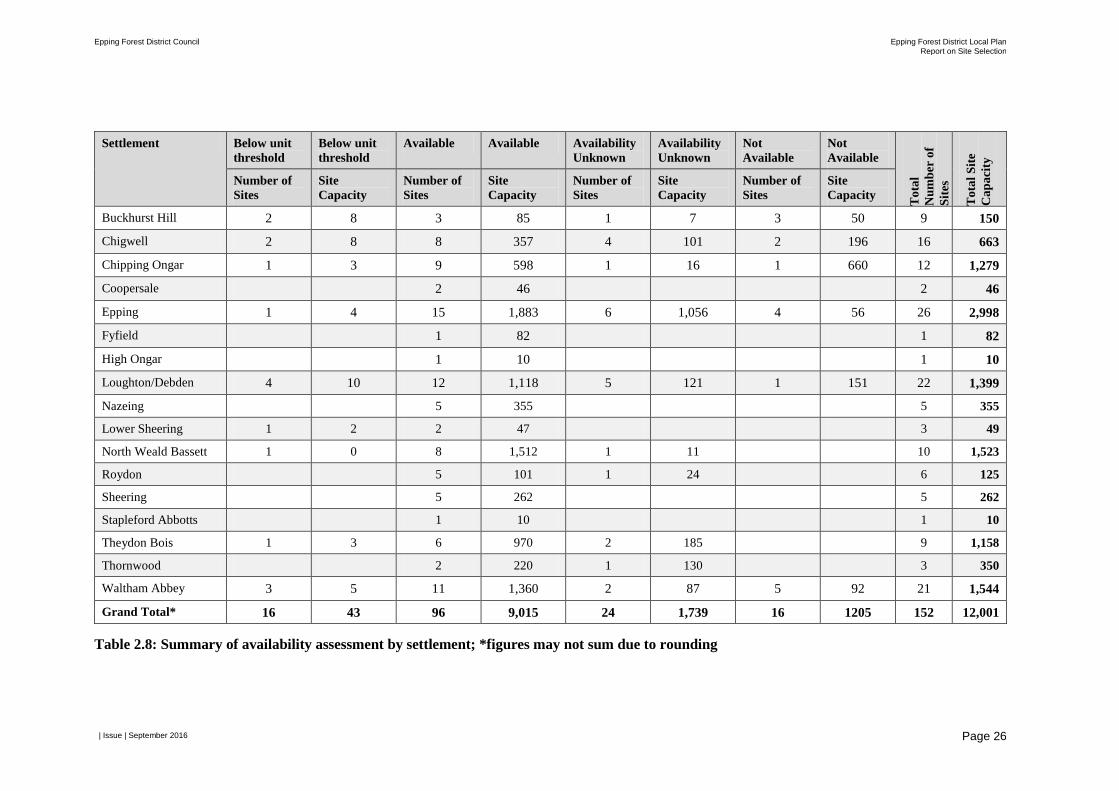
Table 2.8 provides an overview of the availability of the 152 sites subject to the deliverability assessment. It shows that some 9,000 homes can be delivered on sites where the availability has been confirmed with the remaining 3,000 homes located on windfall sites, sites where the landowner is known but timescale for bringing forward development is not, or where the landowner has confirmed the site is not available for development within the Plan period.
Epping Forest District Council Epping Forest District Local Plan Report on Site Selection
| Issue | September 2016
Page 26
Settlement Below unit threshold
Below unit threshold
Available Available Availability Unknown
Availability Unknown
Not Available
Not Available
Tot
al
Num
ber
of
Site
s
Tot
al S
ite
Cap
acity
Number of Sites
Site Capacity
Number of Sites
Site Capacity
Number of Sites
Site Capacity
Number of Sites
Site Capacity
Buckhurst Hill 2 8 3 85 1 7 3 50 9 150
Chigwell 2 8 8 357 4 101 2 196 16 663
Chipping Ongar 1 3 9 598 1 16 1 660 12 1,279
Coopersale 2 46 2 46
Epping 1 4 15 1,883 6 1,056 4 56 26 2,998
Fyfield 1 82 1 82
High Ongar 1 10 1 10
Loughton/Debden 4 10 12 1,118 5 121 1 151 22 1,399
Nazeing 5 355 5 355
Lower Sheering 1 2 2 47 3 49
North Weald Bassett 1 0 8 1,512 1 11 10 1,523
Roydon 5 101 1 24 6 125
Sheering 5 262 5 262
Stapleford Abbotts 1 10 1 10
Theydon Bois 1 3 6 970 2 185 9 1,158
Thornwood 2 220 1 130 3 350
Waltham Abbey 3 5 11 1,360 2 87 5 92 21 1,544
Grand Total* 16 43 96 9,015 24 1,739 16 1205 152 12,001
Table 2.8: Summary of availability assessment by settlement; *figures may not sum due to rounding

Epping Forest District Council Epping Forest District Local Plan Report on Site Selection
| Issue | September 2016
Page 27
Further details of the deliverability assessment undertaken for each site is presented in a further site proforma (with the indicative net capacity assessment) presented in Appendix B1.6. The assessments are presented by settlement. For each settlement there is an overview map which identifies the sites within the settlement that were assessed, followed by a proforma for each site which are presented in ascending order by site reference number.
Following completion of the availability and achievability assessment, an assessment of insurmountable constraints was undertaken. Each site was assessed ‘in the round’ to identify whether any restrictions or constraints, either individually or collectively, could be deemed insurmountable. The assessment took into account all achievability criteria in the Stage 4 assessment (2.1-2.8), as well as on-site restrictions (1.3). The assessment was undertaken qualitatively and utilised professional judgement to determine whether restrictions or constraints would be likely to be insurmountable.
2.8.3 Identify Sites for Allocation Following completion of the indicative net capacity assessment and the availability and achievability assessment a Local Plan Officer Working Group meeting was held on 28 July 2016 to identify which sites should be allocated in the Draft Local Plan.
At the meeting a judgement was made for each site as to whether it should be allocated or not in the Draft Local Plan. This judgement was informed by the findings of the availability and achievability assessment, including the assessment of insurmountable constraints and the emerging settlement visions, which helped to identify the quantum of development which should be allocated in each settlement. A justification for the judgements made was documented.
In accordance with paragraph 4.43 of the SSM a second Member workshop was held on 6 August 2016 to ‘check and challenge’ the sites identified for allocation. Where appropriate, Member feedback was incorporated in the judgements made.
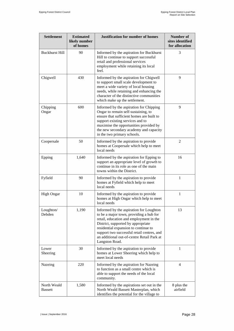
In summary, the Council proposes to allocate 88 sites and take into account an allowance for circa 225 homes on part of the North Weald airfield site, which in total will support delivery of approximately 7,200 homes across the District. This is in excess of the 4,450 homes needed to meet the objectively assessed housing need in the District and ensures a sufficient number of reserve sites should the status of any of the sites identified for allocation change during the Draft Local Plan consultation or up to examination of the Local Plan.
The identified sites are spread across the District as supported by the Community Choices consultation feedback. Table 2.9 identifies the estimated likely number of homes in each settlement that the Council will make provision for through the Draft Local Plan, sets out how these figures align with the emerging settlement visions and confirms the number of sites identified for allocation in each settlement, which if brought forward would deliver about the estimated likely number of homes.
Epping Forest District Council Epping Forest District Local Plan Report on Site Selection
| Issue | September 2016
Page 28
Settlement Estimated likely number
of homes
Justification for number of homes Number of sites identified for allocation
Buckhurst Hill 90 Informed by the aspiration for Buckhurst Hill to continue to support successful retail and professional services employment while retaining its local feel.
3
Chigwell 430 Informed by the aspiration for Chigwell to support small scale development to meet a wide variety of local housing needs, while retaining and enhancing the character of the distinctive communities which make up the settlement.
9
Chipping Ongar
600 Informed by the aspiration for Chipping Ongar to remain self-sustaining, to ensure that sufficient homes are built to support existing services and to maximise the opportunities provided by the new secondary academy and capacity in the two primary schools.
9
Coopersale 50 Informed by the aspiration to provide homes at Coopersale which help to meet local needs
2
Epping 1,640 Informed by the aspiration for Epping to support an appropriate level of growth to continue in its role as one of the main towns within the District.
16
Fyfield 90 Informed by the aspiration to provide homes at Fyfield which help to meet local needs
1
High Ongar 10 Informed by the aspiration to provide homes at High Ongar which help to meet local needs
1
Loughton/ Debden
1,190 Informed by the aspiration for Loughton to be a major town, providing a hub for retail, education and employment in the District, supported by appropriate residential expansion to continue to support two successful retail centres, and an additional out-of-centre Retail Park at Langston Road.
13
Lower Sheering
30 Informed by the aspiration to provide homes at Lower Sheering which help to meet local needs
1
Nazeing 220 Informed by the aspiration for Nazeing to function as a small centre which is able to support the needs of the local community.
4
North Weald Bassett
1,580 Informed by the aspirations set out in the North Weald Bassett Masterplan, which identifies the potential for the village to
8 plus the airfield
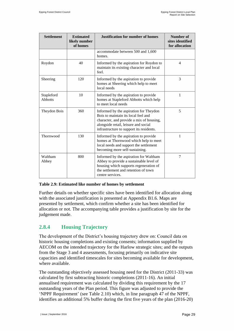
Epping Forest District Council Epping Forest District Local Plan Report on Site Selection
| Issue | September 2016
Page 29
Settlement Estimated
likely number
of homes
Justification for number of homes Number of
sites identified
for allocation
accommodate between 500 and 1,600
homes.
Roydon 40 Informed by the aspiration for Roydon to
maintain its existing character and local
feel.
4
Sheering 120 Informed by the aspiration to provide
homes at Sheering which help to meet
local needs
3
Stapleford
Abbotts
10 Informed by the aspiration to provide
homes at Stapleford Abbotts which help
to meet local needs
1
Theydon Bois 360 Informed by the aspiration for Theydon
Bois to maintain its local feel and
character, and provide a mix of housing,
alongside retail, leisure and social
infrastructure to support its residents.
5
Thornwood 130 Informed by the aspiration to provide
homes at Thornwood which help to meet
local needs and support the settlement
becoming more self-sustaining.
1
Waltham
Abbey
800 Informed by the aspiration for Waltham
Abbey to provide a sustainable level of
housing which supports regeneration of
the settlement and retention of town
centre services.
7
Table 2.9: Estimated like number of homes by settlement
Further details on whether specific sites have been identified for allocation along
with the associated justification is presented at Appendix B1.6. Maps are
presented by settlement, which confirm whether a site has been identified for
allocation or not. The accompanying table provides a justification by site for the
judgement made.
2.8.4 Housing Trajectory
The development of the District’s housing trajectory drew on: Council data on
historic housing completions and existing consents; information supplied by
AECOM on the intended trajectory for the Harlow strategic sites; and the outputs
from the Stage 3 and 4 assessments, focusing primarily on indicative site
capacities and identified timescales for sites becoming available for development,
where available.
The outstanding objectively assessed housing need for the District (2011-33) was
calculated by first subtracting historic completions (2011-16). An initial
annualised requirement was calculated by dividing this requirement by the 17
outstanding years of the Plan period. This figure was adjusted to provide the
‘NPPF Requirement’ (see Table 2.10) which, in line paragraph 47 of the NPPF,
identifies an additional 5% buffer during the first five years of the plan (2016-20)
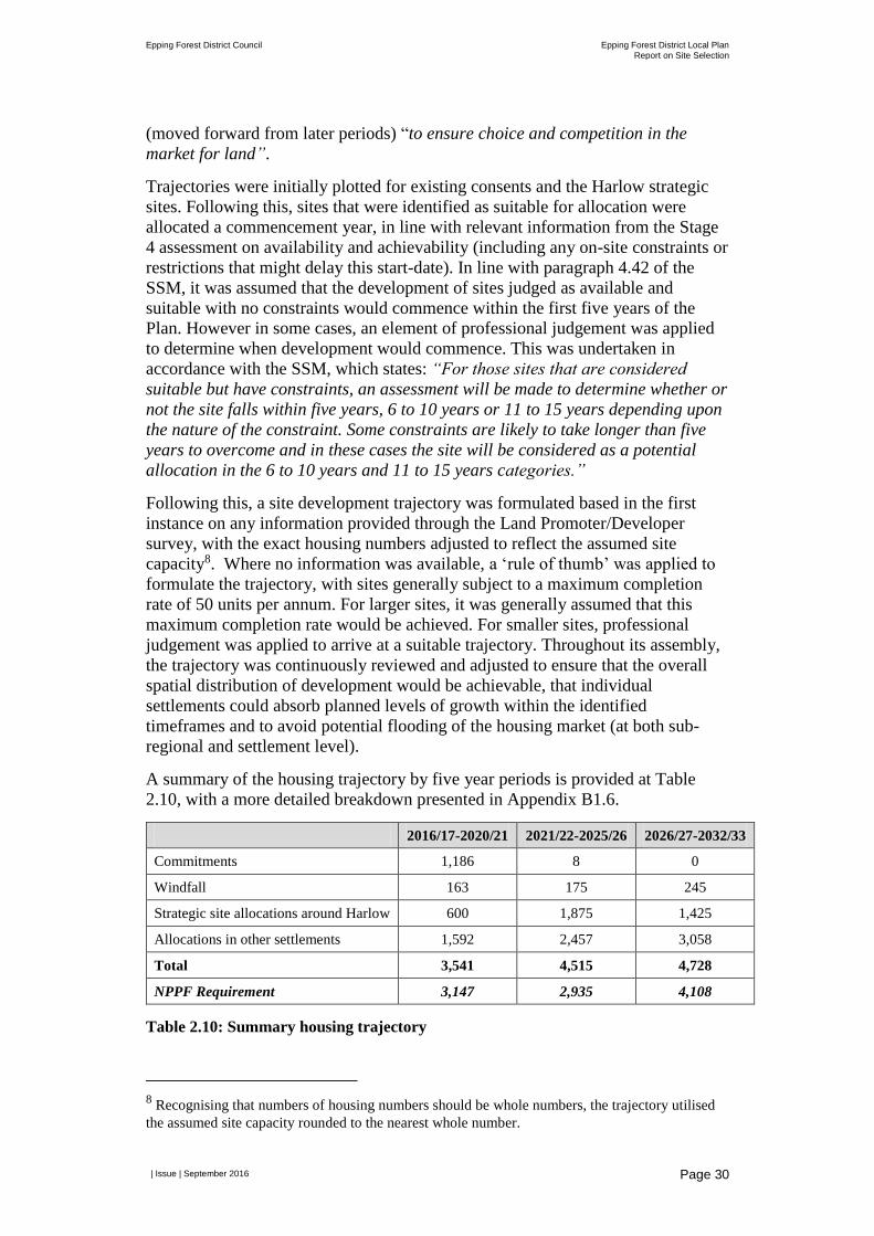
Epping Forest District Council Epping Forest District Local Plan
Report on Site Selection
| Issue | September 2016
Page 30
(moved forward from later periods) “to ensure choice and competition in the
market for land”.
Trajectories were initially plotted for existing consents and the Harlow strategic
sites. Following this, sites that were identified as suitable for allocation were
allocated a commencement year, in line with relevant information from the Stage
4 assessment on availability and achievability (including any on-site constraints or
restrictions that might delay this start-date). In line with paragraph 4.42 of the
SSM, it was assumed that the development of sites judged as available and
suitable with no constraints would commence within the first five years of the
Plan. However in some cases, an element of professional judgement was applied
to determine when development would commence. This was undertaken in
accordance with the SSM, which states: “For those sites that are considered
suitable but have constraints, an assessment will be made to determine whether or
not the site falls within five years, 6 to 10 years or 11 to 15 years depending upon
the nature of the constraint. Some constraints are likely to take longer than five
years to overcome and in these cases the site will be considered as a potential
allocation in the 6 to 10 years and 11 to 15 years categories.”
Following this, a site development trajectory was formulated based in the first
instance on any information provided through the Land Promoter/Developer
survey, with the exact housing numbers adjusted to reflect the assumed site
capacity8. Where no information was available, a ‘rule of thumb’ was applied to
formulate the trajectory, with sites generally subject to a maximum completion
rate of 50 units per annum. For larger sites, it was generally assumed that this
maximum completion rate would be achieved. For smaller sites, professional
judgement was applied to arrive at a suitable trajectory. Throughout its assembly,
the trajectory was continuously reviewed and adjusted to ensure that the overall
spatial distribution of development would be achievable, that individual
settlements could absorb planned levels of growth within the identified
timeframes and to avoid potential flooding of the housing market (at both sub-
regional and settlement level).
A summary of the housing trajectory by five year periods is provided at Table
2.10, with a more detailed breakdown presented in Appendix B1.6.
2016/17-2020/21 2021/22-2025/26 2026/27-2032/33
Commitments 1,186 8 0
Windfall 163 175 245
Strategic site allocations around Harlow 600 1,875 1,425
Allocations in other settlements 1,592 2,457 3,058
Total 3,541 4,515 4,728
NPPF Requirement 3,147 2,935 4,108
Table 2.10: Summary housing trajectory
8 Recognising that numbers of housing numbers should be whole numbers, the trajectory utilised
the assumed site capacity rounded to the nearest whole number.
Epping Forest District Council Epping Forest District Local Plan Report on Site Selection
| Issue | September 2016
Page 31
2.8.5 Tenure mix and unit type mix The SHMA established the need for market and affordable housing across the District for the Plan period. This included the number of units required, broken down by tenure and dwelling type, i.e. houses or flats, and number of bedrooms. An indicative tenure and unit size mix assessment was undertaken on the sites proposed for allocation to understand the extent to which the District’s housing needs could be met. More detail on how this assessment was undertaken can be found at Appendix B.1.5.3.
The SSM identifies that this assessment would consider how the District’s need for Starter Homes would also be met. At the time the SSM was written it was assumed that further guidance would have been issued from Government on the approach to Starter Homes to enable local authorities to better understand the relationship between Starter Homes and other forms of affordable housing. It is understood that further guidance will be provided by Government on the requirement for Starter Homes, but at the time of completing the assessment prior to the Draft Local Plan consultation it was not available. Upon receipt of this guidance further assessment work will be undertaken to identify how the District’s requirement for Starter Homes can be met having regard to the findings of further viability work.
The SHMA (2015) sets out the housing needs for the District. However, as explained in Section 2.1 the site selection process only sought to identify sites for part of the District’s housing need. Therefore, the assessment has considered the extent to which a prorated apportionment of the identified needs can be met through the proposed site allocations.
The indicative tenure and unit size mix assessment has shown that the housing needs identified in the SHMA can generally be accommodated through the proposed site allocation. Table 2.11 compares the tenure type mix needed across the District (as identified in the SHMA) against the indicative tenure mix for sites proposed for allocation. The proportion of units which are estimated to be affordable, including intermediate and affordable rent, is approximately 39%. This is higher than the proportion identified in the SHMA. However, this higher figure is driven by an assumption that all sites in the District with a capacity over 11 units are deemed viable and capable of delivering 40% affordable housing.
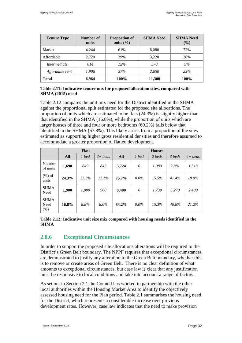
Epping Forest District Council Epping Forest District Local Plan Report on Site Selection
| Issue | September 2016
Page 32
Tenure Type Number of units
Proportion of units (%)
SHMA Need SHMA Need (%)
Market 4,244 61% 8,080 72%
Affordable 2,720 39% 3,220 28%
Intermediate 814 12% 570 5%
Affordable rent 1,906 27% 2,650 23%
Total 6,964 100% 11,300 100%
Table 2.11: Indicative tenure mix for proposed allocation sites, compared with SHMA (2015) need
Table 2.12 compares the unit mix need for the District identified in the SHMA against the proportional split estimated for the proposed site allocations. The proportion of units which are estimated to be flats (24.3%) is slightly higher than that identified in the SHMA (16.8%), while the proportion of units which are larger houses of three and four or more bedrooms (60.2%) falls below that identified in the SHMA (67.8%). This likely arises from a proportion of the sites estimated as supporting higher gross residential densities and therefore assumed to accommodate a greater proportion of flatted development.
Flats Houses All 1 bed 2+ beds All 1 bed 2 beds 3 beds 4+ beds
Number of units 1,690 849 842 5,724 0 1,080 2,881 1,313
(%) of units 24.3% 12.2% 12.1% 75.7% 0.0% 15.5% 41.4% 18.9%
SHMA Need 1,900 1,000 900 9,400 0 1,730 5,270 2,400
SHMA Need (%)
16.8% 8.8% 8.0% 83.2% 0.0% 15.3% 46.6% 21.2%
Table 2.12: Indicative unit size mix compared with housing needs identified in the SHMA
2.8.6 Exceptional Circumstances In order to support the proposed site allocations alterations will be required to the District’s Green Belt boundary. The NPPF requires that exceptional circumstances are demonstrated to justify any alteration to the Green Belt boundary, whether this is to remove or create areas of Green Belt. There is no clear definition of what amounts to exceptional circumstances, but case law is clear that any justification must be responsive to local conditions and take into account a range of factors.
As set out in Section 2.1 the Council has worked in partnership with the other local authorities within the Housing Market Area to identify the objectively assessed housing need for the Plan period. Table 2.1 summarises the housing need for the District, which represents a considerable increase over previous development rates. However, case law indicates that the need to make provision
Epping Forest District Council Epping Forest District Local Plan Report on Site Selection
| Issue | September 2016
Page 33
for development needs is not, in itself, sufficient to justify the exceptional circumstances necessary to make alterations to the Green Belt boundary. It is, however, part of the overall set of local conditions which together can demonstrate exceptional circumstances.
In the Harlow Strategic Sites Assessment for West Essex and East Herts authorities, AECOM provide some evidence to justify any decision to alter existing Green Belt boundaries in this location, to enable the allocation of strategic sites on the fringes of Harlow in Epping Forest District, as identified by AECOM. That evidence is directly relevant for demonstrating exceptional circumstances. The Green Belt and District Open Land Background Paper (Epping Forest District Council, 2016) provides further detail to demonstrate exceptional circumstances in Epping Forest District.
Beyond Harlow, the SSM sets out a clear strategy to minimise the use of Green Belt land for development. Paragraph 4.26 of the SSM sets out a sequential approach in which non-Green Belt land is prioritised for development over land within the Green Belt; within the Green Belt sites on land of least value are preferred over sites on land of most value to the Green Belt. This approach was informed by feedback from the Community Choices consultation in 2012, which identified that the Council needed to be certain that all opportunities for the re-use of brownfield land were identified before land is released from the Green Belt.
In addition the feedback from the community influenced the Council commissioning the Settlement Capacity Study (2016), which sought to ensure that potential opportunities to redevelop existing brownfield sites outside of the Green Belt were identified. Sites identified through this study were included in the SLAA and subject to the caveats identified in Section 2.4 of this report assessed through the site selection process. Table 2.6 also shows that there is insufficient suitable land located outside the Green Belt to meet the housing needs of the District within the Plan period. In order to meet the development needs identified, and achieve sustainable forms of development in and around existing settlements, alterations to the Green Belt boundaries are necessary.
The proposed site allocations would require alterations to the Green Belt boundary in the following settlements: Buckhurst Hill; Chigwell; Chipping Ongar; Coopersale; Epping; Fyfield; High Ongar; Lower Sheering; Nazeing; North Weald Bassett; Roydon; Sheering; Stapleford Abbots; Theydon Bois; Thornwood; and Waltham Abbey.
For each settlement consideration has been given to the aspirations for each settlement, the most suitable broad locations for growth, the suitability of individual sites to accommodate development and their deliverability over the Plan period. The sites proposed for allocation therefore represent the minimum land take required from the Green Belt to enable the Council to meet the District’s housing needs through a strategy that is both sustainable and deliverable. Such an approach accords with the requirements of the NPPF.
Epping Forest District Council Epping Forest District Local Plan Report on Site Selection
| Issue | September 2016
Page 34
3 Site Selection for Traveller Sites This chapter contains an introduction to the District’s Traveller accommodation needs, provides an overview of the methodology developed to guide the selection of Traveller sites in the Epping Forest District Council’s Draft Local Plan and presents the findings of the site selection process.
3.1 Existing Traveller Provision in the District As at 16 September 2016 within Epping Forest District there were:
• 127 authorised permanent pitches9 in the District (comprising 197 caravans);
• 16 authorised temporary personal permissions10 for pitches with a total of 29 caravans; and
• 9 unauthorised11 caravans on sites where permissions have never been granted (a number of which are subject to planning appeals awaiting decisions).
• In relation to the provision for Travelling Showpeople in the District there are currently nine yards12 in one location accommodating in total up to 39 caravans.
These pitches, yards and caravans are on sites within the Green Belt and, with the exception of one site, are all in private ownership. Since 2004 there has been a steady decline in number of unauthorised caravans and a commensurate rise in the number of authorised sites as temporary and unauthorised sites have become regularised through planning applications and appeals.
A key finding of the consultation13 undertaken in 2008 was that the local Traveller community in Epping Forest District is unusually settled, with a significant number living in chalets rather than caravans. However, under the Government’s
9 A pitch is an area which is large enough for one household to occupy and typically contains enough space for one or two caravans. Fire safety concerns and functional requirements (amenity unit, large trailer, touring caravan, drying area, lockable sheds, parking space) effectively set a minimum pitch size. An average pitch size of 0.1 hectares is used across East of England and therefore used as the basis for site search in this report. 10 In cases where a temporary pitch is permitted the permission is always personal to the applicant and granted for a stipulated period, consistent with the Town and Country Planning Act 1990 s70 (1) (a) 11 An unauthorised development refers to the occupation of land which is owned by Travellers but for which they do not have planning permission to use for residential purposes. An unauthorised encampment refers to unauthorised occupation of land which is not owned by Travellers. 12 Travelling Showpeople sites are also referred to as yards and the space occupied by one household is commonly referred to as a plot. Travelling Showpeople are likely to require a larger area, (often referred to as a ‘plot’ or ‘yard’), as they are likely to need space for the storage of equipment. The Council has used the average yard size (0.13 hectares) of the existing Travelling Showpeople sites within the District to identify future provision. 13 Consultation on Options: Development Plan Provision for Gypsies and Travellers in Epping Forest District – produced following receipt of a direction from Government to produce a plan by 30 Sept 2009. The plan was not completed.
Epping Forest District Council Epping Forest District Local Plan Report on Site Selection
| Issue | September 2016
Page 35
revised definition for ‘Gypsies and Travellers’ it is likely that many of these Gypsies and Travellers will no longer be considered as ‘Gypsies and Travellers’ as defined in the DCLG’s Planning Policy for Traveller Sites (August 2015) (the PPTS). Those previously interviewed in 2008 found it difficult to consider living in other parts of the District – the concept of choice being unfamiliar with general restrictions on site availability and opposition from the settled community. Others wished to be allowed to stay where they were, particularly if they had children in school.
Larger existing sites tend to be overcrowded with small pitches on sites that are difficult to expand. Smaller existing sites cater for individuals, often elderly people, as well as extended families and hence generate more pressure to grow.
Historically, a particular issue within Epping Forest District has been and remains the concentration of existing Traveller sites; 99 of the Council’s 127 permanently authorised pitches are concentrated in two of the District’s 24 parishes – Nazeing and Roydon. This concentration is attributed to the proximity to the main urban areas, the former link with the glasshouse industry in these parishes, and availability of small plots of land, glasshouse and chalet plots.
3.2 Traveller Housing Needs
3.2.1 Gypsy and Traveller Accommodation Assessment To identify need for Traveller accommodation the PPTS requires an assessment of current and future pitch requirements, but does not provide a methodology for this. The PPTS also requires a Gypsy and Traveller Accommodation Assessment (GTAA) to determine whether households living on sites, yards, encampments and in bricks and mortar fall within a planning definition of a Gypsy, Traveller or Travelling Showperson. Opinion Research Services (ORS) was commissioned by the Essex Planning Officers Association (EPOA) to undertake a GTAA in 2014.
The PPTS introduced a definitional change which removed the term “persons…who have ceased to travel permanently” from the definition of a Traveller; the implication of this change being the fact that an individual is an ethnic Gypsy or Traveller is not directly relevant to their land-use planning needs – rather a nomadic habit of life is relevant and that individuals have not ceased travelling permanently. As such, a local planning authority must make appropriate provision to meet the accommodation needs of “persons of nomadic habit of life”. The PPTS does not therefore recognise those persons who have ceased permanently “to be of nomadic habit of life” to have land-use planning needs that fall within the provision of the PPTS, rather their housing needs are assessed with the rest of the settled community through the SHMA.
An update to the GTAA is being produced for EPOA in 2016 to bring the evidence in line with the PPTS and the amended definition for travellers. ORS has produced an interim note on the updated GTAA for Epping Forest District in advance of the publication of the full GTAA for all Essex authorities.
The updated information provided in ORS’ note has a baseline date of May 2016 (interviews were also carried out in July and August 2016) and will provide an
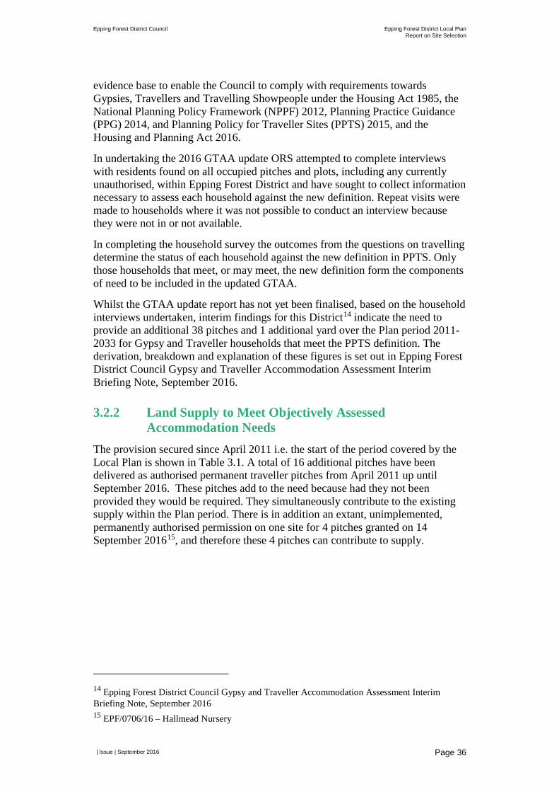
Epping Forest District Council Epping Forest District Local Plan Report on Site Selection
| Issue | September 2016
Page 36
evidence base to enable the Council to comply with requirements towards Gypsies, Travellers and Travelling Showpeople under the Housing Act 1985, the National Planning Policy Framework (NPPF) 2012, Planning Practice Guidance (PPG) 2014, and Planning Policy for Traveller Sites (PPTS) 2015, and the Housing and Planning Act 2016.
In undertaking the 2016 GTAA update ORS attempted to complete interviews with residents found on all occupied pitches and plots, including any currently unauthorised, within Epping Forest District and have sought to collect information necessary to assess each household against the new definition. Repeat visits were made to households where it was not possible to conduct an interview because they were not in or not available.
In completing the household survey the outcomes from the questions on travelling determine the status of each household against the new definition in PPTS. Only those households that meet, or may meet, the new definition form the components of need to be included in the updated GTAA.
Whilst the GTAA update report has not yet been finalised, based on the household interviews undertaken, interim findings for this District14 indicate the need to provide an additional 38 pitches and 1 additional yard over the Plan period 2011- 2033 for Gypsy and Traveller households that meet the PPTS definition. The derivation, breakdown and explanation of these figures is set out in Epping Forest District Council Gypsy and Traveller Accommodation Assessment Interim Briefing Note, September 2016.
3.2.2 Land Supply to Meet Objectively Assessed Accommodation Needs
The provision secured since April 2011 i.e. the start of the period covered by the Local Plan is shown in Table 3.1. A total of 16 additional pitches have been delivered as authorised permanent traveller pitches from April 2011 up until September 2016. These pitches add to the need because had they not been provided they would be required. They simultaneously contribute to the existing supply within the Plan period. There is in addition an extant, unimplemented, permanently authorised permission on one site for 4 pitches granted on 14 September 201615, and therefore these 4 pitches can contribute to supply.
14 Epping Forest District Council Gypsy and Traveller Accommodation Assessment Interim Briefing Note, September 2016 15 EPF/0706/16 – Hallmead Nursery
Epping Forest District Council Epping Forest District Local Plan Report on Site Selection
| Issue | September 2016
Page 37
Time period Number of additional authorised pitches
Permissions granted between 1 April 2011 and 14 September 2016
16 pitches (comprising 28 caravans)
Extant unimplemented permissions 4 pitches (comprising 8 caravans)
TOTAL 20 pitches
Table 3.1: EFDC authorised Traveller pitches April 2011 – September 2016
It is not possible to deduct from the overall additional need figure the 13 temporary pitches authorised since April 2011 because these permissions have all been granted on a personal permission basis pertaining to the applicant and all are permitted for a stipulated period. However, this study has considered the scope for permanently regularising these sites.
Therefore, having regard to the 2016 GTAA and taking account of completions and commitments, the Council needs to identify and deliver a minimum of a further 18 pitches and 1 yard up until 2033. This position is summarised in Table 3.2.
Category Pitches/yards
Number of pitches required 2011-2033 based on 2016 Interim Gypsy and Traveller Accommodation Assessment
38 pitches and 1 yard
No of pitches permitted (implemented) 16
Pitches with planning permission (unimplemented) 4
Remaining requirement to be provided 18 pitches and 1 yard
Table 3.2: Traveller pitch and yard identified need 2011 – 2033
3.2.3 Qualitative Need Considerations In terms of site location previous responses16 received from the settled community living in Roydon and Nazeing parishes expressed a clear preference for wider dispersal of any additional provision across the rest of the District. Residents and Town/Parish Councils with little or no existing Traveller pitches generally oppose this alternative. Occupiers of existing pitches also tended to be opposed to wider dispersal; favouring instead concentration of provision within existing areas to enable them to live in close proximity to family members.
Respondents to the Council’s 2008 consultation cited access to healthcare as being the most important factor closely followed by access to schools. Access to work was also a significant factor.
The 2014 GTAA found there to be no reported issues amongst the traveller community in accessing employment with a number of travellers being self-employed or engaged in casual labour such as groundwork and tree surgery.
16 2008 consultation on Development Plan Provision for Gypsies and Travellers and 2012 Community Choices consultation for the new local plan EFDC
Epping Forest District Council Epping Forest District Local Plan Report on Site Selection
| Issue | September 2016
Page 38
However, access to the countryside and green spaces was very important, particularly for families living in close proximity to one another.
Therefore, in ensuring sustainable locations are chosen, the provision of additional traveller pitches should avoid locations that are too remote from settlements. Access to a town and the services and facilities provided, is desirable. However, it is acknowledged from responses the Council received to Traveller site consultations undertaken in 2008 and 2012, that locating sites too near existing settlements is likely to be unpopular with both Travellers and the settled community and therefore reduce the prospects for promoting the peaceful and integrated co-existence that the PPTS advises local planning authorities should seek.
Whilst the 2014 GTAA found no reported specific community cohesion difficulties in relation to existing sites, it was acknowledged that proposals or planning applications for sites often meet with significant opposition from the settled community.
3.2.4 Traveller Site Size Preferences The local Traveller community views expressed during previous consultations on site size preference indicate that there is no one ideal size of site or number of pitches. The views expressed by site managers, Council officers and residents alike suggest that a maximum of 15 pitches in capacity is conducive to providing a comfortable environment which is easier to manage than larger sites. The experience of Epping Forest District Council officers (Development Management, Planning Enforcement and Environmental Health) suggests that large Traveller sites or intensification on already comparatively large existing sites, should be avoided. A number of respondents to both the 2008 and 2012 Traveller consultations expressed a clear preference for the provision of a larger number of smaller sites rather than expanding provision on existing sites that already have over five pitches.
3.3 Overview of Traveller Site Selection Methodology The TSSM seeks to take careful account of national policy and guidance and, in particular the considerations outlined in DCLG’s Planning Policy for Traveller Sites (PPTS) 2015. Where possible the Council has sought to align the TSSM with the SSM.
In response to the requirements of government policy and practice guidance contained within the NPPF, PPG and the PPTS the Council working collaboratively with Arup has developed a TSSM. The TSSM was drafted in April 2016 and finalised in August 2016 following Counsel’s advice.
The purpose of the TSSM is to provide a robust framework that guides the preparation of an adequate evidence base to support the proposed site allocations. In order for the site selection process to be adequate, the evidence base must be robust, assessments should be founded upon a cogent methodology, undertaken in a transparent manner and fully documented at key stages. Professional judgements require justification and site-selection decisions must be clearly explained.
Epping Forest District Council Epping Forest District Local Plan Report on Site Selection
| Issue | September 2016
Page 39
The TSSM explains the proposed methodology for identifying suitable sites for Traveller accommodation to meet identified needs. The most appropriate Traveller sites have been selected and included as proposed site allocations in the Epping Forest District Draft Local Plan, which will be subject to a six week formal consultation from 31 October to 12 December 2016.
The TSSM identifies seven stages through which sites have been sifted and subject to more detailed assessment at each stage in order to identify the proposed site allocations for Traveller accommodation for the Draft Local Plan consultation. The seven stages are summarised below.
• Stage 1 Identifying Sites for Consideration – identify sites which should be subject to the TSSM. The TSSM sets the criteria for narrowing broad locations to sites and the approach to defining opportunities for intensification or extension of existing traveller sites.
• Stage 2 Site Availability – understand whether sites may be available for traveller accommodation to enable a decision to be made about which sites should proceed for further testing.
• Stage 3 Major Policy Constraints – identify sites which are subject to one or more of these constraints and therefore not considered to be suitable for development.
• Stage 4 Quantitative and Qualitative Assessment – undertake more detailed assessment of sites to understand their relative suitability for development.
• Stage 5 Identify Candidate Preferred Sites – identify those sites which are considered suitable for development and should be subject to further capacity and deliverability assessment.
• Stage 6 Deliverability – understand the availability and achievability of sites to enable a decision to be made about which sites to allocate and to ensure that the land can be provided throughout the Plan period.
• Stage 7 Sustainability Appraisal/Habitats Regulation Assessment of Candidate Preferred Sites – establish the impact of the candidate Preferred Sites alone and in combination.
A full version of the TSSM is located at Appendix D.
The remainder of this chapter explains how the TSSM has been applied to Traveller sites and provides a summary of the results, with reference made to detailed appendices which provide further detail of the assessment undertaken and justification for key decisions made. This includes Appendix E1.1, which provides an overview of how each site proposed for Traveller uses was assessed at each stage of the SSM.
The Council was responsible for preparation of the methodology and conducting Stage 1 and Stage 2 of the TSSM; the write-up presented in Sections 3.4 and 3.5 and associated appendices was produced by the Council with Stages 3 to 6 led by Arup. The results of Stage 7 of the TSSM is documented under separate cover in the Interim Sustainability Appraisal report for the Draft Local Plan (AECOM, 2016).
Epping Forest District Council Epping Forest District Local Plan Report on Site Selection
| Issue | September 2016
Page 40
3.4 Stage 1: Identifying Sites for Consideration
3.4.1 Stage 1a Narrowing Broad Locations to Sites Stage 1a involved the identification of potentially appropriate locations for new Traveller sites through a Geographic Information Systems (GIS) desk-based analysis and scrutiny of digital maps and aerial photographs. This approach addresses source h) of paragraph 16 of the TSSM. The area of search comprised the whole District.
3.4.1.1 Identification of Broad Locations Using GIS mapping tools, the initial step involved creating a mapping layer of the District. The areas of the District not within 100 metres of the edge of a road were discounted from further consideration as potential traveller site locations. Locations in already developed built-up areas and within 100m boundary of a settlement were also discounted. The mapped findings are set out in Appendix E1.2.1.
3.4.1.2 Narrowing down the Broad Locations Each broad location identified was screened against the major policy constraint criteria set out in paragraph 21 of the TSSM (Appendix D) using GIS. If any part of the broad location was subject to one or more of the major policy constraints that portion of land was removed from further consideration as a potential traveller site location. For ease of reference the major policy constraints identified at paragraph 21 are repeated below; sites were discounted if located:
• in relatively isolated and remote rural parts of the District
• within internationally designated sites of importance for biodiversity
• within Sites of Special Scientific Interest
• within designated Ancient Woodland
• within Epping Forest Buffer Land
• fully within a Council owned or managed Local Nature Reserve
• within designated Registered Parks and Gardens
• within designated Ancient Monuments
• entirely within Flood Risk Zone 3a and 3b
• within high pressure gas pipeline safety zone
• within 150m of a high voltage power line
• adjacent to or at the end of airfield runways.
The justification for each of these major policy constraints is identified in Table 1 within the TSSM (see Appendix D).
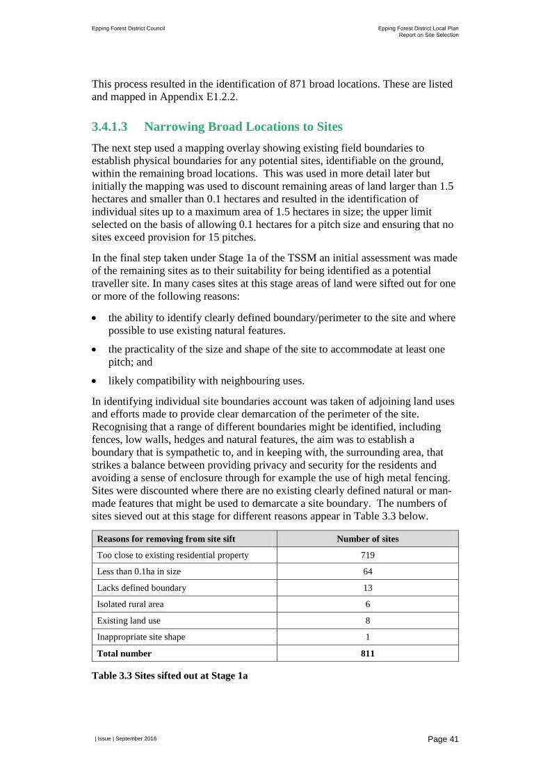
Epping Forest District Council Epping Forest District Local Plan Report on Site Selection
| Issue | September 2016
Page 41
This process resulted in the identification of 871 broad locations. These are listed and mapped in Appendix E1.2.2.
3.4.1.3 Narrowing Broad Locations to Sites The next step used a mapping overlay showing existing field boundaries to establish physical boundaries for any potential sites, identifiable on the ground, within the remaining broad locations. This was used in more detail later but initially the mapping was used to discount remaining areas of land larger than 1.5 hectares and smaller than 0.1 hectares and resulted in the identification of individual sites up to a maximum area of 1.5 hectares in size; the upper limit selected on the basis of allowing 0.1 hectares for a pitch size and ensuring that no sites exceed provision for 15 pitches.
In the final step taken under Stage 1a of the TSSM an initial assessment was made of the remaining sites as to their suitability for being identified as a potential traveller site. In many cases sites at this stage areas of land were sifted out for one or more of the following reasons:
• the ability to identify clearly defined boundary/perimeter to the site and where possible to use existing natural features.
• the practicality of the size and shape of the site to accommodate at least one pitch; and
• likely compatibility with neighbouring uses.
In identifying individual site boundaries account was taken of adjoining land uses and efforts made to provide clear demarcation of the perimeter of the site. Recognising that a range of different boundaries might be identified, including fences, low walls, hedges and natural features, the aim was to establish a boundary that is sympathetic to, and in keeping with, the surrounding area, that strikes a balance between providing privacy and security for the residents and avoiding a sense of enclosure through for example the use of high metal fencing. Sites were discounted where there are no existing clearly defined natural or man-made features that might be used to demarcate a site boundary. The numbers of sites sieved out at this stage for different reasons appear in Table 3.3 below.
Reasons for removing from site sift Number of sites
Too close to existing residential property 719
Less than 0.1ha in size 64
Lacks defined boundary 13
Isolated rural area 6
Existing land use 8
Inappropriate site shape 1
Total number 811
Table 3.3 Sites sifted out at Stage 1a
Epping Forest District Council Epping Forest District Local Plan Report on Site Selection
| Issue | September 2016
Page 42
This final step of Stage 1a resulted in 60 sites remaining in the potential list – they are noted in Appendix E1.2.2 as ‘proceed’ and coloured green in the ‘status’ column.
3.4.2 Stage 1b Intensification and/or Extension of Existing Sites
This stage of the assessment was separate to, and not sequential to, Stage 1a which identifies a set of sites from different sources. At Stage 1b, in line with paragraph 16(d) of the TSSM, consideration was given to the scope for more intensive use of or extensions, up to a maximum of 15 pitches in capacity at:
• existing permanent authorised sites;
• sites with temporary permissions that may potentially be suitable for regularisation and then also have the potential for intensification and/or expansion; and
• unauthorised sites that may potentially be suitable for regularisation and then also have the potential for intensification and/or expansion.
At the time this assessment was undertaken updated information from ORS was not available on the status of occupants against the revised definition contained within the PPTS. All existing sites that contain pitches were therefore considered for regularisation, intensification and/or extension regardless of the occupants’ status which was unknown at this time17.
The initial identification of potential sites for expansion or intensification was established through desk-based analysis using GIS. This analysis was sense checked by Epping Forest District Council colleagues who are familiar with the existing Traveller sites in the District – opinions were sought as to whether, in relation to intensification of use, areas of land of at least 0.1 hectare within the existing site boundary could be identified for intensification and/or whether there was adjacent land of at least 0.1 hectare potentially suitable for a Traveller site extension18. In addition the suitability of sites that were presently either subject to a temporary planning permission, or unauthorised occupation by Travellers, were considered in relation to access, proximity to settlement and services, flood risk and compatibility of neighbouring and surrounding land uses.
In considering extending the existing boundaries of sites analysis of immediately joining land uses was undertaken, together with identification of land ownership
17 When information was available from ORS on the status of traveller sites against the amended PPTS definition, the site remaining in the sift were checked to ensure they either met the definition or were unknown. All sites remaining in the sift fell within one of these two categories. No sites were therefore discounted on the basis that the current occupants did not meet the definition set out in the PPTS. 18 EFDC undertakes a bi annual (January and July) Traveller Caravan Count. This entails visiting all traveller sites in the District and counting the number of mobile homes and touring caravans on each. Following the July 2016 Caravan count the Council’s site information now records an EFDC officer view on the potential suitability for intensification and /or an extension of the site in order to accommodate additional pitches.
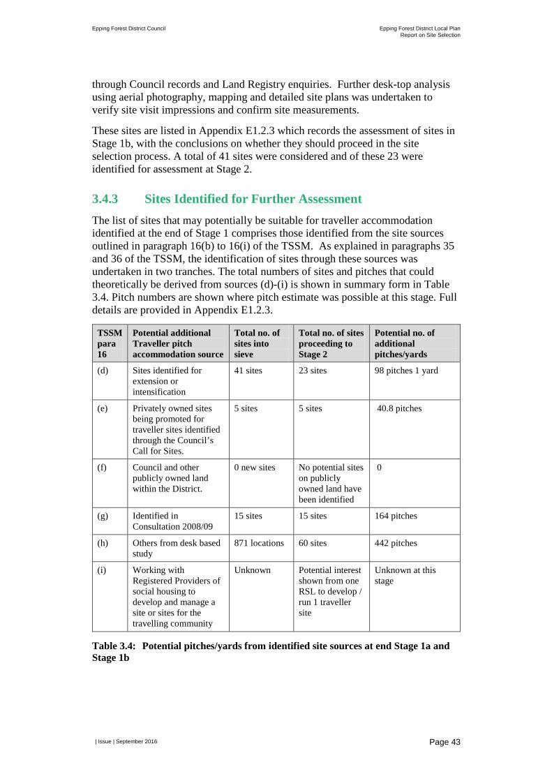
Epping Forest District Council Epping Forest District Local Plan Report on Site Selection
| Issue | September 2016
Page 43
through Council records and Land Registry enquiries. Further desk-top analysis using aerial photography, mapping and detailed site plans was undertaken to verify site visit impressions and confirm site measurements.
These sites are listed in Appendix E1.2.3 which records the assessment of sites in Stage 1b, with the conclusions on whether they should proceed in the site selection process. A total of 41 sites were considered and of these 23 were identified for assessment at Stage 2.
3.4.3 Sites Identified for Further Assessment The list of sites that may potentially be suitable for traveller accommodation identified at the end of Stage 1 comprises those identified from the site sources outlined in paragraph 16(b) to 16(i) of the TSSM. As explained in paragraphs 35 and 36 of the TSSM, the identification of sites through these sources was undertaken in two tranches. The total numbers of sites and pitches that could theoretically be derived from sources (d)-(i) is shown in summary form in Table 3.4. Pitch numbers are shown where pitch estimate was possible at this stage. Full details are provided in Appendix E1.2.3.
TSSM para 16
Potential additional Traveller pitch accommodation source
Total no. of sites into sieve
Total no. of sites proceeding to Stage 2
Potential no. of additional pitches/yards
(d) Sites identified for extension or intensification
41 sites 23 sites 98 pitches 1 yard
(e) Privately owned sites being promoted for traveller sites identified through the Council’s Call for Sites.
5 sites 5 sites 40.8 pitches
(f) Council and other publicly owned land within the District.
0 new sites No potential sites on publicly owned land have been identified
0
(g) Identified in Consultation 2008/09
15 sites 15 sites 164 pitches
(h) Others from desk based study
871 locations 60 sites 442 pitches
(i) Working with Registered Providers of social housing to develop and manage a site or sites for the travelling community
Unknown Potential interest shown from one RSL to develop / run 1 traveller site
Unknown at this stage
Table 3.4: Potential pitches/yards from identified site sources at end Stage 1a and Stage 1b
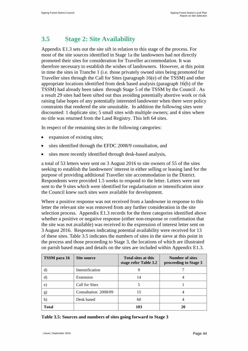
Epping Forest District Council Epping Forest District Local Plan Report on Site Selection
| Issue | September 2016
Page 44
3.5 Stage 2: Site Availability Appendix E1.3 sets out the site sift in relation to this stage of the process. For most of the site sources identified in Stage 1a the landowners had not directly promoted their sites for consideration for Traveller accommodation. It was therefore necessary to establish the wishes of landowners. However, at this point in time the sites in Tranche 1 (i.e. those privately owned sites being promoted for Traveller sites through the Call for Sites (paragraph 16(e) of the TSSM) and other appropriate locations identified from desk based analysis (paragraph 16(h) of the TSSM) had already been taken through Stage 5 of the TSSM by the Council . As a result 29 sites had been sifted out thus avoiding potentially abortive work or risk raising false hopes of any potentially interested landowner when there were policy constraints that rendered the site unsuitable. In addition the following sites were discounted: 1 duplicate site; 5 small sites with multiple owners; and 4 sites where no title was returned from the Land Registry. This left 64 sites.
In respect of the remaining sites in the following categories:
• expansion of existing sites;
• sites identified through the EFDC 2008/9 consultation, and
• sites more recently identified through desk-based analysis,
a total of 53 letters were sent on 3 August 2016 to site owners of 55 of the sites seeking to establish the landowners' interest in either selling or leasing land for the purpose of providing additional Traveller site accommodation in the District. Respondents were provided 1.5 weeks to respond to the letter. Letters were not sent to the 9 sites which were identified for regularisation or intensification since the Council knew such sites were available for development.
Where a positive response was not received from a landowner in response to this letter the relevant site was removed from any further consideration in the site selection process. Appendix E1.3 records for the three categories identified above whether a positive or negative response (either non-response or confirmation that the site was not available) was received to the expression of interest letter sent on 3 August 2016. Responses indicating potential availability were received for 13 of these sites. Table 3.5 indicates the numbers of sites in the sieve at this point in the process and those proceeding to Stage 3, the locations of which are illustrated on parish based maps and details on the sites are included within Appendix E1.3.
TSSM para 16 Site source Total sites at this stage refer Table 3.2
Number of sites proceeding to Stage 3
d) Intensification 9 7
d) Extension 14 4
e) Call for Sites 5 1
g) Consultation 2008/09 15 4
h) Desk based 60 4
Total 103 20
Table 3.5: Sources and numbers of sites going forward to Stage 3
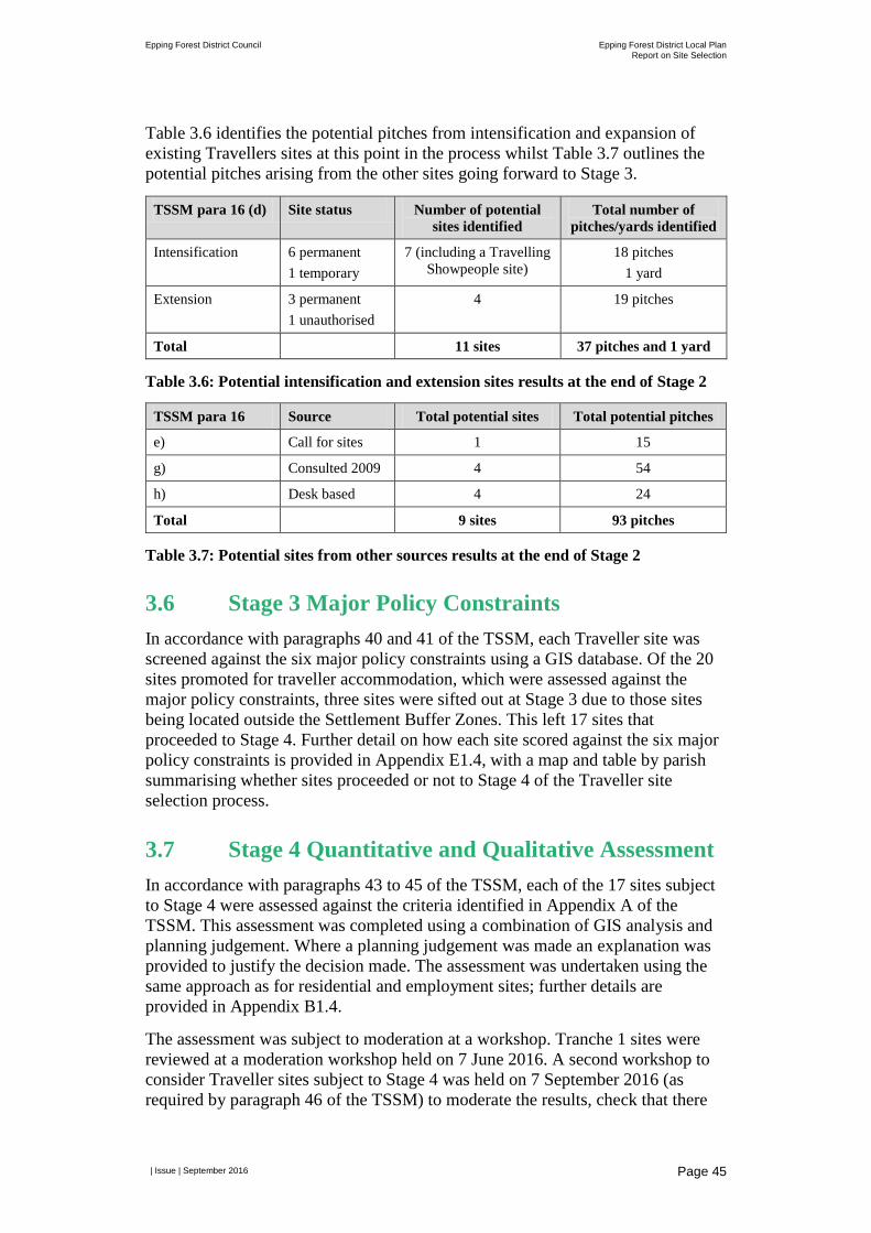
Epping Forest District Council Epping Forest District Local Plan Report on Site Selection
| Issue | September 2016
Page 45
Table 3.6 identifies the potential pitches from intensification and expansion of existing Travellers sites at this point in the process whilst Table 3.7 outlines the potential pitches arising from the other sites going forward to Stage 3.
TSSM para 16 (d) Site status Number of potential sites identified
Total number of pitches/yards identified
Intensification 6 permanent 1 temporary
7 (including a Travelling Showpeople site)
18 pitches 1 yard
Extension 3 permanent 1 unauthorised
4 19 pitches
Total 11 sites 37 pitches and 1 yard
Table 3.6: Potential intensification and extension sites results at the end of Stage 2
TSSM para 16 Source Total potential sites Total potential pitches
e) Call for sites 1 15
g) Consulted 2009 4 54
h) Desk based 4 24
Total 9 sites 93 pitches
Table 3.7: Potential sites from other sources results at the end of Stage 2
3.6 Stage 3 Major Policy Constraints In accordance with paragraphs 40 and 41 of the TSSM, each Traveller site was screened against the six major policy constraints using a GIS database. Of the 20 sites promoted for traveller accommodation, which were assessed against the major policy constraints, three sites were sifted out at Stage 3 due to those sites being located outside the Settlement Buffer Zones. This left 17 sites that proceeded to Stage 4. Further detail on how each site scored against the six major policy constraints is provided in Appendix E1.4, with a map and table by parish summarising whether sites proceeded or not to Stage 4 of the Traveller site selection process.
3.7 Stage 4 Quantitative and Qualitative Assessment In accordance with paragraphs 43 to 45 of the TSSM, each of the 17 sites subject to Stage 4 were assessed against the criteria identified in Appendix A of the TSSM. This assessment was completed using a combination of GIS analysis and planning judgement. Where a planning judgement was made an explanation was provided to justify the decision made. The assessment was undertaken using the same approach as for residential and employment sites; further details are provided in Appendix B1.4.
The assessment was subject to moderation at a workshop. Tranche 1 sites were reviewed at a moderation workshop held on 7 June 2016. A second workshop to consider Traveller sites subject to Stage 4 was held on 7 September 2016 (as required by paragraph 46 of the TSSM) to moderate the results, check that there
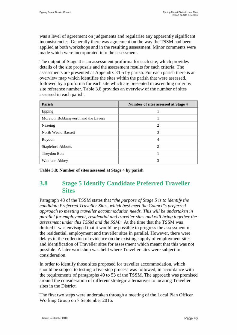
Epping Forest District Council Epping Forest District Local Plan Report on Site Selection
| Issue | September 2016
Page 46
was a level of agreement on judgements and regularise any apparently significant inconsistencies. Generally there was agreement on the way the TSSM had been applied at both workshops and in the resulting assessment. Minor comments were made which were incorporated into the assessment.
The output of Stage 4 is an assessment proforma for each site, which provides details of the site proposals and the assessment results for each criteria. The assessments are presented at Appendix E1.5 by parish. For each parish there is an overview map which identifies the sites within the parish that were assessed, followed by a proforma for each site which are presented in ascending order by site reference number. Table 3.8 provides an overview of the number of sites assessed in each parish.
Parish Number of sites assessed at Stage 4
Epping 1
Moreton, Bobbingworth and the Lavers 1
Nazeing 2
North Weald Bassett 3
Roydon 4
Stapleford Abbotts 2
Theydon Bois 1
Waltham Abbey 3
Table 3.8: Number of sites assessed at Stage 4 by parish
3.8 Stage 5 Identify Candidate Preferred Traveller Sites
Paragraph 48 of the TSSM states that “the purpose of Stage 5 is to identify the candidate Preferred Traveller Sites, which best meet the Council's preferred approach to meeting traveller accommodation needs. This will be undertaken in parallel for employment, residential and traveller sites and will bring together the assessment under this TSSM and the SSM.” At the time that the TSSM was drafted it was envisaged that it would be possible to progress the assessment of the residential, employment and traveller sites in parallel. However, there were delays in the collection of evidence on the existing supply of employment sites and identification of Traveller sites for assessment which meant that this was not possible. A later workshop was held where Traveller sites were subject to consideration.
In order to identify those sites proposed for traveller accommodation, which should be subject to testing a five-step process was followed, in accordance with the requirements of paragraphs 49 to 53 of the TSSM. The approach was premised around the consideration of different strategic alternatives to locating Traveller sites in the District.
The first two steps were undertaken through a meeting of the Local Plan Officer Working Group on 7 September 2016.
Epping Forest District Council Epping Forest District Local Plan Report on Site Selection
| Issue | September 2016
Page 47
Step 1: Three broad spatial options for accommodating Traveller needs were identified. These were:
• Distribute pitches across the District.
• Focus pitches in parts of the District traditionally favoured by the travelling community.
• Focus pitches in parts of the District traditionally not favoured by the travelling community.
Each option was assessed using planning judgement having regard to a range of factors including principles set out in the PPTS, local knowledge/initial officer evaluation of sites, previous feedback from Members and feedback from the consultations held in 2008 and 2012 (as detailed in Section 3.2.4). The feedback from the consultations included an indication that the settled and travelling communities favour a degree of separation from each other; concerns about an over-concentration of Travellers in the parishes of Nazeing and Roydon and a desire not to see the expansion of existing sites.
For each spatial option a judgement was made about whether the option represented a more suitable or less suitable location for development. Of the three options considered provision of pitches across the District was considered most suitable. Appendix E1.6 contains a table which identifies each spatial option and provides the justification for the judgement reached.
Step 2: Consideration was also given to the site sizes for Traveller accommodation. Paragraph 12 of the TSSM states that: “the maximum size of any site should be around 15 pitches with the size of a single pitch site 0.1ha – hence the initial search for sites across the District will range in size between 0.1ha and 1.5ha.” However, it was identified that within this range there were further sub-options which needed to be explored. Two options in relation to site sizes for new sites were identified:
• Traveller needs accommodated in new sites with a proposed capacity of no more than five pitches.
• Traveller needs accommodated in new sites with a proposed capacity of five or more pitches.
Consideration was also given to the approach to existing Traveller sites which had scope for intensification and extension.
Accommodating Traveller needs on sites of no more than five pitches was considered the most appropriate approach for new sites. Intensification or extension of existing sites should not exceed 10 pitches subject to detailed consideration of the suitability of each site and the justification for exceeding the preferred maximum of 5 pitches. These site size thresholds reflect the views and preferences expressed in the consultation feedback summarised at Section 3.2.4.
Step 3: Given the decision to consider a distributed approach to accommodating Traveller needs across the District, all sites identified for testing at Stage 4 were subject to further assessment. This included:
Epping Forest District Council Epping Forest District Local Plan Report on Site Selection
| Issue | September 2016
Page 48
• Sites identified for intensification and extension were checked to see whether with additional pitches they would stay within the 10 pitch limit. Sites which were above this site size were discounted at this point. Where sites were within the pitch limit they were subject to more detailed assessment.
• The capacity of sites for regularisation or for new sites was reviewed. For sites of five pitches or fewer they proceeded for more detailed assessment. Where they exceeded the threshold the site was considered further but only for its suitability to accommodate five pitches. In cases where proposed sites would result in an overconcentration of provision of Traveller accommodation in parts of the District and thus increased pressure on local services, it was agreed in line with the preferred option to seek a distribution of sites across the District to adopt a preference for alternative sites with less existing provision of Traveller accommodation.
When undertaking the more detailed consideration of sites identified in the previous paragraph regard was had to paragraph 50 of the SSM, which states that: “in general…those sites with the most dark green (++) and least red scores (--) are likely to be the most suitable [sites] for allocation. However, in common with all site selection/allocation processes, the identification of candidate Preferred Traveller Sites will involve an element of planning judgement, the effect of which on outcomes cannot be prejudged. It should also be noted that in exercising planning judgement different weight may be given to each of the criteria reflecting the specific criteria for identifying traveller sites outlined in PPTS [Planning policy for traveller sites] and the characteristics of the sites being assessed under the TSSM. Where this is the case, the rationale for applying different weight to the criteria in relation to a particular site will be documented.”
Therefore, for each site considered regard was had to the findings of the Stage 4 assessment and local knowledge/initial officer evaluation of sites. Based on this assessment a judgment was made as to whether a site was considered suitable or not suitable for further testing; eight sites were identified for further testing. A justification for this judgement with reference to the particular planning matters considered relevant to the site is set out in Appendix E1.6.
Step 4: The eight sites which were judged to be suitable for allocation were then categorised against the hierarchy presented at paragraph 51 of the TSSM. The principle of the hierarchy is that a sequential approach is applied to identifying those sites which should be further considered.
For ease of reference the hierarchy set out in paragraph 51 of the TSSM has been repeated in Table 3.9 along with the number of sites identified for further testing that fall within each category. The final category in the hierarchy to look at strategic sites took account of the possibility of considering the location of Traveller sites within larger proposed residential sites being considered by the District where there was agreement from the promoter as well as the strategic sites identified for residential allocation around Harlow.
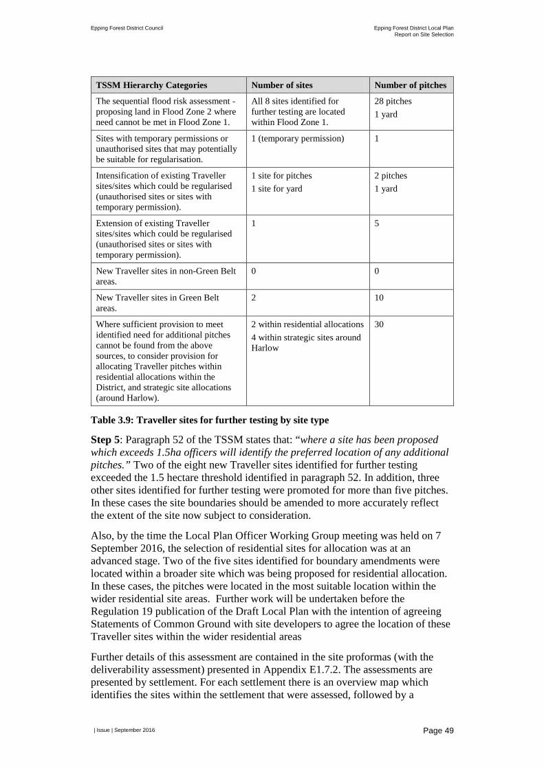
Epping Forest District Council Epping Forest District Local Plan Report on Site Selection
| Issue | September 2016
Page 49
TSSM Hierarchy Categories Number of sites Number of pitches
The sequential flood risk assessment - proposing land in Flood Zone 2 where need cannot be met in Flood Zone 1.
All 8 sites identified for further testing are located within Flood Zone 1.
28 pitches 1 yard
Sites with temporary permissions or unauthorised sites that may potentially be suitable for regularisation.
1 (temporary permission) 1
Intensification of existing Traveller sites/sites which could be regularised (unauthorised sites or sites with temporary permission).
1 site for pitches 1 site for yard
2 pitches 1 yard
Extension of existing Traveller sites/sites which could be regularised (unauthorised sites or sites with temporary permission).
1 5
New Traveller sites in non-Green Belt areas.
0 0
New Traveller sites in Green Belt areas.
2 10
Where sufficient provision to meet identified need for additional pitches cannot be found from the above sources, to consider provision for allocating Traveller pitches within residential allocations within the District, and strategic site allocations (around Harlow).
2 within residential allocations 4 within strategic sites around Harlow
30
Table 3.9: Traveller sites for further testing by site type
Step 5: Paragraph 52 of the TSSM states that: “where a site has been proposed which exceeds 1.5ha officers will identify the preferred location of any additional pitches.” Two of the eight new Traveller sites identified for further testing exceeded the 1.5 hectare threshold identified in paragraph 52. In addition, three other sites identified for further testing were promoted for more than five pitches. In these cases the site boundaries should be amended to more accurately reflect the extent of the site now subject to consideration.
Also, by the time the Local Plan Officer Working Group meeting was held on 7 September 2016, the selection of residential sites for allocation was at an advanced stage. Two of the five sites identified for boundary amendments were located within a broader site which was being proposed for residential allocation. In these cases, the pitches were located in the most suitable location within the wider residential site areas. Further work will be undertaken before the Regulation 19 publication of the Draft Local Plan with the intention of agreeing Statements of Common Ground with site developers to agree the location of these Traveller sites within the wider residential areas
Further details of this assessment are contained in the site proformas (with the deliverability assessment) presented in Appendix E1.7.2. The assessments are presented by settlement. For each settlement there is an overview map which identifies the sites within the settlement that were assessed, followed by a
Epping Forest District Council Epping Forest District Local Plan Report on Site Selection
| Issue | September 2016
Page 50
proforma for each site which are presented in ascending order by site reference number.
Paragraph 54 of the TSSM requires that consideration be given to exceptional circumstances for sites located in the Green Belt. Given the sequential approach followed to identify sites for further testing, and that sites in the Green Belt were only identified for testing in order to meet the District’s traveller need, at this point in the process it was considered that the approach adopted would support the case for exceptional circumstances should the remaining assessment work conclude release of the Green Belt was required.
3.9 Stage 6: Deliverability
3.9.1 Land Promoter/Developer Survey Paragraph 58 of the TSSM makes reference to additional information on availability being sought from landowners where a positive response was received to Stage 2 of the TSSM.
To maintain consistency with the SSM, a similar online survey to that sent to land promoters/developers of residential sites was sent to landowners of proposed Traveller sites (these were sent to the owners of the 13 sites who indicated potential availability at Stage 2 and the owners of 7 existing traveller sites identified for potential intensification/regularisation). Amendments to the survey questions were developed in coordination with the Council and in response to the Council’s information requirements including those topics identified for assessment at Stage 6 of the TSSM.
A series of questions were posed through the survey, a copy of which is provided at Appendix E1.7.1, which can be broadly grouped as follows:
• Contact information;
• Ownership and availability;
• Achievability;
• On-going engagement. Respondents were also provided with the opportunity to submit additional information to support their responses, including drawings, plans and any other relevant technical work undertaken to date. Invitations to complete the survey were issued via letter for all sites that proceeded to Stage 3 (20 sites in total). Respondents had two weeks to respond to the survey. In total, five survey responses were returned.
3.9.2 Availability and Achievability Assessment Paragraph 57 of the TSSM states that: “the purpose of Stage 6 is to consider the deliverability of the candidate Preferred Traveller Sites to inform the identified need for traveller accommodation. Stages 1 and 3 to 5 will have already
Epping Forest District Council Epping Forest District Local Plan Report on Site Selection
| Issue | September 2016
Page 51
considered the suitability of the site. Therefore focus of this stage is whether a site is deliverable and specifically:
• To better understand site availability including whether the site is available now, or is it likely to become available during the Local Plan period?
• Whether there is a reasonable prospect that development will be achievable within the appropriate timescales?”
The TSSM provides an indication of the matters which will be subject to the availability and achievability assessment. In applying the TSSM, the methodology for this assessment was further refined. The starting point was the criteria developed under the SSM for residential sites. The same criteria were used with the exception of marketability and viability which considered to be less relevant to traveller sites. Traveller sites were therefore assessed against the following criteria:
• Availability: site ownership, existing uses, on-site restrictions and site availability.
• Achievability: on-site physical and infrastructure constraints, impact on capacity of primary and secondary schools in the Planning Area and at individual primary and secondary schools, access to open space, access to health facilities and impact on mineral deposits.
• Cumulative achievability (in combination with residential site allocations): cumulative loss of open space, cumulative impact on primary schools, cumulative impact on secondary schools, cumulative impact on green infrastructure network, cumulative impact on sewage treatment works capacity and cumulative impact on Central Line capacity.
• Overview assessment of constraints: insurmountable constraints.
Further details on each criteria including how the assessment was undertaken are provided at Appendix B1.6. For each criteria a RAG rating system was utilised using a scale of three scores.
Each of eight sites subject to Stage 6 were assessed against the availability, achievability and insurmountable constraints criteria. This assessment was completed using a combination of GIS analysis, information from the land promoter/developer survey or other information held by the Council and planning judgement. Where a planning judgement was made an explanation was provided to justify the decision made. If a site was identified for allocation (see Section 3.9.3 below) it was also assessed along with other Traveller and residential sites identified in that settlement for the cumulative achievability of the proposals.
Overall, a total of five sites scored positively against the Stage 6 assessment criteria and three sites scored less positively. Further details of the deliverability assessment undertaken for each site is presented in a further site proforma presented in Appendix E1.7.3. The assessments are presented by settlement. For each settlement there is an overview map which identifies the sites within the settlement that were assessed, followed by a proforma for each site which are presented in ascending order by site reference number.
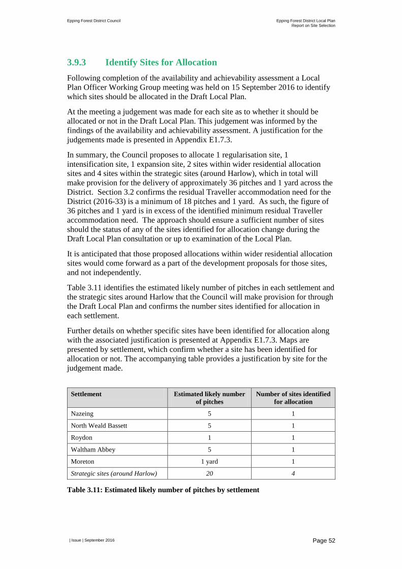
Epping Forest District Council Epping Forest District Local Plan Report on Site Selection
| Issue | September 2016
Page 52
3.9.3 Identify Sites for Allocation Following completion of the availability and achievability assessment a Local Plan Officer Working Group meeting was held on 15 September 2016 to identify which sites should be allocated in the Draft Local Plan.
At the meeting a judgement was made for each site as to whether it should be allocated or not in the Draft Local Plan. This judgement was informed by the findings of the availability and achievability assessment. A justification for the judgements made is presented in Appendix E1.7.3.
In summary, the Council proposes to allocate 1 regularisation site, 1 intensification site, 1 expansion site, 2 sites within wider residential allocation sites and 4 sites within the strategic sites (around Harlow), which in total will make provision for the delivery of approximately 36 pitches and 1 yard across the District. Section 3.2 confirms the residual Traveller accommodation need for the District (2016-33) is a minimum of 18 pitches and 1 yard. As such, the figure of 36 pitches and 1 yard is in excess of the identified minimum residual Traveller accommodation need. The approach should ensure a sufficient number of sites should the status of any of the sites identified for allocation change during the Draft Local Plan consultation or up to examination of the Local Plan.
It is anticipated that those proposed allocations within wider residential allocation sites would come forward as a part of the development proposals for those sites, and not independently.
Table 3.11 identifies the estimated likely number of pitches in each settlement and the strategic sites around Harlow that the Council will make provision for through the Draft Local Plan and confirms the number sites identified for allocation in each settlement.
Further details on whether specific sites have been identified for allocation along with the associated justification is presented at Appendix E1.7.3. Maps are presented by settlement, which confirm whether a site has been identified for allocation or not. The accompanying table provides a justification by site for the judgement made.
Settlement Estimated likely number
of pitches Number of sites identified
for allocation
Nazeing 5 1
North Weald Bassett 5 1
Roydon 1 1
Waltham Abbey 5 1
Moreton 1 yard 1
Strategic sites (around Harlow) 20 4
Table 3.11: Estimated likely number of pitches by settlement
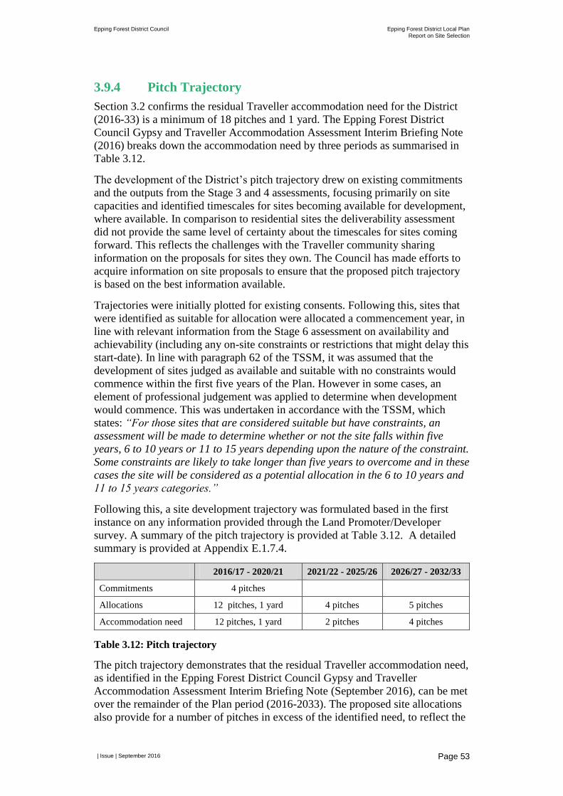
Epping Forest District Council Epping Forest District Local Plan
Report on Site Selection
| Issue | September 2016
Page 53
3.9.4 Pitch Trajectory
Section 3.2 confirms the residual Traveller accommodation need for the District
(2016-33) is a minimum of 18 pitches and 1 yard. The Epping Forest District
Council Gypsy and Traveller Accommodation Assessment Interim Briefing Note
(2016) breaks down the accommodation need by three periods as summarised in
Table 3.12.
The development of the District’s pitch trajectory drew on existing commitments
and the outputs from the Stage 3 and 4 assessments, focusing primarily on site
capacities and identified timescales for sites becoming available for development,
where available. In comparison to residential sites the deliverability assessment
did not provide the same level of certainty about the timescales for sites coming
forward. This reflects the challenges with the Traveller community sharing
information on the proposals for sites they own. The Council has made efforts to
acquire information on site proposals to ensure that the proposed pitch trajectory
is based on the best information available.
Trajectories were initially plotted for existing consents. Following this, sites that
were identified as suitable for allocation were allocated a commencement year, in
line with relevant information from the Stage 6 assessment on availability and
achievability (including any on-site constraints or restrictions that might delay this
start-date). In line with paragraph 62 of the TSSM, it was assumed that the
development of sites judged as available and suitable with no constraints would
commence within the first five years of the Plan. However in some cases, an
element of professional judgement was applied to determine when development
would commence. This was undertaken in accordance with the TSSM, which
states: “For those sites that are considered suitable but have constraints, an
assessment will be made to determine whether or not the site falls within five
years, 6 to 10 years or 11 to 15 years depending upon the nature of the constraint.
Some constraints are likely to take longer than five years to overcome and in these
cases the site will be considered as a potential allocation in the 6 to 10 years and
11 to 15 years categories.”
Following this, a site development trajectory was formulated based in the first
instance on any information provided through the Land Promoter/Developer
survey. A summary of the pitch trajectory is provided at Table 3.12. A detailed
summary is provided at Appendix E.1.7.4.
2016/17 - 2020/21 2021/22 - 2025/26 2026/27 - 2032/33
Commitments 4 pitches
Allocations 12 pitches, 1 yard 4 pitches 5 pitches
Accommodation need 12 pitches, 1 yard 2 pitches 4 pitches
Table 3.12: Pitch trajectory
The pitch trajectory demonstrates that the residual Traveller accommodation need,
as identified in the Epping Forest District Council Gypsy and Traveller
Accommodation Assessment Interim Briefing Note (September 2016), can be met
over the remainder of the Plan period (2016-2033). The proposed site allocations
also provide for a number of pitches in excess of the identified need, to reflect the
Epping Forest District Council Epping Forest District Local Plan Report on Site Selection
| Issue | September 2016
Page 54
greater uncertainty around deliverability of traveller sites, some of which are not incorporated into the trajectory set out in Table 3.12. For simplicity these additional sites have not been incorporated into the trajectory. Following the Draft Local Plan consultation the draft pitch trajectory will be reviewed and any amendments made to reflect updated information and evidence. At this time, all sites proposed for allocation will be reflected in the trajectory.
3.9.5 Exceptional Circumstances The TSSM sets out a clear strategy to minimise the use of Green Belt land for development. Paragraph 51 of the TSSM sets out a sequential approach in which existing sites are promoted before new sites are identified; within this new sites on non-Green Belt land are preferred to those sites located in the Green Belt. Table 3.9 also shows that there is insufficient suitable land located outside the Green Belt to meet the Traveller needs of the District within the Plan period.
For the proposed Traveller site allocations which do not fall within proposed residential sites (including strategic sites around Harlow), alterations to the Green Belt boundary are not proposed but will remain washed over by Green Belt. Very special circumstances will have to be demonstrated at the development management stage, however, the existence of the Local Plan allocation will provide a compelling case upon which very special circumstances may be demonstrated. That decision can only be made at the time the application is considered and the allocation of land does not predetermine any decision to grant planning permission.
In order to support the proposed site allocations where alterations to existing Green Belt boundaries are proposed, it will be necessary to demonstrate exceptional circumstances. This relates to those proposed site allocations that form a part of a larger proposed residential site allocation (GRT-N_06 which is located in North Weald Basset and GRT_N-07 which is located in Waltham Abbey), and the four strategic sites proposed for allocation around Harlow. The sites proposed for allocation therefore represent the minimum land take required from the Green Belt to enable the Council to meet the District’s Traveller needs through a strategy that is both sustainable and deliverable. Such an approach accords with the requirements of the NPPF and PPTS. In the event that the residential site allocation is forthcoming then the related proposed Traveller site allocations within the same site would benefit from the associated Green Belt releases.
Epping Forest District Council Epping Forest District Local Plan Report on Site Selection
| Issue | September 2016
Page 55
4 Employment Sites This chapter contains an introduction to the District’s employment needs, provides an overview of the methodology developed to guide the selection of employment sites in Epping Forest District Council’s Local Plan and presents the findings of the site selection process completed to-date.
4.1 Employment Need The Council with its Housing Market Area authority partners jointly commissioned economic evidence, which identified a need in Epping Forest District over the Plan period of between 8,800 and 10,010 new jobs. This equates to between 400 and 455 new jobs per annum.
The Draft Memorandum of Understanding on the ’Distribution of Objectively Assessed Need Across the West Essex/East Hertfordshire Housing Market Area assumes that each Council will meet its own employment needs. Therefore, the Councils’ preferred approach is to plan to meet the higher end of the jobs range, which represents an aspirational level of employment and job growth over the Plan period.
The Employment Land Review19 identifies 42 ‘employment’ sites within the District, 16 of which are allocated in the 1998 Local Plan and updated by the 2006 Local Plan Alterations and 26 are unallocated. In total these sites provide 127 hectares of employment land, which includes 536 separate employment related premises.
The Joint Economic Report concluded that in order to meet the upper end of the employment projections that in addition to the existing land supply identified in the Employment Land Review the following land supply would be required:
• Class B1a (offices), there is gross demand of up to 13 hectares of land.
• Classes B1b, B1c, B2 and B8 (industrial and warehousing) there is a gross demand for up to 18 hectares of land.
Table 4.1 summarises the components of the land supply, which will be delivered to meet the Council’s objectively assessed employment need figure. Once completions and commitments are accounted for, there is a residual requirement of circa 31 hectares of land.
Employment floorspace (B1a uses) required to be built 2011-2033 13 hectares
Net gain in B1a employment floorspace via planning permission to 31 July 2016
-0.52 hectares
Remaining requirement to be identified 13.52 hectares
Employment floorspace (B1b, B1c, B2 and B8 uses) required to be built 2011-2033
18 hectares
19 Epping Forest District and Brentwood Borough Employment Land Review (Atkins, 2010)
Epping Forest District Council Epping Forest District Local Plan Report on Site Selection
| Issue | September 2016
Page 56
Net gain in B1b, B1c, B2 and B8 employment floorspace via planning permission to 31 July 2016
-3.80 hectares
Remaining requirement to be identified 21.8 hectares
Table 4.1: Employment land supply
4.2 Overview of Site Selection Methodology As discussed in Chapter 2, the SSM identifies five stages through which sites are sieved and subject to more detailed assessment at each stage in order to identify the proposed site allocations for employment uses. The five stages can be summarised as follows.
• Stage 1 Major Policy Constraints – identify sites which are subject to one or more of these constraints and therefore not considered to be suitable for development.
• Stage 2 Quantitative and Qualitative Assessment – undertake more detailed assessment of sites to understand their relative suitability for development.
• Stage 3 Identify Candidate Preferred Sites – identify those sites which are considered suitable for development and should be subject to further capacity and deliverability assessment. More detailed indicative capacity assessment is also undertaken for each site identified for further testing.
• Stage 4 Deliverability – understand the availability and achievability of sites to enable a decision to be made about which sites to allocate and to ensure that the land can be provided throughout the Plan period.
• Stage 5 Sustainability Appraisal/Habitats Regulation Assessment of Candidate Preferred Sites – establish the impact of the candidate Preferred Sites alone and in combination.
A full version of the SSM is located at Appendix A.
The remainder of this chapter explains how the SSM has been applied to employment sites and provides a summary of the results, with reference made to detailed appendices which provide further detail of the assessment undertaken and justification for key decisions made. This includes Appendix F1.1, which provides an overview of how each site proposed for employment (B Class) use was assessed at each stage of the SSM.
It should also be noted that the results of Stage 5 of the SSM is documented under separate cover in the Interim Sustainability Appraisal report for the Draft Local Plan (AECOM, 2016).
4.3 Stage 1: Major Policy Constraints In accordance with paragraph 4.5 of the SSM, each employment site was screened against the six major policy constraints using a Geographic Information Systems (GIS) database. Of the 36 sites promoted for employment uses, which were assessed against the major policy constraints, four sites were sifted out at Stage 1
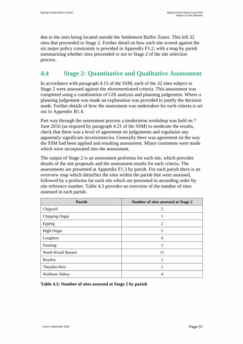
Epping Forest District Council Epping Forest District Local Plan Report on Site Selection
| Issue | September 2016
Page 57
due to the sites being located outside the Settlement Buffer Zones. This left 32 sites that proceeded to Stage 2. Further detail on how each site scored against the six major policy constraints is provided in Appendix F1.2, with a map by parish summarising whether sites proceeded or not to Stage 2 of the site selection process.
4.4 Stage 2: Quantitative and Qualitative Assessment In accordance with paragraph 4.15 of the SSM, each of the 32 sites subject to Stage 2 were assessed against the aforementioned criteria. This assessment was completed using a combination of GIS analysis and planning judgement. Where a planning judgement was made an explanation was provided to justify the decision made. Further details of how the assessment was undertaken for each criteria is set out in Appendix B1.4.
Part way through the assessment process a moderation workshop was held on 7 June 2016 (as required by paragraph 4.21 of the SSM) to moderate the results, check that there was a level of agreement on judgements and regularise any apparently significant inconsistencies. Generally there was agreement on the way the SSM had been applied and resulting assessment. Minor comments were made which were incorporated into the assessment.
The output of Stage 2 is an assessment proforma for each site, which provides details of the site proposals and the assessment results for each criteria. The assessments are presented at Appendix F1.3 by parish. For each parish there is an overview map which identifies the sites within the parish that were assessed, followed by a proforma for each site which are presented in ascending order by site reference number. Table 4.3 provides an overview of the number of sites assessed in each parish.
Parish Number of sites assessed at Stage 2
Chigwell 5
Chipping Ongar 1
Epping 2
High Ongar 1
Loughton 4
Nazeing 3
North Weald Bassett 11
Roydon 1
Theydon Bois 1
Waltham Abbey 4
Table 4.3: Number of sites assessed at Stage 2 by parish
Epping Forest District Council Epping Forest District Local Plan Report on Site Selection
| Issue | September 2016
Page 58
4.5 Next Steps The Council has identified the need to update the Employment Land Review undertaken in 2010 to better understand existing employment land supply within the District and the scope for further intensification of employment uses on existing sites. The site selection process has therefore been paused at the end of Stage 2 until a more up-to-date picture of existing employment land supply has been established. Once this piece of work has been completed the Council will better understand the contribution that such sites might make to meeting the employment need figures identified in Section 4.1 and therefore the remaining balance that may need to be found through extensions to existing sites or new employment sites. The site selection process will then re-commence to identify the preferred employment sites for allocation.