esr main report 05.05.2006 final - eskom
TRANSCRIPT

Eskom Holdings Limited Transmission Division i Issue 1.0 / May 2006 765kV Transmission Power Lines EIA: Environmental Scoping Report
EXECUTIVE SUMMARY
Background
The Transmission Division of Eskom Holdings Limited (Eskom) proposes to construct three new 765 kV transmission power lines of varying length between Dealesville in the Free State Province and De Aar in the Northern Cape Province. The power lines form part of Eskom’s larger network strengthening programme, which aims to meet increased electricity demand in South Africa, specifically the Western and Eastern Cape regions. In terms of legislation, authorisation is required from the Department of Environmental Affairs and Tourism prior to the construction of the proposed power lines. Accordingly, an Environmental Impact Assessment (EIA) has to be conducted and the information presented to the authorities for decision-making. The EIA process as prescribed by Regulations consists of a Scoping phase (preliminary investigations) and EIA phase (detailed investigations). The Scoping phase of the EIA process has largely been concluded, and the outcome thereof is contained in this Environmental Scoping Report, which provides a broad description of the preliminary biophysical and socio-economic issues related to the proposed project. The report contains a detailed project description, an evaluation of alternatives, a detailed record of the Public Participation Process to date, the outcome of preliminary specialist investigations and defines the scope of further detailed investigations to be conducted during the EIA phase. In order to allow input by stakeholders into the process, as required by legislation, significant consultation has taken place to provide Interested and Affected Parties with an opportunity to present comments and raise concerns regarding the proposed project. Authorities, potentially affected land-owners, representative organisations and other stakeholders in the area were identified and notified of the proposed project and the EIA process. Direct interaction took place through a stakeholder’s workshop and a number of focus group meetings. Throughout the Scoping phase, comments and concerns raised were captured and are responded to in this Environmental Scoping Report. The report is accordingly also being made available for stakeholder review and comment. The stakeholder engagement and Public Participation Process is an iterative process, and will therefore continue throughout the remaining EIA process.
Scoping Phase
The proposed project will entail the following:
• Establishment of one 765 kV transmission power line, approximately 260 km in length,
between the Perseus Substation near Dealesville and the Hydra Substation near De Aar; • Establishment of two 765 kV transmission power lines, approximately 12 km in length,
between the Perseus Substation near Dealesville and the Beta Substation south-west of Dealesville; and
• Expansion of the existing Perseus Substation in order to accommodate the additional incoming and outgoing 765 kV transmission power lines.
The study area for the EIA process traverses the Free State and Northern Cape Provinces, and covers approximately 1 594 054 ha (15 940 km²). The main towns situated within the study area are Dealesville, Petrusberg, Koffiefontein, Oppermans, Luckhoff, Orania, Vanderkloof, Phillipstown and De Aar.

Eskom Holdings Limited Transmission Division ii Issue 1.0 / May 2006 765kV Transmission Power Lines EIA: Environmental Scoping Report
The Scoping phase study focussed on a broad environmental assessment of the study area, and included preliminary specialist investigations and identification of relevant, sensitive biophysical and socio-economic aspects and areas. The main purpose was to identify and evaluate possible alignment corridors for the proposed power lines, and to identify preferred alignment corridors and related environmental issues that require further detailed investigation during the EIA phase.
The following alternative alignment corridors were assessed for the Hydra-Perseus line: Alternative 1 – Existing 765 kV power line corridor (Green)
This alternative is located parallel to the existing 765 kV power line, which lies furthest west of the four existing transmission power lines between Perseus and Hydra Substations in the centre of the study area. This alignment was chosen to explore the possibility of restricting all the transmission lines to a single corridor.
Alternative 2 – Eastern Corridor (Yellow)
Alternative 2 refers to a position approximately 2 km west of the existing 765 kV transmission line. This alternative was selected as a result of the need to avoid the saline soils and pans. Alternative 3 – Centre Corridor (Dark Blue)
Located approximately 5 km west of the existing 765 kV transmission line. In addition to avoiding saline soils and pans, this corridor is characterised by a higher lying landform and plains interrupted by dolerite remnant landforms of plateaux and koppies. These features will provide occasional screens and backdrops to the line. Alternative 4 – Western Corridor (Red) This corridor is located approximately 10 km west of the existing 765 kV power line. This corridor will be visually disassociated with the existing lines and on the highest lying area - yet able to be visually screened along portions of its length by ridges, plateaux and koppies. Based on the assessment of the alternatives, it was recommended that Alternative 3 and Alternative 4 be taken forward into the EIA phase for further detailed study. This recommendation is based on the following: • Three of the six specialist studies which identified a most preferred alternative selected
Alternative 3 as the most preferred corridor for the power line. However, the difference between Alternative 3 and Alternative 4 in the visual impact, geology and geotechnical, fauna and flora is insignificant in many respects.
• Although the fauna and flora assessments suggested a different preferred corridor, both assessments agree that the possible impact of the proposed power line is very limited, irrespective of the corridor alignment finally selected.
• The only specialist assessments, which did not favour Alternative 3 or Alternative 4, was the avi-fauna assessment and flora assessment, which favoured Alternative 1 and Alternative 2 respectively. Unfortunately, Alternative 1 is the least favoured option in terms of soils, geology and visual impact. Mitigation in the form of tower placement and construction methodology can significantly reduce the impact of power lines on avi-fauna and vegetation and this will be investigated further in the EIA Phase.
• Alternative 3 and Alternative 4 address the risk factor associated with all power lines in close proximity to one another.
• The maintenance and cost factors associated with these alternatives are greater than the other alternatives but they do not make the project unfeasible.

Eskom Holdings Limited Transmission Division iii Issue 1.0 / May 2006 765kV Transmission Power Lines EIA: Environmental Scoping Report
It was further recommended that a 500 m corridor towards the east in the Beta-Perseus study area be identified and investigated during the EIA phase, based on the following: • The environment within the Beta-Perseus study area is relatively homogenous and any
alignment of the double servitude is likely to have a similar environmental impact. • The geological report suggested that the corridor be placed in the east, as the dolerite in
this area would best facilitate the geotechnical requirements of the towers. • The most significant impact is likely to be visual due to the number of existing power lines
in the area, particularly where the lines will need to cross the R64. The extent of the visual impact can be reduced through mitigation measures, which will be explored in the EIA Phase.

Eskom Holdings Limited Transmission Division iv Issue 1.0 / May 2006 765kV Transmission Power Lines EIA: Environmental Scoping Report
OPSOMMING
Agtergrond
Die Transmissie Afdeling van Eskom Holdings Beperk (Eskom) stel die konstruksie van drie nuwe 765 kV transmissie kraglyne, van verskillende lengtes, tussen Dealesville in die Vrystaat Provinsie en De Aar in die Noord-Kaap Provinsie, voor. Die kraglyne maak deel uit van Eskom se groter netwerk versterkingsprogram, wat daarop gemik is om in die groeiende vraag na elektrisiteit in Suid-Afika, en meer spesifiek in die Wes- en Oos-Kaap streke, te voldoen. In terme van wetgewing word goedkeuring van die Departement van Omgewingsake benodig, alvorens konstruksie van die voorgestelde kraglyne kan begin. ‘n Omgewingsimpakstudie (OIS) moet dus diensooreenkomstig onderneem word en die inligting moet aan die owerhede voorgelê word vir besluitneming. Die OIS proses word deur Regulasies voorgeskryf en bestaan uit ‘n Omvangsbepalingfase (voorlopige ondersoeke) en ‘n OIS-fase (in-diepte ondersoeke). Die Omvangsbeplingfase van die OIS is reeds grotendeels voltooi en die resultate daarvan is in hierdie Omgewingsomvangsbepaling-verslag saamgevat. Dit verskaf ‘n breë beskrywing van die voorlopige natuurlike en sosio-ekonomiese kwessies wat met die voorgestelde projek verband hou. Die verslag bevat ‘n gedetailleerde projekbeskrywing, ‘n evalueering van alternatiewe, ‘n gedetailleerde rekord van die Publieke Deelname Proses tot op datum, die resultate van voorlopige spesialis ondersoeke en dit definieer die omvang van verdere in-diepte ondersoeke wat as deel van die OIS-fase onderneem sal word. Ten einde alle belanghebbendes die geleentheid te bied om insette, soos deur die wetgewing voorgeskryf word, in die proses te lewer het omvattende konsultasie plaasgevind ten einde Geïntereseerde en Geaffekteerde Partye die geleentheid te bied om kommentaar te lewer en besware ten opsigte van die voorgestelde projek te opper. Owerhede, moontlik geaffekteerde grondeienaars, verteenwoordigende organisasies en belanghebbendes in die area was geïdentifiseer en van die voorgestelde projek en die OIS-proses in kennis gestel. Direkte interaksie het deur ‘n werkswinkel vir belanghebbendes en ‘n aantal fokusgroep vergaderings plaasgevind. Kommentaar en besware wat gedurende die Omvangsbepalingfase ge-opper is, is deurlopend aangeteken en terugvoer hierop is in die Omvangsbepaling-verslag uiteengesit. Die verslag is ook beskikbaar vir oorsig en kommentaar deur belanghebbendes. Betrokkenheid deur belanghebbendes in die Publieke Deelname Proses is ‘n interaktiewe proses en sal dus deur die loop van die OIS-proses voortduur.
Omvangsbepalingfase
Die voorgestelde projek sal die volgende behels:
• Die oprigting van een 765 kV transmissie kraglyn, ongeveer 260 km lank, tussen die
Perseus-substasie naby Dealesville en die Hydra-substasie naby De Aar; • Die oprigting van twee 765 kV transmissie kraglyne, ongeveer 12 km lank, tussen die
Perseus-substasie naby Dealesville en die Beta-substasie suidwes van Dealesville; en • Die uitbreiding van die bestaande Perseus-substasie ten einde die addisionele
inkomende en uitgaande 765 kV transmissie kraglyne te akkommodeer.
Die studie area vir die OIS-proses kruis die Vrystaat- en Noord-Kaap Provinsies en beslaan ongeveer 1 594 054 ha (15 940 km²). Die belangrikste dorpe wat binne die studie area geleë is, is Dealesville, Petrusberg, Koffiefontein, Oppermans, Luckhoff, Orania, Vanderkloof, Phillipstown en De Aar.

Eskom Holdings Limited Transmission Division v Issue 1.0 / May 2006 765kV Transmission Power Lines EIA: Environmental Scoping Report
Die Omvangsbepalingfase studie fokus op die breë omgewingsimpakbepaling van die studie area en sluit voorlopige spesialis ondersoeke en die identifikasie van relevante, sensitiewe natuurlike en sosio-ekonomiese aspekte en areas in. Die hoof doelwit is die identifikasie en evalueering van moontlike belynings-korridors vir die voorgestelde kraglyne, sowel as die identifikasie van voorkeur belynings-korridors en verwante omgewingskwessies wat tydens in-diepte ondersoeke gedurende die OIS-fase ondersoek moet word.
Die volgende alternatiewe belynings-korridors is vir die Hydra-Perseus lyn beoordeel: Alternatief 1 – Bestaande 765 kV kraglyn korridor (Groen)
Hierdie alternatief loop parallel aan die bestaande 765 kV kraglyn en is die verste wes van die vier bestaande transmissie kraglyne tussen die Perseus en Hydra Substasies in middel van die studie area geleë. Hierdie belyning is gekies om ‘n moontlikheid te ondersoek waardeur al die transmissielyne tot een korridor beperk word.
Alternatief 2 – Oostelike korridor (Geel)
Alternatief 2 verwys na ‘n posisie ongeveer 2 km wes van die bestaande 765 kV transmissielyn. Hierdie alternatief is gekies weens die nodigheid om soutgrond en panne te vermy. Alternatief 3 – Middelste korridor (Donker blou)
Hierdie alternatief is ongeveer 5 km wes van die bestaande 765 kV transmissielyn geleë. Bykomend tot die vermyding van soutgrond en panne, word hierdie korridor gekarakteriseer deur hoër liggende landvorms en vlaktes wat deur platos en koppies afgewissel word. Hierdie eienskappe sal nou en dan agtergrond vir die lyn voorsien en dit afskerm. Alternatief 4 – Westelike korridor (Rooi) Hierdie korridor is ongeveer 10 km wes van die bestaande 765 kV transmissielyn geleë. Dié korridor is visueel van die bestaande lyne geskei en op die hoogliggendste area geleë. Tog is dit moontlik om gedeeltes van die lyn deur riwwe, platos en koppies af te skerm. Op grond van die evalueering van die alternatiewe, is daar aanbeveel dat Alternatief 3 en Alternatief 4 na die OIS-fase geneem word vir verdere in-diepte ondersoek. Hierdie aanbeveling is op die grond van die volgende gedoen: • Drie van die ses spesialis studies wat ‘n voorkeur alternatief identifiseer het, het
Alternatief 3 as die voorkeur korridor aanbeveel. Die verskil in die visuele impak, geologie, geo-tegniese, fauna en flora tussen Alternatief 3 en Alternatief 4, is meestal onbeduidend.
• Hoewel die fauna en flora studies ‘n ander voorkeur korridor aanbeveel het, is beide studies dit eens dat die moontlike impak van die voorgestelde kraglyn beperk is, ongeag van watter korridor-belyning uiteindelik gekies word.
• Die enigste spesialis studie wat nie Alternatief 3 of Alternatief 4 verkies het nie, was die avi-fauna (voëllewe) en die flora studie wat onderskeidelik Alternatief 1 en Alternatief 2 verkies het. Ongelukkig is Alternatief 1 die minder gunstige opsie in terme van grondtoestande, geologie en visuele impak. Versagting, in die vorm van toring plasing en konstruksie metodes, kan die impak van kraglyne op voëllewe en plantegroei aansienlik verminder en sal verder in die OIS-fase ondersoek word.
• Alternatief 3 en Alternatief 4 spreek die risiko faktor wat met kraglyne naby aan mekaar geassosieer word, aan.
• Onderhoud en koste faktore wat met hierdie alternatiewe gepaardgaan is hoër as die ander alternatiewe, maar maak nie die projek onlewensvatbaar nie.
- 2 -

Eskom Holdings Limited Transmission Division vi Issue 1.0 / May 2006 765kV Transmission Power Lines EIA: Environmental Scoping Report
Daar is verder voorgestel dat ‘n 500 m breë korridor in die ooste van die Beta-Perseus studie area identifiseer en ondersoek word tydens die OIS-fase, om die volgende redes: • Die omgewing binne die Beta-Perseus studie area is relatief homogeen en enige
belyning van die dubbele serwituut sal waarskynlik dieselfde omgewingsimpak hê. • Die geologiese verslag stel voor dat die korridor in die ooste geplaas word, omdat die
doloriet in hierdie area die beste in die geo-tegniese vereistes vir die torings voldoen. • Die mees beduidende impak sal waarskynlik visueel wees, weens die aantal bestaande
kraglyne in die area, spesifiek waar die lyne die R64 kruis. Die omvang van die visuele impak kan deur versagtingsmaatreëls verminder word en dit sal gedurende OIS-fase ondersoek word.

Eskom Holdings Limited Transmission Division vii Issue 1.0 / May 2006 765kV Transmission Power Lines EIA: Environmental Scoping Report
HYDRA-PERSEUS AND BETA-PERSEUS 765KV TRANSMISSION POWER LINES ENVIRONMENTAL IMPACT
ASSESSEMENT
ENVIRONMENTAL SCOPING REPORT
CONTENTS: VOLUME 1
Chapter Description Page
EXECUTIVE SUMMARY
1 INTRODUCTION 1
1.1 Purpose of the Scoping Report 1
1.2 Project background 1
1.3 Change in project scope 2
1.4 Structure of the Scoping Report 5
1.5 Proponent details 5
2 DESCRIPTION OF THE ENVIRONMENTAL IMPACT ASSESSMENT (EIA) PROCESS 6
2.1 Introduction 6
2.2 Application of the New EIA Regulations 8
2.3 Scoping Phase 8 2.3.1 Pre-application consultation 8 2.3.2 Plan of Study for Scoping (POSS) 9 2.3.3 Identification and engagement of stakeholders and I&APs 9 2.3.4 Environmental Scoping Report (ESR) 9 2.3.5 Authority review of ESR 9
2.4 Environmental Impact Assessment Phase 9 2.4.1 Plan of Study for EIA 10 2.4.2 Consultation with I&APs and Stakeholders 10 2.4.3 Specialist Investigations 10 2.4.4 Draft Environmental Impact Report (EIR) 10 2.4.5 Final EIR 10 2.4.6 Record of Decision (RoD) 10 2.4.7 Appeal Period 11
3 PROJECT DESCRIPTION 12
3.1 The transmission of electricity 12

Eskom Holdings Limited Transmission Division viii Issue 1.0 / May 2006 765kV Transmission Power Lines EIA: Environmental Scoping Report
3.2 Location and extent of the study area 12
3.3 Project need and desirability 14
3.4 Project requirements and specifications 15 3.4.1 Existing power line network and servitudes 15 3.4.2 The steps in constructing and operating a transmission power line 16 3.4.3 Negotiation and registration of a servitude 16 3.4.4 Clearance requirements 17 3.4.5 Proposed infrastructure to be constructed / erected 17 3.4.6 Use of services and resources during construction 19
(a) Water 19 (b) Sewage 19 (c) Roads 19 (d) Stormwater 19 (e) Solid waste disposal 19 (f) Electricity 19
3.4.7 Project timeframes 19
4 DESCRIPTION OF THE BASELINE ENVIRONMENT 20
4.1 Introduction 20
4.2 Climate 20
4.3 Air quality 20
4.4 Topography 20
4.5 Drainage 21
4.6 Geology and Hydrogeology 21 4.6.1 Geology 21 4.6.2 Hydrogeology 22
4.7 Soils 22
4.8 Vegetation 23 4.8.1 Classification 23
(a) Biomes 23 (b) Acocks 23 (c) Low and Rebelo 24 (d) Vegmap 24
4.8.2 Potential Red Data species 24 4.8.3 Land Cover 24 4.8.4 Alien vegetation 25
4.9 Fauna 25
4.10 Avi-Fauna 25
4.11 Visual aesthetics 26
4.12 Socio-economic status of the study area 26 4.12.1 Population demographics 27

Eskom Holdings Limited Transmission Division ix Issue 1.0 / May 2006 765kV Transmission Power Lines EIA: Environmental Scoping Report
4.12.2 Current land use 27 4.12.3 Housing 27 4.12.4 Access and transportation infrastructure 28 4.12.5 Access to Basic Services: Water, Electricity, Housing and
Sanitation 28
4.13 Cultural and heritage resources 28
5 PROJECT ALTERNATIVES 30
5.1 Determining the project alternatives 30 5.1.1 Hydra-Perseus line 31 5.1.2 Beta-Perseus line 32
5.2 Specialist assessment of power line corridor alternatives 33 5.2.1 Beta-Perseus 33 5.2.2 Hydra-Perseus line 34
(a) Visual impact assessment 34 (b) Cultural heritage study 35 (c) Avi-faunal study 35 (d) Geological and geotechnical engineering 36 (e) Faunal study 37 (f) Soils study 37 (g) Flora study 38 (h) Socio-economic study 39
5.3 Identification of preferred corridors 39 5.3.1 Environmental factors 39 5.3.2 Logistical and technical factors 40 5.3.3 Cost factors 40 5.3.4 Assessment recommendations 41
6 PUBLIC PARTICIPATION PROGRAMME 42
6.1 Approach to the Scoping Study 42
6.2 PPP description 42 6.2.1 Public participation prior to compilation of Scoping Report 43
(a) Identification of I&APs 43 (b) Compilation of an electronic I&AP database 43 (c) Project announcement 44 (d) Identification of issues 45 (e) One-on-One interaction 45 (f) Key Stakeholder and Public Workshop 46 (g) Focus Group Meetings 47 (h) Site visit with landowners 47 (i) Internal Stakeholder Meeting 48 (j) Website and email address 48 (k) Public Participation Office 48
6.2.2 Ongoing communication 48 6.2.3 Record keeping 48 6.2.4 Issues raised by I&APs 49 6.2.5 Public participation after compilation of Scoping Report 49

Eskom Holdings Limited Transmission Division x Issue 1.0 / May 2006 765kV Transmission Power Lines EIA: Environmental Scoping Report
7 POTENTIAL ENVIRONMENTAL IMPACTS IDENTIFIED 50
7.1 Construction Phase 50 7.1.1 Noise 50 7.1.2 Employment opportunities 50 7.1.3 Traffic 50 7.1.4 Security 50 7.1.5 Litter and waste 51 7.1.6 Pollution from petrol/diesel spillage 51 7.1.7 Windblown dust 51 7.1.8 Fauna and flora 51 7.1.9 Avi-fauna 51 7.1.10 Geology and soils 51 7.1.11 Land use 51 7.1.12 Heritage resources 52 7.1.13 Socio-economic impacts 52
7.2 Operational Phase 52 7.2.1 Employment opportunities through economic growth in the Eastern
Cape 52 7.2.2 Safety 52 7.2.3 Avi-fauna 52 7.2.4 Fauna and flora 52 7.2.5 Geology and soils 53 7.2.6 Land use 53 7.2.7 Aesthetics 53 7.2.8 Socio-economic impacts 53 7.2.9 Health impacts 53
8 CONCLUSION AND RECOMMENDATIONS 54
9 WAY FORWARD 55
10 REFERENCES 56

Eskom Holdings Limited Transmission Division xi Issue 1.0 / May 2006 765kV Transmission Power Lines EIA: Environmental Scoping Report
LIST OF TABLES
Table 1: Summary of points of origin and destination of the proposed power lines 14
Table 2: Typical steps in construction and operation of a transmission power line 16
Table 3: Distribution of formal and informal housing in the study area 27 Table 4: Percentage of households without access to basic services 28 Table 5: Some alternatives considered prior to determining the need for
new 765 kV power lines 30 Table 6: Summary of specialist findings with respect to the Beta-Perseus line 33 Table 7: Comparative assessment of the different alternative corridors 40 Table 8: Advertisements for project announcement 44 Table 9: Distribution of public documents at post offices 44 Table 10: Distribution of public documents at farmers associations 45 Table 11: Focus Group Meetings held during the Scoping Phase 47
LIST OF FIGURES
Figure 1: Proposed network strengthening by Eskom 2 Figure 2: Project study area 4 Figure 3: The EIA process 7 Figure 4: Regional location of the project study area 13 Figure 5: Diagram of a cross-rope suspension tower 18 Figure 6: Diagram of a strain tower 18
APPENDICES Appendix 1: Application forms Appendix 1.1: Original application forms Appendix 1.2: Revised application forms Appendix 1.3: Letter to DEAT advising of changes to application forms Appendix 2: Plan of Study for Scoping Appendix 2.1: Original Plan of Study for Scoping Appendix 2.2: Revised Plan of Study for Scoping Appendix 2.3: DEAT acceptance letter of revised Plan of Study for Scoping Appendix 3: Specialist studies Appendix 3.1: Geology and geotechnical study Appendix 3.2: Soils study Appendix 3.3: Vegetation study Appendix 3.4: Fauna study

Eskom Holdings Limited Transmission Division xii Issue 1.0 / May 2006 765kV Transmission Power Lines EIA: Environmental Scoping Report
Appendix 3.5: Avi-fauna study Appendix 3.6: Visual aesthetics study Appendix 3.7: Socio-economic study Appendix 3.8: Cultural and heritage resource study
CONTENTS: VOLUME 2 (APPENDICES) Appendix 4: Public Participation Process Appendix 4.1: Interested and Affected Party Database Appendix 4.2: Media advertisements Appendix 4.3: Letter of invitation to Participate - 31 October 2005 Appendix 4.4: Background Information Document Appendix 4.5: Key Stakeholder Workshop - 2 November 2005 Appendix 4.5.1: Letter of Invitation Appendix 4.5.2: RSVP Form and Map Appendix 4.5.3: List of Invitees Appendix 4.5.4: Workshop proceedings Appendix 4.6: Focus Group Meetings Appendix 4.6.1: Focus Group Meetings -17-20 January 2006 Appendix 4.6.2: Focus Group Meeting Dealesville – 14 March 2006 Appendix 4.6.3: Focus Group Meeting Petrusburg – 15 March 2006 Appendix 4.7: Internal Stakeholder Meeting – 11 November 2005 Appendix 4.8: Project Presentations Appendix 4.9: Notification of project scope change Appendix 4.10: Issues and Response Report Appendix 4.11: List of properties along preferred corridors Appendix 5: Maps Appendix 5.1: Hydra-Perseus Appendix 5.1.1: Lithography Appendix 5.1.2: Stratigraphy Appendix 5.1.3: Soil land type Appendix 5.1.4: Soil depth Appendix 5.1.5: Soils clay content Appendix 5.1.6: Soil (Agricultural) potential Appendix 5.1.7: Vegetation classification Appendix 5.1.8: Land cover Appendix 5.1.9: Stakeholder consultation map Appendix 5.2: Beta-Perseus Appendix 5.2.1: Lithography Appendix 5.2.2: Stratigraphy Appendix 5.2.3: Soil land type Appendix 5.2.4: Soil depth Appendix 5.2.5: Soils clay content Appendix 5.2.6: Soil (agricultural) potential Appendix 5.2.7: Vegetation classification Appendix 5.2.8: Stakeholder consultation map
Eskom Holdings Limited Transmission Division xiii Issue 1.0 / May 2006 765kV Transmission Power Lines EIA: Environmental Scoping Report
Appendix 5.3: Sensitivity Maps Appendix 5.3.1: Visual Appendix 5.3.2: Archaeology and Heritage Appendix 5.3.3: Avi-fauna Appendix 5.3.4: Geology Appendix 5.3.5: Ecology Appendix 5.3.6: Social Appendix 6: Plan of Study for Environmental Impact Assessment

Eskom Holdings Limited Transmission Division xiv Issue 1.0 / May 2006 765kV Transmission Power Lines EIA: Environmental Scoping Report
GLOSSARY
ACER ACER Africa Environmental Management Consultants
ARCUS GIBB ARCUS GIBB (Pty) Ltd
BID Background Information Document
DEAT Department of Environmental Affairs and Tourism
ECA Environment Conservation Act, 1989 (Act 73 of 1989)
EIA Environmental Impact Assessment
EIR Environmental Impact Report
EMP Environmental Management Plan
ESR Environmental Scoping Report
ESKOM Eskom Holdings Limited
FS DTEEA Free State Department of Tourism, Environmental and Economic Affairs
I&APs Interested and Affected Parties
Km kilometre
kV Kilovolt
m metre
NC DTEC Northern Cape Department of Tourism, Environment and Conservation
NEMA National Environmental Management Act, 1998 (Act 107 of 1998)
PED Provincial Environmental Department
POSS Plan of Study for Scoping
PPP Public Participation Process
RDP Reconstruction and Development Programme
RoD Record of Decision

Eskom Holdings Limited Transmission Division 1 Issue 1.0 / May 2006 765kV Transmission Power Lines EIA: Environmental Scoping Report
1 INTRODUCTION
1.1 Purpose of the Scoping Report
The Transmission Division of Eskom Holdings Limited (Eskom) proposes to construct three 765 kV transmission power lines of varying length. The power lines are to be constructed in the Free State Province and Northern Cape Province and are necessary in light of increased electricity demand in the broader Cape region. In terms of legislation, an Environmental Impact Assessment (EIA) must be conducted for the proposed power lines and the information from the EIA must then be presented to the authorities for decision-making. The EIA process typically comprises two phases, a Scoping Phase and if warranted, an Environmental Impact Assessment phase. The Scoping Phase is carried out at the commencement of the EIA process, and seeks to: • Communicate general and preliminary specialist information regarding the proposed
project to all interested and affected parties and other stakeholders in such a manner that it is easily understandable; and
• Identify the key project issues and alternatives raised by the proponent, consultants, authorities and the public, which will require more detailed investigation in the EIA phase.
This report is referred to as a Scoping Report and seeks to provide a broad description of the preliminary biophysical and socio-economic issues related to the proposed project.
1.2 Project background
Eskom is responsible for the generation, transmission and distribution of commercial electricity in South Africa. Electricity demand continues to increase in South Africa and the country’s ability to meet the current and future demand has recently been the subject of much media interest. The proposed transmission power lines that are the subject of this EIA form part of a broader project to strengthen the existing electricity network between Mpumalanga, where most power is generated, and the Western and Eastern Cape, where power demand is set to exceed the the available supply (Figure 1). One of the main components of the broader network-strengthening project is the construction of a 765 kV transmission power line between Secunda (Mpumalanga) and Port Elizabeth (Eastern Cape). The power line is necessary in order to satisfy the increasing demand for electricity in the broader Western and Eastern Cape, and in particular, the Coega Industrial Development Zone (IDZ). The total length of the proposed power line, from Secunda to Port Elizabeth is approximately 1 300 km. In order to facilitate the EIA process, the proposed power line from Secunda to Port Elizabeth was divided into the following four sections: • First section: Secunda (Mpumalanga) to Dealesville (Free State): ± 450 km • Second section: Dealesville (Free State) to De Aar (Northern Cape): ± 260 km • Third section: De Aar (Northern Cape) to Victoria West (Northern Cape): ± 140km • Fourth section: Victoria West (Northern Cape) to Port Elizabeth (Eastern Cape): ± 320
km

Eskom Holdings Limited Transmission Division 2 Issue 1.0 / May 2006 765kV Transmission Power Lines EIA: Environmental Scoping Report
ARCUS GIBB (Pty) Ltd (ARCUS GIBB) has been appointed as the independent environmental consultant to conduct the EIA for the second section. This section of the transmission power line is represented in Figure 1 as the proposed 765 kV power line between the Hydra Substation and the Perseus Substation. For ease of simplicity, this proposed power line will henceforth be referred to as the “Hydra-Perseus line”. Although one 765 kV and three 400 kV power lines exist along this route, electricity demand has necessitated the strengthening of the network through the establishment of an additional 765 kV line. In terms of the legislation, an Environmental Impact Assessment (EIA) must be conducted for the proposed activities and the information from the EIA presented to the authorities for decision-making. The decision-making authority for this project is the Department of Environmental Affairs and Tourism (DEAT). Figure 1. Network strengthening proposed by Eskom. Source: Zeus-Perseus Pre-feasibility Report (2005).
1.3 Change in project scope
The EIA commenced in August 2005. During December 2005 – February 2006, Eskom evaluated the different options for the provision of additional lines to the single 260 km line originally proposed. It was determined that a further two 765 kV transmission power lines should be considered. The two additions to the original EIA application were as follows: • 12 km transmission power line (765 kV) from the Beta Substation to the Perseus
Substation (the Beta-Perseus line) and;

Eskom Holdings Limited Transmission Division 3 Issue 1.0 / May 2006 765kV Transmission Power Lines EIA: Environmental Scoping Report
• 33 km transmission power line (765 kV) from the Perseus Substation to the existing 765 kV transmission power line which runs between the Beta Substation and the Hydra Substation (the Perseus-Hydra 2 line).
The change in the scope of the proposed project was discussed with the authorities and new application forms as well as an amended Plan of Study for Scoping document was produced and submitted to DEAT. In addition, the specialists were advised of the change in scope and requested to amend their independent specialist reports by incorporating an assessment of the two additional power lines. The only specialist study which was not affected by the change in scope was the socio-economic analysis as the status of the socio-economic environment was considered to be relatively homogenous throughout the study area. Localising the socio-economic study further into the relatively small linear area of the two new proposed power lines was considered to add little further information. A letter communicating the change in project scope was sent to all registered Interested and Affected Parties towards the end of March 2006. In April 2006, the project scope changed again with the removal of the Perseus-Hydra 2 line and the expansion of the Beta-Perseus line from a single servitude to a double servitude. The expansion of the servitude of the Beta-Perseus line implies the construction of two 12 km power lines in parallel with each other. This latest change was communicated to DEAT in May 2006 (APPENDIX 1.3). The changes to the project scope have been caused by ongoing discussions regarding the most efficient manner in which the power supply problems in the Eastern and Western Cape can be resolved in the short to medium term. The project scope for this EIA is therefore as follows: • 1 X 260 km transmission power line (765 kV) from the Hydra Substation to the
Perseus Substation (Hydra-Perseus line); • 2 X 12 km transmission power lines (765 kV) from the Beta Substation to the Perseus
Substation (Beta-Perseus lines) and; • Expansion of the Perseus Substation by approximately one hectare. Figure 2 indicates the spatial location of the project study area. Please note that the specialist studies attached to this report were compiled at the time that the Hydra-Perseus 2 line was still within the project scope. These sections of the specialist reports are however no longer applicable.

Eskom Holdings Limited Transmission Division 4 Issue 1.0 / May 2006 765kV Transmission Power Lines EIA: Environmental Scoping Report
Figure 2. Project study area (see overleaf)

Eskom Holdings Limited Transmission Division 5 Issue 1.0 / May 2006 765kV Transmission Power Lines EIA: Environmental Scoping Report
1.4 Structure of the Scoping Report
In compiling this report, it has been ensured that the contents and structure of the report comply with the following: • Integrated Environmental Management (IEM) approach; • Guideline Document: EIA Regulations – Implementation of Sections 21, 22 and 26 of
the Environment Conservation Act (April 1998): issued by the Department of Environmental Affairs and Tourism;
• Government Notice R.1183 (as amended), promulgated in terms of the Environment Conservation Act, 1989 (Act 73 of 1989) and
• The principles of the National Environmental Management Act, 1998 (Act 107 of 1998).
1.5 Proponent details
Eskom Holdings Limited (Eskom) is a parastatal utility owned by the South African Government that is responsible for generating, transmitting and distributing electricity throughout South Africa and the African continent1. Through the Eskom Conversion Act, 2001 (Act 13 of 2001), Eskom was converted into a public company with a share capital. Prior to this, the company was a tax-exempt public enterprise managed by the Electricity Council and a Management Board. In 2002, the two-tiered governance structure was replaced by a Board of Directors2. Eskom owns and operates a number of power stations incorporating different technologies as well as thousands of kilometres of transmission and distribution lines throughout South Africa. The company has four subsidiary companies. This EIA has been commissioned by the Transmission Division of Eskom. The details of the proponent of this project are as follows: Proponent: Eskom Holdings Limited (Eskom) Transmission Division Contact person: Ms. C. Streaton, Environmental Practitioner Physical address: Megawatt Park, Maxwell Drive, Sunninghill, Sandton Postal address: P.O. Box 1091, Johannesburg, 2000 Telephone: 011 - 800 5411 Fax: 011 - 800 3917 Email: [email protected]
1 http://www.eskom.co.za/live/content.php?Item_ID=790 2 http://heritage.eskom.co.za/heritage/eskom_1990.htm

Eskom Holdings Limited Transmission Division 6 Issue 1.0 / May 2006 765kV Transmission Power Lines EIA: Environmental Scoping Report
2 DESCRIPTION OF THE ENVIRONMENTAL IMPACT ASSESSMENT (EIA) PROCESS
2.1 Introduction
Section 22 of the Environment Conservation Act, 1989 (Act No. 73 of 1989) (ECA) prohibits a listed activity from commencing prior to the authorisation thereof by the competent authority. Information Box 1. A listed activity is an activity identified in Government Notice R.1182 (as amended), published in terms of section 21 of the ECA. These activities are listed as a result of their potential to have a significant detrimental impact on the environment. The main listed activity for this project is defined in Government Notice R.1182 (as amended) as follows: The construction, erection or upgrading of – • facilities for commercial electricity generation with an output of at least 10 megawatts
and infrastructure for bulk supply. Section 26 of the ECA requires that an EIA be undertaken in order to inform the authorisation process for a listed activity. Government Notice R.1183 (as amended), published in terms of sections 26 and 28 of the ECA, defines the manner in which the EIA is to be undertaken. A guideline document published by the Department of Environmental Affairs and Tourism (April 1998) provides further guidance in implementing Government Notice R.1182 (as amended) and Government Notice R.1183 (as amended). The EIA procedure required by the aforementioned regulations and guideline document has been followed in this project (see Figure 3). According to Government Notice R.1183 (as amended), the National Department of Environmental Affairs and Tourism (DEAT) is the competent authority for this project and is accordingly responsible for issuing the decision on whether or not to authorise the proposed development. DEAT is the competent authority for this project for two reasons namely the status of the Applicant as a parastatal organisation and the fact that the project traverses two provinces. The role of the two Provincial Environmental Departments (PEDs) relevant to this project, namely the Free State Department of Tourism, Environmental and Economic Affairs (FS DTEEA) and the Northern Cape Department of Tourism, Environment and Conservation (NC DTEC), is to provide comment and recommendations to DEAT regarding the proposed development.

Eskom Holdings Limited Transmission Division 7 Issue 1.0 / May 2006 765kV Transmission Power Lines EIA: Environmental Scoping Report
Figure 3: The EIA process
Advertise EIA process Identify I&APs
Public and Authority meetings Collation of comments.
Compile Draft Scoping Report.
I&AP review of Draft Scoping Report.
Finalise and submit Final Scoping Report.
Authority Review of Scoping Report.
Appoint specialist team. Compile specialist reports.
Prepare Plan of Study for EIA
Compile draft EIR and EMP
Pre-application consultations with DEAT Prepare Plan of Study for Scoping
Pre-application consultation with consultant
Submit Plan of Study for Scoping and Application Documentation. Review and Acceptance
of Plan of Study for Scoping.
ENVIRONMENTAL CONSULTANT AUTHORITIES AND PUBLIC
Public and Authority meetings
Authority response to Scoping Report
AP
PLI
CA
TIO
N P
HA
SE
Record of Decision
Request Full EIA
Approval of Plan of Study for EIA
I&AP review of Draft EIR and EMP
Finalise and submit Final EIR
Authority Review of Final EIR
SC
OP
ING
PH
AS
E
EIA
PH
AS
E
AP
PE
AL
Require further studies
30 day appeal period Record of Decision upheld
EIA revisited
Appeal successful
Record of Decision
Advise I&APs of ROD
Appeal unsuccessful
Eskom Holdings Limited Transmission Division 8 Issue 1.0 / May 2006 765kV Transmission Power Lines EIA: Environmental Scoping Report
2.2 Application of the New EIA Regulations
New EIA regulations (NEMA EIA Regulations) were published in the Government Gazette on 21 April 2006. The new EIA regulations were published in terms of Section 24 of the National Environmental Management Act, 1998 (Act 107 of 1998) and replace the regulations made in terms of the ECA. Although the NEMA EIA regulations take effect from 1 July 2006, the transitional arrangements therein require applications submitted under the ECA EIA regulations to be dispensed with in terms of those regulations and not in terms of the new NEMA EIA regulations. The new EIA regulations are therefore not applicable to this project. The remainder of this section of the Scoping Report describes the relevant stages of the ECA EIA process in more detail.
2.3 Scoping Phase
The aim of the Scoping Study is to record issues and concerns of Interested and Affected Parties (I&APs), authorities and other stakeholders and to thereafter determine the scope of in-depth studies during the Impact Assessment Phase of the EIA. The main objectives of the Scoping phase of an EIA are to: • Identify and inform stakeholders about the proposed project and the environmental
process to be followed; • Provide ample opportunity for all parties to exchange information and express their
views and concerns; • Obtain contributions of stakeholders (including the client, consultants, relevant
authorities and the public) and ensure that all issues, concerns and queries raised are fully documented;
• Provide a documented description of the receiving environment, proposed project and alternatives considered in the planning process;
• Identify the key issues of concern that should be addressed in the EIA Specialist Studies; and
• Define the scope of the project and the studies to be done in a way which would result in a thorough and scientifically defensible Environmental Impact Report (EIR) and, if the project proceeds at the end of the EIA, to ensure that the proposed development will be executed in an environmentally sound manner.
2.3.1 Pre-application consultation
Prior to the submission of the first EIA application for the project, consultation was arranged with DEAT, FS DTEEA and NC DTEC. During this consultation the Plan of Study for Scoping (POSS) was discussed with the officials attending. A second pre-application meeting was held with the above authorities on 21 February 2006 to introduce the change in the project scope. An invitation was extended to all environmental authorities concerned to attend a site visit on two separate occasions. The first site visit undertaken in August 2005 was attended by a representative of the FS DTEEA (Mr. Realeboha Khadi) whilst the second site visit, undertaken in March 2006 was attended by a representative from both the FS DTEEA (Mr. Realeboha Khadi) and the NC DTEC (Mr. Sebonelo Mbanjwa).

Eskom Holdings Limited Transmission Division 9 Issue 1.0 / May 2006 765kV Transmission Power Lines EIA: Environmental Scoping Report
2.3.2 Plan of Study for Scoping (POSS)
In August 2005, application forms were completed and submitted to FS DTEEA, NC DTEC and DEAT (APPENDIX 1.1). The original POSS (APPENDIX 2.1) was also submitted to the authorities at this time. The original POSS was accepted on 3 October 2005. Once the change in project scope had been confirmed, revised application forms (APPENDIX 1.2) and a revised POSS (APPENDIX 2.2) were submitted to all the relevant environmental authorities. The revised POSS was accepted by DEAT on 14 March 2006 (APPENDIX 2.3). The last change in project scope was communicated to DEAT in a letter dated 5 May 2006 (APPENDIX 1.3)
2.3.3 Identification and engagement of stakeholders and I&APs A process to identify and register all I&APs and stakeholders was initiated at the beginning of the project and continues throughout the EIA. Section 6 of this report describes the public participation process executed to date.
2.3.4 Environmental Scoping Report (ESR) This ESR documents the issues identified through the site visits and the public participation process as well as through the professional input of the relevant specialists and the ARCUS GIBB team.
The ESR will be submitted to the authorities and the public simultaneously so that both authority and public comment can be obtained at the same time. The public will be given a four-week (28 calendar day) period to review and comment on the ESR. The purpose of the review is to identify any additional environmental issues and concerns for inclusion in the ESR.
All public comment on the ESR will be captured in an updated Issues and Response Report which will be submitted as an addendum to the ESR to the authorities. This will be submitted to DEAT, FS DTEEA and NC DTEC for review and their response. Correspondence will be sent to all I&APs registered on the database, informing them of the availability of the updated Issues and Response Report so that they can see how their comments have been addressed.
2.3.5 Authority review of ESR The DEAT and other authorities will review and approve the ESR before issuing their requirements for the Environmental Impact Assessment (EIA) Phase.
2.4 Environmental Impact Assessment Phase
The aim of the Environmental Impact Assessment (EIA) Phase is to investigate and address the significant issues highlighted in the Scoping Phase. The EIA Phase will form the main body of the assessment, and will incorporate further specialist investigation.
The objectives of the EIA Phase are to: • Address the issues and concerns expressed by the environmental authorities and
I&APs; • Assess the potential significant impacts imposed by the project and assess
alternatives and mitigation measures to minimise potential impacts; • Assess layout and design alternatives in order to minimise potential impacts; and

Eskom Holdings Limited Transmission Division 10 Issue 1.0 / May 2006 765kV Transmission Power Lines EIA: Environmental Scoping Report
• Document findings into an Environmental Impact Report (EIR) that will be used by the Authorities together with all other information, as a basis for authorising or rejecting the application.
Key tasks associated with the EIA Phase include: • Reviewing the response to the ESR from the authorities and subsequent consultation
with them, in order to formulate a Plan of Study for EIA; • Conducting specialist investigations of all the significant issues as per the Authority
requirements; • Undertaking a detailed impact assessment, assessing alternatives, options and
potential mitigation measures; • Compilation of an Environmental Management Plan (EMP); and • Documenting the findings of the Impact Assessment into an EIR.
2.4.1 Plan of Study for EIA Based on the authority response to the final ESR, ARCUS GIBB will compile a Plan of Study for EIA, describing all the activities including the specialist investigations to be undertaken during the EIA phase. The Plan of Study for EIA will be submitted to the authorities for review and approval. Depending on the outcome of the review, amendments to the Plan of Study for EIA may be required. The final Plan of Study will be compiled and agreed upon by the Authorities and ARCUS GIBB.
2.4.2 Consultation with I&APs and Stakeholders The consultations undertaken during the Scoping Phase will be supplemented by further public consultation during the EIA Phase. This will include meetings and an open-house day aimed primarily to communicate the findings of the specialist investigations, but also to provide further opportunity for I&APs to raise further issues. The Issues and Response Report will be updated with any comments received during the consultations.
2.4.3 Specialist Investigations A number of specialist investigations will be undertaken during the EIA phase. The extent of these studies is dependent on the findings of the Scoping Phase.
2.4.4 Draft Environmental Impact Report (EIR) The findings of the specialist investigations will be integrated into a draft EIR. The draft EIR will be submitted to the authorities and distributed to all stakeholders. The review period will run for four weeks (28 calendar days). The Issues and Response Report will be updated with any comments received on the EIR.
2.4.5 Final EIR The final EIR will be compiled and sent to the Authorities with the updated Issues and Response Report for their review and decision-making. I&APs will be informed of the availability of the updated Issues and Response Report.
2.4.6 Record of Decision (RoD) On review of the EIR, DEAT will issue a RoD. The RoD may indicate one of the following: • Authorisation of the development subject to certain conditions; or • Rejection of the proposal in its entirety. The RoD will be made available by ACER Africa to all registered I&APs within seven days of being issued by DEAT.

Eskom Holdings Limited Transmission Division 11 Issue 1.0 / May 2006 765kV Transmission Power Lines EIA: Environmental Scoping Report
2.4.7 Appeal Period The conditions of appeal will be detailed within the RoD. Appeals must be lodged with the Minister of Environmental Affairs and Tourism within 30 days of the date of the decision.

Eskom Holdings Limited Transmission Division 12 Issue 1.0 / May 2006 765kV Transmission Power Lines EIA: Environmental Scoping Report
3 PROJECT DESCRIPTION
3.1 The transmission of electricity3
Electricity is generated at power stations when magnets are made to spin inside copper coils. Most of Eskom’s power stations generate electricity at about 22 000 volts (or 22kV). Electricity is transmitted over long distances at high voltage along transmission power lines from the power stations to the areas where it is needed. Electricity must be carried at high voltages along transmission power lines in order to make up for losses that occur over long distances and to limit the number of power lines. Transmission power lines usually consist of overhead conductors suspended from transmission towers. The electricity generated in a power station must be reduced to a voltage that is suitable for the consumer. This could be 11kV in large factories and 380/220 volts in shops and homes. Power is distributed to end-users via distribution power lines. At the same time, the voltages at which power are generated at the power stations are too low for transmission over long distances. To overcome this problem, transformers are installed at the power stations and substations to increase the voltage. Transformers step-up the voltage from, for example, 22kV to 220kV, 275kV, 400kV or 765 kV and feed the electricity into Eskom’s national grid.
3.2 Location and extent of the study area
The proposed 260 km Hydra-Perseus line traverses the Free State Province and the Northern Cape Province. The proposed 12 km Beta-Perseus lines are situated in the Free State Province (Figure 4).
3 Adapted from Eskom GFS 0029 Distribution Communication: Transmission and Distribution of Electricity (Rev 2)

Eskom Holdings Limited Transmission Division 13 Issue 1.0 / May 2006 765kV Transmission Power Lines EIA: Environmental Scoping Report
Figure 4. Regional location of the project study area The nomenclature of transmission power lines in this EIA is based on the respective power line point of origin and destination, relative to the closest substation. The following three substations are recognised in the study area: • Perseus Substation, situated close to Dealesville, approximately 70 km north-west of
Bloemfontein in the Free State Province; • Beta Substation, situated approximately 12 km south-west of the Perseus Substation
in the Free State Province; and • Hydra Substation, situated close to De Aar in the Northern Cape. The table below summarises the points of origin and destination of each of the three power lines.

Eskom Holdings Limited Transmission Division 14 Issue 1.0 / May 2006 765kV Transmission Power Lines EIA: Environmental Scoping Report
Table 1. Summary of points of origin and destination of the proposed power lines Name of power line
Origin of power line
Closest town/city (origin)
Destination of power line Closest town/city (destination)
Hydra-Perseus
Perseus Substation
Dealesville Hydra Substation, tying into the 765 kV line to be constructed from the Gamma Substation
De Aar
Beta-Perseus
Perseus Substation
Dealesville Beta Substation Dealesville
The study area of this EIA is limited to the area between the Hydra Substation, (situated near De Aar, Northern Cape) and the Perseus Substation (situated near Dealesville, Free State). The study area is approximately 300 km in length and traverses parts of both the Free State and Northern Cape Provinces. The shape of the study area is elliptical towards the North-East (Dealesville) and linear towards the South-West (De Aar). The elliptical shape was formed as a result of the manner in which the extent of the study area was determined (Figure 2). This involved taking the length of the most direct route between the Hydra Substation and the Perseus Substation and expanding this length by 10-15 % in both an easterly and westerly direction. The 10-15 % expansion of the most direct route represents the maximum length of the line beyond which significant voltage loss is incurred. In determining the boundaries of the study area, care was taken to ensure that there was consistency between the other EIAs for the remaining sections of the power line between Secunda and Port Elizabeth such that the entire proposed area for all alternative locations for the power line was appropriately defined and described. The majority of this study area is only relevant to the Hydra-Perseus power line. The study area covers approximately 1 594 054 ha or 15 940 km², which is almost the size of the Kruger National Park or a country the size of Wales. The main towns which are situated within the study area are Dealesville, Petrusberg, Koffiefontein, Oppermans, Luckhoff, Orania, Vanderkloof, Phillipstown and De Aar. The local municipalities potentially affected by the proposed power line include Emthanjeni, Kopanong, Letsemeng, Mangaung, Renosterberg, Thembelihle and Tokoloho. The farmers and water user associations potentially affected are Boshof–Suid Boerevereniging, Dealesville Boerevereniging, Vanderkloof Boerevereniging, Oranje Riet Water User Association, Petrusberg Landbou, Hopetown Boerevereniging, Petrusville Boerevereniging, Phillipstown Boerevereniging, De Aar Boerevereniging and Bo Karoo Boere Unie.
3.3 Project need and desirability
The three proposed transmission power lines are part of a broader network strengthening programme aimed at increasing available electricity capacity in specifically the Western and Eastern Cape. The proposed broader network strengthening changes are indicated in Figure 1.

Eskom Holdings Limited Transmission Division 15 Issue 1.0 / May 2006 765kV Transmission Power Lines EIA: Environmental Scoping Report
The existing transmission network requires strengthening because of the unprecedented demand in these areas and the absence of sufficient generation infrastructure in close proximity to the major demand centres. Future demand in the Port Elizabeth area, primarily as a result of the planned developments at Coega is estimated at 1700 MW excluding the natural growth in demand. This project is critical for ensuring that adequate supply capacity exists to meet the future demand. The importance of the project for addressing the capacity problem in the short to medium term can be summarised as follows: • Increased generation capacity in the region is planned through the use of small
“peaking” power stations (Open Gas turbine technologies and hydro-power pumped storage schemes in the Western Cape and Kwazulu-Natal and Mpumalanga respectively). These technologies will however not be able to address the generation supply needed without an increase in base load supply;
• Current options for increasing the base load supply include the Pebble-Bed Modular Reactor (PBMR), imported power from the Congo, new gas-fired power stations along the west coast of South Africa and Namibia and a new coal-fired power station in the Limpopo Province (Matimba). The most feasible of these options is the Matimba coal-fired power station;
• Decommissioned power stations in Mpumalanga (Camden and Grootvlei) are being brought back into service in order to meet the growing demand and will assist in supplying additional capacity to the network whilst the new power stations are constructed;
• Generation capacity in Mpumalanga is sufficient to meet the expected demand in the short to medium-term (5 to 7 years). The strengthening of the Alpha-Gamma-Hydra part of the network is however critical for ensuring adequate supply to the Western and Eastern Cape;
• Improving the efficiency of energy transfer on particularly long sections of existing lines is an ongoing maintenance activity by Eskom and will not address the supply problem without strengthening through additional lines;
• The availability of a reliable electricity supply of good quality is fundamental to investment and economic growth in South Africa. The medium to long-term socio-economic benefits of this project are accordingly significant; and
• The proposed power lines will reduce the inherent risk profile of the national grid by augmenting the existing supply, resulting in less frequent power outages and an improved quality of electricity supply.
3.4 Project requirements and specifications
3.4.1 Existing power line network and servitudes
In brief, the power line network in the study area consists of the following: • Six substations (Perseus, Beta, Luckhoff, Van Der Kloof, Roodekuil, Hydra); • One existing 765 kV line between the Hydra Substation and the Perseus Substation; • One existing 765 kV line between the Beta Substation and the Hydra Substation (this
line was upgraded in 2004, from a 400 kV line to a 765 kV line); • Three 400 kV lines between the Hydra Substation and the Perseus Substation; and • A number of 132 kV and 220 kV power lines which branch off to the East and West of
the study area. Registered servitudes are in place for the existing power lines.

Eskom Holdings Limited Transmission Division 16 Issue 1.0 / May 2006 765kV Transmission Power Lines EIA: Environmental Scoping Report
3.4.2 The steps in constructing and operating a transmission power line The typical steps involved in the construction and operation of a transmission power line is summarised in Table 2 below. Table 2. Typical steps in construction and operation of a transmission power line Step Activity 1 Determination of technically feasible alternative corridors 2 EIA of alternative corridors and recommendation on most preferred corridor 3 Authority authorisation of corridor 4 Negotiation of final route alignment within corridor with landowners 5 Aerial survey of the route 6 Selection of best-suited structures and foundations 7 Final design of line and placement of towers 8 Vegetation clearance and gate erection 9 Construction tender advertised and awarded 10 Establishment of construction camp and construction of access roads (if necessary) 11 Construction of foundations 12 Assembly and erection of towers 13 Stringing of conductors 14 Rehabilitation of working areas and protection of erosion susceptible area 15 Testing and commissioning of power line 16 Ongoing maintenance
3.4.3 Negotiation and registration of a servitude The Hydra-Perseus line will require the registration of an 80 m wide servitude, 40 m either side of the centre-line, across all land traversed by the proposed power line. The double servitude required for the Beta-Perseus lines requires the registration of a servitude of 120 m wide, 60 m either side of the centre-line. The servitudes do not imply that the holder of the servitude (Eskom) is the owner of the land but merely that the holder has a right to convey electricity over that land, subject to certain provisions. Registration of a servitude can be a lengthy process, as it requires contractual negotiation with each affected landowners. Once this is complete, an application for registration of the servitude is lodged with all the relevant municipal authorities through whose jurisdiction the line may pass. The actual location of the towers across which the conductors (power lines) are spanned is determined by a number of factors including Eskom negotiation with landowners, environmental features and technical requirements. As a result of these factors, it is impossible to predict the exact position of towers within the EIA process. The inherent variation that is likely in the final placement of the towers is factored into the EIA through the assessment of power line corridors which are approximately five times the width of the final servitude actually required. Each of the proposed alternatives for the Hydra-Perseus line represents individual corridors 500 m in width. The 2x12 km Beta-Perseus lines will also be constructed within a single 500 m corridor. The final route alignment will lie somewhere within the 500 m corridor and will be determined by Eskom in conjunction with individual landowners during the negotiation process. A project-specific Environmental Management Plan (EMP) is compiled for the project and this document details the specific controls which must be in place for the duration of the construction phase. An Environmental Control Officer (ECO) who acts as an intermediary between individual landowners, Eskom and the contractors, implements the EMP.
Eskom Holdings Limited Transmission Division 17 Issue 1.0 / May 2006 765kV Transmission Power Lines EIA: Environmental Scoping Report
3.4.4 Clearance requirements For safety reasons, the transmission power lines require certain minimum clearance distances. These are as follows: • The minimum vertical clearance distance between the ground and the power lines is
15 m. • The minimum vertical clearance to any fixed structure that does not form part of the
power line is 10.4 m-11 m. • The maximum operational height under the tower conductors is 5.5 m. • The minimum distance between a 765 kV power line and an existing road is 60 m –
120 m (depending on the type of road). Any farming activity can be practiced under the conductors provided that safe working clearances and building restrictions are adhered to.
3.4.5 Proposed infrastructure to be constructed / erected The proposed development will require the following with respect to the permanent infrastructure: 1) The 765 kV lines require towers with an average height of 48 m and a tower separation
distance of approximately 400 m. For the proposed Hydra-Perseus line, approximately 650 towers will be required. The Beta-Perseus line will require approximately 60 towers in parallel with each other. (The actual number of towers required will vary according to the final route alignment determined).
2) The proposed type of tower design under consideration is a concept design (Figure 5). Strain towers (Figure 6) and/or angle towers may be required on difficult terrain and on bends greater than 3°. Due to the expense and visual intrusiveness of the latter, transmission power lines are planned with as few bends as possible.
3) The minimum distance between two parallel 765 kV power lines is 60 m. 4) A working area of 100 m x 50 m is needed for each of the proposed towers to be
constructed. 5) Where the transmission line crosses a fence between neighbouring landowners and there
is no suitable gate in place, Eskom will erect a suitable gate in consultation with the landowner. These gates are necessary in order to ensure access to the line for maintenance and repair purposes. The installation and use of access gates is regulated through Eskom’s Gates Guideline TRMAGABE1.
6) Existing road infrastructure will be used as far as possible to provide access for construction vehicles during the construction of the line. Thereafter, the roads are used for inspection and maintenance purposes. (It should be noted that these roads do not fall within the definition of a road as defined in Government Notice R.1182 (as amended)). Only two-track roads are necessary for the construction and maintenance activities.
7) The proposed Hydra-Perseus line will bypass the Hydra Substation to the west and connect to the Gamma Substation in Victoria West. The Hydra-Perseus line will not link with the Hydra Substation, as the expansion of this Substation is technically complex and prohibitively expensive.
8) The Perseus Substation will need to be expanded by approximately one hectare either east or west of the existing substation footprint in order to accommodate the proposed Hydra-Perseus line, Beta-Perseus lines and the new 765 kV line from the Zeus Substation. The number of transmission power lines that currently link to this substation complicates the proposed expansion. The decision regarding the direction of expansion of the substation is mainly a question of technical feasibility and will not be significantly influenced by environmental factors due to the homogenous nature of the environmental attributes. Confirmation regarding the east-west expansion of the Perseus Substation will be provided in the EIR.

Eskom Holdings Limited Transmission Division 18 Issue 1.0 / May 2006 765kV Transmission Power Lines EIA: Environmental Scoping Report
Figure 5. Diagram of a cross rope suspension tower (concept design for this EIA)
Figure 6. Diagram of a strain tower
Width at the top 30 m
Height 45 m
Minimum ground clearance 10.4 m
Anchor width 80 m Mast width 30 m
Height 33 m
Width at top 22.5 m
Conductor ground clearance 8.5 m
Footing width 8.5 m

Eskom Holdings Limited Transmission Division 19 Issue 1.0 / May 2006 765kV Transmission Power Lines EIA: Environmental Scoping Report
Temporary infrastructure such as temporary housing, caravans, containers and portable sanitary facilities will be erected during the construction phase and possibly during major repair work to towers. This infrastructure will form part of managed, centralised construction camps. The cost for the construction of a 765 kV line is approximately R 2.5 million per km.
3.4.6 Use of services and resources during construction (a) Water
Water will be required for potable use and in the construction of the foundations for the towers. The water will be sourced from approved water use points at locations closest to the area of construction.
(b) Sewage A negligible sewage flow is anticipated for the duration of the construction period. On site treatment will be undertaken through the use of chemical toilets. The toilets will be serviced periodically by the supplier.
(c) Roads Existing roads will be utilised as far as possible during the construction and operational periods. The use of roads on landowner property is subject to the Environmental Management Plan (EMP) and will be determined based on discussions with landowners during the negotiation process.
(d) Stormwater Stormwater will be managed according to the Eskom Guidelines for Erosion Control and Vegetation Management as well as the Environmental Management Plan (EMP), which will be compiled for the construction phase.
(e) Solid waste disposal All solid waste will be collected at a central location at each construction site and will be stored temporarily until removal to an appropriately permitted landfill site in the vicinity of the construction site.
(f) Electricity Diesel generators will be utilised for the provision of electricity.
3.4.7 Project timeframes In order to meet the expected demand, the Hydra-Perseus line must be operational by 2008. Construction is thus required to commence by the end of 2006. The EIA process has been managed in such a manner that a Record of Decision should be issued by November 2006.

Eskom Holdings Limited Transmission Division 20 Issue 1.0 / May 2006 765kV Transmission Power Lines EIA: Environmental Scoping Report
4 DESCRIPTION OF THE BASELINE ENVIRONMENT
4.1 Introduction
This section provides an overview of the biophysical and socio-economic aspects of the environment prior to the development commencing. Most of the information has been summarised from the preliminary specialist studies which were undertaken. The full copies of the specialist studies are attached hereto in Appendix 3.
4.2 Climate
The study area transects two climatic regions. Approximately two thirds of the study area in the north is located within the Northern Steppe climate region (BS (kh)w), while the southern third is located within the Southern Steppe climate region (BSkw). According to the Köppen climate code, the BS represents a Steppe climate, a semiarid climate characterized by grasslands. It occupies an intermediate position between the desert climate (BW) and the more humid climates (Strahler & Strahler, 1987). In areas classified within the B major climate group, evaporation exceeds precipitation on average throughout the year. There is no water surplus hence no permanent streams originate in B climate regions. The area is considered to be dry-cold, with the majority of the area receiving less than 400 mm of rain a year, which confirms its arid status (Bothma, 1995). The study area is characterised by a narrow mean annual temperature range of between 15 °C and 18 °C. Due to the semiarid/ dry climate within the study area, it is expected that mechanical weathering rather than chemical weathering will determine the nature of the topography.
4.3 Air quality
The contamination of insulating surfaces of power infrastructure contributes to flashovers and it is important to take cognisance of existing sources of pollution in an area where new infrastructure is to be erected. The most significant source of contamination that may potentially impact on the power lines is agricultural activities like ploughing and crop spraying. Reliable data on ambient air pollution in the study area is not available but the absence of significant point and non-point sources of pollution suggest that ambient air quality is good. Existing transmission power lines within the area have not experienced significant problems with flashovers as a result of air pollutant contamination.
4.4 Topography
The dominant landforms in the study area are plains, lowlands and hills. These are associated with the following terrain morphological units: plains and pans, slightly irregular plains and pans, lowlands with hills and hills.

Eskom Holdings Limited Transmission Division 21 Issue 1.0 / May 2006 765kV Transmission Power Lines EIA: Environmental Scoping Report
The plains and hills are the result in the difference in resistance to weathering of the underlying lithological units. In arid climates, sedimentary rocks (shale, sandstone) tend to be less resistant to mechanical weathering than igneous rocks (dolerites) which are more prone to chemical weathering in humid climates. Therefore in arid areas, plains are the result of the weathering of the sedimentary rocks and ridges or hills consist of igneous rocks. Pans developed on the large plains between residing remnants of large mountains, which in the study area most probably consisted of large dolerite sills which eroded along existing fault lines. Alluvial fans occur throughout the study area in association with steep environments (mountains, ridges, hills, escarpments). They are the result of the movement of sediment in these steep environments within channels (canyons/ gorges/ ravines, drainage lines) during sporadic episodes of significant rain (flooding) and occur where the current of water and sediment (suspended material) exits on a flat area (plains, pans). They therefore vary significantly in scale and extent. The altitude decreases from the east towards the west. It should be noted that these geological process are currently taking place within the study area and that different stages of landscape development occur within the study area only separated over space. This intricate landscape with its mosaic of landforms in conjunction with the geology and climate set the platform for soil development in the area.
4.5 Drainage
The study area transects the Vaal River primary catchment and the Orange River primary catchment. The number of quaternary catchment areas within the study area increases from the north to the south, which is the result of an increase in drainage line density. Primary (Orange river) and secondary (Riet river) drainage lines flowing towards the northwest drains the landscape in a southwesterly to northeasterly direction. With the increase in altitude towards the south of the study area, there is an increase in drainage lines, which are mainly non-perennial. Although the Kalkfontein Dam and the Vanderkloof Dam fall within the study area, these features are located in the east of the study area and will not be affected by the proposed development.
4.6 Geology and Hydrogeology
The specialist report compiled by Knight Piesold (Pty) Ltd. is attached as APPENDIX 3.1. Please refer to APPENDIX 5 for the figures referred to in the geology report. The information from this report indicates the following with respect to the geology and hydrogeology of the area:
4.6.1 Geology The entire study area is underlain by near-horizontally layered sedimentary rocks of the Karoo Supergroup (APPENDIX 5.1.1 and APPENDIX 5.1.2). Two main groups are represented, viz. the older Ecca Group shale, which occur roughly along the western portion, while the younger Beaufort Group mudstone forms the higher-lying eastern portion. Sandstone and siltstone are subordinate in this area and usually occur as thin interlayered horizons. The predominant rock type along the proposed alignments is grey shale of the Tierberg Formation (part of the Ecca Group).

Eskom Holdings Limited Transmission Division 22 Issue 1.0 / May 2006 765kV Transmission Power Lines EIA: Environmental Scoping Report
Thick dolerite sill intrusions in the eastern portion of the study area have resulted in generally hilly to mountainous topography, in contrast to the remaining portion which is generally flat. The sedimentary rocks mainly comprise mudrock, with dark grey shale and mudstone the dominant rock types. The mudrocks in the study area are the disintegrating type, which will break down to angular gravel when exposed to atmospheric conditions. Calcified soils have a widespread distribution in the study area. Widespread non-perennial pans occur over a large portion of the study area, but are mainly limited to the north of the Gariep River. Some of these are mined for salt and gypsum and are associated with poor drainage, corrosive and potentially erodible soils. The soil cover in the study area is mostly thin (<750mm), except along drainage channels where deposits with a thickness of up to 2 m to 3 m can be expected. These transported alluvial soils are often dispersive and therefore highly erodible.
4.6.2 Hydrogeology The majority of the study area has a moderate to low groundwater potential. Typical borehole yields are between 0,5 l/s to 2,0 l/s and aquifers are mostly of the fractured type. Higher yields of up to 5 l/s are associated with the large calcrete deposits, e.g. in the Petrusburg region. Groundwater quality is, however, generally poor with high electrical conductivity of more than 70mS/m. Excessively high electrical conductivities of up to 12 000 were recorded, which are believed to occur within the spheres of influence of salt pans (Meyer, 2003). Nitrate concentrations exceeding the maximum allowable limit for drinking water of 10mg/_ occur at various localities, which are ascribed to agricultural practices. Groundwater from the Ecca group rocks generally has a sodium-chloride character (Meyer, 2003).
4.7 Soils
Rehab Green Environmental Monitoring Consultants CC compiled an independent specialist report on the soils within the study area (APPENDIX 3.2). A summary of the report is provided hereunder. The Land Type soil and terrain inventories show a certain percentage of high agricultural potential soil in almost all the Land Type units within the study area (APPENDIX 5.1.3). The location of these high potential soils is not known and therefore the average agricultural potential of each Land Type unit was used for spatial calculations. The first approximately 5% of the proposed route for the Hydra-Perseus line starting at the Perseus Substation is dominated by moderately deep, red, freely drained soils with low to intermediate base status and moderate agricultural potential. Land uses in this part are dominated by cultivation. The following approximately 20% of the proposed route for the Hydra-Perseus line consists of duplex soils with prominent textural contrast between a sandier topsoil and a blocky to prismatic structured subsoil. Brown coloured subsoils are dominant. Non-perennial pans occur frequently, which is evident of poor internal drainage of soils. Salt precipitation is frequently observed at the edges of pans and this could be indicative of high electrical conductivity and the soils may furthermore cause erosion. This part is dominated by natural grassland. A further approximate 25% of the proposed route for the Hydra-Perseus line up to approximately 50% of the route is again dominated by shallow to moderately deep, red, freely drained soils with low to intermediate base status and low to moderate agricultural potential. Land uses in this part are dominated by natural grassland with frequent small cultivated areas. Soils along the Orange River consist of deep alluvial deposits with moderate agricultural potential, where the land use is dominated by cultivation.
Eskom Holdings Limited Transmission Division 23 Issue 1.0 / May 2006 765kV Transmission Power Lines EIA: Environmental Scoping Report
Approximately 60 to 70 percent of the proposed route for the Hydra-Perseus line is dominated by duplex soils with prominent textural contrast between sandier topsoil and a blocky to prismatic structured subsoil. Red coloured subsoils are dominant. Erosion often occurs and this part is dominated by shrubland and low fynbos. The last 30% of the proposed route for the Hydra-Perseus line is dominated by shallow red and brown soils underlain by soft carbonates, hardpan carbonates and moderately weathered to hard rock. This part is dominated by shrubland and low fynbos.
The majority of the Beta-Perseus study area (87.16% of the study area) is characterised by soils with moderate agricultural potential and low erosion susceptibility. Soils with low agricultural potential and moderate to high erosion susceptibility comprise 12.84% of the study area. Land is predominantly used for grazing (96.31%), cultivation (1.87%) and residential (1.81%). See APPENDICES 5.1.4, 5.1.5 and 5.1.6 for maps of the soil depth, soil clay content and soil (agricultural) potential.
4.8 Vegetation
A specialist study on the vegetation of the area was conducted by EkoInfo CC (APPENDIX 3.3). A summary of the findings of this assessment is provided hereunder.
4.8.1 Classification On a regional scale, vegetation is classified into biomes and vegetation units. In South Africa three sources of regional vegetation classification are recognised namely Acocks, Low and Rebelo, and Vegmap. (a) Biomes Three biomes occur within the study area, namely Savanna, Grassland and Nama Karoo, of which the Nama Karoo has the largest extent at approximately 97%. The dominant vegetation in the Nama Karoo biome is a grassy, dwarf shrubland. The amount and nature of the fuel load is insufficient to carry fires and fires are rare within the biome (Low & Rebelo 1996). Small trees occur along drainage lines and on rocky hillsides. Plains are dominated by low shrubs (generally less than 1m in height) intermixed with grasses, succulents, geophytes and annual forbs. The grassiness of the vegetation varies over time, increasing in periods of above average summer rainfall and decreasing in periods when summers are drier than winters (Le Roux 2002). Threatened and sensitive habitats include riverine areas, pans and drainage systems, as well as localised red sand dunes and succulent plant habitats (eg. specific calcrete, dorbank and quartz patches) (Knobel 1999). (b) Acocks In terms of Acocks’ veld type classification of South Africa, the study area transects four major veld type regions and eight veld types. According to Acocks’ a veld type presents a unit of vegetation whose range of variation is small enough to permit the whole of it to have the same farming potentialities. The majority of the study area is associated with the False Karoo major veld type region (86%), of which the False Upper Karoo veld type represents 77% of the study area.

Eskom Holdings Limited Transmission Division 24 Issue 1.0 / May 2006 765kV Transmission Power Lines EIA: Environmental Scoping Report
Acocks’ describe this veld type as a national disaster because it represents degraded grassland. In principle the grassland had been replaced by eroded Karoo, which can only establish significantly once all of the topsoil has been removed. (c) Low and Rebelo Five regional vegetation types occur within the study area, of which Eastern Mixed Nama Karoo dominates at 76%. A complex mix of grass- and shrub-dominated vegetation types, which are subject to dynamic changes in species composition dependent on seasonal rainfall events, occurs within this vegetation type. Common shrubs include Bitterkaroo Pentzia incana, Kapokbush Eriocephalus ericoides, Thornkapok E. spinescens and Hermannia spp., while grasses, such as Aristida spp., Eragrostis spp. and Redgrass Themeda triandra, may dominate the landscape after good summer rains, especially in the north-east. Trees are not abundant, except along the dry riverbeds where Sweet Thorn Acacia karroo is a common element. This type has the highest cover of herbs of all the Nama Karoo types, as well as numerous geophytes.
The northeast region of Eastern Mixed Nama Karoo is the only Karoo type in which fire is important in shaping the communities. This type has the highest rainfall of all the Karoo types and is thus ecotonal to grassland. As a result, it is relatively sensitive to grazing pressure and, depending on stocking density and rainfall conditions, may resemble either grassland or Karoo. Eastern Mixed Nama Karoo is considered to be poorly conserved. (d) Vegmap Vegmap represents the latest classification of South Africa’s vegetation. It is clearly based on more detail than the previous classifications, with 14 different vegetation units occurring within the study area. None of the vegetation units occurring within the study area is listed as critically endangered in terms of the South African National Spatial Biodiversity Assessment.
4.8.2 Potential Red Data species The South African National Biodiversity Institute’s Interim Red Data Flora list indicates 97 species for the Free State Province and 685 species for the Northern Cape. Of the 685 species for the Northern Cape, 99 species are considered threatened. Nine (9) of the species from the Free State Province are considered threatened. A combined list of the threatened species from both provinces indicates that 117 species are considered threatened, of which three species occur in both provinces. Of the 117 Red Data flora present in the area, information on their habitat preference, appearance and flowering period was only available for approximately 30%. Based on the study area’s environmental description, potential habitat for seven of the 117 potential Red Data flora species occur within the study area. These species are mainly associated with outcrops, either of shale or dolerite, where soils occur with a sandy texture on any aspect.
4.8.3 Land Cover Based on the 2001 National Land Cover Assessment for the study area, approximately 94% of the study area is considered to be natural. Shrubland cover is approximately 53% of the study area. Transformation within the study area is mainly attributed to cultivation.

Eskom Holdings Limited Transmission Division 25 Issue 1.0 / May 2006 765kV Transmission Power Lines EIA: Environmental Scoping Report
4.8.4 Alien vegetation The Prickly Pear Opuntia aurantiaca and Mesquite Prosopis glandulosa are the major alien invader species.
4.9 Fauna
Ecocheck Environmental Services and Art CC. assessed the study area with respect to faunal species. The independent report produced in this regard is attached hereto (APPENDIX 3.4). A summary of the report is provided hereunder. From the analyses conducted during the preliminary specialist study, flat areas, especially those dry habitats with sandy soils are regarded as the most sensitive habitat types that best meet the habitat requirements of the group of Red Data species which may occur in the study area. A visit to the study area revealed large, relatively undisturbed areas that are flat, dry and sandy. In contrast, wetlands and outcrops are relatively scarce within the study area, especially in the northern parts. Also, woodlands, mostly found cluttered along the perennial and non-perennial streams and rivers, are also relatively scarce in the study area. The wetlands, woodlands and outcrops are associated with the highest faunal species diversity. A difference therefore exists in the conservation requirements of the Red Data species and scarce animal communities and assemblages (and therefore maximum animal diversity conservation). The nature of the impact of the power line during construction, operation and decommissioning and the nature of the habitat availability and – status of the study area, indicate that the habitat of scarce animal communities and – assemblages (and therefore biodiversity) is more likely to be affected significantly than that of the Red Data species of the study area. The “Red Flag” areas (areas to be avoided where possible) are all wetlands (and associated habitat – including woodlands and outcrops.)
4.10 Avi-Fauna
Overhead power lines and associated infrastructure such as substations are known to impact significantly on various bird species, both directly through causing mortality of birds, and indirectly through disturbance of birds and destruction of habitats. The Endangered Wildlife Trust compiled an independent specialist report on avi-fauna within the study area. The full report is attached hereto (APPENDIX 3.5). A summary of the report is provided hereunder. The characteristic vegetation and the specific habitat available to birds influence bird distribution in the study area. Four types of vegetation were identified in the specialist assessment. In addition, various bird microhabitats were identified including arable lands, saltpans, wetlands, rivers, flats or plains, kopjes or ridges, dams and bushveld or thicket. A total of 22 Red Data species have been recorded in the study area, with the White Stork and Abdim’s Stork being included as they are protected internationally under the ”Bonn Convention on Migratory Species”. With the exception of the Melodious Lark, Short-clawed Lark, Painted Snipe, Caspian Tern and Chestnut-banded Plover all of the above species are known to potentially interact directly with power line infrastructure i.e. by perching, roosting, nesting on it or colliding with the line. All five species listed above will be impacted on “indirectly” by the power line through disturbance and habitat destruction. Many of the Red Data species are vulnerable to collision with the overhead cables of the power line – an impact anticipated to be the most significant impact on birds as a result of this potential project.

Eskom Holdings Limited Transmission Division 26 Issue 1.0 / May 2006 765kV Transmission Power Lines EIA: Environmental Scoping Report
Of particular importance to this study area is the large Important Bird Area (IBA) – SA037 Platberg Karoo Conservancy situated in the south of the study area (a total area of 1 200 000 ha). Reasons for this area being selected as an IBA include having extremely important populations of almost all the Red Data species identified in the study, in particular the Lesser Kestrel and Blue Crane. None of the Coordinated Waterbird Counts (CWAC) sites are very close to any of the preliminary corridor alternatives proposed for the Hydra-Perseus line. It appears from the land use data that the Beta-Perseus line will be situated well clear of any pans, arable lands or dams and rivers. However this will need to be confirmed once the exact alignment is decided upon. Many “non Red Data” bird species also occur in the study area and will also be impacted on by the proposed power lines.
4.11 Visual aesthetics
Cave Klapwijk and Associates assessed the visual aesthetics of the study area (APPENDIX 3.6). A summary of the findings of this report is provided below. The topography of the northern part of the study area is characterised by flat open plains that contain a number of salt pans. The soils are commercially cultivated either as dryland or by irrigation. The pans align generally north-south along ancient drainage lines. The topography of the southern area is characterised by open grassland plains with the vertical relief of plateaux and koppies formed by dolerite intrusions. The soils are predominantly shallow and are used as natural grassland pasture. The vegetation in the northern part of the study area is a patchwork of cultivated land and natural grassland. Few trees are present and if so they are clustered on rocky outcrops or along drainage lines. The southern area is predominantly grassland with natural fynbos on the slope of koppies and plateaux. The landscape diversity of the northern part of the study area is influenced by the land use patterns of cultivation rather than any topographical features. This pattern is made up of the cultivated lands and natural veld areas, which are interspersed with the shallow salt pans. This pattern of diversity is significantly altered by the dense irrigated lands in the immediate surroundings of the Modder and Riet Rivers, which flow east to west across the area. The northern half (between the Riet River and Modderspruit) has an agricultural character as a result of the dryland and irrigated lands. This character is significantly negatively modified by the four existing transmission lines which all fall within a 10 km wide corridor midway between the boundary of the study area.
4.12 Socio-economic status of the study area
Bembani Sustainability Training (Pty) Ltd. conducted a socio-economic investigation of the study area. The independent report is attached hereto (APPENDIX 3.7). The socio-economic report does not refer to the Beta-Perseus lines specifically but the scale of the study area included the area in which these lines are proposed. The contents of the report is summarised hereunder.

Eskom Holdings Limited Transmission Division 27 Issue 1.0 / May 2006 765kV Transmission Power Lines EIA: Environmental Scoping Report
4.12.1 Population demographics
The general profile of the population is predominantly Setswana and Sesotho speaking Africans with some Coloureds and Whites. The population density is low with approximately 0-0.4 persons/ha. The main forms of income are generated from farming (crop and stock) and some limited employment in the few mines that exist in such areas as Koffiefontein and Soutpan.
Kopanong and Tokologo municipalities are listed as having a below average position regarding the degree of depravation both in the province and nationally.
4.12.2 Current land use
Farming is the major form of land use within the study area. On the western side of the feasibility corridor in areas such as Luckhoff, sheep farming and irrigation farming using centre pivots is the more common economic activity, whereas in Phillipstown the terrain is mostly mountainous and is therefore used for game farming. Irrigation farming is mostly practiced near the Vanderkloof dam. Cattle, sheep, ostrich and goat farming are also practiced. The land uses within the eastern side of the study area are similar to those of the western side of the study area, i.e. crop farming/cultivated lands, cattle, sheep, ostrich and game farming. However, the difference is that the eastern side also consists of Nature Reserves, particularly the Kalkfontein Dam Nature Reserve and the Rolfontein Nature Reserve. The Doornkloof Nature Reserve is situated just outside the study area, east of the Rolfontein Nature Reserve. The Vanderkloof Dam is also within the study area, next to the Rolfontein Nature Reserve. No significant existing tourism activities were identified towards the western part of the study area. Land use within the study area is depicted on the map in APPENDIX 5.1.8.
4.12.3 Housing Outside of the major centres, the housing settlements are predominantly informal, consisting of basic scattered mud huts in the more remote areas, as well as Reconstruction and Development Programme (RDP) homes in some areas. Many more families live on the farms where they are labourers. Table 3. Distribution of formal and informal housing in the study area
Type of dwelling
Name of province Municipalities
Formal Informal
Free State Kopanong LM
Letsemeng LM
Tokologo LM
86.0%
74.8%
78.2%
14%
25.2%
21.8%
Northern Cape Emthanjeni LM
Renosterberg LM
Thembelihle LM
91.0%
90.9%
77.9%
9%
9.1%
22.1%

Eskom Holdings Limited Transmission Division 28 Issue 1.0 / May 2006 765kV Transmission Power Lines EIA: Environmental Scoping Report
4.12.4 Access and transportation infrastructure The road network in the study area consists predominantly of secondary roads. A national road (N8) crosses the study area in the north in an east-west direction. The N8 eventually links up with the N12 to Gauteng. A regional road (R48) branches from the N8 at Petrusburg towards the south-west of the study area. A number of other regional roads branch off the R48 in an east-west direction, including the R704, R705, R369, R389 and R369. Access to the Hydra Substation is via the N10 and the R64, which branches off the N12, provides the most convenient access to the Perseus and Beta Substations. A single railway line is located in the south of the study area, close to the town of De Aar.
4.12.5 Access to Basic Services: Water, Electricity, Housing and Sanitation Access to basic services varies from municipality to municipality within the study area. In general, basic service provision is poor. Table 4: Percentage of households without access to basic services
% without access to basic services4 Province Municipality
Sanitation Water Housing Electricity
Kopanong 18.3 2.5 14.0 18.0
Letsemeng 25.7 5.1 25.2 27.7
Free State
Tokologo 67.9 4.7 21.8 26.4
Emthanjeni 30.6 0.8 9.0 16.1
Renosterberg 45.3 0.9 9.1 27.7
Northern Cape
Thembelihle 37.6 1.4 22.1 31.8
4.13 Cultural and heritage resources
Cultural and heritage resources are regulated in terms of the South African Heritage Resources Act, 1999 (Act. No. 25 of 1999). An independent specialist, Mr. Albert van Jaarsveld compiled a specialist report on the cultural and heritage resources in the study area (APPENDIX 3.8). A summary of the report is provided hereunder. A number of cultural and heritage resources exist within the study area proposed for the three powerlines including the following:
• The entire study area comprises one large Stone Age site. Artefacts ranging from the
Acheullian period (ESA) to the Smithfield culture (LSA) are known to occur on mainly “open” sites throughout the study area. The helicopter visit on 25 August proved the same: At all 4 sites the helicopter landed Stone Age tools ranging from the Middle Stone Age to the Later Stone Age were found;
• Rock art and rock engravings are known to occur at several places within the study area;
• The towns of Phillipsville, Petrusville, De Aar, Luckhoff, Koffiefontein, Jacobsdal, and Dealesville have various buildings older than 60 years which, in certain cases have important historical significance;
4 Adapted from the DBSA’s 2005 Quantification of Poverty in South Africa: An Inter-Regional Profile

Eskom Holdings Limited Transmission Division 29 Issue 1.0 / May 2006 765kV Transmission Power Lines EIA: Environmental Scoping Report
• The Battle of Poplar Grove, a recognised Anglo Boer War battlefield, is situated within the study area;
• One declared National Monument occurs within the study area, namely the Olive Schreiner house in De Aar and;
• One of the most well known diamonds of Southern Africa, namely the “Star of South Africa”, was found within the defined study area in 1868 on the farm Zandfontein.

Eskom Holdings Limited Transmission Division 30 Issue 1.0 / May 2006 765kV Transmission Power Lines EIA: Environmental Scoping Report
5 PROJECT ALTERNATIVES
5.1 Determining the project alternatives
The consideration of project alternatives is a key requirement of an EIA as it provides a basis for choice for the competent authority. A number of different categories of alternatives were considered for the proposed development, including the following: • Demand and scheduling alternatives; • Process and technical alternatives; and • Location alternatives. This ESR only considers location alternatives in detail relating to the alignment of the proposed power line corridors within the identified study areas. The other alternatives were considered as part of Eskom’s broader network strengthening project. Some of these alternatives were examined in more detail in the Pre-feasibility Study Report for the Zeus-Perseus 765 kV Transmission Line (2005).
Table 5. Some alternatives considered prior to determining the need for new 765 kV
power lines
Demand and scheduling alternatives
Reason for rejection from further consideration
1. Delay new power lines until new generation facilities are constructed.
Will not address short to medium term demand in the Eastern Cape.
2. Construct all proposed 765 kV lines in the network strengthening project simultaneously.
Predicted demand may not match actual demand because step load increases in demand may not materialise as quickly as planned. Staggered construction allows for changes to be made based on demand management strategies.
3. Improve energy efficiency of existing transmission power lines by installing capacitor stations between long sections of line.
This is part of routine maintenance of existing lines and the energy-savings obtained will not be sufficient to meet the predicted demand.
4. Improve use of energy by consumers.
An ongoing public awareness campaign by Eskom seeks to promote energy-efficiency. This is a long-term demand management strategy which will not address the short to medium term problems.
Process and technical alternatives 1. Use of Beta Substation instead of
Perseus Substation Beta Substation is a Gas Insulated Substation (GIS). Expansion of these stations is prohibitively expensive.
2. Use of proposed new generation facilities / imported power outside of Mpumalanga.
Generation facilities not guaranteed and/or timeframe not suitable to meet short-term power demands in the Eastern Cape.
3. Construct 400 kV lines rather than 765 kV lines.
400 kV lines would not satisfy the predicted power demand.
4. Use underground cables as opposed to aboveground cables.
Underground cabling for the length and type of the power lines proposed will be prohibitively expensive.
5. Upgrade existing 400 kV line(s) to 765 kV line(s).
The additional capacity provided by upgrading of existing lines would not be sufficient to meet the short-medium term demand in the broader Cape region. Also, the infrastructure needed for 765 kV and 400 kV power lines differ and the cost involved in upgrading a 400 kV line is similar to that involved in constructing a new 765 kV line.

Eskom Holdings Limited Transmission Division 31 Issue 1.0 / May 2006 765kV Transmission Power Lines EIA: Environmental Scoping Report
The process followed in the selection of location alternatives for each of the proposed power lines was as follows:
5.1.1 Hydra-Perseus line • The proposed Hydra-Perseus line is part of the 765 kV strengthening of the Alpha-
Hydra-Gamma part of the transmission network, which as noted earlier, is critical for the provision of energy to the broader Cape region in the short to medium term.
• A number of possible alternative corridors for the location of the power line were proposed. The alternatives were based on technical feasibility, sensitivity mapping and site observations, which identified the following constraints and requirements: �� Four major transmission power lines exist between the Hydra and Perseus
Substations. The proposed line will bypass the Hydra Substation and will thus have to be either west or east of the existing power lines;
�� The transmission line route should minimise the need to change direction; and �� Each corridor would need to be 500 m in width in order to allow for minor
directional change during construction. • This assessment resulted in four corridors being identified, all of which are on the
western side of the existing power lines. The four suggested corridors were subjected to a preliminary specialist study, which consisted of a field trip to the study area on 24-26 August 2005 and 29-31 August 2005 and the generation of specialist reports on the following: �� Visual impacts; �� Cultural heritage resources; �� Avi-fauna; �� Geological and geotechnical engineering; �� Fauna; �� Soils; �� Flora; and �� Socio-economic environment.
• A fifth alternative was also proposed involving small directional changes between the Central and Western corridor alternatives.
The alternative corridors are briefly described as follows (described from existing 765 kV transmission power line between the Hydra Substation and the Perseus Substation westwards) (See Figure 1):
Alternative 1 – Existing 765 kV power line corridor (Green) This alternative is located parallel to the existing 765 kV power line with a separation distance of between 60 m and 200 m. This alignment was chosen to explore the possibility of restricting all the transmission lines into a single corridor. Alternative 2 – Eastern Corridor (Yellow) Alternative 2 refers to a position approximately 2 km West of the existing 765 kV transmission line. This alternative was selected as a result of the need to avoid saline soils and pans. Alternative 3 – Centre Corridor (Dark Blue) Located approximately 5 km West of the existing 765 kV transmission line. In addition to avoiding the saline soils and pans, this corridor is characterised by a higher lying landform and plains interrupted by dolerite remnant landforms of plateaux and koppies. These features will provide occasional screens and backdrops to the line.

Eskom Holdings Limited Transmission Division 32 Issue 1.0 / May 2006 765kV Transmission Power Lines EIA: Environmental Scoping Report
Alternative 4 – Western Corridor (Red) This corridor is located approximately 10 km from the existing 765 kV power line. This corridor will be visually disassociated with the existing lines and on the highest lying area - yet able to be visually screened along portions of its length by ridges, plateaux and koppies. (a) Alternative 5 – Cross-over Corridor (Light-Blue) These cross-over options were included in order to try and avoid the sensitive habitats identified along the linear path of Alternative 3 and Alternative 4.
5.1.2 Beta-Perseus line
• Upon confirmation of the addition of this line to the project scope, a second study area
was defined (Figure 2). This study area is within the study area for the Hydra-Perseus line and was predominantly influenced by the technical limitation of the line crossing with the existing 400 kV lines.
• No alternative corridors were proposed for the line as the short length of the line and homogenous surrounding environment suggested that the differences between the limited numbers of corridor alternatives possible (to avoid the cross-over of power lines) would be negligible.
• All relevant specialists were however requested to undertake a desktop assessment of the impact of the addition of this line to the study area defined for the Hydra-Perseus line in order to confirm whether corridor alternatives were necessary or not.
• All specialist studies confirmed that any route alignment within this study area would effectively have the same impact.

Eskom Holdings Limited Transmission Division 33 Issue 1.0 / May 2006 765kV Transmission Power Lines EIA: Environmental Scoping Report
5.2 Specialist assessment of power line corridor alternatives
5.2.1 Beta-Perseus
The findings of the specialists with respect to the Beta-Perseus servitude is summarised in Table 6. As noted earlier, the length of the proposed lines and the relatively homogenous environmental conditions throughout the respective study areas did not necessitate the consideration of different power line corridors. Table 6. Summary of specialist findings with respect to the Beta-Perseus lines Specialist study Beta-Perseus line findings Geological and geotechnical ��The study area is largely underlain by dolerite soils, which are resistant
to erosion. ��Characterised by shallow soil conditions and limited clay content
(<15%). ��No large pans occur in the study area and the topography is generally
flat to slightly undulating. ��Advantageous to select an eastern alignment that will maximise the
length of line on dolerite as much as possible.
Soils ��Land type dominated by moderate average agricultural potential. ��Predominantly red freely drained soils with low erosion susceptibility. ��Land use is predominantly grazing.
Fauna ��Total ecological sensitivity of low to moderate. ��No high or very high ecological sensitivity areas identified anywhere in
the study area. Flora ��Study area contains no high to very high sensitivity areas.
��Any alignment will avoid high to very high sensitive areas within the study area.
Visual ��Little can be done to obscure the transmission pylons silhouette against the horizon. The alignment should skirt all pans wherever possible.
��The transmission towers and the line will be more visually significant in the monoculture cropland of geometric lines.
��The transmission lines’ project above the horizontal geometry of the cultivated land and visual mitigation is limited.
��The visual character of the area in the vicinity of the two substations has already been affected by the existing transmission lines that serve the Perseus and Beta Substations.
��The most significant identified visual impact is focused on the section of the R64 Road just west of Dealesville.
Cultural-Heritage ��No declared heritage resources identified within the study area. Avi-fauna ��The study area is relatively devoid of sensitive areas. Its exact
placement within the identified buffer is therefore unlikely to affect its impact on avifauna.
Based on the findings of the specialists with respect to the Beta-Perseus lines, it was decided to consider the entire study area for the establishment of the double servitude. The actual placement of the lines within the study area will be determined by technical, environmental and social considerations. These factors will be considered in more detail in the EIA phase and a proposed 500 m corridor for the double servitude will be determined after these factors have been assessed. Based on the outcome of consultation with individual landowners and avoiding pan areas as well as cross-over of lines, the final route alignment of the Beta-Perseus lines will be determined.

Eskom Holdings Limited Transmission Division 34 Issue 1.0 / May 2006 765kV Transmission Power Lines EIA: Environmental Scoping Report
An eastern alignment for the Beta-Perseus line was recommended by the geological study as the founding conditions in the east (dolerite) were assessed to be better. The visual impact study suggested the staggering of the towers in order to reduce the visual impact of the lines especially at the point where they will traverse the R64. The specialists will further assess the viability of these recommendations and propose additional mitigation measures in the EIA phase.
5.2.2 Hydra-Perseus line Each specialist assessed the four alternative corridors described earlier in order to determine which corridor was the most suitable for the power line. Alternative 5, representing cross-over alternatives between Alternative 3 and Alternative 4 will be assessed in more detail in the EIA phase. The cross-over alternatives represent possibilities for avoiding the identified sensitive areas on Alternative 3 and Alternative 4. Whether a particular cross-over alternative is viable or not is dependent on whether the proposed main corridor (Alternative 3 or Alternative 4) is selected or not. It is thus necessary to first determine which of the main corridors is the most preferable and then assess which of the cross-over alternatives on this line is most preferable. This will be done in the EIA phase once the most preferable main corridor alternative has been determined. A short summary of the findings of each specialist with respect to the different alternative corridors is provided below. APPENDIX 5.3 provides a series of sensitivity maps which spatially identify the location of sensitive areas (“Red Flag”). (a) Visual impact assessment Study methodology Four visual assessment criteria were established, namely the following: • Visibility from existing major roads; • Visibility from general surrounding landscape; • Visual intrusion on landscape character and sense of place and; • Visual association with existing transmission lines to the east.
An intensity rating of High, Medium or Low was then defined for each of the above criteria. Each of the four proposed alternative corridors were then evaluated in terms of the visual assessment criteria and assigned an intensity rating. Findings
It is the operational phase i.e. after construction that presents the most significant long-term visual impact (APPENDIX 5.3.1).
Alternative 1, located approximately 200 m from the existing 765 kV line will by virtue of the closeness to the existing line present the greatest visual intrusion in the landscape. This is due to the visual “mass” of the double row of transmission towers through the landscape.
Alternative 2 was assessed to be the second most visually intrusive alternative because of its visual association with existing transmission lines and the visual intrusion to landscape character and sense of place.
Alternative Corridor 3 and 4 present the lowest intensity rating of the chosen assessment criteria. If the visual association with the existing transmission line is ignored since both routes have the same value, Alternative 3 has the lower visibility intensity rating, but a higher “visual intrusion on landscape character” rating than that of Alternative 4. The result therefore presents Alternative 3 as the preferred corridor with Alternative 4 a close second by virtue of the medium intensity ratings for “visual intrusion on character”. The visual specialist study suggested that Alternative 3 and Alternative 4 be considered in more detail in the EIA phase.

Eskom Holdings Limited Transmission Division 35 Issue 1.0 / May 2006 765kV Transmission Power Lines EIA: Environmental Scoping Report
(b) Cultural heritage study Study methodology The cultural heritage study consisted predominantly of a literature review of published material pertaining to the area. Contact with S.A.H.R.A. (The South African Heritage Resource Agency), was also made to locate all identified archaeological sources (that is Stone Age sites as well as known sites of rock paintings and rock engravings). The National Museum in Bloemfontein, which has a database on archaeological sites in the Free State, was also contacted. Findings The specialist indicated that the proposed Hydra-Perseus 765 kV line will have a low impact on heritage resources in the study area. Although “open” Stone Age sites occur throughout the study area, the sites are of low significance (APPENDIX 5.3.2). In most cases these consist of scattered artefacts, as well as waste material, which are not stratified and therefore reveal little historical information except for typology. The erection of pylons for the transmission line would have little or no effect on the “open” Stone Age sites. As far as villages, historic buildings, Anglo Boer War Battlefields and declared historical monuments are concerned; these are “no-go” areas, which could easily be avoided. The same applies for sites where rock paintings and engravings occur. No preferred corridor alternative was identified as all were assessed to have an equal low impact upon existing cultural heritage resources. (c) Avi-faunal study Study methodology In predicting impacts of a proposed power line on birds, a combination of science, field experience and common sense is required. More specifically, the methodology used to predict impacts in the current study was as follows: • Various data sets were collected; • This data was examined to determine the location and abundance of power line
sensitive Red Data species as well as non-Red Data power line sensitive species in the study area;
• The area was visited to obtain a first-hand perspective of the proposed routes and birdlife and to determine which bird micro-habitats are present and relevant to the study. This involved one and a half days of driving – from Perseus to Hydra and a short session in the helicopter flying from Hydra to Perseus; and
• The impacts of the proposed power line on birds were predicted on the basis of experience in gathering and analysing data on wildlife impacts with power lines throughout southern Africa since 1996 (see van Rooyen & Ledger 1999 for an overview of methodology), supplemented with first hand data.
Findings The study area is extremely well covered in terms of bird distribution and abundance data sources including the Southern African Bird Atlas Project, the Co-ordinated Avifaunal Road counts project, the Co-ordinated Waterbird Counts and the Important Bird Areas projects.
Sensitive areas, around which the above impact is likely to be most significant, include the salt pans, wetlands, dams, arable lands and river crossings (APPENDIX 5.3.3). Where possible the power line should be aligned to avoid or minimise the crossing of the above microhabitats. Where this cannot be avoided, suitable on-site mitigation measures must be implemented.

Eskom Holdings Limited Transmission Division 36 Issue 1.0 / May 2006 765kV Transmission Power Lines EIA: Environmental Scoping Report
The most important factor influencing the selection of the most preferred of the preliminary corridor alternatives at this stage, is the issue of placing the line adjacent to existing lines as this would reduce the most significant impact of the power lines on birds i.e. collision. Alternative 1, namely the corridor in close proximity to the existing 765 kV line was the most preferred option in terms of avi-fauna for the following reasons: • The more overhead power lines there are together, the more visible they would be to
the birds in the area (Avian Power Line Interaction Committee - 1994); • Resident birds in an area become accustomed to a power line that crosses their flight
paths, and learn to avoid it during their everyday activities. Hence adding a new power line adjacent to an existing line would probably have less impact than putting it in a totally new area, where the resident birds are not yet accustomed to overhead power lines;
• Spatially, it makes more sense to have all the threats to birds (in particular through collision) in one relatively confined area, rather than spread out across the landscape; and
• Building the new line adjacent to an existing line should to a certain extent eliminate the need for new access roads and gates etc. This would reduce the level of disturbance and habitat destruction. In addition, birds in the immediate vicinity of the existing line would already be relatively tolerant of disturbance as a result of maintenance activities on this line.
All the alternatives pass in close proximity to sensitive bird habitat namely pans, arable lands and dams to a varying degree and impact to birds will therefore need to be mitigated, irrespective of the corridor selected. Mitigation measures will be determined in the EIA phase based on the significance of the impact to bird species. (d) Geological and geotechnical engineering Study methodology This investigation phase essentially consisted of an overview of available relevant information, such as published maps, text books, reports and remote sensing data. The study area was briefly visited by means of a helicopter flight from Perseus to Hydra Sub-stations. Findings From a geotechnical point of view, the main objective in route selection will be to avoid the pans and associated areas of poor drainage (APPENDIX 5.3.4). The pan areas are highly corrosive to mild steel and special precautionary measures will have to be taken, should pylons be situated within the affected areas of these pans. The Existing 765 kV corridor (Alternative 1) and Eastern corridor (Alternative 2) are associated with the highest concentrations of pans and thus corrosive soils and poor drainage. Highly erodible transported soils exist along the flat-lying portion of the corridor. The Centre (Alternative 3) and Western (Alternative 4) corridors are the preferred alternative because these routes follow the higher ground in the interfluvial areas, formed mainly by dolerite. The doleritic soils are indicative of better drainage and are relatively resistant to erosion even along moderate slopes. Although pans do occur along these routes in places, particularly in the Oppermans area, the corridors seem to avoid most of the prominent pan clusters.

Eskom Holdings Limited Transmission Division 37 Issue 1.0 / May 2006 765kV Transmission Power Lines EIA: Environmental Scoping Report
(e) Faunal study Study methodology To be able to assess and compare the four alternative routes quantitatively, four variables influencing the ecological sensitivity of various regions within the study area were defined and subjected to an ecological sensitivity analysis. The four variables were: fauna Red Data species, flora Red Data species, biodiversity and transformation pressure. The four variables were treated as equal, and no weighting was applied during the analysis. The sensitivities of each variable for a specific area were totalled and these totals were divided by four to arrive at a final percentage ecological sensitivity for each of the areas. Using the four variables, the total study area was divided into five sensitivity categories namely 0-20%; 20-40%, 40-60%, 60-80% and 80-100%, where 0-20% represents the least ecologically sensitive and 80-100% represents the most ecologically sensitive. The ecological sensitivity of the four corridor alternatives was then assessed by comparing the percentage of each corridor area which coincided with the various sensitivity categories. Findings It is concluded that the four proposed alternatives are very similar with regards to Red Data sensitivity, biodiversity, transformation pressure and total ecological sensitivities. All corridors are predominantly located within the 60-80% sensitivity category. This is largely due to the fact that very high ecological sensitive areas cover less than 1% of the study area while moderate to high ecological sensitive areas cover approximately 60% of the study area. The ecological sensitivity analysis indicated that the Existing 765kV corridor (Alternative 1) is the third most preferable with regards to the four variables mentioned above. This is largely due to the fact that this corridor passes through the second highest percentage of the most ecologically sensitive areas. 0.04% of the corridor lies within the 80-100% sensitivity category (the most sensitive category) and 72.34% lies within the 60-80% category. 72.37 % of the Eastern (Alternative 2) corridor lies within the 60-80% sensitivity area and 0.04% within the 80-100% sensitivity area. The ecological sensitivity analysis identified the Central (Alternative 3) corridor alignment as the most preferred option as the corridor will not coincide with the 80-100% sensitivity area and only 68.47% will coincide with the 60-80% sensitivity area. The Western (Alternative 4) corridor was very similar to Alternative 3 but was assessed to be less preferable as slightly more area of this corridor is associated with the 40-60 % and 60-80% categories than Alternative 3. (f) Soils study Study methodology Land Type Data of the Land Type Survey, which has been carried out by the ARC-Institute for Soil, Climate and Water at a scale of 1:50 000 and published at a scale of 1:250 000 was used for the derivation of soil and agricultural potential. The impact on soil was assessed in terms of the length of the alternative corridors affecting different agricultural potential classes. Erosion sensitive areas were identified using Land Type soil information and existing erosion occurrences were identified from the National Land Cover database. The land use impact was also evaluated in terms of the corridor length affecting different Land uses.

Eskom Holdings Limited Transmission Division 38 Issue 1.0 / May 2006 765kV Transmission Power Lines EIA: Environmental Scoping Report
Findings The general impact on soil physical and chemical conditions is low. The focus should be on the impact on agricultural potential, land use and erosion. All alternative routes affect between 63-70% low potential soils, between 14-19% low to moderate potential soils and between 15-18% moderate potential soils. The Western alternative (Alternative 4) affects the least high potential agricultural land. The impacts of the Eastern (Alternative 2) and Centre alternative (Alternative 3) are similar and somewhat higher than the Western alternative. Alternative 2 has the highest effect on cultivated areas and the Centre alternative (Alternative 3) the least. The impact of Alternative 4 on cultivated areas is slightly higher than Alternative 3. Alternative 3 affects the most wetlands and water bodies. The impact of Alternative 2 and Alternative 4 is similar and much lower. Alternative 3 will impact the most on areas susceptible to erosion whilst Alternative 4 will impact the least on these areas. Based on the above, the most favourable alternative in terms of impacts on soil, agricultural potential, land use and erosion is the Western alternative (Alternative 4). (g) Flora study
Study methodology Due to the nature of the study on scoping level, the following sources were used to describe the affected area: • Literature review; • Desktop review – Internet and GIS analysis; • Correspondence with provincial and regional specialists; and • A field trip. A total ecological sensitivity analysis was undertaken to assess the corridor alternatives. The variables used in defining the total ecological sensitivity were the same as that used in the faunal study namely Red Data faunal sensitivity, biodiversity, transformation and Red Data floral sensitivity. Findings The literature review confirmed to a large extent, observations made during the field trip that the study area is to a large extent very homogenous, with the expected impact of the proposed 765 kV power line being very limited irrespective of the corridor alignment. The literature review highlighted the sensitivity of the alluvial fans, pans, drainage lines and outcrops within the study area as well as the catastrophic nature of rainfall with this arid environment (APPENDIX 5.3.5). As noted with the faunal study, very high ecological sensitive areas cover less than 1% of the study area while moderate to high ecological sensitive areas cover approximately 60% of the study area. The Western (Alternative 4) corridor is the second most sensitive alternative and therefore the third option in terms of being the preferred alternative. Based on its current alignment its servitude will affect all five total ecological sensitivity categories within the study area but the highest percentage of the very low total ecological sensitivity category. It influences the same percentage of the very high total ecological sensitivity category than the proposed Centre (Alternative 3) corridor.

Eskom Holdings Limited Transmission Division 39 Issue 1.0 / May 2006 765kV Transmission Power Lines EIA: Environmental Scoping Report
The Centre (Alternative 3) corridor is the most sensitive alternative and therefore the fourth option or least preferred alternative. Its current alignment affects the highest percentage of high total ecological sensitive areas as well as the same percentage (0.04%) of very high total ecological sensitive areas as the western alternative. The proposed Existing 765 kV corridor (Alternative 1) is the second least sensitive alternative and therefore the second choice or second preferred alternative. Its current proposed alignment affects higher percentages of both the moderate and high total ecological sensitivity categories than the eastern alternative, but less than either the western or centre alternatives. The Eastern (Alternative 2) corridor is the least sensitive alternative and therefore the first choice or most preferred alternative. Its current alignment does not transect any very high total ecological sensitive areas but does cross the highest percentage (4.69%) of low total ecological sensitive. (h) Socio-economic study Study methodology The information contained in this report is based on: • A review of existing literature and maps of the study area; • Review of the Integrated Development Plans and Local Economic Development Plans
of the municipalities; • A two day site inspection; • Interviews with municipal authorities and staff of the nature reserves that could be
affected; and • Telephonic interviews with relevant authorities in the project area.
Findings The socio-economic study did not indicate any preferred corridor alignment but suggested that mitigation measures be implemented irrespective of the proposed corridor alignment (APPENDIX 5.3.6).
5.3 Identification of preferred corridors
The purpose of assessing the various corridor alternatives in the Scoping study is to be able to identify one or if necessary two preferred options which will then be studied in greater detail in the EIA phase. The alternative corridors were subjected to a comparative assessment in which environmental factors, technical factors and cost factors were considered.
5.3.1 Environmental factors The environmental factors consisted predominantly of the findings of the various specialist studies but also considered the input of I&APs during the PPP. Table 7 contains the findings of the specialist studies with respect to the most preferred corridor alternatives for the Hydra-Perseus line. This table indicates that the alternatives should be ranked as follows (in order of most preferable to least preferable):
1. Centre corridor (Alternative 3); 2. Western corridor (Alternative 4); 3. Existing 765 kV corridor (Alternative 1); and 4. Eastern corridor (Alternative 2).

Eskom Holdings Limited Transmission Division 40 Issue 1.0 / May 2006 765kV Transmission Power Lines EIA: Environmental Scoping Report
The most significant impact as a result of the preference rating is that to avi-fauna. However, various mitigation measures are available to reduce the impact to avi-fauna to an acceptable level. These mitigation measures will be explored in more detail in the EIA phase.
Table 7. Comparative assessment of the different alternative corridors (√√√√ = most
preferred alternative)
RECOMMENDED ALTERNATIVE CORRIDOR FOR FURTHER STUDY
SPECIALIST STUDY 1 Existing 765 kV (Green)
2 Eastern (Yellow)
3 Centre
(Dark Blue)
4 Western
(Red)
Flora √√√√ Fauna √√√√ Avi-fauna √√√√ Heritage resources1 - - - - Visual impact √√√√ Socio-economic3 - - - - Geology and geotechnical considerations2 √√√√ √√√√
Soils √√√√ Notes: 1The cultural heritage assessment suggested no preference between the four alternative corridors. 2The geotechnical study indicated no preference between Alternative 3 and Alternative 4. 3 The socio-economic study did not suggest any preference between the four alternative corridors.
5.3.2 Logistical and technical factors
These factors are mainly based on the technical requirements for 765 kV power lines including the maintenance thereof by Eskom. The two most important technical factors influencing the selection of the power line corridors are risk and maintenance. The operational risk associated with lines running in close proximity to one another suggests that the lines should be as far apart as possible. The risk factor would therefore favour Alternative 3 or Alternative 4. In contradiction thereto, the maintenance requirements suggest that new lines be as close as possible to existing lines in order to reduce the distances which need to be travelled between lines and the network of support infrastructure. The maintenance factor would favour Alternative 1 or Alternative 2.
The contradictory requirements between risk and maintenance imply that a compromise is always necessary in order to balance the requirements of these factors.
5.3.3 Cost factors The approximate cost for constructing the transmission lines is influenced primarily by the length of the line and the number of directional changes which are necessary. It is likely that the expense of the power lines will increase the further west the power lines are placed from the existing 765 kV line between the Perseus Substation and Hydra Substation.

Eskom Holdings Limited Transmission Division 41 Issue 1.0 / May 2006 765kV Transmission Power Lines EIA: Environmental Scoping Report
5.3.4 Assessment recommendations
Hydra-Perseus line Based on the assessment conducted, it is recommended that Alternative 3 and Alternative 4 be taken forward into the EIA phase for further detailed study. This recommendation is based on the following: • Three of the six specialist studies which identified a most preferred alternative
selected Alternative 3 as the most preferred corridor for the power line. However, the difference between Alternative 3 and Alternative 4 in the visual impact, geology and geotechnical, fauna and flora is insignificant in many respects.
• Although the fauna and flora assessments suggested a different preferred corridor, both assessments agree that the possible impact of the proposed power line is very limited, irrespective of the corridor alignment finally selected.
• The only specialist assessments, which did not favour Alternative 3 or Alternative 4, was the avi-fauna assessment and flora assessment, which favoured Alternative 1 and Alternative 2 respectively. Unfortunately, Alternative 1 is the least favoured option in terms of soils, geology and visual impact. Mitigation in the form of tower placement and construction methodology can significantly reduce the impact of power lines on avi-fauna and vegetation and this will be investigated further in the EIA Phase.
• Alternative 3 and Alternative 4 address the risk factor associated with all power lines in close proximity to one another.
• The maintenance and cost factors associated with these alternatives are greater than the other alternatives but they do not make the project unfeasible.
Beta-Perseus line Based on the assessments, it is recommended that the EIA Phase be utilised to identify a 500 m corridor towards the east of the Beta-Perseus study area. This recommendation is based on the following: • The environment within the Beta-Perseus study area is relatively homogenous and
any alignment of the double servitude is likely to have a similar low environmental impact.
• The geological report suggested that the corridor be placed in the east, as the dolerite in this area would best facilitate the geotechnical requirements of the towers.
• The most significant impact is likely to be visual due to the number of existing power lines in the area, particularly where the lines will need to cross the R64. The extent of the visual impact can be reduced through mitigation measures which will be explored in the EIA Phase.
Eskom Holdings Limited Transmission Division 42 Issue 1.0 / May 2006 765kV Transmission Power Lines EIA: Environmental Scoping Report
6 PUBLIC PARTICIPATION PROGRAMME
This section of the report describes the Public Participation Process (PPP) which has been undertaken prior to the compilation of this ESR and the envisaged PPP to be followed once comments on the ESR have been received. ACER Africa Environmental Management Consultants (ACER) is responsible for the PPP as part of the broader EIA.
6.1 Approach to the Scoping Study
This Scoping Study is intended to identify potential environmental, social and economic aspects of the various alternatives for the power line corridor as well as outline issues of concern raised by Interested and Affected Parties (I&APs). Box 2. Public participation terminology Interested and Affected Party (I&AP) refers to individuals or groups concerned with or affected by an activity and its consequences. These include the authorities, local communities, investors, customers, consumers, environmental interest groups and the general public. Stakeholder refers to a subgroup of the public whose interests may be positively or negatively affected by a proposal or activity and/or who are concerned with a proposal or activity and its consequences. The term therefore includes the proponent, authorities and all I&APs. Key stakeholder is defined as an individual or group of individuals who have a direct or vested interest in the particular development that is being proposed. Authority refers to the national, provincial or local authorities that have a decision-making role or interest in the proposal or activity. The term includes the lead authority, as well as other authorities. Focus group meeting refers to a group who have a significant common interest around a particular issue or geographic area, e.g. farmers associations, conservation/ecotourism associations, ratepayers associations, etc. Workshop refers to a gathering, which involves exchange of information between stakeholders, which provides an opportunity for stakeholders to raise concerns and comment on the impacts and merits of a proposal or activity before a decision is made. In principle, all concerns and comments raised by I&APs should be taken into account in making final decision.
6.2 PPP description
The following section provides a detailed description of the PPP conducted for the power lines. The process was conducted in accordance with relevant guidelines, policies and legislation including the principles of the National Environmental Management Act, 1998 (Act 107 of 1998) and in terms of the Plan of Study for Scoping approved by DEAT.

Eskom Holdings Limited Transmission Division 43 Issue 1.0 / May 2006 765kV Transmission Power Lines EIA: Environmental Scoping Report
Drawing from the principles contained in legislation and from best practice, the following standards guided the PPP for this project:
• Inclusive consultation with all sectors of society, affording a broad range of I&APs the
opportunity to become involved (bearing in mind that it is not practically possible to personally consult with every individual in the project area);
• Wide announcement of the project in a variety of ways; • Provision of sufficient and easily accessible information to allow meaningful
participation of I&APs; • Provision of information in a variety of forms, viz. by way of discussion documents,
presentations at meetings and workshops, visual displays, and the print media; • Providing sufficient time and various opportunities for comment at various stages in
the process; • Enabling stakeholders to provide inputs by various methods, for example, written
submissions, comment sheets, e-mails, faxes, briefing meetings, workshops, public meetings and personal contact with members of the EIA team; and
• Providing stakeholders with ongoing feedback and acknowledgement, and the opportunity to verify that their issues have been considered (and if not, to receive an explanation for this).
6.2.1 Public participation prior to compilation of Scoping Report
The following steps preceded the compilation of the ESR: • Identification of I&APs; • Compilation of an electronic I&AP database; • Project announcement; • Identification of issues; • Compilation of an I&AP Issues and Response report for inclusion in the ESR; and • Technical assessment of alternatives.
(a) Identification of I&APs The identification and registration of I&APs was ongoing for the duration of the study, although concentrated during the initial phases. I&APs were identified from reconnaissance visits to the area, use of existing databases, internet searches, stakeholder referrals, advertisements, completed comment sheets and attendance registers at meetings.
(b) Compilation of an electronic I&AP database I&APs were entered onto a database. At the time of compiling this Public Participation Chapter, the database contained 1045 I&APs across a range of sectors (APPENDIX 4.1) including: • National Government; • Provincial Government (Northern Cape and Free State); • Local Government (District and Local Municipalities); • Agricultural Unions and Farmers Associations; • Water User Associations; • Landowners; • Tourism authorities; • Conservation authorities, including provincial nature reserves; • Local residents; • Environmental groups; • Statutory and regulatory bodies; • Public enterprises, utilities and agencies; • Mining and organised business; • Media; and • Libraries.

Eskom Holdings Limited Transmission Division 44 Issue 1.0 / May 2006 765kV Transmission Power Lines EIA: Environmental Scoping Report
(c) Project announcement The project and environmental assessment process was widely announced, with an invitation to the general public to register as I&APs and to actively participate in the PPP. This was achieved via the following activities: • Print media advertisements in English and Afrikaans were placed in national, regional
and local newspapers for project announcement as indicated in Table 8. Copies of the advertisements are provided in (APPENDIX 4.2).
• Key stakeholders were contacted telephonically and informed of the project and EIA process.
• A letter of invitation dated 18 October 2005 was faxed to key stakeholders inviting them to a Key Stakeholder Workshop as well as informing them of the project and inviting their participation in the EIA process (APPENDIX 4.5.1). Follow up contact was also made telephonically.
• A personally addressed letter of invitation written in English and Afrikaans was sent on 31 October 2005 to identified I&APs announcing the project and opportunities for participation (APPENDIX 4.3).
• A Background Information Document (BID) with a comment sheet enclosed were produced in English and Afrikaans detailing the proposed project and explaining the EIA process (APPENDIX 4.4). The BID was mailed with a letter to I&APs on the database, emailed to I&APs with email addresses and delivered to farmers associations;
• Copies of the BID were also hand-delivered to various post offices and farmers associations as indicated in Tables 9 and 10 respectively; and
• The Eskom website was used to house the various public documents, which have been available on line from 31 October 2005 and will continue to be available throughout the project. The website address is www.eskom.co.za/eia.
Table 8. Paid advertisements for project announcement
Table 9. Distribution of public documents at Post Offices
Post Office Quantities inserted into farmers post boxes De Aar 100 Philipstown 61 Petrusville 105 Vanderkloof 35 Luckhoff 120 Koffiefontein 120 Petrusberg 250 Dealesville 140 Boshoff 110 Oppermans 90
Publication Distribution Language Insertion dates The Echo Local English and Afrikaans Friday, 21 October 2005 Bloemnuus Local English and Afrikaans Friday, 21 October 2005 The Express Local English 19 - 21 October 2005 Volksblad Regional Afrikaans Monday, 24 October 2005 Rapport National Afrikaans Sunday, 23 October 2005 Sunday Times National English Sunday, 23 October 2005

Eskom Holdings Limited Transmission Division 45 Issue 1.0 / May 2006 765kV Transmission Power Lines EIA: Environmental Scoping Report
Table 10. Distribution of public documents to Farmers Associations
Farmers Association Chairperson Farmers Association Members
De Aar Boerevereniging Mr JP Truter 50 Pederberg Boerevereniging Mr Faan Kriel 30 Oppermans Boerevereniging Mr Elbrecht Mathea 35 Phillipstown Boerevereniging Mr Jurgens van Denheever 40 Vanderkloof Boerevereniging Mr Abraham van Zyl 50 Luckhoff Boerevereniging Mr Johannes du Plessis 35 Petrusburg Landbou and Perdeberg Boerevereniging
Mr Hennie Wagner 100
Dealesville Boerevereniging Mr Merwie Fourie 60
(d) Identification of issues
Various opportunities were provided for I&APs to participate in the process and to submit comment. These included One-on-One Interactions, Key Stakeholder and Public Workshop, Focus Group Meetings, Public Participation Office including a Local Public Participation Officer. The issues raised have been incorporated into an Issues and Response Report. I&AP consultation within the Hydra-Perseus study area and the Beta-Perseus study area is spatially represented in APPENDIX 5.1.9 and APPENDIX 5.2.8 respectively.
(e) One-on-One interaction
One-on-one interactions were held with individuals and representatives of relevant sectors including local, national and provincial government, agriculture, tourism and conservation. These meetings were particularly useful in identifying key issues and other relevant stakeholders. • Local Government Local Government Officials were contacted telephonically where they were informed of the proposed project. In addition, personal visits were arranged with various officials (Municipal Managers, IDP Managers an/or delegated Authorities). The following Municipalities were personally visited: − Tokoloho Local Municipality. − Letsemeng Local Municipality. − Petrusville Local Municipality. − Renosterberg Local Municipality. − Emthanjeni Local Municipality.
• Organised Structures Civil
Representatives of Orania Dorpskantoor were personally visited to inform them about the proposed project • National and Provincial Government National and Provincial Government Departments and Agencies were contacted telephonically and also visited. Personal visits were aimed at informing them about the proposed project and opportunities for participation, identifying potentially affected stakeholders and providing opportunities to raise issues. − Department of Agriculture, Koffiefontein. − Department of Minerals and Energy, Free State Regional Office. − Department of Minerals and Energy, Northern Cape Regional Office. − Northern Cape Department of Tourism, Environment and Conservation.

Eskom Holdings Limited Transmission Division 46 Issue 1.0 / May 2006 765kV Transmission Power Lines EIA: Environmental Scoping Report
− Department of Water Affairs and Forestry, Vanderkloof Dam. • Agricultural Unions A meeting was held with the Free State Agricultural Union on 26 August 2005. The objectives of the meeting were to: − Inform the Free State Agricultural Union of the proposed project. − Obtain approval to contact all potentially affected farmers that fall under the Free State
Agricultural Union. − Identify all Farmers Associations in the study area under the Free State Agricultural
Union. A similar meeting was arranged with the Northern Cape Agricultural Union, due to time constraints, they were unable to attend such a meeting. However, information of farmers associations that fall within their umbrella body was provided to the Public Participation Consultant. In addition, permission to consult with the potentially affected farmers was granted to ACER. • Farmers Associations A large percentage of potentially affected landowners are members of Farmers Associations. Meetings were held with representatives of the following associations: − National Agricultural Farmers Union. − Phillipstown Farmers Association. − De Aar Farmers Associations. • Tourism and conservation bodies Meetings were held with representatives of: − Soetdoring Nature Reserve. − Kalkfonteindam Nature Reserve. − Rolfontein Nature Reserve. − McGregor Museum.
(f) Key Stakeholder and Public Workshop
A Key Stakeholder and Public Workshop to discuss the key issues around the proposed Transmission Power Line was held at Vanderkloof Holiday Resort on 02 November 2005. Stakeholders that were invited to the workshop were representatives of various sectors. This meeting was also advertised in the publications listed in Table 8 thus providing the public with an opportunity to attend. The objectives of the workshop were to: • Provide stakeholders with an overview of the proposed development by Eskom; • Identify issues relating to the proposed transmission power line (negatives and positives); • Promote common understanding of complexity of project and relationships between
issues; • Provide an opportunity for stakeholders and the general public to comment, ask questions
and raise issues to be addressed by Eskom and the EIA Project Team; and • Conduct constructive debate and discussion. The workshop invitation, list of invited stakeholders, attendance registers and proceedings of workshop are provided in APPENDIX 4.5.
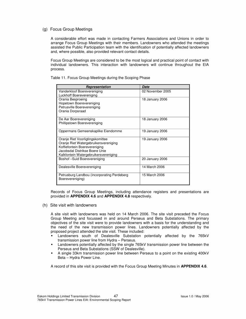
Eskom Holdings Limited Transmission Division 47 Issue 1.0 / May 2006 765kV Transmission Power Lines EIA: Environmental Scoping Report
(g) Focus Group Meetings
A considerable effort was made in contacting Farmers Associations and Unions in order to arrange Focus Group Meetings with their members. Landowners who attended the meetings assisted the Public Participation team with the identification of potentially affected landowners and, where possible, also provided relevant contact details. Focus Group Meetings are considered to be the most logical and practical point of contact with individual landowners. This interaction with landowners will continue throughout the EIA process. Table 11. Focus Group Meetings during the Scoping Phase
Representation Date Vanderkloof Boerevereniging Luckhoff Boerevereniging
02 November 2005
Orania Besproeing Hopetown Boerevereniging Petrusville Boerevereniging Orania Dorpsraad
18 January 2006
De Aar Boerevereniging Phillipstown Boerevereniging
18 January 2006
Oppermans Gemeenskaplike Eiendomme
19 January 2006
Oranje Riet Voorligtingskomittee Oranje Riet Watergebruikersvereniging Koffiefontein Boerevereniging Jacobsdal Distrikse Boere Unie Kalkfontein Watergebruikersvereniging
19 January 2006
Boshof –Suid Boerevereniging
20 January 2006
Dealesville Boerevereniging
14 March 2006
Petrusburg Landbou (incorporating Perdeberg Boerevereniging)
15 March 2006
Records of Focus Group Meetings, including attendance registers and presentations are provided in APPENDIX 4.6 and APPENDIX 4.8 respectively.
(h) Site visit with landowners A site visit with landowners was held on 14 March 2006. The site visit preceded the Focus Group Meeting and focussed in and around Perseus and Beta Substations. The primary objectives of the site visit were to provide landowners with a basis for the understanding and the need of the new transmission power lines. Landowners potentially affected by the proposed project attended the site visit. These included: �� Landowners south of Dealesville Substation potentially affected by the 765kV
transmission power line from Hydra – Perseus. �� Landowners potentially affected by the single 765kV transmission power line between the
Perseus and Beta Substations (SSW of Dealesville). �� A single 33km transmission power line between Perseus to a point on the existing 400kV
Beta – Hydra Power Line. A record of this site visit is provided with the Focus Group Meeting Minutes in APPENDIX 4.6.

Eskom Holdings Limited Transmission Division 48 Issue 1.0 / May 2006 765kV Transmission Power Lines EIA: Environmental Scoping Report
(i) Internal Stakeholder Meeting An internal stakeholder meeting to discuss the key issues around the proposed Transmission Power Line was held at Indaba Lodge, Bloemfontein on 11 November 2005. Internal stakeholders were mainly Eskom employees and/or representatives responsible for planning, management and maintenance of Eskom’s transmission infrastructure within the study area. The primary objectives of this meeting were as follows: • Present the proposed project to all internal stakeholders. • Provide an opportunity to internal stakeholders to comment, ask questions and raise
issues to be addressed by the EIA Project Team. • Identify issues relating to the proposed 765kV Transmission Power Line (positives and
negatives). • Conduct constructive debate and discussion. The proceedings of this workshop and the presentation content are provided in APPENDIX 4.7 and APPENDIX 4.8 respectively.
(j) Website and email address Project information has been available on Eskom’s website from 31 October 2005 and will continue to be available throughout the project. The website address is www.eskom.co.za/eia. I&APs were also able to submit comment via the project’s email address [email protected]
(k) Public Participation Office
The public and registered I&APs were provided with the contact details (telephone, facsimile, postal address and email address) of the Public Participation Office in order for them to interact directly with the PPP team either with queries or to submit comment. All interaction was recorded on the database and the issues captured in the Issues and Response Report (APPENDIX 4.10). A Local Public Participation Officer based in Luckhoff, Mr Jan Combrinck provided assistance with the dissemination of project information as well as providing a local contact for stakeholders within the study area.
6.2.2 Ongoing communication
In addition to the public documents distributed to I&APs described in 6.2.1 (c), there has been ongoing communication between the Public Participation Team, Eskom Transmission, the EIA team and I&APs. These interactions included: �� Forwarding of information requests, including maps, and issues raised by stakeholders to
the project team and Eskom Transmission; �� An additional letter was sent out on 29 March 2006 to all registered I&APs providing them
with an update of the project and the EIA (including additional transmission power lines); (APPENDIX 4.9);
�� Interactions with I&APs took place in Afrikaans where required; �� Feedback to stakeholders, individually and collectively; and �� Written responses (email, faxes and letters) were provided to numerous I&APs
acknowledging issues and providing information requested.
6.2.3 Record keeping An important part of the PPP is record keeping. The following information has been kept on record as hard copy and on the electronic database:

Eskom Holdings Limited Transmission Division 49 Issue 1.0 / May 2006 765kV Transmission Power Lines EIA: Environmental Scoping Report
• Minutes and notes of meetings; • Attendance registers; • Comment sheets; • Letters, e-mails and faxes; • Telephone conversations; • Public Participation Report (this chapter), which summarises the Public Participation
Process up to the distribution of ESR and; • Issues and Response Report (APPENDIX 4.10).
6.2.4 Issues raised by I&APs
Issues were raised by I&APs as part of Scoping at the various meetings, on comment sheets and by letter, fax or email. These issues were forwarded to the project team and collated in the Issues and Response Report (APPENDIX 4.10).
6.2.5 Public participation after compilation of Scoping Report
Upon completion of the ESR, all registered I&APs will be advised of the availability of the document and will be provided with an opportunity to review and comment on this report. The following are proposed tasks/actions associated with the public review process of the ESR:
• A letter will be sent to all registered I&APs informing them of the availability of the ESR for
comment and the relevant comment period. • Print media advertisements will be placed in national, regional and local newspapers in
English and Afrikaans advising I&APs of the availability of the ESR. • The ESR with comment sheets will be made available at public venues and on the project
website. • Meetings will be held with stakeholder groups at their request. • Assistance, where required, will be provided to I&APs in order to facilitate understanding
of the ESR so that I&APs have the opportunity to provide comment. • Comments on the ESR will be included in an Issues and Response Report submitted to
DEAT, FS DTEEA and NC DTEC as an addendum to the ESR. • I&APs will be notified of the availability of the updated Issues and Response Report. • Sending out progress feedback letters to stakeholders. The specific farms which the Alternative 3 (Central) and Alternative 4 (Western) corridors traverse are identified in APPENDIX 4.11. Landowner identification is an ongoing process throughout the EIA and all potentially affected landowners in APPENDIX 4.11 who have not been informed through one of the opportunities to date will be contacted during the EIA Phase.

Eskom Holdings Limited Transmission Division 50 Issue 1.0 / May 2006 765kV Transmission Power Lines EIA: Environmental Scoping Report
7 POTENTIAL ENVIRONMENTAL IMPACTS IDENTIFIED
A list of potential environmental (bio-physical and social) impacts has been identified using the following information: • Project description; • Site inspection of the project area; • Various specialist studies; and • Issues and concerns raised by I&APs. Potential positive and negative impacts are discussed for each phase of the project below. The nature of the activity is such that most impacts will be realised during the construction phase. Some of these impacts may extend into the operational phase albeit at a reduced level of significance. The impacts identified are listed randomly and no comment is provided on the significance of the impact. The impacts will be assessed in terms of significance, duration and extent during the Impact Assessment Phase. The list below should therefore not be interpreted as impacts which cannot be mitigated to acceptable levels.
7.1 Construction Phase
7.1.1 Noise
The movement of machinery and vehicles will constitute an additional source of noise to the study area. However, this will be limited to the period of construction and mitigation can involve the use of equipment fitted with noise abatement technology (where possible) and the restriction of construction to certain days and times.
7.1.2 Employment opportunities Numerous temporary and some permanent employment opportunities will be created in the construction phase. The use of local labour will bring some much-needed economic activity to the study area.
7.1.3 Traffic A number of vehicles will be needed during the construction period and this will result in additional vehicles and machinery using certain roads in the study area. Traffic has not been raised as a concern in the study area and the additional vehicles required for the project are therefore not considered to have a significant impact.
7.1.4 Security During construction, access between properties of affected landowners will need to be arranged and this could result in the safety of landowners being compromised. Restricting access to roads used by the construction team and efficient management of the construction team itself can mitigate this impact. The use of fire by the construction team, either during the establishment of firebreaks, removal of encroaching vegetation or for cooking purposes also constitutes a safety risk.

Eskom Holdings Limited Transmission Division 51 Issue 1.0 / May 2006 765kV Transmission Power Lines EIA: Environmental Scoping Report
7.1.5 Litter and waste
General waste will inevitably be produced during the construction phase. Proper procedures for the management of this solid waste will need to be in place to prevent possible environmental health impacts.
7.1.6 Pollution from petrol/diesel spillage Heavy machinery, equipment and vehicles utilised during the construction phase will need to be refuelled and inevitably serviced during the construction period. If appropriate measures are not employed to prevent the contact of fuel, grease and oils with the environment, negative impacts on soil and water resources could occur.
7.1.7 Windblown dust The activities during construction such as clearing of vegetation, construction of access roads and the excavations for the towers will generate windblown dust. The proximity of construction operations to communities will determine the actual impact of this activity. The low population density of the area suggests that most dust generated will disperse naturally before an impact at ambient level is realised.
7.1.8 Fauna and flora Irreversible habitat destruction associated with construction camps and extensions of the two substations are likely to be the largest sources of risk to the faunal and floral communities in the study area. The establishment of construction camps and access roads (if necessary) is done in consultation with the landowner and must take cognisance of sensitive areas identified in the EIA. A number of sensitive environments including wetlands, kopjes, pans and rivers are associated with the study area. During construction of the line, a 4 m – 8 m strip is required to be cleared of all vegetation down the centre of the transmission power line servitude. The vegetation is removed in accordance with the specialist recommendations, the EMP and Eskom’s minimum standards in this regard (Table 13).
7.1.9 Avi-fauna The potential impact on birds is primarily related to the destruction of habitat during access road construction and the establishment of temporary camps as well as the disturbance of normal bird behaviour patterns.
7.1.10 Geology and soils
Removal of vegetation during site clearing may expose soils and make them more susceptible to erosion. The placement of towers on the banks of drainage lines may also result in erosion of the banks.
7.1.11 Land use The proposed power line will require the registration of a servitude in which, for safety reasons, no other land use will be allowed. Although there is some variation between land use in the alternative corridors, the area is primarily used for farming and the loss of land for cultivation or grazing is thus considered to be the most likely negative impact in this respect. Compensation of landowners will mitigate this impact.

Eskom Holdings Limited Transmission Division 52 Issue 1.0 / May 2006 765kV Transmission Power Lines EIA: Environmental Scoping Report
7.1.12 Heritage resources
Various cultural and heritage resources exist in the study area and the abundance of specifically Stone Age artefacts could result in the removal or damage of these resources during construction of excavations, access roads or during the establishment of camps.
7.1.13 Socio-economic impacts The standard (social and economic) impacts and issues, amongst others, related to the proposed project include:
• Decrease in agricultural production potential; • Resettlement of farm labourers or any other affected communities; • Possible displacement of the graves; • Disruption of current and existing land use and farming practices; • Disruption of social relations as a result of temporary work camps; • Spread of HIV/AIDS and other infectious diseases; and • Employment of local labour.
7.2 Operational Phase
7.2.1 Employment opportunities through economic growth in the Eastern Cape
The strengthening of the Eskom network will enable further economic growth in the Eastern and Western Cape, particularly for the Coega development, which has and will continue to have significant job creation potential.
7.2.2 Safety
Faults caused by lightning and vegetation encroachment for example can result in fires, which in the specific study area, can result in significant damage to commercial farming activities. Preventative maintenance is thus essential to ensure that these problems do not eventuate.
7.2.3 Avi-fauna
During operation, collision of large terrestrial birds with the earth wires of the proposed power line will be the most significant impact of the proposed development on birds.
7.2.4 Fauna and flora
The largest effect on faunal and floral habitat during the operational phase is likely to be that of the service roads. The maintenance of the servitude may also result in the creation of a vegetation structure and composition, which will differ from the surrounding landscape. These maintenance activities e.g. use of fire may influence the re-establishment of certain species over others. Faunal habitat that might be affected during the construction and operation of the proposed powerline include flat, open spaces, wetlands and outcrops. Areas that are likely to be affected the most are areas that will suffer total or partial habitat destruction, such as the areas earmarked for the additions to the two substations and the construction camps.

Eskom Holdings Limited Transmission Division 53 Issue 1.0 / May 2006 765kV Transmission Power Lines EIA: Environmental Scoping Report
7.2.5 Geology and soils Corrosion problems have been experienced at the towers of the existing 765 kV line between the Perseus Substation and the Hydra Substation. It is suspected that it may be as a result of the soil chemistry but this has not been verified. As a precautionary approach, all soils associated with corrosive conditions will be avoided where possible. Agricultural potential may be impacted upon especially if the power lines traverse cultivated lands. Low potential agricultural areas are typically used for grazing (unless there is good water availability) and after construction, grazing can proceed as normal, with minimal loss to grazing productivity. Some soils in the study area are more susceptible to erosion than others. Ongoing use of poorly constructed access roads with inadequate provision for stormwater management may increase erosion areas.
7.2.6 Land use Once the servitude for the power line has been determined, land use within the servitude will be restricted for most land uses except grazing. Eskom personnel will be responsible for the maintenance of the servitude including the control of invasive plant species, control of erosion and the maintenance of firebreaks.
7.2.7 Aesthetics The following general risks are associated with the visual intrusion in the landscape and therefore apply to all corridor alternatives. These may result if the urge to keep the line as straight as possible persists. • The obscuring of views from existing farm houses. • The provision of views along the transmission line from existing roads. This will
magnify the visual intrusion of the line in the landscape. • The degradation of areas of particular visual character e.g. salt pans, if the line is
placed too close by. • The exposure of the entire silhouette of the transmission tower by unnecessarily
crossing plateaux or ridges.
7.2.8 Socio-economic impacts Most negative socio-economic impacts related to the development will be observed during the construction phase. Ongoing impact during the operational phase will result from the loss of income from cultivated lands and possible ongoing social disruption from displaced households, should the latter be necessary.
7.2.9 Health impacts Some concern exists regarding the impact of exposure of humans and animals to Electromagnetic Fields (EMFs) from power lines. EMFs are produced by various human activities but also naturally by amongst others lightning and the earth’s magnetic field. Extremely Low Frequency (ELF) fields are the type of EMF which most power lines, wiring and appliances generate. A number of studies have been undertaken internationally on the biological impact of ELF fields. To date, no conclusive evidence of any health-related impacts has been advanced5. Eskom has commissioned its own study on the health impacts of EMFs from power lines and the findings of this study will be provided in the EIR.
5 http://www.who.int/peh-emf/publications/facts/environimpact/en/index.html

Eskom Holdings Limited Transmission Division 54 Issue 1.0 / May 2006 765kV Transmission Power Lines EIA: Environmental Scoping Report
8 CONCLUSION AND RECOMMENDATIONS
This document is an Environmental Scoping Report (ESR), compiled in compliance with Government Notice R.1183 (as amended), promulgated in terms of the Environment Conservation Act, 1989 (Act No. 73 of 1989). The Environmental Scoping Study described in this report identified potential environmental, social and economic aspects of the various alternatives for the power lines and incorporated the issues of concern raised by Interested and Affected Parties (I&APs). The way forward involves the following steps:
• Obtain feedback from DEAT and I&APs on the ESR; • Issue an addendum to the ESR; • If necessary, amend the Plan of Study for EIA (APPENDIX 6) and submit to DEAT; • Obtain feedback from DEAT (and the Provincial Environmental Authorities) on the
Plan of Study for EIA; • Initiate specialist studies; and • Compile the draft Environmental Impact Report (EIR).
It is recommended that specialist studies in visual impact, avi-fauna, fauna, flora and cultural and heritage resources be undertaken for the Centre (Alternative 3) corridor and Western (Alternative 4) corridor for the Hydra-Perseus line. Furthermore, it is recommended that the same specialist studies be undertaken for the Beta-Perseus servitude in order to determine the most appropriate alignment of the corridor for the proposed double servitude.

Eskom Holdings Limited Transmission Division 55 Issue 1.0 / May 2006 765kV Transmission Power Lines EIA: Environmental Scoping Report
9 WAY FORWARD
This document constitutes the ESR for the proposed project. The Issues and Response Report will be updated with all comments received on the ESR and an addendum to the ESR will be provided to the authorities. All I&APs will be notified of the availability of the updated Issues and Response Report. The following specialist studies will commence in the EIA Phase: • Visual impact; • Cultural and heritage resources; • Fauna; • Flora; and • Avi-fauna. The detailed terms of reference for each of the specialist studies will be determined after the Scoping Phase has been completed. It is envisaged that the terms of reference for each specialist study will be provided in the Plan of Study for EIA. In general, each specialist study will comprise of the following for the Hydra-Perseus and Beta-Perseus lines: • A description of the status quo of the study area; • Evaluation of the potential impacts of the power lines using recognised impact
assessment methodology; and • Recommendation of appropriate mitigation measures to ameliorate the potential
negative impacts. Each of these reports will be attached to the EIR produced during the EIA Phase. The most significant issues raised in the PPP relate to the management of safety, access to farms and general maintenance of the power lines. These impacts will be addressed in the EIR through specific management plans.

Eskom Holdings Limited Transmission Division 56 Issue 1.0 / May 2006 765kV Transmission Power Lines EIA: Environmental Scoping Report
10 REFERENCES
Department of Environmental Affairs and Tourism. 1998. Implementation of sections 21,22 and 26 of the Environment Conservation Act. Government Printer: Pretoria. Margen Industrial Services and pba International (SA). 2005. Environmental Impact Assessment of the Zeus Perseus and Zeus Mercury 765 kV Transmission power line. Republic of South Africa. 1989. Environment Conservation Act. Government Printer: Pretoria. Republic of South Africa. 1998. National Environmental Management Act. Government Printer: Pretoria. Republic of South Africa. 1997. Government Notice No. 18261. Government Printer: Pretoria.

Eskom Holdings Limited Transmission Issue 1.0 / April 2006 765kV Transmission Power Lines EIA Environmental Scoping Report
APPENDIX 1
APPLICATION FORMS

Eskom Holdings Limited Transmission Issue 1.0 / April 2006 765kV Transmission Power Lines EIA Environmental Scoping Report
APPENDIX 1.1
ORIGINAL APPLICATION FORMS

Eskom Holdings Limited Transmission Issue 1.0 / April 2006 765kV Transmission Power Lines EIA Environmental Scoping Report
APPENDIX 1.2
REVISED APPLICATION FORMS

Eskom Holdings Limited Transmission Issue 1.0 / April 2006 765kV Transmission Power Lines EIA Environmental Scoping Report
APPENDIX 1.3
LETTER TO DEAT ADVISING OF CHANGES TO
APPLICATION FORMS

Eskom Holdings Limited Transmission Issue 1.0 / April 2006 765kV Transmission Power Lines EIA Environmental Scoping Report
APPENDIX 2
PLAN OF STUDY FOR SCOPING
Eskom Holdings Limited Transmission Issue 1.0 / April 2006 765kV Transmission Power Lines EIA Environmental Scoping Report
APPENDIX 2.1
ORIGINAL PLAN OF STUDY FOR SCOPING

Eskom Holdings Limited Transmission Issue 1.0 / April 2006 765kV Transmission Power Lines EIA Environmental Scoping Report
APPENDIX 2.2
REVISED PLAN OF STUDY FOR SCOPING

Eskom Holdings Limited Transmission Issue 1.0 / April 2006 765kV Transmission Power Lines EIA Environmental Scoping Report
APPENDIX 2.3
DEAT ACCEPTANCE LETTER OF REVISED PLAN OF
STUDY FOR SCOPING
Eskom Holdings Limited Transmission Issue 1.0 / April 2006 765kV Transmission Power Lines EIA Environmental Scoping Report
APPENDIX 3
SPECIALIST STUDIES

Eskom Holdings Limited Transmission Issue 1.0 / April 2006 765kV Transmission Power Lines EIA Environmental Scoping Report
APPENDIX 3.1
GEOLOGY AND GEOTECHNICAL STUDY
Eskom Holdings Limited Transmission Issue 1.0 / April 2006 765kV Transmission Power Lines EIA Environmental Scoping Report
APPENDIX 3.2
SOILS STUDY

Eskom Holdings Limited Transmission Issue 1.0 / April 2006 765kV Transmission Power Lines EIA Environmental Scoping Report
APPENDIX 3.3
VEGETATION STUDY
Eskom Holdings Limited Transmission Issue 1.0 / April 2006 765kV Transmission Power Lines EIA Environmental Scoping Report
APPENDIX 3.4
FAUNA STUDY

Eskom Holdings Limited Transmission Issue 1.0 / April 2006 765kV Transmission Power Lines EIA Environmental Scoping Report
APPENDIX 3.5
AVI-FAUNA STUDY

Eskom Holdings Limited Transmission Issue 1.0 / April 2006 765kV Transmission Power Lines EIA Environmental Scoping Report
APPENDIX 3.6
VISUAL AESTHETICS STUDY
Eskom Holdings Limited Transmission Issue 1.0 / April 2006 765kV Transmission Power Lines EIA Environmental Scoping Report
APPENDIX 3.7
SOCIO-ECONOMIC STUDY

Eskom Holdings Limited Transmission Issue 1.0 / April 2006 765kV Transmission Power Lines EIA Environmental Scoping Report
APPENDIX 3.8
CULTURAL AND HERITAGE RESOURCE STUDY

Eskom Holdings Limited Transmission Issue 1.0 / April 2006 765kV Transmission Power Lines EIA Environmental Scoping Report
APPENDIX 4
PUBLIC PARTICIPATION PROCESS

Eskom Holdings Limited Transmission Issue 1.0 / April 2006 765kV Transmission Power Lines EIA Environmental Scoping Report
APPENDIX 4.1
INTERESTED AND AFFECTED PARTY DATABASE

Eskom Holdings Limited Transmission Issue 1.0 / April 2006 765kV Transmission Power Lines EIA Environmental Scoping Report
APPENDIX 4.2
MEDIA ADVERTISEMENTS

Eskom Holdings Limited Transmission Issue 1.0 / April 2006 765kV Transmission Power Lines EIA Environmental Scoping Report
APPENDIX 4.3
LETTER OF INVITATION TO PARTICIPATE
31 OCTOBER 2005

Eskom Holdings Limited Transmission Issue 1.0 / April 2006 765kV Transmission Power Lines EIA Environmental Scoping Report
APPENDIX 4.4
BACKGROUND INFORMATION DOCUMENT

Eskom Holdings Limited Transmission Issue 1.0 / April 2006 765kV Transmission Power Lines EIA Environmental Scoping Report
APPENDIX 4.5
KEY STAKEHOLDER AND PUBLIC WORKSHOP
2 NOVEMBER 2005
Eskom Holdings Limited Transmission Issue 1.0 / April 2006 765kV Transmission Power Lines EIA Environmental Scoping Report
APPENDIX 4.5.1
LETTER OF INVITATION

Eskom Holdings Limited Transmission Issue 1.0 / April 2006 765kV Transmission Power Lines EIA Environmental Scoping Report
APPENDIX 4.5.2
RSVP FORM AND MAP

Eskom Holdings Limited Transmission Issue 1.0 / April 2006 765kV Transmission Power Lines EIA Environmental Scoping Report
APPENDIX 4.5.3
LIST OF INVITEES

Eskom Holdings Limited Transmission Issue 1.0 / April 2006 765kV Transmission Power Lines EIA Environmental Scoping Report
APPENDIX 4.5.4
WORKSHOP PROCEEDINGS
Eskom Holdings Limited Transmission Issue 1.0 / April 2006 765kV Transmission Power Lines EIA Environmental Scoping Report
APPENDIX 4.6
FOCUS GROUP MEETINGS

Eskom Holdings Limited Transmission Issue 1.0 / April 2006 765kV Transmission Power Lines EIA Environmental Scoping Report
APPENDIX 4.6.1
FOCUS GROUP MEETINGS
17-20 JANUARY 2006

Eskom Holdings Limited Transmission Issue 1.0 / April 2006 765kV Transmission Power Lines EIA Environmental Scoping Report
APPENDIX 4.6.2
FOCUS GROUP MEETING DEALESVILLE
14 MARCH 2006
Eskom Holdings Limited Transmission Issue 1.0 / April 2006 765kV Transmission Power Lines EIA Environmental Scoping Report
APPENDIX 4.6.3
FOCUS GROUP MEETING PETRUSBURG
15 MARCH 2006

Eskom Holdings Limited Transmission Issue 1.0 / April 2006 765kV Transmission Power Lines EIA Environmental Scoping Report
APPENDIX 4.7
INTERNAL STAKEHOLDER MEETING
11 NOVEMBER 2005

Eskom Holdings Limited Transmission Issue 1.0 / April 2006 765kV Transmission Power Lines EIA Environmental Scoping Report
APPENDIX 4.8
PROJECT PRESENTATIONS

Eskom Holdings Limited Transmission Issue 1.0 / April 2006 765kV Transmission Power Lines EIA Environmental Scoping Report
APPENDIX 4.9
NOTIFICATION OF PROJECT SCOPE CHANGE

Eskom Holdings Limited Transmission Issue 1.0 / April 2006 765kV Transmission Power Lines EIA Environmental Scoping Report
APPENDIX 4.10
ISSUES AND RESPONSE REPORT

Eskom Holdings Limited Transmission Issue 1.0 / April 2006 765kV Transmission Power Lines EIA Environmental Scoping Report
APPENDIX 4.11
LIST OF PROPERTIES ALONG CENTRAL AND
WESTERN CORRIDORS

Eskom Holdings Limited Transmission Issue 1.0 / April 2006 765kV Transmission Power Lines EIA Environmental Scoping Report
APPENDIX 5
MAPS

Eskom Holdings Limited Transmission Issue 1.0 / April 2006 765kV Transmission Power Lines EIA Environmental Scoping Report
APPENDIX 5.1
HYDRA-PERSEUS

Eskom Holdings Limited Transmission Issue 1.0 / April 2006 765kV Transmission Power Lines EIA Environmental Scoping Report
APPENDIX 5.1.1
LITHOGRAPHY OF THE STUDY AREA

Eskom Holdings Limited Transmission Issue 1.0 / April 2006 765kV Transmission Power Lines EIA Environmental Scoping Report
APPENDIX 5.1.2
STRATIGRAPHY OF THE STUDY AREA

Eskom Holdings Limited Transmission Issue 1.0 / April 2006 765kV Transmission Power Lines EIA Environmental Scoping Report
APPENDIX 5.1.3
SOIL LAND TYPE

Eskom Holdings Limited Transmission Issue 1.0 / April 2006 765kV Transmission Power Lines EIA Environmental Scoping Report
APPENDIX 5.1.4
SOIL DEPTH

Eskom Holdings Limited Transmission Issue 1.0 / April 2006 765kV Transmission Power Lines EIA Environmental Scoping Report
APPENDIX 5.1.5
SOILS CLAY CONTENT

Eskom Holdings Limited Transmission Issue 1.0 / April 2006 765kV Transmission Power Lines EIA Environmental Scoping Report
APPENDIX 5.1.6
SOIL (AGRICULTURAL) POTENTIAL

Eskom Holdings Limited Transmission Issue 1.0 / April 2006 765kV Transmission Power Lines EIA Environmental Scoping Report
APPENDIX 5.1.7
VEGETATION CLASSIFICATION OF THE STUDY
AREA

Eskom Holdings Limited Transmission Issue 1.0 / April 2006 765kV Transmission Power Lines EIA Environmental Scoping Report
APPENDIX 5.1.8
LAND USE WITHIN THE STUDY AREA

Eskom Holdings Limited Transmission Issue 1.0 / April 2006 765kV Transmission Power Lines EIA Environmental Scoping Report
APPENDIX 5.1.9
STAKEHOLDER CONSULTATION MAP

Eskom Holdings Limited Transmission Issue 1.0 / April 2006 765kV Transmission Power Lines EIA Environmental Scoping Report
APPENDIX 5.2
BETA-PERSEUS
Eskom Holdings Limited Transmission Issue 1.0 / April 2006 765kV Transmission Power Lines EIA Environmental Scoping Report
APPENDIX 5.2.1
LITHOGRAPHY OF THE STUDY AREA

Eskom Holdings Limited Transmission Issue 1.0 / April 2006 765kV Transmission Power Lines EIA Environmental Scoping Report
APPENDIX 5.2.2
STRATIGRAPHY OF THE STUDY AREA

Eskom Holdings Limited Transmission Issue 1.0 / April 2006 765kV Transmission Power Lines EIA Environmental Scoping Report
APPENDIX 5.2.3
SOIL LAND TYPE

Eskom Holdings Limited Transmission Issue 1.0 / April 2006 765kV Transmission Power Lines EIA Environmental Scoping Report
APPENDIX 5.2.4
SOIL DEPTH

Eskom Holdings Limited Transmission Issue 1.0 / April 2006 765kV Transmission Power Lines EIA Environmental Scoping Report
APPENDIX 5.2.5
SOILS CLAY CONTENT

Eskom Holdings Limited Transmission Issue 1.0 / April 2006 765kV Transmission Power Lines EIA Environmental Scoping Report
APPENDIX 5.2.6
SOIL (AGRICULTURAL) POTENTIAL
Eskom Holdings Limited Transmission Issue 1.0 / April 2006 765kV Transmission Power Lines EIA Environmental Scoping Report
APPENDIX 5.2.7
VEGETATION CLASSIFICATION OF THE STUDY
AREA

Eskom Holdings Limited Transmission Issue 1.0 / April 2006 765kV Transmission Power Lines EIA Environmental Scoping Report
APPENDIX 5.2.8
STAKEHOLDER CONSULTATION MAP

Eskom Holdings Limited Transmission Issue 1.0 / April 2006 765kV Transmission Power Lines EIA Environmental Scoping Report
APPENDIX 5.3
SENSITIVITY MAPS

Eskom Holdings Limited Transmission Issue 1.0 / April 2006 765kV Transmission Power Lines EIA Environmental Scoping Report
APPENDIX 5.3.1
VISUAL

Eskom Holdings Limited Transmission Issue 1.0 / April 2006 765kV Transmission Power Lines EIA Environmental Scoping Report
APPENDIX 5.3.2
ARCHAEOLOGY AND HERITAGE

Eskom Holdings Limited Transmission Issue 1.0 / April 2006 765kV Transmission Power Lines EIA Environmental Scoping Report
APPENDIX 5.3.3
AVI-FAUNA

Eskom Holdings Limited Transmission Issue 1.0 / April 2006 765kV Transmission Power Lines EIA Environmental Scoping Report
APPENDIX 5.3.4
GEOLOGY

Eskom Holdings Limited Transmission Issue 1.0 / April 2006 765kV Transmission Power Lines EIA Environmental Scoping Report
APPENDIX 5.3.5
ECOLOGY

Eskom Holdings Limited Transmission Issue 1.0 / April 2006 765kV Transmission Power Lines EIA Environmental Scoping Report
APPENDIX 5.3.6
SOCIAL

Eskom Holdings Limited Transmission Issue 1.0 / April 2006 765kV Transmission Power Lines EIA Environmental Scoping Report
APPENDIX 6
PLAN OF STUDY FOR ENVIRONMENTAL IMPACT ASSESSMENT
Eskom Holdings Limited Transmission Issue 1.0 / April 2006 765kV Transmission Power Lines EIA Environmental Scoping Report
DOCUMENT CONTROL SHEET (FORM IP180/B) CLIENT : Eskom Transmission PROJECT : Hydra-Perseus and Beta-Perseus 765 kV PROJECT No : J25235 TITLE : Environmental Scoping Report Prepared by Reviewed by Approved by
ORIGINAL NAME Paul Furniss
NAME Hanre Crous
NAME Jaana-Maria Ball
DATE 05/05/2006
SIGNATURE
SIGNATURE
SIGNATURE
REVISION NAME
NAME
NAME
DATE
SIGNATURE
SIGNATURE
SIGNATURE
REVISION NAME
NAME
NAME
DATE
SIGNATURE
SIGNATURE
SIGNATURE
REVISION NAME
NAME
NAME
DATE
SIGNATURE
SIGNATURE
SIGNATURE
This report, and information or advice, which it contains, is provided by ARCUS GIBB solely for internal use and reliance by its Client in performance of ARCUS GIBB duties and liabilities under its contract with the Client. Any advice, opinions, or recommendations within this report should be read and relied upon only in the context of the report as a whole. The advice and opinions in this report are based upon the information made available to ARCUS GIBB at the date of this report and on current SA standards, codes, technology and construction practices as at the date of this report. Following final delivery of this report to the Client, ARCUS GIBB will have no further obligations or duty to advise the Client on any matters, including development affecting the information or advice provided in this report. This report has been prepared by ARCUS GIBB in their professional capacity as Consulting Engineers. The contents of the report do not, in any way, purport to include any manner of legal advice or opinion. This report is prepared in accordance with the terms and conditions of the ARCUS GIBB contract with the Client. Regard should be had to those terms and conditions when considering and/or placing any reliance on this report. Should the Client wish to release this report to a Third Party for that party's reliance, ARCUS GIBB may, at its discretion, agree to such release provided that: (a) ARCUS GIBB written agreement is obtained prior to such release, and (b) By release of the report to the Third Party, that Third Party does not acquire any rights, contractual or otherwise, whatsoever against ARCUS GIBB and ARCUS GIBB,
accordingly, assume no duties, liabilities or obligations to that Third Party, and (c) ARCUS GIBB accepts no responsibility for any loss or damage incurred by the Client or for any conflict of ARCUS GIBB interests arising out of the Client's release of this
report to the Third Party. ARCUS GIBB (Pty) Ltd GIBB House 359 Rivonia Boulevard Rivonia 2128 South Africa Tel : +27 11 519 4600 Fax : +27 11 807 5670 Email : [email protected] Website : www.arcusgibb.co.za