esri production mapping: meeting the needs of water … · · 2015-01-16esri production mapping:...
TRANSCRIPT

An Esri
® White Paper • October 2010
Esri Production Mapping: Meeting the Needs of Water and Wastewater Utilities
Esri, 380 New York St., Redlands, CA 92373-8100 USA TEL 909-793-2853 • FAX 909-793-5953 • E-MAIL [email protected] • WEB esri.com

Copyright © 2010 Esri All rights reserved. Printed in the United States of America. The information contained in this document is the exclusive property of Esri. This work is protected under United States copyright law and other international copyright treaties and conventions. No part of this work may be reproduced or transmitted in any form or by any means, electronic or mechanical, including photocopying and recording, or by any information storage or retrieval system, except as expressly permitted in writing by Esri. All requests should be sent to Attention: Contracts and Legal Services Manager, Esri, 380 New York Street, Redlands, CA 92373-8100 USA. The information contained in this document is subject to change without notice. Esri, the Esri globe logo, ArcGIS, ArcMap, ArcInfo, SDE, esri.com, and @esri.com are trademarks, registered trademarks, or service marks of Esri in the United States, the European Community, or certain other jurisdictions. Other companies and products mentioned herein may be trademarks or registered trademarks of their respective trademark owners.

J-9835
Esri White Paper i
Esri Production Mapping: Meeting the Needs of Water and Wastewater Utilities
An Esri White Paper Contents Page The Challenge ....................................................................................... 1
Overview of Esri Production Mapping ................................................. 1
Key Benefits for Water and Wastewater Utilities................................. 2
More Information.................................................................................. 8

J-9835
Esri White Paper
Esri Production Mapping: Meeting the Needs of Water and Wastewater Utilities
The Challenge Water and wastewater utilities are increasingly deploying geographic information systems (GIS). GIS enables the sharing of information about assets and operations throughout the utility from a single comprehensive and authoritative source and supports the needs of multiple departments through a common set of applications. GIS is also now being integrated with other commonly used water utility systems such as work order, computerized maintenance, and enterprise asset management; billing; customer service; and hydraulic modeling. This increased use of GIS technology drives the need for water and wastewater utilities to maintain high-quality GIS data that is spatially accurate, descriptive, and current. To solve these challenges, water and wastewater utilities must create workflows that ensure data is current and of sufficient quality while minimizing operating costs. At many utilities, the task of data maintenance and creation, as well as map production, is carried out by technicians who would benefit from workflow standardization.
Overview of Esri Production Mapping
Esri® Production Mapping helps water and wastewater utilities create and maintain GIS data and maps in standardized workflows that reduce costs, require less staff time, and increase the speed at which new information is available to the entire utility. Whether a utility is small or large, Esri Production Mapping helps improve the quality and timely availability of GIS data and maps through the building of standardized and repeatable workflows that fit the needs of each utility. With Esri Production Mapping, water and wastewater utilities can Efficiently produce geospatial data and map products while adhering to water and
wastewater industry-specific requirements.
Centralize GIS workflow creation and management to ensure consistency throughout the utility.
Enhance user productivity by standardizing data collection and validation, cartography, workflows, and data management.
Streamline data creation and maintenance with additional feature templates, construction tools, and on-the-fly validation of features while editing.
Implement an efficient and consistent review process by automating spatial data quality control tasks.
Standardize and centralize detailed map production with tools for creating and maintaining symbology, page elements, and maps.
Esri Production Mapping: Meeting the Needs of Water and Wastewater Utilities
J-9835
Editing water distribution and wastewater collection geometric networks and system features
Key Benefits for Water and
Wastewater Utilities
Outlined below are some of the ways water and wastewater utilities can benefit by using Esri Production Mapping. Need: Simplify data creation and maintenance workflow management and track the progress of work assigned to staff. Common workflows for water and wastewater utilities include the following:
Collecting data in the field and integrating the data into the enterprise geodatabase
Implementing extracting, transforming, and loading (ETL) procedures for importing data into and out of the geodatabase
Solution: The Esri Production Mapping workflow management component enables water and wastewater utilities to establish repeatable production procedures and prioritize tasks at the technician level. It allows the simplification of many aspects of managing and streamlining workflows for data collection, maintenance, ETL processes, and so forth, resulting in significant time savings. The component also provides tools for allocating resources and tracking the status and progress of jobs. Utility managers and supervisors can utilize the built-in reporting functionality to summarize the jobs in the system. Users can query, filter, sort, and group data and display the results of queries in various formats (for example, based on job types). The results can then be exported as HTML. When working in ArcMap™, a task assistance component allows utilities to streamline the production process even further. They can configure and distribute workflows that guide users through defined processes within ArcMap, then execute ArcMap commands or geoprocessing tools and set layer properties such as visibility and snapping. Using these workflows can reduce the number of mouse clicks and help users execute common processes consistently throughout the organization. Helpful resources for this component, such as tutorials, sample downloads, and forums, are available on the ArcGIS Resource Center at http://resources.arcgis.com/content/ workflow-manager/10.0/about.
October 2010 2

Esri Production Mapping: Meeting the Needs of Water and Wastewater Utilities
J-9835
Use the workflow management component to establish production procedures and define processes within ArcMap.
Need: Improve efficiency and productivity using data editing tools to do the following:
Effectively create and update GIS datasets to support asset management activities such as pipe maintenance, repair, and replacement.
Rapidly incorporate and manage new planned infrastructure from developers.
Streamline incorporation of as-built data.
Maintain and update key attribute information for water/sewer/storm drain pipes, such as pipe material, diameter, installation date, and condition, to support hydraulic modeling, asset management, and accounting.
Create multiple assets in one sketch. Solution: The Esri Production Mapping editing interface provides tools to streamline the creation of new residential and commercial development projects as well as tools for efficiently updating GIS datasets for aging pipe replacement programs. These tools make maintaining key attribute information, such as pipe material, diameter, and installation date, easy by allowing users to set attributes before features are created. In-process quality control allows features to be validated as they are created or edited to ensure data integrity. The Esri Production Mapping editing environment consists of a variety of
Esri White Paper 3

Esri Production Mapping: Meeting the Needs of Water and Wastewater Utilities
J-9835
single-click editing tools to enhance productivity. It also includes batch data processing tools, which will snap points, split lines, and populate attributes by tracing data in water/wastewater networks. At ArcGIS® 10, creating features is accomplished through the use of feature templates. Feature templates define all the information required to create a feature: the layer where a feature will be stored, the attributes a feature is created with, and the default tool used to create that feature. Esri Production Mapping provides additional types of feature templates, such as temporary, invalid, table, and composite templates, and construction tools, other than what is available within ArcMap. The composite template allows the combination of multiple feature templates and the creation of features in all the template layers with one edit sketch. For example, a composite template containing feature templates of Service Tap, Service Lateral, and Service Meter can be created in one sketch. With this, utilities will just have to define the start and end points of the Lateral; the Service Tap and Service Meter are automatically placed since they are part of the composite template.
Esri Production Mapping allows users to perform on-the-fly validation of features while creating or updating them as well as define attribute display and feature-level metadata.
October 2010 4

Esri Production Mapping: Meeting the Needs of Water and Wastewater Utilities
J-9835
Esri White Paper 5
Need: Maintain accuracy and precision of water and wastewater features to accomplish tasks such as the following:
Successfully execute construction and repair projects and perform spatial analysis, such as using digital elevation models (DEM) to calculate and assign pressure values to pipes.
Support routing applications to effectively route field crews to outage locations.
Assist pipeline markers during excavation projects.
Maintain accurate location and operable conditions of valves, hydrants, pumps, and so forth, to support critical modeling and analysis, such as emergency valve shutoff and valve isolation as well as access to fire hydrants during emergency incidents.
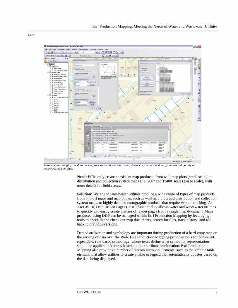
Solution: The data review component promotes independent quality control of data both visually and through automated checks. It allows users to simplify the data review processes by providing tools to assess, document, correct, and verify the overall quality of GIS data to successfully execute construction and repair projects as well as perform spatial analysis. Over 40 automated data checks can be run individually or as a group in a batch job. Errors are collected and managed in a central table that stores the error properties and correction status of the features. Checks can also be scheduled to run at set intervals—eliminating the need to manually run the batch job—to further free up resources and reduce the time needed to obtain high-quality data. Examples of some of the automated checks available are described in the following table.
Check Name Check Description Use Case Example Domain Validates features where coded value and
range domains have been assigned to ensure that all values meet geodatabase attribute domain constraints
Subtype Searches for features with improper or null (optional) subtype code
These checks are useful when migrating GPS-collected data and data from another format, like CAD, shapefile, or coverage into the geodatabase.
Connectivity Rules Finds features that are part of a geometric network and violate connectivity rules
Connectivity rules are an important aspect of a network. Identifying features that violate geometric network rules and resolving them will enhance data integrity. This helps functions like valve isolation that use the geometric network.
Relationship Searches for records that are orphans or have improper cardinality in a relationship class
Knowing the exact number of pumps in the pump station or treatment plant is important. This check can find orphan pumps that do not have a relationship to a pump station or treatment plant.

Esri Production Mapping: Meeting the Needs of Water and Wastewater Utilities
J-9835
October 2010 6
Check Name Check Description Use Case Example Duplicate Geometry Finds features of the same geometry type
that are colocated and optionally share attributes (Features can be from either two different feature classes or the same feature class.)
This check can find locations where two or more junctions in a geometric network are on top of each other. Only one of those junctions can actually be connected to the network. These duplicate features can be identified and addressed to ensure proper connectivity of network features.
Geometry on Geometry Finds features that have a specific spatial relationship, from either two different feature classes or the same feature class, and optionally compares specific attributes
This check can find valves that are connected to mains and compare the diameter. If the diameters do not match, it is reported as an error.
Valency Validates relationships between point and line features or line features within the same feature class, from ensuring that a point has a specified number of lines connected to it to ensuring that specific patterns of features are met with valency
This check can validate relationships, for example, tees should be connected to three pipes or a reducer must connect two pipes of different diameters.
Helpful resources for this component, such as tutorials, sample scripts, blogs, and forums, are available on the ArcGIS Resource Center at http://resources.arcgis.com/content/data-reviewer/10.0/about. To learn more about organizations benefitting from the data review component, see the following case studies:
CDM Gains Significant Time Savings from Automated Data Management
Louisville Water Uses ArcGIS Data Reviewer to Check Data Quality
Tucson Water Uses ArcGIS Data Reviewer to Check Data Quality
Esri Production Mapping: Meeting the Needs of Water and Wastewater Utilities
J-9835
Automate and simplify the data review processes with tools to assess, document, correct, and verify the overall quality of water/wastewater data.
Need: Efficiently create consistent map products, from wall map plots (small scale) to distribution and collection system maps at 1':200" and 1':400' scales (large scale), with more details for field crews. Solution: Water and wastewater utilities produce a wide range of types of map products, from one-off maps and map books, such as wall map plots and distribution and collection system maps, to highly detailed cartographic products that require version tracking. At ArcGIS 10, Data Driven Pages (DDP) functionality allows water and wastewater utilities to quickly and easily create a series of layout pages from a single map document. Maps produced using DDP can be managed within Esri Production Mapping by leveraging tools to check in and check out map documents, search for files, track history, and roll back to previous versions. Data visualization and symbology are important during production of a hard-copy map or the serving of data over the Web. Esri Production Mapping provides tools for consistent, repeatable, rule-based symbology, where users define what symbol or representation should be applied to features based on their attribute combination. Esri Production Mapping also provides a number of custom surround elements, such as the graphic table element, that allow utilities to create a table or legend that automatically updates based on the data being displayed.
Esri White Paper 7

Esri Production Mapping: Meeting the Needs of Water and Wastewater Utilities
J-9835
This wastewater collection system map was produced using Esri Production Mapping cartographic tools.
Need: Decrease the time required to ingest data from disparate sources into the geodatabase. Solution: The Data Loader enables water and wastewater utilities to load or append data into geodatabases using parameters stored in the cross-reference database. A cross-reference database directs how the source data is loaded into the data schema and provides a repeatable way to bulk load data into a personal or enterprise geodatabase. This allows easy importing of data from different schemas. Need: Manage large amounts of data and cartographic products related to projects. Solution: The product library helps water and wastewater utilities manage their collections of digital data and maps. Data model information, data validation rules, geographic extents, symbology rules, and map documents can all be managed inside the product library with the ability to check out files and check in changes. When configured in a Spatial Database Engine (SDE™) environment, users can be granted permissions to access specific parts of the product library and perform various actions.
More Information For more information, visit esri.com/productionmapping or e-mail [email protected]. Helpful resources, such as tutorials, sample scripts, tools, and forums, can be accessed via the ArcGIS Resource Center at http://resources.arcgis.com/content/esri-production-mapping/10.0/about.
October 2010 8

Printed in USA
About Esri
Since 1969, Esri has been helping
organizations map and model our
world. Esri’s GIS software tools
and methodologies enable these
organizations to effectively analyze
and manage their geographic
information and make better
decisions. They are supported by our
experienced and knowledgeable staff
and extensive network of business
partners and international distributors.
A full-service GIS company, Esri
supports the implementation of GIS
technology on desktops, servers,
online services, and mobile devices.
These GIS solutions are flexible,
customizable, and easy to use.
Our Focus
Esri software is used by hundreds
of thousands of organizations that
apply GIS to solve problems and
make our world a better place to
live. We pay close attention to our
users to ensure they have the best
tools possible to accomplish their
missions. A comprehensive suite of
training options offered worldwide
helps our users fully leverage their
GIS applications.
Esri is a socially conscious business,
actively supporting organizations
involved in education, conservation,
sustainable development, and
humanitarian affairs.
Contact Esri
1-800-GIS-XPRT (1-800-447-9778)
Phone: 909-793-2853
Fax: 909-793-5953
www.esri.com
Offices worldwide
www.esri.com/locations
380 New York Street
Redlands, CA 92373-8100 USA