estimate of tsunami sourceusing optimized unit sources and
TRANSCRIPT

1
Estimate of tsunami source using optimized unit sources and 1
including dispersion effects during tsunami propagation: The 2012 2
Haida Gwaii earthquake 3
4
Aditya Riadi Gusman1, Iyan Eka Mulia2, Kenji Satake1, Shingo Watada1, Mohammad 5
Heidarzadeh3,1, and Anne F. Sheehan4 6
7
1) Earthquake Research Institute, the University of Tokyo, Japan 8
2) Ocean Alliance, the University of Tokyo, Japan 9
3) Port and Airport Research Institute, Yokosuka, Japan 10
4) Department of Geological Sciences and Cooperative Institute for Research in 11
Environmental Sciences, University of Colorado Boulder, USA 12
13
Keypoints: 14
1. Comparison of the source models from tsunami and seismic data suggests a 15
possible submarine mass failure during the earthquake. 16
2. The tsunami dispersion effects on amplitudes depend on azimuth from the 17
tsunami source, reflecting the directivity of tsunami source. 18
3. Long wave simulation yields shorter travel times than the more accurate 19
dispersive wave by 1 min for every 1,300 km on average. 20
21
Abstract 22
We apply a genetic algorithm (GA) to find the optimized unit sources using 23
dispersive tsunami synthetics to estimate the tsunami source of the 2012 Haida Gwaii 24
earthquake. The optimal number and distribution of unit sources gives the sea surface 25

2
elevation similar to that from our previous slip distribution on a fault using tsunami 26
data, but different from that using seismic data. The difference is possibly due to 27
submarine mass failure in the source region. Dispersion effects during tsunami 28
propagation reduce the maximum amplitudes by up to 20% of conventional linear 29
long wave propagation model. Dispersion effects also increase tsunami travel time by 30
approximately 1 min per 1,300 km on average. The dispersion effects on amplitudes 31
depend on the azimuth from the tsunami source reflecting the directivity of tsunami 32
source, while the effects on travel times depend only on the distance from the source. 33
34
Introduction 35
Tsunami is a dispersive wave that may contain a wide range of wavelengths 36
from a couple tens to several hundreds of kilometers. The long wave assumption 37
breaks down and dispersion effect becomes significant at short wavelengths for 38
earthquakes with a steep dipping fault plane [e.g., Gusman et al., 2009; Inazu and 39
Saito, 2014] or submarine mass failures [e.g., Synolakis et al., 2002; Watts et al., 40
2003; Grilli and Watts, 2005; Løvholt et al., 2005; Tappin et al., 2014]. For such cases 41
the Boussinesq equations are solved instead of the linear long wave equations 42
[Tanioka, 1999; Saito et al., 2010; Kirby et al., 2013; Baba et al., 2015]. Weak 43
dispersion at long periods, due to the seawater compressibility, the elasticity of the 44
Earth, and the gravitational potential variation effects [Watada et al., 2014], causes 45
travel time delay relative to linear long wave and initial phase reversal at far-field. 46
This dispersion effect can be ignored for near-field (0 – 500 km) tsunami observations 47
and it is a common practice to generate tsunami synthetics by solving the linear 48
shallow water equations [e.g., Titov et al., 2005; Fujii and Satake, 2006; Lorito et al., 49
2011; Gusman et al., 2012]. The dispersion effect must be considered when tsunami 50

3
observations are in the mid-field (500 – 2,000 km) and far-field (>2,000 km) [Watada 51
et al., 2014; Allgeyer and Cummins, 2014; Yoshimoto et al., 2016]. 52
In this paper, the tsunami source of the 2012 Haida Gwaii earthquake (Mw 7.8) 53
is first estimated using mid-field (500 – 2,000 km) tsunami observations. We apply a 54
genetic algorithm (GA) to find the optimal number and distribution of unit sources. 55
We describe the features in the optimum initial sea surface elevation model that is 56
obtained by tsunami waveform inversion and compare the initial sea surface elevation 57
with the ones computed from existing fault slip models inverted from tsunami and 58
seismic waves. We explore the consequences of ignoring the dispersive effects in 59
tsunami source estimation and tsunami wave prediction. To evaluate the dispersion 60
effects on tsunami propagation, we compare the simulation results of linear wave and 61
dispersive wave from the best tsunami source model in terms of maximum amplitude 62
and travel time. 63
64
The 2012 Haida Gwaii earthquake and tsunami 65
An earthquake with moment magnitude (Mw) 7.8 occurred off Haida Gwaii, 66
British Columbia, Canada on 28 October 2012. The earthquake source mechanism 67
[Lay et al., 2013], aftershock relocation [Kao et al., 2015], and its tsunami impact 68
[Leonard et al., 2014; Fine et al., 2015] have been previously studied. The tsunami 69
generated by this earthquake was recorded in near-field at tide gauges, in mid-field at 70
DART buoy systems, the NEPTUNE cabled bottom pressure gauges and bottom 71
pressure gauges on an OBS array in the Cascadia subduction zone and in far-field at 72
DART buoy systems [Lay et al., 2013; Fine et al., 2015; Sheehan et al., 2015; 73
Gusman et al., 2016]. The bottom pressure gauges consist of Absolute Pressure 74
Gauges (Lamont Doherty Earth Observatory – LDEO) and Differential Pressure 75

4
Gauges (Scripps Institution of Oceanography – SIO, and Woods Hole Oceanographic 76
Institution – WHOI) [Sheehan et al., 2015; Gusman et al., 2016]. The peak amplitudes 77
at mid-field DART and OBS stations ranged from 2 to 5 cm. In this study we use the 78
mid-field tsunami waveforms at 8 DARTs and 19 LDEOs for tsunami waveform 79
inversion (orange and blue circles in Figure 1). Then, we employ four tide gauge 80
waveforms in the near-field, four WHOI waveforms in the mid-field, and three DART 81
waveforms in the far-field for tsunami source model validation (green circles in 82
Figure 1). 83
84
Figure 1. Map of tsunami observation stations. Orange and blue circles indicate 85
DART and LDEO stations, respectively, that are used in tsunami inversion. Green 86
circles indicate tide gauges (Henslung Cove, Bella Bella, Port Hardy, and Winter 87
Harbour), WHOI differential pressure gauges (J06B, J23B, J27B, and J28B), and 88
DARTs (D46408, D46413, and D51407) that are not used in tsunami inversion but 89
are used for tsunami source model validation. Contours represent great circle 90

5
distances in km from the earthquake’s epicenter (red star). 91
92
Methodology 93
Genetic algorithm to estimate the initial sea surface elevation 94
Without using earthquake fault parameters, initial sea-surface elevation in the 95
source region can be estimated by inversion of tsunami waveforms [Satake et al., 96
2005, Saito et al., 2010; Hossen et al., 2015; Mulia and Asano, 2015]. A combination 97
of genetic algorithm (GA) methods for tsunami source inversion [Mulia and Asano, 98
2015; 2016] is used in this study to determine the initial sea surface elevation in the 99
source region of the 2012 Haida Gwaii earthquake. The method uses a two-100
dimensional Gaussian shape water surface displacement with a characteristic 101
horizontal wavelength of 40 km as a unit source inside the source area. Initially, we 102
distribute 189 unit sources at 15 km equidistant interval covering the source area 103
(green dots in Figure 2). Unlike most of other tsunami inversion techniques that fix 104
the distribution of unit sources (Figure 2a), our GA uses the least squares method 105
iteratively to find the optimal number and distribution of unit sources. In the 1st stage, 106
the GA selects the optimal unit sources among the initial ones. This leads to a 107
reduction of the unit sources because the GA removes any unit source that has similar 108
information in terms of surface height from the adjacent source points (black dots in 109
Figure 2b) [Mulia and Asano, 2016]. In the 2nd stage, the GA adjusts the locations of 110
the selected unit sources from the 1st stage in order to further improve the waveform 111
fit [Mulia and Asano, 2015]. The GA selects the next distribution of unit sources that 112
produces a better waveform fit than the previous distribution. This is done iteratively 113
until the conditions for convergence are met, which is when the number of GA 114
generations is larger than 500 and the average fitness change over 50 GA generations 115

6
is less than or equal to 1 × 10⁻⁶. As a result, the spatial distribution of the unit sources 116
will be scattered throughout the source area non-equidistantly (black dots in Figure 117
2c). 118
119
Cost function 120
The cost function for the GA measures the fit between observed and synthetic 121
seafloor pressure waveforms. We quantify the waveform fit based on a combination 122
of root mean square error (RMSE) and Pearson correlation coefficient (r) [Mulia and 123
Asano, 2015] (see supplementary text). The correlation of the data is normalized 124
as 𝑅𝑅 = 0.5(𝑟𝑟 + 1), so that it falls in the range of [0, 1]. The cost function (𝐸𝐸) is a 125
summation of RMSE and R for all time windows, which can be written as: 126
𝐸𝐸 = �[𝑅𝑅𝑅𝑅𝑅𝑅𝐸𝐸𝑘𝑘 + (1 − 𝑅𝑅𝑘𝑘)]𝑁𝑁
𝑘𝑘=1
128
(1) 127
where 𝑘𝑘 denotes the respective time window and 𝑁𝑁 is the total number of windows. 129
130
Synthetic tsunami waveforms 131
We construct two sets of tsunami Green’s functions. The first Green’s function 132
is built from linear long waves that are produced by solving the linear shallow water 133
equations [Satake, 1995]. The tsunami source model estimated by GA inversion using 134
this Green’s function is named as the LM source model. The second Green’s function 135
is built from synthetic tsunami waveforms that include the dispersive effects of the 136
surface gravity wave and those imposed from the Earth model (i.e., the elasticity of 137
the Earth, compressibility of seawater, and gravitational potential change due to water 138
and earth mass movement) [Watada et al., 2014]. The tsunami source model estimated 139

7
by GA inversion using this Green’s function is named as the DM source model. 140
The linear long wave is simulated by a finite difference method with a staggered 141
grid scheme [Satake, 1995]. The size of the modeling grid is 1 arc-min and the time 142
interval is 1 s. To include the dispersion effects, the simulated linear long waves are 143
corrected by a phase correction method [Watada et al., 2014]. The phase correction 144
method keeps the linearity of tsunami waves and its computational cost is low. These 145
features make the method suitable for building tsunami Green’s functions for tsunami 146
waveform inversion [e.g., Gusman et al., 2015; Yoshimoto et al., 2016]. 147
During the 2nd stage of GA inversion the locations of unit sources are moving 148
within the area of the initial 189 unit sources. For every new location of unit source, 149
synthetic tsunami waveforms at the stations are computed by applying nearest 150
neighbor-weighted interpolation of waveforms from four nearest initial unit sources 151
[Mulia and Asano, 2015]. The weights are determined by the distances from the new 152
unit source location to the four nearest initial unit sources. For the final distribution of 153
unit sources, the synthetic tsunami waveforms are computed by the method described 154
in the previous paragraph. 155
156
Dispersive tsunami propagation model 157
To simulate ocean-wide dispersive tsunami propagation, the phase correction 158
method is applied for all grids in the modeling domain. We first store the simulated 159
linear long waves at all grids and then we apply the phase correction method to all of 160
them. This process needs a large computer memory. For efficiency, we choose 15 s of 161
time interval, 6 arc-min for the computational grid size (the grid dimension is 701 162
times 551), and a total simulation time of 10 hours. With this computation setup, we 163
need to apply the phase correction method for 386,251 tsunami traces, and the matrix 164

8
size to store the whole waveforms is 2,400 × 386,251. 165
166
167
Figure 2. Initial sea surface elevations from a) the initial source model with fixed unit 168
sources (green dots), b) the 1st stage source model for which GA reduced the number 169

9
of unit sources (black dots) of the initial distribution, c) the 2nd (final) stage source 170
model for which GA optimized the distribution unit sources (black dots), d) a fault 171
slip model of the 2012 Haida Gwaii earthquake estimated using tsunami waveforms 172
[Gusman et al., 2016], e) a fault model of the 2012 Haida Gwaii earthquake estimated 173
using teleseismic waveforms [USGS], and f) the submarine mass failure model, green 174
rectangle indicates the failure area. The positive contour interval is 0.2 m, the 175
negative contour interval is 0.1 m, and the bathymetric features shown in the 176
background. 177
178
Results and Discussion 179
Initial sea surface elevation 180
For the DM source model, the GA produces an optimum distribution of 41 unit 181
sources (black dots in Figures 2c and 3b). This optimum distribution is obtained after 182
1,040 GA runs in the 1st stage and 2,132 GA runs in the 2nd stage. We show that our 183
GA method has the ability to represent non-uniform distribution of unit sources. More 184
unit sources are located around region B near the coast than around region A near the 185
trench (Figures 2c and 3b). A tsunami source model with fixed number and location 186
of unit sources (Figure 2a) failed to capture the complexity of the tsunami source. 187
Our preferred tsunami source model (DM) shows that secondary sea surface 188
elevation in region B (Figure 2c) is distinctly separated from main sea surface 189
elevation in region A near the trench. The main uplift region A has a maximum uplift 190
of 1.1 m that is above the trench and the secondary uplift region B has a maximum 191
uplift of 0.9 m that is located above the unique and complicated steep bathymetry near 192
the Queen Charlotte Fault (Figure 2c). Our previous result for this event assuming a 193
fault model [Gusman et al., 2016] shows a significant slip on the shallowest fault near 194

10
the trench (which corresponds to region A) and bathymetric slope displacement effect 195
near the coast (region B) (Figure 2d). We interpreted that the sea surface elevation 196
near the coast was almost entirely from the horizontal motion of the steep slope, 197
rather than vertical deformation from faulting [Gusman et al., 2016]. 198
We compare our initial sea surface elevation with that from a fault slip 199
distribution obtained by the USGS (United States Geological Survey) 200
(http://earthquake.usgs.gov/earthquakes/eventpage/usp000juhz#finite-fault) which 201
was inverted from teleseismic body and surface waves. The initial sea surface 202
elevation pattern near the trench between our model (Figure 2c) and the USGS model 203
(Figure 2e) are similar, but around region B, the USGS model does not produce a sea 204
surface elevation unlike our tsunami source model. One possible explanation is that 205
the sea surface elevation is produced by a source mechanism that does not generate 206
teleseismic waveforms, such as submarine mass failure (SMF) which may occur on a 207
steep bathymetric slope [Grilli and Watts, 2005; Ma et al., 2013; Tappin et al., 2014]. 208
Wide area in region B has bathymetric slope angle larger than 20° (Figure S1) which 209
is one of the factors that make the region susceptible to slope failure [Varnes, 1984; 210
Highland and Bobrowsky, 2008]. 211
The USGS source model underestimate the observed amplitude of the first 212
tsunami peak in the mid-field by a factor of almost a half (Figure S2a). We attempt to 213
add a SMF source with parameters of width = 40 km length = 5 km, thickness = 250 214
m, slope = 15°, and slide direction = 225° by the method described in previous studies 215
[Watts et al., 2005; Heidarzadeh and Satake, 2015]. This SMF model produces sea 216
surface uplift near region B, similar to the DM source, but also produces subsidence, 217
which is not modeled in the DM source (Figure 2f). The maximum and minimum sea 218
surface deformation are 4 and -5 m, respectively. Simulation results show that the 219

11
combined USGS fault slip model and the SMF model produce the larger tsunami peak 220
amplitude at mid-field stations (Figure S2b) than the USGS model, but the computed 221
waveforms are not as close to the observations as the DM source. Therefore, this SMF 222
model should not be considered as a realistic SMF model. 223
224
Dispersion effects on estimation of tsunami source 225
The initial sea surface elevation pattern that is estimated from the long wave 226
tsunami Green’s function (LM source model) (Figure 3a) is different from the one 227
estimated from Green’s function that includes the wave dispersion effects (DM source 228
model) (Figure 3b). Both LM and DM source models have main and secondary uplift 229
regions (A and B regions), but their size and locations are different. The LM source 230
model has a maximum uplift near the trench (0.6 m) that is almost a half of that in the 231
DM source model. The locations of uplift regions appear to be pushed away from the 232
stations distinctively at around the trench and also around region B (Figures 3a and 233
3b). This is mainly because the tsunami wave computed by the linear long wave 234
approximation arrives earlier than the one that considers the dispersive effects. 235
The matches between the synthetic and observed tsunami waveforms, which are 236
used in the inversions for the LM and DM source models, are equally good (Figures 237
3c and 3d). The tsunami waveform match for the DM source model (dispersive 238
propagation model was used) is slightly better with a smaller root mean square error 239
of 0.0103 m compared to 0.0106 m for the LM source model (linear propagation 240
model was used). Although the waveform matches from the LM and DM source 241
models are equally good, their sea surface elevation patterns are different (Figures 3a 242
and 3b) as described above. 243
244

12
245
246
Figure 3. Two possible instantaneous sea surface elevations for the 2012 Haida Gwaii 247
earthquake tsunami. a) Sea surface elevation of the source model (LM) estimated 248
using linear long wave synthetics. b) Sea surface elevation of the source model (DM) 249
estimated using dispersive wave synthetics that consider the dispersive surface gravity 250

13
wave and the Earth model. Green dots represent the initial unit source distribution, 251
and the black dots represent the final unit source distribution which are estimated by 252
the genetic algorithm. Stations in c and d are used for the inversion, while stations in e 253
and f are used only for validation. Gray traces (c, d, e and f) indicate observed 254
tsunami waveforms. Blue traces indicate tsunami waveforms simulated by c) the 255
linear long wave propagation model and e) the dispersive wave propagation model 256
from the LM source model. Red traces (d and f) indicate tsunami waveforms 257
simulated by the dispersive wave propagation model from the DM source model. 258
259
To validate the initial sea surface elevations, we compare the observed and 260
simulated tsunami waveforms from the LM (Figure 3a) and DM (Figure 3b) source 261
models at near-, mid-, and far-field stations that are not used in the inversion (Figures 262
3e and 3f). We first simulate the tsunami from the LM source model using the linear 263
long wave propagation model to maintain the consistency (Figure S3). The simulated 264
arrival time at the far-field DART stations are earlier than the observations. Then we 265
use the dispersive propagation model for tsunamis from the LM and DM source 266
models. We computed waveforms at: 1) Near-field tide gauge stations in British 267
Colombia, Canada which are located 0 – 500 km from the source; 2) mid-field WHOI 268
stations located 500 – 2,000 km to the south of the source; 3) far-field DART stations 269
located more than 2,000 km from the source and near the Hawaiian and Aleutian 270
Islands (green circles in Figure 1). 271
The tsunami waveforms both from the LM and DM source models fit well the 272
observations at the near- and mid-field stations (Figures 3e and 3f). The good fits at 273
the mid-field stations (WHOIs) are expected because the tsunami waveforms used in 274
the inversions (DARTs and LDEOs) are located around these WHOI stations, and the 275

14
effects of different propagation models are not very significant in the near-field. The 276
underestimation of the first peak amplitude by the LM source model becomes more 277
significant as the travel time increases from mid- to far-field stations (Figure 3e). In 278
the far-field, the first peak of the simulated tsunami waveforms at D46408 and 279
D46413 are underestimated (71% and 66% of the observation, respectively), although 280
the first peak at D51407 fits fairly well the observation (Figure 3e). The tsunami 281
waveforms at far-field stations from the DM source model match well the 282
observations both in terms of timing and amplitude (Figure 3f). This result suggests 283
that the DM source model is more reliable than the LM source model. 284
285
Dispersion effects on maximum amplitude and travel time 286
We further explore the dispersion effects on tsunami propagation by using the 287
DM source model (Figure 3b) for the linear long wave and dispersive wave 288
simulations. In this experiment we simulate the tsunami for the wider region of the 289
Pacific Ocean to measure the maximum tsunami amplitude and travel time 290
distributions. The maximum tsunami amplitude distributions are compared by 291
calculating the amplitude ratio between the one simulated by the linear long wave 292
propagation model (Figure 4a) and the one simulated by the dispersive wave 293
propagation model (Figure 4b). The travel time difference of the two tsunami 294
propagation models is obtained by comparing the timing of the peak amplitude of the 295
first wave cycles from the same source model. 296
The distribution of maximum amplitude ratios show that the dispersive effects 297
are more significant in the southwest direction (Figure 4c) perpendicular to the 298
elongated shape of the tsunami source (Figure 3b), indicating the tsunami source 299
directivity. Compared to the dispersive wave simulation, the linear long wave 300
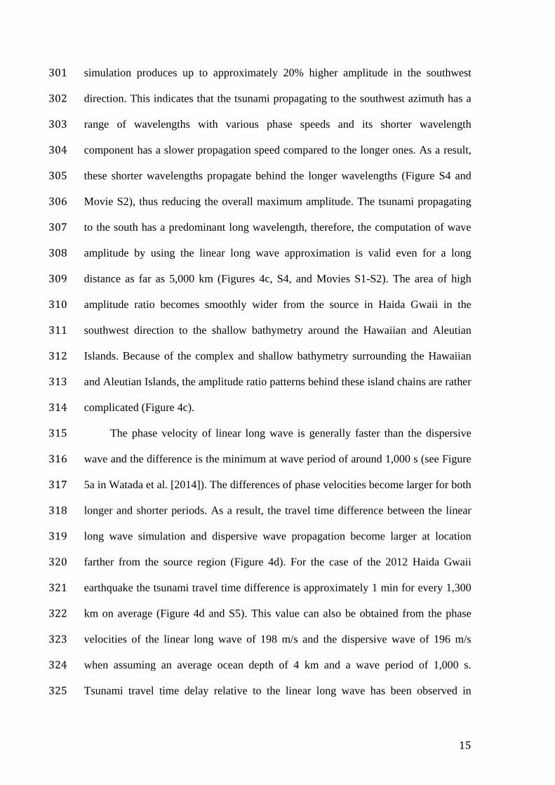
15
simulation produces up to approximately 20% higher amplitude in the southwest 301
direction. This indicates that the tsunami propagating to the southwest azimuth has a 302
range of wavelengths with various phase speeds and its shorter wavelength 303
component has a slower propagation speed compared to the longer ones. As a result, 304
these shorter wavelengths propagate behind the longer wavelengths (Figure S4 and 305
Movie S2), thus reducing the overall maximum amplitude. The tsunami propagating 306
to the south has a predominant long wavelength, therefore, the computation of wave 307
amplitude by using the linear long wave approximation is valid even for a long 308
distance as far as 5,000 km (Figures 4c, S4, and Movies S1-S2). The area of high 309
amplitude ratio becomes smoothly wider from the source in Haida Gwaii in the 310
southwest direction to the shallow bathymetry around the Hawaiian and Aleutian 311
Islands. Because of the complex and shallow bathymetry surrounding the Hawaiian 312
and Aleutian Islands, the amplitude ratio patterns behind these island chains are rather 313
complicated (Figure 4c). 314
The phase velocity of linear long wave is generally faster than the dispersive 315
wave and the difference is the minimum at wave period of around 1,000 s (see Figure 316
5a in Watada et al. [2014]). The differences of phase velocities become larger for both 317
longer and shorter periods. As a result, the travel time difference between the linear 318
long wave simulation and dispersive wave propagation become larger at location 319
farther from the source region (Figure 4d). For the case of the 2012 Haida Gwaii 320
earthquake the tsunami travel time difference is approximately 1 min for every 1,300 321
km on average (Figure 4d and S5). This value can also be obtained from the phase 322
velocities of the linear long wave of 198 m/s and the dispersive wave of 196 m/s 323
when assuming an average ocean depth of 4 km and a wave period of 1,000 s. 324
Tsunami travel time delay relative to the linear long wave has been observed in 325

16
previous studies [Rabinovich et al., 2011; Watada et al., 2014]. Our estimated travel 326
time delay rate is consistent with the observed travel time delay at DART stations 327
during the 2010 Chile and 2011 Tohoku tsunamis [Watada et al., 2014] (Figure S6). 328
This is because waves with periods of 900 - 2,000 s will arrive at almost the same 329
time (as shown in the dispersive curve in Watada et al. [2014]), their phase velocity is 330
the fastest, and most tsunamis including the 2010, 2011, and 2012 events produced 331
waves within the period range. 332
333
334
Figure 4. a) Maximum amplitude distribution from the DM source model computed 335
by the linear long wave propagation model. b) Maximum amplitude distribution from 336

17
the DM source model computed by the dispersive wave propagation model. c) Ratio 337
distribution between the linear and dispersive maximum amplitudes. d) Travel time 338
difference map between the first tsunami cycles of the linear long wave and dispersive 339
wave. Contours represent great circle distances in km from the earthquake’s epicenter 340
(blue star). 341
342
Conclusions 343
Optimizing unit sources using the genetic algorithm yielded two possible initial 344
sea surface elevation models as a tsunami source of the 2012 Haida Gwaii earthquake. 345
The first one is computed by the linear long wave propagation model (for the LM 346
source model), and the second one contains the dispersive effects of surface gravity 347
wave and the Earth model (for the DM source model). The initial sea surface 348
elevations of the DM source model is more reliable because it can satisfy the 349
observed tsunami waveforms at tide gauges and offshore pressure gauges in the near-, 350
mid-, and far-fields. The linear long wave synthetics from the LM source model does 351
not predict the arrival times and amplitudes at the far-field stations well. Our 352
preferred sea surface elevation model has two peaks similar to our fault slip inversion 353
result using tsunami waveforms [Gusman et al., 2016]. Because the fault slip 354
distribution from the seismic wave analysis only produced significant uplift near the 355
trench, our preferred sea surface model (DM source model) may hint a submarine 356
mass failure at the steep bathymetric slope near the Queen Charlotte Fault. 357
Compared to the dispersive wave simulation, the linear long wave simulation 358
produces up to approximately 20% higher amplitude to the southwest azimuth 359
perpendicular to the elongated shape of the tsunami source. This shows the directivity 360
effect on amplitude estimate which is dependent on the shape of tsunami source. 361
18
The dispersive effects of the surface gravity wave and the Earth model can 362
reduce the maximum tsunami amplitude. The degree of amplitude reduction at a point 363
of interest depends on the wavelength of predominant tsunamis that pass through that 364
point. The dispersion effects on amplitude reduction is more significant for shorter 365
tsunami wavelengths. The dispersion effects also reduce the tsunami propagation 366
speed. For the case of the 2012 Haida Gwaii earthquake the tsunami travel time delay 367
relative to linear long wave due to the dispersion effects is approximately 1 min per 368
1,300 km on average. This tsunami propagation speed reduction value is likely 369
applicable to tsunamis propagating in the deep open ocean. 370
371
Acknowledgments: 372
The sea bottom pressure data at the Ocean Bottom Seismograph stations used 373
in this research were provided by instruments from the Ocean Bottom Seismograph 374
Instrument Pool (http://www.obsip.org) which is funded by the US National Science 375
Foundation. The facilities of the IRIS Data Management System were used to access 376
the data used in this study. The sea level observations at the DART stations used in 377
this research were provided by the National Oceanic and Atmospheric Administration 378
and publicly available from http://nctr.pmel.noaa.gov/Dart/. The sea level 379
observations at the tide gauge station in Canada were provided by the Canadian 380
Hydrographic Service http://www.tides.gc.ca/eng. We thank Alexander Rabinovich 381
(Institute of Ocean Sciences, Canada) for providing processed tide gauge data at the 382
Canadian stations. We thank Lisa Beal (Editor), an anonymous reviewer, and David 383
Tappin (British Geological Survey, UK) for the constructive comments. 384
385

19
References: 386
Allgeyer, S., and P. Cummins (2014), Numerical tsunami simulation including elastic 387
loading and seawater density stratification, Geophys. Res. Lett., 41, 2368–388
2375, doi:10.1002/2014GL059348. 389
Baba, T., N. Takahashi, Y. Kaneda, K. Ando, D. Matsuoka, and T. Kato (2015), 390
Parallel implementation of dispersive tsunami wave modeling with a nesting 391
algorithm for the 2011 Tohoku tsunami, Pure and Applied Geophysics, 392
172(12), 3455-3472. 393
Fine, I. V., J. Y. Cherniawsky, R. E. Thomson, A. B. Rabinovich, and M. V. 394
Krassovski (2015), Observations and numerical modeling of the 2012 Haida 395
Gwaii tsunami off the coast of British Columbia, Pure and Applied 396
Geophysics, 172(3-4), 699-718. 397
Fujii, Y., and K. Satake (2006), Source of the July 2006 West Java tsunami estimated 398
from tide gauge records, Geophys. Res. Lett., 33, L24317, 399
doi:10.1029/2006GL028049. 400
Grilli, S.T. and P. Watts (2005), Tsunami generation by submarine mass failure. I: 401
Modeling, experimental validation, and sensitivity analyses, Journal of 402
Waterway, Port, Coastal, and Ocean Engineering, 131(6), 283-297. 403
Gusman, A. R., Y. Tanioka, H. Matsumoto, and S. I. Iwasaki (2009), Analysis of the 404
Tsunami generated by the great 1977 Sumba earthquake that occurred in 405
Indonesia, Bulletin of the Seismological Society of America, 99(4), 2169-406
2179, doi: 10.1785/0120080324. 407
Gusman, A. R., Y. Tanioka, S. Sakai, and H. Tsushima (2012), Source model of the 408
great 2011 Tohoku earthquake estimated from tsunami waveforms and crustal 409

20
deformation data, Earth Planet. Sci. Lett., 341–344, 234–242, doi: 410
10.1016/j.epsl.2012.06.006. 411
Gusman, A. R., S. Murotani, K. Satake, M. Heidarzadeh, E. Gunawan, S. Watada, and 412
B. Schurr (2015), Fault slip distribution of the 2014 Iquique, Chile, earthquake 413
estimated from ocean-wide tsunami waveforms and GPS data, Geophys. Res. 414
Lett., 42, 1053–1060, doi: 10.1002/2014GL062604. 415
Gusman, A. R., A. F. Sheehan, K. Satake, M. Heidarzadeh, I. E. Mulia, and T. Maeda 416
(2016), Tsunami data assimilation of Cascadia seafloor pressure gauge records 417
from the 2012 Haida Gwaii earthquake. Geophys. Res. Lett., 42, doi: 418
10.1002/2016GL068368. 419
Heidarzadeh, M. and K. Satake (2015), Source properties of the 1998 July 17 Papua 420
New Guinea tsunami based on tide gauge records, Geophysical Journal 421
International, 202 (1), 361-369. 422
Highland, L. and P.T. Bobrowsky (2008), The landslide handbook: a guide to 423
understanding landslides, Reston, Virginia, U.S. Geological Survey, Circular 424
1325, p 129. 425
Hossen, M. J., P. R. Cummins, J. Dettmer, and T. Baba (2015), Tsunami waveform 426
inversion for sea surface displacement following the 2011 Tohoku earthquake: 427
Importance of dispersion and source kinematics, J. Geophys. Res. Solid Earth, 428
120, 6452–6473, doi:10.1002/2015JB011942. 429
Inazu, D., and T. Saito (2014), Two subevents across the Japan Trench during the 7 430
December 2012 off Tohoku earthquake (Mw 7.3) inferred from offshore 431
tsunami records, J. Geophys. Res. Solid Earth, 119, 5800–5813, 432
doi:10.1002/2013JB010892. 433

21
Kao, H., S. J. Shan, and A. M. Farahbod (2015), Source characteristics of the 2012 434
Haida Gwaii earthquake sequence, Bulletin of the Seismological Society of 435
America, 105(2B), 1206-1218. 436
Kirby, J.T., F. Shi, B. Tehranirad, J.C. Harris, and S.T. Grilli (2013), Dispersive 437
tsunami waves in the ocean: Model equations and sensitivity to dispersion and 438
Coriolis effects, Ocean Modelling, 62, pp.39-55. 439
Lay, T., L. Ye, H. Kanamori, Y. Yamazaki, K. F. Cheung, K. Kwong, and K. D. 440
Koper (2013), The October 28, 2012 Mw 7.8 Haida Gwaii underthrusting 441
earthquake and tsunami: Slip partitioning along the Queen Charlotte fault 442
transpressional plate boundary. Earth and Planetary Science Letters, 375, 57-443
70. 444
Leonard, L. J. and J. M. Bednarski (2014), Field survey following the 28 October 445
2012 Haida Gwaii tsunami, Pure and Applied Geophysics, 171(12), 3467-446
3482. 447
Lorito, S., F. Romano, S. Atzori, X. Tong, A. Avallone, J. McCloskey, M. Cocco, E. 448
Boschi, and A. Piatanesi (2011), Limited overlap between the seismic gap and 449
coseismic slip of the great 2010 Chile earthquake, Nature Geoscience, 4(3), 450
173-177. 451
Løvholt, F., C.B. Harbitz, and K.B. Haugen (2005), A parametric study of tsunamis 452
generated by submarine slides in the Ormen Lange/Storegga area off western 453
Norway. Marine and Petroleum Geology, 22(1), pp.219-231. 454
Ma, G., J.T. Kirby, and F. Shi (2013), Numerical simulation of tsunami waves 455
generated by deformable submarine landslides, Ocean Modelling, 69, pp.146-456
165. 457

22
Mulia, I. E., and T. Asano (2015), Randomly distributed unit sources to enhance 458
optimization in tsunami waveform inversion, Natural Hazards and Earth 459
System Science, 15(1), 187-196. 460
Mulia, I. E., and T. Asano (2016), Initial tsunami source estimation by inversion with 461
an intelligent selection of model parameters and time delays, J. Geophys. Res. 462
Oceans, 121, 441–456, doi:10.1002/2015JC010877. 463
Rabinovich, A. B., P. L. Woodworth, and V. V. Titov (2011), Deep-sea observations 464
and modeling of the 2004 Sumatra tsunami in Drake Passage, Geophys. Res. 465
Lett., 38, L16604, doi:10.1029/2011GL048305. 466
Saito, T., K. Satake, and T. Furumura (2010), Tsunami waveform inversion including 467
dispersive waves: the 2004 earthquake off Kii Peninsula, Japan, J. Geophys. 468
Res., 115, B06303, doi:10.1029/2009JB006884. 469
Satake, K. (1995), Linear and nonlinear computations of the 1992 Nicaragua 470
earthquake tsunami, In Tsunamis: 1992–1994 (pp. 455-470), Birkhäuser 471
Basel. 472
Satake, K., T. Baba, K. Hirata, S.I. Iwasaki, T. Kato, S. Koshimura, J. Takenaka, and 473
Y. Terada (2005), Tsunami source of the 2004 off the Kii Peninsula 474
earthquakes inferred from offshore tsunami and coastal tide gauges, Earth, 475
planets and space, 57(3), 173-178. 476
Sheehan, A. F., A. R. Gusman, M. Heidarzadeh, and K. Satake (2015), Array 477
observations of the 2012 Haida Gwaii tsunami using Cascadia Initiative 478
absolute and differential seafloor pressure gauges, Seismological Research 479
Letters, 86(5), 1278-1286. 480

23
Synolakis, C.E., J.P. Bardet, J.C. Borrero, H.L. Davies, E.A. Okal, E.A. Silver, S. 481
Sweet, and D.R. Tappin (2002), The slump origin of the 1998 Papua New 482
Guinea tsunami. In Proceedings of the Royal Society of London A: 483
Mathematical, Physical and Engineering Sciences, Vol. 458, No. 2020, pp. 484
763-789, The Royal Society, doi: 10.1098/rspa.2001.0915. 485
Tanioka, Y. (1999), Analysis of the far‐field tsunamis generated by the 1998 Papua 486
New Guinea earthquake, Geophysical research letters, 26(22), pp.3393-3396. 487
Tappin, D. R., S. T. Grilli, J.C. Harris, R. J. Geller, T. Masterlark, J. T. Kirby, F. Shi, 488
G. Ma , K. K. Thingbaijam, and P. M. Mai (2014), Did a submarine landslide 489
contribute to the 2011 Tohoku tsunami?, Marine Geology, 357, 344-361. 490
Varnes, D.J. (1984), Landslide hazard zonation: a review of principles and practice 491
(No. 3). 492
Watada, S., S. Kusumoto, and K. Satake (2014), Traveltime delay and initial phase 493
reversal of distant tsunamis coupled with the self-gravitating elastic Earth, J. 494
Geophys. Res. Solid Earth, 119, 4287–4310, doi:10.1002/2013JB010841. 495
Watts, P., S. T. Grilli, J. T. Kirby, G. J. Fryer, and D. R. Tappin (2003), Landslide 496
tsunami case studies using a Boussinesq model and a fully nonlinear tsunami 497
generation model, Natural Hazards and Earth System Science, 3 (5), 391-402. 498
Watts, P., S. T. Grilli, D. R. Tappin, and G. J. Fryer (2005), Tsunami generation by 499
submarine mass failure. II: Predictive equations and case studies. Journal of 500
Waterway, Port, Coastal, and Ocean Engineering, 131(6), 298-310. 501
Yoshimoto, M., S. Watada, Y. Fujii, and K. Satake (2016), Source estimate and 502
tsunami forecast from far-field deep-ocean tsunami waveforms - The 27 503

24
February 2010 Mw 8.8 Maule earthquake, Geophys. Res. Lett., 43, 659–665, 504
doi:10.1002/2015GL067181. 505
506
507
508