estudio geológico de costas de pr
DESCRIPTION
Costa PR GeologiaTRANSCRIPT

SHORELINE OF PUERTO RICO

Financial assistance provided in part by Coastal Zone Management Act of 1972, administered by the Office of Coastal Zone Management of the National Oceanic and Atmospheric Administration.

SHORELINE OF PUERTO RICO
COASTAL ZONE MANAGEMENT PROGRAM
DEPARTMENT OF NATURAL RESOVRCES
COM:10NWEAL TH OF PUERTO RICO
JANUARY 1978

'fflis report on selected aspects of the shoreline of Puerto Rico is
one of a series of reports prepared by this Department as part of
the Coastal Management "Program of Puerto Rico.
This report responds to the need for a better understanding of the
complex interrelationships that exist in the near oceanographic
regime of Puerto Rico.
The report focuses on different aspects of the beaches of Puerto
Rico. The first concerns are the processes involved in beach
development and the development of the coastal and beaches of Puerto
Rico. in response to these processes. There is a broad description
of the types of beach sands, processes of sand movement, and man's
impact on the beach system.
Comments on this report are welcome in order that we may be able to
continue to improve our understanding of the shoreline and to seek
better ways to cope with the problems of coastal erosion and sediment
transport,
Ph.D.
cretary

TAB L E O F CONTENTS
PAGE
REGIONAL GEOLOGY
COASTAL DEVELOPMENT AND CLASSIFICATION
COASTAL CLASSIFICATION 8
BEACHES
PUERTO Rico COASTAL TYPES 15
PUERTO RICO BEACH SYSTEMS 17
DRAINAGE BASIN AND BEACH COMPOSITION 18
BEACH EROSION 20
COASTLINE AND BEACH ANALYSIS 24
SUMMARY AND RECIJMMENDATIONS 42
ACKNOWLEDGEMENT 45
1

2
REGIONAL GEOLOGY
The geological history of the earth is read from clues left in the rock record (fig. I). The fossilized remains of past life in sedimentary rocks and radioactive dates from igneous rocks allow us to derive a calendar of earth history. Geological evidence ind icatcs that the earth was formed more than 4.5 billion years ago. In rocks of Cambrian age, formed more than 600 million years ago, we find preserved fossil remains of plant and animal life. These fossils and geophysical evidence indicate that in the past the arrangement of oceans and continents ""as greatly different frcm the present distribution.
During the Paleozoic, the land masses fonned one supercontinent chat began to break up at the beginning of the Mosozoic. Rifting along the line of the mid-Atlantic ridge and subsequent drifting apa"Ct of the continents led to the origin of the Atlantic Ocean. The internal forces causing this movement added new crustal material in the region of the mid-ocean ridge.
The history of Puerto Rico begins less than 200 million years ago. The Caribbean basin is a creation of Mesozoic time and no rocks older than Jurassic age have been found. During the drifting of continents and movements of the earth's crust, blocks of the crust act as discrete plates. The Caribbean region appears to have been formed as the North AmericAn and South American plates separated during their westward drift. This was accompanied by greAt outpourings of lava which formed the platform upon which the Caribbean islands were formed. The oldest rocks in Puerto Rico are igneous rocks bound together by volcanic flows.
ERA
' ,-,-
,_ ----
L-it.,,--8
, __ rs .
\ '
I I I I I I I I I I I I
PERIOD EPOCH
I �"'--=-= --, • .,,ff'-'---l @ l'J•�·-"O of OI0(.'9o
<:>o•o-no o, "'"'.,..>' °' ........ '?:::::;:: ,.,_,_ ,., N.,..,,.
··-
I I, o) ..... 110 111,eo" 1,.,....,.... o• o •••••
o• -.co� l•!o...,. ""'"'AO,M!!IJ" .• ,,,.,--.,_ .LJOOQ
@4pp_o,.e• o, '"•' ,., ..... ..... (! ... (..
ll O<O••• ,oc, C:, ••«>oote CIO• Of '"•
Eo,11,
..., o•o••• •OoC:•• '°"'"'° °"' t>otN)to'> o• co� oo.o" s.o o,.c, Au..,.,oc
©••0+""'"0 O'I C-"-"''l>i •"'" ot •"Cl Of pot•o,o,c oo•
•o• ... MUO·o ... qi Y•ci•• •-•P••-) rig. I geologic•{ tiae 1ulc, TM: •l>•olut• aa• or the e•rth ,Hid hbtor1 or i»•t evenu i• •eMund by the d•c:•1 or ndio.ctive ttlf'lleAU, Th& ut to bietvf:!ofn 4ttc•y product• •Ad p1u·1u udloa.etiv• utedah ii u1ed to detenllllne the el•p•ed ti.ae lit1u 11'1,t ro,elt vu foNed. Sequence• of c:h11114e u&ed inch14e:
uredua 2)8 to Jud ?06 tlloorlua 2)8 tO lu,t 208 p,ot•ui..- 40 to •rsoft 40 c.rbon 14 to nitr(lleft 14
The oldett luloi,,n rocka in central c .... .t., ""uraJia, Mid Ruuh 4•te in "l!:e lr<.m 2,S to ).S Mllion year• in age. Theee are tr� anc:h·nt volc•nic flov• "'Mc:b pOl,lt.-.ci out ov�r e.n oi•ting old•r urtb c:"'"' Co.•ologiclll .vid�c:• •uuut• that the ag,e or ort,,n or the eatth h four Md onie: half biJUot1 yur• •10, rn Hdt-ftury rocb, fouib .re our -Jor •ut1• ot c:orrdatioa •nd iftt•rpnutiot1 of hiuory. n. •11,1c:c:u•ion of rocl1. forwoatiOM •nd fo••11• i• u•.-.d to t...Ud • uoJoek•I hhtory. Thi• k.novl-"-1• ..,,. uMd to divide •nd MM dlvhlou of e•rth hhtory th.at 11re ttp•r•ted by vorld vid• •P'Uodea ot c:1'-•t• C:h•na•, •Ololntain bullding, •Ad ..,f4Hpu1tid pl•nt and •"'-•1 •iautlon.a. Th• ••Jor dlvt.ioo• •re •ru: th&•• •r• .... w,vLded into period•, 11-nd the dlvhioo• of the period• ar• epoch.A. Tbh h • relative tiae •c:alt, and .... t b4 tied to the raHoac:rhe •cale by c:orrel•t ton, Mt"'l!en •'41-eAtary •nd i.An.tOlol• rock.a. So ••Jor fou'1 .. ud11! I• rOlolrwt In roc:b older than tM C-1)da.n (!;600 •illioci yuu ... o) 90 thH th& r.c:ord of phnt and •ftt.al Uh h re•tri<ted to the htt one aiahth of tlw hi•tory of th& earth. To better vnder•t•Ad the t.len•hy of aeoloeical ti•e, - •l&l'll CC-1M1re th• "'•lory of 1.tw ••rth to • 24 "°"' c:loc:lt. and note tht follovlng •v••ru•
bu afo •m< 00 20:U 21;S6 2J:S9:22
4.SOO all lton yuu •sci orlglft ot the earth 600 •lllioft year• •10 fo.dl r.c:ot<I et•ru c-l>rhn 200 •ill ion yuu 1110 Puerto Jico kah• for.i"I
2 •'11 on yeau -.o orl.a[I\ of ••t1
Puerto Rico was formed on the emerged crest of an elongated ridge that trends through Hispaniola, Puerto Rico, and the Virgin Islands. The central structure is a Cretaceous volcanic framework, flanked by thick mid-Tertiary sediments on the north and south and bounded by the seismically active Puerto Rico Trench and the Anegada Trough. An initial lowland was built up by explosive volcanic activity which was partially underwater eruptions. The core of Cretaceous to Tertiary volcanics and volcanic sediments are two-thirds of the present land area of Puerto Rico.
During the Cretaceous, Puerto Rico was probably a chain of volcanic islands. Pyroclastic sediments from volcanic activity and marine carbonate deposition built on the original platform. Oscillations of the land and alternation of volcanic activity with normal marine sedimentation is recorded in the rock record.
rrom the close of the Mesozoic through early Tertiary time, large segments of the earth's crust were subjected to intensive deformation by the Laramide orogeny. In Puerto Rico, the response to the compressive forces was extensive folding and volcanic activity. The Cenozoic rock sequences continued to be marine sediments al tern at ing with ig11eous rocks.
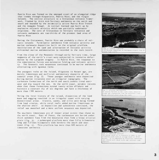
The youngest rocks on the Island. Oligocene to Recf"nt age. are mainly limestones and surficial sedimentary deposits of the coastal areas (fig. 2). These younger sediments were deposited during marine invasions over an irregular topography. The carbonate formations of the north and south coAsts trend eastwest and dip toward the sea. On the north coast, seismic re<"ords show that these formations extend twenty miles offshore and rnalntain a constant dip of six degrees and have a thickness of more than ) 500 meters.
During the Jater history of the tsland, dissectio11 of the land mass and sagging resulted in an irregular coast with varying depositional areas. Gravels. sands, and silts were being formed from land erosion, while coral reefs added marine limestones on the shallow shelf. As deposition and subsidPnce continued, the re.lief was smoothed and a more uniform sequence was deposited.
The southern limestones are of lesser areal extent than tho$e on the north coast. East of Ponce, the carbonates are buried undc>r thick sediment fans from the mountains that form a broad a.lluviat plain (fig. J). A submerged platform more than fifty kilometers long and fifteen kilometers wide borders the south and west coast (fig. 4). This platform has more than 600 meters of limestone sed incnts.
3

4
Four major glaciations occurred during Pleistocene time (fig. 5). Each of these glaciations caused a lowering of sea level of about 100 meters. The interglacial periods witnessed a retreat of ice and a rise of sea level. There has been an overall lowering of sea level since the beginning of Pleistocene time as water has been pennanently trapped in the higher latitudes. The final glaciAtion, the Wisconsin, had the most profound effect on the present coastal featur es, and the rising sea level following glacial retreat is one of the major factors affecting our present coastal pattern and beaches.
The Miocene limestones of Puerto Rico are overlain by Pleistocene to recent a1 luvial and coastal sedi.r.ients. t\long the north coast, the alluvial deposits form a reworked blanket of sand and sandy silts inside the karst topography and the river valleys. Coastal deposits including cemented sand dunes (fig. 6) (eobonites), modern sand dunes (fig. 7), lagoon and swamp sedioents, beach rock ( f i.g. 8), ond beach sands are distributed along the coast from .i-\recibo to the Rio Grande de Loiza.
On the south coast, the alluvial deposits arc distributed along the prcsetlt rivers, or form a series of over I app i ng alluvial fans which coalesce into broad alluvial plains. Coastal deposits of beach sand and gravels, swamp ---md lagoons (fig. 9) sM iments, ond coral reefs (fig.10) fringe the coast. On the ,,,est and case co.ists of ?uerto Rico� the surficial deposits fill valleys which are generally locations of transcurrent fai.lts. (fig. 11).
;; • " a
"
! ,
�
> " ,
100
"100
" ..
200 000
'Y£:AAS BEFORE PRESENT
ri._. !> Kla<1a1 rh,-ctu•t1ol\ll of •t'• IC"vtl
400000 600 000 eoo ooo
,b th.- gl,1cicr11 gu-v ,u'-1 M1t•nc«I ov" l•ftd on.u. tht prttipu•t1on N1111g ,.4,.1._,J to th• u·• •111•• vJ" �urrlicd by r....,...•l ol >C"•v11,tt'r (rtw tlw> OC't'1t,n.11. Thu tf'llullt'd fo 11 101111 of vol,..,. ol •vl'lll•blt> ""•V,\C,rf ,ind ll11b11 ... q11._•1'1t IC> .. ('tll'lfl. (If $(',l ll'HI in rc-1.Hil>fl to the l.1nd, [,a,ch �I.I,.,! c-pi,,>de ie n �._..s fll'r the .. f:l(l9.l• gc<>11,rn.rt11 .t1t,nu• ,:,1 th.- u,· ,iw,.-u OYc>t '"rth NtaH,l.
,-1.g. 1 -co.n•I ••nd d11ne• 'nit' ••n4 dun•• north •rd t'•U ot krinqu•n airport (o.-. • tt'Htvotr o( ••u'ld lor bc-Meh no11ri•l••nt. Tht')' havt' bet'n t'lllploirtd for c-crd•I ••tld •n.d ofhr llttlt' prot«tioo to 1hr ,hort• •1t•1�t hurt1cirn.- •1190( 1atff ";>Vt'•·

O· -· ·• • ········ ,
o-- -------·· 11·-·
·�·
5

6
The narrow submerged shelf surround· in.g Puerto Rico was cut during the period of Wisconsin glaciation. The lov point of sea withdrawal was sme 15, 000 years before present ti.me, and sea level wa.s more than 120 meters below the present level. There has been a fairly rapid rise, marked by interruptions, until the sea approached its present level S,000 years ago. The interruptions in glacial retreat and c:omcociittant sea level rise allowed the developoent of marine terraces and exerted some control on shelf depth and features {fig. 12). Many of the shelf' sediments were formed during thjs period of sea level rise. The present beach systems .. ,we develor,ed during the last
5 ,000 years, since the sea opp roached its present level. Relict sand and beach lines, formed car 1 icr, lie on the shelf itself. A continuing SlO'W' rise of sea level Md minor f luctuntions of uplift or sinking of the coastal regions have a profound e.f f ec t on the beach sys teci.
•
It ..
.. ..
l
I
..
..
YE AAS BE "'OAE' PAESl:NT (THOUSANDS)
� 40•-'-"-='1'-"'��c!;,.,C....�e.::l�::1"��i...:.:2���Jc::�i,...
100
rta I} ""' l'"•I <wn>• llWt r•t'lr• ,ot ..... 1 ..... 1 •tu, It•• \obc,.,a1n al .-.. u1loo v,u r11p�J 11Mll •Mlt 1000 )•.n• .. ,..,, ly tM1 ,, • ., ••• 1 ...... 1 ..,,. vutu111 t1v, llfl '"" -••n ,o,l th• pr••tM 1 ..... 1 .. � ,i.,.r• ""'' ",,..,, .... 1 .,-, 4.,;r•.-..111111 r111, of rh ... ,tlll·•lll""• ,,. 11,11 1 ..... ,1 ,1 .. ,1.lh-.d tt1• .,,,.,.1...-,.l'lt ,•f ••rln• tHr«•• 1h.ot ., .. ••i•...i 11,y ,'4"111 a1o-...th. n,...,., .., .. ....,1,rv..S 1a ••f'lll' rHt• o,f ,._ .. C.i1bw111"1, l,,tllt of l'lo,l�o •ad 1M Pllt'lflt. n., •,•t pr.•1a.-M lur•�" 1,,...,a, •r• 11t I\ •#hr• -� 40 tq ),()

COASTAL DEVJ::LOPHENT AND CLASSIFICATION
Coastal forms and features vary considerably in Puerto Rico since the coast is acted upon by many processes and the nature of the materials forming the coast vary. We can group coasts into three significant types:
rocky shorelines vith cliffs and headlands (fig. 13) sand and cobble beaches (fig. 14) mangrove - mud flat - marsh grass coast (fig. lS)
Classification schemes may seem tedious, but they allow us to coapare and contrast what ••e sec and to form conclusions about the origin of the various coastal types. In the following modification of the classification scheme devised by Shepard, there is a basic division into primary coasts that have not been significantly affected by marine processes and secondary coasts that have been shapOO by marine processes. The secondary or mature coastal type is not only dependent on ti.me for the modification, but also on the type of moteriols forming the coast. availob le phys icol cnerg ies.. and the ecosystem.
The coast is a meeting place of energies. Rivers, volcanoes. wind. and earth movements expend energy in a seaward direction in eroding the land. Resistance to this erosion is dependent on the lithology and structure of the rocks. Waves. currents. and marine organisms expend energy shoreward ond contribute to the development of the coastal configuration. The effect of these forces con be evoluoted more easily with the aid of this coastal classification system.
Rivers corry sediment to the sea where it is redistributed by marine processes. [( the wove energies and currents connot keep up with the supply, then deltAS, bnrs, nnd other features will extend the coast seaward. Wl1cre marine forces ore Mequote, the sands nre distributed across the shelf. Strong marine forces coupled with o low supply of sedUDent con result in erosion of the land oreo at a fairly rapid rate.
The rising sea Level thot .1ccomponied the melting of glociers n.t the close of the Pleistocene had n profound effect on coastol confi.gurotion. Where deposition could not keep pace with the rising ""aters, mnny Pleistocene fenturcs ve.rc drowned. Drowned river volley coasts ore clnsscd ns rio coasts and drovned glacial vnlleys form ( iord con.see. A combinntion of rapid submergence, relatively hard rock coast, and low sediment supply Leads to the development of these. coasts.
In many coastal regions volcanic activity is important and the coast moy be shaped by lava flowing into the aco or by the building of volcnnic cones.
The. pro I ifcrotion of particular plants nnd oni.mnls moy d01Dinatc coastal and ncarshore. environments, and in the tropical regions coasts built by ciarine organisms are eapecially common. These
Ar(' dominantly corlll r('('f nod m�rn grove collsts. tn higher latitudt·"· th(' mangrove co11st is reploct-'d bv mnrsh g rnss('9
A gcologicol fllctor which docs not build co11st.s. but strongly dt'terr:ilnes how c.xtcrnnl forces shope thCII is Ii thology. Som" rocks nn• le�s resistant to chemical solution than physical forccB, or vice- vcrs•. A rock's susceptibility to physlcnl and chcmicnl erosion is re lnu·d to it8 composition, degree of ccmentation. strucuarc. and frncturc patterns. Thus. under some comticions. we 11ny hove n prUDary const because of lnck of rock erosion. '-'hi le the &omc phy8icol forces would cause a secondory coast 8 iven dif(('>rent underlying roc:k fonnotions.
7
8
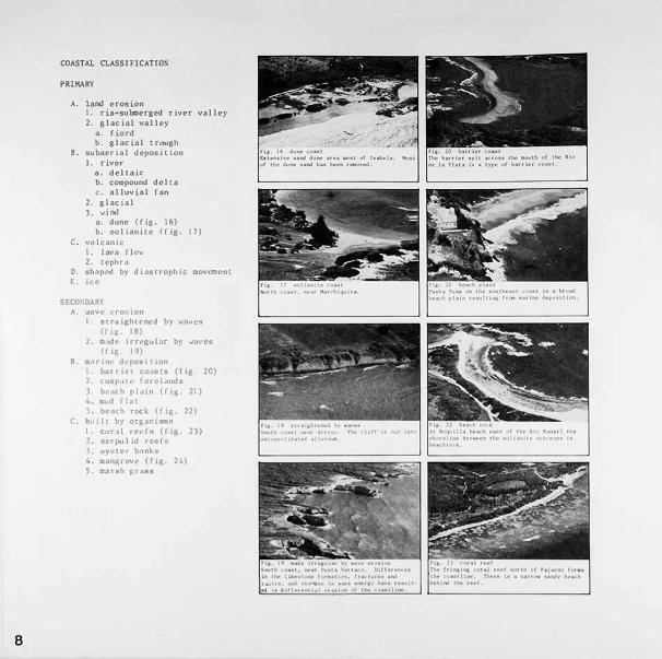
COASTAL CLASS!FlCAT!ON
PRIMARY
A. land erosion 1. ria-submerged river valley 2. glacial valley
a. fiord b. glacial trough
8. subaerial deposition l. river
a. deltaic b. compound delta c. alluvial fan
2. glacial 3. wind
a. dune (fig . l 6) b. eolianite (fig. 17)
C. volcanic 1. lava f lo<;,,• 2. tephro
0. sh3pt."<1 by diostrophic movcocnt E. ict>
SECOSDAR\'
A . .... nv"' t•ro•. ion I. 8lr,1ightt.•n('d by WOVC!'i
(f i�. 18) 2. m,1dt.• 1rrcgul.1r by wnv�s
(f is. 19) 8. m.,trin, dt·poHi t ion
1 . b�u r hr co.ts t R (l i)):. 20) 2. cusp,ll'-' ton.• l.rnds 1. b< l<h pJJlO (l lR, 21 )
::.ud J l 1t S. b,.ach rock (fi�. 22)
C, l,1Jlll by OT)t30lSQS 1. Cll(,I\ U't•fff (fig. 2)) ... twrpu 1 id ru•fs ). oy,ner b,1nks
man�rov,• (fig. 24) �- !"2,'\fllh j,tr'l\!U
, ••. 1 • ..,.
Nu, ,lu.,. •ut ., u

Fig. 27 11andc,,.tr11ction In thi11 are11. just east of l111bela, ••l\d"a• not only rcr1ov«I from thll dunes, but epparl!ntly froa the bc11ch iuelf, leaving 11 1111jor ch,mge in the coastline.
clay
colloid
256 128
64 32 16
8 4
2
1
Fig. 28 Cr•ln •lr;e clHniric11tion
. 5
. 25
.125
. 0625
. 03125
.01562
. 00781
. 0039
.002
. 00098
. 00049
. 00024
Panlcle• larger than 2.0 cm1 11re gravel, 0.06) to 2.0 - gr11in.s &Tf' sand. 0.002 to 0.06) graiM are ailt, and particles •aller th11n 0.002 -llfl' Clll• fli7,('.
BEACIIES
A beach is an unconsolidated shore of sand and gravel (fig. 25). This definition excludes muddy shores found in quiet water conditions and rocky shores where no appreciable amount of loose sediment exists. Beaches are unstable features geologically and may advance, retreat, or even disappear. They are of great economic importance for recreation and serve as a buffer zone protecting the land from wave attack (fig. 26). Since beaches are also a source of sand for couunercial exploitation, there is a strong conflict of us where the supply of sand is limited (fig . 27) .
In discussing marine sediments and beach deposits we use a grain size terminology by which the particles are classified to describe the sediment texture (fig. 28). The classification is based on the diameter of the particles. In referring to sediments as sand, silt, clay, or gravel we refer to the size of the particles making up the sample (figs. 29 and 30) . Sand is an accumulation of sedimentary particles having a diameter between 0.063 and 2.0 millimeters.
The percentages of size diameters of grains are detennined and a mean size calculated to discuss the average size of grains in a sediment sample. The range of sizes, the sort.ing, is determined statistically (fig. 31). These properties, along with the mineral composition are used to describe beach sediments.
A logaritlunic or geometric type scale is best suited for describing sediment size distributions. A geometric series is a progression of numbers of such a nature that there is a fixed ratio between successive elements of the series.
9

10
The distribution o! size of sediment grains agrees with a normal probability distribution if po\</ers of two are used for the diameter in millimeters. If we use the exponents --the powers of the base 2-- 'Wt" have a convenient logurthmic sca .. e of sed.ir.ent size. Because most sediments are finer than one millimeter, we use the negative logarittD to the bnse two of the particle dia:neter in millimeters in what \tC call the phi notation:
� • -log7.
Beaches along continental shores consist predooin�mtly of terrigenous minerols derived from the disintegration of rocks. Because quartz {fig. 32) is the most stable of thc,·cc:m:uon minerals it is most abundant in mature beach sands. Xost l,·aches nlso hove nn odoixturt' of fl·ldsp.1r .:1nd ferromagnesion rich mirwr,ils. The heavy minerals ::i,1Knclil<• nnd ilocnit.c arc present in many bt·,h.·ht..•s.
In Lht' souttwrn part of Florida. lht• C,,ribbcan, and tropical rc�i.ons c 1 lc tum c.1rboni1li' �he J 1 fragments .irt• ccamon ,nstitui'nt� of bench '"mJ., (f i . 33). Thr�l· Stmds ar<' o,,dt· of -ol lu�i· �hell frt\AfflC"nt�. cor.,l. t1Jr,1m1nltt•r:i coralline ,ih· . .-w. ,,nJ t'<'hinoid nnd gorgoni-.10 NP icu le-.. Bt•cause o( the abundance of volc,lnic rock in much of the C:itibbt•,in, lhi' b<'.ache-t may have volc1n1c rock fragments. serpentine, anJ dark mint•r..ils i\i coc=:non con" ti tuents (fig.. )4).
Th<' dtr<.'ct ffourcc of much beach ,und ii,, tht.• shnllov sea floor • ._1wre s:mJ va8 carried by runoff I rom th'"• lAnd. A minor source is frca vt1ve ('toeion of sea cliffs. If the clitfit is 11lh1via.l mott"riol thAt iti llghtly cemented or unconsolidoted, cliff eros:ion mny be an 1.mpor tant srd u1ent source.
v •
l . u
� t. ... o�......- • ._ v
? � � J , u u
•
10
OIAMCTC,. IN M,..
r1,i ll .,.1 .. •lu-41.iuWo,c,i plH•,
• , • � • • i
!,, .• f•I•'
· ...... /·.I. I I
. . . . ..
oo, 004 00?
••1 h ••�•plot••• ..,.,._.I pr, .. •IHllh (oru, � 11 .. 11,._..., f'll('•H l1w vc,rtt<•I 1uu I• ,;,-.I.HtYf' r•r.•at ,f tlw t,•t.al •ed tl'w h,,,ru"'hl .u.u 1• &r•u1 •U• u1 •1lh•ott.-u J1-..t .. r. n,.,,.,. •-Pl•• •r• ,.,. to 100 ,..,,,.a1 , • ..,. uu• ••ur1•I, n-.... ,r .. w ,,r ,1,.-. r r•••• b .. i., .. ,n ,,.., hth ,11114 1401 ,.,c.11111•• u • • .,, ... ,, ... r ·-ll'I• • fllf\& T� 'IM\1 .,.,1 .. """• eud1 .,.u,, • ·lfHltl th • ., '""' ·�·Otjl .... ""Iii •• ,, •. T'hfl I rtlTIIC 11 • fwl'l(Uoa ur INI\• Mlll'fl.11• .,.., v ...... .fWf'lltf'•

r1,. n ...... ,.._ncl•turf' �•"ie •r<' g<'Mtt•t11d by the- wind bl 1ng off ttw ..,rf• <' .�t the "A!<'r. Th<' wind ,t>u up r1rrlt'• '"' tht' w.ttiPr •urh, .. and thu• ar into w,tvt', \tlth • •ht-ltt'rlng tlh<t c>n thf'1t lf';t 11d.-,. Thi$ l•lld• '" prop•1t•t1on of th• """"' In lhl' d1r«t1c>fl 111 ....,l<'h th<! "'Ind 1• bhw1n fht' J�t'nl'l<>n"
1 .,.,_f'• 11rt' glvf'n .t• h .. 1,ht, wtnch II the dtflt>r•nct' 1n .. 1�u1<m twc� .. n th-t Ct<'H 4nJ thf' n "'"• •nd l•r,gth, the- d 1st11ntcc, b .. t.,.. .. n ,.,o -,iJ.Cf'nt crt>•t•. Thf' t1•f' 1n 11,· ,nJ, !.:ir th .. p11J1• "
t l" """"crru11p11111 th• •-1>4tnt u tlwop,C"r1(1d
�-•·� ••r t.. ,tn1•r11t..t lou1l )y, •r ••�- h•vt' •-..t '(IUI or • t'n•r1t 1r« IT<'I and n, l..r1,<'t b• undl'r t"•f' 1nfJ .. 11n ,. f thf' wand. In thl' illtt'r ,._.., thf' .,,.,,, .. , &ll' lf'rw.N �"l'II. Jo. 111 """• ,.nt r• , ... 11 ., 11,1t•r th• "'"" ,p.,,' Mid """f' 1.-nicth dt t<'IIH• •nJ ti<' Wa\ll' h<11tht 1n�r<'•t .. •. \lnttl th<'
Ul't'p .. n l� 11h.up ;,,nlo:• •t'p11r.1tf'J hv rtl•tlv,h fl11t tt"'Jith•
• ,,.,.. ! "'""" ti '1'1111 L Jlv•tll•"' • 11nJ ttw ,.._ \ln4 I "f;•ll••f I fll\ -C •I• u •ll•J :.n•r•• • ... �, C v•rt•n., COG<•·'IUT•lt'• •""" -•TlJ lnl •· •rl'11 •M 1 .... r••••• llr••••t lwolt"I,
,I •rar • ra! •• p,.. •iwq;y rr• ht IM c:ci-tlln•.
n .... ,, .. • t ,, .. o .. 1 , ..... . , ... Ill bre-••1 , ... ,.,, .. ,, I ........ uw,., t• ••IJe-.. t UI lbl• l • rther11 11•rt ,t th• 11,_., t• pr ,., t•J Ir• ur 'IC,......,.,, •!\J '" , .... .-,,1 tt>. e-n•r•u•
... -....:.t .., rll� •t•r-.ii _,,. 11\.e rr•I• itOI ,, .. 1e-1n lor.,c•fW,rf' lr&n•p,rl 11! ,_.""1
In tropic regions, the biogenic sands are derived from the remains of marine organisms, often associated with coral reefs. Beaches may also be supplied by sands that were deposited on the continental shelf during the Pleistocene stage of low sea level. Such relict sands arc -ommon on the shallow shelf. Rivers and estuaries may carry sand to the beaches, but estuaries may also trap most of the sediment.
The energy applied to the coastal zone is prcpondcnmtly from wnvc action. As wnvcs appro?ch tht' co11st tht?y nre mudtfi('d by n pr ccss of refraction which governs the final distribution of cnergi('S
and generation of longshorc cur-1·!.!nts. At depths of water where the rntio of \,mter depth (d) to
wove length (L) is 1 css than O. 5,
the wove motion begins to be nffccted by the bottom (fig. 5). Si nee each pnrt of the wnvc t r,1vf• ls ,.,dth n v('lo ity thnt is dcpendf•nt
on tht.' d('pth, the wovt.' must clHlll};t'
direction of uppronch nnd confonn to th(' bnth ymC'try as it shoots. \11
<Kldition to n de rcnsc in velocity
nnd chongc of direction o oppr('lnt'h, then• ore otlwr vnriutions in w.1vt.• chorocteristi s oA thC' wnv(' shonl.s:
wove heights incrcns(' wnvc (•ncrgy is reducc-d wove lenghts dccrcnse
.-Jave per i ocl rt..""1Uo ins cons tnnt Ju r In�
the sh('lnl ini, nnd the period, or timt� in seconds b twc<"n wove nr
rivals, mny be used to estimntt� thl• dN•p wotcr wnvc length.
Wave refrnction nnd energies nrt• ('Xtrcmely tmportnnt in mcxkl ing thl·
configuration or the coast. The· nnnlyaia of the rc1-1ults of wnvl·
refraction ore done by constn1ct ion of refrocrion diagrnms (fig. 36).
The or thogonn I tcchn iquc of annlys i.s lends i tsclf to canputcr
techn i qucs. Or thogonn ls arc the
wave rays drnvn nt right nnglcs to the. crest of opp roach i.ng waves
11
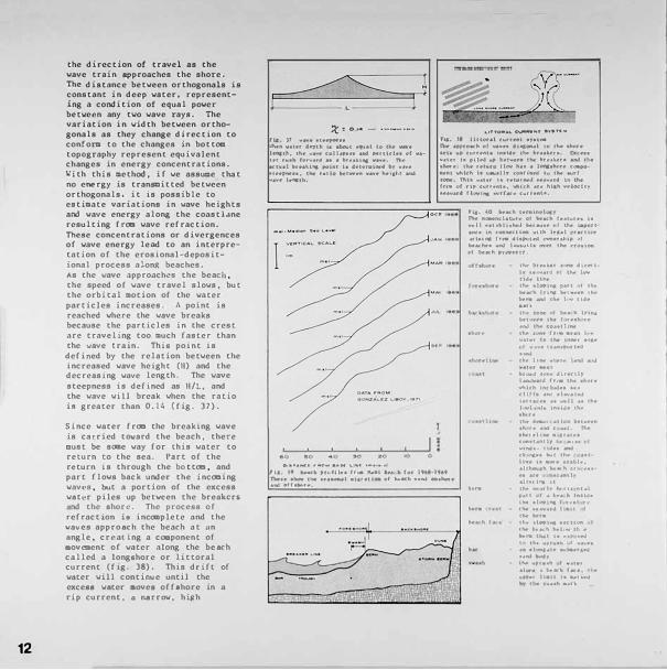
12
the direction or travel as the vave train approaches the shore. The distance between orthogonals is constant in deep water, representing a condition of equal povcr betvee.n any two wave rays. The variation in width between orthogonals as they change direction to conform to the changes in bottom topography represent equivalent changes in energy concentrations. �ith this method, if we assume that no energy is transmitted between orthogonals, it is possible to estimate variations in wave heights and wove energy along the coastlane resulting from wave refraction. These concentrations or divergences of wave energy leod to an interpretation of the erosional-depositional process along beaches. As the wave nppronchl.!S the beach, the speed of wove travel slows, but the orbitnl motion of the water particles increases. A point is renched where the wave breaks because the particles in the crest .arc traveling too much faster than the \.lave train. Thi& point is defined by the relation between the increased wave height (ll) and the decreasing wave length. The wave steepness 1s defined as H/L. and the wave will break when the ratio i• greater than 0.14 (fig. 37).
Since voter from the breaking wave is cnrricd toward the beach, there must be soae woy for lhis woter to relurn lo the seo. Part of the r4?turn is through the bottom, and port flovs back under the incoming waves. but a portion of the excess w.,ter piles up bctv�en the breoltcr5 a.nd the •horc. The process of refraction i8 inccaplete and the voves approach the beach at on angle. creating a coaiponcnt o( •ovcaent of water "long the beach called a long1hor-e or littoral current (f,g. 38). This dnfc or w3ter will contiooe until the exceaa water aovee offshore in a rip current, n n.srrow. hilth
!t::: Ot<I - ••. ,. __ .... ,.
rl,f;. )1 v,t• Uffp!W.U l.'tw11 .., .. t•r d-i,th t• ,li,o,.tt .... .i to th•.., .. ,...., hqtb, th• ... ,,., c:011 .. ,., •• -1 ,.-n,,h, of.., .. _ ur ""'*' for..ud •• , ,,u\u11 .., .. ,.-. Th• ec:tv,1 fltt•._I.,. po1•t h d•lt1'9U'W4 b? \I.iv, at••ll'fWH, ttw r.u,o lM!tVf't'ft \l#'f• h•1,1't,1 Mid .... ,,. 1,11111101,
O-•••...c:r- .-.o.., -M \. ., .. •-''"'•
'-•TT'O"'&'-�"°T ...... l'C ... ri.,. )I lono,ul c:11,rr•t1t •YU� nw ap.peo�II ot .... ,,,, d 1.-,.0..•l co th• ,hi'tft Ht• up. n1n,111• '"'"'• 1tw ,,,,11\tr•. Cll(:""" v,ur h int� "'" b•tV<t•• tht br•.1!.ftU and 01• ,hoot•; ti'••,,,.,,,. t1tov h•• .. 10C11,,lwr• c'-•P"'""111 ..tilt(h h v• .. ,lty {\lfllU'l.-d hl tlwt .... rt ,..-. nu ""'"' 1., r,t,uMJ ,.,,..,.u4 '" th• fl.''9 ..,f rip. (\irtf'IIIU, vtnc:h aroe h1Jh 'tvlo.;1tv $ft&V•t• tlCY1ft!K •11,r(.ao;:e (11,rfftflO,
r,,. 40 W<l(h ttr-•1n(lh-...-t'h. 111.-n(:l•t1,1re c,t IM'.._h t••t\lr,, l11 ....11 ,n•bll11hoNI "'IC""••\'' ti',, laPl.'tl •n..• lft c:OC1,..c:O""" vuh 1 .. ,. .. 1 pr•, ll•• •1tl1, .. t,� .tbp,utff -rdnp .,1 M,1,.;1'1,1.1...i h-H11\W•f thft,t4U"'1\ c,f \!,r.<,(h ph'9ftf1Y,
.....
'"" .. , .... 1;,, ···- .t11.....:1 1-, ,.,.,..,.uJ or th, i. ... uJ, 11t1• 1t,, •h'f'11'4; """'' ,f ,,. .. b.-....:h 1v,,.. �t .. ,•11 ,,,... .... ,. _. '"" ...... '1J, •ult. 11'" NIW ol t,,..,,,t, IVII'., b•t""'" tit•• Ir.-,! r.,1\J th• c:outluw thft t,'flft If·• •••II h•v vu,r h• tM ,n...,., •·'a, c,t .,.,.,., 1,•n•rc•tU..i ......
tl',ft llM .,..1,,., .al'IJ A11J
""".S """'""•<llv 1,,-h .. uJ h,w ct, •IK>t, vl\1,h U1(l.,J,1 '""' ,hit• .n.1 ,1 ....... 1,J 1•n•••••.,,·1l •1 t1,, J..,.l.,·'IJ• lnOJ• lh• •her, '"" ,-.n •11,n lhtVT•n 11'1 rt .ir-.i < ,UI, ft\fl •hcr,luw •1cr.i1,, c..,.11t•n1Jvt,.- .a,,u · •l "''"""· ........ iw , .. ,.,., 1,-,t ti'• HI
r1, 1' k..1(11 ,,.,fll .. hnl �H lff,:11 fM" 196'·1h9 1lw1.- 1h,r,,, llw _.._.., •le,r•1t.-.. •f ... ...._h ••l'OJ -·�·Ht .� .,, .... , ..
....
hn• ,, •M" •tllbl•, .olll100., .. ""' h ,., • ·� •• u• 11 .. ,u1, alu, i"II' 11 ct,, .... ,rh· ...,,., r,1 ,t ••U CII ;1 l>t• h t•u..1• ,.._.. 11.,1"'1 r,r,1 rr IM Uh•f' h•1t 1 th• .. ..,. I�• 11, Pl"" 111'( IINI I IN to,• h 1 .. 1 .... 01• ....... ti\.<,(, •• ," .. " t If•"'""'•" f v•v•• .. ,. .. i..,.1.u• .... t.•r&,4 ...... ""'4 .. , ...... ,,, .. h 1 " .. ,, .. '10"'• I to••'- l.r•, r I/'
.... ,., 11•11 ..... , ••• ... l .• ·••h ... ,�

...... --o..e_, ... _
velocity flow of water directed oway from the bench. The longshorc currents are generally too slow to erode sand grains, but turbulence in the surf zone will keep grains in suspension and they will move with even a low velocity current.
Almost oll beaches are subject to frequent fluctuations in size and shape. Repented measurement of beach profiles ore used to study se�sonol beach cycles (fig. 39). A large port of the movement of beach sand co11sists of an exchange betvcen offshore bars and the berm, the nearly horizontal deposit of sand n.t the top of the beach (fig. 40).
Sars nre products of erosion since they appear \.'hen strong wove :acti<,n cut<; b,,ck the ben:t and ooves material offshore. The fortiation of bnrs ·is related to wove steepness. The incoming wovcs nre. in turn. uodified by the bars. Bars act os wave filters: !WOl le1 waves pass over without breaking, but larger ,,...oves br<"ak over the bar and reform inside ns smaller '-'OVes.
•I. \,- •J•l•U • .... ,_ ,._ di •II u1Ml1 •• •t <Att• • &,-1• •1 • ,.,ti •l•r UI
LIJ ... •f .,:.., Ir• H.., '-<I If• .,.,,...H .... • ti•• INlt •, f " ,.,N ti 1• .... ,... •• ,- ••• •"' ... " thu ,1 r r ,-.,.
·-•, Ct• a1lh..,.•••• , .. ,.... '''"' 9.-1•11p It• ... ut ...... ""' ri,.,1.,,--··�··,...-, ... ,, ........ ,,
, ••I 11• •' il••lf•I•• lt..1 -• ar•I ... t•• 1• f••I , . .- ct.. ,, ... , '�"""' ...... 11 •••• , ....... 1, ... I . - · . ""'' . ..... . , . . . ·- -
'" .. 1 ••u•tU• f.• .. hi, ""•I• .... a,.,.
�, .... C,,ONlllll;lt ...... t'ae-.,,
t ... a,-11,-. • ,... .. ,., ......... ,,.,.
I .... •u••u ,,_ •• k..-11 •-'• •••• ..t.lN 1• , ... l"fl•U la I
..... " ..... ,. o ... ,. , • •,. ", t '"" .,u ......... 1.,.i.-1"••t • ... ,.t.�11-
After the stormy season, vave steepness decreases and sand is moved shore>1ard (fig. 41). The material fror:i the bar migrates to the berm, building it seaward. Except on very f lot beaches, the berm usually has o well defined edge, the crest, and the method of growth can be observed by watching the action at the crest. AB each 1,1ave reaches the beach face. its remaining energy is spent in a thin swash or water carrying sond up••ard. PA rt of the water sinks into the bench nnd docs not return as bock••ash. Thus the energy in the returning •.rntcr is less, 01ld sand is added to the b�Mll at tht:> crest.
fhc material rC£1ovcd from the b1.'rm by storm waves normn. l ly rt:>tu rns �·i th calm weather. llowcver. extreme wove conditions may cnrry th1,,.• sond to depths so great that normal wnves cannot reach it, nnd t hl' "lat.er ial is lost to the svstt'IIL
The onshorc--01 tshor.:, mi�rt\t ion Jc,pcnds on n comp \('X inu�rnc tum between wov(' height ._,nd pt:>r lod. snnd groin site. beach $lopC', Lldl' stage, nnd wind c;:01¥.lit Lons. Stmlil'" of orbitnl velocities in the �ud ZOllC 6h0\rl Lhllt the Vt•locllU.!S of onshore mot.ion ore grcOLl'r undt•r odvanci1'l8 w�1ve cre�Lt; th�1n th1,,.• offshore motion under the troo�h (fig. 42). During pniods of low wnves, dif f<'r{'nlifl1 vt·loclt)' is sufficient. so that 1:hmd vi 11 movt• ups lopt and onshor{' c·xc-t.•pt in zones of rq> curr<"nts. ,hi� ono.:ho1 l' migrntion lS pnrticulnrly lar�l' during the ndv('nt of long p<"rlod wav{'8 when tlwrc lS more t 101..· I c>r the sand groins to be d{'positl'd -once deposited on the bottom. the Rrn ln& nre harder to mov<- thon Rand tho t is in suapenti lon. WhC'n hiJth waves of short per i.od keep the sond i.n suspension. the bench retrNHS because snnd washed off the foreshore by bnckwnsh does not set.t.le
13

14
until 1t 1s carried into a. rip current and has moved into relatively deep water.
Since beaches receive new supplies from runoff and erosion of the land and from offshore shell material produced by marine organisms, it shoold follow that the beaches would grow continuously wider, unless some means exists of disposing of the excess saod. In sane cases there is growth and builup of beaches, but generally sand is disposed of in several ways and is lost to the beaches, either permanently or temporarily (fig. 43).
t;e hove already described the effect of excessively high woves moving sand so far downslope that it is lost to the be.a.ch cycle. Sc.me of the sand that is carried downcurrent along the shore in the littoral drift is deflected sea.ward at the lower end of the beach system. If deep water conditions exist close to shore. the smd may be lost. Studies have shown that sand may bypass rocky points ttnd cont inuc along the shore. provided the water off the points is less thun I On. (fig. 41,).
r,, "'" Pruru• \'f'•l•floll .... i...,,M • .,.,,,... •v•t�
0 ·&
O•c:AeH SANO
OLANO
,. ... -'-JI ufld, tMI • .,,. df•""''• .,. U•pr..t 1• .... (.OI\V,•<'I ••'-.! , .. .,..."" Ir,• lhf. N'•,h • .,.t,.
Rip currents au1y also carry the littoral drif't sand into vater depths that nre beyond the norm.al return beach cycle depth. Sand 111ny be quickly lost where littorol drift or offshore movement encounters unusual depths such os a submarine. canyon (fig. �5). The presence of canyons close to shore and of rocky points bordered by deep water, may result in a series of closed bench compartments. There is an irregularity of contours on the insular shelf of Puerto Rico, and an apparent abundn.nce of submar inc conyons nnd k.orst topography chonncls. There is an extensive system of submarine canyons cut into the north co.ost frOCI Vncia ,:alc,R.4'1 to Arecibo. These may be trapping lon((shorc moving sand nnd funneling it to deeper water. Th<'re is also relntivcly deep water near shore nt the rocky termination of mnny of the Puerto Rican beaches. and here again sand is probably moved offshore and lost to the beach system in these llrcas.
Another mode of sand loss is the formation of beach dunes (fig. 46). The wind blown sands deposited in the dunes arc removed from the reach of wnve action and the normal beach cycle. Land erosion may return this sand via rivers, or later erosion of the shoreline may result in direct return. If the dune sands are carried far enO\lgh inland, as into desert basins, there may be permanent loss.
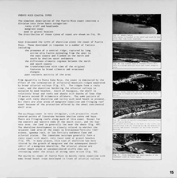
PUERTO RICO COASTAL TYPES
The simplest description of the Puerto Rico coast involves a division into three basic categories:
rocky cliff and headlands mangrove coast
sand or gravel beac!,es The distribution of these types of coast are shown on fi�. 64.
Kaye discussed the tyy>rs of shoreline alon.� the coast of Pu�rco
Rico. These developed in response to a number of factors including:
the presence of a central ridge, ruptured by long strike slip faults extending from the west to the east coasts and flanked on the north and south by shallow water sediments
the difference climatic regimes between the north and south coasts
the transformations with time of the original features by broad climatic and erosional changes
past tectonic activity of the area.
From Aguadilla to Punta Caho Rojo. the coast is dominated by the effect of the termination of structural mountain ridges separated by broad alluvial valleys (fig. 47). The ridges form a rocky coast. and the shoreline bordering the olluviol valleys is occupied by sand beaches. South of Mayagucz, the shelf is relatively brood and reefs and shoals with depths of less than 10 meters extend 20 kilometers offshore. The. sdfflc pattern of ridge with rocky shoreline and vall<'y wi.th sand beach is present. but there. arc also areas of mangrove coastline and fringing reef coasL because of the protection offered by the shoal continental shelf area.
Thesooth,..,cst coast is very irr egular, with projcctin" brush covered points of lime.stone between shallow coves a.nd bays. There are fringing reefs along much of this coast. Except for the eastern and wcstt:'rn ends of the south coost. and thl.' Cuanica area, the land is generally low near the shore (fig. 48). The shoreline develoixnent is closely related to whether the adjacent land area of the coast is Cretaceous-Tertiary 1 i.i'lc-· stones, igneous rock, or low Tertiary sed Ul'lcot fans and alluvial plains. The limestone outcrops generally forr.1 a rocky coast with smoll, very local sand or gravel bcachPs (fi::;. 49). ln many places, this type of shoreline has been riltcrcd by the growth of ma ngrove and the subsequent devc lopm<'tH of o mongrove shoreline. The alluvial plains are either beach areas or unconsolidated cliffs thnt are rt:'treating under the attock of strong wave nccion (fig. 50).
The southc-.1c;t coast of Puerto Rico is mainly rocky coast! inc with some broad beach 1reas developed in front of alluvial valleys
flit Vl , l ,H, ..,, P< •th , •n..->11.tuN 111J .. Ya.l rl.un n•tt Pl.aylt1 .... 11 .. t, tt,f ., .... ,,. c,,11 .. IU\·� ,U Hu· b.tH ,,I 1h .. lttl Hr ,,,n..otntr,llotJ h• 1h., •11 .. v,..,. Jur1ry 1h,r s,,0<,u <•I ,·r ",.,., ,M �t'·'"" I t, -•"�P" , t uf thot t ",.., 11;1.a1,,,.J ••• �ri•I
15

16
and a fev areas of fringing reef coastline (fig. 51). This pattern extends along most of the east coast where irregular projecting rocky bluffs separate numerous small shallow coves and bays. In these areas. as on the west coast. the hi 1 ls are ... •ithin a mile of the coast. Shonl ,..,acer extends offshore 35 part of the platform connecting Puerto Rico and the. Virgin Islands.
There is fairly �·ndcsp::-cad mangrove coast along the nor thcrn half of the CA!H coast.
Tht• nor th coast ! roai the east end of the island to San Juan is low and s.1ndy, except for occasional colianill• bluffs (fig. 52). The I ow I and t'X tends three to seven k i lonet<>rs inland. The coast is indented bv n:rnny coves thnt are prott· ll·d bv rpefs and rocky 1sh•ts lying only one LO two
kilccnl'tt·r,; offshon·. �ost of the (O:lsL fs s,m,lv ht..·,1ch. Tlw Largl ':'l,m•r<•v1 1rt 1s th.it lit t:i\Sl of
1n Ju.rn do not ( orm the· co.1st . but 11.t• l'Vl·r,11 hunJn·d rn\.'lt..•rs b<"h1nd Lht• s.md h· 1ch.,.·s and dun.._, systl1:I (r iR. SJ).
From s.1n Ju.rn lo Arl'<' 1 bo, the "o:l.gt 1 h's in front of ,1 lov-lyin1,t CO,l'H.d pl.110. Bl·ad, s.1nJ , C<'fflt:'nlt·<l Junt.•s, hl•,1t·h roe\..., and m.,1ngtO\'<' Rw,i.,ips J1cin,at1..· this n·gion. Thcr.._• .1r1..• s inch- b.._•acht•s .1nd dun�s with oc.,s ,ln.1l Iv ro<..·kv (•ol inllit(' co.,�L mJ b .. ·ilch rock c�.1st t ror.:i San luan
to \\·�·· !i.qa (f i�. 54). nw rn.10,.� rov1..•s Ii l c los1.• LO short• on th( co.1st,1l pl.,in but do not tonn the co.1st 1 im: .ilo� .1ny part o! the nor th, rn co.1s l. J-'rOCl \'c�.1 8:ij:a to ,\r1·l ibo. ltll' co.lst is domin,.mlly .._·ol i 1nj Lt' with numc>rous SlDall lun.n,· b,1vs bordl'n'<l by b<.'ach�s (11�·. SS). lht•r... 1s somc movC'ffl,•nt ol tlH bt.•,1ch s.md from ont• bov to .inoth .. •r b ... ·l11 nd tlw i:-ol iani te -rid�, .. , 0 iK. 56).
The north coast from. Arecibo to Aguadilla is a series of rocky cliffs with sand beaches and dunes between them (fig. 57). The prominent features are the high hills in the interior and high cliffs along the coast. Where l°""• coast31 plains with beach are present, they are less than a kilometer in width. .,-
The north shelf is only two to four kilometers wide and there are fc1,,• offshore reefs beyond a half kilometer from shore.. l'n most places the open ocean waves break directly against the shore . Tr is a high energy coast with a rugged shoreline and :active beach systems.

PUERTO RICO BEACH SYSTEM
The coastal zone of Puerto Rico is remarkably diverse. Unlike the shorelines of many mojor continents, there arc no long interrupted stretches of basically similar beach. The beaches of Puerto Rico 3rc relatively short and arc divided into separate and distinct beach systems that have restricted comnunication,with one another (fig. 58). Each is a closed or semicloN�d unit rece iv ins its supply of sed iment from limited local sources nnd trruu:miLting little of its longshore moving sand to nnothor beach system. ln analyzing the sond and beach systems to determine the extc1n of isolation, mincrnlogy. metal content rul<l biosenic const.itucnts have been studied: olso the octuAl physical pnrnm�tC'rf; vf tit"pnr {IL ion h,Wl" b\.'('1\ ,Ultl l VZ('d.
The S0\1rccs of beach snnd arc rc.'lntivcty limited and the tot.ti tlvoilable volume of sand Lhnt c.·rn be added to the sys Lem is n(ll. v'-•rv large. 1'hc�c sourc.cs ii,,·JudC':
offshore s�mds modern. erosional f"C'�iduC' rel iCI P1Citil0C('1ll' dt..'!)(>Sit:'I
rivers .md cstunrics dirc1,.•tlv ct"osion of l,1nd
nlh1vi.1l river VaJlc}'H (II��· 5q)
cl i r, crotJlon �,lluvi.tl .._,r ro,·k (( ig. 60)
col inni tcs nnd lwnd1rol'k (figs. 61 and 62)
biogcnic m.1tcri.1l (tom ror.,I n•,·f:; (fi�. h))
Hl l' I l nc..�cumu Lat lOll�
17

18
DRAINAGE BASHI AND BEACH COMPOSITION
The beaches of Puerto Rico contain sand grains de.rived frm three major sources. Erosion of land areas and transport of rock material by rivers to the beach supplies terrigenous sand grains. The composition variances are a function of the source area vhere the material is eroded and added to the river sand system. Are.as of river drainage underlain by basaltic type rocks supply dark minerals and dark igneous rock fragments. Granite rock outcrops supply quartz and feldspar to the beach. Feldspar is a relatively unstable mineral that breaks down to clay minerals. The presence of feldspar in a beach system is indicative of a geologically younR. environment.
Calcium carbonate is supplied to the beach by the shoreward transport of the shells of ma['iae organisms. The composition changes in calcium carbonate and terrigenous mate['ial are a function of .wailable supply and transport system.
Along parts of the: coast containing major rivers. there is an increase in terr igenous content in the beach sands. There is also a shift toward ter['igcnous beaches where an offshore carbonate source is lacking. By analyzing the availability of supply ve can draw conclusions about the transport system and beach dyn.nics. Larger concentrations of calcium carbonate can indicate shoreward transport. ln on area such as Guanaj ibo Beach (Mayagucz) the absence of carbonate grains in the beach sands coupled with the preeence of reefs just off shore shows that shoreward transport of beach material is ne.gl igible. This is part of the reason for the severe erosion on this relatively protected beach env irornent.
DRAINAGE BA SIN AND BEACH COMPOSITION
I
C) r· 64

LEGEND:
-�
19

20
BEACH EROSION
Fig,. 65,. (!uf'bnd• Ce.;Sro• Ml!n •M• •ro•l"• •h11Hion. Th• extr-ctic,n of ••net
fr<• thf' dunu h•• pr1Ke*<!NI ufltH thoc df'pth of t-M V.Uf'f tlblf' l\llt bHfl tt-•C-h-fod (thf" d.rlr., Vf'l •and UI. ti•• N•nu·r of dw photograph). Th,Uf' I• • v•ry urrov b,1ni.f'r bf't-•I\ tlW t>•r1v<1ttoo •nd th• oce•n Vlth V<1)h. •tee,.r th llll. t� ;Iott)• �( l"O!,OH os•) Of dry un.(01UOl1dllt� ••lld·
r,s: 66 h11b .. 1., a..,.,..,.1 t•! ,i11nd Ir,• th•· 1,(-a,·h 1or cc,n•tr1.1c11� ""' ff''lUlt� 111 .<'Yt11t•OI ,,f th.._. •h"tf'ilflt.' l•Nhl,HJ.
Fu;, 67, C11M1co lhu 1• •n .1rN, of n.atur•I tro11on. The v11Ye .-ction i• cauu� th• o;c1.1tt11¥1 ol a low c-hff rnto pu•11nuit ,·�f>t<ltlun th.tt ha• itrMM CNf>r thf' old bf'Mh flnt.
hg,. 68. l'Unu S11111\u Th• to.bolo th<1t fora• lh1• l}OH\I (• d(',01111ton•I {('AIUf('} t• nov WtAJJ, .. ,oJ«I on tht' .... .,, .11idf' OUI �rt of th• fk'W C••n •.-cl,io) 1.A...,.1ttown IMoy c-1rculat100 ,..,,.,-. n,.,,.,. 1• 1t11t1•1MWt of •·•"" hi» the- .,,,t 11nd Vf'lt 1r-.,i <11 thf' b,1y too,.,. ('t"l'lt,..r. aod tl,.,fl ofhhote tr.ln,roct into tho, b.lY.
fig. 69. i...vittOYn Th,,. 1" ,111, H.,., of Blltvtlll ;>ro-,1on th,u h•• btet-n 1nf1ut'11<...cl by ,,,,.. cluol'l;(t' '" b•Y conf1iur•t1C)n l>'f' CO'fl.lNtll<>r• of th, ... 1,d <,IUH"lfllY fOnlM'Ctlng, 1,1.i C1br,1" tr, th, a11nlnl'ld Thill h,1!1 f,H'llf"d a dt''l'P h1n,ue b•Y tn ,,tuch tl'it rt"Ht•t of tht co.,•uhn.- 1 .. a<.ctltr•h>d 11 .. a�hr(IO.k 11• e:iop ... ,4"11 ,u tt.c- be1c-h ind
I r .. 1; ,.,. ... 1th II d(-rp ..,,n.,.r ur.-• b .. 1,..etn n,..- ol t � •�or. u.u,11s,,:,rc ,,t "•nd h,u re•ullol'd in 1,1p1,I tt.-.. 1on du,11, .. ti, l•"t 1,,,,·t,11"'
F11t 70 &«,, d..- c .. ru:r.,jo. n,,, 1• -•"' -1r,.1 ..,, n.uvral ('f1J011vn tlut ha<1 l>"etl 1ntl,,en,N by ••n'• a..t1vu1"'"· n,,.. Jof'tlJ protf'ct1ng_ the- ,h,1n110;l mJ tll1· n 11turJI f,..•t\lr,.. of Punta l'faldonado 1-ep,arntt- lhts MC-,1 Ira. lh'<' •1111J ,n,pply to thof' t',U,t The .,.,01i,,n of th11 ,ue• tuppl lt'I !lllnd to thot" bead"<'• to tlw """' 1n l\lrfl. t...._.rc-fort•. tl!,.. raprap t11 .. 1 prot,·( 1,: tht' h1ghv.n .,,., , ..... �,.. IMtf'O\CNI ero111on ....... l ,f t'lli'I i,,..,.c1,.
,- .,'.· 11. ,ut ·I '!,llde>n,Jo Point lleoa,,.,,.,,J •I •1nJ It·• tit.., l>..-.Kh t<>C tlloe! ,uq,nrt C:t>l'IUru.:11,,n ""• rllp,o,.-d bf'�ct,rNl. ,ll th-e <.o.iul1n<-' •r.J .�coth,r•t<'d 1·,., cro11on of th1,. b,e•ch.
tu:. 12. \'.•� 1,, T.11<;;.l .-.1�t Tht ,r. •1cn .... r thf' b,-.;i,h ...... 1 .if th,• 14,11.1 a,v"r lu• I,,, n _. •lrr.u, I t,v 11,., H•qy.a) <>I sand hi» lht' I u, hvf'r _,h bu. nn, 1• P·•rt of 11,._, hctord Jr11t smJ S\IN'h t.:> tl,c b.,a,h ,...,,, .:,I fhi' riv"r .... ,1h.
1111. 1J t.ut I rtw l.(ua 11,,...., ',.,ltn.JI t11)a1,n, f>f, h.Jhlv Jl'lrH•• o.,4 I I><!' ..u�,· ,f ,,nJ ,·,n, , 1 ,,.,.. 1•• l>.Jr .,1 lh• a ,..,1h
f 11 ... ,1,1a, ... ,·r•
r,,:. 14. l'l,nu 1,u c.urn1111 S,1h1r•l , roa100. Thot 11.and •<IY••f'nl u 10 111,t, w,u � thot" uodfd •• ucrial t1 b.-1"'1( .-dd«I to the 1011K-11h.,,c tnuu,por't ,.,,t_ -•t of lwr•.
hit 1\ Ill Afll'fl a.111 ,,uural r10•1"n
ti!( 1n I t, "' - I, ".n, <1• •,at•u ,1 .-r, •1,�a ll'w , .. "4 •.:t110•••"I • 1, 1 , • ,tr ,.,.,.1,w,,- .. 1 ft'., \rtt\ .ti th.-p,<rt ,·1r1n,· 1• r•ll...ct 1n11 -,111..-.,,-,,,11 ! ·-!, l><tt n,:,,,, .. ,.,l •·•l)•(lfl"" � ....... , ... <'fl br-lh • 1d,-• • l 1i,,.. ·,·1 t
78 77 76

-- -
- .
;: . ..:-_- . - - - --
_ ..,. __ ,t' ..
73
,,,. 11 hcu .. i.1 rc,iu•b �•t<1ftol f'l'OoUN•· fh,. l•fll(' v•v;,<1 ol'ld ,1uf e>n thu p.lrt f'l th .. C<.>MH h,l'I rt-11 .. ltNI In , .. -vl'rf' n•t11r.JI vroU,lfl tt1• tr•n .. l>Ol't of •.l1l'r111 u tu t11 .. vt.n Th• n,utn,. c,t " :111\111 <1'u1nn•·I Mid �dtnf'n �·! ;Mtu-11 ••Y h.tYf' ...... o!fft•,t• but Ul')1k_,, •rt'.tl' vt-..(·f•· ti-� J .. t11,,,. .1r,· ,·,1;•1f\lt lf'ltrir,u.....i �ro•1,,n. tl':irro· , .. n, depo .. 1111>n •·••1 vi llw 1,·ltY 11v11u .. , d11• ,.,,It t4 •1.o l'H>d&n� <'itu•pt , • ...,, .. t .. h at tho!> Jolt\'
r1ir. hi P., .. 1111,• )il•tur,1! .-1,••1,•n Th, ._.1,1111,,11 M 111nk,·.S, .,,, ., .. , fo,- ,•! r111ro1p tu-. t, .. ,11 Hh·4 1n ,...,·,·r.11 pl,lu·• ,l! AA lhf' ,u., .. r th,· ,, ,,It., h..,..,. fl••I \o•t i,..,.,n :"°'''' '�"t· """· bo.,t thu Kf'no.·r11IIY ro-....,.h tn ti',,· •pr .. JJ ,,1 ,.,.,,. inf!, •••I.JI 1• 111 .. . md 111'(1!,,1�.ml ''""""'1,n,,• t,•r publh ... �. I IIW .,,..,., .... ,,. n b·· ,,w�
fi_,t. 19, N,1y��t - W,u1•j1bo flO()Ji� of thof C,,,,11.lj1bo v:111-ty (Ill 111lo r1pu,p, l•ncl, i>nd hiAhv.iy. Tlw hlJhV .. ., and rlpT,lp ........... b ...... ,. rtost-0rN "'"�" th, .. fl,x,J,
F::1:, 80. r, � 1<"n ,u ti," 't.u·.iic;,"·z ,1r.,., hM• ,.,�" 11...S '" th" p.,1rt1:r.l lo1u1 (If <1rv,•r.lll hou� ... i.. fht, n"r•.-l PT()(:•·�• oi ,..H'"l"n h,1.,, b<1.•,c·n t'll<lii;'ltf,11,'d bv th� ,1ct1vith·� ,,1 •·•n. Con .. t,U<'l1on (10"" to thC' bC'Mh h•,. rto•1>••H-d th, ,ldJ1t1on ,>I rapr.ap (r.,.d• b,>11IJ,cr!>l ti) th .. ll<lrlh ••tk.l ,,1 u,., b,·,i.:h to •h"" th,· ,.,.,,...,,.., Thi', c-to111<>n """ .. 11pplv1t1J: ,i,)n.j ru tho.• t,,·,i.;h .,r,h1 to tlw> !lo<ltotl, • ...o th-it t•n,•u,�n ·,1•plv ihll t.-d """'"· rirq1.1lru111, aodd1tw1YI r,pr:r.p. TI•(' (('·••t 1.11 nov c-nr irdv , 'l""P b,,uldH•· rht• r;1tC' of .. ,o,oon 1•uH1 b�cll •1n1•,1I .i .. r1t'lg t"4, patt two y�ar•.
21

22
BEACH EROS ION
Examination of the coast by aerial reconnaissance, beach surveys, and comparative analysis of aerial photographs shows that there is severe erosion on all coasts. The data available for the Caribbean, Central America, Mexico, and the southern part of the United States indicates that erosion is the dominant activity in the beach and coastal areas. There was a history of aggradation beginning roughly 5,000 years ago and then a shift froo, deposition to erosion during the past 500 years. Although the rate of beach erosion fluctuates, there is presently a general state of recession of Caribbea'n beaches and shorelines.
The causes of this erosion may be: changes in sea level diastrophism erosion of barrier reefs and eolianites activities of man maturing of the system
These factors are not isolated, but are complexly inter-related. Although the rapid rise of sea level ended sooie 5,000 years ago, measurements lead some geologists to believe that there has been a slow rise of several centimeters during the last fifty years. In an area of limited tidal range such as Puerto Rico, a rise of several centimeters would lead to changes in the beach equilibrium. However. the change from aggradation to erosion throughout the middle America region is not synchronous as would be expected i.f the controlling mechanism were continued sea level rise.
Diastrophism. producing changes in the height of the land by vertical rise or fall, also affects the stability of the shoreline. If the land has dropped relative to sea level. there would be increased erosion. These movements and the accompanying effect may be local in nature.
The eolianites and beachrock along the north coast of Puerto Rico form a relatively continuous barrier which protects the shore. Behind this protection, lagoons. tombolos. and other depositional features have formed. This protection is being breached and ranoved by the natural force of the waves. Where the eolianite i.s breached, erosion has cut into the land to form lunate bays. Beca.use eolianites on the nor th coast are loosely cemented. they are being reduced in height and are being destroyed. allowing waves to penetrate to the beaches with greater force. This has upset the established equilibrium and caused retreat of the shore and erosion of the beaches. Beachrock is separated from the coast by tens of meters in many places. indicating recent erosion.
Many beaches are protected by fringing and offshore coral reefs. Increased sedimentation and other factors have led to the diminished ability of many of these reefs to survive, with a resultini increa.se in coastal erosion as they cease to be a
barrier to wave energy. The development of agriculture on th,? Island nnd later heavy urbanization and industrialization hnve been riaior factors contributin$t to the loss of reefs.
Human activity is important locally. The activities of 1aan have been varied and striking in contributing to the loss of coastal areas. In some cases the natural transfer of sand from one area to another has been blocked .by the construction of new structures
such as the causeway between Punta Tocones and Isla de Cabras. This has not only cut off a source of sand nourishment, but has altered the prior circulation patterns. and tombolo of Punta Salinas is now being eroded.
Removal of sand from river mouths includes the collection of littoral drift &and and results in severe erosion such as that seen near the mouths of the Ariasco and Loiza rivers. Removal of sand dunes and beach sand for use as fill and aggregate have certainly contri!:iuted to the depletion of many beach systems. In areas where sand dunes have been removed, leaving only a small barrier, waves have started to break over the barrier and are carrying sand away.
Construction activities have crowded close to the shoreline because of limited land areas and reduced construction costs. This has not only aggravated the erosional process. but has put valuable new property in areas of natural erosion. This has in turn created the need to institute urgent and expensive protective techniques to protect the investment. These remedies may have effects not immediately recognized. Construction close to the beach south of Mayaguez Harbor was being rapidly endangered by erosion. Riprap was emplaced to protect this property, which then cut off a source of sand -- natural coastal erosion -- from the area to the. south. The next step was riprap protection for houses to the south which were being threatened by the erosion generated by the riprap. As the problem moved south, the entire beach was eventually replaced with riprap. The coast is now stabilized, with a basic change in coastal classification from sandy beach to rocky shoreline. man-made.
l t has been suggested that the broad change from aggradation of beach and coastal land to the present widespread state of erosion is part of maturing of the system. The entire process may be an evolving adjustment to the present sea level. There are many areas in Puerto Rico such as the accretionary beach ridges east of Ponce. the Hunaacao coastal region. and the many tombolos that show past periods aggradacion. There is also evidence of a shift to erosion in these saoe areas.
Bea.ch!J's are fragile and transitory geological features and rc,:uir" <';')re and consideration if we are to transmit to our ehiH,·cn',:; C"hildren the joys of a day at the beach.
23

24
couo Mom•Y•• l,.uqull1o A •ul
l!!:n••nocio Co-- cf• V•ouo ��C-,-)
DDDDDDDDDDD . . . . . = . - = -
I
MINERAL
COMPOSITION
Legend
O B•oc:h
• Sev•,.• E,.oalon
t1A, 81 . ._,.,.th .,f faJ·•r.l<>. Allrl>.-it•· d .... � u1 ••"lr...,.,, ,auov 1.and.,. t,,.,,h 1• 1rnllllftll Ok a.&r,j;l'<WI'
,,•
•' ,,•
De•••••• •• ..... ., .....( NO"•)
.
De ....... .
, ... ., ... ..(C•I•)
'
\}
L]'"···
fi&, 81 f\lnu Pic1,1a, Hyul housing de<Yeloi-,l'ftt. Vlei• ••l'IISJ (cat�ll') liH,C'h vith �rou, off•hor• •ho..l•, "° no,ioll of b,u,c:h Z(Mle, ••Jor rr -•I o! a.at1groY• Juu w•t of th1a
Plate I
r�. d). Punu laa (,41n1;0r••· n.arrOY •iud "'«h. C'a.-t>oof\ue, qu•t•, •rid itl�Na rock fr-i-"nr•. Se"Yl:'l'I' ero•ioo '" o .. ,. ,r .. -11 ii c:wtt1t14 lnto tht> •h.ol"• •• evld"MN by rapid 1,1nderc:utt lflll, of pai... treea.

COASTLINE Af'D llEACH ANALYSIS The southern part of Medio Mundo is a mangrove coast and the northern part is beach plain. North of Quebrada Aguas Claras, there is a short mangrove coast and then northward a rocky shoreline to Punta Barrancas. From here to Playa de Fajardo the coast is mangrove (fig. 81). From Fajardo to Cabeza de San Juan, the shoreline is fringing reef with a narrow beach developed behind the reef. Bahia Las Cabezas is a beach plain and west of this there is a narrow stretch of fringing reef coast. The coast westward to San Juan is beach plain with the exception of a limited amount of mangrove coastline at Ensenada Comenzon, a barrier coast at the mouth of the Loiza River, and an eolianite coastline at Punta Vacia Talega and Punta Maldonado. Huch of this coast is partially protected by a narrow band of shoal offshore reefs and rocks. Reef development is especially strong off Punta La Bandera, Punta Picua, Punta Miquillo, and from Punta Uvero to Punta Iglesia.
There is a narrow, fine-grained beach at Playa de Fajardo composed of quartz. feldspar, and igneous rock fragments. Most of this sediment has been carried by the Fajardo River. The beach is interrupted in several places by riprap, but erosion does not appear to be severe. Bahia Las Cabezas and Las Croabas beaches are narrow carbonate beaches lying behind a fringing reef which supplies most of the beach material. There are igneous rock fragments in the Las Croabas beach. derived from local sources. Neither of these beaches nhow� si�n!: of ncvcrc erosion. From Cabo San Juan to Rio Herrera, th� beach sands are caroonatc shell material derived from offshore. Minor amounts of quartz, feldspar, and igneous rock material are supplied by local erosion. The beaches are relatively broad and essen.tially continuous. Rocky outcrops interrupt the bcaC"h system at the point west of Rio Juan Martin and Punta La Bandera. At Punta Picua. there is also an interruption of the beach. but fran composition and bathymetry it appears that a single beach system is present from Cabezas de San Juan to Punta Vacia 'falega (fig. 82). The increases in quartz and heavy minerals near the Herrer� and the. Loiza Rivers are. local additions of sediment by the rivers. The sand bypass from one beach to another in the shoal
rta, 14. a,o L.ou•, do..�I• -..r d•"•lo,..,.11, ..,,,., •• lhi• rl.w•r -ourh • ....,..,. kllh •·Hl #Od -•I ••nodcJuft SIM.I Muth i• �loc\....S � C:awN• t10...S11111, of lovlan,h H llw ('..__, u ..,_, •aintallWld
rtt,. IS. T'r•• Pai.it-. ni..u ti., IN•• .....,f're •rNiOII fol1wlna .--oval of ••M for c:o,utruc:tion at lah Vf'r4•, nw,. i:a � • na.rrov b.-a.c:h Wh1fld n.p_..,, IM-a.ehf'OC":k aM nprap.
,., •• tlob, .... c.,.,. .... J•lll', � lOMlr\H'liPJII oll tt!I• J•ttl' ..... '""'«! • VIJf' Nthlna bf',1o<h by 1,,,,1111 th• ..... ,,...,,d •11,ac1.._ .....
offshore zone.
Between Punta Uvero and the Loiza River, there are several areas of severe erosion. Just east of Punta Uvero to Rio Herrera and east and west of Punta Iglesia and Punta las Carreras there is erosion (fig. 83). In both cases, this is strikingly shown by palm trees in the ocean, many of them lying at the water's edge. The composition of the Loiza beach from Punta Uvero to Vacia Talega is striki!l,lllY different from the
rest of the beach system in having a very high quartz content. This is contributed by the Loiza drainage system (fig. 84). Erosion is markedly severe from the mouth of the Loiza River halfway to Punta Vacia Talega.
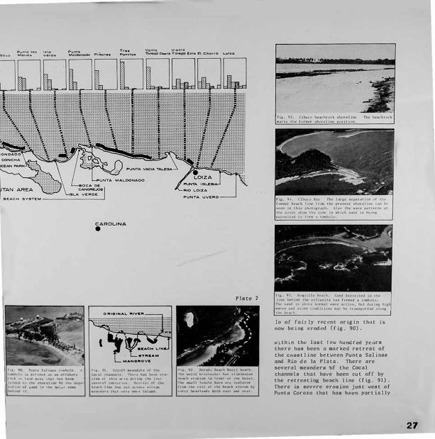
West of Punta Vacia Talega there is an entirely different beach system from the Luquillo beach complex and specifically from the Loiza beach. Quartz is al.most absent from the beach sands which are 70 to 95 percent calcium carbonate of marine shell origin. The Loiza sands arc apparently carried offshore in passing Punta Vacia Talega and only limited amounts return to the beach. Erosion is severe west of Punta Vacia Talega (fig. 85). There is a high stabilized dune system behind the beach which is affording some protection to the land area. The beach foreshore is relatively steep. Maldonado Beach is a short. narrow beach between Punta Maldonado and Punta Cangrejos. Erosion is severe on this beach
From Boca dt: Cangrcjos to Punta Chivato the coast -is beach plain interrupted by numerous outcrops of eolfonite. forming an eolionite shorcl ine. and several local benchrock coastlines (Cibuco and Puerto Nu�vo). The rDt)\1th of Rio de la l'l,n a 1s a bnrrter coastline.
25

26
The beach sand a from Boca de Cang rejoa to Old San Juan are a mixture of carbonate groins and quartz. There are about seven separate be.ache• separated by rock outcrops, but the vater depths and cOllposition indicate that there is probably transference of material frcm one beach to another resulting in essentially one beach system. The add it ion oC a jetty at La Concha (C i.g. 86) has interrupted the westward migration. There ore sand deposits in deep water {40-50 meter,) off Boca C.ingrejoa which 11ay result from the offshore transport of the beach aands.
Th� beaches nre thin coverings of sand over a rocky shorel inc.. Severe erosion at Boca de Cangrejos has threatened the road. The remed ia I action has be�n emplacement of riprnp (fig. 87). There is nctivc ero1ion at Ocean Park ond Isla Verd�. There is loss of land offshore and also vindblown into the street• in lhe Condado area. Although the c0111po1ition of sand on Isla Cabras ia 1iailar co the San Juan beach ayatca, there is probably no tranaport oC sand across the deep entrnncc channel of San Juan Harbor.
Froa Leviccown to Rio de la Plata. the beach is dominantly igneous rock fra.gm('nls with other dark •inerals. quartz, feld1par, and carbonate grain,. Ther� is severe ero11on at L\."Vittown and Palo Stto. n,e erosion of sand fra11 behind the bonchrock "' L�vittown (fig. 88) I• fairlv rec<-nL and show1 the rapid
h4"8,ee :in b�•ch po1ition since the conetruction of the t1la Cahra• cou,evay and the BayDon canal (fig. 89) . n, i8 cons cruc t ion Ml dra1tical ly altered the current and v•ve patter I and se:c up nev cond it iona in the large lunate bay• between I1la Cabraa and Punta Sal inaa. Punta Sal inaa i.a a tOllbo-,
MINERAL
COMPOSITION
Legend:
o ....... � P"•IO•H•
c •••••
TOA BAJA •
-c.,.,-c--•••
•• " ...... ..... I", .. -,. ••
..... .. " .....01 "•' O•ri. Ml"•'•I
O Beoch
- Sever-• tt,.o•lon
C•1to1,•lio C�OO.. I
L ... "'-• •o• '•'• MOtoO• V•ro•
CAROLINA
•
Voclo voe•• To� 0-t• TQteQO E•1• Bt enono �lao
Plate 2
'I& � "'--te 'l•hM• I •Ml• ,\ .... • "• ,: . ...... "
,,.,. iwll i-, ... h,,1 .. , .... .. 1.,11 .. 1...a ....... UNI- I• lf-t Of tN IIIIM•I
• ••II-., - - e41 ...... • ,.,1 I "''" N•• ,,..._ , •• ..; ..... , .... , ,,.. ...... , ··-·· , .. , • •• , ... ,111& 1 ........
I Ow ....... � ..... U• ,..,l •t•ri•• a.u••I d
... ...... ....... - . • h ... ._ .. , ....... . ., .. �·· 1u, tt..t .,..,,. _., iab ...
. ...... ·-·· ... , ....... , .. ,u ..
....... , .............. ,.,-, �, "" ............ , ....... .......... ,
lo of rairly rec<'nt origin thnt ,_ now beiOR nodf'd (fig. 90).
W1th1n tht" last tev hundrt'd y� .. r• therr ha• been n anrked rttr4."4t of the C"oostllne bt•tveen Punto Salin4S and Rio de la Plata. 'nlere, are 1everal mennderH bf thft Cocnl channels that have b•en cut off by the rnruti11g buch line (fig. 91) . There ls •evere <'roston jutll weac of Puntn Corozo that ha1 be•n part {ally
27

28
controlled by riprap to protect the highway .
Froa Boca Juana to Rio Cibuco, the sands are dominantly carbon.ate with some quartz, except for the Ccrromar Beach. fl'lis is a man-aade beach, nourished by truck vith quartz sand. The high level of quartz in the next beach vest shows that eand transport and by passing occurs. There is severe erosion at Sard incra beach evidenced by the continuing loss of palm trees at the shoreline. There is on input of dark minerals and i3neous rock fragments by the Cibuco River. There is also severe erosion in the bay west of the river mouth.
The ahorel inc in Lhis area is Ueachrock and ia separated frca an ear lier shoreline by a widening expanse of water (fig. 93). The interferance of refracti� and de!racting waves behind the isolated eolianitc shown in fig. 94 cr('otes a zone in vhich 1and ia depoa ited to form n tombolo.
Prom Laguna Tor tuguero to PeOon Afut"ra, tht" coaatline is beach plair and eolianite. More of the coast is eolianlte th.nn to the east. The sanda froa Punta Chivato to Rio Manati are c:arbon,ttte vith &omt" quttrtz groins and igneous rock frag:ment1. The material is from offshore product ion by aar ine orgnnisme ond weathering of the eol ianitc. There ore numerous lunete bnya. for.NS by erosion of the lond when the eol iAnite ia breoched. ond numerous cxumplcs of tcaboloa, vhere the aand connects rf'11nant1 of eolianite to the receding short?line. ln monv or these. tht"re 1a no obatruction to the t,'aaaage of sand behind the eol ianlt� (f lg. 95). Host of the benches are thin sand depoaits over a rocky lower foreshore. f'Jr �ng winter aton1 p"r iods these sands mny cnovr affshc,rr tonporarily. The K&nali Rh,er cardea large •°'-Intl of igne°'-11 r0<k aaterial,
O..-••• o.....r ... c;o.-,1.... $.- o-•• ··-
MINERAL.
COMPOSITION
ilc., ... � --··· 01,10,t•
�-•c11•••'
IOI'\•-• ,_ __ ,r-,aem.f'\H
M091'\•t11•
o,,-.,. o., .. ......... .
O Beach
• Sevel"e e:,-oelon
•• ..... , ...... , IIM 1--.•ho,t'• U•
,..,.., f ,...., ulilor\N..,. thto �·•-t " ... , .. , .. ,, .... uc .. , ...
' ,._,_ ........ 1.
ce,•••t•• T,•• "'•tmo• ., 0•-1• c-, ...... � T\,,,.,.. Ul•t• N•,�• AUo• A.
llho .. o,mo• hO• MOl'\OH
-·-(';lbvco Oo,ao.
"•· •• 1,.,--1,_ --· •• ...i ........ ... h&. 100. ,.u •• ••••h. thh u ct.. l•l••I" .. ,,.. fl••• ••nJ •• 1 .. , • ..,.,.., r••Ult'U•t ••• kAch •t 111. to ,._ N•lrlt •"•'- '""'••• '"'"•-.! •·�th t-1 a ., ... b,.ia. TM r,11,l,,y ..,. ............ 1 rrDU- �I 11·• I,,,. •h<>r•lt ... •• f•tcur,- IUlf••t-. h• "'' llw t><>.a.rh wM• •r• 1.1n•ov• r �
h...-nu. �..,,,, .,.,, fd,f,,.ar
Plate 3
r,,. 101. c. ... J•t•• .......... n, .. .. •,1""1, '"'• ... ,,h.i tr.- th• dralr1• .,.. li••I• c,{ ch Cw•J•t.._• 111v,,. n.. kad1 I• U<>hl .. fr09 t>th.tr bu i.., by ""' It.,- h•,•iU•'IJ• loc>th ••u •"'1-u
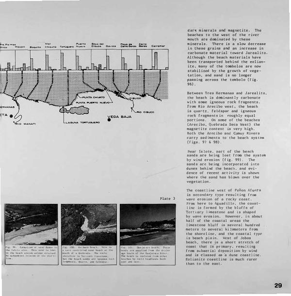
dark minerals and magnetite. The beaches to the west of the river mouth are dominated by these minerals. There is a slow decrease in these grains and an increase in carbonate material toward Jarealito. Although the beach materials have been transported behind the eolianite, many of the tombolos are now stabilized by the growth of vegetation, and sand is no longer passing across the tombolo (fig. 96).
Between Tres Hermanas and Jarealito, the beach is dcxninantly carbonate with socne igneous rock fragments. From Rio Arecibo west, the beach is quartz, feldspar and igneous rock fragments in roughly equal portions. On some of the beaches (Arecibo, Quebrada Seca West) the magnetite content is very high. Both the Arccibo and Camuy Rivers carry sediments to the beach sys tcm (figs. 97 & 98).
Near Is lo te. part of the be11.ch sands are being lost from the system by wind erosion (fig. 99). The sands arc being incorporated il'lto dunes behind the beach, and evidence of recent activity is shown where the sand has blown over the vegetation.
The coastline west of Pciion Afucrn is secondnry type resulting from wave erosion of a rocky const. From here to Aguadilln., the coast-1 inc is formed by the bluffs of Tertiary 1 i.mestone and .is shaped by wave erosion. However. in about half of the coastal areas the limestone bluff is several hundred meters to several ki lomctcrs from the shorcl ine. and the coastal type" is beach plo in. West of Jobos beach, there ia u short stretch of coast that is primary. resuliing frOII suboerial deposit ion by wind and is classed as ·a dune coastline . £olianitc coastline is much rarer than to the east.
29

30
The beach at Bellaca is o saall local sand accumulation or pocket beach ( fig. 100). Most of the beoch material is carried to the area by the quebrada. The Cuajataca beach is quartz, feldspar, and igneous rock material carried to the area by the Rio Cuajataca. It is isolated from the other beaches by rocky head lands (fig. 101). The beaches east of Isabela are generally narrov, thin veneers of sand over a rocky shoreline (fig. 102).
Fr<11 De.l Toro beach westvard, there is a thick and vide dune system behind the beaches "hich probably suppl ics most. of the beach sands by landward erosion. There is no per113nent drairu•ge system into this part of the coastline. but the sands are dominantly igneous roc.k mr\L(•rinl. quartz, and feldspar. Cnrbonnte grain& make up only a s1Hll part of the beach sand. There are numerous rocky heMlands interrupting the beaches. but there is probobly l,1Leral migration of the snnds in the nearshore region.
The dunes behind the beeches have been extensively mined for sand, nnd in place, (Sord inn.) the beach sands httvc hl't"n removed. The beach at Punu J�cinto (fig. 103) shove Lhe vide and thick. accumulation of sand that 1 iea in front of the veget11.t ion covered sand dunes. West of Jobos bench, there Ms been major removal of the dune Hndo (fig. 104). lloth the coapoaition of the Mach, and the presence at the lower part of the beach of bcachrock outcrops (fig. 105) suggests that the major eource of beach sand ia the dune system.
Puntr1 Borinqutn and Cra1hboat beachea ore isolated beachoa bounded by rocky shoreline (fig. 106). Th• b�ach is continuous (roa Aguadil la to Punta Corda. and the coa.s ta l type is beach plain (rig. 107).
�.,..\I. Color, e,oe.hboot
P1• l!l1 Al..._._ .. et tllU c-•••t, I ..... •n· • ,.,.,., lhl" ... IW.I
.... , .......... '""'" ., .. • I �1-1, l,f ..... .... _.
,, •. 101 ,�111to a....:h ··-· t•\. h .... ,111• ••h· \IP a1"' ti"'" 'I)
...,. ""' ., ................... ... ·tWr C' .,_,.,, • • ,,. .,..,,, e11101! 1•14 .... f � ...... floW. • ..-H •te-.fl<f'e..,_• _,. ••r ... .,.,.
AOUAOIL.L.A
•
MOCA
•
,111 Ilk l•�r.,, l�h•II 1"• ........... , t ...... 1 ,, .• 11,� .... ftr. 1 .... 1•11 _.,. • n..ft,., tlofar N' cltil•
... ,,_ .... ....... _.,11-.

, .. IOl t4t" .. 4< .. Qi• ••
••1111• f •• • •<Uf W ... 1•1• I I ...... , .. .... �··1 •"' , .... , ... .,, ..... , ... , .. , I• IM1•• I ......... '
MINERAL COMPOSITION
Le9end:
o ..... r,. "'•'G•oor
-e••"•m ..__•••
IOt1•ou• 11to•11 ,..rao,....no MoQ,..etlte Other Oorio Mlfl•tel
O Beoch
• S•v•,.• Er'Oelon
• ,a ICMo c,,,t.lH>,n .._. •• � ti.1, 1, •• l-1•1 ... •••I, Vi(h .... , 1ll,.,r.,� ''"•, J1w ....... -· e •1•1 .,. �·' ..,._. � r • .,.......,...,. •"" ,,...
, ... .. _" ..... ..., .......... • ·· _.....,,,•••••It • .. ,.t ••
Plate 11
niere is severe erosion frca Rio Culebrinas to Punta Corda. The beach sediments arc approximately equal par ts carbonate shell moterio t� quor tz and feldspar. and igneous rock fragments. Sediments frm a large drainage basin are carried to this part of the coast by Rio Culebrinas and Rio Grando. Most of the coastline between Punta Jiguera and Punta Cuanajibo ia beach plain. There are thre(' bench systems: Corc<':gn, AOasco, ond Mayaguez beaches. These arC' separated by rocky heodlan<(s at l.a Tosca and by man-a.ode f ac it it ies at Mani. Fr<B Punt� C',onnaiibo to Punta Melonca there ore a variety ol coastal types. Aboul haH ol the coast is beach ploin. Tlll'rt..' are several rocky shore 1 ines of secondary \l:lVC" eros iontt I type .u'kl several stretches of mangrove shoreline. At Punta Gunniqu i.J L;:1, the shore is fr ing.1ng rc(\f.
The Corcega beach s�1nd1 are carbo noLe, quarlt, and -41neous rock rrngmcnts with minor amounts of
31
32
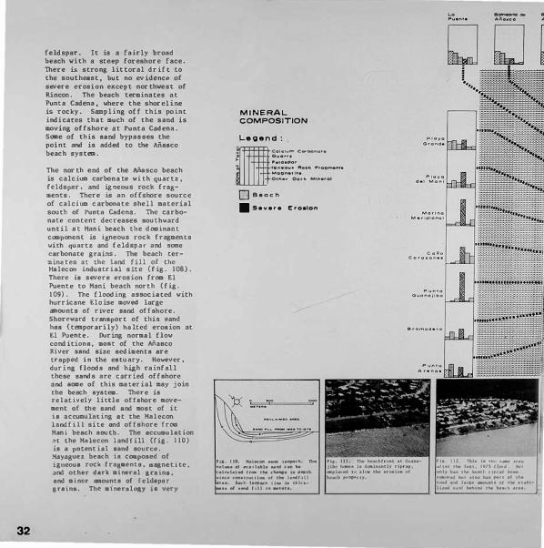
feldspar. It is a fairly broad beach with a steep foreshore face. The.re ia stro ng littoral drift to the southeast. but no evidence of severe e rosi o n except northwest of Rincon. The beach terminates at Punta Cadena, where the shoreline i8 rocky. Sampling off this point indicates that much of the sand is moving offshore at Punto Cadena. Scae of this sand bypasses the point and is added to the Masco beach system.
The nor th end of the Ai\uco beach is calciua carbona te. with quartz, £ eldspe.r, and ig neous rock fragments. There ie an of!shore source of calcium carbonate shell material south of Punta Cadena. The carbonate. content decreases southward until at Mani beach the dominant caaponent is igneous roclc. fragments with quartz and feldspar and SOiie corbonote grains. The beach terminates at the land fill of the Halecon industrial site (fig. 108). There ia severe erosion from !.l Puente to Mani beach north (fig. 109). The flooding a88ociated vith hurricane Eloi•e aoved large •ounta of river aand offshore. Shoreward transport of this 11and hos (tOllporarily) halted erosion at El Puente. During noraal flov cond it ione. •o•t of the Masco River aftnd size eedimente aretrapped in the estuary. However. during floods and high rainfall these aands are carried offshore and &OIIC of thi• aateriol uy join the beach systND. There is relatively little offshore aoveaent of the aand and aoat of it i1 accumulating at the Halecon laNlf!ll site ond offshore from Kani beach south. The accumulation oc the H4lecon landfill (fig. 110) ie a potential aand source. �oyogue� beoch u coatpoa�d of igneou1 rock frag:•enta. eagnethe. and other dark aineral araina. and •inor •oonts of reld1p,ar grain,. The. •1neral()Ay ia very
MINERAL COMPOSITION
Legend: lie••••·- c�-•••• o ... •�•• "••••po, .. ., ...... .._ ... --�··-"'•..... -,"·
Other 0.,11 M,fterel
O Beach
- Severe Eroalon
na. uo. ""'l•oc,, •Miff ,.o,,,ec111. ni. ,,,_ ., ..... ,l .. l• .... c:• Ille •l�l•l ... "- t ..... tltioNil• u .......
•�• c:_.,,-u- ... t.._ l ... flll ...... u,
r••• IM .. t ....... 11 .. t• t .. 1.cl .... of ...... ,,11 '" .. ''"·
·-
. .-....
.,. 112 fl'•l• 1•1111• ._ .. ,,. ,tin tlw S.f'I l'H\ I h �I \i,t
I •• 1lw ...... tlf'• .. i.....11 ..,.,., •l_ ..... ,.u.r ,.,. • 1 •••• --u ef ... •t ... ,• .. ...a ...................... ., ••
..
"'

•-• .. 11••1• 1•1 1t..- l1·W •••
,i. •• I i ••'•'• ••••
different fr0111 the Anesco beach system. The deep water of the Mayaguez Harbor entrance blocks tranapor t o( sand from the Masco system to Mayague z beach.
There is severe erosion along the southern half of Mayaguez beach. Riprop hos been odded to long stretches for protection until the coast line is no longer beach er ig. 111). This has slowed the loss, but has also shifted the erosion to another port of the beach until riprap now extends to the Cuanajibo River. The SepL�mber 197 5 flood 11.ade •ajor alterations to the bN\Ch (fig. 112) ond ripped out both h igl1wny a1\J rip mp (fig. 113). Prior to the flooding. the severity of the beach erosion was shown by the undermining of homes on the beach er ig. 114). The flood , carried large mounts of sand olrshore. Some of these sttnds aay return to the bench system. but most will be covered by the morin(\ silts that are the d011inant sediaent beyond the three meter depth contour.
The bC'ache!i south of Punta Guonnjibo nre cnrbonatc. qunrt:t. and igm."OU8 rock frng•enu1. Some of the u·rrigcnous mnter iols in thr beachf'a north of Puntn Arenos art• passin.g thl� rocky Cuanojibo Point nnd r<'turning LO the bench 1tysH111. At Ost ione,. thl' beach sands are 100 p<'rcent carbonate. dominnncly llnlim("dll pJntC'S (calcnr£'oue olgat') ( f i�. 115) , Th� aand1 nt 8oqueron b("ach nre cnrbonnce 3nd qunrtz. The ll I luv la l plo ins wC"fl t of 8oqu<'ron are the source of the qu11rtz ,:traim,. 11u�re i8 severe erotdon at Puntn Ar(•nns, Punta la Mt•la. and .outhveflt o' ioaut"r('ln het1ch.
8etwetn Punta Me tones nnd the Pargut'ra forest, the coaat ia beach plain with short stretches of rocky wave ("rosion coattt nt Cllbo Rojo and Punta Holino. fllere are ahort.
33
34
expanses of mangrove coast on the west and east side of the Cabo Rojo tombolo and west of Pleya Sucia. From a point just east of Punta Molino to Punta Montalva, the. coastline is dominantly aangrove (fig. 116). There arc areas of striking grovth of land contributed by the spread of mangrove, and several former beach lines can be seen as much as half a kilODeter inland.
At Parguera there is n tidal flat coastline behind fringing mangrove. The land im=ed iately behind the coast is n lOW" ronge of limestone hills that are the southern llDlb of a syncline. Isla Hagueyes and Ls1o Matei are outcrops of this limestone. Visual observations, sei•ic surveys. and collected data show that the ahelf south of Lo Parguera is under lain by the some. limestone. and it has been sugges
ted that t.he 1 incs or offshore reefs aay be localized by outcrops of the southern flank of the 1 imcs tonc syncline.
Both Hague.yes ond Motci arc surrounded by fringing mangrove. B3hi.a Fosforescente i.a also bounded by mangrove. ..·rom Porguero east. there are lOlor tidal flats and solinas behitd the aangrov� shoreline.
East of Montalvo the coastline is fon1td by wave erosion of the southern limestone plntform. The coaat can be g<'ncral ly claaaed 4S secondary wave t'ro.sion 11adt" irrt"gular by voves. Thert' a.re numerous small pocket beache• of sand and grovel at the base of the lime.atone cliffs. with no appnrent C:onnecLion to one another.
El Combate beach is quartz and calci1.n carbonate 1and. Th�re ia no evidence of atrong ero1 i.on. Punta Aguila It par a tea Cea bate beach frOII Aguila b•ach vhich ta dcninnntly c3lcium carbonate with

.,.�A•C:'!> � A tonel"'O'lf.Si:t �TC J ...... ,...
ll_J C.<i1"0 l').,,4(1
MINERAL
COMPOSITION
Legend:
Be•,.••m eo,...,.,. o .... ,,. .... .. .,.. '9"•-• -. .... l'",oom•n1• Mao"•'U• o,,., •• oo,-. '''""····
O B•oer,
II Seve,o Ero•lon
miner ,mounts of quart1. and i�nl'OUS rock fragments (fig. 117). Cons Ld<'r ing thC' changt• in composition and thl· prev.1il1ng patt<>rn of lon&tihorc drift. L rttnsport.:tt ion of s ... tnd betw1..'l'O the two beactws i.s probably of limited ext�nc. C,100 Rojo be.1ch i·� .i �all pocket i•t•a.:h at tlw base or the liJ1w·,tOn<" clifl 8, Tt iK <'OfflPOKt.·d of c.irbon�1 .. te anJ quartz �rnins. C.tbo R,1Jo is an outlit>r ot the. l 1::u,;ston�: fonn.1rtA the 1.'."0l\Hl and ii. connt•,·tt-d to till' m,1inLmd by tlh.' df..'posit i<,n of a H,mJ sritl which i•'lO' tht• l,...o (ti�. 118). h1-, hJ. n us,-...:1 as an ex:mple of i'I tombolo. PJ.1y:a Sucia is ,1 carbonnte und <1u,1rL7. beach th.-.t S'-'l its naml' t roa tlw uniqut circulation pattt.·rns in the bay bl•Lwl'en Cabo Rojo mJ Punt,, Molino. As llw :mrftH't' <'urn•ntli 11ove w�htvard .1Long tht• south coast of Puerto Rico. p.art of th,to, ( low p.1i,u»es Cnbo Rojo .u� cont rnues Lnto tlw Monn P,ttiti:tgl', Part oi thi' ( low ia J ivcr tl'J into clu· bay .mJ carrit• ,ur(:ic1.· Jebri·. to Pl.1y., Suci.,. The b,,v ('Ont.,inA lariw ccuonLilLl'l:i of t1ond whJch ,lrt.' ht•in� movl•J ·.c.H1thw,•st p,1st Caho RoJo (fi . 119). Since the long.short Jrit t 18 south trt.,m J'unl,"1 ,\>,1uJl.1. this H,and is h,•iu� mov,"I ool 111 the bt•,1rh syst,-o inJ 111 1 poh•nl 1.11 sa� 1r(tc c-1 otfshor,• m1n1ng.
t'rro 11unL1 Mol 1ou '-'.:mt lo Punt I Vt.·rr,1c o, thl·r,• lr't' m1ly Hm,11 J pock,·t t, .,ch,·s at th,• b ,�e of llme·,tont.· cl.iffo c•r uwl 11,-J an I m.1n�;n-.vt• L'0,1Ht I uu•. Tlwr l' ts nu ,•vid,•m, of ,·(W!JlllunLcutf,m ,mJ ,, 1ss.1;•1 ot snnJ from ont. LO tnothcr of th<'lm bt•&( lwa. ,\) I of th,• h,•.\c.'ht•N .,r,· (' fll'l'IJ'llth.•d ol c."',llc 111m carbon.1l(• gr.unu ,Jl•tivt•,I from t•ro-8lOO of the llm,scon<" C'lllfs nnd frm tlu- fiht•lla ot mar1n,• orgrnh•-. liviu>,! ol l�hvrt•, Tiw IHrg,•st ut th1.•s1.• h1•11ch,•s .,r,• 'lont,1 Iv,,. l\11 J.1·1. C ,n., Gc·r d�. nnd B.1 l l t'n 1.
35

36
beach easily reached by car from tnsenada (fig. 120). The area is rapidly being built up by construction of a condcxninium and an urbanization of small houses. Pardoe i8 bounded by national for est and access for the public is difficult. Several aerial observations suggest that surface oil may be carried to this beach from Cuayanilla. Cano Corda is a public balneario with II hotel at the east end, and is a popular and pleasant beach are.a (fig. 121). Ballena is relatively easy to reoch by the dirt road tho.t continues along the coast past Caila Corda. This is the only beach of this group that shows signs o( severe erosion.
The small pocket beaches at the base of cliffs west of Ballena are cOIDposed of calcium carbonate sands. The beach at Punta Ventana is Hfferent in cmposition (fig. 122). It is a mixture of calcium carbonate quartz, and dark minerals and igneous rock frag,,,,nts. The Yauco River once flowed to the coast at Punla Ven tono and cut n deep submor ine canyon in the shcl f to the south. The quartz and dar'k mine .. rale were transported to the area from the interior by the river and ore relict sediments. Since the course of the river hos been diverted, probably by faulting, the only mcxlern sedlllcnts being contributed are calcium carbonate. Playa Ventona is virtually inaccessible to the public. The road to the beach runs through land1 owned by Central S•n Francisco and signs on tvo locked gates varn of prosecution of treapassers.
From Punta Verra.co eastvnrd, th� coastline ond beaches are drastically differ�nt. The coast ia a low lying alluvial plain except for a short stretch between Tallaboa and Punt& Cuchara. llcre the conat-1 ine. is vove erosiona.l and fringing reef. ffle reat of the c.oaatline ie
MINERAL
COMPOSITION
Legend: lllc.····---·
Overt, f'"eldepor lon•oue ,.ocl\ ...... ,,.."" Mo9r,et1te Ot,..•r Oor.., Minero!
O B•och
II S•v•r• Ef"O•lon
l'1.a, au. l'\o,u, \·,,11-• ........ ti. Tl\11 lytH..J ••• ..... .,. ,>1rup1•• wf'wl v•• -""'' ...... 11., •• lh• "-· ., ... , nw,.,, •• c--1, ..... , ...... _,, -,-,.i. .... �11-· -, .. ". _,. ..... ,,
........ ''- .......
PONCE
RIC) tNA•OH
I'll, 11', l'l•,11 ilf ro.1t•. Tlwt NM I, c-�� of 1111•�..i• rq,i:,� ... ,..n.tll•, _,,, ,.,..1, •1-t•I•, "'-""el , ......... - • _,. • .t ...........
,., ............. c-, ..... , .. o. _, -tcllt ly .. ,01 I• Plo•Uo ••�•·

[] [] Q []] [] [jJ GJ • ....,.. ..,. �lfO '""""""• SoM• ._, • .,.. Lo•
•••• .. c.,.._ c.r•• ••- oc--•
Place
either beach plain or mangrove.
The composition of the sands and distribution of beaches is very different Crom the preceding area. Cuayanilla beach is dominantly igneous rock fragments with quartz and dark ainerals (fig. 123). Tallaboa beach is dominantly igneOYs rock fragments with some carbonate grains and Punta Cuchora is of dark :aoncaineralic composition with i&neous rock frapent1. The rocky shoreline between these two beaches hos only Moll and isolated pocket be.aches.
There is almost no carbonate m.1-terial in the beach sands eascw�rd from Punta Cuchara. The beaches are composed of igneous rock fragments, magnetite, and dork monomineralic components with minor a:mouncs of quartz and feldspar.
The beach lll Punta Cuchara is b�ing rapidly eroded and a huge amount of the land behind the beach hos
been r<:movt..�. rht.> low beach to the east, Playa de Ponce. is n fret.� snnd removo l orea and n gar bag(' nnd junk dump site. lt iH one of Lh(' vorst looking stretches of coasc-1 ;.., in Puerto Rico (fig. 124). From Punto Carenero en.st to Punta Pctrona. there is al.moat continuous beoch plain interrupted by mangrovL\ eroding alluvial plain. and rock riprap (fig. 125). Hore than fifty pC>rcent of this co.ist is sufferinp 8t'vt"re erosion. The mntC>rinlA rnnRe fran ttond co Arnvpl and nrt• doainnntly dnrk minernla and rock fragments. Several of the beacht.• hnve espt>'ciallv hi$th concentrat a�n-. of r.mgnet i u•
The coast] ine from Jnuco to Playo Salinas is a combination of beach plcnn and u'*rove. Eaat of Sal inaa there ill considerable mangrovt con st. The Ctiyos Car [bf' nrc smo t t mungrovc ialon.ds thol nrc behind n fringing reef coast I ine. Froa Laa Mareas ea•tward the coaat is do-
37

38
minantly the result of wave erosion of the relatively unconaolidated alluvial plain material that lies south of the central mountains (fig. 126) . There is ex tensive development of narrow beaches at the base of wave cut cliffs. From Arroyo eastward. the coastline is dominantly beach plain (fig. 127).
The beach materials arc fragments of igneous rock material with magnetite.. dark minerals, and some quartz and feldspar. There is considerable increase in the amount of quartz and feldspar east of Las Man�as and the beach nt the mouth of Rio Monuabo is almost entirely quartz and feldep.4r composition. There is very little calcium carbonnte moteriaJ except ot Libre Florida.
>tuch of the bench ma tcr ial in this port of the Island is gravel sized. The gravr:l appears to be residual alluvial plain mllteriol left in the surf zone as the nlluvial plain ie cut bock by wave action on •any of the beaches.
Thr:re ia severe erosion over at.oat one-third of the coastline shown on this plntc {(igu. 12u anJ ll9). Only the aongrove area surround iog Bah io de Jobos and the beaches off Pnt.illGs and Rio Mmmnbo are not showing some si,.ns of eevere erosion. Thl' coaet from Las Koreas west to tflcuelo Pozuelo is one of th<' most severe oreas of erosion t'ncountt'red on the lslaod ({ i,ts. 11'\ 3nd 1)1).
The coastline from Punte. Tuna to Naguabo ie an alternation of rocky herdlands thnt have been partly shaped by marine erosion and val leya or alluvial aaterial that have been vorl<.ed on by wave oction ond mnrtne dt'po<ion to fora brood buch plains (flR•· 1}2 and I )3). •1orth of Punta Lima the coast.line 1A man,Rrove coast. rocky hendlande.
MINERAL
COMPOSITION
Le oend: lllco,e,_ =-••
01,10,,.
l"elO•POf"
•o,.•01o1• �oc1o. ,,.,ootne"'•
,.,. ...... u,.
Outet OOl'lo; Mi"e,ol
D Beoeh
- Sevef'e Ero•lon
GUAVA MA
•
[:J[i]w][]lmJQ� �t•;,• L•• �- .... ,, •o e,.,...,. .......... eoo"'•�.. .....,,,... �·• ...... _,. ""--·· ll••• ...... .,. v ··"·

PAT ILL AS •
JJ G] [[] 0 (•0 M0..,,.0- Mo..t\000 • ..,,.,o • .,.,.,c;i
0•••• E••• T.,.,.c;i Toro
YABUCOA •
[J[J[] o,.._.ooc;i voo..c- a--"•• �G .... r Plate 8
and a few small beach plains and pocket beaches. The eastern end of the island is bordered by a shallow shelf with abundant coral and marine organisms forming carbonate sands. As a consequence. the beaches are a mixture of calcium carbonate grains from offshore and quartz and feldspar and igneous rock material and dark minerals from the land area.
Although the composition of the beaches is similar, physical boundaries for med by roe ky headlands divide the coast into eight distinct beaches. There may be li.inited transfer of sand from one beach to another in the offshore zone, but they arc distinctly separated physically.
Punta Tuna beach is 3 beautiful coarse carbonate sand beach with some quartz and igneous rock
material that lies e.nst of the Punta Tunn lighthouse.(fig. 134). The land adjace1\t to the beach is pasture for large herds of cattle, but the owner;s have provided access to the hen.ch.
Punta I oro beAch 1.s quartz anJ carbonate with some feldspar (fig. l35). The quartz and feldspar .is derived from the plutonic outcrops nor th o( the beach.
Froo:i Quebrada Honda to Guayancs there is a series of pocket beaches and some re lat i.vcly long stretches of wide beach ( f i&. 136) c<ll1lposcd of <1uar t?. and feldspar, ...,i th some
cnrbo,,atc and igneous rock moteri.n L. Cuayones beach. n.t the nor th end or chis system is especially rich in magnetite (fig. 137). The trnnRport of sand in this system is no .... interrupted by the deep channel n.nd jetties constructed as part of the Ynhuco.n Jl:1rhnr.
The Cclndelero bench system starts with a group of small pocket
39
n-....... . , ... "· .1 f, l e,1lj
•l'I i,.,_.,-. olO I' f � � Ml O , ... , I '""'
l•Y• r .... ,.,,. • 1 f,e IP• �. • /,, • U •l••f ,h-1 "Af
���IA"\d •••• I• hi I •••-•1v�lf dr1rl.1...J Ir
beaches between Punta Guayanes and Punta Fraile. There is a continuous beach plain from the Palmas del Mar marina at Punta Fraile to Morro de Humacao (fig. 138). The composition is dominantly calcium carbonate. There is severe erosion at Punta Candelero and for a short distance north.
The Morillo beach is quartz with some igneous rock fragments and dark minerals (fig. 139). From here northward, the beach sands are dominantly terrigenous origin. The beach fran El Morillo to Naguabo is a relatively broad beach of quartz and feldspar with some dark minerals and igneous rock material. There is severe erosion along the northern half of this beach and extensive riprnp has been emplaced to protect the highway (fig. 140). Naguabo beach is adjacent but slightly separated from the rest of the beach. The calcium carbonate content is much higher in this beach.

MINERAL
COMPOSITION
Legend:
O Beoc;h
• s ..... ,..
HUMACAO
•
�·.� ::Ji.
��
.' 'fr
'
Plate 9
41

42
SUMMARY AND RECOMMENDATIONS
1. The beach system of Puerto Rico is not continuous, but is broken into separate beach systems. From preliminary data, there seems to be transport from one beach to another within a beach system, but little or no communication between separate systems.
The termination of a beach system is generally a rocky headland with relatively deep water adjacent to the shore.
2. Since the communication from system to system is probably minimal, modifications of the shoreline within a particular beach sould have an effect only on other beaches within the same system.
3. Erosion of the shoreline in general and beaches in particular is a common phenomenon. Accretion of the shoreline is generally occuring only in areas of mangrove shoreline.
4. The mangrove is a major factor limiting erosion. Where mangrove forests have been replaced by. coconut groves erosion has generally been initiated.
5. Erosion is proceding at a much more rapid rate where the shoreline is unconsolidated or poorly consol idatcd alluvial sediments.
6. Erosion is much more severe where offshore coral reefs and beach rock or submerged eolianitc has been breached and reduced in size.
7. Where sand has been removed from the dune system, major erosion seems to be eminent.
8. The removal of littoral transported sand from river mouths has reAulted in accelerated erosion. This is rut area in which control of sand extraction is of major importance.
9. Man's activities of a wide variety. from agriculture and urbanization to harbor and industrial construction, has adversely affected reef areas and resulted in increased erosion.
10. Addition of riprap has given protection to local areas. but has also shifted the locus of erosion and caused problems in other areas.
11. Removal of mangrove along the shoreline has resulted in increased erosion.
12. It is possible that sand could be removed at the downstream end of a beach syatcm without an adverse effect on the enviro1"1Dent. i.e. La Plata River, Cuonajibo River, Punta

Ventana Canyon, Malecon dock areas. The rate and extent of removal would have to be controlled to avoid environnental ccmplications.
13. A major prospect for sand resources is the submerged sand bodies on the insular shelf of Puerto Rico.
14. The main conflict of interest in the beach portion of the coastal zone is between those activities which would use the beach area Le. recreation, tourism, urbanization, industrial sites and the construction materials irdustry which would remove major amounts of beach Mterial.
Secondary conflicts exist be.tween the users of the beach in terms of natural quality of the enviroment. The solution of these conflicts is a matter of planning and zoning.
15. To date we. have had limited data for use in planning the utilization of the beach areas. A major task in collecting and analyzing data so that we will have a major body of information with which planning decisions can be made.
16. The program to date has been collection of preliminary and relatively unsophisticated data for the preparation of a general interest publication. The major aim is to inform and alert private citizens atd goverrwent officials of the potential problems and the need for careful utilization of our beoch resources.
17. On the basis of the data analyzed to date, specific recommendations can be made as to areas where river and dune dredging, and near shore dredging should not be allowed. Where there is a requirement to keep the bar of a river open, and removal of the material fran the system is causing accelerated erosion, the dredged sand should be returned to the system downstream.
Tentative areas of non-harmful sand extraction can also be suggested. In these areas, the beach equilibrium should be monitor before and during any dredging operations.
18. The continuation of the beach study program should include:
measurement of beach profiles in selected areas to etaablish the equilibrium beach situation
measurement of currents ond current systems in the noarshore zone
measurement of the rates of movement of the beach sand alongahore in selected areas
detailed etudiee of the rate of erosion in areas of severe erosion ae outlined in this study
43

:44
location of any evaluation of offshore sand bodies. This should include surface. sampling, coring, and seismic surveys to determine potential volumes of available sand.
continued studies of the characteristics (grain size, composition, construction properties, e.tc.) of both offshore and beach deposits.
19. There should be consideration of legislation and grant procedures that would encourage the developing of offshore sand extraction.
20. Control of dune, river, beach and very nearshore dredging and construction should be developed by new legislation or implementation of existing laws. Patterns for this can befound in Florida, California, and other coastal states ofthe United States.

AC KNOWLEDGEMENT
CONSULTANT JACK MORELOCK
(All technical work, including preparation of text. photography and recommerdations)
rield Assistance Beach Composition Sample cuts and discussion
Report Preparntion
Car lo& Carrera Kurt Crove
James Trumbull
Staff of' the Puerto Rico Coastal Zone Management Pro::iram
45