ethiopia : livelihood zones analysis
DESCRIPTION
A tool for planning agricultural water management investments. LIVELIHOOD ZONES ANALYSIS in EthiopiaTRANSCRIPT
Improved livelihoods for smallholder farmers
A tool for planning agricultural water management investments
LIVELIHOOD ZONES ANALYSIS
Ethiopia
Prepared by Dr. Girma Medhin in consultation with FAO, 2011
About this report The AgWater Solutions Project aimed at designing agricultural water management (AWM) strategies for smallholder farmers in sub Saharan Africa and in India. The project was managed by the International Water Management Institute (IWMI) and operated jointly with the Food and Agriculture Organization of the United Nations (FAO), International Food Policy Research Institute (IFPRI), the Stockholm Environmental Institute (SEI) and International Development Enterprise (IDE). It was implemented in Burkina Faso, Ethiopia, Ghana, Tanzania, Zambia and in the States of Madhya Pradesh and West Bengal in India. Several studies have highlighted the potential of AWM for poverty alleviation. In practice, however, adoption rates of AWM solutions remain low, and where adoption has taken place locally, programmes aimed at disseminating these solutions often remain a challenge. The overall goal of the project was to stimulate and support successful pro-poor, gender-equitable AWM investments, policies and implementation strategies through concrete, evidence-based knowledge and decision-making tools. The project has examined AWM interventions at the farm, community, watershed, and national levels. It has analyzed opportunities and constraints of a number of small-scale AWM interventions in several pilot research sites across the different project countries, and assessed their potential in different agro-climatic, socio-economic and political contexts. This report was prepared as part of the efforts to assess the potential for AWM solutions at national level. The livelihood zones analysis divides the country in a series of areas where rural people share relatively homogeneous living conditions on the basis of a combination of biophysical and socio-economic determinants. It describes the main sources of livelihood of rural populations (by category of people), their natural resources base, potential and key constraints to development. It analyses the relation between people and water and helps understanding to what extent and how water can be a factor for development.
Contents
CONTENTS ....................................................................................................................................................IABBREVIATIONSANDACRONYMS .................................................................................................................... III
LIVELIHOODZONE1 ............................................................................................................................. 1
LOWLANDMIXED–WESAMELIVELIHOODSYSTEM............................................................................................. 1
LIVELIHOODZONE2 ............................................................................................................................. 2NORTHERNMIXEDMIDLANDSLIVELIHOODSYSTEM............................................................................................. 2
LIVELIHOODZONE3 ............................................................................................................................. 2NORTHERNCEREALPULSEMIXEDLIVELIHOODSYSTEM ........................................................................................ 2
LIVELIHOODZONE4 ............................................................................................................................. 3
NORTHWESTLOWLANDSORGHUM/SESAMEMIXEDLIVELIHOODSYSTEM................................................................ 3
LIVELIHOODZONE5 ............................................................................................................................. 4WESTERNCOFFEE/MAIZELIVELIHOODSYSTEM ................................................................................................. 4
LIVELIHOODZONE6,16AND17........................................................................................................... 46. NORTHERNPASTORALLIVELIHOODSYSTEM;16:GAMBELLAAGRO‐PASTORALLIVELIHOODSYSTEM;17:SOUTHERNPASTORALLIVELIHOODSYSTEMS...................................................................................................................... 4
LIVELIHOODZONE7 ............................................................................................................................. 6EASTERNHIGHLANDMIXEDLIVELIHOODSYSTEM ................................................................................................ 6
LIVELIHOODZONE8 ............................................................................................................................. 6
AWASHPASTORAL/AGRICULTURALSYSTEM....................................................................................................... 6
LIVELIHOODZONE9 ............................................................................................................................. 8
MEHER/BELGTRANSITIONLIVELIHOODSYSTEM................................................................................................. 8
LIVELIHOODZONE10 ........................................................................................................................... 9NORTHEASTERNPASTORALLIVELIHOODSYSTEM ................................................................................................ 9
LIVELIHOODZONE11 ........................................................................................................................... 9EASTERNCHAT/SORGHUMHIGHLANDMIXEDLIVELIHOODSYSTEM ........................................................................ 9
LIVELIHOODZONE12 ........................................................................................................................... 9
‘OGADEN’PASTORALLIVELIHOODSYSTEM ........................................................................................................ 9
LIVELIHOODZONE13 ......................................................................................................................... 10HIGHLANDMIXED–TEFFLIVELIHOODSYSTEM ................................................................................................ 10
LIVELIHOODZONE14 ......................................................................................................................... 11HORTICULTURAL(ENSET/CEREAL)MIXEDLIVELIHOODCOMPLEX......................................................................... 11
LIVELIHOODZONE15 ......................................................................................................................... 12
RIFTVALLEYLIVELIHOODSYSTEM .................................................................................................................. 12
1
ANNEX1–LIVELIHOODZONESATTRIBUTETABLE‐GENERALCHARACTERISTICS................................. 1
ANNEX2–LIVELIHOODZONESATTRIBUTETABLE‐SOCIOECONOMICASPECTS .................................. 4
ANNEX3–LIVELIHOODZONESATTRIBUTETABLE‐WATER‐RELATEDASPECTS ................................... 7
1
Abbreviationsandacronyms
BBM BroadBedmaker
CBPB ContagiousBovinePleuropneumonia
FAO FoodandAgricultureOrganizationoftheUnitedNations
NGO Non‐governmentalorganization
1
Livelihoodsystemsanalysis
LIVELIHOODZONE1
Lowlandmixed–Sesamelivelihoodsystem
This livelihood zone covers theworedas of Kafta, Humera, Tsegedie andWolkeit and belongs to the
traditional climatic zone of ‘Kolla’ (lowland). The livelihood zone is classified as hot‐warm semi‐aridlowlands. There are extensive plains covered with bush, scrub and acacia. The hottest months are
between April and June with temperatures rising to 42°C, and 25 and 35°C between June andFebruary. The zone has a distinctly unimodal rainfall pattern and agricultural crop production isexclusivelydependentonthemajorrainsthekiremtbetweenJuneandSeptember.Totalannualrainfall
ranges between 400–650mm. The zone is drained by the tributaries of the Tekeze river, which hasfertileblackcottonsoils,clayloamandredclaysoils.
The zone has become a resettlement area and is a sparsely populatedwith considerable agriculturalproductionpotential.
Mixedfarmingwithcropandlivestockproductionprovidesthemajor livelihood,whiletheeconomyis
centered on the production of the oil crop sesame, which is one of the country’s major exportcommodities.Sesame isproducedbothbysmall‐scaleand large‐scale farmerswith42and58percentsharerespectively.Productiontechniquesandmethodsusedbyboth large‐scaleandtraditionalsmall‐
scalefarmersaresimilar,theonlymajordifferencebeingtheuseoftractorsbylarge‐scalefarmersforploughingandseedbedpreparation.Sesameproductionishighlylabourintensive,mostofthesehighlypaidlabourersareimportedfromotherareasduringthepeakseasons.
Themain livestock in the zone are cattle and shoats,which aremostly tradedwith Sudan across the
border. There is abundant grazing and browsing for livestock. The major production challenges arebovineandovinepasteurellosis,lumpskindiseasesandtrypanosomiasis.
Aseriousprobleminthezoneiswaterforlivestockanddomesticuse.Waterispurchasedfromprivatelyowned,hand‐pumpoperatedwellsusingscarceopenwatersources.
Sesameisthemainagriculturalproduct.It isexportedovertwomajorroutes:tothecentralmarketin
AddisAbabaandtotheSudanacrosstheborder.Thezoneisquitewellconnectedbyall‐weatherroads.
Landholdingandfamilysizevariesconsiderablywithwealthgroup.Theverypoorhouseholdscultivate1to2.5haofland,whilethebetteroffcultivatebetween10and22ha.
1
LIVELIHOODZONE2
Northernmixedmidlandslivelihoodsystem
This livelihoodzone includestheworedasofGantaAhferomDebayZenaandAtsbiWomberta,.WorieLehe, Kola Tembein, Samre, Tahtay Kararo, TahtayMaychew,Wukro,Degua Tembein andAdwa. Thezone iswarmtocool,moistmid‐highlandswitha long,unimodal rainfallpattern.This livelihoodzone
coverswideareasoftheTigraycentralhighlands,whichhashighlyvariabletopography,withmoderatetemperatures(Woynadega)andsomeareaswithahotclimate(Kola).Agriculturalproductionisentirelysupportedbythe‘kiremt’,mainseason,JunetoSeptemberrainsbetween500‐700mm/year;although
therearepocketsutilizingtheveryshortrainsforplantingoflong‐seasoncrops.Themaincropsgrownincludemaizeandsorghum,aswellasteffandfingermillets.Themainlivestockincludecattle,shoatsanddonkeys.Theareaisdominatedbyinfertileclayandsandysoils,thevegetationcoverisdominated
by bushes, scrubs and acacia trees. The very poormay own from 0 to 0.25 ha, while the better offbetween1and2ha.
Theareaisgenerallyfooddeficientbecauseofacombinationoffactors includinglowsoilproductivityresulting from poor soils, high population density, striga weed infestation, the livestock diseases
pasteurollosis andBlackleg. Activities that support livelihoods are honey production andmigration oflabour force outside the livelihood zone.Main destinations formigrating workers are the large‐ andsmall‐scalesesameproductionareasintheneighbouringworedas.
Worie Lehe and other rivers draining into the Tekeze river system provide the major surface water
resources.
LIVELIHOODZONE3
Northerncerealpulsemixedlivelihoodsystem
ThelivelihoodzonefullyorpartiallycoverstheworedasofBelesa,Beyda,Dabat,Debark,JanamoraandZiquala and represents thehighlands aroundGondar. The agri‐ecological zone iswarm to cool,moistmid‐highlandswithunimodalrainfallpattern.Thetopographyishillyandmountainousatthefootofthe
EthiopiaHighlandshighestpeaktheRas‐dashen.Thelivelihoodzonehasarelativelylongrainyseason,fromMay toSeptember.Agriculturalproduction is fullydependenton thekiremt (main season) rainsthatsupportamoderatelyproductivemixedfarmingsystem.Themaincultivatedcropsincludewheat,
barleyandbeans.Themajorsoil types in the livelihoodzonearemoderately fertileclay,vertisolsandclayloamsoils.
Despitetherelativelyabundantrainsandmoderatefertility,thezonefacesrecurrentfoodcrises.Croppests and diseases are themajor factors affecting crop production. Sheep, cattle and horses are the
major livestock kept in the livelihood zone. Springs and rivers provide themain sources ofwater forlivestockandhumanconsumption.Theprimaryfactorsaffecting livestockproduction includeshortageof animal feedandgrazing,diseases suchas anthrax,Blackleg, Foot‐and‐mouth,parasites,Rinderpest
1
andpasteurellosis.Verypoorhouseholdswith familiesofbetween3and7own0 to1ha. Betteroffhouseholdshavefamiliesofbetween6and10andownfrom1.5to2.5ha.
Steepslopesandmountainoustopographycoupledwithhighpopulationcauseseriousshortageofland.
This is a livelihood system in the subafro‐alpine agro‐ecologies, where sparse vegetation cover is
dominated by the production of barley and sheep. This area is 3000 m above sea level withprecipitationofover1400mm.Oneortwocropsofbarleyareproducedandhighlandsheepandgoatsdominatelivestockproduction.
LIVELIHOODZONE4
Northwestlowlandsorghum/sesamemixedlivelihoodsystem
The woredas included in the livelihood zone are Kamashi, Guangua, Dibate, Bulen, Assosa, Bambasi,
Belojegonfoy andAgeloMeti. The livelihoodagro‐ecological zonebelongs to thehot‐to‐warm,humidlowlandsandpartlytothehot‐warm,sub‐humidlowlands.Temperaturesrangebetween20and25°CduringMaytoOctoberandbetween35and40°CfromNovembertoApril.TherainyseasonspansMay
toOctoberwithanaverageannualrainfallbetween900and1200mm.
ThiszonebordersthestatesofOromiaandAmharaandSudan,belongstotheBenishangulcentralKollaregion. Although there is huge irrigation potential with the numerous rivers criss‐crossing the zone
agriculture remains totally rainfall dependent. Plains and undulating land dominate the topographywhilethevegetationinmostoftheworedasismainlybambooforestandbushscrub.Blackvertisolsandsandy clay soils are the dominant soil types. Regardless of the high agricultural potential, the area
suffersfromintermittentfooddeficitsmainlycausedbyconflictandunrest.
This is a mixed farming livelihood zone in which crop and livestock production provide the mainlivelihoodbase for communities.Wild foodgatheringplaysa supplementary role to livelihoods in thezone. The main crops are sorghum, sesame, finger millet, Niger seed and groundnuts. Sesame and
sorghumaremainlyproducedforsale,whiletherestofthecropsareproducedforhomeconsumption.
Armyworm,bollworm,termites,stalk‐borer,lateblightandsmutaswellasweedinfestationareamongthe major challenges faced in the livelihood zone. Cattle, goats and sheep are the main livestockresources. The riversofDabus,Dedesa,BelesChankurmKetebandAbay (Nile) are themain surface
waterresources.Othernaturalresourcessuchasgold,marble,fish,GumArabicarebelievedtoexistinlargequantities.Accesstomarketandtransportinfrastructureisfair.
Verypoorhouseholdshavefamiliesof3to5andownfrom0to2ha,whilebetteroffhouseholdswith8‐10familymembersmayown4to6ha.
1
LIVELIHOODZONE5
WesternCoffee/Maizelivelihoodsystem
The livelihood zone comprises theworedasofAleAyraGuliso, Begi, Bench,Bila Seyo,Borecha, Bure,Cheta,Chora,DaleSadi,Darimu,Decha,Diga,Ganji,Dawodale,Gechi,Gera,Godere,goma,GutoWayu,Haru,HawaWelel,Jarso,JimmaArgjo,JimmaHoro,Kersa,LaloAsabi,LaloKillie.LimuKosa,LimuSeka,
Mana,Mana Sibu,MeanitGoldiiya,Menit Shesha,Metu,Nunu Kumba, Sayo, Sekuru, Setema, Sheka,ShewaBench,SibuSire,Sigmo,SupenaSodo,Sylem,TiroAfeta,YayuAndyeki.
Thereisahighlevelofforestcoffeeproductionalongwithspicesthatarecollectedfromtheforestsformarket.PermanentcropsareproducedsuchasErnestaroundhomesteads.
Theagro‐ecologicalzonewarmtocoolsub‐humid;midland(‘Woynadega’)withundulatingtopography.
Maximumtemperaturerangesbetween25and28°CinFebruarywithminimumtemperaturesfrom10
to15°CinSeptember.Thevegetationcoverisamixofnaturalcoffeeforestsandbushscrub.
Thegeographic features include riversandmountains.Thedominant soil typesare fertile sandy loamsoilswithhighproductivity.Thisisaone‐seasonrainfallarea;theextendedrainfallperiodstartsinApril
until the end of November. TheGanna, min rains, fall from June to September andmergewith theArfasa(smallrains,MarchtoMay).Cropproductionistotallydependentonrainfall.
Maize, sorghumand fingermilletsaregrown forhomeconsumption,whilecoffeeandeucalyptusare
produced for cash.Othermajornatural resources in the livelihood zonearegoldandbamboo.Majorcropproductionconstraintsinthelivelihoodzoneareweeds,wildanimals,coffeeberrydiseaseandstalkborer.
Themainlivestockarecattle,sheep,goats,donkeysandchickens.Majorsourcesofwaterforhumansas
wellaslivestockduringthewetseasonareminorriversandseasonalpools,whilemajorriversaretheonlywater sources during the dry season. Trypanosomiasis and Contagious Bovine Pleuropneumonia(CBPB)andanthraxaffectlivestockproduction.
Thelivelihoodzoneismoderatelypopulatedandwithmoderateaccesstomarkets.Familiesinverypoor
householdsrangefrom4to6andcultivatebetween0.5and1ha.Thebetteroffinthelivelihoodzonehavefamilysizesofbetween7and9andown2.5to4.5ha.
LIVELIHOODZONE6,16AND17
6. Northernpastorallivelihoodsystem;16:Gambellaagro‐pastorallivelihoodsystem;17:Southernpastorallivelihoodsystems
ThislivelihoodcategoryrepresentsthewesternandsouthernpastoralareasincludingLivelihoodZone6(southern);LivelihoodZone16(western)andLivelihoodZone17(northwestern).UnderLivelihoodZone
6are theworedasofArero,BakoGazer.Basketo,Bena,Bero,Chereti,Dire,DoloOdo,Filtu,Gambela
1
Gelila,GoroBaqaqsa,GuradamoleHamer,Kuraz,Moyale,Telteleyabelo.WoredasunderLivelihoodZone16areAbobo,Akobo,AnderchaAnfilo,Bero,Dima,Gambela,Gidami,GogItang, Jikawo, Jor,Majiand
Surma.LivelihoodZone17includestheworedasofAlefa,ChilgaGuba,Kurmuk,Metema,Quara,Sanja,SherkoleandTsegede.Thethreecategoriessharecommonfeaturessuchasthepracticeofsomeformofpastoralismincombinationwithotherlivelihoodactivities.
Thezoneunder6predominantlybelongstotheagro‐ecologicalclassificationofhottowarmsub‐moist
lowlands, while the zone under 16 is under the agro‐ecological class of hot to warm sub‐humidlowlands.LivelihoodZone17fallsunderthecategoriesofhot‐to‐warm,semi‐aridlowlandsandhot‐to‐warm arid lowland plains. Themain livelihoods are pastoralist and agro‐pastoralist.Where practiced
crop production plays a varying supplementary and risk‐minimizing role. Although the bulk ofpastoralists’foodisderivedfromlivestockproductionwithvariousherdingpractices,cerealsandpulsesobtainedby tradeplay a significant role.Wild fruits contribute to thedietof pastoralists, particularly
duringperiodsofdisasteranddrought.
Thepastoralistproductionsystemservesassourceofdraughtanimalsandotherlivestockproductsforhighland and lowland sedentary farmers. Trans‐boundary trade in the border areas of Kenya andSomalia significantly contribute topastoralists’ livelihoods.Collectingof some forestproducts suchas
incense,GumArabic,GumOlbanin,GumOpoponexfromAcaciaSenegalBosweliaspp.andComiphoraspp. supplement pastoralists’ livelihoods. As a result of increasing pressure on the livelihoods in thesystem,thenumberofWoredasbeingdeclaredasfoodinsecureisgrowing
Withriversidecultivation(cropproduction/Fishingsystems),LivelihoodZone16hassomedistinctive
features.Definingfeaturesofthissystemofproductionare:livelihoodpatternsbasedonrecessionagriculturealongthefloodplainsofriverembankmentsandfishingpracticedwiththeseasonal
movementsoflivestockwhenpeoplemoveclosertoorfurtherawayfromriverbanksfollowingseasonalriverflowlevels.
Cropping activities are carried out about 150‐200m along both sides of the riverbanks twice a year.Mostcultivated landisdirectlysownusingadibblingsystem(3‐4seedsperhole)withoutanyformof
landtillage.
Thefirst(mainseason)plantingiscarriedoutbetweenthesecondweekofAprilandthesecondweekofMay. Early‐maturing varieties of crops are planted to avoid flood damage in August. The secondcroppingseasonstartsinOctober,afterthefloodshaverecededwhenresidualmoistureisused.Crops
cultivatedincludemaize,sorghum,sesame,andgroundnuts,cowpea,rice,tobaccoandbeans.HarvestiscarriedoutinDecemberandJanuary.
Productivity is very lowas a result of soil‐bornepests anddiseases since there is no soil exposure tosunlight.Householdfoodanddietaryneedsaresupplementedbyfishing,which ispracticedbyalmost
all members of the family. Mango trees that are planted along riverbanks serve to supplementhouseholdconsumptionandprovideasourceofadditional income.Thecultivatedplotsizesalongtheriverbanksaresosmallbecauseoftheseasonallyhighconcentrationofpeople
1
Livestock production is the main source of livelihood, while fishing and crop production play asupplementaryrole.
Seasonal runoff along the banks of major rivers support production activities and determines the
livelihood pattern. During the peak rainfall seasons, because of flooding of large areas, people andlivestockmovefromlow‐lyingareastohigheraltitudes.Whenwaterlevelsreturntonormaltheycarryoutcropproduction,which is supplementedby fishing.Nodeliberatewatercontrolandmanagement
interventionsarecarriedout.
The livelihoodsystemforzone17 is increasinglyacquiringfeaturesofneighbouringLivelihoodZone1,wheresesameproductionandtradeplayasignificantroleinthelocaleconomy.
LIVELIHOODZONE7
Easternhighlandmixedlivelihoodsystem
Thislivelihoodzonerepresentsalargepartoftheeasternhighlandcomplexwithdiverseagro‐ecologicalfeatures.Agro‐ecologiesincludewarm‐to‐cool,arid,mid‐highlands(towardsthenortheasterntipofthe
livelihood zone); warm‐to‐cool, sub‐humid, mid‐highlands in the north; warm‐to‐cool, humid, mid‐highlandstowardstheeastandcentralparts;hot‐to‐warm,sub‐moistlowlands,aswellashot‐to‐warm,moist lowlands towards the south. This is a predominantly mixed production system based on the
productionofawidespectrumofcropsandtherearingoflivestock.
TheworedasincludedunderthislivelihoodzoneareAdaba,Amaro,Amigna,ArbeGona,Aroresa,Aseko,Bekoji,Boke,Chiro,Chole,Darolebu,Dodola,Fedis,Gedeb,Ginir,Goloodo,Gololcha,Goro,Guradamole,Habro, Hager Mariam, Kochere, Kofele, Kokosa, Konso, Kuni, Lagahida, Liben, Melaka Balo, Meda
Welabu, Mennana Arena, Merti, Mesela, Meyu, Nensebo, Odo Shakiso, Raytu, Robe, Selahad, Seru,Shirka,Sinana,SudeandTena
LIVELIHOODZONE8
Awashpastoral/agriculturalsystem
Thislivelihoodzoneispartofthehugepastoralistsystemintheeasternpartsofthecountrycommonlyreferred to as the Afar Depression. The woreds of the livelihood zone are Afambo, Amibara, Awash
Fentale,Aysaita,BureMudaytu,Chifra,Dewe,Dubti,Fentale,Fursi,Mile,SimurobiandTelalak.Withanaveragealtitudeofbetween330and350mabovesea level,thevegetation isamixofshrubs,bushesandpastureland.The livelihoodzonebelongsentirely to theagro‐ecological zoneofhot‐to‐warmarid
lowlands.Thispredominantlypastoralistareaisbecomingincreasinglyanareaforlarge‐scaleagriculturebasedon irrigation.Huge farmsproducingcotton, sugarcaneandhorticultural crops functionparallelwiththepastoralistmodeofproductionofindigenousAfarcommunities.
1
Wateravailabilitydetermines,toagreatextent,productionandmovementpatternsofpastoralistsandagro‐pastoralists. Water (rainfall) is generally scarce and temperatures are very high. Availability of
surfaceandgroundwaterishighlyvariable.Despitetheshortageofwater,watercontrolisonlylimitedto small, traditionalpondsand irrigationplaysan insignificant role. Exceptionsherearemedium‐andlarge‐scaleirrigationdevelopmentsinpartsofthelivelihoodzone.Theverylowrainfallandrunofffrom
the highlands are themain sources ofwater,which determine livelihood andmovement patterns ofpastoralistsandagro‐pastoralists.
The extremely low level of precipitation has a bimodal nature, occurring in two distinctly separaterainfallseasons.Generally,thelivelihoodzonetowardstheeasternhighlandescarpmentsreceivesmore
rain than areas towards the east. The livelihood benefits from runoff coming from the highlandescarpmentsandtheAwashriver,oneofthecountry’slargestrivers,whichisthemajorsourceofwaterforlivestockandhumanconsumptionaswellasthelarge‐scaleirrigationschemes.
The distinctive feature of this system of production is the extensive transhumance‐based livestock
productionlivelihoodpattern,whichispracticedunderrelativelyharsh(hotanddry)climaticconditions,withasparsepopulationandpoorintegrationofmarkets.
Pastoralistshavedevelopedhighlyefficientproductionsystemsbasedongenerallysustainablenaturalresourcesmanagementand,inparticular,opportunisticmanagementofrangelands(wetanddryseason
grazingareas).Pastoralistscanbeclassifiedascomparativelywealthy,holdingsubstantialassetsintheformof livestock. Thepoorhave small herds and flocks, thosewhomoreor less relyon saleof theirlabourforalivingareincreasinglyengagingincropproduction.
Livestock production is the major means of livelihood for pastoralists and agro‐pastoralists, crop
production playing only a supplementary and risk‐minimizing rolewhere it is practiced. Although thebulk of pastoralists’ food is derived from livestock production, based on diverse herding practices,
cerealsandpulsesobtainedthroughtradealsoplayasignificantrole.Wildfruitscontributetothedietofpastoralistsparticularlyduringperiodsofdisasteranddrought.
The pastoralist production system serves as a source of draught animals and also other livestockproductsforhighlandandlowlandsedentaryfarmers.Irrigatedandrainfedcropproduction,combined
withlivestockrearing,mainlycattleandshoats,providethemajorlivelihoodbasis.Therearebothlarge‐scalegovernmentandprivatelyoperated farms in the zone focusingon theproductionof cottonandhorticulturalcrops.Tendaho,andmiddleAwashagriculturaldevelopmentfarms,areamongthemajor
farms in the zone. An increasing number of households are taking up irrigated crop production as ameans of livelihood because of the frequent natural hazards that have led to widespread foodinsecurity. Most households in the livelihood zone purchase additional grains from markets to
supplement their livestock‐product based diets. Very poor households receive in kind from middleincomeandbetter‐offhouseholds.
LivestockandpeoplemovealongthebanksoftheAwashriverduringdryseasonsandmoveoutagainwhentheAwashriverbeginstoflooditsbanks.Infrastructureandroadconnectivityiscomparativelyfair
1
becausethemainroadfromAddistoDjiboutipassesthroughitsotheworedasareconnectedwithall‐weatherroads.
Verypoorhouseholdshavefamilysizesof5‐7whilebetteroffhouseholdshavefamilysizesof9‐11.Poor
householdshave5‐8shoatswhilebetter‐offhouseholdsown30‐50.
LIVELIHOODZONE9
Meher/Belgtransitionlivelihoodsystem
The livelihoodzoneoccupiesanarrowstripofhighlandescarpmentdividingthecentralhighlandsandtheeasternlowlands.Agro‐ecologiesrepresentedinthelivelihoodzonearemainlywarm‐to‐cool,moist,mid‐highlands and warm‐to‐cool, sub‐moist, mid‐highlands. This is among the livelihood zones with
characteristically bimodal rainfall pattern and two crop production seasons, theBelg and theMeher.WoredaswithareasfallingunderthislivelihoodzoneincludeAmbalage,AngolelaTera,ArgobaSpecial,Artuma Fursi, Asagirt, Bati, Berehale, Dalul, Dawa Chefa, Debre Berhan, Debre Birhan Zuria, Dessie,
DessieZuria,Dewe,EfratanaGidim,Endamahoni,Enemay,JileTimuga,Kewet,Koneba,MegaleMojanaWedera,Ofla,RayaAzeboTehuledere,WoldyaandWerebabu.
The topography of the livelihood zone is mountainous and hilly with plains in some places. Thelivelihood zone is largelydeforested vegetation is comprisedofbushes and shrubs. The river systems
includemajorriverssuchastheBorkenaandChefa.Thesoilsaresandy,sandyclayandsandyloamwithmoderatefertility.
Cropproductionisthemajoreconomicactivity,whilelivestockproductionissignificantamongwealthierhouseholds. Crop production is dependent on the major rains of Kiremt occurring from July to
September,theBelgrainsfromFebruarytoAprilplayasupplementaryrole.Thereare,however,somepockets in which irrigated agriculture is practiced. The livelihood zone receives an average annualrainfallofabout726mm.Rainfallisunimodalandthereisasingleharvestofbothshortandlong‐cycle
crops.
Major crops cultivated are sorghum, teff, vetch and maize. Cattle, goats and sheep are the mainlivestock in order of importance, while wealthier people also keep some camels. Among the majorchallengesofthelivelihoodzone,inorderofimportanceareshortageofanderraticrainfall,croppests
anddiseases, livestockdiseasesandfloods.Whilecropand livestocksalesbringthewealthier farmersmostoftheirincome,thepoorheavilyrelyonpaidworkinlocalfieldsandsafetynetprogrammes.
Verypoorhouseholdshave familysizesof4 to6,while thebetteroffhave larger familysizes rangingbetween7and9.Verypoorhouseholdscultivatebetween0and0.75ha,whilethebetteroffown1.5to
2ha.
1
LIVELIHOODZONE10
Northeasternpastorallivelihoodsystem
This zone includes extreme arid and hot areas east of the pastoralist Livelihood Zone 8. WoredasincludedareAfdem,Afdera,Ayisha,Dembel,Elidar,Erebti,Erer,Ewa,Gulina,Habru,Miesso,TeferiBerandTeru.Theagro‐ecologyishot‐to‐warmaridlowlandplainsallworedasexperienceextremedryand
hot climatic conditionswith temperatures in excess of 30°C. The livelihood zone ranges from116m
belowsealevelto700mabove.TheAsaleandAfderalakesarefoundinthelivelihoodzone.Thetotalannual rainfall is less than 250 mm. Seasonal streams flowing from both the western and eastern
plateauusuallydryupuponreachingthesandyplainsandthelakes.
Pastoralism is the main livelihood with camels, sheep and goats being the most important livestockspeciesonwhichthezoneslivelihoodsarebased.Migrationofpeopleandlivestocktowardstheedgeoftheescarpmenttakesplaceduringthedryseason.Purchasedcerealssupplementthepastoralists’food,
whichisbasedonlivestockproducts.Chronicwatershortages,recurrentdroughtandlivestockdiseasesarethemainchallengesofthelivelihoodzone.
The poor in the livelihood zone have 6 to 7 family members, while the middle andbetter‐offhave8to10and11to13familymembersrespectively.Thepoorown10to15shoatsand1
to3cattle,whilethemiddlewealthgroupsown55‐60shoats,6‐8cattleand6‐8camels.Thebetteroffown100‐140shoats,14‐16cattle,14‐16cattle,14‐16camels,2‐4donkeysand2‐4packanimals.
LIVELIHOODZONE11
Easternchat/sorghumhighlandmixedlivelihoodsystem
Thislivelihoodzonehasdistinctlivelihoodandcroppingpatterns,whichareessentiallyanextensionofthecentralandeasternEthiopianhighlands.TheworedasunderthislivelihoodzoneareBedeno,Deder,
Doba,Girawa,GoroGutu,Gursum,HaroMaya, Jijiga,KebriBeyah,Kersa,Kombolcha,KurfaCheleandTulao.Agro‐ecologyispredominatelywarm‐to‐cool,arid,mid‐highlands.Theagro‐ecologyatthefootofthemountainousterrainbelongstotheclassofhottowarm,moistlowlands.
LIVELIHOODZONE12
‘Ogaden’pastorallivelihoodsystem
This livelihood zone comprises areas commonly referred to as the ‘Ogaden’ (Somali region) with
extensivesandylowlandplainswithveryhightemperaturesandverylowrainfall.SomelargeriverssuchastheWabeShebeleGenaleDawacomprisethemajorsurfacewaterresources.Theworedasincludedunder this livelihood zone are Afder, Aware, Bare, Boji, Debeweyin, Danot, Egehabur, Degehamedo,
Dihun, Doloby, East Imi, Elkere, Ferfer, Fik, Geladin, Gerbo, Gode, Gudis, Kebridahar, Kelafo,Meyumuluka,Mustahil, Segeg, Shekosh, Shilabo,Warder andWest Imi. Thepredominate topography
1
areplainswithsomehillyandundulatingareas.Theagro‐ecologyofthelivelihoodzoneishot‐to‐warm,arid, lowland plains. Bushy vegetation covers (sometimes thick) the livelihood zone. The extremely
meagerrainfallhasadistinctbimodalpatternwiththemainrainDiroccurringMarchtomid‐MayandthesmallrainKaranduringJulytoSeptember.
LIVELIHOODZONE13
Highlandmixed–tefflivelihoodsystem
This livelihood zone includes the early settlement central and northern highland complexes inwhichsedentary agricultural production has been practiced for centuries. Major agro‐ecologies in this
livelihood zone include cold‐to‐very cold, sub‐moist, subafro‐alpine‐to‐afro alpine; cold‐to‐very cold,moist,subafro‐alpine‐to‐afroalpine;warmtocool,sub‐moist,mid‐highlands;warmtocool,moist,mid‐highlandsandhottowarm,moist,lowlands.Thelivelihoodzonereceivesrelativelyabundantrainfallon
whichagricultural production isdependent.Areasof the livelihood zone towards theeast experiencebimodalrainfallpatterns,whilethosetowardsthewesternpartshaveunimodalpatterns,theMinrains(Kiremt)dominateinbothcases.
WoredasunderthislivelihoodzoneareAbayChomen,AbeDongora.AbichunaGena,Akaki,AlemGena,
Ambassel, Ambo, Ameya, Ankasha, Awebel, Bahir Dar, Bahir Dar Zuria, Bako Tibe, Banja, Baso Liben,Becho,BerehnaAleltu,Bibugen,Bugna,BureWombera,Chelya,Dangila,Dano,Dawo,DawntDelanta,Deby Telatgen, Debre Markos, Debre Tabor, Debre Sina, Dega Damot, Degem, Dehana, Dejen,
Dembecha,Dembia, Dendi, Dera, Ejere, Enarj Enawga, Enebsie Sarmider, Estie, Fagita Lakoma, Farta,Fogera,GeraMidir,GerarJarso,GidaKiremu,Gimbichu,GindeBeret,GisheRabel,GonchaSisoEnessie,Guduru, Guzamen,Hulet Ej Enesie, Ibantu, IlluJarti, Jeldu, Jimma Haro, Jima Rare, Kelela, Kembebit,
Kutaber, Kuyu, Lay Betna Tach Bet, Lay Gaynt, Legambo, Limu, Machakel, Mama Midir, Mekeda,Merawi,MetaRobi,MoretenaJiru,MulonaSululta,Nono,Quarit,Samre,Sayint,Sekela,Sekota,ShebelBerenta, Simada, Siya Debirna, Tach Gayint, Tenta, Wadla, Walisona Goro, Walmera, Wara Jarso,
Wegede,Wonchi,Woreillu,WeremoWajietur,WuchalenaJidoandYayaGulele.
In the zone rainfedproductionof awide‐rangeof highland cereals (teff dominated) andpulses usingdeeply entrenched, traditional crop and livestock husbandry practices under temperate climaticconditionsinthehighlands,inwhichlongyearsofextractiveformsofproduction,highpopulationand
livestockdensitieshaveledtoadvancedlevelsofnaturalresourcesdegradationcharacterizethesystemofproduction.
Thebasisofthelivelihoodsystemistheproductionofcereals,pulsesandoilcropsalongwithlivestockthatiskeptonnaturalpastureandcropresidues.Beforethedepletionofthenaturalforestcovertoits
presentprecariouslevel,saleoffirewoodandwoodforconstructionaswellassaleofforestproductsused to contribute significantly to farmers’ livelihoods. Farmers in this systemare also engaged, to acertainextent,inpettytradetoaugmenttheirincome.
1
Rainfall, which has a unimodal pattern in the north and northwest, and bimodal in some central,southernandsoutheasternhighlands,determinesproductionandlivelihoodpatterns.Increasednatural
resourcesdegradationandclimatechange,andassociatedrainfallvariability,haveinducedsomedegreeofsmall‐scaleirrigationdevelopmentandwatercontrol.Theneedtointensifyagriculturalproductiontomeet the demands of rapidly growing populations in this livelihood zone prompted some degree of
irrigation development and water control. Most of the traditional and modern small‐scale irrigationdevelopmentactivitiesareconcentratedinthislivelihoodsystem.
The high level of runoff and irrigation potential remains mostly untapped. Drainage associatedproblems;vertisoilsthatoccur inconsiderably largearea inthe livelihoodzone,areseriouschallenges
constrainingproduction.Althoughsomeeffortstoimprovedrainagetechniques,suchastheBroadBedmaker(BBM),haveshownsomesignsofsuccessinimprovingworkabilityofthesoilsandextendingthegrowingperiod,theirup‐scalingremainsachallenge.Decliningorganicmattercontentandmulchinthe
soil as a result of the unsustainable agronomic practices have reduced effective utilization of soilmoistureinmanypartsofthelivelihoodzone.
LIVELIHOODZONE14
Horticultural(Enset/cereal)mixedlivelihoodcomplex
Thislivelihoodzonemainlybelongstotheproductionsystemcommonlyreferredtoasthehorticulture(Enset complex). The agro‐ecology is warm to cool, moist, mid‐highlands. This livelihood zone is
characterizedbyveryhighpopulationdensityandintensivelandusebysmall‐scalefarmers.
This livelihood zone includes the woredas Akilina Mohr, Angacha, Alaba, Alicho Woriro, Andercha,Angacha, Badawacho, Bita, Bule, Cheha, Chena,Dalocha,Dara,Daramalo, Ela, Enemorna,GenaBosa,Gewata, Gimbo, Gofa Zuria, Goro, Gumer, Hulla, Humbo, Isara, Kacha Bira, Kedida Gamela, Kemba,
Kindo Koisha, Kokir, Kokir Gedebano. Lanfero, Limu, Lomo Bosa, Mareka Gena, Masha, Melekoza,Menjiwo,Misha, Nono, Ofa, Omo Sheleko, Selti,Sodo, Sodo zuria, Soro, Telo, Tocha, Ubadebrtsehay,urga,Wenago,VirgachefeandZala.
This systemofproduction isbasedonacombineduseof thehandhoeand theanimal‐drawnplough
‘Maresha’fortheproductionofmainlyhorticulturalcrops(Enset,coffee,chat,rootcropsandfruits)aswellasamoderateamountofcerealsandpulseswithmultiplecroppingpractices.Livestockproductionis an integral part of the system that is increasingly being restricted to stall and restricted feedingof
animalsbecauseofthescarcityofland,whichistheresultofextremelyhighpopulationdensities.Theseareas,whichbenefitfromprolongedmoistperiods,havethehighestlandutilization/productivityrates,whilelabourproductivityislowestasaresultoftheveryhighratioofadultlabourtoland.‘Enset’(False
banana) is themost important foodcrop,whilecattleathigheraltitudes,coffeeandothercashcropssuchassugarcaneinmidtolowaltitudeareasserveassourcesofincome.Land‐holdingsizeisrelativelylargerinhighaltitudeareasreachingupto1.5haperhousehold,whileitisonlyabout0.5hainmedium
andlowaltitudeareas.
1
Ensetismainlyplantedasahomesteadcropalongwithsomecerealsandpulses.Thecropisplantedinsmall plots in the field and provides the most important basis of livelihood in the system. It is
supplemented by livestock production and/or cash crops, depending on the agro‐ecologies. Nolivelihood is provided from the collection of honey and other forest products because the naturalvegetationhasdisappeared.Tradehasbeenconstrainedbecauseofpoorinfrastructuredevelopment,is
emerging as an area of economic activity after recent improvements in road communication. Landdegradationisincreasingcausedbytheveryhighpressurefromthegrowingruralpopulationandsomeweatherirregularitiesthatoccurinthissystemofproduction,thelevelofpovertyandfoodinsecurity.
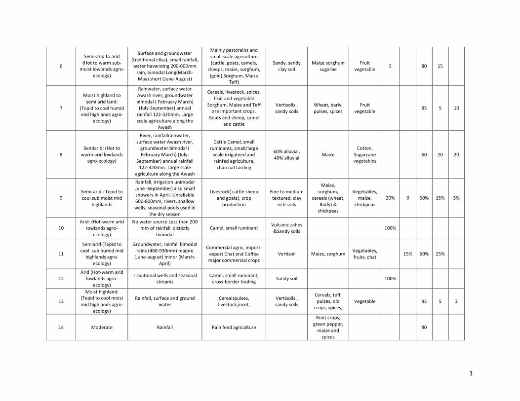
LIVELIHOODZONE15
RiftValleylivelihoodsystem
This livelihood zone is part of theGreat Rift Valley depressionwith high concentration of freshwater
lakes.Hottowarm,humid,lowlands,hottowarmmoistlowlandsandhottowarmsub‐moistlowlandsmake up the agro‐ecology of the livelihood zone. The topography is predominantly plains withundulatingfeaturesandacaciatrees,bushandgrasslandsdominatethevegetationcover.Mostofthe
freshwaterlakesoftheRiftValleyareaareconcentratedinthislivelihoodzonemakingitanattractivedestinationbothforlocalandinternationaltourists.
MajorriversincludeBulbula,Meki,HulukaandHarakelo.Thelivelihoodzoneisasanctuaryforwildlife,especially for a variety of birds includingmigratory. In addition to thehuge geothermal potential the
area is also endowedwith soda ash. TheGanna is themajor rainy season that extends from June toSeptember, while Arfasa is the minor rainy season occurring from March to April. The soils of thelivelihoodzonearesandyandlessfertile.Althoughthelivelihoodzonehashugegrazingpotential, it is
frequentlyaffectedbymoisturestress.
Thelivelihoodzoneisafooddeficitzonereceivingfoodaidduringdrought.Maizeisthemajorcultivatedcrop,while haricot beans are grown for income. The low level of soil fertility, coupledwithmoisturestress,keepagriculturalproductionandproductivityverylow.Thereisanincreasedflowofinvestment
intoirrigatedagriculturebothbylarge‐scaleaswellassmall‐scalefarmers.
Themain types of livestock kept include cattle and shoats in a free grazing system.Main sources ofwater during the rainy seasons are rivers, surface rainwater, seasonal ponds and community ponds.Duringthedryseasonriversandcommunitypondsbecometheonlysourcesofwater.Waterqualityis
affected by the high fluoride content, which is a problem for human health. Market access in thelivelihoodzoneisgood.

1
1
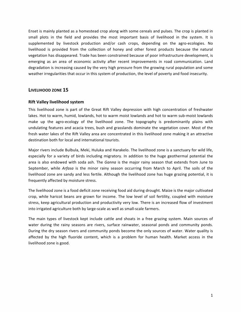
ANNEX1–VIVELIHOODZONESATTRIBUTETABLE‐GENERALCHARACTERISTICS
Maincrops FarmerstypologyLivelihood
zoneMainclimate
Mainwatersourceforagriculture
Mainsourcesofliving(typeofproduction,incometypology,etc.)
Maintypeofsoil
Rainfed Irrigated A B C D E
1
Arid:(Hot‐warmsemi‐aridlowlandsagro‐
ecology)
RainfallUnimodalMeher‐Majorrains)rainfall(JuneJulyAugust(350‐750mm),shallow
wellsfordomesticuse
Mixedsystem‐Livestock,cropproductionLivestockdominatedbycattleand
Shoats
ModeratelyfertileBlack
clay
Sorghum&sesame
0 0 <5% 70% 25%
2
(Tepidtocoolmoistmidhighlands
agroecology)‐humid,unimodal&bimodal
RainfallLongUnimodalrainfall(May,JuneJulyAugust,
September,
ModeratelyproductivemixedfarmingCrop
production
Moderatelyfertile,clay,vertisolandclayloam,mediumtextured
Cereals&pulses
Vegetables,maize
3% 15% 80% 2% 0
3
(Tepidtocoolmoistmidhighlands
agroecology)‐humid,unimodal&bimodal
RainfallLongUnimodalrainfall(May,JuneJulyAugust,
September,
ModeratelyproductivemixedfarmingCrop
production
Moderatelyfertile,clay,vertisolandclayloam,mediumtextured
Cereals&pulses
Vegetables,maize
3% 15% 80% 2% 0
4Hotandwarm
climateRainfall Farmers,andtraders
Teff,sorghum,maizeandserials
10 80
5(Tepidtocoolsub
humidmidhighlandsagro‐ecology)
Rain,groundwater,surfacewaterUnimodalRinfalloneofthehighest1200‐1700)longrainyseasonApril‐October‐oneagriculturalseason
Coffee,spices,maize,fruits,vegetablemajorcoffeeproducingarea.
Cattleandshoatsarethemainlivestock
RedclaysoilLoamsoilwithmoderateproductivity
Coffee,Chatmaize,sprices,cereals,root
crops
Vegetable 97 3
1
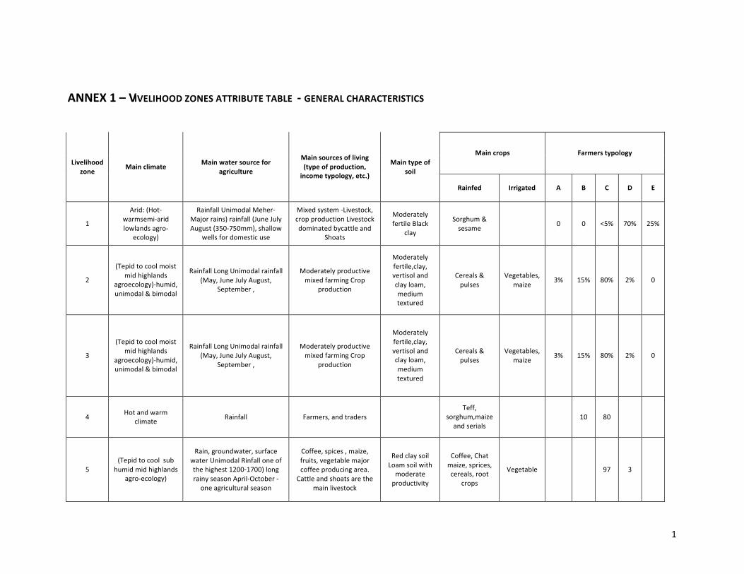
6
Semi‐aridtoarid(Hottowarmsub‐
moistlowlandsagro‐ecology)
Surfaceandgroundwater(trsditionalellas),smallrainfall,waterhaversting200‐600mmrain,bimodalLong(March‐May)short(June‐August)
Mainlypastoralistandsmallscaleagriculture(cattle,goats,camels,
sheeps,maize,sorghum,(gold),Sorghum,Maize
Teff)
Sandy,sandyclaysoil
Maizesorghumsugarbe
Fruitvegetable
5 80 15
7
Moisthighlandtosemiaridland:
(Tepidtocoolhumidmidhighlandsagro‐
ecology)
Rainwater,surfacewaterAwashriver,groundwaterbimodal(FebruaryMarch)(July‐September)annualrainfall122‐320mm.Largescaleagriculturealongthe
Awash
Cereals,livestock,spices,fruitandvegetable
Sorghum,MaizeandTeffareimportantcrops.
Goatsandsheep,camelandcattle
Vertisoils,sandysoils
Wheat,barly,pulses,spices
Fruitvegetable
85 5 10
8Semiarid:(Hotto
warmaridlowlandsagro‐ecology)
River,rainfallrainwater,surfacewaterAwashriver,groundwaterbimodal(FebruaryMarch)(July‐
September)annualrainfall122‐320mm.Largescale
agriculturealongtheAwash
CattleCamel,smallruminants,small/largescaleirrigateedandrainfedagriculture,charcoaltarding
60%alluvial,40%alluvial
MaizeCotton,
Sugarcanevegetables
60 20 20
9Semi‐arid:Tepidtocoolsubmoistmid
highlands
Rainfall,irrigationunimodalJune‐September)alsosmallshowersinApril.Unreliable600‐800mm,rivers,shallowwells,seasonalpoolsusedin
thedryseason
Livestock(cattlesheepandgoats),crop
production
Finetomediumtextured,clay
richsoils
Maize,sorghum,
cereals(wheat,Barly)&chickpeas
Vegetables,maize,
chickpeas20% 0 60% 15% 5%
10Arid:(Hot‐warmarid
lowlandsagro‐ecology)
NowatersourceLessthan200mmofrainfalldistictly
bimodalCamel,smallruminant
Vulcanicashes&Sandysoils
100%
11
Semiarid(Tepidtocoolsubhumidmidhighlandsagro‐
ecology)
Groundwater,rainfallbimodalrains(460‐930mm)majore(June‐august)minor(March‐
April)
Commercialagric,import‐exportChatandCoffeemajorcommercialcrops
Vertisoil Maize,sorghumVegetables,fruits,chat
15% 60% 25%
12Arid(Hot‐warmarid
lowlandsagro‐ecology)
Traditionalwellsandseasonalstreams
Camel,smallruminant,cross‐bordertrading
Sandysoil 100%
13
Moisthighland:(Tepidtocoolmoistmidhighlandsagro‐
ecology)
Rainfall,surfaceandgroundwater
Cerealspulses,livestock,incet,
Vertisoils,sandysoils
Cereals,teff,pulses,old
crops,spices,Vegetable 93 5 2
14 Moderate Rainfall Rainfeedagricalture
Rootcrops,greenpepper,maizeandspices
80
1
15 Semi‐aridtoarid
Surfacewater,rainwater,groundwaterbimodalrainslong(June‐September),short
(April‐May)500‐800mmannualprecipitation
Livestock(cattle,sheep,goatsandchicken),
vegetable,fruit,cereals
Sandandclaysoils
Cereals,pulses,maize,
Vegetable,maize,
87 10 3
16
Semi‐arid(Hottowarmsubhumidlowlandsagroecology):
Surfacewaterandrainfall400‐500mmrainfallbimodal,(March‐May)(September‐
October)
Cross‐bordertrading,fishing,agro‐pastoral
Don'tknow Maize Coffe 90
17
Semi‐arid:Hottowarmsub‐moistlowlandsagro‐
ecology)
Unimodalrainfall(June‐September)about800mm
Farmers,andtradersVertisolandClayloam
Maize,sorghum.Fingermillets,Sesamecotton
80
1
ANNEX2–CIVELIHOODZONESATTRIBUTETABLE‐BOCIOECONOMICASPECTS
Marketaccess(high,moderate,limited)
Livelihoodzone
Averagelandholdingsize(ha)
Mainconstraintsforlivelihoods
Leveloffoodinsecurity(high,
moderate,limited)
Incidenceofruralpoverty
(high,moderate,limited)
Inputs Outputs
Ruralpopdensity
Migrationissues
%female‐headed
householdOtheraspects Notes
1 >2
Watershortage,erraticrainfall,
economic&socialinfrastructure
Limited
LimitedVerypoor20%,poor30%,middle
30%Better‐off20%
Moderate ModerateSparcelypopulated
No ItisanissueEffectofmalaria
epidemic,shortageoflabor
2 1
Shortageofcultivableland,erraticrainfall,
shortageofwaterforagric,land
degradation,poorinfrastructure
High High Moderate ModerateDenselypopulated
Yes,exists Itisanissue
Shortageofagriculturalland,lackofmarketfor
vegetables,traditionalfarmimplements
3 1
Shortageofcultivableland,erraticrainfall,
shortageofwaterforagric,land
degradation,poorinfrastructure
High High Moderate ModerateDenselypopulated
Yes,exists Itisanissue
Shortageofagriculturalland,lackofmarketfor
vegetables,traditionalfarmimplements
4 <2haLesslandownership,
traditionalfarmingModerate Moderate Low
Sparselypopulated
Insignificant No
1
5
Coffeefarmersareconsidered
astraditionalastheir
productivityisverylow
3
Inefficientuseofressources,
livestockdesease
Moderate‐
good
6 <2ha
Erraticrainfallandpoorinfrstructure,accesstomarketandroads,low
waterdevelopment
Moderatewithseasonalpeacks
Moderatwithseasonalpeacks
Limited LimitedSparselypopulated
Nomadic.Agropastoralmigration
Low
7 3
Lackofprivatelandpropertyrights(notallcertified)andcommonlands=unappropriate
landuses,moisturestress,inefficientuseofressources,infrastructure,
market
8 >1haFlooding,salinity,curlture(nomads)
Moderate High Moderate Moderate Low Low 5
Peopleuselandforkeepingcattleand
workinlargescaleestate,nomadshavenotadaptedtofarming
9 >1.5
Shortageofgrazingland,erraticrainfall,
shortageofwaterforagric,poorinfrastructure
Moderate Moderate Moderate ModerateModeratelypopulated
Yes,exists Itisanissue
Effectofmalariaepidemic,
livestockdisease,shortageoflabor
1
10Clan
holding
Harshclimate,salinity,vulcanicsoil,accessto
marke
Low High Low Low Low Low 5
Lackofawareness,culturalinfluence,marginal
developmentactivity
11 0.5Landscarcity,degradation
Moderate Moderate High High Low Low 5
12Clan
holdingWaterscarcity,
insecurityLow High None None Low Low 5
Lackofawareness,culturalinfluence,marginal
developmentactivity
13 Landscarcity,degradation
Waterlogging,land
fragmentation,inefficientuse
ofwater
HighModerate‐
good
14 <2ha
Rainfall,traditionalagricalturalsystem,high
populationdensity
High High Moderate High High
Alotoffarmingactivityisdonebyfemales
15 Droughthazards,poorsoilfertility,waterquality
Moistureconstraint,inefficientofwater,price
variability,poorguidanceforirrigationschemes
High Good
16 <2haErraticrainfallandpoorinfrastructure
Moderate Moderate Limited Limited Low
Significantcross
border,forlabourand
trade
Femalecroppingsystem,
femaleownland
17 <2ha
Rainfall,traditionalagricaltural
system,illegaltrade
High HighHigh
(illegal) Scattered
Significantcross
border,forlabourand
trade
Low
1
ANNEX3–EIVELIHOODZONESATTRIBUTETABLE‐BATER‐RELATEDASPECTS
Livelihoodzone
Mainwater
resources
Mainwateruse(farming,livestock,domestic,
etc.)
Mainwater‐relatedconstraints
Seasonality
(bimodal,
unimodal,etc.)
Frequenceof
droughtsanddryspells
Frequenceof
floods
TowhatextentAWMcan
improvelivelihoods
Localconflicts(compet
inguses)onwatermanagement
LevelofAWMdevelopment(high,medium,low)
Surfacewateravail
Groundwater
availability
Levelsurfacewater
exploitation
Levelgroundwa
terexploitatio
n
PhysicalAWMpotenta
il
Reuseof
waterforagriculture
Waterquality
problemsfor
agriculture(salinity,sodicity,etc.)
Ethnicity
implicationsforAWM
Notes
1
2
3
4
GW,surfacewaterandrainfall
DomesticScarsityofwater,malariaandtse‐tse
fly
Unimodal
Low LowIfthereisAWM,itishigh
No Low High High Low High High LowInsignifica
ntLow
5
Rain,groundwater,surfacewater
Foralltheabove
Poorawarenessoftheresource,highcostfordiversion
anddamconstruction,
topographiccontrollforlowschemirrigation,poorextesionsurvice
Unimodal
Low Low Highly None Low Good Good Low Low Medium None NoneLimited
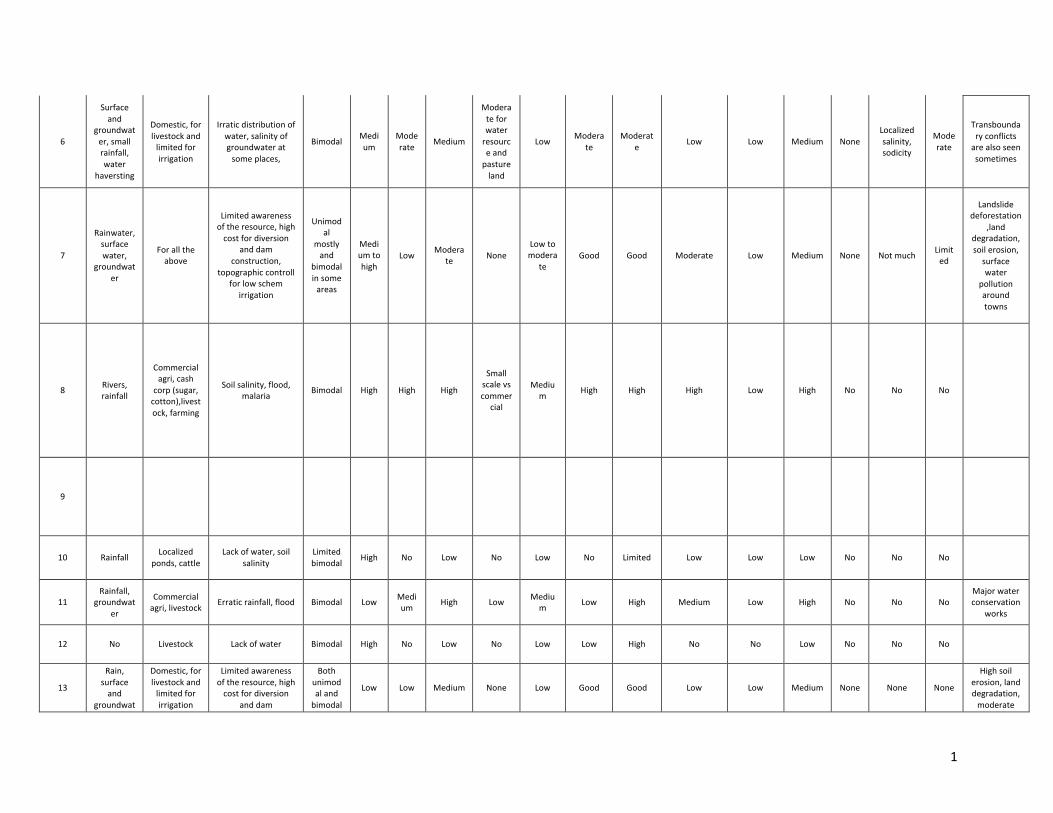
1
6
Surfaceand
groundwater,smallrainfall,water
haversting
Domestic,forlivestockandlimitedforirrigation
Irraticdistributionofwater,salinityofgroundwateratsomeplaces,
BimodalMedium
Moderate
Medium
Moderateforwaterresourceandpastureland
LowModera
teModerat
eLow Low Medium None
Localizedsalinity,sodicity
Moderate
Transboundaryconflictsarealsoseensometimes
7
Rainwater,surfacewater,
groundwater
Foralltheabove
Limitedawarenessoftheresource,highcostfordiversion
anddamconstruction,
topographiccontrollforlowschem
irrigation
Unimodal
mostlyand
bimodalinsomeareas
Mediumtohigh
LowModera
teNone
Lowtomodera
teGood Good Moderate Low Medium None Notmuch
Limited
Landslidedeforestation
,landdegradation,soilerosion,surfacewater
pollutionaroundtowns
8Rivers,rainfall
Commercialagri,cashcorp(sugar,cotton),livestock,farming
Soilsalinity,flood,malaria
Bimodal High High High
Smallscalevscommer
cial
Medium
High High High Low High No No No
9
10 RainfallLocalized
ponds,cattleLackofwater,soil
salinityLimitedbimodal
High No Low No Low No Limited Low Low Low No No No
11Rainfall,
groundwater
Commercialagri,livestock
Erraticrainfall,flood Bimodal LowMedium
High LowMedium
Low High Medium Low High No No NoMajorwaterconservation
works
12 No Livestock Lackofwater Bimodal High No Low No Low Low High No No Low No No No
13
Rain,surfaceand
groundwat
Domestic,forlivestockandlimitedforirrigation
Limitedawarenessoftheresource,highcostfordiversion
anddam
Bothunimodalandbimodal
Low Low Medium None Low Good Good Low Low Medium None None None
Highsoilerosion,landdegradation,moderate
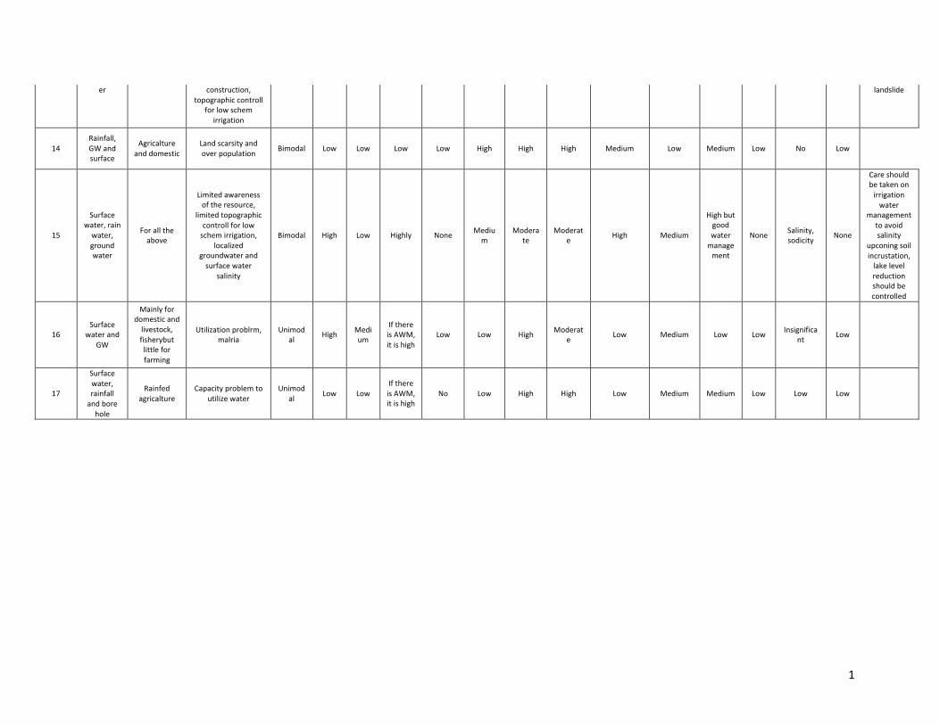
1
er construction,topographiccontroll
forlowschemirrigation
landslide
14Rainfall,GWandsurface
Agricaltureanddomestic
Landscarsityandoverpopulation
Bimodal Low Low Low Low High High High Medium Low Medium Low No Low
15
Surfacewater,rainwater,groundwater
Foralltheabove
Limitedawarenessoftheresource,
limitedtopographiccontrollforlowschemirrigation,
localizedgroundwaterandsurfacewater
salinity
Bimodal High Low Highly NoneMedium
Moderate
Moderate
High Medium
Highbutgoodwatermanagement
NoneSalinity,sodicity
None
Careshouldbetakenonirrigationwater
managementtoavoidsalinity
upconingsoilincrustation,lakelevelreductionshouldbecontrolled
16Surface
waterandGW
Mainlyfordomesticandlivestock,fisherybutlittleforfarming
Utilizationproblrm,malria
Unimodal
HighMedium
IfthereisAWM,itishigh
Low Low HighModerat
eLow Medium Low Low
Insignificant
Low
17
Surfacewater,rainfallandborehole
Rainfedagricalture
Capacityproblemtoutilizewater
Unimodal
Low LowIfthereisAWM,itishigh
No Low High High Low Medium Medium Low Low Low