european environment european commission … environment commission european ... 2008 04:30 utc. ......
TRANSCRIPT

GEOSS for Ecosystems
The GEO Ecosystems Societal Benefit Area
Research policy
EnvironmentE U R O P E A NCOMMISSION
European Research Area
KI-31-10-595-E
N-CRecognising the need to improve our
understanding of the Earth system and enhance our ability for informed decision making for the benefit of our planet and the sustainability of our societies, over 130 governments and leading international organisations are participating in the Group on Earth Observations, or GEO, to coordinate the construction of a Global Earth Observation System of Systems (GEOSS) by the year 2015.
This series of brochures provides a snapshot of the process developed by the GEO to build the GEOSS taking advantage of the international framework of cooperation and of the common vision to share and integrate information with a view to serving nine Societal Benefit Areas.
Examples of contributions from European and the European Commission-funded projects benefiting to the specific societal area or to the GEOSS building blocks are presented in each thematic brochure
GEOSS for DisastersGEOSS for HealthGEOSS for EnergyGEOSS for ClimateGEOSS for WaterGEOSS for WeatherGEOSS for EcosystemsGEOSS for AgricultureGEOSS for Biodiversity
Architecture and Data Management within GEOCapacity Building within GEOScience and Technology within GEOUser Engagement within GEO
http://ec.europa.eu/research/environment/index_en.cfm?pg=earth
Interested in European research?
Research*eu is our monthly magazine keeping you in touch with main developments (results, programmes, events, etc.). It is available in English, French, German and Spanish. A free sample copy or free subscription can be obtained from:
European Commission Directorate-General for ResearchCommunication UnitB-1049 Brussels, BelgiumFax (32-2) 29-58220E-mail: [email protected]: http://ec.europa.eu/research/research-eu
EUROPEAN COMMISSION
Directorate-General for ResearchDirectorate I – EnvironmentUnit I.4 – Management of natural ressources
Contact: Jane Shiel
European CommissionOffice CDMA 03/173B-1049 Brussels
Tel. +32 2 29 62984
E-mail: [email protected]
EUROPEAN COMMISSION
GEOSS for Ecosystems
The GEO Ecosystems Societal Benefit Area
Directorate-General for Research2010 Cooperation : Environment EUR 10595 EN
LEGAL NOTICE
More information on the European Union is available on the Internet (http://europa.eu).
Cataloguing data can be found at the end of this publication.
Luxembourg: Publications Office of the European Union, 2010
ISBN 978-92-79-16600-6doi 10.2777/22311
© European Union, 2010Reproduction is authorised provided the source is acknowledged.
Printed in Belgium
Printed on elemental chlorine-free bleached PaPer (ecf)
EUROPE DIRECT is a service to help you find answers to your questions about the European Union
Freephone number (*):
00 800 6 7 8 9 10 11(*) Certain mobile telephone operators do not allow access to 00 800 numbers
or these calls may be billed
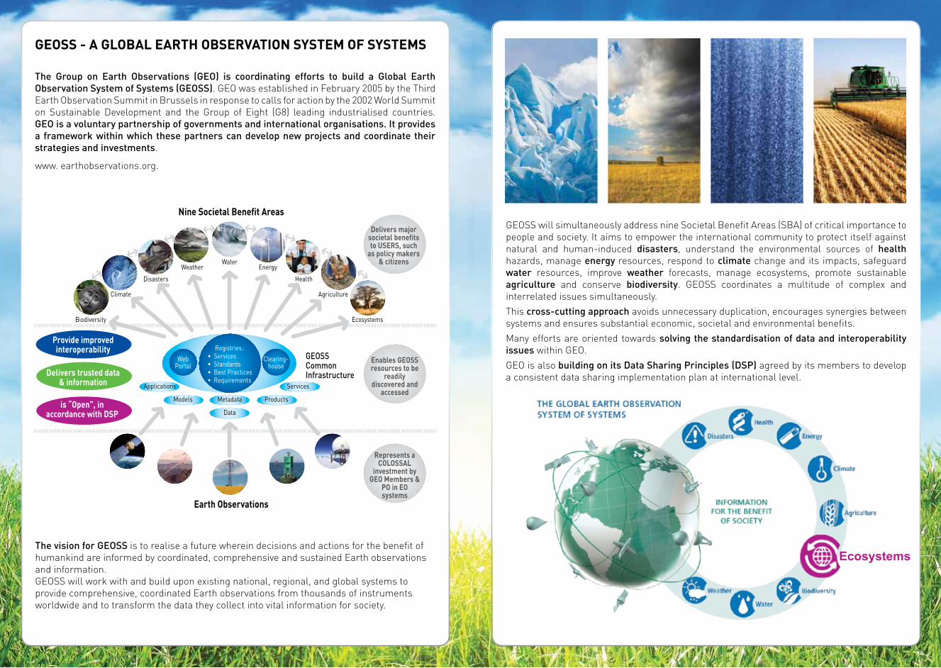
Delivers majorsocietal benefitsto USERS, such
as policy makers & citizens
Represents aCOLOSSAL
investment byGEO Members &
PO in EOsystems
Enables GEOSSresources to be
readilydiscovered and
accessed
Provide improvedinteroperability
Delivers trusted data& information
is “Open”, inaccordance with DSP
Biodiversity Ecosystems
Climate
Applications
Models
WebPortal
Clearing- house
Registries :• Services• Standards• Best Practices• Requirements
ProductsMetadata
Data
Services
GEOSSCommonInfrastructure
Agriculture
Disasters Health
Weather EnergyWater
Nine Societal Benefit Areas
Earth Observations
Ecosystems
The Group on Earth Observations (GEO) is coordinating efforts to build a Global Earth Observation System of Systems (GEOSS). GEO was established in February 2005 by the Third Earth Observation Summit in Brussels in response to calls for action by the 2002 World Summit on Sustainable Development and the Group of Eight (G8) leading industrialised countries. GEO is a voluntary partnership of governments and international organisations. It provides a framework within which these partners can develop new projects and coordinate their strategies and investments.
www. earthobservations.org.
GEOSS - A GLOBAL EARTH OBSERVATION SYSTEM OF SYSTEMS
GEOSS will simultaneously address nine Societal Benefit Areas (SBA) of critical importance to people and society. It aims to empower the international community to protect itself against natural and human-induced disasters, understand the environmental sources of health hazards, manage energy resources, respond to climate change and its impacts, safeguard water resources, improve weather forecasts, manage ecosystems, promote sustainable agriculture and conserve biodiversity. GEOSS coordinates a multitude of complex and interrelated issues simultaneously.
This cross-cutting approach avoids unnecessary duplication, encourages synergies between systems and ensures substantial economic, societal and environmental benefits.
Many efforts are oriented towards solving the standardisation of data and interoperability issues within GEO.
GEO is also building on its Data Sharing Principles (DSP) agreed by its members to develop a consistent data sharing implementation plan at international level.
The vision for GEOSS is to realise a future wherein decisions and actions for the benefit of humankind are informed by coordinated, comprehensive and sustained Earth observations and information. GEOSS will work with and build upon existing national, regional, and global systems to provide comprehensive, coordinated Earth observations from thousands of instruments worldwide and to transform the data they collect into vital information for society.

GEO Work Programme relating to ECOSYSTEMSUnder the current GEO Work-Plan 2009-2011, the Ecosystems issue is addressed in two main tasks organised in sub-tasks :
EC-09-01 Ecosystem Observation and Monitoring Network (GEO EcoNet) Coordinate and improve the observation, characterisation and monitoring of terrestrial, freshwater, ice and oceans ecosystems. Develop a global integrated sampling frame in coordination with the GEOSS Geodesy activities. a) Ecosystem Classification and Mapping
Continue efforts to produce a standardised, robust, and practical classification and map of global ecosystems at management-appropriate scales for terrestrial, freshwater, and marine environments. Integrate the global ecosystems product with existing ecosystem maps and databases.
b) Ecosystem Functions and ServicesCoordinate the collection, processing and distribution of bio-geophysical and land surface parameter data. Coordinate the continuing characterisation and monitoring of ecosystems status and trends. Using the GEO Ecosystem map as a framework, extract geospatial data on key indicators of all ecosystems’ status, health and functioning.
c) Regional Networks for EcosystemsBuild upon the successful extension of the regional-scale ANTARES project (South America) to the global-scale ChloroGIN project – under POGO and IOCCG. Further develop existing regional networks initiatives (e.g. IOC-sponsored; GOFC-GOLD and ILTER).
d) Protected Areas Assessment and Monitoring (GEO PAAM)Apply Earth observation to the characterisation, mapping and monitoring of global protected areas consisting of UNESCO World Heritage sites & Biosphere Reserves; RAMSAR Wetlands, natural areas; and sites of cultural, geological and archaeological significance. Improve dissemination of Earth observation data to protected area planners and managers.
e) Forest Mapping and Change MonitoringIntegrate international efforts on assessment and monitoring of forests and forest changes using a combination of ground and satellite information and internationally agreed standards. Make relevant synergies with Climate task on Forest Carbon Tracking and Disaster task on the Implementation of a Fire Warning System at Global Level.
EC-09-02 Ecosystem Vulnerability to Global ChangeIdentify and assess the risks posed by global change and human development to the environment, society and regional economies. Support the development of adaptation strategies to reduce these risks and mitigate impacts at local, regional and global levels.
a) Impact of Tourism on Environmental and Socio-Economic Activities
Map potential impacts of global change on key sectors of Eastern Mediterranean’s economy and society.
b) Impact of Transport Infrastructure Developments
Identify, map and assess environmental risks to support the development of transport infrastructure in Africa.
c) Vulnerability of Sea BasinsDevelop a collaborative management system to store, analyse, visualise and disseminate crucial data and information on past, present and future states of European seas.
d) Vulnerability of Mountain RegionsProduce and disseminate more complete information on the local, regional and global impact of climate change in mountain regions. Implement a high-elevation climate and environment monitoring network, starting with the existing SHARE network. Build upon the European project ACQWA to analyse the future of water resources in vulnerable mountain regions and deliver water-policy recommendations to decision-makers.
GEOSS FOR ECOSYSTEMS
The GEOSS Strategic Target for Ecosystems is the following :
Before 2015, GEO aims to :
Establish, in conjunction with a comprehensive biodiversity observation network, a wide-ranging monitoring capability for all ecosystems and the human impacts on them, to improve the assessment, protection and sustainable management of terrestrial, coastal and marine resources and the delivery of associated ecosystem services.
This will be demonstrated by :
• Implementation of a global standardised ecosystem classification system and map as a basis for worldwide inventory, assessment and monitoring.
• Implementation of a global, standardised inventory of major ecosystems and the protected areas within them.
• Increased operational monitoring of major ecosystems on land on an annual basis, including properties such as land cover type; species composition; vegetation structure, height and age; net ecosystem productivity; and biomass and carbon estimates of vegetation and soils based on remote sensing and sampled in- situ observations using internationally agreed standards.
• Increased operational monitoring of major marine and coastal ecosystems on an annual basis including properties such as extent, water temperature, salinity, pH and pCO2, phytoplankton species composition and productivity and marine resource stocks, based on remote sensing and sampled in-situ observations using internationally agreed standards.
• Increased knowledge of environmental flow requirements of river base flow and peak flow, as well as human requirements for irrigation and power plant cooling water and domestic usage.
Target 2015

Targeted field campaigns are carried out regularly to complement the long term measurements of oxygen observatories. Scientist from the Scottish Association for Marine Science (SAMS) are retrieving a benthic chamber system that determines oxygen uptake by the sediments of Loch Etive, a fjord-like sea loch in Scotland. Photograph courtesy of Henrik Stahl, SAMS.
The Loch Etive cabled observatory is one example of observatories that are installed in HYPOX to resolve oxygen dynamics by continous measurements of oxygen and related parameters.
The occurrence of hypoxic conditions is increasing world-wide mainly as a consequence of anthropogenic eutrophication and global warming. Ecosystems become anoxic environments where micro-organisms replace all higher life.
HYPOX deploys several observatories in coastal and open seas and in land-locked water-bodies as a first step towards a global observation system for continuous oxygen monitoring. HYPOX includes experimental
and modelling studies on hypoxia drivers and consequences for ecosystems. Based on HYPOX monitoring data, experimental results, and numerical simulations, predictive and decision-making capabilities can be gained. The collected information and the description of services and products will be made available in compliance with GEOSS principles. (www.hypox.net).
Anomaly in land surface temperature during the week of 21-28 August 2006.
Atmospheric boundary layer height simulation with the GRAPES model, July 16th 2008 04:30 UTC.
Examples of the European Projects contributing to the Ecosystems SBA
Human life and the entire ecosystem of South East Asia depend upon the monsoon climate, its link to land-surface hydrology and its predictability. The headwaters areas of the Yellow River, the Yangtze, Mekong, Salween, Irrawaddy, Brahmaputra and Ganges are located in the Tibetan plateau. CEOP-AEGIS aims to construct an observing system to determine and monitor water-yield of the Tibetan plateau to determine how much water is going into the seven major rivers of S.E. Asia. The project also aims to monitor snow, vegetation and surface fluxes as a precursor of intense precipitation and improve forecasts of extreme precipitation in S.E. Asia. The time-series of image data will be used to demonstrate an early-warning system for drought and floods. (www.ceop-aegis.org).

Long-term observation of our oceans is vital to understanding how the ocean functions and how it is changing in response to climate change. Ocean observatories are key infrastructures fixed at locations in the global ocean and are used to measure biological, chemical and physical variables. EuroSITES aims at integrating and enhancing the existing
in-situ infrastructure of 9 European deep-ocean observatories. Integration is being carried out across Europe and is advancing ocean observation beyond the current state of the art. EuroSITES will be an essential component of European and International Ocean Observation programmes including GOOS (Global Ocean Observing System) and GEOSS. (www.eurosites.info).
The Black Sea hydrological catchment is a case study to test the capacity of integrating large datasets to assess vulnerability and sustainability issues related to freshwater resources at various scales. The Black Sea region is internationally known for its ecologically unsustainable development and inadequate resource management which have led to several environmental, social and economic problems. EnviroGRIDS aims to assemble an observation system of the Black Sea catchment that will address several GEO Societal Benefit Areas. This system will
incorporate a shared information system that operates on the boundary of scientific/technical partners, stakeholders and the public. It will contain an early warning system able to inform decision-makers and the public about risks to human health, biodiversity and ecosystem integrity, agriculture production or energy supply caused by climatic, demographic and land cover changes with a 50-year time horizon. (www.envirogrids.net).
ACQWA (Assessing Climatic change and impacts on the Quantity and quality of Water), has as scientific objectives to assess the impacts of climate change on water resources in vulnerable mountain regions where snow and ice are major components of the hydrological cycle; to use, refine, and develop numerical hydrological and process models to help understand interlinks between climate system components : climate, hydrology, snow and ice, vegetation; to predict the evolution of these systems over the next 50 years. The results of this research will be useful for water managers at a local level and policy makers at a regional level. In addition, the project will allow comparisons between European and non- European mountain regions (Central Asia, Argentine and Chilean Andes) to determine whether or not production technologies, consumption patterns, and regulatory frameworks developed in Europe can be successfully adopted elsewhere.(http://www.acqwa.ch).

Benefitting from Earth-observation satellite data, the Global Monitoring for Environment and Security (GMES) Land Services provide cross-border harmonised geo-information at global to local scales in a time- and cost-effective manner. GEOLAND2 builds upon the results of projects funded by the EC and ESA and is working towards the implementation of fully mature GMES Land Services. (www.gmes-geoland.info).
Acid Mine Drainage in South Africa.
Making reliable and objective information about ecosystems, populations and societies affected by mineral resource exploration and exploitation available to industrialists, regulatory bodies and stakeholders to foster mutual exchanges based on reliable undisputable data.
The Earth Observation for Monitoring and Observing Environmental and Societal Impacts of Mineral Resources Exploration and Exploitation (EO-Miners) project is supported by the FP7 Co-operation Programme. The project aims to address a strategic gap in GEO and to identify synergies. The project aims to further demonstrate the capabilities of integrated EO-based methods and tools in monitoring, managing and contributing to reducing the footprint of the extractive industry.
Using cutting-edge remote sensing technologies IMPACTMIN is developing a cost-effective, reliable and replicable approach in order to identify and predict potentially serious consequences of mining for the natural and human environment. The project addresses the need for
the provision of accurate, timely information for decision makers. Developing and sharing of methods for modelling and analysis in order to transform data into useful products is being advocated in line with the aims of the GEOSS. (www.impactmin.eu).
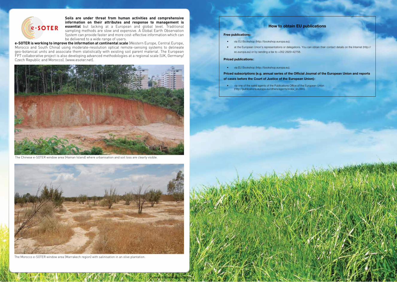
The Chinese e-SOTER window area (Hainan Island) where urbanisation and soil loss are clearly visible.
The Morocco e-SOTER window area (Marrakech region) with salinisation in an olive plantation.
How to obtain Eu publications
Free publications :
• via EU Bookshop (http://bookshop.europa.eu);
• at the European Union’s representations or delegations. You can obtain their contact details on the Internet (http://
ec.europa.eu) or by sending a fax to +352 2929-42758.
Priced publications :
• via EU Bookshop (http://bookshop.europa.eu).
Priced subscriptions (e.g. annual series of the Official Journal of the European union and reports
of cases before the Court of Justice of the European union) :
• via one of the sales agents of the Publications Office of the European Union (http://publications.europa.eu/others/agents/index_en.htm).
Soils are under threat from human activities and comprehensive information on their attributes and response to management is essential but lacking at a European and global level. Traditional sampling methods are slow and expensive. A Global Earth Observation System can provide faster and more cost-effective information which can be delivered to a wide range of users.
e-SOTER is working to improve the information at continental scale (Western Europe, Central Europe, Morocco and South China) using moderate-resolution optical remote-sensing systems to delineate geo-botanical units and associate them statistically with existing soil parent material. The European FP7 collaborative project is also developing advanced methodologies at a regional scale (UK, Germany/Czech Republic and Morocco). (www.esoter.net).
Pictures © Shutterstock, 2010