evaluating state land use control: perspectives and hawaii
TRANSCRIPT
Urban Law Annual ; Journal of Urban and Contemporary Law
Volume 18
January 1980
Evaluating State Land Use Control: Perspectivesand Hawaii Case StudyG. Kem Lowry Jr.
Follow this and additional works at: https://openscholarship.wustl.edu/law_urbanlaw
Part of the Law Commons
This Article is brought to you for free and open access by the Law School at Washington University Open Scholarship. It has been accepted forinclusion in Urban Law Annual ; Journal of Urban and Contemporary Law by an authorized administrator of Washington University Open Scholarship.For more information, please contact [email protected].
Recommended CitationG. Kem Lowry Jr., Evaluating State Land Use Control: Perspectives and Hawaii Case Study, 18 Urb. L. Ann. 085 (1980)Available at: https://openscholarship.wustl.edu/law_urbanlaw/vol18/iss1/3
EVALUATING STATE LAND USE
CONTROL: PERSPECTIVES AND HAWAII
CASE STUDY
G KEM LO WRY, JR.*
I. INTRODUCTION
A state role in land development control, considered "revolution-ary" a decade ago, has become commonplace in recent years. Atleast thirty-four states exercise some type of regulatory authority overland development, although the level of state involvement and thepurposes for which state authority is exercised vary widely.' Stateshave developed or are developing programs to manage flood plainsand wetlands,' designate and regulate development in critical areas,3
site power plants and other regional facilities,4 protect agriculturalland.5 regulate surface mining6 and achieve other goals.7
The case for a state role in land development control is based on
W Assistant Professor of Urban & Regional Planning, University of Hawaii. B.A.,
Washburn. 1964; Ph.D., University of Hawaii, 1976. The author wishes to acknowlegecomments on previous drafts by Professors Edward Kaiser and David Godschalk,Department of City and Regional Planning, University of North Carolina at ChapelHill; Professors Tom Dinell and John Holmstrom, Urban and Regional PlanningProgram; and Professor David Callies, School of Law, University of Hawaii.
1. COUNCIL OF STATE GOVERNMENTS, STATE GROWTH MANAGEMENT (1976).2. E.g., GA. CODE ANN. § 43-2413 (1977); ME. REV. STAT. tit. 38, § 3 (1978).
3. Eg., FLA. STAT. ANN. § 380.05 (West Supp. 1979).
4. ME. REV. STAT. tit. 38, § 3 (1978); OHIO REV. CODE ANN. § 4906.01-4906.15,§ 4906.98-4906.99 (Supp. 1978) WASH. REV. CODE § 80.50.010-80.50.902 (Supp.1979).
5, E.g., MINN. STAT. ANN. § 273.111 (Supp. 1978); HAWAII REV. STAT. § 246-12,
Washington University Open Scholarship

URBAN LAW ANNUAL
several arguments.8 Perhaps the most prominent argument is that thelocal structure of land development control is insufficiently sensitiveto the environmental consequences of local land development deci-sions. Since polluted air and water do not respect jurisdictionalboundaries, extra-local authority is required to minimize the "spill-over" of adverse environmental impacts from one jurisdiction to an-other. The Air Pollution Prevention and Control Act,9 the WaterPollution Prevention and Control Act,' ° and the National CoastalZone Management Act' I are prominent examples of federal statuteswhich have redistributed regulatory authority to state governments inorder to deal with the regional impact of local land development de-cisions.
A second argument for a larger state role in land development con-trol is that particular natural resource units such as coastal wetlandsand prime agricultural lands are statewide resources which are notadequately managed by local governments. Many states have devel-oped programs that require state permits for development in environ-mentally sensitive areas or provide incentives, such as tax breaks, forthe protection of some resource units.' 2 At the federal level, theCoastal Zone Management Act provides financial incentives tothirty-four coastal states and territories to develop programs for themanagement of coastal resources.'3 One condition of federal ap-proval of state programs is a state role in the authorization of coastaldevelopment. 14
A third rationale for a state role in land development control is thefragmentation of land use regulatory authority in many metropolitan
§ 246-12.3 to 246-12.4 (1976); CAL. GOV'T. CODE §§ 51200-51205 (Supp. 1979); CAL.REV. & TAX CODE §§ 421-429 (Deering Supp. 1977).
6. See, e.g., IOWA CODE § 83A.1-83A.31 (Supp. 1979); TENN. CODE ANN. § 58-1540 to 58-1564 (Supp. 1978).
7. E.g., CAL. GOV'T CODE § 65300 (Deering 1979) (requiring city and county leg-islative bodies to adopt a comprehensive plan).
8. See generally G. HEALY, LAND USE AND THE STATES (1976); D. MANDELKER,ENVIRONMENTAL AND LAND CONTROLS LEGISLATION (1976); N. ROSENBAUM, LANDUSE AND THE LEGISLATORS (1976).
9. 42 U.S.C. §§ 7401-7642 (Supp. 1979).10. 33 U.S.C. §§ 1251-1376 (1976).11. 16 U.S.C. §§ 1451-1464 (Supp. 1979).12. See notes 2, 5 supra.13. 16 U.S.C. § 1451 (Supp. 1979).14. Id. § 1455.
[Vol, 18:85
https://openscholarship.wustl.edu/law_urbanlaw/vol18/iss1/3
HAWAII LAND USE
areas. This fragmentation of authority, it is argued, contributes tocompetition for fiscally preferable industrial and commercial devel-opment, to exclusionary land use policies, and to a general lack ofattention to regional needs for subsidized housing or major, region-serving capital facilities. In some metropolitan areas, regional bodieshave been established to provide a broader geographic base for landdevelopment planning and control. 5
The size or the impact of certain public and private facilities hasled some states to require state development permits. While thirty-four states have power plant siting requirements, 16 a few states gomuch further. Vermont, for example, requires state developmentpermission for subdivisions and developments which are "of greaterthan local concern," defined in terms of the number of housing unitsinvolved, the amount of acreage involved or the elevation of the pro-posed development.' 7 The American Law Institute's Model LandDevelopment Code also promotes a state role in reviewing regionalfacilities with its section on "developments of regional impact or ben-efit."'"
Finally, some believe that a strong state role in land developmentcontrol is preferable to a local monopoly on control because stateauthority is less subject to the political forces that surround local citycouncils and zoning boards. Critics of locally administered land usecontrols argue that land development is an enormously profitable in-dustry, an industry whose profits go not only to landowners and de-velopers, but also to contractors, local businessmen, lawyers,mortgage bankers and a host of others. These critics suggest that thelocal administration of land use controls is dominated by such inter-ests." Ironically, at a time when decentralization of authority is be-ing touted as a solution to many ills including land use problems, 20
15. The Association of Bay Area Governments, the Twin Cities MetropolitanCouncil, and the Washington, D.C. Council of Governments are prominent exam-ples. Seegeneral/' 2 ADVISORY COMMISSION ON INTER-GOVERNMENTAL RELATIONS,SuB-STATE REGIONALISM AND THE FEDERAL SYSTEM: REGIONAL GOVERNANCE-PROMISE AND PERFORMANCE (1973).
16. See e.g., ME. REV. STAT. tit. 38, § 3(1978); OHIO REv. CODE ANN. § 4906.01-4906.15, § 4906.98-4906.99 (Supp. 1978); WASH. REV. CODE § 80.50.010-80.50.902(Supp. 1979).
17. VT. STAT. ANN. tit. 10, § 6001 (1973 & Supp. 1979).18 ALI MODEL LAND DEVELOPMENT CODE § 7-301 (1976).19. See, e.g., L. DOWNIE, MORTGAGE ON AMERICA (1974).20 For a discussion of this trend, see M. REAGAN, THE NEW FEDERALISM (1972).
1980]
Washington University Open Scholarship
URBAN LAW ANNUAL
greater centralization of authority is promoted to reform the existingstructure of land use control.2 1
The distribution of land use regulatory authority is a volatile issue.For example, while noting the "pervasive feeling that local controlhas been a failure,",22 One observer questions whether states or met-ropolitan areas can do a better job.23 Substantive arguments aboutthe relative merits of state versus local land use control illustrate thegeneral problem of determining the "success" or "failure" of any pol-icy program or series of public actions. Formal policy evaluationposes formidable conceptual and methodological problems.
Most evaluative generalizations about state land use control rest ona few impressions and anecdotes gleaned from case studies of partic-ular programs. Given the disparate purposes for which state land usecontrol programs are designed, the wide variety of control mecha-nisms employed, and the different socio-economic and political con-texts within which programs have been implemented, this is notsurprising. Now, however, there is sufficient experience with stateland use programs to begin to conduct evaluative studies.
This Article will identify five general approaches for evaluating theeffects of a comprehensive state land use control program. The vehi-cle for this analysis will be the Hawaii land use program. The studywill focus on the implementation of the Hawaii program as opposedto the conditions that led to its enactment with particular attention tothe development of concepts and analytical approaches from whichhypotheses can be generated and tested comparatively.
II. EVALUATIVE APPROACHES
Presently, studies purporting to be evaluations of state land use orenvironmental programs generally fall into five categories: legal as-sessments, goal achievement studies, administrative capability assess-ments, cost studies and compliance studies.
21. See generally F. BOSSELMAN & D. CALLIES, THE QUIET REVOLUTION INLAND USE CONTROL (1971); E. HASKELL & V. PRICE, STATE ENVIRONMENTAL MAN-AGEMENT: CASE STUDIES OF NINE STATES (1973); R. HEALY, LAND USE AND THESTATES (1976); D. MANDELKER, ENVIRONMENTAL AND LAND CONTROLS LEGISLA-TION (1976).
22. R. HEALY, LAND USE AND THE STATES 5 (1976).23. Id. at 6. See generally R. LINOWES & D. ALLENSWORTH, THE POLITICS OF
LAND USE: PLANNING, ZONING, AND THE PRIVATE DEVELOPER (1973).
[Vol, 18:85
https://openscholarship.wustl.edu/law_urbanlaw/vol18/iss1/3

HAWAII LAND USE
A. Legal Assessments
Perhaps the most prevalent type of "evaluation" is that found inlegal journals. The authors of these studies assess particular stateland use control strategies in terms of their judicial acceptability instate or federal courts.24 While judicial acceptability is a necessarycondition of program effectiveness, it is not a sufficient one. Never-theless, legal evaluations are important because they draw attentionto particular issues that may affect program implementation. Suchevaluations help to convey a sense of the boundaries of permissibleregulatory behavior and to draw attention to glaring loopholes andburdensome aspects of a particular regulatory regime. A broaderevaluative perspective, however, is needed: one that focuses on pat-terns of regulatory behavior and the distribution of benefits and bur-dens resulting from that pattern of behavior.
B. Goal Achievement
A second evaluative approach is to focus on the extent to whichstate land use programs successfully achieve their statutory objec-tives." Most of these studies rely on subjective perceptions of effec-tiveness. While most such studies focus on single cases there areexamples of comparative studies of perceived effectiveness based onlarge sample surveys. Because the standards by which effectiveness isjudged frequently are not stated, the inferences drawn from thesestudies suffer from problematic validity. Even when specific permitdecisions are discussed, the reader can only speculate how character-istic the particular case is of the total population of decisions fromwhich it is drawn. Finally, most of these studies lack an explicitframework or set of concepts to serve as a basis for comparative anal-ysis. Nevertheless, the best of these accounts provides rich sources ofdescriptive information about the problems of implementing stateland use programs.
A second type of goal achievement study seeks to trace the actual
24. See, e.g., Bosselman, Growth Management and Constitutional Rights-Part I.The Blessings af Quiet Seclusion, 8 URBAN L. ANN. 3 (1974); Hess, Institutionalizingthe Revolution: Judicial Reaction to State Land Use Laws, 9 URB. LAW. 183 (1977).
25 See, e.g., E. BOSSELMAN AND D. CALLIES, THE QUIET REVOLUTION IN LANDUSE CONTROL (1976); L. CARTER, THE FLORIDA EXPERIENCE (1974); E. HASKELL &V. PRICE, STATE ENVIRONMENTAL MANAGEMENT: CASE STUDIES OF NINE STATES(1973); R. HEALY, LAND USE AND THE STATES (1970); McCahill, Florida's Not SoQuiet Revolution, 40 PLAN. 10, 10-13 (1974).
19801
Washington University Open Scholarship
URBAN LAW ANNUAL
impacts of specific land use programs rather than relying on subjec-tive perceptions of impacts. To what extent do tax incentive pro-grams encourage landowners to dedicate land for agriculture or openspace?26 Do coastal zone regulatory programs enhance the aestheticquality of the shoreline?27 Analysts seeking to determine how stateland use programs affect the problems they were designed to addressdeal with these and other similar questions.
C. Administrative Capabilities
Another mode of evaluation is to focus on a state's administrativecapability to engage in land use control. In one such study, compo-nents of an "ideal" state planning apparatus were identified and thenstates were evaluated with respect to the extent they measured up tothat ideal.28 While this particular study has received criticism re-garding the appropriateness of the "ideal" system components andthe research methods for rating states,29 other standards and researchmethodologies might make this a more useful approach.30 Such anapproach might be particularly useful if variations in types of admin-istrative structures and administrative resources could be correlatedwith variations in patterns of regulatory behavior. This would makepossible inferences about "optimal" administrative conditions for theimplementation of state land use programs.
D. Cost Studies
One of the principal arguments against state land use and environ-mental control programs is that they impose additional developmentcosts. Cost, then, is another criterion for evaluating these programs.Increased development costs occur directly because of additional in-terest charges the developer must bear since permit processing takesmore time, and because of additional legal, planning or engineeringstudies which the new permits may require.31 Indirect costs may in-
26. See J. KEENE, D. BARRY, R. COUGHLIN, J. FERNAM, E. KELLY, T. PLANT &A. STRONG, UNTAXING OPEN SPACE (1976).
27. See R. DILTON, J. SEYMOOR & G. SWANSON, COASTAL RESOURCES MANAGE-MENT 147-166 (1977).
28. Catanese, An Evaluation of State Planning, 38 PLANNING 155 (1972).29. Letter from Jack Thomas to the Editor, 38 PLAN. 219 (October 1972).30. For a further discussion of the administration of state planning, see COUNCIL
OF STATE PLANNING AGENCIES, STATE PLANNING SERIES (1977).31. See generally BERGMAN, EXTERNAL VALIDITY OF POLICY RELATED RE-
[Vol, 18:85
https://openscholarship.wustl.edu/law_urbanlaw/vol18/iss1/3
HAWAII LAND USE
crease if the price of developable land increases in other areas as aresult of new or more stringent controls. While the current evaluativeinterest is in the costs of such programs, the costs of not having suchprograms also would be an appropriate area of inquiry.
E. Compliance Studies
Compliance studies represent a fifth evaluative approach. Compli-ance theorists are concerned with the conditions of and propensitytoward obedience.32 Compliance studies have their intellectual ante-cedents in the psychological and sociological analysis of individualdeviant behavior and in legal philosophy. In the 1960's politicalscientists, in particular, became interested in the compliance of insti-tutions such as police departments and school boards with U.S.Supreme Court decisions.33 Compliance also is an important conceptin administrative theory.34 In this field, the principal focus is oncompliance within organizations.
Environmental management is a potentially rich field for compli-ance studies although few such studies have been conducted.35 Suchstudies might focus on the consistency with which a subordinateagency implements environmental management policies of a legisla-tive body or an implementing agency follows its own substantive orprocedural guidelines in its individual regulatory or allocative deci-sions. The principal evaluative criterion in such studies is adminis-trative consistency. The principal criticism of this approach is thattoo little attention is given to the impact of the policies or guidelineson those whose behavior is regulated.
SEARCH ON DEVELOPMENTAL CONTROLS AND HOUSING COSTS (1974); C. FIELD & S.
RIVKIN. THE BUILDING CODE BURDEN (1975); D. RICHARDSON, THE COST OF ENVI-RONMENTAL PROTECTION (1976); L. SAGALYN & G. STERNLIEB, ZONING AND Hous-
ING COSTS (1973); S. SEIDEL, HOUSING COSTS AND GOVERNMENT REGULATIONS(1978).
32. COMPLIANCE AND THE LAW 10 (S. Krislov, K. Boyum, J. Clark, R. Shaefer, S.White eds. 1966).
33. See T. BECKER, THE IMPACT OF SUPREME COURT DECISIONS: EMPIRICALSTUDIES (1969); W. MUIR, PRAYER IN PUBLIC SCHOOLS (1967); Birkay, The SupremeCourt and the Bible Bel: Tennessee Reaction to the Schemp Decision, 10 MIDWEST J.
OF POLITICAL SCi. 304 (1966).34. See H. SIMON, MODELS OF MAN (1956); Litwak & Meyer, A Balance Theory
of Coordination Between Bureaucratic Organization and Community Primary Groups,II AD. ScI. Q. 31 (1966).
35. For one such study, see Bryden, The Impact of Variances: A Study of State-wide Zoning, 61 MINN. L. REV. 769 (1977).
19801
Washington University Open Scholarship

URBAN LAW ANNUAL
The study of the actual impacts of state land use programs is animportant evaluative enterprise. Because state land use programsdiffer so widely, however, the analysis of program impacts does notlend itself well to comparative evaluation. Tracing the consequencesof a wide range of permit decisions in a particular state would makefor an extremely valuable case study. Although direct and immediategeneralizations to other states would be of dubious validity, the in-sights gained from such studies could at least serve as credible hy-potheses to be tested in other states.
Although states vary widely with regard to what the state controls,it is possible to evaluate states in terms of how rigorously land useand environmental regulatory programs are enjoined. Whether stateland use regulatory programs involve comprehensive state controls,36
special purpose state permits, 37 shared state-local authority over cer-tain resources or classes of uses,38 mandatory local planning withstate review 39 or any other regulatory model, all such programs canbe evaluated in terms of how regulatory decisions are made. Specifi-cally, one can ask:
*To what extent are state land use regulatory decisions consis-tent with local preferences?*To what extent are regulatory decisions consistent with the rec-ommendations of the professional staff?*Are decisions on permits, approval of local plans or appeals oflocal decisions consistent with the legislative goals or other pol-icy objectives of the regulatory program?*If not, with what goals or policies are they consistent (i.e., whatis the manifest regulatory policy)?*Is compliance with program goals changing over time? If so,how?*What are the characteristics of permit applications the deci-sions on which depart substantially from legislated goals or en-gender conflicts with local authorities or the professional stall?Although this emphasis is not evaluative in the sense of referring to
the achievement of program goals, it makes it possible to establishsome inferences about the "success" of state land use regulatory pro-grams. The answers to these and other questions can also be useful
36. See, e.g., VT. STAT. ANN. tit. 10, § 6001 (1973 and Supp. 1979).37. See notes 2-4 supra.38. See, e.g., Coastal Area Management Act of 1974, N.C. GEN. STAT. § I13A-
100 to 113A-128 (1975).39. See note 7 supra.
[Vol. 18:85
https://openscholarship.wustl.edu/law_urbanlaw/vol18/iss1/3

HAWAII LAND USE
in guiding further inquiry into the appropriateness of the policy baseupon which decisions are made, the effect of particular decision-mak-ing arrangements on state-local relations, the impact of special inter-est groups on regulatory decisions, and related questions. Thecompliance questions above are the basis for the evaluative casestudy of Hawaii's State Land Use Law4" that follows.
III. A CASE STUDY: HAWAII
The introduction of state land use control in Hawaii was not revo-lutionary. State control has been viewed as a response to conditionsunique to the fiftieth state: a relatively small land mass, concentratedownership of land, and a history of centralized government.4
Hawaii has a land area of just over four million acres, most ofwhich is distributed among six major islands. More than five hun-dred thousand acres are mountainous or barren, unsuitable for devel-opment or agriculture. Another million and a half acres are in forestreserves, national parks, military or other uses which remove themfrom potential urban use.42
Land ownership is highly concentrated. The federal governmentcontrols nine percent of the land in the state; thirty-nine percent iscontrolled by the state government and about forty-five percent is inthe hands of major private owners.43
Hawaii's Land Use Law, originally enacted in 1961," has sincebeen amended several times.45 The law's goals, as stated in its pre-amble, are to protect the state's dwindling supply of prime agricul-
40 HAWAII REV. STAT. § 205 (1976).
41 See Lowry & McElroy, State Land Use Control: Some Lessons from Experi-ence. I STATE PLAN. ISSUES 1 (1977).
42 DEPARTMENT OF PLANNING AND ECONOMic DEVELOPMENT, STATE OF HA-WAli DATA BOOK, 97 (1977).
43 Id, at 102.44 HAWAII REV. STAT. § 205 (1976) (originally enacted in 1961 Hawaii Sess.
Laws Act 187).45 Id. 1963 Hawaii Sess. Laws Act 205 (clarified provisions of 1961 Hawaii Sess.
Laws Act 187); 1970 Hawaii Sess. Laws Act 136 (amending HAWAII REV. STAT.§ 205-6. added Part II Shoreline Setbacks); 1972 Hawaii Sess. Laws Act 187 (amend-ing HAWAII REV. STAT. § 205-4); 1975 Hawaii Sess. Laws Act 193 (amending HAWAIIRi-v STAT. §§ 205-1, 205-2, 205-3. 205-4, 205-7; repealed 205-9, 205-10, 205-11; ad-ded 205-16.1 interim statewide land use guidance policy); 1977 Hawaii Sess. Laws Act140 (amending HAWAII REV. STAT. § 205-2, 205-5); 1977 Hawaii Sess. Laws Act 163(amending § 205-2); 1978 Hawaii Sess. Laws Act 166 (amending § 205-6).
1980)
Washington University Open Scholarship

URBAN LAW ANNUAL
tural land and prevent scattered urban subdivisions. 6 To achievethese purposes the law set forth a system of controls and incentives.The law contained differential tax assessment provisions47 making itpossible for agricultural interests to dedicate their land to agriculturaluses and consequently to receive tax breaks. Before the 1973 amend-ments, only about 60,000 acres had been dedicated, but an additional361,000 acres were dedicated after the amendments.4 8
The regulatory aspects of the law have received the most atten-tion.4 9 The law originally mandated placing all state lands in one ofthree districts: urban, conservation, and agriculture." A fourth dis-trict, rural, was added by amendment in 196351 to make possible lowdensity development on the counties of Hawaii, Kauai, and Maui.The law established a nine-member State Land Use Commission toallocate lands among districts, to approve or deny amendments todistrict boundaries, and to rule on special permits. 2 The Land UseLaw5 3 broadly defines state land use districts and administrative au-thority for determining permitted uses.54 Districts and permitted usesare defined as follows:
Conservative districts include all lands within forest and watershedzones as of 1961, although the Land Use Commission may reclassifysuch lands. Areas necessary for protecting watersheds, scenic andhistoric areas, parklands, wilderness, beach, open space or recreationareas are also to be included within this district. 55
46. 1961 Hawaii Sess. Laws Act 187 (finding and declaration of purpose).47. HAWAII REV. STAT. § 246-12 (1976).
48. Strong, Deferred Taxation-Long Rollback: Hawaii, in UNTAXING OPENSPACE (1976).
49. See generally F. BOSSELMAN & D. CALLIES, THE QUIET REVOLUTION INLAND USE CONTROL (1976); D. MANDELKER, ENVIRONMENTAL AND LAND CON-TROL LEGISLATION (1976); P. MEYERS, SLOW START IN PARADISE (1974); Lowry &McElroy, State Land Use Control Some Lessons from Experience, in STATE PLAN.ISSUES (1977).
50. HAWAII REV. STAT. § 246-2 (1976).51. Id.52. Under the original legislation the directors of the Department of Planning and
Economic Development and the Department of Land and Natural Resources servedas ex officio voting members. Amendments enacted in 1976 require that one memberbe appointed from each of the counties and the remainder appointed at large. Sixaffirmative votes are required for a boundary amendment. Id. § 205-1.
53. Id. § 205-2.
54. Id.55. Id.
(Vol. 18:85
https://openscholarship.wustl.edu/law_urbanlaw/vol18/iss1/3
HAWAII LAND USE
Agricultural districts include uses characterized by the cultivationof crops, orchards, forage and forestry, as well as such ancillary usesas worker housing and processing mills.56 Minimum lot size in agri-cultural districts is one acre, although each county may adopt largerlot standards."
Rural districts include small farms with very low density residentiallots. A minimum lot size of one-half acre (substantial by Hawaii'sstandards) is required in rural districts.58
Urban districts include activities or uses permitted by ordinance orregulation of each county.59
Since 1964, the Commission's primary objective has been to allo-cate land use in the state by ruling on proposed changes in districtboundaries. Boundary changes occur in one of two ways. A govern-ment agency, landowner, lessee, or the Commission itself petitionsfor a change under the first method. After two hearings and a recom-mendation from the county in which the subject land unit is located,the Commission rules, approving the petition either wholly or in partor denying it.' Under the 1961 law, the Commission was also re-quired to conduct a statewide boundary review every fifth year, revis-ing district boundaries as it deemed appropriate. The comprehensiveboundary review procedure was repealed in 1975.61
In its conception, Hawaii's Land Use Law closely relates to zoning.That is to say, the Land Use Law sets up four broad "use" categoriesof land by describing each district in terms of the uses allowedtherein. Beyond this rather superficial similarity, however, the LandUse Law barely resembles the modern local zoning ordinance. Ap-proval of a land use district boundary change by the Commission
56. Id,
57. Id. § 205-5.
58. Id. § 205-2.59 id.60. d. § 205-4.
61 Act 193, Hawaii Sess. Laws (1975). Ironically, the five-year boundary reviewwas originally viewed as the primary means of amending district boundaries. Thus,petitions filed between reviews were referred to as "interim" petitions. Increasingly,however, developers chose to submit "interim" petitions rather than take theirchances in the more comprehensive periodic review of district boundaries. By drop-ping the more comprehensive approach to land use regulation inherent in the five-year boundary review procedure the legislature has provided explicit recognition tothe ad hoc approach currently favored by developers.
19801
Washington University Open Scholarship
URBAN LAW ANNUAL
does not confer development permission upon the petitioner,62 nordoes approval necessarily imply the future density or quality of thedevelopment. Counties exercise the full panoply of land use controlsin the urban district.63
The Land Use Law gives the State Land Use Commission a largerdirect role in allocating land among alternative uses than is availableto any other American state. The Land Use Law gives the Land UseCommission primary responsibility for what Professor DanielMandelker suggests is the most fundamental planning decision maderegarding new urban growth, namely the determination of the spatiallimit of growth, in terms of quantity and location.64 The determina-tion of how much growth is to be allowed is critical. If the bounda-ries are too loosely drawn the result may be an irregular,discontinuous pattern of growth. Such a pattern of growth can resultin much higher costs for public services and facilities, such as roadsand sewers. Tightly drawn boundaries, on the other hand, increasethe competition for development approvals and increase land costs asdevelopers compete for developable land units.
The second major category of planning decisions delegated to theCommission involves the determination of where new development isto occur. Should Honolulu be allowed to encroach on prime agricul-tural land? Will more urban expansion occur in Windward Oahuwhere small farms and low density development are now prevalent?Decisions about the location of urban expansion have critical impli-cations for the direct public costs of growth; the provision of water,roads, sewers and schools. They also have important social implica-tions. A tight urban-limits policy where growth is allowed to occuronly in carefully selected locations lessens the public costs of devel-opment and protects certain existing land uses such as plantation ag-riculture or small farms, but could easily result in increased housingcosts if too tightly drawn.
In making these decisions about where and how much land is to beadded to the urban district, then, the Land Use Commission makesimportant trade-offs. The Commission has been delegated the re-sponsibility for determining which land uses are more socially valua-ble. In changing the district designation of agricultural land to urbandistrict designation, for example, the Commission is in effect making
62. HAWAII REV. STAT. § 205-6 (1976).
63. Id. § 46-4.64. D. MANDELKER, THE ZONING DILEMMA 36-44 (1971).
[Vol. 18:85
https://openscholarship.wustl.edu/law_urbanlaw/vol18/iss1/3
HAWAII LAND USE
a policy decision that the urban use of that land is more valuable tothe community than the agricultural use of that same land or, at leastthat the political costs of denying a more intensive use are greaterthan the benefits that would flow from such an action.
From a planning perspective, then, the primary impacts of theCommission are on the location of urban development, the amountof land designated for urban development, the trade-offs between ur-ban and other uses, particularly agriculture, and the protection of en-vironmentally fragile areas from uses that would degrade or depletethe land. Each of these potential impacts has secondary and tertiaryeffects on the cost of public services, potential agricultural revenues,open space amounts, scenic values and environmental degradation.
From a political perspective the issues include an analysis of thoseserved by particular allocative patterns; whether or not the allocationis consistent with some standard of equity; and what the ideology iswhich rationalizes a particular pattern of allocation. Prior to the1975 amendments (discussed below), no explicit legislative policy ex-isted beyond the broad goals stated in the law's preamble. Hence, theCommission made state land use policy when ruling on individualpetitions. This is, of course, not new, either in land use control or inmany areas in which governmental control is exercised in America.Regulation is usually, in practice, allocation; a process of distributingbenefits and burdens often without an explicit plan or well-developedcriteria to rationalize the process.65
The process of allocation has special meaning in Hawaii. Becausethe land ownership is so concentrated, the Commission in effect regu-lates competition among a relatively small number of landowners.Secondly, there is some evidence that the Conservation, Agricultureand Rural districts serve as holding zones in which some land units,particularly large ones, are taxed at relatively lower rates.66 A Com-mission decision to place such land in an urban district thereforeoften confers large financial benefits upon the landowners. Thefinancial advantages of this arrangement may explain why corporateinterests have never staged a major political or judicial challenge tothe Land Use Law.
Hawaii's Land Use Law supplements rather than substitutes for
65 See T. Lowi, THE END OF LIBERALISM (1979). See generally Reich, The Lawf, the Planned Socieft 75 YALE L.J. 1227 (1966).
66. See J. KEENE, D. BARRY, R. COUGHLIN, J. FERNAM, E. KELLY, T. PLANT, &A STRONG, UNTAXING OPEN SPACE (1976).
1980]
Washington University Open Scholarship
URBAN LAW ANNUAL
local land use development authority. The Land Use Law adds anadditional level of land use control to existing local controls. Com-mission approval of a boundary change is merely the first step in amaze of regulatory authority that stands between private initiation ofa development proposal and ultimate change in a land unit's use.
Once the Commission places land in the urban district, it is subjectto a broad range of county controls including the county's generalplans, the zoning and subdivision ordinances, the grading ordinances,and building permit laws among others.6" In short, the counties exer-cise substantial authority including the power to alter or deny privateproposals for urban development.68
The primary role exercised by the counties in public managementof land conversion is in determining how much growth is to occur atspecific sites. Zoning and subdivision ordinances regulate theamount and distribution of growth controlling population densities.Both these ordinances, and the building code, also affect the qualityof the development by establishing minimum aesthetic and construc-tion standards.69
A. To TWhat Extent are State Land Use Regulatory DecisionsConsistent with Local Preferences?
In the previous section a number of evaluative questions wereraised, focusing on the compliance of a state land use regulatory au-thority with statutory goals, administrative guidelines and the recom-mendations of local authorities and professional staff. In examiningthe implementation of Hawaii's Land Use Law, we turn first to thequestion of state-local relations.
Each petition acted upon by the Land Use Commission from thetime permanent land use district boundaries were drawn until theend of 1978 was reviewed and coded for computer analysis. Petitionswithdrawn before final Commission action were not included.7 0 Ta-ble I summarizes Commission actions for that study period.
67. See HONOLULU, HAWAII, REV. ORDINANCES ch. 21, 22, 23 (1969).68. HAWAII REV. STAT. § 46-4 (1976).
69. See note 67 supra.70. Withdrawals involved about three percent of the total number of petitions.
The analysis is somewhat biased by excluding petitions that were withdrawn sincewithdrawals were sometimes caused by an adverse county or staff recommendation.
[Vol. 18:85
https://openscholarship.wustl.edu/law_urbanlaw/vol18/iss1/3

HAWAII LAND USE
Table I
Commission Decisions on Interim Boundary Petitions1964-1978, by Island
Island/County No. of Approved % Partial % Denied %Petitions Approval
filed
Hawaii 111 69 62.2 15 13.5 27 24.3Kauai 56 39 69.6 10 17.9 7 12.5Maui 54 37 68.5 6 11.1 1I 20.4Oahu 72 38 52.8 15 20.8 19 26.4
TOTAL 293 183 62.5% 46 15.7% 64 21.8%
Of the 293 petitions acted upon by the Commission, 286 involvedrequests for more intensive land uses. Of that number, 247 petitions,or eighty-four percent, were for urban district classification.
The law stipulates that a petition for a boundary change must beforwarded to the county in which the land unit under petition is lo-cated for recommendations and comments by the county council.71
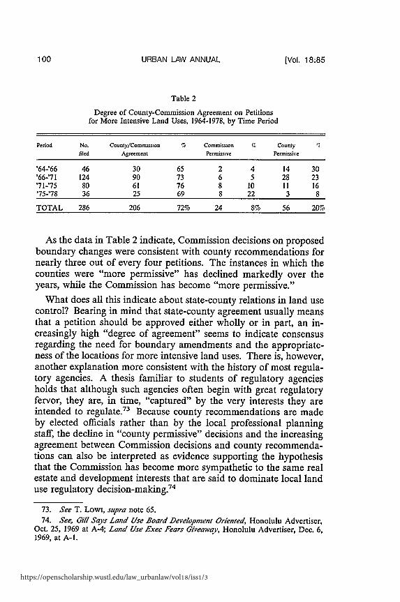
Data on the consistency with which the Commission has followedcounty recommendations were organized by first dividing the studyperiod into three periods corresponding to the tenure of the ExecutiveOfficers of the Commission staff.72 Second, the analysis used onlythose petitions for a boundary change that could have resulted inmore intensive land use. Third, the data were arranged to indicate:1) those petitions which the Commission approved, approved in part,or denied consistent with the county recommendation; 2) Commis-sion decisions that would have allowed a more intensive land usethan recommended by the county (Commission permissive); and 3)those petitions for which the county recommended a more intensiveland use than allowed by the Commission (county permissive). Thedata indicating the degree of agreement between county recommen-dations and Commission decisions are presented in Table 2.
71. HAWAII REV. STAT. § 205-4(a) (1976).72. Because Commission members have died, resigned or been reappointed, there
is no clear division among Commissions. To the extent that there have been water-sheds in Commission history, those points are more likely to be reflected in a changeof the Commission's Executive Officer rather than in specific time segments. Hence,the first period is from October 1964, until July 1966. The second period is fromFebruary 1976, until March 197 1, the third period extends until October 1975, and thefourth period extends from that time until December 1978.
1980]
Washington University Open Scholarship
URBAN LAW ANNUAL
Table 2
Degree of County-Commission Agreement on Petitionsfor More Intensive Land Uses, 1964-1978, by Time Period
Period No. County/Commission S Commission % County 'filed Agreement Permissive Permissive
'64-'66 46 30 65 2 4 14 30'66-'71 124 90 73 6 5 28 23'71-'75 80 61 76 8 10 11 16'75-'78 36 25 69 8 22 3 8
TOTAL 286 206 72% 24 8% 56 20%
As the data in Table 2 indicate, Commission decisions on proposedboundary changes were consistent with county recommendations fornearly three out of every four petitions. The instances in which thecounties were "more permissive" has declined markedly over theyears, while the Commission has become "more permissive."
What does all this indicate about state-county relations in land usecontrol? Bearing in mind that state-county agreement usually meansthat a petition should be approved either wholly or in part, an in-creasingly high "degree of agreement" seems to indicate consensusregarding the need for boundary amendments and the appropriate-ness of the locations for more intensive land uses. There is, however,another explanation more consistent with the history of most regula-tory agencies. A thesis familiar to students of regulatory agenciesholds that although such agencies often begin with great regulatoryfervor, they are, in time, "captured" by the very interests they areintended to regulate.73 Because county recommendations are madeby elected officials rather than by the local professional planningstaff, the decline in "county permissive" decisions and the increasingagreement between Commission decisions and county recommenda-tions can also be interpreted as evidence supporting the hypothesisthat the Commission has become more sympathetic to the same realestate and development interests that are said to dominate local landuse regulatory decision-making.74
73. See T. Lowi, supra note 65.74. See, Gill Says Land Use Board Development Oriented, Honolulu Advertiser,
Oct. 25, 1969 at A-4; Land Use Exec Fears Giveaway, Honolulu Advertiser, Dec. 6,1969, at A-1.
(Vol. 18:85
https://openscholarship.wustl.edu/law_urbanlaw/vol18/iss1/3
HAWAII LAND USE
Although the data above suggest growing state-county consensuson land use issues, such a conclusion is misleading. While electedofficials often support Commission decisions, the professional plan-ning staffs of the counties have grown increasingly antagonistictoward the Commission.75
When Hawaii's Land Use Law was enacted in 1961, county gov-ernments appeared to have neither the will nor the means to copewith the rapid growth that accompanied statehood.76 County plan-ning offices were understaffed and overworked, particularly on theNeighbor Islands. The Land Use Law bought time for all the coun-ties. Because they had direct responsibility for exercising land usecontrols only in the urban districts, the planning staffs were betterable to concentrate their energies there while the state controlled therest of the land.
Since the Land Use Law provides the Commission with the au-thority to determine where urban development may occur and howlarge urban land inventories are to be, the counties have been rele-gated to a secondary role in growth management. Once land is put inan urban district, it becomes difficult for the counties to resist grant-ing required development approvals. Instead, their role has been oneof exercising authority over the density and quality of approved de-velopment through zoning and subdivision ordinances.
Since the law's enactment, the role and influence of county plan-ning has expanded. HUD 701 grants77 made possible a wide varietyof county and local plans. County planning staffs have grown in size,in professional ability and in their desire to exercise more authorityover the disposition of lands within their jurisdiction.
The 1974 boundary review suggests the potential conflict between aLand Use Commission and a county having substantially differentcommunity development objectives. In 1974, the City and County ofHonolulu refused to take part in the five-year boundary review con-
75. Such opposition takes many forms. For example, a motion for a resolutioncalling upon the legislature to abolish the Land Use Commission was introduced by acounty official (and former executive officer to the Commission) at the annual meet-ing of the Hawaii Congress of Planning Officials at Kailua-Kona in September 1977.The motion was tabled. but the point was made.
76. See Lowry & McElroy, supra note 49.77 The General Plan revision process undertaken by the Department of General
Planning resulted in a nine-volume series entitled PLANNING FOR OAHU (1974). TheCity Council adopted its own policy plan. See CITY AND COUNTY OF HONOLULU,GENERAL PLAN (1976).
1980]
Washington University Open Scholarship
URBAN LAW ANNUAL
ducted by the Land Use Commission.78 The county indicated thatmajor studies for revision of the county general plan were nearlycompleted, and that any changes in district designations should con-form with the draft plan. The county general plan revision programfocused on housing, transportation, and community developmentneeds; preliminary recommendations supported intensification of de-velopment in the already-urbanized Honolulu coastal corridor, with"directed growth" toward a new urban concentration in the area ofcentral Oahu closest to existing urban centers.79 The more compacturban pattern would be served primarily by a combined bus/trainrapid transit system now in advanced planning stages. The pattern oflow-density suburban development in less accessible areas of centralOahu and the windward coast would be discouraged by a low-prior-ity capital improvement program for those districts.
The Commission approved additions of 1,782 acres to Oahu's ur-ban districts."0 While the county, holding to its earlier position,made no recommendations on these petitions, 796 acres approvedwere in areas designated for little or no growth under the preliminarycounty general plan revisions.8' To be fair to the Commission, itcould have done far more to undermine Honolulu's draft generalplan revision than ultimately occurred in 1974. The Commissionturned down major development proposals for the windward coastand central Oahu, rezoning far less acreage than had been re-quested. 82 The county's "directed growth" strategy for a concen-trated urban node in accessible parts of central Oahu was supportedby several major rezonings. The major "losing" development pro-posals of 1974 will be submitted again. Commission action on these
78. See note 61 supra.79. DEPARTMENT OF GENERAL PLANNING, CITY AND COUNTY OF HONOLULU,
PLANNING FOR OAHU: AN EVALUATION OF ALTERNATIVE RESIDENTIAL POLICIES(1974).
80. LAND USE COMMISSION, STATE OF HAWAII, REPORT TO THE PEOPLE ON THESECOND FIVE-YEAR DISTRICT BOUNDARIES AND REGULATIONS REVIEW OF THESTATE OF HAWAII LAND USE COMMISSION 26 (1975).
81. Id.82. A less generous interpretation of the Commission's behavior was offered by
Robert Way, a former director of the Department of General Planning in the Cityand County of Honolulu: "It drives me crazy as a planning technician. Here they goaround willy-nilly deciding how land should be used. They might as well be throwingdarts at a map saying 'the blessed shall receive.'" Way .4ssails Land Use Dec/sion,Honolulu Sunday Star-Bulletin and Advertiser, Dec. 22, 1974 at A-I.
[Vol. 18:85
https://openscholarship.wustl.edu/law_urbanlaw/vol18/iss1/3
HAWAII LAND USE
petitions will be an important test of intergovernmental cooperationon growth management for Oahu.
Oahu's general plan revision process is representative of the in-creasing sophistication and comprehensiveness of county plans . 3
While earlier county plans for Oahu have resulted in detailed mapsof desired land uses, the general plan revision stressed the definitionof general policies and desired development patterns at the regionalscale. Thus, Honolulu seeks to institute allocation at the same scaleas that practiced by the Land Use Commission. If all the countiesmove to this approach (and in so doing begin to consider the supplyof urban land as somewhat less of a "given"), opportunities for directstate-county conflict will increase.
B. To What Extent are Regulatory Decisions Consistent with theRecommendations of Professional Staf.
Studies of the professional staff role in regulatory decision-makingbodies suggest that full-time staffs are likely to dominate part-timedecision-makers.84 Such domination arguably is likely because of thedecision-maker's lack of expertise in the relevant policy area and be-cause of the staffs ability to devote more time and energy to back-ground research on the decisions they must make. Staff domination,if it existed, would be manifest in a high degree of consistency be-tween staff recommendations and Commission decisions. Unfortu-nately, such a consensus might also be explained by eitherCommission intimidation of staff members or by an ideology sharedby both Commissioners and staff members.
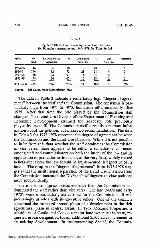
Hence, the degree of agreement between staff recommendationsand Commission decisions only becomes fully meaningful in explain-ing staff-Commission relations if 1) it is supplemented with otherdata, such as interviews, or 2) one inquires into the details of particu-lar cases. The data on Commission-staff agreement are presented inTable 3.
83 See Lowry & Elroy, supra note 49.84 See A. ALTSCHULER. THE CITY PLANNING PROCESS (1965); I. SCHILLMAN,
THE LIMITS OF THE LOCAL PLANNING COMMISSION (1975).
1980]
Washington University Open Scholarship
URBAN LAW ANNUAL
Table 3
Degree of Staff-Commission Agreement on Petitionsfor Boundary Amendments, 1964-1978, by Time Period
Period No. Staff/Commission % Commission % Staff PercentageFiled Agreement Permissive Permissive
1964-66 46 36 78 9 20 1 21966-71 124 92 72 28 21 4 31971-75 80 74 93 4 5 2 31975-78 36 24 67 10 28 2 6
TOTALS 286 226 79% 51 18% 9 3%
Source: Tabulated from Commission files.
The data in Table 3 indicate a remarkably high "degree of agree-ment" between the staff and the Commission. The consensus is par-ticularly high from 1971 to 1975, but drops off dramatically after1975. After that time the role played by the Commission staffchanged. The Land Use Division of the Department of Planning andEconomic Development assumed the advocacy role previouslyplayed by the staff. The Commission staff currently generates infor-mation about the petition, but makes no recommendation. The datain Table 3 for 1975-1978 represent the degree of agreement betweenthe Commission and the Land Use Division. While it is not possibleto infer from this data whether the staff dominates the Commissionor vice versa, there appears to be either a remarkable consensusamong staff and commissioners on both the intent of the law and itsapplication to particular petitions, or, at the very least, widely sharedbeliefs about how the law should be implemented, irrespective of itsintent. The drop in the "degree of agreement" from 1975-1978 sug-gests that the institutional separation of the Land Use Division fromthe Commission increased the Division's willingness to view petitionsmore independently.
There is some impressionistic evidence that the Commission hasdominated the staff rather than vice versa. The late 1960's and early1970's were a particularly active time for the Commission. It wasincreasingly at odds with its executive officer. One of the conflictsconcerned the proposed second phase of a development in the richagricultural plain in central Oahu. In 1969, Oceanic Properties, asubsidiary of Castle and Cooke, a major landowner in the state, re-quested urban designation for an additional 2,500 acres increment toan existing development. In recommending denial, the Commis-
[Vol. 18:85
https://openscholarship.wustl.edu/law_urbanlaw/vol18/iss1/3

HAWAII LAND USE
sion's staff pointed to the developer's failure to produce proposedlow-cost housing in an already completed first phase. Of 14,265 unitsdeveloped in the first phase, only 75 could be termed "low-cost., 8 5
In assessing Oceanic's performance, the executive officer statedthat "(the petitioner) has not performed. The Land Use Commissionhas been duped. They should recognize their mistake and not correcta mistake by repeating it. They have not kept faith with the Commis-sion and should be willing to accept the consequences." 6 Somemonths later he resigned under pressure and was replaced. As Table3 indicates, the recommendations of the subsequent executive officerwere consistent with the Commission's decisions in more than ninetypercent of the petitions.
The Land Use Commission has been attentive to the staffs recom-mendations with regard to a large proportion of the petitions onwhich they ruled. Yet there are some cases which, because of theirsize, or location, or perhaps because of the pleas, promises or politicalinfluences of the petitioner, have been approved by the Commissionover strong objections by its professional staff.
The question of whether Commission decision-making processesare more or less political than, say, the typical zoning decision-mak-ing process cannot be answered by focusing solely on Commissiondecisions or voting patterns of the Commissioners. In any case, thecharacterization of a regulatory decision as "political" may not sig-nify anything more than the fact that the observer disagrees with thedecision.
If, however, we understand "political" decisions to mean seem-ingly arbitrary ones, decisions that do not conform to the applicablerules, guildelines or criteria that are intended to govern regulatorydecision-making, then it is possible to provide a perspective about thedegree to which "politics" is a part of the decision-making process byconducting a case-by-case analysis of the extent to which decisionsconform to such guidelines.8 7 Such a perspective is offered in thefollowing section.
85. LAND USE COMMISSION, STATE OF HAWAII, STAFF REPORT ON MILILANI
TOWN PETITION # 69-225 (Dec. 5, 1969).86 Id.87 There are, of course, more refined approaches to identifying "politically sig-
nificant" petitions, such as reputational surveys and cross-checks of petitions with listsof campaign contributors.
1980]
Washington University Open Scholarship
URBAN LAW ANNUAL
C. Are Land Use District Boundaries Consistent with StatutoryObjectives?
We turn now to the question of the consistency of the Land UseCommission's decisions with the intent of the law. To facilitate anal-ysis, Commission history has been divided into two periods. The firstperiod begins in 1964 when the "permanent" Commission boundarylines were established and includes petitions acted upon prior to themajor procedural and substantive changes in the Land Use Law en-acted in 1975. The second period includes petitions reviewed by theCommission after those changes were enacted.
In its original form, the Land Use Law provided little in the way ofsubstantive policy guidance to the Commission for ruling on specificpetitions. The "Findings and Declarations of Purpose" section of thelaw suggests that the purposes of the law are to prevent "scatteredsubdivisions with expensive, yet reduced public services" and "theshifting of prime agricultural lands into non-revenue producing resi-dential uses when other lands are available that would adequatelyserve urban needs. 88
Prior to the enactment of the interim statewide land use guidancepolicies in 1975,89 such detailed policy guidance as was availablecould be found in the Commission's regulations.9" The Commis-sion's State Land Use District Regulations includes a section entitled"Standards for Determining District Boundaries."'" According tothe Regulations, these standards "shall be used in establishing the dis-trict boundaries. They also shall be used as guides for the periodicreview of district boundaries for the granting of amendments to thedistrict boundaries and for other changes and amendments. 92
These standards are intended to ensure that new urban districts arelocated near existing urban concentrations, in close proximity to ex-isting facilities and services and involve land units that are environ-mentally suited for development. Taken together the statutorylanguage governing changes in district boundaries and the standards
88. 1961 Hawaii Sess. Laws, Act 187. This section was repealed before the lawwas codified.
89. HAWAII REV. STAT. § 205-16.1 (1976).
90. LAND USE COMMISSION, STATE OF HAWAII, RULES OF PRACTICE AND PROCE-DURE AND DISTRICT REGULATIONS (1975).
91. Id.§2-2.92. Id.§6-1.
[Vol. 18:85
https://openscholarship.wustl.edu/law_urbanlaw/vol18/iss1/3

HAWAII LAND USE
set forth in the regulations provide the policy base for Commissiondecision-making.
While most of the guidelines are individually clear and straightfor-ward, in application there are potential ambiguities and contradic-tions. For example, guidelines require the Commission to ensure thatthere is a "sufficient reserve" of undeveloped urban land to accom-modate new growth. The guidelines also require the Commission toprotect prime agricultural land. While there is no necessary policyconflict here in principle, in actual practice a petition may involve aland unit that is both well suited for agriculture and for urban pur-poses. When such policy conflicts occur with regard to particular pe-titions, the Commission emphasizes one or more guidelines at theexpense of others when it chooses to approve or deny the petition inwhich the conflict occurs. Such tradeoffs are, of course, characteristicof any regulatory program. To the extent that it is possible to empiri-cally identify a consistent pattern of tradeoffs, it is possible to speakof Commission policy with regard to changes in the district bounda-ries.
The empirical delineation of Commission policy is conceptuallysimple. It involves trying to identify a subset of the original set ofguidelines which the Commission has consistently emphasized in itsdecisions. If, for example, the Commission has been faithful to theoriginal goals of the land use law with regard to the preservation ofprime agricultural land and the prevention of scattered, non-contigu-ous urban development, those guidelines having to do with locationand agricultural suitability will, other things being equal, best distin-guish between decisions to approve a petition for urban boundaryclassification and decisions to deny.
To identify Commission policy, a multi-variate statistical tech-nique, discriminant analysis, was selected.93 While the mathematicsof the technique are complex, the findings greatly facilitate under-
93. For a discussion of discriminate analysis, see J. OVERALL & C. KLETT, AP-PLIED MULTIVARIATE ANALYSIS (1970); M. TATSUOKA, MULTIVARIATE ANALYSIS
TECHNIQUE FOR EDUCATIONAL AND PSYCHOLOGICAL RESEARCH (1971). For a dis-
cussion of the conceptual basis for discriminant analysis, see J. NUNNALLY, PSYCHO-METRIC THEORY (1967). For an application of discriminant analysis to dichotomousdata (such as those used in this Article) see Maxwell, Canonical Variate Analysis when
the Vanables are Dichotomous, 21 EDUC. PSYCHOLOGICAL MEASUREMENT 259(1961). See generalr N. NIE C. HILL, JENKINS, K. STEMBIENER & D. BENT, STATIS-TICAL PACKAGE FOR THE SOCIAL SCIENCES (2d ed. 1975).
19801
Washington University Open Scholarship
URBAN LAW ANNUAL
standing the types of tradeoffs made.94 First, the technique identifiesspecific guidelines to distinguish petitions that were approved, par-tially approved and those that were denied.95 These guidelines con-stitute Commission policy in explaining Commission decisions.Second, the technique makes it possible to determine whether therewas more than one Commission policy at work and it indicates therelative importance of each policy. Third, the technique makes itpossible to determine how consistently the policy (or policies) wereapplied by identifying those individual decisions on petitions that canbe "explained" in terms of the policy (or policies) and those whichcannot be so explained.
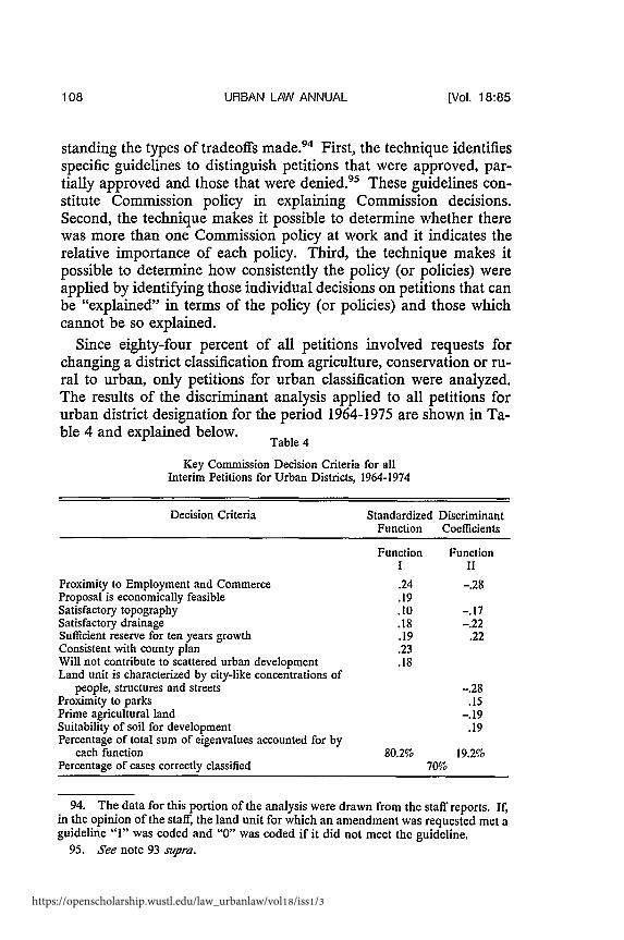
Since eighty-four percent of all petitions involved requests forchanging a district classification from agriculture, conservation or ru-ral to urban, only petitions for urban classification were analyzed.The results of the discriminant analysis applied to all petitions forurban district designation for the period 1964-1975 are shown in Ta-ble 4 and explained below.
Table 4
Key Commission Decision Criteria for allInterim Petitions for Urban Districts, 1964-1974
Decision Criteria
Proximity to Employment and CommerceProposal is economically feasibleSatisfactory topographySatisfactory drainageSufficient reserve for ten years growthConsistent with county planWill not contribute to scattered urban developmentLand unit is characterized by city-like concentrations of
people, structures and streetsProximity to parksPrime agricultural landSuitability of soil for developmentPercentage of total sum of eigenvalues accounted for by
each functionPercentage of cases correctly classified
Standardized DiscriminantFunction Coefficients
Function FunctionI II
.24 -. 28
80.2%
-. 28.15
-. 19.19
19.2%
94. The data for this portion of the analysis were drawn from the staff reports. If,in the opinion of the staff, the land unit for which an amendment was requested met aguideline "I" was coded and "0" was coded if it did not meet the guideline.
95. See note 93 supra.
(Vol. 18:85
https://openscholarship.wustl.edu/law_urbanlaw/vol18/iss1/3

HAWAII LAND USE
Table 4 indicates that the Commission had two policies for urbandistrict boundary amendments. Function I identifies the dominantCommission policy.96 The most striking characteristic of the domi-nant commission policy is that in spite of the express goal of the lawto protect agricultural land, agricultural suitability does not appear tohave been a major factor in Commission decision-making. Thischaracteristic is consistent with a review of Commission files whichindicates that more than 36,000 acres of agricultural land have beenadded to the urban district since 1964, about ten percent of which wasranked "prime" in terms of agricultural productivity. 97 In other re-spects, however, the dominant policy is generally consistent with theintent of the law. Several measures of the location of the proposedadditions to the urban district-proximity to employment, consis-tency with the county plan, and the avoidance of scattered urban de-velopment--emerged as crucial variables in the dominant policy.Two measures of the environmental suitability of land units-topo-graphy and drainage-were also important.9 8
The minor policy described by function II is almost the opposite ofthe major policy. Again, criteria having to do with the location ofnew urban development are important as are criteria related to theenvironmental suitability of the land units. The coefficients are nega-tive in this function, indicating that they are describing land units notcharacterized by these attributes. In addition, some of the land units
96 The discriminant technique calculates two measures for judging the relativeimportance of each discriminant function. One of these is the relative percentage ofthe eigenvalue associated with the function. The eigenvalue is a special measure com-puted in the process of deriving the discriminant function. The sum of theeigenvalues is a measure of the total variance existing in the discriminating variables.When a single eigenvalue is expressed as a percentage of the total sum of eigenvalues,we have an easy reference to the relative importance of the associated function. Herethe first function accounts for 80.2% of the total sum of the eigenvalues. See N. Nm,
iupra note 93. at 442.97 These figures were computed from petitions in the Commission's files.98 The standardized discriminant function coefficients, which are analagous to
beta weights in multiple regression, indicate the relative contribution of the decisioncriteria to each function. The larger the coefficient the greater its significance in dis-criminating among petitions that were approved, partially approved, and denied. Inthis instance, the proximity of a land unit under petition to "centers of employmentand commerce" (.24) and "consistency with county general plan" (.23) emerged asdominant explanatory variables.
1980]
Washington University Open Scholarship
URBAN LAW ANNUAL
described by this function were highly productive agricultural unitsas indicated by the negative value of that criterion.
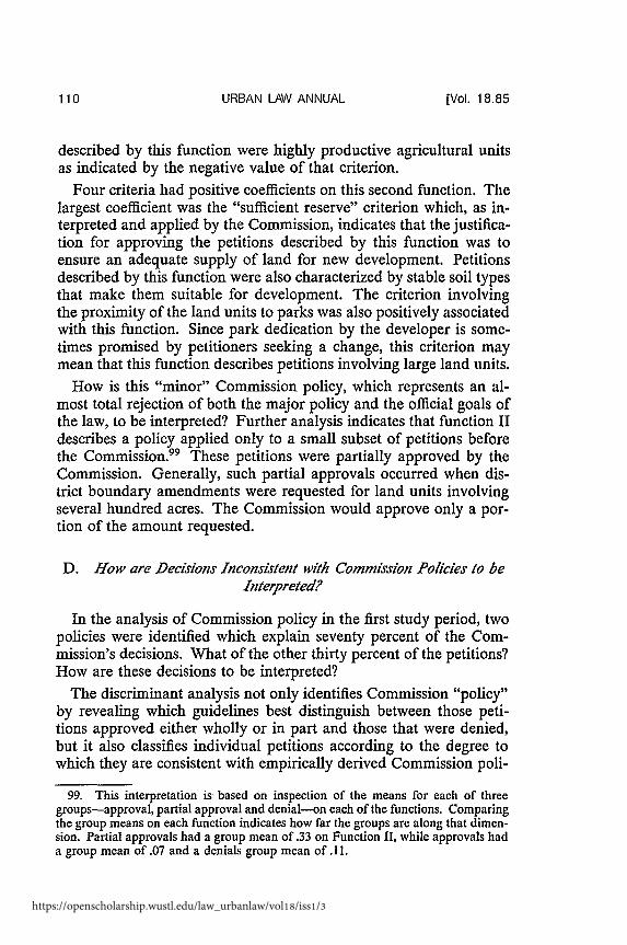
Four criteria had positive coefficients on this second function. Thelargest coefficient was the "sufficient reserve" criterion which, as in-terpreted and applied by the Commission, indicates that the justifica-tion for approving the petitions described by this function was toensure an adequate supply of land for new development. Petitionsdescribed by this function were also characterized by stable soil typesthat make them suitable for development. The criterion involvingthe proximity of the land units to parks was also positively associatedwith this function. Since park dedication by the developer is some-times promised by petitioners seeking a change, this criterion maymean that this function describes petitions involving large land units.
How is this "minor" Commission policy, which represents an al-most total rejection of both the major policy and the official goals ofthe law, to be interpreted? Further analysis indicates that function IIdescribes a policy applied only to a small subset of petitions beforethe Commission.99 These petitions were partially approved by theCommission. Generally, such partial approvals occurred when dis-trict boundary amendments were requested for land units involvingseveral hundred acres. The Commission would approve only a por-tion of the amount requested.
D. How are Decisions Inconsistent with Commission Policies to beInterpreted?
In the analysis of Commission policy in the first study period, twopolicies were identified which explain seventy percent of the Com-mission's decisions. What of the other thirty percent of the petitions?How are these decisions to be interpreted?
The discriminant analysis not only identifies Commission "policy"by revealing which guidelines best distinguish between those peti-tions approved either wholly or in part and those that were denied,but it also classifies individual petitions according to the degree towhich they are consistent with empirically derived Commission poli-
99. This interpretation is based on inspection of the means for each of threegroups-approval, partial approval and denial-on each of the functions. Comparingthe group means on each function indicates how far the groups are along that dimen-sion. Partial approvals had a group mean of .33 on Function II, while approvals hada group mean of .07 and a denials group mean of 11.
[Vol. 18.85
https://openscholarship.wustl.edu/law_urbanlaw/vol18/iss1/3

HAWAII LAND USE
cies. " The discriminant technique presents a theoretical decision oneach petition before the Land Use Commission. These theoreticaldecisions can then be compared to actual Commission decisions,making it possible to identify each of the petitions not conforming tothe dominant Commission policy. Figure 1 compares actual Com-mission decisions with those predicted by the two discriminant func-tions. Those decisions in which the theoretical decision is the same asthe actual decision are located in the cells in the main diagonal ex-tending from the lower left to the upper right. The 152 petitions inthe cells on that diagonal represent seventy percent of the total of 218petitions.
Figure 1
Theoretical Decisions Compared withActual Commission Decisions
Theoretical DesignPartial
Denial Approval Approval
Approval
Actual PartialDecision Approval
Denial
13 18 98
6 23 14
31 11 7
50 52 119 218
The empirical delineation of Commission policy provides a valua-ble global perspective on the bases for Commission decision-making
100. The classification problem involves determining which group each petition"resembles" the most in terms of the variables identified as constituting Commissionpolicy. The "typical" classificatory problem to which discriminant analysis is appliedinvolves determining a set of characteristics that differentiates among a particular setof well-defined groups and then assigning an individual whose group membership isunknown to one of the groups on the basis of his individual characteristics. For ex-ample, job placement in a large organization might be aided by matching an individ-ual's placement test scores (characteristics) to the job profiles until the best "fit"between the individual's profile and a particular job profile is obtained. The particu-lar discriminant program being used in this analysis computes two classificationmeasures: chi-square and posterior probability. The chi-square is a measure of dis-tance or dissimilarity. The higher the chi-square value of a particular petition, thefarther away is the point representing the score of an individual petition from thecentroid of that group. Conversely, the lower the chi-square value, the closer thepetition is to the "average" petition in that group. The second classification measureis the posterior probability of group membership. The posterior probability is theprobability that a particular petition, X, belongs to a particular group, Hk. Both thechi-square and posterior probabihty result in the same classification.
1980]
Washington University Open Scholarship
URBAN LAW ANNUAL
in the first period. In this section the focus is on individual petitionswhich cannot be explained with reference to that policy; that is to say,those petitions in the cells above and below the main diagonal inFigure 1 above. While it is not possible to account for all the factorsthat motivated Commissioners to react positively or negatively toparticular petitions, it may be possible to identify some of the sub-stantive bases for departing from the primary Commission policy.
The first set of petitions to be examined involves those petitions inwhich the "theoretical" decisions would have allowed for more inten-sive land uses than actually allowed by the Commission. There arethree subsets of petitions to be examined under the heading of "per-missive misclassifications:" 1) those petitions statistically classifiedas approval but actually denied by the Commission; 2) those peti-tions classified partial approval but actually denied by the Commis-sion; and 3) those petitions classified approval but partially approvedby the Commission.
Detailed analysis of the individual misclassified petitions in thethree cells revealed some interesting similarities. All but one of thesix petitions denied by the Commission but classified approval werelocated on the island of Hawaii. All the petitions involved relativelysmall agricultural parcels adjacent to or in close proximity to urbanareas. In each case the land unit was served by facilities and servicesand consistent with the county general plan.
The denial by the Commission of these six petitions points to oneof the sources of tension between the state and the counties in landuse planning matters. Each of these petitions was consistent with thecounty's general plan and each was recommended for approval bythe county. Each met most of the relevant standards for an urbandistrict. And yet, the Commission's denials were not wholly capri-cious: the failure of a petitioner to develop a previously re-districtedparcel, the failure to establish the need for additional urban land; or apetitioner's unwillingness to submit a development plan for a landunit each represent a legitimate basis to deny a petitioner. On theother hand, the denial of these six petitions does justify a charge ofinconsistency on the part of the Commission. As subsequent analysisindicates, the Commission has approved petitions involving severalsimilar land units.
Ten of the eleven petitions denied by the Commission but classi-fied as partial approval involved land units located on Oahu. Sevenof the eleven petitions involved land units in the conservation district.
[VOL, 18:85
https://openscholarship.wustl.edu/law_urbanlaw/vol18/iss1/3
HAWAII LAND USE
These land units are, for the most part, adjacent to urban districtsand in close proximity to urban services. They met all or most of thestandards governing urban designation except those relating to to-pography. Several of these land units included steeply sloped landwhich, if graded and developed, would have increased theprobability of flooding and slides.
These classifications are, in part, an artifact of the discriminanttechnique. The application of the technique to all petitions for urbandesignation in the 1964-1975 period revealed an overall Commissionpolicy for deciding on petitions in that period. The petitions underexamination represent a subset of petitions to which that policy doesnot apply. These petitions were classified partial approval on thestrength of the second discriminant function, which, it should be re-called, was a secondary Commission policy of approving in part peti-tions for large land units or petitions involving environmentallyfragile land units, some portion of which might be suitable for devel-opment.
Of the fourteen petitions classified approved, but actually only par-tially approved by the Commission, eleven involved land units on theneighbor islands (i.e. islands other than Oahu). Each land unit metthe tests for urban district classification usually applied by the Com-mission (as revealed by the discriminant analysis). In eleven of thefourteen petitions, the Commission staff recommended partial ap-proval and the Commission followed the staff recommendation. Ineach instance, the Commission appears to have used the partial ap-proval decisions to maintain some control over the supply of urbanland available for urbanization, as well as the pace and character ofdevelopment.
Partial approvals constitute the most interesting, and perhaps themost important, class of decisions made by the Land Use Commis-sion. By definition a partial approval decision is somewhere betweena decision to approve and a decision to deny a district designationchange of a land unit. In distinguishing between partial approvalsand denials on the one hand, and partial approvals and approvals onthe other, the Commission has exercised a great deal of discretion.The proportion of misclassifications involving partial approval ismuch higher than that involving other types of decisions. The overallCommission policy described in the previous section cannot ade-quately explain the circumstances surrounding this class of decisions.
What gives this class of decisions special importance in under-
1980]
Washington University Open Scholarship

URBAN LAW ANNUAL
standing the role of the Commission in land use guidance is the foot-in-the-door character of these decisions. Partial approvals representseveral special classes of approval. A partial approval can be a tenta-tive "green light" to further urban development in a particular area,signaling some urbanization is likely to take place. It may createpressures on the petitioner to develop the initially approved portionin a way that is likely to gain favor with the Commission so as toallow total development of the land unit at some future time. A par-tial approval, like an approval, may also create development pres-sures on adjacent landowners whose taxes may increase as urbandevelopment moves toward this land unit.
The second major subset of petitions unexplained by the Commis-sion policy are those in which the theoretical decision was more re-strictive than the actual decision reached by the Commission. Thissubset includes the following: 1) petitions approved by the Commis-sion but classified partial approval; 2) petitions partially approved,but classified denial; and 3) those petitions approved by the Commis-sion but classified denial.
As Figure 1 indicates, the Commission approved eighteen petitionsalthough they were classified partial approval according to the globalCommission policy. Twelve of the eighteen petitions involvedchanges not in compliance with the county general plan. Nine of thetwelve petitions involving land units on Oahu led to land use classifi-cations inconsistent with Oahu's general plan. Four of the petitionsinvolved land units, some portion of which had steep topography.Two of the petitions involved land units with a high agricultural pro-ductivity. In short, most of the petitions in this subset did not meetone of the "critical" standards and therefore received a more restric-tive classification than that granted by the Commission.
The Commission's use of "partial approvals" to control the supplyof urban land and the timing of development was discussed in theprevious section. In those petitions, there was a high degree of agree-ment between the Commission staff and the Commission regardinghow much land should be redistricted.
The six petitions partially approved by the Commission but classi-fied denial represent a different use of the partial approval techniqueby the Commission. The Commission staff and the Commission dis-agreed on each of the six petitions. Three of the six petitions ap-peared to directly contravene the purposes of the Land Use Law.And three petitions involved large undeveloped and unimproved
[Vol. 18:85
https://openscholarship.wustl.edu/law_urbanlaw/vol18/iss1/3
HAWAII LAND USE
land units in areas in which the staff held that there was already a"sufficient reserve" of undeveloped urban land. These decisions topartially approve petitions appear to be attempts to strike a compro-mise between the dictates of the law (as represented by the staff) andthe preferences of politically powerful development interests.
Finally, thirteen petitions were classified denial but were approvedby the Commission. None of the thirteen petitions met the "sufficientreserve" standard. In the judgment of the staff, approval of each ofthese petitions would result in more urban land than required to meetanticipated population growth over the next ten years.
Approval of nine of the thirteen petitions resulted in a land usedesignation inconsistent with the county's general plan. Three of thepetitions involved land units on the island of Hawaii that the staffstated would result in scattered urban development, if approved.Four petitions involved land units with steep slopes and possibledrainage or flooding problems. A number of the other petitions alsoinvolved land units lacking basic services and facilities such as water,roads, sewers and the like.
E. 1975 Procedural Revisions in the Land Use Law
As noted above, the 1975 legislature made significant changes bothin Commission procedures and in the policy guidelines governingCommission decisions.'' A 1974 ruling of the Hawaii SupremeCourt'0 2 dictated reforms in Commission procedures. The court heldthat the Commission was bound by the contested case procedures foradjudicatory proceedings as contained in the state AdministrativeProcedures Act.'0 3 One of the most controversial of the new proce-dures related to participation in Commission hearings on boundaryamendments. Under the amended procedures, full participation inboundary amendment proceedings is limited to "parties."'' " The pe-titioner, the Department of Planning and Economic Development,and the Planning Department of the county in which the land unitunder petition is situated are automatic parties. Standing may alsobe granted to "all departments and agencies of the state and of thecounty in which the land is situated. . . upon timely application for
101. Hawaii Rev. Stat. §§ 205-1-205-37 (1976). For a statement of purpose, see1975 Hawaii Sess. Laws, Act 113, § 1.
102. Town v. Land Use Comm'n, 55 Hawaii 538, 524 P.2d 84 (1974).103. HAWAII REV. STAT. §§ 91-1(5) to 91-9 (1976).104. HAWAII REV. STAT. § 205-4(e) (1976).
1980]
Washington University Open Scholarship

URBAN LAW ANNUAL
intervention."' 5 Standing is also granted to persons with a propertyinterest in the land as well as to those who reside on it or who candemonstrate that they will be directly affected by the proposedchange.10 6 Others are granted standing at the discretion of the Com-mission.
Because all such parties have an opportunity to present evidence,to call witnesses, and to rebut the testimony of witnesses, the newCommission procedures were viewed by environmental activists,community groups, and development interests with a mixture of con-cern and enthusiasm. While the conference committee called thestanding provisons "extremely liberal,"' 7 other legislative partici-pants thought the effect of these provisions might be to restrict partic-ipation.
10 8
Allowing individuals, community groups and special interestgroups to have formal standing before the Commission provides an-other set of recommendations to the Commission. These recommen-dations do not constrain the Commission in its decision-making anymore than do the recommendations of County Council or the Com-mission's staff (or the Land Use Division since 1965).109 To the ex-tent that recommendations by parties are unanimous, however, it ispossible to assess the extent to which the Commission has been re-sponsive to those recommendations.
Of the thirty-six petitions ruled on by the Commission since theseprocedural changes were enacted in 1975, there were only seven in-stances in which parties other than the petitioner, the Department ofPlanning and Economic Development and the County Planning De-partment, all of whom are parties on every case, petitioned for stand-ing. Of that number, the parties, which included state agencies,individuals, community groups and special interest groups, were gen-erally opposed to six petitions, although often in different degreesand for different reasons." 0 Table 5 indicates the degree of agree-
105. Id. § 205-4(e)(2).106. Id. § 205-4(e)(3).107. CONFERENCE REP. No. 25, Hawaii State Legislature (1975).108. Honolulu Advertiser, April 12, 1975, § A, at 3.109. However, "[fif any party to a proceeding has filed proposed findings of fact,
the Commission shall incorporate in its decision a ruling upon each proposed findingso presented." HAWAII STATE LAND USE COMMISSION, RULES OF PRACTICE ANDPROCEDURE, Pt. 4, at 3 (1975).
110. One petition involving the downzoning of portions of a marsh located inwindward Oahu was dropped from the analysis because the parties were divided in
[Vol. 18:85
https://openscholarship.wustl.edu/law_urbanlaw/vol18/iss1/3
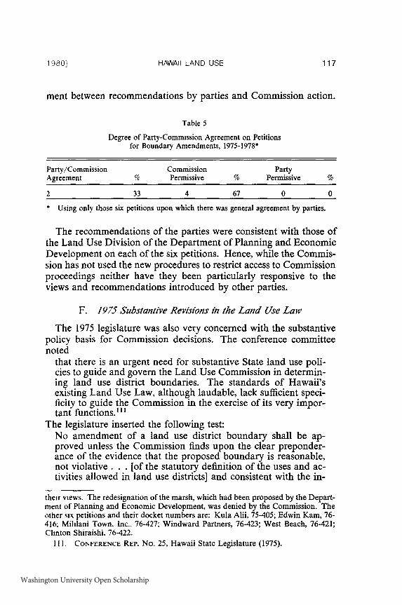
HAWAII LAND USE
ment between recommendations by parties and Commission action.
Table 5
Degree of Party-Commission Agreement on Petitionsfor Boundary Amendments, 1975-1978"
Party/Commission Commission PartyAgreement % Permissive % Permissive %
2 33 4 67 0 0
* Using only those six petitions upon which there was general agreement by parties.
The recommendations of the parties were consistent with those ofthe Land Use Division of the Department of Planning and EconomicDevelopment on each of the six petitions. Hence, while the Commis-sion has not used the new procedures to restrict access to Commissionproceedings neither have they been particularly responsive to theviews and recommendations introduced by other parties.
F. 1975 Substantive Revisions in the Land Use Law
The 1975 legislature was also very concerned with the substantivepolicy basis for Commission decisions. The conference committeenoted
that there is an urgent need for substantive State land use poli-cies to guide and govern the Land Use Commission in determin-ing land use district boundaries. The standards of Hawaii'sexisting Land Use Law, although laudable, lack sufficient speci-ficity to guide the Commission in the exercise of its very impor-tant functions." 1
The legislature inserted the following test:No amendment of a land use district boundary shall be ap-proved unless the Commission finds upon the clear preponder-ance of the evidence that the proposed boundary is reasonable,not violative. . . [of the statutory definition of the uses and ac-tivities allowed in land use districts] and consistent with the in-
their views. The redesignation of the marsh, which had been proposed by the Depart-ment of Planning and Economic Development, was denied by the Commission. Theother six petitions and their docket numbers are: Kula Aii, 75-405; Edwin Kam, 76-416 Mililani Town, Inc., 76-427; Windward Partners, 76-423; West Beach, 76-421;Clinton Shiraishi, 76-422.
11. CONFERENCE REP. No. 25, Hawaii State Legislature (1975).
1980]
Washington University Open Scholarship
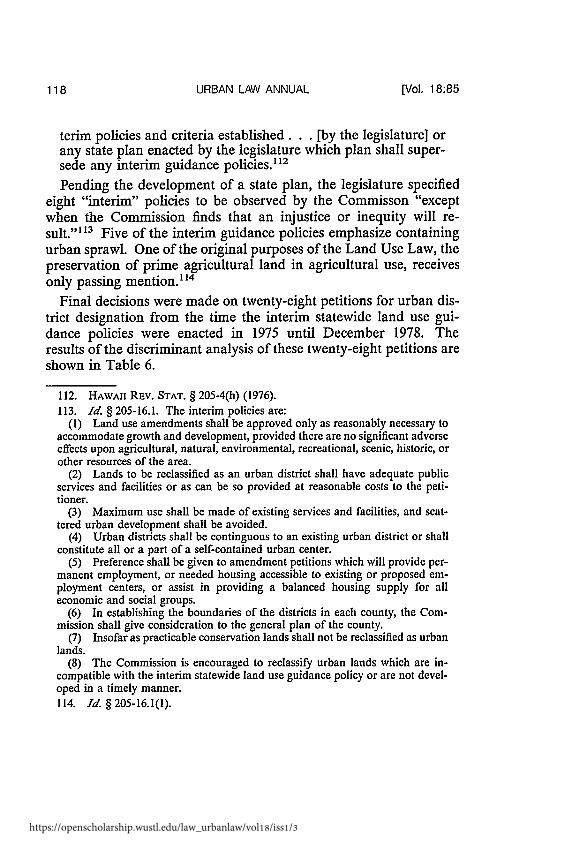
URBAN LAW ANNUAL
terim policies and criteria established. . .[by the legislature] orany state plan enacted by the legislature which plan shall super-sede any interim guidance policies. 12
Pending the development of a state plan, the legislature specifiedeight "interim" policies to be observed by the Commisson "exceptwhen the Commission finds that an injustice or inequity will re-sult." ' 3 Five of the interim guidance policies emphasize containingurban sprawl. One of the original purposes of the Land Use Law, thepreservation of prime agricultural land in agricultural use, receivesonly passing mention." 4
Final decisions were made on twenty-eight petitions for urban dis-trict designation from the time the interim statewide land use gui-dance policies were enacted in 1975 until December 1978. Theresults of the discriminant analysis of these twenty-eight petitions areshown in Table 6.
112. HAWAII REv. STAT. § 205-4(h) (1976).113. Id. § 205-16.1. The interim policies are:
(1) Land use amendments shall be approved only as reasonably necessary toaccommodate growth and development, provided there are no significant adverseeffects upon agricultural, natural, environmental, recreational, scenic, historic, orother resources of the area.
(2) Lands to be reclassified as an urban district shall have adequate publicservices and facilities or as can be so provided at reasonable costs to the peti-tioner.
(3) Maximum use shall be made of existing services and facilities, and scat-tered urban development shall be avoided.
(4) Urban districts shall be continguous to an existing urban district or shallconstitute all or a part of a self-contained urban center.
(5) Preference shall be given to amendment petitions which will provide per-manent employment, or needed housing accessible to existing or proposed em-ployment centers, or assist in providing a balanced housing supply for alleconomic and social groups.
(6) In establishing the boundaries of the districts in each county, the Com-mission shall give consideration to the general plan of the county.
(7) Insofar as practicable conservation lands shall not be reclassified as urbanlands.
(8) The Commission is encouraged to reclassify urban lands which are in-compatible with the interim statewide land use guidance policy or are not devel-oped in a timely manner.114. Id. §205-16.1(1).
[Vol. 18:85
https://openscholarship.wustl.edu/law_urbanlaw/vol18/iss1/3
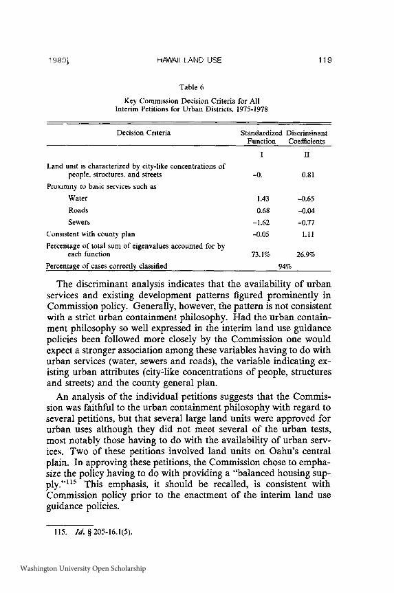
HAWAII LAND USE
Table 6
Key Commission Decision Criteria for AllInterim Petitions for Urban Districts, 1975-1978
Decision Criteria Standardized Discriminant
Function Coefficients
I II
Land unit is characterized by city-like concentrations ofpeople, structures, and streets -0. 0.81
Proximity to basic services such as
Water 1.43 -0.65
Roads 0.68 -0.04
Sewers -1.62 -0.77
Consistent with county plan -0.05 1.11
Percentage of total sum of eigenvalues accounted for byeach function 73.1% 26.9%
Percentage of cases correctly classified 94%
The discriminant analysis indicates that the availability of urbanservices and existing development patterns figured prominently inCommission policy. Generally, however, the pattern is not consistentwith a strict urban containment philosophy. Had the urban contain-ment philosophy so well expressed in the interim land use guidancepolicies been followed more closely by the Commission one wouldexpect a stronger association among these variables having to do withurban services (water, sewers and roads), the variable indicating ex-isting urban attributes (city-like concentrations of people, structuresand streets) and the county general plan.
An analysis of the individual petitions suggests that the Commis-sion was faithful to the urban containment philosophy with regard toseveral petitions, but that several large land units were approved forurban uses although they did not meet several of the urban tests,most notably those having to do with the availability of urban serv-ices. Two of these petitions involved land units on Oahu's centralplain. In approving these petitions, the Commission chose to empha-size the policy having to do with providing a "balanced housing sup-ply.""' This emphasis, it should be recalled, is consistent withCommission policy prior to the enactment of the interim land useguidance policies.
115. Id. § 205-16.1(5).
19801
Washington University Open Scholarship

URBAN LAW ANNUAL
G. The 1978 State Plan and the Land Use Commission
The State Plan proposed by the state administration and enactedby the 1978 legislature" 16 provides the institutional and policy contextfor Hawaii's future state growth management efforts. The legislationmandates a "statewide planning system" which explicitly includesstate functional plans, county general plans, the state program appro-priations process, state capital improvements appropriations, thebudgetary review process conducted by the Department of Budgetand Finance, land use regulatory decisions made by the Board ofLand and Natural Resources and the Land Use Commission and,finally, a Policy Council.17 The "statewide planning system" can bethought of as including a policy apparatus, a planning apparatus, animplementation apparatus and a monitoring apparatus.
The policy context of the state plan is found in the overall theme,goals, objectives, policies, and priority directions of the legislation., 18These objectives and policies vary somewhat in the level of generalityin which they are expressed. Most of them, however, are not suffi-ciently specific to provide clear guidance in regulatory decision-mak-ing or budget allocations. The most specific policy guidance in thelegislation is found in the section on priority directions. Priority di-rections are defined as "overall direction and implementing ac-tions. . . .'I The legislature developed priority directions for theeconomy, for population growth and distribution, and for land re-sources. The legislature also extended the Land Use Commission'sinterim guidance policies, originally scheduled for repeal upon enact-ment of the state plan, until "two years after the effective date of thereenactment of the state plan."'120
The planning apparatus includes state functional plans and countygeneral plans.' 2' Functional plans are to be based on the policiesarticulated in the state plan. Additionally, "[c]ounty general plansand development plans shall be used as a basis in the formulation of
116. Id. § 226 (Supp. 1978).117. Id. §§ 226-52, 53.118. Id. §§ 226-3 to 226-8, 226-101 to 226-105.119. Id. § 226-2(7).120. Id. § 205-16.2.121. Id. § 226-52(3). "State functional plans shall be prepared for, but not limited
to, the areas of agriculture, conservation lands, education energy, higher education,health, historic preservation, housing, recreation, tourism, transportation, and waterresources development." d.
[Vol. 18:85
https://openscholarship.wustl.edu/law_urbanlaw/vol18/iss1/3
HAWAII LAND USE
state functional plans."' 22 Likewise county general plans are to beconsistent with policies in the state plan and the "[flormation,amendment, and implementation of county general plans or develop-ment plans shall utilize as guidelines, statewide objective, policies,and programs stipulated in state functional plans adopted in conso-nance with this chapter."'123
The state plan specifically designates several mechanisms for im-plementing the plan:
*the appropriation of funds for major programs under the bien-nial and supplemental budgets;*a capital improvement projects and plans;*the budgetary review and allocation process of the Departmentof Budget and Finance;*state plans;*decisions by the Land Use Commission; and*decisions by the Board of Land and Natural Resources. 124
The state plan act requires that decisions and appropriations be "inconformance with the overall theme, goals, objectives, policies andpriority directions" contained in the plan. 2 The act also specifiesthat the appropriation of funds for capital improvements and deci-sions by the Land Board and the Land Use Commission must beconsistent with functional plans adopted pursuant to the law. 126 Inaddition, rules and regulations adopted by both the Land Board andthe Land Use Commission are to be in conformance with the Act. 127
The Hawaii state plan legislation is far-reaching both in terms ofthe degree of consistency required between the law and individualplans and programs and in terms of the sheer number of planning,programmatic, regulatory and budgetary processes that must be coor-dinated. Given the generality of the policy statements in the stateplan and the array of planning, budgetary and regulatory activitiesthat are to be coordinated, conflicts are inevitable. To deal with suchconflicts, the act mandates the formation of an eighteen-member pol-icy council, half of whose voting members are appointed by the gov-ernor from lists submitted by county mayors. In addition to these
122. Id. § 226-52(3).123 Id. § 226-61(a).124. Id. § 226-52(b)(2).
125. Id. § 226-52(a)(5).
126. Id.127. Id. § 226-52(b)(2)(D).
1980]
Washington University Open Scholarship

URBAN LAW ANNUAL
"public" representatives there are nine members who represent stateand county agencies.'12
The Policy Council is to "provide a forum for the discussion ofconflicts" and to make recommendations on all such conflicts to thegovernor, the legislature, the mayors and county councils.12 9 Thecouncil is also to review and evaluate the state's functional plans forconformance with the plan; 30 to conduct comprehensive reviews ofthe plan's policies on a periodic basis commencing in 1981;11' tomake recommendations for the legislature on the administration,amendment and review of the plan;' 32 and to issue an annual reportassessing the progress of the plan.133
IV. CONCLUSIONS
While there is little disagreement concerning the need for evaluat-ing state land use regulatory programs, less consensus exists as to theappropriate evaluative approaches and methods. Among the variousapproaches reviewed, the compliance approach proved fruitful be-cause it lends itself well to comparative analysis and because it canprovide the basis for broader analysis focusing on the institutional,political and socio-economic conditions that enhance or impede com-pliance.
In particular, the compliance analysis of the implementation ofHawaii's Land Use Law indicated several points of interest to thoseconcerned about state land use programs.
1. There was a high degree of agreement between local(county) recommendations by elected officials for boundaryamendments and Commission decisions. This apparent con-sensus, however, masked some genuine conflicts with localprofessional planning staff.
2. The Commission's decisions were consistent with the recom-mendations of its professional staff on a substantial propor-tion of decisions. The Commission followed staffrecommendations closely on most routine cases, but wasmore apt to depart from staff recommendations if the peti-
128. Id. § 226-53.
129. Id. § 226-54(1), (2).130. Id. § 226-54(3).131. Id. § 226-54(8).132. Id. § 226-54(4).133. Id. § 226-54(9).
[Vol. 18:85
https://openscholarship.wustl.edu/law_urbanlaw/vol18/iss1/3
HAWAII LAND USE
tion involved potentially large additions to the urban dis-trict.
3. The original legislative objectives of the Land Use Law wereto preserve prime agricultural land and prevent scattered ur-ban subdivisions. Analysis of Commission decisions indi-cated that the preservation of agricultural land was notemphasized in Commission decisions, although the Com-mission was more sensitive to issues regarding the appropri-ate location of new development, particularly wherepetitions involving small land units were concerned.
4. Analysis of compliance of Commission decisions with ad-ministrative guidelines during the period before the reformof the law in 1975 indicated that the Commission had twopolicies governing proposed additions to the urban district.The major policy applied to the majority of the petitionsbefore the Commission was largely consistent with the intentof the law, except that it did not emphasize preservation ofprime agricultural land in agricultural use. The minor pol-icy, however, violated the intent of the law. Under this mi-nor policy the Commission partially approved several largeproposed additions to the urban district involving agricul-tural land. Several steeply sloped land units were also addedto the urban district under this minor policy. The minor pol-icy applied to about seventeen percent of the petitions beforethe Commission.
5. Despite the procedural and policy amendments to the LandUse Law enacted in 1975, the same major pattern of Com-mission decision-making prevailed in the period from 1975-1978.
6. A Commission decision to "partially approve" some propor-tion of a proposed addition to the urban district has been itsway of seeking a political compromise on petitions aboutwhich there was a great deal of conflict. Historically, how-ever, the area that is approved for addition to the urban dis-trict subsequently becomes the rationale for furtheradditions to the district.
It is difficult to explain the approval or partial approval of manypetitions by reference to the formal criteria governing Commissiondecision-making. How, then, are they to be explained? What "infor-mal" criteria govern Commission decision-making?
The need for housing, or more specifically, the need for low-costhousing, is generally cited as the primary rationale for most of the
1980]
Washington University Open Scholarship
URBAN LAW ANNUAL
decisions consistent with the Commission's minor policy.' 34 Theneed for low-cost housing is a constant theme echoed by almost alldevelopers or landowners whose land unit would not qualify for ur-ban designation if the Commission rules and regulations were con-sistently enforced.
On Oahu, in particular, some of the land most suitable for develop-ment in terms of location and topography is also the most agricultur-ally productive. Faced with what appears to be a choice betweenpreserving this land for agriculture and redistricting for low-costhousing, promised by a developer, how should the Commission de-cide? The case for development becomes more compelling whenthose with the largest stakes in agriculture argue for development.Some of the corporate managers of the agricultural interests have ar-gued that rising labor costs, new technologies and foreign competi-tion have made Hawaii's pineapple and sugar less competitive in aworld market.'35 The closing of several mills and processing plantsseems to have underscored their arguments. It is possible to discountthe argument of corporate managers as being somewhat self-servingattempts to realize the greater corporate profits that can come fromland sales or a development package. When they are joined by lead-ers of the unions that represent the agricultural workers, the case fordevelopment becomes politically viable.
"Low-cost housing" is not the only value against which the preser-vation of prime agricultural land has been weighed. At least twoother factors can also be cited to explain Commission departuresfrom their policy of maintaining loose control over the supply of ur-ban land and its location relative to other urban areas.
134. With regard to one such decision the Commission's executive officer isquoted as saying that "the vast plain of prime agricultural land in Central Oahu willbe sacrificed to urban use as fast as leases expire, withdrawal clauses are exercised,development contracts are signed and bulldozers can move." On the other side, anofficial of the union that represents agriculture workers and a member of the Com-mission noted that the Commission agreed to a change in the district boundary fromagriculture to urban because there is a "desperate need for housing for plantationworkers in the Waipahu area." Waipahu Land Zonedfor Homes, Honolulu Star Bul-letin, Sept. 13, 1969, at A-9, col. I. See Official Split on Land Use, Honolulu Adver-tiser, Sept. 18, 1969, at A-18, col. 1.
135. The amount of land in sugar production declined from 329,800 acres in 1967to 220,700 acres in 1977, but lands in pineapple declined from 64,000 in 1967 to47,000 in 1977. While the number of major pineapple producers in Hawaii hasdropped dramatically, some have merely shifted their operations to Taiwan and thePhilippines. STATE OF HAWAII, DEPARTMENT OF PLANNING AND ECONOMIC DEVEL-OPMENT, DATA BOOK 292 (1978).
[Vol. 18:85
https://openscholarship.wustl.edu/law_urbanlaw/vol18/iss1/3

HAWAII LAND USE
One of these important factors seems to be the scale of a proposeddevelopment. A petition for several hundred acres-or several thou-sand-often creates a certain dynamic in the form of high-priced law-yers, slick brochures, feasibility studies and endorsements fromcommunity groups and elected officials. In reviewing the Commis-sion's decision to partially approve the original Mililani Town peti-tion, the Commission's Executive Officer commented that "theCommission was undoubtedly overwhelmed by the fact that $500,000was spent in planning and economic feasibility studies, three separatehousing studies, three different architectural teams all submittingsupporting data justifying $15,000 to $20,000 housing packages."' 36
Closely related to the importance of scale in explaining otherwisedifficult-to-explain decisions is what seem to be certain value prem-ises shared by Commissioners about the use of land. Among thesevalue premises that seem to guide the Commission in its decision-making is a conception of land as primarily a commodity, an eco-nomic resource. The Commissioners are not alone in this orientationtoward land. It is, in fact, widely shared.
It is difficult to determine whether some of those Commission deci-sions that contravene the purposes of the Land Use Law actually rep-resent a belief that a developer will provide low-cost housing, arespect for large-scale investment, or a feeling that investors andlandowners are entitled to the "highest and best use" of their land solong as those uses do not violate too many public purposes. It is,however, possible to construct a plausible ideology to account forwhat otherwise appear as aberrations in Commission decision-mak-ing, to impute this ideology to the various Commissioners and,thereby explain all the Commission's decisions in a large but tidypackage.
Ideology is, of course, just one of several possible lines of inquiryto explain the seemingly inexplicable. One of the arguments to ex-plain Commission decisions with which one disagrees is to suggestthat they represent "political payoffs." Historically, the zoning pro-cess in America has been rife with subtle and less-than-subtle formsof influence peddling. There is no reason to think that Commission-ers in Hawaii have been wholly immune to the pressure of powerfulpolitical forces or to the favors that a beneficial land use decision canbring.
1 37
136. See note 85 supra.137. One prominent example involved charges made by two community groups
1980)
Washington University Open Scholarship

URBAN LAW ANNUAL
Several of the petitions which violate the explicit purposes of theLand Use Law involved state legislators or county councilmen eitheras owners or as lawyers for the landowners or developers. 38 Otherfavored petitioners have been prominent financial backers of one fac-tion of the Democratic Party.'39 Finally, two Commissioners werethemselves active in re-districting land in which they had a financialinterest. 1
40
Several observers of the Commission have used these examples toserve as a basis for inferences about the processes which led to awider range of Commission decisions. Charges of political favoritismor corruption are often advanced as convenient explanations for landuse decisions that are difficult to explain with reference to the stan-dards that are supposed to govern such decisions. The process ofgaining a favorable Commission decision is, however, often moresubtle and complex, involving elements of merit, shared ideology,and cronyism. Such a process is more difficult to evaluate by thesorts of "objective standards" of which ethics laws are constructed.
Whatever the explanation for Commission decisions in contraven-tion of the Land Use Law's intent, it is important for policy makersand program administrators to determine the implications for stateland use control elsewhere. One perspective is that the sort of broaddiscretion exercised by Hawaii's Land Use Commission in the inter-pretation and application of legislative mandates and/or administra-tive guidelines to particular petitions is one of the political costs ofengaging in state land use control. Tight, specific policies, it is ar-gued, will result in the legislative death of most state programs as
on Kauai that a mainland firm approached the then chairman of the Commissionabout how to expedite its petition. The chairman was alleged to have recommended aparticular lawyer and suggested that a fee of several hundred thousand dollars wasnot out of line. See Land Use Manioulatdon Charged in Kauai Case, Honolulu StarBulletin, Oct. 4, 1974, at A-I, col. 1.
138. See, 4 Hot Argument over Bills, Honolulu Advertiser, June 20, 1969, at A-I,col. 5. A former commissioner alleged that a legislator and former lawyer for a majordevelopment corporation introduced legislation designed to aid the developer.
139. See, Apartment Greener than Golf Course, Honolulu Star Bulletin, Oct. 19,1972, at A-2, col. 1. This Article recounts the successful efforts of the campaignfinance chairman of a former governor to engineer a multi-million dollar develop-ment through the regulatory maze of two state agencies.
140. See State Land Official Voted to Rezone Own Propery, Honolulu Star Bulle-tin, Aug. 14, 1970, at A-l, col. 3; Chairman Rezoned His Land, Honolulu Advertiser,Aug. 20, 1970, at A-I, col. 1. See also Land Use Conflicts Held Not Criminal, Hono-lulu Advertiser, Oct. 30, 1970, at A-12, col. 6.
[Vol. 18:85
https://openscholarship.wustl.edu/law_urbanlaw/vol18/iss1/3

HAWAII LAND USE
would strict enforcement of generally stated preservationist policies.Thus, the broad discretion exercised by a regulatory body such asHawaii's Land Use Commission and the consequent, seemingly arbi-trary decisions which may result from that discretion are not a "prob-lem" but a condition inherent in regulation.
For those who regard such discretion as a problem, there may beother, more appropriate regulatory models. Specific policies are onesolution, particularly when tied to cause of action provisions thatmake it possible to sue in instances of noncompliance by an adminis-tering body. One of the difficulties with such policies, aside from po-tential inflexibility, is that a state generally trades comprehensivenessfor specificity. A specific set of policies which leave little room fordiscretion is generally more likely to be politically and judicially via-ble when dealing with only a few special resources (wetlands) or par-ticular uses (power plants).
Another regulatory model of which there are several variations isstate or regional review of certain classes of decisions at the locallevel (residential developments of more than a certain size), or alllocal decisions in certain areas (coastal zone). Such review wouldalso require a specific policy base. Such a state review reduces thepotential arbitrariness of decisions at only one level of government.
The tight coordination between planning, budgetary and regula-tory decisions inherent in Hawaii's new state plan legislation repre-sents a third potential model for other states. These managementmodels and their many variations require careful evaluation.
1980]
Washington University Open Scholarship

https://openscholarship.wustl.edu/law_urbanlaw/vol18/iss1/3