evaluation report and findings · subsequent deq refined information request following completion...
TRANSCRIPT

EVALUATION REPORT AND FINDINGS on the
Application for Certification Pursuant to Section 40 1 of the
Federal Clean Water Act
Submitted via Permit Application to U.S. Army Corps of Engineers
and Also addressing the Order Granting Authority
under the Natural Gas Act issued by the. Federal Energy Regulatory Commission
for
Bradwood Landing, LLC Liquefied Natural Gas Import Terminal and Pipeline
in Clatsop and Columbia Counties, Oregon and into Washington
File identifiers: USACE #2005-00399
FERC Docket #s CP06-365-000, CP06-366-000, CP06-376-000, and CP06-377-000
Pursuant to Oregon Administrative Rules Chapter 340, Division 48
l•l :(•1 Stata ol 0-eg:>n Departrnenlof Envifonmootal
Prepared by:
Oregon Department of Environmental Quality Northwest Region
2020 SW 4th Avenue Portland, Oregon 97201
March 10, 2011

This page was intentionally left blank.
2

Table of Contents
l. INTRODUCTION ........................................................................................................................................................ 4
2. REQUIREMENTS FOR CERTlFICA TION ............................................................................................................... 8
3. SUMMARY OF APPLICATION ................................................................................................................................ 8 3.1 Documents Filed by Applicant.. ............................................................................................................................... &
3.2 Notification of Complete Application ...................................................................................................................... 9
3.3 Legal Name and Address ofProject Applicant ........................................................................................................ 9 3.4 Description of Project Location ............................................................................................................................. 10
3.5 Waters of the State Impacted by Project ................................................................................................................ 12
3.6 Adjacent Landowners ................................ : ............................................................................................................ 13
4. DESCRIPTION OF PROPOSED PROJECT ............................................................................................................. 13
5. ISSUANCE OF PUBLIC NOTICE ........................................................................................................................... 14
6. APPLICABLE WATER QUALITY REGULATIONS AND DEQ EVALUATIONS ............................................. 14
6.1 Protection of Beneficial Uses ................................................................................................................................. l4
6.2 Water Quality Standards ........................................................................................................................................ 16
6.3 Antidegradation Policy ........................................................................................................................................... 17
7. POTENTIAL MODIFICATION OF SURFACE WATER QUALITY ..................................................................... 17
7.1 Antidegradation ...................................................................................................................................................... 17
7.2 State\vide Narrative Criteria ................................................................................................................................... 26 7.:i Bacteria .................................................................................................................................................................. 33 7.4 Biocriteria ............................................................................................................................................................... 36
7.5 Dissolved Oxygen (D0) ........................................................................................................................................ .40
7.6 Nuisance Phytoplankton Growth ........................................................................................................................... .43
7.7 pH .......................................................................................................................................................................... .46
7.8 Temperature .......................................................................................................................................................... .47
7.9 Total Dissolved Gas (TDG) ................................................................................................................................... 55
7.10 Total Dissolved Solids (TDS) .............................................................................................................................. 51
7.11 Toxic Substances .................................................................................................................................................. 58
7.12 Turbidity ............................................................................................................................................................... 60
7.13 Basin·Specific Criteria (North Coast & Main Stem Columbia River) ................................................................. 63
8. EVALUATION OF WATER QUALITY-RELATED REQUIRMENTS OF STATE LAW .................................... 65
9. EVALUATION OF COMPLIANCE WITH SECTIONS 30 l, 302, 303, 306, AND 307 OF THE CLEAN WATER ACT ................................................................................................................................................................................. 68
10. CONCLUSIONS ...................................................................................................................................................... 70
II. REFERENCES ......................................................................................................................................................... 70
APPENDIX
3

1. INTRODUCTION
The Department of Environmental Quality (DEQ) was first contacted about this proposal in 2004, when the applicant requested general information regarding the Clean Water Act Section 40I Water Quality Cettification (40I WQC) process. During 2005 through mid-2007, DEQ actively patticipated in the National Environmental Policy Act (NEPA) process led by the Federal Energy Regulatory Commission (FERC). Although the NEPA process is not the usual fomm for DEQ's 40 I program to engage, DEQ participated for several reasons. First, there was uncertainty as to whether FERC wonld be the federal agency triggering 40I WQC in cooperation with the U.S. Army Corps of Engineers (USACE). Also, due to the novelty of the proposed liquefied natural gas (LNG) import facility and the large scope of proposed impacts, both unprecedented in Oregon, DEQ needed to learn more about the proposal and the FERC process. Finally, in response to changes in the national Energy Policy Act in 2005 and an influx of LNG project proposals in Oregon, the Governor's office requested that DEQ coordinate with Oregon Department of Energy (DOE) and all other natural resource agencies to engage in the FERC process (Carrier, 2006). Therefore, throughout 2006 and 2007 DEQ provided comments on multiple iterations ofNEPA Resource Reports, and on October 3I, 2007, DEQ provided comments on FERC's Draft Environmental Impact Statement (DEIS) with regard to water, air and land quality issues. DEQ also provided comments on the FERC FEIS in June of2008.
Per DEQ's usual procedure regarding USACE permit applications, DEQ considered receipt of the Public Notice on the proposal issued by the USACE on October 18, 2007, a request for 40 I WQC for the project. DEQ's 40 I WQC Public Notice was included with the USACE notice, in accordance with Oregon Administrative Rule (OAR) 340-048-0032, as were notices for Oregon Department of Land Conservation and Development's (DLCD) coastal zone consistency concurrence decision and Washington Depmtment of Ecology's (Ecology) 401 WQC. Thus, DEQ's 401 WQC process began on October 18,2007. This DEQ 401 WQC decision covers the entire scope of the FERC licensing process as well as the subset considered under the USACE permit process.
FERC itself did not establish a process for requiring 401 WQC. FERC's order and accompanying certifications under the Natural Gas Act constitute a license or permit under CW A Section 40 I and state authority to issue a certificate is expressly preserved under Section 3 ofthe Natural Gas Act. However, FERC issued its granting authority for the project without first obtaining the 40I WQC required by the CW A. Although 40 I WQC is not addressed in the Order, on reconsideration, FERC did acknowledge that 40I WQC is required as a condition for construction of the facility. See FERC January I5, 2009, Order on Reconsideration at II and I2.
During the 30 day public notice period, DEQ received numerous letters requesting an extension of the comment period due to the large amount of information to review and the complexity of the project, which spans multiple counties and states. Along with USACE, DLCD and Ecology, DEQ extended the public comment opportunity until December I8, 2007. DEQ received 86letters of comment during the extended comment period. In addition, DEQ and DLCD sponsored a joint agency public meeting in Astoria on February 13, 2008, attended by representatives from DEQ, DLCD, USACE, National Marine Fisheries Service (NMFS), applicant representatives and in excess of 150 members of the public. The meeting gave the public an opportunity to hear more about each agency's process and to give oral and written comments on the project information
4

available to that date. DEQ recorded 58 oral comments at the meeting and accepted 88 written comments until Febmary 29, 2008.
DEQ reviewed the available infmmation, as the project and suppmting information continued to evolve during the FERC NEPAprocess. DEQ then prepared an information request that covered seven multi-faceted and interrelated topics with respect to proposed impacts to waters of the state, including wetlands, surface waters and subsurface waters. The information was requested on May 16, 2008 (D EQ, 2008, May 16).
The applicant was not able to compile and submit the information requested with adequate time for DEQ to evaluate it before the end of DEQ 's statutory time line of one year for a 40 I WQC decision (October 17, 2008). On September 2, 2008, the applicant withdrew the request for 401 WQC and immediately resubmitted the request, extending the 401 WQC timeline until September I, 2009. The applicant submitted some information responsive to the May 2008 information request on October 3 and I 0, 2008, and December 2, 2008. On January 28, 2009, DEQ requested clarifications to the information submitted and on February 13, 2009, DEQ repeated via email the May 2008 request for all the data used in the hydrodynamic modeling and analysis.
Along with NMFS and the Columbia River Inter-Tribal Fish Commission (CRITFC), DEQjointly contracted with an independent third party for review of the hydrodynamic modeling and analysis submitted by the applicant in response to the repeated information requests. Beginning in March 2009, Dr. Antonio Baptista of the Oregon Health Sciences University's Center for Coastal Margin Observation and Prediction (CMOP) conducted the review.
On May 8, 2009, the applicant again withdrew and resubmitted the request for 40 I WQC, extending the DEQ 401 WQC timeline until May 7, 2010.
On June 30, 2009, DEQ issued patt 1 of a refined information request (DEQ, 2009). This fmmally repeated the request for infmmation not yet or not adequately provided from the May 2008 information request. It also noted that the Hydraulics Alteration section was to be addressed in a subsequent DEQ refined information request following completion of Dr. Baptista's report and identified areas that would need to be revisited following collection, modeling and analysis of new data.
On September 2, 2009, Dr. Baptista finalized a report (Baptista, 2009) on the modeling review with recommendations for improving the hydrodynamic modeling. On November 3, 2009, part 2 of DEQ's refined information request (DEQ, 2009) asked for additional data collection and 3D modeling analysis, incorporating Dr. Baptista's recommendations. Because the data collection schedule would not conclude until September of20l 0 and additional time would then be required for modeling and analysis, DEQ requested in person on November 6, 2009, that the applicant once more withdraw and resubmit the request for 401 WQC.
On a conference call with the applicant on December 4, 2009, DEQ learned that the applicant had collected additional data outside of the timelines specified in DEQ's November 3, 2009, refined information request and intended to use this data to fulfill the 3D modeling requirement. On December 16,2009, DEQ clarified in a letter to the applicant (DeConcini, 2009) that data collected in November was unacceptable because it would leave gaps in needed water quality information
5

relevant to tempera hire and turbidity and would dampen natural variability of the system that the 3D modeling was designed to caph1re. DEQ expanded on the importance of the timing of data collection for biological significance and widest range of river variability, in DEQ's February I, 20 I 0, letter (DeConcini, 20 I 0) approving the applicant's 3D modeling proposal, conditional on data collection in May/June high flow and August/September low flow and other technical details.
The applicant met with DEQ's Director on January 20,2010, to discuss the 401 WQC process and lodge several demands as to how DEQ should proceed with the evaluation for 40 I WQC. DEQ formally responded to these demands in a letter (Pedersen, 2010) dated February 17,2010. This letter details DEQ's need for the requested information, including the 3D modeling with data collected during May/June high flow and August/September low flow, and explains why the information is needed to evaluate potential direct and indirect impacts to water quality and beneficial uses as a result of the proposed LNG terminal and pipeline construction.
In early February 2010, DEQ made all application materials received available to the public at DEQ offices in Pmtland and in Warrenton and advertised a public meeting to be held in approximately one month. DEQ held a second public information meeting on March 3, 20 I 0, to update the public and take further comments on the 401 WQC process, as well as other water quality, air quality and land quality permits and issues under consideration by DEQ. DEQ recorded 60 oral comments at the meeting and accepted 22 written comments until March 17,2010.
Upon receipt of all needed information, DEQ's process is to evaluate the proposal to prepare a draft findings document and draft ce1tification decision and publishes both for a final public comment opportunity before finalizing the decision. However, DEQ did not receive the adequate information following part I ofDEQ's revised information request (June 2009) or any response to part 2 of the revised information request (November 2009). DEQ learned from a press release dated May 4, 20 I 0, that Northern Star was suspending effmts to develop the LNG terminal at Bradwood Landing. Then, on May 5, 20 I 0, DEQ learned from a newspaper article that NmthernStar had filed for bankruptcy. On June 30,2010, DEQ received notice from USACE that the permit application was withdrawn from consideration because the applicant had not responded to USACE's request for information necessary to complete the review. To date, DEQ has not received notice from the applicant or from FERC withdrawing the request for 401 WQC.
DEQ has prepared this Evaluation and Findings Report and the attached 401 Water Quality Certification decision pursuant to Section 40 I of the Clean Water Act (33 U.S.C. Section 1431 ), Oregon Revised Statutes (ORS) chapter 468B and Oregon Administrative Rules (OAR) 340 Division 48, other water quality related requirements of state law, and in consideration of all public comments received relevant to water quality and beneficial use concerns.
DEQ's responses to most relevant public comments received to date are incorporated into this document at the appropriate sections in the following manner. All commenters have been organized into a table and assigned a number (see Table I below). Some, but not all of the comments relevant to water quality have been summarized by topic, discussed in section 7 of this document, and integrated into the DEQ evaluation section of most water quality parameters. Because DEQ is denying certification based, in part, upon the failure of the applicant to provide necessary information, a complete response to comment has not been prepared.
6

Table 1: All Commenters
1 Aden McDaniel 49 Gayle Kiser 97 Mclaren Innes 2 Adina L Walsh 50 Gene Malizia 98 Michael Kilpatrick 3 Alex P Brown 51 George Exum 99 Michael McAvoy 4 Allen Neuringer 52 Georgia Marincovich 100 Michael P Tehan 5 Anita Amick 53 Gloria Mackenzie 101 Miles & Linda C. Martin 6 Ann Samuelson 54 Gregg Carlson 102 Mitchell Ross 7 Anne Berblinger 55 Helen McDaniel 103 Ned Heavenrich 8 Anne Marie Clarie Madison 56 Hobe Kytr 104 Nick Englefried 9 Anne Marie DiStefano 57 lsa Haverlan 105 Olivia Schmidt 10 Anne Oliver 58 J Reed 106 Pamela Mattson McDonald 11 Aubrae Hersel 59 Jack Marincovich 107 Pat Ross 12 Barbara Wilson 60 James Brady 108 Patrick Mcgee 13 Becky Read 61 James Wells 109 Paul & Karen Dryden 14 Ben Embree 62 Jamie Boyd 110 Paul Butler 15 Bill Dias 63 Jan Mitchell 111 Paul Johnson 16 Bill Erickson 64 Janelle Rieland 112 Paul Sansone 17 Bob Goldberg 65 Jay Kiddie 113 Peter Huhtala 18 Brett Vandenheuvel 66 Jean Wheatley 114 R. Duncan MacKenzie 19 Carine M Goldin 67 Jim Kodama 115 Randy Von Tungeln 20 Carl Dominey 68 Jim Scheller 116 Richard Beck 21 Carol Christen 69 Jimmy Beckwith 117 Richard Erickson 22 Carol Kriesel 70 Joan Zuber 118 Richard Johnson 23 Carol lucas 71 Jodi Parker 119 Richard Parker 24 Carol Multanen 72 Jody D Abing 120 Robert Clark 25 Carol Newman 73 Joe Esmonde 121 Robert Stang 26 Carolyn Eady 74 John & Polly Wood 122 Roger Hanna 27 Carolyn Eddy 75 John Bell 123 Roger Rocka 2S Charles Burtch 76 John Dunzer 124 Ron Copenhagen 29 Cheryl Johnson 77 John Goetz Ill 125 Sam Sweeny 30 Craig Brown 78 John Veenendaal 126 Sandra Davis 31 Dan Armstrong 79 John Vlastelicia 127 Sara Meyer 32 Daniel Serres 80 Joshua Prichard 128 Sharon Cox 33 David & Doris Cruickshank 81 Julie Carter, CRITFC 129 Stephanie Zakrzewski 34 David Goodroe 82 June & Brian McCollister 130 Stephen Couche 35 Debbie Twombly 83 Katie Dryden 131 Steve Huff & Cindy Tullis 36 Deborah Donnelly 84 Keith Morey 132 Steve J Dragich 37 Dennis Hauth 85 Kim Heinesh 133 Steve Wick 38 Diane Jette 86 Laree Johnson 134 Susanna Gladwin 39 Dioniscio 11 Don 11 Y. Abing 87 Larry D. McCre 135 Ted Messing 40 Don B. Hennig 88 Laurie Caplan 136 Ted Thomas 41 Don West 89 Lori Durheim 137 Thomas Brownson 42 Emil E. Nyberg 90 Marc Auerbach 138 Thomas Peake 43 Erin Dryden 91 Marc Auerbach 139 Toby Query 44 Ethan Searl 92 Margaret & John Green 140 Tom lvande 45 Frank Aguesto 93 Marilyn Putman 141 Vance Fraser 46 Frank Wolf 94 Mark Mayko 142 Wayne Stoneipher 47 Frans Eykel 95 Martha Neuringer 143 William & Janice Van Dyke 48 Freda Stevenson 96 Mary & Jeff Duvall
7
2. REQUIREMENTS FOR CERTIFICATION
Section 401 of the CW A establishes requirements for state certification of proposed projects or activities that may result in any discharge to navigable waters. Before a federal agency may issue a permit or license for any project that may result in any discharge to navigable waters, the state must certify that the proposed project or activity will comply with applicable effluent limitations, water quality-related effluent limitations, water quality standards and implementation plans, national standards of performance for new sources, and toxic and pretreatment effluent standards (Sections 30 I, 302, 303, 306, and 307 respectively, of the CW A) and any state regulations adopted to implement these sections. The state is fmiher authorized to condition any granted certificate to require compliance with appropriate water quality-related requirements of state law.
The CWA creates a unique system for protection of water quality. The state has primary responsibility and authority for protecting water quality. The federal law recognizes and suppotis state requirements as long as they are not less stringent than established federal minimums. Indeed, federally approved state requirements and standards become federal requirements and standards.
In the Section 401 certification process, the state acts under the authority of the federal law. However, the state must also comply with state law. In Oregon, statutory authority for Section 40 I certification is contained in ORS Chapter 468B. The DEQ is the agency of the State of Oregon designated to carry out the certification functions prescribed by Section 401 of the Clean Water Act. DEQ may issue an unconditional certification where a project will not impact water quality. A conditioned cetiification may be issued in those cases where a project may have an impact on water quality, but implementation of the conditions contained in the certification will assure compliance with standards. Certification may be denied in cases where a project cannot be undetiaken in accordance with water quality standards. States are also authorized to impose conditions needed to implement other water quality related requirements arising under state law.
Administrative rules (OAR Chapter 340, Division 48) prescribe the procedures for Section 40 I certifications. The rules identity the information that must be included in an application for Section 40 I certification (OAR 340-048-0020(2)). Aside from general information about the project, the substantive information is that "required by the federal permitting or licensing agency or such other environmental background information as may be necessary to demonstrate that the proposed project or activity will comply with water quality requirements," DEQ may also request any additional information necessary to adequately evaluate the project impacts on water quality (OAR 340-048-0020(3)).
3. SUMMARY OF APPLICATION
3.1 Documents Filed by Applicant
The following documents are considered to be the application, as filed by the applicant, and have become part of the DEQ record:
• 3 binders of the Joint Permit Application (JP A) materials dated October 2006; • 3 binders of JP A materials dated November 2006;
8

• Multiple iterations of Resource Reports used to develop the DEIS (FERC process); • DEIS dated August 2007; • A Pipeline Waterbody and Wetland Construction and Mitigation Procedures Plan dated
December 2007; • Applicant's response to comments from USACE dated April!, 2008; • Applicant's response to comments on the DEIS from FERC dated April22, 2008; • FERC FEIS dated June 2008; • 3 binders of JPA materials dated August 2008; • 1 binder of Geomorphology Assessment dated September 2008; • 2 binders of materials in response to DEQ's May 2008 information request dated October
10, 2008; • 4 binders of materials in response to DEQ's May 2008 information request dated November
2008; • External hard drive containing all data used in the hydrodynamic modeling (hard drive
subsequently retrieved); • CD with Systems & Procedures to Minimize Juvenile Fish Entrainment; • Letter describing additional 2D modeling and analysis dated April 2009; • CD on water curtain information; • CD with FERC prepared Biological Assessment dated June 2009; • CD with additional info on wake erosion and FERC conditions; • 1 binder of materials in response to DEQ's part 1 June 2009 refined information request; • Letter and attachments reviewing Dr. Baptista's hydrodynamic modeling review report; • 3D modeling proposal; • CD of materials in response to DEQ's part 1 June 2009 refined information request.
3.2 Notification of Complete Application
Not applicable per OAR 340-048-0032.
3.3 Legal Name and Address of Project Applicant
Northern Star Energy, LLC Bradwood Landing, LLC 905 Commercial Street Astoria, Oregon 971 03
Bankruptcy Trustees:
Rodney Tow, Trustee 26219 Oak Ridge Drive The Woodlands, TX 77380
9
Palomar Gas Transmission, LLC One SW Columbia, Suite 475 Pmtland, OR 97258
Lowell Cage, Trustee 5851 San Felipe Street Houston, TX 77507

3.4 Description of Project Location
The Columbia River Basin has been formally designated as nationally significant in a number of forums. For instance, the Lower Columbia River Estuary is one of27 estuaries in EPA's National Estuary Program. In 2007, the Columbia River was named by EPA as one of seven Nation's Great Waterbodies and elevated to a national priority to improve watershed health by focusing on toxics reduction, reversing extensive wetland loss, cleaning up contaminated sediment and conserving clean sediment within the system. In addition, the entire Columbia River Basin, including the estuary and its tributaries, has been designated as one of nine geographic-based eff01ts that focus on protecting and restoring the health of critical aquatic ecosystems in EPA's Large Aquatic Ecosystem Council (EPA, 20 I 0).
The Columbia River is classified as water quality limited under the Clean Water Act, Section 303(d), for the parameters of: Arsenic; DOE (DDT metabolite); Fecal Coliform; PCB; pH; Polynuclear Aromatic Hydrocabons (PAHs); and Temperature; and with potential concern for the parameters of: Cadmium; Copper; Iron; Lead; Mercury; Nickel; Silver; Tributyltin; Zinc; Aldrin; Alkalinity; Alpha-BNC; Benzo(a)anthracene; Benzo(g, h, i)perylene; Bhc; Chlordane; Chrysene; Cyanide; ODD; DDT; Dieldrin; Endrin; Hexavalent Chromium; Manganese; Mercury; Phenol; Phosphorus; Pyrene; and Radionuclides. Total Maximum Daily Loads (TMDLs) have been developed by DEQ and approved by the U.S. Environmental Protection Agency (EPA) for the parameters of: Dioxin and Total Dissolved Gas. EPA has not yet completed development of a TMDL for the parameter of Temperature, and DEQ has not yet completed TMDLs for the parameters of Arsenic; DOE; Fecal Coliform; PCBs; pH; and PAHs.
The Lower Columbia River and its side channels are designated by DEQ as salmon and steelhead migration corridors from the mouth at the Pacific Ocean to river mile.309, with regard to application of the water quality standard for Temperature. Areas above river mile 140 are also designated as salmon and steelhead spawning and shad and sturgeon spawning and rearing fish uses.
The area proposed for dredging and terminal development is located in the estuary of the lower Columbia River at approximately river mile 38 to 39. The area is a tidally influenced, highly complex confluence of the 91h order main channel, Clifton Channel, and Cathlamet Channel. Flows bifurcate around Puget Island, Ryan Island, Tenasillahe Island, Hunting Islands, and unnamed smaller islands and confluences with tributaries from Oregon, Washington, and island stream channels. Clifton Channel provides access to the Tenasillahe Island portion of the Julia Butler Hansen National Wildlife Refuge and the multi-island complex of the Lewis and Clark National Wildlife Refuge. The Columbia River, including Clifton Channel, is designated by NMFS as critical habitat for 16 Endangered Species Act (ESA) listed species and as essential fish habitat under the Magnuson-Stevens Fishery Conservation and Management Act for Pacific sahnon (Tehan, 2007). Salmonid use of the river at the Bradwood Landing site and in Clifton Cham1el is nearly continuous year round, particularly for Chinook, at a variety of life stages (Roegner, 20 I 0). Recreational and commercial fishing trips on the Columbia River are estimated to number approximately 400,000 annually (FERC, 2008). The Clifton Channel is a very popular fishing destination within the Lower Columbia River estuaty (Germond, 20 10).
10

The USACE maintains the federally authorized navigation channel within the main channel of the Columbia River from river mile 3 to I 06.5 at the recently deepened depth of -48 feet and approximately 600 feet wide. This channel serves all manner of commercial vessels, on the order of approximately 1,700 commercial vessels annually (FERC, 2008). Recreational vessels on the Columbia River in just Clatsop and Columbia Counties totaled more than 194,000 trips in 2008 (OSMB, 2009).
Hunt Creek flows northward from a waterfall down to the Columbia River floodplain, meandering with pool and riffle complexes through the upper reaches, through the proposed terminal site into its own, small, freshwater estuary, before flowing into the Clifton Channel of the Columbia River. Hunt Creek is listed on Section 303(d) list of impaired waterbodies with potential concern for the parameter of Alkalinity. Hunt Creek is designated by DEQ as sahnon and trout rearing and migration fish use, with regard to application of the water quality standard for Temperature. ODFW has designated Hunt Creek as state essential fish habitat (EFH) for listed Lower Columbia coho, and as a target habitat for recovery for chum and other listed salmonids.
Approximately half of the 40 acre proposed terminal site is currently delineated as wetland areas, including a former log pond that currently provides off channel fish refuge at the head of the Clifton Channel. Historically, these tidal freshwater and brackish water marshes, tidal creeks and intertidal flats were dominant features of the estuary (Tehan, 2007). Currently however, the tributary mouths, backwater areas, marshes and other features along the Clifton Channel offer some of the last remaining locations in the Columbia River estuary where these biologically sensitive, off-channel habitat complexes still occur (LCREP, 2010).
Mitigation actions are proposed on Svensen Island, which is located approximately 14 miles downstream from the terminal site, across Clifton Channel from the Russian Island portion of the Lewis and Clark National Wildlife Refuge complex.
The pipeline is proposed to tun from the terminal eastward along the Columbia River, crossing approximately 66 waterways (ditches, sloughs, streams, and Columbia River tributaries) and impact approximately 75.64 acres of wetlands, covering 30 miles before crossing under the Columbia River into Washington, where it will cross approximately 31 waterbodies and impact approximately 4.8 acres of wetlands.
A TMDL has been developed by DEQ and approved by EPA for the North Coast Subbasins, which captures all streams draining to the Columbia River below river mile 86. Therefore, the Clatskanie River, Driscoll Slough, Westport Slough, Ludviksen Slough, Midland Canal, Uncle Tom Slough, Wallace Slough, Larson Slough, McLean Slough, and multiple ditches and other tributaries to these waters are regulated by the Load Allocations assigned by the North Coast Subassins TMDL for the parameters of Temperature and Bacteria. The Clatskanie River is also on Section 303(d) list of impaired waterbodies with potential concern for the parameters of Alkalinity and Iron. A p01tion of Westport Slough, begitming at the mouth, is designated by DEQ as salmon and steelhead spawning fish use, with regard to application of the water quality standard for Temperature.
II

3.5 Waters of the State Impacted by Project
· **Note all reported quantities are considered approximate since various submittals received report different values. As noted above, the applicant declared bankruptcy and is no longer communicating with DEQ and, as a result, DEQ has not been able to obtain or confirm final figures.
An area of approximately 46 acres is proposed to be dredged within the Columbia River to create a 58 acre turning basin and a 0.9 acre betthing area. The berthing area is proposed to begin approximately 330 feet off the existing shoreline, at the head of the Clifton Channel, and the turning basin will extend to the navigation channel. Current depths range from approximately -20 to -40 feet in the proposed betthing area and turning basin and approximately -5 to -20 feet in Clifton Channel. Approximately 700,000 cubic yards ( cy) of material will initially be removed to achieve the proposed depth of -44 feet (-43 feet with up to an additional! foot of"allowable overdredge"). The applicant estimates that approximately 74,200 cy yards of material will need to be dredged from the turning basin and berthing area every two years to maintain the proposed depth. Maintenance dredging will be considered under a separate permit application to USACE, as needed.
Approximately 49 piles will be placed in-water to support a wharf stmcture, concrete and steel gangways and associated mooring and cargo unloading facilities. According to the FERC prepared Biological Assessment (Section 2.1.3.1 and Figure 2.1.3-5), approximately 2,000 feet of bank line will be elevated to approximately 12 feet above the 100-yr floodplain (or to 25 feet NA VD 88, where the I 00-yr floodplain is at approximately 13 feet NA VD 88). This bank line will be hardened by placement of a cement fmtified berm increasing bank line elevation an additional five feet, for a total elevation of approximately 17 feet above the I 00-yr floodplain. Cement hardening will also be placed below Ordinary High Water (OHW) (at 5.5 feet NA VD 88) along two sections of the full perimeter berm. At the bank line starting at the wharf and moving eastward, cement will be placed in a trench measuring approximately I 00 feet by I 0 feet to suppott the toe of the steep faced (approximately 20° to 51 °) berm. The existing connection between the Columbia River and the former log pond will be closed off by placing cement at the existing stream bottom and working upward to similar elevation above high tide (approximately 9.5 feet NAVD 88) and berm face grade will be approximately !5°.
Hunt Creek will be impacted by replacement of an existing bridge, vegetation removal, and relocation of the existing railroad to within 30 feet of the creek in some areas.
Groundwater and surface water withdrawals and discharges are proposed for terminal and pipeline construction and operation and ship operations. During construction groundwater withdrawals are estimated to be approximately 27.3 million gallons and Columbia River withdrawals are estimated to be approximately 69 million gallons over a four year construction period. Operation of the facility receiving approximately 125 ships per year will require groundwater withdrawals of approximately 1.05 million gallons per year and Columbia River withdrawals of up to approximately 6.25 billion gallons per year. Discharges to the Columbia River during construction are estimated to be approximately 86.2 million gallons over a four year construction period. Discharges to the Columbia River during facility operations are estimated to be approximately 0.9 million gallons per year, with up to approximately 4.5 billion gallons per year of cooling water
12

discharged from ships. Each ship would discharge water at temperatures up to I9°F above ambient river temperatures over durations of20 to 24 hours, depending on ship size. A continuous sheet of water pumped from the Columbia River and flowing over the landward side of ships as LNG is unloaded was also proposed, but never quantified by the applicant.
Approximately 75 waterbodies in Oregon, including Driscoll Slough, Westport Slough, Whiskey Joe Slough, Ludviksen Slough, Kelli Slough, Midland Canal, Uncle Tom Slough, Wallace Slough, Clatskanie River, Larson Slough, McLean Slough, and multiple ditches and other tributaries to these waters and the Columbia River, will be disturbed, most by various diversion and open cut trenching methods of crossing. The Clatskanie River, Columbia River and possibly other Oregon streams will be crossed using Horizontal Directional Drilling (HOD). Additional stream impacts may occur due to disturbance of unstable slopes along the pipeline route, where landslides could transpoti material to waterways. Unstable locations within 500 feet of the Columbia River have been identified in Oregon, as well as multiple locations in Washington within 500 feet offish bearing waterways.
Approximately 13.76 acres of wetlands at the terminal, including the existing former log pond, are proposed to be permanently filled as the elevation of the site is raised to 20 ft NA VD 88 (the quantity of elevation change was not able to be determined by information submitted by the applicant). Fill will occur by rough grading and leveling of existing sand dredge spoils piles and then adding sand material dredged from the proposed turning basin and other imported aggregate, soil, cement and other materials. Approximately 75.65 acres of wetlands along the Oregon portion of the pipeline route are proposed to be disturbed during construction activities, trenching and pipeline placement. These areas are planned to be restored to prior condition, except in some portions of the right-of-way which must be maintained for access and safety.
In-water disturbances related to mitigation actions including breaching of two dikes, culvert placement, removal of tide gates, side channel excavation and installation of large woody debris are proposed on Svensen Island. The applicant has not yet developed specific plans and impact minimization measures for this work," nor provided details on long term maintenance and conservation of the area, once restored or enhanced. A conservation easement and riparian planting are also proposed as mitigation at Hunt Creek, and three mitigation sites are proposed in Washington.
3.6 Adjacent Landowners
This information was not submitted by the applicant in a useable form.
4. DESCRIPTION OF PROPOSED PROJECT
**Note all reported quantities are considered approximate since various submittals received report different values. As noted above, the applicant declared bankruptcy and is no longer communicating with DEQ and, as a result, DEQ has not been able to obtain or confirm final figures.
The applicant proposes impacts to the above listed waters of the state in order to construct a turning basin, berthing area, terminal and associated facilities and infrastructure to receive and regasify
13

imported LNG; and to construct an associated pipeline to carry approximately 1.3 billion cubic feet per day of gas to: a new delivery point at the existing Georgia-Pacific Wauna paper mill; a new interconnection with the existing NW Natural intrastate pipeline at Port Westward; a new delivery point at the existing PGE power plant at Port Westward; through a new meter station; and under the Columbia River to the terminus in Washington interconnecting with the existing Williams Northwest interstate pipeline, near Kelso W A.
The terminal would occupy approximately 116.7 acres (including 59 acres in the Columbia River) of an approximately 411 acre site. Up to 125 ships per year would call on the port, with capacities ranging from l 00,000 to 200,000 cubic meters. These vessels require draft depths ranging from approximately 37 feet to 46 feet. The pipeline extends for approximately 19.4 miles in Oregon and an additional16.9 miles into Washington.
5. ISSUANCE OF PUBLIC NOTICE
DEQ's initial40 l WQC Public Notice was included with the USACE public notice in accordance with OAR 340-048-0032, published for 30 days on October 18,2007, and subsequently revised to extend the closing date until December 18, 2007. DEQ received 86 letters of comment during the extended comment period.
DEQ issued public notices on January 24,2008, and January 29,2010, for public meetings held February 13,2008, and March 3, 2010, respectively. DEQ accepted public comments following these meetings until February 29, 2008, and March 17, 2010, respectively. DEQ recorded 58 oral comments at the 2008 meeting and accepted 88 additional written comments. DEQ recorded 60 oral comments at the 20 I 0 meeting and accepted 22 additional written comments.
6. APPLICABLE WATER QUALITY REGULATIONS AND DEQ EVALUATIONS
Oregon's water quality regulations are contained in OAR Chapter 340, Divisions 40 tlll'ough 56 and 71. Division 40 contains the state's groundwater standards. Division 41 entitled "Water Quality Standards: Beneficial Uses, Policies, and Criteria for Oregon" contains the surface water standards, and is the most significant with respect to Section 40 l certification evaluation of a proposed project. The requirements and standards set forth in Division 41 were adopted to comply with the surface water quality protection provisions of both state and federal law. The water quality standards in Division 41 are composed of three elements: beneficial uses, water quality criteria (both narrative and numeric), and the antidegradation policy.
6.1 Protection of Beneficial Uses
Both Oregon Law and the federal Clean Water Act are structured to require that water quality be protected and maintained so that existing and potential beneficial uses of public waters are not impaired or precluded by degraded water quality. The regulatory approach used is to;
I. Identify beneficial uses that are recognized as significant with regard to water quality protection;
2. Develop and adopt standards of quality for significant water quality parameters to define the
14
quality that is necessary to protect the identified beneficial uses;
3. Establish and enforce case-by-case discharge limitations for each source that is permitted to discharge treated wastes into public waters to assure that water quality standards are not violated and beneficial uses are not impaired; and
4. Establish and implement "best management practices" for a variety of "land management" activities to minimize their contribution to water quality standards violations or impairment of beneficial uses.
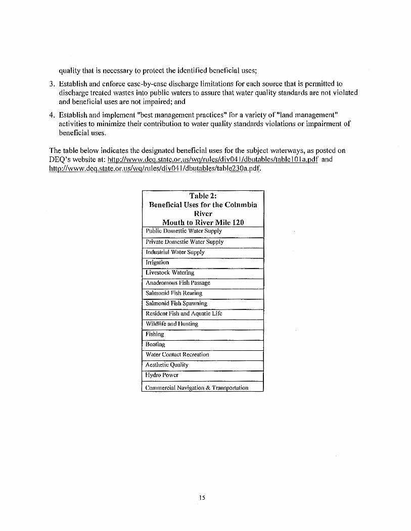
The table below indicates the designated beneficial uses for the subject waterways, as posted on DEQ's website at: http://www.deq.state.or.us/wq/rules/div041 /dbutables/table I 0 I a.pdf and http://www.deq.state.or.us/wq/rules/div041 /dbutables/table230a.pdf.
Table 2: Beneficial Uses for the Columbia
River Mouth to River Mile 120
Public Domestic Water Supply
Private Domestic Water Supply
Industrial Water Supply Irrigation
Livestock Watering
Anadromous Fish Passage
Salmonid Fish Rearing Salmonid Fish Spawning
Resident-Fish and Aquatic Life Wildlife and Hunting
Fishing Boating
Water Contact Recreation Aesthetic Quality Hydro Power
Commercial Navigation & Transportation
!5

Designated Fish Uses of the Main Stem Columbia River at the subject reach include salmon and steelhead migration corridor, as depicted in Figure l 0 lB at: http://www.deq.state.or.us/wg/rules/div04l/futables/table l 0 l b.Qill'.
Table 3: Estuaries All Other
Beneficial Uses for the & Streams & Adjacent Tributaries
North Coast Basin Marine Thereto Waters
Public Domestic Water Supply X
Private Domestic Water Supply X
Industrial Water Supply X X
Irrigation X
Livestock Watering X
Anadromous Fish Passage X X
Salmonid Fish Reuring X X
Salmonid Fish Spawning X X
Resident Fish and Aquatic Life X X
Wildlife and Hunting X X
Fishing X X
Boating X X
Water Contact Recreation X X
Aesthetic Quality X X
Commercial Navigation & Transportation X
Salmon and Steelhead Spawning Use Designations for the North Coast Basins streams are depicted in Figure 230B at: htlp://www.deg.state.or.us/wglrules/div04l/futigures/tigure230b.pdf.
6.2 Water Quality Standards
Water quality standards are developed for varying geographic areas to protect beneficial uses. Generally, if a water quality standard fully protects the most sensitive beneficial use, then all beneficial uses are fully protected. Water quality standards have been adopted for water quality parameters that are most significant or useful in regulating pollution. These standards take the form of both numeric limits and nanative criteria and have been established based on best available information at the time they were adopted. Development of standards is a continuing process. As new information becomes available, standards for additional parameters may be added and existing numeric standards or narrative criteria may be revised to better reflect the intent of protection of the identified beneficial uses.
16

6.3 Antidegradation Policy
Oregon's antidegradation policy (OAR 340-41-0004) applies to all surface waters. In the case of bodies of water that meet water quality standards, it provides for the maintenance of existing water quality. Specifically, it states that the existing quality of high quality waters (i.e., waters meeting water quality standards) must be maintained and protected unless the Environmental Quality Commission makes certain findings of need. For water quality-limited waters, water quality may in no circumstances be lowered; that is, these waters have a non-degradation status.
7. POTENTIAL MODIFICATION OF SURFACE WATER QUALITY
7.1 Antidegradation
340-041-0004 (I) Purpose. The purpose of the Antidegradation Policy is to guide decisions that affect water
quality such that unnecessary further degradation from new or increased point and nonpoint sources of pollution is prevented, and to protect, maintain, and enhance existing surface water quality to ensure the full protection of all existing beneficial uses. The standards and policies set forih in OAR 340-041-0007 through 340-041-0350 are intended to supplement the Antidegradation Policy.
(2) Growth Policy. In order to maintain the quality of waters in the State of Oregon, it is the general policy of the Commission to require that growth and development be accommodated by increased efficiency and effectiveness of waste treatment and control such that measurable· future discharged waste loads from existing sources do not exceed presently allowed discharged loads except as provided in section (3) through (9) of this rule.
(3) Non-degradation Discharges. The following new or increased discharges are subject to this Division. However, because they are not considered degradation of water quality, they are not required to undergo an anti degradation review under this rule:
(a) Discharges Into Existing Mixing Zones. Pollutants discharged into the pmiion of a water body that has been included in a previous mixing zone for a permitted source, including the zones of initial dilution, are not considered a reduction in water quality, so long as the mixing zone is established in accordance with OAR 340-041-0053, there are no other overlapping mixing zones from other point sources, and the discharger complies with all effluent limits set out in its NPDES permit.
(b) Water Conservation Activities. An increase in a pollutant concentration is not considered a reduction in water quality so long as the increase occurs as the result of a water conservation activity, the total mass load of the pollutant is not increased, and the concentration increase has no adverse effect on either beneficial uses or threatened or endangered species in the water body.
(c) Temperature. Insignificant temperature increases authorized under OAR 340-041-0028(11) and (12) are not considered a reduction in water quality.
17
{d) Dissolved Oxygen. Up to a 0.1 mg/1 decrease in dissolved oxygen from the upstream end of a stream reach to the downstream end of the reach is not considered a reduction in water quality so long as it has no adverse effects on threatened and endangered species.
( 4) Recurring Activities. Since the baseline for applying the antidegradation policy to an individual source is the water quality resulting from the source's currently authorized discharge, and since regularly-scheduled, recurring activities remain subject to water quality standards and the terms and conditions in any applicable federal and state permits, certifications and licenses, the following activities will not be considered new or increasing discharges and will therefore not trigger an antidegradation review under this rule so long as they do not increase in frequency, intensity, duration or geographical extent:
(a) Rotating grazing pastures,
(b) Agricultural crop rotations, and
(c) Maintenance dredging.
(5) Exemptions to the Antidegradation Requirement. Some activities may, on a short term basis, cause temporary water quality degradation. However, these same activities may also have substantial and desirable environmental benefits. The following activities and situations fall into this category. Such activities and situations remain subject to water quality standards, and must demonstrate that they have minimized adverse affects to threatened and endangered species in order to be exempt from the antidegradation review under this rule:
(a) Riparian Restoration Activities. Activities that are intended to restore the geomorphology or riparian vegetation of a water body, or control invasive species need not undergo an antidegradation review so long as the Depmiment determines that there is a net ecological benefit to the restoration activity. Reasonable measures that are consistent with the restoration objectives for the water body must be used to minimize the degradation;
(b) Emergency Situations. The Director or a designee may, for a period of time no greater than 6 months, allow lower water quality without an antidegradation review under this rule in order to respond to public health and welfare emergencies (for example, a significant threat of loss of life, personal injury or severe property damage); and
(c) Exceptions. Exceptions authorized by the Commission or Department under (9) of this rule.
(6) High Quality Waters Policy: Where the existing water quality meets or exceeds those levels necessary to support propagation of fish, shellfish, and wildlife and recreation in and on the water, and other designated beneficial uses, that level of water quality must be maintained and protected. However, the Environmental Quality Commission, after full satisfaction of the intergovernmental coordination and public participation provisions of the continuing planning process, and with full consideration of sections (2) and (9) of this rule, and 340-041-0007( 4), may allow a lowering of water quality in these high quality waters if it finds:
18

(a) No other reasonable alternatives exist except to lower water quality; and
(b) The action is necessary and benefits of the lowered water quality outweigh the environmental costs of the reduced water quality. This evaluation will be conducted in accordance with DEQ's "Antidegradation Policy Implementation Internal Management Directive for NPDES Permits and section 401 water quality certifications," pages 27, and 33-39 (March 2001) incorporated herein by reference;
(c) All water quality standards will be met and beneficial uses protected; and
(d) Federal threatened and endangered aquatic species will not be adversely affected.
(7) Water Quality Limited Waters Policy: Water quality limited waters may not be further degraded except in accordance with section (9)(a)(B), (C) and (D) of this rule.
(8) Outstanding Resource Waters Policy. Where existing high quality waters constitute an outstanding State or national resource such as those waters designated as extraordinary resource waters, or as critical habitat areas, the existing water quality and water quality values must be maintained and protected, and classified as "Outstanding Resource Waters of Oregon."
(a) The Commission may specially designate high quality water bodies to be classified as Outstanding Resource Waters in order to protect the water quality parameters that affect ecological integrity of critical habitat or special water quality values that are vital to the unique character of those water bodies. The Department will develop a screening process and establish a list of nominated water bodies for Outstanding Resource Waters designation in the Biennial Water Quality Status Assessment Report (305(b) Report). The priority water bodies for nomination include:
(A) Those in State and National Parks;
(B) National Wild and Scenic Rivers;
(C) State Scenic Waterways;
(D) Those in State and National Wildlife Refuges; and
(E) Those in federally designated wilderness areas.
(b) The Depmiment will bring to the Commission a list of water bodies that are proposed for designation as Outstanding Resource Waters at the time of each triennial Water Quality Standards Review; and
(c) When designating Outstanding Resource Waters, the Commission may establish the water quality values to be protected and provide a process for determining what activities are allowed that would not affect the outstanding resource values. After the designation, the Commission may not allow activities that may lower water quality below the level established except on a
19

sh01t term basis to respond to public health and welfare emergencies, or to obtain long-term water quality improvements.
(9) Exceptions. The Commission or Depattment may grant exceptions to this rule so long as the following procedures are met:
(a) In allowing new or increased discharged loads, the Commission or Depattment must make the following findings:
(A) The new or increased discharged load will not cause water quality standards to be violated;
(B) The action is necessary and benefits of the lowered water quality outweigh the environmental costs of the reduced water quality. This evaluation will be conducted in accordance with DEQ's "Antidegradation Policy Implementation Internal Management Directive for NPDES Permits and section 401 water quality certifications," pages 27, and 33-39 (March 2001) incorporated herein by reference; and
(C) The new or increased discharged load will not unacceptably threaten or impair any recognized beneficial uses or adversely affect threatened or endangered species. In making this determination, the Commission or Depatiment may rely upon the presumption that if the numeric criteria established to protect specific uses are met the beneficial uses they were designed to protect are protected. In making this determination the Commission or Department may also evaluate other State and federal agency data that would provide information on potential impacts to beneficial uses for which the numeric criteria have not been set;
(D) The new or increased discharged load may not be granted if the receiving stream is classified as being water quality limited under sub-section (a) of the definition of"Water Quality Limited" in OAR 340-041-0002, unless:
(i) The pollutant parameters associated with the proposed discharge are unrelated either directly or indirectly to the parameter(s) causing the receiving stream to violate water quality standards and being designated water quality limited; or
(ii) Total maximum daily loads (TMDLs), waste load allocations (WLAs) load allocations (LAs), and the reserve capacity have been established for the water quality limited receiving stream; and compliance plans under which enforcement action can be taken have been established; and there will be sufficient reserve capacity to assimilate the increased load under the established TMDL at the time of discharge; or
(iii) Effective July I, 1996, in water bodies designated water-quality limited for dissolved oxygen, when establishing WLAs under a TMDL for water bodies meeting the conditions defined in this rule, the Department may at its discretion provide an allowance for WLAs calculated to result in no measurable reduction of dissolved oxygen (DO). For this purpose, "no measurable reduction" is defined as no more than 0.10 mg/L for a single source and no more than 0.20 mg/L for all anthropogenic activities that influence the water quality limited segment. The allowance applies for surface water DO criteria and for Inter-gravel dissolved oxygen (IGDO)
20

if a determination is made that the conditions are natural. The allowance for WLAs applies only to surface water 30-day and seven-day means; or
(iv) Under extraordinary circumstances to solve an existing, immediate and critical environmental problem, the Commission or Department may, after the completion of a TMDL but before the water body has achieved compliance with standards, consider a waste load increase for an existing source on a receiving stream designated water quality limited under sub-section (a) of the definition of"Water Quality Limited" in OAR 340-041-0002. This action must be based on the following conditions:
(I) That TMD Ls, WLAs and LAs have been set; and
(II) That a compliance plan under which enforcement actions can be taken has been established and is being implemented on schedule; and
(III) That an evaluation of the requested increased load shows that this increment of load will not have an unacceptable temporary or permanent adverse effect on beneficial uses or adversely affect threatened or endangered species; and
(IV) That any waste load increase granted under subparagraph (iv) of this paragraph is temporary and does not extend beyond the TMDL compliance deadline established for the water body. If this action will result in a permanent load increase, the action has to comply with sub-paragraphs (i) or (ii) of this paragraph.
(b) The activity, expansion, or growth necessitating a new or increased discharge load is consistent with the acknowledged local land use plans as evidenced by a statement of land use compatibility from the appropriate local planning agency.
(c) Oregon's water quality management policies and programs recognize that Oregon's water bodies have a finite capacity to assimilate waste. Unused assimilative capacity is an exceedingly valuable resource that enhances in-stream values and environmental quality in general. Allocation of any unused assimilative capacity should be based on explicit criteria. In addition to the conditions in subsection (a) of this section, the Commission or Department may consider the following:
(A) Environmental Effects Criteria:
(i) Adverse Out-of-Stream Effects. There may be instances where the non-discharge or limited discharge alternatives may cause greater adverse environmental effects than the increased discharge alternative. An example may be the potential degradation of groundwater from land application of wastes;
(ii) In-stream Effects. Total stream loading may be reduced through elimination or reduction of other source discharges or through a reduction in seasonal discharge. A source that replaces other sources, accepts additional waste from less efficient treatment units or systems, or reduces discharge loadings during periods of low stream flow may be permitted an increased discharge
21

load year-round or during seasons of high flow, so long as the loading has no adverse affect on threatened and endangered species;
(iii) Beneficial Effects. Land application, upland wetlands application, or other non-discharge alternatives for appropriately treated wastewater may replenish groundwater levels and increase streamflow and assimilative capacity during othe1wise low streamflow periods.
(B) Economic Effects Criteria. When assimilative capacity exists in a stream, and when it is judged that increased loadings will not have significantly greater adverse environmental effects than other alternatives to increased discharge, the economic effect of increased loading will be considered. Economic effects will be of two general types:
(i) Value of Assimilative Capacity. The assimilative capacity of Oregon's streams is finite, but the potential uses of this capacity are virtually unlimited. Thus it is important that priority be given to those beneficial uses that promise the greatest return (beneficial use) relative to the unused assimilative capacity that might be utilized. In-stream uses that will benefit from reserve assimilative capacity, as well as potential future beneficial use, will be weighed against the economic benefit associated with increased loading;
(ii) Cost of Treatment Teclmology. The cost of improved treatment technology, non-discharge and limited discharge alternatives may be evaluated.
7.1.1 Application of Standard for Antidegradation
The above rule is generally designed to address new or increased pollutant loads, such as in a National Pollutant Discharge Elimination System (NPDES) permitted discharge. However, applicability can also be drawn for use in 40 l WQC evaluation of new or increased pollutant loads or potential for impairment.
The above rule sections require that existing high quality waters, where quality exceeds the levels necessary to protect fish, shellfish, wildlife, and recreation, must be maintained and protected. Exceptions are delineated and include a determination by the Environmental Quality Commission (EQC) or DEQ to allow lowered water quality for justifiable reasons, such as short-term (one month or less) lowering of water quality to respond to emergencies or otherwise protect public health and welfare. These sections also require DEQ to minimize degradation of water quality limited waters and protect the recognized beneficial uses of such waters by requiring the highest and best practicable control of all waste discharges and activities. These sections, in conjunction with other provisions of the water quality standards contained in OAR Chapter 340, Division 41 are intended to assure that water quality is not changed so as to impair designated beneficial uses of the water.
DEQ is required to interpret and apply the EQC adopted water quality standards, including the antidegradation policy, in a manner consistent with the guiding federal rules. DEQ has developed an internal management directive (!MD) to guide interpretation of the antidegradation policy when considering issuance of water quality permits and certifications. The !MD details the following guiding steps:
22

I. Determine if an Antidegradation Review is needed; 2. If needed, determine if a significant lowering of water quality will occur; 3. Factors to consider in allowing a lowering of water quality include:
a. The classification of the waterbody (outstanding, high, or limited); b. Consideration of alternative treatments; and, c. Comparison of the economic or social benefits with the environmental costs;
4. Determine whether or not the permit or certification should be drafted. DEQ typically allows approval of new discharges or activities that may have some theoretical or detectable impact on quality of waters provided that:
a. Adverse impact on water quality will not be significant; b. Any change in water quality will not adversely affect existing, designated and potential
beneficial uses; and, c. Highest and best practicable treatment and control of waste discharges and activities is
employed to minimize any adverse effects on water quality. 5. Provide public notice of the Antidegradation review.
Under ordinary circumstances, compliance with the water quality standards in OAR Chapter 340, Division 41 would be considered sufficient to assure that beneficial uses will be protected. However, if a standard has not been adopted for a pollutant parameter of concern, or if new information indicates that an existing standard is not adequate to prevent adverse water quality impact on a beneficial use in the particular situation, DEQ is required to impose more stringent water quality protection measures to protect designated beneficial uses, including denial of project approval if necessary.
7.1.2 Present Condition for Antidegradation Review
The Columbia River, Hunt Creek, Clatskanie River, Driscoll Slough, Westport Slough, Whiskey Joe Slough, Ludviksen Slough, Kelli Slough, Midland Canal, Uncle Tom Slough, Wallace Slough, Larson Slough, McLean Slough, and the ditches and other tributaries to these waters are not · currently designated as high quality waters. Impairments in each are specified below, indicating that all of these waters are non-degradation status.
The Columbia River is classified in various reaches as water quality limited under the Clean Water Act, Section 303(d), for the parameters of: Arsenic; DOE (DDT metabolite); Fecal Coliform; PCB; pH; Polynuclear Aromatic Hydrocabons (PAHs); and Temperature; and with potential concern for the parameters of: Cadmium; Copper; Iron; Lead; Mercury; Nickel; Silver; Tributyltin; Zinc; Aldrin; Alkalinity; Alpha-BNC; Benzo(a)anthracene; Benzo(g, h, i)perylene; Bhc; Chlordane; Chrysene; Cyanide; ODD; DDT; Dieldrin; Endrin; Hexavalent Chromium; Manganese; Mercury; Phenol; Phosphorus; Pyrene; and Radionuclides.
In the Columbia River, Total Maximum Daily Loads (TMDLs) have been developed by DEQ and approved by the U.S. Environmental Protection Agency (EPA) for the parameters of: Dioxin and Total Dissolved Gas. EPA has not yet completed development of a TMDL for the parameter of Temperature, and DEQ has not yet completed TMDLs for the parameters of Arsenic; DOE; Fecal Coliform; PCBs; pH; and PAHs.
23
Beneficial uses impaired by the listed parameters in the Columbia River include: salmon and steelhead migration corridor; anadromous fish passage; resident fish and aquatic life; shellfish growing; fishing; human health; drinking water; and water contact recreation.
Hunt Creek is on the 303(d) list of impaired waterbodies with potential concern for the parameter of Alkalinity. The beneficial use of aquatic life may be impaired by degradation of existing levels of Alkalinity.
The Clatskanie River. Driscoll Slough. Westpmi Slough, Ludviksen Slough, Midland Canal, Uncle Tom Slough, Wallace Slough, Larson Slough, McLean Slough, and multiple ditches and other tributaries to these waters are regulated by the Load Allocations assigned by the North Coast Subassins TMDL for the parameters of Temperature and Bacteria. The Clatskanie River is also on Section 303(d) list of impaired waterbodies with potential concern for the parameters of Alkalinity and Iron.
Beneficial uses impaired by the listed parameters in these waters include: aquatic life, human health, water contact recreation, shellfish growing, and salmonid fish spawning, rearing and passage.
7.1.3 Applicant's Position on Antidegradation
The applicant did not provide any discussion specifically on the Antidegradation Policy. However, the applicant did provide an analysis of potential impacts to the designated beneficial uses in the subject waterways and to eight of the foUtieen applicable water quality standards, as a result of the proposed project.
The applicant's analyses concluded that the proposed project will have no adverse impacts to the beneficial uses of: Public and Private Domestic Water Supply; Industrial Water Supply; Irrigation; Livestock Watering; Fishing; Boating; Aesthetic Quality; and Commercial Navigation and Transpmiation. The applicant's analysis of impacts to Water Contact Recreation concluded that there will not be any adverse impacts and that positive impacts may occur for personal watercraft use. The applicant's analysis of impacts to Wildlife and Hunting concluded that there may be some impacts, but these will be offset by mitigation offered. The applicant's analysis of impacts to fish and Aquatic Life examined the potentially impactful categories of: wake stranding; shoreline erosion; terminal construction; terminal operation; power line construction; access roads and Hunt Creek bridge replacement; pipeline; and habitat alteration. Most categories were determined not to have adverse impacts. For categories where minimal· impacts were identified, implementation of best management practices (e.g., ships traveling more slowly than vessels on the Columbia do now, use of bubble curtains during in-water pile driving, timing activities when no fish are present) or offset through mitigation offered is concluded to be sufficient to avoid impairment of the Fish and Aquatic Life beneficial use.
The applicant's analyses concluded that the proposed project will have no adverse impacts to the water quality parameters of: Dissolved Oxygen; Nuisance Phytoplankton Growth; pH; Bacteria; and Total Dissolved Gas. The applicant's analysis·ofpotential impairments to the water quality parameter of Temperature concluded that any adverse affects would be negligible and that the mitigation offered will improve Temperature impairment. The applicant's analyses of potential
24
impacts to the water quality parameters of Turbidity and Toxics concluded that Turbidity impacts would be short lived and that implementation of best management practices would minimize the potential for impacts to both parameters.
The applicant's analyses did not address the applicable water quality parameters of: Antidegradation; Statewide Narrative Criteria; Biocriteria; or Basin Specific Criteria in the Main Stem Columbia River and the North Coast Basin.
7.1.4 Public Comment on Antidegradation
DEQ received many comments relevant to Antidegradation. However, lacking information requested from the applicant to make determinations on this and other water quality criteria, DEQ did not complete the integration of public comments on Antidegradation.
7.1.5 DEQ Evaluation on Antidegradation
DEQ undertook an Antidegradation Review following DEQ's Antidegradation Policy Implementation Internal Management Directive forNPDES Permits and Section 401 Water Quality Cettifications (March 2001). See DEQ's Bradwood Landing LNG Antidegradation Review Sheet for Proposed 401 Water Quality Certification, which is provided as an attachment to 401 WQC decision (as is this Evaluation and Findings Report).
The Columbia River, Hunt Creek, Clatskanie River, Driscoll Slough, Westport Slough, Ludviksen Slough, Midland Canal, Uncle Tom Slough, Wallace Slough, Larson Slough, McLean Slough, and multiple ditches and other tributaries to these waters are all Water Quality Limited Waters.
Based on evaluation of the best available information, DEQ determined that a lowering of water quality would occur for the following parameters: Narrative Criteria (as described in OAR 340-041-0007); Biocriteria; Dissolved Oxygen; Nuisance Phytoplankton; Temperature; Total Dissolved Solids; Toxic Substances; and Turbidity. DEQ's evaluation of potential impacts to all water quality parameters follows in section 7.2 through 7.13 of this document and finds that the dredging and subsequent side slope slumping will initiate channel alterations that will propogate down the Clifton Channel and cause significant degradation of these parameters. This lowering of water quality, along with loss of habitat and food sources, will adversely impact the existing designated beneficial uses of: Anadromous Fish Passage; Salmonid Fish Rearing; Salmonid Fish Spawning; Resident and Aquatic Life; Wildlife and Hunting; Fishing; and Aesthetic Quality in the Columbia River, which is designated as a salmon and steelhead migration corridor.
7.1.6 DEQ Finding on Antidcgradation
Based on evaluation of the best available information, adverse impacts to multiple water quality parameters may be significant and this will adversely impact existing and potential designated beneficial uses. Because the subject waterways are already Water Quality Limited, reversal of the impacts of the geomorphic alterations would not be possible, and mitigation has not been demonstrated to be adequate or achievable, DEQ concludes that application for 40 I WQC for this proposed project should be denied.
25
7.2 Statewide Narrative Criteria
340-041-0007 (1) Notwithstanding the water quality standards contained in this Division, the highest and best
practicable treatment and/or control of wastes, activities, and flows must in every case be provided so as to maintain dissolved oxygen and overall water quality at the highest possible levels and water temperatures, coliform bacteria concentrations, dissolved chemical substances, toxic materials, radioactivity, turbidities, color, odor, and other deleterious factors at the lowest possible levels.
(2) Where a less stringent natural condition of a water of the State exceeds the numeric criteria set out in this Division, the natural condition supersedes the numeric criteria and becomes the standard for that water body. However, there are special restrictions, described in OAR 340-041-0004(9)(a)(D)(iii), that may apply to discharges that affect dissolved oxygen.
(3) For any new waste sources, alternatives that utilize reuse or disposal with no discharge to public waters must be given highest priority for use wherever practicable. New source discharges may be approved subject to the criteria in OAR 340-041-0004(9).
(4) No discharges of wastes to lakes or reservoirs may be allowed except as provided in section OAR 340-041-0004(9).
(5) Logging and forest management activities must be conducted in accordance with the Oregon Forest Practices Act to minimize adverse effects on water quality.
(6) Log handling in public waters must conform to current Commission policies and guidelines.
(7) Sand and gravel removal operations must be conducted pmsuant to a permit from the Depatiment of State Lands and separated from the active flowing stream by a watertight berm wherever physically practicable. Recirculation and reuse of process water must be required wherever practicable. Discharges or seepage or leakage losses to public waters may not cause a violation of water quality standards or adversely affect legitimate beneficial uses.
(8) Road building and maintenance activities must be conducted in a manner so as to keep waste materials out of public waters and minimize erosion of cut banks, fills, and road smfaces.
(9) In order to improve controls over nonpoint sources of pollution, federal, State, and local resource management agencies will be encouraged and assisted to coordinate planning and implementation of programs to regulate or control runoff, erosion, turbidity, stream temperature, stream flow, and the withdrawal and use of irrigation water on a basin-wide approach so as to protect the quality and beneficial uses of water and related resources. Such programs may include, but not be limited to, the following:
(a) Development of projects for storage and release of suitable quality waters to augment low stream flow;
26
(b) Urban runoff control to reduce erosion;
(c) Possible modification of irrigation practices to reduce or minimize adverse impacts from irrigation return flows;
(d) Stream bank erosion reduction projects; and
(e) Federal water quality restoration plans.
(I 0) The development of fungi or other growths having a deleterious effect on stream bottoms, fish or other aquatic life, or that are injurious to health, recreation, or industry may not be allowed;
(II) The creation of tastes or odors or toxic or other conditions that are deleterious to fish or other aquatic life or affect the potability of drinking water or the palatability of fish or shellfish may not be allowed;
(12) The formation of appreciable bottom or sludge deposits or the formation of any organic or inorganic deposits deleterious to fish or other aquatic life or injurious to public health, recreation, or industry may not be allowed;
( 13) Objectionable discoloration, scum, oily sheens, or floating solids, or coating of aquatic life with oil films may not be allowed;
(14) Aesthetic conditions offensive to the human senses of sight, taste, smell, or touch may not be allowed;
(15) Radioisotope concentrations may not exceed maximum permissible concentrations (MPC's) in drinking water, edible fishes or shellfishes, wildlife, irrigated crops, livestock and dairy products, or pose an external radiation hazard;
(16) Minimum Design Criteria for Treatment and Control of Wastes. Except as provided in OAR 340-041-0 I 0 I through 340-041-0350, and subject to the implementation requirements set fotih in OAR 340-04 I -0061, prior to discharge of any wastes from any new or modified facility to any waters of the State, such wastes must be treated and controlled in facilities designed in accordance with the following minimum criteria.
(a) In designing treatment facilities, average conditions and a normal range of variability are generally used in establishing design criteria. A facility once completed and placed in operation should operate at or near the design limit most of the time but may operate below the design criteria limit at times due to variables which are unpredictable or uncontrollable. This is patiicularly true for biological treatment facilities. The actual operating limits are intended to be established by permit pursuant to ORS 468.740 and recognize that the actual performance level may at times be less than the design criteria.
27

(A) Sewage wastes:
(i) Effluent BOD concentrations in mg/1, divided by the dilution factor (ratio of receiving stream flow to effluent flow) may not exceed one unless otherwise approved by the Commission;
(ii) Sewage wastes must be disinfected, after treatment, equivalent to thorough mixing with sufficient chlorine to provide a residual of at least I pat1 per million after 60 minutes of contact time unless otherwise specifically authorized by permit;
(iii) Positive protection must be provided to prevent bypassing raw or inadequately treated sewage to public waters unless otherwise approved by the Department where elimination of inflow and infiltration would be necessary but not presently practicable; and
(iv) More stringent waste treatment and control requirements may be imposed where special conditions make such action appropriate.
(B) Industrial wastes:
(i) After maximum practicable in-plant control, a minimum of secondary treatment or equivalent control (reduction of suspended solids and organic material where present in significant quantities, effective disinfection where bacterial organisms of public health significance are present, and control of toxic or other deleterious substances);
(ii) Specific industrial waste treatment requirements may be determined on an individual basis in accordance with the provisions of this plan, applicable federal requirements, and the following:
(I) The uses that are or may likely be made of the receiving stream;
(II) The size and nature of flow of the receiving stream;
(III) The quantity and quality of wastes to be treated; and
(IV) The presence or absence of other sources of pollution on the same watershed.
(iii) Where industrial, commercial, or agricultural effluents contain significant quantities of potentially toxic elements, treatment requirements may be determined utilizing appropriate bioassays;
(iv) Industrial cooling waters containing significant heat loads must be subjected to off-stream cooling or heat recovery prior to discharge to public waters;
(v) Positive protection must be provided to prevent bypassing of raw or inadequately treated industrial wastes to any public waters;
(vi) Facilities must be provided to prevent and contain spills of potentially toxic or hazardous .
28

materials.
7.2.1 Application of Standard for Narrative Criteria
This standard is self-explanatory in its purpose to prohibit degradation of water quality, pmticularly with respect to aesthetic offenses, and to ensure that where natural (non-anthropogenic) causes result in water quality that exceeds the numeric criteria, that the naturally occurring condition shall be the standard.
7.2.2 Present Condition of Narrative Criteria
7.2.2.1 Fungi and Other Growths
There is no current information available as to unacceptable deleterious effect on stream bottoms, fish or other aquatic life; or demonstrating that fungi or other growths are injurious to health, recreation, or industry in the subject waterways.
7.2.2.2 Creation of Taste, Odor, Toxic or Other Conditions Deleterious to Fish, Aquatic Life, Drinking Water Potability or Fish or Shellfish Palatability
There is no current information available as to unacceptable taste and odor or other conditions in the subject surface waters that has a deleterious effect on fish, other aquatic life, potability of drinking water, or palatability of fish or shellfish. No known drinking water sources from these surface waters exist in the area, though multiple groundwater wells serve residents near the terminal and along the pipeline route. Shellfish harvest does occur at the mouth of the Columbia River.
7.2.2.3 Appreciable Bottom or Sludge Deposits or any Organic or Inorganic Deposits
A portion of the ditches and other tributaries to the North Coast Basin sloughs and streams may have appreciable bottom deposits and organic or inorganic deposits due to conformance of these waterways to serve land use practices in the area. The mouths of the sloughs, larger streams and the Columbia River do not currently exhibit deleterious deposits.
7.2.2.4 Objectionable Discoloration, Scum, Oil Sheens, or Floating Solids or Coating of Aquatic Life with Oil Films
No information is available that indicates that any of these issues are currently present in the subject waterways.
7.2.2.5 Aesthetic Conditions Offensive to the Human Senses of Sight, Taste, Smell or Touch
No information is available that indicates that any of these issues are currently present in the subject waterways.
7.2.2.6 Radioisotope Concentrations
There is potential concern in some Oregon reaches the Columbia River or Radionuclides because
29

elevated levels have been detected. Howeve•·, no information is available that indicates exceedance of maximum permissible concentrations in drinking water, edible fishes or shellfishes, wildlife, irrigated crops, livestock and dairy products, or pose an external radiation hazard.
7.2.2.7 Minimum Design Criteria for Treatment and Control of Wastes
Not applicable.
7.2.3 Applicant's Position on Narrative Criteria
7.2.3.1 Fungi and Other Growths
7.2.3.2 Creation of Taste, Odor, Toxic or Other Conditions Deleterious to Fish, Aquatic Life, Drinking Water Potability or Fish or Shellfish Palatability
7.2.3.3 Appreciable Bottom or Sludge Deposits or any Organic or Inorganic Deposits
7.2.3.4 Objectionable Discoloration, Scum, Oil Sheens, or Floating Solids or Coating of Aquatic Life with Oil Films
7.2.3.5 Aesthetic Conditions Offensive to the Human Senses of Sight, Taste, Smell or Touch
7.2.3.6 Radioisotope Concentrations
7.2.3.7 Minimum Design Criteria for Treatment and Control of Wastes
The applicant did not provide data or evaluation on the potential impacts to Narrative Criteria in the subject waterways as a result of the proposed project. The applicant's beneficial use analysis concluded that the stream crossing impacts would have no perceptible change to aesthetic quality and that many of the streams crossed currently have little or no aesthetic value.
7.2.4 Public Comment on Narrative Criteria (See Table I [page 6-7] for commenter names assigned to numbers)
7.2.4.1 Fungi and Other Growths No comments were received specific to fungi and other growths.
7.2.4.2 Creation of Taste, Odor, Toxic or Other Conditions Deleterious to Fish, Aquatic Life, Drinking Water Potability or Fish or Shellfish Palatability
No comments were received specific to taste and odor.
7.2.4.3 Appreciable Bottom or Sludge Deposits or any Organic or Inorganic Deposits
Commenters expressed concern for increased bottom deposits at the proposed turning basin and in Clifton Channel following dredging (52, 79). The sump created by additional depth will slow water flows and encourage suspended material to settle out. The dredge cut in unconsolidated sand of approximately one foot vertical to 3 feet horizontal will tend toward the original slope (I foot vertical to I 0 feet horizontal) aided by waves, wake, propeller wash and other hydrodynamic forces. This will instigate shoreline erosion and supply material which could be carried into
30

Clifton Channel and deposited (79). In addition, wake and propeller wash from very large LNG ships would cause shoreline erosion of material which could also be deposited in Clifton Channel (52).
7.2.4.4 Objectionable Discoloration, Scum, Oil Sheens, or Floating Solids or Coating of Aquatic Life with Oil Films
Commenters expressed concern that oily sheens and other objectionable films may begin occurring due to increased large shipping traffic and accidental spills of LNG or other industrial products associated with ships and the terminal (40, 41, 52, 88, 97, 106 and 141). Further, distribution of oily sheens, from accidental spills or incidental to the operation of ships and the terminal, will be wide spread due to the strong currents and dynamic flow patterns at the site ( 40).
7.2.4.5 Aesthetic Conditions Offensive to the Human Senses of Sight, Taste, Smell or Touch
The chief aesthetic concern was establishment of a large industrial facility extending into the Columbia River at an area that is currently undeveloped. It is feared that construction and operation of the facility will change the area and eliminate fish habitat and other use opportunities (52, 63, 87, 93, 96, 135 and 138), especially in the event of a catastrophic event (e.g., accidental or earthquake induced spill or explosion) (63 and 134). The effects on aesthetics and ecosystem function due to such an event would be worsened by the extent of combustible forested area in proximity and far distance of potential emergency response to the remote location (58). Even without incident, building and operating the terminal facility may preclude commercial and recreational fishing, boating, hunting and other water related pursuits (9, 21, 40, 41, 52, 63, 88, 97, I 03 and I 06). Residents on Clifton Road regularly count more than I 00 boats per day in Clifton Channel during spring and summer months (52), enjoying the existing beneficial uses.
7.2.4.6 Radioisotope Concentrations
No comments were received specific to radioisotope concentrations.
7.2.4.7 Minimum Design Criteria for Treatment and Control of Wastes
Not applicable.
7.2.5 DEQ Evaluation on Narrative Criteria
7.2.5.1 Fungi and Other Growths
7.2.5.2 Creation of Taste, Odor, Toxic or Other Conditions Deleterious to Fish, Aquatic Life, Drinking Water Potability or Fish or Shellfish Palatability
7.2.5.3 Appreciable Bottom or Sludge Deposits or any Organic or Inorganic Deposits
7.2.5.4 Objectionable Discoloration, Scum, Oil Sheens, or Floating Solids or Coating of Aquatic Life with Oil Films
7.2.5.5 Aesthetic Conditions Offensive to the Human Senses of Sight, Taste, Smell or Touch
31

7.2.5.6 Radioisotope Concentrations
7.2.5.7 Minimum Design Criteria for Treatment and Control of Wastes
DEQ did not receive requested information necessary to complete the evaluation on potential impacts to the Narrative Criteria. However, DEQ's concern for creation of Conditions Deleterious to Fish and Aquatic Life and Appreciable Bottom Deposits were part of the basis for the DEQ's request for specific information on Hydraulic and Hydrologic Alteration and refined data collection and modeling. In evaluating the available geomorphic and modeling information, DEQ believes that dramatic side slope slumping at the mouth of Clifton Channel will occur, perhaps propagating effects up Clifton Channel past the existing hydraulic control riffle area (Castro, 20 I 0). Flows are likely to exacerbate slumping and perhaps set up a perpetual cycle of erosion and resuspension until the project area banks are undermined or a hard structure is placed. This could extend erosive or aggradational impacts to island banks and inter-island channels within the National Wildlife Refuges complexes and at Svenson Island. DEQ documented multiple restoration projects in this immediate area funded or undertaken by Oregon Watershed Enhancement Board, Bonneville Power administration (under court order for impacts to salmonids due to the Columbia River hydropower system), Lower Columbia River Estuary Partnership, Columbia River Inter-Tribal Fish Commission & other tribes, and US Fish and Wildlife Service. In addition, NMFS Science Center has a decade long study site at the mouth of the Clifton Cham1el. These potential, perpeh1al geomorphic alterations could imperil these completed restoration projects targeted to improve water quality and beneficial uses functions and eliminate the NMFS study site. This would create Conditions Deleterious to Fish and Aquatic Life by reversing water quality and habitat improvements and compromise millions of dollars of public and private funding spent in restoring these areas at the expense of other areas.
7.2.6 DEQ Finding on Narrative Criteria
7.2.6.1 Fungi and Other Growths
7.2.6.2 Creation of Taste, Odor, Toxic or Other Conditions Deleterious to Fish, Aquatic Life, Drinking Water Potability or Fish or Shellfish Palatability
7.2.6.3 Appreciable Bottom or Sludge Deposits or any Organic or Inorganic Deposits
7.2.6.4 Objectionable Discoloration, Scum, Oil Sheens, or Floating Solids or Coating of Aquatic Life with Oil Films
7.2.6.5 Aesthetic Conditions Offensive to the Human Senses of Sight, Taste, Smell or Touch
7.2.6.6 Radioisotope Concentrations
7.2.6.7 Minimum Design Criteria for Treatment and Control of Wastes
Lacking specific information requested on Hydraulic and Hydrologic Alteration and refined data collection and modeling, DEQ cannot find that the proposed project will not cause or contribute to violations of the Narrative Criteria.
32

7.3 Bacteria
340-041-0009 (l) Numeric Criteria: Organisms of the coliform group commonly associated with fecal sources
(MPN or equivalent membrane filtration using a representative number of samples) may not exceed the criteria described in paragraphs (a) and (b) of this paragraph:
(a) Freshwaters and Estuarine Waters Other than Shellfish Growing Waters:
(A) A 30-day log mean of 126 E. coli organisms per I 00 milliliters, based on a minimum of five (5) samples;
(B) No single sample may exceed 406 E. coli organisms per I 00 milliliters.
(b) Marine Waters and Estuarine Shellfish Growing Waters: A fecal coliform median concentration of 14 organisms per I 00 milliliters, with not more than ten percent of the samples exceeding 43 organisms per 100 ml.
(2) Raw Sewage Prohibition: No sewage may be discharged into or in any other manner be allowed to enter the waters of the State, unless such sewage has been treated in a manner approved by the Department or otherwise allowed by these rules;
(3) Animal Waste: Runoff contaminated with domesticated animal wastes must be minimized and treated to the maximum extent practicable before it is allowed to enter waters of the State;
(4) Bacterial pollution or other conditions deleterious to waters used for domestic purposes, livestock watering, irrigation, bathing, or shellfish propagation, or otherwise injurious to public health may not be allowed;
(5) Effluent Limitations for Bacteria: Except as allowed in subsection (c) of this section, upon NPDES permit renewal or issuance, or upon request for a permit modification by the permittee at an earlier date, effluent discharges to freshwaters, and estuarine waters other than shellfish growing waters may not exceed a monthly log mean of 126 E. coli organisms per I 00 ml. No single sample may exceed 406 E. coli organisms per I 00 ml. However, no violation will be found, for an exceedance if the permittee takes at least five consecutive re-samples at four-hour intervals beginning as soon as practicable (preferably within 28 hours) after the original sample was taken and the log mean of the five re-samples is less than or equal to 126 E. coli. The following conditions apply:
(a) If the Depattment finds that re-sampling within the timeframe outlined in this section would pose an undue hardship on a treatment facility, a more convenient schedule may be negotiated in the permit, provided that the permittee demonstrates that the sampling delay will result in no increase in the risk to water contact recreation in waters affected by the discharge;
(b) The in-stream criterion for chlorine listed in Table 20 must be met at all times outside the
33

assigned mixing zone;
(c) For sewage treatment plants that are authorized to use reclaimed water pursuant to OAR 340, division 55, and that also use a storage pond as a means to dechlorinate their effluent prior to discharge to public waters, effluent limitations for bacteria may, upon request by the permittee, be based upon appropriate total coliform, limits as required by OAR 340, division 55:
(A) Level II limitations: No two consecutive samples may exceed 240 total coliform per I 00 milliliters.
(B) Level III and Level IV limitations: No single sample may exceed 23 total coliform per I 00 milliliters.
(C) No violation will be found for an exceedance under this paragraph if the permittee takes at least five consecutive re-samples at four hour intervals beginning as soon as practicable (preferably within 28 hours) after the original sample(s) were taken; and in the case of Level II effluent, the log mean of the five re-samples is less than or equal to 23 total coliform per 100 milliliters or, in the case of Level III and IV effluent, if the log mean of the five re-samples is less than or equal to 2.2 total coliform per I 00 milliliters.
(6) Sewer Overflows in winter: Domestic waste collection and treatment facilities are prohibited from discharging raw sewage to waters of the State during the period of November I through May 21, except during a storm event greater than the one-in-five-year, 24-hour duration storm. However, the following exceptions apply:
(a) The Commission may on a case-by-case basis approve a bacteria control management plan to be prepared by the permittee, for a basin or specified geographic area which describes hydrologic conditions under which the numeric bacteria criteria would be waived. These plans will identify the specific hydrologic conditions, identify the public notification and education processes that will be followed to inform the public about an event and the plan, describe the water quality assessment conducted to determine bacteria sources and loads associated with the specified hydrologic conditions, and describe the bacteria control program that is being implemented in the basin or specified geographic area for the identified sources;
(b) Facilities with separate sanitary and storm sewers existing on January I 0, 1996, and which currently experience sanitary sewer overflows due to inflow and infiltration problems, must submit an acceptable plan to the Depattment at the first permit renewal, which describes actions that will be taken to assure compliance with the discharge prohibition by January I, 2010. Where discharges occur to a receiving stream with sensitive beneficial uses, the Depattment may negotiate a more aggressive schedule for discharge elimination;
(c) On a case-by-case basis, the beginning of winter may be defined as October 15, if the permittee so requests and demonstrates to the Department's satisfaction that the risk to beneficial uses, including water contact recreation, will not be increased due to the date change.
(7) Sewer Overflows in summer: Domestic waste collection and treatment facilities are prohibited
34

from discharging raw sewage to waters of the State during the period of May 22 tluough October 31, except during a storm event greater than the one-in-ten-year, 24-hour duration storm. The following exceptions apply:
(a) For facilities with combined sanitary and storm sewers, the Commission may on a case-by-case basis approve a bacteria control management plan such as that described in subsection (6)(a) of this rule;
(b) On a case-by-case basis, the beginning of summer may be defined as June l if the permittee so requests and demonstrates to the Department's satisfaction that the risk to beneficial uses, including water contact recreation, will not be increased due to the date change;
(c) For discharge sources whose permit identifies the beginning of summer as any date from May 22 through May 31: If the permittee demonstrates to the Department's satisfaction that an exceedance occurred between May 21 and June l because of a sewer overflow, and that no increase in risk to beneficial uses, including water contact recreation, occurred because of the exceedance, no violation may be triggered, if the storm associated with the overflow was greater than the one-in-five-year, 24-hour duration storm.
(8) Storm Sewers Systems Subject to Municipal NPDES Storm water Permits: Best management practices must be implemented for permitted storm sewers to control bacteria to the maximum extent practicable. In addition, a collection-system evaluation must be performed prior to permit issuance or renewal so that illicit and cross connections are identified. Such connections must be removed upon identification. A collection system evaluation is not required where the Department determines that illicit and cross connections are unlikely to exist.
(9) Storm Sewers Systems Not Subject to Municipal NPDES Stormwater Permits: A collection system evaluation must be performed of non-permitted storm sewers by January I, 2005, unless the Department determines that an evaluation is not necessary because illicit and cross connections are unlikely to exist. Illicit and cross-connections must be removed upon identification.
(10) Water Quality Limited for Bacteria: In those water bodies, or segments of water bodies identified by the Department as exceeding the relevant numeric criteria for bacteria in the basin standards and designated as water-quality limited under section 303(d) of the Clean Water Act, the requirements specified in section II of this rule and in OAR 340-041-0061(!2) must apply.
(ll) In water bodies designated by the Depmiment as water-quality limited for bacteria, and in accordance with priorities established by the Department, development and implementation of a bacteria management plan tnay be required of those sources that the Depatiment determines to be contributing to the problem. The Department may determine that a plan is not necessary for a patiicular stream segment or segments within a water-quality limited basin based on the contribution of the segment(s) to the problem. The bacteria management plans will identify the technologies, best management practices and/or measures and approaches to be implemented by point and nonpoint sources to limit bacterial contamination. For point sources, their National Pollutant Discharge Elimination System permit is their
35

bacteria management plan. For nonpoint sources, the bacteria management plan will be developed by designated management agencies (DMAs) which will identify the appropriate best management practices or measures and approaches.
7.3.1 Application of Standard of Bacteria
This is a water quality standard of public health significance. It takes into account the cumulative impacts of all coliform bacteria discharges; however, its major emphasis is on the control of human fecal coliform bacteria sources.
7.3.2 Present Condition of Bacteria
The Columbia River is listed as impaired for the parameter of Fecal Coliform between river mile 0 to 35.2. Bacteria discharges to the Columbia River occur at Portland and Astoria as a result of permitted municipal wastewater discharges. Both of these sources are under agreed Orders from DEQ.
7.3.3 Applicant's Position on Bacteria
The applicant does not believe that the proposed project will contribute additional Bacteria to any of the subject waterways.
7.3.4 Public Comment on Bacteria
No comments were received on the criterion of Bacteria.
7.3.5 DEQ Evaluation on Bacteria
New sources of bacteria which could contribute to water quality impairment include human waste during construction and operation of the terminal facility and pastureland disturbance which could carry dormant fecal coliform into streams crossed by or adjacent to the proposed pipeline. Installation and maintenance of properly permitted septic facilities will adequately address control of bacterial spread to waters from new human waste sources at the terminal facility. Implementation and maintenance of properly functioning erosion and sediment controls during land and stream disturbance for pipeline installation should be effective in controlling any soil associated bacteria from entering waterways.
7.3.6 DEQ Finding on Bacteria
Provided appropriate permits are obtained and conditions implemented and adequate erosion and sediment control practices are adhered to, DEQ does not anticipate violation of the Bacteria standard as a result of the proposed project activities.
7.4 Biocriteria
340-041-0011 Waters of the State shall be of sufficient quality to support aquatic species without detrimental changes in the resident biological communities.
340-041-0002
36

Defines "without changes in the resident biological community" as "no loss of ecological integrity when compared to natural conditions at an appropriate reference site or region." "Ecological integrity" is defined as "the summation of chemical, physical and biological integrity capable of supporting and maintaining a balanced, integrated, adaptive community of organisms having a species composition, diversity, and functional organization comparable to that of the natural habitat for the region." An "appropriate reference site or region" is further defined as "a site on the same water body, or within the same basin or eco-region that has similar habitat conditions, and represents the water quality and biological community attainable within the area of concern."
7.4.1 Application ofBiocriteria Standard
The biocriteria standard is meant to complement the other parameter-specific criteria in the following manner. The parameter-specific criteria are designed to give full protection to the most sensitive beneficial use, with the implicit assumption that if the most sensitive beneficial use is protected, then all uses will be protected. However, the application of these criteria is very limited in considering multiple stressors and cumulative effects. By contrast, the biocriteria are aimed at gaining the ability to assess total impact to the community in situ. Biocriteria make it possible to evaluate the impact of a source without a need for measuring every possible water quality variable. Thus, the standard is applied as a measure of the impact of a source by comparing the biological integrity (as represented by appropriate expressions) downstream of the source with that at a reference site or region.
7.4.2 Present Condition of Biocritcria
There are 13 salmonid species listed under federal and state endangered species statutes that inhabit the Columbia River. While the factors that have led to their decline are manifold, water quality has played a role.
Green and white sturgeon species are present in the Columbia River, most prevalently in the areas above the Mouth. Presence seems to be greater in summer, lower in winter and at some intermediate level in the spring. Green sturgeon are currently federally listed as endangered.
Migrating eulachon (smelt) densities vary by season, but seem to be at their greatest abundance in the spring. Eulachon were petitioned for listing in 2009 and listed as threatened in March 20 I 0.
Dungeness crab are present in the river up to river mile 18.
River lamprey and Pacific lamprey migrate throughout the Columbia River and into the Pacific Ocean.
Steller and California Sea lions traverse the Columbia River from the mouth to Bonneville Dam, and sometimes above.
Marine species as detailed in the applicant's Biological Assessment.
Other anadromous or resident organisms which may be present in areas proposed for impact by dredging and disposal are: American Shad, Starry flounder; Cottid; Banded killfish; Suckers;
37

Yellow perch; Pikeminnow; Peamouth; Pacific tomcod; Northern anchovy; Sand sole; Shiner perch; Threespine stickleback; Sand shrimp; Smooth bay shrimp; and multiple groups of benthic organisms.
Prior to large scale river alteration by dams, pile dikes, island and bank dikes, tidegates and other flood control devices, the lower Columbia River estuary provided a diverse array of fish and wildlife habitat types. In the past I 00 years, these alterations combined with other factors have resulted in a decline in water quality and a loss of more than 50% of former fish habitat (LCREP, 2010).
The existing ecological community in the immediate area of the project location and the Clifton Channel seems to exhibit some diversity and robustness, but almost no data or specific study information exists on ecological community or the individual components (e.g., water quality, benthic organisms, sediment contamination, fish use) in this reach. The lack of significant development along the banks, especially within the island complexes which are designated as National Wildlife Refuges, has allowed a high degree of natural function to be retained, despite impaired water quality, frequent commercial use of the navigation channel on the opposite side of the island chain, historical impacts of the upriver dams and much more intense development on banks mimy miles up and down river. The Clifton Channel appears to be a significant migration corridor for multiple life stages of anadromous species (Roegner, 20 I 0). The channel offers refuge from higher velocities, access to a diverse array of shorelines and features within the Cathlamet Bay island complexes that make up the National Wildlife Refuges, and a unique sheltered transition zone from fresh to saline waters about midway down the island chain. 15
In studies where monthly sampling was conducted at seven shallow-water, tidal estuarine sites in the lower Columbia River estuary, National Oceanic and Atmospheric Administration (NOAA) Fisheries Science Center found dominant numbers ofThreespine stickleback in the Clifton Channel, as well as smaller numbers of Chinook, coho, steelhead and chum salmon at various life stages and eight other fish species. Removing stickleback from consideration, Chinook salmon represented 42% of all the other fish collected from shallow areas. Of the seven sites, the highest overall percent abundance of salmonid fry (Chinook) was found at the upper Clifton Channel site. This identifies upper Clifton Channel as a critical rearing zone for salmon ids. Additional significance is conferred by the studies' fmding that these fry are likely wild progeny as opposed to hatchery fish (Roegner, 20 I 0). Deeper water preferring adult salmonids also frequently migrate in Clifton Channel, as evidenced by the high recreational and connnercial fishing use.
Richness and diversity of benthic organisms is likely higher in Clifton Channel than the mainstem Columbia River due to shallower depths, tributary inputs, inter-island channels, lower velocities, and plentiful overhanging vegetation and other nutrients inputs. These food sources may be one reason that salmonid presence at the project site is year round for multiple life stages. A particularly abundant stage is fry, which are found in Clifton Channel even into late-August to mid-September when temperatures have been measured at 23°C. Although these fish exhibit stress, they are using the Clifton Channel rather than the mainstem Columbia River, even when temperatures above 20°C can be lethal (Roegner, 20 I 0).
38

7.4.3 Applicant's Position on Biocriteria
The applicant did not provide data or evaluation specific to the potential impacts to Biocriteria in the subject waterways and wetlands as a result of the proposed project. The applicant prepared a Biological Assessment (BA) with respect to potential impacts to the trust species ofNMFS and FERC refined the information. A copy of the FERC prepared BA was provided to DEQ when it was submitted to NMFS for initiation of consultation on potential impacts to NMFS' trust species. This BA discusses potential impacts to NMFS' trust species, but does not provide an analysis of the ecological community as a whole, either the existing conditions or the potential impacts associated with the proposal. The applicant presented a conceptual plan and funding for mitigation efforts to address unavoidable impacts to the biological community and ecological integrity of the action area.
7.4.4 Public Comment on Biocriteria (See Table I [page 6-7] for commenter names assigned to numbers)
Comments were received expressing concern for the ecological integrity of the Clifton Chatmel and the estuary as a whole. Comments included discussion on the proximity of the site to the National Wildlife Refuges, as the refuges may be susceptible to impacts to the aquatic and terrestrial species that use these areas, since impacts will extend well past the terminal site (52). Commenters identified Clifton Channel as perhaps the most impot1ant salmonid nursery in the estuary and that it provides access to Hunt Creek and the National Wildlife Refuge island complexes. (52 and 135) Loss of access or avoidance by fish of this nursery and migration corridor will occur due to presence of the operating terminal or increases in temperature, sedimentation, deposition and erosion. This will result in loss of salmon, which are already on the decline (9, 21, 52, 63, 87, 103 and I 06). Other comments included concern for the river ecosystem being in a fragile balance, which is already teetering toward decline in water quality and salmonid use. The impacts from this project, in combination with all other river industry activities and stressors, could tip the balance irrevocably (58). A loss of sahnon and river quality are a loss of lifestyle, traditional sustenance, spiritual importance, and cultural significance for tribal people (39) as well as to all who fish.
7.4.5 DEQ Evaluation on Biocritcria
DEQ did not receive information requested from the applicant necessary to complete the evaluation of potential impacts to Biocriteria. However, DEQ's concern for the wholesale loss of the biological community and ecological integrity within the Clifton Channel was pat1 of the basis for the DEQ's request for specific information on Hydraulic and Hydrologic Alteration and refined data collection and modeling.
Evaluation of the available geomorphic and modeling information indicates a strong potential for loss offunding spent and water quality and aquatic life habitat improvements from multiple restoration projects completed in the Clifton Channel and refuge island chain, due to altered stream dynamics in response to the proposed dredging.
Finally, the mitigation proposal lacked detail regarding potential benefits to water quality and beneficial uses in the immediate area; lacked certainty of occurring, since Congressional action needed for the dike removals proposed; and was positioned partly in the Clifton Channel where geomorphic alterations were likely to be propagated. With these unsurmounted barriers to success
39

of the proposed mitigation, DEQ could not find that impacts to the biological community and ecological integrity of the system would be offset by replacement of lost functions.
7.4.6 DEQ Finding on Biocriteria
Lacking specific information on Hydraulic and Hydrologic Alteration and refined data collection and modeling and a well-defines and potentially successful mitigation plan, DEQ cannot fmd that violations or contributions to violations to Biocriteria would not occur as a result of implementation of the proposal.
7.5 Dissolved Oxygen (DO)
340-041-0016 No wastes may be discharged and no activities may be conducted that either alone or in combination with other wastes or activities will cause violation of the following standards: The changes adopted by the Commission on January II, 1996, become effective July I, 1996. Until that time, the requirements of this rule that were in effect on January I 0, 1996, apply:
(I) For water bodies identified as active spawning areas in the places and times indicated on the following Tables and Figures set out in OAR 340-041-0101 to 340-041-0340: Tables IOIB, 121B, and 190B, and Figures 130B, 151B, 160B, 170B, 180A, 201A, 220B, 230B, 260A, 271B, 286B, 300B, 310B, 320B, and 340B, (as well as any active spawning area used by resident trout species), the following criteria apply during the applicable spawning through fry emergence periods set forth in the tables and figures and, where resident trout spawning occurs, during the time trout spawning through fry emergence occurs:
(a) The dissolved oxygen may not be less than 11.0 mg/1. However, if the minimum intergt·avel dissolved oxygen, measured as a spatial median, is 8.0 mg/1 or greater, then the DO criterion is 9.0 mg/1;
(b) Where conditions of barometric pressure, altitude, and temperature preclude attainment of the 11.0 mg/1 or 9.0 mg/1 criteria, dissolved oxygen levels must not be less than 95 percent of saturation;
(c) The spatial median inter-gt·avel dissolved oxygen concentration must not fall below 8.0 mg/1.
(2) For water bodies identified by the Department as providing cold-water aquatic life, the dissolved oxygen may not be less than 8.0 mg/1 as an absolute minimum. Where conditions of barometric pressure, altitude, and temperature preclude attainment of the 8.0 mg/1, dissolved oxygen may not be less than 90 percent of saturation. At the discretion of the Department, when the Department determines that adequate information exists, the dissolved oxygen may not fall below 8.0 mg/1 as a 30-day mean minimum, 6.5 mg/1 as a seven-day minimum mean, and may not fall below 6.0 mg/1 as an absolute minimum (Table 21);
(3) For water bodies identified by the Department as providing cool-water aquatic life, the dissolved oxygen may not be less than 6.5 mg/1 as an absolute minimum. At the discretion of the Department, when the Department determines that adequate information exists, the
40

dissolved oxygen may not fall below 6.5 mg/1 as a 30-day mean minimum, 5.0 mg/1 as a seven-day minimum mean, and may not fall below 4.0 mg/1 as an absolute minimum (Table 21);
(4) For water bodies identified by the Department as providing warm-water aquatic life, the dissolved oxygen may not be less than 5.5 mg/1 as an absolute minimum. At the discretion of the Depmtment, when the Department determines that adequate information exists, the dissolved oxygen may not fall below 5.5 mg/1 as a 30-day mean minimum, and may not fall below 4.0 mg/1 as an absolute minimum (Table 21);
(5) For estuarine water, the dissolved oxygen concentrations may not be less than 6.5 mg/1 (for coastal water bodies);
(6) For ocean waters, no measurable reduction in dissolved oxygen concentration may be allowed.
7.5.1 Application of Standard of DO
Dissolved oxygen is essential for maintaining aquatic life. Historically, the depletion of dissolved oxygen was one of the most frequent water pollution problems. Its effect on aquatic organisms, especially at low concentrations, has been studied extensively. Sensitivity to low dissolved oxygen concentrations differs between species, between various life stages (egg, larvae, and adults), and between different life processes (feeding, growth, and reproduction).
7.5.2 Present Condition of DO
The water quality standard for dissolved oxygen for the lower Columbia River is for cold-water aquatic life. Monitoring data held in DEQ's Laboratory Anylitcal Storage and Retrieval (LASAR) database disclose dissolved oxygen concentrations ranging between 9.0 mg/1 and 15.8 mg/l.
7.5.3 Applicant's Position on DO
The applicant's analysis concluded that no impacts to Dissolved Oxygen in any of the subject waterways would occur as a result of the proposed project activities.
7.5.4 Public Comment on DO
DEQ did receive comments relevant to Dissolved Oxygen. However, lacking information requested from the applicant to make determinations on this and other water quality criteria, DEQ did not complete integration of public comments on this criterion.
7.5.5 DEQ Evaluation on DO
In-stream and inter-gravel Dissolved Oxygen levels can be influenced by many factors. For project impacts to most streams proposed for pipeline crossings, potential factors include: temperature increases; pH changes; substrate content; groundwater inflow and hyporheic exchange; levels of total suspended solids; presence of toxics, excess dissolved gases, algal blooms or other decaying organic matter; and degree of sedimentation already occurring within the stream. For project impacts related to the proposed dredging, in-water dredged material disposal and terminal
41

construction and operation, potential factors are likely limited to: levels of total suspended solids, substrate content; presence oftoxics; temperature increases; and pH changes.
For pipeline stream crossings, impairment of Dissolved Oxygen can be avoided by controlling the above factors using site specific scoping, planning, and implementation of best management practices. These practices include selecting crossing locations that avoid areas of fine sediment, especially when it is upstream of gravel areas; avoiding hyporheic zones; characterizing sediment for potential contaminants; keeping organic matter from entering the streambed; limiting riparian vegetation removal and restoring disturbed vegetation; employing effective erosion and sediment control measures; and stabilizing disturbed stream beds and banks prior to reintroduction of stream flows.
Impairment of Dissolved Oxygen is not likely during initial dredging and in-water disposal activities because the material proposed for dredging is largely coarse grained, devoid of organics, and sediment evaluation in 2006 indicated that toxics were not present in amounts that would influence Dissolved Oxygen levels. Maintenance dredging may also disturb similar coarse grained material deposited in the basin. However, initial dredging of the turning basin and placement of in-water struch1res for terminal construction is likely to result in creation of a new depositional area at the basin and into Clifton Channel, as water velocities change at the new depth and side slope material slumps (Castro, 20 I 0). Adequate information is not available to determine if material deposited following initial dredging and then disturbed during future maintenance dredging will be fine grained or contain levels of organics or toxics that would impair Dissolved Oxygen levels.
Evaluation of potential fluvial geomophologic alterations concludes that stream channel adjustments (e.g., streambed scour, bank erosion, deposition) expressed in the ve11ical dimension, may be propagated down Clifton Channel as a result of the initial dredging of the turning basin and these actions may be amplified by tidal influence (Castro, 201 0). As the Clifton Channel contains backwaters, side channels, marshes, and other depositional areas containing fine grained sediments and organic matter, these propagating actions are likely to mobilize and transp01t fine grained and organic matter that are likely to result in localized impairments to Dissolved Oxygen.
If turbidity is largely due to excess nutrients, dissolved oxygen (DO) depletion may occur in the waterbody. The available excess nutrients will increase the rate at which microorganisms breakdown detritus, a process that requires DO. In addition, excess nutrients may result in increased algal growth. Although the algae's photosynthetic processes produce DO during the day, these algae also respire at night, a process that consumes DO. Large declines in fish communities are often the result of extensive DO depletion (Smith, 1990). (USGS)
These impainnents may be worsened by increased temperatures resulting from tidal recirculation of cooling water discharges from LNG vessels moored at the proposed terminal for up to 24 hours at a time, particularly during summer months when the Columbia River does not meet the Temperature standard, as warmer water is less conducive to accommodating DO.
During terminal construction, erosion control techniques can be employed to minimize additional sedimentation entering the river. Similarly, measures to avoid pH changes due to river contact with uncured cement can be applied during construction of the perimeter berm and log pond isolation.
42

Monitoring and implementation of contingency measures may be necessary for effective control of Dissolved Oxygen influencing factors.
7.5.6 DEQ Finding on DO
Some potential for changes in the above noted factors influencing Dissolved Oxygen does exist, though not likely as a result of the initial turning basin dredging and in-water dredged material disposal. Potential impairment of Dissolved Oxygen levels as a result of stream crossings and terminal construction can be prevented or minimized through conditions that require implementation of control measures and monitoring, coupled with contingency measures.
However, currently available information indicates that geomorphological alterations will be propagated down Clifton Channel. DEQ did not receive requested 3D modeling to better understand the potential magnitude, duration and location(s) of increased temperature, and any subsequent alterations to Dissolved Oxygen in the Columbia River. DEQ cannot be reasonably assured that Dissolved Oxygen levels will not be impaired by the proposed project.
7.6 Nuisance Phytoplankton Growth
340-041-0019 (1)(a) The following values and implementation program must be applied to lakes, reservoirs, estuaries and streams, except for ponds and reservoirs less than ten acres in surface area, marshes and saline lakes:
(b) The following average Chlorophyll a values must be used to identify water bodies where phytoplankton may impair the recognized beneficial uses:
(A) Natural lakes that thermally stratify: 0.0 I mg/1;
(B) Natural1akes that do not thermally stratify, reservoirs, rivers and estuaries: 0.015 mg/1;
(C) Average Chlorophyll a values may be based on the following methodology (or other methods approved by the Department): A minimum of three samples collected over any three consecutive months at a minimum of one representative location (e.g., above the deepest point of a lake or reservoir or at a point mid-flow of a river) from samples integrated from the smface to a depth equal to twice the secchi depth or the bottom (the lesser of the two depths); analytical and quality assurance methods must be in accordance with the most recent edition of Standard Methods for the Examination of Water and Wastewater.
(2) Upon determination by the Depattment that the values in section (I) of this rule are exceeded, the Department may:
(a) In accordance with a schedule approved by the Commission, conduct such studies as are necessary to describe present water quality; determine the impacts on beneficial uses; determine the probable causes of the exceedance and beneficial use impact; and develop a proposed control strategy for attaining compliance where technically and economically practicable. Proposed strategies could include standards for additional pollutant parameters,
43

pollutant discharge load limitations, and other such provisions as may be appropriate. Where natural conditions are responsible for exceedance of the values in section (I) of this rule or beneficial uses are not impaired, the values in section (I) of this rule may be modified to an appropriate value for that water body;
(b) Conduct necessary public hearings preliminary to adoption of a control strategy, standards or modified values after obtaining Commission authorization;
(c) Implement the strategy upon adoption by the Commission.
(3) In cases where waters exceed the values in section (I) of this rule and the necessary studies are not completed, the Department may approve new activities (which require Department approval), new or additional (above currently approved permit limits) discharge loadings from point sources provided that it is determined that beneficial uses would not be significantly impaired by the new activity or discharge.
7.6.1 Application of Standard for Nuisance Phytoplankton
Certain types of wastes in water, under proper ambient conditions, may stimulate nuisance algal growths. The magnitude of such growths is determined by measuring chlorophyll;!, a photosynthetic pigment which is very closely correlated to biomass. OAR 340-41-0019 sets fmih a process for determining when phytoplankton growths may be reaching nuisance proportions. This rule is designed to trigger further study and control strategies if the chlorophyll;! values exceed specified levels in streams or lakes. Where natural conditions are responsible for the algal blooms, the existing level of chlorophyll is considered to be the upper level of acceptability.
7.6.2 Present Condition of Nuisance Phytoplankton
There is little monitoring data on nuisance phytoplankton growth in the lower Columbia River. Although historical data on abundance is limited, information developed by USACE during analysis of deepening the Columbia River navigation channel suggests that phytoplankton productivity in the lowest reaches of the estuary is low due to quick flushing times, exposure to lethal levels of salinity (salinity influence is from the mouth to approximately river mile 30) and lack of significant light penetration due to channel depths.
Multiple wastewater treatment facilities are currently permitted to discharge to the Columbia River, so this common source of nutrients which support nuisance phytotplankton growth is present. Nutrients are likely diluted by the volume of flow in the Columbia and the distance of travel between discharges and the project site, however, the river is listed with potential concern for the parameter of Phosphorus from river mile 0 to 319.3.
Extensive wetlands are currently present on the proposed terminal site and these have adequate vegetation and microorganism communities to discourage nuisance algal growth.
7.6.3 Applicant's Position on Nuisance Phytoplankton
The applicant did not provide data or evaluation on the potential impacts to Nuisance Phytoplankton in the subject waterways as a result of the proposed project.
44

7.6.4 Public Commeut on Nuisance Phytoplaukton
No comments received included Nuisance Phytoplankton concerns.
7.6.5 DEQ Evaluatiou ou Nuisauce Phytoplanktou
The Columbia River at the terminal site is relatively deep and characterized by constant high volume stream flow with tidal reversals that can have equal flow volumes. Although some periods of slack tide can occur, they are short lived, localized and more prevalent in off channel areas. The main stem flows provide for dilution and regular flushing of nutrient inputs and are contrary to the favorable conditions (e.g., warm, slow, nutrient rich waters) that promote nuisance phytoplankton growth and algal blooms.
In the proposed terminal area at river mile 38 to 39, salinity levels are low. Oregon Health Sciences University's Center for Coastal Margin Observation and Prediction has expanded on work done by Oregon Department of Geology and Mineral Industries (DOGAMI) to show that dramatic deepening of the lower estuary (e.g., coastal subsidence of several meters) is predicted to increase the extent of salinity influence well past the terminal site. However, deepening of the project area as proposed by dredging the turning basin is unlikely to affect salinity moving further up the main channel from the existing interface around river mile 30. Therefore, salinity is expected to remain low and thus, have no deterring effect on nuisance phytoplankton growth in shallow, slow moving, nutrient rich areas.
The USACE channel deepening studies found that higher populations of nuisance phytoplankton are associated with increased light penetration. The project proposes to increase depth of the river at the turning basin, which will serve to limit light penetration with respect to depth. Geomorphic alteration of the Clifton Channel in response to the dredging of the turning basin, however, is likely to result in aggradation (Castro, 20 I 0), which could increase light penetration with respect to depth in the Clifton Chatmel.
7.6.6 DEQ Finding on Nuisance Phytoplauktou
The project proposes no additional sources of nuisance phytoplankton, but does propose removal of existing wetlands which may be contributing to control of nuisance phytoplankton. The terminal site is unlikely to develop conditions favorable to nuisance phytoplankton growth due to deeper water.
Existing phosphorus levels may be above water quality standards at the terminal site and in Clifton Channel. This along with the following changes, could result in favorable nuisance phytoplankton conditions developing in Clifton Channel: shallowing in response to dredging and side slope slumping; reductions in flow volumes at depositional and backwater areas and resultant reductions in tidal flushing; higher temperatures (especially in summer) due to cooling water discharges; and continued low salinity.
Given the likely geomorphic responses of Clifton Channel to the proposed dredging, and lacking refined data collection and 3D modeling requested from the applicant to better understand potential
45

geomorphic alterations, DEQ cannot be reasonably assured that nuisance phytoplankton growth will not be encouraged by implementation of the project.
7.7pH
340-041-0021 (I) Unless otherwise specified in OAR 340-041-0101 through 340-041-0350, pH values (Hydrogen ion concentrations) may not fall outside the following ranges:
(a) Marine waters: 7.0-8.5;
(b) Eshmrine and fresh waters: See basin specific criteria (OAR 340-041-0101 through OAR 340-041-0350).
(2) Waters impounded by dams existing on January I, 1996, which have pHs that exceed the criteria are not in violation of the standard, if the Department determines that the exceedance would not occur without the impoundment and that all practicable measures have been taken to bring the pH in the impounded waters into compliance with the criteria.
7.7.1 Application of Standard for pH
pH values relate to the balance of acid and alkaline substances in the water. The theoretical range is from I (very acid) to 14 (very alkaline). Most streams in Oregon have pH values falling somewhere between 6.5 and 8.5. There may be seasonal fluctuations in the pH number due to substances entering the water from land or bio-chemical activity in the water. Since the fish and other aquatic life in any particular stream have evolved under rather specific pH conditions, it is important to set a pH standard that reflects natural conditions and will prevent any intolerable acid/alkalinity imbalances.
7.7.2 Present Condition of pH
The Columbia River is listed as impaired for the parameter of pH in reaches at river mile 121.8 to 319.3 and with potential concem at river mile 35.2 to 98. Insufficient information is available to determine definitive impairment in other reaches.
7.7.3 Applicant's Position on pH
The applicant does not believe the proposed project will contribute to pH alterations in any of the subject watetways.
7.7.4 Public Comment on pH
No comments received specifically addressed pH concerns.
7.7.5 DEQ Evaluation on pH
The current pH standard for the main stem Columbia River fi·om the mouth to river mile 309 is between 7.0 to 8.5.
46

During construction of the cement fortified perimeter berm and former log pond isolation structure, the applicant proposes uncured cement contact with the Columbia River. At the bank line starting at the wharf and moving eastward, cement will be placed in a trench measuring approximately 100 feet by 10 feet to suppott the toe of the berm. The existing connection between the Columbia River and the former log pond will be closed off by placing cement at the existing stream bottom and working upward to similar elevation of the berm. Methods for isolation of flowing water from uncured cement are not proposed by the applicant, therefore, uncured cement will contact river water altering localized pH significantly.
7.76 DEQ Finding on pH
Provided that isolation of uncured cement from surface waters is effectively implemented, DEQ does not anticipate that pH would be altered by the proposed activities.
7.8 Temperature
340-041-0028 (I) Background. Water temperatures affect the biological cycles of aquatic species and are a
critical factor in maintaining and restoring healthy salmonid populations throughout the State. Water temperatures are influenced by solar radiation, stream shade, ambient air temperatures, channel morphology, groundwater inflows, and stream velocity, volume, and flow. Surface water temperatures may also be warmed by anthropogenic activities such as discharging heated water, changing stream width or depth, reducing stream shading, and water withdrawals.
(2) Policy. It is the policy of the Commission to protect aquatic ecosystems from adverse warming and cooling caused by anthropogenic activities. The Commission intends to minimize the risk to cold-water aquatic ecosystems from anthropogenic warming, to encourage the restoration and protection of critical aquatic habitat, and to control extremes in temperature fluctuations due to anthropogenic activities. The Commission recognizes that some of the State's waters will, in their natural condition, not provide optimal thermal conditions at all places and at all times that salmonid use occurs. Therefore, it is especially important to minimize additional warming due to anthropogenic sources. In addition, the Commission acknowledges that control technologies, best management practices and other measures to reduce anthropogenic warming arc evolving and that the implementation to meet these criteria will be an iterative process. Finally, the Commission notes that it will reconsider beneficial use designations in the event that man-made obstructions or barriers to anadromous fish passage are removed and may justify a change to the beneficial use for that water body.
(3) Purpose. The purpose of the temperature criteria in this rule is to protect designated temperature-sensitive, beneficial uses, including specific salmonid life cycle stages in waters of the State.
( 4) Biologically Based Numeric Criteria. Unless superseded by the natural conditions criteria described in section (8) of this rule, or by subsequently adopted site-specific criteria approved by EPA, the temperature criteria for State waters supporting salmonid fishes are as follows:
(a) The seven-day-average maximum temperature of a stream identified as having salmon and
47

steelhead spawning use on subbasin maps and tables set out in OAR 340-041-0 I 0 I to 340-041-0340: Tables I 01 B, and 1218, and Figures 1308, 1518, 1608, 1708, 2208, 2308, 2718, 2868,3008,3108,3208, and 3408, may not exceed 13.0 degrees Celsius (55.4 degrees Fahrenheit) at the times indicated on these maps and tables;
(b) The seven-day-average maximum temperature of a stream identified as having core cold water habitat use on subbasin maps set out in OAR 340-041-10 I to 340-041-340: Figures 130A, 151A, 160A, 170A, 180A, 201A, 220A, 230A, 271A, 286A, 300A, 310A, 320A, and 340A, may not exceed 16.0 degrees Celsius (60.8 degrees Fahrenheit);
(c) The seven-day-average maximum temperature of a stream identified as having salmon and trout rearing and migration use on subbasin maps set out at OAR 340-041-0 I 0 I to 340-041-0340: Figures 130A, 151 A, 160A, 170A, 220A, 230A, 271A, 286A, 300A, 31 OA, 320A, and 340A, may not exceed 18.0 degrees Celsius (64.4 degrees Fahrenheit);
(d) The seven-day-average maximum temperature of a stream identified as having a migration corridor use on subbasin maps and tables OAR 340-041-0 I 0 I to 340-041-0340: Tables I OIB, and 1218, and Figures !51 A, 170A, 300A, and 340A, may not exceed 20.0 degrees Celsius (68.0 degrees Fahrenheit). In addition, these water bodies must have coldwater refugia that are sufficiently distributed so as to allow salmon and steelhead migration without significant adverse effects from higher water temperatures elsewhere in the water body. Finally, the seasonal thermal pattern in Columbia and Snake Rivers must reflect the natural seasonal thermal pattern;
(e) The seven-day-average maximum temperature of a stream identified as having Lahontan cutthroat trout or red band trout use on subbasin maps and tables set out in OAR 340-041-0 I 0 I to 340-041-0340: Tables 1218, 1408, 1908, and 2508, and Figures 180A, 201A, 260A and 310A may not exceed 20.0 degrees Celsius (68.0 degrees Fahrenheit);
(f) The seven-day-average maximum temperature of a stream identified as having bull trout spawning and juvenile rearing use on subbasin maps set out at OAR 340-041-0 I 0 I to 340-041-0340: Figures 1308, 1518, 1608, 1708, 180A, 20 lA, 260A, 3108, and 3408, may not exceed 12.0 degrees Celsius (53.6 degrees Fahrenheit). From August 15 through May 15, in bull trout spawning waters below Clear Creek and Mehlhorn reservoirs on Upper Clear Creek (Pine Subbasin), below Laurance Lake on the Middle Fork Hood River, and below Carmen reservoir on the Upper McKenzie River, there may be no more than a 0.3 degrees Celsius (0.5 Fahrenheit) increase between the water temperature immediately upstream of the reservoir and the water temperature inunediately downstream of the spillway when the ambient seven-day-average maximum stream temperature is 9.0 degrees Celsius (48 degrees Fahrenheit) or greater, and no more than a 1.0 degree Celsius (1.8 degrees Fahrenheit) increase when the seven-day-average stream temperature is less than 9 degrees Celsius.
(5) Unidentified Tributaries. For waters that are not identified on the "Fish Use Designations" maps referenced in section (4) of this rule, the applicable criteria for these waters are the same criteria as is applicable to the nearest downstream water body depicted on the applicable map. This section (5) does not apply to the "Salmon and Steelhead Spawning Use Designations"
48

maps.
(6) Natural Lakes. Natural lakes may not be warmed by more than 0.3 degrees Celsius (0.5 degrees Fahrenheit) above the natural condition unless a greater increase would not reasonably be expected to adversely affect fish or other aquatic life. Absent a discharge or human modification that would reasonably be expected to increase temperature, DEQ will presume that the ambient temperature of a natural lake is the same as its natural thermal condition.
(7) Oceans and Bays. Except for the Columbia River above river mile 7, ocean and bay waters may not be warmed by more than 0.3 degrees Celsius (0.5 degrees Fahrenheit) above the natural condition unless a greater increase would not reasonably be expected to adversely affect fish or other aquatic life. Absent a discharge or human modification that would reasonably be expected to increase temperature, DEQ will presume that the ambient temperature of the ocean or bay is the same as its natural thermal condition.
(8) Natural Conditions Criteria. Where the department determines that the natural thermal potential of all or a pmtion of a water body exceeds the biologically-based criteria in section ( 4) of this rule, the natural thermal potential temperatures supersede the biologically-based criteria, and are deemed to be the applicable temperature criteria for that water body.
(9) Cool Water Species.
(a) No increase in temperature is allowed that would reasonably be expected to impair cool water species. Waters of the State that suppmt cool water species are identified on subbasin tables and figures set out in OAR 340-041-0 l 0 l to 340-041-0340; Tables 140B, 190B and 250B, and Figures 180A, 20 I A and 340A.
(b) See OAR 340-041-0185 for a basin specific criterion for the Klamath River.
(I 0) Borax Lake Chub. State waters in the Malheur Lake Basin suppmting the Borax Lake chub may not be cooled more than 0.3 degrees Celsius (0.5 degrees Faluenheit) below the natural condition.
(II) Protecting Cold Water.
(a) Except as described in subsection (c) of this rule, waters of the State that have summer seven-day-average maximum ambient temperatures that are colder than the biologically based criteria in section (4) of this rule, may not be warmed by more than 0.3 degrees Celsius (0.5 degrees Fahrenheit) above the colder water ambient temperature. This provision applies to all sources taken together at the point of maximum impact where salmon, steelhead, or bull trout are present.
(b) A point source that discharges into or above sahnon & steelhead spawning waters that are colder than the spawning criterion, may not cause the water temperature in the spawning reach where the physical habitat for spawning exists during the time spawning through emergence use occurs, to increase more than the following amounts after complete mixing of the effluent
49

with the river:
(A) If the rolling 60 day average maximum ambient water temperature, between the dates of spawning use as designated under subsection (4)(a) of this rule, is 10 to 12.8 degrees Celsius, the allowable increase is 0.5 Celsius above the 60 day average; or
(B) If the rolling 60 day average maximum ambient water temperature, between the dates of spawning use as designated under subsection (4)(a) of this rule, is less than 10 degrees Celsius, the allowable increase is 1.0 Celsius above the 60 day average, unless the source provides analysis showing that a greater increase will not significantly impact the survival of salmon or steelhead eggs or the timing of salmon or steelhead fry emergence from the gravels in downstream spawning reach.
(c) The cold water protection narrative criteria in subsection (a) do not apply if:
(A) There are no threatened or endangered salmonids currently inhabiting the water body;
(B) The water body has not been designated as critical habitat; and
(C) The colder water is not necessary to ensure that downstream temperatures achieve and maintain compliance with the applicable temperature criteria.
(12) Implementation of the Temperature Criteria.
(a) Minimum Duties. There is no duty for anthropogenic sources to reduce heating of the waters of the State below their natural condition. Similarly, each anthropogenic point and nonpoint source is responsible only for controlling the thermal effects of its own discharge or activity in accordance with its overall heat contribution. In no case may a source cause more warming than that allowed by the human use allowance provided in subsection (b) of this rule.
(b) Human Use Allowance. Insignificant additions of heat are authorized in waters that exceed the applicable temperature criteria as follows:
(A) Prior to the completion of a temperature T.tv!DL or other cumulative effects analysis, no single NPDES point source that discharges into a temperature water quality limited water may cause the temperature of the water body to increase more than 0.3 degrees Celsius (0.5 Fahrenheit) above the applicable criteria after mixing with either twenty five (25) percent of the stream flow, or the temperature mixing zone, whichever is more restrictive; or
(B) Following a temperature T.tv!DL or other cumulative effects analysis, waste load and load allocations will restrict all NPDES point sources and nonpoint sources to a cumulative increase of no greater than 0.3 degrees Celsius (0.5 Fahrenheit) above the applicable criteria after complete mixing in the water body, and at the point of maximum impact.
(C) Point sources must be in compliance with the additional mixing zone requirements set out in
50

OAR 340-041-0053(2)( d).
(D) A point source in compliance with the temperature conditions of its NPDES permit is deemed in compliance with the applicable criteria.
(c) Air Temperature Exclusion. A water body that only exceeds the criteria set out in this rule when the exceedance is attributed to daily maximum air temperatures that exceed the 90th percentile value of annual maximum seven-day average maximum air temperatures calculated using at least 10 years of air temperature data, will not be listed on the section 303(d) list of impaired waters and sources will not be considered in violation of this. rule.
(d) Low Flow Conditions. An exceedance of the biologically-based numeric criteria in section (4) of this rule, or an exceedance of the natural condition criteria in section (8) of this rule will not be considered a permit violation during stream flows that are less than the 7Q I 0 low flow condition for that water body.
(e) Forestry on State and Private Lands. For forest operations on State or private lands, water quality standards are intended to be attained and are implemented through best management practices and other control mechanisms established under the Forest Practices Act (ORS 527.610 to 527.992) and rules thereunder, administered by the Oregon Department of Forestry. Therefore, forest operations that are in compliance with the Forest Practices Act requirements are (except for the limits set out in ORS 527.770) deemed in compliance with this rule. DEQ will work with the Oregon Department of Forestry to revise the Forest Practices program to attain water quality standards.
(f) Agriculture on State and Private Lands. For farming or ranching operations on State or private lands, water quality standards are intended to be attained and are implemented through the Agricultural Water Quality Management Act (ORS 568.900 to 568.933) and rules thereunder, administered by the Oregon Depmtment of Agriculture. Therefore, farming and ranching operations that are in compliance with the Agricultural Water Quality Management Act requirements will not be subject to DEQ enforcement under this rule. DEQ will work with the Oregon Depattment of Agriculture to revise the Agricultural Water Quality Management program to attain water quality standards.
(g) Agriculture and Forestry on Federal Lands. Agriculture and forestry activities conducted on federal land must meet the requirements of this rule and are subject to the depmtment's jurisdiction. Pursuant to Memoranda of Agreement with the U.S. Forest Service and the Bureau of Land Management, water quality standards are expected to be met through the development and implementation of water quality restoration plans, best management practices and aquatic conservation strategies. Where a Federal Agency is a Designated Management Agency by the Depmtment, implementation of these plans, practices and strategies is deemed compliance with this rule.
(h) Other Nonpoint Sources. The depattment may, on a case-by-case basis, require nonpoint sources (other than forestry and agriculture), including private hydropower facilities regulated by a 40 I water quality certification, that may contribute to warming of State waters beyond 0.3 degrees Celsius (0.5 degrees Fahrenheit), and are therefore designated as water-quality limited,
51

to develop and implement a temperature management plan to achieve compliance with applicable temperature criteria or an applicable load allocation in a TlviDL pursuant to OAR 340-042-0080.
(A) Each plan must ensure that the nonpoint source controls its heat load contribution to water temperatures such that the water body experiences no more than a 0.3 degrees Celsius (0.5 degree Fahrenheit) increase above the applicable criteria from all sources taken together at the maximum point of impact.
(B) Each plan must include a description of best management practices, measures, effluent trading, and control technologies (including eliminating the heat impact on the stream) that the nonpoint source intends to use to reduce its temperature effect, a monitoring plan, and a compliance schedule for undertaking each measure.
(C) The Department may periodically require a nonpoint source to revise its temperature management plan to ensure that all practical steps have been taken to mitigate or eliminate the temperature effect of the source on the water body.
(D) Once approved, a nonpoint source complying with its temperature management plan is deemed in compliance with this mle.
(i) Compliance Methods. Anthropogenic sources may engage in thermal water quality trading in whole or in part to offset its temperature discharge, so long as the trade results in at least a net thermal loading decrease in anthropogenic warming of the water body, and does not adversely affect a threatened or endangered species. Sources may also achieve compliance, in whole or in patt, by flow augmentation, hyporheic exchange flows, outfall relocation, or other measures that reduce the temperature increase caused by the discharge.
U) Release of Stored Water. Stored cold water may be released from reservoirs to cool downstream waters in order to achieve compliance with the applicable numeric criteria. However, there can be no significant adverse impact to downstream designated beneficial uses as a result of the releases of this cold water, and the release may not contribute to violations of other water quality criteria. Where the Department determines that the release of cold water is resulting in a significant adverse impact, the Depattment may require the elimination or mitigation of the adverse impact.
(13) Site-Specific Criteria. l11e Department may establish, by separate mlemaking, alternative site-specific criteria for all or a portion of a water body that fully protects the designated use.
(a) These site-specific criteria may be set on a seasonal basis as appropriate.
(b) The Department may use, but is not limited by the following considerations when calculating site-specific criteria:
(A) Stream flow;
52
(B) Riparian vegetation potential;
(C) Channel morphology modifications;
(D) Cold water tributaries and groundwater;
(E) Nah1ral physical features and geology influencing stream temperatures; and
(F) Other relevant technical data.
(c) DEQ may consider the thermal benefit of increased flow when calculating the site-specific criteria.
(d) Once established and approved by EPA, the site-specific criteria will be the applicable criteria for the water bodies affected.
7.8.1 Application of Standard for Temperature
Oregon's water temperature standard was adopted by the Environmental Quality Commission (EQC) based on research regarding effects of water temperature on salmonid productivity, modeling temperature effects of various activities, and identification of sensitive habitats.
Water quality criteria produced by national fishery experts, and provided by the federal Water Pollution Control Administration, recommended a maximum not-to-be exceeded temperature of 68°F (20°C) for salmonid growth and migration routes and 55.4°F (l3°C) for salmonid spawning and egg development waters. Because of the number of trout and salmon waters that had been destroyed or made marginal or non-productive nationwide, it was further recommended that the remaining trout and salmon waters be protected. More specifically that inland trout streams and headwaters of salmon streams should not be warmed.
As temperatures increase above the optimal range, spawning and egg development becomes rapidly impaired, thus limiting reproduction. With increasing temperature, salmon ids and trout experience sublethal effects of impaired feeding, decreased growth rates, reduced resistance to disease and parasites, increased sensitivity to toxics, intolerance with migration, reduced ability to compete with more temperature resistant species, and increased vulnerability to predation. If temperatures are high enough for sustained periods, mortality occurs. In addition, other water quality parameters (such as dissolved oxygen) may also be adversely affected by elevated temperatures. Based on the available information, the temperature standard was established with the primary intent of protecting the most temperature sensitive species occurring in the subject stream. It was recognized that natural temperatures may exceed the desirable upper limit for protection. However, the determination made in the adoption of the standard was that when temperatures are above the optimum established as the upper limit in the standard, discharges of waste or activities which cause a measurable increase should not be allowed.
DEQ has traditionally applied the temperature standard to activities that cause a change in temperature as well as to discharges that cause a change in temperah1re. The intent is to protect the fishery values that the standard was adopted to protect. Thus, if natural temperatures are above
53

the optimum specific to the waterbody, a point source discharge will not be approved if it will cause a 0.5°F (0.3°C) or more increase in temperature outside of a limited size "mixing zone" which is established in the waste discharge permit for the source. (The mixing zone size and shape is established to assure that uses are not impaired, including fishery uses.) Similarly, an activity or project that does not result in a discharge of waste but would cause a 0.5°F (0.3°C) or more increase in the temperature of the stream compared to the temperature that would exist without the activity or project would not be approved.
7.8.2 Present Condition of Temperature
The Columbia River (from river mile 0 to 306.1) and the North Coast Basin streams are impaired for Temperature. While an EPA approved TMDL has been developed for the Nmih Coast Basin streams, EPA has not yet completed the Temperature TMDL for the Columbia River.
Temperature data was collected from 2003 to 2006 by NOAA Fisheries at four stations spanning Clifton Channel (from the Brad wood Landing site north to the tip of Tenasillahe Island). These data indicate that water temperatures at the head of Clifton Channel are consistently higher than the standard (20°C) from mid-July through August and sometimes into September. The highest temperature recorded there was 23.5°C on August 17, 2004.
7.8.3 Applicant's Position on Temperature
The applicant submitted various analyses of the projects impacts to temperature, mainly related to the Columbia River. From these, the applicant concludes that any potential impacts to Temperature in the subject waterways as a result of the proposed project will be negligible and that Temperature in the Columbia River and Hunt Creek will be improved by implementation of the proposed mitigation projects.
7.8.4 Public Comment on Temperature
DEQ did receive comments relevant to Temperature. However, lacking information requested from the applicant to make determinations on this and other water quality criteria, DEQ did not complete integration of public comments on this criterion.
7.8.5 DEQ Evaluation on Temperature
DEQ evaluated the applicant's analyses of temperature impacts, including a November 2009 technical memorandum titled Effect of Bradwood Landing project on Temperature of Columbia River and Clij/on Channel, which included a two-dimensional Cormix modeling approach. DEQ requested three-dimensional modeling of potential temperature impacts from ship cooling water discharge at a range of water elevations (including lowest), during a range of tidal influences, in highest temperature months (July through September), and using the most conservative discharge orifice parameters (e.g., size, orientation, locations, flow rate). DEQ did not receive this data and analysis.
The standard for streams designated as a migration corridor (Columbia River) is that the seven-day average temperature does not exceed 68°F (20°C). These waterbodies must also have coldwater refugia that are sufficiently distributed so as to allow salmon and steel head migration without
54

significant adverse effects from higher water temperatures elsewhere in the waterbody. Finally, the seasonal thermal pattern in Columbia River must reflect the natural seasonal thermal pattern.
Hunt Creek and most streams proposed to be crossed by the pipeline are designated as salmon and trout rearing and migration fish use and the standard is that the seven-day average does not exceed 64.4°F (18°C).
A portion of Westport Slough, beginning at the mouth, is designated as salmon and steelhead spawning fish use and the standard is that the seven-day average does not exceed 55.4°F (13°C), except during May 16 to October 14 when it may not exceed 64.4°F (18°C).
While an EPA approved TMDL has been developed for the North Coast Basin streams, a specific Load Allocation has not been established for activities related to the proposed pipeline construction impacts for this project. DEQ did not received information requested on potential impacts to Temperature at proposed steam crossings.
7.8.6 DEQ Finding on Temperature
Lacking the requested modeling and analysis of cooling water discharge in the Columbia River, DEQ could not complete that pmiion of the analysis. Lacking requested stream crossing impact information, DEQ could not complete analysis on Temperature in the other watetways proposed for impact. Therefore, DEQ cannot be reasonably assured that violations or contributions to violations of the Temperature criterion would not occur as a result of implementation of the proposal.
7.9 Total Dissolved Gas
340-041-0031 (I) Waters will be free from dissolved gases, such as carbon dioxide hydrogen sulfide, or other
gases, in sufficient quantities to cause objectionable odors or to be deleterious to fish or other aquatic life, navigation, recreation, or other reasonable uses made of such water.
(2) Except when stream flow exceeds the ten-year, seven-day average flood, the concentration of total dissolved gas relative to atmospheric pressure at the point of sample collection may not exceed II 0 percent of saturation. However, in hatchery-receiving waters and other waters of less than two feet in depth, the concentration of total dissolved gas relative to atmospheric pressure at the point of sample collection may not exceed 105 percent of saturation.
7.9.1 Application of Standard for Total Dissolved Gas
Pati (1) of this rule refers to noxious gases that sometimes result from putrescible substances in the water. Putrescible substances may be from discharged wastes or they may be from accumulations of naturally occurring organic debris settled in stream or reservoir bottoms. Such gases have two primary adverse propetiies when in excess concentrations:
1. Some can be directly toxic to aquatic life; and,
2. Others consume dissolved oxygen which may lead to indirect mmialities.
55

Part (2) of this rule involves the supersaturation of atmospheric gases in water may cause either crippling or lethal gas bubbles to form in the tissues of fish. The standard, based on scientifically derived evidence, is designed to prohibit discharges or activities that will result in atmospheric gases reaching known harmful concentrations. The EPA and the American Fisheries Society have identified six ways that total dissolved gas supersaturation can occur:
I. Excessive biological activity--dissolved oxygen concentrations often reach supersaturation because of excessive algal photosynthesis. Gas bubble disease in fishes results, in part, from algal blooms. Algal blooms often accompany an increase in water temperature and this higher temperature further contributes to supersaturation.
2. Water spillage at hydropower dams caused supersaturation. When excess water is spilled over the face of a dam, it entrains air as it plunges to the stilling or plunge pool at the base of the dam. The momentum of the fall carries the water and entrained gases to great depths in the pool; and, under increased hydrostatic pressure, the entrained gases are driven into solution, causing supersaturation of dissolved gases.
3. Natural waterfalls with deep plunge basins can cause supersaturation and subsequent adverse effects to fish.
4. The use of air in turbine intakes to avoid cavitation creates supersaturation--a condition that can be avoided if identified.
5. Improper engineering of hatchery water supplies can cause Venturi action.
6. Gas bubble disease may be induced by discharges from power-generating and other thermal sources. Cool, gas-saturated water is heated as it passes through the condenser or heat exchanger. As the temperature of the water rises, percent saturation increases because of the reduced solubility of gases at high temperatures. Thus, the discharged water becomes supersaturated with gases and fish or other organisms living in the heated water may exhibit gas bubble disease.
7.9.2 Present Condition of Total Dissolved Gas
The Columbia River is impaired for the parameter of Total Dissolved Gas from river mile 0 to 303.9 due to operations of multiple hydroelectric dams on the river. DEQ has developed a TMDL for the parameter of Total Dissolved Gas which has been approved by EPA and is implemented through management plans at the dams.
7.9.3 Applicant's Position on Total Dissolved Gas
The applicant did not provide data or evaluation on the potential impacts to Total Dissolved Gas in the subject waterways as a result of the proposed project, but provided a statement that none of the project activities would contribute to increased levels of Total Dissolved Gas in the river.
7.9.4 Public Comment on Total Dissolved Gas
None of the comments received specified Total Dissolved Gas as an issue of concern.
56

7.9.5 DEQ Evaluation on Total Dissolved Gas
Quiescent waters that would allow putrescence or algal blooms are not characteristic of the flowing waterways in the area.
Dams with spillways, deep plunging watetfalls, turbine intakes, hatcheries, power generation or any other circumstance that could promote entrainment of large quantities of air and its subsequent compression into solution at depth, do occur in the subject waterways. However, the proposed dredging, facility construction, and operation of an LNG terminal and pipeline is unlikely to contribute to alterations in the compression of gas into solution.
7.9.6 DEQ Finding on Total Dissolved Gas
The proposed project is unlikely to cause impairment for any parameters related to Total Dissolved Gas in the subject waterways.
7.10 Total Dissolved Solids
340-041-0032 Total Dissolved Solids: The concentrations listed in the basin specific criteria found in OAR 340-041-0 I 0 I through 340-041-0350, may not be exceeded unless othetwise specifically authorized by DEQ upon such conditions as it may deem necessary.
7.10.1 Application of Standard for Total Dissolved Solids
Certain dissolved chemicals in water are known to be toxic to aquatic life and antagonistic to higher animals when in drinking water at low concentrations. Maximum allowable concentrations of the known toxic or offensive substances have been incorporated in standards for the protection of both aquatic and human life.
Water quality may also be affected by a number of other substances (e.g., calcium, sodium, phosphorus, iron, etc.) that may be undesirable either individually or collectively to domestic, industrial, or agricultural uses when in high concentrations. A measurement of their collective concentration in water is specific conductance, which can be used as a surrogate for total dissolved solids.
7.10.2 Present Condition of Total Dissolved Solids
No data specific to Total Dissolved Solids levels in the subject waterways is available. The subject surface waters are not listed as impaired for parameters related to Total Dissolved Solids.
7.10.3 Applicant's Position on Total Dissolved Solids
The applicant did not provide data or evaluation specific to potential impacts to Total Dissolved Solids in the subject watetways as a result of the proposed project.
57

7.10.4 Public Comment ou Total Dissolved Solids
Commenter 114 expressed concern for discharge of excessive Total Suspended Solids and other chemicals from operation of the proposed submerged combustion vaporizers.
7.10.5 DEQ Evaluation on Total Dissolved Solids
The basin-specific criterion for the main stem Columbia River (OAR 034-041-1 04(2)(b)) requires that concentrations of Total Dissolved Solids must not exceed 500.0 mg/1.
Disturbance of in-stream sediments can cause short lived, highly localized increases in h1rbidity.
7.10.6 DEQ Finding on Total Dissolved Solids
Given the likely geomorphic responses of Clifton Channel to the proposed dredging, pmticularly suspension of bed material, and lacking refined data collection and 3D modeling requested from the applicant to better understand potential geomorphic alterations, DEQ cannot be reasonably assured that violations or contributions to violations of the Total Dissolved Solids criterion would not occur as a result of implementation of the proposed project.
7.11 Toxic Substances
340-041-0033 (I) Toxic substances may not be introduced above natural background levels in waters of the state
in amounts, concentrations, or combinations that may be harmful, may chemically change to harmful forms in the environment, or may accumulate in sediments or bioaccumulate in aquatic life or wildlife to levels that adversely affect public health, safety, or welfare or aquatic life, wildlife, or other designated beneficial uses.
(2) Levels of toxic substances in waters of the state may not exceed the applicable criteria listed in Tables 20, 33A, and 33B. Tables 33A and 33B, adopted on May 20, 2004, update Table 20 as described in this section.
(a) Each value for criteria in Table 20 is effective until the corresponding value in Tables 33A or 33B becomes effective.
(A) Each value in Table 33A is effective on February 15, 2005, unless EPA has disapproved the value before that date. If a value is subsequently disapproved, any corresponding value in Table 20 becomes effective immediately. Values that are the same in Tables 20 and 33A remain in effect.
(B) Each value in Table 33B is effective upon EPA approval.
(b) The depa1tment will note the effective date for each value in Tables 20, 33A, and 33B as described in this section.
(3) To establish permit or other regulatory limits for toxic substances for which criteria are not included in Tables 20, 33A, or 33B, the depmtment may use the guidance values in Table 33C,
58

public health advisories, and other published scientific literature. The department may also require or conduct bio-assessment studies to monitor the toxicity to aquatic life of complex effluents, other suspected discharges, or chemical substances without numeric criteria.
7.11.1 Application of Standard for Toxic Substances
This standard provides protection for humans, wildlife, and aquatic life from adverse effects resulting from the presence of toxic substances above natural levels, either alone or in combination with other chemicals or substances. Where needed, DEQ can consider additional studies reported in the scientific literature to review applicability of numeric criteria, or to set guidance values. Bioassays can be used to determine effects of site-specific effluents or chemical substances on aquatic life.
7.11.2 Present Condition of Toxic Substances
The Columbia River is classified as impaired for the toxics parameters of: Arsenic; DOE (DDT metabolite); PCB; and PAHs; and with potential concern for the parameters of: Cadmium; Copper; Iron; Lead; Mercury; Nickel; Silver; Tributyltin; Zinc; Aldrin; Alpha-BNC; Benzo(a)anthracene; Benzo(g, h, i)perylene; Bhc; Chlordane; Chrysene; Cyanide; ODD; DDT; Dieldrin; Endrin; Hexavalent Chromium; Manganese; Mercury; Phenol; PAI-ls; Pyrene; and Radionuclides. A TMDL has been developed by DEQ and approved by the EPA for the toxics parameter of Dioxin. DEQ has not yet completed TMDLs for the toxics parameters of Arsenic, DOE, PCBs, and PAHs.
Very little sediment chemical data is available at the project location and in the Clifton Channel reach.
7.11.3 Applicant's Position on Toxic Substances
The applicant did not provide data or evaluation specific to potential impacts to Toxic Substances in the subject waterways as a result of the proposed project. In 2006, the applicant provided sediment sampling and analysis following the protocols of the Dredged Material Evaluation Framework of 1998 (which was updated in 2009 to the Sediment Evaluation Framework for the Pacific Northwest), which did not show exceedances for any of the required analytes. Therefore, the applicant contends there will be no increase in Toxic Substances in the subject waterways as a result of the project.
7.11.4 Public Comment on Toxic Substances
DEQ did receive comments relevant to Toxic Substances. However, lacking information requested from the applicant to make determinations on this and other water quality criteria, DEQ did not complete integration of public comments on this criterion.
7.11.5 DEQ Evaluation on Toxic Substances
Disturbance of in-stream sediments can cause shmt lived, highly localized increases in turbidity.
Potential increases in Toxic Substances could occur in relation to increased road use and risk of mechanical fluid spills, increasing the potential for toxics to be carried in stormwater to wetlands
59

and streams.
Toxic Substances present in sediment currently in the Clifton Channel or that would be deposited there due to dredging induced aggradation could be mobilized and distributed during geomorphic responses of the channel.
Chemical additions to cooling water and hydrostatic test water could increase levels of Toxic Substances in the Columbia River and other surface waters.
7.11.6 DEQ Finding on Toxic Substances
Lacking information requested from the applicant to make determinations on other water quality criteria, DEQ did not complete the evaluation of impacts to the criterion of Toxic Substances.
7.12 Turbidity
340-041-0036 Turbidity (Nephelometric Turbidity Units, NTU): No more than a ten percent cumulative increase in natural stream turbidities may be allowed, as measured relative to a control point immediately upstream of the turbidity causing activity. However, limited duration activities necessary to address an emergency or to accommodate essential dredging, construction or other legitimate activities and which cause the standard to be exceeded may be authorized provided all practicable turbidity control techniques have been applied and one of the following has been granted:
(I) Emergency activities: Approval coordinated by the Department with the Oregon Depmiment of Fish and Wildlife under conditions they may prescribe to accommodate response to emergencies or to protect public health and welfare;
(2) Dredging, Construction or other Legitimate Activities: Permit or certification authorized under terms of section 401 or 404 (Permits and Licenses, Federal Water Pollution Control Act) or OAR 141-085-0100 et seq. (Removal and Fill Permits, Division of State Lands), with limitations and conditions governing the activity set forth in the permit or certificate.
7.12.1 Application of Standard for Turbidity
Turbidity in water results from particulate and dissolved phase matter being held in suspension. The standard is designed to minimize the addition of soil patiicles or any other suspended substances that would cause significant increases in the river's normal, seasonal turbidity pattern.
7.12.2 Present Condition of Turbidity
None of the subject waterways are currently listed as impaired for the parameter of Turbidity.
7.12.3 Applicant's Position on Turbidity
The applicant indicated that Turbidity would be violated at times during dredging and construction of the terminal facilities and pipeline. However, these violations would be of limited magnitude and duration, such that long term, deleterious impacts would not occur. The applicant proposed
60
best management practices to minimize turbidity for turbidity causing activities during construction . of the terminal and pipeline stream crossings, but not during dredging. The applicant proposed a monitoring schedule that allowed limited duration exceedances of the Turbidity standard.
7.12.4 Public Comment on Turbidity
DEQ did receive comments relevant to Turbidity. However, lacking information requested from the applicant to make determinations on this and other water quality criteria, DEQ did not complete integration of public comments on this criterion.
7.12.5 DEQ Evaluation on Turbidity
For determination of potential impacts to the parameter of Turbidity as a result of the proposed project activities, DEQ evaluated the applicant's two-dimensional hydraulics and sediment transp011 modeling, the applicant's analysis of turbidity during dredging and the applicant's Geomorphology Report. DEQ also reviewed information not provided by the applicant, including USACE dredging records and independent research and consulted with fluvial geomorphologists at USFWS and NMFS. DEQ did not receive additional three-dimensional modeling requested to provide more refined information on potential changes to hydraulics and sediment transpot1 that could also inform potential geomorphic alterations, pm1icularly in Clifton Channel, as a result of the proposed project activities.
The parameter of Turbidity is likely to be impacted by the proposal in both short term and long term manifestations. Shoti term impacts are likely to occur in all 66 streams proposed for crossing, either during in-stream work or through diversion and reintroduction of flows and also upon reintroduction of flows following completion of work accomplished when streams are dry. Short term turbidity increases are also likely in the Columbia River and Hunt Creek during initial dredging over (an unspecified) duration; during maintenance dredging over (an unspecified) duration every two years; and during in-water disposal of dredged material; due to uncontrolled stormwater discharges, particularly during times when uplands and stream banks are in a disturbed state.
"Long-term turbidity increases may cause chronic behavioral changes in fish that reduce net energy gains (and growth) either from photosynthetic food chain reductions, or from fishes reduced ability to identify and consume prey. High-magnitude pulses of turbidity may disorientate fish, reduce habitat access, or result in physical sedimentation impacts in the water column or to spawning beds. In general, long-term turbidity discharges should be lower than short-term discharges because they have the potential to influence the same local environment over long periods of time, producing a chronic affect on migration routes, habitat quality and access, and shoreline environments." (Rosetta, 2005)
Long term impacts from increasing episodes of turbidity in exceedance of natural conditions are also likely to occur as a result of the project, pat1icularly in Clifton Channel. Although materials proposed to be disturbed by the direct project actions are largely unconsolidated sands, side channels and backwater areas contain greater amounts of fine and organic material. If suspended, fine and organic materials are likely to contribute to longer durations and higher magnitudes of turbidity impairment, and may negatively influence other water quality parameters such as
61

Dissolved Oxygen. River alterations proposed by the project include the dredging of material for the turning basin and betihing area, placement of in-water structures for the proposed wharf and associated cargo unloading facilities, and placement of concrete berms sections in the waterway. These alterations will change bottom depth and configuration, thereby eliciting geomorphic responses in Clifton Channel and changes in flow patterns and velocities that are likely to result on-going episodes of resuspension of disturbed material (Castro, 20 l 0). Readily mobilized material will be supplied by increased bed and bank erosion, increased deposition and side slope slumping events, as the unconsolidated sands of new channel sides and bottom areas cut at 3:1 find a more realistic angle of repose (currently between- l 0: l to- 15: l) and parallel flows act on the slumping material (Castro, 20 l 0).
Physical observations of USACE dredging in the Columbia River, reveals that some erosion occurs even when modeling doesn't predict it (Castro, 2010). Aerial photos and historical information presented by the applicant does not support applicant's claim of net dowmiver displacement (Castro, 20 10). The historical stability of Clifton Channel depth adjusting only zero to six feet is attributable to known sand waves travelling down the Columbia in two to six foot swells (Castro, 2010). No information is available that ensures continued stability in Clifton Channel following significant dredging at the mouth to a depth more than twice the maximum depth of the Clifton Channel. Geotechnical investigations of the project bank line at the proposed dredging area was not undetiaken with regard to propagation of bank erosion in response to the newly dredged side slopes slumping. Although typical channel dredging produces side slope slumping that can be quantified with a final arresting predicted, flows in these cases are perpendicular to the side slopes. At the proposed turning basin, dredging will result in side slopes parallel to river flows at the mouth of Clifton Channel (Castro, 20 l 0). DEQ believes that dramatic side slope slumping at the mouth of Clifton Channel will occur, perhaps propagating effects up Clifton Channel past the existing hydraulic control riffle area (Castro, 20 10). Flows are likely to exacerbate slumping and perhaps set up a perpetual cycle of erosion and resuspension until the project area banks are undermined or a hard structure is placed. This could extend erosive or aggradational impacts to island banks and inter-island channels within the National Wildlife Refuges complexes and at Svenson Island.
Clifton Channel suppotis 13 species of ESA listed salmonids and multiple species of resident and other migratory fish species. Direct and indirect impacts of excessive turbidity to sahnonids and other fish species is well documented in the literature (Rosetta, 2005). Impacts to endangered salmonids, other migratory species and resident fish may reach lethality at times or cause behavioral impacts (Rosetta, 2005), such as avoidance of Clifton Chmmel.
Increases in phytoplankton lead indirectly to increases in turbidity (Senay, et al., 2000).
7.12.6 DEQ Finding on Turbidity
OAR 340-048-0036 allows limited exceedances of Turbidity, provided the turbidity causing activity is essential, a 401 WQC has been issued, and all practicable turbidity control measures are applied. For predictable, short term exceedances, 401 WQC conditions can specify allowable magnitude and duration of turbidity exceedances, as well as effective control measures to be applied, including work stoppages. Magnitude and duration of allowable exceedance vary depending on the size of the waterway, type of substrate being disturbed, and timing of use by
62

potentially affected beneficial uses. For impacts due to initial dredging and stream crossings for the pipeline, 401 WQC conditions can be crafted to be protective of water quality.
Long term turbidity exceedances can also be allowed if specificity as to timing, duration and magnitude over distance can be analyzed, akin to setting an effluent limit or justifying a "mixing zone. However, highly variable river dynamics make it difficult to understand how and when turbidity episodes in response to project related alterations to the river may occur. Therefore, the timing and duration of these episodes would not be predictable or controllable.
From the information currently available, DEQ believes that the proposed project actions will result in vertical adjustments in Clifton Channel, through both erosive scour and aggradation. These responsive adjustments will increase episodes of excessive turbidity at unpredictable times, magnitudes and durations in Clifton Channel and perhaps the inter-island channels.
Due to repeated and unpredictable exceedances of the water quality standard for turbidity as a direct result of proposed project activities, lethal or behavioral fish impacts are likely. Fish avoidance of Clifton Channel equates to a loss of multiple beneficial uses (e.g., anadromous fish spawning, rearing and passage, resident fish and aquatic life, fishing) within the Clifton Channel.
Finally, as mitigation for habitat and water quality function lost at the terminal site is proposed on Svensen Island, there is no cetiainty of success of the mitigation, should uncontrollable geomorphic alterations also impact Svensen Island and its access channels. Therefore, even if impacts were permissible, DEQ cmmot be reasonably assured that lost water quality and beneficial use functions will be adequately replaced.
7.13 Basin-Specific Criteria (Main Stem Columbia River)
340-041-0101 Beneficial Uses to Be Protected in the Main Stem Columbia River (I) Water quality in the main stem Columbia River (see Figure I) must be managed to protect the designated beneficial uses shown in Table I 0 I A (November 2003). (2) Designated fish uses to be protected in the main stem Columbia River are shown in Table 10 I B (November 2003).
340-041-0103 Approved TMDLs in the Basin:
The following TMDLs have been approved by EPA, and appear on the Department's web site:
Columbia River-- Dioxin -- February 25, 1991
Columbia River-- Dissolved Gas --November II, 2002
340-041-0104
63

Water Quality Standards and Policies Specific to the Main Stem Columbia River
(I) pH (hydrogen ion concentration). pH values may not fall outside the following range: main stem Columbia River (mouth to river mile 309): 7.0- 8.5.
(2) Total Dissolved Solids. Guide concentrations listed below must not be exceeded unless otherwise specifically authorized by DEQ upon such conditions as it may deem necessary to carry out the general intent of this plan and to protect the beneficial uses set forth in OAR 340-041-0 I 0 I:
(a) Main stem Columbia River (river miles 120 to 147 and 218-309) --200.0 mg/1;
(b) All other river miles of main stem Columbia River-- 500.0 mg/1.
(3) Total Dissolved Gas. The Commission may modify the total dissolved gas criteria in the Columbia River for the purpose of allowing increased spill for sahnonid migration. The Commission must find that:
(a) Failure to act would result in greater harm to salmonid stock survival through in-river migration than would occur by increased spill;
(b) The modified total dissolved gas criteria associated with the increased spill provides a reasonable balance of the risk of impairment due to elevated total dissolved gas to both resident biological communities and other migrating fish and to migrating adult and juvenile sahnonids when compared to other options for in-river migration of sahnon;
(c) Adequate data will exist to determine compliance with the standards; and
(d) Biological monitoring is occurring to document that the migratory salmonid and resident biological communities are being protected.
(e) The Commission will give public notice and notify all known interested parties and will make provision for oppmtunity to be heard and comment on the evidence presented by others, except that the Director may modify the total dissolved gas criteria for emergencies for a period not exceeding 48 hours;
(f) The Commission may, at its discretion, consider alternative modes of migration.
(4) Minimum Design Criteria for Treatment and Control of Sewage Wastes:
(a) During periods of low stream flows (see paragraphs 4(a)(A) and 4(a) (B) of this rule): Treatment resulting in monthly average effluent concentrations not to exceed 20 mg/1 of BOD and 20 mg/1 of SS or equivalent control. Periods of low stream flow vary throughout the main stem Columbia River. Low stream flow periods, by river mile, are:
(A) River miles 120 to 147: Approximately July I to January 31;
64

(B) River miles 147 to 218: Approximately May I to October 31.
(b) During periods of high stream flows (see paragraphs 4(b)(A) and 4(b)(B) below): A minimum of secondm·y treatment or equivalent control and unless otherwise specifically authorized by the Department, operation of all waste treatment and control facilities at maximum practicable efficiency and effectiveness so as to minimize waste discharges to public waters.
(A) River miles 120 to 147: Approximately February I to June 30;
(B) River miles 147 to 218: Approximately November I to April 30.
These specific standards are each addressed in the appropriate preceding sections.
8. EVALUATION OFWATERQUALITY-RELATEDREQUIRMENTS OF STATE LAW
DEQ has reviewed the information in the record and the requirements of the state laws to determine the water quality-related requirements that may be applicable to the applicant's proposed project. In determining whether particular requirements may be water quality-related, DEQ has relied on the following considerations:
a. The statute, or mles promulgated pursuant to the statute, contain explicit reference to water quality and are applicable to the proposed project.
b. The statute, or rules promulgated pursuant to the sta(\1te, address factors that are necessary for maintenance of water quality in conjunction with the proposed project, or for evaluation of water quality impacts of the proposed project.
c. The statute, or rules promulgated pursuant to the statute, authorize, require, or control actions or activities that may, in conjunction with the proposed project, be reasonably expected to impact water quality.
Based on these initial criteria, DEQ has identified the following as potential water quality-related requirements of state law:
8.1 Laws Administered by the Oregon Department of State Lands
ORS 196.795 to 196.990 requires that permits be obtained from the Depmtment of State Lands (DSL) prior to any fill or removal of material from the bed or banks of any stream. Such permits, when issued, may be expected to contain conditions to assure protection of water quality so as to protect fish and aquatic habitat. DEQ and DSL operate under a Memorandum of Agreement as to DEQ providing water quality evaluation, recommended conditions and other considerations during DSL's permit application review process. A permit is under consideration by DSL for the proposed action. DEQ anticipates deference by DSL to the DEQ 40 I WQC decision. Conversely, DEQ will defer to DSL on mitigation elements such as implementation, monitoring and success criteria, provided DEQ's concerns of adequacy of the proposal to replace in-kind
65

functional water quality and beneficial use attributes impacted are addressed.
8.2 Laws Administered by Oregon Department of Fish and Wildlife
ORS 496.012 sets wildlife policy for prevention of depletion of indigenous species and toward wildlife resource decisions to be made in the best social, economical and recreational interests of all user groups
ORS 496.164 provides for cooperation and technical assistance to other agencies with regard to wildlife resource management
ORS 496.170 to 496.192 requires collection and analysis of scientific data to determine and inventory biological stahts of species, develop conservation strategies, and provide recommendations to other agencies regarding actions affecting threatened or endangered species
OAR 635-007-0502 et. seq. native fish conservation policy- protection of natural ecological communities and habitats tailored to individual watersheds and sihmtions
OAR 635-059-0000 et. seq. aquatic invasive species control
OAR 635-100-0135 Survival Guidelines for Species Listed as Threatened or Endangered - lower Columbia coho
OAR 635-100-0150 requires consultation with ODFW on affects to endangered species
OAR 635-410-0000 natural resource losses
OAR 635-412-0005 et. seq. addresses fish passage
OAR 635-413-0000 et. seq. fish habitat mitigation policy
OAR 635-425-0000 et. seq. in-water blasting
OAR 635-500-0002 et. seq. addresses fish management plans
8.3 Laws Administered by Department of Environmental Quality
ORS 468B.155 prevention of groundwater contamination
ORS 468B.l60 (5) triggers action to prevent groundwater contamination or restore acceptable levels
OAR 340-040-0030 permitted operation (5) action requirements and (6) remedial action requirements
OAR 340-045 pettaining to NPDES and WPCF permits
66

ORS 466.635 to 466.645 requirements for reporting and cleanup of spills of petroleum products and hazardous materials
8.4 Laws Administered by Department of Land Conservation and Development
Oregon has a comprehensive system of statewide land use planning requirements. These are based on state statutes and administrative rules adopted by the Land Conservation and Development Commission under ORS chapter 197. The rules include substantive and procedural requirements known as Statewide Goals and also implementing rules for the Goals and other statutes. Statewide Goals are implemented through comprehensive land use plans and regulations adopted by local governments and through state agency decisions when those decisions have the potential to affect land use. Under ORS 197.180, state agencies are required to make decisions in programs affecting land use that comply with Statewide Goals and that are compatible with those local land use plans and regulations that have been determined to comply with the Goals. Plans and regulations that comply with the Goals are referred to as "acknowledged."
DEQ's section 401 program is a program affecting land use for purposes ofORS 197.180. OAR 340-018-0030. Goals designed to protect water resources and implementing local comprehensive plan and regulations relating to those Goals are "other appropriate requirements of State law" for purpose or CWA Section 40l(d). Arnold Irrigation Dist. v. DEQ, (79 Or. App. 136, rev. den, 301 Or. 756 (1986). Goals that are water quality related include Goals 5, 6 and 16.
Clatsop County's acknowledged land use plan and regulations implementing Goal 16 do not allow for the proposed LNG terminal. Clatsop County adopted amendments to allow for the LNG terminal, but these amendments were appealed and found to be inconsistent with Goal 16 by the Land Use Board of Appeals and Oregon Court of Appeals. Columbia Riverkeeper v. Clatsop County, 238 Or. App. 439 (20 I 0). As a consequence, these measures are not deemed to be acknowledged and construction of the terminal would not comply with Goall6 or the acknowledged local plans and regulations implementing Goal 16.
In addition, DEQ's rules governing applications for Section 401 certificates require applicants to supply a land use compatibility determination from the affected local government or in the alternative to identify the specific provisions of the acknowledged local land use plans and implementing regulations that are applicable to the activity at issue. The applicant must further discuss whether the local provisions have any direct or indirect relationship to water quality. OAR 340-048-00 15(i). In this instance Northern Star failed to provide a land use compatibility statement covering the portion of the pipeline proposed to be located in Columbia County. Northern Star also failed to provide the necessary information to identify land use provisions that might relate to water quality or implement Goals 5 and 6 so that DEQ could make its own determination under ORS 197.180. Without such information, DEQ cannot determine whether proposed pipeline is consistence with Goals 5 and 6 and the local plans and regulations implementing those Goals.
Oregon's Depmiment of Land Conservation and Development is responsible for administering the Coastal Zone Management Program in Oregon. ORS 196.435. Compliance with Coastal Zone Management Plan requirements is also an applicable state requirements under CWA Section 40l(d). On September 14,2010, DLCD objected to the applicant's federal consistency ce1iification application for this project, because the applicant
67

failed to provide information requested to·demonstrate consistency with Oregon's enforceable policies and that the proposed activities were inconsistent with the enforceable policies of Oregon's coastal zone management program.
8.5 Laws Administered by Oregon Water Resources Department
OAR 690-009 groundwater interference with surface water
OAR 690-010 appropriation and use of groundwater
OAR 690- 012 out-of-basin diversion
OAR 690-020 dam safety
OAR 690-28 surface water registrations
OAR 690-033 standards for new appropriations
OAR 690-051 standards for appropriation and use of water for hydroelectric projects
OAR 690-077 instream water rights
OAR 690-086 water management and conservation plans
8.6 Laws Administered by Oregon Watershed Enhancement Board
ORS 541-351 et. seq. Oregon Plan for Salmon and Watersheds
8. 7 Summary
Pursuant to 33 USC 134l(d) and OAR 340-048-0001(1), DEQ acknowledges the above other requirements of state law. However, because cettification is being denied, further review has not been undertaken.
9. EVALUATION OF COMPLIANCE WITH SECTIONS 301, 302, 303, 306, AND 307 OF THE CLEAN WATER ACT
In order to certify a project pursuant to Section 401 of the federal Clean Water Act, DEQ must find that the project complies with Sections 30 I, 302, 303, 306, and 307 of the Act and state regulations adopted to implement these sections, provided appropriate permits are obtained as required.
Sections 301, 302,306, and 307 of the federal Clean Water Act deal with effluent limitations, water quality related effluent limitations, national standards of performance for new sources, and toxic and pretreatment standards. All of these requirements relate to point source discharges and are the foundation for conditions to be incorporated in National Pollutant Discharge Elimination System (NPDES) permits issued to the point sources. The evaluation for 40 I WQC is predicated on the applicant applying for, obtaining and meeting all permit conditions and effluent limitations of all required NPDES and Water Pollution Control Facility (WPCF) permits.
68
Section 303 of the Act relates to Water Quality Standards and Implementation Plans. The EPA has adopted regulations to implement Section 303 of the Act. The EQC has adopted water quality standards consistent with the requirements of Section 303 and the applicable EPA rules. The EQC standards are codified in Oregon Administrative Rules Chapter 340, Division 41 and have been analyzed by parameter in Section 7: Potential Modification of Surface Water Quality of this report. The EPA has approved the Oregon standards pursuant to the requirements of Section 303 of the Act. Therefore, the applicant's project must comply with Oregon Water Quality Standards and TMDLs to qualify for certification.
While the proposed project will likely comply with the TMDLs developed for the parameters of Dioxin and Total Dissolved Gas, four additional parameters are in TMDL development. Given the national significance of the Lower Columbia River (one of27 estuaries in EPA's National Estuary Program, one of EPA's seven Nation's Great Waterbodies, one of nine geographical regions of the EPA's Large Aquatic Ecosystem Council and accommodating an extensive network of hydropower generating dams in the western U.S. and Canada), EPA has committed to developing the TMDL for Temperature on the Columbia River. TNIDL's are also under development but not yet completed by DEQ for the parameters of Arsenic, DOE and PCBs. As Load Allocations and management plans have not yet been completed for Temperature, Arsenic, DDE and PCBs, no additional load can be allowed from a new source.
9.1 Finding
Provided all necessary NPDES and WPCF permits are obtained and implemented, DEQ is reasonably assured that the proposed construction and operation of an LNG impmt terminal and distribution pipeline will comply with Sections 30 I, 302, 304, 306, and 307 of the Clean Water Act.
For Section 303, DEQ completed evaluation of the 303(d) listed parameters of Bacteria (Fecal Coliform) and pH and fo\md that violations or contributions to violations of these water quality criteria were unlikely to occur as a result of implementation of the proposed project in the Columbia River.
Because the applicant has failed to supply essential information and failed to follow through with the development of mitigation measures aimed at addressing expected impacts of the project, DEQ was unable to complete evaluation for the 303(d) listed parameters of Temperature and Toxic Substances [Arsenic; ODE (DDT metabolite); PCB; Polynuclear Aromatic Hydrocabons (PAHs) and potential concern for: Cadmium; Copper; Iron; Lead; Mercury; Nickel; Silver; Tributyltin; Zinc; Aldrin; Alkalinity; Alpha-BNC; Benzo(a)anthracene; Benzo(g, h, i)perylene; Bhc; Chlordane; Chrysene; Cyanide; DDD; DDT; Dieldrin; Endrin; Hexavalent Chromium; Manganese; Mercury; Phenol; Pyrene; and Radionuclides] in the. Columbia River or for Temperature in the Clatskanie River, Driscoll Slough, Westpmt Slough, Ludviksen Slough, Midland Canal, Uncle Tom Slough, Wallace Slough, Larson Slough, McLean Slough, and multiple ditches and other tributaries to these waters, for which a Nmth Coast TMDL has been developed and approved by EPA. Therefore, DEQ cannot be reasonably assured that further degradation of these parameters would not occur as a result of implementation of the proposed project.
69

10. CONCLUSIONS
DEQ's Antidegradation Review recommends denial401 WQC for the Bradwood Landing LNG proposal because implementation of the proposal would result in a significant lowering of water quality for the parameters of: Narrative Criteria (as described in OAR 340-041-0007); Biocriteria; Dissolved Oxygen; Nuisance Phytoplankton; Temperature; Total Dissolved Solids; Toxic Substances; and Turbidity.
While geomorphology and mitigation information requested of the applicant may allow DEQ to make other determinations as to lowering of specific water quality standards that could change the outcome of the Antidegradation Review, DEQ has not received the requested information.
This finding on Antidegradation prevents a demonstration that the proposal will be in compliance with Section 303 of the Clean Water Act.
Because the applicant has not provided adequate Land Use Compatibility information, the application requirement specified in OAR 340-048-0020(2)(i) has not been satisfied and DEQ cannot find that other requirements of state law have been satisfied.
11. REFERENCES
Baptista, Antonio M. 2009 (September). Bradwood Landing Liquefied Natural Gas Impmt Terminal Project: Assessment of Hydrodynamic Modeling by WEST. Center for Coastal Margin Observation and Prediction, Oregon Health & Science University. Report to Oregon Department of Environmental Quality, National Marine Fisheries Service and Columbia River Inter-Tribal Fish Commission.
Bottom, D.L., Anderson, G., Baptista, A., Burke, J., Burla, M., Bhuthimethee, M., Campbell, L., Casillas, E., Hinton, S., Jacobson, K., Jay, D., McNatt, R., Moran, P., Roegner, G.C., Simonstad, C., Stamatiou, V., Tee!, D. and.Zamon, J. 2008 (August). Salmon Life Histories, Habitat and Food Webs in the Columbia River Estuary: An Overview of Research, 2002-2006. Repmt of research by Fish Ecology and Biology Conservations Divisions of NOAA Fisheries Northwest Fisheries Science Center to US Army Corps of Engineers, Pmtland District and Bonneville Power Administration.
Bridges, T.S., Ellis, S., Hayes, D., Mount, D., Nadeau, S.C., Palermo, M.R., Patman!, C. and Schroder, P. 2008 (February). The Four R's of Environmental Dredging: Resuspension, Release, Residual and Risk. US Army Corps of Engineers, Environmental Research and Development Center. ERDC/ EL TR-08-04.
Buck, Jeremy. 2004 (May). Environmental Contaminants in Aquatic Resources from the Columbia River. US Fish and Wildlife Service. Final Repmt of studies 1130-IF02 and 1261-IN04, On-and Off- Refuge Investigation.
70

Carrier, Mike. 2006 (January 17). Memo to Natural Resources Cabinet from Natural Resources Policy Director to Governor Theodore Kulongoski on Liquefied Natural Gas Facilities.
Castro, Janine. 20 I 0 (March 18). Memorandum to Doug Young, USFWS Energy Program Manager, on Technical Review of Geomorphology Assessment, Bradwood Landing LNG Terminal Project. US Fish and Wildlife Service.
DeConcini, Nina. 2009 (December 16). Letter to David Glessner and Gary Coppedge, Bradwood Landing, LLC, on clarification of two issues. Oregon Depattment of Environmental Quality.
DeConcini, Nina. 20 I 0 (February I). Letter to David Glessner and Gary Coppedge, Brad wood Landing, LLC, on conditional approval of the 3D modeling proposal. Oregon Department of Environmental Quality.
DEQ. 2008 (May 16) Initial Information Request for 401 Water Quality Certification Evaluation of Bradwood Landing LNG Terminal and Pipeline. Oregon Depmtment of Environmental Quality.
DEQ. 2008 (May 30). Evaluation Report and Findings on the Application for Certification Pursuant to Section 401 of the Federal Clean Water Act- US Army Corps of Engineers Columbia River Channel Improvement Project and Operations and Maintenance Dredging. Oregon Department of Environmental Quality.
DEQ. 2009 (June 30). Response to Northern Star's Submittals for May 2008 Information Request for 401 Water Quality Certification Evaluation ofBradwood Landing LNG Terminal and Pipeline. Oregon Department of Environmental Quality.
DEQ. 2009 (November 3). DEQ's 2nd Response to Northern Star's Submittals (September 2008 & August 2009) in fulfillment ofDEQ's May 2008 Information Request for 401 Water Quality Certification Evaluation of Bradwood Landing LNG Terminal and Pipeline. Oregon Department of Environmental Quality.
Emmett, R., Llanso, R., Newton, J., Thorn, R., Hornberger, M., Morgan, C., Levings, C., Copping, A. and Fishman, P. 2000. Geographic Signatures ofNmth American West Coast Estuaries. Estuaries 23(6): 765-792.
EPA website. Columbia River Basin page. http://yosemitc.epa.gov/r I 0/ecocomm.nst/Columbia/Columbia. Accessed March 15, 20 I 0. U.S. Environmental Protection Agency.
FERC. 2008 (June). Final Environmental Impact Statement Bradwood Landing Project. FERC/EIS- 0214F. Docket No. CP06-365-000 and CP06-366-000. pp 2-21. Federal Energy Regulatory Commission.
Germond, Jon. 2010 (March 2). Personal communication via phone, discussing ODFW habitat quality of Clifton Channel. Oregon Depattment of Fish and Wildlife.
71

Jackson F., Jagger E., Jeffel"ies C., Karafloga A., Key E., King C., Knight K. Dredging and Disposal in Estuaries: The Cons. Southampton Oceanography Centre, Department of Ocean and Earth Sciences.
LCREP. 2010. Lower Columbia River Estuary Partnership Habitat Restoration Program 2000-2009 pamplet.
OSMB. 2009. Boating in Oregon- Tl"iennial Survey Results 2008. Oregon State Marine Board.
Parsley, M. and Popoff, N. 2004 (July). Site Fidelity, Habitat Associations, and Behavior During Dredging Operations of White Sturgeon at Three Tree Point in the Lower Columbia River. US Geological Survey. Report to US Army Corps of Engineers, Portland District.
Pedersen, Dick. 20 I 0 (February 17). Letter to David Glessner and Gary Coppedge, Bradwood Landing, LLC, on DEQ response to Northern Star's demands regarding the 401 WQC process. Oregon Depmtment of Environmental Quality.
Roegner, G. Curtis. 20 I 0 (March). Fish Community Structure and Chinook Salmon Abundance and Size Distribution at the Proposed Bradwood Landing LNG Site 2002-2007 and select temperature data. NOAA Fisheries Northwest Fisheries Science Center.
Rosetta, Tom. 2005 (October). Draft Technical Basis for Revising Turbidity Criteria. Oregon Department of Environmental Quality.
Schoellhamer, D.S. 2002 (June). Comparison of the Basin-scale Effect of Dredging Operations and Natural Estuarine Processes on Suspended Sediment Concentration. Estual"ies 25(3): 488-495.
Senay, Gabl"ial B., Shafique, Nassar A., Autrey, Bradley C., Fulk, Florence, and Cormier, Susan. 2000. The Selection of Narrow Wavebands for Optimizing Water Quality Monitoring on the Great Miami River, Ohio using Hyperspectral Remote Sensor Data. Journal of Spatial Hydrology.
Tehan, Michael. 2007 (December 17). Letter to Karla Ellis, US Army Corps of Engineers, on Fish and Wildlife Coordination Act comments regarding Bradwood LNG proposal. National Marine Fisheries Service.
The Watershed Company. 2006 (October). Williams Notthwest Pipeline Company Capacity Replacement Project -Turbidity Monitoring Report for the Nisqually River Crossing.
USACE. 2004 (September). Biological Assessment, Columbia River Channel Operations and Maintenance, Mouth of the Columbia River to Bonneville Dam. US Army Corps of Engineers Pottland District.
USACE. 2003 (January). Final Supplemental Integrated feasibility Repott and Environmental Impact Statement- Columbia River Channel Improvement Project. US Army Corps of Engineers Portland District.
72