even-aged management and landslide inventory, jackson ... · pdf fileinventory, jackson...
TRANSCRIPT
Even-Aged Management and Landslide Inventory, Jackson Demonstration State Forest, Mendocino County, California1
Julie A. Bawcom2
Abstract Tree removal associated with clearcutting in a coastal redwood forest does not alone initiate numerous shallow landslides that deliver large quantities of sediment to watercourses. This landslide inventory focused on the relationship between vegetation removal in a predominantly second-growth redwood forest and shallow landslides. Deep-seated dormant landslide features were mapped to record if reactivation had occurred within clearcuts. This field-based inventory included mapping all fifty clearcut units and characterizing landslides by type, cause, age, sediment delivery and stream classification. Thirty-two active landslides were found; and all except two were associated with older roads. The percent of the total landslide volume to the volume of landslide sediment reaching a watercourse for each watershed varied from 34 to 75 percent delivery. Sediment delivery depended on the proximity of the road to higher order watercourses. Many deep-seated dormant rockslides were mapped within clearcut units with no reactivation except within old road fills. Mapping nearby uncut or partially cut control units with similar slope characteristics as the clearcuts have yielded similar road failures.3 Results of this study support the current focus on road rehabilitation and decommissioning for watershed restoration.
Key words: forestry, Jackson State Forest, landslides, redwoods
Introduction Clearcutting in North Coast redwood forests is suggested as being a significant
factor contributing to an increase in landsliding. Available scientific data are not consistent in documenting an association between the two. To better understand the relationship between vegetation removal and slope stability in a second-growth redwood dominated conifer forest, a landslide inventory was prepared for all units that have been clearcut on Jackson Demonstration State Forest (JDSF) in coastal Mendocino County (fig. 1). JDSF is within the redwood forest region in western Mendocino County between Fort Bragg and Willits, California (fig. 1). It is the largest of eight California Demonstration State Forests, having a total area of 48,652 acres, including over 100 miles of fish bearing streams and over 300 miles of actively maintained forest roads.
The four watersheds where clearcutting occurred are in the west half of JDSF. These are the South Fork Noyo River (17,348 acres), a tributary to the Noyo River;
1 This paper was presented at the Redwood Science Symposium: What does the future hold? March 15-17, 2004, Rohnert Park, California. 2 Julie A. Bawcom, California Geological Survey, 17501 N. Highway 101, Willits, California 95490, (707) 456-1814. email: [email protected] 3 Unpublished mapping by author.
USDA Forest Service Gen. Tech. Rep. PSW-GTR-194. 2007. 323

Session 8—Even-Aged Management and Landslide Inventory—Bawcom
Berry Gulch (7,993 acres), tributary to the Little North Fork of Big River; Hare Creek (6,179 acres), a small coastal stream, and the North Fork of Caspar Creek (1,168 acres),4 a portion of a small coastal stream (fig. 1). All four of these watersheds are dominated by second-growth redwood with varying percentages of Douglas-fir and hardwoods, primarily tanoak (Henry 1998).
Figure 1—Map of Jackson Demonstration State Forest and the study watersheds. (Unpublished mapping by the author.)
The bedrock geology of the four watersheds is fairly uniform Coastal Belt of the Franciscan Complex (Kilbourne 1982, Kilbourne and Mata-Sol 1983, Manson and others 2001, Short and Spittler 2001, Spittler and McKittrick 1995). Marine sandstones, siltstones, mudstones and conglomerates are dominant, with minor belts of volcanic rocks locally exposed. Weathering and mechanical fracturing is highly variable, and can change dramatically over short distances. The sedimentary rocks are generally massive to poorly bedded sandstone with local outcrops of thin-bedded friable siltstone and shale. A blocky fracture overprints all of the bedrock units. Local areas of deeply weathered and sheared materials with low shear strengths occur in the area studied. The slopes of the clearcut areas are highly variable.
Historic land use pre-dating the establishment of JDSF includes logging of old-growth forest between 1860 and 1947. Splash dams and animal teams were utilized along portions of Big River and Caspar Creek (1860 to 1890). Logging methods changed to steam donkey and railroad in the late 1800s and continued until the beginning of World War II. Many remnant historic logging features (railroad grades, trestles, steam donkey cables and blocks and portions of splash dams) are evident throughout the State Forest. Tractors were first used in the woods prior to World War II, gradually becoming the predominant method of yarding timber by the 1940s. Road construction and use of logging trucks began in the 1930s and replaced the
4 The North Fork of Caspar Creek watershed is defined as the portion of the basin above the weir constructed in 1962 for the Caspar Creek Watershed Study (Ziemer 1998).
324 USDA Forest Service Gen. Tech. Rep. PSW-GTR-194. 2007.
Session 8—Even-Aged Management and Landslide Inventory—Bawcom
railroad by the mid-1940s. The majority of the main roads on JDSF were constructed between 1950 and 1980.
An association between clearcut harvesting of coniferous forests and landsliding is clearly demonstrated in many parts of the world (Bishop and Stevens 1964, Gray 1970, Montgomery and others 2000, O’Loughlin 1974, Swanston and Swanson 1976). Analyses of this association typically identify the loss of root strength as a controlling mechanism (Abe and Ziemer 1991, Wu and Swanston 1980, Ziemer 1981). Most of these studies involve non-sprouting species, such as pine, varieties of fir, and Douglas fir.
Methods Between 1980 and 1995, fifty forested blocks were clearcut within nineteen
timber sales on JDSF. Approximately 1800 acres were clearcut in four separate watersheds. Most of the clearcut blocks in this study consisted of 80- to 100-year old second-growth stands that naturally regenerated following clearcut logging of the old-growth forest between 1860 and 1947. This majority of second entry clearcuts on JDSF represent a unique data set. Since 1994, JDSF has limited the amount of even-aged management conducted and has transitioned from clearcutting to a system that includes retention of structure trees for habitat purposes.
For this study all of the landslides within modern clearcut units were mapped on the ground using field-mapping methods. Aerial photo interpretation was completed for gathering background data using several sets of photos (1947, 1964, 1981, 1984, 1988, 1996, 2000). Logging history, road construction, date and type of logging method and site preparation were recorded. Within one of the four watersheds, the North Fork of Caspar Creek is part of a paired watershed study of the effects of logging and road building on stream flow, sedimentation, anadromous fish and fish habitat (Lewis and others 2001, Ziemer 1998). Detailed information on the sub-watersheds of the North Fork (14 gauging stations, rain-gauges, subsurface drainage and soil piping sites, and the solar radiometer site) is documented in Ziemer (1998). In addition to geomorphic mapping (Spittler and McKittrick 1995) an inventory of sediment sources, including landslides, are compiled yearly in the North Fork Caspar Creek database (Elizabeth Keppeler, USFS-PSW, personal communication, 2004). Cafferata and Spittler (1998) identified that storm sequences meeting the criteria for triggering landsides have occurred in all phases of the Caspar Creek study, with the greatest number in 1998. Precipitation amounts of at least two inches in one day combined with five inches in three days or eight inches in ten days are thought to trigger landslide events. Three record water years of precipitation occurred with 79.03 inches in 1983, 61.38 inches in 1995, and 80.50 inches in 1998. Because of the close proximity of the other watersheds to Caspar Creek (fig. 1), all of the clearcuts in this study were exposed to rainfall conditions capable of triggering landslides. The landslides mapped for this study were compared to a shallow landslide potential map developed for JDSF by Vestra Inc. in 1997 using the SHALSTAB model. Just over half of the landslide failures occurred within a potential instability rating of moderate or high.
USDA Forest Service Gen. Tech. Rep. PSW-GTR-194. 2007. 325

Session 8—Even-Aged Management and Landslide Inventory—Bawcom
Results South Fork Noyo River Seventeen clearcut units totaling 557 acres were mapped for landslides along the South Fork Noyo River (fig. 2). Six of the clearcut units had been broadcast burned after logging. Most of the clearcut units have a Northwest orientation except for three units along the Bear Gulch tributary. Clearcut logging of the original old growth occurred in this basin between 1900 and 1930. Modern clearcutting occurred between 1985 and 1990. Only three westernmost clearcut units had been selectively harvested using tractors in 1968 and 1969. A total of 67 miles of roads are present in the watershed. Slopes are variable, ranging from 10 percent to over 70 percent. About one-half of the units are on dormant landslides (deep-seated rockslides) mapped for this study. None of these deep-seated landslides reactivated after clearcutting. Fifteen landslides (not including the dormant landslides) were mapped in and near the modern clearcut units, with six of these exhibiting evidence of displacement since the most recent logging entry. All of the 15 recently active landslides in clearcut units are shallow debris slides and fill slumps (rotational fill-slides) related to midslope roads constructed in the 1980’s. No in-unit landslides occurred in South Fork Noyo clearcut units following the recent harvest. Three slides represent a total of 117 cubic yards of sediment measured in the field delivered into first order watercourses with a delivery ratio for South Fork Noyo River of about 70 percent (table 1, fig. 2).
Figure 2—South Fork Noyo River clearcuts and mapped landslides.
326 USDA Forest Service Gen. Tech. Rep. PSW-GTR-194. 2007.
Session 8—Even-Aged Management and Landslide Inventory—Bawcom
Table 1—South Fork Noyo River landslides summary (refer to map in figure 2). Slide no.
Volume (yd3)
Age Road # age Delivery (yd3)
Stream type
Delivery ratio in percent
N1 90 1988 # 259 1979 90 Class III 100 N2 1988 #91 1987 None None N.A. N3 15 1997 #91 1987 15 Class III
first order 100
N4 213 1988-1989 #80 1987 None N.A. N.A.
N5 415 1997 #80 1987 None N.A. N.A. N6 670 1987 # 81 1987 None N.A. N.A.
N7 60 1997 # 91 1987 12 Class III first order
20
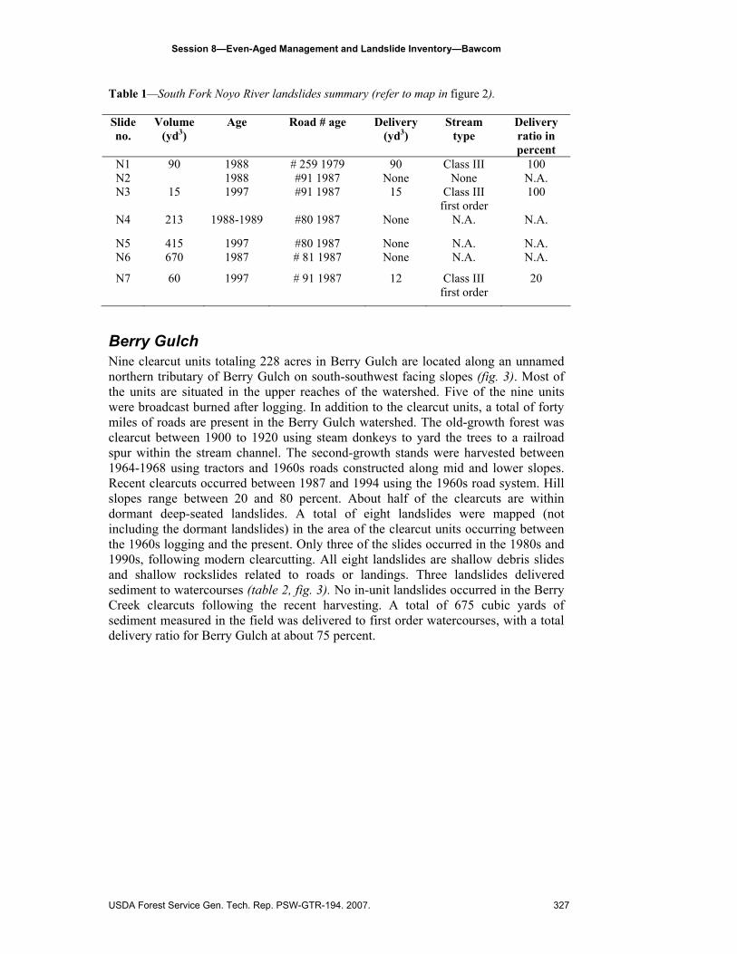
Berry Gulch Nine clearcut units totaling 228 acres in Berry Gulch are located along an unnamed northern tributary of Berry Gulch on south-southwest facing slopes (fig. 3). Most of the units are situated in the upper reaches of the watershed. Five of the nine units were broadcast burned after logging. In addition to the clearcut units, a total of forty miles of roads are present in the Berry Gulch watershed. The old-growth forest was clearcut between 1900 to 1920 using steam donkeys to yard the trees to a railroad spur within the stream channel. The second-growth stands were harvested between 1964-1968 using tractors and 1960s roads constructed along mid and lower slopes. Recent clearcuts occurred between 1987 and 1994 using the 1960s road system. Hill slopes range between 20 and 80 percent. About half of the clearcuts are within dormant deep-seated landslides. A total of eight landslides were mapped (not including the dormant landslides) in the area of the clearcut units occurring between the 1960s logging and the present. Only three of the slides occurred in the 1980s and 1990s, following modern clearcutting. All eight landslides are shallow debris slides and shallow rockslides related to roads or landings. Three landslides delivered sediment to watercourses (table 2, fig. 3). No in-unit landslides occurred in the Berry Creek clearcuts following the recent harvesting. A total of 675 cubic yards of sediment measured in the field was delivered to first order watercourses, with a total delivery ratio for Berry Gulch at about 75 percent.
USDA Forest Service Gen. Tech. Rep. PSW-GTR-194. 2007. 327
Session 8—Even-Aged Management and Landslide Inventory—Bawcom
Figure 3—Berry Gulch clearcuts and mapped landslides.
Table 2—Berry Gulch landslide summary( refer to map, figure 3). Slide no.
Volume (yd3)
Failure age
Road # age Delivery (yd3)
Stream type
Delivery ratio in percent
#BG2 129 1975? # 560 1965 90 Intermit. class III
70
#BG3 100 1995? # 561 1965 100 Intermit. class III
100
#BG5 670 1980’s # 560 1965 485 class III 72
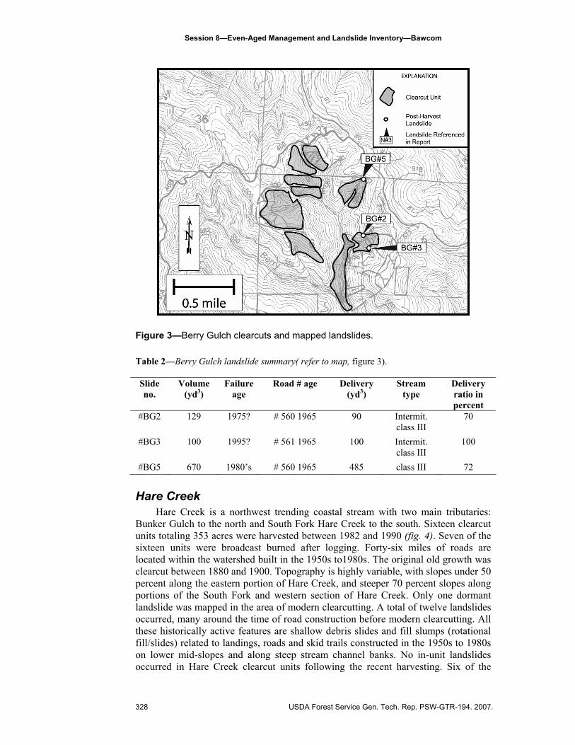
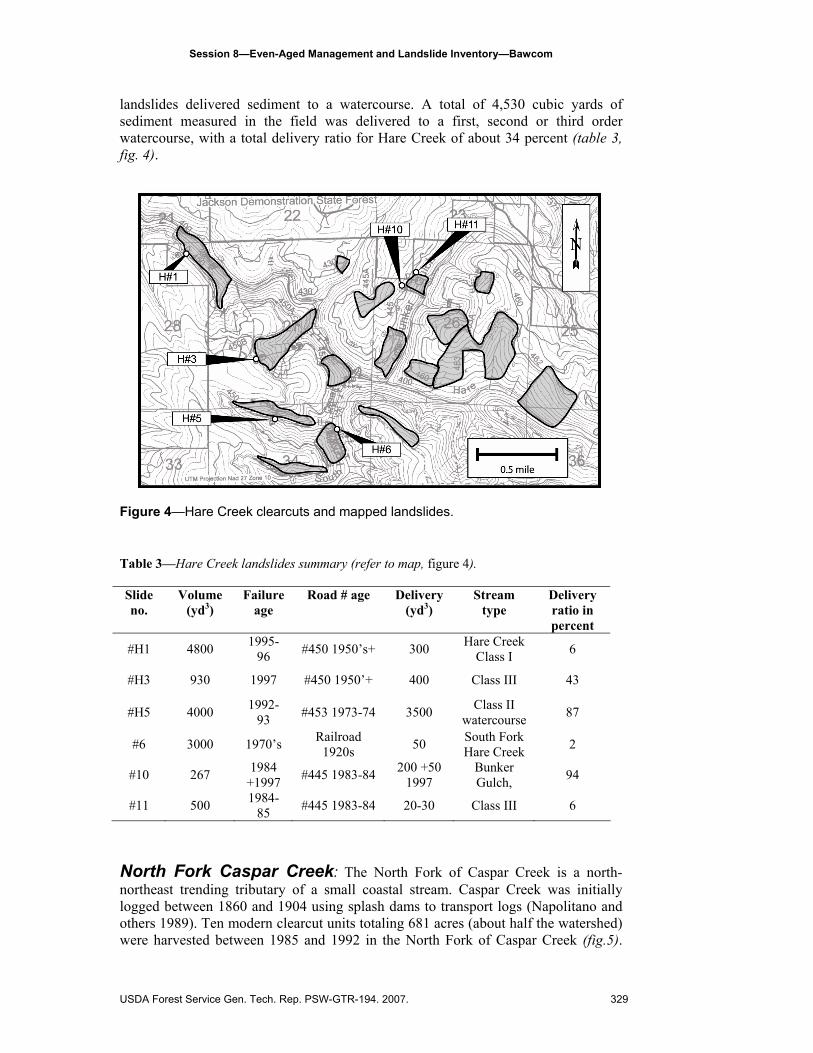
Hare Creek
Hare Creek is a northwest trending coastal stream with two main tributaries: Bunker Gulch to the north and South Fork Hare Creek to the south. Sixteen clearcut units totaling 353 acres were harvested between 1982 and 1990 (fig. 4). Seven of the sixteen units were broadcast burned after logging. Forty-six miles of roads are located within the watershed built in the 1950s to1980s. The original old growth was clearcut between 1880 and 1900. Topography is highly variable, with slopes under 50 percent along the eastern portion of Hare Creek, and steeper 70 percent slopes along portions of the South Fork and western section of Hare Creek. Only one dormant landslide was mapped in the area of modern clearcutting. A total of twelve landslides occurred, many around the time of road construction before modern clearcutting. All these historically active features are shallow debris slides and fill slumps (rotational fill/slides) related to landings, roads and skid trails constructed in the 1950s to 1980s on lower mid-slopes and along steep stream channel banks. No in-unit landslides occurred in Hare Creek clearcut units following the recent harvesting. Six of the
328 USDA Forest Service Gen. Tech. Rep. PSW-GTR-194. 2007.
Session 8—Even-Aged Management and Landslide Inventory—Bawcom
landslides delivered sediment to a watercourse. A total of 4,530 cubic yards of sediment measured in the field was delivered to a first, second or third order watercourse, with a total delivery ratio for Hare Creek of about 34 percent (table 3, fig. 4).
Figure 4—Hare Creek clearcuts and mapped landslides.
Table 3—Hare Creek landslides summary (refer to map, figure 4). Slide no.
Volume (yd3)
Failure age
Road # age Delivery (yd3)
Stream type
Delivery ratio in percent
#H1 4800 1995-96 #450 1950’s+ 300 Hare Creek
Class I 6
#H3 930 1997 #450 1950’+ 400 Class III 43
#H5 4000 1992-93 #453 1973-74 3500 Class II
watercourse 87
#6 3000 1970’s Railroad 1920s 50 South Fork
Hare Creek 2
#10 267 1984 +1997 #445 1983-84 200 +50
1997 Bunker Gulch, 94
#11 500 1984-85 #445 1983-84 20-30 Class III 6
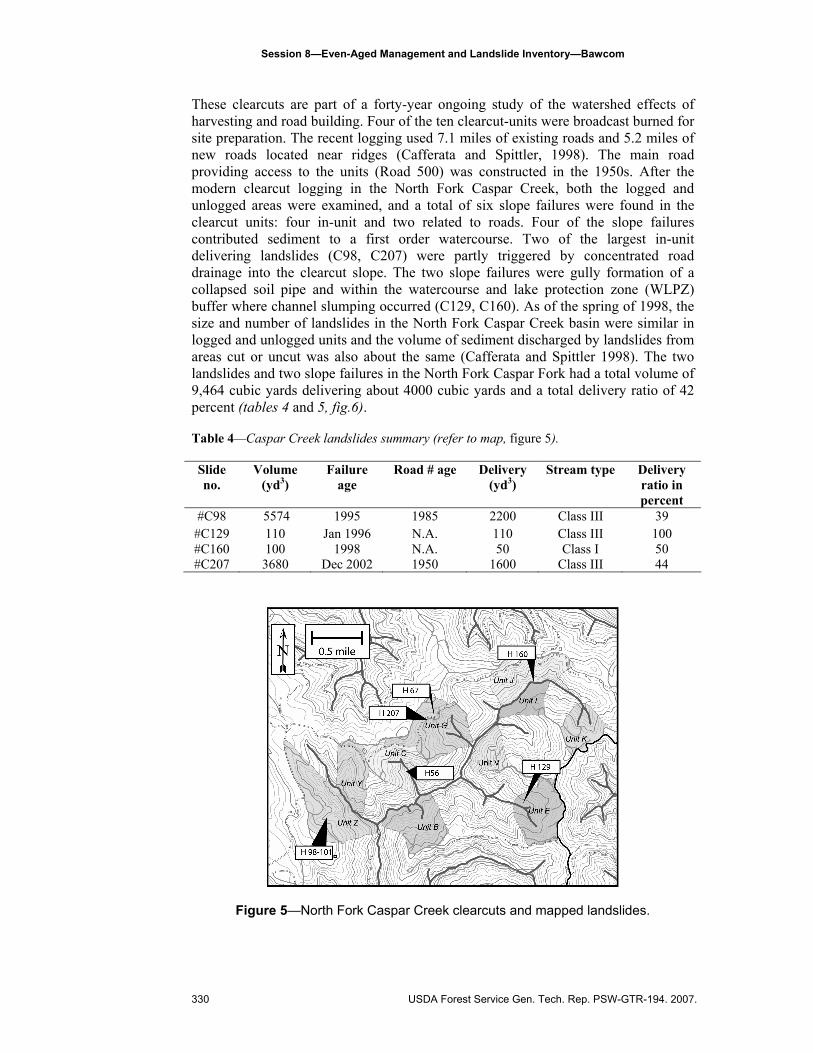
North Fork Caspar Creek: The North Fork of Caspar Creek is a north- northeast trending tributary of a small coastal stream. Caspar Creek was initially logged between 1860 and 1904 using splash dams to transport logs (Napolitano and others 1989). Ten modern clearcut units totaling 681 acres (about half the watershed) were harvested between 1985 and 1992 in the North Fork of Caspar Creek (fig.5).
USDA Forest Service Gen. Tech. Rep. PSW-GTR-194. 2007. 329
Session 8—Even-Aged Management and Landslide Inventory—Bawcom
These clearcuts are part of a forty-year ongoing study of the watershed effects of harvesting and road building. Four of the ten clearcut-units were broadcast burned for site preparation. The recent logging used 7.1 miles of existing roads and 5.2 miles of new roads located near ridges (Cafferata and Spittler, 1998). The main road providing access to the units (Road 500) was constructed in the 1950s. After the modern clearcut logging in the North Fork Caspar Creek, both the logged and unlogged areas were examined, and a total of six slope failures were found in the clearcut units: four in-unit and two related to roads. Four of the slope failures contributed sediment to a first order watercourse. Two of the largest in-unit delivering landslides (C98, C207) were partly triggered by concentrated road drainage into the clearcut slope. The two slope failures were gully formation of a collapsed soil pipe and within the watercourse and lake protection zone (WLPZ) buffer where channel slumping occurred (C129, C160). As of the spring of 1998, the size and number of landslides in the North Fork Caspar Creek basin were similar in logged and unlogged units and the volume of sediment discharged by landslides from areas cut or uncut was also about the same (Cafferata and Spittler 1998). The two landslides and two slope failures in the North Fork Caspar Fork had a total volume of 9,464 cubic yards delivering about 4000 cubic yards and a total delivery ratio of 42 percent (tables 4 and 5, fig.6). Table 4—Caspar Creek landslides summary (refer to map, figure 5). Slide no.
Volume (yd3)
Failure age
Road # age Delivery (yd3)
Stream type Delivery ratio in percent
#C98 5574 1995 1985 2200 Class III 39 #C129 110 Jan 1996 N.A. 110 Class III 100 #C160 100 1998 N.A. 50 Class I 50 #C207 3680 Dec 2002 1950 1600 Class III 44
Figure 5—North Fork Caspar Creek clearcuts and mapped landslides.
330 USDA Forest Service Gen. Tech. Rep. PSW-GTR-194. 2007.
Session 8—Even-Aged Management and Landslide Inventory—Bawcom
Discussion and Conclusions Jackson Demonstration State Forest is unique due to its availability for all types
of research in the coastal redwood region, the previously un-entered second growth redwood stands and the uniformity of the underlying geologic bedrock. This research project was able to study the removal of trees in 80- to 100-year old second-growth stands that naturally regenerated following clearcut logging of the old-growth forest between 1860 and 1947. All other studies related to harvesting and slope stability has been completed in areas with predominantly non-sprouting tree species. The inventory on JDSF represents a unique data set.
This study attempts to document the relationship between clearcutting and shallow landslides that deliver sediment to watercourses in a redwood dominated conifer forest. All fifty units, totaling about 1800 acres, within four watersheds were clearcut, and many were broadcast burned for site preparation following logging. All were subjected to storms capable of triggering landslides (Cafferata and Spittler 1998) with thirteen storm sequences above thresholds for initiating landsliding. Following the most recent clearcut logging (1980-1995), a total of thirty-two landslides failed within clearcut units and no deep-seated dormant landslides showed evidence of reactivation except road fill failures.
Of the thirty-two landslide failures, all but two have an association with old roads and landings. Mapping by the author of nearby uncut or partial cut control units revealed similar road related failures. The four in-unit landslides occurred in the Caspar Creek watershed. The first one in the uncut watercourse and lake protection zone (WLPZ), another as gully formation from a collapsed soil pipe and the last two in-unit debris slides associated with poor road drainage. Only the North Fork Caspar Creek watershed with 50 percent of the watershed clearcut as part of a paired watershed study had in-unit landsliding associated with upslope road drainage. The in-unit landsliding may be attributed to the large unit area of vegetation removal along steep slopes and use of other treatment methods such as pre-commercial thinning.
The total amount of sediment delivered from landslides after clearcutting in all four watersheds was about 8,800 cubic yards (table 5), with 98 percent of that total associated with old roads and landings. In comparison, one natural debris slide that failed in 1975 and 1998 in another portion of the State Forest (North Fork of the South Fork Noyo River) in uncut fifty-year old second growth delivered about 10,000 cubic yards.
Table 5—A summary of the number of sediment delivering landslides in each watershed, amount delivered and the delivery ratio (in percent) for each watershed. Watershed Percent
acres clearcut
# of slides
Road-related In-unit slides
# of slides delivering sediment
Delivery (yd3)
Delivery ratio
percent SF Noyo 4 6 6 0 3 115 70 Berry Gulch
5 8 8 0 3 675 75
Hare Creek 9 12 12 0 6 4530 34 NF Caspar 50 6 4 2 4 3960 42 Total 32 28 4 16 8,740
USDA Forest Service Gen. Tech. Rep. PSW-GTR-194. 2007. 331

Session 8—Even-Aged Management and Landslide Inventory—Bawcom
The results of this inventory suggests that vegetation removal associated with clearcutting alone has not been a significant contributor to slope instability or delivery of sediment, and older road, skidtrail and landing fills are the predominant source of shallow landsliding and stream aggradation. Currently there are no other published studies similar to this inventory within coastal redwood forests. The results of this study are supported by other unpublished studies conducted in several nearby watersheds on private industrial timberlands.5 The results of this inventory also find no increase in the rate of landsliding or initiation of movements of older dormant landslides within clearcuts on JSDF. Results show a clear relationship between roads, particularly older roads as the main source of sediment delivery to streams from shallow landslides and erosion.
Acknowledgments I would like to thank Marc Jameson, Pete Cafferata, Tom Spittler, Burt Hardin, Mark Smelser, Sebastian Roberts, Elizabeth Keppeler, Dave Longstreth, Brian Bishop, Jim Bawcom and my canine field assistant “Champ.”
References Abe, K.; Ziemer, R.R. 1991. Effect of tree roots on shallow-seated landslides: technical
session on geomorphic hazards in managed forests. Gen. Tech. Rep. PSW-GTR-130. Albany, CA: Pacific Southwest Research Station, Forest Service, U.S. Department of Agriculture; 11-20.
Bishop, D.M.; Stevens, M.E. 1964. Landslides on logged areas in southeast Alaska. Res. Paper NOR-1. Northern Forest Experiment Station, Forest Service, U.S. Department of Agriculture; 18 p.
Cafferata, P.H.; Spittler, T.E. 1998. Logging impacts of the 1970’s vs. the 1990’s in the Caspar Creek watershed. In: Ziemer, R.R., technical coordinator. Proceedings of the conference on coastal watersheds: the Caspar Creek story; 1998 May 6; Ukiah, CA. Gen. Tech. Rep. PSW-GTR-168. Albany, CA: Pacific Southwest Research Station, Forest Service, U.S. Department of Agriculture; 103-115. Available at http://www.fs.fed.us/psw/publications/documents/gtr-168/12-cafferata.html
California Department of Forestry and Fire Protection. 2002. Jackson Demonstration State Forest; State Forest Management Plan. Available at http://www.fire.ca.gov/ MiscDocuments/jdsf_mgt_ plan.asp
Gray, D.H. 1970. Effects of forest clearcutting on the stability of natural slopes. Bulletin of the Association of Engineering Geologists VII: 45-67.
Henry, N. 1998. Overview of the Caspar Creek watershed study. In: Ziemer, R.R., technical coordinator. Proceedings of the conference on coastal watersheds: the Caspar Creek story; 1998 May 6; Ukiah, CA. Gen. Tech. Rep. PSW-GTR-168. Albany, CA: Pacific Southwest Research Station, Forest Service, U.S. Department of Agriculture; 1-9. Available at http://www.fs.fed.us/psw/publications/documents/gtr-168/01-henry.html
5 Timothy C. Best, personal communication, 2004.
332 USDA Forest Service Gen. Tech. Rep. PSW-GTR-194. 2007.

Session 8—Even-Aged Management and Landslide Inventory—Bawcom
Kilbourne, R.T. 1982. Geology and geomorphic features related to landsliding Glenblair NW 7.5’ quadrangle, Mendocino County, California. Sacramento, California: California Department of Conservation, Division of Mines and Geology. OFR 82-25 S.F.; 1:24,000.
Kilbourne, R.T.; Mata-Sol, A.R. 1983. Geology and geomorphic features related to landsliding Glenblair SW 7.5’ quadrangle, Mendocino County, California. Sacramento, California: California Department of Conservation, Division of Mines and Geology. OFR 83-20 S.F; 1:24,000.
Manson, M.W.; Bawcom, J.A.; Parker, T. 2001. Noyo River watershed geologic and geomorphic features. California Geological Survey. Map Set 1- B;1:24,000.
Montgomery, D.R.; Schmidt, K.M.; Greenberg, H.M.; Dietrich, W.E. 2000. Forest clearing and regional landsliding. Geology [28(4)]: 311-314.
Napolitano, M.B. 1998. Persistence of historical logging impacts on channel form in Mainstem North Fork Caspar Creek. In: Ziemer, R.R., technical coordinator. Proceedings of the conference on coastal watersheds: the Caspar Creek story; 1998 May 6; Ukiah, CA. Gen. Tech. Rep. PSW-GTR-168. Albany, CA: Pacific Southwest Research Station, Forest Service, U.S. Department of Agriculture; 97-101. See http://www.fs.fed.us/psw/publications/documents/gtr-168/11-napolitano.html
Napolitano, M.; Francis, J.; Caffarata, P. 1989. A history of logging in the Caspar Creek basin. Jackson Demonstration State Forest Newsletter, No. 33, 4/1989; 4-7. See http://www.rsl.psw.fs.fed.us/projects/water/JDSF89.pdf
O'Loughlin, C.L. 1974. The effect of timber removal on the stability of forest soils. Journal of Hydrology (N.Z.) 13: 121-134.
Short, W.R.; Spittler, T.E. 2001. Preliminary map of geologic and geomorphic features related to landsliding, Jackson Demonstration State Forest, Mendocino County, California. California Geological Survey: Draft Map Set 2- B, 1:24,000.
Spittler, T.E.; McKittrick, M.A. 1995. Geologic and geomorphic features related to landsliding, north and south forks of Caspar Creek, Mendocino County, California. California Division of Mines and Geology, ORF 95-08, 1:12,000. Available at http://www.rsl.psw.fs.fed.us/projects/water/Caspar_Geology.pdf
Swanston, D.N.; Swanson, F.J. 1976. Timber harvesting, mass erosion, and steepland forest geomorphology in the Pacific Northwest. In: Coates, D.R., ed. Geomorphology and Engineering. Stroudsburg, PA: Dowden, Hutchinson & Ross; 199-221.
Wu, T.H.; Swantston, D.N. 1980. Risk of landslides in shallow soils and its relation to clearcutting in southeastern Alaska. Forest Science 26(3): 495-510.
Ziemer, R.R. 1981. Roots and the stability of forested slopes. In: Davies, T.R.H.; Pearce, A.J., eds. Erosion and sediment transport in Pacific Rim Steeplands. Christchurch New Zealand: International Association of Hydrological Sciences Pub. No. 132, 343-361. Available at http://www.rsl.psw.fs.fed.us/projects/water/ZiemerIAHS.PDF
Ziemer, R.R., technical coordinator. 1998. Proceedings of the conference on coastal watersheds: the Caspar Creek story; 1998 May 6; Ukiah, CA. Gen. Tech. Rep. PSW-GTR-168. Albany, CA: Pacific Southwest Research Station, Forest Service, U.S. Department of Agriculture; 129-134. Available at http://www.fs.fed.us/psw/ publications/documents/gtr-168/14-ziemer.html
USDA Forest Service Gen. Tech. Rep. PSW-GTR-194. 2007. 333