evolution of concepts in cartography in internet and ubiquitous...
TRANSCRIPT
Evolution of Concepts in Cartography in Internet and Ubiquitous Environments
Takashi MORITA (Hosei University)
Proposition of the Creation of the Commission on ubiquitous mapping was adopted at the
general assembly of ICA Durban 2003, and the author became a chairperson of the commission.
Since then the commission has developed researches not only on theoretical field but also to
collect examples including cross culture effect. In this paper, we discuss the direction of this
domain in the future by tracing the evolution of concepts and technological environments since
its foundation. The concepts may be described by the following key terms; communication
model, map and mapping, mapping world, key elements of ubiquitous environment, GIS and
ubiquitous mapping, cross cultural issues, real scale map, egocentric mapping, sideoblique and
vertical view, spatial reasoning, cartographic discourse, data input issues, non-geographical
coordinate, and quality issues. Before the start of the commission, there was the ICA report discussing the difference between
map, cartography and GIS. There, it was mentioned that map should be dynamic and
interactive in digital era, which conduct to the notion of ubiquitous mapping. At that time
people had begun to talk about the notion of ubiquitous computing while not few people had
already begun to use mobile phone and car navigation system with small screen capable to
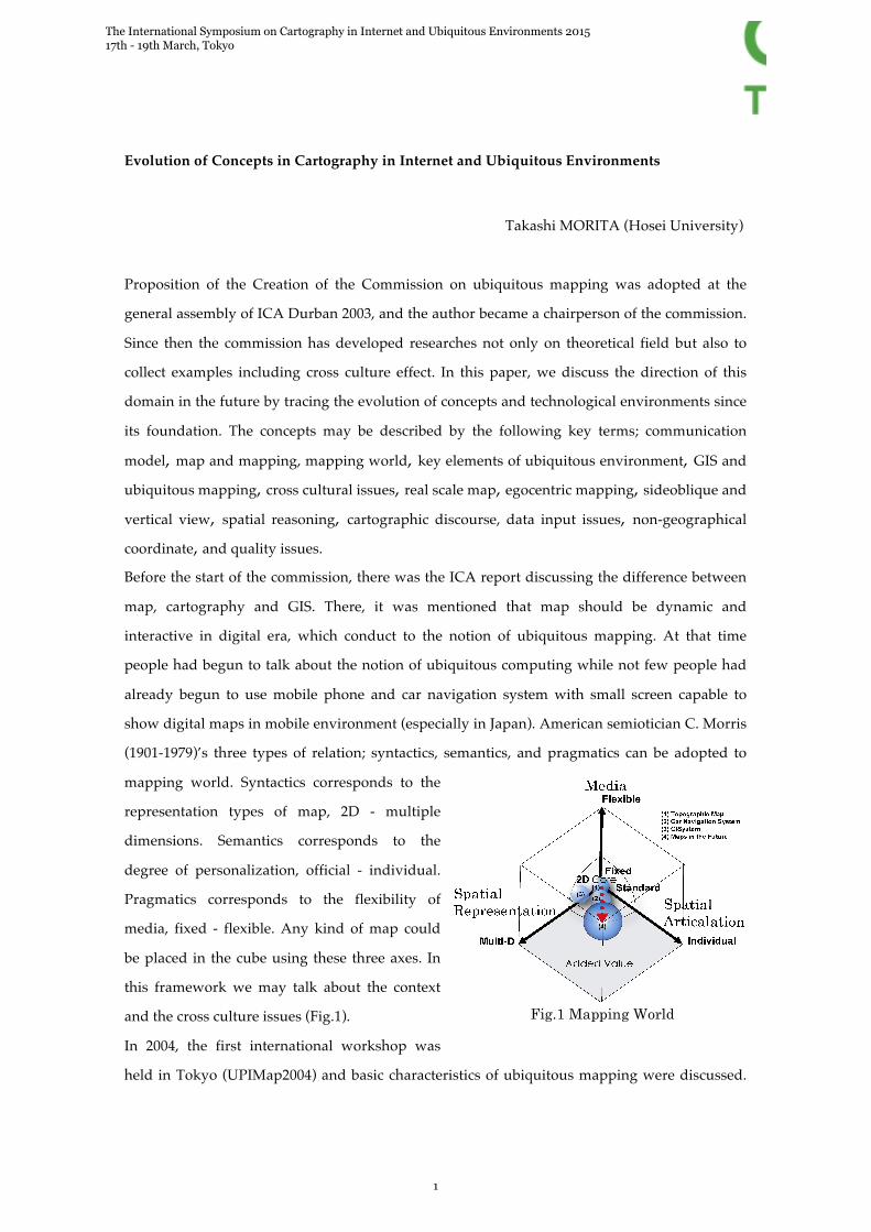
show digital maps in mobile environment (especially in Japan). American semiotician C. Morris
(1901-1979)’s three types of relation; syntactics, semantics, and pragmatics can be adopted to
mapping world. Syntactics corresponds to the
representation types of map, 2D - multiple
dimensions. Semantics corresponds to the
degree of personalization, official - individual.
Pragmatics corresponds to the flexibility of
media, fixed - flexible. Any kind of map could
be placed in the cube using these three axes. In
this framework we may talk about the context
and the cross culture issues (Fig.1).
In 2004, the first international workshop was
held in Tokyo (UPIMap2004) and basic characteristics of ubiquitous mapping were discussed.
Fig.1 Mapping World
The International Symposium on Cartography in Internet and Ubiquitous Environments 2015 17th - 19th March, Tokyo
1
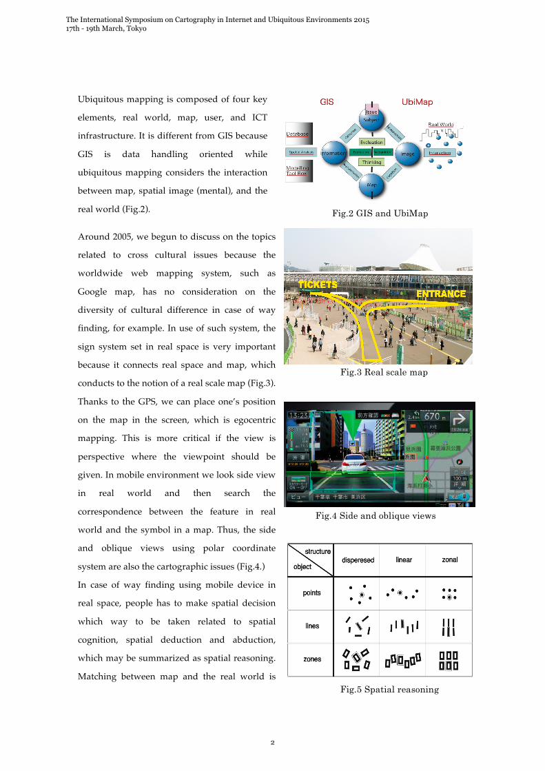
Ubiquitous mapping is composed of four key
elements, real world, map, user, and ICT
infrastructure. It is different from GIS because
GIS is data handling oriented while
ubiquitous mapping considers the interaction
between map, spatial image (mental), and the
real world (Fig.2).
Around 2005, we begun to discuss on the topics
related to cross cultural issues because the
worldwide web mapping system, such as
Google map, has no consideration on the
diversity of cultural difference in case of way
finding, for example. In use of such system, the
sign system set in real space is very important
because it connects real space and map, which
conducts to the notion of a real scale map (Fig.3).
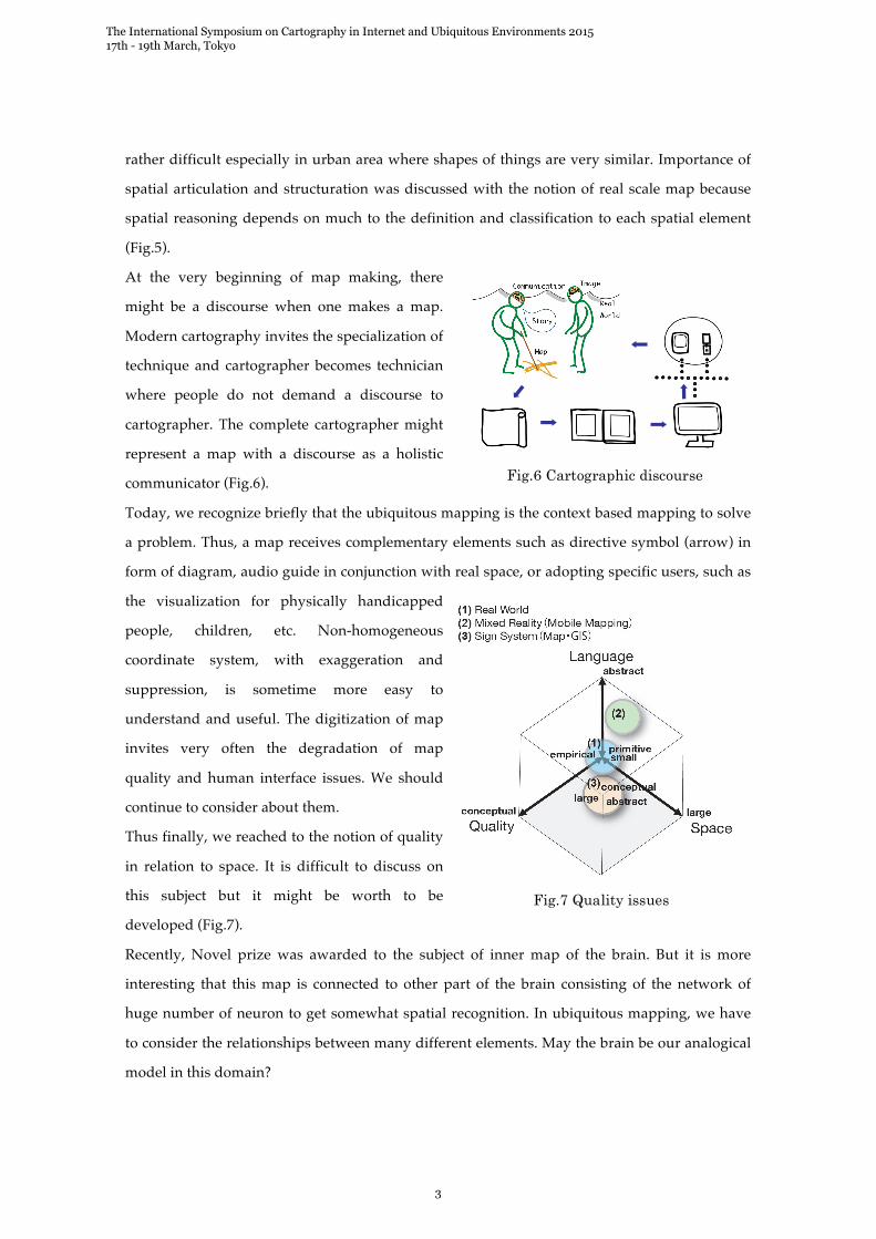
Thanks to the GPS, we can place one’s position
on the map in the screen, which is egocentric
mapping. This is more critical if the view is
perspective where the viewpoint should be
given. In mobile environment we look side view
in real world and then search the
correspondence between the feature in real
world and the symbol in a map. Thus, the side
and oblique views using polar coordinate
system are also the cartographic issues (Fig.4.)
In case of way finding using mobile device in
real space, people has to make spatial decision
which way to be taken related to spatial
cognition, spatial deduction and abduction,
which may be summarized as spatial reasoning.
Matching between map and the real world is
Fig.2 GIS and UbiMap
Fig.3 Real scale map
Fig.4 Side and oblique views
Fig.5 Spatial reasoning
The International Symposium on Cartography in Internet and Ubiquitous Environments 2015 17th - 19th March, Tokyo
2
rather difficult especially in urban area where shapes of things are very similar. Importance of
spatial articulation and structuration was discussed with the notion of real scale map because
spatial reasoning depends on much to the definition and classification to each spatial element
(Fig.5).
At the very beginning of map making, there
might be a discourse when one makes a map.
Modern cartography invites the specialization of
technique and cartographer becomes technician
where people do not demand a discourse to
cartographer. The complete cartographer might
represent a map with a discourse as a holistic
communicator (Fig.6).
Today, we recognize briefly that the ubiquitous mapping is the context based mapping to solve
a problem. Thus, a map receives complementary elements such as directive symbol (arrow) in
form of diagram, audio guide in conjunction with real space, or adopting specific users, such as
the visualization for physically handicapped
people, children, etc. Non-homogeneous
coordinate system, with exaggeration and
suppression, is sometime more easy to
understand and useful. The digitization of map
invites very often the degradation of map
quality and human interface issues. We should
continue to consider about them.
Thus finally, we reached to the notion of quality
in relation to space. It is difficult to discuss on
this subject but it might be worth to be
developed (Fig.7).
Recently, Novel prize was awarded to the subject of inner map of the brain. But it is more
interesting that this map is connected to other part of the brain consisting of the network of
huge number of neuron to get somewhat spatial recognition. In ubiquitous mapping, we have
to consider the relationships between many different elements. May the brain be our analogical
model in this domain?
Fig.6 Cartographic discourse
Fig.7 Quality issues
The International Symposium on Cartography in Internet and Ubiquitous Environments 2015 17th - 19th March, Tokyo
3