evolution of the triassic shelf in the northern barents ... of the triassic shelf in the northern...
TRANSCRIPT

Evolution of the Triassic shelf in the northern BarentsSea regionFridtjof Riis,1,4 Bjørn A. Lundschien,1 Tore Høy,1 Atle Mørk2,3 & Mai Britt E. Mørk3
1 Norwegian Petroleum Directorate, Professor Olav Hanssens vei 10, P.O. Box 600, NO-4003 Stavanger, Norway
2 SINTEF Petroleum Research, NO-7465 Trondheim, Norway
3 Department of Geology and Mineral Resources Engineering, Norwegian University of Sciences and Technology, NO-7491 Trondheim, Norway
4 International Research Institute of Stavanger, P.O. Box 8046, NO-4068 Stavanger, Norway
Abstract
The interpretation of an unpublished data set of shallow stratigraphic coresand deep, seismic profiles from the northern Barents Shelf has provided newinformation about the Middle and Late Triassic development of the BarentsShelf and Svalbard. At that time, sediment sources along the eastern andsouth-eastern margins of the Barents Sea controlled the infilling of a previouslydeeper shelf area, gradually converting it into a paralic platform. Comparedwith the eastern source, sediment volumes from other areas were small. In ourdata, there are no indications of a provenance area north of Svalbard. Progra-dation from the ESE resulted in diachronous lithostratigraphic boundaries. Theorganic-rich shales of the Botneheia and Steinkobbe formations were depos-ited in the remaining deeper shelf areas in the western and north-westernBarents Sea shelf, from the Olenekian to the latest Ladinian, by which time theprogradation from the ESE had reached eastern Svalbard. In mid-Carniantimes, the area of paralic deposits extended from the eastern Barents Sea intothe Svalbard Archipelago.
KeywordsBarents Sea; palaeogeography; paralic;
shelf sediment; Svalbard; Triassic.
CorrespondenceFridtjof Riis, Norwegian Petroleum
Directorate, Professor Olav Hanssens vei 10,
P.O. Box 600, NO-4003 Stavanger, Norway.
E-mail: [email protected]
doi:10.1111/j.1751-8369.2008.00086.x
By the end of the Permian, the formation of the Uralideswas completed, and the Siberian terrain formed an inte-gral part of the Pangean supercontinent (Cocks & Torsvik2007). The Late Permian plate tectonic reconstruction ofCocks & Torsvik (2007) shows that the Barents Sea andSvalbard areas were located on a shelf opening uptowards the Panthalassa Ocean, to the north, and sur-rounded by Pangea towards the south, east and west(Fig. 1). This general palaeogeographic setting prevailedthroughout the Early and Middle Triassic, when the shelfareas were gradually filled in by sediments.
Tectonically, the Triassic was a quiet period in thewestern Barents Sea and Svalbard region. Except forsome local fault tectonics, no significant faulting or tec-tonic unconformities have been mapped. By contrast, thenorthern and southern Barents Sea basins (Gramberg1988; Johansen et al. 1992) were strongly subsiding, andformed important depocenters. The total thickness of theTriassic section typically reaches 250–1200 m in Svalbard(Mørk et al. 1982), and increases to 2000–3000 m in theplatform areas of the western Barents Sea, according toregional seismic interpretations of the Norwegian
Petroleum Directorate (NPD; see profiles in Gabrielsenet al. 1990). Relatively uniform thicknesses and a gener-ally shallowing depositional environment suggest thatsubsidence and sedimentation rates were generallycomparable in this western shelf area. “Shelf-edge” andprogradational clinoform features on the south-westernpart of this shelf were first noted by Rønnevik & Jacobsen(1984), and were described in detail by Rasmussen et al.(1993).
The geometry and facies of these sediments weremainly controlled by erosion and sedimentary inputfrom the borderlands, and by changes in sea level. Themajor transgressive–regressive sequences in the BarentsSea have been correlated with the Sverdrup Basin inArctic Canada and other Triassic basins (Mørk et al. 1982;Mørk et al. 1989; Egorov & Mørk 2000; Mørk & Smelror2001), and even globally (Embry 1997). According toEgorov & Mørk (2000), the major Triassic sequenceboundaries are at the base Triassic, base Olenekian, baseMiddle Triassic (Anisian), base Upper Triassic (Carnian),within the lower Norian, and at the Triassic–Jurassicboundary (Fig. 2).
Polar Research 27 2008 318–338 © 2008 The Authors318
The present Triassic lithostratigraphy in the south-western Barents Sea region (Fig. 2) was defined byWorsley et al. (1988), and the Svalbard nomenclaturewas revised by Mørk et al. (1999), incorporating thesouth-western Barents Sea and Svalbard. Whereas thelithostratigraphy of Svalbard is based on rock outcrops,the Triassic lithostratigraphy of the southern Barents Seais mainly based on well log data and seismic correlation,because of the limited core data available. The Middle andUpper Triassic succession in the southern Barents Sea hasbeen penetrated by 30 exploration wells, and has beensampled by 34 shallow stratigraphic coreholes, of which13 were drilled by the NPD in the northern Barents Sea(Fig. 3a).
The Lower Triassic lithostratigraphical boundaries aresynchronous from Svalbard into the Barents Sea (Fig. 2;Mørk et al. 1999; Mørk & Smelror 2001), and the sedi-ments represent shallow–open marine environments.Organic-rich mudstones are prevalent in the Middle Tri-assic succession (Leith et al. 1992); however, this organic-rich facies was already developed centrally in the BarentsSea, at the Svalis Dome, in the mid-Olenekian (late EarlyTriassic), prompting the definition of the Steinkobbe For-
mation in that area (Mørk & Elvebakk 1999). During theMiddle Triassic, the coastal sediments of western Spitsber-gen (Bravaisberget Formation) graded into deep shelfsediments to the east and south (Botneheia Formation),merging with the organic-rich mudstones of theSteinkobbe Formation in the central Barents Shelf. Alongthe coast of the Norwegian mainland coastal and deltaicsediments of the Kobbe Formation grade into open shelfdeposits in the central Hammerfest Basin (Worsley et al.1988). A transition from a delta-front setting to a deepshelf is marked by the clinoform belt that will be describedbelow. A change in sedimentation pattern is seen whenpassing from the Sassendalen Group to the Kapp ToscanaGroup. The group boundary is time-transgressive in thesouthern Barents Sea, where the Snadd Formation initi-ated the group in the early Ladinian, whereas in Svalbard,the correlative Tschermakfjellet and De Geerdalen forma-tions first developed in the Carnian. A poorly constrained“mid” Ladinian age has been suggested at the base of thecorrelative Skuld Formation on Bjørnøya (Mørk et al.1990; Fig. 2). A major widespread transgression in theearly Norian initiated marine sedimentation of theWilhelmøya Subgroup in Svalbard, and adjacent areas,and of the correlative Realgrunnen Subgroup in theBarents Sea.
The time-transgressive formation boundaries should beunderstood and analysed within a regional geologicalframework. Data from the southern Barents Sea andSvalbard show that the western Barents Sea regionevolved from a marine shelf, with a central deeper troughin the Anisian, to a paralic platform in the late Carnian. Inthe southern Barents Sea, the main sources of sedimentappear to be the Baltic Shield in the south, and theUralides and Novaya Zemlya to the east (Mørk 1999).Most of Svalbard was located in a distal basinal position inthe Early and Middle Triassic, and the basin was graduallyfilled in from the west and from the north (Mørk et al.1982).
There has been no exploration activity by the oil indus-try in the northern Barents Sea, and data acquisition andinterpretation has been limited to work carried out by theNPD, on behalf of the Norwegian authorities. Because ofthe small volume of published data, the interpretation ofthe Triassic palaeogeography of large areas of the north-ern Barents Sea has not been well constrained.
In this study, we have used unpublished NPD data fromthe north-western Barents Sea: north of 74°30′N andwest of 35°E. The study focusses on the cored Middle andUpper Triassic succession, up to the regional early Noriantransgression. Observations and interpretations from thestudy area are correlated with the geology of Svalbardand the south-western Barents Sea. Our interpretationof the results from shallow stratigraphic drilling and
Shelf
Deep ocean
NovayaZemlya
TimanPechora
Norway
Green-land
Svalbard
Franz JosephLand
SevernayaZemlya
Siberia
Panthalassa
H?
H?
H
H
H South
Barents
Basin
North
Barents
Basin
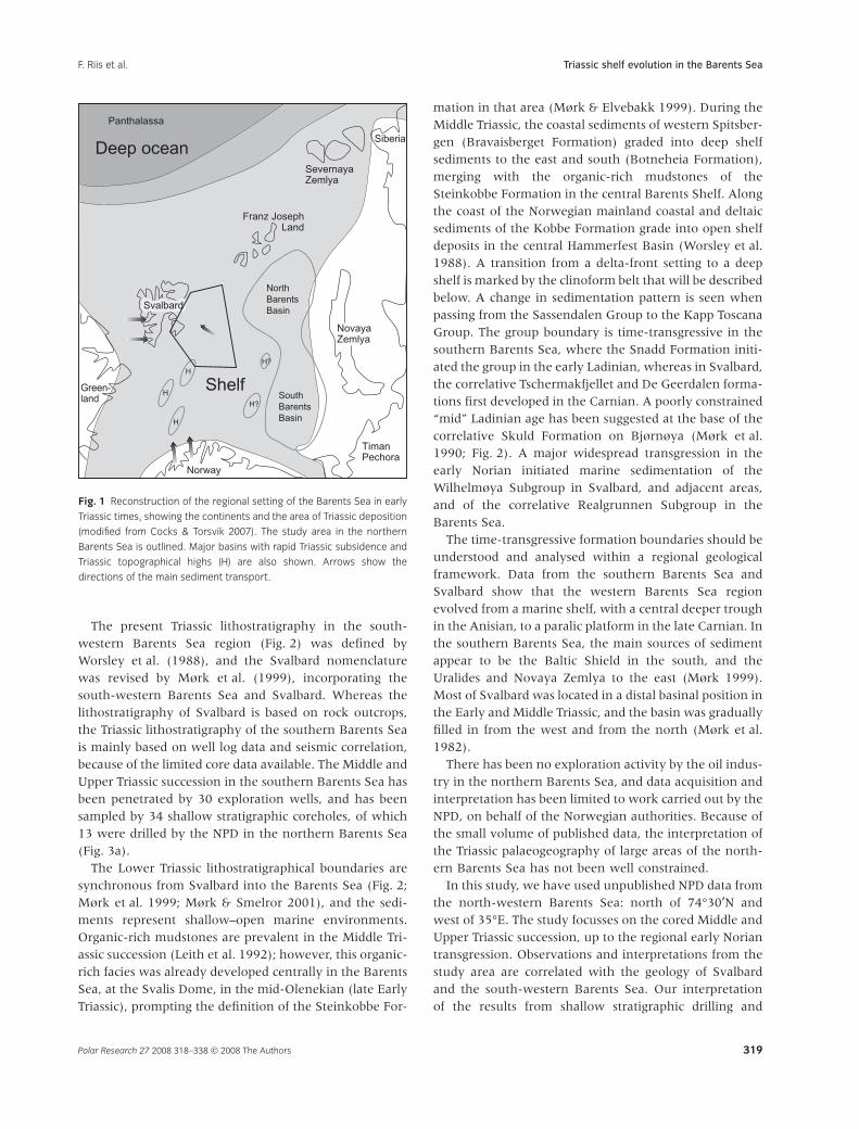
Fig. 1 Reconstruction of the regional setting of the Barents Sea in early
Triassic times, showing the continents and the area of Triassic deposition
(modified from Cocks & Torsvik 2007). The study area in the northern
Barents Sea is outlined. Major basins with rapid Triassic subsidence and
Triassic topographical highs (H) are also shown. Arrows show the
directions of the main sediment transport.
Triassic shelf evolution in the Barents SeaF. Riis et al.
Polar Research 27 2008 318–338 © 2008 The Authors 319

regional seismic data implies that progradation fromeastern and south-eastern provenance areas continuedfarther to the north and west than has been previouslysuggested, and that the contribution from the north andnorth-west was correspondingly smaller. These results aresummarized in a palaeogographic reconstruction.
Database and study area
The study area in the northern Barents Sea is a remotearea where no commercial seismic acquisition or drillinghas taken place. The main source of conventionalseismic data in the study area in the Northern BarentsSea consists of so-far unreleased regional seismic linesacquired by the NPD. The NPD has carried out seismicacquisition since 1973, in order to establish a frameworkto aid their assessment of hydrocarbon resources. Theseismic data coverage in the area is a grid where thedistance between the lines typically varies between5 and 10 km (Fig. 3b). This is sufficient for regionalmapping, but not for detailed prospect evaluation. In thisstudy, the Triassic sequences have been interpreted onmost of the seismic lines shown in Fig. 3b, north of 75°Nand east of 25°E.
The seismic data quality is generally related to theproperties of rocks near the seabed. Most of the region
has been an area of net erosion since the Paleogene, andMesozoic rocks outcrop at the sea floor over vast areas ofthe northern Barents Sea, covered only by Pleistocenetills with a thickness of a few metres. Where high-velocityand -density Triassic beds or basaltic sills are located nearthe sea floor, there is poor penetration of the seismicenergy into the underlying rocks, resulting in a generallypoor quality of data. Figure 3b shows that this is thetypical situation in the bank areas surrounding Svalbard,and the consequence is that direct and detailed seismiccorrelation from the Svalbard outcrops into the BarentsSea is difficult. Further east, where acoustic impedancesat the sea floor are lower, the seismic data quality isgenerally much better. The quality is also dependent onthe data vintage, and on the acquisition and processingparameters.
The Mesozoic outcrops at the sea floor in the northernBarents Sea range from the Lower Triassic to the LowerCretaceous. Because of this geological setting, shallowstratigraphic drilling (Rise & Sættem 1994) can be used toobtain a good coverage of cores. The NPD contractedSINTEF Petroleum Research (formerly IKU) to drill andstudy Mesozoic stratigraphic cores east and south-east ofSvalbard in 1990, 1995, 1998 and 2005 (Fig. 3a). Thecores reach a depth of up to 200 m below the sea floor,and several cores were positioned along geological
Rhaetian
Norian
Carnian
Ladinian
Anisian
Olenekian
Induan
Sa
sse
nd
ale
n
Ea
rly
La
teM
idd
leT
RI
AS
SI
C
AGEWest
Spitsbergen
East
Svalbard BjørnøyaLoppa High
Svalis Dome
Hammerfest
BasinGro
up
Gro
up
Van Keulenfjorden Mb.
Somovbreen Mb.
Karentoppen Mb.
Passhatten Mb.
Bravais-berget
Fm.
Tvillingodden Formation
VardebuktaFormation
Blanknuten Member
Isfjorden Member
Vendomdalen Mb.
Lusitaniadalen Mb.
Deltadalen Mb.
Slottet Bed
Knorringfjellet Fm.?
Slottet Bed
Flatsalen Fm.
StorfjordenSubgp.
Skuld Fm.
Verdande Bed
Urd Fm.
Havert Formation
Klappmyss Fm.
Ingøydjupet Subgp.
Kobbe Fm.
Snadd Fm.
FruholmenFormation
Tschermakfjellet Formation
BotneheiaFormation
Viking-høgdaFm.
Stein-kobbeFm.
Ka
pp
To
sca
na
Sa
sse
nd
ale
n
De Geerdalen Formation
RealgrunnenSubgp.
WilhelmøyaSubgp.
Ka
pp
To
sca
na
Seq
uenc
eB
ound
arie
s
Fig. 2 Overview of the Triassic lithostratigraphy of Svalbard and the southern Barents Sea, simplified from Mørk et al. (1999). The positions of major
Boreal Triassic sequence boundaries are based on Egorov & Mørk (2000).
Triassic shelf evolution in the Barents Sea F. Riis et al.
Polar Research 27 2008 318–338 © 2008 The Authors320

profiles with structural dips to evaluate and sample themain sequence boundaries, and to obtain as much cov-erage of the geological succession as possible (Fig. 4). Inthis way, the most important parts of the section havebeen sampled at a low cost compared with the drillingof deep exploration wells. These stratigraphic coresconstitute the main geological database for the northernBarents Sea.
The present study is the first publication of the coredata, and is based on the integration of geological studiesof the cores with the regional seismic interpretation. Theresults are compared with the exposed rocks of Svalbardand the area under exploration in the southern part ofthe Barents Sea.
Triassic cores used in this study were drilled to obtaininformation from two different areas located on eitherside of the Middle Triassic clinoform belt, described below(Fig. 4). The Sentralbanken section on the SentralbankenHigh was compiled from five coreholes with nearly1000 m of core, ranging in age from the Olenekian to theNorian (Fig. 4). The Kong Karls Land east section consistsof five coreholes with 450 m of core, dating from the lateLadinian to the Carnian (Fig. 5). The cores were describedin detail, and were continuously sampled for biostratig-raphy and geochemistry by SINTEF Petroleum Research.The biostratigraphic analyses of the core samples weremainly based on palynology carried out by SINTEF Petro-leum Research and Applied Petroleum Technology (APT),
72°
74°
76°
78°
20° 24° 28° 32°
(a)K ongKarlsLandEast
Bjørnøya
Sentralbanken High
Svalis Dome
Hopen
Blank-nuten
7226/11-1
Kobbe Formationtype well
Bravais-berget
75°
76°
77°
78°
79°
16° 20° 24° 28° 32°
(b)
Fig. 3 (a) Outcrop of Triassic rocks in the Barents Sea and Svalbard (shaded grey). Black dots show the locations of exploration wells that have penetrated
into the Anisian or stratigraphically deeper layers. Open circles show the locations of the Triassic shallow stratigraphic cores discussed in the text; squares
indicate the sample localities on Edgeøya and Hopen. (b) Location of seismic lines acquired by the Norwegian Petroleum Directorate in the northern
Barents Sea since 1980. In the shaded areas, the data quality is affected by rocks with high acoustic impedance close to the sea floor.
Triassic shelf evolution in the Barents SeaF. Riis et al.
Polar Research 27 2008 318–338 © 2008 The Authors 321

supplemented with a few macrofossil identificationscarried out at the University of Hamburg (WolfgangWeitschat). In this paper, the study of the cores is sum-marized, and the main results of the biostratigraphicstudies are provided.
The petrography of the Upper Triassic samples was cor-related with data from outcrops at Svalbard (Fig. 3a) andwells in the southern Barents Sea. The Svalbard samplesanalysed were collected during an NPD field study ineastern Svalbard in 2007.
5 km
BCret
Pliensbachian / Sinemurian
NorianCarnian
Ladinian
NW SE0
ms(twt)
1000
500
60 km
AB
Hopen
Olga Basin
Sentralbanken High
30° 35°
76°
75°
25°
Profile A
W Ems(twt)Profile B
500
2000
1500
1000
Ladinian
Olenekian
Norian
Carnian
Ladinian
Anisian
Lower
Triassic
Permian
Intra Ladinian seismic sequence boundary
10 km
Base Triassic
(a)
(c)
(b)
Discontinuous - spotsClinoformsLaminated parallel Parallel - discontinuous
Fig. 4 (a) The Sentralbanken section consists of six boreholes. Five of them are drilled along seismic profile A, shown in (b), and cover an almost complete
section from the late Ladinian to the Norian. The last borehole is located at the Olenekian–Anisian boundary, further to the south-east. The anticlinal
features were formed by compressional tectonics that post-dates the age of the youngest sedimentary rocks preserved in the area (post-Early Creta-
ceous). (b) Location of the Sentralbanken section. The Triassic outcrops area is shown in grey. The boreholes included in the section and described in the
paper are indicated by the larger black dots. (c) The stratigraphic locations of the coreholes are projected into seismic profile B, where the different seismic
facies are interpreted. Laminated parallel reflectors (light blue; facies 1) correspond to an open marine, shallow to deep shelf environment. Large-scale
clinoforms (light brown; facies 2), which are occasionally chaotic, slumped layers, correspond to a prodelta environment. Mainly parallel, discontinuous
reflectors (yellow; facies 3) in a more proximal setting correspond to a delta-front environment (lower to upper shoreface). Discontinuous reflectors with
abundant bright spots (green; facies 4) represent channelled features, indicative of a delta plain setting. The main seismic sequence boundaries are
shown. Lithostratigraphically, the light-blue seismic facies is correlated with the Botneheia Formation. The Kobbe Formation is defined as the more
proximal part of the Anisian succession (yellow and brown seismic facies). The Snadd Formation comprises the Ladinian and Carnian sequence (yellow and
green seismic facies). The precise position of the top Ladinian is not known.
Triassic shelf evolution in the Barents Sea F. Riis et al.
Polar Research 27 2008 318–338 © 2008 The Authors322

Distribution of seismic facies
For this regional study, four main seismic facies associa-tions are defined, and they are interpreted to representdifferent depositional environments. The different faciesare shown overlying seismic profile B in a central part ofthe study area (Fig. 4). Changes of seismic facies areindicative of changes in lithological facies. The seismichorizons, which are interpreted to separate geologicalsequences of different ages, cut across the facies bound-aries. Facies changes in each seismic sequence indicate
changes in the overall depositional pattern through time,and have been used together with the core data to con-struct the palaeogographic maps presented in this paper.
The base of the clinoform belt described below can bedefined at the blue reflector, which is a prominent seismicsequence boundary in the platform areas in the westernBarents Sea. This reflector represents the top of theHavert Formation, near the Induan–Olenekian boundary.In the southern Barents Sea, the Havert Formationconsists mainly of marine mudstones and siltstones,coarsening upwards to sandstones in the Nordkapp Basin
Kong Karls Land
Stor-BankenEdgeøya
Nordaust-landet
A
B
100 km
N S
W
Profile A
Profile B
10 km200 ms
ms(twt)
900
500
700
Ladinian - Carnian boundary
P
79°
78°
30°28°26° 32°
1 km
E
(a)
(b)
(c)
Fig. 5 (a) The Kong Karls Land east section consists of five boreholes. The stratigraphic positions of the cores are projected onto a single seismic line
(profile A in panel b). The boundary between the Ladinian Botneheia Formation and the overlying Carnian shales is represented by the blue reflector
(Ladinian–Carnian boundary). The cores cover the late Ladinian and early Carnian seismic sequence boundaries. The base Triassic reflector (P) and the top
of the Carnian clinoform belt (green horizon) are also shown. (b) Location of the Kong Karls Land east section. (c) Profile B is a seismic section that is
flattened on the blue reflector (top of Botneheia Formation, indicated with an arrow). The Carnian clinoform belt is located between the blue reflector and
the green line. The green horizon is not a true timeline, as the upper Carnian clinoforms become progressively younger towards the west. The dip of the
sea bed and its corresponding seismic multiple in the central part of the section results from the flattening. Strong reflectors are interpreted as basaltic
sills. The Snadd Formation continues from the blue reflector up to the sea floor, with a thickness exceeding 1000 m.
Triassic shelf evolution in the Barents SeaF. Riis et al.
Polar Research 27 2008 318–338 © 2008 The Authors 323
area (well 7226/11-1; NPD 2008). Its upper boundary isinterpreted as the transgressive surface of the overlyingKlappmyss Formation (Worsley et al. 1988). Prior to thisOlenekian transgression, the seismically interpreted maindirections of Triassic progradation in the western BarentsSea imply a major source area in the south (i.e., the BalticShield).
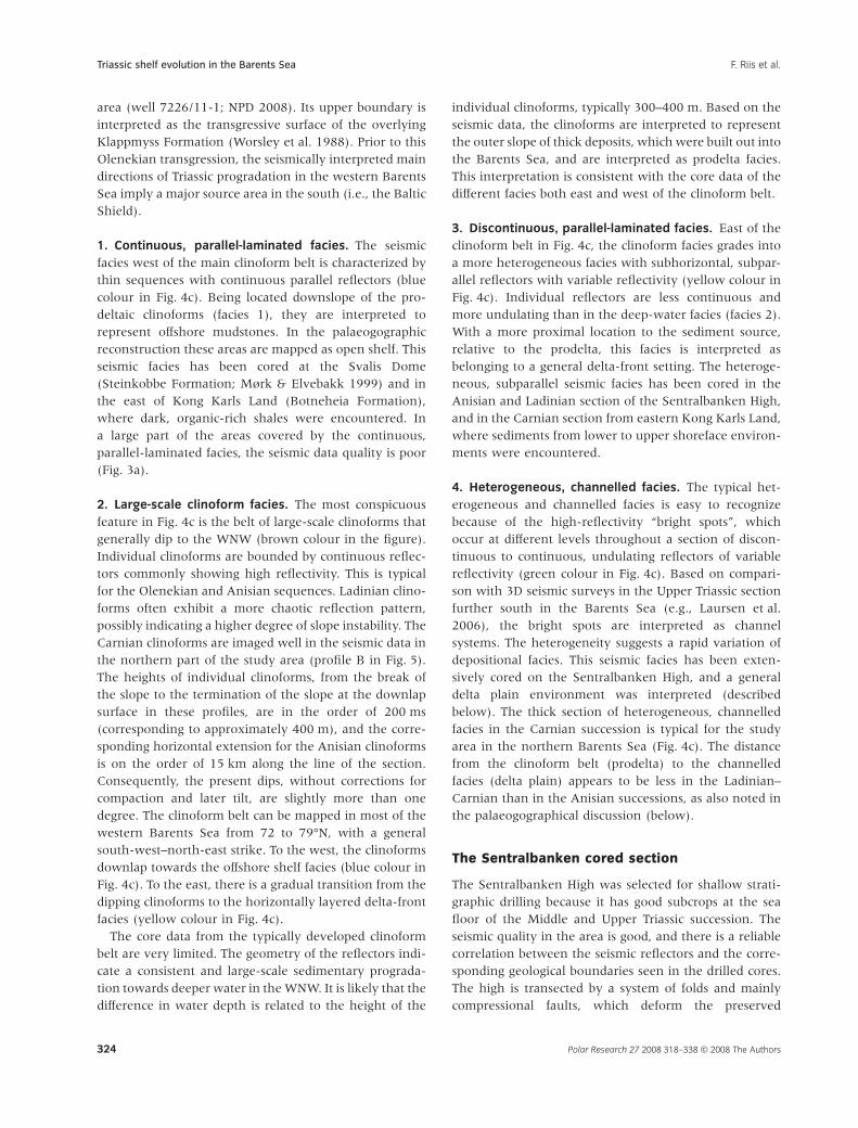
1. Continuous, parallel-laminated facies. The seismicfacies west of the main clinoform belt is characterized bythin sequences with continuous parallel reflectors (bluecolour in Fig. 4c). Being located downslope of the pro-deltaic clinoforms (facies 1), they are interpreted torepresent offshore mudstones. In the palaeogographicreconstruction these areas are mapped as open shelf. Thisseismic facies has been cored at the Svalis Dome(Steinkobbe Formation; Mørk & Elvebakk 1999) and inthe east of Kong Karls Land (Botneheia Formation),where dark, organic-rich shales were encountered. Ina large part of the areas covered by the continuous,parallel-laminated facies, the seismic data quality is poor(Fig. 3a).
2. Large-scale clinoform facies. The most conspicuousfeature in Fig. 4c is the belt of large-scale clinoforms thatgenerally dip to the WNW (brown colour in the figure).Individual clinoforms are bounded by continuous reflec-tors commonly showing high reflectivity. This is typicalfor the Olenekian and Anisian sequences. Ladinian clino-forms often exhibit a more chaotic reflection pattern,possibly indicating a higher degree of slope instability. TheCarnian clinoforms are imaged well in the seismic data inthe northern part of the study area (profile B in Fig. 5).The heights of individual clinoforms, from the break ofthe slope to the termination of the slope at the downlapsurface in these profiles, are in the order of 200 ms(corresponding to approximately 400 m), and the corre-sponding horizontal extension for the Anisian clinoformsis on the order of 15 km along the line of the section.Consequently, the present dips, without corrections forcompaction and later tilt, are slightly more than onedegree. The clinoform belt can be mapped in most of thewestern Barents Sea from 72 to 79°N, with a generalsouth-west–north-east strike. To the west, the clinoformsdownlap towards the offshore shelf facies (blue colour inFig. 4c). To the east, there is a gradual transition from thedipping clinoforms to the horizontally layered delta-frontfacies (yellow colour in Fig. 4c).
The core data from the typically developed clinoformbelt are very limited. The geometry of the reflectors indi-cate a consistent and large-scale sedimentary prograda-tion towards deeper water in the WNW. It is likely that thedifference in water depth is related to the height of the
individual clinoforms, typically 300–400 m. Based on theseismic data, the clinoforms are interpreted to representthe outer slope of thick deposits, which were built out intothe Barents Sea, and are interpreted as prodelta facies.This interpretation is consistent with the core data of thedifferent facies both east and west of the clinoform belt.
3. Discontinuous, parallel-laminated facies. East of theclinoform belt in Fig. 4c, the clinoform facies grades intoa more heterogeneous facies with subhorizontal, subpar-allel reflectors with variable reflectivity (yellow colour inFig. 4c). Individual reflectors are less continuous andmore undulating than in the deep-water facies (facies 2).With a more proximal location to the sediment source,relative to the prodelta, this facies is interpreted asbelonging to a general delta-front setting. The heteroge-neous, subparallel seismic facies has been cored in theAnisian and Ladinian section of the Sentralbanken High,and in the Carnian section from eastern Kong Karls Land,where sediments from lower to upper shoreface environ-ments were encountered.
4. Heterogeneous, channelled facies. The typical het-erogeneous and channelled facies is easy to recognizebecause of the high-reflectivity “bright spots”, whichoccur at different levels throughout a section of discon-tinuous to continuous, undulating reflectors of variablereflectivity (green colour in Fig. 4c). Based on compari-son with 3D seismic surveys in the Upper Triassic sectionfurther south in the Barents Sea (e.g., Laursen et al.2006), the bright spots are interpreted as channelsystems. The heterogeneity suggests a rapid variation ofdepositional facies. This seismic facies has been exten-sively cored on the Sentralbanken High, and a generaldelta plain environment was interpreted (describedbelow). The thick section of heterogeneous, channelledfacies in the Carnian succession is typical for the studyarea in the northern Barents Sea (Fig. 4c). The distancefrom the clinoform belt (prodelta) to the channelledfacies (delta plain) appears to be less in the Ladinian–Carnian than in the Anisian successions, as also noted inthe palaeogographical discussion (below).
The Sentralbanken cored section
The Sentralbanken High was selected for shallow strati-graphic drilling because it has good subcrops at the seafloor of the Middle and Upper Triassic succession. Theseismic quality in the area is good, and there is a reliablecorrelation between the seismic reflectors and the corre-sponding geological boundaries seen in the drilled cores.The high is transected by a system of folds and mainlycompressional faults, which deform the preserved
Triassic shelf evolution in the Barents Sea F. Riis et al.
Polar Research 27 2008 318–338 © 2008 The Authors324

Mesozoic rocks in this area. The geological profile inFig. 4a is based on a seismic line that intersects two ofthese compressional structures. Five of the coreholes areprojected onto the profile. The figure shows that the baseCretaceous horizon takes part in the deformation, andthis is also the case for the overlying Lower Cretaceousreflectors. This implies that the main phase of the com-pressional deformation of the Sentralbanken High post-dates the Early Cretaceous. In our regional studies, wehave not observed synsedimentary movement on thefaults in the Triassic succession. In contrast to the westernhighs in the Barents Sea, the deeper seismic sectionsindicate that the Sentralbanken High is an uplifted part ofthe platform area, and does not represent a buried base-ment high, a conclusion that was also reached byGabrielsen et al. (1990). The Triassic geological setting inthis section is interpreted to be representative for a largearea east of the clinoform belt.
The Klappmyss and Kobbe formations
The time thickness of the Anisian seismic sequenceincreases to 300 ms, corresponding to approximately600 m, in the eastern part of the profile shown in Fig. 4c.The lowermost part, including the Olenekian–Anisianboundary, has been cored. There is also a short corehigher up in the section showing shallow marine con-ditions. The short core is not described further in thispaper. The cores penetrated the parallel, discontinuousfacies (yellow colour in Fig. 4c) east of the mainclinoform belt.
In the stratigraphically deepest core, the lower unit(below the Olenekian–Anisian boundary) is palynologi-cally dated as late Olenekian, and is assigned to theKlappmyss Formation of Worsley et al. (1988). It consistsof dark-grey to green siltstones with interbeds of veryfine-grained sandstones (Fig. 6). The sandstone beds gen-erally have sharp bases and fine upwards. Palynodebrisand trace fossils indicate a marine depositional environ-ment: both the low abundance and low diversity of theichnofauna may suggest reduced oxic conditions in thebottom water, or rapid sedimentation. The sandstonebeds may represent deposition from minor, possiblystorm-generated, turbidity currents. The unit is inter-preted as having been deposited below the storm-wavebase on a moderately shallow shelf, with reduced oxicsea-bottom conditions, and rapid depositional rates.
The unit above the Olenekian–Anisian boundary,included in the Kobbe Formation of Worsley et al. (1988),starts with a dark-grey claystone of poor to fair organicrichness in type-IV kerogen, resting on an erosive topsurface of the Klappmyss Formation. Upwards, the unitgrades into a clayey siltstone with thin, generally
sharp-based and upward-fining sandstone interbeds(Fig. 6). Bioturbation is sparse and of low diversity.Ammonoids and palynomorphs of early Anisian ageoccur in the claystone interval. The lowermost part of theAnisian succession seems to be missing, as may also bethe case in outcrops over most of Svalbard (Mørk et al.1992). The siltstone interval is palynologically dated tothe middle Anisian. A phosphate conglomerate is present,and resembles contemporaneous deposits in Svalbard(Mørk et al. 1982; Krajewski 2000). The dark-grey clay-stone with fair organic content in its lower part suggestsdeposition under mostly low-energy anoxic conditions. Aslight upward increase in energy level and ventilation isindicated by the increased content of silt and sandstones,and by slightly more bioturbation. The depositionalenvironment for this unit is interpreted as being a deep,low-oxic shelf for the claystone part, gradually shallowingupwards to an environment within the reach of episodicstorm influence, and slightly more ventilated, but stillwith reduced oxic conditions.
The abrupt facies change from sandy siltstones of theKlappmyss Formation to dark organic-rich claystones ofthe Kobbe Formation across an erosive boundary, and thepossible lack of a lowermost Anisian succession above theboundary, may represent a major transgression, wherethe erosive surface represents reworking during trans-gression. There are no indications of subaerial exposure atthe boundary, as has also been reported on Svalbard(Mørk et al. 1982; Mørk et al. 1999). The boundary coin-cides with a prominent seismic sequence boundary thatcan be mapped regionally in the Barents shelf, and isinterpreted to correspond to a major early Anisian trans-gressive episode throughout the Arctic (Mørk et al. 1989;Mørk et al. 1992; Mørk & Smelror 2001).
The Snadd Formation
Three long boreholes cover the upper part of the Ladinianand most of the Carnian sections, respectively (Figs. 4,6).
The stratigraphically deepest core is dated as late Ladin-ian by palynology, and is included within the SnaddFormation of Worsley et al. (1988). It commences with aunit consisting of two upward-coarsening sequencesgrading from slightly silty mudstone to siltstone. Sparse,but upwards increasing bioturbation in both sequences,as well as trace fossils in the upper sequence, are indica-tive of open marine conditions. The two upward-coarsening sequences may represent prograding lobeswithin a delta system. At the core locality, probably onlythe prodelta parts of the lobes are present.
A radical change in depositional environment isrecorded on top of the siltstone unit described above.
Triassic shelf evolution in the Barents SeaF. Riis et al.
Polar Research 27 2008 318–338 © 2008 The Authors 325

0
m
100
200
300
400
500
600
700
800
900
1000
1100
West SpitsbergenBravaisberget
EdgeøyaBlanknuten
Hopen East ofKong Karls Land
Sentralbanken
6-700 mnot drilled
Botneheia Formation
Tschermakfjellet Formation
Bravais-bergetFm.
De Geerdalen Formation
Wilh
elm
øya S
ubgro
up
Flatsalen Fm
Svenskøya Fm
mF ”
eb
bo
K“
Snadd Formation
Fig. 6 Interpreted sedimentological sections of the Middle and Upper Triassic strata in Svalbard, and the cored sections of north-east Kong Karls Land and
Sentralbanken High. The legend is given in Fig. 7.
Triassic shelf evolution in the Barents Sea F. Riis et al.
Polar Research 27 2008 318–338 © 2008 The Authors326

Above an erosional surface at 152.8 m depth in the core(Fig. 7), there is a thin basal calcite- and siderite-cementedbioclastic-rich sandstone bed. This bed is followed by aseries of stacked intraformational conglomerates consist-
ing of sandstone and siltstone clasts organized in upward-fining motifs, with an upward diminishing trend in clastsize. Bioturbation is completely lacking within this unit,indicating unfavourable living conditions. The unit as a
140
150
160
170
C
CCG
C
G
152.80
C
C
Op
en
mari
ne
Tid
al ch
an
nel co
mp
lex
m
Sand- and siltstone
Conglomerate Calcite cementation
Siderite cementation
Cole debris
Glauconite
Ammonoids
Bivalves
Plant fossils
Roots
Bioturbation
Nodule / septarian nodule
Sediment clasts
Ripple lamination
Cross-bedding
Lamination
Mud waves
Fining up lamination
Lenticular lamination
Phosphate nodules
Mud- and claystone
Siltstone
Limestone
Dolomite
Siderite
Coal
Fig. 7 Core photos and sedimentological log from the upper Ladinian Sentralbanken section. The cores show an abrupt change from an open marine to
a deltaic tidal depositional environment at 152.8 m depth (arrow). This change may indicate a facies shift of regional extent, and is interpreted to
correspond with a regional seismic sequence boundary separating an open marine and delta plain seismic facies (the green reflector in Fig. 4c, profile B).
Triassic shelf evolution in the Barents SeaF. Riis et al.
Polar Research 27 2008 318–338 © 2008 The Authors 327

whole may represent a channel system, possibly within adeltaic tidal depositional environment.
The abrupt change from an open marine to a deltaicdepositional environment, with a possible erosionalunconformity in between, may be regionally significant.A base-level fall may have forced the incision and depo-sition of deltaic or estuarine facies, on top of open-marinefacies, during the subsequent base-level rise. If theboundary between the two units described above repre-sents a regional sequence boundary, one would expect itto be expressed in the seismic data. In Fig. 4c, theapproximate stratigraphic positions of the cores are pro-jected onto the seismic section, which crosses theclinoform belt some 50 km west of the drilling localities.As the true location of the cores is further east, theseismic section does not give an exact representation ofthe reflector pattern in the cores, but it is clear that thegreen seismic facies correlates with the long core sectionabove the erosional surface. The green seismic horizon isinterpreted to be at, or close to, the boundary in the core.The horizon marks the boundary between the green(channelled) facies and the yellow (parallel, discontinu-ous) facies over a large area, and is interpreted as apossible sequence boundary.
The possible deltaic channel system overlying theerosional surface in the core is in turn overlain by aunit that consists of fine- to medium-grained sand-stones, interlaminated with coal debris. Bioturbation iscompletely lacking. Thin siderite-cemented beds occurfrequently throughout the unit. The abundant coaldebris and lack of marine ichnofossils may be indicativeof a non-marine depositional environment. Thinupward-fining beds in the lower part of the unit areinterpreted as interchannel deposits in a delta plainsetting, which develop upwards into a barrier barcomplex represented by thicker, low-angle cross-beddedsandstone beds.
The upper part of this core consists of silty shales,siltstones and sandstones, forming a series of upward-coarsening subunits, often capped by coal beds. Thelower, fine-grained parts of each subunit are oftenstrongly bioturbated. Upward-coarsening sequences withmarine bioturbation and coal layers on top may be indica-tive of a lower delta plain or estuarine depositionalenvironment. An association of coal beds and roots pen-etrating deep into marine bioturbated beds may pointtowards a tidal flat with heavy vegetation. The unit isinterpreted as being deposited in a lower delta plainsetting, where fully continental or elevated delta plainconditions never developed. The core resembles theSnadd Formation in the southern Barents Sea (Worsleyet al. 1988), which in that area dates from the Ladinian tothe early Norian.
The next two cores in the Sentralbanken section aredated by palynology as Early Carnian, whereas the upper-most part passes into the Late Carnian. Both cores consistdominantly of upward-fining sandstones, some of whichcontain intraformational conglomerates, although someupward-coarsening sandstone beds also occur. Coal debrisand root horizons are abundant, and some soil profilesare also present. Indicators of marine influence are gen-erally lacking. The cores are interpreted to represent amid to upper delta plain depositional environment, withthe upward-fining sandstones representing channel fills.
The entire Carnian succession resembles the SnaddFormation, but it also bears a strong similarity to the DeGeerdalen Formation in its closest onshore exposures atHopen.
Carnian–Norian transition
The stratigraphically highest Triassic core from the Sen-tralbanken section is dated as Carnian–Norian. The lowerunit in the core is dominated by sandstones, and is datedto the Late Carnian by palynology. The sandstonescontain ripple-laminated and low-angle cross-laminatedbeds, some of which are amalgamated in sequences asthick as 2 m. One bed has a siderite and mud-clast con-glomeratic lag at its base. Coal debris and plant fragmentsare present on a few bed surfaces. Bioturbation is gener-ally lacking, except for the uppermost bed, which isintensely bioturbated, and calcite and siderite cemented.A delta plain environment is suggested for this unit,because of the general lack of bioturbation and the pres-ence of coal debris and plant fragments. The thickersandstone beds, especially the one with the siderite andmud-clast conglomeratic lag, may represent fluvialchannel fills.
Overlying units (Flatsalen andSvenskøya formations)
In the upper part of the core described above, the intensebioturbation, and calcite and siderite cementation, of thetop bed is interpreted as a result of a transgression. Theunit can be correlated with the uppermost part of the deGeerdalen Formation on Svalbard, and with the SnaddFormation in the Barents Sea, and the top bed resemblesthe Slottet Bed, which initiates the Wilhelmøya Subgroupon Svalbard (Mørk et al. 1999).
On top of the Slottet Bed equivalent, a mudstone-dominated unit gradually passes upwards intosandstones. This unit is dated by palynology as earlyNorian. These sediments are interpreted as a new regres-sive succession that evolved above the transgressed deltaplain surface at the top of the Snadd Formation. The
Triassic shelf evolution in the Barents Sea F. Riis et al.
Polar Research 27 2008 318–338 © 2008 The Authors328

mudstone unit is correlated with the Flatsalen Formation,and the overlying sandy unit is correlated with the Sven-skøya Formation in Svalbard (Mørk et al. 1999).
The condensed transgressive bed (?Slottet Bed) on topof the delta-plain sandstone, within the early Norian,coincides with a seismic sequence boundary. There is achange in seismic facies from the Snadd Formation,through the more shaly Flatsalen Formation, to the sandySvenskøya Formation. In large parts of the study area inthe north-western Barents Sea, the Carnian–Norian tran-sition has been eroded or is situated close to the sea floor.Consequently, it is not easy to generate a regional map ofthis sequence boundary. The surface is interpreted tocorrespond to the regional early Norian transgression thatinitiated a major sedimentological shift in the BarentsShelf area, including Svalbard. This transgression led to along period of shallow shelf conditions, on which maturesandstone complexes evolved during the latest Triassicand Early Jurassic (Bergan & Knarud 1992; Mørk et al.1999; Worsley 2008, this issue).
The Kong Karls Land east cored section
The area selected for the drilling of stratigraphic cores,east of Kong Karls Land and north of Storbanken (Fig. 5),is localized on a salt-cored structure, which brings Middleand Upper Triassic rocks to the sea floor in an area west ofthe Middle Triassic clinoform belt. The main salt move-ment took place after the deposition of the Triassicsuccession, and our regional interpretation has not yetrevealed any significant anomalies in the Middle/UpperTriassic seismic pattern that can be related to the initialsalt basin, or to later salt movement. The quality of theseismic data in the area is generally good, and in mostcases enables a reliable correlation between the drilledTriassic sections and the surrounding platform.
In the Kong Karls Land east section, one short core wasobtained from the top of the uppermost Ladinian succes-sion, which is developed as a dark-grey, organic-richmudstone, representing the Botneheia Formation. Theother four coreholes were drilled on three differentCarnian seismic sequences, within an approximately700-m-thick section (Fig. 5a).
The Botneheia Formation
Throughout Svalbard, a pronounced lithological changetakes place at the transition between the BotneheiaFormation of the Sassendalen Group and the Tschermak-fjellet Formation of the Kapp Toscana Group. At thisboundary, marine organic-rich mudstones, often formingan upward-coarsening succession, are overlain by greyprodelta shales, with siderite nodules of the Kapp Toscana
Group (Mørk et al. 1982; Mørk et al. 1999). In Svalbard,this boundary approximates to the Ladinian–Carniantransition (Weitschat & Dagys 1989; Dagys & Weitschat1993). In the southern Barents Sea the correlativeboundary is located at the base of the Snadd Formation inthe earliest Ladinian (Van Veen et al. 1992; Vigran et al.1998; Mørk et al. 1999), and on Bjørnøya at the base ofthe Skuld Formation within the Ladinian (Mørk et al.1990).
The Botneheia Formation core from the Kong KarlsLand east section consists of dark shales with a highorganic content. It contains phosphate nodules and isvery similar to the Botneheia Formation exposed onEdgeøya. The algae Tasmanites are very abundant at somelevels (Fig. 8; see Vigran et al. 2008 [this issue]). Themain difference from Edgeøya is the presence of chertynodules, probably originating from the skeletal material
Fig. 8 (a) Occurrence of Tasmanites in the core from eastern Kong Karls
Land. Dark-grey claystone with horizontal lamination cause by the accu-
mulation of algal thalli. (b) Thin-section photograph from the same level as
(a), showing the flattened algal thalli of Tasmanites stems within a dark
clay matrix.
Triassic shelf evolution in the Barents SeaF. Riis et al.
Polar Research 27 2008 318–338 © 2008 The Authors 329
of siliceous sponges. This may indicate deposition in adeeper, more distal shelf position than the BotneheiaFormation on Edgeøya.
The transition between the Botneheia and Tschermak-fjellet formations was not cored in the Kong Karls Landeast section, as the two adjacent cores are separated by anundrilled section, estimated to be between a few metresand 30 m thick.
In the Kong Karls Land area, the top of the BotneheiaFormation is a prominent seismic reflector that can betraced towards the west. The outcrops of the BotneheiaFormation at the sea floor are typically associated withtopographic highs, which apparently have resistedglacial erosion. This observation indicates that the well-cemented top of the Botneheia Formation observed in thecore may be widespread in the area. East of the drillingarea, the seismic quality is poor because of shallow basal-tic intrusions close to the sea floor, and so the seismic tieis uncertain.
The lowermost part of the cored succession above theBotneheia Formation also consists of dark shales, and thechange in lithology is more subtle than between the Bot-neheia Formation and the Tschermakfjellet Formation onEdgeøya. However, unpublished geochemical analyses bySINTEF Petroleum Research show that the organiccontent of the overlying unit is significantly lower than inthe Botneheia Formation. The dark shales of this overly-ing unit bear no resemblance to the contemporaneousshallow shelf/deltaic sediments found further south-eastin the Barents Sea, as described from stratigraphic coreson Sentralbanken High, and from exploration wellsfurther south. Lithologically, it can be compared with theuppermost parts of the Botneheia Formation and theTschermakfjellet Formation, as seen on Edgeøya (Locket al. 1978; Mørk et al. 1982; Mørk et al. 1999), althoughin a more offshore development, and is interpreted as adistal part of the Tschermakfjellet Formation, deposited ina deep shelf environment. On Svalbard, the transitionfrom the Botneheia Formation to the TschermakfjelletFormation is sharp, and is interpreted as a shallowing ofthe basin from deep shelf to prodeltaic conditions (Mørket al. 1982; Mørk et al. 1999). In the distal position of thedrilled area, this shallowing may not have been equallydistinct, resulting in a more subtle change in lithologyfrom one formation to the next.
The De Geerdalen and Snadd formations
The Tschermakfjellet Formation in the Kong Karls Landeast section is overlain by a unit with a pronouncedchange in lithology. It contains silt and abundant coaldebris, indicating a similar transition as that observedfrom the Tschermakfjellet to the De Geerdalen formations
on Edgeøya (Flood et al. 1971; Lock et al. 1978; Mørket al. 1982; Mørk et al. 1999). The unit was deposited ina shallow shelf environment, and is regarded as the DeGeerdalen Formation, although it may also be regarded asthe first occurrence of the Snadd Formation, progradinginto the area from the south-east (see below). Seismicand palynological interpretations indicate that sedimentinput was dominantly from the south and the east;however, this trend is more evident higher up in thesuccession. The transition to the overlying unit has notbeen cored.
The overlying and dominant part of the cored intervalis seismically and palynologically correlated with theSnadd Formation, as defined in the southern Barents Seaand in the Sentralbanken High. It is dated as EarlyCarnian, with its topmost part passing into the early LateCarnian. A summary of the core description is presentedin Fig. 6, and according to our interpretation, the SnaddFormation starts with a deep shelf environment passingupwards into a more proximal open marine environ-ment, followed by an approximately 200-m-thick deltaicsuccession. The depositional environments of the deltaicsuccession range from shallow shelf and prodelta, to deltafront and interdistributary bay. These are developed asrepeated upward-shallowing units, most likely as a resultof the autocyclic switching of lobes within one majordelta system. On top of the deltaic succession a transgres-sion, anticipated to be regional in character, and whichcan also be identified in the seismic data, took place, anda new regressive unit evolved, which can be seen inthe cores to have started with an open shelf deposi-tional environment, passing upwards into shallow shelfconditions.
The seismic data show a well-developed Carnian clino-form belt trending WSW–ENE in the drilling area (profileB in Fig. 5b, c). The clinoforms dip to the north-west, andseem to be particularly well developed in the upperCarnian succession. Their dimensions are similar to thosedescribed for the middle Triassic (Fig. 5c). The clinoformbelt extends out of our study area in the east, and is welldeveloped towards the west beyond Kong Karls Land.Towards the north, the clinoform belt is truncated byglacial erosion towards Nordaustlandet. Our interpreta-tion of these seismic data is that the Carnian delta systemwas prograding towards the north-west into a deep shelfarea in the north.
Regional comparison of sandstonecompositions of the De Geerdalen andSnadd formations
In Svalbard, Triassic rocks are exposed along the westernCenozoic fold-belt, in central Spitsbergen, and on the
Triassic shelf evolution in the Barents Sea F. Riis et al.
Polar Research 27 2008 318–338 © 2008 The Authors330
eastern islands of Wilhelmøya, Barentsøya, Edgeøya andHopen, as well as in small exposure areas on south-westernmost Nordaustlandet. The northern parts ofSpitsbergen and Nordaustlandet, where large areas withpre-Caledonian rocks are exposed (Hjelle & Lauritzen1982; Lauritzen & Ohta 1984), have been considered aspossible provenance areas for the De Geerdalen For-mation in Svalbard and the northern Barents Sea(Birkenmajer 1977; Lock et al. 1978; Mørk et al. 1982).However, the northernmost Triassic exposures on Spits-bergen, Barentsøya and Wilhelmøya show no moreproximal development than the exposures further south(Mørk et al. 1982). Based on our seismic observationseast and south of Svalbard, outcrop data from Svalbard,and the two corehole sections presented here, we suggestas a new hypothesis that the late Triassic infilling of thenorthern Barents Sea and Svalbard was sourced fromthe south and from the east, implying an open seaway tothe north. To test this hypothesis, which is mainly derivedfrom seismic interpretation, we have compared mineral-ogical compositions of the sandstones from the studiedcores in the northern Barents Sea with rock data fromSvalbard and previously published data from the region.
Sentralbanken and Kong Karls Land east sections
The very fine- and fine–medium-grained sandstones ofthe Snadd Formation from the sections studied at theSentralbanken High and from eastern Kong Karls Landare all characterized by mineralogically immature com-positions, rich in feldspar and lithics, in addition tothe monogranular quartz (Fig. 9). The Ladinian–lower
Carnian sandstones from the Sentralbanken High, andthe lower Carnian sandstones from Kong Karls Land eastsection, are fairly well to moderately sorted, and haveangular to subangular grains. Albite/plagioclase (twinnedand untwinned) is typically more abundant thanK-feldspar in these locations. Similar rock fragments ofchert, volcanic/igneous rocks, and sedimentary andmetamorphic rocks are observed in the two cored sec-tions, with chert being the most abundant rock fragmentin all samples. Accessory heavy minerals compriseCr-spinel, zircon, tourmaline and opaque minerals. Onthe basis of the detrital mineralogy, both differentiatedigneous rocks as well as mafic/ultramafic rocks have beeneroded in the source area. Garnet is seen in the samplesfrom Sentralbanken, but not from the Kong Karls Landeast section. This indicates that metamorphic source areashad more influence on sedimentation at Sentralbankenthan in eastern Kong Karls Land.
The sandstones have been somewhat modified bydiagenesis, which resulted in the formation of kaolinite,Fe-carbonate, and, in a later stage, pyrite. In the Sentral-banken High, chlorite, quartz and calcite formedrelatively late in the paragenetic sequence.
Edgeøya, Svalbard
A few sandstone samples from the De Geerdalen Forma-tion were collected from outcrops at Blanknuten andHopen during a reconnaissance expedition in 2007(Figs. 3a, 6, 11b). These samples have lithic arenite com-positions, and show similar detrital mineralogy and rockfragments to those described above from the cored
Fig. 9 Comparison of sandstone compositions
in shallow drill cores from north-east Kong Karls
Land and Sentralbanken (De Geerdalen–Snadd
formations) based on petrographic modal analy-
ses. Samples from Edgeøya and Hopen are also
included. The lithic grains include polygranular
rock fragments, mica and heavy minerals: F,
fine-grained sandstones; M, medium-grained
sandstones; VF, very fine-grained sandstones.
)M-F( E dnaL slraK gnoK
)M-F( neknablartneS
)F-FV( neknablartneS
)M( ayøegdE
)M( nepoH
Arkosicarenite
Quartz
Feldspar Lithic grains
Sub-arkosic
Lithic arenite
Sub-lithic
Triassic shelf evolution in the Barents SeaF. Riis et al.
Polar Research 27 2008 318–338 © 2008 The Authors 331

section east of Kong Karls Land and Sentralbanken(Fig. 9). Volcanic/igneous fragments and clay fragmentsare common. The main accessory heavy minerals areCr-spinel, zircon, rutile and tourmaline. Garnet was notobserved, but has been recorded in the De GeerdalenFormation elsewhere at Edgeøya (Flood et al. 1971).Sandstone samples from the De Geerdalen Formation atFestningen in west Spitsbergen are also mineralogicallyimmature (Mørk 1999), and include similar heavy min-erals to those found on Edgeøya.
Franz Josef Land
Upper Triassic sandstones in Franz Josef Land were inter-preted by Dibner (1957) and Pcelina (1988) to have aprovenance from the north-east, based on thicknessvariations, facies distributions and mineralogy. Chertygrains are abundant, as in the north-western Barents Sea,but heavy minerals differ by common garnet and lowCr-spinel (Mørk 1999), probably reflecting a higher pro-portion of pelitic schists and granitic gneisses beingeroded in the source area.
Central southern Barents Shelf
Triassic sandstone compositions in the central and south-ern Barents Sea show an increase in mineralogicalmaturity from the Lower and Middle Triassic to the UpperTriassic (Mørk 1999). These sandstones have higherK-feldspar/plagioclase ratios than are found in our studyarea, and show more garnet-rich heavy mineral compo-sitions. Metamorphic schists or gneisses and granitic rockswere important sediment sources, supporting erosionof the Caledonides along Baltoscandia (Mørk 1999).However, chert fragments are also common, and volcanicfragments are also present, suggesting additional sourcesthat could have been located more centrally in theBarents Sea, or could be related to northern extensions ofthe Uralides. It should be taken into account that thecored parts of the Snadd Formation tend to be morefine-grained than the overlying and underlying forma-tions, e.g., in the Nordkapp Basin (Bugge et al. 2002), andalso comprise mudstones, siltstones or very fine sand-stones in more central areas at the Bjarmeland Platform,Gardarbanken High, Bjørnøya and Hopen. Cr-spinel,rutile, zircon and tourmaline are common heavyminerals in these very fine-grained sandstones.
Sources of chert and volcanic clasts
In the sandstones studied, both mafic and felsic volcanicrocks are present as rock fragments. In the southernBarents Sea it has been suggested that chert and volcanic
components in the Lower and Middle Triassic sandstonescould have originated from extensions of the Uralides inthe south-east, and in the Upper Triassic sandstones suchcomponents could have been transported from morecentral and eastern areas of the Barents Sea (Mørk 1999).Granitic and pelitic rock components could have beentransported from the Caledonides or Precambrianrocks from the mainland in the south-west, but thesecomponents contributed less to deposition north ofSentralbanken.
The sandstones from the Kong Karls Land east andSentralbanken sections show strong compositionalresemblance to the samples from Edgeøya. Flood et al.(1971) recognized rock fragments in the sandstonesat Edgeøya that looked similar to the groundmass ofvolcanics/quartz porphyry of Hecla Hoek at Nordaust-landet. Mafic igneous rocks are exposed east ofNordaustlandet (Lauritzen & Ohta 1984), and theserocks show some evidence of Na- and Si-metasomaticalterations (Ohta 1978). However, the dominant rocksin the exposed basement areas at Spitsbergen and Nor-daustlandet are gneisses and granites, which are lessprobable as sources for the sandstones in the northernBarents Sea, as these sandstones have low K-feldspar/plagioclase ratios. Cherts and silicified rocks occur in theUpper Palaeozoic Kapp Starostin Formation, exposed tothe south-west on Nordaustlandet (Lauritzen & Ohta1984). This formation also has a wide distribution in theoffshore areas, but it is not known where it was exposedin Late Triassic times, and as mentioned above, thecherty rock fragments are typical in the Triassic sedi-ments over an enormous area stretching from thenorthern Barents Sea towards the south-east. Thesamples studied from Edgeøya show the most distinctinfluence from volcanic/igneous sediment sourcesconsisting of both mafic and felsic rocks, but morecomprehensive studies are needed to identify the volca-nic source areas. The feldspar types in all of the northernareas indicate a larger contribution from basic and inter-mediate, rather than acidic, compositions compared withthe south-western Barents Sea, and contributions fromthe Caledonides were less, except for some influencein the Sentralbanken area.
In conclusion, the petrographic and mineralogical stu-dies on Upper Triassic samples from the offshore coreholes,and east Svalbard outcrops, show lithic arkosic sandstonecompositions, including some characteristic provenancecomponents of cherty rocks, felsic and mafic igneous/volcanic (and metamorphic) rocks, which are similar overthe entire area. Some regional differences in feldspar typesand metamorphic components of the Upper Triassic sand-stones across large areas of the Barents Sea reflect strongercontributions from the Caledonides in the southern
Triassic shelf evolution in the Barents Sea F. Riis et al.
Polar Research 27 2008 318–338 © 2008 The Authors332
Barents Sea, and from mafic igneous rocks, probablyderived from the east in the northern Barents Sea.
Palaeogeography
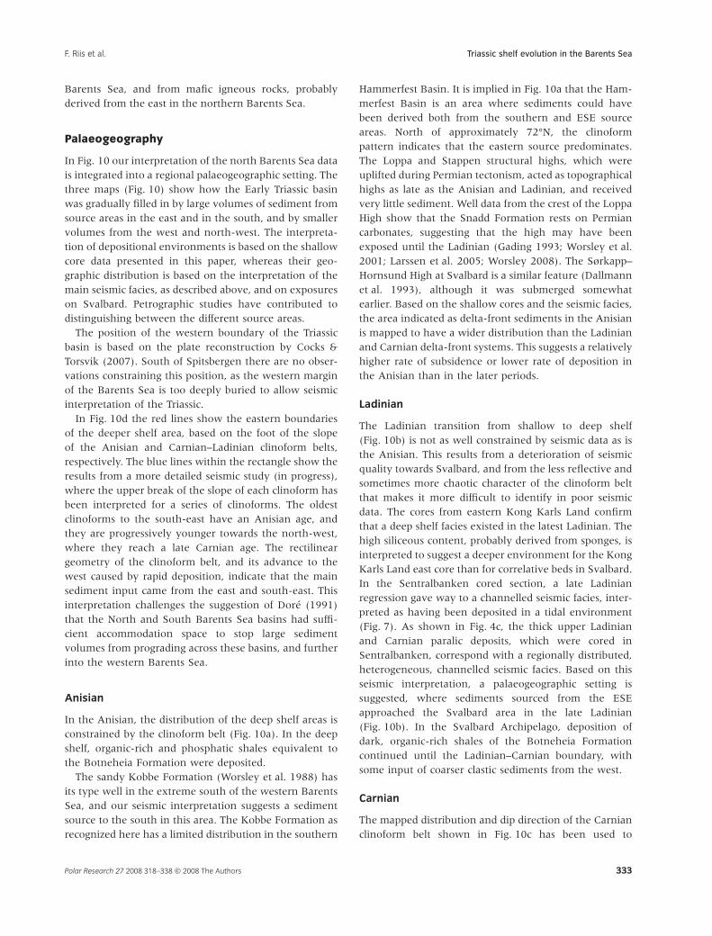
In Fig. 10 our interpretation of the north Barents Sea datais integrated into a regional palaeogeographic setting. Thethree maps (Fig. 10) show how the Early Triassic basinwas gradually filled in by large volumes of sediment fromsource areas in the east and in the south, and by smallervolumes from the west and north-west. The interpreta-tion of depositional environments is based on the shallowcore data presented in this paper, whereas their geo-graphic distribution is based on the interpretation of themain seismic facies, as described above, and on exposureson Svalbard. Petrographic studies have contributed todistinguishing between the different source areas.
The position of the western boundary of the Triassicbasin is based on the plate reconstruction by Cocks &Torsvik (2007). South of Spitsbergen there are no obser-vations constraining this position, as the western marginof the Barents Sea is too deeply buried to allow seismicinterpretation of the Triassic.
In Fig. 10d the red lines show the eastern boundariesof the deeper shelf area, based on the foot of the slopeof the Anisian and Carnian–Ladinian clinoform belts,respectively. The blue lines within the rectangle show theresults from a more detailed seismic study (in progress),where the upper break of the slope of each clinoform hasbeen interpreted for a series of clinoforms. The oldestclinoforms to the south-east have an Anisian age, andthey are progressively younger towards the north-west,where they reach a late Carnian age. The rectilineargeometry of the clinoform belt, and its advance to thewest caused by rapid deposition, indicate that the mainsediment input came from the east and south-east. Thisinterpretation challenges the suggestion of Doré (1991)that the North and South Barents Sea basins had suffi-cient accommodation space to stop large sedimentvolumes from prograding across these basins, and furtherinto the western Barents Sea.
Anisian
In the Anisian, the distribution of the deep shelf areas isconstrained by the clinoform belt (Fig. 10a). In the deepshelf, organic-rich and phosphatic shales equivalent tothe Botneheia Formation were deposited.
The sandy Kobbe Formation (Worsley et al. 1988) hasits type well in the extreme south of the western BarentsSea, and our seismic interpretation suggests a sedimentsource to the south in this area. The Kobbe Formation asrecognized here has a limited distribution in the southern
Hammerfest Basin. It is implied in Fig. 10a that the Ham-merfest Basin is an area where sediments could havebeen derived both from the southern and ESE sourceareas. North of approximately 72°N, the clinoformpattern indicates that the eastern source predominates.The Loppa and Stappen structural highs, which wereuplifted during Permian tectonism, acted as topographicalhighs as late as the Anisian and Ladinian, and receivedvery little sediment. Well data from the crest of the LoppaHigh show that the Snadd Formation rests on Permiancarbonates, suggesting that the high may have beenexposed until the Ladinian (Gading 1993; Worsley et al.2001; Larssen et al. 2005; Worsley 2008). The Sørkapp–Hornsund High at Svalbard is a similar feature (Dallmannet al. 1993), although it was submerged somewhatearlier. Based on the shallow cores and the seismic facies,the area indicated as delta-front sediments in the Anisianis mapped to have a wider distribution than the Ladinianand Carnian delta-front systems. This suggests a relativelyhigher rate of subsidence or lower rate of deposition inthe Anisian than in the later periods.
Ladinian
The Ladinian transition from shallow to deep shelf(Fig. 10b) is not as well constrained by seismic data as isthe Anisian. This results from a deterioration of seismicquality towards Svalbard, and from the less reflective andsometimes more chaotic character of the clinoform beltthat makes it more difficult to identify in poor seismicdata. The cores from eastern Kong Karls Land confirmthat a deep shelf facies existed in the latest Ladinian. Thehigh siliceous content, probably derived from sponges, isinterpreted to suggest a deeper environment for the KongKarls Land east core than for correlative beds in Svalbard.In the Sentralbanken cored section, a late Ladinianregression gave way to a channelled seismic facies, inter-preted as having been deposited in a tidal environment(Fig. 7). As shown in Fig. 4c, the thick upper Ladinianand Carnian paralic deposits, which were cored inSentralbanken, correspond with a regionally distributed,heterogeneous, channelled seismic facies. Based on thisseismic interpretation, a palaeogeographic setting issuggested, where sediments sourced from the ESEapproached the Svalbard area in the late Ladinian(Fig. 10b). In the Svalbard Archipelago, deposition ofdark, organic-rich shales of the Botneheia Formationcontinued until the Ladinian–Carnian boundary, withsome input of coarser clastic sediments from the west.
Carnian
The mapped distribution and dip direction of the Carnianclinoform belt shown in Fig. 10c has been used to
Triassic shelf evolution in the Barents SeaF. Riis et al.
Polar Research 27 2008 318–338 © 2008 The Authors 333

Shelf
Deep ocean
NovayaZemlya
Franz JosephLand
SevernayaZemlya
Panthalassa
pa
kdr
oN
p
Bisa n
Sne
t
nablar
k e ngiH h
Gardarbanken
High
Loppa
High
SvalisDome
B j a r m e l a n d P l a t f o r m
F i n n m a r k P l a t f o r m
O l g a B a s i n
Carnian
pa
kdr
oN
p
Bisa n
Goliath
Sne
t
nablar
k e ngiH h
Gardarbanken
High
Loppa
High
SvalisDome
B j a r m e l a n d P l a t f o r m
F i n n m a r k P l a t f o r m
O l g a B a s i n
20° 25° 30° 35° E
70°
75°
80° N
H o p e n
K o n g K a r l s L a n d
N o r d a u s t l a n d e t
E d g e ø y a
B a r e n t s ø y a
S p i t s b e r g e n
B j ø r n ø y a
?
70°
75°
80° N
Late Ladinian
pa
kdr
oN
p
Bisa n
Sne
t
nablar
k e ngiH h
Gardarbanken
High
Loppa
High
SvalisDome
B j a r m e l a n d P l a t f o r m
F i n n m a r k P l a t f o r m
O l g a B a s i n
pa
kdr
oN
p
Bisa n
Goliath
Sne
t
nablar
k e ngiH h
Gardarbanken
High
Loppa
High
SvalisDome
B j a r m e l a n d P l a t f o r m
F i n n m a r k P l a t f o r m
O l g a B a s i n
5° 10° 15°
70°
75°
80° N
H o p e n
K o n g K a r l s L a n d
N o r d a u s t l a n d e t
E d g e ø y a
B a r e n t s ø y a
S p i t s b e r g e n
B j ø r n ø y a
70°
75°
80° N
20° 25° 30° 35° 40° 45° E
pa
kdr
oN
p
Bisa n
Sne
t
eknablar
ngiH h
Gardarbanken
High
Loppa
High
SvalisDome
B j a r m e l a n d P l a t f o r m
F i n n m a r k P l a t f o r m
O l g a B a s i n
?
Anisian
pa
kdr
oN
p
Bisa n
Goliath
Sne
t
eknablar
ngiH h
Gardarbanken
High
Loppa
High
SvalisDome
B j a r m e l a n d P l a t f o r m
F i n n m a r k P l a t f o r m
O l g a B a s i n
5° 10° 15°
70°
75°
80° N
H o p e n
K o n g K a r l s L a n d
N o r d a u s t l a n d e t
E d g e ø y a
B a r e n t s ø y a
S p i t s b e r g e n
B j ø r n ø y a
70°
75°
80° N
20° 25° 30° 35° 40° 45° E
Delta plain
Deltaic / Fluvial
Prodelta
Shallow shelf
Deep shelf
Salt diapir
Structural elements
High (recent)
Basin (recent)
Palaeohigh
Field / discovery
Depositional environments
Clinoforms
Svalbard
Nordaust-landet
TimanPechora
Norway
Green-land
Siberia
??
(a) (b)
(c) (d)
Triassic shelf evolution in the Barents Sea F. Riis et al.
Polar Research 27 2008 318–338 © 2008 The Authors334

constrain the Carnian prodelta area, and the remainingareas of deep shelf, which were located north of theclinoform belt. The dimensions of the individual clino-forms are similar to the Middle Triassic clinoforms, and asimilar water depth in the deep shelf areas is suggested.Hence, our regional seismic data show a continuingCarnian progradation towards the north and north-west,into deeper waters in the areas east of Svalbard, includingKong Karls Land (Figs. 5c, 10c).
Within the Svalbard Archipelago, the situation is morecomplex. In eastern Svalbard, the Tschermakfjellet For-mation prograded over the Botneheia Formation in theearliest Carnian (Lock et al. 1978; Mørk et al. 1982).There is a considerable increase in thickness from theCarnian succession of the De Geerdalen and Tschermak-fjellet formations in Svalbard, to the areas east of Kong
Karls Land, where the total Carnian thickness exceeds1000 m (Figs. 5a, c). In eastern Svalbard, the typicalthickness of the Tschermakfjellet Formation combinedwith the prodeltaic lower part of the De Geerdalen For-mation is in the order of 100 m (Fig. 11a), compared withapproximately 400 m in the seismically interpreted clino-form belt east of Kong Karls Land (Fig. 5c). The thicknessincrease implies a larger accommodation space east ofSvalbard, which could be related to a deeper shelf prior tothe deltaic infilling. The interpretation is also consistentwith the interpretation of a deeper water environment ofthe uppermost Botneheia Formation in the core east ofKong Karls Land, than in eastern Svalbard.
In Kvalpynten, south-western Edgeøya, a transportdirection with a component from the north seems to besupported by spectacular exposures of growth faults in
Fig. 10 (a–c) Palaeogeographic maps showing the progradation of sediments into the Middle Triassic marine embayment, and the development of a
paralic platform in the Late Triassic. In the maps, the detailed boundaries between depositional areas are simplified, and the positions of the rivers are
conceptual. (d) Overview map showing the interpreted progradation of shallow shelf/delta-front areas across the study area in the Barents Sea from
Anisian (red line to the east) to Carnian times (red line to the west). Blue lines show seismically interpreted Anisian, Ladinian and Carnian clinoform breaks
within the study area. Wavy lines show the main sediment source areas suggested in the text. The position of the continents is redrawn from Cocks &
Torsvik (2007), see Fig. 1. The rectangle shows the location of the maps in (a–c).
�
Fig. 11 (a) Outcrop of the Botneheia, Tscher-
makfjellet and De Geerdalen formations at
Klinkhammaren, north-west Edgeøya, with
northwards dipping beds caused by rotation
resulting from growth faults in the Tschermak-
fjellet Formation and lower part of the De
Geerdalen Formation. The total thickness of the
dipping strata is 100–150 m. (b) Outcrop at
Blanknuten, north-west Edgeøya, with deltaic
sandstones in the middle part of the De
Geerdalen Formation. The thickness of the
Tschermakfjellet Formation is approximately
50 m. North is to the left in both panels.
De Geerdalen Fm
De Geerdalen Fm
(a)
(b)
Tschermakfjellet Fm
Tschermakfjellet Fm
Botneheia Fm
Botneheia Fm
Triassic shelf evolution in the Barents SeaF. Riis et al.
Polar Research 27 2008 318–338 © 2008 The Authors 335

the Lower Carnian section described by Edwards (1976).The true dip directions of these growth faults were notmeasured, but in the north–south-trending cliff, the faulttraces dip towards the south, with a few exceptions. Thesediments that were exposed to growth faulting aredescribed as four upward-coarsening deltaic sequences(Edwards 1976). Their accumulated thickness is in theorder of 100 m. This transport direction is opposite to theregional direction obtained from seismic interpretation inthe neighbouring Barents Sea.
Additional fieldwork was carried out in easternSvalbard in 2008 to reconstruct the Late Triassic palaeo-geography in this area. Preliminary results appear to beconsistent with the observations by Knarud (1980), whoreported a predominance of sediment transport directionsfrom easterly directions in the deltaic sediments of theDe Geerdalen Formation. According to our observations,growth faults in the Tschermakfjellet and De Geerdalenformations could be widely distributed on Edgeøya(Fig. 11a). Faults with dip directions towards the north aswell as to the south seem to be common, and the rela-tionship between the growth faults and the sedimentprogradation needs to be investigated further. Thequestion marks in Fig. 10c indicate that the palaeo-geography of the early Carnian of eastern Svalbard isnot yet resolved. Sediment transport from the WNW,as well as from the south-east, should be considered aspossible.
Figure 10c implies that in the Carnian, the originalEarly Triassic shelf area was almost filled in by Triassicsediments prograding from its south-eastern, southernand western margins. More information about the detailsof the possible closure of the seaway across Svalbardcould be sought in the outcrops on the Spitsbergen Archi-pelago, and in the sediments underlying the centralSpitsbergen Cenozoic Basin.
Summary and conclusions
Interpretation of an extensive dataset of deep seismicprofiles and shallow stratigraphic cores has resulted innew information about the development of the Middleand Late Triassic succession, in the northern Barents Shelfand eastern Svalbard. Mapping of seismic clinoformssuggest that after the late Early Triassic (Olenekian), thewestern Barents Sea shelf was infilled through a large-scale deltaic progradation from sediment sources locatedto the ESE. The clinoform belt represents the slope thatseparated a deep shelf area with deposition of organic-rich, phosphatic shales in the west (Botneheia andSteinkobbe formations) from the delta-front area in theeast (Kobbe and Snadd formations). In the time periodfrom the Olenekian to the Carnian, progressively larger
areas were covered by shallow shelf and paralic deposits.As a result of this progradation, Middle and Upper Triassicformational boundaries are diachronous, being older inthe south-east than in the north-west. Our interpretationof seismic data from the south-western Barents Sea indi-cates that prior to this Middle–Late Triassic progradation,a southern, Baltoscandian sediment source prevailed inthe Early Triassic.
These new paleogeographic reconstructions of the LateTriassic in the northernmost Barents Sea imply that pre-vious reconstructions, which did not have access tothe regional seismic data, tended to underestimate thevolume of sediments sourced from the ESE, and to over-estimate the importance of sources from the west andnorth. In our reconstruction, a Triassic open marine shelfarea existed on Svalbard and in the northernmost BarentsSea until the earliest Carnian. In that time period, sedi-ment input to Svalbard mainly came from the westernmargin (Mørk et al. 1999). As a result of further progra-dation from the ESE, a continuous paralic shelf areaextended from the Barents Sea to Svalbard (the De Geer-dalen Formation in Svalbard, and the Snadd Formationin the Barents Sea) in the late Carnian. Our palaeo-geographic reconstruction based on seismic data, shallowcoreholes and correlation with Svalbard outcrop dataindicates that the Snadd and De Geerdalen formationscoalesced and formed a continuous depositional system.The diachronous lower boundary of this system is causedby progradation across a large part of the Barents Seashelf. Some uncertainty remains for south-westernSpitsbergen, where a local western sediment source isindicated by Mørk et al. (1982), and further north inSvalbard, where a source area from the WNW cannot beexcluded.
Acknowledgements
We thank the Norwegian Petroleum Directorate forgiving permission to publish the core and seismic data.Palynological datings have been carried out by SINTEFPetroleum Research, and by Applied Petroleum Technol-ogy. We appreciate the comments and suggestions fromSnorre Olaussen, David Worsley and one anonymousreviewer, whose contributions have significantlyimproved the paper.
References
Bergan M. & Knarud R. 1992. Apparent changes in clasticmineralogy of the Triassic–Jurassic succession, NorwegianBarents Sea: possible implications for palaeodrainage andsubsidence. In T.O. Vorren et al. (eds.): Arctic geology andpetroleum potential: proceedings of the Norwegian Petroleum
Triassic shelf evolution in the Barents Sea F. Riis et al.
Polar Research 27 2008 318–338 © 2008 The Authors336

Society Conference, 15–17 August 1990, Tromsø, Norway.Pp. 481–493. Amsterdam: Elsevier.
Birkenmajer K. 1977. Triassic sedimentary formations of theHornsund area, Spitsbergen. Studia Geologica Polonica 51,1–74.
Bugge T., Elvebakk G., Fanavoll S., Mangerud, G., SmelrorM., Weiss H.M., Gjelberg J., Kristensen S.E. & Nilsen K.2002. Shallow stratigraphic drilling applied in hydrocarbonexploration of the Nordkapp Basin, Barents Sea. Marineand Petroleum Geology 19, 13–37.
Cocks L.R.M.& Torsvik T.H. 2007. Siberia, the wanderingnorthern terrane, and its changing geography through thePalaeozoic. Earth-Science Reviews 82, 29–74.
Dagys A. & Weitschat W. 1993. Correlation of the BorealTriassic. Mitteilungen Geologisch-Paläontologisches InstitutUniversität Hamburg 75, 249–256.
Dallmann W.K., Andresen A., Bergh S.G., Maher H.D. Jr. &Ohta Y. 1993. Tertiary fold-and-thrust belt of Spitsbergen,Svalbard. Norsk Polarinstitutt Meddelelser 128. Oslo:Norwegian Polar Institute.
Dibner V.D. 1957. Geologiceskoe stroenie ZemliFranca-Iosifa. (Geological structure of Franz Josef Land.)Trudy Instituta Geologii Arktiki 81, 11–20.
Doré A.G. 1991. The structural foundation and evolution ofMesozoic seaways between Europe and the Arctic.Palaeogeography, Palaeoclimatology, Palaeoecology 87, 441–492.
Edwards M.B. 1976. Growth faults in Upper Triassic deltaicsediments, Svalbard. American Association Petroleum GeologistsBulletin 60, 341–355.
Egorov A.Y. & Mørk A. 2000. The East Siberian and SvalbardTriassic successions and their sequence stratigraphicalrelationships. Zentralblatt für Geologie und Paläontologie,Teil 1, 1377–1430.
Embry A.F. 1997. Global sequence boundaries of theTriassic and their identification in the western Canadasedimentary basin. Canadian Petroleum Geology Bulletin 45,415–433.
Flood B., Nagy J. & Winsnes T.S. 1971. The Triassic successionof Barentsøya, Edgeøya and Hopen (Svalbard). NorskPolarinstitutt Meddelelser 100. Oslo: Norwegian PolarInstitute.
Gabrielsen R.H., Færseth R.R., Jensen L.N., Kalheim J.E. &Riis F. 1990. Structural elements of the Norwegian continentalshelf, part 1, the Barents Sea region. Norwegian PetroleumDirectorate Bulletin 6. Stavanger: Norwegian PetroleumDirectorate.
Gading M. 1993. Triassic evolution in the Barents Sea, Norwegianand Russian sectors: a seismic and sequence stratigraphicapproach. PhD thesis, Norwegian Institute of Technology,University of Trondheim.
Gramberg I.S. (ed.) 1988: Barentcevskaja Šel�fovaja Plita.(Barents Shelf Plate.) VNIIOkeangeologija Trudy 196.Leningrad: All-Russian Research Institute for Geologyand Mineral Resources of the World Ocean.
Hjelle A. & Lauritzen Ø. 1982. Geological map of Svalbard1:500,000, sheet 3G, Spitsbergen northern part. NorskPolarinstitutt Skrifter 154C. Oslo: Norwegian Polar Institute.
Johansen S.E., Ostisty B.K., Birkeland Ø., Fedorovsky Y.F.,Martirosjan V.N., Bruun Christensen O., Cheredeev S.I.,Ignatenko E.A. & Margulis L.S. 1992. Hydrocarbonpotential in the Barents Sea region: play distribution andpotential. In T.O. Vorren et al. (eds.): Arctic geology andpetroleum potential: proceedings of the Norwegian PetroleumSociety Conference, 15–17 August 1990, Tromsø, Norway.Pp. 273–320. Amsterdam: Elsevier.
Knarud R. 1980. En sedimentologisk og diagenetisk undersøkelseav Kapp Toscana Formasjonens sedimenter på Svalbard. (Asedimentological and diagenetic study of the sediments of theKapp Toscana Formation in Svalbard). Cand. real. thesis,University of Oslo.
Krajewski K.P. 2000. Phosphogenic facies and processes inthe Triassic of Svalbard. Studia Geologica Polonica 116, 7–84.
Larssen G.B., Elvebakk G., Henriksen L.B., Kristensen E.,Nilsson I., Samuelsberg T.J. & Stemmerik L. 2005. UpperPalaeozoic lithostratigraphy of the southern Norwegian BarentsSea. Norges Geologiske Undersøkelser Bulletin 444. Trondheim:Geological Survey of Norway.
Lauritzen Ø. & Ohta Y. 1984. Geological map Svalbard 1:500000, Sheet 4G Nordaustlandet. Norsk Polarinstitutt Skrifter 154D.Oslo: Norwegian Polar Institute.
Laursen I., Solli K., Gytri S.R., Larssen G.B., Ryseth A.E. &Sandvoll. T. 2006. Triassic reservoir distribution anddepositional environments recognized by high resolutionseismic imaging in southwestern Barents Sea. In H.A.Nakrem & A. Mørk (eds.): Boreal Triassic 2006.Longyearbyen, Svalbard, 16–19 August 2006. NGF Abstracts andProceedings of the Geological Society of Norway 3, 92–94.
Leith T.L., Weiss H.M., Mørk A., Århus N., Elvebakk G.,Embry A.F., Stewart K.R., Pchelina T.M., Bro E.G., VerbaM.L., Danyushevskaya A. & Borisov A.V. 1992. Mesozoichydrocarbon source-rocks of the Arctic region. In T.O.Vorren et al. (eds.): Arctic geology and petroleum potential:proceedings of the Norwegian Petroleum Society Conference,15–17 August 1990, Tromsø, Norway. Pp. 1–25. Amsterdam:Elsevier.
Lock B.E., Pickton C.A.G., Smith D.G., Batten D.J. & HarlandW.B. 1978. The geology of Edgeøya and Barentsøya, Svalbard.Norsk Polarinstitutt Skrifter 168. Oslo: Norwegian PolarInstitute.
Mørk A., Dallmann W., Dypvik H., Johannessen E.P.,Larssen G.B., Nagy J., Nøttvedt A., Olaussen S.,Pcelina T.M. & Worsley D. 1999. Mesozoiclithostratigraphy. In W.K. Dallmann (ed.): LithostratigraphicLexicon of Svalbard. Upper Palaeozoic to Quaternary bedrock.Review and recommendation for nomenclature use.Pp. 127–214. Tromsø: Norwegian Polar Institute.
Mørk A. & Elvebakk G. 1999. Lithological description ofsubcropping Lower and Middle Triassic rocks from theSvalis Dome, Barents Sea. Polar Research 18, 83–104.
Mørk A., Embry A.F. & Weitschat W. 1989. Triassictransgressive–regressive cycles in the Sverdrup Basin,Svalbard and the Barents Shelf. In J.D. Collinson (ed.):Correlation in hydrocarbon exploration. Pp. 113–130.London: Graham & Trotman.
Triassic shelf evolution in the Barents SeaF. Riis et al.
Polar Research 27 2008 318–338 © 2008 The Authors 337

Mørk A., Knarud R. & Worsley D. 1982. Depositional anddiagenetic environments of the Triassic and Lower Jurassicsuccession of Svalbard. In A.F. Embry & H.R. Balkwill(eds.): Arctic geology and geophysics: proceedings of the ThirdInternational Symposium on Arctic Geology. Pp. 371-398.Calgary: Canadian Society of Petroleum Geologists.
Mørk A. & Smelror M. 2001. Correlation andnon-correlation of high order circum-Arctic Mesozoicsequences. Polarforschung 69, 65–72.
Mørk A., Vigran J.O. & Hochuli P.A. 1990. Geology andpalynology of the Triassic succession of Bjørnøya.Polar Research 8, 141–163.
Mørk A., Vigran J.O., Korchinskaya M.V., Pchelina T.M.,Fefilova L.A., Vavilov M.N. & Weitschat W. 1992.Triassic rocks in Svalbard, the Arctic Soviet islands andthe Barents Shelf: bearing on their correlations.In T.O. Vorren et al. (eds.): Arctic geology and petroleumpotential: proceedings of the Norwegian Petroleum SocietyConference, 15–17 August 1990, Tromsø, Norway. Pp. 457–479.Amsterdam: Elsevier.
Mørk M.B.E. 1999. Compositional variations and provenanceof Triassic sandstones from the Barents Shelf. Journal ofSedimentary Research 69, 690–710.
Norwegian Petroleum Directorate (NPD) 2008. Explorationwellbore: 7226/11-1. NPD factpages. Accessed on the internetat http://www.npd.no/engelsk/cwi/pbl/en/index.htm on24 September 2008.
Ohta Y. 1978. Caledonian basic rocks of Storøya andKvitøya, NE Svalbard. Norsk Polarinstitutt Årbok 1977,25–42.
Pcelina [Pchelina] T.M. 1988. The Mesozoic sedimentarycomplexes. Chapters 6.1 and 9.7. In I.S. Gramberg (ed.)1988: Barentcevskaja Šel�fovaja Plita. (Barents Shelf Plate.)VNIIOkeangeologija Trudy 196. Pp. 142–157, 211–218.Leningrad: All-Russian Research Institute for Geologyand Mineral Resources of the World Ocean.
Rasmussen A., Kristensen S.E., Van Veen P., Stølan T. &Vail P.R. 1993. Use of sequence stratigraphy to define asemi-stratigraphic play in Anisian sequences, southwesternBarents Sea. In T.O. Vorren et al. (eds.): Arctic geology andpetroleum potential: proceedings of the Norwegian Petroleum
Society Conference, 15–17 August 1990, Tromsø, Norway.Pp. 439–456. Amsterdam: Elsevier.
Rise L. & Sættem J. 1994. Shallow stratigraphic wirelinecoring in bedrock offshore Norway. Scientific Drilling 4,343–257.
Rønnevik H.C & Jacobsen H.P 1984. Structural highs andbasins in the western Barents Sea. In A.M. Spencer et al.(eds.): Petroleum geology of the North European Margin.Pp. 19–32. London: Graham & Trotman.
Van Veen P.M., Skjold, L.J., Kristensen, S.E., Rasmussen, A.,Gjelberg, J. & Stølan T. 1992. Triassic sequencestratigraphy in the Barents Sea. In T.O. Vorren et al. (eds.):Arctic geology and petroleum potential: proceedings of theNorwegian Petroleum Society Conference, 15–17 August 1990,Tromsø, Norway. Pp. 515–538. Amsterdam: Elsevier.
Vigran J.O., Mangerud G., Mørk A., Bugge T. & Weitschat W.1998. Biostratigraphy and sequence stratigraphy of theLower and Middle Triassic deposits from the Svalis Dome,central Barents Sea, Norway. Palynology 22, 89–141.
Vigran J.O., Mørk A., Forsberg A.W., Weiss H.M. &Weitschat W. 2008. Tasmanites algae—contributors to theMiddle Triassic hydrocarbon source rocks of Svalbard andthe Barents Shelf. Polar Research 27, 360–371.
Weitschat W. & Dagys A.S. 1989. Triassic biostratigraphy ofSvalbard and comparison of northeast Siberia. MitteilungenGeologisch-Paläontologisches Institut der Universität Hamburg68, 179–213.
Worsley D. 2008. The post-Caledonian development ofSvalbard and the western Barents Sea. Polar Research 27,298–317.
Worsley D., Agdestein A., Gjelberg J.G., Kirkemo K., MørkA., Nilsson I., Olaussen S., Steel R.J. & Stemmerik L. 2001.The geological evolution of Bjørnøya, Arctic Norway:implications for the Barents Shelf. Norwegian Journal ofGeology 81, 195–234.
Worsley D., Johansen R. & Kristensen S.E. 1988. TheMesozoic and Cenozoic succession of Tromsøflaket.In A. Dalland et al. (eds.): A lithostratigraphic scheme for theMesozoic and Cenozoic succession offshore mid- and northernNorway. Norwegian Petroleum Directorate Bulletin 4, 42–65.Stavanger: Norwegian Petroleum Directorate.
Triassic shelf evolution in the Barents Sea F. Riis et al.
Polar Research 27 2008 318–338 © 2008 The Authors338