excavating the cotton mill: towards a research framework...
TRANSCRIPT

Excavating the cotton mill: Towards a research framework for the belowground
remains of the textile industryNevell, MD
Title Excavating the cotton mill: Towards a research framework for the belowground remains of the textile industry
Authors Nevell, MD
Type Conference or Workshop Item
URL This version is available at: http://usir.salford.ac.uk/12956/
Published Date 2010
USIR is a digital collection of the research output of the University of Salford. Where copyright permits, full text material held in the repository is made freely available online and can be read, downloaded and copied for noncommercial private study or research purposes. Please check the manuscript for any further copyright restrictions.
For more information, including our policy and submission procedure, pleasecontact the Repository Team at: [email protected].
Footprints of Industry
Papers from the 300th anniversary conference at Coalbrookdale, 3-7 June 2009
Edited by
Paul Belford, Marilyn Palmer and Roger White
With a foreword by
Sir Neil Cossons
BAR British Series 523 2010

Published by Archaeopress Publishers of British Archaeological Reports Gordon House 276 Banbury Road Oxford OX2 7ED England [email protected] www.archaeopress.com BAR 523 Footprints of Industry: Papers from the 300th anniversary conference at Coalbrookdale, 3-7 June 2009 © Archaeopress and the individual authors 2010 ISBN 978 1 4073 0727 5 Printed in England by 4edge, Hockley All BAR titles are available from: Hadrian Books Ltd 122 Banbury Road Oxford OX2 7BP England www.hadrianbooks.co.uk The current BAR catalogue with details of all titles in print, prices and means of payment is available free from Hadrian Books or may be downloaded from www.archaeopress.com

153
E x c a v a t i n g t h e c o t t o n m i l l : t o w a r d s a r e s e a r c h f r a m e w o r k f o r t h e b e l o w -
g r o u n d r e m a i n s o f t h e t e x t i l e i n d u s t r y .
M i c h a e l N e v e l l This paper will look briefly at the archaeological evidence for industrialisation in the Manchester area. In the first part of the paper an overview will be given of one way of ordering the data, the ‘Manchester methodology’, and an assessment made of how applicable this approach to landscape and society is outside of the Manchester area. In the second part of the paper, one class of monument, the textile mill, will be studied in more detail to look at the spread and impact of industrialisation in this region. Whilst archaeology at he moment is not capable of answering why industrialisation happened, it is well placed to chart its growth and impact on the landscape and contemporary society. With three mills monographs (East Cheshire, Greater Manchester, and Yorkshire) and more than 30 articles published in Industrial Archaeology Review on the textile mill since 1977 (including two dedicated issues in 1988 and 1993) is there any more to say, archaeologically, about this iconic building-type of the Industrial Revolution? The editor of the Industrial Archaeology Review certainly thought so in a recent editorial,1 whilst Palmer and Neaverson in their study of the textile mills of south-western England have shown that there is more to textile archaeology than just the buildings of one or two manufacturing processes.2 As Paul Belford and Ian Mellor have reminded us, we are dealing with whole landscapes that changed the way people lived as well as worked.3 Yet static museum displays showing the technology of mill engines and textile machinery in purpose-built buildings often fail to show the wider context of this technology and it’s not until one visits museums that were built as textile mills, such as Helmshore in Lancashire or Quarry Bank Mill in Cheshire, that the full life-changing impact of this technology becomes obvious. In recent years the intimate relationship between the standing remains, archive material and the excavated remains has been shown by excavations across the UK. From Glasgow, through Lancashire to London, but particularly in the Greater Manchester area where excavations of textile mills have been undertaken for more than 20 years,
archaeology is revealing new insights into the role and impact of that iconic image of industrialisation. This paper will focus upon that Greater Manchester experience, which has seen a concerted research effort through the archaeological planning process to explore the remains of the textile industry locally, via both building survey and excavation. Consequently, this region has the greatest volume of excavated data and standing building surveys across all branches of the textile industry from anywhere in the UK. Whilst much of this material remains unpublished as grey literature reports, enough data has been synthesised to show that textile mill excavations, particularly when combined with standing building studies, have the potential to produce new data and new theories about the development of mill technology and the landscape and social impact of textile mills.4 This article will attempt, for the first time, to provide an overview of the excavated evidence and its relationship to the standing building record from the Greater Manchester region, in the process charting some of the major themes and highlighting some future directions for mill research. R E C O R D I N G T H E T E X T I L E M I L L : 1 9 9 2 - 2 0 0 9 The ‘Cotton Mills of Greater Manchester’ volume was published in 1992 as one of three pioneering studies of standing textile mill buildings, the others

F o o t p r i n t s o f I n d u s t r y
154
Fig. 115. Distribution map showing the locations of above-ground mill surveys in the Greater Manchester area, 1992 to 2008.
Fig. 116. Distribution map showing the locations of mill sites excavated in the Greater Manchester area, 1986 to 2008.

F o o t p r i n t s o f I n d u s t r y
155
being the woollen mills of Yorkshire and the silk and cotton mills of east Cheshire sponsored by the RCHME during the 1980s.5 They were pioneering because they took the study of an industrial building type and analysed its life cycle and variations. At the time this was an innovation in both Industrial Archaeology and Buildings Archaeology and the approach has gone on to become one of the standard building research techniques for post-medieval and industrial archaeologists in the UK.6 Since the publication of the Greater Manchester book the recording of the standing building remains of textile mills within Greater Manchester has continued, mainly through developer-funded work under the old PPGs 15 and 16, whilst the recording of textile mills in Cheshire and Yorkshire has also continued. The first stage of a mill survey of Lancashire, modelled on the 1980s studies, has just been completed although the study of Cotswold Mills undertaken by the RCHME and English Heritage during the 1990s still remains to be published.7 Within Greater Manchester, the standing mill structures were surveyed mostly at what is now called English Heritage Recording Levels 2 and 3, and ranged from weaving sheds and cotton spinning blocks to fulling mills, woollen spinning blocks and finishing works. For the purposes of the present article I am omitting the dozens of mainly cotton textile warehouses recorded in the textile district of Manchester and the corresponding textile districts of the satellite cotton towns of Ashton, Bolton, Bury, Rochdale, Oldham, and Stockport. Even excluding this particular textile building type the number of standing structures on textile production sites studied by the end of 2008 amounted to 74 sites, nearly twice as many as the 39 cotton spinning mill buildings recorded in detail for the Greater Manchester study during the late 1980s (Fig. 115). The Greater Manchester textile mill survey, quite deliberately, did not deal with the excavated mill remains, although it did identify more than 2400 textile mill sites in the region with 41% having standing remains.8 Faced with such a wealth of data, a focus on the standing structures, particularly the cotton spinning mill which characterised the industry in the region and many of which were threatened with demolition, was a sensible research strategy given the resources available at the time.9 However, there were a few sites across Greater Manchester investigated during the 1980s as spin-offs from the mills project, although these did not provide a sufficiently large data-base to warrant inclusion in the book.10 The legacy of that work in
the 1980s was the protection through listing of more than 30 cotton spinning textile mills and more importantly for the current study the display of several excavated remains of textile mills, mainly in the form of their power systems. These displayed sites can still be seen at Higher Woodhill Mill at The Burrs in Bury Mythom Mill in the Saddleworth area of Oldham, and Broad Mills, Hodge Mill and Moss Mill all in Broadbottom in Tameside.11 After the completion of the Greater Manchester Textile Mill Survey there was a heightened interest amongst archaeologists and conservation officers in the historic and landscape importance of these sites. This was shown in two ways. Firstly, through continued fieldwork such as the rescue conservation work at Cheesden Lumb Mill in the remote upland Cheesden Valley in Rochdale, and the archaeological building and excavation work at the Hodge Print Works in Broadbottom, Tameside, during the early 1990s. Secondly in the further listing of textile mills in the region during the mid-1990s, which was in part spurred by the loss through demolition of the early iron-framed Havelock spinning mill in Manchester in 1992.12 The work of the 1980s and early 1990s, though, left a lingering question; how reliable was the standing building evidence in telling the story of the technological development and social impact of the textile mill in the Manchester region? This was a particular concern because the main published studies concentrated only on a significant, but nevertheless narrow aspect of the buildings’ archaeology of one textile branch, spinning; albeit the dominant manufacturing form in the industry. Furthermore, it was unknown how far excavation could go in revealing the more detailed record of the technological development and landscape impact of the textile mill, of all kinds. What was known from the 1980s survey work was that the survival rate of cotton spinning mill blocks across Greater Manchester favoured those sites with mill buildings from the late nineteenth and early twentieth centuries, and those from the mid-nineteenth century. Yet there were significant mill-building booms during the early nineteenth century and the earliest cotton spinning mills were built in the 1770s; by 1800 there were 387 textile production sites of all kinds in the region of which 219 were cotton spinning factories.13 As ever in building studies the bias of the sample was known, but unusually in the case of the textile mill the total size, the population, of the monument type was also known. This meant that potentially those sites that were poorly represented in the

F o o t p r i n t s o f I n d u s t r y
156
standing building record could be investigated through excavation. Furthermore, conservation work in the early to mid-1990s at Quarry Bank Mill, Cheshire, a rural cotton spinning and weaving mill complex owned and run as an industrial and social museum by the National Trust, demonstrated the value of combining buildings archaeology and excavation on the same industrial site. This proved particularly useful in understanding the development of the power systems and their impact on the design of the mill complex and the surrounding river valley landscape.14 Significantly, this was an experience that the Manchester archaeologists who undertook the archaeological work would use to help develop new approaches to the archaeology of the textile mill in Greater Manchester. Thus it was, that in the late 1990s the county archaeologist and SMR officer for Greater Manchester and the director and deputy director of the University of Manchester Archaeology Unit (UMAU),15 sitting down to discuss the problems of understanding the industrialisation process in relation to the Tameside Archaeology Survey, realised that targeted PPG16 excavations16 on mill sites could answer some of those research questions, around the technological development and landscape impact of the textile mill, that could not be recovered from the existing standing building evidence. Consequently, between 1999 and 2008 42 mill excavations were undertaken in Greater Manchester almost wholly through the planning process (Fig. 116), their investigation guided by these research questions – research questions which pre-dated the publication of the North West Regional Research Framework by nearly a decade.17 This approach had its own biases; those areas where redevelopment was highest and mill building historically densest would receive the most intensive study, meaning that the majority of rural mills would not be looked at through PPG16 investigations. This was offset, however, by using the Tameside Archaeological Survey, a long-running research project studying the landscape of one of the boroughs of Greater Manchester, which acted as a control on the PPG16 results by investigating such rural sites.18 The highest concentration of PPG16 excavated sites (14) was in the city centre of Manchester, and this reflected both the focus of redevelopment work in the region during the economic boom of the period 1992 to 2008, and the focus of the cotton industry from the eighteenth to the early twentieth centuries. Other redevelopment hot spots included the former textile manufacturing towns of Bury and Stockport.
The PPG16 excavations were focussed upon the mill power systems - wheel pits, steam engine houses and boiler houses- as these were the main technological areas that could be, firstly, recovered archaeologically, and secondly which saw rapid phases of development during the late eighteenth to early twentieth centuries. Where standing building remains were encountered study focussed upon the fabric and plan form of the structures. Mapping technological and spatial changes would focus attention on when the earliest water-powered mills were introduced, the rise of steam power, the fate of water-powered mills and the growth of social control on these sites. Inevitably this would be an urban study, for by the mid-nineteenth century most mills were urban. But the study would also encompass all the major branches of the textile industry in the region; cotton and wool spinning blocks, weaving mills and finishing mills. The latter, as an industrial building-type that was poorly known, saw more extensive excavation to include the production floors and overall complex layout as well as the power systems. The landscape and social side of the textile mill, its layout and the evidence for social control within and without the mill buildings was also pushed forward by the Tameside Archaeological Survey, which fed back its results into the developer-funded work. T H R E E C A S E S T U D I E S It is not the intention of the current paper to provide a detailed synthesis of the textile mill grey literature generated by the PPG15, PPG16 and research excavations since 1999.19 Such a synthesis would be a large research project, covering more than 150 sites, with national research implications for the future. The Manchester mill evidence, though, has been recently summarised in two publications.20 For current purposes three mill case studies will be used to highlight the variety of excavated and surveyed sites encountered in terms of the differing branches of the textile industry in the region, the range of archaeology deposits investigated and the relationship between the below and above-ground archaeological remains. Castle Mill, Castle Yard, Stockport: technology and display in a late eighteenth century cotton mill During 2003 redevelopment work on the site of the former Magistrates Court at Castle Yard, Stockport, affected one of the most unusually-designed and least understood cotton mill complexes in the region: the oval-shaped Castle Mill. The documented history of the site is not extensive, but is intriguing in terms of function and motive.

F o o t p r i n t s o f I n d u s t r y
157
The construction of Castle Mill in 1778 was probably inspired by the success of Richard Arkwright’s mill at Cromford, Derbyshire, built during the years 1769-71. Yet, this mill was not erected by an industrial entrepreneur but by Sir George Warren, the lord of the manor, with the intention of renting the building ‘for carrying on a cotton manufactory’.21 The mill was built in Castle Yard (SJ 8964 9059) an area situated on a triangular sandstone outcrop formerly known as Castle Hill, and the site of the eponymous medieval castle. It projects from the north-western corner of a larger promontory occupied by the medieval market place of Stockport.22 This location would have implications for the way in which the archaeology of the site survived. The mill closed in 1800 and in 1841 was demolished by the lord of the manor, Lord Vernon, to provide additional space for the market.23 The design of the Castle Mill may have been unique. Arkwright’s Mill was rectangular in plan, as were the silk mills that preceded it, and set the standard for cotton mill design into the twentieth century. Castle Mill was oval, with a central courtyard c. 28m by c.22m (Fig. 117). This design was probably influenced by the fact that the town’s castle had stood on this very site. Sir George Warren was known as someone who harked back to the manorial past of Stockport and his determination to exercise what he believed to be his traditional manorial rights brought him during the late 1760s into a bitter conflict with a number of the townspeople. At the time that Castle Mill was built he was hoping to prove his claim to the ancient earldom of Surrey which had been held by his ancestors, the Warenes. Sir George could, therefore have been making a personal statement to his contemporaries in the mill’s design.24 The building appeared to be roughly 5m in width and contemporary illustrations show a three storey structure whilst plans indicate three entrances and one part of the complex in use as an inn. The original lease specified that power to the mill was to be provided by a waterwheel, 40ft (12m) in diameter and 6ft (1.8m) in width. The map evidence shows that this was located on the north-eastern side of Castle Mill, on the flank of the hill. Water was fed to the site along a leat dug from an existing tunnel which supplied a group of earlier mills in the area known as the Park. After leaving the wheelhouse a tail race tunnel channelled the water back to the supply system for the Park. One plan also showed what appears to have been a short byewash tunnel. John Milne, a noted copyist of Arkwright’s work, is recorded at the mill in 1782 and suggests that
Fig. 117. Castle Mill. The (unscaled) eighteenth century plan overlaid onto the modern street plan, showing the locations of
archaeological trenches. pirated copies of Arkwright’s water-frames were used in the building. However, a reference in 1795-6 to both hand and powered loom weaving at the mill suggests that only part of the structure was given over to powered work. Furthermore, in a lease of 1796 most of the mill was described as being used for spinning by hand25 suggesting that the water-powered system had been abandoned by this date. This may imply that the mill was unsuitable for such powered work, which is nor unsurprising. The main research question for the PPG16 work, therefore, was whether any of the mill structure survived, and if so could any power-system remains confirm or amplify the documentary and map evidence for this innovative and unusual mill building. Despite significant modification of the ground levels during the latter nineteenth century, which was truncated perhaps by as much as 2m, and health and safety problems surrounding digging on a steep rubble sandstone slope, the excavations located and recorded significant mill features. The major discovery was the remains of a rock-cut wheelpit, containing various rock-cut niches, slots, basal channels and two tunnel openings at opposite ends of the pit that appear to have been structural components of the eighteenth century wheelpit and water-management system. The wheelpit itself was 13.5m long, 2.5m wide and over 7m deep and could have easily accommodated the recorded size of the

F o o t p r i n t s o f I n d u s t r y
158
Fig. 118. Castle Mill: the wheelpit during excavation. Top: general view showing the rock-cut niches (arrowed); bottom:
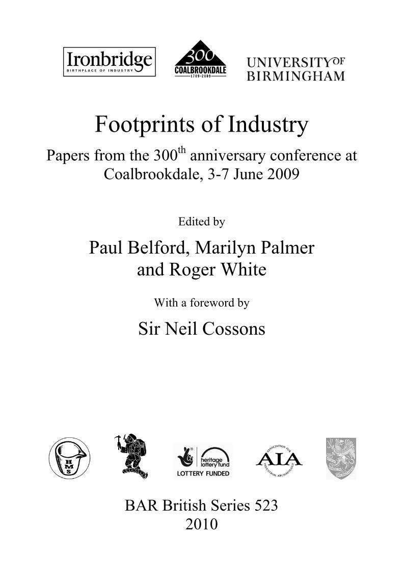
detail of the base timbers showing the cross-beam. waterwheel in 1778, which was 40ft (12m) in diameter and 6ft (1.8m) wide. Scour marks were recorded on the walls of the wheelpit which also indicated a wheel of this size, although no evidence of axel bearings were noted in the sides of the wheelpit and these may have been lost through truncation. Seven oak timbers were found in-situ at the bottom of the wheelpit and a further 57 pieces of timber were found in the lower fills. These proved to the remains of an eight spoke flat paddle wooden waterwheel and included the remains of the wooden axle of the wheel. The rock-cut niches and slots in the bottom and sides of the wheelpit show
that there was an inclined, wooden, sluice controlling the water in from of the head race tunnel and forming a very low breast shot wheel. This arrangement was very reminiscent of one of the pioneering waterwheel designs of John Smeaton, generally regarded as the first professional civil engineer and one of the founding fathers of that profession, for the boring mill at the Carron Company ironworks in Falkirk.26 The remains of a brick wall at the southern end of the wheelpit, and a brick wall and arched opening at the northern end of the wheepit was interpreted as the remnants of the wheelhouse superstructure. Two rock-cut chambers at the southern and south-western edge of the wheelpit appeared to have formed part of the mill structure on the eastern side of the complex, although their precise function was unclear. Three rock-cut tunnels were located on the redevelopment site. A rock-cut tunnel was excavated east of the wheelpit. This was 1m wide and at least 1m deep, although it was filled with concrete. It was traced for c.11.4m before turning a right angle to the east at its southern end. This was interpreted as the bye-wash. South of the wheelpit a second rock-cut tunnel of similar dimensions was recovered and appeared to be the wheelpit tailrace. A third tunnel was located at the north-eastern end of the site. Despite the difficult ground conditions the excavation of Castle Mill revealed textile remains of at least regional significance. The fragments of a waterwheel reminiscent of one of John Smeaton’s designs was a complete surprise and leaves open the question as to how far Smeaton was influenced by existing prototypes in his pioneering waterwheel work. In terms of the mill’s plan-form, the transmission of water-power to machines through gears and horizontal and vertical line shafts was impractical across a thin curving structure like Castle Mill, but was ideally suited to a rectangular structure. However, many early cotton spinning mills housed a mixture of hand and powered manufacturing processes27 so the position of the wheelpit at Castle Mill strongly suggests that the only part of the complex that ever housed water-powered machinery was on this side of the mill. This is also supported by the documentary material from the early 1790s, but the really extraordinary find from this excavation was the waterwheel remains with its design links to John Smeaton (Fig. 119).
F o o t p r i n t s o f I n d u s t r y
159
Fig. 119. Castle Mill: suggested reconstruction of the water wheel, based on archaeological evidence. Portwood Mills, Stockport: water versus steam on a nineteenth century cotton spinning complex The second case study also comes from Stockport and focuses upon a textile mill complex, Portwood Mills, that the map and documentary evidence showed had a complicated power-system history with water and steam on the same site as late as 1919.28 The site was established in the late eighteenth century as a water-powered cotton spinning mill, probably by the Howard family. It formed one of a group of textile mills built along a large leat of similar date known as the Portwood Cut. This was fed from the lower reaches of the River Tame and the tail race re-joined that river just above its confluence with the River Goyt. The documentary evidence indicated that steam-power was introduced in 1807. From 1808 power loom weaving was added and this became a major activity on the site with 350 power looms at work in 1822 and 750 a decade later. Cotton spinning continued in parallel with weaving until 1876-7 when Portwood Mills reverted to cotton spinning as the sole activity, and
the company was re-established as the Portwood Spinning Company Ltd. Around 1897 the company became part of the English Sewing Cotton Company Ltd, and water-turbines were installed in 1902. Textile production ceased around 1960 and the mills were demolished in the early 1980s after some years of abandonment. Although the mill structures were not formally recorded during the twentieth century they were visited by the industrial historian George Watkins in 1956 and the pioneering North West Industrial archaeologist Owen Ashmore in the early 1970s, both of whom who recorded a number of power-system details. The 2004 excavations on the Portwood Mills site (SJ 899 911; Fig. 120, overleaf) were undertaken ahead of a large retail development. Since the mill complex was large and rambling, and the evidence for a complex power-system development good enough to locate the power-houses, the excavation strategy adopted was to focus on the mill power technology by targeting the wheelhouse and what was probably the earlier of the two engine houses known on the site.

F o o t p r i n t s o f I n d u s t r y
160
Fig. 120. Portwood Mill: location map showing the site of the engine house and wheelpit.
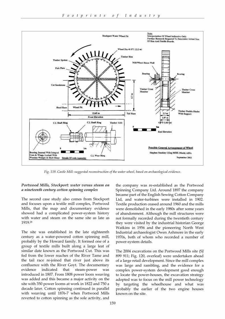
The excavation of the original 1796 wheelhouse revealed, as expected, a long history, although it was far more complex than originally anticipated(Figs. 121 and 122). This structure represented the original motive power of the mill and was a gable-end wheelhouse built into the Portwood Cut. The original waterwheel was found to be a large (20ft wide and 20ft (6.1m) diameter) undershot design, and provided power to the mills until it was replaced by a smaller (3.1m wide and 6.1m diameter) low-breast wheel between 1833-1842. This design was more successful and efficient at managing the infrequent water supply from the Portwood Cut. Following this, an even larger low-breast wheel (5.5m wide and 6.1m diameter) was installed (c.1865) which possibly utilised a cog and pinion to support the increased weight on the axle. The wheelhouse was converted into a turbine housein 1902, with the establishment of a pair of water turbines. These turbines were replaced by a single, less powerful Gilbert Gilkes & Co. Twin turbine (No. 2759) in 1919 which was recovered in-situ during the excavations (Fig. 122). All of these changes appear to have been as much to do with improving the power from the comparatively low and slow flow of the Portwood Cut as they were to do with changes in textile machinery.
Many of the original 1790s internal features and dimensions within the wheelhouse were retained, though early twentieth century red brick walls foreshortened the tailrace and had rebuilt the western wall, and the floor was raised well above its original level to create a penstock through the
installation of a concrete floor upon which the turbines were mounted. This floor comprised two I-section steel-beams and a cast-iron turbine mounting plate, rectangular in plan, with shallow sloping sides. A central hole approximately 40in. (1m) in diameter, had been set into the new floor at the north-western end. This had formed a combined turbine mounting and water outflow pipe or suction tube for the replacement turbine. This was installed to combat the infrequent and diminishing water supply from the Portwood Cut.
The engine house excavation was located east of the wheelhouse, at the northern end of the eastern range of the Portwood Mills complex. Like the wheelhouse it was found to have undergonesubstantial development from the early nineteenth century when a steam engine was first installed in 1808/9 until its closure in the late twentieth century. The excavations stripped the whole of the engine house to reveal its outer walls and internally acomplex overlapping sequence of stone engine beds. At least four major phases of rebuilding activity were visible within the footprint of the engine-house.
The primary steam engine was identified within a long narrow brick building and was clearly visible as a set of stone engine beds retaining square-section bolt fittings. The output of the original beam-engine is not recorded in the documentary evidence but the plan-size of the steam engine would suggest this was no more than 15-20hp. In 1833 the total power available for the mill was 80hp (60kW) of which water power contributed 10-20hp (7.5kW-15kW) or about 20%. The rest of the power was accounted for by the two other engine houses, although it seems likely that the second later engine house contained a larger beam engine. By 1865 the proportion of power generated by steam on the site had expanded, for in that year two beam engines were in place producing a total of 110hp (82kW). The output of both were expanded in the 1860s by their conversion to high-pressure steam engines. This was known as the ‘McNaughting’ process whereby an extra high-pressure cylinder was installed on an existing steam engine to increase its horsepower. This mid-nineteenth century power system development was associated within theexcavation by Phase 2 cast-iron brackets and gearing boxes for the line-shafting system which must have been replaced at the same time. The newly ‘MacNaughted’ steam engine required a bigger engine house which was expanded to the east. A stone base for the second high-pressure cylinder was also located. This power system was completely replaced in 1907, Phase 3, by a horizontal compound engine (producing 2050hp)
F o o t p r i n t s o f I n d u s t r y
161
Fig. 121. Portwood Mill: Phased plan of the engine house.
Fig. 122. Portwood Mill. Left: general view of the engine house during excavation. Right: the wheelhouse with the Gilkes twin turbine in situ.
F o o t p r i n t s o f I n d u s t r y
162
Fig. 123. Wallsuches Bleachworks, Horwich, Bolton, Greater Manchester. Aerial view showing the general layout of the complex.
Fig. 124. Wallsuches Bleachworks. Left: the cistern in Room 20; right: the Wallsuches works during excavation.

F o o t p r i n t s o f I n d u s t r y
163
and the installation of a rope drive. The engine-house was doubled in size and for the first time concrete and brick machine bases were used. A characteristic feature of the horizontal steam engine was its large oil sump. Phase 4 represented the insertion of a small vertical steam engine at the western end of the engine house, although why is unclear. The multi-phased engine house reflected the continuous use of steam power on the site from 1807 until the mills closed around 1960. The longevity of steam was not surprising in a Greater Manchester context since the textile mills survey of the 1980s had recorded many mills where steam power survived into the mid-twentieth century. The archaeological expression of that longevity was, however, complex and revealing. Much more surprising was the multi-phased wheelhouse which signified the long and repeated use of water to generate power within the Portwood Mills complex. The changing forms of water power discovered during the excavations are testament to the continuity of its usage and the attempts of the mills’ occupants to maximise its power through their investment in new designs and machinery. A significant feature of the site was the later introduction of steam power, which supplemented but did not supplant water-power as the only means of power on the site.29 This diversity of power supply throughout the nineteenth century is a feature of many of the 45 textile mills excavated across the Manchester City region since 1986 and would appear to represent a significant feature of the textile industry within Greater Manchester. The plan-form and orientation of the original mill was determined by the need for water power and the location of the Portwood Cut to the north, and the continuity of water power ensured that the mill developed south and south-east away from this water feature around a long thin central courtyard, as far as was possible within the valley bottom, which by the 1850s had become a main railway route. Wallsuches Bleachworks, Horwich The final case study demonstrates the complementary nature of above and below ground textile remains. Until the early twenty-first century, textile finishing sites, that is bleaching, dyeing and printing mills, were little studied in England,30 archaeologists focussing upon the recording of the spinning blocks and weaving sheds of the cotton, silk and woollen industries. Although notable concentrations of finishing works existed in the Cotswolds, London and Yorkshire, it is the c. 200
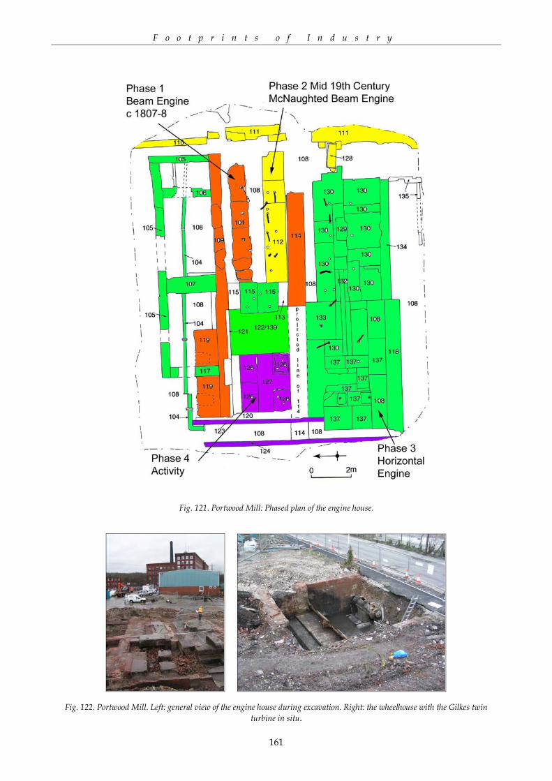
Fig. 125. Plan of the Wallsuches Bleachworks in 1901. finishing sites within Greater Manchester that have been studied extensively during the last 10 years, with a dozen building complexes recorded and seven excavations undertaken. Wallsuches Bleachworks at Horwich, Bolton, was one of the first finishing sites to be recorded in the Greater Manchester area. Both PPG15 and PPG16 work began in 2000 ahead of redevelopment plans to convert the site into a village and continued until the major on-site works were finished in 2008, providing the most detailed study so far of an industrial textile finishing site in England, and one of the most detailed textile complex surveys within Greater Manchester. By 2000 the site survived as an irregular complex of eight listed buildings comprising office, process, stabling, storage and domestic structures set within a landscape dominated by the management of water and four surviving reservoirs (Fig. 123). The industrial development of the Wallsuches bleachworks site (SD 653 117) began in the late eighteenth century with its acquisition by the Ridgway family who established the bleachworks. The Ridgways have been described as ‘one of the most enterprising bleaching firms of the time’, and are said to have been among the first in the country to carry out bleaching by chlorine on an extensive scale.31 By 1854 Wallsuches Bleachworks was one of the largest finishing employers in the region with a workforce of 461.32 In 1900 the Wallsuches firm was one of 60 companies which amalgamated to form the Bleachers Association,33 but in 1933, against a background of mounting difficulties in the textile industry, the complex closed.34 In 1950 the site was taken over by Arcon Engineering and in 2002 Redrow Ltd acquired the site. Conversion work started in 2003 and was largely complete by 2008.

F o o t p r i n t s o f I n d u s t r y
164
Fig. 126. Overall plan of evaluation and excavation at the Wallsuches Bleachworks site. The archaeological recording of the site included excavation and standing building survey work. The standing remains were recorded in detail first, with particular attention paid to the remains of any individual processes, and these results were then used to inform targeted excavation work.35 Although eight buildings survived on the site the two largest complexes were two process buildings, the bleaching croft buildings 1 and 2, at the eastern end of the site. Building 1, which occupied the south-eastern quarter of the site, had late eighteenth century origins. The complexity of the standing structures meant that each group of rooms was individually labelled during the survey work and this was carried through the rest of the project. The main surviving structure, Building 1A, was built by 1819. It may have held at least two steam engines one from the early nineteenth century and the other from the mid-nineteenth century. The western range formed part of the bleach croft while the eastern range may have been involved in finishing processes. Building 1B has at its eastern end at least two engine houses from the early and mid-nineteenth centuries, whilst Building 1C was probably the main bleach croft area for the whole of the complex where the cotton piece goods were processed. Building 1D may have originated as an
early engine and boiler house and had at least three phases of construction. Buildings 1E/F/G dated from the mid-nineteenth century and were built over the foundations of a c. 1819 structure and probably housed cloth finishing processes. The tall eastern engine house, with its striking two storey windows, Building 1H, was built in the early twentieth century c. 1910 to house a large horizontal steam engine which seems to have replaced all the earlier power systems. Below ground preservation within and around the Building 1 was good and the remains of other demolished buildings, such as the boiler house to the north east, were recovered during a watching brief. Culverts, pipe tunnels, drains and pipe work formed a complex below ground network both inside and out, and tanks and cisterns relating to bleaching and washing survived under the floors in Buildings 1B and 1C. Building 2, which lay in the north-eastern quarter of the site, formed the second bleaching croft on the site. Once more the complexity of the standing structures meant that each group of rooms was individually labelled during the survey work, whilst a below ground watching brief was undertaken during the conversion works in the same manner as with Building 1. The main stone structures, Buildings 2A and 2B were built by 1819, although Room 2C was added in 1858. A large bleaching croft that lay in the later courtyard was

F o o t p r i n t s o f I n d u s t r y
165
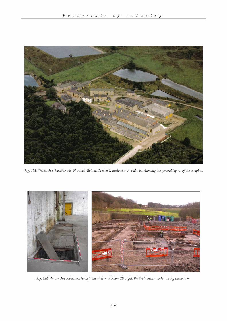
demolished during the mid-twentieth century and was covered with a thick modern concrete floor. This area became the focus of an archaeological evaluation that led to an open area excavation of the main bleach croft and kier house along with ancillary buildings housing the engines and boilers (see below). The surviving standing remains of Building 2A (rooms 10a and 11) housed on the ground and first floors finishing processes that involved heavy machinery. In 1910 they housed a calendering process; Room 10a was probably the location of a beam engine replaced by a later horizontal engine. The below ground watching brief suggested that the room was the focus of several power systems. The two western bays of rooms 10 were used for loading and storage. The upper storeys, later demolished, had been used as making up rooms and for hanging stoves. Building 2B room 28 housed heavy machinery at the eastern end, and may have had at least one steam engine probably replaced by another in the early twentieth century. In 1910 this part of the bleaching croft was known as the ‘New Calender House’. The original rooms 9a-9-8 were single storey out buildings demolished in the early twentieth century, but in 1910 they were used as a cylinder drying house and a starch mixing place. After demolition the space was roofed over and amalgamated with room 28 and probably used for finishing processes associated with those undertaken in room 28. Building 2D was possibly the earliest standing structure on the site. Originating in the late eighteenth century, by 1819 it was probably the main building where initial processing of the cloth before bleaching took place. After 1858 Building C took over this role with room 1 as the main unloading bay and by 1910 room 4 was the main singe room. Fire brick channels and bases revealed by the below ground watching brief probably housed the singeing stoves. In 1910 room 1 was a lofty grey room, Building 2D housed cloth scutching on the first floor of room 2, with grey rooms on the two upper floors. Cloth scutching also took place in the single storey room 2. The below ground survival of archaeology was good and an extremely complex system of pits, machine and engine bases, culverts, pipe tunnels and truncated walls emerged during the watching brief. These could only be understood in relation to the standing building remains, as separate elements of contemporary and later finishing process lines. The complexity of the development of the finishing processes was highlighted by large-scale excavation
of the demolished bleaching croft in the area of the courtyard. The investigation of the courtyard bleaching croft followed standard PPG16 methodology with an evaluation followed by area excavation. Two evaluation trenches targeted the demolished remains of former rooms 5, 6, 7, 11 and 27 of Building 2. These were part of complex of integrated buildings including a long rectangular stone range aligned east west with a spread of other ranges situated to the north. These rooms housed steam engines, boilers and a chimney all associated with the power systems for the building. The trenches also revealed walls, floor surfaces, engine beds and flues. The identification of significant below ground archaeology led to the area excavation which covered most of the central bleach-croft area (rooms 5 & 6), the foot print of room 7 and the eastern end of the demolished section of Building 2A (room 11). These archaeological investigations revealed a complex sequence of brick and stone structures associated with the various processes involved in the bleaching of cloth and yarn. Probably the most significant feature was a central stone tank or cistern flanked by stone surfaces with fittings for machinery. To the north of this was another wide sunken area which was originally a single tank that was later reorganised to house a series of kiers or pressure boiling tanks that may have been surrounded by a wooden floor at the level of the stone floors. Traces of walls along with a complex system of cast iron piping, brick flues and machine beds lay to the east within the foot print of a north-south aligned building containing room 7. At the southern end of this building was a large late nineteenth century boiler house (room 27), whilst to the west of this were the remains of a series of boilers, the earliest of which was a wagon boiler of the very early nineteenth century which was later replaced by at least two Lancashire boilers. Associated with this earliest boiler, at the eastern of the building, was a wall containing machine beds which probably marked the location of the first Bolton and Watt beam engine of 1779. The latest features on the site were a late nineteenth or early twentieth century series of structures, including a set of stone and fire brick lined tanks with adjacent settings for machines, which probably represented piling pits for one of the stages of bleaching. What is clear from the above and below ground archaeological recording at Wallsuches Bleachworks is that the understanding of this particular type of site benefitted from both approaches. The plethora of finishing processes and the mechanisation of

F o o t p r i n t s o f I n d u s t r y
166
bleaching, dyeing and printing were reflected in the multi-phased process buildings, boiler houses and engine houses encountered. These in turn relied upon a complex network of leats, culvets and drains that were fed by the surrounding reservoirs, which altered the appearance of this part of the valley. The complexity of the water and power-systems reflected the development of the finishing processes and it might be thought that the layout of the site, which was inward-looking with many courtyards, does the same. However, as Paul Belford has highlighted,36 there are extra meanings that can be retrieved from such industrial complexes beyond the merely functional. Thus, whilst the bleaching crofts and drying houses were distinguished by their functional industrial architecture from the warehouses and stables at the western end of the site, a centrally placed office, with one of the few instances of architectural embellishment, appeared to be so positioned as to be able to see all the major elements of the processes on the site. Particular types of finishing processes were often unique to a particular firm so the safe-guarding of these ‘recipes’ was vital for the business and indeed standing of the family concerned. Although the site was not surrounded by a wall as many urban manufactories were, entry and exit into the site was controlled through just two openings which channelled the grey, unbleached, cloth on its finishing journey from east to west across the site, and perhaps even discouraged unwanted ‘visitors’. Overlooking all was the owner’s house on the south side of the complex a feature common to many industrial sites in the nineteenth century and reflected the social control of the site as well as the status of the owner.37 C O N C L U S I O N : T O W A R D S A R E S E A R C H F R A M E W O R K F O R R E C O R D I N G / E X C A V A T I N G T E X T I L E M I L L S The long-awaited replacement of PPG15 and PPG16 was published in March 2010 – PPS5: Planning for the Historic Environment emphasises the need for understanding the significance of a heritage asset through its below-ground archaeology as well as its standing remains (Policy HE6.1, HE7.1 & HE7.2). It also calls for recording to explicitly advance the understanding of those heritage assets that are threatened and or altered by redevelopment (Policy HE12.2 and HE12.3). With budgets and timescales tight on developer-funded projects what should we as archaeologists be looking to record on textile sites? The Manchester experience of textile mill archaeology since the mid-1990s, as exemplified by the three mill case studies detailed above, shows a
possible way forward, highlighting research issues that can be organised under three broad headings; processes, landscape and social meaning. Processes There are still large gaps in our archaeological understanding of the remains of the textile industry. For instance, the North West Regional Research Agenda highlighted the need for specific studies of those industries that have received little archaeological attention - policy 7.35 – such as textile finishing.38 However, beyond this gap-filling remit there is also a need to understand the development of different types of process machinery and power features such as engine houses, boiler houses and wheelpits, as a way of revealing the technological history of a textile site where there are no standing remains. A broader methodological approach taken by TICCIH has been to categorise industrial sites according to their level of technical innovation and to seek the preservation and understanding of these key sites. Thus, in Greater Manchester textile terms this would include pioneer sites (Arkwright’s Mill in Manchester, Chorlton New Mill weaving shed), flagships (Murrays Mills), time capsule sites (Quarry Bank), and giants (Swan Lane Mills, Bolton). Such an approach can be used to focus the analysis of innovation in power technology and landscape impact.39 Finally, there is an urgent need to disseminate the existing grey literature studies on textile mill sites as a way of promoting the best-practice recording of these features. Landscape Impact of the textile industry on the new industrial towns and the ancient river valleys of a given area has received a growing amount of attention over the last decade.40 For instance, the importance of the textile industry in the emergence of new industrial towns has been highlighted by the North West Regional Research Agenda,41 and in several historic and urban landscape characterisation projects across England. That landscape impact is reflected in the water-management systems of the textile sites, the transport networks needed to support these sites, in the overall plan-form of mill complexes and their relationship to the industrial urban landscape. Studies of groups of mills, chronologically or spatially, can also reveal new insights into the localised landscape impact of a variety of new technologies and social groupings.42

F o o t p r i n t s o f I n d u s t r y
167
Social meaning Finally, the last decade has also seen a recognition that the studies of industrial processes and landscapes should include an examination of the presence of indicators of authority and social control so as to illuminate the wider impact of industrialisation on individuals and social groupings.43 Or, as Kenneth Hudson noted in 2001, industrial remains ‘whether they are steam engines [or] cotton mills...are valuable only in so far as they provide evidence about the people who used them’.44 Thus, more detailed studies are needed of individual mill workspaces in order to show how social control developed inside individual mill buildings and across whole mill complexes;45 something which buildings archaeology should be adept at showing. The social linkages between outworking and factory working, and between mill and textile community are also unevenly recorded within the textile districts, despite the pioneering work of the East Cheshire and Yorkshire textile volumes.46(45) Here a combination of buildings, landscape and documentary analysis is required, although this may be beyond the remit of most developer-funded projects. I began by asking is there any more to say, archaeologically, about that iconic building-type of the Industrial Revolution, the textile mill. Hopefully, this article has demonstrated, through
the large amount of new data gathered from around the Manchester City region since the 1990s, that not only is there more for archaeology to say about the textile mill, but also that there is a detailed and varied set of research questions that can and should be pursued concerning this industrial monument type. So far these wider research questions have only been asked systematically of the Greater Manchester evidence, and have yet to be fully answered. Even so, such research approaches should help archaeologists working in the other textile districts of Britain, and indeed wherever the textile industry led the industrial revolution, ensuring that textile mill studies remain an important and dynamic strand within Industrial and Historical Archaeology research into the mid-twenty-first century. A C K N O W L E D G E M E N T S Thanks to Norman Redhead, County Archaeologist for Greater Manchester, for reading through a draft of this paper and for his many helpful comments, and to Professor Marilyn Palmer and John Walker, of the York Archaeological Trust, for the many conversations over the years about the direction of Industrial Archaeology and in particular the need to broaden the study beyond the focus of processes, out of which this paper grew.
NOTES 1 Gwyn 2009, 84. 2 Palmer & Neaverson 2005. 3 Belford 2004, 45-6; Belford 2009; Mellor 2005, 49-50. 4 Miller & Wild 2007; Nevell, Grimsditch & King 2006. 5 Calladine & Fricker 1991; Giles & Goodall 1992; Williams with Farnie 1992. 6 Nevell 2006. 7 Faulkner 1993; Palmer & Neaverson 2005. 8 Williams 1988, 197. 9 Williams 1988 & 1993. 10 pers. comm. John Walker, who during the 1980s was deputy director of GMAU and oversaw the Greater Manchester Textile Mills Survey project. 11 Fletcher 1994, 44-63; Nevell & Walker 1999, 54-5. 12 Williams 1993. 13 Nevell 2008a. 14 Milln 1995. 15 Robina McNeil and Norman Redhead of GMAU, and John Walker and Dr Michael Nevell of UMAU. 16 PPG16: ‘Planning Policy Guidance Note No 16: Archaeology & Planning, November 1990’. Department of the Environment. 17 Brennand, with Chitty and Nevell 2006; Brennand, with Chitty and Nevell 2007. 18 Nevell and Walker 1998; Nevell and Walker 1999; Nevell with Grimsditch and King 2006. 19 PPG15: ‘Planning Policy Guidance Note No 15: Planning and the Historic Environment, September 1994’. Department for National Heritage & Department for the Environment. 20 Miller and Wild 2007; Nevell 2008b. 21 Hurst nd, 117-8. 22 UMAU 2004. The following description is summarised from the excavation report.

F o o t p r i n t s o f I n d u s t r y
168
23 Arrowsmith 1997. 24 Arrowsmith 1997, 103, 118-9. 25 Arrowsmith 1997, 144. 26 pers. comm. Dr Colin Rynne, University College Cork, Eire. 27 Williams with Farnie 1992; Miller and Wild 2007. 28 Noble 2004. The following description is summarised from the excavation report. 29 A similar progression was noted in archaeological excavations at Wednesbury Forge: Belford 2010a. 30 Nevell, Connelly, Hradil and Stockley 2003. 31 Sykes 1925, 81; Higgins 1924, 44. 32 Parliamentary Papers 1854-5 XVIII, 19. 33 Sykes 1925, 36, 84. 34 Connelly, Arrowsmith, Stockley and Hradil 2000. 35 King & Nevell 2005; King and Nevell 2009; Craig, King, Nevell & Power 2009. The following description is summarised from the building survey and excavation reports. 36 Belford 2004, 45-6. 37 Belford 2004, 54-8; Belford 2009. 38 Brennand with Chitty and Nevell 2007, 154. 39 Newman and McNeil 2007, 152. 40 Belford 2004; Palmer 2005; Nevell and Walker 1999. 41 Brennand with Chitty and Nevell 2007, 146; policy 146. 42 Holden 1999; Miller and Wild 2008; Nevell 2008b. 43 Brennand with Chitty and Nevell 2007, 154; policy 7.36. 44 Hudson 2001, 6. 45 Belford 2004, 58; Mellor 2005. 46 Calladine and Fricker 1993; Giles and Goodall 1992.