excavations at aðalstræti, 2003 - · pdf fileexcavations at aðalstræti,...
TRANSCRIPT

Excavations at Aðalstræti, 2003
Edited by H. M. Roberts With Contributions by Mjöll Snæsdóttir, Natascha Mehler, Oscar Aldred, Garðar Guðmundsson, Árný E. Sveinbjörnsdóttir, Jan Heinemeier, Karen Milek and Alex Chepstow Lusty. Fornleifastofnun Íslands FS243-00162 Reykjavík November 2004

© Fornleifastofnun Íslands Bárugötu 3 101 Reykjavík Sími: 551 1033 Fax: 551 1047 Netfang: [email protected]

Excavations at Aðalstræti, 2003 TABLE OF CONTENTS SUMMARY 1 PROJECT DESIGN 2 AIMS AND METHODOLOGY 3 RESULTS 4 Spring 2003 – H.M.Roberts 4 List of Contexts 11 July 2003 – Oscar Aldred 13 Haust/Autumn 2003 – Mjöll Snæsdóttir 14 List of Contexts 25 Skrá un Sýni – List of Samples 27 APPENDIX 1 The Finds - Natascha Mehler 28 APPENDIX 2
The Settlement of Iceland in Light of New 14C Dates from Reykjavík Garðar Guðmundsson, Árný E. Sveinbjörnsdóttir, and Jan Heinemeier. 50
APPENDIX 3 High resolution pollen and microcharcoal analysis from a Viking Period skáli at Aðalstræti, Reykjavík, Iceland: Evidence of pre-Landnám settlement?
Alex Chepstow-Lusty 55 APPENDIX 4 Aðalstræti, Reykjavík, 2001: Geoarchaeological Report on the Deposits within the House and the Soils Immediately Pre- and Post-Dating its Occupation
Karen B. Milek 73


Excavations at Aðalstræti, 2003 ACKNOWLEDGEMENTS Excavation at Aðalstræti in 2003 was carried out by Águsta Edwald, Garðar Guðmundsson, Gavin Lucas, Hildur Gestsdóttir, Howell Roberts, Hrönn Konráðsdóttir, Jane Hammill, Johann Terje Hole, Mjöll Snæsdóttir, Oscar Aldred, Oddgeir Hansson, Ragnar Edvardsson, Rúnar Leifsson, Sigríður Þorgeirsdóttir, Stefán Ólafsson, and Uggi Ævarsson. The project was administered for Fornleifastofnun Íslands by Ólöf Þorsteinsdóttir. Orri Vésteinsson and Colleen Batey edited portions of the text. SUMMARY Between May and September of 2003 Fornleifastofnun Íslands carried out a multi-phase investigation of multi-period archaeological remains at Aðalstræti 14, 16 and 18 in the heart of urban Reykjavík. This work was carried out in advance of development work on the site – and is the direct continuation of major archaeological investigations carried out in the winter and spring of 2000-2001. The site is known to be of the highest archaeological significance, and the continued work discovered additional remains of buildings dating both to the Viking period, and the 18th and 19th centuries. Excavation in 2001 had revealed the exceptionally well preserved remains of a Viking period hall, beneath the remains of factory buildings dated to the 18th and 19th centuries. During excavation in 2001 the decision was taken to preserve in-situ the exceptional Viking hall, and to construct a public exhibition space around the extant remains. This decision required a sensitive re-design of the proposed development – including the re-routing of several major services (water, electricity and sewerage) - and this process itself necessitated additional archaeological work. Excavation in 2003 revealed a small ancillary building attached to a doorway in the eastern wall of the Viking period hall, together with internal paving, floor layers and a possible external midden. The ancillary building is interpreted as a porch or ante-room for the main entrance. The fragmentary remains of 18th and 19th buildings and deposits were also excavated, towards the western limit of the excavation area – although these had been substantially truncated by modern cellarage. A large assemblage of early modern / modern artefacts were recovered from these layers.

PROJECT DESIGN Due to the complex requirements of the development project archaeological investigations at Aðalstræti in 2003 were carried out in three major tranches, and additionally frequent monitoring episodes;
Figure 1 – Excavation outline
1) Spring 2003 (v) - Excavation of post-medieval (C18th and 19th) remains at the
western part of the site. This area had been left in abeyance at the close of work in 2001 due to the continued presence of a standing building – an ancillary building extending north from the rear of Aðalstræti 16.
2) Autumn 2003_1 (h1) – Excavation of modern, medieval and early medieval layers at the eastern limit of the 2001 excavation. Parts of this area had been
2001_excavation
2003v_excavation
2003v_truncation
2003h1_excavation
2003h1_truncation
2003h1_observation
2003h2_excavation
2000_trial trenches
50m0m
Túngata
Aðal
stræ
ti
Grjótagata
14
16
18
12
4
2

left in abeyance in 2001 due to the continued presence of active services (water, electricity, telephones, sewerage). Re-design of the development required the further investigation of a strip up to 6m in width and extending from Grjótagata in the north, to Túngata in the south. The planned construction of a subsurface passage connecting Aðalstræti 14-16-18 to Aðalstræti 10 further required investigation at the rear of Aðalstræti 12 and Grjótagata 4. Additionally, ground works on the plot of Aðalstræti 18 were observed under watching brief conditions – in case any archaeological material remained on site after the investigations of the 1970’s.
3) Autumn 2003_2 (h2) – The discovery of further Viking period building remains during work in August 2003 required the slight diversion of a sewer main running beneath Aðalstræti. Although highly truncated by modern services, a small triangular area beneath the roadway was also excavated.
This complex, and at times difficult, process was carried in close co-operation with representatives of Reykjavík City Museum, the City roads authority, the project architects and construction companies, and the public utility companies. We are grateful for their assistance.
AIMS AND METHODOLOGY
As in 2001 the excavation methodology adopted was one of single context planning within 5m squares, and located within the Reykjavík City co-ordinate system. Plans, sections and contextual data were recorded on pro-forma recording sheets. These were supplemented by conventional and digital photography. All artefacts and bones were recovered by hand, and a programme of environmental sampling was carried out. All archaeological layers were hand-excavated, after modern deposits and overburden had been removed by machine under archaeological supervision The aims of excavation in 2003 were complex and varied. The primary aim may be described simply as the preservation by record of all archaeological deposits at risk from development, and the recovery of all possible artefacts and ecofacts from those layers. The broader aims were to complete the investigations commenced in 2001, and to the greatest extent this new work shares the aims of that project. These include the recovery of all remains at threat – but also the rapid display and dissemination of the results of all studies deriving from that material. We hope to achieve a new and more complete understanding of the development of Reykjavík from first settlement through to the modern era. We hope to shed new light not only on the Viking period settlement, but also upon the birth of urban Reykjavik in the period after 1750, and to account for the apparent absence of major structural remains on this site in the intervening period. This is a work in progress – further planned development in central Reykjavik will inevitably produce new data and raise further issues. The continued study of material from Aðalstræti 14-16-18 can only reinforce the value of work to date – and further establish these remains as being of major regional, national and international significance.
3

RESULTS Spring 2003
Figure 2 – Spring 2003. Major structural elements and the extent of truncation.
Following the demolition of an outbuilding at the rear of Aðalstræti 16, further areas became available for archaeological study. Excavation revealed fragmentary but substantial structural remains dating to the 18th and 19th centuries, along with associated deposits, including traces of the 1764 fire horizon noted previously in 2001. To prepare the site for excavation the remains of 3 co-joined concrete and stone cellars (dating to circa 1900) were first removed by mechanical excavator. Cellarage had severely affected the survival of archaeological remains in this area, and flooding of the void left on removal of the cellar hindered excavation in some areas.
1999
1002
1004
1026
10391035
Cellar
1030
Well
EN-1970's
10m0m
4

Nonetheless, several phases of construction and development maybe discerned, including terracing (1026, 1039, 1099) wall foundations (1030), wall footings (1002), small areas of paving (1035), and the remains of a stone built drain (1004) - leading to a well first excavated in the 1960’s, and re-excavated in 2001. Dating evidence for these events is primarily based upon the artefactual assemblage (largely pottery and glass) – although intrusive and residual material inevitably permits some margin of doubt. Stratigraphic evidence from the excavation does however permit a firm constraint on these issues. Phase A – Pre 1750ad The structural and anthropogenic deposits shown above were seen to lie above a sequence of naturally deposited layers, broadly consistent with similar deposits recorded in 2001. At the base of the sequence was a sterile gritty grey green deposit of clay silt (context 1018), and this is thought to be prehistoric in origin. Overlying this were deposits of grey-green silt (1015 and 1016), consistent with colluvial deposits removed from above the Viking period hall in 2001 – and thus perhaps datable to post 900ad. They in turn were sealed by orange brown aeolian deposits (1012, 1013 and 1014), exhibiting both ferric precipitation and some very limited peat ash content. The latter contexts are once more comparable to deposits recorded in 2001 – and may represent soil accumulation from the broader medieval period, perhaps c.1200-1750ad. The earliest clearly anthropogenic layers recorded in the spring of 2003 lie above these deposits. Phase B – 1750-1764 – the earlier factories. Some limited activity was seen to lie beneath a widespread but discontinuous deposit of charcoal and peat ash (contexts 1019 and 1043). The latter deposits are interpreted as part of a burning horizon associated with the destruction of the earlier “factory” buildings by fire – and thus closely datable to 1764ad. Beneath the 1764 fire horizon were; 1020 – a peat ash deposit including brick fragments, recorded in section adjacent to a circa 1900 drain (see below) 1044 – a mixed fill of clay and turf debris, including occasional charcoal 1045 – a shallow irregular cut containing 1044 located at the south eastern corner of the excavation area – and much truncated by later foundations etc. Together with Context 1044 this feature may conceivably represent a levelling/terracing event associated with the construction of the earlier factories. 1046 – a small isolated patch of peat ash including brick fragments. 1047 – two isolated stones – potentially the last truncated remains of a structure of unknown nature and dimensions.
5

Phase C – 1764 – c.1800 Following the fire of 1764, the factory buildings or “innréttingar” were reconstructed. Upon previous excavation in 2001 these were seen to be characterised by their massively built stone filled foundation trenches and chimney piers. Excavation in 2003 exposed one corner of the northern wing of the later factories (contexts 1030/1031), and the truncated remains of a massive stone revetment (1026 and 1039) upslope and west of the surviving traces of the factory building itself. Although the stratigraphic relationship between these features remains opaque, it is suggested that the stone reveting may be associated with the major construction project entailed by the reconstruction of the factories. Artefactual evidence for the dating of the revetment (1026 and 1039) is unfortunately unclear. Whereas deposits associated with fragment 1039 are consistent with a date in the late 18th century, fragment 1026 was subject to later disturbance and finds recovered from associated contexts appear to be intrusive.
Figure 3 – The revetment 1026/1039 and the foundation of the later factory (1030).
10260m
10m
EN-1970's
1030
Cellar
1039
6
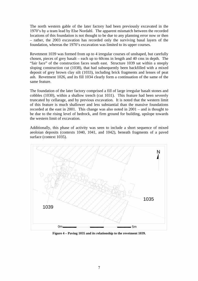
The north western gable of the later factory had been previously excavated in the 1970’s by a team lead by Else Nordahl. The apparent mismatch between the recorded locations of this foundation is not thought to be due to any planning error now or then – rather, the 2003 excavation has recorded only the surviving basal layers of the foundation, whereas the 1970’s excavation was limited to its upper courses. Revetment 1039 was formed from up to 4 irregular courses of unshaped, but carefully chosen, pieces of grey basalt – each up to 60cms in length and 40 cms in depth. The “fair face” of the construction faces south east. Structure 1039 sat within a steeply sloping construction cut (1038), that had subsequently been backfilled with a mixed deposit of grey brown clay silt (1033), including brick fragments and lenses of peat ash. Revetment 1026, and its fill 1034 clearly form a continuation of the same of the same feature. The foundation of the later factory comprised a fill of large irregular basalt stones and cobbles (1030), within a shallow trench (cut 1031). This feature had been severely truncated by cellarage, and by previous excavation. It is noted that the western limit of this feature is much shallower and less substantial than the massive foundations recorded at the east in 2001. This change was also noted in 2001 – and is thought to be due to the rising level of bedrock, and firm ground for building, upslope towards the western limit of excavation. Additionally, this phase of activity was seen to include a short sequence of mixed aeoloian deposits (contexts 1040, 1041, and 1042), beneath fragments of a paved surface (context 1035).
Figure 4 – Paving 1035 and its relationship to the revetment 1039.
0m 5m
10351039
7

Paving 1035 was seen to abut the revetment 1039. As such it must date to a slightly later period than the revetment itself – probably circa 1800ad. Also included in this phase of activity is a minor deposit of peat ash (1011) including brick fragments, and located within an isolated pillar of stratigraphy surrounding a circa 1900 drain (see below). Group 1999 (see figure 2) was a fragmentary spread of building stone located at the western limit of excavation. The latter feature provided insufficient evidence for secure phasing, but may date to the major phase of reconstruction seen post 1764 – although it could however be placed somewhat later, at any point between 1764 and circa 1900ad. Phase D – c.1800-1900 Only 2 structural elements may be securely placed within this phase – a wall fragment (context 1027) and the truncated remnants of a possible surface (context 1032). Artefacts recovered from in and amongst these constructions are suggestive of a date in the 19th century, and they are thought to represent a modification or addition to the surface 1035 described above.
Figure 5 – Contexts 1027 and 1032, overlying surface 1035
A number of mixed deposits were found to seal the above structures (contexts 1021, 1025, and 1029) – these may dated to the 19th century. Sealing a part of the factory foundation (1030, see above) was a minor deposit of yellow brown silt (context 1023). Although this cannot be securely dated, its nature and location make a late C19th date most likely.
5m
10271032
0m
8

Contexts 1006, 1007, 1008, 1009 and 1010 were located above context 1011 (see above). They comprise a mixed sequence of dumps including peat ash, gravel and brick within an enriched dark grey brown clay silt matrix. Finds evidence suggest a date in the 19th century. These latter layers were in turn truncated by the construction trench of a drain (see below). Phase E –Post 1900
Figure 6 – C19th structural remains From 19th century layers 2 further structural elements were recorded. At the southwestern corner of the excavation an “L-shaped” footing of stone (1002) was noted. This survived only as a single course of large coarsely shaped basalt blocks. The location and alignment of this structure is fully consistent with the extension of Aðalstræti 16, and the stones appear to form a direct continuation of the stone wall/ cellar foundation excavated in 2001. These events are believed to have happened circa 18991. Additionally, the well preserved remains of a stone built drain (context 1004) were excavated at the eastern limit of excavation. Feature 1004 consisted of two rows of small unshaped stones (and occasional bricks), up to 4 courses in depth, forming a channel some 25cms in width and capped with larger, flatter pieces of coarsely shaped stone. The capping stone itself had in places been sealed with both fragments of leather and tar paper, although this feature survives unevenly. The stone structure 1004 was bedded directly onto prehistoric deposits (1018, see above), and sat within a deep vertical cut (context 1005) some 65cms wide and up to 2m in depth. This feature can be seen to be a direct continuation of a drain excavated in 2001, and feeds into a well – first excavated in the 1960’s.
1 Guðmundur Ingolfsson, Guðný Gerður Gunnarsdóttir and Hjörleifur Stefánsson. See page 82, “Kvosin”, 1987, Torfusamtökin, Reykjavík for a discussion of the later building history.
0m 10m
Well
Cellar
1004
1002
9

Figure 7 – Detail of drain construction (1004)
Plate 1 – The drain 1004 after removal of the capping stones. Looking north west, the scale is 1m.
0m 2m
Tar paper
Leather
Brick
10

Drain 1004 had been substantially truncated by the construction of a large and deep cellar at sometime in the early 20th century. Whilst these features are not technically of archaeological interest, a selection of ceramics was recovered from the cellar fill (context 1001) for comparative purposes and the creation of a reference collection. List of Contexts excavated in Spring 03 Number Type Description 1000 Deposit Cleaning 1001 Deposit Modern cellar backfill 1002 Deposit Stone footing 1003 Deposit Backfill of drain cut 1004 Deposit Drain structure 1005 Cut Drain cut 1006 Deposit C19th dumping layer 1007 Deposit C19th dumping layer 1008 Deposit C19th dumping layer 1009 Deposit C19th dumping layer 1010 Deposit C19th dumping layer 1011 Deposit Peat ash 1012 Deposit Orange brown aeolian layer - natural 1013 Deposit Orange brown aeolian layer - natural 1014 Deposit Orange brown aeolian layer - natural 1015 Deposit Grey green silt - colluvial - natural 1016 Deposit Grey green silt - colluvial - natural 1017 Deposit Basal fill of drain cut 1018 Deposit Grey green gritty clay silt - glacial? 1019 Deposit Charcoal horizon - 1764? 1020 Deposit Peat ash 1021 Deposit Peat ash 1022 Deposit Peat ash cellar fill 1023 Deposit Charcoal layer 1024 Deposit Structural stones 1025 Deposit Mixed gravel horizon 1026 Deposit Revetment 1027 Deposit Stone foundation 1028 Cut Trench cut 1029 Deposit Peat ash 1030 Deposit Fill of 1031 1031 Cut Foundation trench 1032 Deposit Dark brown gravel layer 1033 Deposit Fill of 1038
11

Number Type Description 1034 Deposit Fill of 1026 1035 Deposit Stone foundation in cut 1048 1036 VOID VOID 1037 VOID VOID 1038 Cut Foundation cut 1039 Deposit Stone foundation 1040 Deposit Brown aeolian layer 1041 Deposit Gravel horizon 1042 Deposit Aeolian deposit 1043 Deposit Charcoal layer - 1764? 1044 Deposit Fill of 1045 1045 Cut Construction, terracing? 1046 Deposit Peat ash horizon 1047 Deposit Stones beneath 1043 1048 Deposit Foundation cut
12

Aðalstræti 2003 - 16th July to 17th July By Oscar Aldred Oscar Aldred, Hildur Gestsdóttir, Garðar Guðmundsson and Uggi Ævarsson. A monitoring operation was carried on July 16th-17th 2003 during the placement of groundfast steel shuttering around the remains of the viking period hall excavated in 2001. During this process, it was noticed that the remains of an in-situ turf structural element could be seen extending eastwards from the 2001 limit of excavation. This location had been obscured by service pipes during excavation in 2001 – these services had subsequently been removed prior to the driving down of shuttering in the summer of 2003. Context List 1049 disturbed colluvium, probably [1053], brown and sandy infill at base of pipe cut [1050] 1050 pipe cut 1051 same as [1049] but for pipe cut [1052] 1052 pipe cut, goes under edge of excavation towards east 1053 colluvium with patches of peat ash, charcoal fragments and burnt bone fragments, brown gradually getting greener towards the south; truncated by pipes and during machining and all that is above it in this location 1054 turf debris, either collapse, trample or even part of structural elements to the entrance structure 1055 charcoal patch, perhaps part of the floor to the entrance structure or part of the skalí floor During the excavation a relatively straight forward sequence was observed. Two pipes [1049, 1050 & 1051, 1052] had been cut into the colluvium deposit [1053], which in turn sealed the the turf debris [1054] as well as the in situ turf structure (the northern wall of Group 1066 – see below). The latter context had been partially truncated, perhaps during excavation, but was clearly visible in the better exposed section by several compressed layers of turf with stones either side and organic and dark floor like deposits to the south inside the wall. Under the turf debris, south of the structural element a small patch of charcoal, possibly a floor or a dumping was seen. The deposits [1053, 1054, and the turf element] remained substantially unexcavated. These deposits were excavated in full in the Autumn of 2003 (below)
13

Haust 2003 – Autumn 2003 Summary During preparation for further building work in 2003, it was decided that additional areas would need to be excavated, i.e., a strip of land beneath the modern pavement next to the hall. This exposed an addition at the eastern side of the hall, ca 3 x 2.5 m, built about the same time as the hall, but seemingly added on to it. The building material was the same as in the hall, stone and turf, and the turf contained a tephra layer dated to 871 +/- 2 A.D. It is not altogether unknown that Viking age hall buildings excavated in Iceland have "entrance buildings," but we do not have many examples of it. This lack of such buildings, may possibly be due, in part, to preservation and/or excavation techniques. Similar additions are also known e.g. in Viking age Denmark. Svæðið sem rannsakað var um haustið var undir gangstétt og hluta akbrautar vestanvert við Aðalstræti, löng og mjó skák meðfram lóðunum Aðalstræti 14, 16 og 18, á milli Grjótagötu að norðan og Túngötu að sunnan, en náði þó ekki alveg að þeim. Skákin var víðast hvar um 6 m að breidd og rúmlega 30 m á lengd (2003h1_excavation á Figure 1). Næst Túngötu var svæði sem ekki átti að hreyfa við og ekki var heldur hreyft við lítilli skák næst Grjótagötu. Þar voru lagnir og rafmagnsstrengir í notkun.Eftir því sem best varð séð var þar öllum lögum raskað niður á malarkamb.
Verkið hófst 15. ágúst. Byrjað var að vinna á vestari hluta skákar, en hún var stækkuð til austurs 30.-31. ágúst. Á sama tíma var verið var að grafa með stórvirkum gröfum niður á fast á svæðinu vestan og sunnan við skála, og var jafnframt fylgst með þeim grefti, ef fram kæmu mannvistarminjar. Þegar það gerðist voru gröfur stöðvaðar og minjar skráðar. Þá var einnig fylgst með grefti fyrir gangi neðanjarðar frá lóð Aðalstrætis undir Grjótagötu og meðfram húsinu á Grjótagötu 4. Vegna breytinga á kjallara var svæðið stækkað til austurs og þá, 6.-10. okt., rannsökuð þríhyrnd skák, löng og mjó, 22 m á lengd og mest 3,2 m breið (2003h2_excavation á Figure 1).
Við rannsóknina var notast við bráðabirgðahnitakerfi sérstaklega sniðið eftir lögun svæðisins og var það síðan mælt inn með alstöð í hnitakerfi borgarinnar.
14

Fyrri vísbendingar um minjar Rannsóknarsvæði haustsins er skammt vestan við elsta kirkjugarð Reykjavíkur, sem er handan Aðalstrætis, á horni Aðalstrætis og Kirkjustrætis. Á korti sem til er af kaupstaðarlóðinni 1787 virðast sýnd vesturmörk á kirkjugarði með brotalínu vestan kirkjunnar. Þessi lína er u. þ. b. 20 álnir frá austurgafli húss á lóð Aðalstrætis 14, um 12,5 m. Ekki er vitað hvort vesturmörk garðsins hafa alltaf verið þarna á sama stað, eða hvort einhverjar breytingar hafa orðið á þeim. Ekkert kom fram við rannsóknina 2003 sem ætla mætti að tilheyrði kirkjugarði.
Á lóð Grjótagötu 4 hafði verið boruð könnunarhola við rannsókn Þorkels Grímssonar og Þorleifs Einarssonar 1962.2 Hola sú var norðan við húsið, u.þ.b. miðja vegu milli hússins og lóðarmarka að norðan, og u.þ.b. fyrir miðju húsinu. Hún var því töluvert vestar á lóðinni og ofar í brekkunni en staður sá sem grafið var á 2003. Í þessari holu hafði komið í ljós viðarkolalag á um hálfs metra dýpi og að því er virðist eftir lýsingu hreyfð lög þaðan niður á rúmlega 1 metra dýpi þar sem komið var í grjót.3 Á elsta korti sem sýnir hús á þessum slóðum, korti Lievogs af kaupstaðarlóðinni 1787 má sjá “Skálann” á þessari lóð, hann var torfhús. Hann sneri norður og suður og gafli að Grjótagötu. Snemma á 19. öld var hann rifinn og reist timburhús á lóðinni Það sneri einnig norður og suður. Hús þetta sést á Reykjavíkurkorti V.Lottins frá 1836. Árið 1896 var reist það hús sem enn stendur, tvílyft timburhús á hlöðnum kjallara.4 Elstu ummerki (9.-11. öld) Á rannsóknarsvæðinu var neðsta lagið víðast hvar malarlag það sem er undir miðbæ Reykjavíkur. Þetta er malarkambur sem talið er að hafi myndast fyrir um 1200 árum.5 Glögglega mátti sjá að malarkamburinn hækkar lítillega til norðurs, í átt að sjó, á þessum slóðum. Hæð hans yfir sjó var á bilinu 2,20 til 2,40 metrar. Það virðist yfirleitt vera þannig að malarkamburinn hækki frá suðri til norðurs, og hefur mátt sjá það víðar í miðbænum.6 Tvílitt gjóskulag, hið svonefnda landnámslag, sem talið er hafa fallið 871 +/- 2 7 lá allsstaðar á skákinni meðfram Aðalstræti, nema þar sem síðari tíma rask náði alla leið niður á mölina. Gjóskan lá ýmist beint ofan á malarlaginu, eða ofan á þunnu moldarlagi (um 1 cm) milli malar og gjósku.
2 Þorkell Grímsson og Þorleifur Einarsson: Fornminjar í Reykjavík og aldursgreiningar. Árbók hins íslenzka fornleifafélags 1969, bls. 80-97. 3 Sama heimild, bls. 94. 4 Nanna Hermansson ofl: Grjótaþorp, Reykjavík 1977, bls. 141. 5 Þorleifur Einarsson: Jarðfræði Reykjavíkur og nágrennis, Reykjavík í 1100 ár, Rvík 1974, 44; Margrét Hallsdóttir, Saga lands og gróðurs. Tjörnin, saga og lífríki, Rvík 1992, 12 6 Sjá t.d. Skia: Survey 1993. A Report of Archeological Test Pits in Downtown Reykjavík. Skýrslur Árbæjarsafns XXXI. Rvík 1993, 100, um könnunarholu í Hafnarstræti vestanverðu, þar sem undirlag undir götuna liggur beint á malarkambinum. 7 Karl Grönvold, Níels Óskarsson, Sigfús J. Johnsen, Clausen, H.B., Hammer, C.U., Bond, G. & Bard, E. 1995. “Ash layers from Iceland in the Greenland GRIP ice core correlated with oceanic and land sediments.” Earth and Planetary Science Letters 135, 149-55.
15

Ummerki sem geta verið eldri en skáli: Norðarlega á rannsóknarsvæðinu fundust veggjarleifar [1081]. Það var mjög lítill stúfur úr torfvegg, um 1,40 x 0,6 m og um 0,1 m á þykkt. Þessar torfleifar voru úr fíngerðu, brúnleitu og fremur einsleitu efni. Landnámslagið var ekki í þessu torfi, en dökkar rendur (gömul grasrót) og viðarkol. Undir veggjarleifunum var landnámslagið óhreyft, þar undir 2-3 cm af ljósri mold og þá komið niður á malarkambinn. Veggjarleifar þessar voru í hæðinni 2,22–2,50 m.y.s. Efnið í þessum veggjarleifum er áþekkt efninu í vegg sem leifar fundust af við rannsóknina 2001, og var eldra en landnámslagið og skálinn. Ef til vill mætti túlka veggjarleifarnar sem fundust 2003 sem fallinn bút úr þeim vegg er leifar fundust af 2001, enda er skammt milli þeirra. Um það verður þó ekki sagt með vissu. Norðarlega á rannsóknarsvæðinu voru tvö þunn lög af viðarkolasalla, einingarnar [1084] og [1085], 0,5-1 sm að þykkt. Sumsstaðar lágu þau beint á landnámslaginu en víðar var þunnt moldarlag, 1–1,5 cm, milli kolalagsins og landnámslagsins. Einingarnar [1084] og [1085] eru samskonar, og eru líklega hlutar úr sama lagi, þó aðeins séu varðveittir þessir tveir blettir af því. Milli þeirra eru um 2 m. Ætla má að þetta lag eða lög séu eldri en skálabyggingin sem könnuð var 2001, eða a.m.k. eldri en fordyrið [1066]. Blettur af áþekku lagi var einnig austar á rannsóknarsvæðinu, eining [1122], og lá einnig beint ofaná landnámslaginu. Ofan á [1084] var rótuð ljósbrún fokmold og í henni var töluvert af smásteinum úr malarkambinum, eining [1086]. Lagið var 2-30 cm að þykkt, 3 x 2 m að stærð. Lag þetta hefur orðið til við byggingu skálans eða fordyrisins austan hans.
Grjótagata
Pavement Aðalstræti
Aðalstræti 14
(863)
(1081)
0m 5m
16

Fordyri Þegar grafið var niður með skálavegg að austan í júlí 2003 vegna stálþils sem reka átti niður umhverfis skála til að verja hann meðan á byggingaframkvæmdum stæði höfðu komið í ljós leifar af veggjum. Vegna þessara byggingaleifa var því frestað að reka þilið niður að austanverðu.
Á skálabyggingunni sem rannsökuð var 2001 voru dyr á báðum langhliðum,
norðarlega á austurhlið og sunnarlega á vesturhlið. Ekki voru neinar viðbyggingar á vesturhlið, móti brekkunni. Austurmörk uppgraftarsvæðisins 2001 voru við útvegg skála að austan og því var ekki hægt að sjá hvort nokkuð var byggt upp að húsinu að austan, en þegar svæðið austan skála var rannsakað 2003 kom ljós viðbygging við austurdyrnar. Viðbygging þessi var byggð úr samskonar efni og skálinn sjálfur. Hún var að utanmáli 5,1 m frá norðri til suðurs og 3,8 m frá austri til vesturs, en austurendi var að einhverju leyti skertur. Breidd að innan frá norðri til suðurs var rúmir 3 m. Veggir voru úr strengjatorfi með landnámsgjósku í. Veggirnir voru 0,9–1,2 m að þykkt. Að innanverðu og utanverðu í veggnum voru hleðslur úr vatnssorfnu grágrýti, flestir voru þeir steinar fremur litlir, 30-40 cm langir. Varðveitt voru 1-4 umför steina. Fordyrið og lögin sem því tilheyrðu eru skráð sem flokkur [1066].
17

Innan veggja fordyrisins voru nokkur lög úr hrundu torfi [1067], [1071],
[1097], einnig fokmoldarlag [1075]. Undir þessum lögum var gráleitt lag, lítillega kolaborið, en ekki harðtroðið [1090], og undir því annað lag, fíngert og dökkbrúnt með örlitlu af viðarkolum [1096], sem lá ofan á landnámslaginu og innsiglaði það. Þessi tvö síðarnefndu lög eru túlkuð sem gólflög. Hellulögn í skáladyrum hélt áfram austur í fordyrið, eining [1116]. Hún er gerð úr hellum og flötum steinum sem lágu í grófri möl. Greinileg skil voru í fordyrinu um 1,5 m frá útbrún skálaveggjar. Þar var einföld steinaröð, eining [1117], lítillega óregluleg og skarð í hana miðja. Þessa
18

steinaröð ber trúlega að túlka sem ummerki um þilvegg, þ.e. timburþil hafi hvílt á steinaröðinni og dyr verið á því miðju. Austan hennar var gólflag nokkuð frábrugðið og hallaði til austurs, eining [1094]. Syðst í fordyri var moldarlag með möl, eining [1099]. Undir steinaröðinni og moldarlaginu syðst voru torflög, einingar [1089] og [1101] og eru þau túlkuð sem undirlag undir gólf.
Undir gangstéttinni við Aðalstræti vestanvert var skurður fyrir skólplögn og vatnslögn. Skurðurinn var 3-4 m austan við austurvegg skála og var um 1,4 metra breiður. Hann var grafinn niður á eða í malarkambinn sem er undir miðbænum í Reykjavík og hefur því skorið í gegnum allar mannvistarminjar. Báðir hliðarveggir fordyris voru skertir að vestan af skurði þessum. Ekki var hægt að sjá nein ummerki þess að framhald væri á fordyrinu austan lagnaskurðarins. Ekki er fullkomlega víst hve langt hliðveggir kunna að hafa náð áður en skurður sá var grafinn sem skólplögnin lá í, og ekki er víst að veggirnir hafi verið mikið lengri upphaflega en þeir voru þegar rannsóknin var gerð. Miðað við sveigjuna á hliðveggjunum báðum er óvíst að það hafi verið nema ca 0,4 – 0,5 m sneið sem tekin var af fordyrinu að austan (innanmál). Suðurveggur fordyrisins var einnig örlítið skaddaður af nýlegum skurði sem legið hafði fast við hann að sunnan og stefnt austur og vestur.
Þar sem suðurveggur fordyris og austurveggur skála koma saman, má sjá að
steinaröð í útbrún skálaveggjar er samhangandi alla leið að dyrunum, og suðurveggur fordyris er hlaðinn þar upp að. Þetta bendir til þess að fordyrið sé reist á eftir skálabyggingunni. Efniviður í veggjum fordyris er samskonar og í skálaveggjum, og er það vísbending um að ekki hafi endilega liðið mjög langt milli byggingar skála og fordyris. Samskeyti norðurveggjar fordyris og skálaveggjar voru skert af síðari tíma skurði og ekki verður séð hvernig frágangur hefur verið þeim megin.
Undir suðurvegg fordyris var lítið gráleitt leirlag með örlitlu af viðarkolum í,
[1100], 85 x 20 cm, ef til vill fært á staðinn til að jafna út undirstöðu áður en veggur var reistur. Undir þessu lagi er landnámslagið óraskað.
Ekki þarf að fjölyrða um til hvers slíkt fordyri hefði verið. Það hefur verið til
hlýinda og einangrunar og til að koma í veg fyrir dragsúg. Dæmi eru um fordyri á skálabyggingum frá svipuðum tíma, bæði hérlendis og erlendis.8
Vegna byggingaframkvæmdanna var talið nauðsynlegt að fjarlægja fordyrið
en áætlað er að byggja það aftur á sama stað að framkvæmdum loknum. Veggjagrjót og hluti stéttar var merkt og sett í geymslu í Árbæjarsafni. Vegna fyrirhugaðrar sýningar voru einnig þrír bútar úr torfhleðslunni teknir heilir og pakkað inn.
8 Sjá t.d. Guðmundur Ólafsson, Grelutóttir, Árbók hins íslenska fornleifafélags 1979, 25-73; Howell M. Roberts, Area E Excavation Report. Hofstaðir 1998. Framvinduskýrslur. Ritstj. Adolf Friðriksson /Orri Vésteinsson, FS156-00161, Rvík 1998, 38-58; Holger Schmidt, Vikingetidens byggeskikk i Danmark, Højbjerg 1999, 68-70.
19

Ummerki sem gætu verið frá sama tíma og skáli: Austan við skála var óregluleg dreif af steinum, sumum allstórum (30–70 cm að lengd) og nokkrum minni í kring, eining [1123], og mátti sjá þessa röð eða dreif á um 6 metra kafla. Steinar þessir hvíldu á landnámslaginu. Ekki virðist líklegt að þeir séu náttúrulegir á þessum stað og meiri líkur á að þeir séu færðir á staðinn. Ef til vill eru þetta leifar af garðlagi, sem ekki hefur varðveist að öðru leyti. Sá garður hefur þá legið nálægt því í norður og suður.
Á lóð Aðalstrætis 18 höfðu árið 1971 verið rannsakaðar leifar af torfhúsi, sem var mikið skaddað af síðari tíma byggingum. Við rannsóknina 2001 kom í ljós að húsið var áfast stærri skála sem var norðan við það. Eftir að uppgrefti lauk á lóðinni Aðalstræti 18 hafði verið færður ofaníburður á svæðið og það síðan notað sem bílastæði allt fram til 2001. Fylgst var sérstaklega vel með vélgrefti á hinu áður kannaða svæði á lóðinni nr. 18, ef vera skyldi að eitthvað af áður rannsakaðri byggingu hefði verið skilið eftir, enda hafði rannsóknin 2001 á lóð Aðalstrætis 14 sýndi að ýmsar minjar þar, sem kannaðar höfðu verið 1972-4, höfðu verið skildar eftir. Ekki varð vart við leifar af hinni áður
rannsökuðu byggingu á lóð Aðalstrætis 18. En utan þess svæðis sem athuganir 1971 tóku til, á suðausturhorni rannsóknarsvæðisins, á horni „Uppsalalóðarinnar”, (Aðalstræti 18) var nokkuð af óhreyfðum jarðlögum. Lítill bútur af torfvegg með landnámsgjósku [1127] kom í ljós aðeins austar en húsið hafði staðið sem kannað var 1971. Svo lítið var eftir af þessum vegg að ekki verður mikið um hann sagt, stærð veggjarbútsins var 0,7 x 0,5 x 0,1 m. Ekki varð vart við gólflag sem gæti tengst honum og vel gæti það hafa verið t.d. veggur um húsagarð, eða lítið gerði áfast húsum.
N
1123
Sewer trench
10m0m
20

Vestar, á lóð Túngötu 2, þar sem fylgst var með vélavinnu komu í ljós minni háttar mannvistarummerki, eining [1126]. Það var stallur grafinn í óhreyfð lög (ísaldarleir) í brekkunni. Þessi mannaverk voru næst Túngötu, hornrétt á hana, stallurinn var um 7 m að lengd og ca 0,15 m á hæð. Þessi ummerki kunna að vera meðal elstu minjanna, en úr því verður þó ekki skorið. Víða á rannsóknarsvæðinu mátti finna þunn gráleit lög lítillega viðarkolaborin, sem lágu ofan á landnámsgjóskunni, sem aftur lá ofan á malarlagi því sem er að finna alls staðar undir miðbæ Reykjavíkur. Líklega eiga þessi lög saman, þó að þau hafi ekki verið alveg samhangandi. Þau eru skráð sem einingarnar [1065], [1078], [1087] [1120]og [1121]. Þykkt þessara laga var töluvert misjöfn, á bilinu 0,5-10 cm. Ekki varð séð að neitt þessarra laga næði undir veggi skálans og er trúlegt að lögin hafi myndast um það leyti er skálinn var byggður eða á meðan hann var í notkun. Áþekk lög, einingar [1102] og [1103], eru undir fordyrinu, og eru einnig vísbending um að það sé reist síðar en skálinn. Sunnan fordyris, við austurvegg skála, komu í ljós þykkari sorplög , flokkur [1113]. Sá flokkur var myndaður af 9 einingum,[1104], [1105], [1106], [1107], [1108], [1109], [1110], [1111], [1112] og eru þau túlkuð sem efni sem safnast hefur utandyra meðan skálinn var í notkun, á hlaði eða svæði utan við húsvegg þar sem umgangur var. Þessi lög voru grafin í eins metra reitum, og voru sýni tekin úr um það bil öðrum hvorum reit, enda voru þessi lög einna vænlegust til að gefa einhverjar lífrænar leifar. Þessar einingar voru á bilinu 2,15 – 2,47 m yfir sjó. Ummerki sem líklega eru yngri en skálinn og fordyrið: Skammt norðan við fordyrið voru nokkur lög, trúlega frá því eftir að skálinn og fordyrið voru reist. Þetta voru einingarnar [1070], brúnleitt áfokslag með viðarkolum og ösku í (u.þ.b. metri á hvorn veg; þar undir [1073] 2 x 1 m, torfhrun með ösku og kolum í. Nálægt því voru einingarnar [1082] og [1083], svipuð brúnleit moldarlög, hið
N
10TH CENTURY
Terracing (1127)
Reconstruction of the walls of skali excavated in 1971-2
0m
10m
Fragment of turf wall (1126)
21

síðarnefnda lá að norðurvegg fordyris, en bar merki um nýlegt rask. Tvö lítil viðarkolalög, [1074] og [1077], lágu upp að norðurvegg fordyris. Lag af hrundu torfi, eining [1056], lá meðfram austurvegg skála sunnan fordyrisins. Torfið var grábrúnleitt og í því rendur af landnámsgjósku. Þetta lag er túlkað sem hrun úr eystri skálaveggnum. Kolefnisgreiningar sem þegar er búið að gera á kornleifum úr skálagólfi benda til þess að hann hafi verið í notkun um miðbik 10. aldar.9 Má því ætla að torfhrunslagið sé frá lokum 10. aldar eða frá 11. öld. Leifar af torfhrunslagi sáust einnig á kafla allra austast á rannsóknarsvæðinu, eining [1118], á um 5 metra löngum kafla en mjótt, með nokkurri vissu skert af síðari tíma framkvæmdum. Ekki varð ráðið hverju það tilheyrði né aldur þess ákvarðaður. Undir því, en yfir sorplögum var troðið yfirborðslag m. grjóti, eining [1119], 2 cm þykkt, sem gæti verið samtíma skála og fordyri. 11/12. – 18. öld Eining [1059] er heildarnúmer gefið ljósum áfokslögum sem hlaðist hafa upp á löngum tíma og eru samskonar og lög sem lágu á rannsóknarsvæði ársins 2001. Þessi lög voru mikið skert af ýmis konar niðurgrefti og skurðum. Líklega er það rask aðallega frá 20. öld. 19. öld Þá var einnig fylgst með grefti fyrir gangi sem liggja á neðanjarðar frá lóð Aðalstrætis 14 undir Grjótagötu og meðfram húsinu á Grjótagötu 4 að Aðalstræti 10. Fremur grunnt var á klöpp á þessum stað eins og hafði sýnt sig 1994 þegar grafið var á lóð Aðalstrætis 12.10 Á þessum stað var komið niður á eitt mannvirki, einingu [1091], á lóð Grjótagötu 4, í vesturjaðri þess svæðis sem grafið var. Var þetta fremur óregluleg grjóthleðsla (1-2 umför steina). Röð af steinum, ca 3,5 m löng lá í norður og suður en styttri bútur í austur og vestur, eða um 2 m. Þannig að sú hleðsla, sem séð varð, var nánast eins og L í laginu. Ekki verður sagt um það með neinni vissu til hvers hleðslan hefur verið, en hugsast getur að þarna hafi verið hlaðinn upp stallur í brekkunni til að skorða jarðveg.
9 Sjá viðauka / Appendix 2, einnig Howells M. Roberts ofl. Skáli frá víkingaöld í Reykjavík. Árbók hins ísl.fornleifafélags 2000-2001, bls. 219-234. 10 Bjarni F Einarsson: Fornleifarannsókn í Aðalstræti 12 1993. Rannsóknarsaga, endurmat og landnám. (Skýrslur Árbæjarsafns XLIX), Reykjavík 1995, bls. 49 og 50)
Grjótagata
41091
Aðalstræti 1210m
0m
22

Slíkur frágangur var meðal þess sem fram kom á efri hluta lóðarinnar Aðalstræti 14-16. Armurinn sem lá til austurs þar frá gæti verið hluti úr garði á lóðamörkum. Hleðslan var í hæðinni 4,50 – 5,00 metrar yfir sjó. Frá þeirri hæð og um 20 – 30 cm niður voru lítillega hreyfð lög. Þar neðan við var komið í óhreyfð lög og í klöpp um metra undir hleðslunni. Nokkru var safnað af lausafundum við vélavinnuna, og virðast þeir hlutir sem hægt er að tímasetja vera frá 18. öld og yngri, einkum leirkera- og krítarpípubrot.
0m
10m
N
19TH CENTURY
19th century house excavated in 1971-2
Pit (1125)
Þegar fylgst var með vélavinnu sunnantil á byggingarsvæðinu, á lóð Túngötu 2, kom í ljós hola, eining [1125], skammt vestan við grunn timburhússins stóra á lóð Aðalstrætis 18 frá 1902, sem var kallað Uppsalir. Hola þessi um 1,5 x 1,3 m, en 0.5 – 0,7 m djúp, en líklega skert að ofan af nýlegu raski, og gæti því hafa verið dýpri í fyrstu. Hún var grafin niður í óhreyfð lög. Í henni var móöskublandaður jarðvegur. Líklegt er að hola þessi sé frá 19. öld, en það verður þó ekki fullyrt með vissu. 20. öld Á þessum stað er mikið rask vegna síðari tíma framkvæmda, eins og við er að búast í miðbæ Reykjavíkur. Allt var aðalrannsóknarsvæðið skorið í tvennt af skurði fyrir skólplögn og vatnslögn. Sá skurður lá um 3-4 metrum austar en austurveggur skála og var 1,4 metra breiður. Hann var grafinn niður á eða í malarkambinn sem er undir miðbænum í Reykjavík og hefur því skorið í gegnum allar mannvistarminjar. Austan hans náði nýleg uppfylling einnig víða niður undir mölina, eða nálægt hæðinni 2 m yfir sjó. Fundnir gripir Fundir voru fremur fáir við þennan síðari þátt uppgraftarins 2003. Engir gripir fundust í fordyrinu, ekki fundust heldur neinir gripir í þeim sorplögum sem telja má að tilheyri skála, nema illa varðveitt hvalbein sem virtist tilskorið, AST03-1749 (í einingu [1102] ). Það var steypt í plast til að ná því heilu, og fært til forvörslu í Þjóðminjasafni Íslands en forvörslu er ekki lokið. Dálítið fannst af gler- og
23

leirkerabrotum við hreinsun, og einnig eru meðal funda krítarpípubrot og bein, bæði brennd og óbrennd. Um fundna gripi úr báðum áföngum uppgraftar 2003 fjallar Natascha Mehler hér á eftir. Niðurstöður Helstu niðurstöður haustáfangans voru þær að í ljós kom að við áður rannsakaðan skála var viðbygging á austurhlið, og hafði verið inngangur í skálann eða fordyri. Austasti endi fordyris þessa er skertur en það virðist þó ekki vera mikið. Fordyri þetta hefur verið notað með skálanum. Það virðist byggt eftir að hann var reistur, en líklega ekki löngu síðar. Örlítill veggbútur með landnámsgjósku í torfi fannst sunnan við áður rannsakað hús í Aðalstræti 18, og er ef til vill leifar garðlags. Nokkrir allstórir steinar í óreglulegri röð austan skála kunna einnig að vera leifar af garðlagi. Þá fundust lítilfjörlegar leifar af torfvegg án landnámsgjósku norðan fordyris. Allar eru þessar veggjarleifar of illa varðveittar til þess að sagt verði um hvað þar hefur verið. Allar tilheyra þær fyrstu öldum búsetu á staðnum. Eins og á rannsóknarsvæðinu 2001 höfðu síðan verið lítil umsvif á skákinni sem rannsökuð var haustið 2003 allt frá því að skálinn fór úr notkun og líklega fram yfir lok miðalda. Þykk ljósbrún áfokslög höfðu safnast fyrir á þessu tímabili. Ekki voru á rannsóknarsvæðinu neinar byggingaleifar sem með vissu má telja frá 18. öld eða tímum Innréttinganna. Það kann að skýrast af tvennu. Á Innréttingatímanum var komin þarna gata og eins var mikið af raski og skerðingum frá 20. öld á svæðinu. Ekki voru heldur neinar yngri mannvirkjaleifar á því svæði sem rannsakað var, nema grjóthleðslur á lóð Grjótagötu 4, en töluvert af fundnum gripum er frá þessu tímabili. Þeir voru margir úr röskuðum lögum og fundnir við hreinsun. Þegar allt er samantekið má segja að niðurstöður haustsins hafi staðfest og stutt niðurstöður frá 2001. Hér við Aðalstræti sunnanvert hefur á 10. öld staðið skáli, íveruhús með viðbyggingu að sunnan og fordyri að austan. Kolefnisgreiningar á korni úr skálagólfinu benda til þess að hann hafi verið í notkun á 10. öld.11 Eftir að hætt var að nota skálann virðast ekki hafa verið reistar byggingar nákvæmlega á þessum stað um aldir, en áfokslög söfnuðust fyrir ofan á rústunum. Ummerki frá 18. öld og síðar hafa að mjög litlu leyti varðveist á skák þeirri sem rannsökuð var haustið 2003 vegna umsvifa á 20. öld. Þó að rannsóknin um haustið 2003 hafi aðeins tekið til fremur lítils óraskaðs svæðis hefur hún enn aukið við vitneskju okkar um elstu byggðina í Reykjavík. Það er eflaust óhætt að fullyrða að ekki sé víða til öllu ítarlegri mynd af elstu búsetu í nokkrum bæ eða borg.
11 Sjá viðauka / Appendix 2.
24

Einingaskrá (haustáfangi AST 03) - Context List (Autumn 2003) Context Type Description 1056 D torfhrun 1057 C skurður fyrir skólplögn 1058 C skurður fyrir skólplögn / vatnslögn 1059 D áfoks- eða vatnsborin lög 1060 D gráleitt lag 1061 D grábrúnt leirkennt lag 1062 C skurður f. skólplögn sunnantil á svæði 1063 D brúnt siltlag í halla 1064 D torfleifar 1065 D grátt þunnt sorplag rétt yfir landnámslaginu 1066 G flokkur: byggingarleifar (viðbygging, fordyri) 1067 D torfleifar inni í [1066] 1068 D áfokslag 1069 D torfleifar 1070 D lag með viðarkoli og ösku 1071 D torfleifar, undir [1067], en þéttara lag 1072 D fokmold með torftætlum og viðarkoli 1073 D torfhrun 1074 D viðarkolablettur 1075 D gult áfokslag inni í [1066] undir [1067] 1076 D blandað áfokslag með viðarkolum 1077 D Dökkbrúnt /gráleitt þunnt sorpborið lag 1078 D þunnt sorplag (S við [1066] ) = 1065 ? 1079 D nýleg uppfylling 1080 C skurður fyrir skólplögn 1081 D hrunið torf og steinar á N enda svæðis –
veggjarleifar? 1082 D viðarkolalag 1083 D blandlag 1084 D þunnt viðarkolalag 1085 D þunnt viðarkolalag 1086 D brúnt siltlag 1087 D grábrúnt lag með viðarkolum, austan lagnaskurðar1088 D landnámslag, óhreyft 1089 D blandað lag, torfhrun og silt, í viðbyggingu 1090 D gólflag í viðbyggingu 1091 ST steinhleðsla á lóð Grjótagötu 4 1092 D grjót við suðurvegg (=1117) 1093 D steinar í N vegg viðbyggingar 1094 D lag í NA-horni viðbyggingar 1095 D steinar í norðurvegg viðbyggingar 1096 D gólflag í NV hluta viðbyggingar 1097 D torfhrun úr suðurvegg útbyggingar, norðan við
hann
25

Context Type Description 1098 D torfhrun 1099 D blandað grábrúnt silt með möl 1100 D grár leir, fyllingarlag undir vegg 1101 D torfhrun / veggleifar (?) 1102 D grár leir með miklu viðarkoli 1103 D rauðgult silt með nokkru viðarkoli 1104 D linsur af rótuðu torfi 1105 D grábrúnt siltlag, aðeins leirkennt 1106 D torfhrun 1107 D lag m brunaleifum, aska, viðarkol, brennd bein 1108 D áfokslag, silt 1109 D móöskulag, neðst í sorphaug 1110 D móaska rétt undir yfirborði sorphaugs 1111 D viðarkolalag í sorphaug 1112 D grábrúnt lag efst í sorphaug 1113 G flokkur, einingar 1104, 1105, 1106, 1107, 1108,
1109, 1110, 1111, 1112 1114 D steinar í N-vegg fordyris (yfir 1039 + 1095) 1115 D steinar í N-vegg, ofan á [1114] 1116 S grjótlögn í inngangi 1117 S steinaröð milli norðurveggjar og hellulagnar 1118 D torfleifar, ef til vill hrun 1119 D þjappað yfirborðslag með steinum 1120 D þunnt viðarkolalag 1121 D gráleitt lag, samskonar og þunnu sorplögin 1122 D viðarkolalag þunnt 1123 ST steinaröð 1124 D dökkgrátt sorpblandað lag (undir [1121]) 1125 C hola með móöskublönduðum fokmoldarlögum 1126 C stallur grafinn í óhreyfð lög 1127 D veggjarleifar með landnámsgjósku
26

SKRÁ UM SÝNI, HAUST 2003 - List of environmental samples, Autumn 2003 Tekin voru sýni úr ýmsum mannvistarlögum til fornvistfræðilegra rannsókna. Þau hafa öll verið fleytt og sigtuð, en ekki er búið að vinna úr þeim að fullu. Því er ekki ljóst hve góð varðveisla er í þessum lögum og hvort vænta má upplýsinga til viðbótar. Nr. Eining lítrar lýsing lags 1 1065 20 þunnt sorplag sunnantil 2 1067 20 torfhrunslag 3 1067 20 torfhrunslag 4 1065 20 þunnt sorplag sunnantil 5 1065 20 þunnt sorplag sunnantil 6 1065 20 þunnt sorplag sunnantil 7 1065 20 þunnt sorplag sunnantil 8 1065 5 þunnt sorplag sunnantil 9 1065 10 þunnt sorplag sunnantil 10 1068 10 áfok 11 1074 10 viðarkol 12 1078 10 þunnt sorplag 13 1078 10 sorplag 14 1078 10 sorplag 15 1078K 10 sorplag 16 1078O 10 viðarkolalag í sorphaug 17 1078Q 10 leirlag í sorphaug, m.viðark. 18 1078L 5 móaska í sorphaug, m.viðark.19 1078F 10 siltblandinn sandur m.viðark. 20 1078E 10 brunalag, aska, viðarkol etc 21 1078H viðarkol 22 1078H 10 ljós móaska með viðarkolum 23 1120 viðarkol 24 1120 10 kolaborið lag 25 1120 20 kolaborið lag 26 1121 10 gráleitt mannvistarlag 27 1121 10 gráleitt mannvistarlag 28 1122 5 kolaborið lag 29 1124 10 dökkgrátt lag
27

Appendix 1 - The Finds Natascha Mehler The excavations at Aðalstræti 14–16 recovered a total of 1475 finds of various materials such as glass, ceramics, wood, cork, metal, stone, plastic, gum, leather and textile (see Table 1). Bones were treated as samples. The composition of post-medieval and early modern artefacts is of very similar consistence to that of the previous excavations carried out in 2001. Medieval and viking age finds are essentially absent, despite the fact that new structures of the viking age longhouse were discovered – one exception may be the remains of a possible whalebone “sword” – currently awaiting the completion of conservation treatment. Most of the artefacts were manufactured in the late 18th and 19th century. Unfortunately the area of excavation was heavily truncated and disturbed by modern intrusions, thus a number of objects were either re-deposited or had to be treated as loose finds and cannot serve as dating evidence for some contexts. The total time span of the artefacts ranges from the mid 18th century to late 20th century, only one glass fragment is most likely of slightly older date (see glass vessels: 03-1557). The objects are therefore analysed by their purpose or use rather by dividing them into chronological order.
material general name sum ceramics vessel ceramics 842 clay pipes 49 bricks, tiles 123 glass vessels 284 window fragments 76 wood building material 15 vessel base 1 button 1 cork stopper 2 metal objects 59 stone objects 18 plastic button, stopper 2 gum dental gum 1 leather fragment 1 textile fragment 1 total 1475
Table 1: Total sum of finds sorted by material and general name.
28

1. Building material and remains of structural objects Building material is represented by bricks and roof tiles and window glass, structural objects include a number of nails of various size and fragments of timber. 1.1. Bricks In total 116 fragments of bricks and 7 fragments of roof tiles have been recovered. The fabrics of those bricks correspond well with that of brick types I, II and III recovered during the excavations in 2001 (see table 2).12 These types occur both in periods of the Factories as well as in modern times, most likely due to re-use or re-deposition. Most of the newly discovered bricks were found in contexts dating to the 19th century such as context 1032, and may in fact be re-deposited. The origin of those bricks is unknown, but a Danish source is most likely. There are a few fragments of roof-tiles but, it is unknown to which building they once belonged.
Find Nr. Context Quantity Roof Tile Type I Type II Type III 03-1569 1003 1 1 03-1570 1004 2 1 1 03-1571 1005 2 1 03-1572 1010 10 10 03-1573 1020 1 1 03-1574 1020 4 2 1 1 03-1575 1025 1 1 03-1576 1026 1 1 03-1577 1029 4 3 1 03-1578 1032 17 17 03-1579 1033 1 1 03-1580 1033 8 2 4 2 03-1581 1034 24 16 2 6 03-1582 1035 3 3 03-1658 Midden 1 1 03-1659 Un-strat 9 9 03-1662 Un-strat 1 1 03-1681 1051 1 1 03-1694 Un-strat 3 3 03-1710 1079 3 3 03-1732 Un-strat 5 2 3 03-1741 1079 17 2 7 6 2 03-1733 Un-strat 5 5
123 7 58 42 16 Table 2: Brick and roof tile fragments according to fabric type (N = 123).
12 See Mehler 2001a, 73f. and table 7.2.
29

1.2. Wood 15 small fragments of wood were recovered which are most likely to be the remains of building material such as planks or boards, although parts of furniture or tools cannot be excluded. The pieces are rather fragmentary, burned and in poor condition, thus it remains unknown what purpose they served (see table 3). None of them has been worked.
Finds nr. context number of fragments 03-1604 1041 103-1603 1021 1003-1634 1034 103-1631 1022 103-1629 1000 103-1632 1032 1Table 3: List of unworked wood fragments.
1.3. Building material: Iron Recovered building material made of iron includes nails, strap iron and a bolt fragment (see table 4). In total 12 complete iron nails were found, in addition 9 fragments of other nails. All are heavily corroded, and all of them handmade rather than machine made. The nails are of various size, ranging in length from 2,5 cm (03-1691) up to 9,5 cm (03-1672). Their heads are either round or square shaped, their shank section both round and square. None of the nails was found in a construction. 3 fragments of scrap iron were found, all of them rather small, their purpose unknown. One bar-shaped iron fragment is most likely part of a bolt (03-1597).
Table 4: List of complete nails, nail fragments, scrap iron and bolt fragments.
Find nr.context general name sum 03-16911076 Nail fragment 1 03-16961078 Scrap iron fragment 1 03-1672peat ash midden Nails, complete 2 03-1701us Nail, complete 2 03-17051059 Nail fragment 1 03-17081079 Nail, complete 1 03-17171079 Nail, fragment 1 03-15931021 Nail, complete 2 03-16001043 Nail fragments 2 03-15991035 Nail fragments 2 03-15991035 Strap iron fragments 2 03-15971032 Bolt fragment 1 03-15941022 Nails, complete 5 03-15941022 Nail fragments 2
30

1.4. Building material: Stone 5 tiny fragments of slate were recovered (3 unstratified). Slate does not occur naturally on Iceland, but was imported for roofing houses.
Find nr. context sum 03-1720 1076 1 03-1721 1078 1 03-1726 us 1 03-1730 us 1 03-1748 us 1 Table 5: List of slate fragments.
1.5. Window glass 76 fragments of window glass were found, most of them made of green glass. They were found in contexts 1022, 1025, 1026, 1029, 1032, 1033, 1034, 1035, 1044 and 1079. All fragments date to the late 18th and 19th century. 2. Dress adornments and personal belongings Items of dress adornments recovered include buttons made of copper alloy and wood, fragments of leather and textile and a spur. In addition, clay pipes are considered as personal belongings. 2.1. Buttons Five buttons were recovered: three made of copper alloy, one made of wood, possibly surrounded by leather, and one made of plastic (see Table 6). The white plastic button 03-1670 is of modern date. 03-1680 represents the poorly preserved fragments of a button made of copper alloy, its shank still preserved, its total shape unknown. Completely preserved is the copper alloy button 03-1657, although the decoration is not visible anymore. Another complete button made of copper alloy was found in context 1034 (03-1618). Its shape is round and flat, the backside bears a completely preserved eye but with no visible decoration. All copper alloy buttons can be dated stratigraphically by their connection with other datable objects to the late 18th and 19th century. They are similar to those copper alloy buttons found during the previous excavations at the site (for example AST 01-1047 or 01-117013) . The only button made of wood was found in the top layer 1000 and is probably of rather modern date.
Find nr. context material general name 03-1680 1051 copper alloy button 03-1657 1035 copper alloy button 03-1618 1034 copper alloy button 03-1614 1000 wood and leather (?) button 03-1670 1000 plastic button
Table 6: List of copper alloy, wood and plastic buttons. 2.2. Leather
13 Mehler 2001a, 76.
31

19 small fragments of indeterminate leather were found in context 1004, although the material is extremely deteriorated and the original shape remains unknown. 2.3. Textile One fragment of textile was recovered. 03-1635 is now discoloured, appearing as a brownish fine woven cloth. It was found in context 1021, a peat ash layer dating to the early 19th century. It is not known whether the fragment is part of a dress or a product made in the Factories. 2.4. Spur Two fragments of a spur made of iron were collected as loose finds 03-1591. The date of this artefact is unknown. 2.5. Clay pipes Clay pipes bear witness of the use of tobacco at the site and are clearly personal belongings. 49 clay pipe fragments were found in total: 6 of those show stamp decoration but cannot be dated, 35 stem fragments are undecorated and are also undated. As it is the case with the clay pipe assemblage recovered during the excavation in 200114, the new finds are mainly products of the well-known pipe manufacturers in Gouda, The Netherlands, although imitations of other clay pipe manufactories cannot be excluded in some cases. Only eight fragments can be dated with certainty (see table 7). Unfortunately, most of those are loose finds. None of the fragments date to pre 1733. 03-1692, the fragment of a pipe head, which can be very closely dated to the period 1733 to 1739, but unfortunately this fragment is a stray find. Marks represented on the preserved pipe heals are rather common to be found in Iceland, and they appear on sites such as Viðey and Skálholt.15 The mark with the arms of Gouda, placed on both sides of the heel, is a rather useful for dating the fragments. It was introduced in 1739 and had to be placed on every pipe made in Gouda.16 03-1609 is a rather interesting pipe head most likely originating in England. The moulded decoration shows two animals, a lion and an unicorn (?), in upright position and holding a medallion in their paws. The inscriptions below the animals and around the medallion are not readable. A pipe fragment found during the excavations in 1971–1972 appears to be similar, but is too fragmented to be sure.17
14 Mehler 2001b. 15 Mehler 2003, 177 table 2. 16 Duco 1987, 77. 17 Mehler 2002a, 70 fig. 4.8. Here provenience suggested to be Swedish or Dutch.
32

Finds nr. context mark origin Arms of
Gouda
pipe maker Meulen18 Duco Dating
03-1610 1033 VPS Gouda X Pieter Versluijs
Johannes Spit
post 1746
1829–1838
1746–1829 1746 to early
19th cent.
03-1724 us key Gouda? X Machiel Storm
Jan van Borselen
Sijmen Groenendaal
1730–1819 1730–1812 1739–1819
03-1692 us VPS Gouda X Pieter Versluijs
Johannes Spit
post 1746
1829–1838
1746–1829 1746 to early
19th cent.
03-1692 us Snake Gouda Cornelis Vermeul
Cornelis van der Wal
Lucas de Jong
others19
1733-?
1744-59
?-1770
1733–1808 1733–1739
due to no heel
mark!
03-1609 1032 Gouda X post 1739
03-1609 1032 England? late 18th
century
03-1605 us key Gouda X Machiel Storm
Jan van Borselen
Sijmen Groenendaal
1730–1819 1730–1812 1739–1819
03-1605 us three
crowned
squares
Gouda X Corneis Bouman
Joris van der Dus
others of van Dus
Hermanus Steinfort
1730-?
1748-?
1829–1842
1686–1839 1739–early
19th cent.
Table 7: List of datable clay pipe fragments; pipes with arms of Gouda dates post 1739.
3. Working equipment Only few traces of working equipment were found, including items used for fishing and treating the fish, and a complete horse shoe. 3.1. Fishing equipment Two dark grey basalt stones are worked but cannot be dated since they are unstratified: 03-1584 is an almost complete net sinker of long oval shape and 16,5 cm length, 03-1583 is a half preserved fish hammer of 17,5 cm diameter. These finds indicate that fish has been processed at this location.
18 Dates by Meulen 2003 and Duco 1982. 19 See Meulen 2003, 41.
33

3.2. Horse shoe A complete but corroded horse shoe was collected as loose find (03-1590). It dates to the 18th to 20th century. 3.3. Other Iron fragment 03-1723 is spatula shaped and most likely part of a tool. The object is of uncertain date and origin. 4. Domestic utensils: ceramic vessels and vessel glass The majority of artefacts recovered during the excavations consist of fragments of imported vessel ceramics and vessel glass. The fragments belong to vessels used for preparation, storage and the serving of food and drinks. These objects were made in many different countries: England, Germany, Denmark, The Netherlands and different continents including Asia and North America. The ceramics are analysed by their fabric (see Table 8): including redwares, stonewares, faience, European and Asian porcelain, and industrial refined earthenwares such as creamwares, pearlwares and whitewares.20
type of ware sum % Redwares 383 45,7 Faience 29 3,4 Stonewares 29 3,4 Whitewares 258 30,8 Asian porcelain 18 2,2 European porcelain 28 3,4 Creamware 76 9,2 Pearlware 9 1,1 Other 5 0,6 842 100
Table 8: Distribution of vessel ceramic ware types. 4.1. Redwares 45,7% of all ceramic sherds discovered are made of redware. Redware is the most common ceramic fabric in the early post-medieval period up to the beginning of the 19th century. A number of fragments have already been found during the excavations in 2001, and some of the newly discovered sherds are part of the same vessel whose fragments were found previously. The 2003 material includes various vessel forms : tripods, pans, bowls, plates, serving dishes and tea pot.
20 Industrial refined earthenwares and porcelain were identified by Gavin Lucas. I am very grateful for his help.
34

Finds nr. context quantity date origin vessel form 03-1518 1026 12 late 18th to
early 19th cent.
1 tripod (4 fragments), 1 plate (min. 1 frag.), 1 sieve (1 frag.), others
03-1517 1025 7 late 18th to early 19th cent.
2 bowls, other
03-1521 1029 4 18./19th cent. 2 pots or bowls, others 03-1713 1079 13 18./19th cent. 1 plate (3 fragm.), 1 plate (3
fragm.), 1 bowl (2 fragm.), others
03-1693 us 39 18./19th cent. 1 bowl (11 fragm.), 1 tripod (3 fragm.), 1 plate (1 fragm.), 1 bowl (2 fragm.), others
03-1719 us 12 18./19th cent. England 1 plate from Staffordshire, England (1 fragm.), 1 storage jar (2 fragm.), others
03-1505 1002 3 18th cent. Denmark? 1 little pot 03-1506 1003 4 19th cent. 1 tea pot (1 fragm.), others 03-1512 1021 1 19th cent. pot 03-1500 1000 1 18th cent. Netherland 1 tripod pan 03-1500 1000 1 18th cent. England Staffordshire bowl 03-1525 1033 3 late 18th /
early 19th cent.
Denmark or Germany
1 serving dish
Table 9: Selection of significant redware types with vessel forms, dates and provenance. Four fragments of a redware tripod were found in context 1026. The tripod is of fine red material, its inner and outer surface covered with an orange lead glaze, the exterior part in addition has yellow and green circular decoration, especially close to the handle (03-1518). The vessel was made in the late 18th or early 19th century. The rim of a large redware plate is unfortunately a stray find (03-1719). It originates in Staffordshire, England, where it was produced in the 18th century.21 It probably belongs to the same vessel as 01-335, found during the excavations in 2001 in a context belonging to the later Factory, thus dating after 1764.22 Its fabric is dark red to brownish, the inside is slip-coated and covered with a clear, dark brown lead glaze. The vessel has been moulded and then afterwards turned on a potters wheel. 03-1500, the base of a bowl, is also of the same Staffordshire material and also a stray find.
21 Stephan 1987, 207 ff. 22 Mehler 2002b, 123.
35

The rim of a small pot, probably Danish in origin, was found in context 1002 (03-1505). The glaze is orange, the outside in addition has painted decoration, now fallen off. A bigger pot is represented by 03-1512, found in context 1021. The outside is covered by a white slip and a covering green glaze, the inside is glazed with orange. Three fragments of a rather large redware serving dish were found in context 1033 (03-1525). The vessel’s interior and rim area is covered with a white slip and a green glazed. The rim is upright with a diameter of ca. 26 cm. A 19th century tea pot is represented by a spout of redware covered with dark brown glaze (03-1506). A large fragment of an 18th century large tripod pan is unfortunately a stray find. It is part of the same vessel (01-306) found in 2001.23 The vessel probably originates from The Netherlands or Northern Germany and belongs to the later Factory period, and all connected to the rebuilding activities shortly after the fire thought to have taken place in 1764. The pan originally had a diameter of ca. 27 cm. It is 7.2 cm deep and very sooty on the outside due to heavy utilisation. In- and outsides are covered with orange lead glaze. 4.2. Faience 3,4 % of all sherds discovered are made of faience. This refers to tin-glazed redwares often polychrome decorated. As with some of the redwares, some of the newly discovered faience sherds belong to vessel sets whose fragments were found in 2001. Vessel forms include plates and bowls. Finds nr. context quantity date origin vessel form 03-1517 1025 1 late 18th to 19th cent. plate 03-1522 1029 7 late 18th to early 19th
cent. The Netherlands 1 bowl
03-1507 1003 1 late 18th cent. 1 handle Table 10: Selection of significant faience fragments.
The body sherd of a late 18th to early 19th century faience plate was found in context 1025 (03-1517). The plate had been repaired with drilled holes. The outside is unglazed, the inside is covered with a whitish tin glaze and blueish to purple lined decoration, possibly depicting a landscape. Seven fragments of a Dutch faience bowl were found in context 1029 (03-1522). The vessel can be dated to the late 18th and the beginning of the 19th century. It is part of a set of plates and bowls whose fragments were found during the excavation in 2001 (01-026 and 01-103). 4.3. Stonewares 3,4 % of all vessel ceramic sherds are made of stoneware, originating in Germany and England. Vessel forms include bottles and storage jars of various size.
23 Mehler 2002b, 122.
36

Finds nr. context quantity date provenance vessel form 03-1517 1025 1 late 18th to early
19th cent. unknown
03-1521 1029 7 late 18th to early 19th cent.
Germany or England
1 bottle (6 fragm.), other
03-1707 1079 1 19/20th cent. unknown 03-1713 1079 4 19./20th cent. 1 storage jar (4
fragm.) 03-1502 1000 6 1840–1920 England 6 storage jars 03-1707 1079 1 19th cent. England unknown 03-1713 1079 4 mid to late 19th
cent. England 1 jam jar
03-1506 1003 3 19th cent. Germany or England
1 storage jar
03-1523 1032 2 19th cent. 1 bowl? Table 11: Selection of significant stoneware fragments by date, provenance and vessel form.
Six fragments of a late 18th to early 19th century small sized mineral water stoneware bottle were found in context 1029 (03-1521). The bottle is of German or English origin, its fabric light grey, the inside covered with a dark buff slip, the outside partly salt glazed. 03-1502 includes the remains of six different mid 19th century storage stoneware jars produced in England, all of them industrial and made between 1840 and 1920. Three of them are complete, three others fragmented. Five are of the same origin and manufacture and are most likely to be part of a set. Their fabric is light beige and fine and completely covered by a transparent salt glaze. Two different sizes are represented: three are ca. 13,9 cm high with an inner rim diameter of 6,7 cm, two are slightly smaller with a height of 11,0 cm and an inner rim diameter of 6,0 cm. No serial number is visible on the vessels. The sixth storage jar is of a different fabric: light grey, with clear salt glaze and blueish blemishes. This storage jar is cylindrical in shape, the walls ending in the rim without a shoulder. The outside is decorated with vertical rillings. In context 1079 were found four fragments of another storage jar made of similar fabric and decoration (03-1713). A rather large 19th century storage jar is represented by fragments 03-1506, its origin either Germany or England. Of unknown stoneware type are two fragments found in context 1032 (03-1523) which belong to a bowl-like vessel. The fabric is dark grey, the outer surface with a metallic tinge, the inside covered with a dark brown blistery lead (?) glaze. This is dated to the 19th century by association with redwares found in the same context. 4.4. Asian and European porcelain Luxurious ceramic types such as Chinese porcelain, but also European porcelain, were found in small numbers. 2,2 % of all sherds could be identified as Chinese porcelain and 3,4 % of European origin. Most of the vessels, like the Chinese porcelain, are part of tea or coffee services: cups and saucers with minimal decoration. Other vessel forms include a bowl and plates.
37

Finds nr. context quantity date origin vessel form 03-1707 1079 1 19th cent. Germany doll face, 1 fragment 03-1713 1079 3 1 saucer, 1 cup, 1 plate 03-1689 1059 1 19th cent. Europe unknown 03-1516 1025 1 19th cent. China unknown 03-1519 1026 1 early 19th cent. Denmark bowl 03-1519 1026 1 early 19th cent. China Plate
03-1520 1026 2 early 19th cent. China 2 plates
03-1713 1079 1 mid 19th cent. Europe saucer 03-1676 us 1 Europe 03-1522 1029 1 late 18th to
early 19th cent. Denmark or Germany
cup
03-1515 1022 2 late 18th cent. China 1 cup 03-1503 1000 1 early 19th cent. England 1 cup 03-1503 1000 2 19th cent. Denmark 1 bowl 03-1527 1033 2 mid to late 18th
cent. China 2 cups
03-1529 1034 5 mid to late 18th cent.
China 2 cups
Table 12: Selection of significant Chinese and European porcelain fragments. Chinese Porcelain was found in several contexts, for example two fragments of the same plate made in the early 19th century (03-1519 and 03-1520), both found in context 1026. The vessel is decorated with a rose in the center. Two fragments of a small cup of the 18th century were found in context 1022 (03-1515). European porcelain found during the excavation in 2003 comes from Denmark, England and Germany. Worth mentioning is the fragment of a dolls face made of bisque porcelain found in context 1079 (03-1707), showing a part of the brown painted left eyebrow and eye on buff background. The doll was most likely made in Germany and dates to the second half of the 19th century.24 Of Danish origin is the porcelain bowl fragment 03-1519, dating to the 19th century. Rim fragment 03-1713, belonging to a saucer with painted decoration showing a pink flower is probably of European origin. From Germany or Denmark, the rim of the cup 03-1522 (maybe Royal Copenhagen?), dates to late 18th and early 19th century. Made by the Danish factory of Royal Copenhagen are two fragments of a small 19th century bowl or cup (03-1503) with blue painted decoration. Of English origin is a small complete cup made of porcelain with gilded rim, the wall bears a painted brownish-red floral decoration (03-1503).
24 A very similar fragment was found in Skálholt (SKH 02-021), here identified as made in Bavaria, Germany; see Lucas 2002, 51 f.
38

4.5. Whiteware The term “Whitewares” includes 30,8 % of all ceramic fragments found and refers to the standard body of most refined earthenwares post-dating c. 1820. Most of the vessel forms are plates, cups and saucers with some dishes and bowls and a moulded jug. The origin of most fragments is to be found in England and Denmark, with a single plate most likely manufactured in North-America (03-1655). A number of whiteware fragments were recovered in unstratified contexts. Finds nr. context quantity vessel form date origin 03-1665 1125 4 other 19th cent. 03-1655 us 1 jug late 19th to early 20th cent. Denmark? 03-1655 us 1 plate late 19th to early 20th cent. America 03-1522 1029 18 1 bowl early 19th cent. England 03-1512 1021 3 1 plate 19th cent. Denmark 03-1511 1021 3 3 cups early 19th cent. England
Table 13: Selection of whiteware fragments. A fragment of a whiteware moulded jug with a bearded mans face at the spout was probably manufactured in Denmark at the late 19th or early 20th century (03-1655). The same context contained a part of a whiteware plate (03-1655) bearing the potter’s mark at the base: a crown with the inscription “BIRMINGHAM” below, surrounded by the names “KANNREUTHER FRAUER & CO”. Although the manufacturer’s name sounds German and the place name Birmingham suggests the provenance to be English, the plate most likely originates in America, where it was made at the end of the 19th or the beginning of the 20th century. A small fragment of a whiteware plate (?) with painted decoration (03-1512) shows the letters “FREDENSBO “, the last letters missing, and is most likely of Danish origin . Of English origin is the whiteware bowl 03-1522, whose fragments were found in context 1029. The outside is covered with a blue handpainted landscape decoration. Of English origin is a whiteware vessel with willow pattern, made in the 19th century (03-1503). Other whiteware decorations include sponge pattern, slip coating and at least three different transfer printed ornaments on whiteware cups made in England, dating to the early 19th century (03-1511), but most were collected as stray finds (all 03-1501). 4.6. Creamware As with the whitewares , most of the creamwares (9,2 % of all ceramic fragments), were recovered in unstratified contexts. The production of creamwares started in England during the mid- 18th century. Fragments found during the excavation date from the late 18th to 19th century. Vessel forms include plates and cups. Finds nr. context quantity vessel form date origin 03-1516 1025 5 1 plate (4 fragm.), 1 cup (1
fragm.) late 18th to early 19th cent.
England
39

03-1693 us 5 1 plate with fether edged decoration
1780–1800 England
03-1526 1033 17 2 cups, 1 plate, others late 18th to early 19th cent.
England
Table 14: Selection of creamware fragments. Five fragments of a feather-edged decorated plate are stray finds. They can be dated to the years ca. 1780 to 1800, and were manufactured in England (03-1693). A half creamware cup with black decoration showing a shepherd sitting under a tree, was found in context 1033 (03-1526), the vessel can be dated to the late 18th or early 19th century. 4.7. Pearlware Pearlwares were developed about 1780 and were intended to imitate porcelain; only a few vessels are represented here, 1,1 % of all ceramic fragments and all are part of tablewares.
Finds nr. context quantity vessel form date origin 03-1522 1029 8 1 bowl 1780–1820 England
Table 15: Selection of pearlware fragments. Eight fragments of a pearlware bowl were found in context 1029 (03-1522). The vessel was made in England between 1780 and 1820. The outside shows blue painted floral decoration. 4.8. Other earthenwares 0,6 % of all recovered ceramic fragments are of unknown earthenware fabrics.
Finds nr. context quantity date origin vessel form 03-1521 1029 11 19th cent. 1 storage jar 03-1528 1034 5 18th cent. Denmark 1 cooking pot
Table 16: Selection of other earthenware fragments.
40

Eleven fragments of yellow earthenware belong to a 19th century storage jar of cylindrical shape, the fabric is yellow, the outside covered with a brownish glaze (03-1521). Its origin is unknown. Five fragments found in context 1034 are made of greyware and belong to a so called Jydepot, referring to a vessel form (pot) of greyware with polished outer surface and originating in Denmark, dating to the 18th century (03-1528).25 4.8. Glass vessels 284 glass fragments found during the excavations are part of vessels, such as bottles of various size, drinking glasses, medicine flasks, ink pots and vases. The estimated minimum number of vessels represented is ca. 62. The assemblage is the second largest material group of this excavation. With one exception all glass finds belong to late post-medieval and modern times. In almost all cases the provenance of those vessels is unknown. Only one body sherd (03-1557) found in a modern context, belongs most likely to a late medieval or early post-medieval bottle . The neck is of long and cylindrical shape, the material very thin, blown, light green with many air inclusions. The material resembles that of a similar fragment found during excavations at Þingvellir, although here belonging to a drinking glass.26 The Aðalstræti fragment was found together with glass fragments of the 19th and 20th century and is re-deposited. As the excavation area was heavily truncated, a number of 18th century vessel fragments are re-deposited as well and were found in more recent contexts.
vessel form min. vessel amount beer bottles 13 wine bottles 19 liquor bottles 3 soft drink bottles 1 other bottles 2 perfume bottle 1 medicine flasks 15 storage bottles 2 drinking glasses 3 wine goblets 3
Table 17: Reconstructed minimum amount of glass vessels according to forms (N = 62). Most of these vessel are of industrial made and pressed glass. The fragments were grouped by their vessel forms. Bottles were sorted by their former contents. Beer, wine and liquor bottles Most of the bottles can be identified as beer and wine bottles. Five beer bottles were completely preserved, e. g. 03-1539 bearing the letters AC at the base and dating to
25 For so called “jydepots” see Schia 1981. 26 Mehler 2002a, 352 and 355.
41

the late 19th and early 20th century. Another green cylindrical bottle without inscriptions is most likely a beer bottle (03-1540), with its cork stopper preserved inside. No complete wine bottles survived in tact, but the rim and neck sherd (03-1538 ) is part of such a vessel. A complete cylindrical bottle made of green glass has also its cork stopper preserved inside the vessels body. Along the neck is written “STIBBE´S CACAO EXTRA” (03-1540). All bottles mentioned here were found in the top layer and are stray finds. A rectangular-shaped bottle made of clear glass most likely contained liquor (03-1539), as well as a rectangular shaped blown bottle made of brown glass with air inclusions (03-1547), the latter found in context 1022. Rim 03-1554, found in context 1033, belongs to a square-shaped liquor bottle of the 18th century made of light green blown glass, the neck is short, the rim slightly everted with a cordon. A completely preserved bottle made of green pressed glass is rather small and probably also contained liquor (03-1553). The base 03-1712 is of green pressed glass and bears the inscription “1 LITER HULSTKAMP” and a serial number 3108. It once belonged to a bottle of Hulstkamp Genever, made in The Netherlands. Hulstkamp Zoon & Molyn were the most prolific gin distillers and distributors between the early 1850s and 1920. The fragment was found in context 1079, a layer dated by finds and stratigraphy to the second quarter of the 19th century. Medicine and perfume flasks Ca. 15 medicine flasks are represented in the find assemblage. One little flask made of clear glass and with a rectangular body probably contained perfume. Its four walls are decorated with striped frames. The neck is rather short, the rim everted (03-1540). Probably for the storage of medicine, is the small flask with rectangular body and a thick neck, its cork stopper preserved inside the body, also the little flask with cylindrical body and long neck, its cork stopper still in place. The wall bears the inscription “VALDEMAR JØRGENSEN KJØBENHAVN”, surrounding three little stars (both 03-1540). Out of the top layer comes the fragment of a modern pharmacy bottle of squared shape made of brown glass (03-1552). The rim is lost, but neck and shoulders survive. An almost complete modern medicine flask was found in context 1000 (03-1535). The cylindrical - shaped vessel is made of brown pressed glass, the rim is shaped to take a stopper with screw thread. The body is decorated on one side with vertical rillings and the inscription ”INECTO”, the base bears the (serial?) number 10. Storage bottles The remains of two storage bottles were recovered. Rim fragment 03-1559 belongs to a storage bottle with short neck, everted rim and probably rectangular body. The fabric is dark green and contains many air inclusions, the vessel is blown. Of a very similar bottle, but with slightly bigger rim diameter, is rim fragment 03-1560.
42

Ink bottle and other The peat ash midden contained the fragment of a small dark blue bottle made of blown glass with air inclusions (03-1656), dating most likely to the 18th century. The bottle is blown and has a long, slim and undecorated neck, an upright rim, a sloping shoulder and flat ovoid body decorated with stripes. 03-1539 is a complete ink bottle made of clear pressed glass, its rim slightly chipped. The body is of rectangular shape. Wine goblets and other drinking glasses The remains of three wine goblets and three other drinking glasses were found. These are two rim fragments of a cylindrically shaped drinking glass made of clear glass ( 03-1554). The rather short stem 03-1542 shows a tear shaped air inclusion inside and belongs to a blown wine goblet made of clear glass. The vessel can be dated to the 18th century. Rim fragment 03-1555 is made of similar material and belongs to a bowl of a similar wine goblet.Context 1033 contained a rim fragments of another wine goblet (03-1554). 5. Other finds Other finds cannot be sorted into such categories because their purpose is unknown. These finds include small fragments of copper alloy sheets (03-1616, 03-1615), a rather big lead fragment (03-1690) found in context 1059. It could be part of a lead tube. Nine unworked stones were collected because they do not appear naturally on the site. Stone types include jasper (2), quartz (1), coal (4) and unknown types (2). Another jasper fragment (found in context 1078) has been worked and could have been used as flint strike-a-light (03-1702). Completely preserved is the wooden base of a small stave box (03-1635), made of oak. It was found in context 1021 dating to the early 19th century. Modern finds include a screw stopper made of plastic (03-1720) and the fragment of a dental gum palate (03-1672).
43

Bibliography Duco, Don, 1982, Merken van Goudse pijpenmakers 1660–1940. Lochem. Duco, Don, 1987, De Nederlandse Kleipijp. Handboek for dateren en determineren. Leiden. Lucas, Gavin, 2002, Skálholt 2002. Framvinduskýrslur / Interim Report No. 1. Forleifastofnun Íslands FS191-02131. Reykjavík. Mehler, Natascha, 2001a, The Finds. In: Roberts, H.M., 2001, Fornleifarannsókn á lóðunum / Archaeological Excavations at Aðalstræti 14–18, 2001. A Preliminary Report / Framvinduskýrslur. Fornleifastofnun Íslands FS156-00161. Reykjavík, ps. 68–83. Mehler, Natascha, 2001b, The Clay Pipes. In: Roberts, H.M., 2001, Fornleifarannsókn á lóðunum / Archaeological Excavations at Aðalstræti 14–18, 2001. A Preliminary Report / Framvinduskýrslur. Fornleifastofnun Íslands FS156-00161. Reykjavík, ps. 118–126. Mehler, Natascha, 2002, Hohlglas in Island von der Wikingerzeit bis zur frühen Neuzeit. Offa 57 / 2000, 347–357. Neumünster. Mehler, Natascha, 2002a, Tabak und Tonpfeifen in Island im 18. Jahrhundert am Beispiel der Funde aus Reykjavík, Aðalstræti. Knasterkopf 15 / 2002, 65–72. Hamburg. Mehler, Natascha, 2002b, Reykjavík, the factory town. In: Roberts, Howell M.; Snæsdóttir, Mjöll; Vésteinsson, Orri (eds.), Fornleifarannsóknir við Aðalstræti 2001 / Archaeological investigations in Aðalstræti 2001. Áfangskýrsla / Interim Report. Fornleifastofnun Íslands.Reykjavík, ps. 108–133. Mehler, Natascha, 2003, Altes und Neues vom Tabak und von Tonpfeifen in Island. Knasterkopf 16 / 2003, 170–180. Hamburg. Meulen, Jan van der, 2003, Goudse Pypenmakers en hun merken. Leiden. Schia, Erik, 1981, “Jydepotter”. In: Schia, Erik (ed.), Fra Christianias bygrunn. Arkeologiske utgravninger i Revierstredet 5–7, Oslo. Riksantikvarens skrifter Nr. 4. Øvre Ervik. Stephan, Hans-Georg, 1987, Die bemalte Irdenware der Renaissance in Mitteleuropa. Ausstrahlungen und Verbindungen der Produktionszentren im gesamteuropäischen Rahmen. Forschungshefte des Bayerischen Nationalmuseums 12. München.
44

Finds List Find Unit Name MaterialType Weight Count Spot Date 1500 1000 Pottery Redware 1039.23 32 18th century Dutch and English
(assoc 01-306) 1501 1000 Pottery Ceramic 2123.43 40 19 -20th century? 1502 1000 Pottery Stoneware 2584.56 8 1840-1920 English 1503 1000 Pottery Porcelain 409.04 28 early 19 th century English and
Danish 1504 1001 Pottery Ceramic 86.77 2 19-20th century 1505 1002 Pottery Redware 42.2 3 18th century ?Danish 1506 1003 Pottery Redware; stoneware 238.81 6 19th century incl German or English 1507 1003 Pottery Faience 172.83 28 late 18th century 1508 1003 Glass Vessel 1.54 1 19-20th century 1509 1005 Pottery Ceramic 21.44 5 19-20th century 1510 1010 Pottery Ceramic 35.11 3 19-20th century 1511 1021 Pottery Whiteware 533.3 84 early 19th century incl English 1512 1021 Pottery Redware; whiteware 121.4 12 19th century incl Danish 1513 1022 Pottery Ceramic 36.44 13 early 19th century? 1514 1022 Pottery Redware 190.14 15 18-19th century 1515 1022 Pottery Porcelain 3.98 2 late 18th century Chinese 1516 1025 Pottery Porcelain; creamware 127.04 10 19th century Chinese ; late 18-19th
century English 1517 1025 Pottery 50.84 9 late 18 or 19th century 1518 1026 Pottery Redware 167.18 12 late 17 to 19th century S
Scandinavian? 1519 1026 Pottery Porcelain 90.55 9 early 19th century Chinese and
Danish 1520 1026 Pottery Porcelain 4.18 2 early 19th century Chinese (assoc
1519) 1521 1029 Pottery Redware; stoneware;
earthenware 915.76 23 late 18 or 19th century German or
English; 19th century 1522 1029 Pottery Faience; porcelain;
whiteware; pearlware 194.54 36 late 18 or 19th century Dutch; also
Danish or German and English 1523 1032 Pottery Stoneware 418.75 52 19 th century 1524 1032 Pottery Ceramic 52.54 5 early 19th century? 1525 1033 Pottery Redware 2038.01 117 late 18 to 19th century
Danish/German 1526 1033 Pottery Creamware 207.07 18 late 18 - 19th century English 1527 1033 Pottery Porcelain 5.5 3 mid to late 18th century Chinese 1528 1034 Pottery Earthenware 276.86 30 18th century Danish (Jydepot) 1529 1034 Pottery Porcelain 23.79 5 mid to late 18th century Chinese 1530 1035 Pottery Redware?; earthenware 191.77 12 late 18-19th century 1531 1035 Pottery Ceramic 47.56 6 late 18-19th century 1532 1041 Pottery Ceramic 12.67 4 late 18 -19th century 1533 1044 Pottery Redware 223.16 19 late 18 -19th century 1534 1000 Glass Pitcher/cup 341.33 2 1535 1000 Glass Vessel 291.13 16 20th century 1536 1000 Glass Window 18.98 4 1537 1000 Glass Vessel 11.16 1 1538 1000 Glass Vessel 1276.05 6 19th century 1539 1000 Glass Vessel/Bottle 1168.03 7 late 19 - early 20th century 1540 1000 Glass Vessel/Bottle 1063.24 5 late 19 -early 20th century 1541 1001 Glass Vessel 34.37 2 1542 1002 Glass Drinking glass 30.72 2 18th century 1543 1003 Glass Vessel 393.05 10 1544 1005 Glass Vessel 103.34 4 1545 1010 Glass Vessel 1.67 1 1546 1021 Glass Vessel/window 79.97 19 19-20th century 1547 1022 Glass Vessel/bottle 224.84 11 18th century 1548 1022 Glass Window 50.73 12 1549 1025 Glass Vessel 70.92 10 1550 1026 Glass Vessel/window 76.17 5 19-20th century
45

Find Unit Name MaterialType Weight Count Spot Date 1551 1029 Glass Vessel/window 184.94 12 19th century 1552 1000 Glass Vessel 1268.67 7 20th century 1553 1000 Glass Vessel 1533.3 3 19th century 1554 1033 Glass Drinking glass/vessel 500.43 32 18th century 1555 1032 Glass Drinking glass 226.43 30 18th century 1556 1032 Glass Window 44.7 7 1557 1033 Glass Vessel/bottle 359.88 18 late medieval/early post med 1558 1033 Glass Window 60.17 17 1559 1034 Glass Vessel 344.08 20 late 18 - early 19th century 1560 1035 Glass Vessel 111.38 9 late 18- early 19th century 1561 1035 Glass Window 4.83 3 1562 1041 Glass Vessel 1.57 1 1563 1043 Glass Vessel 2.77 2 1564 1043 Glass burnt 2.47 9 1565 1043 Glass Window 7.67 2 1566 1044 Glass Window 19.68 6 1567 1046 Glass Vessel 25.74 6 1568 From Section Vessel 60.38 1 1569 1003 Brick 351.91 1 Type III; post 18th century 1570 1004 Bricks 2350 2 Types I and III; post 18th century 1571 1005 Bricks 12.15 2 Type I; post 18th century 1572 1010 Bricks 162.77 10 Type II; post 18th century 1573 1020 Brick 2250 1 Type I; post 18th century 1574 1020 Bricks 1209.86 4 Type I; Type II; Type III; post 18th
century 1575 1025 Brick 17.25 1 Type I; post 18th century 1576 1026 Brick 13.99 1 Type I; post 18th century 1577 1029 Bricks 635.65 4 Type I; Type III; post 18th century 1578 1032 Bricks 132.94 17 Type I; post 18th century 1579 1033 Brick 800 1 Type I; post 18th century 1580 1033 Bricks 278.98 8 Type I; Type II; Type III; post 18th
century 1581 1034 Bricks 764.51 24 Type I; Type II; Type III; post 18th
century 1582 1035 Bricks 1060.49 3 Type II; post 18th century 1583 1000 Stone Fish hammer 1020 1 1584 1000 Stone Net Sinker 925 1 1585 1001 Stone Rooftile? 35.65 1 1586 1010 Stone Burnt, indet 4.92 1 1587 1021 Stone Pitchstone/biksteinn 16.86 3 1588 1025 Stone Rooftile? 21.47 1 1589 1043 Stone Slag? 125.29 2 1590 1000 Metal/Iron Horseshoe 150.24 1 1591 1000 Metal/Iron Spur 25.39 10 1592 1003 Metal Object 12.55 1 1593 1021 Metal/iron Nails 23.33 2 1594 1022 Metal/Iron Nails 73.76 5 1595 1022 Metal Keyhole 77.44 1 1596 1029 Metal Object 28.56 1 1597 1032 Metal/Iron Nails 16.49 1 1598 1035 Metal Object 3.1 1 1599 1035 Metal? Slag? 29.73 3 1600 1043 Metal/Iron Nails 2.88 1 1601 1004 Misc Tarred Paper 67.45 8 1602 1004 Leather Indet 40.82 19 1603 1021 Wood Burnt, unworked 4.21 10 1604 1041 Wood Unworked 2.31 1 1605 1000 Clay pipe Bowl 50.4 14 post 1739-1819, Gouda (Netherlands) 1606 1022 Clay pipe 6.59 3 1607 1025 Clay pipe 3.82 2 1608 1026 Clay pipe 2.27 1 1609 1032 Clay pipe Bowl 14.52 3 18th century English
46

Find Unit Name MaterialType Weight Count Spot Date 1610 1033 Clay pipe Bowl and stem 21.5 11 post 1746 -early 19th century, Gouda
(Netherlands) 1611 1034 Clay pipe 12.03 6 1612 1035 Clay pipe 1.69 1 1613 1043 Clay pipe 0.24 1 1614 1000 Wood/leather Button 0.31 1 1615 1022 Copper alloy Sheet 2.69 2 1616 1034 Copper alloy Sheet 0.8 1 1617 1034 Copper alloy Button? 0.45 1 1618 1034 Copper/Bronze Button 2.41 1 1619 1000 Cork Stopper 0.73 1 1620 1000 Metal Bottle top 1.4 1 20th century 1621 1032 Cork Stopper 0.35 1 1622 1003 Shell 2.02 3 1623 1032 Shell 4.7 5 1624 1033 Shell 2.92 3 1625 1034 Shell 1.14 7 1626 1046 Shell 0.5 13 1627 1000 Plastic False teeth 5.31 1 20th century 1628 1041 Stone? Burnt 2.83 1 1629 1000 Wood Unworked 3.41 1 1630 1022 Wood Toothbrush 9.27 1 1631 1022 Wood Unworked 16.93 1 1632 1032 Wood Unworked 1.84 1 1634 1034 Wood Burnt , unworked 3.15 1 1635 1021 Wood Barrel base 17.47 2 1636 1021 Textile 0.24 1 1637 1000 Bone 467.67 1638 1000 Bone 77.76 1639 1003 Bone Tooth from cattle or horse 42.01 2 1640 1005 Bone 2.9 1 1641 1021 Bone 106.96 1642 1022 Bone 208.83 1643 1025 Bone 145.86 1644 1026 Bone 68.59 1645 1029 Bone 13.1 1646 1034 Bone 224.8 1647 1032 Bone 319.78 1648 1032 Bone 47.53 1649 1033 Bone 588.41 1650 1033 Bone 109.98 1651 1034 Bone 495.73 1652 1034 Bone Tooth 5.72 1 1653 1035 Bone 42.67 1654 1046 Bone 1.05 1655 Peat ash midden Whiteware 288.92 11 late 19 - 20th century ?Danish and
USA 1656 Peat ash midden Bottles 59.05 2 18th/19th century 1657 Un-strat Button 4.96 1 19-20th century 1658 Peat ash midden 92.63 1 Type II; post 18th century 1659 Un-strat 62.62 9 Type II; post 18th century 1660 Peat ash midden Window and vessel 50.56 10 19-20th century 1661 Un-strat Window and vessel 212.3 8 19th century and vase 20th century 1662 Un-strat 19.4 1 Type III; post 18th century 1663 Un-strat Redware 2.65 1 1664 Un-strat Stem 5.85 2 1665 1123 Pottery Whiteware 7.32 4 19th century 1666 1123 Glass Obsidian fragment 11.29 1 1667 1123 Bone 1668 1123 Bone Burnt 1669 Un-strat Nails etc. 27.6 3
47

Find Unit Name MaterialType Weight Count Spot Date 1670 Un-strat Button 1.15 1 1671 Un-strat Basalt 17.02 2 1672 1123 Metal/iron Nails 24.57 2 1673 Un-strat 4.26 3 1674 Un-strat Burnt 1675 Un-strat Bird bone, cut 1676 Un-strat Porcelain 79.81 22 nd European porcelain 1677 Un-strat 1678 1049 Clay pipe Stem 1679 Un-strat Ceramic 4.83 1 19 - 20th century 1680 1051 Copper Alloy Button 2.37 1 19 - 20 th century 1681 1051 Brick 128.94 1 Type III; post 18th century 1682 1053 Bone 1683 1058 Bone 1684 1058 Bone 1685 1059 Stone Slate? 2.73 1 Possibly roofing 1686 1059 Bone 1687 1059 Bone ?Whalebone 1688 1059 Bone ?Whalebone 1689 1059 Pottery Porcelain 3.34 1 19th century incl European 1690 1059 Lead ?Tube 70.54 1 1691 1059 Metal/iron Nail 8.73 1 1692 Un-strat 2 bowls 23.87 2 post 1746-early 19th century, Gouda
(Netherlands) 1693 Un-strat Redware; creamware 310.05 55 late 18 or 19th century ; 1780-1800
English 1694 Un-strat 88.69 3 Type I; post 18th century 1695 Un-strat Window/vessel 237.28 9 Window sherd?17th century; rest 19-
20th century 1696 Un-strat Indet 43.98 1 1697 1064 Bone Burnt 1698 1066 Bone Teeth 1699 1067 Stone Quartz? 11.78 1 1700 1068 Bone 1701 1076 Metal/iron Indet 37.49 2 1702 1078 Stone Jasper 5.15 1 Flake? Could be reddish flint 1703 1078 Stone Jasper 6.58 1 Waterworn 1704 1079 Metal/iron Plate 7.2 1 1705 1079 Metal/iron Possible nail 16.75 1 1706 1079 Glass Bottles 378.36 2 19th century? 1707 1079 Pottery Stoneware;porcelain 80.28 20 19 or 20th century incl English and
German (doll face) 1708 1079 Metal/iron Nail 4.07 1 1709 1079 Bone 1710 1079 Brick/ Tile 674.85 3 Type II; post 18th century 1711 1079 Glass Vessel/window 470.95 11 18-20th century 1712 1079 Glass Vessel/window 336.84 31 mid 20th century 1713 1079 Pottery Redware; stoneware;
porcelain 337.73 42 late 18 to 20th century incl English;
mid 19th century European 1714 1079 Bone 1715 1086 Bone 1716 Un-strat Plate fragments 85.6 1 19 - 20th century 1717 Un-strat Indet 139.85 6 Possibly includes base of tin can 1718 Un-strat 1719 Un-strat Redware 490.2 24 Late 18 or 19th century English 1720 Un-strat Bottle top 4.3 1 Modern 1721 Un-strat Jasper 14.35 1 Waterworn 1722 Un-strat Burnt 1723 Un-strat Spatula 34.81 1 Tanged probably modern 1724 Un-strat Bowl 18.15 1 post 1739-1819, Gouda (Netherlands) 1725 Un-strat 1726 Un-strat Teeth
48

Find Unit Name MaterialType Weight Count Spot Date 1727 Un-strat Vessel/window 17.28 4 19-20th century 1728 1078 I 1729 Un-strat 1730 Un-strat Whiteware; pearlware 138.7 31 19th century 1731 Un-strat Vessel/window 64.23 8 19-20th century 1732 Un-strat 104.08 5 Type I; Type II; post 18th century 1733 Un-strat 341.39 5 Roof tile; post 18th century 1734 1059 Bone 1735 1065 Bone Burnt 1736 1069 Bone Burnt 1737 1071 Bone Burnt 1738 1078 Bone Burnt 1739 1078 Bone Burnt 1740 1079 Bone 1741 1079 Brick/ Tile 1650.66 17 Roof tile; Types I,II and III; post 18th
century 1742 Un-
strat Bone
1743 1059 Bone Teeth 1744 1059 Bone Burnt 1745 1059 Bone 1746 1059 Bone 1747 1059 Bone 1748 Un-strat Slate 7.13 1 1749 Whalebone ?Worked To conservation
49

Appendix 2 The Settlement of Iceland in Light of New 14C Dates from Reykjavik Garðar Guðmundsson1, Árný E. Sveinbjörnsdóttir2, Jan Heinemeier3
1Institute of Archaeology, Bárugata 3, 101 Reykjavik, Iceland; 2Science Institute, University of Iceland, IS-107 Reykjavík, Iceland; 3Institute of Physics and Astronomy, University of Aarhus, DK-8000 Aarhus, Denmark
Introduction Icelandic written records from the 12th century state that the first settlers came to Iceland in AD 874 thus marking the beginning of the Settlement period, or Landnam. The archaeological record does not contradict the written sources. Previous 14C dates from various excavations around the country, however, have suggested that the Landnam took place up to 150 years earlier, in the 7th or 8th century (Nordahl 1988, Hermanns-Audardóttir 1989). This has caused a fierce, if not unproductive, debate among Icelandic, as well as foreign scholars. Various reasons have been put forward to explain the high 14Cdates, for example volcanic or geothermal activity and the so-called “island effect” (Olson 1983).
Landnam Iceland - birch wood samples
500 1000 1500
Calibrated date AD
Suðurgata 3-5
U-2534 970±75BP
U-2680 1375±70BP
U-2720 1270±90BP
U-2741 1330±40BP
U-2743 1140±65BP
U-2671 1150±55BP
U-2672 1345±60BP
U-2678 1210±260BP
U-2682 1090±80BP
U-2719 1360±60BP
U-2721 1050±85BP
U-2676 1260±55BP
U-2679 1080±60BP
U-2739 1310±70BP
U-2677 1250±100BP
U-2535 810±70BP
U-2740 1280±65BP
U-2742 1150±60BP
U-2674 1060±55BP
50

Previous 14C datings of charcoal samples from the Reykjavik excavation. (Nordahl 1988).
Landnam Iceland - birch wood samples
500 1000 1500
Calibrated date AD
Suðurgata 7
K-4271 1110±75BP
Tjarnargata 4
U-2082 1140±70BP
U-2167 1190±90BP
Aðalstræti 14
U-4030 305±100BP
U-2530 1330±80BP
Aðalstræti 18
U-2592 1140±90BP
U-2593 960±90BP
U-2617 1280±120BP
U-2618 685±110BP
51

Samples of charcoal previously dated (mainly in Uppsala) from Heimaey, Vestmannaeyjar (Hermanns-Auðardóttir 1989). Forced latest landnam age limit: AD 780 (allowing for one outlier). There is little doubt that the material submitted to the laboratories which give these high dates are, as far as they go, true and accurate dates. The question is whether these dates are meaningful in terms of the archaeology. The material used that has given these high 14C dates has predominantly been charcoal (Betula pubescens). We suggest that material to be submitted for 14C dating must be carefully selected. We recommend that, one should avoid charcoal but opt for seeds of annuals, such as barley which has the advantage of a short “shelf life”, typically being consumed within a year from the time it was harvested. Alternatively, or additionally for comparison and confirmation, bones of young domestic animals should be preferred to charcoal. New 14C dates from Reykjavik During archaeological excavations in the centre of Reykjavik in 2001, a Viking Age longhouse was discovered (Roberts 2001). The longhouse had been built shortly after the Landnam tephra had fallen. The whole longhouse floor was sampled layer by layer and flotated to extract charred plant remains. This facilitated the extraction from contemporary cultural layers of, among other things, both charcoal and charred grains of barley (Hordeum sativum) for 14C dating. Fragments of charred bone was also obtained, but these contained too little material for reliable 14C dating results.
Landnam Iceland - birch wood samples
500 1000 1500
Calibrated date AD
Heimaey
U-2529 1260±60BP
U-2531 1060±65BP
U-2532 550±60BP
U-2533 1240±60BP
U-2660 1390±60BP
U-2661 1340±60BP
U-2662 1240±50BP
U-2663 1300±60BP
U-4402 1035±65BP
U-4403 1070±75BP
780
52

The Landnam tephra is a volcanic ash layer that has been associated all over Iceland with the earliest cultural layers (hence the name). The results of several 14C dates of organic remains adjacent to the Landnam tephra give AD 845±45 (Hallsdóttir 1987). This result is confirmed by the precise result AD 871±2 obtained by absolute dating of the ash layer in the GRIP ice core in Greenland (Grönvold et al. 1995).
14C datings of charcoal and barley from the Reykjavik excavation in 2001. Results
Landnam Iceland - barley grain/charcoal
500 1000 1500
Calibrated date AD
Barley grain:
AAR-7610 1102±35BP
AAR-7611 1092±39BP
AAR-7612 1150±36BP
AAR-7613 1087±35BP
AAR-7614 1218±40BP
AAR-7615 1153±36BP
AAR-7616 1129±35BP
AAR-7617 1152±36BP
Charcoal, birch:
AAR-7618 1082±37BP
AAR-7619 1282±35BP
AAR-7620 1184±35BP
AAR-7621 1210±33BP
AAR-7622 1262±35BP
AAR-7623 1226±33BP
AAR-7624 1192±36BP
AAR-7625 1236±35BP
890
780
53

The charcoal samples from the excavation in Reykjavik in 2001consistently yield dates about 130 years older than the barley grains. The 14C dates of the barley are in a general conformity with dates of the Landnam tephra from the GRIP ice core given the relation of the cultural layers to the Landnam tephra.
Charred seeds of barley (H. sativum). Conclusion Although the results of the investigation presented here may not solve all problems related to 14C dates from Iceland, some basic conclusions can be drawn from it. Our result indicate that the dry wood used by the first settlers in Iceland to build their fires most likely had been dead for more than a century. This makes ‘landnam’ wood unsuited for 14C dating. AMS technique in 14C dating and careful sampling and extraction methods facilitate the use of seeds for dating cultural layers in Iceland with more confidence than previously possible. Roberts H.M. 2001. Fornleifarannsókn á lóðunum/Archaeological Excavations at Aðalstræti 14-18, 2001. A Preliminary Report/Framvinduskýrslur. Fornleifastofnun Íslands FS156-00161 Reykjavík.
54

Appendix 3 High resolution pollen and microcharcoal analysis from a Viking Period skáli at Aðalstræti, Reykjavik, Iceland: Evidence of pre-Landnam settlement? (April, 2003). Alex Chepstow-Lusty Introduction: This present study forms part of a multidisciplinary approach to the analysis
of occupation deposits associated with a Viking Period skáli (hall) from the southern end of
Aðalstræti in the central historic area of Reykjavik. This Viking Period structure is not only
significant in its own right for its preservation and location, but it appears to overlay earlier
archaeological remains predating the “Landnam layer” (LNL). This widely occurring tephra
layer in Iceland dated at 871±2AD is often used as the horizon for colonisation by Norse
settlers, hence the importance of these earlier deposits.
All three profiles examined traverse the LNL. Pollen and microcharcoal analyses of two
profiles (S106) and (S119), ca. 1m east and ca. 5m west of the skáli respectively, provide
high resolution records following a promising preliminary investigation (Chepstow-Lusty,
2002). In addition, a new profile (S105) ca. 2m north of the skáli was examined for its
longer pre-LNL record; this should provide a comparative baseline for environmental
history prior to major anthropogenic impact.
Pollen analyses can be used to elucidate how the landscape was altered such as the loss of
birch woodland with the onset of land clearance and agriculture, including the cultivation of
cereals. The climatic context is also noteworthy as these events were made possible by the
warmer temperatures of the “Medieval Warm Period” (“MWP”), a climatic period that may
have been responsible for societal changes in many parts of the world. It is possible that the
“MWP” may have begun earlier at higher latitudes such as in Iceland and Greenland. One
of the indicators for this warming response in Iceland may have been recolonisation by
birch woodland after a previous cool episode. A gradual phase of earlier settlement
involving fewer people might be expected before the rapid major migration occurred.
However, did these earlier settlers leave a clear imprint on the vegetation record
distinguishable from climatic variability and other natural processes? Aðalstræti, located in
an area highly favourable to early settlement, is potentially well suited to answer this
question.
55

Methodology: Volumetric sub-samples (1cm²) were taken from three columns traversing
the LNL at 1-2cm intervals for high-resolution pollen and microcharcoal analysis. Prior to
pollen preparation, the sub-samples were placed in sealed containers, preventing the
possibility of contamination from modern pollen rain. The samples were processed
according to Method B of Berglund and Ralska-Jasiewiczowa (1986), after the addition of a
Lycopodium tablet; this contains a known number of Lycopodium spores, which are counted
during pollen analyses, allowing the calculation of pollen/spore and microcharcoal
concentrations. Additional techniques during pollen processing included washing in nitric
acid to remove pyrite prior to acetolysis. This reduces confusion when assessing
microcharcoal abundance. The residues were mounted in silicone oil, and a count of over
300 terrestrial pollen and spores was made at a magnification of X 400. Finally, the
microcharcoal was assessed using the point-count method of Clark (1982), where 100 fields
of view are examined at a magnification of X 400, using an eye-piece graticule. The
number of fields of view has been increased from 50 to 100 in these terrestrial samples as
frequently the microcharcoal has an uneven distribution on the microscope slide.
Generally, a count of over 100 grass (Poaceae) pollen grains was made during pollen
analysis. The diameter of all the grasses was measured where possible using an eye-piece
graticule. This was in particular to assess size changes in the grass pollen assemblage
associated with human impact. This is also an important tool for defining those grasses that
fit into the “cereal category”, though other grass species do occur with large pollen grains,
which can be associated with anthropogenic activities. To simplify, grasses with a diameter
reaching 36µ or more could include barley (Hordeum vulgare). Long distance wind
transportion of these large pollen grains is unlikely, but incorporation and concentration in
sediments can be helped by human activities. In addition, because of the large size of
cereal pollen, this makes them vulnerable to breakage and hence preservation.
Occasionally the diameter of the pore annulus attaining 8-10µ has been an additional
determining factor, especially when associated with a sizeable fragment of exine.
The preliminary pollen investigation included as part of the pollen sum (Chepstow-Lusty,
2002) only well preserved, clearly identifiable undifferentiated Polypodiaceae (frequently
referred to as filicales for this lumping category of fern spores). There were however many
56

less well preserved monolete spores, assumed to be extremely worn filicales. These were
not counted. In this new study, this distinction within the undifferentiated Polypodiaceae
continues; undifferentiated Polypodiaceae are also not included within the original sum of
300 terrestrial pollen and spore types. This minimizes any bias in the environmental
reconstruction and interpretation caused by these spores.
Results and Interpretation:
Sample 106. Profile west of the skáli (S106).
Subsampling every 2cm, from 1-19cm.
Ten samples have been analysed from this short, but important organic profile. Of the three
sections examined in this report, the LNL is located close to the middle of the profile at c.
8cm (Figures 1 & 2).
The preservation is highly variable within samples, appearing to improve up the section, but
this presents no problem to achieving sufficient pollen counts.
1. At the base of the profile (17-19cm), pollen concentrations are generally high (20,000-
40,000 grains/cm³), dominated by grasses (Poaceae) and Betula. No microcharcoal is
present. Unexpectedly, a large grass pollen grain >45µ, with a pore annulus diameter > 8µ
was observed at 19cm, which is easily within the cereal category. The landscape appears to
have been wooded with little indication of disturbance. Higher pollen diversity is evident at
17cm, prior to a decline of Betula, but there is little to suggest that this is not a natural event.
2. Between 13-15cm, there is a noticeable decline in Betula, and expansion in herbaceous
taxa, such as Liguliflorae, Apiaceae and sedges (Cyperaceae), followed by a reduction in
pollen concentration.
Microcharcoal was not observed. A large pollen grain >45µ, with a pore annulus diameter >
8µ was observed at 13cm, which can be easily considered within the cereal category.
This appears to represent a return to a more open landscape, dominated by annuals, rather
than pioneering woody species such as Betula. It may suggest a downturn in climatic
conditions prior to the onset of the “Warm Medieval Period” which subsequently allowed
57

major human settlement. These conditions may even have been wetter favouring the
expansion of sedges, though this is speculative. It is not possible to determine whether a
single pollen grain within the cereal category confirms early settlement without other direct
evidence of anthropogenic landscape disturbance.
3. Directly below the LNL (9-11cm), the pollen concentrations increase again and although
microcharcoal is in fact rare, it does occur for the first time. Betula pollen indicates a marked
rise, and other taxa including Poaceae, Cyperaceae, Liguliflorae and Apiaceae
correspondingly decrease. A grass pollen grain >40 µ was found at 9cm which can be
considered within the cereal category. There is little pollen evidence though for expansion of
weeds associated with agricultural activities. Indeed, there is generally an increase in the size
of smaller grasses, probably resulting from ecological changes associated with the expansion
of Betula.
This appears to represent a landscape in which Betula woodland has become an important
component, but it is difficult to assess how dense this cover might have been. Betula is also a
major pollen producer.
If the single cereal category pollen grain, and minor quantities of microcharcoal are not
natural in origin, they could represent the first indication of human activity on a very minor
scale. The rise of Betula pollen may be linked to wider climatic events such as increasing
temperatures, or to more local activities such as Betula products, including leaves being
collected as fodder. This might cause higher concentrations of Betula in the vicinity of the
new settlement. The former explanation is probably more likely. One must also consider that
the frequency of natural fires may have risen due to climatic amelioration and the increase
in fuel load provided by woody taxa, though this is not apparent further down the section.
4. Directly above the LNL (5-7cm), the pollen concentrations show a reduction and
microcharcoal though rare, does occur. The reduction in pollen concentration could well be
linked to the decline in Betula pollen, and hence woodland cover. A single grass pollen grain
reaches the cereal category, and there is a corresponding increase in grass sizes >20µ. This is
associated with greater diversity in pollen taxa, some of which such as the Chenopodiaceae,
Gallium type and Apiaceae may be benefiting from the newly established anthropogenic
conditions. Increased floral diversity is frequently related to agricultural disturbance in
pollen records, whereas woodland cover can restrict the expansion of herbaceous taxa and
58

seemingly reduce diversity. This interval appears to provide evidence of vegetation
clearance for agricultural activities, including cereal cultivation.
5. Towards the top of the sequence (1-3cm), the pollen concentrations remain relatively low,
whilst microcharcoal was extremely rare and not recorded during quantitative analysis.
There is further reduction in the relative abundance of Betula pollen. A fragment of exine
containing a pore annulus attaining 8µ is considered as being representative of the cereal
category from the 3cm horizon. The pollen assemblage is diverse, including noticeable
relative abundances of Tubuliflorae, Rosaceae and Apiaceae pollen. There is an increase in
the grass categories >20µ and >25µ. This topmost interval can be interpreted as showing
further evidence of agricultural activity, including cereal cultivation, though the lack of
microcharcoal could indicate changes in land-use practices, such as less Betula available
and/or used for domestic fuel consumption.
Sample 119. Profile east of the skáli (S119).
Subsampling interval, every 2cm, from 2-58cm.
At S119, the LNL has been identified at ca. 56cm, i.e. very close to the base of the sequence.
Sixteen samples were examined, only one of which pre-dates the LNL (Figures 3 & 4).
Below 50cm, samples were analysed every 2cm; above 50cm, samples were analysed
generally every 4cm. Preservation was much better than observed in S106, and the
prevalence of microcharcoal also greatly exceeds S106.
1. The sample (58cm) immediately prior to the LNL contains high pollen concentrations and
some large fragments of microcharcoal, though unevenly distributed. Relative Betula pollen
abundance attains ca. 23%, in association with a diverse pollen assemblage, including
Rosaceae, Apiaceae and Liguliflorae. Grasses comprise ca. 48% of the pollen assemblage,
but none were observed to reach the cereal category. There was probably a mosaic of
vegetation types, including birch woodland. This could be completely natural, though the
presence of large charcoal fragments suggests human impact in the vicinity.
2. The sample at 56cm is either on the LNL or extremely close to the event. A single grass
pollen grain reaches the cereal category >35µ, with a pore annulus diameter ca. 10µ.
59

Microcharcoal is common, including the presence of large fragments. Pollen concentrations
are maintained (>20,000 grains/cm³), with a noticeable decline in general diversity. Hence,
relative abundances of Betula and grasses (Poaceae) increase slightly.
3. At 54cm, only 2cm above the LNL, this sample achieves the highest pollen concentration
of the profile (ca. 30,000 grains/cm³), except for a sample close to the top of the section.
This means that Betula is in fact increasing in terms of pollen concentration, though its
relative abundance has declined to ca. 20%. Although, microcharcoal appears low, this is
more a function of its unequal distribution on the microscope slide as some sizeable
fragments of microcharcoal were present. The high pollen concentrations could be linked to
increasing temperatures promoting plant productivity. No cereal category grass pollen grains
were observed.
4. Between 34-54cm, pollen concentrations have declined. Large pieces of microcharcoal
were observed during pollen analysis, but because of their uneven distribution, the point
count method probably underestimates their abundance. Relative Betula pollen abundance
increases to almost 45%, accompanied by a slight reduction in grasses. There is a minor
increase in smaller grass pollen categories, possibly related to the expansion of Betula. At
46cm and 34cm, several grass pollen grains reached the cereal category, although the latter
is based only on a pore annulus diameter of ca. 8µ, associated with a sizeable fragment of
exine. The evidence for human impact in this sample is ambivalent, suggesting that the
natural environment may have been reacting more to climatic factors, allowing the continued
colonisation of Betula . However, the common, if unevenly distributed, occurrence of
charcoal in these samples provides probably the most significant evidence for human impact
in the vicinity.
5. Between 12-34cm, pollen concentrations are maintained with a noticeable increase at
12cm. Betula shows a reduction in relative abundance at 30cm, after which it continues to
increase gradually again. Land clearance is probably a factor in the initial reduction of
Betula as the horizon at 30cm contains four cereal category grasses, two of which exceed
47µ in diameter. Three other horizons above also contain grasses attaining the cereal
category. Large fragments of microcharcoal were observed during this interval. The grass
category 20-22.5µ maintains a consistent abundance >25%.
60

6. The interval 2-12cm reveals a significant increase in pollen concentration, particularly
grasses (Poaceae), but a marked decline in relative Betula pollen abundance. Microcharcoal,
including large fragments, was common during analysis and grasses reaching the cereal
category were found across this interval. There is concomitantly an expansion in the larger
grass categories between 22.5µ-30µ.
Pollen diversity expands slightly, with a noticeable occurrence of Caryophyllaceae,
associated with lesser abundances of Liguliflorae, Brassicaceae and Plantago undiff. pollen.
This interval probably indicates major human impact caused by agriculture associated with
clearance of Betula.
Sample 105. Profile north of the skáli (S105).
Subsampling interval, every 1cm, from 1-35cm.
At S105, the LNL has been identified at 7cm, i.e. close to the top of the sequence. Even after
pollen preparation using hydrofluoric acid, tephra is highly abundant in this horizon. Sixteen
samples were examined, only two of which postdate the LNL (Figures 5 & 6). The topmost
4cm were disturbed and are not included in this study. Above 12cm, samples were analysed
every 1cm; below 12cm, the samples were analysed every 2-4cm. Preservation of pollen was
generally good.
This sequence is of importance as it provides a relatively long vegetation record leading up
to the LNL.
1. Between 20-32cm, the interval is dominated by grasses (Poacaeae), associated with minor
abundances of other herbaceous taxa. Relative abundances of Betula pollen are suppressed
and microcharcoal is completely absent. Pollen concentrations are high declining towards
the top of this interval, and similarly Polypodiaceae undiff. are more abundant than further
up the record. The larger grass categories >25µ are particularly noticeable. At 32cm a grass
pollen grain attains a diameter of >37µ, but the diameter of the pore annulus is less than 5µ,
so it is not classified in the cereal category. At 20cm, another grass pollen attains a diameter
of >37µ, with a pore annulus diameter closer to 8µ. Its classification in the cereal category
may have to be revised. This is the only grass pollen grain in this profile which was
considered in the cereal category. No other grass pollen grains attained such a size. This
61

interval is considered to be an open landscape, probably during a colder period, with no
evidence for human impact except this questionable grass pollen grain in the cereal category.
2. Between 12-20 cm, Betula begins to expand, associated with other taxa such as Empetrum
and Rosaceae. There is a concomitant decline in the Poaceae and Polypodiaceae undiff. The
smaller grass categories 12.5µ-20µ expand, whilst the larger grass categories >25µ decline,
which may be a function of a more wooded landscape. The initial expansion of Betula at
18cm corresponds with high pollen concentrations possibly linked to a marked temperature
increase. There is a subsequent decline in pollen concentration, with another marked rise
towards the top of the interval. Some large fragments of charcoal were encountered from
16cm indicating increasing fire frequency in the vicinity. This is 9cm below the LNL. No
grass pollen grains attain the cereal category in this interval. The landscape was in transition
to becoming wooded. Whether these fires were caused by natural or human agents is
unclear. However, the fuel load provided by the Betula was increasing, accompanied
probably by higher annual temperatures.
3. Between 8-12cm, Betula continues to expand reaching its maximum cover, and similarly
grass (Poaceae) cover appears to be in equilibrium. This is the interval just prior to the LNL.
Microcharcoal is variable between the samples. At 10cm there is a distinct reduction in
pollen concentration, corresponding with low abundances of microcharcoal. At 9cm, which
is highly inorganic, tephra rich and quite different to the previous organic samples, charcoal
fragments are common. There is also a higher diversity of pollen types. During this interval
the grass categories 12.5µ-30µ continue to be maintained, with further decline of categories
>22.5µ towards the top. It is still difficult to conclude whether maximum woodland cover
and a marked rise in burning are not natural phenomena, but this would have been a suitable
time for human colonisation. Landscape scale changes by early settlers would have been
small with the creation of new openings. Betula, itself an important light demanding pioneer,
may have even benefited from minor human induced disturbance.
4. Between 5-7cm, Betula is maintained at high abundances across the LNL. At 7cm (the
LNL), a horizon packed with tephra and highly inorganic, microcharcoal is common. No
major changes occur in the pollen concentrations after the LNL, and the herbaceous taxa
observed are largely a continuum of the vegetation mosaic observed in the previous interval.
A grass pollen grain observed at 5cm was at the threshold of the cereal category for its
62

diameter and pore annulus. Small grass categories 12.5µ-17.5µ continue to be maintained,
whilst no noticeable expansion is evident in the larger grass categories >30µ. This is a
wooded environment with only minor human disturbance.
Comments and conclusions: The interpretation at this stage is highly speculative. The only
time control for these profiles is the LNL dated at 871±2AD. Unlike deposition in a
lacustrine environment, sediment accumulation above and below this datum on land may
well have been highly variable and discontinuous. It is probable that rates may have
increased with land clearance and agricultural disturbance, which could also mix sediments
of different ages. It may also not be unexpected that differences occur between different
profiles, such as S106 and S105 both of which contain useful records of the pre-Landnam
history. These are not continuous records being compared, but a sequence of “snapshots”
with hiatuses at different times creating the sections examined. Similarly in spite of the
relative proximity of the profiles, preservation of the pollen may vary as well as the
processes that allowed the pollen or charcoal to be incorporated in the sediment, or even
reworked. In addition, the point count method (Clark, 1982) used for assessing
microcharcoal abundance should be complemented by other techniques to give a more
accurate reflection of charcoal abundance as frequently the microcharcoal is irregularly
distributed on the microscope slide. In lacustrine sediments, where this method is mostly
used, the distribution of charcoal particles is more uniform.
Nevertheless in spite of all these caveats, unusually for archaeological samples, the samples
from Aðalstræti are fortuitously rich in pollen and show consistent trends. The preservation
though variable within a sample is fine for standard pollen counts.
Both profiles S106 and S105 provide evidence of marked Betula colonisation paralleling
increased burning prior to the LNL; large charcoal fragments are particularly prominent at
S105. Only at S106, the shorter of the two profiles, has cereal type pollen been identified
below the LNL. These larger pollen grains would be expected to be rare, poorly dispersed
and liable to breakage. Higher pollen counts and scanning more slides from S105 may still
locate rare cereal type pollen. With increasing colonisation of Betula, smaller grass
categories become more common.
It is possible that the shorter pre-Landnam sequence of S106 is in fact represented by the
Betula colonisation phase in the longer S105 profile. However, does the S105 profile with its
distinct LNL and gradual Betula colonisation record provide the more reliable environmental
reconstruction, or is there a genuine decline in Betula in the S106 record, before expanding
63

again? The apparent decline of Betula at S106 may be explained by local
sedimentological/preservational differences. Only more profiles can provide the wider
environmental history and circumvent the possibility of such local anomalies.
Increasing human impact is particularly shown in profile S119, with only one sample below
the LNL. Cereal type pollen and large fragments of charcoal are observed throughout this
sequence. There is also a noticeable decline in Betula towards the top, with larger grass
categories beginning to expand. This trend continues to complete deforestation, with
expansion of the larger grass categories >30µ as shown at S18 (Figures 7 and 8), the profile
consisting of sediments accumulated since the abandonment of the skáli (Chepstow-Lusty,
2002).
To conclude, it appears quite probable that settlers in low populations were the vectors
mostly responsible for increasing fire frequency pre-A.D. 870 at the same time that Betula
markedly expanded. Some of the cereal size category pollen below the LNL are probably
genuine cereal pollen grains. These trends continued above the LNL, with increasing
exploitation of Betula until its complete removal, whilst increased grazing pressure would
have prevented its regeneration. The major difficulty is resolving how early these settlers
arrived, which could be partly resolved by AMS dating of some of the charcoal rich layers; it
is probably the order of decades rather than centuries. Other tephra layers beneath the LNL
may provide a more precise time control. Unfortunately, natural processes could also have
increased fire frequency at the time of the MWP with the increased fuel load provided by
Betula woodland. Grasses with large pollen grains falling into the cereal category may also
occur naturally. A multidisciplinary approach incorporating a reliable chronology from
several profiles crossing the LNL at Aðalstræti could help in resolving this exciting, but
controversial puzzle.
References: Berglund, B. E. & Ralska-Jasiewiczowa, M. 1986. Pollen analysis and pollen diagrams. In: Handbook of Holocene palaeoecology and palaeohydrology, ed. B. E. Berglund, Wiley. Chichester, pp. 455-484. Chepstow-Lusty, A. 2002. Preliminary environmental results using pollen analysis from a Viking Period skáli at Aðalstræti, Reykjavik, Iceland. Unpublished report submitted to Fornleifastofnun Íslands. Clark, R. L., 1982. Point count estimation of charcoal in pollen preparations and thin sections of sediments. Pollen and Spores 24, 523-535. Acknowledgements: I would like to thank Karen Milek for all her help in making this work possible, and Phil Hughes for preparing the samples for pollen analysis.
64

F
igur
e 1.
Pol
len
Pro
file
wes
t of s
kali
(S10
6)
1 2 3 4 5 6 7 8 9 10 11 12 13 14 15 16 17 18 19
Dep
thcm
%040
Poace
ae
040
Bet
ula u
ndiff. 0· · · · ·Cer
ealia
0Liguli
flora
e
0Cyper
acea
e
0· ·
Plan
tago
und
iff.
0· · ·Caryo
phyll
acea
e
0·
Sali
x und
iff.
0Tubu
liflor
ae
0· ·
Gall
ium ty
pe
0· ·Ericac
eae
0·
Ran
uncu
lus
0· ·Rosac
eae
0Apiace
ae
0· ·
Bot
rych
ium
0· ·Brass
icace
ae
0· · · ·Uniden
t tril.
spor
es
0· · · ·
Lyc
opod
ium ty
pe
0·
Em
petru
m
0·
Rum
ex ty
pe
0Cheno
podia
ceae
0Unkno
wn
040
Polypo
diace
ae u
ndiff.
0·
Sph
agnu
m
× 1
03
040
Pollen
conc
entra
tion
× 1
02 c
m2
cm3
04
8
micr
ocha
rcoa
l
319
256
301
265
267
321
334
246
311
317
Poll
en su
m Abo
ve L
NL
Bel
ow L
NL
65

F
igur
e 2.
Gra
ss s
ize
cate
gory
from
pro
file
wes
t of s
kali
(S10
6)
1 2 3 4 5 6 7 8 9 10 11 12 13 14 15 16 17 18 19
Dep
thcm
%0·1012
.5 m
icron
s
0·12.5
15 m
icron
s
01517
.5 m
icron
s
020
17.5
20 m
icron
s
020
2022
.5 m
icron
s 020
22.5
25 m
icron
s 020
2527
.5 m
icron
s
027.5
30 m
icron
s
03032
.5 m
icron
s
0·32.5
35 m
icron
s
0· ·3537
.5 m
icron
s
037.5
40 m
icron
s
0·4042
.5 m
icron
s
042.5
45 m
icron
s
0· ·4547
.5 m
icron
s
× 1
03
010
20
gra
ss co
ncen
tratio
n × 1
02 c
m2
cm3
02
46
micr
ocha
rcoa
l
194
123
168
112
101
163
223
125
171
172
Poa
ceae
tota
l
Abo
ve L
NL
Bel
ow L
NL
66

F
igur
e 3.
Pol
len
prof
ile e
ast o
f ska
li (S
119)
10 20 30 40 50
Dep
thcm
%040
Poace
ae
040
Bet
ula u
ndiff.
0· · · · · · · ·Cerea
lia
0Cyper
acea
e
0· · · · ·
S. s
elagin
oides
0· · · ·
Plan
tago
und
iff.
0· · · ·Caryo
phyll
acea
e
0· · · · · · ·
Sali
x und
iff.
0·Tubu
liflor
ae
0· ·Ericac
eae
0· · ·
Tha
lictru
m ty
pe
0· · · · · · ·Rosac
eae
0· · · · · ·Apiace
ae
0·
Arte
misi
a typ
e
0· · · · · ·Brass
icace
ae
0· · · · ·Uniden
t. tril.
spor
es
0· · · · ·
Lyc
opod
ium ty
pe
0·
Rum
ex ty
pe
0· · ·Cheno
podia
ceae
0· · · · · · ·Unkno
wn
040
Polypo
diace
ae u
ndiff. 0·
S
phag
num
× 1
03
020
Pollen
conc
entra
tion ×
1 c
m2
cm3
00.
40.
8
micr
ocha
rcoa
l
276
321
259
312
230
309
313
254
314
317
261
313
302
305
321
242
Poll
en su
m Abo
ve L
NL
Bel
ow L
NL
67

F
igur
e 4.
Gra
ss s
ize
cate
gory
from
pro
file
east
of s
kali(
S11
9)
10 20 30 40 50
Dep
thcm
%0· · ·1012
.5 m
icron
s
0·12.5
15 m
icron
s
01517
.5 m
icron
s
020
17.5
20 m
icron
s
020
2022
.5 m
icron
s 020
22.5
25 m
icron
s 02527
.5 m
icron
s
027.5
30 m
icron
s
0· ·3032
.5 m
icron
s
0· · ·32.5
35 m
icron
s
0· · · ·3537
.5 m
icron
s
0·37.5
40 m
icron
s
0· ·4042
.5 m
icron
s
0· ·42.5
45 m
icron
s
04547
.5 m
icron
s
0·47.5
50 m
icron
s
0·5052
.5 m
icron
s
× 1
03
010
20
gra
ss co
ncen
tratio
n × 1
cm
2 cm
3
00.
20.
40.
6
micr
ocha
rcoa
l
194
228
137
159
124
184
195
123
138
154
137
156
171
181
175
116
Poa
ceae
tota
l
Abo
ve L
NL
Bel
ow L
NL
68

F
igur
e 5.
Pol
len
prof
ile n
orth
of s
kali
(S10
5)
10 20 30
Dep
thcm
%020
4060
80
Poace
ae
020
40
Bet
ula u
ndiff.
0·Cerea
lia
0· · ·Liguli
flora
e
0Cyper
acea
e
0· · · · · · ·
Plan
tago
und
iff.
0· · · · ·Caryo
phyll
acea
e
0· · · · · · · ·
Sali
x und
iff.
0· · · ·Tubu
liflor
ae
0· · · · · ·
Gall
ium ty
pe
0· · · · ·Ericac
eae
0· ·
Tha
lictru
m ty
pe
0·
Ran
uncu
lus
0· · · · ·Rosac
eae
0· ·Apiace
ae
0· · · · · · · · ·
Bot
rych
ium
0·
Urti
ca
0·
Arte
misi
a typ
e
0· ·Brass
icace
ae
0·
Ger
anium
0· · · ·Uniden
t. tril.
spor
es
0· · ·
Lyc
opod
ium ty
pe
0· · ·
Em
petru
m
0·Labia
tae
0·
Rum
ex ty
pe
0· · · ·Cheno
podia
ceae
0· · · ·Unkno
wn
020
40
Polypo
diace
ae u
ndiff. 0·
S
phag
num
× 1
04
04
8
Pollen
conc
entra
tion
× 1
cm
2 cm
3
00.
20.
40.
6
micr
ocha
rcoa
l
322
318
310
311
322
311
315
323
321
308
327
331
330
318
320
316
Poll
en S
um Abo
ve L
NL
Bel
ow L
NL
69

F
igur
e 6.
Gra
ss s
ize
cate
gory
from
pro
file
nort
h of
ska
li (S
105)
10 20 30
Dep
thcm
%0· ·1012
.5 m
icron
s
0· · · ·12.5
15 m
icron
s
020
1517
.5 m
icron
s
020
17.5
20 m
icron
s
020
2022
.5 m
icron
s 020
22.5
25 m
icron
s
02527
.5 m
icron
s
027.5
30 m
icron
s
0· · · ·3032
.5 m
icron
s
0· ·32.5
35 m
icron
s
0· ·3537
.5 m
icron
s
0· ·37.5
40 m
icron
s
× 1
03
020
4060
80
gra
ss co
ncen
tratio
n
× 1
cm
2 cm
3
00.
20.
40.
6
micr
ocha
rcoa
l
120
114
101
115
97 97 121
129
200
173
211
215
256
254
264
259
Poa
ceae
tota
l
Abo
ve L
NL
Bel
ow L
NL
70

F
igur
e 7.
Pre
limin
ary
polle
n re
cord
from
nor
ther
n en
d of
ska
li
10 20 30 40 50 60 70
Dep
thcm
%020
4060
80
Poace
ae
020
40
·
Bet
ula u
ndiff.
0· ·Cerea
lia
0·Liguli
flora
e
0Cyper
acea
e
0· ·
S. s
elagin
oides
0· ·
Plan
tago
und
iff.
0· · ·Caryo
phyll
acea
e
0· · ·
Sali
x und
iff.0· ·Tu
bulifl
orae
0·
Gall
ium ty
pe
0· ·Ericac
eae
0· ·
Tha
lictru
m ty
pe
0· · ·
Ran
uncu
lus
0·Apiace
ae
0·
Bot
rych
ium
0·
Arte
misi
a typ
e
0·Brass
icace
ae
0· · · ·
Trig
lochin
type
0·
Lyc
opod
ium ty
pe
0·Labia
tae
0· ·Cheno
podia
ceae
0· · ·
Equ
isetu
m
0·Unkno
wn
0·Polypo
diace
ae u
ndiff.
0·
Myr
iophy
llum
0· ·
Sph
agnu
m
× 1
04
04
812
16
Pollen
conc
entra
tion
× 1
cm
2 cm
3
00.
40.
81.
2
micr
ocha
rcoa
l
327
320
306
295
245
262
Poll
en su
m
10 20 30 40 50 60 70
71

F
igur
e 8.
Gra
ss S
ize
cate
gory
from
pro
file
in n
orth
ern
end
of s
kali
10 20 30 40 50 60 70
Dep
thcm
%0· · ·1012
.5 m
icron
s
012.5
15 m
icron
s
01517
.5 m
icron
s
017.5
20 m
icron
s 020
2022
.5 m
icron
s
020
22.5
25 m
icron
s 02527
.5 m
icron
s
027.5
30 m
icron
s0·30
32.5
micr
ons
0· ·32.5
35 m
icron
s
0· · · ·3537
.5 m
icron
s
0· ·37.5
40 m
icron
s
0· ·4042
.5 m
icron
s
0·42.5
45 m
icron
s
0·4547
.5 m
icron
s
× 1
04
04
812
gra
ss co
ncen
tratio
n
× 1
cm
2 cm
3
00.
40.
81.
2
micr
ocha
rcoa
l
285
272
267
218
120
105
Poa
ceae
tota
l 10 20 30 40 50 60 70
72

Appendix 4 AÐALSTRÆTI, REYKJAVÍK, 2001: GEOARCHAEOLOGICAL REPORT ON THE DEPOSITS WITHIN THE HOUSE AND THE SOILS IMMEDIATELY PRE- AND POST-DATING ITS OCCUPATION Karen B. Milek (Department of Archaeology, University of Cambridge, United Kingdom) Report Outline Introduction Methodology Geoarchaeological Sampling Strategy Analytical Methods Results Soils Pre-Dating the Occupation of the House Occupation Deposits Post-Abandonment Deposits Conclusion and Recommendations for Future Work Acknowledgements References Appendices List of Figures Figure 1. Plan of the house, showing the location of bulk soil samples taken on a 1 m grid, and the location of undisturbed columns for micromorphological and pollen analysis. Figures 2-5. Distribution plots of pH, electrical conductivity, magnetic susceptibility and loss-on-ignition. Figures 6-9. Distribution plots of phosphorus, calcium, potassium, and sulphur. Figures 10-15. Photomicrographs of occupation deposits. List of Tables Table 1. Undisturbed block samples for micromorphological analysis. Table 2. Bulk samples for geochemical and magnetic analyses. List of Appendices Appendix 1. Data tables containing micromorphology descriptions. Appendix 2. Data tables containing analytical results for LOI, magnetic susceptibility, pH, electrical conductivity, and multi-element analysis by ICP-AES.
73

AÐALSTRÆTI, REYKJAVÍK, 2001: GEOARCHAEOLOGICAL REPORT ON THE DEPOSITS WITHIN THE HOUSE AND THE SOILS IMMEDIATELY PRE- AND POST-DATING ITS OCCUPATION Karen B. Milek (Department of Archaeology, University of Cambridge, United Kingdom) Introduction The excavation at Aðalstræti included an extensive soil and sediment sampling programme designed to enhance the understanding of the nature and date of the first human activity on the site, the composition and origin of the archaeological sediments, the spatial distribution of residues in the occupation deposits that may indicate the locations of activity areas or internal partition walls, the depositional and post-depositional processes affecting the site, and past environmental conditions. This report presents the results of a number of analyses conducted on sediments excavated within the house, in addition to the soils immediately above and below these occupation deposits. Following a discussion of the geoarchaeological sampling strategy and analytical methods, the results are presented in three separate sections: the soils pre-dating the occupation of the house, the sediments dating to the period of occupation of the house, and the deposits from the period following the abandonment of the structure. The interpretation of these results must be considered in association with other specialist analyses, particularly the pollen and soil micromorphological work conducted on the natural soil profiles surrounding the house, and the distributions of artefacts, faunal and botanical remains within the house. This report concludes with some recommendations for other scientific analyses, which have the potential to enhance the interpretation of certain archaeological deposits. Methodology Geoarchaeological Sampling Strategy The house was excavated in alternate sextants, which exposed the internal occupation deposits in three long sections that could be utilised for micromorphology sampling: one which ran northeast-southwest through the central axis of the building, and two, north and south of the longfire, which ran northwest-southeast. After making detailed records of the exposed sections, micromorphology samples were taken following the method outlined in Courty et al. (1989). Rectangular aluminium tins (c. 5 x 6 x 10 cm) were inserted into the sections, the undisturbed blocks were cut free with a sharp knife or trowel, and the samples were wrapped carefully in plastic to prevent water loss during storage and transport. Two micromorphology samples were taken from the ashy deposits within the central hearth, five from the floor deposits and the turf collapse above, one from the deposits within the south-western entrance, and one from the turf wall in the north-western part of the building, which had been exposed in section by a later truncation (see Figure 1 and Table 1). Although the occupation deposits were the main targets of this sampling programme, many of the blocks
74

also captured the boundary between the archaeological sediments and the natural soils below, including the in situ landnám tephra layer (LNL). Every floor layer within the house was 100% sampled on a 1 m2 grid in order to permit the controlled spatial analysis of the faunal and organic remains, microrefuse, magnetic properties and chemical residues in the floor sediments (see Figure 1). Small subsamples (c. 200 ml) of the 152 bulk samples that resulted from this sampling programme were retained for chemical and magnetic analyses (see Table 2), while the remaining sediment was floated and wet sieved for the retrieval of botanical remains and microrefuse. Analytical Methods Soil Micromorphology Micromorphology samples were manufactured at the McBurney Geoarchaeology Laboratory at the University of Cambridge. They were dried using acetone replacement of water, impregnated with a crystic polyester resin, and thin sectioned following the method described by Murphy (1986). Thin sections were first studied under a light box at a scale of 1:1 and then analysed with petrographic microscopes at magnifications ranging from x4 to x400, using plane polarised light, crossed polarised light, oblique incident light, and ultra-violet light. Descriptions conform to the internationally accepted terminology in Bullock et al. (1985), and can be found in Appendix 1. In thin section, it is possible to identify and quantify the mineralogy, structure and texture of soils and sediments, as well as any bone, shell, artefacts, coprolites, phytoliths, diatoms, ash crystals, pollen, charcoal and plant remains that are present. In addition, it is possible to observe soil faunal activity, as well as the presence of, iron, manganese, calcium carbonate, and to some degree phosphorous, the mobility of which can be linked to specific environmental and pedogenic conditions. The interpretation of these thin sections was aided by reference to the experimental and ethnoarchaeological materials collected by the author and other researchers, and by the accumulated experience of other soil scientists who have been applying micromorphological techniques to archaeological questions (e.g. Courty et al. 1989). Loss on Ignition Loss on ignition was conducted at the Department of Geography, University of Cambridge, following a procedure based on Nelson and Sommers (1996). After air-drying for one week, samples were pulverised using a mortar and pestle, and sieved in order to remove constituents over 2 mm in size. Approximately 5 g of sediment was measured into crucibles of known weight, which were heated for six hours at 105ºC to remove all water. They were then ignited for six hours to 550ºC and 950ºC consecutively. The weight loss recorded after these two periods of ignition, divided by the oven-dry weight of each sample, gives a proxy measurement for the percentage of organic matter and the carbonate content respectively. These properties were then plotted on the plan of the house in order study their spatial patterning.
75

Concentrations of organic matter in a floor deposit are likely to represent areas in which plant matter or animal excrement accumulated and decomposed in situ. It is extremely valuable to test this property using loss-on-ignition, because even partially decomposed organic matter cannot be recovered by flotation. Since Icelandic soils do not naturally contain calcium carbonate, any concentrations of carbonates in the sediments from Aðalstræti are likely to be derived from ash crystals or microscopic bone fragments. The properties tested by loss-on-ignition can therefore give some indication of activity area patterning, and can be used as a framework for understanding the chemical properties of the floor deposits. Magnetic Susceptibility Magnetic susceptibility was conducted at the Department of Geography, University of Cambridge. After air-drying for one week, samples were gently pulverised using a mortar and pestle, and sieved in order to remove constituents over 2 mm in size. 10 cm3 plastic pots were filled with the powdered sample, weighed, and measured using a Bartington Instruments MS2 magnetic susceptibility meter in order to obtain the mass specific magnetic susceptibility of each sample. This property, which is a measure of the ability of the sediment to be magnetised when it is placed in a magnetic field, was then plotted on the plan of the house in order to investigate its spatial distribution. Enhanced magnetic susceptibility on archaeological sites is usually due to burning, a process which can cause iron to be reduced to magnetite. The distribution of high magnetic susceptibility readings is therefore usually associated with hearths, and it is expected that high magnetic susceptibility will be concentrated around the central hearth of the house. However, high magnetic susceptibility readings elsewhere in the structure could also represent in situ burning outside of the main hearth, or the movement of sediment away from the hearth to other locations within the building. Electrical Conductivity and pH After air-drying for one week, samples were gently pulverised using a mortar and pestle, and sieved in order to remove constituents over 2 mm in size. 10 ml of sediment was placed in 50 ml plastic pots, and mixed with 25 ml de-ionised water. They were then tested for electrical conductivity and pH using DiST WP3 and pHep 3 electronic meters. Electrical conductivity measures the ability of the soil solution to conduct electricity, and is used as a proxy for the quantity of soluble salts, or nutrients in the soil. It is not possible to identify the precise chemistry of these soluble salts without conducting further elemental analyses (see below). Electrical conductivity readings were plotted on the plan of the house in order to detect any activity areas containing enhanced levels of soluble salts. pH is defined on the basis of the hydrogen ion activity in the soil solution, and is used as a measure of the acidity or alkalinity of the sediment. The spatial distribution of pH readings can provide information about the concentration of humic acids resulting from the decay of organic matter. In addition, if there are vast differences in the pH across a floor deposit, it can be used to explain any variations in the preservation of bone, shell and calcareous ash.
76

Multi-Element Analysis (ICP-AES) Multi-element analysis by inductively coupled plasma atomic emission spectroscopy was carried out by ALS Chemex, in Mississauga, Ontario, Canada. 5-15 g of sediment were air dried, pulverised and sieved to remove constituents over 180 µm in size. The elements in the sample were then leached using a nitric acid – aqua regia digestion system, and the resulting solution was heated to a temperature of 8000ºC, which excites all of the elements in the sediment and causes them to emit light at their characteristic wavelengths. This light is then collected by an atomic emission spectrometer, which diffracts the light, resolves it into a spectrum of its constituent wavelengths, measures the intensity of each wavelength, and converts it to an elemental concentration by comparing it to calibrated standards. The elements quantified in this way were then plotted on the plan of the house in order to determine their spatial distribution. Concentrations of elements in certain parts of the house may indicate the location of activity areas. Concentrations of phosphorus, for instance, indicate the location of in situ decomposed organic matter, and very high concentrations of phosphorus can pinpoint the location of accumulated animal excrement, such as might occur in a byre or stabling area. Potassium is present in high concentrations in wood and plant ash, and high potassium readings can help to identify locations where this material had been deposited, even if it had subsequently been decalcified, and is somewhat difficult to identify in the field – a post-depositional process that may occur in acidic conditions. Since Icelandic soils generally lack calcium carbonate, high concentrations of calcium in the floor may be taken to indicate the location of calcareous ash, bone or shell deposition and dissolution.
Results Soils Pre-Dating the Occupation of the House The in situ landnám tephra sequence (LNL) was easily identified on the basis of its single grain microstructure, and its mineral composition: fine and very fine sand-sized shards of white and green volcanic glass, plagioclase crystals, and opaque black minerals. It was present in 4 of the micromorphology samples taken from within the house: in sample 92, where it was sealed below the northwest wall of the structure, in samples 71 and 79, where it was sealed below occupation deposits, and in sample 94, where it was situated below turf collapse in the southwest entrance of the structure (see micromorphology descriptions in Appendix Tables A.3, A.6, A.8 and A.9). The soils below the LNL (context 913) were silt loams and silty clay loams with a moderately developed angular blocky structure. In sample 92, which had captured the greatest thickness of pre-LNL soil, the silty clay loam also contained thin lenses (< 5 mm thick) of fine windblown sand. It may be possible to relate these fine layers of windblown sand to human-induced surface exposure in the vicinity of the site, but this interpretation would require a longer soil and pollen chronosequence, and the issue will be broached more conclusively in forthcoming work by Ian Simpson and Alex Chepstow-Lusty. All three samples showed strong evidence of pedogenesis, in particular the precipitation of iron oxides, mineral weathering and bioturbation. In addition to the orange to reddish brown colour of the clay in these soil horizons, which indicates that the groundmass as a whole had been affected by the
77

oxidation of iron, up to 50% of the soil matrix showed moderate to strong impregnation by iron nodules. In addition, rare fragments of plant tissue had been replaced by iron, which had formed pseudomorphs of the original cell structures. These pedofeatures are a product of very frequent wetting and drying in what are naturally iron-rich soils. Repeated wetting and drying had also weathered many of the sand grains in sample 92, producing domains of oriented clay around sand grains and in the groundmass. These characteristics are in marked contrast to the occupation deposits within the house, which do not exhibit the microstructure, weathering or pedofeatures that may be created when water percolates through the soil, translocating particles and ions, and causing clay to swell and shrink. All of the pre-LNL soils had a mixed fabric, indicating that they had been substantially reworked by soil fauna. The abundance of voids created by the movement of soil fauna (channels and irregularly shaped vughs), and the faunal excrement that was occasionally found within them, testify to the last phase of biological activity in these soils, which was not entirely inhibited by the deposition of the landnám tephra sequence – a fact demonstrated by the few channels that cut across both the LNL and the soils below. In general, the amount of organic material preserved in the pre-LNL layers was extremely low, particularly in comparison with the occupation deposits that will be described below. No anthropogenic inclusions were found in any of the pre-LNL soils, in spite of the charcoal flecking described in the field. The in situ landnám tephra sequence itself (context 910) consisted of lenses of perfectly sorted shards of fine sand-sized white glass, and very fine sand-sized shards of green glass, which are associated with plagioclase crystals and the grains of a black, opaque mineral. In sample 92 there was a fine lens of silty clay loam between the white and green tephra lenses. Plant material within the tephra layer tends to be in the form of long strands of amorphous organic matter – horizontally oriented except where disturbed by soil fauna – which represent stems or leaves that had fallen, been buried, and decomposed in situ. In sample 94, which was taken from the floor within the southwest entrance of the house, the LNL had been partially disturbed and truncated, presumably by trampling, and then subsequently reworked by water. The disturbed LNL was directly overlain by a layer of water-deposited silt and clay, which will be described in more detail below. In samples 71, 79 and 92, the LNL was capped by a thin lens of horizontally bedded phytoliths and decomposed organic matter, indicating that a at least some herbaceous vegetation had died as a result of the tephra fallout. The phytoliths in sample 92 are predominantly the rod-shaped silica bodies most typical of grass stems, but a detailed phytolith study could provide more information about the vegetation cover at the site when the LNL was deposited. In samples 71 and 92, a silty clay soil was preserved between the LNL and the anthropogenic layers above. Like the soils below the LNL, this layer exhibited a weakly granostriated birefringence fabric due to the weathering of fine sand grains, and was heavily impregnated by iron oxides, a pedogenic process resulting from repeated wetting and drying. Below the wall of the house, this soil had a strongly developed ultrafine granular microstructure (rounded peds < 0.5 mm in size), which is typical of surface horizons in Andisols (Arnalds et al. 1995), and indicates that this horizon had been the surface layer prior to being sealed by the turf wall. This soil had also been heavily reworked by soil fauna, which produced an open fabric with large, excrement-filled channels, and a very undulating boundary with the turf wall above. In contrast, within the building, north of the central hearth, the soil above the LNL had an extremely compact, prismatic microstructure that can only have been produced by trampling and compaction during the construction and occupation of the house. The soils
78

above the LNL, like those below, had minimal organic content, and were completely lacking in anthropogenic inclusions, including charcoal. In spite of field evidence for pre-LNL activity elsewhere at the site, the soils that were sealed below the house (and that were captured in these particular samples) show no sign of having been affected by human activity prior to the construction of the building. The sharp boundary between this soil and the floor sediment above it, the lack of a sealed and compacted layer of vegetation in sample 71, and the lack of any soil at all between the LNL and the occupation deposits in sample 79, all suggest that the surface soils and vegetation cover of had been removed prior to the construction of the house. Summary of Soils Pre-Dating the Occupation of the House The pre-LNL soils examined here exhibited pedogenic properties typical of Icelanic andosols. They had been substantially reworked by soil fauna, but showed no sign of disturbance by human activity, and did not contain any anthropogenic inclusions – not even microcharcoal. Occupation Deposits Occupation deposits within the Viking Age house were very variable, which enabled 38 separate contexts to be distinguished on the basis of differences in composition, colour, texture, and compaction. These different contexts were spatially related to features within the house, such as the entrances and the central hearth, and they often had boundaries associated with lines of post holes, making it clear that the differences between them were genuinely a product of how space within the house had been partitioned and used (see Figure 1). It was common for several contexts to share the same boundary line, indicating that space had been partitioned and used in a similar way for the entire life of the house. There were only a few exceptions to this: in the southwest sextant, where a number of overlapping contexts showed shifting boundaries, and space had clearly been re-organised at some point during the occupation of the building; and in the central floor area south of the hearth, where a series of large posts had been installed, removed, and reinstalled in slightly different locations several times. Since the occupation deposits were so well-defined in terms of their spatial extent, a good understanding of their composition has real potential to provide information about how different parts of the house had been used. Loose sediment samples were taken from all 38 contexts on a 1 m2 grid (137 samples in total) in order to see if there were broad patterns in their chemical and magnetic characteristics that grouped contexts together, or cut across context boundaries, or showed up significant variations within contexts. In addition, 8 micromorphology samples were taken from some of the most important occupation deposits: context 824, within the southwest entrance (sample 94); context 844, in the northwest corner of the house, which was associated with several lines of post holes running perpendicular to the west wall (sample 80); contexts 851 and 852, which lay against the west wall and the south end of the presumed ‘bench’ (sample 79); context 864, which lay around the central hearth (sample 71); context 868, which lay up against the eastern long wall (sample 68); and contexts 792, 793, 795, and 802, the ash layers within the central hearth (samples 74 and 75). In addition, one micromorphology sample (67) captured a thin occupation deposit where none had been recorded, in the area of the presumed western ‘bench’.
79

General Preservation of Occupation Deposits When the house was abandoned, all occupation layers with the structure were sealed by substantial layers of turf roof collapse, and were therefore preserved relatively intact. Bioturbation by soil fauna, which disrupts the original structure, orientation, and relationships of sediment constituents, was the major source of post-depositional disturbance of the occupation deposits. The effects of bioturbation varied, depending on the palatability of the original sediment (i.e. how much digestible organic matter was present to attract the fauna) and its compaction, since highly compacted sediments are difficult for soil fauna to penetrate and tend to be avoided. Those sediments that were highly palatable and less compacted had been heavily reworked by soil fauna, so that sometimes only tiny fragments of the original sediment fabric remained to give some indication of the original orientation and organisation of constituents (e.g. context 844). The occupation deposits were also subject to some post-depositional chemical alterations, most notably the leaching of calcium carbonate and phosphorus in some parts of the house. The behaviour of these elements is closely associated with the pH of the soil solution, and it is also related to their relative abundance to each other. Calcium, in particular, is sensitive to acidic conditions, and tends to dissolve and leach very rapidly when the pH of the soil solution is less than 7.0 (neutral). A comparison of the calcium distribution plot (Figure 7) with the pH distribution plot (Figure 2) shows a close association between the two. Particularly evident is the extremely acidic strip south of the hearth, directly underneath the post-medieval foundation trench, where pH values of 4.5- 5.5 have caused most of the calcium to leach out – if indeed there had been any present in the original sediment. The pH values along this strip are probably not a product of the original composition of the occupation deposits, but rather the later foundation trench, which used to hold water rich in organic acids. The view that the foundation trench had concentrated the flow of water in this part of the site is supported by the fact that an iron pan and a concentration of sulphur had formed along this strip (sulphur is produced by bacteria breaking down organic matter in anaerobic conditions, and is indicative of wet conditions; see Figure 9). The leaching of calcium carbonate was also evident in thin section, particularly in the decalcification of wood ash, which normally has a significant proportion of calcium carbonate aggregates (Canti 2003). None of the wood charcoal in any of the thin sections remained associated with calcitic ash. Aggregates of fine crystalline material were observed only in the peat ash deposits within the central hearth (contexts 793, 795, 802), where the shear quantity of alkaline ash had kept pH values over 7.5. Phosphorus can remain in mobile ionic form, and is susceptible to leaching at pH 6.0-7.0, but in more alkaline conditions phosphorus can combine with calcium to form stable calcium phosphates, and at pH less than 6.0, phosphorus can form stable compounds with iron or aluminium. The clays particular to Icelandic andosols also have the capacity to adsorb phosphorus, making Icelandic soils very retentive of this element. Those occupation deposits that contain a proportion of soil are therefore more likely to retain phoshorus, while those deposits composed almost entirely of human-made, or animal-made non-soil material (e.g. organic accumulations, dung, or ash), lack the clay that can adsorb phosphorus, and are therefore more likely to lose this element if their pH happens to be between 6.0 and 7.0. For example, context 844, in the northwest corner of the house, which was composed almost entirely of dung (see below) and would be expected to have a very high phosphate content, had a pH between 6.0 and 7.0, and was in fact dephosphatised. The effects of
80

dephosphatisation are visible in the phosphorus distribution plot (Figure 6), and are confirmed by the fact that this context (including the bone within it) does not autofluorescence when sample 80 is viewed under UV light. A similar process may also have occurred in the south end of the structure, where there are a number of deposits with low phosphorus values and a pH of 6.0-7.0 (contexts 859, 866, 861, 871), but in this case there are no thin sections available to clarify what the original composition of the deposit may have been. Suffice it to say that in such cases, the abundance of phosphorus is more related to pH conditions than to the original composition of the sediment, and it is not possible to infer the presence or absence of dung from relative phosphate concentrations alone. Northeast Entrance The sediment within the elaborated northeast entrance (context 890) was described in the field as a compact light brown silt, containing charcoal, ash, and turf fragments. The bulk chemistry revealed this sediment to be extremely acidic (pH 5-5.5), and to have an unusually high sulphur content, characteristics that can be associated with prolonged exposure to water. Such conditions would not be unusual in an entrance passage, where the combination of water from the outdoors and the impermeability of heavily compacted sediment would both contribute to prolonged wet conditions. Heavy compaction and perpetual damp have in fact been observed in the entrance passages of 19th-century turf houses, and it is interesting to note that in the early 20th-century, both ash and fresh layers of turf were laid down in entrance passages in order to counter these problems: the ash to keep the floor dry, and the turf to even out the surface that had a tendency to become worn (Milek forthcoming). Context 890 is bounded on its south side by a row of post holes that probably supported a partition wall, and the fact that its western edge coincides with the edges of two layers that stretch up and down the central floor area (contexts 864 and 907) strongly suggests that there was a short partition wall on its west side as well. Instead of moving directly from the entrance to the central floor area, traffic appears to have been directed to the right, into the northeast corner of the building. The entrance therefore seems to have consisted of a small, square vestibule (1.5 m2), which would have effectively reduced any draughts, and if high enough, would also have cut off the line of sight from the entrance to the central hearth. Northwest Corner In the northwest corner of the house there was a dark greyish-black ‘clayey’ silt deposit, described in the field as ‘fatty’, or ‘greasy’ (context 844). This layer was associated with three short rows of posts, spaced 1 m apart, which ran perpendicular to the western long wall: its northern and western edges were bounded by the walls of the house, while its eastern and southern edges were bounded by the edges of the post rows (see Figure 1). In thin section (sample 80), context 844 was seen to consist predominantly of amorphous organic matter and phytoliths (silica bodies deposited in the cells of plants, which do not decompose); it is the high proportion of pale brown amorphous organic matter in the sediment that gave it its sticky, ‘clayey’ texture in the field. Four lenses were distinguished within this context. 844.1 (the uppermost lens) and 844.4 (the lowermost lens) were stained dark brown by organic acids, and contained 20-30% dark brown, partially decomposed plant matter. Although these lenses had been heavily reworked by soil fauna, in localised areas where the original fabric was preserved, it was possible to see
81

the original horizontal bedding of the organic matter (Figure 14). Herbivore dung within these lenses was identified by the presence of short, truncated strands of articulated phytoliths (a biproduct of the mastication of phytolith-rich grasses; see Figure 15), and where the original sediment fabric was preserved, it was possible to see that the dung aggregates had been flattened and were horizontally bedded with plant matter – presumably by trampling.1 The short rows of posts running perpendicular to the west wall therefore appear to represent the partition walls of stalls for small herbivores, such as goats or sheep. The thickest lens, 844.3, was composed primarily of phytoliths and very pale brown amorphous organic matter, with 2-5% charcoal, and an usually high concentration of fungal spores (2-5%) and small bone fragments (also 2-5%). Soil fauna had heavily reworked the layer, forming a crumb structure that would normally be considered typical of A horizons, so that horizontal bedding was preserved in only a very few, tiny localised areas (Figure 13). The bone content of this layer was surprising, because in every other way it resembled reworked herbivore dung. The bone fragments themselves were unusual, not merely because of their unusually high concentration, but because they were minute (the largest 5 mm long) and highly weathered: they had abundant pits and cracks, were often partially stained brown by organic pigmentation, and had weathering rims (class 0-1 pellicular alteration, following Bullock et al. 1985: 61). No fish bones could be distinguished, all of the bone being mammal or avian in origin, and no burnt bones were present. It is unfortunate that the bones from this particular context were not analysed, but in thin section it is evident that they are not normal domestic waste products. They are completely embedded in the dung, and appear to have been an original component of it. It would seem, therefore, that either the livestock kept in these stalls was occasionally fed food waste, or humans sometimes used the same area as a lavatory. Lipid biomarker analysis would be required to distinguish the species that produced this material. Between lenses 844.3 and 844.1 there was a thin lens of turf containing the LNL tephra (844.2). This lens had not been identified in the field, and it is therefore possible that it was localised, rather than spread across the entire context. If it was indeed intentionally deposited, it is not unlikely that it served as bedding material. As mentioned above, turf had been regularly used to renew floor surfaces in 19th century turf houses in Iceland, and it had been used as bedding material in animal stalls in other parts of the North Atlantic region until the early modern period. There is also evidence to suggest that the excreta was confined at floor level by a low sill: the extent of context 844 was limited by the length of the stalls, and there was actually a small gap between the eastern edge of this context and the one laying adjacent to it to the east (context 862). Central Floor Area A number of heterogeneous, ashy, and charcoal-rich contexts extend up and down the central aisle of the house (contexts 858, 862, 864, 873, 907). These all overlap to some extent, and their edges share the same boundaries, making it clear that the central floor area had been physically delimited, at least at floor level (see Figure 16). It has already been mentioned that an entrance vestibule with a post-supported partition wall also appears to have bounded the central floor area on its northeastern edge, while its northwestern edge, where it bordered the 1 It should be noted that one of the best indicators of herbivore dung – calcareous spherulites – are not normally produced by animals in Iceland; of the many samples of dung studied by this author in thin section, the only example to contain spherulites was from sheep that had been grazing in a limed infield.
82

animal stalls, had probably been bounded by a low sill. The central part of the floor area had been bounded on its eastern and western sides by bench-like features, which will be discussed in greater detail below. The sediments in this central floor area were characterised by relatively high concentrations of phosphorus, calcium, and potassium due to their high ash content (Figures 6-8), and the calcareous ash also had the effect of increasing the pH of the sediment above its base line, to between 7.0 and 8.1 (Figure 2). Contexts 858 and 864 were examined in sample 71, which was taken just north of the central hearth. In the field, context 858 was described as an orange and black silt deposit, mixed with burnt bones and charcoal, while context 864 was described as a black and orange brown ashy deposit, somewhat coarser than 858, but also containing burnt bones and charcoal. It is testimony to the heterogeneity of these layers, and perhaps their microtopography, that the floor deposit captured in sample 71 bore no resemblance to this description. The upper layer in the sample, which had been labelled as context 858 in the section drawing, did not consist of ash, but turf fragments containing aggregates and lenses of the LNL tephra layer – the uppermost one substantially mixed with soil that had been reworked by soil fauna. This layer represents turf collapse, rather than an occupation deposit. The layer labelled as context 864 in the section drawing was certainly an occupation deposit, but it did not contain any ash or burnt bone, and only 2-5% charcoal. Instead, it was characterised by high organic content (40-50% amorphous, decomposed organic matter), dark brown organic pigmentation, an unusually high concentration of fungal spores (5-10%), and a high proportion of phytoliths (40-50%). About 20% of the layer consisted of small (<5 mm) grey aggregates of phytoliths, within which the phytoliths were packed together in randomly oriented, short, articulated segments (see Figure 12). These aggregates of phytoliths are undoubtedly herbivore dung (sheep or goat), but they are so small that they must be described as ‘crumbs’ of dung. Moreover, this deposit shows no evidence of compaction or trampling. It would therefore appear that dung had been stored in this area, presumably to be used as fuel. Central Hearth The large, well-made central hearth was filled with a sequence of ash deposits distinguished on the basis of their colour and the abundance of charcoal (contexts 792, 793, 795, 802, 831). The two thin sections taken from these ashy deposits, samples 74 and 75, offer the opportunity to identify the types of ash present, and therefore the types of fuels that had been used at the site. It has already been noted that dung was stored just north of the hearth, and that this was likely to have been used as fuel. Samples 74 and 75 did not, however, contain any dung ash. Contexts 793 and 795, which had been described as black and brown silt in the field, consisted of lenses of wood ash and peat ash, as well as lenses containing a mixture of the two. The wood ash had been decalcified, but was easily identified on the basis of a high concentration of wood charcoal. The peat ash was identified on the basis of a high quantity of bright red, oxidised iron nodules, burnt sand and silt grains, aggregates of microcrystalline calcium carbonate, and melted phytoliths. In sample 75, these lenses appeared to have accumulated in situ, but in sample 74, they were more mixed, and appeared to have been redeposited – perhaps during an episode when the more central part of the hearth was cleaned out. Context 802, which had been described as a mixed brown, white, and grey ash in the field, consisted of pure peat ash that had accumulated in situ during the use of the hearth. Context 831, which had been described as a very dark greyish brown and black ashy deposit
83

in the field, consisted of mineral-based turf ash that had also accumulated in situ. This was identified on the basis of the relatively high proportion of sand and silt (20%) – a proportion that was identical to the proportion of sand and silt in the turf observed in other thin sections. The central hearth therefore contained a surprising variety of fuel residues, including peat, mineral-based turf, and wood. These, in addition to the dung found to be stored just north of the hearth, suggest that the full range of fuel types were in use, and that the type of fuel selected at any particular time depended on what was currently in stock, or the type of fire required. A similar range of fuels has been identified in Viking Age middens in northeast Iceland (Simpson et al. 2003), and was also recorded in an ethnohistoric study of 19th-century turf houses in Iceland (Milek forthcoming). The ash layers in the central hearth contained an unusually high proportion of burnt bone (ranging from 2-10%). In sample 74, the boundary between contexts 802 and 831 was actually marked by a continuous lens of burnt fish bone. Although it is possible that this bone was a product of accidental burning during cooking, it is perhaps even more likely that it was intentionally thrown into the fire once the meal was consumed as a convenient and sanitary method of waste disposal. It should be noted that minute fragments of burnt bone were found throughout the house due to the redeposition of hearth residues; they give an indication of how hearth waste was moved around the house, rather than the location of cooking activities. Eastern and Western Side Aisles Beside the western long wall was a rectangular-shaped area, about 1.7 m wide, where turf collapse appeared to rest directly on top of beach cobbles, and no occupation deposit was recorded (see Figure 1). Sample 67, which was taken from this area, revealed the presence of a thin occupation deposit below turf collapse 747: an organic silt loam about 1 cm thick, containing 5-10% charcoal, as well as <2% bone and burnt bone. The deposit had been very heavily bioturbated by soil fauna, and much of its fabric had been reworked into a crumb structure, but where the original fabric survived, it does not show any evidence of compaction by trampling (see Figure 10). The deposit therefore does not appear to be a ‘floor’, as such, but may have accumulated under a raised bench or platform. Support for such a feature also comes from sample 79, which was taken on the very southern edge of the rectangular space. This sample captured occupation deposit 851, a small context, which was described in the field as soft, black and silty. In thin section, context 851 was observed to be extremely mixed and heterogeneous, containing an abundance of charcoal (20-30%), amorphous organic matter (30-40%), as well as ash (2-5%), burnt bone (2-5%), and bone (<2%). There was also a lens of very coarse sand and fine gravel running through the middle of the layer. The loose, porous fabric, the unusually large size of the charcoal (up to 7 mm), and the lack of any horizontal bedding or compaction, all suggest that the layer had not been trampled. In addition, the lensing within the layer argues against it being the product of a one-off dumping event. Instead, the evidence suggests that this layer accumulated against a physical barrier, on the edge of a floor. The horizontal displacement of larger artefacts by kicking and scuffing, their accumulation on the edges of floors and pathways, and their particular tendency to accumulate against physical barriers, has been observed in numerous ethnoarchaeological and experimental studies (e.g. Nielsen 1991; Stockton 1973; Wilk and Schiffer 1979). It would therefore appear that there had been a real physical barrier delimiting the edge of the occupation deposits, which kept the rectangular area against the
84

west wall fairly ‘clean’ and untrampled. It is likely that there was a raised a ‘bench’ or low platform in this area, similar to that observed at dozens of other Viking Age houses in Iceland and the North Atlantic region. While it was more standard practice to create this raised platform by digging the central floor aisle 20-30 cm deeper than the side aisles, this was probably not possible at Aðalstræti due to the shallowness of the natural soils, and the occupants therefore opted to construct a raised platform, supported by the row of posts that can be observed in Figure 1. Instead of having a similar feature in the eastern side aisle, which would be more typical of Viking Age houses in Iceland, the context that occupies the identical rectangular space on the eastern side of the house was described as being a mix of brown, black, and grey silt and ash (context 868). In thin section (sample 68), context 868 was observed to be a very highly compacted organic silt loam, with horizontally bedded lenses of organic matter, articulated phytoliths, and dark greyish brown organic silts (see Figure 11). It was predominantly dark brown due to an abundance of amorphous organic matter and organic pigmentation, but the lenses of articulated phytoliths were grey. Although it contains the rare charcoal fragment (<2%), the occupation deposit captured in this thin section does not contain any ash. Instead, it consists almost entirely of herbaceous plant matter that had been heavily trampled and compacted, and had decomposed, undisturbed, in situ. The eastern side aisle clearly represents a very different use of space from the central floor aisle, which was dominated by redeposited ash. In contrast, context 868 was very ‘clean’, containing even very little charcoal, and the activities that took place in this space – perhaps sitting and sleeping – were conducted on a thick layer of clean hay. The edges of this context were in fact as well defined as the platform on the eastern side of the house: on its northern side it was defined by the partition wall of the entrance vestibule, on its western side it shared a context boundary with the edges of the floor deposits in the central aisle (858, 864, 901), and on its southern side it shared a context boundary with the edge of 871 (see Figure 1). This suggests that there was a real physical barrier delimiting the edges of context 868, perhaps a low sill that acted to contain the hay and to prevent ash from the central aisle spreading into this space. Southeast Corner In the southeast corner of the house, there was black and dark brown, charcoal-rich deposit (context 871), which was roughly contained by a row of posts running parallel to the eastern long wall. This context was enriched in phosphorus, calcium, and potassium, reflecting its high concentration of wood ash (Figures 6-8). In addition, 871 had the distinction of having exceptionally high electrical conductivity values (see Figure 3), which mark it as having an especially high nutrient, or soluble salt content. The enrichment of this context with soluble salts suggests that sea salt or seaweed was being used and/or stored in this area. This small alcove may therefore have been used for processing and storing food. Southwest Entrance One sample (94) was taken from occupation deposits in the southwest entrance. The uppermost layer in the sequence (context 763) consisted of compact, multiple fine lenses of waterlain silty clay, plant matter, organic soils, and ash (both wood ash and peat ash). It had
85

clearly been very heavily compacted by trampling, as would perhaps be expected from an entrance passage. More surprising were the number of waterlain silty clay lenses within the occupation deposit. They suggest that a slight depression had been worn into the floor, which permitted mud to settle there during wet periods. Below 763 there was a reddish brown layer which was entirely waterlain, consisting of multiple fine lenses of well-sorted silt in fining-up sequences such as those typically found in puddles (context 824). The southwest entrance clearly had a problem with water, probably because it faced up slope. The small entrance vestibule in the southwest corner of the house, which was delineated by rows of post holes, contained compact brown clayey silt deposits with charcoal flecks (contexts 859 and 862) and a small ash and charcoal deposit (context 870). The ash content of these layers is reflected in their elevated concentrations of phosphorus, calcium, and potassium (Figures 6-8), their high pH (Figure 2), and the concentration of burnt bone in this corner. Since the floor deposits surrounding the vestibule were not particularly ashy (contexts 849 and 866), the ash within the vestibule could not have been tracked in, but had probably been intentionally deposited. The fact that sulphur had not accumulated within this vestibule, as it had in the other wet parts of the house (along the walls, within the northeast entrance, and the strip below the post-medieval foundation trench; see Figure 9), indicates that the ash and charcoal did an effective job of absorbing moisture coming in through the entrance. Summary of Occupation Deposits The occupation deposits within the house indicate that space was delineated in a very clear, visual way, often with physical barriers. The house had the three-aisle construction typical of other Viking Age houses in the North Atlantic region, and each aisle had been used very differently. The central aisle was the main artery for movement up and down the length of the building, while the side aisles contained other activity areas: entrance vestibules, stalls for animals, an alcove for food processing and storage, and in the middle of the building, ‘clean’ sitting and sleeping areas. In addition to this symmetrical, longitudinal division, the house was clearly divided into three segments, from north to south: 1) The north section, which contained the entrance vestibule on the east side and the sheep/ goat stalls on the west side. 2) The larger, more open central section, which contained the long hearth and the ‘clean’ sitting and sleeping areas: the western one slightly raised, the eastern one boxed-in at floor level. 3) The south section, which contained the entrance vestibule on the west side and the alcove for food processing and storage on the east side. The over-all impression is that of a well-planned, ordered, and symmetrical building.
86

Post-Abandonment Deposits Five micromorphology samples (67, 68, 71, 79 and 80) taken from within the house contained post-occupation deposits, which were derived from the collapse of the turf walls and roof (contexts 747 and 858). These deposits were predominantly silt loams with a heterogeneous fabric showing clear evidence of having been heavily bioturbated by soil fauna: mixed soil fabrics with different particle size and mineralogy and therefore of diverse origins, abundant channels and irregularly shaped pores, and up to 20% soil fauna excrement. These deposits had an ultrafine granular structure (rounded peds < 0.5 mm in size), and contained occasional phytoliths and amorphous organic matter, as well as lenses and aggregates of the landnám tephra sequence (up to 60% in sample 68). Although reworked, this material closely resembles the soils associated with the in situ landnám tephra sequence (LNL), which were observed in samples 71, 92 and 94 (described above). Thin section analysis therefore confirms the observation that had already been made in the field, that the house was constructed of turf containing the LNL, and was therefore built not long after that tephra was deposited. In samples 67 and 79, both of which were taken from the western side of the house, context 747 also contained a microstratigraphic unit (4-11 mm thick) that was not distinguished as a separate context in the field. This thin layer contained horizontally bedded, very well sorted laminations of fine silts and very fine sands. The fine sands included not only mineral grains, but also ‘pseudosands’: subrounded nodules of soil that were strongly concreted by the impregnation of iron oxides, and which were subsequently transported with all of the same properties as normal sand grains. Within this layer, there was a tendency for phytoliths and other rod-shaped mineral grains, as well as the few strands of amorphous organic matter, to be horizontally oriented. The sorting of the mineral material and horizontal bedding indicate that this was a waterlain deposit. It was probably formed by rain or snow-melt running-off the partially collapsed turf roof, picking up mineral material from the exposed undersides of turf fragments, and carrying it down into a shallow depression, where it settled out. The fact that this layer is only evident on the western side of the house would suggest that the turf roof had collapsed inwardly on this side of the building first. Sample 79 also contained two fine lenses of anthropogenic material within context 747, which were not in evidence in any other sample. These were 3-5 mm thick, and contained a poorly sorted mix of charcoal fragments, amorphous organic matter – much of which was horizontally bedded – as well as the rare fragment of burnt bone in a porous, silty loam matrix. These lenses were not deposited by water, but by the dumping of midden debris into the collapsing building. Summary The turf roof seems to have collapsed on the western side of the house first, creating a depression that acted as a trap for water-borne sands and silts. Midden debris was also dumped into the partially collapsed building, indicating that there was continued human presence in the area for some period after the abandonment of the house .
87

Conclusion and Recommendations for Future Work The geoarchaeological analysis of the soils and sediments at Aðalstræti 14-18 has made a significant contribution to the interpretation of the site, particularly to the understanding of the occupation deposits within the house. Most significant, perhaps, was the identification of an area in the northwest corner where small sheep or goats were stalled indoors, and where several centimeters of dung were allowed to accumulate. Additional phytolith analysis and lipid biomarker analysis would confirm this interpretation, and would indicate more specifically which species were responsible for the deposition of the dung. The identification of an alcove in the southeast corner of the house, where sea salt or seaweed may have been used/stored, was also a surprising and significant find. Ideally, further tests would be carried out to try to confirm the exact source of the soluble salts in this small room. The evidence for the wide range of fuels used in the central hearth – including peat, wood, mineral-based turf, and dung – supplements and supports the work of an ongoing project into fuel resource exploitation in Iceland (Ian Simpson and Orri Vésteinsson). In addition, several charred seeds were observed in the ashes in the central hearth, as well as in other contexts containing charred residues, such as the charcoal lens in 844.3. While these seeds cannot be identified in thin section, the fact that they are present even in such small samples indicates the potential of conducting further analysis of the charred seeds within the occupation deposits. Acknowledgements Field descriptions and micromorphology samples were taken on site by Garðar Guðmundsson, and bulk samples were taken by the excavation staff. Thin sections were manufactured by Julie Miller at the McBurney Geoarchaeology Laboratory, University of Cambridge, and multi-element analysis by ICP-AES was conducted by ALS Chemex, in Mississauga, Ontario, Canada. Thanks are due to Steve Boreham and Charles French for their permission to use the Physical Geography Laboratory and the McBurney Geoarchaeology Laboratory at the University of Cambridge. The author is also grateful to Marco Madella for valuable discussions about the phytoliths seen in thin section, and to Gianna Ayala and Matthew Fitzjohn, for their patient instruction in the use of ArcView GIS. References Arnalds, O., Hallmark, C. T, and Wilding, L. P. (1995) Andisols from four different regions in Iceland. Soil Science Society of America Journal 59: 161-169. Bullock, P., Fedoroff, N., Jongerius, A., Stoops, G., Tursina, T. and Babel, U. (1985) Handbook for Thin Section Description. Wolverhampton: Waine Research Publications. Canti, M. G. (2003) Aspects of the chemical and microscopic characteristics of plant ashes found in archaeological sites. Catena 54: 339-361. Courty, M.A., Goldberg, P. and Macphail, R. (1989) Soil Micromorphology in Archaeology. Cambridge: Cambridge University Press.
88

Milek, K.B. (forthcoming) Houses and Societies in the Viking Age North Atlantic: Geoarchaeology and the Interpretation of Social Space. PhD dissertation, University of Cambridge. Milek, K.B. (2000) Walking on Waste: Icelandic House Floors from the 9th to 19th Centuries. Paper presented at a meeting of the Prehistoric Society. London, March 25, 2000. Murphy, C.P. (1986) Thin Section Preparation of Soils and Sediments. Berkhampstead: AB Academic Publishers. Nelson, D.W. and Sommers, L.E. (1996) Total carbon, organic carbon and organic matter. In D.L. Sparks (ed.), Methods of Soil Analysis Part 3: Chemical Methods. Madison: Soil Science Society of America. Pp. 961-1010. Nielsen, A.E. (1991) Trampling and the archaeological record: an experimental study. American Antiquity 56 (3): 483-503. Simpson, I. A., Vésteinsson, O., Adderley, W. P., and McGovern, T. H. (2003) Fuel resource utilisation in landscapes of settlement. Journal of Archaeological Science 30: 1401-1420. Stockton, E.D. (1973) Shaw’s Creek Shelter: human displacement of artefacts and its significance. Mankind 9: 112-117. Wilk, R. and Schiffer, M.B. (1979) The archaeology of vacant lots in Tucson, Arizona. American Antiquity 44 (3): 530-536.
89

Table 1. Undisturbed block samples for micromorphological analysis taken from within the house.
Sample
Context(s) Location Field Description (from top to bottom) Micromorphology Description
67 747 S edge of NW sextant
Light reddish brown and dark brown turf, containing small patches of a light tephra, and a reddish brown lens; a dark brown, friable deposit just overlying the beach pebbles was captured at the bottom of the thin section.
Appendix Table A.1
68 747, 868 N edge of ME sextant
Light reddish brown turf containing patches and lenses of the LNL, and a dark brown lens; a brown, black and grey floor deposit containing ash and charcoal was captured at the bottom of the thin section.
Appendix Table A.2
71 858, 864, 910, 913
S edge of NW sextant
Brown and black silty floor deposits containing ash, burnt bones and charcoal, separated by a bright reddish brown layer, just north of the central hearth; the LNL was captured at the bottom of the thin section.
Appendix Table A.3
74 792, 793, 795, 802, 831
W edge of ME sextant
Black, brown and yellow ashy deposits within the central hearth; a light brown clayey layer was captured at the bottom of the thin section.
Appendix Table A.4
75 792, 793, 795, 802
W edge of ME sextant
Black, brown and yellow ashy deposits within the central hearth.
Appendix Table A.5
79 747, 851, 852, 910
N edge of SW sextant
Light brown turf containing patches and lenses of the LNL; black, dark brown and light red brown floor deposits; the LNL was captured at the bottom of the thin section.
Appendix Table A.6
80 747, 844 E edge of NW sextant
Reddish brown turf containing patches of the LNL; dark brown, clayey floor deposit.
Appendix Table A.7
92 Turf wall, 910, 913
NE wall Dark brown to black, and light reddish brown turf, with lenses of the LNL; the LNL; a light brown soil was captured at the bottom of the thin section.
Appendix Table A.8
94 763, 824, 910, 913
SW entrance Dark grey brown silt; reddish brown silt mixed with charcoal; the LNL was captured at the bottom of the thin section.
Appendix Table A.9
90

Table 2. Bulk samples for geochemical and magnetic analyses taken from within the house.
Sample Context Sampling Location Field Description
54 792 Central hearth Medium to dark brown silt.
60.1-4 793 Central hearth Black, ashy deposit.
62.1-8 795 Central hearth Black and brown silt, mixed with abundant charcoal.
63 796 Black, charcoal deposit under burnt stones, on the floor.
66-3, 7a 802 Central hearth Mixed brown, white and grey ashy deposit.
72 807 Compact black, brown, clayey silt deposit.
73 798 S entrance Compact black and dark grey floor or midden layer.
77 814 Firm, medium dark brown, clayey silt deposit.
78 824 SW entrance Friable brown silt layer containing patches of purple and red, flecks of wood ash and charcoal.
81 752 S end of house
Soft, black, dark brown and orangey brown silt deposit.
82.1-3 793 E half of central hearth
Soft, black, brownish black ashy deposit.
83 824 SW entrance Friable brown silt layer containing patches of purple and red, flecks of wood ash and charcoal.
84.1-8 795 Central hearth
Black, brown, and brownish white ashy deposit.
85 826 S end of house Firm, medium dark greyish brown clayey silt floor deposit.
86.1-8 802 Central hearth
Soft, brownish white and grey ashy deposit.
87 831 Central hearth
Very dark greyish brown and black ashy deposit.
88.1-12 844 NW sextant Firm, dark greyish-black clayey silt deposit.
89 846 S end of house Pale grey ash and charcoal lens.
90.1-6 849 SW sextant Soft, black, silty deposit.
91 851 SW sextant Soft, black, silty deposit.
95.1-6 852 SW sextant Soft, medium brown silty deposit.
97.1-2 854 SW sextant Pale grey and black ash deposit.
101.1-3 859 SW sextant Compact, medium brown clayey silt deposit.
102.1-6 858 NW sextant Orange and black silt deposit.
109.1-2 866 SW sextant Soft, light reddish brown silt deposit overlying beach pebbles.
110.1-17 864 ME and MW sextants Black and orange brown ashy deposit around the central hearth.
111 870 SW sextant Pale brownish grey ash and charcoal deposit.
91

113.1-7 871 SE sextant Black and dark brown charcoal-rich deposit.
115.1-3 873 SE sextant Black, silty, charcoal-rich deposit around the central hearth.
116.1-16 868 ME sextant Brown, black and grey, mixed silt and ash.
118 890 NE sextant
Compact, light brown silt, containing charcoal, ash and turf fragments.
120 892 SE sextant
Dark brown, charcoal-rich silt.
122 894 NE sextant
Medium dark brown silt, containing small stones and rare charcoal fragments.
124.1-4 901 ME sextant Black, silty, charcoal-rich deposit.
127.1-3 904 NE sextant Brown, grey and black silt and gravel deposit.
128.1-3 907 NE sextant Light brown friable silt with abundant charcoal.
131.1-5 861 SW sextant Mottled medium brown and black clayey silt deposit with occasional charcoal flecks.
132.1-3 862 NW sextant Mixed light brown and grey silty deposit
92

Figure 1. Plan of the house, showing sampling locations.
93

Figure 2. pH distribution
Figure 3. Electrical conductivity distribution
Figure 4. Magnetic susceptibility distribution Figure 5. Loss on ignition distribution (proxy for organic
matter content)
94

Figure 6. Total phosphorus distribution, given in standard deviations from the mean.
Figure 7. Total calcium distribution, given in standard deviations from the mean.
Figure 8. Total potassium distribution, given in standard deviations from the mean.
Figure 9. Total sulphur distribution, given in standard deviations from the mean.
95

Figure 10. Sample 67, Context below 747. Thin layer containing charcoal (c), unburnt bone (b), and decomposing plant matter (p). There is no evidence for compaction or trampling.
Figure 11. Sample 68, Context 868. Thin layer containing horizontally bedded and compacted phytoliths (ph), decomposing plant matter (p), charcoal (c), and organic silts.
Figure 12. Sample 71, Context 864. Aggregate of herbivore dung (d), showing the characteristic, random orientation of articulated phytoliths.
Figure 13. Sample 80, Context 844.3. Horizontally bedded bone (b), herbivore dung (d) and plant matter (p) in a localised area not disturbed by bioturbation.
Figure 14. Sample 80, Context 844.4. Horizontally bedded plant matter (p) and dung (d).
Figure 15. Close up of Context 844.4. Note the short, truncated aggregates of articulated phytoliths (ph), a common component of herbivore dung.
ph
p
ph c
p
b c
250 µm 250 µm
b d
d
p
250 µm 250 µm
p
d
ph
250 µm 100 µm
96

Sheep/goat stalls
Raised platform (sitting/sleeping)
Entrance vestibule Boxed in ‘clean’
(sitting/sleeping)
Alcove for food processing/storage
Figure 16. Interpretive plan of the house.
97
Entrance vestibule
Fuel storage
hay

Tab
le A
.1.1
A
ST01
-67:
Thi
n se
ctio
n de
scrip
tion.
Stru
ctur
e
Po
rosi
tyG
roun
dmas
sB
iom
in.
Org
anic
Mat
ter
Incl
usio
ns
Pedo
feat
ures
Context and Microstratigraphic Unit
Microstructure
Dominant Orientation/Distribution of Basic Components
Planar Voids
Simple Packing Voids
Compound Packing Voids
Vesicles
Channels and Vughs
Texture Classification
Coarse:Fine Ratio (10 µm)
Coarse/Fine Related Distribution
Nature of Fine Mineral Material(PPL)
Birefringence Fabric (XPL)
Phytoliths
Diatoms
Amorphous (dark brown to black)
Amorphous (light brown to light reddish brown)
Fungal Sclerotia
Fungal Spores
Charcoal
Bone
Burnt Bone
Aggregates/Lenses of Tephra
Amorphous and Cryptocrystalline (sesquioxide nodules)
Excremental
747.
1
M
oder
atel
y de
velo
ped
ultra
fine
gran
ular
, with
in
tera
ggre
gate
ch
anne
ls
Ran
dom
Silt
loam
30
:70
Porp
hyric
O
rang
e br
own,
red
brow
n,
spec
kled
Und
iffer
entia
ted
+
+
747.
2 Le
nses
of v
ery
fine
silty
cl
ay: m
assi
ve.
Lens
es o
f ver
y fin
e sa
nd a
nd p
seud
osan
d:
sing
le g
rain
.
Fine
hor
izon
tal b
eddi
ng o
f per
fect
ly
sorte
d m
iner
al m
ater
ial.
Stra
nds
of
amor
phou
s or
gani
c m
atte
r, ph
ytol
iths
and
othe
r rod
-sha
ped
min
eral
s, h
ave
a pr
edom
inan
t ho
rizon
tal o
rient
atio
n.
+
Le
nses
of
fine
silty
cl
ay a
nd
very
fine
sa
nd
Lens
es o
f fin
e si
lty
clay
: 10:
90
Lens
es o
f ve
ry fi
ne
sand
: 98:
2
Lens
es o
f fin
e si
lty
clay
: Po
rphy
ric
Ora
nge
brow
n, re
d br
own,
sp
eckl
ed
Und
iffer
entia
ted
+
+
+
747.
3 W
eakl
y to
mod
erat
ely
deve
lope
d ul
trafin
e gr
anul
ar, w
ith
inte
ragg
rega
te
chan
nels
Ran
dom
Silt
loam
30
:70
Porp
hyric
O
rang
e br
own,
red
brow
n,
spec
kled
Und
iffer
entia
ted
+
+
n/a
Mod
erat
ely
to w
ell
deve
lope
d cr
umb
Min
eral
: ran
dom
O
rgan
ic: p
redo
min
antly
hor
izon
tal
Ve
ry
orga
nic
sand
y si
lt lo
am
30:7
0 Po
rphy
ric
Brow
n,
oran
ge
brow
n, d
otte
d
Und
iffer
entia
ted
+
Flo
or d
epos
it;
+ p
rese
nt in
trac
e am
ount
s,
<2%
,
2-5
%,
5-1
0%,
10-
20%
, 2
0-30
%,
30-
40%
, 4
0-50
%,
50-
60%
, 6
0-70
%
T
able
A.1
.2
AST
01-6
7: T
hin
sect
ion
inte
rpre
tatio
n.
Con
text
Su
mm
ary
of Im
port
ant F
eatu
res
Obs
erve
d in
Thi
n Se
ctio
n In
terp
reta
tion
747.
1
27 m
m+
thic
k; s
ilt lo
am w
ith a
mix
ed, h
eter
ogen
eous
fabr
ic, c
onta
inin
g ag
greg
ates
of
whi
te a
nd g
reen
gla
ss s
hard
s, a
nd o
ccas
iona
l am
orph
ous
orga
nic
mat
ter;
no
anth
ropo
geni
c in
clus
ions
; kni
fe-e
dge
low
er b
ound
ary.
Rew
orke
d tu
rf co
ntai
ning
the
LNL;
hea
vily
bio
turb
ated
; dep
osite
d du
ring
the
colla
pse
of tu
rf ro
of
and
wal
ls.
747.
2 4
mm
thic
k; fi
ne h
oriz
onta
l len
ses
of p
erfe
ctly
sor
ted
silt
and
very
fine
san
d, in
clud
ing
pseu
dosa
nd p
artic
les;
hor
izon
tally
orie
nted
min
eral
s an
d st
rand
s of
am
orph
ous
orga
nic
mat
ter;
knife
-edg
e lo
wer
bou
ndar
y.
Wat
erla
in s
ilts
and
sand
s, fo
rmed
by
run-
off c
arry
ing
silt
and
sand
from
the
colla
psed
turf
roof
po
olin
g in
to a
sm
all d
epre
ssio
n an
d se
ttlin
g ou
t in
situ
.
747.
3 55
mm
thic
k; s
ilt lo
am w
ith a
mix
ed, h
eter
ogen
eous
fabr
ic, c
onta
inin
g ag
greg
ates
of w
hite
an
d gr
een
glas
s sh
ards
, occ
asio
nal a
mor
phou
s or
gani
c m
atte
r, an
d no
ant
hrop
ogen
ic
incl
usio
ns; s
harp
, und
ulat
ing
low
er b
ound
ary.
Rew
orke
d tu
rf co
ntai
ning
the
LNL;
hea
vily
bio
turb
ated
; dep
osite
d w
hen
turf
roof
and
wal
l mat
eria
l co
llaps
ed d
irect
ly o
n to
p of
the
floor
.
--
8 m
m+
thic
k; o
rgan
ic s
ilt lo
am w
ith a
loos
e, p
orou
s st
ruct
ure,
con
tain
ing
an a
bund
ance
of
char
coal
(up
to 2
mm
in s
ize)
, bur
nt a
nd u
nbur
nt b
one
(up
to 3
00 µ
m in
siz
e), a
nd
amor
phou
s or
gani
c m
atte
r.
Ant
hrop
ogen
ic d
ebris
, mai
nly
cons
istin
g of
hea
rth re
sidu
es, b
ut a
lso
unbu
rnt o
rgan
ic m
atte
r; he
avily
bio
turb
ated
; whe
re o
rigin
al s
truct
ure
surv
ives
, it d
oes
not a
ppea
r to
have
bee
n co
mpa
cted
by
tram
plin
g; m
ater
ial p
roba
bly
accu
mul
ated
und
erne
ath
a ra
ised
ben
ch b
y be
ing
swep
t and
/or k
icke
d fro
m th
e ce
ntra
l flo
or a
rea
1 cm
98

Tab
le A
.2.1
A
ST01
-68:
Thi
n se
ctio
n de
scrip
tion.
Stru
ctur
e
Po
rosi
tyG
roun
dmas
sB
iom
in.
Org
anic
Mat
ter
Incl
usio
ns
Pedo
feat
ures
Context and Microstratigraphic Unit
Microstructure
Dominant Orientation/Distribution of Basic Components
Planar Voids
Simple Packing Voids
Compound Packing Voids
Channels and Vughs
Texture Classification
Coarse:Fine Ratio (10 µm)
Coarse/Fine Related Distribution
Nature of Fine Mineral Material (PPL)
Birefringence Fabric (XPL)
Phytoliths
Diatoms
Amorphous (dark brown to black)
Amorphous (light brown to lightreddish brown)
Fungal Sclerotia
Fungal Spores
Charcoal
Bone
Burnt Bone
Aggregates/Lenses of Tephra
Aggregates of Well-Humified Herbaceous Matter
Amorphous and Cryptocrystalline (sesquioxide nodules)
Excremental
747
Wea
kly
to m
oder
atel
y de
velo
ped
ultra
fine
gran
ular
, with
in
tera
ggre
gate
cha
nnel
s
Ran
dom
Si
lt lo
am
30:7
0 Po
rphy
ric
Ora
nge
brow
n,
red
brow
n,
spec
kled
Und
iffer
entia
ted
+
+ +
+
868
Mas
sive
, with
few
cha
nnel
s H
oriz
onta
lly b
edde
d ph
ytol
iths
and
stra
nds
of a
mor
phou
s or
gani
c m
atte
r
+
Org
anic
si
lt lo
am
30:7
0 Po
rphy
ric
Brow
n, re
d br
own,
dot
ted
Und
iffer
entia
ted
+
+
Flo
or d
epos
it;
+ p
rese
nt in
trac
e am
ount
s,
<2%
,
2-5
%,
5-1
0%,
10-
20%
,
20-
30%
, 3
0-40
%,
40-
50%
, 5
0-60
%,
60-
70%
T
able
A.2
.2
AST
01-6
8: T
hin
sect
ion
inte
rpre
tatio
n.
C
onte
xt
Sum
mar
y of
Impo
rtan
t Fea
ture
s O
bser
ved
in T
hin
Sect
ion
Inte
rpre
tatio
n 74
7
82 m
m+
thic
k; s
ilt lo
am w
ith a
mix
ed, h
eter
ogen
eous
fabr
ic, c
onta
inin
g le
nses
and
agg
rega
tes
of w
hite
and
gre
en g
lass
sha
rds,
and
occ
asio
nal
amor
phou
s or
gani
c m
atte
r; ve
ry fe
w a
nthr
opog
enic
incl
usio
ns –
onl
y tw
o sm
all p
iece
s of
cha
rcoa
l (<2
mm
) and
one
agg
rega
te o
f wel
l-hum
ified
pla
nt
mat
ter (
<13
mm
) –al
l of w
hich
wer
e fo
und
at th
e bo
ttom
this
laye
r, ju
st
abov
e th
e flo
or; k
nife
-edg
e lo
wer
bou
ndar
y.
Turf
debr
is c
onta
inin
g th
e LN
L; d
epos
ited
whe
n tu
rf ro
of a
nd/o
r wal
l mat
eria
l co
llaps
ed d
irect
ly o
n to
p of
the
floor
; the
agg
rega
te o
f pea
t and
the
smal
l ch
arco
al fr
agm
ents
just
abo
ve th
e flo
or m
ay b
e a
resu
lt of
pos
t-aba
ndon
men
t du
mpi
ng p
rior t
o th
e co
llaps
e of
the
turf
roof
and
wal
ls.
868
5
mm
+ th
ick;
hig
hly
com
pact
ed s
ilt lo
am s
how
ing
orga
nic
pigm
enta
tion,
be
dded
with
hor
izon
tal l
ense
s of
am
orph
ous
orga
nic
mat
ter a
nd a
rticu
late
d ph
ytol
iths;
con
tain
s ra
re a
nd v
ery
min
ute
char
coal
frag
men
ts (<
100
µm).
Hig
hly
com
pact
ed fl
oor d
epos
it co
nsis
ting
alm
ost e
ntire
ly o
f her
bace
ous
mat
ter t
hat h
ad d
ecom
pose
d in
situ
, as
wel
l as
smal
l am
ount
s of
hig
hly
fragm
ente
d ch
arco
al.
1 cm
99

Tab
le A
.3.1
A
ST01
-71:
Thi
n se
ctio
n de
scrip
tion.
Stru
ctur
e
Po
rosi
tyG
roun
dmas
sB
iom
in.
Org
anic
Mat
ter
Incl
usio
ns
Pedo
feat
ures
Context and Microstratigraphic Unit
Microstructure
Dominant Orientation/Distribution of Basic Components
Planar Voids
Simple Packing Voids
Compound Packing Voids
Channels and Vughs
Texture Classification
Coarse:Fine Ratio (10µm)
Coarse/Fine Related Distribution
Nature of Fine Mineral Material (PPL)
Birefringence Fabric (XPL)
Phytoliths
Diatoms
Amorphous (dark brown to black)
Amorphous (light brown to lightreddish brown)
Fungal Sclerotia
Fungal Spores
Charcoal
Bone
Burnt Bone
Aggregates/Lenses of Tephra
Aggregates of Phytoliths
Amorphous and Cryptocrystalline (sesquioxide nodules)
Amorphous and Cryptocrystalline (sesquioxide plant pseudomorphs)
Excremental
858.
1
Mod
erat
ely
to s
trong
ly
deve
lope
d ul
trafin
e gr
anul
ar, w
ith m
any
inte
ragg
rega
te c
hann
els
Ran
dom
Silt
loam
30
:70
Porp
hyric
O
rang
e br
own,
red
brow
n,
spec
kled
Und
iffer
entia
ted
+
+
+
858.
2
Wea
kly
to m
oder
atel
y de
velo
ped
ultra
fine
gran
ular
, with
in
tera
ggre
gate
cha
nnel
s
Ran
dom
Silt
loam
25
:75
Porp
hyric
O
rang
e br
own,
red
brow
n,
spec
kled
Und
iffer
entia
ted
+
+
+
864
M
oder
atel
y de
velo
ped
crum
b st
ruct
ure,
with
in
tera
ggre
gate
cha
nnel
s;
loca
lised
wea
kly
to
mod
erat
ely
deve
lope
d ul
trafin
e gr
anul
ar w
ith
inte
ragg
rega
te c
hann
els
at th
e bo
ttom
of t
he la
yer
Ran
dom
Si
lt lo
am
30:7
0 Po
rphy
ric
Brow
n,
oran
ge
brow
n,
dotte
d
Und
iffer
entia
ted
+
>910
Ve
ry fi
ne p
rism
atic
, with
lo
calis
ed w
eakl
y de
velo
ped
ultra
-fine
gr
anul
ar
Ran
dom
Silty
cla
y lo
am
20:8
0Po
rphy
ricO
rang
ebr
own,
red
brow
n,
spec
kled
Mos
aic
spec
kled
an
d w
eakl
y gr
anos
triat
ed;
parti
ally
mas
ked
by s
esqu
ioxi
des
+
+
910
Si
ngle
gra
in
Min
eral
: ran
dom
O
rgan
ic: h
oriz
onta
l
Fine
and
ve
ry fi
ne
sand
98:2
Mon
icn/
an/
a
<910
Ve
ry fi
ne p
rism
atic
, with
lo
calis
ed w
eakl
y de
velo
ped
ultra
-fine
gr
anul
ar
Ran
dom
Si
lt lo
am
20:8
0 Po
rphy
ric
Brow
n, re
d br
own,
sp
eckl
ed
Und
iffer
entia
ted
+
+
Flo
or d
epos
it;
+ p
rese
nt in
trac
e am
ount
s,
<2%
, 2
-5%
, 5
-10%
, 1
0-20
%,
2
0-30
%,
30-
40%
, 4
0-50
%,
50-
60%
, 6
0-70
%
100

Tab
le A
.3.2
A
ST01
-71:
Thi
n se
ctio
n in
terp
reta
tion.
Con
text
Su
mm
ary
of Im
port
ant F
eatu
res
in T
hin
Sect
ion
Inte
rpre
tatio
n
858.
1 25
mm
+ th
ick;
ver
y m
ixed
, hea
vily
bio
turb
ated
silt
loam
con
tain
ing
smal
l ag
greg
ates
of w
hite
and
gre
en g
lass
sha
rds,
and
rand
omly
dis
tribu
ted
amor
phou
s or
gani
c m
atte
r and
phy
tolit
hs; n
o an
thro
poge
nic
incl
usio
ns;
clea
r but
irre
gula
r low
er b
ound
ary.
Sm
all t
urf f
ragm
ents
, agg
rega
tes
of th
e LN
L, a
nd a
rew
orke
d so
il de
rived
from
turf
colla
pse
debr
is.
858.
2
15-2
4 m
m th
ick;
silt
loam
with
an
ultra
fine
gran
ular
mic
rost
ruct
ure,
co
ntai
ning
a le
ns o
f whi
te a
nd g
reen
gla
ss s
hard
s; o
ne q
uarte
r of t
his
laye
r is
com
pose
d of
a la
rge
faun
al c
hann
el in
fille
d w
ith a
nthr
opog
enic
mat
eria
l fro
m th
e la
yer b
elow
(int
rusi
ve m
ater
ial e
xclu
ded
from
qua
ntifi
catio
n);
shar
p, u
ndul
atin
g lo
wer
bou
ndar
y.
Pie
ce o
f tur
f con
tain
ing
the
LNL;
dep
osite
d by
the
colla
pse
of tu
rf ro
of
or w
all m
ater
ial f
allin
g di
rect
ly o
n to
the
floor
.
1 cm
864
30 m
m th
ick;
org
anic
silt
loam
con
tain
ing
an a
bund
ance
of f
unga
l spo
res,
ph
ytol
iths,
and
am
orph
ous
orga
nic
mat
ter;
20-2
5% o
f the
laye
r is
com
pose
d of
agg
rega
tes
(< 5
mm
) of p
hyto
liths
in th
e fo
rm o
f sho
rt,
rand
omly
orie
nted
, arti
cula
ted
clus
ters
; a fe
w a
ggre
gate
s of
the
LNL
are
pres
ent t
owar
ds th
e bo
ttom
of t
he la
yer;
heav
ily b
iotu
rbat
ed; v
ery
shar
p,
undu
latin
g lo
wer
bou
ndar
y.
Floo
r lay
er d
omin
ated
by
smal
l cru
mbs
of h
erbi
vore
dun
g, a
nd d
ung
rew
orke
d by
soi
l fau
na; a
t the
bot
tom
of t
he la
yer i
s a
smal
l pat
ch o
f re
wor
ked
turf;
thes
e ar
e pr
obab
ly th
e re
sidu
es o
f fue
l sto
red
on th
e no
rther
n ed
ge o
f the
fire
plac
e.
>910
6
mm
thic
k; v
ery
com
pact
silt
y cl
ay lo
am, w
ith a
ver
y fin
e pr
ism
atic
m
icro
stru
ctur
e (s
quar
ed p
eds
<10
mm
); so
me
plan
ar v
oids
sho
w e
vide
nce
of b
eing
com
pact
ed/c
olla
psed
cha
nnel
s; n
o an
thro
poge
nic
incl
usio
ns.
Nat
ural
land
sur
face
, com
pact
ed d
urin
g th
e oc
cupa
tion
of th
e ho
use;
la
ck o
f veg
etat
ion
cove
r ind
icat
es th
at th
e up
per l
ayer
of t
urf a
nd
gras
s w
as re
mov
ed d
urin
g th
e co
nstru
ctio
n of
the
build
ing.
91
0 10
mm
thic
k; te
phra
laye
r dom
inat
ed b
y w
hite
and
gre
en g
lass
sha
rds,
pl
agio
clas
e an
d a
blac
k, o
paqu
e m
iner
al.
In s
itu L
andn
ám T
ephr
a La
yer (
LNL)
.
~913
5
mm
+ th
ick;
dar
k br
own
silt
loam
, con
tain
ing
min
imal
org
anic
mat
eria
l; no
an
thro
poge
nic
incl
usio
ns,
Nat
ural
soi
l bel
ow th
e LN
L; n
o hu
man
pre
senc
e is
det
ecta
ble.
101

Tab
le A
.4.1
A
ST01
-74:
Thi
n se
ctio
n de
scrip
tion.
Stru
ctur
e
Po
rosi
tyG
roun
dmas
sB
iom
in.
Org
anic
Mat
ter
Incl
usio
ns
Pedo
feat
ures
Context
Microstructure
Dominant Orientation/Distribution of Basic Components
Planar Voids
Simple Packing Voids
Compound Packing Voids
Channels and Vughs
Texture Classification
Coarse:Fine Ratio (10µm)
Coarse/Fine Related Distribution
Nature of Fine Mineral Material (PPL); Colour and Aspect in OIL (if differentfrom PPL)
Birefringence Fabric (XPL)
Phytoliths
Diatoms
Amorphous (dark brown to black)
Amorphous (light brown to lightreddish brown)
Fungal Sclerotia
Fungal Spores
Charcoal
Bone
Burnt Bone
Nodules of Highly Oxidised Iron (bright red between XP; yellow orange and glittery under OIL)
Aggregates of Grey, MicrocrystalliticGranules
Aggregates/Lenses of Tephra
Amorphous and Cryptocrystalline (sesquioxide nodules)
Excremental
792
Wea
kly
to m
oder
atel
y de
velo
ped
ultra
fine
gran
ular
; in
tera
ggre
gate
cha
nnel
Ran
dom
Si
lty
clay
lo
am
20:8
0 Po
rphy
ric
Ora
nge
brow
n, re
d br
own,
spe
ckle
d U
ndiff
.
793/
795
Spon
gy
Hor
izon
tal l
ensi
ng; t
ende
ncy
for
elon
gate
d ch
arco
al a
nd o
rgan
ic
mat
ter t
o be
hor
izon
tal
Sand
y si
lt lo
am
50:5
0 Po
rphy
ric
Pale
bro
wn,
red
brow
n, d
otte
d U
ndiff
.
+
+
802
Cha
nnel
H
oriz
onta
l len
sing
; ten
denc
y fo
r el
onga
ted
bone
and
clu
ster
s of
gr
ey g
ranu
les
to b
e ho
rizon
tal
Silt
loam
5:
95
Porp
hyric
Pa
le b
row
n, g
rey,
re
d br
own,
sp
eckl
ed
Und
iff.;
loca
lised
m
icro
-cr
ysta
llitic
831
Wea
kly
deve
lope
d ul
trafin
e gr
anul
ar;
inte
ragg
rega
te c
hann
el
Hor
izon
tal l
ensi
ng; t
ende
ncy
for
elon
gate
d bo
ne, c
lust
ers
of
grey
gra
nule
s an
d or
gani
c m
atte
r to
be h
oriz
onta
l
Fine
sa
ndy
silt
loam
20:8
0 Po
rphy
ric
and
enau
lic
Dar
k br
own,
pal
e br
own,
gre
y,
spec
kled
; yel
low
or
ange
and
glit
tery
(O
IL)
Und
iff.;
loca
lised
m
icro
-cr
ysta
llitic
Hea
rth d
epos
it;
+ p
rese
nt in
trac
e am
ount
s,
<2%
, 2
-5%
, 5
-10%
, 1
0-20
%,
2
0-30
%,
30-
40%
, 4
0-50
%,
50-
60%
, 6
0-70
%
T
able
A.4
.2
AST
01-7
4: T
hin
sect
ion
inte
rpre
tatio
n.
C
onte
xt
Sum
mar
y of
Impo
rtan
t Fea
ture
s in
Thi
n Se
ctio
n
Inte
rpre
tatio
n
792
17 m
m th
ick
(pre
sent
in o
ne c
orne
r); s
ilt lo
am w
ith a
n ul
trafin
e gr
anul
ar s
truct
ure,
con
tain
ing
aggr
egat
es o
f whi
te a
nd g
reen
gla
ss s
hard
s, o
ccas
iona
l phy
tolit
hs, a
nd ra
re o
rgan
ic m
atte
r an
d ch
arco
al; s
harp
low
er b
ound
ary.
Turf
cont
aini
ng a
ggre
gate
s of
the
LNL;
dep
osite
d w
hen
turf
roof
and
/or w
alls
col
laps
ed d
irect
ly o
n to
p of
the
hear
th;
char
coal
frag
men
ts re
wor
ked
from
the
ash
laye
r bel
ow b
y bi
otur
batio
n.
793/
795
40 m
m+
thic
k; p
oorly
sor
ted,
ver
y he
tero
gene
ous
fabr
ic; m
ainl
y co
nsis
ts o
f san
dy s
ilt lo
am
heav
ily m
ixed
with
cha
rcoa
l, bu
rnt a
nd u
nbur
nt b
one
(hea
vily
pitt
ed),
amor
phou
s or
gani
c m
atte
r and
unb
urnt
agg
rega
tes
of s
oil (
silt
loam
s cl
osel
y re
sem
blin
g co
ntex
t 747
turf
colla
pse
(e.g
. in
AST
01-6
8));
at th
e bo
ttom
of t
his
laye
r are
lens
es o
f cha
rcoa
l, no
dule
s of
hig
hly
oxid
ised
iron
and
gre
y, m
icro
crys
tallit
ic g
ranu
les;
sha
rp lo
wer
bou
ndar
y.
Mix
ed le
nses
of a
shes
and
soi
l; pr
edom
inan
tly w
ood
ash,
but
ther
e ar
e le
nses
of c
harc
oal a
nd m
ixed
pea
t ash
and
w
ood
ash
at th
e bo
ttom
of t
he la
yer;
depo
site
d by
dum
ping
, pro
babl
y du
ring
a cl
ean-
out o
f ano
ther
par
t of t
he h
earth
; fo
r int
erpr
etat
ion
of n
odul
es o
f hig
hly
oxid
ised
iron
and
gre
y gr
anul
es, s
ee c
onte
xt 8
02, b
elow
.
802
24 m
m th
ick;
thre
e le
nses
of f
ine
silt,
sep
arat
ed b
y cl
ear b
ound
arie
s, w
hich
are
dis
tingu
ishe
d by
var
iatio
ns in
the
natu
re o
f the
fine
min
eral
mat
eria
l and
the
prop
ortio
ns o
f inc
lusi
ons;
mat
rix
is p
ale
brow
n (P
PL)
and
isot
ropi
c (X
PL)
, and
con
tain
s no
dule
s of
hig
hly
oxid
ised
iron
, and
gr
ey, m
icro
crys
talli
tic g
ranu
les;
con
tain
s an
abu
ndan
ce o
f bur
nt b
one
(muc
h of
it in
a le
ns o
f bu
rnt f
ish
bone
at t
he lo
wer
bou
ndar
y of
the
laye
r), g
rain
s of
fine
san
d an
d co
arse
silt
(c. 5
%),
and
rare
cha
rcoa
l fra
gmen
ts; p
hyto
liths
, whe
re id
entif
iabl
e, a
re d
efor
med
and
indi
stin
ct;
diffu
se lo
wer
bou
ndar
y.
Lens
es o
f pea
t ash
; acc
umul
ated
in s
itu d
urin
g th
e us
e of
the
hear
th; s
harp
, hor
izon
tal b
ound
arie
s be
twee
n th
e le
nses
su
gges
t tha
t the
y w
ere
crea
ted
durin
g se
para
te b
urni
ng e
piso
des;
the
pale
bro
wn,
isot
ropi
c fin
e m
iner
al m
atrix
is
prob
ably
com
pose
d of
am
orph
ous
silic
a de
rived
from
mel
ted
phyt
olith
s an
d di
atom
s, w
hich
are
abu
ndan
t in
peat
; the
fa
ct th
at m
ost c
harc
oal h
as b
een
burn
t off
(thr
esho
ld o
f 550
ºC),
and
phyt
olith
s ha
ve lo
st s
truct
ure
(thre
shol
d of
c.
800º
C),
indi
cate
s th
at h
igh
tem
pera
ture
s w
ere
achi
eved
in th
is h
earth
; nod
ules
of h
ighl
y ox
idis
ed ir
on a
re d
eriv
ed fr
om
the
diss
olve
d iro
n th
at is
nor
mal
ly a
bund
ant i
n pe
at b
ogs,
whi
ch h
ad b
een
oxid
ised
with
the
heat
of t
he fi
re; g
rey,
m
icro
crys
tallit
ic g
ranu
les
are
calc
itic
ashe
s de
rived
from
pla
nt ti
ssue
s he
ated
to a
bove
550
ºC; t
he fi
ne s
and
and
coar
se s
ilt, i
nclu
ding
the
teph
ra a
ggre
gate
s, is
win
dblo
wn
mat
eria
l tha
t had
bee
n pr
esen
t in
the
orig
inal
pea
t fue
l. 83
1 18
mm
+ th
ick;
lens
es o
f fin
e sa
ndy
silt,
sep
arat
ed b
y cl
ear b
ound
arie
s, d
istin
guis
hed
by
varia
tions
in th
e na
ture
of t
he fi
ne m
iner
al m
ater
ial a
nd th
e pr
opor
tions
of i
nclu
sion
s; m
atrix
is
dark
bro
wn
to p
ale
brow
n fin
e m
iner
al m
ater
ial,
whi
ch is
brig
ht o
rang
e an
d gl
itter
y un
der O
IL;
cont
ains
an
abun
danc
e of
gre
y, m
icro
crys
talli
tic g
ranu
les;
silt
and
san
d ha
ve b
een
alte
red
to
brow
n (P
PL)
, and
exh
ibit
pellic
ular
alte
ratio
n (<
clas
s 2)
; phy
tolit
hs d
efor
med
and
indi
stin
ct.
Turf
ash;
acc
umul
ated
in s
itu d
urin
g th
e us
e of
the
hear
th; t
he a
ltera
tion
of th
e fin
e m
iner
al m
ater
ial,
fine
sand
and
silt
(in
clud
ing
teph
ra a
ggre
gate
s) to
a d
ark
brow
n co
lour
in P
PL
and
a br
ight
ora
nge,
glit
tery
col
our u
nder
OIL
is li
kely
to
be a
resu
lt of
oxi
datio
n in
the
heat
of t
he fi
re; g
rey,
mic
rocr
ysta
llitic
gra
nule
s ar
e ca
lciti
c as
hes
deriv
ed fr
om p
lant
tis
sues
hea
ted
to a
bove
550
ºC.
1 cm
102

Tab
le A
.5.1
A
ST01
-75:
Thi
n se
ctio
n de
scrip
tion.
Stru
ctur
e
Po
rosi
tyG
roun
dmas
sB
iom
in.
Org
anic
Mat
ter
Incl
usio
ns
Pedo
feat
ures
Context and Microstratigraphic Unit
Microstructure
)
Dominant Orientation/Distribution of BasicComponents
Planar Voids
Simple Packing Voids
Compound Packing Voids
Vesicles
Channels and Vughs
Texture Classification
Coarse:Fine Ratio (10 µm)
Coarse/Fine Related Distribution
Nature of Fine Mineral Material (PPL); Colour and Aspect in OIL (if different from PPL)
Birefringence Fabric (XPL)
Phytoliths
Diatoms
Amorphous (dark brown to black
Amorphous (light brown to light reddish brown)
Fungal Sclerotia
Fungal Spores
Charcoal
Bone
Burnt Bone
Nodules of Highly Oxidised Iron (bright red between XP; yellow orange and glittery under OIL)
Aggregates of Grey, MicrocrystalliticGranules
Aggregates/Lenses of Tephra
Amorphous and Cryptocrystalline (sesquioxide nodules)
Amorph. and Crypt. (plant pseudomorphs)
Amorph. and Crypt. (hypo-coatings)
Excremental
792.
1 W
eakl
y to
m
oder
atel
y de
velo
ped
ultra
fine
gran
ular
, with
in
tragg
rega
te
chan
nels
; lo
calis
ed v
ughy
Hor
izon
tal l
ensi
ng;
tend
ency
for
elon
gate
d ch
arco
al
and
orga
nic
mat
ter
to b
e ho
rizon
tal
Sa
ndy
silt
loam
30
:70
Porp
hyric
Ora
nge
brow
n, re
d br
own,
br
own;
sp
eckl
ed to
do
tted;
lo
calis
ed
yello
w
oran
ge a
nd
glitt
ery
unde
r O
IL
Und
iff;
loca
lised
gr
ano-
stria
ted
+
+
+
+
792.
2 Si
ngle
gra
in;
inte
rgra
in
chan
nel a
nd
loca
lised
ve
sicu
lar
Hor
izon
tal b
eddi
ng
of v
ery
wel
l sor
ted
coar
se s
ilt a
nd v
ery
fine
sand
and
ps
eudo
sand
Ve
ry fi
ne
sand
98
:2
G
efur
icO
rang
ebr
own,
sp
eckl
ed
Und
iff.
+
792.
3 C
ompl
ex:
spon
gy, w
ith
loca
lised
ultr
afin
e gr
anul
ar a
nd
loca
lised
cha
nnel
Hor
izon
tal l
ensi
ng;
elon
gate
d ch
arco
al
and
amor
phou
s or
gani
c m
atte
r: ho
rizon
tal
Si
lt lo
am;
loca
lised
or
gani
c si
lt lo
am
5:95
-20
:80
Porp
hyric
Pale
bro
wn,
brow
n,
oran
ge
brow
n,
dotte
d
Und
iff.
+
792.
4 M
oder
atel
y de
velo
ped
ultra
fine
gran
ular
, with
in
tera
ggre
gate
ch
anne
ls
Min
eral
: ran
dom
. O
rgan
ic: h
oriz
onta
l
Sand
y si
lt lo
am
25:7
5
Po
rphy
ricO
rang
ebr
own,
red
brow
n,
spec
kled
Und
iff.
++
Spon
gy
Elon
gate
d ch
arco
al
and
amor
phou
s or
gani
c m
atte
r: ho
rizon
tal
Ve
ry
orga
nic
sand
y si
lt lo
am
25:7
5 Po
rphy
ric
Brow
n,
oran
ge
brow
n,
dotte
d
Und
iff.
+
+
.2
Cha
nnel
H
oriz
onta
l len
sing
; el
onga
ted
char
coal
an
d am
orph
ous
orga
nic
mat
ter:
horiz
onta
l
Sa
ndy
silt
loam
25
:75
Porp
hyric
Pa
le b
row
n,
grey
, red
br
own,
sp
eckl
ed
Und
iff.;
loca
lised
m
icro
-cr
ysta
llitic
+ +
+
.3
Cha
nnel
El
onga
ted
char
coal
an
d am
orph
ous
orga
nic
mat
ter:
horiz
onta
l
Ve
ry
orga
nic
sand
y si
lt lo
am
25:7
5 Po
rphy
ric
Brow
n,
oran
ge
brow
n,
dotte
d
Und
iff.
+
.4
Cha
nnel
H
oriz
onta
l len
sing
; el
onga
ted
char
coal
an
d cl
uste
rs o
f gr
ey g
ranu
les:
ho
rizon
tal
Si
lt lo
am
5:95
Po
rphy
ric
Pale
bro
wn,
gr
ey, r
ed
brow
n,
spec
kled
Und
iff.;
loca
lised
m
icro
-cr
ysta
llitic
+ +
+
+
C
hann
el
Hor
izon
tal l
ensi
ng;
elon
gate
d bo
ne
and
amor
phou
s or
gani
c m
atte
r: ho
rizon
tal
Si
lt lo
am
5:95
Po
rphy
ric
Pale
bro
wn,
re
d br
own,
gr
ey,
spec
kled
Und
iff.;
loca
lised
m
icro
-cr
ysta
llitic
Hea
rth d
epos
it;
+ p
rese
nt in
trac
e am
ount
s,
<2%
, 2
-5%
, 5
-10%
, 1
0-20
%,
2
0-30
%,
30-
40%
, 4
0-50
%,
50-
60%
, 6
0-70
%
103
.1
795
795
795
795
802

T
able
A.5
.2
AST
01-7
5: T
hin
sect
ion
inte
rpre
tatio
n.
C
onte
xt
Sum
mar
y of
Impo
rtan
t Fea
ture
s in
Thi
n Se
ctio
n
Inte
rpre
tatio
n
792.
1 10
mm
+ th
ick;
ver
y he
tero
gene
ous
fabr
ic; s
ilt lo
am w
ith a
n ul
trafin
e gr
anul
ar s
truct
ure
(clo
sely
rese
mbl
ing
cont
ext 7
47 tu
rf co
llaps
e), c
onta
inin
g si
gnifi
cant
qua
ntiti
es o
f cha
rcoa
l, oc
casi
onal
frag
men
ts o
f bur
nt b
one,
and
ra
re fr
agm
ents
of u
nbur
nt b
one;
con
tain
s le
nses
with
hig
her f
requ
enci
es o
f cha
rcoa
l, am
orph
ous
orga
nic
mat
ter
and
high
ly o
xidi
sed
iron
nodu
les;
ver
y sh
arp,
und
ulat
ing
low
er b
ound
ary.
Mix
ed tu
rf co
llaps
e an
d du
mpe
d as
h.
792.
2 3
mm
thic
k; le
ns o
f ver
y w
ell s
orte
d ve
ry fi
ne s
and
and
coar
se s
ilt in
a fi
ning
-up
sequ
ence
; inc
lude
s ps
eudo
sand
pa
rticl
es c
onsi
stin
g of
relic
(ie,
tran
spor
ted)
iron
nod
ules
; the
sin
gle
grai
n m
icro
stru
ctur
e is
per
fora
ted
by b
oth
chan
nels
and
ves
icle
s; v
ery
shar
p, u
ndul
atin
g lo
wer
bou
ndar
y.
Wat
erla
in d
epos
it; fo
rmed
whe
n sl
ow-m
ovin
g w
ater
pic
ked
up s
ilt a
nd v
ery
fine
sand
from
th
e ex
pose
d tu
rf co
llaps
e an
d ca
rried
them
into
a s
mal
l dep
ress
ion,
whe
re th
ey s
ettle
d ou
t in
situ
. 79
2.3
7-20
mm
; ver
y m
ixed
, het
erog
eneo
us la
yer,
cons
istin
g of
mix
ed s
oil a
nd c
harc
oal (
c. 3
0%, m
ainl
y in
a le
ns a
t the
to
p of
the
laye
r), m
ixed
ash
es, c
harc
oal a
nd a
mor
phou
s or
gani
c m
atte
r (c.
30%
, mai
nly
in a
lens
in th
e m
iddl
e of
th
e la
yer),
and
pea
t ash
(c. 3
0%, m
ainl
y in
a le
ns a
t the
bot
tom
of t
he la
yer);
con
tain
s oc
casi
onal
bur
nt b
ones
; ve
ry s
harp
, und
ulat
ing
low
er b
ound
ary
Dum
ped
depo
sit w
ithin
turf
colla
pse.
792.
4 13
-20
mm
; san
dy s
ilt lo
am w
ith a
n ul
trafin
e gr
anul
ar s
truct
ure,
con
tain
ing
abun
dant
agg
rega
tes
of w
hite
and
gr
een
glas
s sh
ards
, occ
asio
nal p
hyto
liths
, and
occ
asio
nal a
mor
phou
s or
gani
c m
atte
r and
rare
cha
rcoa
l fra
gmen
ts; v
ery
shar
p, u
ndul
atin
g lo
wer
bou
ndar
y.
Turf
cont
aini
ng a
ggre
gate
s of
the
LNL;
dep
osite
d w
hen
turf
roof
and
/or w
alls
col
laps
ed
dire
ctly
on
top
of th
e he
arth
; cha
rcoa
l fra
gmen
ts re
wor
ked
from
the
ash
laye
r bel
ow b
y bi
otur
batio
n.
795.
1 5
mm
; len
s of
silt
loam
con
tain
ing
an a
bund
ance
of l
arge
cha
rcoa
l fra
gmen
ts (u
p to
10
mm
), oc
casi
onal
am
orph
ous
orga
nic
mat
ter,
occa
sion
al n
odul
es o
f hig
hly
oxid
ised
iron
and
agg
rega
tes
of g
rey,
mic
rocr
ysta
llitic
gr
anul
es, a
nd ra
re b
one
fragm
ents
; ver
y sh
arp
low
er b
ound
ary.
Lens
of w
ood
ash,
mix
ed th
roug
h bi
otur
batio
n w
ith s
ome
peat
ash
from
the
lens
bel
ow;
appe
ars
to h
ave
accu
mul
ated
in s
itu d
urin
g th
e us
e of
the
hear
th; c
onta
ins
som
e ch
arre
d se
eds.
79
5.2
10 m
m; l
ens
of s
andy
silt
loam
; the
fine
mat
rix is
pal
e br
own
(PP
L) a
nd is
otro
pic
(XP
L), a
nd c
onta
ins
abun
dant
no
dule
s of
hig
hly
oxid
ised
iron
, and
gre
y, m
icro
crys
tallit
ic g
ranu
les;
con
tain
s oc
casi
onal
cha
rcoa
l fra
gmen
ts a
nd
rare
bur
nt b
one;
gra
ins
of fi
ne s
and
and
coar
se s
ilt e
xhib
it al
tera
tion
by b
urni
ng; p
hyto
liths
, whe
re id
entif
iabl
e, a
re
defo
rmed
and
indi
stin
ct; c
lear
, und
ulat
ing
low
er b
ound
ary.
Pea
t ash
; acc
umul
ated
in s
itu d
urin
g th
e us
e of
the
hear
th.
795.
3 2-
10 m
m; l
ens
of s
ilt lo
am c
onta
inin
g an
abu
ndan
ce o
f lar
ge c
harc
oal f
ragm
ents
(up
to 7
mm
), oc
casi
onal
am
orph
ous
orga
nic
mat
ter,
occa
sion
al b
urnt
bon
e, ra
re n
odul
es o
f hig
hly
oxid
ised
iron
and
agg
rega
tes
of g
rey,
m
icro
crys
talli
tic g
ranu
les;
diff
use
low
er b
ound
ary.
Mix
ed w
ood
ash
and
peat
ash
; acc
umul
ated
in s
itu d
urin
g th
e us
e of
the
hear
th; c
onta
ins
som
e ch
arre
d se
eds,
incl
udin
g on
e la
rge
enou
gh to
be
a ba
rley
grai
n.
795.
4 7
mm
; le
ns o
f silt
loam
; the
fine
mat
rix is
pal
e br
own
(PP
L) a
nd is
otro
pic
(XP
L), a
nd c
onta
ins
abun
dant
nod
ules
of
hig
hly
oxid
ised
iron
, and
gre
y, m
icro
crys
tallit
ic g
ranu
les;
con
tain
s oc
casi
onal
bur
nt b
one
and
char
coal
fra
gmen
ts; p
hyto
liths
, whe
re id
entif
iabl
e, a
re d
efor
med
and
indi
stin
ct; k
nife
-edg
e lo
wer
bou
ndar
y.
Pea
t ash
mix
ed w
ith s
ome
woo
d as
h; a
ccum
ulat
ed in
situ
dur
ing
the
use
of th
e he
arth
; kn
ife-e
dge
boun
dary
pro
babl
y th
e re
sult
of th
e tru
ncat
ion
of 8
02 d
urin
g a
clea
ning
-out
ep
isod
e.
802
21 m
m+;
the
knife
-edg
e up
per b
ound
ary
is a
ccen
tuat
ed b
y co
mpa
ctio
n an
d iro
n pa
nnin
g at
the
top
of c
onte
xt
802;
silt
; the
fine
mat
rix is
pal
e br
own
(PP
L) a
nd is
otro
pic
(XP
L), a
nd c
onta
ins
abun
dant
nod
ules
of h
ighl
y ox
idis
ed ir
on, a
nd g
rey,
mic
rocr
ysta
llitic
gra
nule
s; c
onta
ins
occa
sion
al b
urnt
bon
e, g
rain
s of
fine
san
d an
d co
arse
si
lt (c
. 5%
), an
d ra
re c
harc
oal f
ragm
ents
; phy
tolit
hs, w
here
iden
tifia
ble,
are
def
orm
ed a
nd in
dist
inct
.
Pea
t ash
; acc
umul
ated
in s
itu d
urin
g th
e us
e of
the
hear
th.
1 cm
104

Tab
le A
.6.1
A
ST01
-79:
Thi
n se
ctio
n de
scrip
tion.
Stru
ctur
e
Po
rosi
tyG
roun
dmas
sB
iom
in.
Org
anic
Mat
ter
Incl
usio
ns
Pedo
feat
ures
Context and Microstratigraphic Unit
Microstructure
Dominant Orientation/Distribution of Basic Components
Simple Packing Voids
Compound Packing Voids
Vesicles
Channels and Vughs
Texture Classification
Coarse:Fine Ratio (10µm)
Coarse/Fine Related Distribution
Nature of Fine Mineral Material (PPL)
Birefringence Fabric (XPL)
Phytoliths
Diatoms
Tissue Fragments (light brown to light reddish brown)
Amorphous (dark brown to black)
Amorphous (light brown to light reddish brown)
Fungal Sclerotia
Fungal Spores
Charcoal
Bone
Burnt Bone
Aggregates of Reddened Fine Mineral Material
Aggregates of Grey, Microcrystalltic Granules
Aggregates of Well-Humified Herbaceous Matter
Aggregates/Lenses of Tephra
Amorphous and Cryptocrystalline (sesquioxide nodules)
Excremental
747.
1
Sp
ongy
;lo
calis
ed c
rum
b
Min
eral
: ran
dom
O
rgan
ic: h
oriz
onta
l
Ve
ry
orga
nic
silt
loam
70:3
0Po
rphy
ricBr
own,
oran
ge
brow
n,
dotte
d
Und
iff.
+
747.
2
W
eakl
y to
mod
erat
ely
deve
lope
d ul
trafin
e gr
anul
ar;
inte
ragg
rega
te
chan
nels
Ran
dom
Si
lt lo
am
25:7
5 Po
rphy
ric
Ora
nge
brow
n, re
d br
own,
sp
eckl
ed
Und
iff.
+
++
747.
3
Sp
ongy
;lo
calis
ed c
rum
b
Min
eral
: ran
dom
O
rgan
ic: h
oriz
onta
l
Ve
ry
orga
nic
silt
loam
70:3
0Po
rphy
ricBr
own,
oran
ge
brow
n,
dotte
d
Und
iff.
+
++
747.
4
M
oder
atel
y to
stro
ngly
de
velo
ped
ultra
fine
gran
ular
; in
tera
ggre
gate
ch
anne
ls
Ran
dom
M
ixed
silt
lo
am a
nd
sand
y si
lt lo
am
25:7
5Po
rphy
ricO
rang
ebr
own,
red
brow
n,
spec
kled
Und
iff.
+
+
747.
5 Le
nses
of v
ery
fine
silt
and
clay
: m
assi
ve.
Lens
es o
f ver
y fin
e sa
nd a
nd
pseu
dosa
nd:
sing
le g
rain
Hor
izon
tal b
eddi
ng o
f ve
ry w
ell s
orte
d si
lt an
d sa
nd. S
trand
s of
am
orph
ous
orga
nic
mat
ter,
phyt
olith
s an
d ot
her r
od-s
hape
d m
iner
als
are
com
mon
ly
horiz
onta
lly o
rient
ed.
Lens
es o
f fin
e si
lty
clay
and
ve
ry fi
ne
sand
Silty
cla
y le
ns:
10:9
0.
Very
fine
sa
nd
lens
es:
98:2
Lens
of
fine
silty
cl
ay:
porp
hyric
; le
nses
of
sand
: ge
furic
Ora
nge
brow
n, re
d br
own,
sp
eckl
ed
Und
iff.
+
+
+
851
Cru
mb;
loca
lised
sp
ongy
in u
pper
10
mm
Min
eral
: ran
dom
. O
rgan
ic: h
oriz
onta
l, w
ith lo
calis
ed ra
ndom
or
ient
atio
n. L
ens
of
very
coa
rse
sand
/fine
gr
avel
in m
iddl
e of
la
yer.
Very
or
gani
c sa
ndy
silt
loam
90:1
0 Po
rphy
ric
Brow
n,
oran
ge
brow
n,
dotte
d
Und
iff.
+
+
910
Sing
le g
rain
M
iner
al: r
ando
m.
Org
anic
: hor
izon
tal a
nd
subh
oriz
onta
l
+
Ve
ry fi
ne
sand
98
:2M
onic
n/a
n/a
+
Floo
r dep
osit;
+
pre
sent
in tr
ace
amou
nts,
<
2%,
2
-5%
, 5
-10%
, 1
0-20
%,
2
0-30
%,
30-
40%
, 4
0-50
%,
50-
60%
, 6
0-70
%
105

Tab
le A
.6.2
A
ST01
-79:
Thi
n se
ctio
n in
terp
reta
tion.
Con
text
Su
mm
ary
of Im
port
ant F
eatu
res
Obs
erve
d in
Thi
n Se
ctio
n In
terp
reta
tion
74
7.1
5 m
m +
thic
k; s
ilt lo
am c
onta
inin
g an
abu
ndan
ce o
f cha
rcoa
l fra
gmen
ts a
nd
amor
phou
s or
gani
c m
atte
r, m
uch
of it
hor
izon
tally
bed
ded,
and
the
rare
frag
men
t of
burn
t bon
e.
Lens
of a
nthr
opog
enic
deb
ris w
ithin
the
turf
colla
pse.
74
7.2
15 m
m th
ick;
silt
loam
with
a m
ixed
, het
erog
eneo
us fa
bric
, con
tain
ing
aggr
egat
es
of w
hite
and
gre
en g
lass
sha
rds,
occ
asio
nal a
mor
phou
s or
gani
c m
atte
r, an
d th
e ra
re c
harc
oal f
ragm
ent.
Rew
orke
d tu
rf co
ntai
ning
the
LNL;
hea
vily
bio
turb
ated
.
74
7.3
3 m
m th
ick;
silt
loam
con
tain
ing
an a
bund
ance
of c
harc
oal f
ragm
ents
and
am
orph
ous
orga
nic
mat
ter,
muc
h of
it h
oriz
onta
lly b
edde
d, a
nd th
e ra
re fr
agm
ent o
f bu
rnt b
one.
Ver
y sh
arp,
und
ulat
ing
boun
darie
s w
ith th
e la
yers
abo
ve a
nd b
elow
.
Thin
lens
of a
nthr
opog
enic
deb
ris w
ithin
the
turf
colla
pse.
74
7.4
22 m
m th
ick;
ver
y m
ixed
, het
erog
eneo
us la
yer,
cont
aini
ng s
ubro
unde
d ag
greg
ates
of
diff
eren
t soi
l fab
rics
(diff
erin
g in
par
ticle
siz
e, m
iner
alog
y an
d th
e na
ture
of t
he
fine
mat
eria
l), o
ccas
iona
l fra
gmen
ts o
f org
anic
mat
ter,
and
the
rare
cha
rcoa
l fra
gmen
t.
Hea
vily
bio
turb
ated
turf
debr
is, w
ith o
ccas
iona
l agg
rega
tes
of w
ater
lain
silt
.
74
7.5
11 m
m th
ick;
fine
hor
izon
tal l
ense
s of
ver
y w
ell s
orte
d fin
e si
lt an
d ve
ry fi
ne s
and,
in
clud
ing
pseu
dosa
nd p
artic
les
cons
istin
g of
relic
(ie,
tran
spor
ted)
iron
nod
ules
; m
iner
als
and
stra
nds
of a
mor
phou
s or
gani
c m
atte
r are
hor
izon
tally
orie
nted
; ver
y sh
arp,
gen
tly u
ndul
atin
g bo
unda
ry w
ith th
e la
yer b
elow
.
Wat
erla
in s
ilts
and
sand
s, fo
rmed
by
run-
off f
rom
the
colla
psed
turf
roof
poo
ling
into
a s
mal
l dep
ress
ion
and
settl
ing
out i
n si
tu.
85
1 28
mm
thic
k; v
ery
mix
ed, h
eter
ogen
eous
laye
r, co
ntai
ning
an
abun
danc
e of
ch
arco
al (u
p to
7 m
m in
leng
th),
burn
t and
unb
urnt
bon
e (u
p to
3 m
m in
leng
th),
amor
phou
s or
gani
c m
atte
r, an
d as
h (a
ggre
gate
s of
rubi
fied
fine
min
eral
mat
eria
l an
d gr
ey, m
icro
crys
talli
tic g
ranu
les)
and
agg
rega
tes
of o
rgan
ic s
ilt lo
am; t
here
is a
le
ns o
f ver
y co
arse
san
d/fin
e gr
avel
in th
e m
iddl
e of
the
laye
r; lo
ose,
por
ous
fabr
ic;
very
sha
rp, u
ndul
atin
g bo
unda
ry w
ith th
e la
yer b
elow
.
Ant
hrop
ogen
ic d
ebris
, mai
nly
cons
istin
g of
hea
rth re
sidu
es,
but a
lso
unbu
rnt o
rgan
ic m
atte
r. It
app
ears
to b
e un
tram
pled
, and
ther
efor
e pr
obab
ly a
ccum
ulat
ed
unde
rnea
th a
rais
ed b
ench
on
the
wes
t sid
e of
the
stru
ctur
e.
1 cm
91
0 3
mm
+ th
ick;
teph
ra la
yer d
omin
ated
by
whi
te a
nd g
reen
gla
ss s
hard
s, p
lagi
ocla
se
crys
tals
, and
opa
que
blac
k m
iner
als;
the
uppe
r 1 m
m c
onta
ins
abun
dant
org
anic
m
atte
r in
the
form
of p
artia
lly d
ecom
pose
d, p
artia
lly b
irefri
ngen
t roo
t tis
sues
and
lig
ht re
ddis
h br
own
amor
phou
s or
gani
c m
atte
r.
Top
of th
e in
situ
Lan
dnám
Tep
hra
Laye
r (LN
L), c
onta
inin
g so
me
parti
ally
pre
serv
ed ro
ot ti
ssue
s. T
he la
ck o
f soi
l be
twee
n th
e LN
L an
d th
e an
thro
poge
nic
laye
r abo
ve w
ould
su
gges
t tha
t the
veg
etat
ion
cove
r and
ass
ocia
ted
soils
w
ere
rem
oved
dur
ing
hous
e co
nstru
ctio
n.
1 cm
106

able
A.7
.1
AST
01-8
0: T
hin
sect
ion
desc
riptio
n.
St
ruct
ure
Poro
sity
Gro
undm
ass
Bio
min
. O
rgan
ic M
atte
r In
clus
ions
Pe
dofe
atur
es
Context and Microstratigraphic Unit
Microstructure
Dominant Orientation/Distribution of Basic Components
Planar Voids
Compound Packing Voids
Complex Packing Voids
Channels and Vughs
Texture Classification
Coarse:Fine Ratio (10µm)
Coarse/Fine Related Distribution
Nature of Fine Mineral Material (PPL)
Birefringence Fabric (XPL)
Phytoliths
Diatoms
Amorphous (dark brown to black)
Amorphous (light brown to light reddish brown)
Fungal Sclerotia
Fungal Spores
Fungal Hyphae
Charcoal
Bone
Burnt Bone
Aggregates/Lenses of Tephra
Amorphous and cryptocrystalline (sesquioxide nodules)
Amorphous and Cryptocrystalline (sesquioxide plant pseudomorphs)
Excremental
747
Wea
kly
to m
oder
atel
y de
velo
ped
ultra
fine
gran
ular
, with
in
tera
ggre
gate
ch
anne
ls
Ran
dom
Si
lt lo
am
25:7
5 Po
rphy
ric
Ora
nge
brow
n,
red
brow
n,
spec
kled
Und
iffer
entia
ted
+
+
844.
1 M
oder
atel
y de
velo
ped
crum
b st
ruct
ure;
lo
calis
ed s
pong
y st
ruct
ure
Ran
dom
; whe
re n
ot
dist
urbe
d, s
ome
horiz
onta
l bed
ding
of
amor
phou
s or
gani
c m
atte
r
Org
anic
si
lt lo
am
30:7
0 Po
rphy
ric
Brow
n, re
d br
own,
dot
ted
Und
iffer
entia
ted
+
844.
2 W
eakl
y de
velo
ped
ultra
fine
gran
ular
, with
in
tera
ggre
gate
ch
anne
ls
Min
eral
: ran
dom
; org
anic
: ho
rizon
tal
Silt
loam
25
:75
Porp
hyric
O
rang
e br
own,
re
d br
own,
sp
eckl
ed
Und
iffer
entia
ted
+
+
+ +
844.
3 M
oder
atel
y de
velo
ped
crum
b R
ando
m; l
ocal
ised
pr
eser
vatio
n of
ho
rizon
tally
bed
ded
phyt
olith
s an
d am
orph
ous
orga
nic
mat
ter
Silty
cla
y 20
:80
Porp
hyric
Ve
ry p
ale
brow
n, o
rang
e br
own,
dot
ted
Und
iffer
entia
ted
+
844.
4 W
eakl
y to
mod
erat
ely
deve
lope
d pl
aty,
with
m
oder
atel
y to
wel
l de
velo
ped
crum
b w
here
dis
turb
ed b
y bi
otur
batio
n
Hor
izon
tally
bed
ded
phyt
olith
s an
d am
orph
ous
orga
nic
mat
ter;
loca
lised
rand
om
orie
ntat
ion
whe
re
dist
urbe
d by
bio
turb
atio
n
Org
anic
si
lty c
lay
20:8
0 Po
rphy
ric
Brow
n, re
d br
own,
dot
ted
Und
iffer
entia
ted
+
n/a
Inte
rgra
inm
icro
aggr
egat
e R
ando
m
Gra
vel
95:5
Enau
licVe
ry p
ale
brow
n, re
d br
own,
dot
ted
Und
iffer
entia
ted
+
+
++
Floo
r dep
osit;
+
pre
sent
in tr
ace
amou
nts,
<
2%,
2
-5%
, 5
-10%
, 1
0-20
%,
2
0-30
%,
30-
40%
, 4
0-50
%,
50-
60%
, 6
0-70
%
T
107
Tab
le A
.7.2
A
ST01
-80:
Thi
n se
ctio
n in
terp
reta
tion.
C
onte
xt
Sum
mar
y of
Impo
rtan
t Fea
ture
s O
bser
ved
in T
hin
Sect
ion
Inte
rpre
tatio
n
747
43 m
m +
thic
k; s
ilt lo
am w
ith a
n ul
trafin
e gr
anul
ar s
truct
ure,
the
uppe
r 20
mm
of w
hich
has
a m
ore
mix
ed fa
bric
, lar
ger f
auna
l cha
nnel
s, a
nd a
n ab
unda
nce
of fa
unal
exc
rem
ent,
parti
cula
rly in
one
ver
y la
rge
chan
nel (
10 m
m w
ide)
. Con
tain
s ag
greg
ates
of w
hite
and
gre
en g
lass
sha
rds,
occ
asio
nal
phyt
olith
s, m
inim
al o
rgan
ic m
atte
r, an
d no
ant
hrop
ogen
ic in
clus
ions
; sha
rp, u
ndul
atin
g bo
unda
ry w
ith
the
laye
r bel
ow.
Turf
and
rew
orke
d, h
eavi
ly b
iotu
rbat
ed s
oil c
onta
inin
g th
e LN
L.
844.
1 7
mm
thic
k; le
ns o
f org
anic
silt
loam
sta
ined
dar
k br
own
by o
rgan
ic p
igm
ent;
cont
ains
an
abun
danc
e of
am
orph
ous
orga
nic
mat
ter (
30%
of w
hich
exh
ibits
firs
t ord
er o
rang
e an
d re
d in
terfe
renc
e co
lour
s); a
fe
w s
hort,
trun
cate
d ag
greg
ates
of a
rticu
late
d ph
ytol
iths;
the
orig
inal
hor
izon
tal o
rient
atio
n of
org
anic
m
atte
r is
pres
erve
d in
onl
y a
few
pla
ces;
diff
use
low
er b
ound
ary.
Lens
of m
ixed
soi
l and
her
bivo
re d
ung;
inte
rfere
nce
colo
urs
in p
lant
tiss
ue a
re n
orm
ally
ass
ocia
ted
with
pre
serv
ed
cellu
lose
, and
the
conc
entra
tion
of c
ellu
lose
-ric
h tis
sue
in
this
laye
r is
unus
ually
hig
h; v
ery
heav
ily b
iotu
rbat
ed.
844.
2 8
mm
thic
k; s
ilt lo
am w
ith a
n ul
trafin
e gr
anul
ar s
truct
ure;
two
larg
e ag
greg
ates
of w
hite
and
gre
en
glas
s sh
ards
mak
e up
40-
50%
of t
his
thin
laye
r; di
ffuse
low
er b
ound
ary.
Tu
rf fra
gmen
ts c
onta
inin
g le
nses
of t
he L
NL.
844.
3 22
mm
thic
k; o
rgan
ic s
ilty
clay
; th
e ve
ry p
ale
brow
n co
lloid
al m
ater
ial m
akin
g up
the
grou
ndm
ass
has
diffu
se b
ound
arie
s w
ith th
e lig
ht b
row
n am
orph
ous
orga
nic
mat
ter,
and
may
itse
lf be
am
orph
ous
orga
nic
mat
ter;
20-3
0% o
f the
am
orph
ous
orga
nic
mat
ter e
xhib
its fi
rst o
rder
inte
rfere
nce
colo
urs
(pal
e ye
llow
and
yel
low
ish
oran
ge in
the
case
of l
ight
bro
wn
amor
phou
s or
gani
c m
atte
r; or
ange
and
red
in
the
case
of d
ark
brow
n am
orph
ous
orga
nic
mat
ter);
con
tain
s an
abu
ndan
ce o
f phy
tolit
hs, c
. 10%
of
whi
ch a
re in
the
form
of s
hort,
arti
cula
ted
aggr
egat
es; c
onta
ins
2-5%
bon
e, w
hich
exh
ibits
wea
ther
ing
feat
ures
in th
e fo
rm o
f cra
cks
(ofte
n fil
led
with
dar
k br
own
amor
phou
s or
gani
c m
atte
r) an
d cl
ass
0-1
pellic
ular
alte
ratio
n (ff
. Bul
lock
et a
l. 19
85: 6
1); t
he b
one
does
not
aut
oflu
ores
ce u
nder
blu
e lig
ht, a
s it
does
in o
ther
con
text
s; c
onta
ins
2-5%
cha
rcoa
l (an
d on
e ch
arre
d se
ed),
up to
5 m
m in
siz
e, m
ost o
f w
hich
is c
once
ntra
ted
in a
thin
lens
; con
tain
s 2-
5% fu
ngal
spo
res;
cle
ar lo
wer
bou
ndar
y.
Laye
r of h
erbi
vore
dun
g; b
one
fragm
ents
are
em
bedd
ed in
th
e or
gani
c, p
hyto
lith-
rich
sedi
men
t, an
d th
eref
ore
appe
ar to
ha
ve b
een
a co
mpo
nent
of t
he d
ung;
the
loss
of
auto
fluor
esce
nce
of th
e bo
ne a
nd th
e gr
ound
mas
s in
dica
tes
the
laye
r has
bee
n de
phos
phat
ised
; hea
vily
bio
turb
ated
; in
a fe
w lo
calis
ed, u
ndis
turb
ed a
reas
, hor
izon
tal b
eddi
ng o
f or
gani
c m
atte
r is
visi
ble,
and
may
indi
cate
that
the
laye
r had
or
igin
ally
bee
n tra
mpl
ed.
844.
4 3
mm
thic
k; s
ilty
clay
, ver
y si
mila
r to
844.
3 (a
bove
), bu
t with
bro
wn
orga
nic
pigm
enta
tion
and
a hi
gher
co
ncen
tratio
n of
hor
izon
tally
bed
ded
dark
bro
wn
amor
phou
s or
gani
c m
atte
r; 20
-30%
of t
he a
mor
phou
s or
gani
c m
atte
r exh
ibits
firs
t ord
er in
terfe
renc
e co
lour
s (p
ale
yello
w a
nd y
ello
wis
h or
ange
in th
e ca
se o
f lig
ht b
row
n am
orph
ous
orga
nic
mat
ter;
oran
ge a
nd re
d in
the
case
of d
ark
brow
n am
orph
ous
orga
nic
mat
ter);
con
tain
s ra
re s
mal
l cha
rcoa
l fra
gmen
ts (u
p to
700
µm
); cl
ear,
undu
latin
g lo
wer
bou
ndar
y.
Her
bivo
re d
ung
and
plan
t mat
ter,
horiz
onta
lly b
edde
d, a
nd
com
pact
ed b
y tra
mpl
ing.
--
8 m
m +
thic
k; s
ubro
unde
d gr
avel
and
coa
rse
sand
; fin
e so
il m
ater
ial s
imila
r to
844.
4 ha
s be
en
rew
orke
d do
wn
into
this
laye
r, an
d is
pre
sent
in th
e fo
rm o
f fau
nal e
xcre
men
ts.
Gra
vel a
nd s
and
beac
h de
posi
t, re
pres
entin
g th
e ba
se
geol
ogy
of th
e si
te; t
he a
bsen
ce o
f sur
face
soi
ls o
r ve
geta
tion
indi
cate
that
they
wer
e re
mov
ed p
rior t
o th
e oc
cupa
tion
of th
e ho
use.
1 cm
108

Tab
le A
.8.1
A
ST01
-92:
Thi
n se
ctio
n de
scrip
tion.
Stru
ctur
e
Po
rosi
tyG
roun
dmas
sB
iom
iner
als
Org
anic
Mat
ter
Incl
usio
ns
Pedo
feat
ures
Context and Microstratigraphic Unit
Microstructure
Dominant Orientation/Distribution of Basic Components
Planar Voids
Simple Packing Voids
Compound Packing Voids
Channels and Vughs
Texture Classification
Coarse:Fine Ratio (10µm)
Coarse/Fine Related Distribution
Nature of Fine Mineral Material (PPL)
Birefringence Fabric (XPL)
Phytoliths
Diatoms
Amorphous (dark brown to black)
Amorphous (light brown to lightreddish brown)
Fungal Sclerotia
Charcoal
Bone
Burnt Bone
Aggregates of Tephra
Amorphous and cryptocrystalline (sesquioxide nodules)
Amorphous and Cryptocrystalline (sesquioxide plant pseudomorphs)
Excremental
Wal
l W
eakl
y to
mod
erat
ely
deve
lope
d ul
trafin
e gr
anul
ar, w
ith
inte
ragg
rega
te c
hann
els
Ran
dom
+
Silty
cla
y lo
am
25:7
5Po
rphy
ricO
rang
e br
own,
red
brow
n,
spec
kled
Und
iffer
entia
ted
+
>910
St
rong
ly d
evel
oped
ultr
afin
e gr
anul
ar, w
ith in
tera
ggre
gate
ch
anne
ls
Ran
dom
+
Si
lty c
lay
loam
20
:80
Porp
hyric
Ora
nge
brow
n,re
d br
own,
sp
eckl
ed
Mos
aic
spec
kled
and
wea
kly
gran
ostri
ated
; par
tially
mas
ked
by s
esqu
ioxi
des.
+
910.
1
Pl
aty
Hor
izon
tal
Silt
loam
50
:50
Porp
hyric
Li
ght b
row
n, re
d br
own,
spe
ckle
d U
ndiff
eren
tiate
d
+
+
910.
2
Si
ngle
gra
inR
ando
m
Ve
ry fi
ne
sand
98
:2M
onic
n/a
n/a
+
+
910.
3 W
eakl
y de
velo
ped
ultra
fine
gran
ular
R
ando
m
Silty
cla
y lo
am
20:8
0
Porp
hyric
Ora
nge
brow
n,re
d br
own,
sp
eckl
ed
Und
iffer
entia
ted
+
+
+
910.
4
Si
ngle
gra
inR
ando
m
Fi
ne s
and
98:2
M
onic
n/
a n/
a
913.
1 W
eakl
y de
velo
ped
ultra
fine
gran
ular
R
ando
m
Silty
cla
y lo
am
30:7
0
Porp
hyric
Yello
w b
row
n,re
d br
own,
sp
eckl
ed
Wea
kly
gran
ostri
ated
; par
tially
m
aske
d by
ses
quio
xide
s
+ +
++
913.
2
M
oder
atel
y de
velo
ped
suba
ngul
arbl
ocky
, with
stro
ngly
dev
elop
ed
ultra
fine
gran
ular
with
in b
lock
y pe
ds
Ran
dom
Fi
ne s
andy
si
lt lo
am
80:2
0Po
rphy
ricO
rang
e br
own,
red
brow
n,
spec
kled
Wea
kly
gran
ostri
ated
; par
tially
m
aske
d by
ses
quio
xide
s
+
913.
3
M
oder
atel
y de
velo
ped
suba
ngul
arbl
ocky
, with
wea
kly
to m
oder
atel
y de
velo
ped
ultra
fine
gran
ular
with
in
bloc
ky p
eds
R
ando
m
Silty
cla
y lo
am
20:8
0Po
rphy
ricO
rang
e br
own,
red
brow
n,
spec
kled
Wea
kly
gran
ostri
ated
; par
tially
m
aske
d by
ses
quio
xide
s
++
+
913.
4
M
oder
atel
y de
velo
ped
suba
ngul
arbl
ocky
, with
stro
ngly
dev
elop
ed
ultra
fine
gran
ular
with
in b
lock
y pe
ds.
Ran
dom
Fi
ne s
andy
si
lt lo
am
80:2
0Po
rphy
ricYe
llow
bro
wn,
red
brow
n,
spec
kled
Mos
aic
spec
kled
and
wea
kly
gran
ostri
ated
; par
tially
mas
ked
by s
esqu
ioxi
des
+
+
Floo
r dep
osit;
+
pre
sent
in tr
ace
amou
nts,
<
2%,
2
-5%
, 5
-10%
, 1
0-20
%,
2
0-30
%,
30-
40%
, 4
0-50
%,
50-
60%
, 6
0-70
%
109

Tab
le A
.8.2
A
ST01
-92:
Thi
n se
ctio
n in
terp
reta
tion.
C
onte
xt
Sum
mar
y of
Impo
rtan
t Fea
ture
s in
Thi
n Se
ctio
n In
terp
reta
tion
W
all
50 m
m +
thic
k; s
ilty
clay
loam
con
tain
ing
min
imal
org
anic
mat
ter a
nd n
o an
thro
poge
nic
incl
usio
ns, b
ut w
ith a
gre
ater
abu
ndan
ce o
f phy
tolit
hs th
an th
e ot
her s
oil l
ayer
s ex
amin
ed in
this
thin
sec
tion.
Turf.
>910
10
-20
mm
thic
k; s
ilty
clay
loam
with
a p
orou
s, h
eavi
ly b
iotu
rbat
ed u
ltraf
ine
gran
ular
st
ruct
ure,
con
tain
ing
min
imal
org
anic
mat
ter;
no a
nthr
opog
enic
incl
usio
ns; c
lear
, but
ve
ry u
ndul
atin
g bo
unda
ry w
ith th
e tu
rf w
all a
bove
.
Soi
l sur
face
prio
r to
the
cons
truct
ion
of th
e tu
rf w
all.
910.
1 1
mm
thic
k; h
oriz
onta
lly b
edde
d ph
ytol
iths
(mai
nly
rod-
shap
ed).
Veg
etat
ion
cove
r tha
t die
d af
ter t
he d
epos
ition
of t
he L
NL.
91
0.2
3 m
m th
ick;
teph
ra la
yer w
ith g
reen
gla
ss s
hard
s, p
lagi
ocla
se, o
paqu
e bl
ack
min
eral
s.
Upp
er p
art o
f the
in s
itu L
andn
ám T
ephr
a La
yer (
LNL)
. 91
0.3
2 m
m th
ick;
silt
y cl
ay le
ns, m
inim
al o
rgan
ic m
ater
ial;
no a
nthr
opog
enic
incl
usio
ns.
Fine
silt
acc
umul
atio
n in
the
LNL
sequ
ence
. 91
0.4
1-3
mm
thic
k; te
phra
laye
r dom
inat
ed b
y w
hite
and
gre
en g
lass
sha
rds.
Lo
wer
par
t of t
he in
situ
Lan
dnám
Tep
hra
Laye
r (LN
L).
91
3.1
91
3.2
913.
3 91
3.4
3 m
m, 5
mm
, 12
mm
, and
4 m
m +
thic
k re
spec
tivel
y; m
ixed
, poo
rly s
orte
d, h
eavi
ly
biot
urba
ted,
silt
y so
ils, c
onta
inin
g le
nses
of w
indb
low
n sa
nd a
nd m
inim
al o
rgan
ic m
atte
r; th
ey h
ave
a w
eakl
y gr
anos
triat
ed b
irefri
ngen
ce fa
bric
that
is la
rgel
y a
resu
lt of
the
in s
itu
wea
ther
ing
of s
and
grai
ns.
Ses
quio
xide
nod
ules
(pre
dom
inan
tly ir
on, b
ut a
lso
som
e m
anga
nese
) are
com
mon
thro
ugho
ut.
Pre
-LN
L so
ils; n
o hu
man
pre
senc
e is
det
ecta
ble.
1 cm
110

Tab
le A
.9.1
A
ST01
-94:
Thi
n se
ctio
n de
scrip
tion.
Stru
ctur
e
Po
rosi
tyG
roun
dmas
sB
iom
in.
Org
anic
Mat
ter
Incl
usio
ns
Pedo
feat
ures
Context and Microstratigraphic Unit
Microstructure
Dominant Orientation/Distribution of Basic Components
Planar Voids
Simple Packing Voids
Compound Packing Voids
Vesicles
Channels and Vughs
Texture Classification
Coarse:Fine Ratio (10µm)
Coarse/Fine Related Distribution
Nature of Fine Mineral Material (PPL)
Birefringence Fabric (XPL)
Phytoliths
Diatoms
Amorphous (dark brown to black)
Amorphous (light brown to lightreddish brown)
Fungal Sclerotia
Fungal Spores
Charcoal
Bone
Burnt Bone
Nodules of Highly Oxidised Iron (bright red between XP; yellow orange and glittery under OIL)
Aggregates of Grey, MicrocrystalliticGranules
Amorphous and Cryptocrystalline (sesquioxide nodules)
Amorphous and Cryptocrystalline (sesquioxide plant pseudomorphs)
Silty Clay Crusts/Intercalations
Excremental
763.
1 M
oder
atel
y de
velo
ped
suba
ngul
ar b
lock
y;
intra
ggre
gate
cha
nnel
Hor
izon
tal b
eddi
ng o
f am
orph
ous
orga
nic
mat
ter,
silt
loam
le
nses
and
silt
in
terc
alat
ions
Si
lt lo
am
25:7
5 Po
rphy
ric
Pale
bro
wn,
or
ange
br
own,
sp
eckl
ed
Und
iff.
+
+
+
763.
2 M
oder
atel
y de
velo
ped
suba
ngul
ar b
lock
y;
inte
ragg
rega
te c
hann
el
Ran
dom
Silt
loam
30
:70
Porp
hyric
Pa
le g
rey
brow
n, p
ale
brow
n
Und
iff.
+
763.
3 M
oder
atel
y de
velo
ped
suba
ngul
ar b
lock
y;
intra
ggre
gate
com
plex
st
ruct
ure:
spo
ngy,
lo
calis
ed p
laty
, lo
calis
ed a
lveo
lar*
Hor
izon
tal b
eddi
ng o
f am
orph
ous
orga
nic
mat
ter,
silt
loam
le
nses
and
silt
in
terc
alat
ions
+
Si
lt lo
am
25:7
5 Po
rphy
ric
Pale
bro
wn,
ye
llow
br
own,
or
ange
br
own,
sp
eckl
ed
Und
iff.
+
+
+
763.
4 M
oder
atel
y de
velo
ped
suba
ngul
ar b
lock
y;
intra
ggre
gate
com
plex
st
ruct
ure:
cha
nnel
, lo
calis
ed s
pong
y,
loca
lised
pla
ty,
loca
lised
alv
eola
r*
Hor
izon
tal b
eddi
ng o
f am
orph
ous
orga
nic
mat
ter,
silt
loam
le
nses
and
silt
in
terc
alat
ions
+
O
rgan
ic
silt
loam
25
:75
Porp
hyric
Pa
le b
row
n,
brow
n, re
d br
own,
do
tted
Und
iff.
+
+
+
824.
Mod
erat
ely
deve
lope
dsu
bang
ular
blo
cky;
in
tragg
rega
te s
truct
ure:
ch
anne
l and
vug
hy
Fine
hor
izon
tal
bedd
ing
of w
ell
sorte
d si
lty c
lay;
rod-
shap
ed m
iner
als
and
orga
nic
mat
ter a
re
horiz
onta
lly o
rient
ed
Si
lt5:
95Po
rphy
ricO
rang
ebr
own,
sp
eckl
ed
Und
iff.
+
+
+
n/
a
>910
Mod
erat
ely
deve
lope
dsu
bang
ular
blo
cky;
in
tragg
rega
te c
ompl
ex
stru
ctur
e: u
ltraf
ine
gran
ular
and
cha
nnel
Min
eral
: ran
dom
; or
gani
c: h
oriz
onta
l
Silt
loam
30
:70
Porp
hyric
O
rang
e br
own,
red
brow
n,
dotte
d
Und
iff.
+
+
910
Mod
erat
ely
deve
lope
dsu
bang
ular
blo
cky;
in
tragg
rega
te c
ompl
ex
stru
ctur
e: c
hann
el a
nd
loca
lised
sin
gle
grai
n
Min
eral
: ran
dom
; or
gani
c: h
oriz
onta
l ex
cept
whe
re
dist
urbe
d
Fine
sa
ndy
silt
loam
; lo
calis
ed
fine
sand
90:1
0Po
rphy
ric;
loca
lised
m
onic
and
en
aulic
Brow
n,
dotte
d U
ndiff
. +
913
Mod
erat
ely
deve
lope
dsu
bang
ular
blo
cky;
in
tera
ggre
gate
co
mpl
ex s
truct
ure:
ul
trafin
e gr
anul
ar a
nd
chan
nel
Min
eral
: ran
dom
; or
gani
c: h
oriz
onta
l
Silt
loam
40
:60
Porp
hyric
O
rang
e br
own,
red
brow
n,
spec
kled
Und
iff.
+
* c
f. Fi
tzPa
trick
199
3 Fl
oor d
epos
it;
+ p
rese
nt in
trac
e am
ount
s,
<2%
,
2-5
%,
5-1
0%,
10-
20%
,
20-
30%
, 3
0-40
%,
40-
50%
, 5
0-60
%,
60-
70%
111

T
able
A.9
.2
AST
01-9
4: T
hin
sect
ion
inte
rpre
tatio
n.
Con
text
Su
mm
ary
of Im
port
ant F
eatu
res
in T
hin
Sect
ion
Inte
rpre
tatio
n 76
3.1
2 m
m +
thic
k; s
ame
as 7
63.3
, bel
ow; c
lear
to k
nife
-edg
e lo
wer
bou
ndar
y.
Sam
e as
763
.3, b
elow
. 76
3.2
1 m
m th
ick;
het
erog
eneo
us s
ilt lo
am, c
onta
inin
g an
abu
ndan
ce o
f hig
hly
oxid
ised
iron
, mic
rocr
ysta
llitic
agg
rega
tes,
and
cha
rcoa
l; co
ntai
ns ra
re
bone
, bur
nt b
one
and
amor
phou
s or
gani
c m
atte
r; cl
ear l
ower
bou
ndar
y.
Mix
ed w
ood
ash
and
peat
ash
; com
pact
ed a
nd p
ossi
bly
tram
pled
.
763.
3 15
mm
thic
k; m
ultip
le fi
ne le
nses
(c. 1
mm
thic
k) o
f: li
ght b
row
n am
orph
ous
orga
nic
mat
ter,
ofte
n as
soci
ated
with
phy
tolit
hs, a
nd
exhi
bitin
g fir
st o
rder
inte
rfere
nce
colo
urs;
silt
y cl
ay, i
dent
ical
to 8
24,
belo
w; a
nd h
eter
ogen
eous
silt
loam
s, s
ome
of w
hich
con
tain
abu
ndan
t fin
e ch
arco
al; c
onta
ins
rare
bon
e an
d bu
rnt b
one;
cle
ar lo
wer
bou
ndar
y.
Floo
r lay
er, c
ompa
cted
by
tram
plin
g, c
onta
inin
g m
ultip
le
laye
rs o
f wat
erla
in s
ilty
clay
, pla
nt m
atte
r, an
d so
ils; t
here
m
ust h
ave
been
a s
light
dep
ress
ion
in th
is e
ntra
nce
that
pe
rmitt
ed m
ud to
set
tle th
ere
durin
g w
et p
erio
ds.
763.
4 8
mm
thic
k; o
rgan
ic s
ilt lo
am c
onta
inin
g oc
casi
onal
phy
tolit
hs, a
mor
phou
s or
gani
c m
atte
r, an
d ch
arco
al; c
onta
ins
rare
bon
e; s
ome
horiz
onta
l be
ddin
g is
vis
ible
; ver
y sh
arp
low
er b
ound
ary.
Floo
r lay
er, c
onta
inin
g or
gani
c so
ils a
nd a
nthr
opog
enic
in
clus
ions
dep
osite
d by
tram
plin
g; h
eavi
ly b
iotu
rbat
ed.
824
10 m
m th
ick;
mul
tiple
fine
lens
es o
f ver
y w
ell s
orte
d to
per
fect
ly s
orte
d si
lt, in
fini
ng-u
p se
quen
ces,
sep
arat
ed b
y ho
rizon
tal d
isco
ntin
uitie
s; k
nife
-ed
ge lo
wer
bou
ndar
y, e
xcep
t whe
re d
istu
rbed
by
biot
urba
tion.
Wat
erla
in d
epos
it, w
hich
has
rew
orke
d a
soil
or fl
oor
depo
sit c
onta
inin
g a
bone
frag
men
t, th
e na
tura
l soi
l ab
ove
the
LNL,
and
the
LNL
itsel
f >9
10
1-2
mm
thic
k; s
ilt c
onta
inin
g ra
re a
mor
phou
s or
gani
c m
atte
r and
rare
ch
arco
al fr
agm
ents
; cle
ar lo
wer
bou
ndar
y.
Nat
ural
sur
face
soi
l prio
r to
the
occu
patio
n of
the
hous
e,
trunc
ated
and
rew
orke
d by
the
wat
erla
in d
epos
it.
910
1-10
mm
thic
k; te
phra
laye
r dom
inat
ed b
y w
hite
and
gre
en g
lass
sha
rds,
pl
agio
clas
e an
d op
aque
bla
ck m
iner
als,
whi
ch h
as b
een
parti
ally
tru
ncat
ed a
nd d
istu
rbed
; cle
ar lo
wer
bou
ndar
y.
In s
itu L
andn
ám T
ephr
a La
yer (
LNL)
, par
tially
rew
orke
d an
d tru
ncat
ed b
y tra
mpl
ing
with
in th
e en
tranc
e of
the
hous
e an
d by
the
wat
erla
in d
epos
it.
913
10 m
m +
thic
k; s
ilt lo
am w
ith a
n ul
trafin
e gr
anul
ar s
truct
ure;
con
tain
s m
inim
al o
rgan
ic m
atte
r and
no
anth
ropo
geni
c in
clus
ions
. P
re-L
NL
soils
; no
hum
an p
rese
nce
is d
etec
tabl
e.
1 cm
112

Table A.10 Chemistry data table.
Context Sample
Loss on Ignition (%)
Magnetic Susceptiblity (x10-8 m3 kg-1)
EC (µS/cm) pH Ca (%)Fe (%) K (%) Mg (%) Mn (ppm) Na (%) P (ppm) S (%)
795 62.5 10.6 81.5 157 7.8 7.02 5.21 0.73 3.59 3700 0.5 26300 0.05 795 84.4 16.4 1337 110 8.1 6.39 4.33 0.31 2.53 3140 0.38 22520 0.05 844 88.1 13.7 153.4 160 7.6 2.26 6.47 0.09 1.05 2020 0.5 2800 0.09 844 88.2 17.8 150 183 7.8 2.09 4.64 0.1 0.74 1765 0.36 10500 0.12 844 88.3 16.5 138.2 167 7.5 1.62 5.91 0.08 0.77 1690 0.35 2840 0.11 844 88.4 19.5 107.3 191 7.5 1.37 5.52 0.08 0.59 2060 0.38 3710 0.11 844 88.5 17.2 134.7 169 7.3 1.77 5.31 0.09 0.72 1345 0.36 6020 0.11 844 88.6 17.2 161.6 195 6 1.19 6.67 0.05 0.6 1295 0.26 1220 0.14 844 88.7 19.8 107.4 209 6.7 0.88 3.11 0.06 0.29 1370 0.19 3250 0.12 844 88.8 18.2 173.1 160 7 1.09 6.66 0.04 0.4 1370 0.17 1260 0.1 844 88.9 16.5 166.1 170 7.3 1.61 5.35 0.07 0.68 2090 0.26 2580 0.09 844 88.10 17.0 154.7 203 6.6 1.66 6.08 0.08 0.67 1335 0.3 2040 0.1 844 88.11 13.6 147.2 165 7.3 2.35 5.25 0.12 1.02 2270 0.45 2480 0.08 844 88.12 15.4 180.3 191 5.2 1.5 5.93 0.07 0.79 2110 0.34 2380 0.12 849 90.1 17.1 168.3 432 5.3 1.62 6.17 0.07 0.77 1400 0.33 2570 0.13 849 90.2 16.7 201.5 514 4.5 1.83 5.67 0.09 1 1760 0.4 3500 0.11 849 90.3 15.8 322.5 595 4.9 2.1 6.13 0.1 1.09 1925 0.4 6410 0.1 849 90.4 17.9 229.2 494 6.5 2.32 5.71 0.11 0.93 1465 0.41 3140 0.1 849 90.5 15.1 259.7 312 5.8 1.69 6.01 0.08 0.91 1090 0.37 3040 0.11 849 90.6 17.0 256.2 488 5.3 1.79 6.51 0.09 0.94 1875 0.4 5400 0.1 852 95.1 12.3 142.5 259 4.6 2.93 5.94 0.12 1.5 1170 0.69 3080 0.11 852 95.2 12.1 250.7 470 4.8 1.56 6.57 0.09 1.21 1200 0.35 5230 0.11 852 95.3 13.9 240.9 663 5.3 1.6 6.67 0.08 1 1350 0.36 4880 0.12 859 101.1 14.2 199.3 366 6.8 2.41 5.61 0.14 0.86 1825 0.36 6750 0.09 859 101.2 12.7 163.8 395 6.3 2.34 5.97 0.1 1.05 1485 0.45 3010 0.08 859 101.3 15.3 219.3 131 6.5 1.85 6.36 0.09 0.75 1840 0.32 4400 0.09 866 109.1 13.0 150.4 273 6.9 2.32 5.93 0.1 0.93 1695 0.41 4890 0.08 866 109.2 12.5 178.2 480 6.2 2.37 6.1 0.11 1.07 1560 0.46 3930 0.07 864 110.1 21.5 310.1 244 7 3.71 4.75 0.13 0.81 2070 0.33 11800 0.09 864 110.2 16.8 336.2 169 7.4 3.81 5.17 0.14 1.06 1645 0.44 10800 0.08 864 110.3 19.2 431.3 224 8 3.39 5.33 0.11 0.83 1830 0.31 8510 0.08 864 110.4 20.3 481.1 215 6.1 2.55 5.16 0.1 0.94 2460 0.38 9420 0.09 864 110.5 20.0 566.3 185 7.9 3.44 5.18 0.15 0.88 2220 0.35 11100 0.07 864 110.6 18.5 533.7 154 7.8 3.23 5.63 0.14 0.91 2080 0.35 7910 0.08 864 110.7 21.2 1080 386 5.5 2.95 5.37 0.16 0.99 2200 0.29 16000 0.11 864 110.8 21.8 742 361 4.8 2.69 5.59 0.15 1.06 2160 0.36 11900 0.11 864 110.9 24.6 649 122 5.4 2.34 5.26 0.15 0.89 2090 0.31 13900 0.09 864 110.10 17.5 564.5 118 6.7 2.64 5.97 0.14 1.03 910 0.43 11600 0.07 864 110.11 21.0 462.3 177 6.1 2.19 5.4 0.09 0.72 1890 0.29 9980 0.09 864 110.12 18.6 417.2 202 7.9 3.15 5.61 0.12 0.82 1985 0.29 8520 0.09 864 110.13 21.0 380.3 132 6.5 2.79 6.31 0.1 0.74 3720 0.33 14500 0.12 864 110.14 19.8 384.2 141 7.7 3.43 5.09 0.1 0.78 1635 0.32 8540 0.09 864 110.15 16.4 221.8 140 7.7 2.33 5.75 0.08 0.79 2010 0.35 3640 0.09 864 110.16 16.8 311 435 6.3 2.32 5.4 0.09 0.82 1690 0.34 8140 0.09 864 110.17 15.8 232 302 5.8 1.78 5.39 0.07 0.76 1735 0.33 5190 0.1 871 113.1 19.9 378.1 370 6 2.23 5.85 0.15 0.92 2380 0.37 7470 0.09 871 113.2 16.6 605.9 760 6.3 3 5.79 0.17 1.03 2330 0.41 7530 0.09 871 113.3 20.4 367 530 6 2.37 5.63 0.15 0.82 2350 0.3 10400 0.12 871 113.4 13.8 257.9 1088 6.6 3.26 5.61 0.13 1.06 2010 0.48 7280 0.06
113

Context Sample
Loss on Ignition (%)
Magnetic Susceptiblity (x10-8 m3 kg-1)
EC (µS/cm) pH Ca (%)Fe (%) K (%) Mg (%) Mn (ppm) Na (%) P (ppm) S (%)
871 113.5 15.1 147.4 954 6.8 2.91 5.79 0.12 1.05 2130 0.51 4130 0.07 871 113.6 15.9 184.1 1159 6.8 2.79 5.68 0.12 1.02 1940 0.49 4230 0.07 871 113.7 15.0 164.9 1068 6.7 2.57 5.7 0.11 0.96 1980 0.46 3810 0.07 868 116.1 16.0 750 95 6.2 2.09 6.58 0.2 0.86 2100 0.37 8920 0.07 868 116.2 19.7 222.7 234 5.7 1.54 6.5 0.07 0.64 1910 0.33 7210 0.11 868 116.3 22.2 280.4 253 6.7 2.07 5.1 0.1 0.73 1820 0.46 9510 0.1 868 116.4 24.6 241.7 143 7.7 4.1 4.89 0.13 0.77 1975 0.41 10100 0.1 868 116.5 17.3 191.7 152 7.5 2.92 6.06 0.11 0.94 2020 0.39 6010 0.08 868 116.6 17.0 165.7 303 7.2 2.86 6.01 0.09 0.84 1530 0.43 6440 0.1 868 116.7 17.3 306.9 162 6.9 2.72 6.78 0.12 0.96 2190 0.45 7260 0.07 868 116.8 16.7 361.6 116 7.1 2.96 7.06 0.14 1.09 1275 0.48 9070 0.07 868 116.9 20.9 550.2 173 7.6 3.21 6.14 0.14 1.05 1815 0.41 12000 0.07 868 116.10 18.4 296.3 167 7.9 3.79 5.36 0.13 0.87 4340 0.4 8630 0.08 868 116.11 21.3 338.5 184 7.9 3.62 5.07 0.11 0.86 2240 0.41 8210 0.08 868 116.12 14.6 257.1 161 7.6 3.63 6.34 0.1 1.2 1735 0.62 4870 0.06 868 116.14 22.4 561.2 137 5 1.73 6.58 0.17 0.73 2160 0.27 14200 0.12 868 116.15 17.2 155.9 191 6.9 2.14 6.96 0.06 0.77 1355 0.41 2500 0.09 868 116.16 16.5 175.7 170 6.8 2.44 6.59 0.08 0.88 2290 0.45 3530 0.08 890 118 16.1 323.5 239 5.1 1.87 5.82 0.08 0.87 1680 0.35 9510 0.12 894 122 18.6 163.8 148 7.3 1.85 6.49 0.06 0.64 1820 0.37 2600 0.08 904 127.1 17.7 146.4 179 7.6 1.99 6.34 0.06 0.7 1525 0.37 2420 0.08 904 127.2 18.3 142.6 156 6.9 1.81 6.2 0.06 0.71 1670 0.36 3030 0.09 904 127.3 16.9 147.4 86 6.7 1.89 6.75 0.08 0.8 2210 0.45 3250 0.09 861 131.1 11.5 222.7 415 6.7 3.66 5.55 0.2 0.97 1970 0.5 8340 0.07 861 131.2 10.0 200 344 6.8 3.05 6.02 0.13 1.11 1445 0.58 4620 0.06 861 131.3 18.1 185.1 430 6.7 2.53 6.1 0.11 0.83 2030 0.41 6430 0.08 862 132.1 17.9 324.1 142 6.9 2.92 5.97 0.1 0.78 2060 0.38 6310 0.07 862 132.3 18.2 205.1 222 6.3 1.6 5.98 0.06 0.64 1785 0.28 5160 0.1 862 132.4 16.9 103.6 127 7.5 2.24 5.13 0.1 0.72 1815 0.44 7480 0.1
114