executive test suite explained: belgium - flanders...
TRANSCRIPT

LPIS Workshop: Applications and Quality, 6-8th October, 2009, Tallinn 1 / 20
Executive Test Suite explained:
Belgium - Flanders experience
Pavel Milenov, Piotr Wojda, Sara De SantisEC – Joint Research CentreInstitute for Protection and Security of the CitizenMonitoring of Agriculture Resources
Pieter Roggemans

LPIS Workshop: Applications and Quality, 6-8th October, 2009, Tallinn 2 / 20
Outline
• Overview of ETSObjective and basic conceptKey quality elements and measuresWorkflow: Sampling, Inspection procedure, reportingPerformance issues and future challenges
•Belgium - Flanders experience with ETSFeasibility, technical constraintsTime and resources neededObservations and suggestions
•Status of the ETS pilots

LPIS Workshop: Applications and Quality, 6-8th October, 2009, Tallinn 3 / 20
Objective of ETS
• unambiguous localisation of all claimed agricultural parcels• quantification of all eligible area for crosschecks
To measure the performance of the LPIS on the ability to fulfil two explicit LPIS functions:
Through evaluation of the level of conformance of a number of pre-defined and agreed LPIS quality elements
Which values are derived though a certain set of data quality measures, specific for each LPIS quality element

LPIS Workshop: Applications and Quality, 6-8th October, 2009, Tallinn 4 / 20
Quality Elements and Data Quality Measures
conformance level
10203 - LPIS eligibility rates
LPIS Sample Level
indication of the statistical spread and nature of the quality problem
Distribution of RP allowing payment on ineligible land
conformance level
10202 – LPIS non-conformant RP
LPIS Sample Level
conformance level
10102_2 - RP Area purityReference Parcel Level
informative10105 – RP Ineligible land cover features
Reference Parcel Level
indication of the statistical size of the quality problem.
Proportion of RP allowing payment on ineligible land
1.2
conformance level
10201– LPIS eligible areaLPIS Sample Level
informative10104_2 – RP landscape elements area
Reference Parcel Level
informative10104 - RP landscape elements
Reference Parcel Level
Informative10103 – RP diversityReference Parcel Level
informative10102 – RP true eligible area
Reference Parcel Level
maximum quantity of land that can be claimed by farmers (SAPS) or eligible hectares upon which entitlements can be activated (SPS)
Total eligible area1.1
ExpectationMeasuresObservation and Reporting Level
DescriptionQuality topic10999.doc
LPIS Workshop: Applications and Quality, 6-8th October, 2009, Tallinn 5 / 20
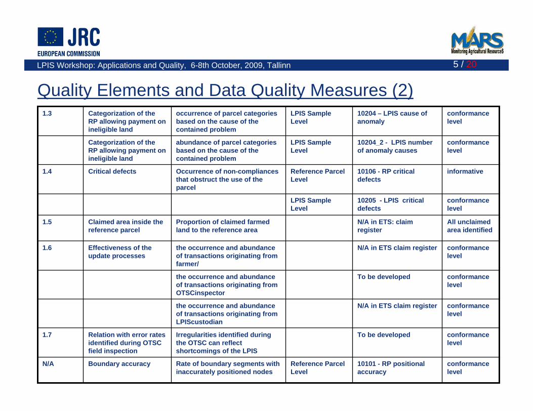
conformance level
10101 - RP positional accuracy
Reference Parcel Level
Rate of boundary segments with inaccurately positioned nodes
Boundary accuracyN/A
conformance level
To be developedIrregularities identified during the OTSC can reflect shortcomings of the LPIS
Relation with error rates identified during OTSC field inspection
1.7
conformance level
N/A in ETS claim registerthe occurrence and abundance of transactions originating from LPIScustodian
conformance level
To be developedthe occurrence and abundance of transactions originating from OTSCinspector
conformance level
N/A in ETS claim registerthe occurrence and abundance of transactions originating from farmer/
Effectiveness of the update processes
1.6
All unclaimed area identified
N/A in ETS: claim register
Proportion of claimed farmed land to the reference area
Claimed area inside the reference parcel
1.5
conformance level
10205 - LPIS critical defects
LPIS Sample Level
informative10106 - RP critical defects
Reference Parcel Level
Occurrence of non-compliances that obstruct the use of the parcel
Critical defects1.4
conformance level
10204_2 - LPIS number of anomaly causes
LPIS Sample Level
abundance of parcel categories based on the cause of the contained problem
Categorization of the RP allowing payment on ineligible land
conformance level
10204 – LPIS cause of anomaly
LPIS Sample Level
occurrence of parcel categories based on the cause of the contained problem
Categorization of the RP allowing payment on ineligible land
1.3
Quality Elements and Data Quality Measures (2)

LPIS Workshop: Applications and Quality, 6-8th October, 2009, Tallinn 6 / 20
Data Flow and Processes in the ETS
Inspect certain number of randomly selected reference parcels on the most recent orthoimagery

LPIS Workshop: Applications and Quality, 6-8th October, 2009, Tallinn 7 / 20
Model Conformance TestConformance Statement (ICS)
Abstract Test Suite (ATS)
Data Conformance TestExecutable Test Suite
(ETS)
Additional Information for Testing
Conformance Test Report
Analysis of results
Application Schema or
Feature Catalogue of the implementation
under test
Model Conformance TestConformance Statement (ICS)
Abstract Test Suite (ATS)
Data Conformance TestExecutable Test Suite
(ETS)
Additional Information for Testing
Conformance Test Report
Analysis of results
Application Schema or
Feature Catalogue of the implementation
under test
•Quality measures and procedures based on ISO
•Most recent orthoimagery as a reference Satellite Imagery collected under the CwRS program
compliant with the JRC VHR specifications for the CwRS
•Inspection based on manual photointerpretation and delineation•Flexible mapping rules
•Identification and quantification of features, based on the difference in land cover
•No link with ATS yet
•No follow-up visits on the field planned
Basic properties of ETS
LPIS Workshop: Applications and Quality, 6-8th October, 2009, Tallinn 8 / 20
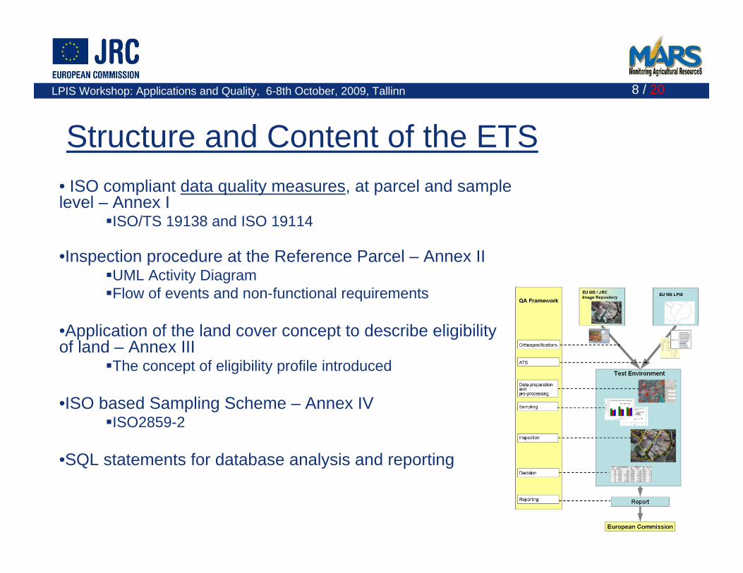
Structure and Content of the ETS• ISO compliant data quality measures, at parcel and sample level – Annex I
ISO/TS 19138 and ISO 19114
•Inspection procedure at the Reference Parcel – Annex IIUML Activity DiagramFlow of events and non-functional requirements
•Application of the land cover concept to describe eligibility of land – Annex III
The concept of eligibility profile introduced
•ISO based Sampling Scheme – Annex IVISO2859-2
•SQL statements for database analysis and reporting

LPIS Workshop: Applications and Quality, 6-8th October, 2009, Tallinn 9 / 20
ETS Sampling scheme•A population of reference parcels defined for each country/region
Isolated lot of reference parcels•A minimum number of reference parcels to be tested
Sample size based on ISO 2859/2-1985 (Procedure A, Limiting Quality = 2%)
•A larger number of reference parcels Sample pre-selection based on clipped reference parcels

LPIS Workshop: Applications and Quality, 6-8th October, 2009, Tallinn 10 / 20
Practical sampling procedure•Reference parcels are represented by points
located inside each parcel•Reference parcels are clipped with CwRS zones
only zones, where VHR data is successfully acquired
1 2503 75080 049764 122
Sample sizePre-selectionClippedLot

LPIS Workshop: Applications and Quality, 6-8th October, 2009, Tallinn 11 / 20
Data Quality Measures - RP true eligible area

LPIS Workshop: Applications and Quality, 6-8th October, 2009, Tallinn 12 / 20
ETS Inspection Procedure• Select the reference parcel from the selection list•Locate the reference parcel•Decide if it can be inspected or not. If yes, proceed with the inspection. If not, select the next one from the ordered list
• Identify and delineate the eligible land cover features on the land represented by the reference parcel. Derive the area.•Identify the eligible landscape features on the land represented by the reference parcel. Derive the area.•Identify the ineligible land cover features on the land represented by the reference parcel. •Identify if the reference parcel has a critical defect, which obstruct its use in the LPIS
LPIS Workshop: Applications and Quality, 6-8th October, 2009, Tallinn 13 / 20
Factors affecting the ETS performance
• Type of reference parcels and structure of the LPIS modelETS more complicated for some types of LPISATS could provide important information for ETS
•Quality of the input orthoimageryPoor image quality will jeopardize the whole ETSAdditional data or processing might be needed
•Operator experience and skillsGood knowledge and experience in land cover mappingSpecial training might be necessary (CAP context, large-
scale mapping)

LPIS Workshop: Applications and Quality, 6-8th October, 2009, Tallinn 14 / 20
•Mapping instruction for landscape features•Decision rules for the land cover features in the range of 0.01 and 0.1 ha?
•To map them or not?
•Link between ATS and ETS: ETS could use information from ATS •Refine Land cover classes, according to FAO LCCS•Elaboration of similar ISO compliant quality measures to assess the orthoimagery•Evaluation of the suitability of the VHR data from CwRS to be used for the ETS•AOB: MMU, visual scale, vectorization, …
Future Challenges

LPIS Workshop: Applications and Quality, 6-8th October, 2009, Tallinn 15 / 20
Continued by Pieter Roggemans

LPIS Workshop: Applications and Quality, 6-8th October, 2009, Tallinn 16 / 20
Status of the ETS pilots
659125026.08.2009MSLPIS 4
80080018.09.2009MSLPIS 3
32780022.09.2009JRCLPIS 2
85080025.08.2009MSLPIS 1
Reference parcels inspected
Minimum number of Reference parcels to check
Date of the pre-selection sample sent from JRC
Work done by
LPIS sample

LPIS Workshop: Applications and Quality, 6-8th October, 2009, Tallinn 17 / 20
ETS-scoreboard (partial and provisional)
2.42021.10.124. Proportion defective RP0.001.389.170.12>50%
0.463.974.590.1220-50%
0.464.155.500.4712-20%
1.523.807.950.128-12%
2.8811.2316.820.474-8%
6.2214.6820.491.292-4%
88.4760.7935.4797.410-2%3. Distribution impure RP8.221.7554.71.65>3%2. Proportion impure RP
101.497.2494.6699.761. LPIS eligible area rateLPIS4LPIS3 LPIS2LPIS1%

LPIS Workshop: Applications and Quality, 6-8th October, 2009, Tallinn 18 / 20
First feedback from the ETS pilots•ETS might require more efforts than expected,
boundary accuracy and landscape elements considered complex measures
•Parcels found to have critical defects, are not necessary erroneous
Additional analysis of these cases in the national context is necessary
•The land cover mapping in that large scale is not a straightforward process
Specific mapping rules needed to be defined, especially for landscape features. National CAP rules should be considered.
• VHR Orthoimagery might not be sufficient source for ETScertain land cover features are problematic to maptime factor needs to be considered when archive data is used

LPIS Workshop: Applications and Quality, 6-8th October, 2009, Tallinn 19 / 20
Conclusions on ETS•Provides lot of objective information on the status of LPIS•Quality indicators defined seems to be meaningful and allows comprehensive analysis•Feasible to be done in relatively short time frame•Applicable in any type of LPIS •Compliant with International Standards (ISO, LCCS, UML)

LPIS Workshop: Applications and Quality, 6-8th October, 2009, Tallinn 20 / 20
Thank you for your attention!