expeditionary warfare decision support system (edss… · expeditionary decision support system...
TRANSCRIPT

Expeditionary Decision Support System (EDSS) and its application to
Information Superiority/Information Operations
Alfred Mitchell SCIENCE APPLICATIONS INTERNATIONAL CORPORATION (C3 ADVANCED INFORMATION TECHNOLOGY GROUP)
4015 HANCOCK STREET SAN DIEGO, CA 92110
PH: (858) 826-5632 FAX: (858) 826-5672
EMAIL: [email protected] OR [email protected]
This paper contains MARKETING INFORMATION ONLY, and contains no Technical Data.

Expeditionary Decision Support System (EDSS) and its application to
Information Superiority/Information Operations
Abstract
The ability to execute true distributed and collaborative planning for amphibious operations, including ship-to-objective maneuver, selected intelligence and meteorological functions, and plan rehearsal is critical in the fast moving littoral/expeditionary warfare area. As part of an ongoing series of newly developed Tactical Decision Aids (TDA) for the Global Command and Control System – Maritime (GCCS-M), the Office of Naval Research has sponsored the development of an expeditionary warfare planning segment for GCCS-M. This TDA incorporates operating features of and shares a common database with the existing GCCS-M Mine Warfare Environmental Decision Aids Library (MEDAL) segment, known officially as MCMSEG, allowing extensive data sharing between mine warfare and amphibious warfare planners. It is currently under experimental fleet use by deploying US Amphibious Ready Groups (ARG) and their staffs. It has been tested during a recent NATO exercise involving multi-national Amphibious Groups. It is currently deployed on a majority of the US amphibious ships involved in Operation Iraqi Freedom. Its employment and operational use are discussed in this paper. 1. The Problem A Task Force/Battle Group/Amphibious Ready Group/Expeditionary Strike Group Commander requires the ability to conduct rapid and reliable collaborative planning with frequently widely dispersed staff elements and forces. The concept of Ship-to-Objective Maneuver (STOM) implies the ability to rapidly plan operations for and move highly mobile combat teams to specific objectives in the most efficient manner consistent with lowest risk. These planning efforts must be robust and dynamically adjustable to changing tactical situations, but requiring a minimum of operator interaction. For example, the Amphibious Task Force Commander must be able to disseminate the Assault Plan to his forces in a timely manner. He also needs to conduct rapid crisis action planning and coordination between elements of the dispersed forces and staffs. This coordination is best accomplished via the exchange of tactical and planning data using existing C4ISR computer systems. While Common Operational Picture (COP) distribution is handled over multiple existing links, the majority of planning coordination is usually conducted via voice radio/telephone, paper charts and/or record message traffic/electronic mail. While this may be adequate when staffs are in port, communicating these plans to forces at sea reverts to message traffic, email and limited voice radio circuits in most cases. Therefore a need existed to provide rapid planning capability using common data exchange formats in a form that allows the fleet to use existing C4ISR display systems and data links. 2. EDSS Background and System Developmental History

The Department of the Navy began a specific effort to focus scientific and technical expertise on specific high-priority high-impact warfare areas in the summer of 1998. This effort came to be known as the “Future Naval Capabilities” (FNC) program managed by the Office of Naval Research (ONR). The FNC program analyzed all areas of naval warfare and, based on their analysis of, and expectation for, warfighting return on investment, selected several key areas for focused investment in science and technology (S&T). This initial analysis led to the identification of several specific “candidate” warfare areas commonly called “spikes”. Mine Countermeasures and Littoral Expeditionary Warfare were selected as FNC “spikes,” having been analyzed as key areas that would greatly benefit from increased emphasis on application S&T investment, as shown in Figure 1. The general term “Organic MCM” refers to the regular deployment of suites of specific MCM systems/capabilities within the architecture of the Navy’s main naval combat groups (Carrier Battle Groups (CVBG), Amphibious Readiness Groups (ARGs), and/or Expeditionary Strike Groups (ESGs)). This “organic” deployment concept drew a great deal of interest during the formative stages of the FNC program and, though the OMCM FNC actually addresses a wide array of MCM war-fighting areas/operations, not just “Organic MCM,” the “OMCM” title remains. In the process of analyzing the MCM warfare area, the OMCM FNC identified the need to improve the management and execution of expeditionary maneuver operations, particularly during the amphibious transition phases of STOM. The OMCM FNC resourced a number of science and technology efforts to address the emerging requirements of STOM.
Organic Mine CountermeasuresLittoral Combat & Power Projection
Autonomous OperationsKnowledge Superiority
Time Critical StrikeWarfighter ProtectionPlatform Protection
Littoral Anti-Submarine WarfareMissile Defense
Capable ManpowerElectric Ships and Combat Vehicles
Total Ownership Cost Reduction
EDSSEDSS
Future Naval Capabilities“Spikes”
Figure 1. ONR Future Naval Capabilities

An Accelerated Amphibious Planning program was established by the OMCM FNC to provide the programmatic vehicle to apply current science and technologies to maneuver warfare and amphibious transition in order to significantly raise the “state-of-the-art” and depart from the legacy of mid-20th century procedures, systems, and equipment. The EDSS program was undertaken by the OMCM FNC in 2001. The vision of a tactical decision aid for Expeditionary Warfare which was integrated with environmental, intelligence, and communications capabilities, across both the Navy and Marine Corps, came from ONR. ONR continues to serve as a coordination agent between Headquarters Marine Corps (HQMC), OPNAV N75, MCCDC, PEO LMW, other sponsors and developers, the GCCS-M and C4I project offices, the EDSS development team, and especially the fleet user community. In addition, ONR, having served as the Joint C4I program manager for the Joint Countermine ACTD and having the leadership role in developing related expeditionary warfare applications, will continue to ensure emerging technology, databases, models, and algorithms can be integrated into a common architecture. The EDSS program is based on integration of systems. First and foremost, the EDSS software suite is fully integrated within the DII COE as embodied in GCCS, in particular, GCCS-M. GCCS-M integration in turn ensures EDSS is capable of full integration with other GCCS-M functional segments. Accordingly, EDSS can exchange information or functionality with GCCS-M core elements such as charting, communications handlers, imagery servers, data bases, servers, etc. Further, this integration allows other GCCS-M segments, such as MCMSEG to exchange information in common formats. EDSS is integrating with various Navy and Marine Corps programs and elements that are key to the execution of expeditionary maneuver. Primary among these is the integration with the Marine Corps ground element command and control/situational awareness tool sets provided through their C2PC application. Long range, EDSS will be capable of integrating with the applicable components of ForceNet, the Expeditionary Sensor Grid, JTF WARNET and other elements of the Global Information Grid. 3. Relevance to Information Superiority/Information Operations The goal of EDSS is to improve the speed of command, both for planning and execution, and thus satisfy this critical element of Ship-to-Objective Maneuver (STOM) in support of Expeditionary Maneuver Warfare. By accelerating the time frame associated with generating, approving, and disseminating a plan, or series of plans, to the assault forces, the commanders can better use movement and concentrated firepower to achieve objectives. Further, by coordinating these plans with other warfare areas, most notably mine warfare, fire support, and logistics, the commander can achieve rapid, seamless transitions from the ship to the objective. These elements combined together support the principal elements of Joint Vision 2010/2020 concepts. The Joint Vision 2010 (JV2010) concept was the first iteration of the military applying new concepts to warfare in the 21st Century. One of the pillars of JV2010 was

Information Superiority. Joint Vision 2020 (JV2020) is a further refinement of the concepts first delineated in JV2010, shown in Figure 2. The principal thrust of JV2020 is “Full Spectrum Dominance”. JV2020 and Joint Pub 1-02 (JP 1-02) further define the principal components of Information Superiority as follows: Information environment – the aggregate of individuals, organizations, and systems that collect, process, or disseminate information, including the information itself. (JP1-02). Information superiority – the capability to collect, process, and disseminate an uninterrupted flow of information while exploiting or denying an adversary’s ability to do the same. (JP1-02) “The evolution of information technology will increasingly permit us to integrate the traditional forms of information operations with sophisticated all-source intelligence, surveillance, and reconnaissance in a fully synchronized information campaign. The development of a concept labeled the global information grid will provide the network-centric environment required to achieve this goal. The grid will be the globally interconnected, end-to-end set of information capabilities, associated processes, and people to manage and provide information on demand to warfighters, policy makers, and support personnel.”
Info
rmat
ion
Sup
erio
rity
Info
rmat
ion
Sup
erio
rity
JO TNI
S TA FFCHIE FS OF
0
-JV2020
Joint Vision 202
Focused Logistics
Precision Engagement
Dominant Maneuver
Full Dimensional Protection
Inno
vati
on FullSpectrum
Dominance
Focused Logistics
Precision Engagement
Dominant Maneuver
Full Dimensional Protection
Inno
vati
on FullSpectrum
Dominance
Figure 2. Joint Vision 2020

The Expeditionary Decision Support System (EDSS) is designed as a core Tactical Decision Aid (TDA) supporting three of the principal components of JV2010/2020’s pathway to Full Spectrum Dominance. These are: Dominant Maneuver: EDSS supports the Commander, Amphibious Task Force (CATF), the Commander, Landing Force (CLF), and other supporting commands in the collaborative planning and execution of all phases of Expeditionary Warfare ranging from traditional large scale amphibious assaults to rubber boat raids by USMC Force Reconnaissance and Special Warfare teams. Precision Engagement: EDSS supports various amphibious missions, including Ship-to-Shore movement for air, surface, breaching, and land forces. It enhances the ability of the assault planners to rapidly adjust plans for precise STOM objectives. Focused Logistics: EDSS provides the templates and databases required by the mission planner to develop the Landing Plan. EDSS is designed to be a complementary TDA to existing and planned stand alone systems including the USMC Computer Aided Embarkation Management System (CAEMS), Integrated Computerized Deployment System (ICODES), MAGTF Deployment Support System (MDSS) and other logistics systems. This data is easily imported and stored in the mission database where it may be easily modified to support “what if planning” and/or re-planning. At the start of the EDSS project, amphibious planning tools were basically the same tools as used during the last century. To plan a major amphibious operation or a smaller MEU operation, amphibious planners still rely mainly on paper charts and voice/record communications. The ability to precisely and accurately pick the exact points, such as a 4W grid or beach center, is often fraught with inadequate tools – paper charts that are of the wrong scale, pencils with various thickness of lead, compasses and dividers that move, human errors in copying down the information, etc. There is no single chart or map that fits both the needs of the Marine Corps or of the Navy. Each has unique requirements that cannot be easily combined in the same paper format. Using the existing GCCS-M Joint Mapping Took Kit (JMTK) EDSS can display a variety of current maps and chart formats as overlays. Raster charts refer to ARC Digitized Raster Graphic (ADRG) or Compressed ADRG (CADRG) chart files normally available via web download or compact disks provided by the National Imagery and Mapping Agency (NIMA). CADRG/ADRG files are digital raster representations of existing paper graphic products. Maps and charts are converted into digital data by raster scanning and transforming the data. These are standard products used by GCCS-M workstation operators, but are very desirable for an expeditionary maneuver operation. A wider range of charts may be required to support expeditionary warfare operations than is normally available/carried throughout the fleet. The ability to download current map and chart files, along with selected imagery files provide critical visualization tools to the expeditionary planner.

Assault planning requires a lot of tedious work: plotting the points, and then checking, rechecking, verifying the points. Messages must be written and then transmitted. Each ship and staff element must then plot the same information. Not only is this manpower intensive, but also each ship may have a slightly different layout on the chart based on how the data is plotted. Much time is spent correcting, rechecking, and re-plotting. This also makes collaborative planning time consuming as it forces sequential planning by each staff entity. To build an assault timeline, hours are spent in mundane calculations. When one assumption or one event is changed, this frequently results in numerous changes as the effects ripple throughout the plan. As a result changes to the plan must be carefully considered before being approved. This results in often significant time delays while these changes are calculated. There is no easy way to transmit updates to plans. The confirmation briefing is currently done in pieces (i.e., weather, ship to AOA movement, supporting forces, surface assault, air assault, logistics, land movement, fire support, etc.). In reality, these items overlap in time and space, but there is currently no easy technique to visualize, foresee, and/or fix possible inconsistencies and conflicts. During the assault, there are few tools to monitor the progress of the assault and compare it to the plan. Near-real time tactical displays are good at showing the “present” but lack the ability to show the “future”. EDSS provides the ability to rapidly show the commander the difference in objective timelines so he will be able to redirect resources as required. He may decide to dedicate more resources to a specific area, or he may want to change the assault and go around the obstacle. Having the ability to accomplish those functions within the confines of existing tactical display systems enhances the considerable investment in operator training while guaranteeing that the information will be displayed at the critical decision points. A sample screen from an EDSS display annotated with information describing the various functions is shown in Figure 3.
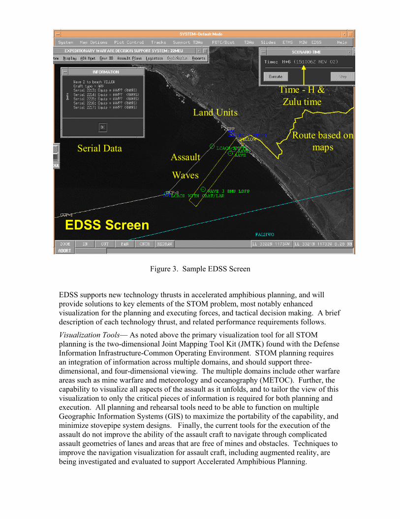
EDSS Screen
Time - H & Zulu time
Serial Data
Land Units
Route based onmaps
Assault
Waves
Figure 3. Sample EDSS Screen
EDSS supports new technology thrusts in accelerated amphibious planning, and will provide solutions to key elements of the STOM problem, most notably enhanced visualization for the planning and executing forces, and tactical decision making. A brief description of each technology thrust, and related performance requirements follows.
Visualization Tools— As noted above the primary visualization tool for all STOM planning is the two-dimensional Joint Mapping Tool Kit (JMTK) found with the Defense Information Infrastructure-Common Operating Environment. STOM planning requires an integration of information across multiple domains, and should support three-dimensional, and four-dimensional viewing. The multiple domains include other warfare areas such as mine warfare and meteorology and oceanography (METOC). Further, the capability to visualize all aspects of the assault as it unfolds, and to tailor the view of this visualization to only the critical pieces of information is required for both planning and execution. All planning and rehearsal tools need to be able to function on multiple Geographic Information Systems (GIS) to maximize the portability of the capability, and minimize stovepipe system designs. Finally, the current tools for the execution of the assault do not improve the ability of the assault craft to navigate through complicated assault geometries of lanes and areas that are free of mines and obstacles. Techniques to improve the navigation visualization for assault craft, including augmented reality, are being investigated and evaluated to support Accelerated Amphibious Planning.

Significant strides in this augmented reality concept were demonstrated in January 2003 during the COMTHIRDFLT sponsored exercise Transparent Hunter 03. Tactical Decision Aids – An amphibious plan must adhere to doctrine but should also exploit the Navy and Marine Corps experience base. Case-based reasoning can be used to capture and share this knowledge, which can potentially reduce the time required to generate a plan while perhaps increasing plan quality. Fully automated plan generation is neither feasible nor desirable because operators wish to observe and control plan generation. Interactive aids to decision making that include the characteristics of being doctrine driven will enhance current operations experience. This functionality is part of the overall EDSS development cycle. To this end, EDSS algorithms produce an optimal Ship-to-Shore assault plan that automatically deconflicts ship and craft movement to produce optimal routes for the ships and assault craft. These routes will take into account the no-transit zones around ships and around possible threat mines or threat weapons, as determined by the operator.
The totality of the improvements offered by EDSS significantly enhance the ability of Expeditionary Warfare planners to design and coordinate their assault plan while reducing the time required to generate or modify plans. This allows such planning to proceed well within the time cycle of potential enemy responses to plans as they are executed. When combined these factors provide the major contributions of EDSS to Information Superiority in the Expeditionary Warfare mission area. 4. Links to Mine Warfare Tactical Decision Aid EDSS is software that runs as a fully DII COE compliant segment in the Global Command and Control System – Maritime (GCCS-M) environment on the Navy's Standard shipboard computer workstations. EDSS displays its geographic overlays on the GCCS-M chart to provide a common operational picture to the commanders. As such the EDSS software suite utilizes existing shipboard C4ISR systems, including hardware, software and communications links. EDSS shares supporting databases with MEDAL. Like MEDAL, EDSS is delivered to the user in a basic software load with little supporting data. EDSS and MEDAL function much like commercial database applications. Commercial products do not generally contain pre-built documents or data; rather they provide sophisticated tools for importing, analyzing, formatting, and displaying the data provided to them by the user. EDSS functions in a similar fashion. Data from master databases is required. Currently, the primary database required to effectively use EDSS is the environmental database, which includes water depths, water currents, etc. The environmental data can be requested from the Naval Oceanographic Office (NAVOCEANO). It can be obtained directly from existing databases, or can be developed as a special product. The data is available on tape or via FTP. EDSS allows the mission planner to graphically enter Assault Area Diagrams consisting of Sea Echelon Areas, Boat Lanes, Lines of Departure (LOD), etc. Supporting areas such as naval fire support areas may be entered to present a graphical display of the amphibious area of operations and to aid in the deconfliction of joint or combined

operations. Each type of area/lane may be individually enabled or disabled for display to the operator. The diagrams may be saved as an overlay and transmitted over the existing communications network to support other documents such as the OPTASK AMPHIB. The resulting areas can be electronically shared with MEDAL, and disseminated to all ships via standard OTH-G message. EDSS uses the Landing Plan data, the Assault Area Diagram data and the environmental data to conduct assault wave timing analysis. The exercise can be visually rehearsed using several graphical and timing tools. Based on these outputs, the planners may collaboratively de-conflict and optimize the Assault Wave schedule. During the execution of the assault, the events may be monitored at the EDSS workstation by CATF, CLF and the Primary Control Ship (PCS) to allow for instant redirection of assets and the data used for post mission analysis. Planning templates include the Helicopter Employment and Assault Landing Table, Assault Schedule, Landing Sequence Table, etc. EDSS provides a checklist of events including event name, start time, end time and codeword. This checklist may be viewed in a tabular or graphical format. In the graphical view, the checklist may be modified by "click and drag" procedures using the workstation mouse. The integration of data from multiple sources to support collaborative and accurate TDA development is the core of EDSS. Sources of data and models include remote METOC servers and fused data (like that found in MEDAL), surf and tides models, craft performance models, deck management models and others. Integration is already underway with collaborative planning tools, like CAS and white boarding tools. The ability of EDSS to share data from these databases in commonly used formats ensures that the flow of information between these systems is literally only a “mouse click” away. 5. Results of Current EDSS Deployment Deployment of EDSS to operational forces for test and evaluation began in early 2002. Selected amphibious ready groups were nominated by fleet commanders and provided with a suite of GCCS-M computers pre-loaded with EDSS software. These computers were all operated in a “stand alone” (i.e., not connected to a secure network) mode by operational staffs. Simultaneously the Space and Naval Warfare Command certification process for new software segments was begun resulting in full “Preferred Products List” certification for EDSS on 18 December 2002. By the time of this certification, which would allow ships/staffs the ability to connect EDSS systems to the secure network, multiple Amphibious Ready Groups were outfitted with the system. Early feedback on EDSS performance was coupled with suggested improvements resulting in several incremental builds leading to the current fleet release, version 1.1.0.7. This version was selected for deployment on both ATF East and ATF West, the principal amphibious formations involved in supporting Operation Iraqi Freedom.

In conjunction with these operational deployments, EDSS was used in a major COMTHIRDFLT exercise named Transparent Thunder 03 in January 2003. This exercise showed new uses of the EDSS-MEDAL interface and further refined the ability of an amphibious force commander to exchange data with the mine warfare commander. This exercise was also notable for its introduction of new methods to provide “augmented reality” to assault craft via distribution of EDSS and MEDAL assault lane geometry to new display technologies. Figure 4 shows a general plan for EDSS development. Fleet amphibious forces are already using Build 1. Build 2 is designed around the new GCCS-M version 4.X and will be released later in 2003 when version 4.X begins fleet introduction. Other builds include incremental improvements such as integration with many other expeditionary warfare systems and improvements suggested by operating forces.
Major DemonstrationsTransparentHunter 03
MEFEX 04
EDSSBuild Delivery Build 2
FY03Q1 Q2 Q3 Q4
FY04Q1 Q2 Q3 Q4
FY05Q1 Q2 Q3 Q4
FY06Q1 Q2 Q3 Q4
FY07Q1 Q2
KernelBlitz 05
MEFEX 06 KernelBlitz 05
Build 3 Build 4
Intelligent Agents
Active Templates
Domain Interpretation Rules
Software Technologies
Interface Development
Technology Development
Build 5
Build 2Target
Build 3Target
Build 4Target
Build 5Target
EDSSRequirements, Technology,& Interface Development
Requirements Development
Project Support
Build 1
Figure 4. EDSS Development Plan Lastly, EDSS was evaluated in a NATO environment in October 2002 during Exercise Destined Glory 02. This major NATO amphibious training exercise took place in and around Italian operational areas and involved two major amphibious groups. One group, led by the combined UK/Netherlands Amphibious Task Group staff (COMATG) was composed of a combined UK, Netherlands and Greek force. The French ALFAN staff featuring a combined French, Spanish and Turkish force led the second group. Both amphibious task group staffs were equipped with EDSS and used it extensively to coordinate not only Destined Glory planning but also plans for follow-on events. All communications were conducted over the NATO secure WAN. In addition the overall

combined CATF (COMPHIBGRU TWO) embarked in HMS Ark Royal also used EDSS to review and approve the plans. 6. Summary EDSS is a new GCCS-M Tactical Decision Aid that is rapidly gaining wide acceptance as a valuable planning tool for Expeditionary Warfare planning and execution. Current widespread operational and exercise use is validating its potential. With close integration into the existing DII/COE C4ISR architecture and shared use of the mine warfare MEDAL database, EDSS provides significant synergy in joint and combined expeditionary operations not possible in prior years. EDSS is a valuable and proven tool for providing Information Superiority in today’s rapidly changing Information Operations environment.