expert witness statement - amazon web services
TRANSCRIPT

Expert Witness Statement
West Gate Tunnel Project
Peer Review of West Gate Tunnel Project Environment Effects Statement, Landscape and Visual Assessment –
Report, May 2017 by Urbis and Development and Urban Design Plans.
Client Maribyrnong City Council
Date 2 August 2017
Author Kirsten Bauer, Director, ASPECT Studios

2
Expert Witness Statement, Kirsten Bauer 20170802
Contents
Background and Brief 3
Limits and Assumptions of the Independent and Peer Review 5
Summary of Key Points 6
Part A: Landscape and Visual Impact Assessment 7
Overview of Landscape and Visual Impact Assessment Methodology 7
Part B: West Gate Project – Sites and Areas of Impact 11
1. Maribyrnong River Crossing and Environs 11
2. Yarraville Gardens and Hanmer Reserve 34
3. Whitehall Street Pedestrian Bridge and Shared Path Project Alignment 39
4. Stony Creek Reserve / Hyde Street 40
5. McIvor Reserve 47
6. Other Areas 49
Part C: Overview of the Urban Design Concept 51

3
Expert Witness Statement, Kirsten Bauer 20170802
Background and Brief
I have been engaged to prepare an expert witness statement of the final Environmental Effects Statement
(EES), Landscape and Visual Impact Assessment (LVIA) technical report and the Urban Design Concept (UDC)
by Maribyrnong City Council.
This expert witness statement is from an urban design/landscape architecture perspective, and is in three
parts.
Part A: Landscape and Visual Impact Assessment ‐ Comments on the EES LVIA methodology
Part B: West Gate Project – Sites and Areas of Impact ‐ Comments on sites and places of impact with respect to
the LVIA and the UDC.
Part C: Overview of the Urban Design Concept ‐ Comments on urban design concept.
Part A, is effectively a peer review of the (LVIA) considers whether:
the investigation or research is clear and appropriate.
the work is well organised in the manner in which it presents its findings.
the work draws and builds on appropriate, recent methodology.
the arguments presented are cogent and coherent.
the assessment is accurate and appropriate.
Part B includes some comments on certain areas. It assesses the proposal in terms of its impacts on the
current, planned and strategic objectives of the City of Maribyrnong, and examine issues such as access,
connectivity, qualities of public realm, built form, topography and land use patterns. Key areas of impact
include:
1. Maribyrnong River Crossing and Environs
2. Yarraville Gardens and Hanmer Reserve
3. Whitehall Street Pedestrian Bridge and Shared Path Alignment
4. Stony Creek / Hyde Street Reserve
5. McIvor Reserve
6. Other Areas
7. Tunnels Section
Part C is a review of the UDC and considers issues such as:
usability of the public realm and open spaces.
overshadowing.
landscape and visual impacts.
impact on pedestrian and bicycle trails.
impact on the achievement of the Maribyrnong River Edge Master Plan Implications for the
Maribyrnong Open Space Strategy.
identifying potential improvements/solutions.

4
Expert Witness Statement, Kirsten Bauer 20170802
I undertook the review in late 2016 and mid‐2017. I am a current Corporate Member of the Australian Institute
of Landscape Architects, with a tertiary qualification in Landscape Architecture. I am a current member of the
Design Review Panel for the Office of Victorian Government Architect.
I have undertaken many infrastructure projects in Victoria and South Australia requiring the assessment of
likely landscape and visual impacts. Environmental Effects Statements and reports to VCAT (Victorian Civil and
Administrative Tribunal) have been undertaken for projects including:
preparation of the Geelong Bypass Sections 1, 2, 3 and 4a Visual Impact Assessment, VicRoads,
including witness statements and attendance at the Geelong Bypass Section 3 panel hearing.
preparation of the Calder Freeway Visual Impact Assessment, VicRoads, including witness statements
and attendance at the Calder Freeway, Harcourt section, panel hearing.
preparation of the City to Airport Rail link landscape visual impact study and attendance at the Airport
Rail link panel hearing.
assistance with the preparation of the landscape and visual assessment report and witness statement
for the Barwon Heads Bridge Panel hearing.
assistance with the preparation of the Dollar Wind Farms Peer Review report.
assistance with the preparation of the Ryans Corner Wind Farms Peer Review report.
assistance with the visual impact assessment and resubmission of this assessment for Barn Hill Wind
Farm.
peer review of the Environment Protection and Heritage Council Draft National Wind Farm
Development Guidelines (landscape section) 2010 for Plansiphere and Hydro Tasmania.
assistance in the preparation of the peer review and witness statement for the Winchelsea Wind Farm
(VCAT Reference No. P2395/2008 and P2654/2008).
presentation of VCAT witness statement for visual impact assessment of proposed dwelling in North
Fitzroy, 2010.
presentation of Witness Statement for Expert of Future Energy Pty Ltd on the Chepstowe Wind Farm
(VCAT Reference No. 3249/2010).
presentation of Witness Statement for Future Energy Pty Ltd on the Chepstowe Wind Farm (VCAT
Reference No. 3249/2010).
peer review of the Lal Lal Wind Farm Review of Lal Lal Wind Farm Landscape and Visual Assessment
Report, 2015.
landscape architect in the design and delivery of Regional rail packages E and F (Vic).
landscape architect in the urban design and assessment of the Heatherton Road level crossing removal
project (Vic).
landscape architect in the design and delivery of the Caulfield to Dandenong Level Crossing Removal
Project (Vic).
Member of the Ministerial Advisory Committee to the State Government on the Protection of the
Yarra.

5
Expert Witness Statement, Kirsten Bauer 20170802
Limits and Assumptions of the Independent and Peer Review
The peer review in Part A is limited to a desktop review of the reports, site visits and professional knowledge
of the current best practice methodologies for infrastructure assessment in Australia. This peer review notes
that:
limited information is available with respect to the Development Design.
no discussions were undertaken with Urbis (LVIA) or the designers.
no new photomontages were undertaken to check the technical accuracy of LVIA photomontages.

6
Expert Witness Statement, Kirsten Bauer 20170802
Summary of Key Points
Landscape and Visual Impact Assessment Report
The relevant EES evaluation objective for the LVIA is "to minimise the adverse effects on the landscape, visual
amenity and recreational and open spaces values and to maximise the enhancement of these values where
opportunities exist". The LVIA fails to meet this objective in five principle ways. The LVIA:
1) Lacks clear correlation between its findings and how well the project meets the EES Evaluation objectives.
There is no clear summary or statement which adequately addresses "how" the urban design concept and
engineering design either minimises adverse effects or enhances values.
2) Focuses on impact assessment but provides neither comment nor options regarding the means for reducing
the impact.
3) Does not consider the potential for changes to the engineering form or urban design concept to ameliorate
effects.
4) Omits assessment of overshadowing.
5) Does not adequately identify the value of the Maribyrnong River environs or address the significant impacts
of the design on the Maribyrnong River.
Urban Design Concept
The current form of the Maribyrnong River crossing design is inadequate for the significance of the site and
does not provide for quality open space outcomes. The design will significantly constrain the planned future
opportunities for public use and enjoyment of the river and the river open spaces. In particular, this affects the
spaces identified by the Footscray River Edge Master Plan, produced by the City of Maribyrnong.
In particular, the Maribyrnong River ramps generate significant detrimental impacts on the river, its use,
adjacent river bank public realm and overall precinct character and amenity.
The urban design concept lacks a coherent urban design strategy, which would outline a clear correlation
between areas of identified sensitivity and the means by which the design would reduce or minimise impact on
those areas.
The urban design concept lacks detail and contains numerous ambiguities between the various modes of
representation it employs including plans, sections and images.

7
Expert Witness Statement, Kirsten Bauer 20170802
Part A: Landscape and Visual Impact Assessment
Overview of Landscape and Visual Impact Assessment Methodology
Base Methodology
The overall base methodology used in the Urbis report meets the general standards undertaken in many
Australian government agencies and professional landscape and visual impact studies undertaken in Australia
and overseas.
However there are some significant departures and inadequacies in the methodology and its application in the
assessment of impacts.
The methodology utilised by Urbis is one typically used for the assessment of infrastructure in more rural or
more peripheral urban locations and is insufficient for assessing infrastructure in fully urban areas. It is of a
concern that the base methodology has not been more specifically modified to suit the highly urbanised
environment of the project. There are a number of shortcomings of the Urbis report in this regard and it
should have for example considered the below issues in more detail as part of its assessment:
the current, planned and strategic objectives of local government and government agencies
identify immediate and future impacts on the open space and public realm strategic objectives of
locations,
not use the narrow notion of “conventional” landscape values that are used in the Urbis report, but
rather, take into account more fully urban landscape values, such as those in regards to future
potential landscape values and urban amenity values. For example issues such as access, connectivity,
qualities of public realm, built form, topography and land use patterns as part of the understanding of
landscape and visual values, which the report does not do adequately.
Overall there is a major emphasise in the report on explaining the technical methodology rather than bringing
together the different qualitative and quantitative visual and landscape impact ratings into a cohesive and
readable impact assessment statement that adequately address the EES objective.
EES Objective
The LVIA report does not adequately summarise how well the project meets the EES objectives and the means
by which it minimises adverse impacts. Given that the scoping requirements for the EES, established by the
Minister for Planning, specify the evaluation objectives and provide the context for the technical studies
informing the EES, this is a substantial oversight. The relevant evaluation objective for the LVIA is “To minimise
adverse effects on landscape, visual amenity and recreational and open space values and to maximise the
enhancement of these values where opportunities exist”. A critical component of the methodology used should
result in clearly determining whether or not, and the extent to which, a correlation exists between the findings
and how well the project meets the EES Evaluation objectives. This is lacking in the report.
The following statement from the Executive Conclusion (9.6 Relevant EES Evaluation Objectives) illustrates a
number of the flaws of the LVIA:

8
Expert Witness Statement, Kirsten Bauer 20170802
“Although the project results in several moderate or high residual adverse visual impact ratings, it is
recognised that the project lies within a townscape defined by built urban environment with hard and
soft open spaces within it. The surrounding high visual sensitive uses are already influenced by road or
urban infrastructure such as port, industrial or rail settings and can absorb the changes proposed by
the project. Where possible, the project has implemented mitigation measures to manage the impacts.
Accordingly, it is concluded that the relevant LVIA EES evaluation objective has been adequately
addressed.”
The problems that the above quote illustrates are that:
No detailed explanation is given within the LVIA as to how the landscape “can absorb the changes”. The
mitigation measures that are proposed are generally limited to vegetation planting and community
management, not design or infrastructure form, which is an unsophisticated approach not in keeping
with any form of best practice for such a significant project.
The LVIA provides a limited and unsophisticated description of the inner western suburbs and the
complexity of the urban environment that the proposal encompasses.
LVIA and the Urban Design Concept
The LVIA makes a significant departure from standard practice when it states it will not include an evaluation of
the merit of the urban design (page 21 LVIA). Specifically, it states that
"it is recognised that the opinions of the urban design outcomes would vary between individuals and
because the likely response to the urban design outcome is not known an assumption has been made
that the changes are adverse. The assessment is therefore conservative".
Assumptions such as perceived or attributed subjectivity, and unknown community response, are not valid
reasons for failing to address the impact of the urban design. The actual design of the infrastructure, including
its height, form, colour, and materials is pivotal in assessing visual impacts on the altered landscape and the
ability of the landscape to absorb these changes. The thrust of the Landscape and Visual assessment report
should be to assess the impact of the urban design on the landscape and visual character of the surrounds in an
evidence‐based manner and not revert to an improperly justified “conservative” position explicitly based on
assumption.
For example, does the LVIA think that the white coloured noise walls facing the community and residents
minimise the impact?
Furthermore, the Urban Design report is itself very limited in detail on how the design reduces the impact on
the landscape and visual values. For example, the urban design report states that the off ramps over the
Maribyrnong River will be clad in charcoal coloured facade system so that they would be more recessive in the
landscape (page 6 ‐18 Urban Design). However this is not substantiated with any evidence and the LVIA does
not comment on the extant of this recessive outcome.
The LVIAs failure to address urban design issues means that important LVIA statements remain untested. For
example, I note the following (from Volume 1: West gate Tunnel project EES Main Report, section 9.3.5):
“While the visual impacts of major new transport infrastructure cannot be avoided completely, the
urban design concept for the West Gate Tunnel Project sets out an integrated approach to
architectural, landscape and infrastructure design across the project. The concept seeks to incorporate

9
Expert Witness Statement, Kirsten Bauer 20170802
a high degree of visual compatibility with the existing built form and aims to create attractive
structures that integrate with their settings. Large scale structures are intended to be attractive, iconic
features that reference Indigenous elements and regional themes.”
Mitigation Options to Reduce Impact
The LVIA departs from standard practice in other areas as well. Conventionally, a LVIA would comment on
known base engineered form and materials, and would recommend physical mitigation measures to reduce
impacts, for instance changes in noise barriers, tree planting, colours used, height of elements and so forth.
The LVIA fails to state clearly what types of landscape and visual mitigation measures should occur to reduce
the specific visual and landscape impacts of the proposal. It suggests instead that the main mitigation
measures will be determined through the Environmental Performance Requirements process, such as
community engagement. At this point in an EES process it is standard practice for actual design options to
reduce landscape and visual impacts to be proposed. But, none are.
For example, when assessing a wind farm the LVIA typically undertakes a colour assessment to determine
which colour minimises the overall visual impact of the turbines on the landscape, and would recommend
where tree planting should occur (even on non‐project land) to further reduce this impact. The onus is on the
LVIA to provide an assessment of the impact based on what the final environment looks like just as much as
what is being placed within it ( in this case wind turbines). This is even more important when dealing with a
major infrastructure development in the urban environment.
The mitigation measures that are proposed in the LVIA are predominantly limited to vegetation planting and
community management, not design or infrastructure form, and show an unsophisticated approach not in
keeping with best practice for such a significant project. High dependence on tree planting within the project to
mitigate impacts is poor practice at this stage because tree planting within infrastructure corridors is highly
speculative without further Reference Design detail to confirm this opportunity and the extent of the
opportunity.
Executive Summary
The Executive Summary fails to adequately communicate a range of information that in standard practice is
regarded as important in the decision making process.
The Executive Summary does not identify in summary form how well the project meets the EES objectives and
the means by which it minimises adverse impacts.
The Executive Summary provides insufficient detail when it states that “The West Gate Tunnel Project has the
potential [my emphasis] to impact visual elements during construction and operation. During construction,
there would be vegetation removal and establishment of construction compounds outside of the freeway
reserve.” The EES should identify which impacts will actually occur and those which might occur, not simply
suggest these are all just “potential” impacts. There is no whole‐of‐landscape assessment in the Executive
Summary, as would be expected. Instead, the Executive Summary limits itself to a few specific impacts only.
The Executive Summary heading “Existing Conditions” is highly misleading. This heading should be “Impact
Assessment Summary”.
No descriptive cross‐referencing is provided in the Executive Conclusion between the impact assessment and
this conclusion. This is inappropriate.

10
Expert Witness Statement, Kirsten Bauer 20170802
Overshadowing
It is remarkable that the LVIA does not include overshadowing as part of its assessment. Overshadowing has a
major impact on landscape amenity, character and usage. It is a widely accepted principle that its impact
cannot be dismissed or ignored.
Spatial Summary
The LVIA omits a spatial mapping summary of identified specific impact issues and locations. The inclusion of
such a standard report element would improve the communication of the report’s findings. Its omission also
hampers efforts to assess the design and its impacts.
Photomontages
The photomontages provided are insufficient in number, often taken from poorly selected vantage points, and
many are overtly misleading of the general views and experience of the location. For example the Yarraville
Gardens photomontage angle is such that it cuts out half of the northern portal and location chosen is not
representative of the character or main views from the park. This is addressed in more detail in Part B of this
report.
Noise Walls
Noise walls are inadequately assessed. The LVIA only assesses them using a selective and therefore unbalanced
viewpoint analysis. A statement concerning their length, height and overshadowing (in comparison to the
existing walls) and their general impact on adjacent areas would be beneficial in understanding the overall
impacts of the proposal on the landscape and the residential community.
Whole of Route Assessment Visual Impact Results (Appendix D)
The Whole of Route Assessment, is typically a standard tool in the assessment of long and complex
infrastructure (ie roads and rail) is relegated to an appendix, which is inappropriate. Also, it contains no overall
impact assessment summary, as would occur in standard practice. Most importantly, it fails to show how the
whole of route assessment is integrated with each detailed assessment of each project section.

11
Expert Witness Statement, Kirsten Bauer 20170802
Part B: West Gate Project – Sites and Areas of Impact
It is essential to assess the proposal in terms of its impacts on the current, planned and strategic objectives of
the City of Maribyrnong, and examine issues such as access, connectivity, qualities of public realm, built form,
topography and land use patterns. Key areas of impact include:
Maribyrnong River Crossing and Environs
Yarraville Gardens and Hanmer Reserve
Whitehall Street Pedestrian Bridge and Shared Path Alignment
Stony Creek / Hyde Street Reserve
McIvor Reserve
Other Areas
Tunnels Section
1. Maribyrnong River Crossing and Environs
1 a. Urban Context of the River Crossing
Urban Design Ambition of the Maribyrnong River Corridor
The route type and Project Alignment of the Westgate Tunnel project have not given adequate consideration
to the current values and future visions for the Maribyrnong River corridor, including the river waterway, banks
and adjacent land uses and urban development.
The river is of citywide and state value, particularly for the community of western Melbourne. As a significant
part of Melbourne’s aboriginal and post‐colonial history and culture, today it is critical to the liveability of the
inner western suburbs, part of the broader green regional infrastructure, an important tourist and recreation
asset and a place loved by many. Accordingly, it requires a high quality, appropriately iconic bridge form and a
respectful expression that matches its significance.
The Maribyrnong River area itself is transitioning from an industrial to a residential, business and mixed use
and public realm precinct sitting within the West Gate Bridge project. The impact of the bridge and its off and
on ramps on future north‐south movement and on the river is significant. While the land to the south is
predominately Port of Melbourne land the decision to encumber the riverbank land with such major long term
infrastructure, reducing opportunities for long‐term city‐making opportunities shows extreme lack of foresight.
The impact on the Billy Button Creek and path on Lyons Street (which also forms part of the Maribyrnong River
to Bay Trail proposed connection) is not discussed in either the LVIA or Urban Design report.
The Maribyrnong River and its corridor landscape is clearly identified as a place of special significance in key
reports:
The Maribyrnong River Valley Design Guidelines 2010 describes it as “one of Melbourne’s most treasured and well‐used waterways. Thousands of Melburnians spend time on or near the river every day”. The Guidelines’ river vision is of “[a] healthy river flowing through a continuous network of open spaces and cultural landscapes that reflect its journey from a natural river to a working river. A river that provides a range of recreation experiences that value local landform and landscape character, and
12
Expert Witness Statement, Kirsten Bauer 20170802
preserve cultural heritage, including significant plantings. A river that supports indigenous vegetation and fauna.”
The City of Maribyrnong Open Space Strategy emphasises that the significance of the river includes “the linked open space system along the waterway ... the most popular open space for residents in the city, with opportunities for improving its accessibility, connectivity and biodiversity values in the future as the city grows".
The open spaces along the river are is given as of regional hierarchy by the City of Maribyrnong Open Space Strategy.
Grimes Reserve, which forms part of the open space along the river, is on the Victorian Heritage Register.
The values and level of significance ascribed to the river in the LVIA report are not reflective of its state and
regional significance as noted in the above points. The LVIA is very limited in its identification of areas of
landscape significance and sensitivity. It limits these areas to the shared pathway along the river and the
narrow banks, but does not include the broader public open spaces, river users and the broader landscape
character of the river, including adjoining streets and public users. There is little identification and assessment
of the impact on the landscape character of Maribyrnong Street and the future Council ambition for the
Maribyrnong Street area as identified in the Footscray River Edge Master Plan (City of Maribyrnong). In general,
no description of overall landscape character and value of the river is provided.
The daily business users of the properties of Maribyrnong Street and Parker Street – adjacent to the Project
Alignment – have not been identified as sensitivity users. In consideration of daily use by workers and visitors I
would suggest that the Maribyrnong Street and Parker Street areas be at least provided moderate user
sensitivity.
The recreation users of the Maribyrnong trail are identified as having moderate visual sensitivity, but both the
river and the Moonee Ponds Creek itself and its open space, including their users, are not granted visual
sensitivity. This is a very narrow interpretation of the LVIA brief, certainly not in keeping with the Minister’s
statement noted above.
Some key assessments have been made. For example:
“the visual modification level of the elevated structures is considered high at the crossing of the
Maribyrnong River”.
Furthermore, a high visual sensitivity assessment is applied for Maribyrnong River adjacent users.
Comparison of current Reference Design with the Footscray River Edge Master Plan
Primarily, the current design will have a significant detrimental impact on the area, both now and in the future.
This is demonstrated by Figures 1 & 2 , which maps the key values of the area that need to be rigorously
assessed for impact. Figure 3 & 4 shows the Project Alignment overlaid on the Footscray River Edge Master
Plan. The key objectives of the Master Plan that are relevant to the Project Alignment include:
reconnecting the community to the river.
creating a civic and regional scale riverfront promenade.
increasing and improving public access and use between Footscray Bridge and Billy Button Creek.
improving the ecological health of the Footscray River.

13
Expert Witness Statement, Kirsten Bauer 20170802
1. Figure Key current and future values of the area with former Westgate Tunnel Reference design overlaid (approximate only).

14
Expert Witness Statement, Kirsten Bauer 20170802
2. Figure Key current and future values of the area with former ‐ with Reference Design and Current Alignment (red) overlaid (approximate only). This illustrates the future impacts on open space and amenity in the areas south of the Footscray Bridge.
Design significantly limits
future connections along
river and overall future
opportunities to improve
urban character and
amenity of the area.
Separated and infrastructure
bounded river space and
banks.

15
Expert Witness Statement, Kirsten Bauer 20170802
3. Figure Footscray River Edge Master Plan ‐ with Reference Design overlaid (approximate only). This illustrates the future impacts on open space and amenity in the areas south of the Footscray Road Bridge. Little assessment on the impact of this Plan has been assessed by the LVIA.

16
Expert Witness Statement, Kirsten Bauer 20170802
4. Figure Footscray River Edge Master Plan ‐ with Reference Design and Current Alignment (red) overlaid (approximate only). This illustrates the future impacts on open space and amenity in the areas south of the Footscray Bridge.
17
Expert Witness Statement, Kirsten Bauer 20170802
River Crossing Project Alignment Type and Footprint Scale
The overall base area impacted by the river crossing bridges/ramps is significantly larger in extent than in the
Reference Design.
The Reference Design was approximately 150m in length (as measured in the plan from the most southerly
ramp crossing to the north ramp crossing). The concept design enlarges this to approximately 275m.
Though the environment has infrastructure elements throughout it, the large scale and form of the bridge
system and its off ramps will significantly change the overall area’s character. The current bridge crossing
structures (outside of the West Gate Freeway) are generally smaller in scale than what is proposed and cross
the river at right angles (perpendicularly), as opposed to diagonally.
The proposed bridge structure curves over the river and is a multi‐level structure and is far wider than existing
bridges on the Maribyrnong river.
The proposed bridge form is dissimilar to existing and adjacent bridge types and consequently its impact is
qualitatively different. It can be reasonably described as “out of scale” with the current landscape character of
the river.
Overall, the Project Alignment and design, revised scale and bridge form combine to significantly accentuate
and increase the impacts identified in the Reference Design, by:
reducing the amount of the open and free river corridor environment.
lengthening the physical impact on Maribyrnong Street, its existing and proposed open space and
adjacent properties, from 75m to approximately 200m.
bringing the bridge closer to the Footscray Bridge and thus reducing long views along the river.
significantly increasing undercroft zone areas.
The landing of the on and off ramps on the eastern side significantly reducing the quality of any future
connectivity along the eastern bank for the community, future land use development and for flora and
fauna.
See Figures 5 and 6.

18
Expert Witness Statement, Kirsten Bauer 20170802
5. Figure Comments on Reference Design 2016
6. Figure Current Alignment Design
Design significantly limits
future connections along
river and overall future
opportunities to improve
urban character and
amenity of the area.
Separated and infrastructure
bounded river space and
banks.
Views along existing and
proposed paths & river corridor
should be considered.
Larger crossing footprint.
Approximately 75m x 275m of river

19
Expert Witness Statement, Kirsten Bauer 20170802
Alternative Project Alignments that significantly reduce impacts
Without access to detailed information on the current design it is hard to understand why this Project
Alignment option and type was preferred, as it does not meet the fundamental EES objective namely:
“to minimise adverse effects on landscape, visual amenity and recreational and open space values and
to maximise the enhancement of these values where opportunities exist”.
At the very least an adequate explanation of why this fundamental objective has not been met should have
been included.
There are a number of strategic Project Alignment and design options that can minimise significantly the
impact of the West Gate Tunnel Project on the Maribyrnong River corridor. They include:
Relocate off and on ramps to the east side, to reduce visual bulk and footprint impact on the river.
Realign the bridge to a more perpendicular Project Alignment, to reduce visual bulk and footprint
impact.
Redesign the bridge to allow greater visual transparency and framing of the river.
Relocate the off and on ramps
and relocate.
Bridge to a more perpendicular
alignment.
Extend tunnel underneath River
and relocate interchange to the
east.
7. Figure Alternate project alignments ‐ diagrammatic

20
Expert Witness Statement, Kirsten Bauer 20170802
1b. Design and Landscape and Visual Impact Assessment of Bridge/Ramps
Key Landscape and Visual Impacts of River Crossing Design
The bridge and off ramps over the Maribyrnong River form one of the most significant landscape and visual
impacts of the West Gate Bridge Tunnel project.
The lower bridge elements significantly impact on both views along and usage of the river. Views from the
riverfront north of the Footscray Bridge (Shepherds Bridge) will be impeded by the bridge and ramps, and block
views of the waterway to the south.
It is not made clear whether noise walls are required on the bridge and ramps, and what increased visual
impacts these may have on the adjacent areas.
Approximately 20,000 sq.m. (2 ha.) of the river corridor will be occupied by the broader project extent, which
will extend along approximately 300m on the western bank. On the eastern bank the additional infrastructure
works will occupy a significant amount of the embankment, reducing future public accessibility.
No urban design mitigation measures are proposed by the LVIA to reduce the impact of the bridge and its
associated elements except vegetation plantings and landscape works beneath the structure. As previously
discussed, these types of mitigation measures run a poor second to more sophisticated measures, especially
given the relevant and formally recognised values of the locale.
The river corridor landscape does have the capacity to appropriately absorb a bridge structure. However, the
structure needs to meet a number of design criteria for it to be appropriate for the location. These include:
a moderate to high bridge form that matches similar heights to those upstream.
allowing long downstream views beneath it.
Furthermore, overall, there is a paucity of discussion on public safety and public amenity in the area.
Specific Issues
From the available documents it can be ascertained that the bridge itself is between 7m and 10m above the
river banks and the Maribyrnong River. On page 136 of the LVIA it is stated that the bridge is 17.5m above the
water (it is unclear whether this is the distance between the water and the bridge underside or whether this is
the overall structural depth). The Project Alignment plans do show this height (refer WDA‐WGTP_VAP_0017).
Though, as noted below, with no specific engineering sections of the bridge available it is difficult to measure
off the plans provided.
The off and on ramps are between 4m and 6m above the river banks space and the Maribyrnong River is barely
the minimal height to achieve a quality open space environment for community use. Preferably useful open
space under infrastructure should be at least predominantly 5‐6m in continuous height. Also any space below
3m should be closed off to reduce anti‐social behaviour and improve amenity.
No detailed engineering or urban design plans have been provided for the bridge element and as such it is
difficult to fully assess its impacts.
No discussion is provided of the future boardwalk planned by Maribyrnong City Council as part of the River
Edge Master Plan. This boardwalk will be built out over the river itself, with the intention of improving the

21
Expert Witness Statement, Kirsten Bauer 20170802
views and experience of the river. The views and design as proposed will severely compromise the overall
ambiance and character of this experience.
Bridge Design
The current proposed bridge design (not including the ramps) goes some way to responding to the significance
of the Maribyrnong River precinct, adding somewhat to its current and future quality. However, the overall
form and design of the bridge can be considerably improved.
The bridge design provides an evocative form when viewed from the air and from within the road. However, it
lacks the same level of quality when viewed from the ground plane, from on the water, and from other public
vantage points.
As for the ramp, Figures 8 indicate that the ramp balustrade is quite high and provides a thickening or depth to
the bridges that increases its visual bulk in the river corridor. When looking from Shepherds Bridge the
combination of these completely blocks any views of the river beyond.
It is hard to determine if the height of the balustrade is related to any intention to incorporate noise walls that
mitigate the impacts of noise on the Maribyrnong Street environments and properties or if the balustrade is
just a visual gesture.
Ramp Form
The overall design of keeping it sleek and horizontal is an appropriate urban design response.
The off ramps, however, fundamentally reduce the quality of the main bridge. As a group of bridges they do
not deliver design excellence in their current proposed form.
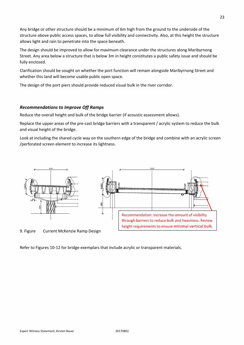
The current information indicates a solid pre‐cast bridge barrier to the outer edges of the off ramps (See Figure
9). These extend higher than the internal barrier. This design creates a significantly “bulky” and inappropriate
presence very close to the river edge, streets and public spaces.
Figures 8 demonstrate that the ramps are as highly visually significant as the main bridge element and
consequently should receive the same level of attention.
The bridge and ramp forms are likely to cause loss of future public realm connectivity along the eastern
foreshore of the river.
Does the project deliver Excellence in Urban Design and Public Realm Design?
The integrated engineering, architecture and landscape architecture of a project of this significance should
meet standards appropriate to excellence in design. The design must relate to all viewers and users of the
precinct, from distant views to up and down stream river views, to underneath and adjacent street views. The
streets, river edge, and the river itself all require high quality interaction and response.
In all these areas the proposal fails to demonstrate how it is delivering excellence in design and excellence in
public outcomes.
The bridge design should be of nationally significant design quality, befitting the significance of the river and
the existing and future urban realm.
See Figure 8 for overall comments on Bridge and Ramp combined design.

22
Expert Witness Statement, Kirsten Bauer 20170802
8. Figure View from Shepherds Bridge (Viewpoint 35 LVIA Report)
Design Recommendations to Reduce Impacts of the Urban Design Concept
It is recommended that the design be improved to allow for long views along the river. Design of off and on
ramps if they are to be constructed must ensure that clear sightlines and usable space is able to be provided
underneath them.
If off and on ramps are unnecessary or can be relocated then consideration should be given to a higher
elevation for the bridge. This will improve the views beneath it along the river corridor.
Loss of any future public
connectivity along eastern foreshore
Significant amount the view corridor is obscured
by the bridge crossing infrastructure. Loss of the
longer view of the river by the ramps.
Current dark colour and overall height of external
panel of ramps creates a heavy and large element in
the river corridor.
Compromised public realm
connection along river bank
23
Expert Witness Statement, Kirsten Bauer 20170802
Any bridge or other structure should be a minimum of 6m high from the ground to the underside of the
structure above public access spaces, to allow full visibility and connectivity. Also, at this height the structure
allows light and rain to penetrate into the space beneath.
The design should be improved to allow for maximum clearance under the structures along Maribyrnong
Street. Any area below a structure that is below 3m in height constitutes a public safety issue and should be
fully enclosed.
Clarification should be sought on whether the port function will remain alongside Maribyrnong Street and
whether this land will become usable public open space.
The design of the port piers should provide reduced visual bulk in the river corridor.
Recommendations to Improve Off Ramps
Reduce the overall height and bulk of the bridge barrier (if acoustic assessment allows).
Replace the upper areas of the pre‐cast bridge barriers with a transparent / acrylic system to reduce the bulk
and visual height of the bridge.
Look at including the shared cycle way on the southern edge of the bridge and combine with an acrylic screen
/perforated screen element to increase its lightness.
9. Figure Current McKenzie Ramp Design
Refer to Figures 10‐12 for bridge exemplars that include acrylic or transparent materials.
Recommendation: Increase the amount of visibility
through barriers to reduce bulk and heaviness. Review
height requirements to ensure minimal vertical bulk.

24
Expert Witness Statement, Kirsten Bauer 20170802
10. Figure Millau‐Viaduct, France showing transparent edge condition (not a full noise mitigation wall)
11. Figure Urban Superway SA
12. Figure Eastlink, Melbourne

25
Expert Witness Statement, Kirsten Bauer 20170802
Recommendations for Additional Detail to be provided by Proponent
The proposal should demonstrate how it is delivering excellence in design and excellence in public outcomes in
all these areas.
Detailed plans should be provided for the main bridge element to allow assessment before approval is given.
Any staging of construction of the off and on ramps must be addressed within the LVIA and UDC, for example
validating the LVIA and UDC through photomontages of adequate quality and quantity.
Undertake a photomontage that approximates the views for the future River Edge Master Plan boardwalk,
north side of Shepherds Bridge.
1c. Summary of Visual Impact from LVIA Viewpoints
Firstly I provide a quick overview of the relevant viewpoints assessment undertaken by the LVIA and my
assessment of the residual impact rating applied.
Key concerns are:
No viewpoint assessment undertaken form the existing public viewing point on Maribyrnong Street
(Figure 13).
The LVIA assesses Viewpoint 26, looking along Footscray Road share use path as having "high" residual
visual impact. Though I do not disagree with this assessment, it is somewhat confusing why Viewpoint
22 is deemed only "moderate to high".
I cannot not understand why Viewpoint 22 is not also deemed of high residual impact, when the
project will fundamentally changes the overall view and character of the area, for shared path users,
street users and adjacent building users (Refer to Figure 14. Figure)
Review of site and
photomontage indicate the
impact will remain high
Not apparent from within the
reserve, however bridge may be
visible
Review of site and
photomontage indicate the
impact will be moderate
Review of site and
photomontage indicate the
impact will be high
Note: that this impact is rated
high, and is a view from the car
and cyclist, in comparison to
views from the river and open
spaces which are not rated High.

26
Expert Witness Statement, Kirsten Bauer 20170802
13. Figure View looking south from Port of Melbourne public lookout. No view point analysis was taken from this existing public view point.
14. Figure Comparison of Viewpoint 26 and Viewpoint 22

27
Expert Witness Statement, Kirsten Bauer 20170802
Viewpoint 22 – MacKenzie Ramp
Viewpoint 22 is located along the Maribyrnong Street road (corner of Parker) and looking out over the river
towards Fishermans Bend.
The landscape character description does not take into account the already formalised and available future
vision for the area and the ongoing transition from an industrial area to an integrated commercial and
industrial area, with already‐existing future planned upgrades to the public realm.
The landscape character description does not take into account either current or potential future “on‐river”
activity.
The LVIA does not take into account the significant land uses and current occupants along Maribyrnong Street
and the impact of the structure on their amenity, both within the buildings and at street level.
The LVIA states the bridge is more than 10m above ground. Does this mean 10m above the bank level or the
high water mark of the river? This is important. Are rising sea levels included in the assessment?
Residual visual impact is rated Moderate to High. I do not agree. I suggest it should be High in consideration of
the multiple elements coming together, that is, bridge, ramps, adjacent 4‐storey height building, narrow river
edge, and pathways, creating a canyon (narrow) type space between Parker Street and Maribyrnong Street
when it turns westwards along the creek.
On the photomontage content and plans provided it is difficult to ascertain if noise walls are represented
and/or integrated into the bridge.
The river port fence in the photomontage has been removed, suggesting that the land will be transferred into
public domain use. The photomontage should be a true representation of existing conditions.
No comment is made on the raised embankment / retaining wall on the McKenzie Road side and its impact on
the river landscape and riverbank.
From the plans, the overall height of the MacKenzie ramp before crossing the river varies between 4m and 6m
to the underside of the structure and an additional 4m to 5m above this point, creating a total of around 8m to
11m in overall structural height. The overall height, charcoal colour and solidity of the ramp design dominates
the landscape and overwhelms the human scale, reducing the amenity of the space adjacent and beneath.
No actual measurements are provided for the height and width of the undercroft.
No assessment has been made on the usability or amenity of the undercroft space in regards to
overshadowing, height, or extent of space available.
Refer to Figures 15‐17.

28
Expert Witness Statement, Kirsten Bauer 20170802
15. Figure View point 22 (Figure 90 LVIA Report)
16. Figure View looking south along Maribyrnong Street. Bridge would be moving from the centre of the image, forward to the view and curving left over the River. A photomontage from this angle will provide a more representative image of the impacts and environment created.

29
Expert Witness Statement, Kirsten Bauer 20170802
17. Figure Viewpoint 22 Photomontage (Figures 91 and 92 in the LVIA Report) comments.
View suggest raised road on
eastern bank of river – not
clearly identified in plans.
Raised planters –
reduce views to the
River.
No fence: Suggest that Port Land
has been transferred to public
open space status or
equivalency.
Significant vertical visual and
physical bulk of ramps on public
space (pathways, streets and
green spaces)
Lack of person in photomontage
reduces readability of scale and
impact.

30
Expert Witness Statement, Kirsten Bauer 20170802
Viewpoint 24 – Maribyrnong River Shared Use Path Western Embankment
The representative viewpoint taken for the Maribyrnong River public bank north of Shepherds Bridge should
also take into consideration the impact on the future planned boardwalk by the City of Maribyrnong (See
Figure 18). This would extend the view further into the river corridor, with broader views looking downstream
to the proposed bridge crossing (See Figure 19).
18. Figure Footscray River Edge Master Plan, City of Maribyrnong. Showing location of future planned boardwalk and new views afforded from, it of the river up and downstream.
Figure 19 illustrates the series of impacts not fully identified in the LVIA assessment including:
Reduction in the river viewing corridor from the Maribyrnong River shared trail and river edge open
space.
Loss (or constrained access) of any future public access along the eastern river embankment.
Future view from future planned
boardwalk

31
Expert Witness Statement, Kirsten Bauer 20170802
19. Figure Viewpoint 24 and Photomontage (Figure 97 & 98 LVIA Report) and comments.
Figures 20 and 21 highlight both new and old bridge forms that are more typical of the river corridor and
illustrate how views along the river can be designed to reduce visual impact. Note: the current pedestrian
tunnel under the Footscray bridge is not deemed current best practice.
Clear framed views of the river.
Significant amount the view corridor
is obscured by the bridge crossing
infrastructure.
Loss of any future public
connectivity along eastern foreshore

32
Expert Witness Statement, Kirsten Bauer 20170802
20. Figure Looking downstream north of Shepherds Bridge from approximate location of future planned boardwalk that extends into river. Long view down the river until in slightly turns left.
21. Figure Looking upstream to Railway Bridge. Shows 90 degree bridge alignment typical of most bridges crossing the Maribyrnong. Clear framed views of the river.
Note that the new pedestrian bridge
on the south side does not block
views of the river downstream.

33
Expert Witness Statement, Kirsten Bauer 20170802
Cycle Veloway
I have considered this element as it is a significant public realm proposal for the community of Maribyrnong
and contributes to the impact of the elevated freeway along Footscray Road.
Across the world elevated cycle ways are becoming more prevalent and popular. However most of these
projects are discernible different to the one proposed, they are within highly urbanised environments where
they are open to the sky and have clear sigh lines to habitable buildings and are not located between freeway
carriageways. Many include also generous areas for pedestrians and cyclists.
I applaud the project for identifying cycling as a major activity along Footscray road, however the preference
would be to locate a high quality cycle way on the ground.
Concerns with the elevated cycleway include:
Lack of security and safety for users.
Lack of light to users.
Lack of connection to the surrounds and activity at street level.
Impact of the structure on the overall bulk of the Project form and reduction in light to the road below.

34
Expert Witness Statement, Kirsten Bauer 20170802
2. Yarraville Gardens and Hanmer Reserve
Yarraville Gardens, including Hanmer Reserve, comprises highly significant public open space for the local and
regional community.
The LVIA report undertook only one viewpoint analysis within the park. Yarraville Gardens and Hanmer Reserve
requires more than one indicative viewpoint assessment (See Figures 24‐28) to inform the landscape and visual
impact on the reserve. The overall residual visual impact assessment was rated Moderate to High. In my
assessment the impact will remain High, given that the Northern Portal will be highly visible from everywhere
in the gardens, and especially from the western area, which is higher in elevation.
The illustrative cross‐section provided in Appendix D Condition 26 (see Figure 21) is not to scale. Instead, it is
combined with a table that is indicated as providing accurate distance measurements. Presenting information
in such a manner merely obfuscates. In this case, it conceals the significant impact on Hanmer Reserve, an
impact not articulated in the body of the document.
22. Figure Condition 26 (Appendix LVIA) ‐ This illustrative cross section that is not to scale is joined with a table concerning accurate distance measurements to identify the impact level depending on your distance from the element. From this assessment it is difficult to ascertain what is being stated and suggest a significant impact on Hamner Reserve, not articulated in the body of the document.

35
Expert Witness Statement, Kirsten Bauer 20170802
Viewpoint 20– Yarraville Gardens, looking north‐east
The single viewpoint chosen, from the southern end of the gardens, substantially misrepresents and
underplays the impacts on the gardens (see Figure 23). The angle chosen only takes in the southern portion of
the Northern Portal overall form.
The residual visual impact on the gardens and reserve is described in the report thus: “Green infrastructure
including canopy trees is proposed adjacent to the northern portal structure however, this proposed
vegetation would not be visible from this viewpoint. As such the residual visual impact is moderate to high
adverse. Community engagement and liaison with key stakeholders (SP2) would assist in managing the impact”
(page 119). Rather than suggesting community (including layperson) engagement as a means of achieving
some mitigation of visual impact, the LVA should identify alternative mitigation measures to reduce the visual
impact, for example additional planting in the reserve or a modification of the portal structure/design to
reduce impact. Relying solely on community management to reduce impact does nothing to address the impact
directly or in a timely manner.

36
Expert Witness Statement, Kirsten Bauer 20170802
23. Figure LVIA View 20, looking south east from Yarraville gardens. This view is a highly edited view from Yarraville Gardens which comprises of a number of higher open spaces that have direct views to the location of the vent stack.
View taken does not include
the full vent stack design.

37
Expert Witness Statement, Kirsten Bauer 20170802
24. Figure Location of indicative views (which match photos below) from within Yarraville Gardens looking in a generally easterly direction. The impact of the vent stack and portal will be highly visible in the public space across number of locations.
The following are a series of photos taken from Yarraville gardens from the higher west area to the lower south
east area. They are more representative character of the reserve and the views afforded.
Indicative location of vent stack and portal

38
Expert Witness Statement, Kirsten Bauer 20170802
25. Figure Looking east towards the vent stack and Fisherman’s Bend from Hyde Street side above Hanmer Reserve Oval
26. Figure Looking east towards the vent stack and Fisherman’s Bend from Hanmer Reserve Oval
27. Figure Looking east towards the vent stack and Fisherman’s Bend from south west end of Yarraville Gardens.
28. Figure Looking east towards the vent stack and Fisherman’s Bend from south east end of Yarraville Gardens.
Indicative location of vent stack
and portal
Indicative location of vent stack
and portal
Indicative location of vent stack
and portal
39
Expert Witness Statement, Kirsten Bauer 20170802
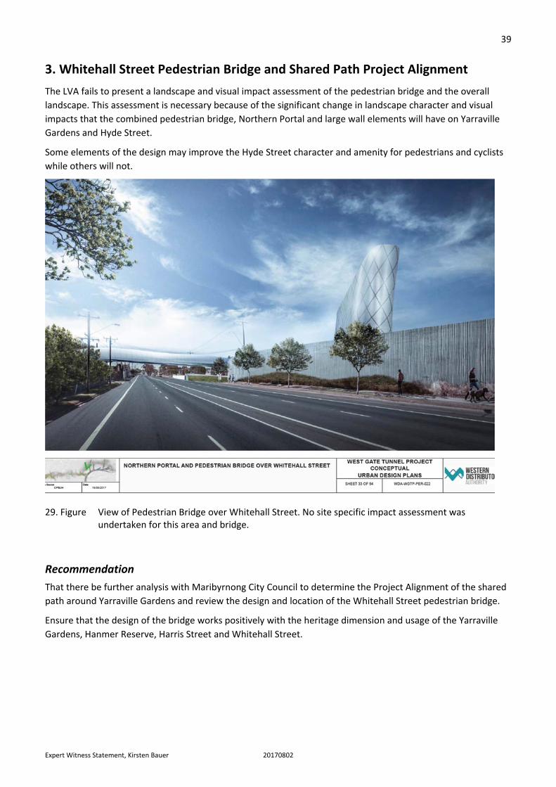
3. Whitehall Street Pedestrian Bridge and Shared Path Project Alignment
The LVA fails to present a landscape and visual impact assessment of the pedestrian bridge and the overall
landscape. This assessment is necessary because of the significant change in landscape character and visual
impacts that the combined pedestrian bridge, Northern Portal and large wall elements will have on Yarraville
Gardens and Hyde Street.
Some elements of the design may improve the Hyde Street character and amenity for pedestrians and cyclists
while others will not.
29. Figure View of Pedestrian Bridge over Whitehall Street. No site specific impact assessment was undertaken for this area and bridge.
Recommendation
That there be further analysis with Maribyrnong City Council to determine the Project Alignment of the shared
path around Yarraville Gardens and review the design and location of the Whitehall Street pedestrian bridge.
Ensure that the design of the bridge works positively with the heritage dimension and usage of the Yarraville
Gardens, Hanmer Reserve, Harris Street and Whitehall Street.

40
Expert Witness Statement, Kirsten Bauer 20170802
4. Stony Creek Reserve / Hyde Street
The report does not appropriately acknowledge the overall vision for this place as outlined in the Stony Creek
Direction Plan, 2011 (Maribyrnong City Council). See Figure 35.
Core to this vision is the continued revegetation of the reserve, increased riparian quality of the creek edge and
improvement in path access. A key value of the reserve is its separation from built‐up areas and the sense of
restful isolation gained, particularly close to the creek. This is an existing quality created despite the West Gate
Bridge.
The development of ramps along its southern edge to Hyde Street will certainly change the character of the
reserve by creating a visible infrastructure edge to the southern park and potential noise impacts.
No noise walls are proposed for the off ramp. Noise walls should be considered in line with the EES objective of
reducing impacts on open space and recreational areas.
The LVIA omits any mention of noise walls as a potential mitigation measure to reduce impacts.
The addition of a noise wall may increase visual impact. The management of noise levels from traffic in open
spaces is critical to the ongoing enjoyment and character of the latter. Stony Creek would benefit from the
reduction of traffic noise from the exit ramps.
The new exit ramp footprint will remove usable public land from the Hyde Street Reserve and reduce access to
the land immediately south of the ramp adjacent to the creek.
Mitigation to reduce the overall impact on the reserve should include investment in revegetating the
mangroves along the creek and overall weed management and revegetation of the broader creek environs.
Vegetation screening of the ramp should occur as much as possible in the landscape immediately north of the
ramp and not be relegated to screening within the reserve itself.
Other impacts that should be ascertained include the visual and landscape impact of the exit ramps on the
West Gate Bridge memorial with a view to improving existing conditions, which create a space difficult to
access and an uncomfortable environment not befitting the memorial.
Stony Creek backwash is not identified as Recreation and Open Space nor having High Visual sensitivity uses as
per page 34 Figure 12 ‐ High Visual sensitivity uses in the LVIA Report. This is a significant omission given its
unique urban qualities and environmental significance. Stony Creek backwash should be included and
identified as High visual sensitivity.
41
Expert Witness Statement, Kirsten Bauer 20170802
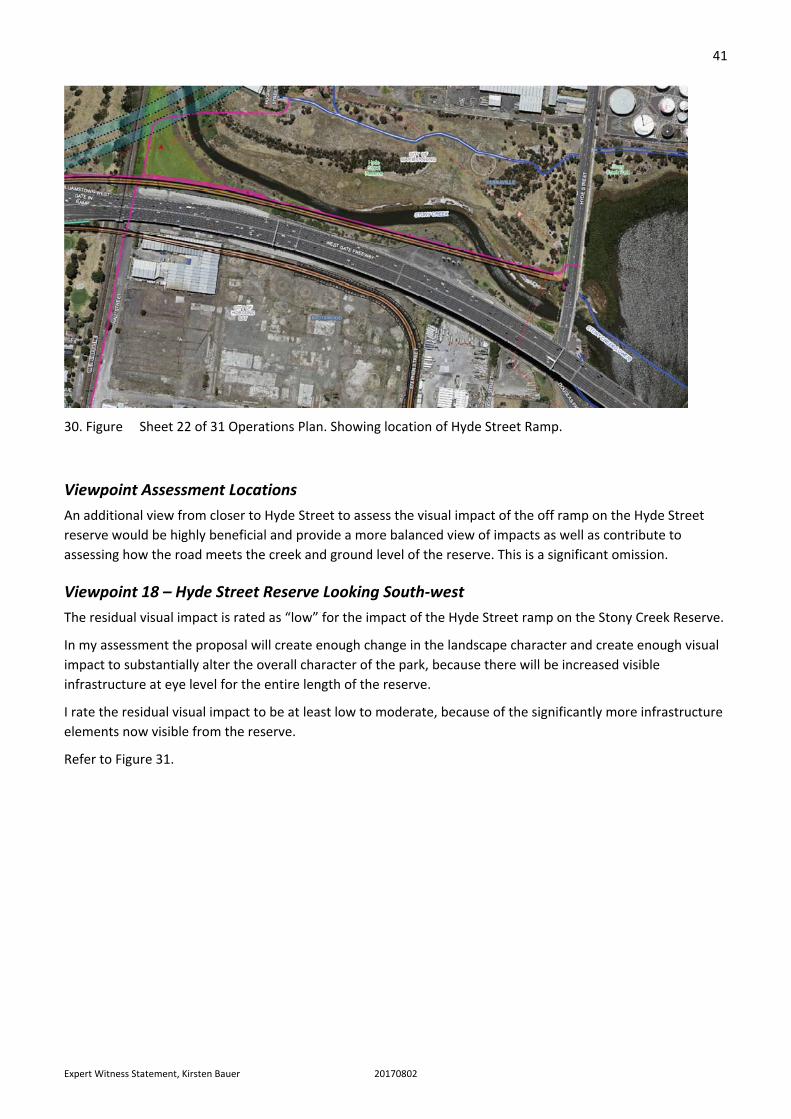
30. Figure Sheet 22 of 31 Operations Plan. Showing location of Hyde Street Ramp.
Viewpoint Assessment Locations
An additional view from closer to Hyde Street to assess the visual impact of the off ramp on the Hyde Street
reserve would be highly beneficial and provide a more balanced view of impacts as well as contribute to
assessing how the road meets the creek and ground level of the reserve. This is a significant omission.
Viewpoint 18 – Hyde Street Reserve Looking South‐west
The residual visual impact is rated as “low” for the impact of the Hyde Street ramp on the Stony Creek Reserve.
In my assessment the proposal will create enough change in the landscape character and create enough visual
impact to substantially alter the overall character of the park, because there will be increased visible
infrastructure at eye level for the entire length of the reserve.
I rate the residual visual impact to be at least low to moderate, because of the significantly more infrastructure
elements now visible from the reserve.
Refer to Figure 31.

42
Expert Witness Statement, Kirsten Bauer 20170802
31. Figure Viewpoint 18 (Figure 66 and 68 LVIA Report)

43
Expert Witness Statement, Kirsten Bauer 20170802
Viewpoint 19 – Stony Creek backwash Boardwalk
The view taken to identify any potential impacts of the off ramp fails to show the foreground and is a
substantially misleading view (refer to Figure 32). The image fails to show an accurate overlay of the proposed
off ramp and thus fails to substantiate the statement that there is “no” impact.
From on‐site inspection, it is difficult to accept that the off ramp would not be visible from this viewpoint and
that there would be no impact..
32. Figure Viewpoint 19 (Figure 69‐70 LVIA Report)

44
Expert Witness Statement, Kirsten Bauer 20170802
33. Figure Past image taken from the boardwalk of the Stony Creek backwash landscape. A more appropriate view to ascertain image on the area. It is suggested that from this view the off ramp may be visible.
Recommendation
That the LVIA is revised to overlay a 3D model of the proposal on the photo to reliably determine whether or
not an impact will occur.
A more appropriate representative viewpoint should be assessed to ascertain the visual impact on Stony Creek
backwash reserve.
After that work is done, there should be an assessment of what is required to mitigate any impacts on the West
Gate Bridge memorial.
Review of Urban Design Concept
The Project Alignment of the off ramp location is not significantly different to that of the Reference Design.
The proposal of an additional shared path link to Hughes Street is of good public benefit.
The removal of the above‐ground electrical lines is of public benefit.
The shared path architectural edge design is appropriate.
The landscape design (Figure 33) seems to be very preliminary and lacking in coordination with the engineering
elements. It lacks site responsiveness too. It has not incorporated the key directions of the Stony Creek
Directions Plan (Figure 35).

45
Expert Witness Statement, Kirsten Bauer 20170802
The typical sections and landscape plans show no planting underneath the shared path and elevated
carriageway. At Stony Creek Street reserve, mounds in abstract shapes are proposed within the estuarine
environment of the creek, an inappropriate treatment for this sensitive environment.
34. Figure Landscape Design for Stony Creek / Hyde Street Reserve
35. Figure Stony Creek Directions Plan (with approximate alignment of exit ramp).
46
Expert Witness Statement, Kirsten Bauer 20170802
Recommendation
The design of Stony Creek Street reserve should be undertaken in full consultation and collaboration with the
City of Maribyrnong, Melbourne Water and other stakeholders. Recommendations flowing from that
consultation and collaboration should be incorporated into any proposed works within the Stony Creek Reserve
as part of the Project.

47
Expert Witness Statement, Kirsten Bauer 20170802
5. McIvor Reserve
There is a significant discrepancy between the Construction Plans and the Landscape Plans as to the extent of
noise walls. New noise barriers are proposed on the southern side of the widened freeway and adjacent to the
new proposed park. However, the noise wall adjacent to existing northern public space does not extend along
the full length of the park.
See Figures 36‐37.
Recommendation
That the northern noise wall extends further west to mitigate increased noise on the users of McIvor Reserve
and also the residents of the Bradmill site.
36. Figure Construction Plans. Proposed noise barrier finishes halfway along McIvor Reserve.
37. Figure Urban Design Plans – proposed noise barrier finishes further west.

48
Expert Witness Statement, Kirsten Bauer 20170802
38. Figure View from soccer field – looking south to Westgate Freeway. Illustrating the value of full noise mitigation along the freeway to improve the over amenity of the open space.

49
Expert Witness Statement, Kirsten Bauer 20170802
6. Other Areas
Viewpoint 2 – Kororoit Creek Trail
The proposal suggests that bridge piers be painted black. I strongly recommend that any colours used under
infrastructure are chosen for their capacity to increase lighting rather than reduce it. While it is recognised that
dark colours reduce visual impact on the landscape, they also absorb instead of reflecting light. The overall
comfort and safety of users is of greater importance here.
This is an example where the LVA should comment on overall colour and form of elements and suggest
mitigation measures to reduce impact while taking into consideration location‐specific relevant criteria.
39. Figure Viewpoint 02 (Figure 19 LVIA Report)

50
Expert Witness Statement, Kirsten Bauer 20170802
Viewpoint 05 – Freemans Road
The residual impact of this view is assessed as Moderate. My assessment of the photomontages leads me to
conclude that a value of High is more appropriate. This is in consideration of the proximity of impact and the
height and form of the elements in the view. The use of vegetation to reduce the impact is important, but the
proposal should not depend entirely on vegetation to reduce the impacts in this particular situation, which it
does in fact do.
40. Figure Viewpoint 05 (Figure 27 LVIA Report) Existing.
41. Figure Viewpoint 05 (Figure 29 LVIA Report. This Note: while there is a 2m gap provided for tree planting I assess the overall impact as high, given the loss of vegetation and sky views.

51
Expert Witness Statement, Kirsten Bauer 20170802
Part C: Overview of the Urban Design Concept
Overall Design Proposition
Overall, the urban design concept is developed and stands at a high level appropriate for the context and site
locations. It endeavours to create an overall narrative across the dispersed infrastructure elements and across
diverse urban environments. It is assumed within the Urban Design Concept report that significantly more
design development work is to be undertaken to improve the design outcomes.
However, there are significant areas that lack unity across the engineering, architecture and landscape
concepts.
The design concept would have significantly more authenticity and recognised community authority if
consultation with relevant indigenous groups was undertaken as part of the concept development.
The colour strategy is well developed and the idea of a monochromic background with colour highlight will
work well for a long linear infrastructure project.
The use of dark colours in undercroft spaces and bridge edges should be reviewed in order to make structures
either more visible or appear to be lighter instead of increasing the shadowing beneath them.
The paint system proposed for the panels and piers is highly appropriate to facilitate the removal of graffiti.
The colour white for piers is a strategic choice and ensures that anti‐graffiti maintenance through applying
paint is achievable.
The proposal of additional open space is a significant positive outcome for the community. However, the actual
usage of the open space by the community needs further clarification.
Ambiguity and Lack of Detail in Design
Overall, there is a mismatch, or a number of inconsistencies, between the Project Alignment plans, the
landscape plans, the urban Design plans, the sections and the perspectives. The Urban Design, Landscape Plans
and Typical Sections also lack drawing scales and north points and comprehensive or adequate legends, which
is straightforwardly poor methodology.
This, in combination with very conceptual (put another way, low level of detail) in the Project Alignment, Urban
and Landscape plans, makes it difficult to understand exactly what is being proposed and consequently difficult
to assess potential impacts on the community.
For example, a retaining wall adjacent to McKenzie Road is identified in the Urban Design plan, but not
identified in the Project Alignment plans or the Landscape plans. Another example is that the Landscape plans
do not identify landscape works beneath many of the structures, though these are pictured in renders and
identified in overall project scope plans.
Typically, at this stage of a large‐scale infrastructure tender process there would be considerably more detail
and coordination between the drawing sets.
I assume that a more detailed engineering package has been developed, but is not available.

52
Expert Witness Statement, Kirsten Bauer 20170802
Recommendation
Provide updated plans with images having scales and north points and methodologically complete.
Update sections to include all architectural and engineering design.
Landscape plans to show extent of works lines.
Portal Designs
The portal elements are large.
While it is clear that the designers are seeking this element to be iconic and to constitute a large urban
landmark, I question the significant value (cost) placed in the portal entry frame (120m long and 35m wide),
which could be more importantly and usefully shifted to a significant extent to improving the public realm
outcomes of the areas underneath and adjacent to the West Gate Tunnel Project.
This is particularly the case for the Northern Portal which will have a high level of impact on the Yarraville
Gardens.
42. Figure Aerial view of Portal design looking north east.
Public Realm / Landscape Design
The overall landscape design concept at this stage of the Urban Design Concept (See Figure 43) process is
barely adequate and certainly not of the standard expected of a major piece of infrastructure with significant
impacts in the public realm.
It is poor partly because it places on the landscape shapes, forms, and spaces that lack site and contextual
relationships. An example of this already mentioned concerns the Stony Creek Street Reserve mounds in
abstract shapes that comprise an inappropriate treatment for this sensitive environment.
53
Expert Witness Statement, Kirsten Bauer 20170802
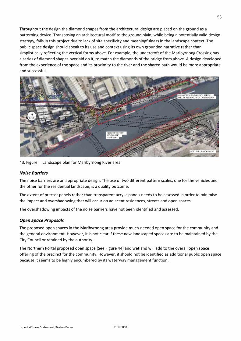
Throughout the design the diamond shapes from the architectural design are placed on the ground as a
patterning device. Transposing an architectural motif to the ground plain, while being a potentially valid design
strategy, fails in this project due to lack of site specificity and meaningfulness in the landscape context. The
public space design should speak to its use and context using its own grounded narrative rather than
simplistically reflecting the vertical forms above. For example, the undercroft of the Maribyrnong Crossing has
a series of diamond shapes overlaid on it, to match the diamonds of the bridge from above. A design developed
from the experience of the space and its proximity to the river and the shared path would be more appropriate
and successful.
43. Figure Landscape plan for Maribyrnong River area.
Noise Barriers
The noise barriers are an appropriate design. The use of two different pattern scales, one for the vehicles and
the other for the residential landscape, is a quality outcome.
The extent of precast panels rather than transparent acrylic panels needs to be assessed in order to minimise
the impact and overshadowing that will occur on adjacent residences, streets and open spaces.
The overshadowing impacts of the noise barriers have not been identified and assessed.
Open Space Proposals
The proposed open spaces in the Maribyrnong area provide much‐needed open space for the community and
the general environment. However, it is not clear if these new landscaped spaces are to be maintained by the
City Council or retained by the authority.
The Northern Portal proposed open space (See Figure 44) and wetland will add to the overall open space
offering of the precinct for the community. However, it should not be identified as additional public open space
because it seems to be highly encumbered by its waterway management function.

54
Expert Witness Statement, Kirsten Bauer 20170802
44. Figure Proposed open space developments around the Maribyrnong River and Yarraville Gardens area.