expires: october 31, 2014 bureau of land...
TRANSCRIPT

OCD Artesfa
Fffm 3166-5 UNITED STATES (March 2012) DEPARTMENT OF THE INTERIOR
BUREAU OF LAND MANAGEMENT
SUNDRY NOTICES AND REPORTS ON WELLS Do .not use this form for proposals to drill or to re-enter an
abandoned well. Use Form 3160-3 (APD) for such proposals.
FORM APPROVED OMBNo. 1004-0137
Expires: October 31, 2014
Fffm 3166-5 UNITED STATES (March 2012) DEPARTMENT OF THE INTERIOR
BUREAU OF LAND MANAGEMENT
SUNDRY NOTICES AND REPORTS ON WELLS Do .not use this form for proposals to drill or to re-enter an
abandoned well. Use Form 3160-3 (APD) for such proposals.
5. Lease Serial No. LC068282-B
Fffm 3166-5 UNITED STATES (March 2012) DEPARTMENT OF THE INTERIOR
BUREAU OF LAND MANAGEMENT
SUNDRY NOTICES AND REPORTS ON WELLS Do .not use this form for proposals to drill or to re-enter an
abandoned well. Use Form 3160-3 (APD) for such proposals.
6. I f Indian, Allottee or Tribe Name N/A
SUBMIT IN TRIPLICATE-Other instructions on page 2. 7. I f Unit of CA/Agreement, Name and/or No.
N/A l .Type of Well
\ Z \ Oil Well • Gas Well • Other
7. I f Unit of CA/Agreement, Name and/or No.
N/A l .Type of Well
\ Z \ Oil Well • Gas Well • Other 8. Well Name and No. Golden Spur WC 25 # 2 H
2. Name of Operator ConocoPhill ips Company
, A P , W e"5J"!9/S"-^Z^r 3a. Address 3b. Phone No. (include area code) P.O. Box 51810 Midland, Tx 79710 432-688-6943
10. Field and Pool or Exploratory Area
Wolfcamp; Red Hills
4. Location of Well (Footage, Sec, T.,R.,M., or Survey Description) 535 FSL & 965 FEL SESEof25-26S-31E
11. County or Parish, State
Eddy County, NM
12. CHECK THE APPROPRIATE BOX(ES) TO INDICATE NATURE OF NOTICE, REPORT OR OTHER DATA
TYPE OF SUBMISSION TYPE OF ACTION
I / 1 Notice of Intent
| | Subsequent Report
| | Final Abandonment Notice
1 1 Acidize 1 1 Deepen • 1 1 Alter Casing 1 I Fracture Treat • 1 1 Casing Repair 1 1 New Construction • 1 1 Change Plans 1 1 Plug and Abandon • 1 1 Convert to Injection 1 1 Plug Back •
I I Water Shut-Off
I I Well Integrity
[7/| other Construction
Start Only
13. Describe Proposed or Completed Operation: Clearly state all pertinent details, including estimated starting date of any proposed work and approximate duration thereof. If the proposal is to deepen directionally or recomplete horizontally, give subsurface locations and measured and true vertical depths of all pertinent markers and zones. Attach the Bond under which the work will be performed or provide the Bond No. on file with BLM/BIA. Required subsequent reports must be filed within 30 days following completion of the involved operations. If the operation results in a multiple completion or recompletion in a new interval, a Form 3160-4 must be filed once testing has been completed. Final Abandonment Notices must be filed only after all requirements, including reclamation, have been completed and the operator has determined that the site is ready for final inspection.)
In as much as the NEPA document (EA) has been prepared and finalized and while waiting on the downhole COAs, ConocoPhillips Company respectfully request approval for construction operations ONLY to begin.
Accepted for record NMOCD RECEIVED
MAR 1 5 2013
^MOCO ARTES5 A i SEE ATTACHED FOR CONDITIONS OF APPROVAL
14. I hereby certify that the foregoing }s true and correct. Name (Printed/Typed) Donna Williams ' '
Title Sr. Regulatory Advisor
Signature ,< - \^ Date 03/12/2013
fWKJVED THIS SPACE FOR FEDERAL OR ST/ [TE OF
Approved by
Conditions of that the appli entitle the ap|
Title Approval of this/otice does not warrant or certify
equitable title to those rights^n the subject lease which would operations thereon.
MAR 1 ? ?fl1:|Date
Office
;ALI OF LA: Title 18 U.S.C. Section 1001 and Title 43 U.S.C. Section 1212, make it a crime for any person knowingly an fictitious or fraudulent statements or representations as to any matter within its jurisdiction,
i wil m f y ^ ' r r ^ ^ j a ' h ^ agency of the United States any false,
(Instructions on page 2)

PECOS DISTRICT CONDITIONS OF APPROVAL
OPERATOR'S NAME: CONOCOPHILLIPS COMPANY LEASE NO.: LC068282B
WELL NAME & NO.: 2H-GOLDEN SPUR WC 25 SURFACE HOLE FOOTAGE: 5357S. & 9657E. BOTTOM HOLE FOOTAGE 3307N. 3307E.
LOCATION: Section 25, T. 26 S., R. 31 E., NMPM COUNTY: Eddy County, New Mexico
T A B L E O F C O N T E N T S Standard Conditions of Approval (COA) apply to this APD. If any deviations to these
standards exist or special COAs are required, the section with the deviation or requirement will be checked below.
I I General Provisions I | Permit Expiration I | Archaeology, Paleontology, and Historical Sites I | Noxious Weeds I | Special Requirements 1X1 Construction
Notification Topsoil Closed Loop System Federal Mineral Material Pits Well Pads Roads
I | Road Section Diagram I I Drilling
Waste Material and Fluids XI Production (Post Drilling)
Well Structures & Facilities Pipelines Electric Lines
1 | Interim Reclamation 1 I Final Abandonment & Reclamation
Page 1 of 19
I. GENERAL PROVISIONS
The approval of the Application For Permit To Drill (APD) is in compliance with all applicable laws and regulations: 43 Code of Federal Regulations 3160, the lease terms, Onshore Oil and Gas Orders, Notices To Lessees, New Mexico Oil Conservation Division (NMOCD) Rules, National Historical Preservation Act As Amended, and instructions and orders of the Authorized Officer. Any request for a variance shall be submitted to the Authorized Officer on Form 3160-5, Sundry Notices and Report on Wells.
II. PERMIT EXPIRATION
If the permit terminates prior to drilling and drilling cannot be commenced within 60 days after expiration, an operator is required to submit Form 3160-5, Sundry Notices and Reports on Wells, requesting surface reclamation requirements for any surface disturbance. However, i f the operator will be able to initiate drilling within 60 days after the expiration of the permit, the operator must have set the conductor pipe in order to allow for an extension of 60 days beyond the expiration date of the APD. (Filing of a Sundry Notice is required for this 60 day extension.)
III. ARCHAEOLOGICAL, PALEONTOLOGY & HISTORICAL SITES
Any cultural and/or paleontological resource discovered by the operator or by any person working on the operator's behalf shall immediately report such findings to the Authorized Officer. The operator is fully accountable for the actions of their contractors and subcontractors. The operator shall suspend all operations in the immediate area of such discovery until written authorization to proceed is issued by the Authorized. Officer. An evaluation of the discovery shall be made by the Authorized Officer to determine the appropriate actions that shall be required to prevent the loss of significant cultural or scientific values of the discovery. The operator shall be held responsible for the cost of the proper mitigation measures that the Authorized Officer assesses after consultation with the operator on the evaluation and decisions of the discovery. Any unauthorized collection or disturbance of cultural or paleontological resources may result in a shutdown order by the Authorized Officer.
IV. NOXIOUS WEEDS
The operator shall be held responsible if noxious weeds become established within the areas of operations. Weed control shall be required on the disturbed land where noxious weeds exist, which includes the roads, pads, associated pipeline corridor, and adjacent land affected by the establishment of weeds due to this action. The operator shall consult with the Authorized Officer for acceptable weed control methods, which include following EPA and BLM requirements and policies.
Page 2 of 19
V. CONSTRUCTION
A. NOTIFICATION
The BLM shall administer compliance and monitor construction of the access road and well pad. Notify the Carlsbad Field Office at (575) 234-5909 at least 3 working days prior to commencing construction of the access road and/or well pad.
When construction operations are being conducted on this well, the operator shall have the approved APD and Conditions of Approval (COA) on the well site and they shall be made available upon request by the Authorized Officer.
B. TOPSOIL
The operator shall stockpile the topsoil in a low profile manner in order to prevent wind/water erosion of the topsoil. The topsoil to be stripped is approximately 6 inches in depth. The topsoil will be used for interim and final reclamation.
C. CLOSED LOOP SYSTEM
Tanks are required for drilling operations: No Pits.
The operator shall properly dispose of drilling contents at an authorized disposal site.
D. FEDERAL MINERAL MATERIALS PIT
Payment shall be made to the BLM prior to removal of any federal mineral materials. Call the Carlsbad Field Office at (575) 234-5972.
E. WELL PAD SURFACING
Surfacing of the well pad is not required.
If the operator elects to surface the well pad, the surfacing material may be required to be removed at the time of reclamation.
The well pad shall be constructed in a manner which creates the smallest possible surface disturbance, consistent with safety and operational needs.
F. ON LEASE ACCESS ROADS
Road Width The access road shall have a driving surface that creates the smallest possible surface disturbance and does not exceed fourteen (14) feet in width. The maximum width of surface disturbance, when constructing the access road, shall not exceed twenty (20) feet.
Page 3 of 19

Surfacing Surfacing material is not required on the new access road driving surface. If the operator elects to surface the new access road or pad, the surfacing material may be required to be removed at the time of reclamation.
Where possible, no improvements should be made on the unsurfaced access road other than to remove vegetation as necessary, road irregularities, safety issues, or to fi l l low areas that may sustain standing water.
The Authorized Officer reserves the right to require surfacing of any portion of the access road at any time deemed necessary. Surfacing may be required in the event the road deteriorates, erodes, road traffic increases, or it is determined to be beneficial for future field development. The surfacing depth and type of material will be determined at the time of notification.
Crowning Crowning shall be done on the access road driving surface. The road crown shall have a grade of approximately 2% (i.e., a 1" crown on a 14' wide road). The road shall conform to Figure 1; cross section and plans for typical road construction.
Ditching
Ditching shall be required on the uphill side of the road.
Turnouts Vehicle turnouts shall be constructed on the road. Turnouts shall be intervisible with interval spacing distance less than 1000 feet. Turnouts shall be constructed on all blind curves. Turnouts shall conform to the following diagram:
Standard Turnout-Plan View "2T ! : : —— : —-•±H> , , . . « Centerline of Road Driving Surface ••
*a *• 50'
Drainage Drainage control systems shall be constructed on the entire length of road (e.g. ditches, sidehill outsloping and insloping, lead-off ditches, culvert installation, and low water crossings).
A typical lead-off ditch has a minimum depth of 1 foot below and a berm of 6 inches above natural ground level. The berm shall be on the down-slope side of the lead-off ditch.
Page 4 of 19
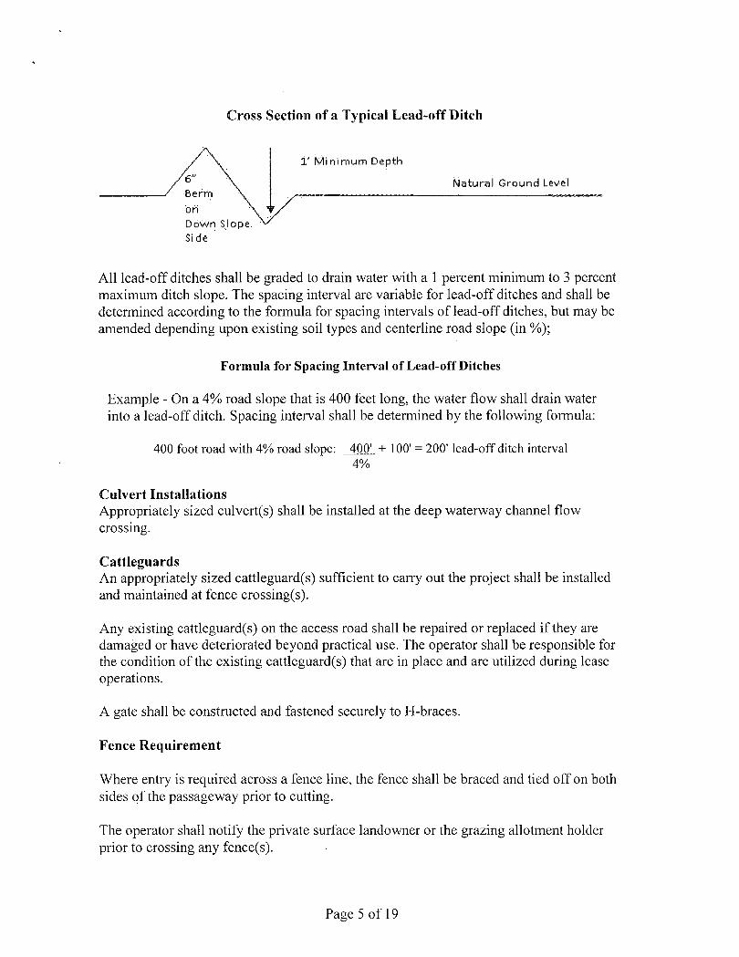
Cross Section of a Typical Lead-off Ditch
i ' Min imum Depth
Natural Ground Level Berm \
on X I Down Slope: v
Side '
•/ All lead-off ditches shall be graded to drain water with a 1 percent minimum to 3 percent maximum ditch slope. The spacing interval are variable for lead-off ditches and shall be determined according to the formula for spacing intervals of lead-off ditches, but may be amended depending upon existing soil types and centerline road slope (in %);
Example - On a 4% road slope that is 400 feet long, the water flow shall drain water into a lead-off ditch. Spacing interval shall be determined by the following formula:
400 foot road with 4% road slope: 400' + 100' = 200' lead-off ditch interval 4%
Culvert Installations Appropriately sized culvert(s) shall be installed at the deep waterway channel flow crossing.
Cattleguards An appropriately sized cattleguard(s) sufficient to carry out the project shall be installed and maintained at fence crossing(s).
Any existing cattleguard(s) on the access road shall be repaired or replaced if they are damaged or have deteriorated beyond practical use. The operator shall be responsible for the condition of the existing cattleguard(s) that are in place and are utilized during lease operations.
A gate shall be constructed and fastened securely to H-braces.
Fence Requirement
Where entry is required across a fence line, the fence shall be braced and tied off on both sides of the passageway prior to cutting.
The operator shall notify the private surface landowner or the grazing allotment holder prior to crossing any fence(s).
Formula for Spacing Interval of Lead-off Ditches
Page 5 of 19

Public Access Public access on this road shall not be restricted by the operator without specific written approval granted by the Authorized Officer.
Figure 1 - Cross Sections and Plans For Typical Road Sections
- cenief Isr.s cf t&
'bmoui 10'
.25: 100' 25' rrcrv;i:i ;n . _ i — i t . . .
r j l hirr.eat v/iCin
Typical Turnout Plan
all firigfc Juris re-cdi cn c'l blind c-jrve* w*:is sddsiionst riiro'Jti cs needed J3 keep sccdr.g bslsv.' 1000 faa!.
Page 6 of 19

F. WASTE MATERIAL AND FLUIDS
All waste (i.e. drilling fluids, trash, salts, chemicals, sewage, gray water, etc.) created as a result of drilling operations and completion operations shall be safely contained and disposed of properly at a waste disposal facility. No waste material or fluid shall be disposed of on the well location or surrounding area.
VII. PRODUCTION (POST DRILLING)
A. WELL STRUCTURES & FACILITIES
Placement of Production Facilities Production facilities should be placed on the well pad to allow for maximum interim recontouring and revegetation of the well location.
Containment Structures The containment structure shall be constructed to hold the capacity of the entire contents of the largest tank, plus 24 hour production, unless more stringent protective requirements are deemed necessary by the Authorized Officer.
Painting Requirement All above-ground structures including meter housing that are not subject to safety requirements shall be painted a flat non-reflective paint color Shale Green, Munsell Soil Color Chart # 5Y 4/2
B. PIPELINES STANDARD STIPULATIONS FOR SURFACE INSTALLED PIPELINES
A copy of the Grant and attachments, including stipulations, survey plat and/or map, will be on location during construction. BLM personnel may request to you a copy of your permit during construction to ensure compliance with all stipulations.
Holder agrees to comply with the following stipulations to the satisfaction of the Authorized Officer:
1. The holder shall indemnify the United States against any liability for damage to life or property arising from the occupancy or use of public lands under this grant.
2. The holder shall comply with all applicable Federal laws and regulations existing or hereafter enacted or promulgated. In any event, the holder shall comply with the Toxic Substances Control Act of 1976 as amended, 15 USC 2601 et seg. (1982) with regards to any toxic substances that are used, generated by or stored on the right-of-way or on facilities authorized under this right-of-way grant. (See 40 CFR, Part 702-799 and especially, provisions on polychlorinated biphenyls, 40 CFR 761.1-761.193.) Additionally, any release of toxic substances (leaks, spills, etc.) in excess of the
Page 10 of 19

reportable quantity established by 40 CFR, Part 117 shall be reported as required by the Comprehensive Environmental Response, Compensation, and Liability Act, section 102b. A copy of any report required or requested by any Federal agency or State government as a result of a reportable release or spill of any toxic substances shall be furnished to the authorized officer concurrent with the filing of the reports to the involved Federal agency or State government.
3. The holder agrees to indemnify the United States against any liability arising from the release of any hazardous substance or hazardous waste (as these terms are defined in the Comprehensive Environmental Response, Compensation and Liability Act of 1980, 42 U.S.C. 9601, et 'seg. or the Resource Conservation and Recovery Act, 42 U.S.C. 6901, et seq.) on the Right-of-Way (unless the release or threatened release is wholly unrelated to activity of the Right-of-Way holder's activity on the Right-of-Way), or resulting from the activity of the Right-of-Way holder on the Right-of-Way. This agreement applies without regard to whether a release is caused by the holder, its agent, or unrelated third parties.
4. The holder shall be liable for damage or injury to the United States to the extent provided by 43 CFR Sec. 2883.1-4. The holder shall be held to a standard of strict liability for damage or injury to the United States resulting from pipe rupture, fire, or spills caused or substantially aggravated by any of the following within the right-of-way or permit area:
a. Activities of the holder including, but not limited to construction, operation, maintenance, and termination of the facility.
b. Activities of other parties including, but not limited to:
The maximum limitation for such strict liability damages shall not exceed one million dollars ($1,000,000) for any one event, and any liability in excess of such amount shall be determined by the ordinary rules of negligence of the jurisdiction in which the damage or injury occurred.
This section shall not impose strict liability for damage or injury resulting primarily from an act of war or from the negligent acts or omissions of the United States.
5. If, during any phase of the construction, operation, maintenance, or termination of the pipeline, any oil, salt water, or other pollutant should be discharged from the pipeline system, impacting Federal lands, the control and total removal, disposal, and cleaning up
(1) (2) (3) (4)
Land clearing. Earth-disturbing and earth-moving work. Blasting. Vandalism and sabotage.
c. Acts of God.
Page 11 of 19

of such oil, salt water, or other pollutant, wherever found, shall be the responsibility of the holder, regardless of fault. Upon failure of the holder to control, dispose of, or clean up such discharge on or affecting Federal lands, or to repair all damages resulting therefrom, on the Federal lands, the Authorized Officer may take such measures as he deems necessary to control and clean up the discharge and restore the area, including, where appropriate, the aquatic environment and fish and wildlife habitats, at the full expense of the holder. Such action by the Authorized Officer shall not relieve the holder of any responsibility as provided herein.
6. All construction and maintenance activity will be confined to the authorized right-of-way width of 15 feet.
7. No blading or clearing of any vegetation will be allowed unless approved in writing by the Authorized Officer.
8. The holder shall install the pipeline on the surface in such a manner that will minimize suspension of the pipeline across low areas in the terrain. In hummocky of duney areas, the pipeline will be "snaked" around hummocks and dunes rather then suspended across these features.
9. The pipeline shall be buried with a minimum of 24 inches under all roads, "two-tracks," and trails. Burial of the pipe will continue for 20 feet on each side of each crossing. The condition of the road, upon completion of construction, shall be returned to at least its former state with no bumps or dips remaining in the road surface.
10. The holder shall minimize disturbance to existing fences and other improvements on public lands. The holder is required to promptly repair improvements to at least their former state. Functional use of these improvements will be maintained at all times. The holder will contact the owner of any improvements prior to disturbing them. When necessary to pass through a fence line, the fence shall be braced on both sides of the passageway prior to cutting of the fence. No permanent gates will be allowed unless approved by the Authorized Officer.
11. In those areas where erosion control structures are required to stabilize soil conditions, the holder will install such structures as are suitable for the specific soil conditions being encountered and which are in accordance with sound resource management practices.
12. Excluding the pipe, all above-ground structures not subject to safety requirement shall be painted by the holder to blend with the natural color of the landscape. The paint used shall be a color which simulates "Standard Environmental Colors" - Shale Green, Munsell Soil Color No. 5Y 4/2; designated by the Rocky Mountain Five State Interagency Committee.
13. The pipeline will be identified by signs at the point of origin and completion of the right-of-way and at all road crossings. At a minimum, signs will state the holder's name,
Page 12 of 19

BLM serial number, and the product being transported. Signs will be maintained in a legible condition for the life of the pipeline.
14. The holder shall not use the pipeline route as a road for purposes other than routine maintenance as determined necessary by the Authorized Officer in consultation with the holder. The holder will take whatever steps are necessary to ensure that the pipeline route is not used as a roadway.
15. Any cultural and/or paleontological resource (historic or prehistoric site or object) discovered by the holder, or any person working on his behalf, on public or Federal land shall be immediately reported to the authorized officer. Holder shall suspend all operations in the immediate area of such discovery until written authorization to proceed is issued by the authorized officer. An evaluation of the discovery will be made by the authorized officer to determine appropriate cultural or scientific values. The holder will be responsible for the cost of evaluation and any decision as to proper mitigation measures will be made by the authorized officer after consulting with the holder.
(March 1989)
BURIED PIPELINE STIPULATIONS
A copy of the Grant and attachments, including conditions of approval, survey plat and/or map, will be on location during construction. BLM personnel may request to you a copy of your permit during construction to ensure compliance with all stipulations.
Holder agrees to comply with the following stipulations to the satisfaction of the Authorized Officer:
1. The Holder shall indemnify the United States against any liability for damage to life or property arising from the occupancy or use of public lands under this grant.
2. The Holder shall comply with all applicable Federal laws and regulations existing or hereafter enacted or promulgated. In any event, the holder shall comply with the Toxic Substances Control Act of 1976 as amended, 15 USC 2601 et seq. (1982) with regards to any toxic substances that are used, generated by or stored on the right-of-way or on facilities authorized under this right-of-way grant. (See 40 CFR Part 702-799 and especially, provisions on polychlorinated biphenyls, 40 CFR 761.1-761.193.) Additionally, any release of toxic substances (leaks, spills, etc.) in excess of the reportable quantity established by 40 CFR Part 117 shall be reported as required by the Comprehensive Environmental Response, Compensation, and Liability Act, section 102b. A copy of any report required or requested by any Federal agency or State government as a result of a reportable release or spill of any toxic substances shall be furnished to the authorized officer concurrent with the filing of the reports to the involved Federal agency or State government.
3. The holder agrees to indemnify the United States against any liability arising from the release of any hazardous substance or hazardous waste (as these terms are defined in the Comprehensive Environmental Response, Compensation and Liability Act of 1980, 42 U.S.C. 9601, et seq. or the
Page 13 of 19
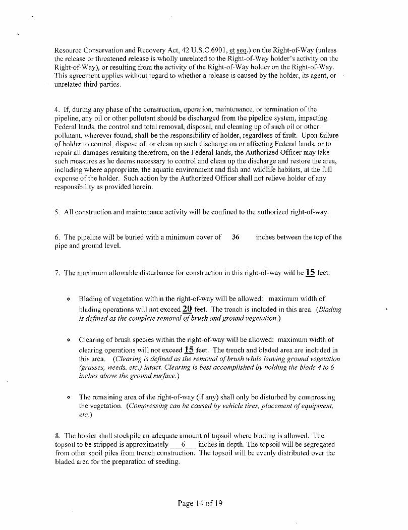
Resource Conservation and Recovery Act, 42 U.S.C.6901, et s_eq.) on the Right-of-Way (unless the release or threatened release is wholly unrelated to the Right-of-Way holder's activity on the Right-of-Way), or resulting from the activity of the Right-of-Way holder on the Right-of-Way. This agreement applies without regard to whether a release is caused by the holder, its agent, or unrelated third parties.
4. If, during any phase of the construction, operation, maintenance, or termination of the pipeline, any oil or other pollutant should be discharged from the pipeline system, impacting Federal lands, the control and total removal, disposal, and cleaning up of such oil or other pollutant, wherever found, shall be the responsibility of holder, regardless of fault. Upon failure of holder to control, dispose of, or clean up such discharge on or affecting Federal lands, or to repair all damages resulting therefrom, on the Federal lands, the Authorized Officer may take such measures as he deems necessary to control and clean up the discharge and restore the area, including where appropriate, the aquatic environment and fish and wildlife habitats, at the full expense of the holder. Such action by the Authorized Officer shall not relieve holder of any responsibility as provided herein.
5. All construction and maintenance activity will be confined to the authorized right-of-way.
6. The pipeline will be buried with a minimum cover of 36 inches between the top of the pipe and ground level.
7. The maximum allowable disturbance for construction in this right-of-way will be 15 feet:
o Blading of vegetation within the right-of-way will be allowed: maximum width of
blading operations will not exceed 20 feet. The trench is included in this area. {Blading is defined as the complete removal of brush and ground vegetation.)
o Clearing of brush species within the right-of-way will be allowed: maximum width of clearing operations will not exceed 15 feet. The trench and bladed area are included in this area. (Clearing is defined as the removal of brush while leaving ground vegetation (grasses, weeds, etc.) intact. Clearing is best accomplished by holding the blade 4 to 6 inches above the ground surface.)
» The remaining area of the right-of-way (if any) shall only be disturbed by compressing the vegetation. (Compressing can be caused by vehicle tires, placement of equipment, etc.)
8. The holder shall stockpile an adequate amount of topsoil where blading is allowed. The topsoil to be stripped is approximately 6 inches in depth. The topsoil will be segregated from other spoil piles from trench construction. The topsoil will be evenly distributed over the bladed area for the preparation of seeding.
Page 14 of 19
9. The holder shall minimize disturbance to existing fences and other improvements on public lands. The holder is required to promptly repair improvements to at least their former state. Functional use of these improvements will be maintained at all times. The holder will contact the owner of any improvements prior to disturbing them. When necessary to pass through a fence line, the fence shall be braced on both sides of the passageway prior to cutting of the fence. No permanent gates will be allowed unless approved by the Authorized Officer.
10. Vegetation, soil, and rocks left as a result of construction or maintenance activity will be randomly scattered on this right-of-way and will not be left in rows, piles, or berms, unless otherwise approved by the Authorized Officer. The entire right-of-way shall be recontoured to match the surrounding landscape. The backfilled soil shall be compacted and a 6 inch berm will be left over the ditch line to allow for settling back to grade.
11. In those areas where erosion control structures are required to stabilize soil conditions, the holder will install such structures as are suitable for the specific soil conditions being encountered and which are in accordance with sound resource management practices.
12. All above-ground structures not subject to safety requirements shall be painted by the holder to blend with the natural color of the landscape. The paint used shall be color which simulates "Standard Environmental Colors" - Shale Green, Munsell Soil Color No. 5Y 4/2.
13. The pipeline will be identified by signs at the point of origin and completion of the right-of-way and at all road crossings. At a minimum, signs will state the holder's name, BLM serial number, and the product being transported. All signs and information thereon will be posted in a permanent, conspicuous manner, and will be maintained in a legible condition for the life of the pipeline.
14. The holder shall not use the pipeline route as a road for purposes other than routine maintenance as determined necessary by the Authorized Officer in consultation with the holder before maintenance begins. The holder will take whatever steps are necessary to ensure that the pipeline route is not used as a roadway. As determined necessary during the life of the pipeline, the Authorized Officer may ask the holder to construct temporary deterrence structures.
15. Any cultural and/or paleontological resources (historic or prehistoric site or object) discovered by the holder, or any person working on his behalf, on public or Federal land shall be immediately reported to the Authorized Officer. Holder shall suspend all operations in the immediate area of such discovery until written authorization to proceed is issued by the Authorized Officer. An evaluation of the discovery will be made by the Authorized Officer to determine appropriate actions to prevent the loss of significant cultural or scientific values. The holder will be responsible for the cost of evaluation and any decision as to proper mitigation measures will be made by the Authorized Officer after consulting with the holder.
16. The operator shall be held responsible if noxious weeds become established within the areas of operations. Weed control shall be required on the disturbed land where noxious weeds exist,
Page 15 of 19

which includes associated roads, pipeline corridor and adjacent land affected by the establishment of weeds due to this action. The operator shall consult with the Authorized Officer for acceptable weed control methods, which include following EPA and BLM requirements and policies.
C. ELECTRIC LINES STANDARD STIPULATIONS FOR OVERHEAD ELECTRIC DISTRIBUTION LINES
A copy of the grant and attachments, including stipulations, survey plat and/or map, will be on location during construction. BLM personnel may request to you a copy of your permit during construction to ensure compliance with all stipulations.
Holder agrees to comply with the following stipulations to the satisfaction of the Authorized Officer:
1. The holder shall indemnify the United States against any liability for damage to life or property arising from the occupancy or use of public lands under this grant.
2. The holder shall comply with all applicable Federal laws and regulations existing or hereafter enacted or promulgated. In any event, the holder shall comply with the Toxic Substances Control Act of 1976 as amended, 15 USC 2601 et seg. (1982) with regards to any toxic substances that are used, generated by or stored on the right-of-way or on facilities authorized under this right-of-way grant. (See 40 CFR, Part 702-799 and especially, provisions on polychlorinated biphenyls, 40 CFR 761.1-761.193.) Additionally, any release of toxic substances (leaks, spills, etc.) in excess of the reportable quantity established by 40 CFR, Part 117 shall be reported as required by the Comprehensive Environmental Response, Compensation, and Liability Act, section 102b. A copy of any report required or requested by any Federal agency or State government as a result of a reportable release or spill of any toxic substances shall be furnished to the authorized officer concurrent with the filing of the reports to the involved Federal agency or State government.
3. The holder agrees to indemnify the United States against any liability arising from the release of any hazardous substance or hazardous waste (as these terms are defined in the Comprehensive Environmental Response, Compensation and Liability Act of 1980, 42 U.S.C. 9601, et seq. or the Resource Conservation and Recovery Act, 42 U.S.C. 6901, et seq.) on the Right-of-Way (unless the release or threatened release is wholly unrelated to the Right-of-Way holder's activity on the Right-of-Way), or resulting from the activity of the Right-of-Way holder on the Right-of-Way. This agreement applies without regard to whether a release is caused by the holder, its agent, or unrelated third parties.
4. There will be no clearing or blading of the right-of-way unless otherwise agreed to in writing by the Authorized Officer.
5. Power lines shall be constructed in accordance to standards outlined in "Suggested Practices for Raptor Protection on Power lines, " Raptor Research Foundation, Inc., 1981. The holder shall assume the burden and expense of proving that pole designs not shown
Page 16 of 19
in the above publication are "raptor safe." Such proof shall be provided by a raptor expert approved by the Authorized Officer. The BLM reserves the right to require modification or additions to all powerline structures placed on this right-of-way, should they be necessary to ensure the safety of large perching birds. Such modifications and/or additions shall be made by the holder without liability or expense to the United States.
6. The holder shall minimize disturbance to existing fences and other improvements on public lands. The holder is required to promptly repair improvements to at least their former state. Functional use of these improvements will be maintained at all times. The holder will contact the owner of any improvements prior to disturbing them. When necessary to pass through a fence line, the fence shall be braced on both sides of the passageway prior to cutting the fence. No permanent gates will be allowed unless approved by the Authorized Officer.
7. The BLM serial number assigned to this authorization shall be posted in a permanent, conspicuous manner where the power line crosses roads and at all serviced facilities. Numbers will be at least two inches high and will be affixed to the pole nearest the road crossing and at the facilities served.
8. Upon cancellation, relinquishment, or expiration of this grant, the holder shall comply with those abandonment procedures as prescribed by the Authorized Officer.
9. All surface structures (poles, lines, transformers, etc.) shall be removed within 180 days of abandonment, relinquishment, or termination of use of the serviced facility or facilities or within 180 days of abandonment, relinquishment, cancellation, or expiration of this grant, whichever comes first. This will not apply where the power line extends service to an active, adjoining facility or facilities.
10. Any cultural and/or paleontological resource (historic or prehistoric site or object) discovered by the holder, or any person working on his behalf, on public or Federal land shall be immediately reported to the Authorized Officer. Holder shall suspend all operations in the immediate area of such discovery until written authorization to proceed is issued by the Authorized Officer. An evaluation of the discovery will be made by the Authorized Officer to determine appropriate actions to prevent the loss of significant cultural or scientific values. The holder will be responsible for the cost of evaluation and any decision as to proper mitigation measures will be made by the Authorized Officer after consulting with the holder.
11. Special Stipulations: o For reclamation remove poles, lines, transformer, etc. and dispose of properly.
Fill in any holes from the poles removed.
Page 17 of 19

V I I I . I N T E R I M R E C L A M A T I O N
During the life of the development, all disturbed areas not needed for active support of production operations should undergo interim reclamation in order to minimize the environmental impacts of development on other resources and uses.
Within six (6) months of well completion, operators should work with BLM surface management specialists (Jim Amos: 575-234-5909) to devise the best strategies to reduce the size of the location. Interim reclamation should allow for remedial well operations, as well as safe and efficient removal of oil and gas.
During reclamation, the removal of caliche is important to increasing the success of revegetating the site. Removed caliche that is free of contaminants may be used for road repairs, fire walls or for building other roads and locations. In order to operate the well or complete workover operations, it may be necessary to drive, park and operate on restored interim vegetation within the previously disturbed area. Disturbing revegetated areas for production or workover operations will be allowed. If there is significant disturbance and loss of vegetation, the area will need to be revegetated. Communicate with the appropriate BLM office for any exceptions/exemptions if needed.
All disturbed areas after they have been satisfactorily prepared need to be reseeded with the seed mixture provided below.
Upon completion of interim reclamation, the operator shall submit a Sundry Notices and Reports on Wells, Subsequent Report of Reclamation (Form 3160-5).
X. F I N A L A B A N D O N M E N T & R E C L A M A T I O N
At final abandonment, well locations, production facilities, and access roads must undergo "final" reclamation so that the character and productivity of the land are restored.
Earthwork for final reclamation must be completed within six (6) months of well plugging. All pads, pits, facility locations and roads must be reclaimed to a satisfactory revegetated, safe, and stable condition, unless an agreement is made with the landowner or BLM to keep the road and/or pad intact.
After all disturbed areas have been satisfactorily prepared, these areas need to be revegetated with the seed mixture provided below. Seeding should be accomplished by drilling on the contour whenever practical or by other approved methods. Seeding may need to be repeated until revegetation is successful, as determined by the BLM.
Operators shall contact a BLM surface protection specialist prior to surface abandonment operations for site specific objectives (Jim Amos: 575-234-5909).
Page 18 of 19

Seed Mixture 1, for Loamy Sites
The holder shall seed all disturbed areas with the seed mixture listed below. The seed mixture shall be planted in the amounts specified in pounds of pure live seed (PLS)* per acre. There shall be no primary or secondary noxious weeds in the seed mixture. Seed will be tested and the viability testing of seed will be done in accordance with State law(s) and within nine (9) months prior to purchase. Commercial seed will be either certified or registered seed. The seed container will be tagged in accordance with State law(s) and available for inspection by the authorized officer.
Seed will be planted using a drill equipped with a depth regulator to ensure proper depth regulator to ensure proper depth of planting where drilling is possible. The seed mixture will be evenly and uniformly planted over the disturbed area (small/heavier seeds have a tendency to drop the bottom of the drill and are planted first). The holder shall take appropriate measures to ensure this does not occur. Where drilling is not possible, seed will be broadcast and the area shall be raked or chained to cover the seed. When broadcasting the seed, the pounds per acre are to be doubled. The seeding will be repeated until a satisfactory stand is established as determined by the authorized officer. Evaluation of growth will not be made before completion of at least one full growing season after seeding.
Species to be planted in pounds of pure live seed* per acre:
*Pounds of pure live seed:
Pounds of seed x percent purity x percent germination = pounds pure live seed
Species lb/acre
Plains lovegrass (Eragrostis intermedia) Sand dropseed (Sporobolus cryptandrus) Sideoats grama (Bouteloua curtipendula) Plains bristlegrass (Setaria macrostachya)
0.5 1.0 5.0 2.0
Page 19 of 19
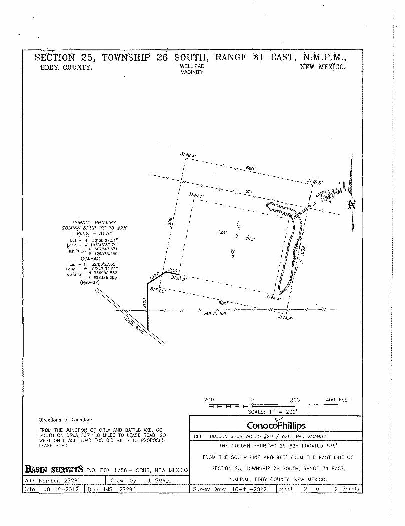
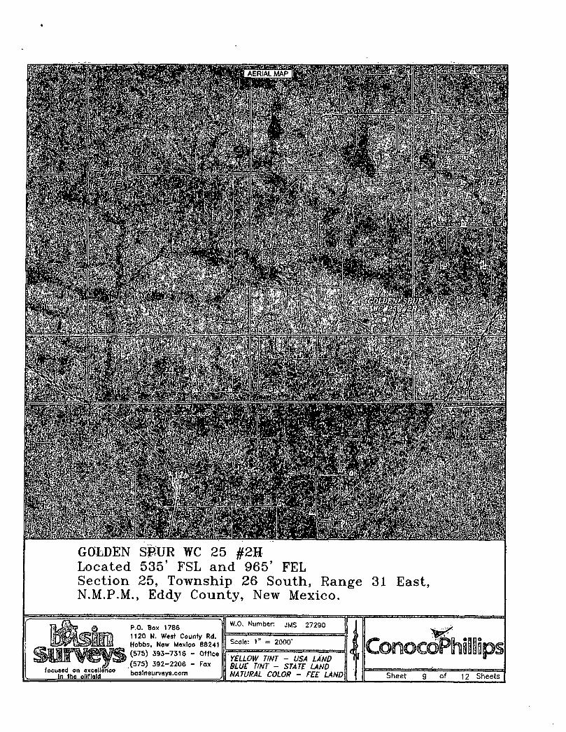
SECTION 25, TOWNSHIP 26 SOUTH, RANGE 31 EAST, N.M.P.M., EDDY COUNTY, WELL PAD NEW MEXICO,
VACINI i Y
r-I
SCO'
w
CONOCO PHILLIPS GOLDEN SPUR WC 25 $2H
ELEV. - 3146' N 32'00'27.51"
H 367047.871 E 729573.490
(NA0-B3) LM - H 32"00"27.05"
Long - W 1 G3'43'32.0D" N 366990.852 £ 688386:205
(NA!)-?/)
Lbt: Long. •NMSPCE-
NMSPCE-
200 0
U H H H- M 200 400 FEET
1 SCALE: 1 " = 2 0 0 '
Directions to Location:
FROM THE JUNCTION OF ORLA AND BATTLE AXE, GO SOUTH ON ORLA FOR 1.8 MILES TO LEASE ROAD, GO WEST ON LEASE ROAD FOR 0.3 MILES TO PROPOSED LEASE ROAD.
P.O. BOX 1 7 8 6 - H O B B S , MEW MEXICO
W.O. Number: 27290
Date:. 1 0 - 1 2 - 2 0 1 2
Drawn By: J . SMALL
Disk: JMS 27290
ConocoPhillips REF: GOLDEN SPUR WC 25 j,2H / WELL PAD VACINITY
THE GOLDEN SPUR WC 25 #2H LOCATED 535'
FROM THE SOUTH LINE AND 965' FROM THE1 EAST LINE OF
SECTION 25, TOWNSHIP 26 SOUTH, RANGE 31 EAST,
N.M.P.M., EDDY COUNTY, NEW MEXICO.
2 of 12 Sheets Survey Dote: 1 0 ^ 1 1 - 2 0 1 2 | Sheet

#2H GOLDEN SPUR WC 25 Located 535' FSL and 985' FEL
rownship 26 South, Range 31 East, Eddy County., New Mexico.
Section N.M.P.M.
25.
P.O. Box 1786 1120 N. Wast County Rd. Hobbs, Nsw Moxlco 80241
foonsQd on QxccllDncQ In ilia oilfield
(575) 392-2206 - fox
hasinBiirveys.com
W.O. Number: JMS 27290'
Survey Date: 10-11-2012
Scale: 1" = 2000'
Date: 10-1-2-2012
4 Sheet 7 of 12 Sheets

Form3160-3 . . . . (March 2012)
UNITED STATES B L M Carlsbad Field Offica
DEPARTMENT,,OF-THE INTERIOR , ,
BUREAU OF LAND ..MANAGEMENT. .
APPLICATION'FOR PERMIT TO DRILL OR= REENTER ''•
FORM APPROVED 0MB No. 1004-0137
Expires October 31,2014
Form3160-3 . . . . (March 2012)
UNITED STATES B L M Carlsbad Field Offica
DEPARTMENT,,OF-THE INTERIOR , ,
BUREAU OF LAND ..MANAGEMENT. .
APPLICATION'FOR PERMIT TO DRILL OR= REENTER ''•
5. Lease Serial No. LC068282-B' < • ' ' " •
Form3160-3 . . . . (March 2012)
UNITED STATES B L M Carlsbad Field Offica
DEPARTMENT,,OF-THE INTERIOR , ,
BUREAU OF LAND ..MANAGEMENT. .
APPLICATION'FOR PERMIT TO DRILL OR= REENTER ''• 6. If Indian, Aliofee or Tribe Name
N/A ' ' ' •' '•' 'h' ' ' ' ' ..(•. . , ! . ( . - S
ia. Type of work: 0 DRILL • REENTER
lb. Type of Well: [ 7 \ Oil Well R l Gas Well [~]Other . . ; , [ 7 ] Single Zone [ 7 ] Multiple Zone •
7 If Unit or CA Agreement, Name and No. . , N/A
ia. Type of work: 0 DRILL • REENTER
lb. Type of Well: [ 7 \ Oil Well R l Gas Well [~]Other . . ; , [ 7 ] Single Zone [ 7 ] Multiple Zone • 8. Lease-Name and'Well No. •• ' \
Golden Spur WC.25#2H, ,, : ...
1 Name of Operator ConocoPhiHips Company ' .' <:< ' ) • ' .,• ""• . I ' l l ' : ' , ' • , . ' I ,
9. API Well No. .i •, .ii • i
3a. Address p.o. Box 51810 Midland, Tx 79710
3b. Phone No. (include area code)
432-688-6943 10. Field and Pool, or Exploratory '•
Wolfcamp; Red Hills
4. Location of Well (Report location clearly andjn accordance wilhany'State requirements*)
At surface 535 FSL & 965 FEL (SESE) 25-26S-31E
At proposed prod, zone 330 FNL & 330 FEL (NENE) 25-26S-31E
l i . Sec.,T.R.M. or BlkandSurvey or Area
Section 25-26S-3IE \ ' ' " '
14. Distance in miles and direction from nearest town or post office* 1
- 2 miles north/west of State Line 12. County or Parish 1 13. State
Eddy •' NM 1 .)
15, Distance from, proposed* „ „ location to nearest '' property or lease line, ft. (Also to nearest drig. unit line, if any)
lcOfo. of acres in lease p f u acres
17. Spacing Unit dedicated to this well
160 '
18. Distance from proposed location* 2000' to nearest well, drilling, completed, applied for, on this lease, ft.
19. Proposed Depth
16396' MD/11866 TVD
20. BLM/BIA Bond No. on file
ES0085
21. Elevations (Show whether DF, KDB, RT, GL, etc.)
3146
22 Approximate date work will start*
01/01/2013 23. Estimated duration
30 days
24. Attachments
The following, completed in accordance with the requirements of Onshore Oil and Gas Order No.l, must be attached to this form:
1. Well plat certified by a registered surveyor. 4. Bond to cover the operations unless covered by an existing bond on file (see 2. A Drilling Plan. I l e m 2 0 a b o v e ) ' 3. A Surface UselMan (if the location is on National Forest System Lands, the 5. Operator certification
SUPO: must b/filed withthe appropriate Forest Service Office). 6. Such other site specific information and/or plans as may be required by the . ./. I BLM.
25. Signature 1 .xjj Name (Printed/Typed) Date,, ,, Donna Williams 10/30/2012
Title V ''•:--r—
, Sr. Regulatory"AdVisor . ,
Approved by (Signature) '• Name (Printed/Typed) Date
Title 'Office ' ' ' • ' •
Application approval does not warrant or certify that the applicant holds legal orequitable title to those rights in the subjectlease which would entitle theapplicantto conduct operations thereon. •• ' i Conditions of approval, if any, are attached. ,, , . . . .. , •,, •
Title 18 U.S.C.' Section 1001 and Tide 43 U.S.C. Section 1212, make it a crime' for any person knowingly and willfully to make to any department or agency of the United States any false, fictitious or fraudulent statements or representations as to any matter within its jurisdiction. '• i — •-; . .j _ • • •.
(Continued on page 2) * ( I i i f t t ^ & & " . > ' . > •' .,! /
. i •

DISTRICT I ie2S N. French Dr., Hobbs, NU BB240 Fhon* (078) 383-8101 Pax: (S76) 303-0720
DISTRICT II 611 S. First St., Artesia. NU 88210 Fluma (675) 74B-12&3 Fan (S7B) 748-0720
DISTRICT III 1000 Rio Brazos Ed., Aztec, NM 87410 Ffcene (MS) 334-6178 P I T (60S) &34-S170
DISTRICT IV 1220 S. SL Francis Dr., easts Pa, NU 875.05 Fbana (BOB) 47S-34S0 Paz: (SOS) 478-3462
State of New Mexico Energy, ofinerala and Na tu ra l Resources Depar tment
O I L C O N S E R V A T I O N D I V I S I O N 1220 South St. Francis Dr.
Santa Fe, New Mexico 87505
WELL LOCATION AND ACREAGE DEDICATION PLAT
Form C-102 Revised August 1, 2011
Submit one copy to appropriate District Office
D AMENDED REPORT
API Number Pool Code Pool Name
Red H i l l s Property Code Property Name Well Number
GOLDEN SPUR WC 25 2H OGRID No. Operator Name Elevation
217817 CONOCO PHILLIPS 3146' Surface Location
UL or lot No.
P Section
25 Township
26 S Range
31 E Lot Idn Feet from the
535 North/South line
SOUTH Feet from the
965 East/West line
EAST County
EDDY
Bottom Hole Location If Different From Surface UL or lot No.
A
Section
25 Township
26 S Range
31 E Lot Idn Feet from the
330 North/South line
NORTH Feet from the
330 East/West line
EAST County
EDDY Dedicated Acres Joint or Infi l l Consolidation Code Order No.
NO ALLOWABLE WILL BE ASSIGNED TO THIS COMPLETION UNTIL ALL INTERESTS HAVE BEEN CONSOLIDATED OR A NON-STANDARD UNIT HAS BEEN APPROVED BY THE DIVISION
+
•- + -•
1 PROPOSED BOTTOM *~ HOLE LOCATION
' Lot - N 32-01'12.28" I Long - W 103*43'26.68"
NMSPCE- N 371575.724 | NMbrct E 7 3 0 1 5 9 g 2 0 |
, (NAD-83) j
' Lot - N 32-Of 11.83" ' I Long - W 103'4S'24.$a' I
kmcor r N 371518.600 1
I NMSPCE- E M M 7 2 _ a 0 6 I
(NAD-27) j _
I
3 3 0 -
- 4- - -
+ I I
+ SURFACE LOCATION Lol - H 32-00 '27.5 l " |
Long - W 103"43'33.79" • NUSPrE- N 367047.871 I
(NAD-83) I
Lot - N 32 - 00'27.05" | Long - W 103"43'32.09" . w u s p r r - N 366990.852 NMsrc t E 6 8 8 3 8 6 2 0 5
(NAD-27) I
OPERATOR CERTIFICATION / hereby certify that the information
contained heroin <g true and complete to the bett of my knowledge and belief, and that this organisation either owns a marking interest or vnteased mineral internal in the land IncttutfngVhe proposed bottom, hole location or hao V right to drill this wall at thit loetaion pursuant to a contract with an owner m such almineral or working interest, or to afvoluntarn pooling agreement or a
pooling order heretofore entered by
/12 Signature
Donna Williams Printed Name
Donna. J . W i l l iams @ ronoccfjl^ill ip Emai l Addreaa

SECTION 25, TOWNSHIP 26 SOUTH, RANGE 31 EAST, N.M.P.M., EDDY COUNTY, WELL PAD NEW MEXICO.
VACINITY
Jt4g
CONOCO PHILLIPS GOLDEN SPUR WC 25 §2H
ELEV. - 3146' N 32-00'27.S1" W 103 -43'33.79"
M 367047.87) E 729573.490
(NAD-83) Lot - N 32'0O'27.O5"
Long - W 103-43"32.09" N 366990.852 E 688386.205
(NAD-27)
Lot Long
NUSPCE-
NMSPCE-
200 0 200 400 FEET U NN hH t - l *-t I |
SCALE: 1 " = 200' Directions to Location:
FROM THE JUNCTION OF ORLA AND BATTLE AXE, GO SOUTH ON ORLA FOR 1.8 MILES TO LEASE ROAD, GO WEST ON LEASE ROAD FOR 0.3 MILES TO PROPOSED LEASE ROAD.
BASIN SOUWSyS P.O. BOX 1786-HOBBS, NEW MEXICO
G>r.ocoPhiD6ips Directions to Location:
FROM THE JUNCTION OF ORLA AND BATTLE AXE, GO SOUTH ON ORLA FOR 1.8 MILES TO LEASE ROAD, GO WEST ON LEASE ROAD FOR 0.3 MILES TO PROPOSED LEASE ROAD.
BASIN SOUWSyS P.O. BOX 1786-HOBBS, NEW MEXICO
REF: GOLDEN SPUR WC 25 #2H / WELL PAD VACINITY
Directions to Location:
FROM THE JUNCTION OF ORLA AND BATTLE AXE, GO SOUTH ON ORLA FOR 1.8 MILES TO LEASE ROAD, GO WEST ON LEASE ROAD FOR 0.3 MILES TO PROPOSED LEASE ROAD.
BASIN SOUWSyS P.O. BOX 1786-HOBBS, NEW MEXICO
THE GOLDEN SPUR WC 25 #2H LOCATED 535'
FROM THE SOUTH LINE AND 965 ' FROM THE EAST LINE OF
SECTION 25, TOWNSHIP 26 SOUTH, RANGE 31 EAST,
N.M.P.M., EDDY COUNTY. NEW MEXICO. W.O. Number: 2 7 2 9 0 | Drawn By: J . SMALL
THE GOLDEN SPUR WC 25 #2H LOCATED 535'
FROM THE SOUTH LINE AND 965 ' FROM THE EAST LINE OF
SECTION 25, TOWNSHIP 26 SOUTH, RANGE 31 EAST,
N.M.P.M., EDDY COUNTY. NEW MEXICO.
Date: 1 0 - 1 2 - 2 0 1 2 | Disk: JMS 2 7 2 9 0 Survey Date: 1 0 - 1 1 - 2 0 1 2 |Sheet 2 of 12 Sheets

SECTION 25, TOWNSHIP 26 SOUTH, RANGE 31 EAST, N.M.P.M., EDDY COUNTY. WELL PAD NEW MEXICO.
DETAIL
- l l / /
100 100 200 FEET
SCALE: 1" = 100'
P.O. BOX 1786-HOBBS, NEW MEXICO
W.O. Number: 27290 | Drown By: J . SMALL
Dote: 10 -12 -2012 I Disk: JMS 27290
REF: GOLDEN SPUR WC 25 §2» / WELL PAD DETAIL
THE GOLDEN SPUR WC 25 #2H LOCATED 535'
FROM THE SOUTH LINE AND 965' FROM THE EAST LINE OF
SECTION 25, TOWNSHIP 26 SOUTH, RANGE 31 EAST,
N.M.P.M., EDDY COUNTY. NEW MEXICO.
Survey Dote: 10 -11 -2012 |Sheet 3 of 12 Sheets

SECTION 25, TOWNSHIP 26 SOUTH, RANGE 31 EAST, N.M.P.M., EDDY COUNTY. NEW MEXICO.
100 o fr H H H H ' t ^
100 200 FEET
SCALE: 1 " = 100'
P.O. BOX 1786-HOBBS, NEW MEXICO
W.O. Number: 27290 | Drown By: J. SMALL
Dote: 10 -12 -2012 j Disk: JMS 27290
REF: GOLDEN SPUR WC 25 #2H / WELL PAD DETAIL
THE GOLDEN SPUR WC 25 #2H LOCATED 535'
FROM THE SOUTH LINE AND 965' FROM THE EAST LINE OF
SECTION 25, TOWNSHIP 26 SOUTH, RANGE 31 EAST,
N.M.P.M., EDDY COUNTY. NEW MEXICO.
Survey Dote: 10 -11 -2012 jSheet of 12 Sheets
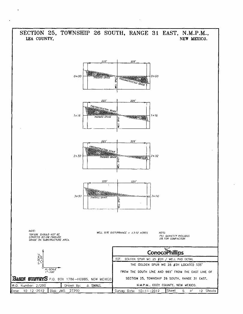
I SECTION 25, TOWNSHIP 26 SOUTH, RANGE 31 EAST, N.M.P.M., LEA COUNTY, NEW MEXICO.
NOTE:
TOPSOIL SHOULD NOT BE STRIPPED BELOW FINISHED GRADE ON SUBSTRUCTURE AREA
SC
AL
E
'-2
0'
H-SCALE " l"-200'
' S P.O. BOX 1786-HOBBS, NEW MEXICO
C©moc©PhlS.ips
SC
AL
E
'-2
0'
H-SCALE " l"-200'
' S P.O. BOX 1786-HOBBS, NEW MEXICO
REF: GOLDEN SPUR WC 25 #2H / WELL PAD DETAIL
i -t H-SCALE "
l"-200'
' S P.O. BOX 1786-HOBBS, NEW MEXICO
THE GOLDEN SPUR WC 25 #2H LOCATED 535'
FROM THE SOUTH LINE AND 965' FROM THE EAST LINE OF
SECTION 25, TOWNSHIP 26 SOUTH, RANGE 31 EAST,
N.M.P.M., EDDY COUNTY, NEW MEXICO. W.O. Number: 27290 f Drown By: J. SMALL
THE GOLDEN SPUR WC 25 #2H LOCATED 535'
FROM THE SOUTH LINE AND 965' FROM THE EAST LINE OF
SECTION 25, TOWNSHIP 26 SOUTH, RANGE 31 EAST,
N.M.P.M., EDDY COUNTY, NEW MEXICO.
Date: 10 -12 -2012 | Disk: JMS 27290 Survey Date: 10 -11 -2012 [Sheet 5 of 12 Sheets
WELL SITE DISTURBANCE = ±3.62 ACRES NOTE: FILL QUANTITY INCLUDES SX FOR COMPACTION.

GOLDEN SPUR WC 25 #2H Located 535' FSL and 965' FEL Section 25, Township 26 South, Range 31 East, N.M.P.M., Eddy County, New Mexico.
ConocoPhillips Sheet 7 of 12 Sheets
focused ..on excellence In tha oilfield
P.O. Box 1786 1120 N. West County Rd. Hobbs, New Mexico 88241 (575) 393-7316 - Office
(575) 392-2206 - Fox boslnsurveys.corn
W.O. Number: JMS 27290
Survey Date: 10 -11 -2012
Scale: 1 " = 2000'
Date: 1 0 - 1 2 - 2 0 1 2

GOLDEN SPUR WC 25 #2H Located 535' FSL and 965' FEL Section 25, Township 26 South, Range 31 East, N.M.P.M., Eddy County, New Mexico.
focused on excellence In thfl Oilfield.
P.O. Box 1786 1120 N. West County Rd. Hobbs. New Mexico 88241 (575) 393-7316 - Office (575) 392-2206 - fax bastnsurveys.com
W.O. Number: JMS 27290
Survey Date: 10-11-2012
Scale: 1" = 2 Miles
Date: 10-12-2012 Sheet 8 of 12 Sheets
GOLDEN SP:UR WC 25 #2H Located 535' FSL and 965' FEL Section 25, Township 26 South, Range 31 East, N.M.P.M., Eddy County. New Mexico.
f flJll5? o p°- B °* 1 7 8 6
Irllill^llfH 1 1 2 0 N- West CountyRd-i a t g y \ a ^ M M l l Hobbs, New Mexico 88241
surveys <ssss:r focused on excellence k..i..i,-,.u<, 1 In fhe oilfield boslnsurveys.com J
W.O. Number. MS 27290
j C©n©c©fiiiSSips f flJll5? o p°- B °* 1 7 8 6
Irllill^llfH 1 1 2 0 N- West CountyRd-i a t g y \ a ^ M M l l Hobbs, New Mexico 88241
surveys <ssss:r focused on excellence k..i..i,-,.u<, 1 In fhe oilfield boslnsurveys.com J
Scole: 1" = 2000' j C©n©c©fiiiSSips f flJll5? o p°- B °* 1 7 8 6
Irllill^llfH 1 1 2 0 N- West CountyRd-i a t g y \ a ^ M M l l Hobbs, New Mexico 88241
surveys <ssss:r focused on excellence k..i..i,-,.u<, 1 In fhe oilfield boslnsurveys.com J
YELLOW TINT - USA LAND BLUE TINT - STATE UNO NATURAL COLOR - FEE LAND j C©n©c©fiiiSSips
f flJll5? o p°- B °* 1 7 8 6
Irllill^llfH 1 1 2 0 N- West CountyRd-i a t g y \ a ^ M M l l Hobbs, New Mexico 88241
surveys <ssss:r focused on excellence k..i..i,-,.u<, 1 In fhe oilfield boslnsurveys.com J
YELLOW TINT - USA LAND BLUE TINT - STATE UNO NATURAL COLOR - FEE LAND j Sheet 9 of 12 Sheets

RIG LAYOUT
Locaton Schematic and Rig Layout for Closed Loop System
Section 25, Township 26 South, Range 31 East, N.M.P.M., Eddy County, New Mexico.
raJflil'- . © P.O. Box 1786
f^^w^ll f f i l ' 1 2 0 N' W a s f County Rd-,. . O ^ ^ ^ S ^ W ^ m , . . . . Hobbs, New Mexico 88241
^ ^ f i l f ^ ^ ^ ^ ^ (575) 392-2206 - Fox
i. , 0 C U ^ J ^ n 6 e bas.nsurveys.com . J
J W.O. Number: JMS 27290
.Q>noGr̂ RhiIlips raJflil'- . © P.O. Box 1786
f^^w^ll f f i l ' 1 2 0 N' W a s f County Rd-,. . O ^ ^ ^ S ^ W ^ m , . . . . Hobbs, New Mexico 88241
^ ^ f i l f ^ ^ ^ ^ ^ (575) 392-2206 - Fox
i. , 0 C U ^ J ^ n 6 e bas.nsurveys.com . J
j Survey Date: 10-11-2012 .Q>noGr̂ RhiIlips raJflil'- . © P.O. Box 1786
f^^w^ll f f i l ' 1 2 0 N' W a s f County Rd-,. . O ^ ^ ^ S ^ W ^ m , . . . . Hobbs, New Mexico 88241
^ ^ f i l f ^ ^ ^ ^ ^ (575) 392-2206 - Fox
i. , 0 C U ^ J ^ n 6 e bas.nsurveys.com . J
Scale: 1" = NONE .Q>noGr̂ RhiIlips
raJflil'- . © P.O. Box 1786
f^^w^ll f f i l ' 1 2 0 N' W a s f County Rd-,. . O ^ ^ ^ S ^ W ^ m , . . . . Hobbs, New Mexico 88241
^ ^ f i l f ^ ^ ^ ^ ^ (575) 392-2206 - Fox
i. , 0 C U ^ J ^ n 6 e bas.nsurveys.com . J j Date: 10-12-2012 Sheet 10 of 12 Sheets]

GOLDEN SPUR WC 25 # 2 » Located 535' FSL and 965' FEL Section 25, Township 26 South, Range 31 East, N.MJPvM., Eddy County, New Mexico.
focused on excellence In tfie oilfield^
P.O. Box 1786 1120 N. West Courtly Rd. Hobbs. New Mexico 88241 (575) 393-7316 - Office
(575) 392-2206 - Fox bqsfnsurveys.com
W.O. Number: J M S 27290
Survey Date: 10 -11 -2012
Scale: NONE
Date: 10 -12 -2012 Sheet 11 of 12 Sheets
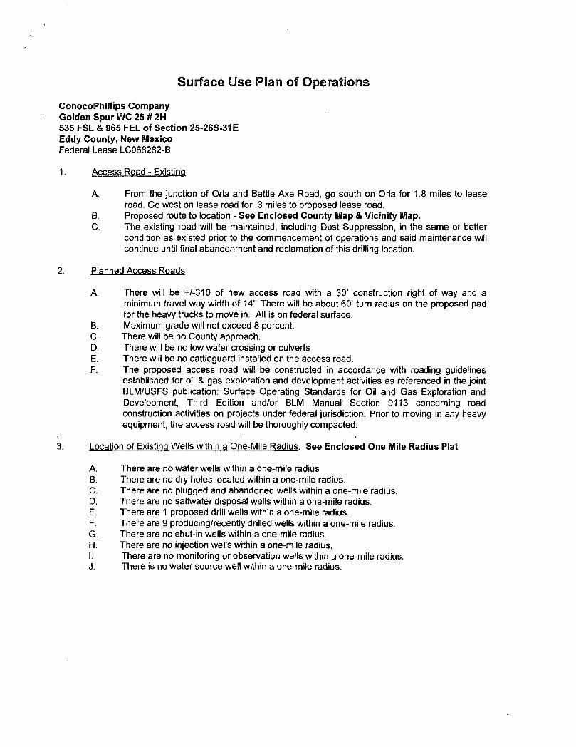
Surface Use Plain of Operations
ConocoPhillips Company Golden SpurWC 25#2H 535 FSL & 965 FEL of Section 25-26S-31E Eddy County, New Mexico Federal Lease LC068282-B
1. Access Road - Existing
A. From the junction of Orla and Battle Axe Road, go south on Orla for 1.8 miles to lease road. Go west on lease road for .3 miles to proposed lease road.
B. Proposed route to location - See Enclosed County Map & Vicinity Map. C. The existing road will be maintained, including Dust Suppression, in the same or better
condition as existed prior to the commencement of operations and said maintenance will continue until final abandonment and reclamation of this drilling location.
2. Planned Access Roads
A. There will be +/-310 of new access road with a 30' construction right of way and a minimum travel way width of 14'. There will be about 60' turn radius on the proposed pad for the heavy trucks to move in. All is on federal surface.
B. Maximum grade will not exceed 8 percent. C. There will be no County approach. D. There will be no low water crossing or culverts E. There will be no cattleguard installed on the access road. F. The proposed access road will be constructed in accordance with roading guidelines
established for oil & gas exploration and development activities as referenced in the joint BLM/USFS publication: Surface Operating Standards for Oil and Gas Exploration and Development, Third Edition and/or BLM Manual Section 9113 concerning road construction activities on projects under federal jurisdiction. Prior to moving in any heavy equipment, the access road will be thoroughly compacted.
3. Location of Existing Wells within a One-Mile Radius. See Enclosed One Mile Radius Plat
A. There are no water wells within a one-mile radius B. There are no dry holes located within a one-mile radius. C. There are no plugged and abandoned wells within a one-mile radius. D. There are no saltwater disposal wells within a one-mile radius. E. There are 1 proposed drill wells within a one-mile radius. F. There are 9 producing/recently drilled wells within a one-mile radius. G. There are no shut-in wells within a one-mile radius. H. There are no injection wells within a one-mile radius. I. There are no monitoring or observation wells within a one-mile radius. J. There is no water source well within a one-mile radius.

4. Location of existing and/or Proposed Facilities
A. On Well Pad 1. This well will be placed on oil production. Temporary production facilities could be
located on this location until such time as a long term CTB can be designed. A products line up to 3" in diameter (surface) and a gas supply line (buried) following the lease roads (south and west) for approximately 2200' to the Golden Spur #1H Y will be installed.
2. All above ground existing facilities are painted an earth tone color that blends with the surrounding area. Any proposed new facilities will be painted a shale green.
3. There is an existing electric line next to the location. A tie in of approximately 2200 linear feet to the wellhead is planned
5. Location and Type of Water Supply
A. Fresh water will be obtained from an approved source. B. No water well will be drilled on this location.
6. Source of Construction Materials
A. Any materials needed in addition to what can be used from location and access road will be hauled in from a supplier having a permitted source of materials.
B. If production is established, any additional construction materials required for the surfacing of the access road and for installation of the production facilities will be purchased from a supplier having a permitted source of materials.
C. No construction materials will be taken from Federal lands without a prior approval from the appropriate Surface Management Agency.
7. Methods for Handling Waste Disposal
A. Hazardous substances as listed as hazardous under the Comprehensive Environmental Response Compensation and Liability Act (CERCLA) of 1980, as amended, 42 U.S.C. 9601 et seq. and the regulations issued under CERCLA, will be disposed of in the appropriate pit.
B. Any spills of oil or any other potentially hazardous material will be cleaned up and Immediately removed to an approved disposal site.
C. Sewage will be disposed of according to county and state requirements in a portable chemical toilet(s) or in a hole at least 20 feet deep excavated in the cut portion of the well pad. Other waste and chemicals may not be disposed of on location. Waste will not be burned on location.
D. Garbage and trash will be contained in portable trash cages. The contents of the trash cages will be disposed of according to county and state regulations at an approved facility. Disposal of it or burning it will not be allowed on the well location.
F. After drilling rig has moved out of area, any scattered trash and litter will be removed from site.
G. All potentially hazardous areas will be fenced, and will remain in this condition until entire area can be rehabilitated.

8. Ancillary Facilities
The production facilities are discussed under Item 4.
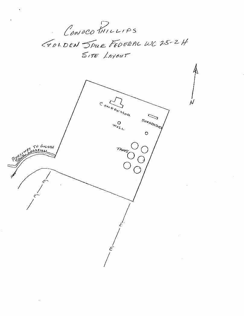
9. Well Site Layout
A. See Enclosed Well Location Plat B. Well Site Layout - The rig to drill this well will need a 450' x 350' location. See Enclosed
Drilling Rig Layout Plat. C. Topsoil will be stripped from the locations and access roads and be stockpiled and be
deposited apart from other excavated material. D. There will be a no reserve pit on location. The well will be drilled via a closed loop system
and the contents will be taken to an approved disposal site.
10. Plans for Reclamation of the Surface
A. If this well is a producer, all site rehabilitation shall be completed within six months. Under normal weather conditions, the timetable for rehab will allow two months for backfill settling and two months to complete final re-contouring, and top-soiling. In the event of winter freeze-up, reclamation will be put on hold as determined by the BLM.
B. At such time as the well is abandoned, ConocoPhillips Company will contact the BLM for development of the final rehabilitation plan. Upon abandonment, a dry hole marker welded to surface casing four feet below ground level will be installed. It will contain the same information as the well sign as directed by 43 CFR 3162.6 (30 CFR 221.22). The dry hole marker sealing the casing will have an 1/8" to 1/4" weep hole which will allow pressure to dissipate and make detection of any fluid seepage easier.
C. If this well site is constructed and not drilled, the site and access road will be reclaimed or BLM approved special erosion control measures implemented within 90 days of site construction unless otherwise approved in writing by sundry notice.
D. The unused portion of the site will be ripped prior to replacing the topsoil. The soil-banked material will be spread over the area. Reseeding will be an approved mixture by the BLM. If the broadcast method is utilized, the seed mixture shall be doubled. There shall be no primary or secondary noxious weed seed in the native seed mixture
E. The entire disturbed location may be fenced after seeding. When the location has been rehabilitated and vegetation re-established, the fence shall be removed or the fenced area reduced as required by the landowner or BLM.
F. Weeds will be controlled on disturbed areas within the exterior limits of the well pad. The control methods will be in accordance with guidelines established by EPA, BLM, state, and local authorities.
G. A pre-work onsite with the BLM and ConocoPhillips Company may be held for all phases of reclamation
H. ConocoPhillips Company will utilize many best management practices. The first is location selection itself and adjusting the project area to accommodate the terrain to minimize the initial disturbance and erosion concerns. The project area will have the required interim reclamation and reseeding for the unused portion of the well site not needed for production operations. The interim reclamation will occur shortly after completion operation and facility installation has happened.

Surface Ownership Bureau of Land Management 620 E. Greene Street Carlsbad, New Mexico 88220
Other Information
A. The area that would be impacted by the well site and access road has been surveyed for cultural resources. The Archaeological Survey Report has been mailed to the BLM by Lone Mountain Archaeological Services, Inc.
B. ConocoPhillips Company will be responsible for informing all persons in the area who are associated with this project that they will be subject to prosecution for knowingly disturbing historic or archaeological sites or for collecting artifacts.
If historic or archaeological materials are uncovered, ConocoPhillips Company will suspend all operations that might further disturb such materials and immediately contact the Authorized Officer, Bureau of Land Management.
Within five (5) working days the Authorized Officer will inform ConocoPhillips Company as to whether the materials appear eligible for the National Register of Historic Places; the mitigation measures the operator will likely have to undertake before the site can.be used (assuming in site preservation is not necessary); and a time frame for the Authorized officer to complete an expedited review under 36 CFR 800.11 to confirm, through the State Historic Preservation Officer, that the findings of the Authorized Officer are correct and that mitigation is appropriate.
C. ConocoPhillips Company will protect, in place, all public land survey monuments, private property corner, and Forest service boundary markers. In the event that any such land markers or monuments are destroyed in the exercise of their rights, depending on the type of monument destroyed, the operator shall see that they are reestablished or referenced in accordance with (1) the procedures outlined in the "Manual of Instructions for the Survey of the Public Land of the United States", (2) the specifications of the county surveyor, or (3) the specification of the BLM.
D. ConocoPhillips Company will comply with the additional Conditions of Approval provided by the BLM.
Operator Certification
CONOCOPHILLIPS COMPANY
CERTIFICATION:
I hereby certify that I, or persons under, my direct supervision, have inspected the proposed drill site and access route proposed herein; that I am familiar with the conditions which currently exist; that I have full knowledge of State and Federal laws applicable to this operation; that the statements made in this APD package are, to the best of my knowledge, true and correct; and that the work associated with the operations proposed herein will be performed in conformity with this APD package and the terms and conditions under which it is approved. I also certify that I, or the company I represent, am responsible for the operations conducted^tjndejr- this application with bond coverage provided by Nationwide Bond ES0085. These statemer|ts are subject to the provisions of 18 U.S.C. 1001 for the filing of false statements.
Date: Donna^AfjJIiams Sr. Regulatory Advisor