expl rpt on mag and vlf-em surveys - howard lake · pdf filemagnetometer and vlf-em surveys...
TRANSCRIPT

32D04NWD204 2 15846 ARNOLD 010
N.T.S.: 32 D/4
RPT. NO. S-95-1
Latitude:48 14
Longitude: 79 49
2.1584 6
EXPLORATION REPORT ON
MAGNETOMETER AND VLF-EM SURVEYS
HOWARD LAKE PROPERTY
THE KIRKLAND LAKE AREA
ARNOLD TOWNSHIP
LARDER LAKE MINING DIVISION
ONTARIO
F.J. SHARPLEY
RECEIVED
FEB6 -1935
MINING LANDS BRANCH
JANUARY 1995

32004NWQ204 2 15846 ARNOLD 01 OC
TABLE OP CONTENTS PAGE
SUMMARY
1.0 INTRODUCTION . . . . . . . . . . . . . . . . . . . . . . 6
2.0 PROPERTY . . . . . . . . . . . . . . . . . . . . . . . 6
2.1 Claims 62.2 Location and Access 72.3 Topography 7
3.0 EXPLORATION HISTORY . . . . . . . . . . . . . . . . . . 8
4.0 GEOLOGY . . . . . . . . . . . . . . . . . . . . . . . . 9
4.1 Regional Geology 94.2 Property Geology 9
5.0 MINERALIZATION . . . . . . . . . . . . . . . . . . . . 10
5.1 Regional Mineralization 105.2 Property Mineralization 11
6.0 CURRENT WORK CARRIED OUT . . . . . . . . . . . . . . . 12
6.1 Line Cutting 126.2 Magnetometer Survey 126.3 VLF-EM Survey 13
7.0 DISCUSSION OF RESULTS . . . . . . . . . . . . . . . . 14
7.2 Magnetometer Survey 147.3 VLF-EM Survey 15
8.0 CONCLUSIONS AND RECOMMENDATIONS . . . . . . . . . . . 17
9.0 REFERENCES AND SELECTED BIBLIOGRAPHY . . . . . . . . . 18
10.0 CERTIFICATE OF QUALIFICATIONS: F.J. SHARPLEY . . . . 20

Appendix I: LIST OF FIGURES page 21
Figure 1: Figure 2: Figure 3: Figure 4: PLAN l PLAN 2 PLAN 3
Location MapClaim MapTopographic MapAirborne Magnetic Map (OGS Map 81327)Topography and ClaimsMagnetic Survey, Readings and ContoursVLF-EM, NLK-Profiles and ReadingsVLF-EM, NLK-Fraser Filter Contours
1:5000 1:5000 1:5000 1:5000
Appendix II INSTRUMENT SPECIFICATIONS 22
LIST OF MAPS IN POCKET
PLAN l - Topography and ClaimsPLAN 2 - Magnetic Survey, Readings and ContoursPLAN 3 - VLF-EM, NLK-Profiles 6 Readings
VLF-EM, NLK-Fraser Filter Contours Compilation-Magnetic Survey, Color Contours St VLF-EM
1:2500 1:2500 1:2500 1:2500 1:5000

SUMMARY
The Howard Lake Property consists of 4 non-patented Mining claim
units located in Arnold Township of the Kirkland Lake area of the
Larder Lake Mining Division of Ontario. The property lies within
the Archean Blake River Basin, six km north of the Victoria Creek
gold discovery in the Abitibi Subprovince of the Superior
Province of the Precambrian Shield.
During the period fro* December 1994 to January 1995, the MDF
Syndicate carried out line cutting, magnetometer and VLF-EM
surveys on the property to investigate interesting airborne
magnetic features for gold and kimberlite potential.
Several weak to strong VLF-EM anomalies have been encountered on
the Howard Lake Property. These conductors are targets for gold
mineralization that may represent structures emanating off the
Murdoch Creek - Kennedy Lake Fault. They may represent westward
extensions of the Broker's Fee Fault Zone where gold is
associated with sulphides in a zone that is two km to the east.
The main magnetic feature is a weak isolated twin peaked ground
magnetic anomaly occurring on the central part of the grid over a
strike length of 300 metres and a width of 100 metres with an
amplitude of 160 to 180 gammas above background. This magnetic
intrusion is probably of mafic or kimberlitic in composition.

5
A program of geological Mapping and geochemical humus sampling is
recommended to evaluate several VLF-EM conductors for gold
potential. Till sampling of the glaciofluvial deposits on the
west side of the grid and gravity or resistivity surveys is
recommended to determine if this magnetic feature on the central
part of the grid is a kimberlite of possible economic interest.
1.0 INTRODUCTION
Line cutting and geophysical surveys have been completed on the
Howard Lake Property, Arnold Township in the Kirkland Lake area,
Larder Lake Mining Division, Ontario. The geophysical ground
program was designed to investigate the oval shaped airborne
magnetic anomaly for gold and kimberlite potential.
The field work was carried out during December 1994 and January
1995.
2.O PROPERTY
2.1 Claims
The Howard Lake Property consists of 4 contiguous, non-patented
mining claim units in Arnold Township in the Larder Lake Mining
Division of Ontario.
The claims are numbered as follows:
L-1189757: 4 units - Arnold Township (Map No. M.321)
The claims total 160 acres or 64.75 hectares and are registered
as follows:

7
D.M. Cameron 33 1/3 percent interest
M. Caron 33 1/3 percent interest
Seal River Exploration Limited - 33 1/3 percent interest
The claims were recorded on February 3,1993.
2.2 Location and Access
The property is located 13 km northeast of Kirkland Lake, Ontario
in Howard Lake in the central part of Arnold Township. Access is
from Kirkland Lake for 8 km east on Highway 66 to the Esker Lake
Road (Highway 672); north for 10 km to the Howard Lake Road;
east-northeast for 3 km to the lake.
2.3 Topography
The property is about 40 percent in Howard Lake which is part of
the Misema River. The topography on land is mainly wet shoreline
with alders and cedar. On the western and eastern edges of the
claim the topography rises to 50 feet above the shoreline of the
lake. The forest cover is mainly birch, spruce, poplar, cedar and
alders.
The climate is typical of northern Ontario with snow cover and
cold weather from mid November until May.
8
Cottage lots cover the island in the lake and the western shore
of Howard Lake on the southern part of the claim.
3.0 EXPLORATION HISTORY
An airborne magnetic and electromagnetic survey with lines spaced
at 200 metre intervals of the Kirkland Lake Area was carried out
by the O.G.S. in 1979; Arnold Township is covered on Map P.2259.
The Arnold and Katrine Townships were mapped by W.A. Hogg for the
O.D.M. in 1962 on a scale of one inch to one half mile (Map
2061); O.D.M. Geological Report No. 29 (Hogg 1964).
There is no record of mineral exploration on the property.

4 . O GEOLOGY
4.1 Regional Geology
The Howard Lake Property lies on the south-central flank of the
east-west trending Blake River Basin and seven miles north of the
east-west trending Larder Lake Fault Zone. The west-northwest
Victoria Creek Shear Zone is four miles to the south. The
northeast trending Murdoch Creek Fault is one mile to the west.
The area is part of the Abitibi Subprovince of the Superior
Province of the Precambrian Shield. The Blake River Basin within
the area of interest consists of undifferentiated intermediate
volcanics intruded by syenite, diorite, gabbro and kimberlite.
4.2 Property Geology
The Howard Lake Property lies on the south-central flank of the
Blake River Basin. The rocks consist of undifferentiated
intermediate volcanics consisting of massive and porphyritic lava
flows striking east-west and dipping steeply (ODM Map 2061-Hogg
1962). Gabbro and diorite intrusives occur in the area.
To the west of the property the Murdoch Creek-Kennedy Lake Fault
strikes northeast.

10
Glaciofluvial deposits occur on the west side of the property.
5.0 MINERALIZATION
5.1 Regional Mineralization
The types of gold deposits in the area are as follows:
Archean Lode Gold Deposits:
(1) Larder Lake Type: mainly mafic-ultramafic volcanic contact
(a) Quartz-Veins in Carbonate: (Carbonate Ore)
(b) Disseminated Pyrite: (Flow-Ore)
(eg) Kerr Addison
(2) Kirkland Lake Type:
(a) Quartz-Veins mainly in syenite.
(b) Quartz-Breccia mainly in syenite
(eg) Macassa
(3) Victoria Creek Type:
(a) Disseminated Pyrite in felsic tuff (Gauthier Group),
(eg) Sudbury Contact

11
Kimberlite Intrusions in the area are as follows:
(1) C14 (diamondiferous) - 4 km north of Howard Lake
(2) A-2 Pipe: - 4 km northwest of Howard Lake
(3) AM-47 Pipe: - 4.5 km west of Howard Lake
(4) A-4 Pipe: - 5 km southwest of Howard Lake
The northwest striking Quinze Dam Fault is 4 km west of Howard
Lake. The area falls within the Timiskaming Structural Zone
(L.T.S.Z.).
5.2 Property Mineralization
There is no record of mineralization on the property.
Two kilometres to the east gold is associated with the Broker's
Fee Fault striking east-west. Gold and chalcopyrite, pyrite
mineralization is associated with quartz veining in carbonatized
intermediate agglomerate with graphite.
12
6.0 CURRENT WORK CARRIED OUT
6.1 Line Cutting
During the period from December 28,1994 to January 18,1995 a
total of 4.8 line kilometres of picket line was cut with a chain
saw by M.C. Exploration Services Inc. of Timmins, Ontario. The
lines are spaced at 100 metre intervals and the stations at 25
metre intervals. Approximately 40% of the lines are on Howard
Lake (Plan 1).
6.2 Magnetometer Survey
The magnetic data was collected with an EDA OMNI IV PPM 350
proton procession magnetometer which measures the absolute value
of the earth's magnetic field to an accuracy of t/- l gammas. The
magnetic survey was carried out by M.C. Exploration Services Inc.
on January 20,1995. A single operator was used with the sensor
mounted on an aluminum pole to remove it from surface geological
noise. Readings were taken at 12.5 metre intervals.
Magnetic diurnal variations were monitored by establishing an EDA
OMNI IV PPM 400 base station magnetometer, which recorded
readings every 30 seconds as the survey was being conducted. The
data from both magnetometers was then dumped with a computer and
base corrected values were computed. Readings were taken along

13
grid lines spaced at 100 metre intervals with readings at 12.5
metre intervals along the line. Approximately 4.8 line kilometres
of data were recorded in this way.
Corrections to the magnetic field values recorded during the
field survey were made using the approximate time and diurnal
change information. The values were then plotted on the computer
by M.C. Exploration Services Inc. at a scale of 1:2500 and
contoured at 10 gamma intervals. The base value used is 57000
gammas.
6.3 VLF-EM Survey
The VLF-EM survey was carried out using a Geonics EM-16
instrument to measure the secondary component produced by the VLF
transmitter station at Seattle (NLK-24.8 KHz). Measurements of
the in-phase and quadrature values were taken every 12.5 metres
along the survey lines spaced at 100 metres on the grid. A total
of 4.8 line kilometres of data was collected by M.C. Exploration
Services Inc. of Timmins, Ontario on January 20,1995.
The results are plotted in profile at a scale of 1:2500. A
conductive response is indicated in a change of gradient from a
positive to negative proceeding in a north direction, as shown on
the map. The Fraser filter values were calculated for the in-

14
phase profiles. The values were plotted and contoured at 10 unit
intervals. The results are compiled by M.C. Exploration Services
Inc. using a computer and shown on maps at a scale of 1:2500.
7.0 DISCUSSION OF RESULTS
7.2 Magnetometer Survey
A weak isolated twin peaked ground magnetic anomaly occurs on
claim L-1189757 between lines 2+OOE to 5+OOE at from 0+25S to
0+75N over a strike length of 300 metres and a width of 100
metres with an amplitude of 160 and 180 gammas above background
(Plan 2). This anomaly corresponds with the airborne magnetic
anomaly over a diameter of 600 metres and an amplitude of 30
gammas.
The anomaly is partly in Howard Lake and part on the west shore
of Howard Lake in wet swamp.
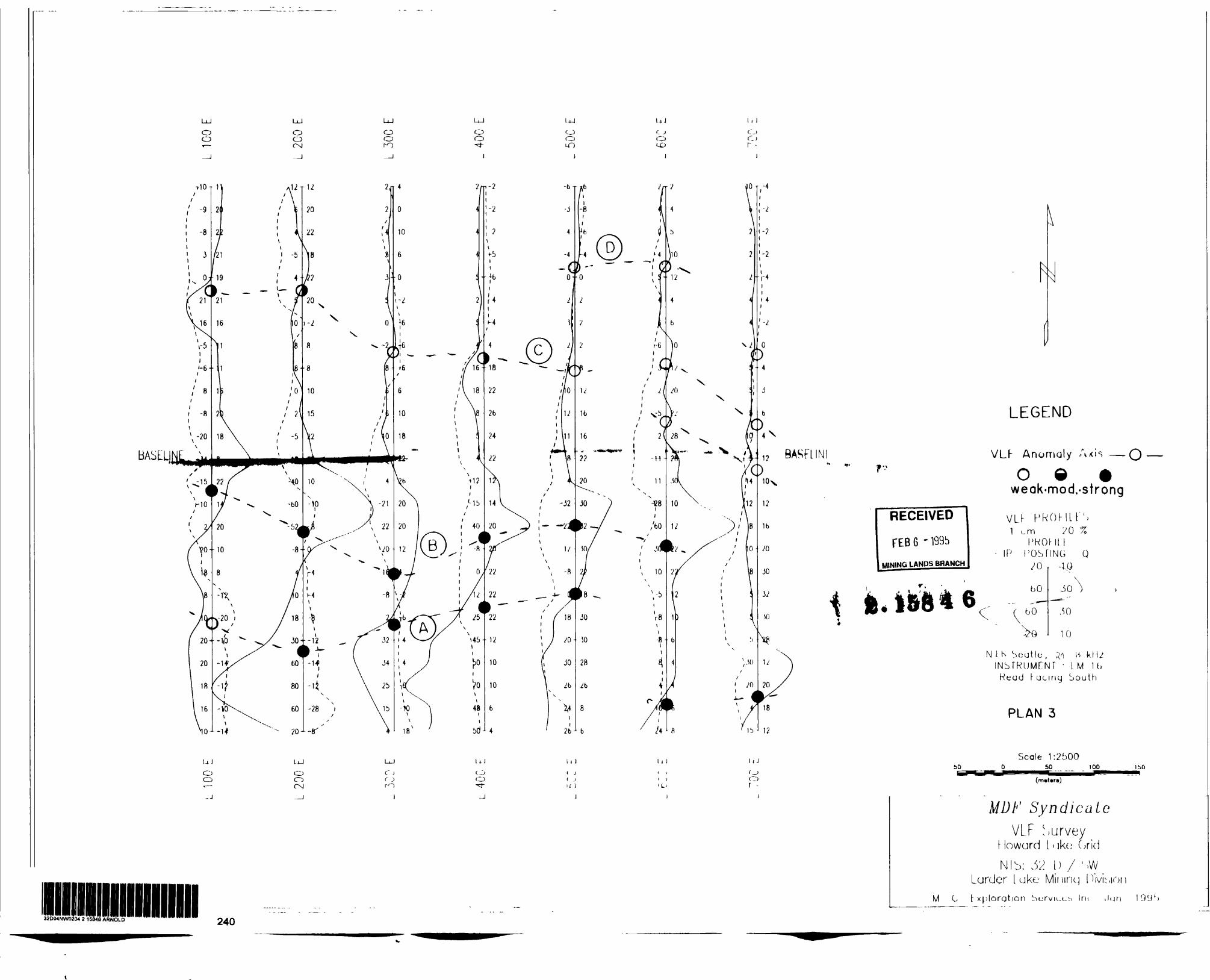
7.3 VLF-EM Survey
Several east-west trending VLF-EM anomalies encountered on the
Howard Lake Property varying from weak to strong are as follows:
15
Anomaly A:
A strong east-west trending VLF-EM anomaly occurs on the southern
flank of the magnetic anomaly over a strike length of 450 metres
from the western boundary of the property to near the eastern
boundary of the property at approximately 1+50S to 2 + 25S from
line 1+OOE to 5+OOE. A possible faulted eastern extension of the
anomaly occurs on lines 6+OOE and 7+OOE at 2+75S (Plan 3). The
anomaly is partly in Howard Lake and partly on the west shore of
Howard Lake.
Anomaly B:
A strong east-west trending conductor occurs on the southern
flank of the magnetic anomaly over a strike length of 550 metres
from the western boundary of the property to near the eastern
boundary of the property (Plan 3). The VLF-EM conductor is partly
in Howard Lake and partly on the western shore of Howard Lake.
Anomaly C:
A weak to moderate conductor trending east-west occurs on the
northern flank of the magnetic anomaly from line 1+OOE to 5+OOE
at 1 + 75N to 1+OON (Plan 3). The anomaly is partly in Howard Lake
and partly on the west shore. A possible faulted weak eastern
extension of the VLF-EM anomaly occurs on lines 6+OOE and 7+OOE
at from 0+00 to 1+OON. This eastern extension is partly in Howard
Lake and partly on the eastern shore of Howard Lake.

16
Anomaly D:
A weak VLF-EM conductor trending east-west occurs in the
northeastern part of the property from line 5+OOE to 6+OOE at
2+OOE (Plan 3). This conductor is partly in Howard Lake and
partly on the eastern shore.

17
8.0 CONCLUSIONS AND RECOMMENDATIONS
Several weak to strong VLF-EM and magnetic zones have been
encountered on the Howard Lake Property. The VLF-EM conductors
are targets for gold mineralization that may represent structures
emanating off the Murdoch Creek Fault Zone. They may represent
extensions of the Broker's Fee Fault Zone, 2 km to the east that
has gold and sulphide association.
The main magnetic feature 300 metres by 100 metres is located on
the central part of the grid between lines 2+OOE to 5+OOE at from
0+25S to 0+75N appears to be caused by a magnetic intrusion of
mafic or kimberlitic composition. This property lies within an
area of a kimberlite field.
Geological mapping and geochemical humus sampling over the VLF-EM
conductors on the east and west shore of Howard Lake would help
to determine the gold potential.
Till sampling of the glaciofluvial deposits on the west side of
Howard Lake and a gravity or IP resistivity survey would help to
determine if the magnetic body is kimberlitic.
Respectfully submitted,
F. J. Sharpleyey

9.O REFERENCES
18
EMR (1981)
GSC (1993)
GSC (1993)
GSC (1993)
GSC (1993)
Jensen L.S. (1983)
ODM (1962)
ODM (1971)
ODM (1979)
OGS (1978)
Topographic Map: 32D/4 Larder Lake 1:50,000
Map C25049G CarteMap of Apparent Conductanceof Bedrock ConductorsBlake River Syncline, OntarioScale 1:50,000
Map C25050G CarteMap of Apparent Conductanceof Bedrock ConductorsBlake River Syncline, OntarioScale 1:50,000
Map C20369G Carte Magnetic Anomaly Map (Residual Total Field) Blake River Syncline, Ontario Scale 1:50,000
Map C20370G Carte Magnetic Anomaly Map (Residual Total Field) Blake River Syncline, Ontario Scale 1:50,000
and Langford F.F.Geology and Petrogenisis of theArchean Abitibi Belt in the Kirkland LakeArea, Ontario; O.G.S.-O.F.R.-5455.
Preliminary Geology Map No. P.178 Arnold Township, District of Timiskaming 1:15,840
Geological Compilation Map: ODM Map 2205 l"* 4 miles: 1:253,440
Kirkland Lake Data SeriesArnold TownshipPreliminary Map P.894(Rev): 1:15,840
Quaternary GeologyKirkland Lake AreaLarder Lake Mining DivisionPreliminary Map P.2479 t P.2492; 1:50,000

19
OGS (1979)
OGS (1982)
OGS (1962)
OGS (1979)
OGS-GSC (1959)
OGS-GSC (1951)
1994
(1986)
Quaternary Geology Larder Lake Area District of Timiskaming Preliminary Map P.2290 Scale: 1:50,000.
Map P.2480Drift Thickness Series Drift Thickness of the Larder Lake Area Scale 1:50,000
Map 2061Arnold and Katrine Townships,Geological Report No. 29,Timiskaming DistrictW.A. HoggScale 1:31,680
Preliminary Map P.2259 Kirkland Lake Area; Arnold Twp; Airborne Electromagnetic Survey; Total Intensity Magnetic Survey. District of Timiskaming
Aeromagnetic Maps 7084G - l"- 4 miles
Map 289G (Rev): Aeromagnetic Map Kirkland LakeTimiskaming District, Ontario Scale 1:50,000
Map 47G: Aeromagnetic Map Larder LakeDistrict of Timiskaming Scale 1:63,360
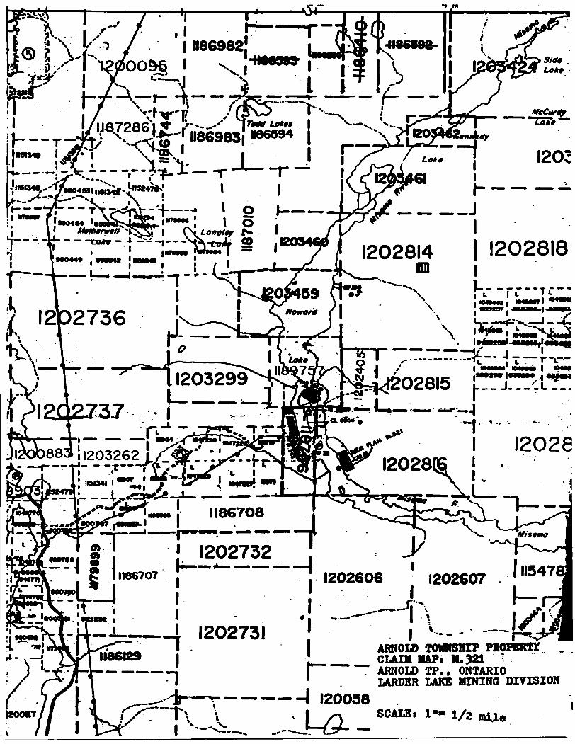
Claim Map: M.321: Arnold Township
Airphotos: 1:20,000 86-4808-02-71..75 86-4807-02-36..39

20
10.0 CERTIFICATE OF QUALIFICATION
I, Frederick Javes Sharpley of the City of Burlington, Province
of Ontario, do hereby certify:
1) That I aa a consulting geologist and reside at 2372 Sinclair
Circle, Burlington, Ontario, L7P 3C3.
2) That I graduated fro* the University of Saskatchewan,
Saskatoon, Saskatchewan, holding a degree of Bachelor of Arts,
Geology (1959).
3) That I aa a Fellow of the Geological Association Of Canada.
4) That I have practised my profession as a Mineral exploration
geologist for a period of 35 years.
5) That I personally was involved with the technical supervision
of the work and the report.
6) That I have a financial interest in the Howard Lake Property
in Arnold Township, Ontario.
\ Burlington Ontario
January 27,1995. F.J. Sharpley

21
APPENDIX I:
LIST OF FIGURES

ARNOLD TP. PROPERTYHOWARD LAKEKIRKLAND LAKE AREALOCATION MAPLARDER LAKE MINING DIVISIONARNOLD TOWNSHIP, ONTARIO
F.J.SHARPLCY
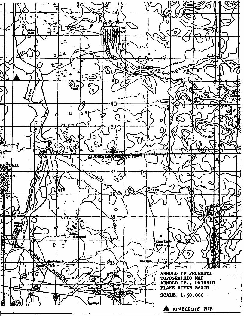
ARNOLD TP PROPERTY TOPOGRAPHIC MAP ARNOLD TP., ONTARIO BLAKE RIVER BASIN
SCALE: 1150.000
A KiMeeuire PIPE.
.T i"
--"l
l 1186982 -Haesee-
kr
McCurty "73**""
I2O2
'••0404 'M-1202814 l 1202818
OD j
!37 iJ203299 ,.i ^"" i
\
MnarlOTH*4*y*M
)883| 1203262 L/&-. t L^S- --.T—rv-,* lU X. ' *-151341 l
12028(6 !
lII867O8
O•\II867O7
•1202732 .l" - !*™" "~*""~" *"~ "™i
! ! 1202606 1202607
•MM
•!^*fri ^ i
J - *' 1202731 !
-—TA
I200U7 T\ l
7 — — —— A 120058
ARNOLD TOWNSHIP PROPERTY l_ CLAIM MAPt M.321 T l —— ~~ ARNOLD TP.. ONTARIO 1 LARDER LAKE MINING DIVISION
SCALBt

K/y
m O
l
\
7
..-jfOLD TP. PROPERTY AIRBORNE MAGNETIC MAP ARNOLD TP., ONTARIO LARDER LAKE MINING DIVISION BLAKE RIVER BASIN O.G.S. MAP P.2259SCALE. 11 20,000
,oo

Doui c -1 J
i
300^1
300*1
300C1
300Z1
30011
30011
30091
30011

BASE
LINE
ere*
.cre
ek
lm
BASC
UNEl
ere*
S
-N-
LEGE
NDTo
tal
Fitld
M
agne
tic C
onto
urs
Itvtl
t; lO
nT f
rom
575
90 t
o S7
B40f
lT
L*v*
l 2;
100
"T f
rom
576
00 t
o S7
800n
TS7
000n
T BO
M S
ubtra
cted
Data
fto
ngi;
5758
4 le
578
44nT
200
tom
pltt
with
o m
aon
of S
7740
nTB
at*
Stat
ion
; So
uth
of G
rid I
n bu
ih57
750
Nano
Tula
Raf
crtn
e* F
l*ld
INST
RUM
ENTS
OMNI
IV
PPM
- 35
0.
porta
ble
unit
OMNI
IV
PPM
- 40
0. b
a*a
notio
n un
it
PLAN
Z 1:25
00
UDF
Synd
icat
eM
agne
tic S
urve
y Ho
ward
Lake
Grid
NTS:
32-D
/ S
W La
rder
Lak
e Mi
ning
Divis
ionM
. C.
Exp
lora
tion
Sorv
teoi
Inc
. Ja
n.
1995
.

r
8
BASE
LINE
8l
N-
LEG
END
VLF
Anom
aly A
ils —
Q-
O
9
9
wtok
-mod
.-ttro
ngVL
F PR
OFIL
ES
l em
. B
20 X
PROF
ILE
•- I
P PO
STIN
G O
- -
- -2
0,
NIK
Sta
tic, M
.tg
kH
i.IN
STRU
MEN
T :
EM 1
6Re
ad F
acin
g So
uth
PLAN
3
Se*
t:290
0
UD
F S
yndi
cate
VLF
Surv
ey
. llu
wunj
Late
God
NTS
32-0
/ S
W
Lvda
r La
te M
Wng
Divi
sion
M.
C.
dptw
vUon
S*f
vte*
* In
c. J
an.
1995
.

8
BASE
LINE
:BA
SELIN
E
-N-
LEG
END
FRAS
ER F
ILTER
PRO
DUCT
S
Cont
our
Inttr
volf
liv
tl
l; l O
X.
from
O t
o 10
8X
L*v*
l 2;
l O
CX.
from
O t
o 10
0X
168
colc
ulot
id t
ompl
ti Do
te R
ang*
: -1
31 t
o 10
8X
Scot
t*.
INST
RUM
ENT
: EM
16
R*od
Fac
ing
Sout
h
SSc
ot*
1:28
00
UDF
Synd
icat
eVL
F Su
rvey
Ho
ward
Lak
e Gr
idNT
S: 3
2-D
/ S
W
Lard
er L
ake
MM
ng D
ivisio
nM
. C.
Exp
lora
tion
Sorv
lcM
Inc
. Ja
n.
1995
.

22
APPENDIX II:
INSTRUMENT SPECIFICATIONS
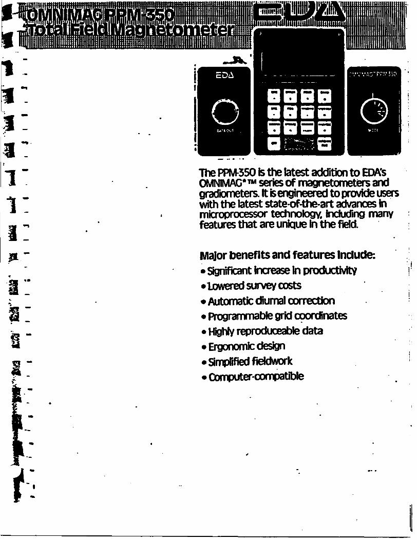
The PPM-350 is the latest addition to EDA's OMNIMAG*™ series of magnetometers and gradiometer*. It fe engineered to provide users with the latest state-of-the-art advances hi microprocessor technology. Including many features that are unique In the field.
Major benefits and features Include:* Significant Increase In productivity*lowered survey costs* Automatic diurnal correction* Programmable grid coordinates* Highly reproduceable data* Ergonomfc design* Simplified fieldwork* QxTiputer-compatible
t

jcificationsDynamic Range SensitivityStatistical Error Resolution Standard Memory Capacity Absolute Accuracy"
Display Resolution -Capture Range
'Display-
3radient Tolerance "sensorm *
-Sensor Cable-Dperating Environmental Range
^ppwer Supply
-Battery Cartridge Life
-Weight and Dimensions fcStrurr^tOxiscteorJy
- lead Add Battery Cartridge. Sensor
System Complement
18.000 to 93.000 gammas±0.02 gamma0.01 gamma1383 data blocks or readings± 15 ppm at 230C.50 ppm overthe operating temperature range '0.1 gamma±25*, relative to ambient field strengthofbststoredvalue Custonvdeslgned. ruggedized Iquid crystal display with an operat Jig temperature range from -35DC1C to
5.000 gammas per meter Optimized miniature design.
- Magnetic cleanliness k consistent with thespedfiedabsoluteaccuracy Remains flexible In temperature range; Indudestow strain connector -SS^C to *550C; 0-100* relative humidity; weather-proof Non-magnetic rechargeable sealed lead add battery cartridge or belt; or. Disposable tT cen battery car-t ridge or belt ^ 2.000 to 5.000 readings, depending upon ambient temperature ana rate of readings3.4 kg. 238 x 150 x 250 mm1.2 kg. 56 mm diameter x 200 mm Electronics console; sensor with 3-meter cable, sensor staff ; power supply; harness assembly; operation manual.
EDA Is a pioneer In the development of advanced geophysical systems and has created many innovations that Increase field productivity and tower survey costs.EDA's OMNIMAG series consists of the PPM-350 Total Held Magne tometer. PPM400 Base Station Magnetometer, and the PPM-500 Vertical Gradiometer. Contact us now f or details.
f ''
i:t D A iwtnimefitt fc*. llhorncVfe Park dive
1C9
toUSA O A instrument* toe.i t
4S0681DVI

VLF Electromagnet!" Unit
Pioneered and patented exclusively by Geonics Limited, the VLF method of electromagnetic surveying has been proven to be a major advance in exploration geophysical instrumentation.
Since the beginning of 1965 a large number of mining companies have found the EM16 system to meet the need for a simple, light and effective exploration tool for mining geophysics.
The VLF method uses the military and lime standard VLF transmissions as primary field. Only a receiver is then used to measure the secondary fields radiating from the local con ductive targets. This allows a very light, one-man instrument lo do the job. Because of the almost uniform primary field, good response from deeper targets is obtained.
The EM16 system provides the in-phase and quadrature components of the secondary field with the polarities indicated.
Interpretation technique has been highly developed particularly lo differentiate deeper targets from the many surface indications.
Principle of OperationThe VLF transmitters have vertical antennas. The magnetic signal component is then horizontal and concentric around the tiansmitter location.
SpecificationsSource of primary field
Transmitting elation* used
Operating frequency rang*
Parameters measured
Method of reading
Scale range
Readability
Reading timeVLF transmitting stations.
Any desired station frequency can be supplied with the instrument m the form of plug-in tuning units. Two tuning units can be plugged in at one time. A switch selects either station.
About 15-25 kHz.
(1) The vertical in-phase component (tangent of the tilt angle of the polarization ellipsoid).(2) The vertical out-of-phase (quadra ture) component (the short axis of the polarization ellipsoid compared to the long axis).
m-phase from a mechanical inclino meter and quadrature from a calibrated dial. Nulling by audio tone.
In-phase ± 150*: quadrature ± 40*. Shipping weight
10-40 seconds depending on signal strength.
Operating temperature range —40 lo SO* C.
Operating controls
Power Supply
Dimensions
Weight
Instrument supplied with
ON-OFF switch, battery testing push button, station selector, switch, volume control, quadrature, dial ± 40*. inclinometer dial ± ISO*.
6 size AA (penlight) alkaline cells. Lite about 200 hours.
42 x 14 x 9 cm (16 x 5.5 x 3.5 in.)
1.6kg(3.5lbs.)
Monotonic speaker, carrying case, manual of operation. 3 station seleclc plug-in tuning units (additional fre quencies are optional), set of batlerir
4.5kg(10lbs.)
.Figure?
l IMITFD Designers 4 manufacturers LIIVIIICL7 of ge0physiCal instruments
f.u!;5idia ry o!
2Thorncliffe Park DriveToronto/Ontario/CanadaM4H 1H2Tel: (416) 4751821

Ontario
. .Report of Work Conducted*** ** j. *** *After Recording Claim
MMngAct
M*!A — — -**-a i Jin aa ahft*-*-^ K a* iBa a i Jarl **t MfcA fftx-M alai ni •lnw ocMocuon snouNi DO OHVCMG 10 mv t*rawincMi Sudbury. Ontwio. P3E 6A5. tataphone (705) 670-7264.
Hljil^n i jJ fclrtj^haaai ff^^*^Ml*MMM**^ — ̂ JMwimry ov nonnoni UBVMOpnwni •no^MMV^^MM^M^B^MM^M ^^^B^dldUKA — *- —- -*
^-..—jfc. ••|n — — . 4 KA ^^— -*— — Qj, a a *rounn r nor, i9v wKMf onvot,
Instructions: - Please type or print and submit in duplicate.- - Refer to the Mining Act and Regulations for requ
Recorder. ,- A separate copy of this form must be completed- Technical reports and maps must accompany thfc- A sketch, showing the daims/the work is
.2.1584 6
32O04NWO2O4 2.15846 ARNOLD 900
* — * Jt * *
f fo/Cr-iJfpkfVfonS ti/hl
Sir*S*it- dyft *ifaffMhiplAreti
OnQho L IP SCZ
r U ArnoldorOA/3AI
Work Performed (Check One Work Group Only)Work Group
l/ Geotechnical Survey
Physical Work, IndurJaig Drilling
Rehabiitation
Other Authorized Work
Assays
Assignment fixunReserve
Type
/fao/ltffrm^Te/' ISL.F-fW ate/ Line Cv'fttnoJ f
RECEIVED
FEBG -1895
MIMtri'J- Lfilir*'- BRANCH
Total Assessment Work Claimed on the Attached Statement of CostsNote: The Minister may reject for assessment work credit aN or part of the assessment work submitted if the recorded
holder cannot verify expenditures claimed in the statement of costs within 30 days of a request for verification.
Persona and Survey Company Who Performed the Work (Give Name and Address of Author of Report)Name Address
flrt- 2*1 Of/ foStCO'/o J t Of/
(atiach a schedule If necessary)
Cai lineation of Deneflclal Interest * See Note No. 1 on reverse side
For Office Use OnlyTotal Value Gr. Recorded
^344,0.
Received Stamp
- -- ; . - -.-^-. -.-- .; i.. . TJ,' .!
' " 'i "" le*1 4--•-.l i! J. 1J,3

il
l
OD J)
l!
•si
fi
li
tA*
?T
tAl 0-*
O
*l 1
~(Al
O
8
S**Value of
MMMTMfltfork Done this Claim
Mf
Credits you are claiming in this report may be cut back. In order to minimize the adverse effects of such deletions, ptoase indicate from which claims you wish to priorize the deletion of credits. Ptoase mark (*) one of the following:1. IB Credits are to be cut back starting with the claim listed last, working backwards.2. D Credits are to be cut back equally over all claims contained in this report of work.3. D Credits are to be cut back as priorized on the attached appendix.
In the event that you have not specified your choice of priority, option one will be implemented.
Hotel: Examples of beneficial interest are unrecorded transfers, option agreements, memorandum of agreements, etc., with respect to the mining claims.
Note 2: If work has been performed on patented or teased land, ptease complete the following:
l certify that the recorded holder had a beneficial interest in the patented or leased land at the time the work was performed.
Signature Dsto
Ministry ofNorthern Development
OntarioMinisteredu DoVeloppeffiont du Nord ei des mines
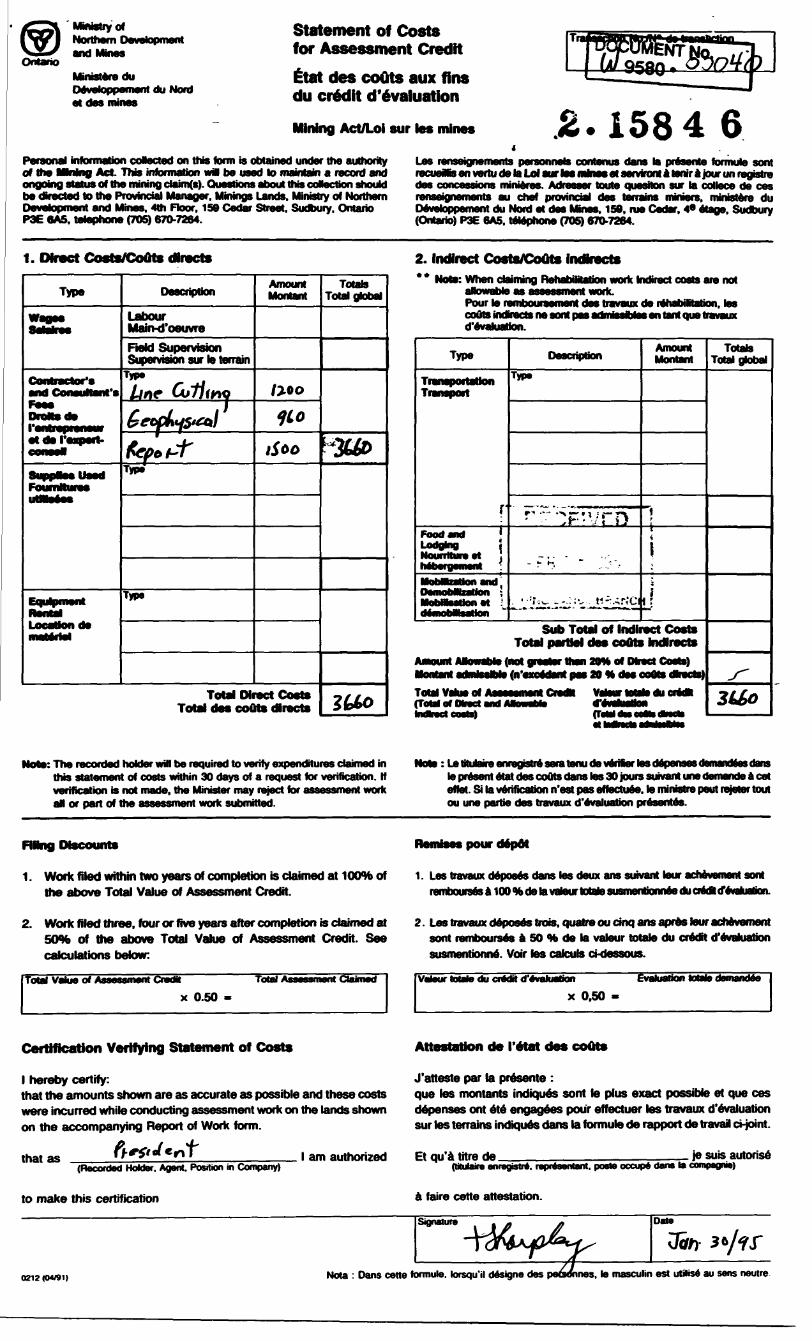
Statement of Costs for Assessment CreditEtaft des coOts aux fins du credit d'evaluation
Mining Act/Loi sur tes mines 1584 6PeraonaJ infonnabon cokected on this term is obtained under the authority of the MMng Act This information w* be used to maintain a record and ongoing status of the mining daim(s). Questions about this cofection should be directed lo the Provincial Manager, Mmmgs Lands, MifMStry of Northern Development and Mines. 4th Floor. 159 Cedar Street. Sudbury. Ontario P3E 6A5. telephone (705) 670-7264.
Les renseignements personnels contents dans la presente formule sent recueMs en vertu de la Ld sur toe mhw* et serviront a tenir a jour un registre des concessions minieres. Adrasser toute question sur la collece de ces renseignements au chef provincial des terrains miners, ministere du Devetoppement du Nord et des Mutes. 159. rue Cedar. 4* etage. Sudbury (Ontario) P3E 6A5. telephone (705) 670-7264.
1. Direct Costs/Gouts directs
Type
and ConeuManfe
Location de
Description
Labour Main-d'oeuvreField Supervision Supervision sur te terrain
TypeLtne "fr
Type
Type
Amount Montant
rfoo
Total Direct Costs Total des couts directs
Totals Total global
2. Indirect Costs/CoOts indbects** Note: When claiming RehabiMaJion work Kfin tare not
Pour le rembouraement des travaux de rehabiMaten, les coOla mdvects ne sort pas admisstoles en tent que travaux d'evaluation.
Type
Transportation
Food flnd Lodging
D68cnpbonType
Amount Montant
l
Sub Total of Indirect Costs Total partJel des eouts hndlrects
t (not jraelir than 20* of Direct Coats)
Total Value of (ToM of Otact end
Totals Total global
Note: The recorded holder will be required to verify expenditures claimed in this statement of costs within 30 days of a request for verification. If verification is not made, the Minister may reject for assessment work al or part of the assessment work submitted.
: tetituWre enregstre seratenu de verifer les depsraesdernandeas dans le present etat des couts dans tes 30 jours suivant une demande a cet effet. Si la verification n'est pas eftectuee. to ministre paul rejetertout ou une partie des travaux d'evaluation presentto.
HMng Discounts
1. Work filed within two years of completion is claimed at 10OTb of the above Total Value of Assessment Credit.
Remises pour depot
1. Les travaux deposes dans tes deux ans suivant tour achevamant sort rembourses a 100 to de ta vateur Mate susmenbormee du crtdl devaluation.
2. Work filed three, four or five years after completion is claimed at 50* of the above Total Value of Assessment Credit. See calculations below:
Total Value of Assessment Credit Total Assessment Claimed
x 0.50
2. Les travaux deposes trois. quatreoucinq ans apres tour achevement sort rembourses a 50 H de la vaJeur totale du credit d'evaluation susmentiorme. Voir tes calculs ci-dessous.
Vtfeur toMe du crtdH d'evaluMionx 0.50
Certification Verifying Statement of Costs
l hereby certify:that the amounts shown are as accurate as possible and these costs were incurred white conducting assessment work on the lands shown on the accompanying Report of Work form.
that as(Recorded Holder. Agent Position in Company)
to make this certification
Attestation de I'etat des coOts
J'atteste par la presente :que tes montants indiques sent te plus exact possible et que ces depenses ont ete engagees pour effectuer tes travaux d'evaluation sur tes terrains indiques dans la formule de rapport de travail ct-joint.
l am authorized Et qu'i titre de . je suisautoris6(Hulaire enregistre. repntoentant. poste occupe dans la compagnw)
faire cotte attestation.
0212WVU91) Nota : Dans cette formute. kxsqu'il designe des to masculin est utiNse au sens neutre

VMiUB OF A88B88MBMT WORK PERFORMED OH MIMIMO CLAIMS
MAY 08, 1995FILE NUMBER 2.15846TRANSACTION MO. W9580.00040
CLAIM NUMBER VALUE OF ASSESSMENT WORKDOME OH THIS CLAIM
L-1189757 93,480.00
TOTAL 93,480.00

OntarioMinistry ofNorthern Developmentand Mines
MinistereduDeveloppement du Nord et des Mines
Geoscience Approvals Office 933 Ramsey Lake Road 6th Floor Sudbury, Ontario P3E 6B5
Telephone: (705) 670-5853 Fax: (705) 67O-5863
May 10, 1995 Our File: 2.15846 Transaction /: 9580. 00040
Mining RecorderMinistry of Northern Development St Mines4 Government Road EastKirkland Lake, OntarioP2N 1A2
Dear Mr. Spooner:
RE: APPROVAL OF NOTICE OF REDUCTION ISSUED FOR ASSESSMENT WORK REPORTED OH MINING CLAIM L-1189757 IN ARNOLD TOWNSHIP.
As discussed with Mr. Sharpley by phone on May 29, 1995, he will receive full assessment credit for the report and only be reduced by the value of the line-cutting, magnetometer and VLF survey performed on the island (0.4km). Accordingly, this resulted in a $180.00 reduction from the original submission.
Assessment work credits have been approved as of May 08, 1995 as outlined on the attached distribution of work form. The credits have been approved under Section 14 (Geophysical) of the Mining Act Regulations. Please contact the Mining Recorder in order to redistribute the allowable assessment credits.
If you require additional assistance in this matter please contact Steven Beneteau at (705) 670-5858.
ORIGINAL SIGNED BY:
Ron C. GashinskiSenior Manager, Mining Lands Section Mining and Land Management Branch Mines and Minerals Division
SBB/jl Enclosure:
cc: Assessment Files Office s Sudbury, Ontario
Resident Geologist Kirkland Lake, Ontario

ri i M
k) C/1
Q
O
THE INFORMATION THAT APPEARS ON THIS MAP HAS BEEN COMPILED FROM VARIOUS SOURCES, AND ACCURACY IS NOT 'V* '*NTEED THOSE
IG TO STAKE MIN- CLAIMS SHOULD CON-
WITH THE MINING HtCOHUEH, MINISTRY OF NORTHERN DEVELOP MENT AND MINES. FOR AD DITIONAL INFORMATION ON THE STATUS OF THE LANDS SHOWN HEREON
rtro^^t
ci
O)
32DQ4NW0204 2 158-16 ARNOLD
Clifford Twp. l M. 338)
l M M l MM
l v i
j 1205595 J 1205596 l 1205424 1203452
-i M 1203423 v j"~ — — —r ~~ ~~ ~~ ^- — H
12028194M
l 1186962
1205598,——4—p- ——
- ____J
12028181202814inn——————
T —r-L--iI04IM4 I04MM l I04MTO i
IMW** tMMI l M4M7,l 1203299 JJ2Q28I5I —— ....*{ ^1202737 r."
— — —! wu4 120281712028^
, l II54783V1202607
li-± ____ 120273111 HI,.; ii. Ylfi- —
— --~— — -l 1200584
1186228 II862J'9
i! M
h
ro ^ci
h-
cuc
M
Gauthier l wp.(M 3f
!
COPY OF THIS MYLAR ARCHIVED APR.08/92
IN ( IH( HI A l li 'N Mil T
NOTICE
200
l Ml. ' OWN iHir/AKI A l All 'i Wl l I1IN III!!lMl:.h AMINi, MANAi.tMhNI i INI l AMI' WAV HI
MIMIM l fuM'UI i l H f Od KA IK 'NS
l Ml MNH l INN t OKhSll H l iiH l Ml , AHt A ( AN 111
t ONIAt IK) Al / K O BOX 129 SWASTIKA ON T
ARUhVfD APR IB.
M l i o W N ̂ M i P
ARNOLDTIMISKAMING
l AKI)! R l AKFMININ* . I )l vi 1 IO^
RECEI
FEBG -
MINING LAND!
x .Al l- 1 li 4c ) ( l IAIN: ,
t'A.CNKD . AN)' i fi J*N l *Nr. SA i
l l ASfcSl t/CATtl) l AND i l E.NM Of (KCLM A
u HH.MTS UNl iHlwUli ONl i
HOADbiM^TOVI I; KOA0S KINO'S UK, H W AY b
W Alt WAYS POWER 'NL
(P)
O
f 1 1 i-nN l Mlkl AI l i i H i urn Y
NCHHS
l H' Hill tj (i Jli| r . j, 111,, i, iu M , th. li ' i l
'i luKii in l li i '
wild'ii c
i. M. -
No
from .tolinr) 'ralei S*' l|oii
A, t (fi l . ^ l')8" )
Dot*
HIGH l S WlnuRAWN FROM STAKING
SECTION 43 ORDER (R.SOI97O) FILE NO 163497
Rir.urs WirHORAWN FROM STAKING StC f ION 43 ORDER (HSOI97O) NONR W 12/73
-61 AKtN4,**e(lt,f. Jb/HU order MO ORDER NO r 54/Ofl OPl-.NS
SURFACE t MINING RICH l S WITHDRAWN FROM ST AKINO.s.cllon Ib/HO OROFK NOW/33/88NR 0-07/881 OPENS W-35/B8NH
IIJTl |lROI 'ostl) t
Mirlirl'i H '11.1.11 '••llvK'l WIIMl'K/.n/lJ f HkM ' ""Alxll''st i HUN j' inf. MINING AC.T nijd i'f'0, w i 'i'. /'.it r/i H
PI AN NO M.32!MINISTRY OF
NORTHERN DFVLL
A If' MINES
/ED
995
BRANCH
'i
h-~~i-*m \f
rr

ro o
cree
k -1*2
to c* 00 Od 'c'c
r'
eli
Wcg
ne'
: C
sMoj-s
le**
',
'0*i
T ••
crt"
5759
C t
o 5
79
*0-'
Leve
i 2,
'0
3"*
f 'O
f 57
60:
is 5
78
00
-'
5709
0r~
Bose
Sub
'rcc'
etf
Dot
s R
ange
, E7
594
-c s^B
^n*
200
soTi
pies
*itK
o w
\egn
of
577^0
-'
Bcs
e S
ts'ic
- ,
SO
L'I
o' G
rid i
n
OWN
IV "w
-
35C,
po
rlobl
e OW
N 'v
'PM
- 4
0:,
fres
e s'.
otio
"
P LA S
2
Sen
* -
ZSOC
____f
It DF
Synd
icat
eM
ao"e
~ c
S'-""
ve.'
K* G
nc
VL F
- E
MS"
5 32
-: /
' SVi
V
Z It
s z-f
o-
5*-v
i:es
in:
JO
T 93
:

o o
CD O CN
CD CD O
LjJ
i- J OLO
UJ
C.) CD CO
J
Howard Lake"
BASELINE
CO
32D04NW0804 2 16846 ARNOLD
UJ
l
\
BASL-LINt
RECEIVED
FEB G -1995
MINING LANDS BRANCH
6.15846
LbGhND
Claim Post Location
ri50
1 2bOO50 100 1bO
(meters)
'' SyndicatePicket Line M(\ lowurd l (ike C,r
NIV .5? h X S' Larder 11 jke Mining
M L Exploration Service b ne Jan
220

11 l L j. J Li J U J
BAbELINL
T 81/2 i i i i i i i i i i f y 682~ l l li li i l i f i /f i i i i i i i i i i ' i i i i i i i i i 'i i i i i i i i l i i i i i i i i i
' ' s x i i i i i l i i ' , r v 7 '///iiiiilil 1 , ' i '^MMy/'/s&m
Kb/ ','
WJV \f M^.8 ) H )l
l l \ \ \' -L 10 \ \ \ \ ^ J ' J
creekl l i
l 1
..j
reek
BASFIINFLU
RECEIVED
FEB G - 1995
MINING LANDS BRANCH
Total Field Magnetic Contours
evel 1; 10nT from 57590 to 57840nT
evel 2; 1 OOnT from 57600 to 57800nT
57000nT Base Subtracted
Data Range; 57584 to 57844nT
200 samples with a mean of 57740nT
^Jise Station ; South of brid m bush
57750 NanoTet.la Keferenc.e Field
INSTRUMENTS
OMNI IV PPM - 350, portable unit
OMNI IV PPM 400, base station unit
PLAN 2
Scale 1 2bOOO 50 100 150
M c.
(meters)
MD F SyndicateMagnetic SurvHoward Lake C^r
NTS: 52 D 7 SW L(]rder Lake Mining Division[ xploration Scrvu^;:* Iru, Jcin 995
230
o o
CD CD CN
CD CD
O O
L-U
CD OLO
J
UJ
C. J COCO
l
111f" l C jr -
j
BASEL J 12 BASFLINI
UJCI) CD
UJ
CDCDCN
_ 1
UJC" 1
f )rO
J
UJ
CO(~t•^r.j
i i J
32DMNW0204 2 16846 ARNOLD 240
c jjr -
RECEIVED
FEB 6 -
MINING LANDS BRANCH
t.
LEGEND
VLf- Anomaly Axis —Q
O 9 0weak-mod.-strong
VLF PKOULf) 1 cm ?0 %
f'KOMI l )SflNG Q
-10
bO
.so10
N l S Scotle w kH/ ' l M 1 b
K ea d Facing South
PLAN 3
Scale 1:2bOOO 50 100
M L
IbO
(maters)
'MDP SyndicateVLF Survey
Howard L uke Grid
Nib: S2 [} 7 'AA/ Larder luke Mining Pivii.iorExploration burvu.L.^ Iru .lun

o o CD CD CN
CD Or-O
UJOCD
. J
UJ
CD Cjin
i
CD CDto_l
O O
BASELINE
\
BASELINE
RECEIVED
FEB G -1995
MINING LANDS BRANCH
LEGEND
KRASER l ILUR PKODUCIS
Contour Intervals. Level 1, 10%. from O to ]QQ7e, level ?; 100%, from O to 1005S
168 culculoted samples Duta Range, -1J1 to
Seatle, Jl^ . 6 kHz
INbTKUMENT EM Ifa Read Facing South
i>
CD CD
250
CD CDCN1
U l
CD CDCD CD
LTJ
CD CD CO
li l
CD CDr
soScale 1:2500
O SO 100 150
MDF SyndicateVLF Survey
Howard Lake GridNFS: '62 D 7 SW
Larder Lake Mining DivisionM. C. Exploration Services Inc. Jan. 1995