explanatory booklet on the reconnaissance soil map of
TRANSCRIPT

HAL Id: hal-00504755https://hal.archives-ouvertes.fr/hal-00504755
Submitted on 21 Jul 2010
HAL is a multi-disciplinary open accessarchive for the deposit and dissemination of sci-entific research documents, whether they are pub-lished or not. The documents may come fromteaching and research institutions in France orabroad, or from public or private research centers.
L’archive ouverte pluridisciplinaire HAL, estdestinée au dépôt et à la diffusion de documentsscientifiques de niveau recherche, publiés ou non,émanant des établissements d’enseignement et derecherche français ou étrangers, des laboratoirespublics ou privés.
Explanatory booklet on the reconnaissance soil map offorest area – Western Karnataka and Goa
G. Bourgeon
To cite this version:G. Bourgeon. Explanatory booklet on the reconnaissance soil map of forest area – Western Karnatakaand Goa. Institut Français de Pondichéry, 96 pp. + 2 annexes dont 1 carte, 1989, Travaux de laSection Scientifique et Technique. Hors Série N° 20, Head of Ecology Department, Institut Françaisde Pondichéry, e-mail: [email protected]. �hal-00504755�

EXPLANATORY BOOKLET ON THE
RECONNAISSANCE SOIL MAP OF FOREST AREA
Western Karnataka and Goa
G. BOURGEON
1989
INSTITUT FRANÇAIS DE PONDICHÉRY Travaux de la Section Scientifique et Technique
Hors Série N° 20

ISSN 0073-8344 1st. edition 1989
© Institut Français de Pondichéry - INDIA Printed at All India Press, Pondicherry, INDIA

FOREWORD
The role of soil survey and mapping and soil classification in optimising utilisation of our limited soil resources have been emphasized at different times and from different platforms. However, adequate attention is still not being paid resulting in sub-optimum utilisation and / or irreparable degradation of this basic resource.
The ever-increasing food requirement for the growing population (at the rate of 2 per cent per year) in India demands optimum utilisation of soil resources through soil resource mapping and classification. This ever-increasing demand has been obliging us to bring more and more area under cultivation which was earlier under forest cover. This has been adding to our soil degradation problems. Therefore, there is an urgent need to halt this process of degradation.
The French Institute of Pondicherry has taken initiative in preparing soil map of forest area in the southern region of the country. The study will help not only to develop relationship between soils and vegetation but also in selecting suitable species which can grow well in these ecological settings.
The present attempt brings to light the Soil Map of Western Karnataka and Goa (on 1 : 1 million scale) supported by an explanatory booklet, as an excellent contribution towards resource mapping. The booklet has been very well written and shall help the land users to appreciate the intricacies of the formation, distribution, characterisation and classification of these soils.
I congratulate the authors for bringing out this publication to enrich the course of environmental studies in general and soil survey and mapping in particular.
Dr. J. L. SEHGAL Director
National Bureau of Soil Survey and Land Use Planning (ICAR)
Nagpur

PREFACE
This soil survey is the continuation of the vegetation studies undertaken by the French Institute, Pondicherry, within the framework of an agreement with the forest departments of the states concerned. This agreement specified the preparation of "a forest map at the scale of 1: 250,000 showing the actual state of the forest, their environmental conditions (climatic, edaphic, biotic, administrative) and their potentialities". The edaphic conditions being diverse and complex, they could not be considered while mapping the vegetation.
The means to overcome this lacuna was afforded to the French Institute by an accord with the "Ecole Nationale du Génie Rural et des Eaux et Forêts", an organization for advanced studies of the Agricultural Ministry of France. Pursuant to this accord and conforming to the wishes of the Indian forest departments, a modern laboratory for soil analysis was set up to work out the typology of forest soils and also to study the dynamics of organic matter and humus in forest ecosystems. The first stage of this research, i.e., the typology of forest soils, is presented here.
The typology of forest soils could have been a simple catalogue of profiles, such as for Benchmark soils; however, it seemed preferable to prepare a map and emphasize the existing relationships between soils and other characteristics of the physical environment through the cartographic method employed here.
The typology and cartography are original and not a compilation of existing works. In fact, the available data on the forest soils of India is very scanty, not to say non-existent, most of the pedological studies in India being carried out for agronomic purposes by organizations of the Ministry of Agriculture.
I should like to thank those persons who have helped at various stages in the preparation of this work, particularly Mr. S. SHYAM SUNDER, Principal Chief Conservator of Forests and many forest officers of the Karnataka Forest Department. I am also extremely grateful to Prof. G. PÉDRO and Dr. J. P. PASCAL who went through the first draft of the booklet and made many valuable suggestions.
Soils analyses were done by Messrs. P. ARUMUGAM, K. BALASUBRAMANIAN and G. ORUKAIMANI, drawings by Mr. A. G. PETRUS, technical collaborators at the French Institute and English translation by Mrs. K. THANIKAIMONI.
Clay determinations were carried out using X-ray diffraction and interpreted at the "Centre de Géochimie de la Surface" of CNRS, Strasbourg, France, by Mr. PH. LARQUÉ.
G. BOURGEON
CONTENTS
Foreword iii Preface iv List of soil profiles in the annexes viii
Chapter 1 Methods and Means 1 I. Choice of a cartographic method 1
A. Region to be surveyed 1 B. Conventional methods of soil mapping 1 C. Soil mapping in the framework of integrated resources
surveys 2 D. Morpho-pedological method 3
1. Definitions and concepts, 3; 2. Adaptations for small scale maps, 5; 3. Advantages of the morpho-pedological method, 5.
II. Survey procedure 6 A. Mapping of the different morpho-pedological landscapes 6 B. Choice of scale and precision of the map 7 C. Legend of the map 7 D. Analysis and description of soils profiles 8
Chapter 2 General Description of the Area 9 I. Bioclimatic features 9
A. Rainfall distribution 9 B. Temperature 9 C. Relative humidity 12 D. Potential evapotranspiration and water balance 12 E. Soil moisture regimes 12
II. Geological features 15 A. Precambrian shield 15 B. Proterozoic sandstones 16 C. Deccan Traps province 16
III. Geomorphological framework 17 A. General topography and river patterns 17 B. Brief outline of the geomorphological history 17
1. Mesozoic events, 20; 2. Cenozoic volcanism and sedimentation, 20; 3. Late Tertiary movements and erosion, 21; 4. Quaternary evolution, 21; 5. Conclusion, 21.
vi CONTENTS
Chapter 3 Morpho-Pedological Landscapes 22 I. The coastal area 23
A. Climatic features 23 B. Morpho-pedological subdivisions 23
1. Fluvio-littoral formations (Morpho-pedological landscape 1) 23; 2. Dissected hilly hinterland (Morpho-pedological landscape 2), 25.
C. Continuity in lateritization processes 28 II. The Western Ghats (Morpho-pedological landscape 3) 30
A. Climatic features 30 B. Morpho-pedological subdivisions (not mapped) 30
1. Escarpment of the Ghats, 30; 2. The foot of the escarpment, 32; 3. Residual hills in the coastal area, 33.
III. The back slope of the Ghats and the humid hilly area of the Karnataka plateau 34
A. Climatic features 34 B. Morpho-pedological subdivisions 34
1. Strongly dissected high level (Morpho-pedological landscape 4), 36; 2. Partially dissected intermediate levels on basalts (Morpho-pedological landscape 5), 39; 3. Partially dissected intermediate levels on greywackes (Morpho-pedological landscape 6), 40; 4. Partially dissected intermediate levels on gneisses and granites (Morpho-pedological landscape 7), 41; 5. Strongly dissected intermediate levels on greywackes (Morpho-pedological landscape 8), 41; 6 Low level (Morpho-pedological landscape 9), 42.
IV. The transitional area on the Karnataka plateau 46 A. Climatic features 46 B. Morpho-pedological subdivisions 47
1. Degraded intermediate levels with convexo-concave relief (Morpho-pedological landscape 10), 50; 2. Degraded intermediate levels with smooth relief (Morpho-pedological landscape 11), 51; 3. Rejuvenated intermediate levels with convexo-concave relief (Morpho-pedological landscape 12), 52.
V. The semi-arid area on the Karnataka plateau 53 A. Climatic features 53 B. Morpho-pedological subdivisions 56
1. Residual reliefs (Morpho-pedological landscape 13), 54; 2. Dissection reliefs on the Deccan traps (Morpho-pedological landscape 14), 54; 3. Glacis of the pediplain (Morpho-pedological landscape 15), 55; 4. Clayey basins and clayey terrace of the pediplain (Morpho-pedological landscape 16), 56.
Chapter 4 Weathering 58 I. Chemical weathering and origin of clay 58 II. Study of weathering and clays in the mapped area 59
A. Analyses done 59 B. Distribution of the different (geochemical) kinds of weathering in the area studied 60
CONTENTS vii
Chapter 5 Soils and their Classification 68 I. Introduction 68 II. Soil Taxonomy : concepts and definitions 69 III. Representative soil profiles according to Soil Taxonomy 72
A. Oxisols 72 1. Ustox, 72; 2. Udox, 73.
B. Ultisols 73 1. Humults, 74; 2. Udults, 74; 3. Ustults, 75.
C. Mollisols 76 Ustolls, 76.
D. Alfisols 77 1.Ustalfs,77;2.Udalfs,79.
E. Inceptisols 79 Tropepts, 80.
IV. French classification : concepts and definitions 82 V. Representative soil profiles according to the French classification 83
A. Skeletal and poorly developed soils 83 B. Vertisols 83 C. Brunified soils 83 D. Sesquioxisols 84 E. Ferrallitic soils 84
1. Subclass of weakly desaturated Ferrallitic soils in B horizon, 85; 2. Subclass of moderately desaturated Ferrallitic soils in B horizon, 85; 3. Subclass of strongly desaturated Ferrallitic soils in B horizon, 86.
F. Other categories 86 1.Intergraded soils between Ferrallitic and Fersiallitic soils, 86; 2. Polyphased soils, 87, 3. Brunified and acidified soils, 87.
Bibliography 88
Annexes I to CVIII

LIST OF SOIL PROFILES IN THE ANNEXES
Soil profile name Page
NITTUR II TSN 3 IV KARW 1 VI KANK 1 VIII SAK 1 X SAK 2 XII BHAT 6 XIV UPP 08 XVI SB 04 XVIII THIR 1 XX MERC 1 XXII BABA 01 XXIV GP 01 XXVI YELL 1 XXVIII KHAN 2 XXX BELG 2 XXXII NAGUR 2 XXXIV T. CAV 01 XXXVI SMSG 01 XXXVIII T 01 XL C 1 1 XLII BEL 3 XLIV KHAN 1 XLVI HLL 1 XLVIII SIDD 1 L KDKP LII
SONDA 4 LIV SIGGA LVI MERC 2 LVIII NRD 1 LX BHAT 04 LXII MAGOD LXIV KANK 2 LXVI GU 06 LXVIII GP 02 LXX SHIGG 1 LXXII HUBLI 1 LXXIV SHIR 1 LXXVI NAGUR 1 LXXVIII TSN 1 LXXX TSN 2 LXXXII SB 09 LXXXIV SONDA 1 LXXXVI BHAT 1 LXXXVIII KDK 2 XC DSG 1 XCII KANK 3 XCIV UPP 11 XCVI BHAT 10 XCVIII SRIN 1 C BHAT 5 CII KDK 4 CIV BEL 1 CVI

FIG. 1. Location map.

1
METHODS AND MEANS
I. CHOICE OF A CARTOGRAPHIC METHOD
For carrying out this study it was necessary to choose a method compatible with the objectives put forth in the preface: to establish the soil typology and specify the soil characteristics in such a way as to complement the vegetation studies. The method should also be adaptable to the available manpower and laboratory facilities. For diverse reasons which will be stated further on, the morpho-pedological method was preferred to other more classical methods.
A. REGION TO BE SURVEYED
The region to be surveyed covers an area of about 80,250 km2 in the western part of peninsular India between 11°30' and 16°N latitudes. This region includes a part of Karnataka, the State of Goa and very small areas of Kerala, Maharashtra and Tamil Nadu (Fig. 1 and "administrative divisions" inset on the Soil Map). In the south, the mapped region abuts the piedmont of the Nilgiri massif. It was mostly a forested area even if the forest cover has recently disappeared in many places. The available data about its pedological and geomorphological features are very scanty.
B. CONVENTIONAL METHODS OF SOIL MAPPING
A strictly pedological inventory of soils in a vast and little known area may be conducted in various ways. If one refers to the Soil Survey Manual (Soil Survey Staff, 1951), there is a choice between:
- the compilation of a schematic soil map from available documentation on the geology, climate, vegetation, etc, and also from existing pedological studies and descriptions reported by scientific travellers, and

2 RECONNAISSANCE SOIL MAP OF FOREST AREA
- the preparation of an exploratory soil map using original field work. Given the lack of available pedological data as already mentioned, the first kind of
map could not have been envisaged. There only remained the second type which led to the problem of plotting the boundaries: how to sketch strictly pedological limits over a vast territory with observations that were necessarily scanty.
This technical problem is solved in the case of strictly pedological maps, by having recourse either to associations of taxonomic units or to simplifications which are sometimes excessive.
Demerits of these Methods
The main weakness of these conventional methods is in not taking into consideration the fact that soils do not evolve independently of the other elements of the environment, but form a system with them. It will always be difficult for soil classifications, elaborate as they are, to express all the diverse and peculiar conditions occurring in the whole world. To-day it seems easier and more efficient to comprehend the soil through the landscape of which it forms a part, than by strictly pedological investigations. The new approach is that of integrated resources surveys where taxonomy is used later and only as a reference system.
C. SOIL MAPPING IN THE FRAMEWORK OF INTEGRATED RESOURCES SURVEYS
Several methods are available for conducting integrated resources surveys. All these methods are in harmony with a global ecological conception; some are better adapted for a good representation of pedological conditions than others.
All the methods delimit units which are considered as systems. The simplest method of identifying these units is by studying the landforms and their evolution, i.e., the geomorphology.
In practice, often only the first step is taken: delimiting the landforms and bringing out the topographic relationships between landforms and soils.
For example, in the mapped region, it can be seen that the Gopalswamy Betta slopes are covered with Brown Eutrophic soils.
Such a simplification, which only takes the static aspect of geomorphology into consideration, corresponds to studies on soil-physiography relationships (of which classic photointerpretation is an example). This approach is widely used. The paper by Pandey and Pofali (1982) may be referred to for examples of applications of this method in India.
As soils and landforms are narrowly correlated with a common history and their actual functioning is also quite interdependent, studies on their relationships can be

1 METHODS AND MEANS 3
more comprehensive. All these relationships will be taken into account by the morpho-pedological method.
D. MORPHO-PEDOLOGICAL METHOD
1. Definitions and Concepts
The morpho-pedological method was conceived (Kilian, 1972, 1974; Bertrand, 1972; Tricart, 1974) for soil mapping destined for development.
The cartographic unit is called a morpho-pedological unit. It is a geomorphological unit which corresponds to a soil type or a group of soils (Gaucher, cited by Bertrand, Ibid). The dynamics of each unit is expressed, in a slightly theoretical manner, by the idea of a morphogenesis-pedogenesis balance.
For example, on the slopes of Gopalswamy Betta in the semi-arid zone, the present pedogenetic tendency should be towards a Red Fersiallitic soil as it is in the case of the surrounding glacis, whereas we only observe a shallow Brown Eutrophic soil. Here it can be explained by morphogenesis, i.e., by rillwash, which by truncation of the upper part of the soil profiles, contributes to maintaining them in a juvenile state and prevents a more complete evolution. The balance between the fersiallitic pedogenesis and the active morphogenesis by rillwash results in a dynamic equilibrium represented by the Brown Eutrophic soil which remains shallow.
Although there was no mention of a scale, such morpho-pedological units generally correspond to elements of an interfluve. They are often differentiated along the slopes in catenae and hence the hydrographic network seems to be the main structuring element of the maps. In other words, they belong to a given spatiotemporal level, for example to the VI of Cailleux and Tricart's "Classification Taxonomique" (Tricart, 1965).
This can be seen in the numerous large or medium scale maps prepared by this method.
Examples of small scale maps are rarer and their scrutiny shows specific problems related to scale:
- representation of elementary morpho-pedological differentiations along the slopes is practically impossible,
- it also becomes very difficult to take the dynamic aspect into consideration and the establishment of a pedogenesis-morphogenesis balance is no more possible.
These problems arise because the change in the cartographic scale corresponds to a change in the spatiotemporal level. On a small scale, the definition of the morpho-pedological unit does not fit the cartographic units.
4 RECONNAISSANCE SOIL MAP OF FOREST AREA FIELD WORK SOIL MAPPING GENERALIZATION TO A SMALLER SCALE
A) MORPHO-PEDOLOGICAL METHOD
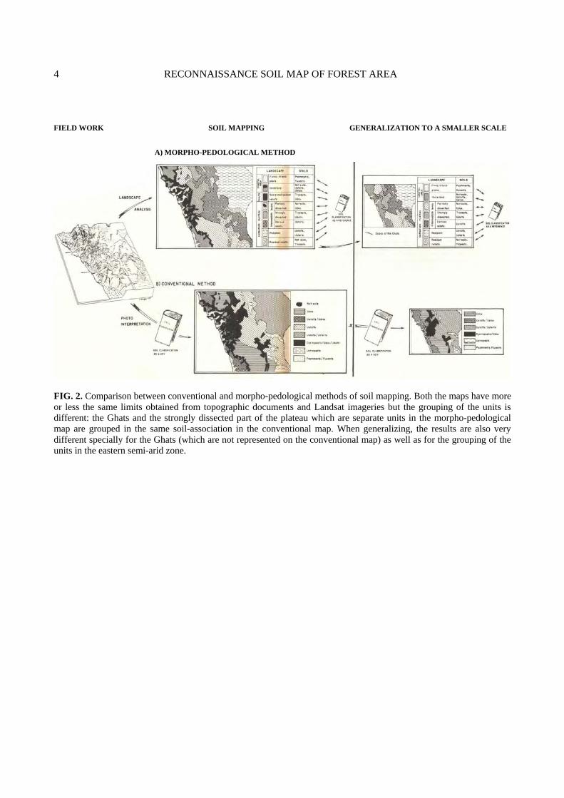
FIG. 2. Comparison between conventional and morpho-pedological methods of soil mapping. Both the maps have more or less the same limits obtained from topographic documents and Landsat imageries but the grouping of the units is different: the Ghats and the strongly dissected part of the plateau which are separate units in the morpho-pedological map are grouped in the same soil-association in the conventional map. When generalizing, the results are also very different specially for the Ghats (which are not represented on the conventional map) as well as for the grouping of the units in the eastern semi-arid zone.

1 METHODS AND MEANS 5
2. Adaptations for Small Scale Maps
Several authors have solved these problems in different ways. Their solutions show common features.
• In their cartography on the potentialities of East Senegal, Bertrand and Valenza, (1979, 1982) created a new cartographic unit called ecofacies which corresponds almost exactly to the morpho-pedological unit of medium scale maps. On their map, the ecofacies are arranged according to the hydrographic axes. They have also created the ecoregion, a much larger unit, which groups together several ecofacies. The ecoregion ignores hydrographic axes and dynamics is also not indicated. The zone studied by these authors is not very complex which has certainly enabled them to map the ecofacies at 1 : 500,000.
• Guillobez (1985), in his cartography of the natural milieus of Burkina-Faso, sketched out large structural domains (in the geological sense of the term). Pedogenesis and morphogenesis were indicated for each unit. The map is on the scale of 1 : 1,000,000; the units are independent of the hydrographic axes.
• Eschenbrenner and Badarello (1975, 1978) used two maps for their study on the Odienné region (Ivory-Coast). They prepared a classic morpho-pedological map at 1 : 50,000 and conceived a new type of map, which they call morpho-pedological landscapes map at 1 : 200,000. A morpho-pedological landscape is made up of several morpho-pedological units of the 1 : 50,000 map arranged in a given sequence for each landscape. In their explanatory booklet this generalization of a sequence of morpho-pedological units in a landscape is illustrated by schematic sections. Delimitation of the different morpho-pedological landscapes also ignores the hydrographic network.
Hence, at a small scale, the cartographic units are associations of morpho-pedological units of larger scale maps; their pedogenesis and morphogenesis are no more unique. The term morpho-pedological landscape seems the most appropriate for designating this type of complex unit and will be utilized here.
The dynamics and the functioning of the morpho-pedological landscape are of a magnitude different from those of each morpho-pedological unit constituting the landscape. On the map the dynamics of the morpho-pedological landscape will be shown in two ways:
- by taking into consideration the intensity of the dissection which has formed the landscape, and
- by indicating the nature of the present weathering.
3. Advantages of the Morpho-pedological Method
There are at least three kinds of technical advantages in the morpho-pedological method, as compared to the more conventional methods.

6 RECONNAISSANCE SOIL MAP OF FOREST AREA
a. Better rendering of the reality: this method which favours the natural soil (the soil of the landscape) as compared to the conceptual soil (the soil of the classification), takes into account, as much as possible, the actual complexity of nature (Fig. 2);
b. Facility of updating and of synthesis: freed of the constraints of using a soil classification as a key to sketch out the units, the morpho-pedological method also makes it possible:
- to easily update the map, if necessary, with the evolution of soil classification or if more data becomes available, for this it is enough to change some names of soils for which classification has been modified or to add the names of recently identified soils (whereas it would be eventually necessary to re-do the divisions on standard pedological maps).
- to simply change the scale for a synthesis (generalization, Fig. 2): the change of scale can be done respecting the natural structure of the physical environment in the case of a morpho-pedological map (in standard pedological maps this change would be by regrouping the cartographic units sometimes belonging to different milieux). It has also been shown above that the change of scale is not restricted to a given spatiotemporal level: several morpho-pedological units are combined in a morpho-pedological landscape in Eschenbrenner and Badarello's work;
c. Advantages for users: as the dynamics of the units are taken into consideration, it helps in estimating certain constraints for development (for example, risk of floods, ablation of soil by rillwash...) which are not pedological in nature.
It may be added that these maps can be drawn up relatively quickly and are also economical.
II. SURVEY PROCEDURE
A. MAPPING OF THE DIFFERENT MORPHO-PEDOLGICAL LANDSCAPES
The survey and delimitation of the different morpho-pedological landscapes is the most important and longest phase of the work done. They were achieved by a continuous "back and forth" between topographic documents and field data.
The geomorphological outline which serves as a framework for mapping the morpho-pedological landscapes is rather rough because it is limited by:
- the nature of the available data : scarcity of aerial photographs, antiquity and poor quality of some topographic sheets were the main obstacles (for example, the Ghats region in the proximity of Castle Rock could not be studied as well as the regions further south because of the lack of good topographic documents). At a larger scale these difficulties become insurmountable;
- the paucity of available data on the regional geomorphology : undertaking an important work within the framework of this study was out of the question.

1 METHODS AND MEANS 7
The documents used for sketching the boundaries were landsat satellite imageries at 1: 1,000,000 and 1: 250,000 and the available geological maps. Topographic maps at 1: 50,000 enable the precision of some details; at 1: 250,000, they show only the important reliefs such as the Ghats and were not utilized much.
The field-work was carried out by traversing roads and major forest tracks. The mapping units sketched with documents had to be verified and their pedological nature specified. Among the numerous cuttings observed, those that were judged to be representative were studied in detail and sampled. This field work also helped in identifying slight differences which could not be deduced from topographic documents.
For example, in the coastal zone, the intensity of induration by iron oxyhydroxides is linked to the nature of the rock but there is no indication of it in satellite pictures. As regards lithology, the geological map is also not detailed enough to permit the marking of these differences which are indicated only at the level of this explanatory booklet.
B. CHOICE OF SCALE AND PRECISION OF THE MAP
When the problem of choosing a scale arose, 1: 250,000 was excluded because very little data is available. The choice was between 1: 500,000 and 1: 1,000,000. Finally, for the reasons mentioned earlier, 1: 1,000,000 which is generally the scale used for studies of regional and national interest was adopted.
It should be noted that this scale is also the one chosen for the soil map of India, as planned by Murthy (1982). However, the method employed here differs greatly from the one preconceived by Murthy which states : "such maps have to be necessarily compiled from maps (1: 1 mile)....By progressive abstraction and synthesis of mapping units and using Soil Taxonomy as a key, the maps are further reduced". Such a method is practical only in big organizations having several teams of technicians. It cannot be envisaged here for studies on forest soils and is in opposition to the concepts expounded above.
C. LEGEND OF THE MAP
The legend is a reflection of the method employed and is presented in the form of a table with double entries. The characteristic features of the morpho-pedological landscape are indicated in columns and the different landscapes in horizontal lines. Such a presentation also helps to visualise the scheme of subdivision of each morpho-pedological landscape into subtypes.
The soils have been classified according to two systems:

8 RECONNAISSANCE SOIL MAP OF FOREST AREA
- the French Classification (CPCS, 1967) which is a morphogenetic classification,
- the American Soil Taxonomy which is the official system adopted in India.
D. ANALYSIS AND DESCRIPTION OF SOIL PROFILES
The profiles are described using the standard glossary STIPA (Bertrand et al. 1984) which is compatible with the "Réseau International de Traitement de Données de Sols (RITDS)".
Samples obtained during field work were analysed using some standard methods:
- determination of the pH in KC1 and water; - mechanical analysis; - determination of the exchangeable bases : Ca, Mg, K and Na; - determination of the cation exchange capacity at pH 7 (CEC); - total analysis by the triacid method. For acidic samples, determination of exchangeable aluminium and manganese. For calcareous samples, determination of carbonates. For some profiles, the analyses were carried further on up to the determination
of clay-minerals by X-ray diffraction. These investigations could be pursued thanks to the collaboration of the Centre for Surface Geochemistry of CNRS, Strasbourg (France).
Descriptions of the profiles and results of the analyses are given in the Annexe. All notions specific to the French School of Pedology are stated precisely. The American concepts on Soil Taxonomy are considered to be well known as the system has been in use for more than 10 years in India.

2
GENERAL DESCRIPTION OF THE AREA
I. BIOCLIMATIC FEATURES
To explain the major trends and subdivisions of the climate in the region studied, the works of Labroue et al. (1965) and Pascal (1982c, 1984b, 1988) have been extensively used.
A. RAINFALL DISTRIBUTION
The fundamental climatic type in South India is sub-equatorial with two rainy seasons, one in spring and the other in autumn. Such a regime can be very well observed in the Mysore region (Fig. 3).
On the western coast, the south west monsoon rains reinforce the spring maximum, deplacing it towards summer, all the more because the latitude is higher. Hence, the relative minimum of summer disappears (Labroue et al., Ibid) and the rainfall distribution becomes monomodal (for example, Mangalore, Fig. 3).
The western regions, subjected to the southwestern monsoon regime, are also the most watered regions. In peninsular India, the monsoon rains are unleashed when the monsoon clouds strike against the reliefs of the Western Ghats and so the rains are largely concentrated here. Once the Ghats are crossed, the rainfall rapidly diminishes (Fig. 4).
B. TEMPERATURE (TABLE 1)
Temperatures are generally quite high: the annual mean temperatures are higher than 25°C in the coastal regions and above 20°C on the Deccan plateau. In the western part of the peninsula, temperatures generally show two maxima corresponding to the zenithal passages of the sun during spring and autumn. They

10 RECONNAISSANCE SOIL MAP OF FOREST AREA
FIG. 3. Diagrams of the two climatic types.
FIG. 4. Relationships between relief and rainfall (from Pascal, 1988).
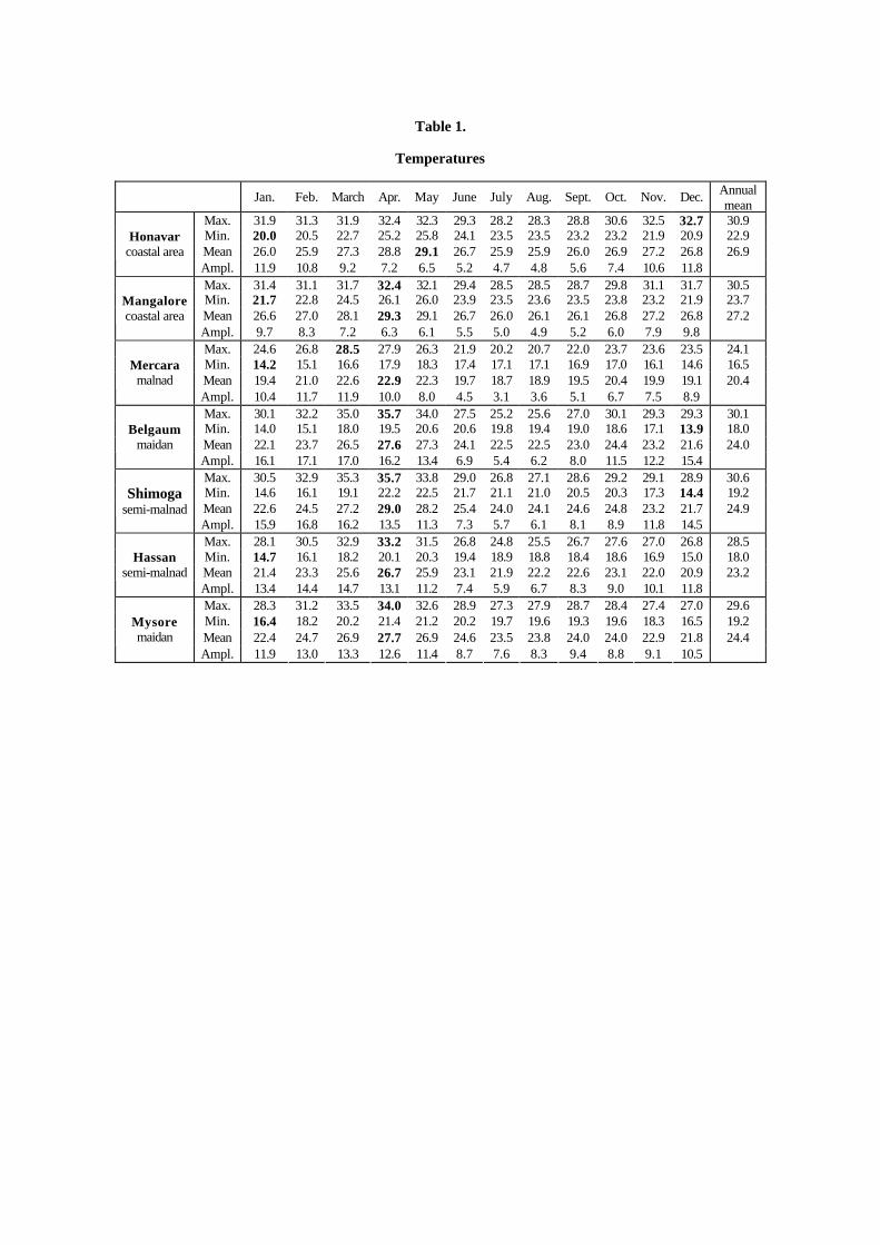
Table 1.
Temperatures
Jan. Feb. March Apr. May June July Aug. Sept. Oct. Nov. Dec. Annual mean
Max. 31.9 31.3 31.9 32.4 32.3 29.3 28.2 28.3 28.8 30.6 32.5 32.7 30.9Min. 20.0 20.5 22.7 25.2 25.8 24.1 23.5 23.5 23.2 23.2 21.9 20.9 22.9 Mean 26.0 25.9 27.3 28.8 29.1 26.7 25.9 25.9 26.0 26.9 27.2 26.8 26.9
Honavar coastal area
Ampl. 11.9 10.8 9.2 7.2 6.5 5.2 4.7 4.8 5.6 7.4 10.6 11.8 Max. 31.4 31.1 31.7 32.4 32.1 29.4 28.5 28.5 28.7 29.8 31.1 31.7 30.5Min. 21.7 22.8 24.5 26.1 26.0 23.9 23.5 23.6 23.5 23.8 23.2 21.9 23.7 Mean 26.6 27.0 28.1 29.3 29.1 26.7 26.0 26.1 26.1 26.8 27.2 26.8 27.2
Mangalore coastal area
Ampl. 9.7 8.3 7.2 6.3 6.1 5.5 5.0 4.9 5.2 6.0 7.9 9.8 Max. 24.6 26.8 28.5 27.9 26.3 21.9 20.2 20.7 22.0 23.7 23.6 23.5 24.1Min. 14.2 15.1 16.6 17.9 18.3 17.4 17.1 17.1 16.9 17.0 16.1 14.6 16.5 Mean 19.4 21.0 22.6 22.9 22.3 19.7 18.7 18.9 19.5 20.4 19.9 19.1 20.4
Mercara malnad
Ampl. 10.4 11.7 11.9 10.0 8.0 4.5 3.1 3.6 5.1 6.7 7.5 8.9 Max. 30.1 32.2 35.0 35.7 34.0 27.5 25.2 25.6 27.0 30.1 29.3 29.3 30.1Min. 14.0 15.1 18.0 19.5 20.6 20.6 19.8 19.4 19.0 18.6 17.1 13.9 18.0 Mean 22.1 23.7 26.5 27.6 27.3 24.1 22.5 22.5 23.0 24.4 23.2 21.6 24.0
Belgaum maidan
Ampl. 16.1 17.1 17.0 16.2 13.4 6.9 5.4 6.2 8.0 11.5 12.2 15.4 Max. 30.5 32.9 35.3 35.7 33.8 29.0 26.8 27.1 28.6 29.2 29.1 28.9 30.6Min. 14.6 16.1 19.1 22.2 22.5 21.7 21.1 21.0 20.5 20.3 17.3 14.4 19.2 Mean 22.6 24.5 27.2 29.0 28.2 25.4 24.0 24.1 24.6 24.8 23.2 21.7 24.9
Shimoga semi-malnad
Ampl. 15.9 16.8 16.2 13.5 11.3 7.3 5.7 6.1 8.1 8.9 11.8 14.5 Max. 28.1 30.5 32.9 33.2 31.5 26.8 24.8 25.5 26.7 27.6 27.0 26.8 28.5Min. 14.7 16.1 18.2 20.1 20.3 19.4 18.9 18.8 18.4 18.6 16.9 15.0 18.0 Mean 21.4 23.3 25.6 26.7 25.9 23.1 21.9 22.2 22.6 23.1 22.0 20.9 23.2
Hassan semi-malnad
Ampl. 13.4 14.4 14.7 13.1 11.2 7.4 5.9 6.7 8.3 9.0 10.1 11.8 Max. 28.3 31.2 33.5 34.0 32.6 28.9 27.3 27.9 28.7 28.4 27.4 27.0 29.6Min. 16.4 18.2 20.2 21.4 21.2 20.2 19.7 19.6 19.3 19.6 18.3 16.5 19.2 Mean 22.4 24.7 26.9 27.7 26.9 24.6 23.5 23.8 24.0 24.0 22.9 21.8 24.4
Mysore maidan
Ampl. 11.9 13.0 13.3 12.6 11.4 8.7 7.6 8.3 9.4 8.8 9.1 10.5

12 RECONNAISSANCE SOIL MAP OF FOREST AREA
enclose a minimum which is linked to the monsoon rains; this minimum is relative, the absolute minimum being recorded in winter.
Temperature decreases appreciably with altitude; this is clearly observable in the Western Ghats (for example, at Mercara).
C. RELATIVE HUMIDITY (TABLE 2)
The coastal zone, where the relative humidity persists above 70%, is in contrast to the plateau where the mean values may sometimes go down to less than 50%, with mean monthly amplitudes of 30-50% during the dry season at the beginning of the year.
D. POTENTIAL EVAPOTRANSPIRATION AND WATER BALANCE
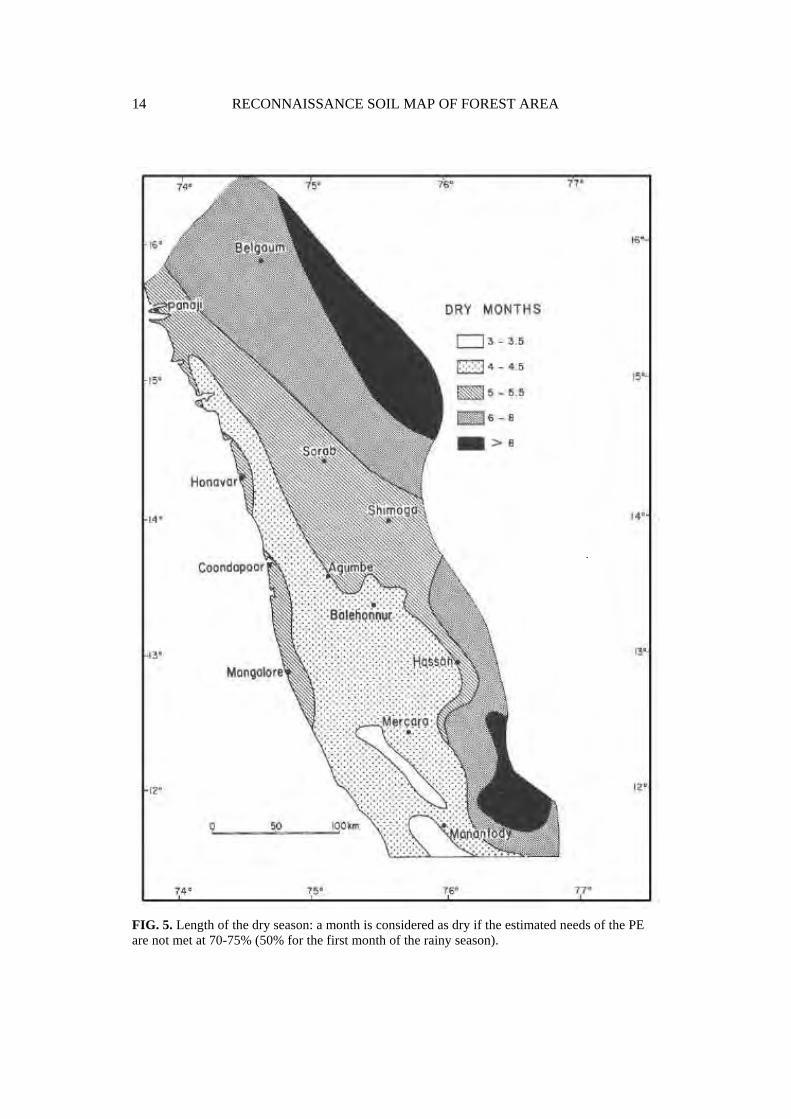
Potential evapotranspiration (PE) was calculated using Penman's formula. This evaluation of evapotranspiration helped in estimating the surplus rainfall in the form of “climatic drainage” calculated every month with the formula d = P-PE, for all the months where P (precipitation) is higher than the PE. The annual climatic drainage being equal to the sum of the monthly drainages, this figure is arbitrarily reduced by 100 mm to take into account the available water capacity (AWC) of the soils. Another use of calculating the PE is in estimating the duration of the dry season (Fig. 5), once again by using the available water capacity of the soils arbitrarily fixed at 100 mm. A month is considered as dry if the estimated needs of the PE are not met at 70-75% (50% for the first month of the rainy season).
E. SOIL MOISTURE REGIMES
Soil moisture regimes are used in Soil Taxonomy to identify the categories at different hierarchic levels; hence it is very important to know or estimate them.
In the region studied, the main problem in estimating the soil moisture regimes is in demarcating the zones where the dry season (estimated by the water balance method described above) passes from 4 to 5 months. It risks passing from an udic moisture regime to an ustic moisture regime if the soil remains dry for more than 90 days in the moisture control section.
This transitional zone is the back slope of the Ghats where forest-savanna mosaics are observed. No precise determinations of the soil moisture control section were made and it is considered that it lies approximately between 10 and 30 cm, as proposed by the authors of "Keys to Soil Taxonomy" (Soil Survey Staff, 1988).
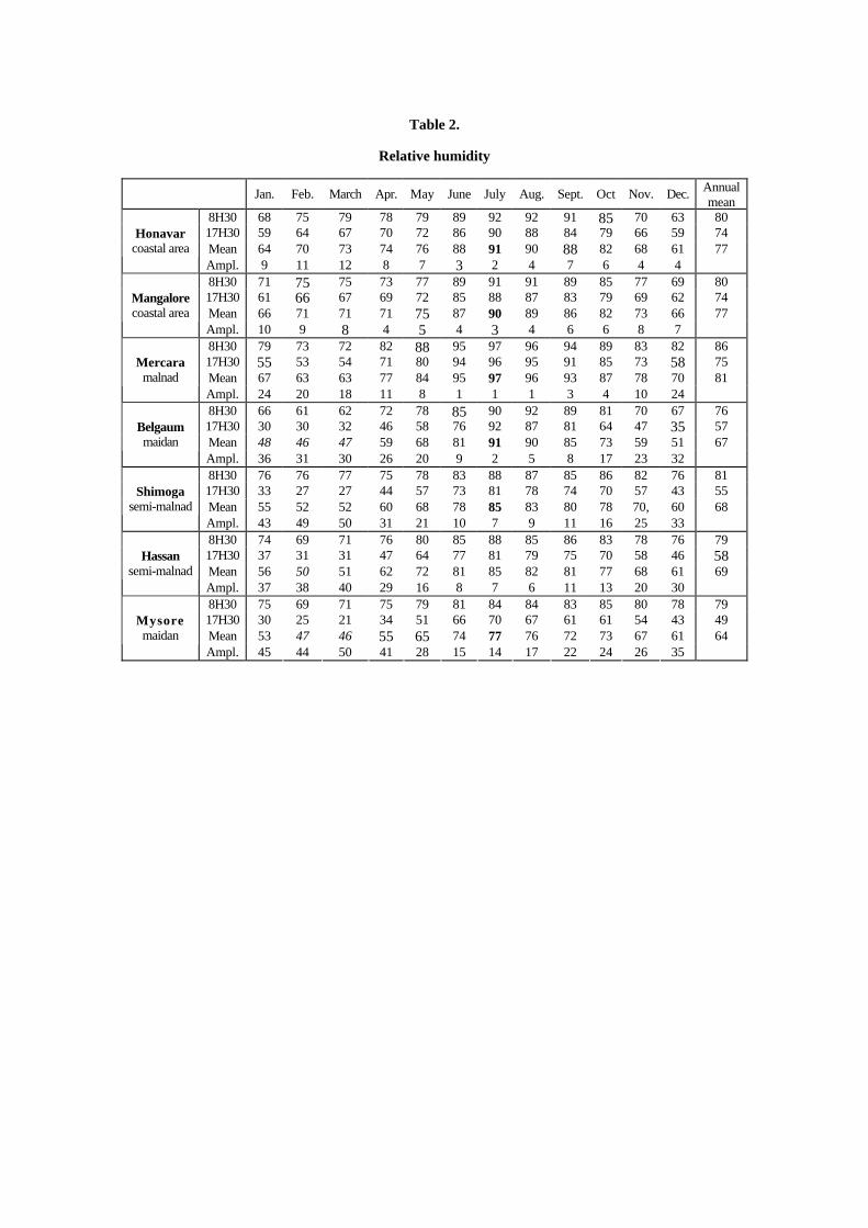
Table 2.
Relative humidity
Jan. Feb. March Apr. May June July Aug. Sept. Oct Nov. Dec. Annual mean
8H30 68 75 79 78 79 89 92 92 91 85 70 63 8017H30 59 64 67 70 72 86 90 88 84 79 66 59 74 Mean 64 70 73 74 76 88 91 90 88 82 68 61 77
Honavar coastal area
Ampl. 9 11 12 8 7 3 2 4 7 6 4 4 8H30 71 75 75 73 77 89 91 91 89 85 77 69 8017H30 61 66 67 69 72 85 88 87 83 79 69 62 74 Mean 66 71 71 71 75 87 90 89 86 82 73 66 77
Mangalore coastal area
Ampl. 10 9 8 4 5 4 3 4 6 6 8 7 8H30 79 73 72 82 88 95 97 96 94 89 83 82 8617H30 55 53 54 71 80 94 96 95 91 85 73 58 75 Mean 67 63 63 77 84 95 97 96 93 87 78 70 81
Mercara malnad
Ampl. 24 20 18 11 8 1 1 1 3 4 10 24 8H30 66 61 62 72 78 85 90 92 89 81 70 67 7617H30 30 30 32 46 58 76 92 87 81 64 47 35 57 Mean 48 46 47 59 68 81 91 90 85 73 59 51 67
Belgaum maidan
Ampl. 36 31 30 26 20 9 2 5 8 17 23 32 8H30 76 76 77 75 78 83 88 87 85 86 82 76 8117H30 33 27 27 44 57 73 81 78 74 70 57 43 55 Mean 55 52 52 60 68 78 85 83 80 78 70, 60 68
Shimoga semi-malnad
Ampl. 43 49 50 31 21 10 7 9 11 16 25 33 8H30 74 69 71 76 80 85 88 85 86 83 78 76 7917H30 37 31 31 47 64 77 81 79 75 70 58 46 58Mean 56 50 51 62 72 81 85 82 81 77 68 61 69
Hassan semi-malnad
Ampl. 37 38 40 29 16 8 7 6 11 13 20 30 8H30 75 69 71 75 79 81 84 84 83 85 80 78 7917H30 30 25 21 34 51 66 70 67 61 61 54 43 49 Mean 53 47 46 55 65 74 77 76 72 73 67 61 64
Mysore maidan
Ampl. 45 44 50 41 28 15 14 17 22 24 26 35
14 RECONNAISSANCE SOIL MAP OF FOREST AREA
FIG. 5. Length of the dry season: a month is considered as dry if the estimated needs of the PE are not met at 70-75% (50% for the first month of the rainy season).

2 GENERAL DESCRIPTION OF THE AREA 15
The soil moisture measured between these depths at the end of the dry season (April 1988) under several evergreen and deciduous forests of the region (Ferry, pers. comm.) showed that the humidity was in accordance with the vegetation types:
- between 23 and 30 percent in April 1988 under evergreen vegetation, thereby excluding the possibility of an ustic moisture regime.
- between 5 and 12 percent under deciduous formations corresponding to an ustic regime.
As no measurements were made for the savannas soils, it is estimated that the soil moisture regime there is the same (ustic) as under the deciduous formations. Hence, it is the natural vegetation which best expresses the moisture regimes; in any case better than the estimates which can be obtained from climatic data.
II. GEOLOGICAL FEATURES
A. PRECAMBRIAN SHIELD
The southern part of the Indian peninsula is constituted almost exclusively of archean rocks; only the coastal strips are made up of more recent sediments. The outcrops of the Deccan Traps are in the northern part of the region surveyed.
The archean shield is composed of crystalline rocks: mostly gneisses, granites and charnockites, alternating with schist-belts which show a volcano-sedimentary assemblage of rocks. The schist-belts are often grouped under "Dharwar schists". The shield is divided into three zones according to the grade of metamorphism (Pichamuthu, 1985):
- the green schists terrain in the north-west, - the amphibolites terrain in the central-west, - the granulites terrain in the south where charnockites are found. These last named rocks are considered to be the result of metamorphism at a
great depth with influx of CO2 rich solutions (Janardhan et al., 1983). The archean volcano-sedimentary series have been studied a great deal during
these last years and the different authors agree neither on the stratigraphy nor on the chronology of this ensemble. The main problem is in the recognition and interpretation of certain conglomerates in the most ancient, highly metamorphosed and folded volcano-sedimentary deposits and, certainly in the presence of a major discontinuity inside the volcano-sedimentary ensemble.
According to Swami Nath and Ramakrishnan (1981) these conglomerates constitute a stratigraphic indicator and represent an important boundary. They distinguish:
- the series deposited before the conglomerates that correspond to a cycle, and hence to a stratigraphic group, the Sargur Group, which is highly metamorphosed.

16 RECONNAISSANCE SOIL MAP OF FOREST AREA
- the conglomerates and the series deposited later on represent another cycle, which they call the Dharwar Group.
For other geologists (Sreenivas and Srinivasan, 1968; Pichamuthu, 1985), these conglomerates (and the stratigraphic discontinuity) are the result of later changes in a single and unique conglomerate located at the base of the Dharwar Group which they refuse to split into two. For them, the only clear differences are due to the much higher grade of metamorphism in the southern than in the northern part of the area. According to this hypothesis, the Sargur group of Swami Nath and Ramakrishna would, in fact, be the more metamorphosed roots of the sole and unique Dharwar group.
This discussion is very important for the interpretation of the age of the Peninsular Gneisses which, in the first hypothesis, are younger than the Sargur Group and older than the Dharwar Group with which they show normal contact with a basal conglomerate. In the second hypothesis, these gneisses appear to be intrusive in the Dharwar schists, which they would have partly metamorphosed. The geological inset on the map was compiled according to the first hypothesis which is the one adopted by the authors of the geological map of Karnataka at 1 : 500,000 (Geological Survey of India, 1981).
B. PROTEROZOIC SANDSTONES
In the mapped area, proterozoic sandstones form outcrops north of Belgaum. They are indicated as part of the Lower Kaladgi Group in the 1: 500,000 geological map of Karnataka but most probably correspond to the Badami Group.
C. DECCAN TRAPS PROVINCE
The second half of the Mesozoic period was marked by the outpourings of huge quantities of basalt which, even to-day, occupy an area of about 500,000 km2. The soil map presented here shows only a very small part of this vast geological province.
The volcanism of the Deccan Traps seems to have started towards the end of Lower Cretaceous (100 MA). The igneous activity in St. Mary Islands, off Malpe (north of Mangalore) dates from this early phase.
The peak activity was around 65-60 MA, i.e., at the end of the Mesozoic era with the major outflows of the central basaltic province. Another significant volcanic episode a little later has affected more particularly the north-eastern part of the area. Lastly, the outpourings may have continued upto the Oligocene considering some isotopic datings (K/Ar) of the basalts from the southern part of the province (Alexander, 1981). But these dates are very controversial because the dating method employed does not seem to be totally reliable (West, 1981) for this problem.

2 GENERAL DESCRIPTION OF THE AREA 17
However, in this southern zone, the Traps have only a limited thickness when compared to that which is observed further north. On the Ghats road from Sanquelim (Goa) to Kankumbi (Karnataka), the basalt outcrops are found only in the upper quarter of the slope.
III. GEOMORPHOLOGICAL FRAMEWORK
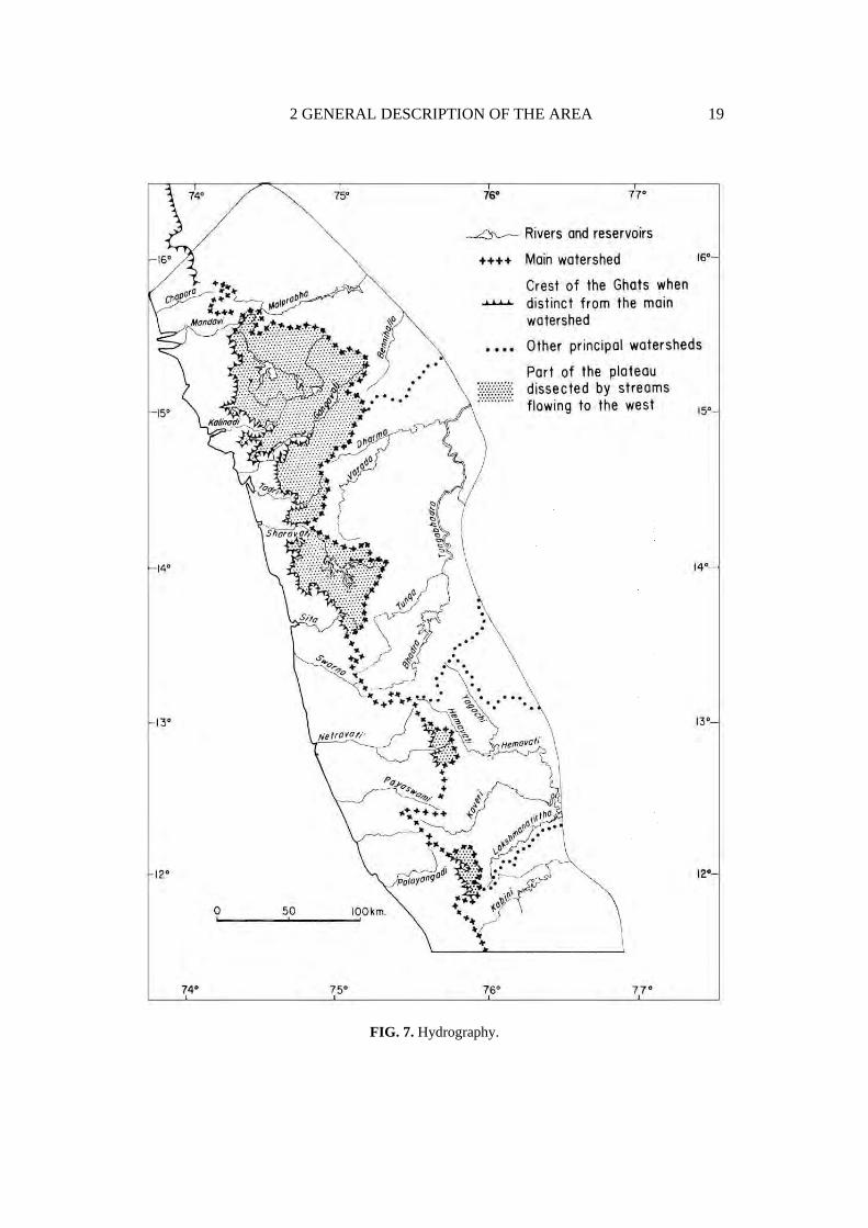
A. GENERAL TOPOGRAPHY AND RIVER PATTERNS
A perusal of the hypsometric and hydrographic maps enables the distinction of two zones (Fig. 6 and 7):
- the low coastal region, sometimes incorrectly called the coastal plain, which is drained by several rivers into the Arabian Sea,
- the Karnataka plateau which is higher is drained by some big rivers such as the Krishna and Kaveri and their tributaries into the Bay of Bengal.
The crest of the Ghats most often constitutes the principal watershed. A small part of the Karnataka plateau is, however, drained towards the Arabian Sea; this corresponds to a general lowering in the topography of the plateau towards 15°N (Fig.7).
The watershed between the two main river systems of the Krishna in the north and the Kaveri in the south is marked by a series of hills and the Bababudan range. If the courses of the rivers of the plateau are examined in detail, it can be seen that most often at first they have a south-north orientation and then deviate to a west-east direction. The first part of the path generally corresponds to a deepening in the western border of the plateau which is clearly visible in cross-section (Fig. 16, Chapter 3). This disposition is undoubtedly favourable to river piracy, large parts of the watercourses of the plateau being captured by rivers flowing towards the west. The high Sharavati basin is probably a recent example of this evolution.
B. BRIEF OUTLINE OF THE GEOMORPHOLOGICAL HISTORY
The peninsula to-day shows a great east-west dissymmetry. This general morphology conditions the distribution of climates and in part, that of soils; it is therefore important to explain its origin.
The Indian peninsula constitutes a fragment of the ancient Gondwanaland. The breaking up of this continent seems to have begun during the Jurassic. For some authors (Klootwijk, 1976) it started even before the Permo-Triassic times. It was achieved during the Cretaceous and India then drifted towards the north and collided with Eurasia during the Miocene. The sedimentary formations of South India were deposited during or after the breaking up.

18 RECONNAISSANCE SOIL MAP OF FOREST AREA
FIG. 6. Hypsometry.
2 GENERAL DESCRIPTION OF THE AREA 19
FIG. 7. Hydrography.
20 RECONNAISSANCE SOIL MAP OF FOREST AREA
The morphological evolution of peninsular India may be summarized as follows:
1.Mesozoic events
Jurassic warping. Upto the Triassic the river flow was towards the present north of the peninsula (Casshyap, 1979). The change in the direction of this flow, which is now mostly oriented towards the east, took place during the Jurassic. This implies an upheaval in the general organization of the relief: the appearance, for the first time, of a Crustal flexure approximately in the axis of the Western Ghats and the opening of a graben on the east where the first marine sediments got accumulated. For a long time faulting was thought to explain the morphology of the Western Ghats. Vaidyanadhan (1967) was the first to suggest the presence of a widely arched flexure, whose western flank later evolved by dissection.
Cretaceous volcanism. At the end of the Lower Cretaceous (100 MA) another rift appeared, this time towards the west. The first outpourings of basalts occurred towards the south in the newly formed western basin. They are stratified with the Cretaceous sediments at the latitude of Calicut where they have been observed in off-shore borings (Desikachar, 1979). This same volcanic event gives rise to the basaltic dykes described in Kerala (Krishnaswami, 1981).
2. Cenozoic volcanism and sedimentation
Sedimentation in the western basin. During the Palaeocene period (60 MA), while the volcanism of the Deccan Traps reached its paroxysm in the north, sedimentation continued in the southern peninsula. The Palaeocene sediments observed in the western basin therefore indicate a shallow fades while the Eocene sediments (30 MA) show a deep facies contrasting with that of the earlier deposits. Desikachar (1979) interprets this as an indicator of a considerable sinking (2000 m) of this region, most probably by the movement of faults located a little to the west of the present coast.
Miocene tectonic events. During the Miocene, the Indian plate drifted north colliding with the Eurasian plate and consequently seems to have provoked considerable tectonic movements in the south, accompanied by heavy sedimentation in the coastal areas: Quilon and Warkalli beds to the west and Cuddalore sandstones to the east. These formations were later weathered and lateritized.

2 GENERAL DESCRIPTION OF THE AREA 21
3. Late Tertiary movements and erosion
At the end of the Tertiary and the beginning of the Quaternary periods, the Indian peninsula was again subjected to considerable tectonic movements: uprise of the charnockite horsts of the Niligiris and Palnis (Vaidyanadhan, 1977), as well as epeirogenesis of the Eastern Ghats. This tectonic event was followed by the erosion of the earlier weathered material in the eastern coastal area (i.e., the Tamil Nadu plain). In the western coastal region, the incision of the rivers through the hardened Tertiary alluvia may be related to the same period as these alluvia now occupy prominent positions.
4. Quaternary evolution
The weathering processes as they can be observed to-day, took place in the late Quaternary. Demangeot (1975a) proposed a Quaternary chronology for the Tamil Nadu plain. This chronology which does not take the nature of weathering into account, is not quite satisfactory and a general scheme for the Quaternary evolution in South India remains to be established.
5. Conclusion
The origin of the Western Ghats, persuant to that which has just been explained, may be summarized as follows: from Jurassic onwards the Ghats area was raised and later tectonic movements (particularly during Miocene and Late Tertiary) combined with dissection by rivers and have given them their present aspect.
During this long period, the rocks of the Deccan plateau were weathered and the products of this weathering were eroded. By differential erosion of strong and weak beds the greenstone belts have given rise to appalachian reliefs.
There seems to have been two phases during which erosion was more important than weathering:
- the first at the moment of deposition of the Miocene sandstones, and - the second at the time of the uprise of the Eastern Ghats.

3
MORPHO-PEDOLOGICAL LANDSCAPES
The mapped region covers three major geographical units: the coastal zone, the Ghats and the Karnataka plateau. Traditionally, the Karnataka plateau is divided into a humid hilly area, the malnad, and a drier less hilly region, the maidan. The change from malnad to maidan is gradual, rarely abrupt, and hence a transitional zone can be distinguished. So there are, in fact, five principal geographic units which are retained and subdivided into 16 morpho-pedological landscapes:
- the coastal area (landscapes 1 and 2), - the Ghats (landscape 3), - the humid area of the Karnataka plateau or malnad landscapes 4 to 9), - the semi-arid area of the Karnataka plateau or maidan (landscapes 13 to 16), - the transitional area between malnad and maidan (landscapes 10 to 12). These large geographic units are subdivided according to the different
geomorphic levels that can be distinguished and the degree of conservation (or degradation) of these levels. The exact meaning of the technical terms vary from one author to another. In this explanatory booklet the vocabulary used for designating the different kinds of reliefs derived from a given level is shown in Fig. 8.
In this chapter the pedological characteristics of the different landscapes are given with special emphasis on those of interest to the forester. The details of the pedological classifications, the entire Chapter 5 being devoted to them hereafter in this booklet.
The profiles referred to in this text are given in the Annexes.

3 MORPHO-PEDOLOGICAL LANDSCAPES 23
FIG. 8. Denomination of the different types of reliefs derived from a geomorphic level.
I. THE COASTAL AREA
A. CLIMATIC FEATURES
Most of the rainfall in this zone is during a single, humid season. It is more than 3.5 m everywhere and very often exceeds 4 m. The dry season lasts for 5 months; the climatic drainage estimated is about 3 m.
The soil moisture regimes are generally considered to be ustic in the freely drained zones. Udic regimes may be found in the south, in a narrow strip of land at the foot of the Ghats. They certainly exist further south, in Kerala, which is outside the mapped region.
B. MORPHO-PEDOLOGICAL SUBDIVISIONS
The coastal zone is divided into: - a low level, which is that of the recent fluvio-littoral formations, - higher levels, largely lateritized1, forming the hinterland (Fig. 9). The highest reliefs of this coastal zone are considered to be evidence of phases
of less dissection of the scarp of the Ghats and so will be regrouped with the Ghats.
1. Fluvio-littoral formations (Morpho-pedological landscape 1)
They consist of two large ensembles, the beach barriers and the fluvio-littoral plains (Fig. 10).
1 In this explanatory booklet the term lateritization is employed for induration by iron oxides and hydroxides(ferricrete), i.e., in the sense that it corresponds to the French terms, carapacement and cuirassement.

24 RECONNAISSANCE SOIL MAP OF FOREST AREA
FIG. 9. Coconuut plantation (Bhatkal) located on the recent fluvio-littoral formations and surrounded by laterite capped mesas (L).
FIG. 10. Recent beach barrier and cultivated fluvio-littoral plain near Honavar.

3 MORPHO-PEDOLOGICAL LANDSCAPES 25
a. Beach barriers (morpho-pedological landscape la). There are one or two barriers depending on the place. The present one, forming the shoreline, consists mainly of sand deposits without any pedological differentiation. The remnants of an ancient beach barrier, located towards the interior, have sandy, rubified soils. Where two barriers are encountered, they were often separated by lagoons and mangroves which are now artificially filled up for rice cultivation.
b. Fluvio-littoral plains (morpho-pedological landscape lb). They are composed of alluvial deposits behind the beach barriers. This deposition is recent, i.e., after the last marine transgression. Some of these plains show fossilized mangrove soils under nearly 2 m of recent sediments. The soils developed on these recent alluvial sediments are hydromorphic soils with considerable ferruginous accumulations (large ferruginous bodies2).
2. Dissected Hilly Hinterland (Morpho-pedological landscape 2)
The coastal hinterland formed by the dissection of old lateritized geomorphic levels can also be subdivided into two, according to the degree of this dissection. Reliefs with well conserved tablelands forming laterite capped mesas (bowé) can be distinguished. These mesas generally lie near the coast. The rest of the hinterland is made up of hills without lateritic caps; here dissection was more intense and did not permit their conservation.
a. Laterite capped mesas (Morpho-pedological landscape 2a). The most typical hardened flat topped hills, those which best justify the term mesa, are essentially situated near the coast. They sometimes penetrate inland, along the principal river valleys.
Their morphology is not perfectly plane; numerous convexities, a few metres above flat bottomed elongated depressions (Fig. 11), can be distinguished. Both the forms are lateritized:
- the ironstone is bare on the convexities; small pockets of non-cemented soil and fissures in the laterite enable the development of a discontinuous plant cover dominated by bushes with a characteristic bearing: Sapium insigne (Euphorbiaceae).
- in contrast, the ironstone is covered by a thin colluvial layer in the depressions; when the thickness of these colluvions exceeds 50 cm, they are often cultivated.
The highest mesas sharply dominate the recent levels. In his work "Laterites of Goa" Teixeira (1965) stresses the fact that a conglomerate always separates the laterites from the weathered rock of the archean shield in the region he studied. He also observed lateritic surfaces at an altitude of 180 m. Elsewhere, i.e., further south, the laterite capped mesas are generally not so high and their substratum is
2 In French these large forms of iron accumulations are called poupees ferrugineuses.
26 RECONNAISSANCE SOIL MAP OF FOREST AREA
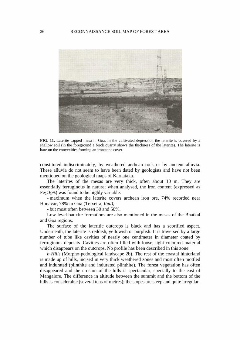
FIG. 11. Laterite capped mesa in Goa. In the cultivated depression the laterite is covered by a shallow soil (in the foreground a brick quarry shows the thickness of the laterite). The laterite is bare on the convexities forming an ironstone cover.
constituted indiscriminately, by weathered archean rock or by ancient alluvia. These alluvia do not seem to have been dated by geologists and have not been mentioned on the geological maps of Karnataka.
The laterites of the mesas are very thick, often about 10 m. They are essentially ferruginous in nature; when analysed, the iron content (expressed as Fe2O3%) was found to be highly variable:
- maximum when the laterite covers archean iron ore, 74% recorded near Honavar, 78% in Goa (Teixeira, Ibid);
- but most often between 30 and 50%. Low level bauxite formations are also mentioned in the mesas of the Bhatkal
and Goa regions. The surface of the lateritic outcrops is black and has a scorified aspect.
Underneath, the laterite is reddish, yellowish or purplish. It is traversed by a large number of tube like cavities of nearly one centimeter in diameter coated by ferruginous deposits. Cavities are often filled with loose, light coloured material which disappears on the outcrops. No profile has been described in this zone.
b Hills (Morpho-pedological landscape 2b). The rest of the coastal hinterland is made up of hills, incised in very thick weathered zones and most often mottled and indurated (plinthite and indurated plinthite). The forest vegetation has often disappeared and the erosion of the hills is spectacular, specially to the east of Mangalore. The difference in altitude between the summit and the bottom of the hills is considerable (several tens of metres); the slopes are steep and quite irregular.
3 MORPHO-PEDOLOGICAL LANDSCAPES 27
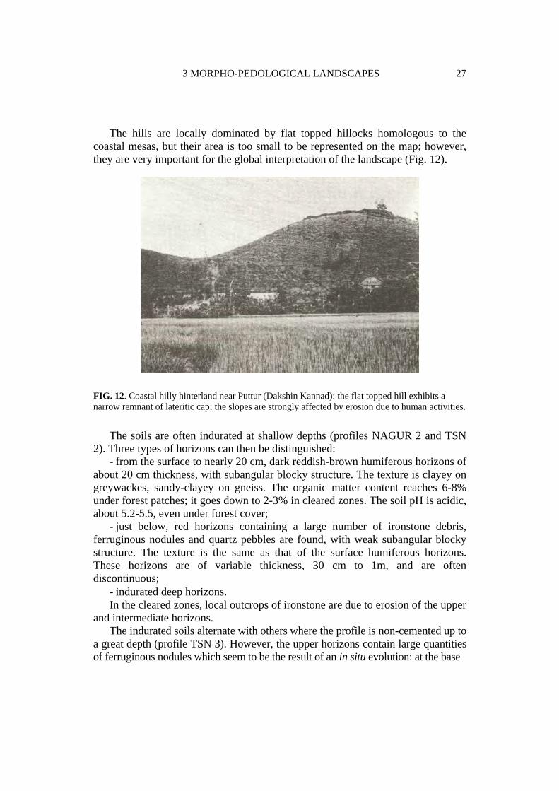
The hills are locally dominated by flat topped hillocks homologous to the coastal mesas, but their area is too small to be represented on the map; however, they are very important for the global interpretation of the landscape (Fig. 12).
FIG. 12. Coastal hilly hinterland near Puttur (Dakshin Kannad): the flat topped hill exhibits a narrow remnant of lateritic cap; the slopes are strongly affected by erosion due to human activities.
The soils are often indurated at shallow depths (profiles NAGUR 2 and TSN 2). Three types of horizons can then be distinguished:
- from the surface to nearly 20 cm, dark reddish-brown humiferous horizons of about 20 cm thickness, with subangular blocky structure. The texture is clayey on greywackes, sandy-clayey on gneiss. The organic matter content reaches 6-8% under forest patches; it goes down to 2-3% in cleared zones. The soil pH is acidic, about 5.2-5.5, even under forest cover;
- just below, red horizons containing a large number of ironstone debris, ferruginous nodules and quartz pebbles are found, with weak subangular blocky structure. The texture is the same as that of the surface humiferous horizons. These horizons are of variable thickness, 30 cm to 1m, and are often discontinuous;
- indurated deep horizons. In the cleared zones, local outcrops of ironstone are due to erosion of the upper
and intermediate horizons. The indurated soils alternate with others where the profile is non-cemented up to
a great depth (profile TSN 3). However, the upper horizons contain large quantities of ferruginous nodules which seem to be the result of an in situ evolution: at the base

28 RECONNAISSANCE SOIL MAP OF FOREST AREA
of the profiles (2 m or more) faint contrasted red mottles can be observed in the centre of the peds; higher up (1 m) the mottles become more distinct and more coherent than the rest of the horizon, and the blocky structure becomes stronger; in the upper horizons (50 cm), ferruginous nodules with irregular contours are quite clearly individualized and become abundant. These mottles, which gradually get hardened, also correspond to a plinthite.
Whatever the soil type, indurated or not, when the forest cover is removed acidity increases and exchangeable aluminium appears. The only crop cultivated with some success is the cashewnut.
In granito-gneissic region on leucocrate rock, i.e., poor in ferromagnesian minerals, traces of lateritization are much more subdued and there are no important traces of ironstones. On the other hand, the landscape is dominated by numerous imposing inselbergs. The presence of horizons rich in ferruginous nodules is the only common character showing the segregation of iron oxyhydroxides. There are two examples of coastal granito-gneissic regions on leucocrate rocks: that of batholithe in Dakshina Kannada, near Karkala, and a smaller zone in the state of Goa, near Quepem.
C. CONTINUITY IN LATERITIZATION PROCESSES
Laterites were described for the first time by Buchanan (1807) in Angadipuram in Kerala. This locality is situated in the coastal hinterland, about 50 km to the south of the mapped region. The fact that Buchanan chose this coastal zone is revealing as it seems that it was, and still is, the privileged place for observing lateritization in the southern part of the Indian peninsula (Fig. 13).
Below the spectacular laterite capped mesas, lateritization affects most of the more recent landforms. However, these laterites are less coherent than those of the mesas and are almost always covered by non-indurated soil used for rice cultivation. Teixeira (Ibid.) observed laterites below 10-20 m of alluvia in the Goa region (especially in the river Mandovi facing Panaji and, therefore, below sea-level).
The fact that lateritization has affected different geomorphic levels, erosional landforms as well as depositional ones, proves the existence of several phases.
The presence of a thick laterite, even on alluvial formations poor in iron, suggests the possibility of lateritization by lateral movement of iron (by absolute accumulation).
As mentioned earlier, some soils of recent fluvio-littoral plains behind the coastal barriers are also marked by ferruginous accumulations. This shows that the process of absolute accumulation of iron is still active under the present climatic conditions of

3 MORPHO-PEDOLOGICAL LANDSCAPES 29
laterite capped mesas
lateritized lower landforms
recent beach barrier
older beach barrier
rock outcrops ancient course of the Aghnashini scarps
Kumta town
FIG. 13. Detailed map of the Kumta area showing the importance of lateritized formations.

30 RECONNAISSANCE SOIL MAP OF FOREST AREA
the coastal region: heavy rainfall exceeding 3.5 m everywhere and a dry season of about 5 months per year.
II. THE WESTERN GHATS (Morpho-pedological landscape 3)
A. CLIMATIC FEATURES
Little is known about the climate of the Western Ghats as there is no meteorological equipment beyond a few rain-gauges on this escarpment.
The Ghats form a region of transition between the hot and humid coastal zone and the edge of the Deccan plateau, also well watered but more elevated, cooler, and not continuously humid. In terms of plant cover, this transition is observed in the succession of evergreen forest types graded according to altitude (Pascal, 1982a & b, 1984a & b, 1986, 1988).
The length of the dry season, estimated by the water balance method, varies from 3-4.5 months and is shorter than in the coastal area at the same latitude. It is probably underestimated by the method used to calculate it, because the majority of the soil profiles should have a water holding capacity of much more than 100 mm.
The soil moisture regimes were considered to be udic and this has been verified in certain locations.
B. MORPHO-PEDOLOGICAL SUBDIVISIONS (NOT MAPPED)
The Ghats appear to be homogeneous at the scale of the map presented here and hence have not been subdivided into several units. The lithological differences between the North and the South do not fundamentally affect the soil characteristics and similarly, the altitudinal gradient of temperature is not perceptible in the pedogenesis. Three subdivisions (not mapped) will be distinguished to describe this major unit, the most important one for the evergreen forest cover:
- the escarpment, - the particular zone where the escarpment meets the coastal hinterland, and - the residual reliefs in the coastal area which have been interpreted as
evidences of the retreat of the escarpment.
1. Escarpment of the Ghats
The upper part of the Ghats is made up of a succession of sub-vertical rocky crags and zones where huge rocky boulders measuring several cubic metres alternate
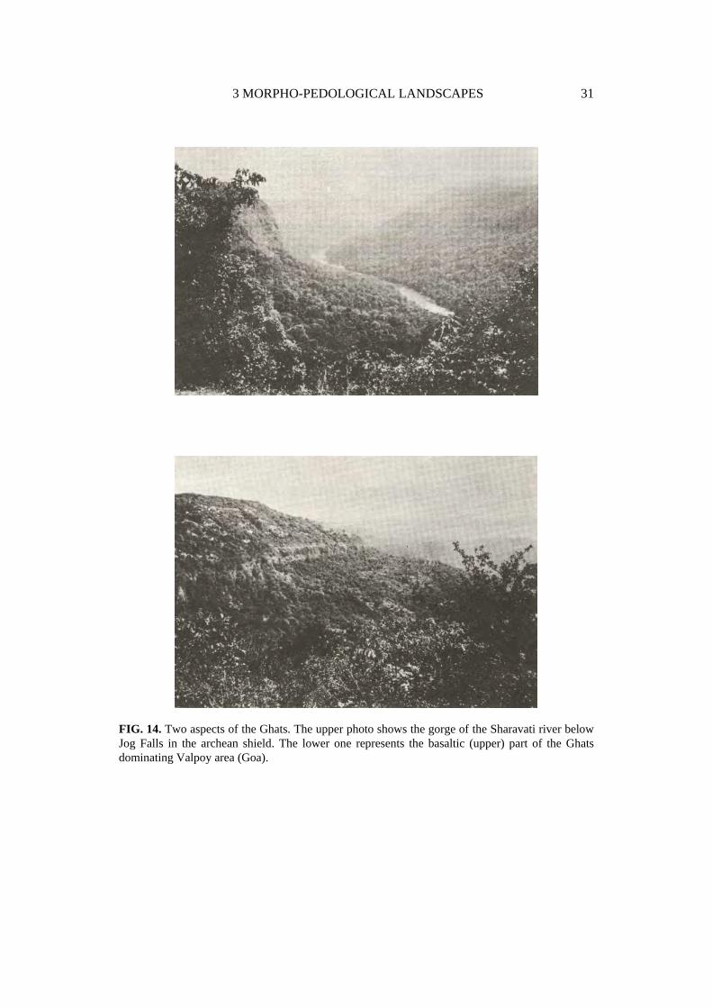
3 MORPHO-PEDOLOGICAL LANDSCAPES 31
FIG. 14. Two aspects of the Ghats. The upper photo shows the gorge of the Sharavati river below Jog Falls in the archean shield. The lower one represents the basaltic (upper) part of the Ghats dominating Valpoy area (Goa).

32 RECONNAISSANCE SOIL MAP OF FOREST AREA
with deep soils. The whole escarpment is carved by numerous V-shaped sub-parallel ravines. The slope is very steep and projected on a horizontal plane, the total width of the Ghats rarely exceeds 10 km. It is only in the northernmost part of the mapped region that the Ghats exhibit some large steps formed by the basalt flows of the Traps. Even this aspect is present only in the upper quarter of the escarpment (Fig. 14).
The soils are generally not very differentiated and show neither indurations nor mottles. (Profiles MERC 2, BHAT 1, BHAT 4, KARW 1, TSN 1, NAGUR 1), The following sequence is observed in the horizons:
- humiferous horizons, about 20 cm thick are reddish-brown in colour, they generally have a massive structure associated with a subangular blocky structure and a clayey texture. These horizons are highly porous with abundant biological activity (termites and earthworms) and plenty of fine roots;
- a horizon where the organic matter follows vertical tracks linked to macroporosity. This horizon, on the whole, is reddish-brown; the humiferous tracks are darker in colour. The texture is generally clayey;
- the deeper horizons are of variable thickness (50 cm to several metres), red in colour with blocky structure. The empty space between the structural elements is generally filled with micro-aggregates; the texture is clayey.
The soils are slightly acidic near the surface and acidic deeper. Saturation is high in the humiferous horizons and medium in the deep horizons. In these soils, there is no pronounced deficit in exchangeable mineral elements. Another important feature of these soils is the excellent development of the structure for tropical soils of very rainy climates.
The amount of coarse elements is extremely variable from one soil profile to another. They do not show any particular pattern of distribution such as "stone line" in the profile.
2. The Foot of the Escarpment
The region where the Ghats meet the hilly coastal hinterland is of great interest to an understanding of the regional morphology. The area of the Uppangala Reserve Forest (Coorg) can be taken as an example. Here two types of soils can be observed: soils on debris and soils on thick regolith.
The soils on debris show a very high proportion of coarse elements (pebbles and boulders) whose variable petrological nature in the same profile clearly shows that they are alluvial material. The debris are localized on both sides of the talwegs. The soil profiles on debris are not very differentiated and it is barely possible to distinguish more than two horizons: a dark brown humiferous horizon and a yellowish brown deep horizon. These soils are acidic (pH between 5 and 5.5) and the organic matter content is about 5% on the average in the first 10 cm of the profiles.

3 MORPHO-PEDOLOGICAL LANDSCAPES 33
These recent deposits enclose stretches of an older regolith. The soils here are much more weathered than the soils described earlier and show the following arrangement:
- the humiferous horizon is only about 10 cm thick, dark brown, with sandy-loam texture and weak subangular blocky structure;
- it is followed by a yellowish brown eluvial horizon, about 20 cm thick, with sandy-loam texture and massive structure;
- below are mottled horizons; these red horizons show yellow mottles in the form of vertical streaks. Mottles are less coherent than the rest of the horizon and.roots are exclusively confined to them. They seem to be the penetrations of the eluvial horizon into the red horizon. The whole horizon has a sandy-loam texture and a massive structure.
These soils are acidic to very acidic (pH is around 5 and KC1 pH attains 4 in the yellow mottles of the deep horizons). Only the organic matter of the upper horizon enables a sufficent reserve of exchangeable bases. In mineral horizons, the major exchangeable cation is aluminium with 1.3 meq/100 g of exchangeable aluminium, whereas the sum of Ca+Mg+K+Na is only 0.2 meq/100 g. The mineral reserve is therefore exclusively concentrated in the forest humus, rendering the forest ecosystem very fragile.
The detailed morphology of this zone, a considerable area of which is occupied by alluvial coarse deposits covered by dense evergreen forests, cannot be explained without referring to the existence of a dry phase during the Quaternary period which saw the disappearance of the forest and the deposition of the debris. This same dry phase probably also gave rise to this particular soil morphology on the older regolith.
3. Residual Hills in the Coastal Area
In the coastal hinterland, reliefs much higher than the hills of the morpho-pedological landscape 2 b were considered as evidences of the retreat of the Ghats escarpment accompanying the dissection of the western flank of the original flexure. For this reason these residual reliefs have been regrouped with the Ghats unit. They exhibit steep slopes favourable for the development of soil profiles of the type described in the Ghats, i.e., without mottles or important indurations (none of the profiles described in the annexe belong to these hills).

34 RECONNAISSANCE SOIL MAP OF FOREST AREA
III. THE BACK SLOPE OF THE GHATS AND THE HUMID HILLY AREA OF THE KARNATAKA PLATEAU
A. CLIMATIC FEATURES
The zone described here constitutes the "malnad" and shows a fairly wide climatic diversity. Rainfall which is heavy on the crest of the Ghats, decreases appreciably towards the east. Agumbe (Fig. 15a) is a good example of the situation on the crest where large quantities of rainwater fall in a few months. Balehonnur (Fig. 15b) is an example of the less rainy conditions on the back slope. The general aspect of the rainfall curve is the same as on the crest of the Ghats, but the monsoon peak is already attenuated when compared to that observed in Agumbe.
A dry season of at least 4 months is the rule on the back slope of the Ghats (estimated by the water balance method). In the north the dry season is longer, attaining 5 months. The climatic drainage is considerable and exceeds 1 m everywhere.
Estimation of the soil moisture regime poses a problem here, because with a dry season of at least 4 months it is in between the udic and ustic moisture regimes. As mentioned in the preceding chapter, this problem was resolved using some measurements of soil moisture under different vegetational covers. Evergreen formations were observed to have an udic soil moisture regime and deciduous forests, an ustic one.
B. MORPHO-PEDOLOGICAL SUBDIVISIONS
Differentiation of different geomorphic levels in such a vast territory whose recent tectonics is also not well known, presents numerous difficulties. Recourse to altimetric correlations for distant points is obviously excluded. Only geomorphic levels or groups of levels which are important for this enterprise were retained. This inventory is evidently incomplete, but a more precise identification would necessitate a detailed and strictly geomorphological study which is beyond the scope of this project.
Three geomorphic levels, or groups of levels, have been distinguished and named high level, intermediate levels and low level, according to their altitude (Fig. 16).
The high level (there may be several) is quite easy to identify in an East-West cross-section of the Karnataka plateau taken in the southern part of the region studied (Fig. 16c). In this cross-section, reliefs dominate the escarpment of the Ghats, as well as the plateau at its western limit. This feature disappears in cross-sections located further north (Fig. 16a &b) and the northernmost relief is the

3 MORPHO-PEDOLOGICAL LANDSCAPES 35
FIG. 15. Malnad - Climatic diagrams of Agumbe (a) and Balehonnur (b).

36 RECONNAISSANCE SOIL MAP OF FOREST AREA
Kodachadri peak (14°N). All these reliefs located on the crest of the Ghats are grouped under "strongly dissected high level".
The low level is also not very extensive and concerns some deepened river basins of the back slope of the Ghats (Fig 16c). These basins are occupied by convex hills called "meio laranjas" (half oranges). These convex hills are separated by flat bottomed hollows. Strictly speaking, the surface formed by all the hollows in reality constitutes the low level, but this name has, however, been extended to the whole landscape (hollow + convex hills). This low level is present only in the southern part of the mapped region. Further north, the "meio laranjas" and their flat hollows are absent, either because dissection is still active or because the rock is not favourable for the development of this type of relief.
The intermediate levels, more or less dissected, are more complex and correspond to the major part of the Malnad hills. These levels show considerable evidences of lateritization which means abundant lateritic caps to the north on rocks rich in iron, or horizons essentially composed of ferruginous gravels on all types of rocks. The intermediate levels, which are very extensive, are subdivided according to the intensity of their dissection and the nature of the rock. Three main types of rocks are encountered from north to south, namely the basalts of the Deccan Traps, the greywackes of the Dharwar group and the gneisses, successively. For each rock type there is a zone of partially dissected intermediate levels which most often correspond to the zone subjected to moderate dissection by the streams flowing eastwards. On greywackes, when the rivers flowing westwards colonize the plateau, a much more intensive dissection is observed and a zone of strongly dissected intermediate levels is then defined. This intense dissection is not seen in the high basin of the river Sharavati which, however, flows westwards; this is explained as being a sign of a recent capture.
The following morpho-pedological landscapes are presented here: - the strongly dissected high level; - the partially dissected intermediate levels on basalts; - the partially dissected intermediate levels on greywackes; - the partially dissected intermediate levels on gneiss; - the strongly dissected intermediate levels on greywackes; - the low levels.
1. Strongly Dissected High Level (Morpho-pedological landscape 4)
This unit forms the crest of the Ghats, south of 14°N. It is constituted by grassy rounded crests and spurs, as well as forested slopes. This general disposition is clearly visible on Landsat imageries, as it contrasts well with the uniform forest cover (even if it is degraded) of the neighbouring Ghats. On the upper part of the slopes, the forests sometimes have a more or less vallicole aspect (Fig. 17).

3 MORPHO-PEDOLOGICAL LANDSCAPES 37
FIG. 16. Different sections across the Karnataka plateau - a) at the latitude of Belgaum several lateritized levels, considered as intermediates levels, are seen (II, II', II", II'"). - b) at the latitude of Sirsi, different degrees in the evolution (degradation), of the intermediate levels can be observed. -c) at the latitude of Sultan's Battery the three geomorphic levels are well individualized (I, high; II, intermediate; III, low).

38 RECONNAISSANCE SOIL MAP OF FOREST AREA
Numerous residual reliefs not showing rounded crests have been linked to this unit. They form appalachian ridges, such as the "tail" of the Bababudan range.
To the east, in the semi-arid zone, the more or less flat summit of Gopalswamy Betta was also linked to this unit because of the presence of an ancient saprolite in geochemical disequilibrium with the present climatic conditions.
- a. Rounded Crests (landscape 4a). Under an essentially grassy vegetation, the soils of these zones (profiles MERC 1T, CAV 01, GP 01, BABA 01) show some constant features:
- impoverishment in clay in the upper horizons. This impoverishment is not clear in the BABA 01 soil which is very clayey.
- high acidity. Throughout the profile, the pH values are around 5. This high acidity is always accompanied in depth, and often in the surface soil, by the predominance of aluminium over the other exchangeable cations. The soil profile BABA 01 has the highest amount of exchangeable aluminium recorded during the course of this study.
All these characteristics are very unfavourable and hinder the mineral supply to the majority of plants.
FIG. 17. The rounded crests of the strongly dissected high level near Tala Kavery.
- b. Slopes and Appalachian Ridges (landscape 4b). These zones are covered by evergreen forests of medium and high elevations (Pascal 1982a & b, 1984b). Under these forests, the soil is morphologically identical to those observed in the higher regions of the Ghats. The soil profiles KDK 2 and KDK 4 were described in a zone
3 MORPHO-PEDOLOGICAL LANDSCAPES 39
where a particular forest formation is found: the Poeciloneuron indicum forest which exhibits a strong gregariousness. KDK 2 is under forest cover and KDK 4 under savanna in the same zone. None of the pedological characteristics observed can explain the gregariousness of Poeciloneuron.
2. Partially Dissected Intermediate Levels on Basalt (Morpho-pedological landscape 5)
Numerous elongated mesas dominate a hilly landscape. Here the mesas are also topped by laterites and have been called laterite capped mesas by analogy to those described in the coastal zone. The slopes of the mesas and hills are also very lateritized in the west, much less in the east.
a. Laterite Capped Mesas (landscape 5a). On the highest mesas to the west, the ironstones often cover "high level" bauxites which are exploited, as are those of Changad (Fig. 16a). These formations, ironstone + bauxite, may attain a thickness of about 10 m. The mesas continue to the east, in the drier zone of the plateau and are thus evidence of the past vast extent of the lateritization (no soil profile described on these mesas).
b. Slopes and Hills (landscape 5b). Many of these slopes are also lateritized, as has been emphasized earlier. There are, nevertheless, two kinds of non-indurated soils on these slopes: soils developed on the products issuing from the dismantling of the ironstones and those formed on the recent weathering material of basalts.
The first type of soils, developed on ironstone dismantling products, occupy extensive areas. Among them, those situated under the cornice of the mesas were studied in greater detail (Fig., soil profiles KANK 1, KANK 3) as they are occupied by a particular plant formation, the Memecylon umbellatum (Melastomataceae) evergreen forest. These soils are very rich in ferruginous gravels and ironstone boulders; under forest cover they are rich in organic matter: 15-20%. Some coarse elements resistant to moderate grinding when separating the fine soil, are in fact, hardened, highly organic peds which do not crumble when immersed in water, but are easily destroyed if treated with hydrogen peroxide. The soils are acidic and have a clayey texture. The topographic position (under cornice), more than the soil type, is certainly responsible for the presence of the Memecylon forest. Lower down on the slopes, identical soils support other types of forests.
Soils on recent weathering products of basalts are localized in zones where the dissection is active and the slopes generally steep; they are formed under humid climatic conditions. The weathered basalt is visible at shallow depths where spheroids showing exfoliation (onion weathering) can be observed. The corestones are not weathered much, whereas the exfoliation shells are completely decomposed but retain the rock structure. Above this, the thin soil cover is not much differentiated. It is acidic and analyses show that the clays are essentially kaolins. The release of iron

40 RECONNAISSANCE SOIL MAP OF FOREST AREA
sesquioxides during weathering is responsible for the reddish-brown colour of the whole profile.
3. Partially Dissected Intermediate Levels on Greywackes (Morpho-pedological Landscape 6)
This morpho-pedological landscape extends between 13°45' and 15°30' N latitudes, i.e., over a distance of about 200 km, and presents interruptions as well as variations. The northernmost zones are the most hardened.
a. Laterite Capped Mesas (landscape 6a). To the north, the general morphology is very similar to that just described on basalt: mesas dominating a hilly landscape; the laterites are also very thick. The most spectacular mesas are in the vicinity of Castle Rock, but they can still be seen at the latitude of Sirsi. Mapping them was very difficult due to the lack of good topographic documents but it seems that they follow a vein of schists, particularly rich in manganese, within the greywackes formation. Further south, the laterites are less prominent and do not form important mesas (no profile described in this unit).
b. Slopes and Hills (landscape 6b). The slopes are less lateritized than on basalt. The soil profiles at the top of the slope, on the dismantling products of the mesas ironstones, are very gravelly. In the northern part of the unit (profile SHIR 1) they support the same Memecylon umbellatum forests as their homologues on basalt. However, to the south, this type of plant formation is very limited.
In the remaining part of the unit and further south, most of the soils (BHAT 5, BHAT 10, NITTUR) show ferruginous nodules whose morphology and origin, in situ, are similar to that described earlier for the coastal hinterland. In these soils, the Si02/A1203 molecular ratio determined in the fine earth is always less than 2, indicating highly weathered material. Savanna zones are numerous and the soils there are poor in organic matter, acidified near the surface with exchangeable aluminium. There are a few rare islets of low evergreen forests, with stunted moss covered trees. The organic matter content in the soils under these islets is very high, 15%, whereas the other morphological and analytical characteristics are not different from those in the savannas, except that the pH is slightly higher. These characteristics are the same as those observed under Memecylon forests. More generally, tall evergreen forests occupy, in a preferential manner, the recently dissected areas where the soils are similar to those of the Ghats.

3 MORPHO-PEDOLOGICAL LANDSCAPES 41
4. Partially Dissected Intermediate Levels on Gneisses and Granites (Morpho-pedological Landscape 7)
This unit is made up of hills rarely supporting good evergreen forests. The relief of the hills is roughly convex, the slopes are generally irregular and the valleys are narrow. There are numerous inselbergs.
The surface horizons of the soils (profiles THIR 1, SRING 1, BHAT 6, KHAN 1) are often impoverished in clay" when compared to the other horizons. They are acidic but have only traces of exchangeable aluminium. The ferruginous concretions are less here than on the greywackes and the stone layers often have more residual quartz than ferruginous elements. There are a few rare laterites which have been observed only near Thirthahalli, Samshe and Virarajendrapet.
The general characteristics of these soils, the coarse texture of the upper horizons and low mineral reserves, are quite unfavourable in terms of water economy, as well as chemical fertility. They are certainly responsible for the mediocre aspect of the forests, as well as for the absence of intense cultivation of these hills.
5. Strongly Dissected Intermediate Levels on Greywackes (Morpho-pedological Landscape 8)
North of 14°N, the rivers flowing into the Arabian Sea, viz., Agnashini (or Tadri), Gangavali and Kalinadi, dissect a large part of the back slope of the Ghats.
The major rivers have deeply incised their beds. The hydrographic network shows numerous ramifications and the landscape is made up of numerous small, steep hills separated by narrow valleys (Fig. 18). Some high points show traces of laterites, and ironstone boulders are frequent on the slopes.
The soil profiles (profiles NRD 1, DSG 1, SONDA 1, MAGOD 1) show signs of erosion and rejuvenation: the weathering zone is visible at shallow depths and numerous incompletely weathered rocky fragments are present practically from the surface. The soils show fairly similar features from the top to the bottom of the slopes. Humiferous horizons have a crumb structure and a sandy-clay-loam texture; porosity is very high and roots are numerous. Underneath, disjoint boulders of weathered rock constitute the major part of the soil. Intermediate horizons, not so rich in coarse elements, may exist in large pockets at the base of the humiferous horizons, thus giving a thicker stone-free profile (profile SONDA 1).
The beginning of clay leaching is perceptible in some profiles (NRD 1, MAGOD).
These soils are acidic but lack or have very little exchangeable aluminium. The cation exchange capacity measured at pH 7, as well as the ECEC, are low. These soils, like those of the Ghats, show characteristics of both immature (numerous

42 RECONNAISSANCE SOIL MAP OF FOREST AREA
FIG. 18. Landscape 8 - The steep slopes of the hill have been partially cleared and are subjected to erosion. The differences in altitude are compensed by the height of the trees.
partially weathered rocky elements in the profiles and Si02/A1203 ratios often higher than 2), as well as highly weathered soils (low CEC/100 g of clay and low ECEC). Further, like those of the Ghats, they seem to be favourable for evergreen forests which occupy a large part of this morpho-pedological landscape.
6. Low Level (Morpho pedological landscape 9)
The low level is constituted by "meio laranjas" hills (half oranges), i.e., hills with perfect convexities separated by flat and wide hollows. In Fig. 19, the hollows occupy 50% of the total surface. It is these that form the low level in the strict sense of the term.
Morphologically, these hills are quite easy to distinguish from the hills described earlier whose convexities are never so perfect and which are not separated by wide hollows. The difference is very clearly seen in landsat satellite imageries. They are dominated by inselbergs (Fig. 20)
The meio laranjas areas exhibit practically constant characteristics and cover three fairly extensive basins in the southern part of the mapped area.
- the Hemavati basin in the Saklespur region. In this region they were largely cleared and many erosional forms like the "lavakas" of Madagascar can be observed (Fig.21);
- the basins of the Kaveri and its main tributaries near Mercara;

3 MORPHO-PEDOLOGICAL LANDSCAPES 43
- the high Kabini basin in the Sultan's Battery (Kerala) region. The important valleys are all oriented in the same direction. These alignments
may be due to lithological differences inducing different rates of weathering. From higher elevations dominating the meio laranjas area, the latter appear to
form relatively uniform level. The difference in the altitude between the convex summits and the neighbouring hollows is about 50 m. This type of relief accompanies a deep weathering front on gneissic rock. Construction works in these zones enabled the observation of exposures of more than 10 m. In these exposures, a thin line of debris, a true stone-line, reproduces the convexity of the hill at a depth of nearly 1.5 m. In Kerala, in the lower part of the slope, this stone line incorporates an alluvial terrace made up of rounded pebbles; this terrace is also reworked and now follows the general convexity of the slope. The presence of rounded pebbles in a zone of intense weathering where the rivers now transport only fine sand, proves that much drier climates existed in this region, and therefore on the whole plateau.
The general features of the profiles are (soil profiles SB 04, SB 09, SAK 1, SAK 2):
- the stone line separates two types of horizons which are essentially differentiated by their structures : massive structure which is easily reduced to "coffee powder" under slight pressure above the stone-line and polyedric structure below it. Only the voids between peds of the blocky structure are filled with "coffee powder" micro-aggregates;
- the deep weathered horizons retain the rock structure; their aspect and physico-chemical characteristics show that they are mainly constituted by kaolinite and quartz;
- the soils are acidic in the whole profile and very acidic when the forest is compelety destroyed. Kaolinite is the dominant clay in these soils where the Si02/Al203 ratio is often slightly less than 2. This has been confirmed by the mineralogical study done on sample 382 of the soil profile SAK 2.
The soils of the hollows are sandy (fine sand) and very acidic. The upper horizons often show stratifications and sometimes cover peaty deposits. The weathered rock is at shallow depth below the hollow surface and rock outcrops are common in the stream beds. The transition from a hill to the adjoining hollow is gradual over a short distance : the soil which is redder on the hill becomes yellowish and then traces of clay leaching become evident; at first the leaching occurs along vertical cracks of the subsoil and then becomes more generalized, giving rise to white, very sandy soils near the hollow.
The Saklespur region priovides a good example of soils acidified after the removal of the forest cover (soil profile SAK 2). Anthropic deforestation is probably linked to the failure of coffee plantations. Morphologically, the soils do not show any modifications when compared to those observed under relic forests. On the other hand, the chemical properties are affected: pH is lowered by one unit between the sample under forest (soil profile SAK 1) and the soil in a cleared area. This fall in pH

44 RECONNAISSANCE SOIL MAP OF FOREST AREA
FIG. 19. Detailed geomomorphic map of the Sultan's Battery area showing the considerable extension of the hollows in the morpho-pedological landscape 9.

3 MORPHO-PEDOLOGICAL LANDSCAPES 45
FIG. 20. Inselberg in a "meio laranjas" landscape between Sultan's Battery and Kalpatta (Kerala).
FIG. 21. Erosion forms in the "meio laranjas" of Sakleshpur region. The very thick saprolite enables the development of this type of these erosion forms. Trees spontaneously recolonize the bottom of the form where acidity is lower than in the grassy convexity.

46 RECONNAISSANCE SOIL MAP OF FOREST AREA
is accompanied by a quasi total base desaturation: the base saturation is always less than 10%, with values of the sum of exchangeable bases less than 0.3 meq/100 g; aluminium therefore becomes the principal exchangeable cation (80% of the ECEC).
IV. THE TRANSITIONAL AREA ON THE KARNATAKA PLATEAU
This climatic transitional zone between the humid and semi-arid parts of the Deccan plateau varies in area, depending on the latitude; their width seems to be correlated with the altitude of the crest of the Ghats: they are wider when the Ghats are lower, as is the case to the north of 14°N. These regions also appear as transitional zones as far as the reliefs and soils are concerned. They are often called semi-malnad in the Karnataka Gazetteers.
A. CLIMATIC FEATURES
Sorab, situated in the north zone where the transitional zones are at their maximum extent, will be taken as an example. The rainfall diagram (Fig. 22) is
FIG. 22. Semi-malnad - Climatic diagrams of Sorab.

3 MORPHO-PEDOLOGICAL LANDSCAPES 47
typically of the mixed type: the monsoon maximum is quite clear but it is followed by a secondary maximum as a result of the autumnal convectional rainfall. The water balance calculated from mean values shows a climatic drainage of 1000 mm and a dry season of 5.5 months. Inter-annual variability of rainfall is high and mostly affects the drainage : thus in 1952, a low-rainfall year, the drainage was estimated to have been reduced to 300 mm, whereas the duration of the dry season was the same as in a normal year.
The soil moisture regimes are undoubtedly ustic, as may be deduced by the presence of a semi-deciduous vegetation. This has been verified by measurements of soil moisture at the end of the dry season (Ferry, pers. comm.) in the Sorab region (soil moisture in the control section was between 9 and 12%), as well as further south in the Bandipur region (11%). In both cases the measurements "were made under deciduous formations. It must be added that the value (19%) recorded under evergreen forest islets ("kan forests") in the Sorab region is certainly not very far from the wilting point and the soil moisture regime a transitional one between ustic and udic.
B. MORPHO-PEDOLOGICAL SUBDIVISIONS
Morphologically, the climatic transitional zone is complex. Many relics, either of landforms or of soils, are subjected to the present processes of evolution.
It seems, and it is the hypothesis retained here, that most of the morpho-pedological landscapes of the transitional zone have been formed from intermediate levels as there is no evidence of the high level in this area. On the other hand, many remains, either kaolinic zones of weathering or ferruginous indurations, from periods more humid than at present are observed. They are located in the transitional area as well as in the semi-arid regions situated to the east. These remains were identified as belonging to the intermediate levels because of the nature of the materials and the general elevation (Fig. 23).
FIG. 23. Section across the transitional and semi-arid areas showing the different types of reliefs.
48 RECONNAISSANCE SOIL MAP OF FOREST AREA
As the map concerns only a very limited region in the Deccan Traps province, it is not possible to distinguish a transitional area on basalts. If the cartography is to be continued northwards, the morpho-pedological consequences of the climatic transition on basalts should be studied and new subdivisions would probably be introduced.
On the archaean shield, the transformation of the intermediate levels resulting in morpho-pedological landscapes as observed at present, seems to have taken place along two main evolutionary lines:
- by the dismantling of ancient laterites and the slow lowering of the topography accompanied by a slight incision of streams. This type of evolution gives rise to the degraded intermediate levels;
- by rejuvenation of the relief by a stronger incision giving the rejuvenated intermediate levels.
The degraded intermediate levels occupy the northern and central parts of the transitional area, whereas the rejuvenated relief is limited to the south.
The presence of large quantities of ferruginous nodules in the soils is explained here by the disintegration of older ironstones. The existence in the past of an ancient lateritized topography, at least locally, is attested by the presence of residual hillocks and numerous boulders mixed with the nodules. The past extent of lateritization greatly exceeds the transitional zone. It extended at least up to Gadag to the east of Hubli and probably further. Disintegration of ironstone is not the only phenomenon giving rise to ferruginous nodules; a plinthitic horizon may also evolve into these ferruginous nodules without passing through a stage of generalized induration.
On the archaean greywackes, the relief of the degraded intermediate levels is more pronounced to the west (morpho-pedological landscape 10) than to the east (morpho-pedological landscape 11). The malnad-maidan dichotomy is thus reproduced here on the scale of the transitional zone (both for time -the Quaternary period - and space - a few tens of km).
Three types of degraded intermediate levels are distinguished according to the relief. These three types follow the climatic gradient. The central type (morpho-pedological landscape 10a) is the one observed in the Sorab region and so corresponds to the average climatic conditions stated above; the relief is convexo-concave with a strong dominance of convex zones. To the west can be observed a morphological variant corresponding to a more humid climate (morpho-pedological landscape 10b) where the convexities occupy a very limited area; whereas the concave forms at the bottom of the slopes become preponderant and also get lateritized. To the east, near the semi-arid zone, the relief is smooth (morpholo-pedological landscape 11a). In the south-central part of the transitional area, the relief on gneisses (morpho-pedological landscape 11b) is similar to the preceding one.
Further south, the transitional area is constituted by rejuvenated intermediate levels. A first rejuvenation seems to concern the entire southern zone, and its origin

3 MORPHO-PEDOLOGICAL LANDSCAPES 49
FIG. 24. Three types of relief derived from the intermediate levels. - a & b: two examples of degraded intermediate levels, the first illustrating landscape 10a and the second landscape 11a -c : rejuvenated intermediate levels, landscape 12. (Note: the contours maps are schematic).

50 RECONNAISSANCE SOIL MAP OF FOREST AREA
should certainly be linked to a general movement of this southern region at the time of the uprising of the Niligiri hills. Rejuvenation is evident when the parental material of the soils is examined: while it is largely inherited in the north, in the south it is made up of weathered material whose nature is more in accordance with the present climatic conditions. This rejuvenation has also greatly affected the relief and can be made out on the topography maps (Fig. 24). A second rejuvenation, of lesser amplitude, affects the bottom of some slopes. It is also revealed when the topographic maps (Fig. 25) are carefully scrutinized, and is much more evident when the soils are examined.
1. Degraded intermediate levels with convexo-concave relief (Morpho-pedological landscape 10)
a. With large extension of the upper convexities (Morpho-pedological landscape 10a). This landscape mainly concerns the greywackes zone. It was also observed on the Proterozoic sandstones in North Belgaum. The small patches mapped to the east of Belgaum and Hubli are merely to show the past extent of this unit. Their actual area is less than that represented and they are no more situated in the climatic transitional zone. The following descriptions concerning this type of landscape correspond to that observed in the Sorab-Sirsi zone (Fig. 24a).
The relief is constituted by very wide interfluves (2-3 km wide). The maximum difference in altitude is not more than 50 m. The small, concave hollows are generally not incised, but the large rivers are bordered by alluvial terraces with yellow coloured soils.
The interfluve is made up of gravelly material. The colour of the soils is red (profiles HLL 1, BIDR 1). The humiferous horizons are about 50 cm thick, dark reddish brown; they have very little ferruginous gravels near the surface but much more deeper down. This is interpreted as being due to biological reworking processes. They have a massive structure associated with a crumb structure and a sandy-clay-loam texture. The non-humiferous horizons are red, very gravelly with sandy-clay-loam texture and massive structure.
The cation exchange capacity in the deep horizons (lacking significant organic matter) is quite low, between 9 and 11 meq/100 g when it is expressed in function of the total soil. When related to clay alone, it is around 16 meq/100 g. On the other hand, it is higher, almost double, in the organic horizons and the percentage of saturation is also higher, varying between 0.75 and 1.
A short, often indurated, slope follows the interfluve. The induration seems recent and due to the incision of the hydrographic network. This may have produced the remobilization of the iron from the interfluve and its re-precipitation at the bottom of the slope in the water table fluctuation zone. This laterite has a vesicular facies.

3 MORPHO-PEDOLOGICAL LANDSCAPES 51
The hollows are completely modified by human activity and often widened to the detriment of the non-indurated zones of the slopes. They are now used for cultivation of rice and for water tanks.
The kan forests are confined to the gravelly soils of the convex interfluves and hence they appear as patches separated from one another. The existence and preferential location of the "kans" have been interpreted (Bourgeon and Pascal, 1986) as the consequence of the high water holding capacity of these gravelly soils; in the absence of measurements made in India, this interpretation was made by analogy with that which has been described many times in Western Africa (Avenard, 1971; Peltre 1977).
- b. With large extension of the lower concavities (Morpho-pedological landscape 10b). Some narrow convexities with red gravelly soils dominate glacis where a considerable, quasi generalized, lateritization occurs. This zone constitutes a kind of transition with the morpho-pedological landscape 6 described earlier.
- on the narrow convexities, soils are very similar to those described in the interfluves of the preceding zone.
- soils of glacis (no soil profile described in the annexe) are brownish yellow in colour, massive and shallow. Surface horizons are slightly humiferous with a sandy-clay-loam texture. Non-organic brown horizons do not contain coarse elements; the texture is sandy-clay-loam and numerous hydromorphic mottles are present in depth. These non-indurated horizons overlie an ironstone at shallow or moderate depths. The ironstone locally forms outcrops.
These soils have several unfavourable characteristics, namely massive structure and hydromorphism.
In the small valleys the talwegs are slightly incised and the ironstone forms ledges.
The evergreen forests, still very degraded, occupy only some convexities. The indurated glacis are the domain of low, discontinuous thickets. The bottom of glacis which are quasi-horizontal, are cultivated with rice.
2. Degraded intermediate levels with smooth relief (Morpho-pedological landscape 11)
This landscape is situated to the west and south of the peceding one, in generally drier zones. The ferruginous debris here are less considerable than in landscapes 10a and b but still occupy the position of a stone-layer in the soil profiles. In addition, many exposures show that they have often been redistributed on the slopes by runoff. The relief is convexo-concave and very smooth (Fig. 24b).
The soils exhibit the following characteristics (profiles SMG 1, BEL 1): the surface horizons are not very humiferous and have a large prismatic structure; they overlie gravelly horizons where the coarse elements are essentially ferruginous on

52 RECONNAISSANCE SOIL MAP OF FOREST AREA
greywackes and mostly formed by quartz on gneiss. All the horizons show a mixture of several types of clay.
On the coarse-grained anatectic granites of Chickmagalur, the gravelly horizons (mostly composed of quartz gravels of 5 mm) exhibit a special facies with large red mottles separated by whitened zones. The deferrification, present or past, which seems to explain this particular disposition, has already been observed in Africa (Leprun, 1979) and was interpreted as being equivalent to an ironstone disintegration.
3. Rejuvenated Intermediate levels with convexo-concave relief (Morpho-pedological landscape 12)
In the south, the width of the transitional zone is restricted to about 10 km and the passage, from the type prevailing in the humid zone to that of the semi-arid zone, is gradual both for landforms and soils. The "meio laranjas" are succeeded by a convexo-concave relief; the slopes become irregular (Fig. 24c).
area concerned by recent rejuvenation
FIG. 25. Rejuvenated intermediate levels showing two phases of rejuvenation - A general rejuvenation affects the whole area; a more recent one only affects the bottom of some slopes and corresponds to Inceptisols. (Note: the contours map is schematic).
The first pedological changes are observed in the surface horizons and even more in the gravelly horizons, which become thicker, more massive and more coherent than in the contiguous "meio laranjas" zone. The relief is further smoothened and the more leveled landforms correspond to different soils where different clays and different textural arrangement reduce the infiltration rate. This is specially clear during the rainy season: the least watered zones are those where the puddles remain the longest. The

3 MORPHO-PEDOLOGICAL LANDSCAPES 53
soils of this landscape are typically intergraded soils, showing characteristics which are intermediate between the adjacent zones (profile C 11).
V. THE SEMI-ARID AREA ON THE KARNATAKA PLATEAU
This semi-arid area is level land and constitutes the "maidan".
A. CLIMATIC FEATURES
The entire semi-arid area is subjected to rainfall between 1200 and 500 mm, which is generally distributed over two rainy seasons. The climatic drainage calculated is nil everywhere. The duration of the dry season is between 6 and 10 months.
B. MORPHO-PEDOLOGICAL SUBDIVISIONS
Morphologically, two types of semi-arid regions may be distinguished in the mapped area:
- those in the north, on the Deccan Trap, with a dissection relief strongly influenced by the geological structure;
- those in the centre and south, forming a vast pediplain. Geomorphologists (Demangeot, 1975a & b), designate this pediplain as the Mysore surface. It is made up of glacis which may have been fashioned under a climate similar to the present and under a very open natural vegetation : "denudation glacis", according to Tricart and Cailleux's (1969) terminology, or pediments (in the sense of an inclined plane without any reference to the foot of a mountain). A large number of rocky outcrops intersperse the glacis.
When the slope diminishes near the large hydrographic axes, vast depressions can be observed. While glacis are occupied by red soils when they are not too eroded, depressions are the domain of black soils.
The pediplain is dominated by residual reliefs. The following four units are described:
- residual reliefs, - dissection relief on the Deccan Trap, - glacis of the pediplain, - depressions of the pediplain.
54 RECONNAISSANCE SOIL MAP OF FOREST AREA
1. Residual Reliefs (Morpho-pedological landscape 13)
The residual reliefs vary with the rock type: rocks of the volcano-sedimentary formations of Dharwar form Appalachian crests or hogbacks; gneisses give rise to inselbergs or whalebacks, more or less obscured by a mantle of waste; infra-trappean sandstones and the basal conglomerate of the Bababudan range form true cuestas.
On these reliefs, the soils are highly yaried; lithosoils and not-soils are common. The differentiated soils are similar to those of the surrounding pediplains. They often exhibit juvenile characteristics and the development of the profiles is less than in the neighbouring pediplain (profiles YELL 1, KHAN 2, GP 02, BABA 02).
The most typical soil profile in these reliefs is that of a poorly differentiated brown soil with the following characteristics: pH is near 7, saturation is high in the whole profile and the clay are smectites associated with other types. The profiles of the most evolved soils tend to be similar to the red soils of the pediplain.
2. Dissection Relief on the Deccan Traps (Morpho-pedological landscape 14)
The relief of the semi-arid zone on the Deccan Trap is different from those observed on the shield further south. This relief results from the dissection of the basalt flows which are not highly weathered and are sub-horizontal. Some of these flows form structural surfaces which dominate the landscape; others give ledges on the slopes, visible on "false colour" satellite imageries where they appear as light coloured lines. The valleys are very flat, U-shaped and appear black on these same imageries.
a. Structural Surfaces (landscape 14a) The most extensive structural surfaces have been represented on the map. They have relatively thick weathering zones giving rise to more or less vertic soils. The vertic characters are expressed better as the soil is thicker. The borders of these structural surfaces are strewn with corestones (Fig. 26).
b. Irregular Slopes (landscape 14b). The slopes of the semi-arid basaltic zone are typically irregular slopes. Soils are generally very shallow (BELG 2); they are black soils but by no means vertisols. The physio-chemical characteristics of these soils are excellent and only their limited depth is a constraint for spontaneous vegetation (deciduous thickets) as well as for cultivation (wheat).
c. Valleys (landscape 14c). The principal valleys are large. They have not been studied in detail because they are essentially agricultural zones (irrigated cultivation). The soils are generally vertic but whereas the vertisols of the structural surfaces have a good external drainage, those of the valleys have reduced external drainage.

3 MORPHO-PEDOLOGICAL LANDSCAPES 55
FIG. 26. Basalt corestones at the limit of a structural surface.
3. Glacis of the Pediplain (Morpho-pedological landscape 15)
A typical profile exhibits more or less impoverished surface horizons of a reddish-brown colour, light textured (sand to loamy-sand) with a massive structure. The horizons at moderate depths are redder and the texture more clayey (sandy-clay loam); they generally have a large blocky structure but are sometimes massive; the peds show glossy faces. A stone layer (Fig. 27), resulting from the differential accumulation of the most resistant rock elements as well as quartz, separates these upper horizons from the zone of weathering constituted by disintegrated rock. The rock is still recognizable; the colours vary depending on the rock minerals and there is no pedological characteristic. The weathering front may be quite deep and the disintegrated rock may be several metres thick. All the soils of this landscape are rich in calcium in the exchangeable form. Calcium is also often present as carbonates in:
- the zone of weathering where a calcareous crust may occupy the fissure network, whereas higher up in the profile carbonates are evacuated.
- the "B" horizons where nodules (irregularly shaped nodules) are frequent ("Bk" horizons),
- the surface horizons where rare highly crystallized, very hard and even crusts are found (these may be inherited accumulations).
The percentage of organic matter in all the cultivated soils is very low; in contrast, it may attain 6% under a natural vegetation of dry deciduous forests. Most

56 RECONNAISSANCE SOIL MAP OF FOREST AREA
FIG. 27. Stone layer formation in a maidan glacis soil.
often the pH is between 5.5 and 6.5 and increases with depth. It exceeds 7 in the presence of carbonates. The base saturation is high and generally increases with depth. Clay analyses of the B horizons, as well as of the zone of weathering, reveal a mixture of various clays (7,10 and 14A types).
4. Clayey Basins and Clayey Terrace of the Pediplain (Morpho-pedological landscape 16)
- a. Clayey Basins (landscape 16a). The soil profiles are poorly differentiated and are constituted of:
• dark grey upper horizons, massive when they are sandy-clayey and with a blocky structure when clayey;

3 MORPHO-PEDOLOGICAL LANDSCAPES 57
• light coloured (10 YR 3/2) or brown (10 YR 5/2) deep horizons, where friable accumulations of carbonates are often observed; sometimes slickensides also occur (vertic character).
The exposures may show stratifications and the vertic characters are often embryonic and so these soils should be considered as poorly developed soils. True vertisols are also present.
-b. Clayey terrace (landscape 16b) This unit is specific to the Tungabhadhra basin. It forms horizontal patches with black clayey soils, often well developed vertisols. These patches of clayey terrace dominate over a more recent alluvial terrace having little evolved soils. The difference in altitude between the two terraces is of several metres; the two terraces are separated by rubified deposits of rounded pebbles (Fig. 28). In the rare places where the clayey terrace is not cultivated, the surface exhibits a "gilgai" micro-relief.
As it is an agricultural zone, the clayey terrace has not been much studied.
FIG. 28. Rubified alluvial deposits bordering the clayey terrace.
4
WEATHERING
Among the numerous definitions for the term weathering, the one proposed by Oilier (1979) is retained: "Weathering is the breakdown and alteration of materials near the earth's surface to products that are more in equilibrium with newly imposed physico-chemical conditions". The changes that occur during weathering are in the direction of a lower energy state and generally exothermic. When schematized, weathering may be said to be the opposite of diagenesis.
Three types of weathering can be distinguished: physical weathering, chemical weathering and biological weathering.
However, this distinction becomes arbitrary in details and it is obvious that there are numerous interactions. For example, the efficiency of chemical weathering is greatly facilitated by earlier disintegration of the rock.
Of the three kinds of weathering, only the second (chemical weathering) is important for the genesis of tropical soils and will be dealt with at the end of the chapter.
I. CHEMICAL WEATHERING AND ORIGIN OF CLAY
The important characteristics governing the weathering phenomena in the area studied are:
- lithology: the rocks are aluminosilicates everywhere, but they show a wide range of chemical compositions.
- climate: tropical throughout, but the humidity is extremely variable from one point to another.
Under these conditions hydrolytic weathering would prevail over the other weathering processes.
According to Pedro (1982), in aluminosilicate rocks "hydrolysis is characterised by the extraction and separation of aluminium as insoluble compounds: the two other

4 WEATHERING 59
components (Si02 and basic cations) remain in solution...." This author considers different degrees of hydrolysis:
- total hydrolysis when all the elements of the minerals appear in the form of hydroxides. The corresponding crystallochemical process is then called allitization;
- partial hydrolysis when part of the silica extracted combines with the whole of the free alumina to form new silicate compounds. The process is called siallitization (Pedro, Ibid):
• monosiallitization if 1 : 1 clays are formed (Figs. 29 and 30), • bisiallitization if 2 : 1 clays are formed (Figs. 29 and 30).
Bisiallitization resulting from partial hydrolysis is called true bisiallitization and must be distinguished from apparent bisiallitization in which mica is transformed into smectite by selective solubility and rebuilding (Paquet 1970).
II. STUDY OF WEATHERING AND CLAYS IN THE MAPPED AREA
A. ANALYSES DONE
Indications about the nature of weathering and the resulting products can be obtained by certain standard methods of chemical analyses.
The triacid analysis of soil enables the estimation of the Si02/Al203 molecular ratio (Ki) of weathered materials. This analysis, in principle, concerns only the highly weathered materials and the newly formed products. In reality, as has been emphasized particularly by Claisse (1968), Njopwouo and Orliac (1979), this is not quite accurate as a large part of minerals such as micas and amphiboles and a small part of quartz of the size of fine silt or clay are also involved. Nevertheless, the results of the triacid analysis are very valuable, for soils developed on gneissic rocks and when the insoluble residue obtained by this method corresponds almost exactly to the soil skeleton (coarse and fine sand + coarse silt). In this case the value of 2 for the molecular ratio Si02/Al203 quite clearly separates the products of monosiallitization from those of bisiallitization. In non-humiferous soil horizons additional information is obtained from the exchange capacity per 100 g of clay.
The problem of attributing the total iron percentage obtained by triacid analysis either to crystalline silicates or to free oxides is solved by the determination of the latter by the dithionite-citrate-bicarbonate (or Mehra-Jackson's) method. The difference between the total iron (by triacid analysis) and free iron (by Mehra-Jackson's) then corresponds to the iron of the silicates. The analysis of free iron was not carried out systematically during this survey.
All these analyses give only global indications which, in the best case, concern a mixture of clays. For more precise information on the mineral composition of the 0-2 mm fraction, the clay was determined by X-ray diffraction of 38 samples.

60 RECONNAISSANCE SOIL MAP OF FOREST AREA
In the diagrams reproduced in this text, the different treatments of the sample before diffraction are indicated as:
- N : normal (without treatment), - 500° : heated to 500°, - EG : saturated with ethylene glycol, - H : saturated with hydrazine. Lastly, complementary observations by transmission electron microscope
(TEM) were made only for some samples. All these mineralogical analyses were carried out in the advanced research laboratories of the Centre for Surface Geochemistry of CNRS, Strasbourg (France).
B. DISTRIBUTION OF THE DIFFERENT (GEOCHEMICAL) KINDS OF WEATHERING IN THE AREA STUDIED
A schematic map (Fig. 30) drawn up from field observations and chemical analyses (confirmed by mineralogical analyses) shows the distribution of the different kinds of weathering. The isovalue curve for Ki=2 is traced; in the monosiallitization dominant zones (Ki < 2) from those where bisiallitization prevails (Ki > 2). The climatic drainage curves on the same map show that the Ki = 2 curve corresponds in a quasi systematic manner to a climatic drainage of 1000 mm.
The only problem is to define the exact nature of the bisiallitization observed: whether true or apparent. This has not been studied till now, but a number of arguments are in favour of a true bisiallitization:
- the bisiallitization zone contains a large number of brown soils (Brown Eutrophic Tropical soils in the French classification and Inceptisols or Mollisols according to Soil Taxonomy), which in other parts of the world, particularly in Africa, have been interpreted as resulting from true bisiallitization;
- a weathering zone having only smectitic clay was observed on gneisses, as well as on basalts (Fig. 31). Hence, from these examples it is evident that all the weathered primary minerals of rocks have produced smectite, which certainly entails true bisiallitization.
However, it is not impossible that in this same zone a part of the micaceous minerals evolved by apparent bisiallitization.
If the distribution of the weathering processes is relatively simple, that of clay minerals, when entire soil profiles are considered, is much more complex. This complexity is essentially due to three kinds of phenomena linked to the long time needed to constitute a tropical soil of 10 m thickness. During this long period occur:
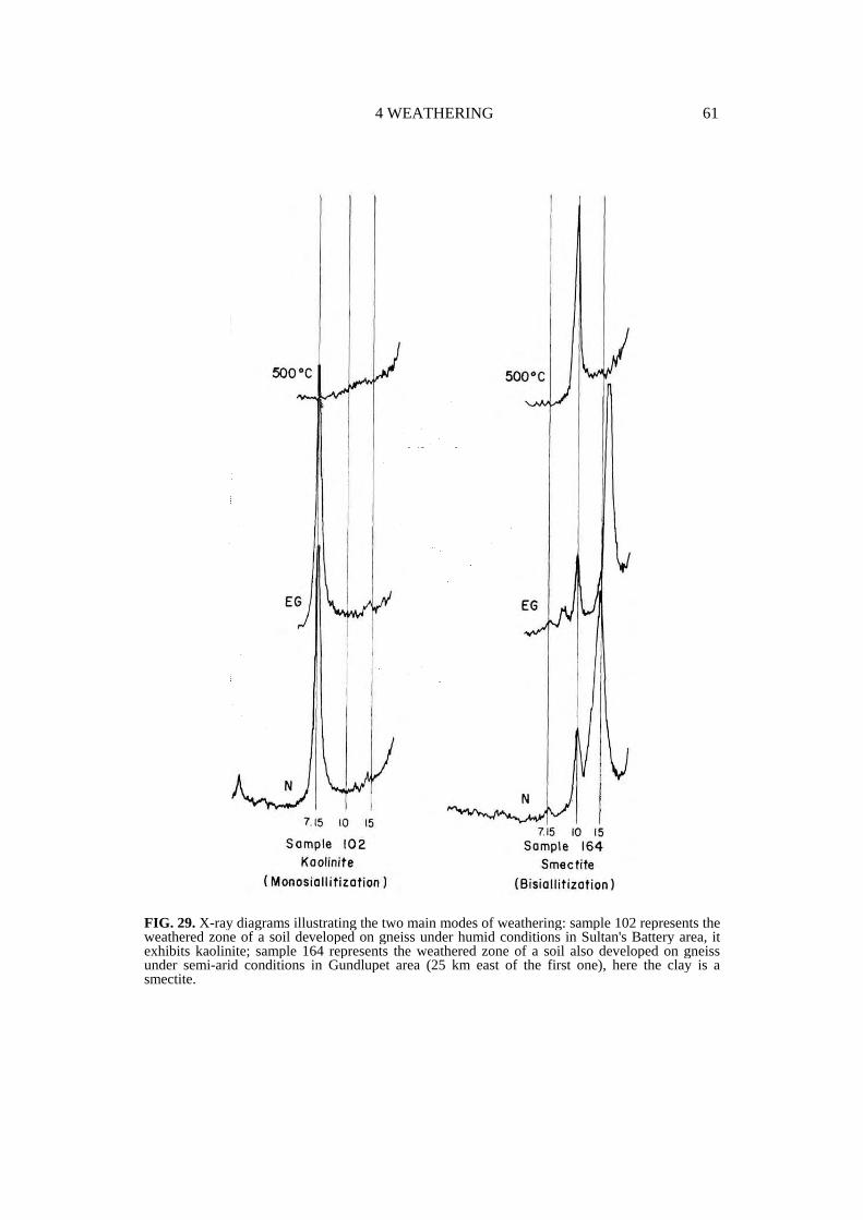
4 WEATHERING 61
FIG. 29. X-ray diagrams illustrating the two main modes of weathering: sample 102 represents the weathered zone of a soil developed on gneiss under humid conditions in Sultan's Battery area, it exhibits kaolinite; sample 164 represents the weathered zone of a soil also developed on gneiss under semi-arid conditions in Gundlupet area (25 km east of the first one), here the clay is a smectite.

62 RECONNAISSANCE SOIL MAP OF FOREST AREA
FIG. 30. Schematic repartition of the two main modes of weathering drawn up from field observations and chemical analyses (confirmed by X ray determinations).

4 WEATHERING 63
FIG. 31. X-ray diagrams of two samples where true bisiallitization is supposed to be the principal mode of weathering. Sample 523 represents the zone of weathering of a soil developed on basalt, its clay fraction is constituted by a mixture of interstratified material dominated by smectite and 1 : 1 minerals. Sample 551 represents the zone of weathering of a soil developed on gneiss and its clay fraction is essentially constituted by smectite.
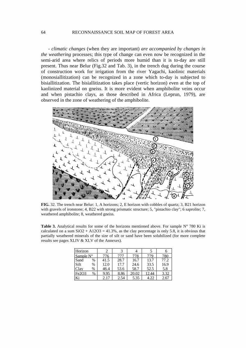
64 RECONNAISSANCE SOIL MAP OF FOREST AREA
- climatic changes (when they are important) are accompanied by changes in the weathering processes; this type of change can even now be recognized in the semi-arid area where relics of periods more humid than it is to-day are still present. Thus near Belur (Fig.32 and Tab. 3), in the trench dug during the course of construction work for irrigation from the river Yagachi, kaolinic materials (monosiallitization) can be recognized in a zone which to-day is subjected to bisiallitization. The bisiallitization takes place (vertic horizon) even at the top of kaolinized material on gneiss. It is more evident when amphibolite veins occur and when pistachio clays, as those described in Africa (Leprun, 1979), are observed in the zone of weathering of the amphibolite.
FIG. 32. The trench near Belur: 1, A horizons; 2, E horizon with cobbles of quartz; 3, B21 horizon with gravels of ironstone; 4, B22 with strong prismatic structure; 5, "pistachio clay"; 6 saprolite; 7, weathered amphibolite; 8, weathered gneiss.
Table 3. Analytical results for some of the horizons mentioned above. For sample N° 780 Ki is calculated on a sum SiO2 + A12O3 = 41.3%, as the clay percentage is only 5.8, it is obvious that partially weathered minerals of the size of silt or sand have been solubilized (for more complete results see pages XLIV & XLV of the Annexes).
Horizon 2 3 4 5 6Sample N° 776 777 778 779 780Sand % Silt % Clay %
41.5 12.0 46.4
28.7 17.7 53.6
16.7 24.6 58.7
13.7 33.5 52.5
77.2 16.9 5.8
Fe2O3 % 9.95 8.86 20.02 12.44 3.32Ki 2.17 2.54 5.35 4.22 2.67

4 WEATHERING 65
- the weathering of the different rock minerals is not synchronized. Thus to the south-west of Sakleshpur where the majority of the gneiss constituting minerals are completely hydrolysed into gibbsite and kaolinite at the base of the profiles, some others, particularly muscovite, can be observed persisting very near the soil surface in the exposures. They are weathered very slowly which may explain the presence of chloride material in the topsoil whereas it is absent at the bottom (Fig.33).
FIG. 33. Mineralogical profile (X-ray diagrams) showing the appearance of chlorite at a shallow depth in a soil of a region where weathering is of the monosiallitic type.
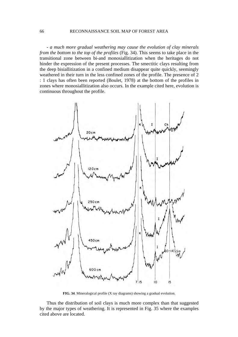
66 RECONNAISSANCE SOIL MAP OF FOREST AREA
- a much more gradual weathering may cause the evolution of clay minerals from the bottom to the top of the profiles (Fig. 34). This seems to take place in the transitional zone between bi-and monosiallitization when the heritages do not hinder the expression of the present processes. The smectitic clays resulting from the deep bisiallitization in a confined medium disappear quite quickly, seemingly weathered in their turn in the less confined zones of the profile. The presence of 2 : 1 clays has often been reported (Boulet, 1978) at the bottom of the profiles in zones where monosiallitization also occurs. In the example cited here, evolution is continuous throughout the profile.
FIG. 34. Mineralogical profile (X ray diagrams) showing a gradual evolution.
Thus the distribution of soil clays is much more complex than that suggested by the major types of weathering. It is represented in Fig. 35 where the examples cited above are located.

4 WEATHERING 67
FIG. 35. Sketch map showing the distribution of clay minerals in the surveyed area.

5
SOILS AND THEIR CLASSIFICATION
I. INTRODUCTION
Indian scientists had for a long time distinguished the South Indian soils into four main categories: alluvial soils, lateritic soils, red soils and black soils (Raychauduri et al., 1963), the forest soils not having been studied and classified. More recently, the adoption of the American system, Soil Taxonomy, has led to changes in their nomenclature and these categories were assimilated into Inceptisols, Oxisols-Ultisols, Alfisols and Vertisols, respectively. This has often been done without reconsidering the soil properties according to the new criteria of classification, which has now led some specialists (Naga Bhushana et al., 1987) to conclude that of the 9 series belonging to Alfisols in the Benchmark of Indian soils (Murthy et al., 1982), 4 have micromorphological characteristics which are in contradiction to this assimilation.
Now Soil Taxonomy is the official Indian system; however, for the cartographic method used here it is impractical as it is not a genetic classification:
- it is impossible to find a major taxonomic unit (for example, an order) which corresponds to a landscape unit, whereas it is quite common with a genetic classification.
- as the weathering processes had not been considered as a criterion for classification, a soil which is not very thick and another thicker soil showing the same type of kaolinitic and gibbsitic weathering are classified in different orders (Inceptisols and Oxisols, respectively) in Soil Taxonomy, while they are separated only at the level of subgroups (rejuvenated and typical, respectively) of the same class of Ferrallitic soils in the French classification.
Two classifications are therefore used in this study: - The French classification (CPCS, 1967) which is morphogenetic and whose
higher taxonomic units often correspond to landscape units, - The Soil Taxonomy applied to individual soil profiles. A table (Table 5) showing the relations of Soil Taxonomy to the French
Classification is also given. It has been established for the representative profiles.

5 SOILS AND THEIR CLASSIFICATION 69
However, it is impossible to show relations between the different taxa, for example, relations of a subgroup of Soil Taxonomy to subgroups of the French classification. Another table (Table 6) shows the relations of the two classifications to the morpho-pedological units.
II. SOIL TAXONOMY: CONCEPTS AND DEFINITIONS
The different categories of Soil Taxonomy are orders, suborders, great groups and subgroups. They are differentiated according to the following rules (modified from Buol et al., 1980):
Table 4.
Simplified key to soil orders* (modified from S.W. Buol et al., 1980, according to Soil Survey Staff, 1988)
If the soil has: 1. More than 30% organic matter up to a depth of 40 cm Histosols 2. Other soils with a Spodic horizon within 2 m Spodosols 3. Other soils that have either
a) an Oxic horizon and do not have a clay content increase necessary to define the upper boundary of a Kandic horizon, or b) 40% or more clay in the surface 18 cm and either a Kandic or an Oxic horizon that meets the weatherable mineral requirements of an oxic horizon. Oxisols
4 Other soils with more than 30% clay in all horizons; some cracks when dry at 50 cm Vertisols
5. Other soils that are dry for more than 50% of the year and have no mollic epipedon Aridisols
6. Other soils that have an Argillic or Kandic horizon and have base saturation of < 35% at a depth of 1.8 m Ultisols
7. Other soils that have a Mollic epipedon and have base saturation of > 50% at a depth of 1.8 m Mollisols
8. Other soils that have an Argillic or Kandic horizon Alfisols 9. Other soils that have an Umbric, Mollic or Plaggen
epipedon or a Cambic horizon Inceptisols 10. Other soils Entisols
* Orders occurring in the area studied are in hold characters.
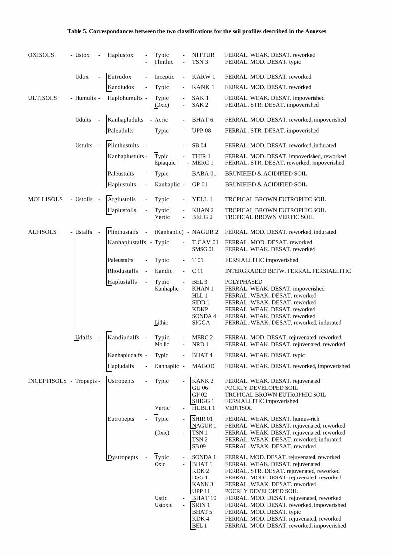
Table 5. Correspondances between the two classifications for the soil profiles described in the Annexes
OXISOLS - Ustox - Haplustox - Typic - NITTUR FERRAL. WEAK. DESAT. reworked - Plinthic - TSN 3 FERRAL. MOD. DESAT. typic
Udox - Eutrudox - Inceptic - KARW 1 FERRAL. MOD. DESAT. reworked
Kandiudox - Typic - KANK 1 FERRAL. MOD. DESAT. reworked
ULTISOLS - Humults - Haplohumults - Typic - SAK 1 FERRAL. WEAK. DESAT. impoverished (Oxic) - SAK 2 FERRAL. STR. DESAT. impoverished
Udults - Kanhapludults - Acric - BHAT 6 FERRAL. MOD. DESAT. reworked, impoverished
Paleudults - Typic - UPP 08 FERRAL. STR. DESAT. impoverished
Ustults - Plinthustults - - SB 04 FERRAL. MOD. DESAT. reworked, indurated
Kanhaplustults - Typic - THIR 1 FERRAL. MOD. DESAT. impoverished, reworked Epiaquic - MERC 1 FERRAL. STR. DESAT. reworked, impoverished
Paleustults - Typic - BABA 01 BRUNIFIED & ACIDIFIED SOIL
Haplustults - Kanhaplic - GP 01 BRUNIFIED & ACIDIFIED SOIL
MOLLISOLS - Ustolls - Argiustolls - Typic - YELL 1 TROPICAL BROWN EUTROPHIC SOIL
Haplustolls - Typic - KHAN 2 TROPICAL BROWN EUTROPHIC SOIL Vertic - BELG 2 TROPICAL BROWN VERTIC SOIL
ALFISOLS - Ustalfs - Plinthustalfs - (Kanhaplic) - NAGUR 2 FERRAL. MOD. DESAT. reworked, indurated
Kanhaplustalfs - Typic - T.CAV 01 FERRAL. MOD. DESAT. reworked SMSG 01 FERRAL. WEAK. DESAT. reworked
Paleustalfs - Typic - T 01 FERSIALLITIC impoverished
Rhodustalfs - Kandic - C 11 INTERGRADED BETW. FERRAL. FERSIALLITIC
Haplustalfs - Typic - BEL 3 POLYPHASED Kanhaplic - KHAN 1 FERRAL. WEAK. DESAT. impoverished HLL 1 FERRAL. WEAK. DESAT. reworked SIDD 1 FERRAL. WEAK. DESAT. reworked KDKP FERRAL. WEAK. DESAT. reworked SONDA 4 FERRAL. WEAK. DESAT. reworked Lithic - SIGGA FERRAL. WEAK. DESAT. reworked, indurated
Udalfs - Kandiudalfs - Typic - MERC 2 FERRAL. MOD. DESAT. rejuvenated, reworked Mollic - NRD 1 FERRAL. WEAK. DESAT. rejuvenated, reworked
Kanhapludalfs - Typic - BHAT 4 FERRAL. WEAK. DESAT. typic
Hapludalfs - Kanhaplic - MAGOD FERRAL. WEAK. DESAT. reworked, impoverished
INCEPTISOLS - Tropepts - Ustropepts - Typic - KANK 2 FERRAL. WEAK. DESAT. rejuvenated GU 06 POORLY DEVELOPED SOIL GP 02 TROPICAL BROWN EUTROPHIC SOIL SHIGG 1 FERSIALLITIC impoverished Vertic - HUBLI 1 VERTISOL
Eutropepts - Typic - SHIR 01 FERRAL. WEAK. DESAT. humus-rich NAGUR 1 FERRAL. WEAK. DESAT. rejuvenated, reworked (Oxic) - TSN 1 FERRAL. WEAK. DESAT. rejuvenated, reworked TSN 2 FERRAL. WEAK. DESAT. reworked, indurated SB 09 FERRAL. WEAK. DESAT. reworked
Dystropepts - Typic - SONDA 1 FERRAL. MOD. DESAT. rejuvenated, reworked Oxic - BHAT 1 FERRAL. WEAK. DESAT. rejuvenated KDK 2 FERRAL. STR. DESAT. rejuvenated, reworked DSG 1 FERRAL. MOD. DESAT. rejuvenated, reworked KANK 3 FERRAL. WEAK. DESAT. reworked UPP 11 POORLY DEVELOPED SOIL Ustic - BHAT 10 FERRAL. MOD. DESAT. rejuvenated, reworked Ustoxic - SRIN 1 FERRAL. MOD. DESAT. reworked, impoverished BHAT 5 FERRAL. MOD. DESAT. typic KDK 4 FERRAL. MOD. DESAT. rejuvenated, reworked BEL 1 FERRAL. MOD. DESAT. reworked, impoverished

Table 6. Relations of the two classifications to the morpho-pedological landscapes.
OXISOLS ULTISOLS MOLLISOLS ALFISOLS INCEPTISOLS Ustox Udox Humults Udults Ustults Ustolls Ustalfs Udalfs Ustropepts Eutropepts Dystropepts
POORLY DEV. GU 06 (15) UPP 11 (3) VERTISOLS HUBLI 1 (16a) BROWN TROP. YELL 1 (13)
KHAN 2 (13) BELG 2 (14b)
GP 02 (13)
FERSIALLITIC T 01 (15) SHIGG l (15) FERRAL. W. D. NITTUR (6b) SAK 1 9(a) SMSG 1 (11a)
KHAN 1 (7) HLL 1 (10a)SIDD 1 (10b)KDKP (10a)SONDA 4 (10a)SIGGA (10a)
NRD 1 (8) BHAT 4 (3) MAGOD (8)
KANK 2 (5b) NAGUR 1 (3) SHIR 1 (6b) TSN 1 (3) TSN 2 (3) SB 09 (9a)
BHAT 1 (3) KANK 3 (5B)
FERRAL. M. D. TSN 3 (2b) KARW 1 (3) KANK 1 (5b)
BHAT 6 (7) SB 04 (9a)THIR 1 (7)
NAGUR 2 (2b)T. CAV 1 (4a)
MERC 2 (3) SONDA 1 (8) DSG 1 (8) BHAT 10 (6b) SRIN 1 (7) BHAT 5 (6b) KDK 4 (4b) BEL 1 (11b)
FERRAL. S. D. SAK 2 (9A) UPP 08 (3) MERC 1 (4a) KDK 2 (4b) INTERGRADED C 11 (12) POLYPHASED BEL 3 (11b) BRUNIF. ACIDIF. BABA 01 (4a)
GP 01 (4a)
The numbers of the pedological landscapes are given in parenthesis. Abbreviations used: POORLY DEV. : Poorly developed soils. BROWN TROP. : Brunified soils of tropical climates. FERRAL. W. D. : Ferrallitic soils weakly desaturated in B horizon. FERRAL. M. D. : Ferrallitic soils moderately desaturated in B horizon. FERRAL. S. D. : Ferrallitic soils strongly desaturated in B horizon. BRUNIF. ACIDIF. : Brunified and acidified soils.

72 RECONNAISSANCE SOIL MAP OF FOREST AREA
- Orders are identified by the presence of one or more diagnostic horizons for mineral soils and by the presence of organic soil material for Histosols.
- Suborders are characterized by the presence or absence of properties associated with wetness, soil moisture regime, major parent material and vegetational effects as indicated by key properties.
- The great groups are identified by the kind, arrangement and degree of expression of horizons with emphasis on the upper sequum, base status, soil temperature, soil moisture regimes and the presence or absence of diagnostic layers.
- Subdivisions of great groups are based on properties indicating an intergradation to other great groups, suborders or orders.
III. REPRESENTATIVE SOIL PROFILES ACCORDING TO SOIL TAXONOMY
The representative soil profiles of the area are described in the Annexe. Here they are presented according to Keys to Soil Taxonomy by Soil Survey Staff (1988 ed.).
A. OXISOLS
Oxisols are soils developed on highly weathered rocks in the most humid regions of the area studied. They are mainly soils developed on basic rocks (poor in quartz) of the Dharwar metasediments. Since the introduction of the kandic diagnostic horizon with restrictions regarding textural properties in the definition of Oxisols, in Soil Taxonomy, most of the soils developed on granito-gneissic rocks and having oxic characteristics which were earlier considered as Oxisols (as they do not show an argillic horizon) are now placed under Ultisols (even under Alfisols) because of their textural differentiation and low percentage of clay in the upper 18 cms.
The differentiation of suborders is based on moisture regimes (which are estimated from the characteristics of the vegetation, as already mentioned). Two suborders, Ustox and Udox, are present in the area studied.
1. Ustox
Ustox are Oxisols that have an ustic moisture regime. They are represented only by the great group of Haplustox.
Haplustox. TYPIFYING PROFILES: NITTUR and TSN 3 The NITTUR soil is a member of the subgroup of Typic Haplustox and is not
very different from an Eutrodox because of its high base saturation. Profile TSN 3 is

5 SOILS AND THEIR CLASSIFICATION 73
classified as Plinthic Haplustox. These two soils have fairly low ECEC values in all the horizons (ECEC always lower than 5 meq/100 g of soil) in spite of a high percentage of granulometric clay.
2 Udox
Udox are Oxisols that have an udic moisture regime. In the area studied, they are represented by two great groups: Eutrodox and Kandiudox.
a. Eutrodox. These soils are characterized by a base saturation (>35%) which is high for Oxisols.
TYPIFYING PROFILE: KARW 1 This soils is developed on the metamorphosed rocks of Dharwar and is located
under evergreen forests in the Western Ghats. The clay content is high. It is classified as Inceptic Eutrudox as the lower limit of the oxic horizon is not deep. In fact, after 115 cm, the subsoil contains abundant lithorelicts with weatherable minerals. This is frequent in soil profiles of the scarp of the Ghats and represents an intergradation to Dystropepts. KARW 1 profile is located at the top of the scarp, in the zone of dismantling of laterites.
b. Kandiudox. TYPIFYING PROFILE: KANK 1 This soil is developed on ferruginous debris resulting from the dismantling of
the laterite capped mesas on basalt, under evergreen forests (Memecylon type). It is considered as Typic Kandiudox and has a base saturation of only 35% at 80 cm (and probably even less lower down) which places it at the limit of Eutrudox. On this ferruginous debris, Typic Kandiudox are associated with other soils whose oxic character is less pronounced and which are therefore classified as Oxic Dystropepts (KANK 3 profile).
In profile KANK 1, many coarse elements result from the dismantling of the laterites, but mixed with them are found gravels, which are in fact very hardened, non-fragile peds, resistant to a moderate crushing. These hardened aggregates do not crumble in water even after several hours, but are destroyed by hydrogen peroxide. Two types of coarse elements have been analysed:
- gravels (a) = ferruginous gravels, - gravels (b) = hardened aggregates. The Hapludox are not represented in the soil profiles described in the annexe;
however it is possible that they occur in association with Eutrudox on basic rocks.
B.ULTISOLS
The other highly developed soils in the very humid regions are generally Ultisols. Three suborders are present in the area studied: Humults, Udults and Ustults.

74 RECONNAISSANCE SOIL MAP OF FOREST AREA
1. Humults
Humults are Ultisols rich in organic matter and hence are mostly found under forest cover. Here they are represented by only one great group: the Haplohumults.
Haplohumults. TYPIFYING PROFILES: SAK 1 and SAK 2 The two soils are located in the region of Sakleshpur on the back slope of the
Ghats. For the first one, SAK 1, the base saturation was not determined at the required depth (180 cm) to differentiate it from an Alfisol; nevertheless it is probable that at this depth it is less than 35%. This profile is located under forest.
The second profile, SAK 2, is located close to the first one in a pasture. If clearing of the forest does not lead to a heavy reduction in the organic stock, it is nevertheless accompanied by a sharp fall in the base saturation and hence the soil is classified as Oxic Haplohumult, although the subgroup was not envisaged in the Taxonomy.
This last soil dominates a bank carved by erosion in which the weathered rock can be observed. It is rich in aluminium hydroxide (SiO2/Al203=0.26) and passes above abruptly to a regolith where the original arrangement of the rock is no more visible. The SiO2/Al203 ratio is also higher (1.60) in the regolith.
2. Udults
Udults are Ultisols that have an udic moisture regime; they are represented by the great groups of Kanhapludults and Paleudults.
a. Kanhapludults. TYPIFYING PROFILE: BHAT 6 This soil shows an oxic horizon and as the increase in clay content does not
coincide with the upper limit of the oxic horizon, it is not possible to define a kandic horizon. On the other hand, the presence of clay skins in the second and third horizons enables the distinction of an argillic horizon. After 120 cm, subsoil showing numerous lithorelicts is found below the oxic horizon. The subsoil exhibits a very low ECEC (1 meq/l00g) which confers an acric character to this soil which is classified as Acric Kanhapludult.
b. Paleudults TYPIFYING PROFILE: UPP 08 This soil is located at the bottom of the Ghats, in the area where they meet the
coastal hinterland. It is found on the (ancient ?) saprolite of the gneissic complex. In depth, the roots are localized exclusively in the yellow mottles of the subsoil. The lowermost horizon has a very low base saturation and is rich in exchangeable aluminium. This profile also has a distinct acric character which is not taken into account at the level of the subgroups of Paleudults and the soil is hence considered as a member of Typic Paleudults.

5 SOILS AND THEIR CLASSIFICATION 75
3. Ustults
Ustults are ultisols that have an ustic moisture regime; they are represented by four great groups: Plinthustults, Kanhaplustults, Paleustults and Haplustults.
a. Plinthustults. TYPIFYING PROFILE: SB 04 In this soil, the fourth horizon located below the plinthite is a kandic horizon.
It would have been classified as Plinthic Haplustox if the upper horizon contained more than 40% clay. The ECEC of the kandic horizon is very low: 1.6 meq/100 g. The soil profile is located in the lower part of the slope in the "meio laranjas" area and shows yellowish colours typical of this position.
b. Kanhaplustults. TYPIFYING PROFILES: THIR 1 and MERC 1 Both the soils are developed on gneiss and in the earlier version of Soil
Taxonomy would have been considered as Oxisols as they do not have an argillic horizon. These are soils which, in addition to the impoverishment in clay of the upper horizons, show a high concentration of coarse quartz (size of quartz gravels between 2 and 8 mm). In both the profiles, the "BC" horizons below the kandic horizons show a decrease of more than 20% in the clay content as compared to the kandic horizon.
The profile THIR 1, located in the partially dissected intermediate levels on gneiss, is a member of Typic Kanhaplustults.
The MERC 1 soil is located on the rounded crests of the strongly dissected high level dominating the town of Mercara; the vegetation is one of ferns. It is classified as Epiaquic Kanhaplustult because of the yellowish colour of its upper horizons (10 YR) and has very low sum of exchangeable bases and a high content of aluminium extractable by KC1 1 M.
c. Paleustults. TYPIFYING PROFILE: BABA 01 This soil is located on the rounded crests of the strongly dissected high level of
the Bababudan range; the vegetal cover is graminaceous. The soil is developed on very fine textured material rich in clay of the chlorite type. It is highly desaturated and exceptionally rich in aluminium extractable by KC1 1 M (up to 5 meq/100 g of soil).
d. Haplustults. TYPIFYING PROFILE: GP 01 This soil is located on the summit of Gopalaswamy Betta. On this summit can be
observed, in depth, the roots of an old saprolite which constitutes the subsoil. The surface soil is subject to a new pedogenesis which consists of a moderate leaching of clay and a general colour change (from red to yellowish brown). In this newly formed soil a tendency towards an accumulation of organic matter (more here than in some of the soils under deciduous forests) is also observed. The contact between the
76 RECONNAISSANCE SOIL MAP OF FOREST AREA
humiferous soil and the old saprolith is often emphasized by a rust coloured boundary.
Other profiles seen on the road cuttings sometimes show a horizon with a strong, large blocky structure at the upper limit of the saprolith. The analyses carried out on these horizons do not reveal a clear increase in the SiO2/Al203 ratio as may be expected in view of this morphology.
The vegetation is a herbaceous savanna; the GP 01 soil is classified as Kanhaplic Haplustult developed on gneiss which shows a high desaturation in bases and high percentage of aluminium extractable by KC1 1 M. There are many features in common with the soil profile MERC 1 described earlier. The tendency for organic matter accumulation will increase with altitude, for example on the slopes of the Niligiri hills (not described here).
C. MOLLISOLS
Only one Suborder is represented in the soil profiles described in the Annexe: Ustolls which are Mollisols that have an ustic moisture regime; they occur in the semi-arid zone. In more humid regions, the penetration of organic matter in depth and the base saturation are insufficient for Mollisols.
Ustolls
In the mapped area, the Mollisols are mainly located on the residual reliefs of the semi-arid zone under natural vegetation which, when well preserved, is a dry deciduous forest. They are associated with Inceptisols and, when the natural vegetation is destroyed, with Entisols and numerous rock outcrops. Mollisols are observed on clayey products resulting from the weathering of basic rocks: Dharwar metasediments rich in hornblende and basalts of the Deccan Traps. Inceptisols predominate on the more acidic rocks of the gneiss type where weathering releases more coarse sand and where structures are less distinct than on the other types of rocks.
Two great groups have been identified: Argiustolls having an argillic horizon and Haplustolls which do not have it.
a. Argiustolls TYPIFYING PROFILE: YELL 1 The soil has a strong, fine blocky structure up to a depth of 110 cm. It is
located on an appalachian ridge whose frame is a bed of ferruginous quartzite. The soil is developed on a more schistose bed which passes in depth to a coarse grained rock. Secondary minerals produced by weathering are mostly smectites as seen in the results of clay determination of sample N°548. The solum is coloured red by the iron.

5 SOILS AND THEIR CLASSIFICATION 77
b. Haplustolls. TYPIFYING PROFILES: KHAN 2 and BELG 2 Profile KHAN 2 is located on the residual reliefs formed by the numerous
ferruginous quartzite beds which traverse the region west of Dharwar-Hubli. This situation is very similar to that of the YELL 1 soil described earlier, but here we do not observe an argillic horizon. The soil is classified as Typic Haplustoll.
The other soil, BELG 2, is on the very steep slope of a laterite capped mesas in the Deccan Traps province, at the limit of the semi-arid zone. The weathering of basalt also produces considerable quantities of clay minerals, almost all the granulometric fractions being constituted by clay minerals. The BELG 2 soil is classified as Vertic Haplustoll. The steep slope limits the depth of the profile and prevents the formation of a Vertisol.
D. ALFISOLS
Alfisols are not characteristic of any climatic zone and are found in the humid as well as in the semi-arid zones: Udalfs and Ustalfs, respectively.
1. Ustalfs
Ustalfs are Alfisols that have an ustic moisture regime. They are very frequent and are represented by five great groups: Plinthustalfs, Kanhaplustafs, Paleustalfs, Rhodustalfs and Haplustalfs.
a. Plinthustalfs, TYPIFYING PROFILE: NAGUR 2 As this great group has not been subdivided into subgroups, by analogy with
that which is done for the other great groups, this soil would be classified as Kanhaplic Plinthustalf, taking into account the low value of CEC/100 g of clay and the relative desaturation in bases.
b. Kanhaplustalfs are a great group of Haplustalfs that have a kandic diagnostic horizon or kandic characteristics in part of the argillic horizon. In the earlier version of Soil Taxonomy, some of them had been considered as Oxisols.
TYPIFYING PROFILES: T. CAV 01 and SMSG 1 Soil profile T. CAV 01 is situated on the rounded crests of the strongly
dissected high level in the vicinity of the source of the river Kaveri. The weathering of the rock (gneiss or charnockite) has led to a high desilicification : the SiO2/Al2O3 molecular ratio is close to the unit in the whole profile. The analysis of a pebble (sample 620) shows the predominance of aluminium hydroxide in the coarse elements of the solum. The values of ECEC are also very low. This soil is classified as Typic Kanhaplustalf.
78 RECONNAISSANCE SOIL MAP OF FOREST AREA
The other profile, SMSG 1, also classified as Typic Kanhaplustalf, shows an argillic horizon above the kandic horizon. It is located on the landforms derived from the dismantling of the laterites of the intermediate levels in the semi-arid zone. It represents an extreme case where the oxic character (CEC < 24 meq/100 g of clay) of an old weathering phase under humid conditions is particularly well preserved, the more general case being represented by the Kanhaplic Haplustalfs.
c. Paleustalfs. TYPIFYING PROFILE:T 01. This soil profile is classified as Paleustalf because of the rapid and abrupt
transition between its upper sandy eluviated horizon and the underlying argillic horizon. It is a Typic Paleustalf and a good representative of soils formed under the present conditions (bisiallitic weathering process) and occupying the convexities in the landscape.
d. Rhodustalfs. TYPIFYING PROFILE: C 11
The soil profile was described in the southern transitional zone between malnad and maidan. It is coloured deep red by iron oxides and totally decarbonated. The clay skins are very clear and well developed in the argillic horizon. It is classified as Kandic Rhodustalf.
e. Haplustalfs. TYPIFYING PROFILE: BEL 3, KHAN 1, HLL 1, SIDD 1, KDKP and SONDA 4. The profile BEL 3 is classified as Typic Haplustalf. It was described in the
central transitional zone between malnad and maidan, where the actual bisiallitic evolution is superimposed to the mono-siallitic heritage. In this profile a vertical vein of amphibolite traverses the gneisses; this is a common feature encountered in the Peninsular Gneisses.
The profile KHAN 1 classified as Kanhaplic Haplustalf is developed on gneiss in a zone of partially dissected intermediate levels at the bottom of a slope; the second horizon, 20-80 cm, is strongly eluviated; the 80-110 (not analysed) horizon shows clay skins coating some peds; the last horizon described, 110 -140 cm, is mottled and on the whole has a yellowish colour.
The soil profiles HLL 1, SIDD 1, KDKP and SONDA 4 are also Kanhaplic Haplustalfs, all of them developed on landforms derived from the dismantling of the laterites of the intermediate levels in the semi-arid zone. The disintegration of the ironstones has given rise to a material rich in ferruginous nodules which seems very favourable for the formation of argillic horizons. The kandic character (CEC< 24 meq/100 g of clay) shows the high degree of weathering of these soils. All the soil profiles described, except SIDD 1, are under forest cover and the organic matter content is generally very high in the top-soil horizons (which is sufficient to get mollic epipedons, but the associated massive and blocky structures of these horizons are incompatible with this epipedon type). The epipedon which comes nearest to the mollic epipedon is that of HLL 1 which is located in a well preserved "kan forest".

5 SOILS AND THEIR CLASSIFICATION 79
The profile SIGGA 1 is located in the same region as the preceding ones, but in a zone of incompletely dismantled laterite; it typifies a Lithic Haplustalf.
2. Udalfs
Udalfs are Alfisols that have an udic moisture regime. They are therefore all localized in the humid zone subjected to the southwestern monsoon and under evergreen forests. Two examples of Kandiudalfs and one of Hapludalf are described.
a. Kandiudalfs have a kandic horizon and, in the earlier versions of Taxonomy, some of them were classified as Oxisols from which they now differ only in the low content of clay in their surface horizons. They constitute the intermediate stage of development between Oxisols and Inceptisols. In the Ghats region, where they are common, they are generally rich in incompletely weathered rock elements.
TYPIFYING PROFILES: MERC 2 and NRD 1. The soil profile MERC 2, typifying a Typic Kandiudalf, is located in the
Ghats. The other profile, NRD 1, located in the strongly dissected intermediate levels, has dark surface horizons and is a member of Mollic Kandiudalfs.
b. Kanhapludalfs. These soils are only slightly different from Kandiudalfs. TYPIFYING PROFILE: BHAT 4.
Profile BHAT 4 is located under evergreen forests in the Ghats and is classified as Typic Kanhaplustalf.
c. Hapludalfs. TYPIFYING PROFILE: MAG 01. This soil is located in the strongly dissected intermediate levels and differs
from the preceding ones in the lower intensity of the kandic character (16 meq/100 g of clay < CEC < 24 meq/100 g of clay), and is therefore classified as Kanhaplic Hapludalf.
E. INCEPTISOLS
This important order concerns most of the soil profiles lacking characteristics which would have enabled them to be classified in the preceding orders. Hence it includes soils of the semi-arid as well as the humid zones.
There is only one suborder for the Inceptisols of tropical regions: Tropepts.

80 RECONNAISSANCE SOIL MAP OF FOREST AREA
Tropepts
Tropepts are divided into five great groups, of which three are represented in the region studied: Ustropepts, Eutropepts and Dystropepts.
a. Ustropepts are Tropepts that have an ustic moisture regime and a base saturation (by NH4 OAc) of 50% or more in all subhorizons between 25 cm and 1 m.
TYPIFYING PROFILES: KANK 2, GU 06, GP 02, SHIGG 1 and HUBLI 1. The first four soils are Typic Ustropepts, but are quite different from one another:
- profile KANK 2 is shallow and is developed on weathered basalt under herbaceous vegetation on the back slope of the Ghats. It shows a moderate base desaturation in its upper horizon.
- profile GU 06 is located on an alluvial terrace; it shows some slickensides at depth.
- profile GP 02 is located on the slopes of Gopalswamy Betta on gneiss; the weathered gneiss is rich in smectite. Some characteristics such as the high organic matter content and the well structured upper horizon, place it at the limit of Mollisols.
- profile SHIGG 01, in the semi-arid zone, is on a glacis. No clay skins are observed in the second horizon. The pronounced textural discontinuity with the first horizon is interpreted as a colluvial feature;
The profile HUBLI 1 is classified as Vertic Ustropept and is located in the clayey basins to the east of Hubli. Its upper horizons are too poor in clay for it to be a Vertisol.
b. Eutropepts. In the mapped region, the Eutropepts have an udic moisture regime and a base saturation (by NH4 OAc) of 50% or more in all subhorizons between 25 cm and 1 m. All the Eutropepts described are Typic Eutropepts.
TYPIFYING PROFILES: NAGUR 1, TSN 1, TSN 2, SB 09 and SHIR 1 Three soil profiles are located in the lower part of the scarp of the Ghats:
NAGUR 1, TSN 1 and TSN 2 on greywackes. TSN 2 shows some features of Kandic Plinthustalfs.
- profile SB 09 is in the "meio laranjas" zone. - the last profile, SHIR 1, is located in the zone of dismantling of the laterite
capped mesas of the partially dissected intermediate levels on greywackes under a Memecylon forest.
Three of these profiles, SB 09, TSN 1 and TSN 2, have a CEC/100 g of clay < 24 meq which is used to define the oxic subgroup in another great group of Inceptisols (Dystropepts). Hence it is proposed to consider them as Oxic Eutropepts although this subdivision has not been created.
c. Dystropepts. In the mapped region Dystropepts are other Tropepts either with an udic or an ustic moisture regime accompanied by a base saturation (by NH4 OAc, pH ) of less than 50% in some subhorizons between 25 cm and 1 m.

5 SOILS AND THEIR CLASSIFICATION 81
TYPIFYING PROFILES: SONDA 1, BHAT 1, BHAT 5, BHAT 10, KDK 2, KDK 4, DSG 1, KANK 3, UPP 11, SRING 1, BEL 1.
Profile SONDA 1 is located in the strongly dissected intermediate levels on greywackes. But for the base saturation, it differs little from the Eutropepts described in the same area. It is classified as Typic Dystropept.
Oxic Dystropepts are represented by five soils which correspond to fairly diverse situations:
- profile BHAT 1 located on the greywackes under evergreen forests of the Ghats. It is not very different from an Udalf but there are no distinct clay skins on the peds of the 40-70 cm horizon to have an argillic horizon and therefore to classify it as Hapludalf (Ultic). The value of CEC/100 g of clay in this same horizon is also too high to consider it as Kandiudalf (Mollic).
- profile KDK 2 located on a slope of the strongly dissected high level under the Poeciloneuron forest. It has a very low ECEC in depth, which brings it close to Acrudox. The base saturation (by NH4 OAc) is also very low.
- profile DSG 1 located in the strongly dissected intermediate levels on greywackes under evergreen forests and is close to a Kandiudox because of its low value of CEC/100 g of clay.
- profile KANK 3 located in a zone of dismantling of the laterite capped mesas of the partially dissected intermediate levels on the Deccan Traps, under the Memecylon forest. It is very similar to an Eutropept such as SHIR 1. As in the profile KANK l, the coarse elements are of two types:
• gravels (a) = lateritic debris, which are very aluminious in this profile. • gravels (b) = hardened aggregates, whose composition reflects that of the
soil. - profile UPP 11 located at the junction of the Ghats with the coastal hilly
hinterland (like the profile UPP 08) and developed on a scree. One soil is classified as an Ustic Dystropept: - profile BHAT 10 is situated on the back slope of the Ghats under a
herbaceous cover in the region of Agumbe. Although located in an area where precipitations are in the order of 7 metres, it still has an ustic moisture regime.
Four soils are classified as ustoxic Dystropepts and are all, except for one, located in the humid zone but have an ustic moisture regime:
- profile SRING 1 on the partially dissected intermediate levels on gneiss is quite close to a Kanhaplic Haplustalf, but does not show clay skins in the 35-110 cm horizon. It is located under moist deciduous forests;
- profile BHAT 5 is on greywackes on the back slope of the Ghats, in a position quite comparable to that of BHAT 10 and is also under a graminaceous cover. It is situated in the vicinity of a thicket in which the high percentage of organic matter allows a base saturation higher than 50% in the surface horizon (sample N° 483). Profile BHAT 5 contains numerous ferruginous nodules resulting from the hardening of mottles near the surface; these mottles can be observed in peds of the third horizon.
82 RECONNAISSANCE SOIL MAP OF FOREST AREA
- profile KDK 4 is located on a slope of the strongly dissected high level; the vegetation is a savanna with a few interspersed Phoenix. The rock is metasedimentary Dharwar schist.
- profile BEL 1 is in the central transitional zone between Malnad and Maidan but at the western limit of the unit. The monosiallitic heritage predominates the actual bisiallitic evolution. The vegetation is a highly degraded deciduous forest; this zone also marks the eastern limit of coffee plantations. The deepest horizon has a CEC/100 g of clay lower than 16 meq but contains numerous alterable minerals, so it cannot be considered as an oxic horizon; it also has numerous clay skins but the percentage of clay is not high enough, when compared to the second horizon, to get an argillic horizon.
IV. FRENCH CLASSIFICATION: CONCEPTS AND DEFINITIONS
Founded on the morphological study of soils, the French classification is based on the processes of soil evolution. The higher categories are Classes, Subclasses, groups and subgroups.
Soil Classes are defined by certain basic processes of soil evolution, the degree of evolution and development of the profile. The basic processes concern the types of weathering and secondary minerals derived from them, the type of distribution of organic matter, hydromorphism and halomorphism.
Subclasses are based on the effects of climatic factors. Groups are defined according to a second process of evolution such as
induration, impoverishment, leaching... Subgroups are based on the intensity of the second process of evolution or on
the appearance of a third one; for example, induration plus impoverishment. There are 12 Classes; the Classes present in the studied area are in bold
characters.
1. Skeletal soils. 2. Poorly developed soils. 3. Vertisols. 4. Andosols. 5. Calci-magnesic soils. 6. Isohumic soils. 7. Brunified soils. 8. Podzolized soils. 9. Sesquioxisols.
10. Ferrallitic soils. 11. Hydromorphic soils. 12. Salsodic or halomorphic soils.

5 SOILS AND THEIR CLASSIFICATION 83
The relationships between the weathering types (as defined in the preceding chapter) and the soil types are given for each class.
The French Classification is being revised and should be greatly modified in the coming years. The new name of the French system of classification will be "Référentiel Pédologique".
V. REPRESENTATIVE SOIL PROFILES ACCORDING TO THE FRENCH CLASSIFICATION
A. SKELETAL AND POORLY DEVELOPED SOILS
The soils of this class present in the studied area belong to the subclasses of "skeletal and poorly developed soils not due to the climate". They are located either in the recent alluvial or fluvio-littoral formations (profile GU 101) or in recently eroded areas (profile UPP 11); weathering is always embryonic.
B. VERTISOLS
Many vertisols (according to the French classification) with limited external drainage are found in the plains and clayey alluvial basins (profile HUBLI 1). Some soils with good external drainage may be found on the basaltic structural reliefs of the Deccan Traps province (there is no profile of this type in the Annexe).
C. BRUNIFIED SOILS
The soils of this class present in the studied area belong to the group of Brown soils of the subclass of Brunified soils of tropical climates. They correspond to juvenile soils either because of the erosion or because of the characteristics of the parent rock which retard the evolution towards another class. They are located in the semi-arid zone, essentially on the residual reliefs (profiles YELL 1, KHAN 2 and GP 02) and on the basaltic slopes in the Deccan Traps province (profile BELG 02); they are associated with other soils on the pediplain of the archean shield. Two subgroups have been distinguished: Brown eutrophic soils and Brown vertic soils. The weathering process is of the bisiallitic type. 2: 1 clays dominate in the zone of weathering. An association or paragenesis of 1: 1 and 2: 1 clays can be observed higher up in the soil profile.

84 RECONNAISSANCE SOIL MAP OF FOREST AREA
D. SESQUIOXISOLS
These soils are characterized by an incomplete weathering of primary minerals and a limited elimination of silica, alkaline and alkaline earth bases. The secondary minerals produced are mostly 2: 1 clays (by true or apparent bisiallitization), but 1: 1 clays are also present. The percentage of free iron in the form of oxides (which gives the colour to the profile) is approximately 3 in the B horizons of these soils.
The name of this class may lead to confusion because there is another class (Ferrallitic) where the soils are also rich in sesquioxides of iron.
Sesquioxisols present in the studied area belong to the subclass of Fersiallitic soils (Bourgeon, 1987a &b) and are very common in the entire semi-arid region on the archean shield where they represent a more evolved stage than the Brown soils mentioned above (profiles T 01 and SHIGG 1).
E. FERRALLITIC SOILS (from AUBERT and SEGALEN, 1966)
This is by far the best represented class (41 of the 53 profiles described in the annexe). Soils are characterized by a complete weathering of the primary minerals (allitization or monosiallitization) accompanied by the elimination of the major part of the alkaline and alkaline earth bases and of a large part of the silica. The secondary products are 1:1 clay of the kaolinite type, aluminium hydroxide and iron oxyhydroxide.
Three subclasses are distinguished according to base saturation, pH and total exchangeable bases. Generally two subclasses are present in association in each zone where ferrallitic soils are encountered. As the definition of subclasses is based on the variation of three parameters (pH, base saturation and total exchangeable bases), it is often found that the values of two of these parameters correspond to one subclass, whereas that of the third corresponds to another. Hence the classification of a given profile at the level of subclass can be a little difficult.
Groups are distinguished according to a second process of evolution. The following groups are defined:
- a humus-rich group (humiferous) if the accumulation of organic matter is at least 7% at a depth of 20 cm.
- an impoverished group, if the clay or iron has been eliminated from the A horizons and if there is no correlative accumulation in the B horizons.
- a reworked group (translation of the French word "remanié"), if the lower part of a profile which has not moved is covered by transported soil material which is as evolved as the soil in the rest of the profile;
- the rejuvenated group, which corresponds to soils whose evolution is delayed by erosion (as compared to normal evolution which could be defined in the region studied):
5 SOILS AND THEIR CLASSIFICATION 85
• either the profile is truncated in such a way that the zone of weathering is reached and the distribution of the primary rock minerals becomes visible at a depth of less than 50 cm, or
• poorly evolved materials are deposited and form the upper part of a truncated profile.
- the typic group, which corresponds to soils lacking the characters which serve to define the other groups.
1. Subclass of Weakly Desaturated Ferrallitic Soils in B Horizon
Sum of exchangeable bases 2 to 8 meq/100 g Base saturation 40-80% pH 5 to 6.5
a. Typic group. One representative profile, BHAT 4. b. Humus-rich group, one representative profile, SHIR 1. This group is
unusual in this subclass. c. Impoverished group. Two representative profiles: SAK 1 and KHAN 1. d. Reworked group. The representative profiles SMSG 1, HLL 1, SIDD 1,
KDKP, SONDA 4, NITTUR and KANK 3, are all located in the zone of dismantling of laterites and contain numerous ferruginous elements; profile SB 09 is completely different and shows the presence of a stone layer constituted by quartz pebbles. The SIGGA and TSN 2 soils are representative of the reworked and indurated subgroup. The MAGOD profile belongs to the reworked and (slightly) impoverished soils.
e. Rejuvenated group. All the profiles described belong to the subgroup of rejuvenated soils with erosion and reworking : TSN 1, NAGUR 1, KANK 2, NRD 1, BHAT 1, BHAT 4.
2. Subclass of Moderately Desaturated Ferrallitic Soils in B Horizon
Sum of exchangeable bases 1 to 3 meq/l00g Base saturation 20 - 40% pH 4.3 to 6.0.
a) Typic group. Represented by two profiles, BHAT 5 and TSN 3. The numerous ferruginous nodules of these profiles result from in situ formation and not from the dismantling of a pre-existing ironstone; so the soils are considered as typic and not as reworked.
b) Impoverished group. Only one representative profile THIR 1 which corresponds to the impoverished and reworked subgroup.
c) Reworked group, representated by many profiles. The typic subgroup is represented by four profiles: NITTUR, KANK 1, KARW 1, T. CAV 01 (KANK 1 is

86 RECONNAISSANCE SOIL MAP OF FOREST AREA
probably a member of the humus-rich subgroup, but the percentage of organic matter was not determined at 20 cm). The profiles SB 04 and NAGUR 2 belong to the reworked and indurated subgroup and the profiles BEL 1, BHAT 6 and SRIN 1 to the reworked and impoverished subgroup.
d) Rejuvenated group. As in the preceding subclass, all the profiles described belong to the subgroup of rejuvenated soils with erosion and reworking: MERC 2, SONDA 1, KDK 4, DSG 1 and BHAT 10.
3. Subclass of Strongly Desaturated Ferrallitic Soils in B Horizon
Sum of exchangeable bases less than 1 meq/100 g Base saturation less than 20% pH less than 5.5
Soils of this subclass are small in number. Only a few groups have been observed.
a) Impoverished group. Represented by two profiles, UPP 08 and SAK 2. b) Reworked group, impoverished subgroup. Represented by the profile
MERC 1. c) Rejuvenated group, reworked subgroup. Represented by the profile KDK 2.
F. OTHER CATEGORIES
Besides the above classes, other categories were created for the purposes of this study: a category of intergraded soils between ferrallitic and fersiallitic soils, one of polyphased soils in regions where the actual bisiallitic evolution is superimposed on past monosiallitic weathering and another of brunified acidified soils of higher elevations.
I. Intergraded Soils between Ferrallitic and Fersiallitic Soils
These are represented by the profile C 11. The evolution of clay minerals from the top to the bottom of this profile has already been described in the preceding chapter. This is accompanied by characteristics of both ferrallitic and fersiallitic soils.
- horizons resembling the zone of weathering of ferrallitic soils (kaolinized zone) occur below the stone layer in the profiles,
- deep horizons show high SiO2/Al2O3 molecular ratios and a base saturation exceeding 100%, which are more characteristic of fersiallitic soils.

5 SOILS AND THEIR CLASSIFICATION 87
2. Polyphased Soils
These are represented by the profile BEL 3. The evolution of the mineral nature of the clays in this type of profile has also been described in the preceding chapter.
3. Brunified and Acidified soils
These are represented by the soil profiles BABA 01 and GP 01, both situated on rounded crests of the strongly dissected high level. Here the complex properties of these profiles probably result from a polyphasing: accumulation of organic matter accompanied by acidification in a material resulting from an older ferrallitization. This is particularly clear on the summit of Gopalswamy Betta (Fig 36).
FIG. 36. Brunified and acidified soil on the summit of Gopalswamy Betta. The irregular transition between the organic horizons and the saprolite is seen clearly.

BIBLIOGRAPHY
ALEXANDER (P.O.), 1981. — Age and duration of Deccan Volcanism: K - Ar evidence. In: Deccan Volcanism and related basait provinces in other parts of the world, SUBRARAO (K.V.) and SUKHESWALA (R.N.) Edit., Bangalore, Geological Society of India, Memoir n° 3, pp. 244-258.
AUBERT (G.), SEGALEN (P.), 1966. — Projet de classification des sols ferrallitiques. Cah. O.R.S.T.O.M. sér. Pédol., 4 (4): 97-112.
AVENARD (J.M.), 1971. — La répartition des formations végétales en relation avec l'eau du sol dans la région de Man-Touba. Trav. et Doc. O.R.ST.OM. n° 12: 159 p.
BERTRAND (R.), 1972. — Morphopédologie et orientations culturales des régions soudaniennes du Siné-Saloum (Sénégal). L'Agron. Trop., 27 (11): 1115-1190.
BERTRAND (R.), VALENZA (J.), 1979. — Evaluation des possibilités agricoles, pastorales et forestières des milieux naturels du Sénégal Oriental. Map at 1:500,000 scale, G.E.R.D.A.T., Montpellier.
BERTRAND (R.), VALENZA (J.), 1982. — Méthode de cartographie des milieux naturels du Sénégal Oriental, évaluation des possibilités agro-sylvo-pastorales. L'Agron. Trop., 37 (4): 329-339.
BERTRAND (R.), FALIPOU (P.), LEGROS (J.P.), 1984. — S.T.I.P.A., 1.- Notice pour l'entrée des descriptions et analyses de sols en banque de données. ACCT, Paris, 136 p.
BOULET (R.), 1978. — Toposéquences de sols tropicaux en Haute-Volta. Equilibre et déséquilibre pédobioclimatique. Mémoire O.R.S.T.O.M. n°85: 272 p.
BOURGEON (G.), 1987a. — Les "sols rouges" des régions semi-arides du sud de l'Inde. I - Propriétés et classification pédologique. L'Agron. Trop., 42 (3): 153-164.
BOURGEON (G.), 1987b. — Les "sols rouges" des régions semi-arides du sud de l'Inde. II - Potentialités, rôle dans les systèmes agraires. L'Agron. Trop., 42 (3): 165-170.
BOURGEON (G.), PASCAL (J.P.), 1986. — Influences des héritages morphopédologiques dans la répartition des formations forestières: région de Sorab-Siddapur (Inde du sud). Bois et Forêts des Tropiques, 214: 3-21.
BUCHANAN (F.), 1807. — A journey from Madras through the countries of Mysore, Canara, and Malabar. (Asian Educational Services first reprint, 1988, New-Delhi, Madras, 3 volumes).
BUOL (S.W.), HOLE (F.D.), MCCRACKEN (R.J.), 1980. — Soi genesis and classification. Second edition Oxford & IBH Publishing Co., New Delhi, 404p.
BIBLIOGRAPHY 89
CASSHYAP (S.M.), 1979. — Patterns of sedimentation in Gondwana basins. In: Fourth International Symposium, Geological Survey of India, Calcutta, janv. 1977, vol. II. Hindustan publishing corporation, Delhi, pp. 525-551.
CLAISSE (G.), 1968. — Etude expérimentale de l'analyse aux trois acides, comportement du quartz pur à l'attaque triacide. Cah. O.R.S.T.O.M. sér. Pédol., 6 (2): 129-149.
C.P.C.S., 1967. — Classification des sols, 87 p.
DEMANGEOT (J.), 1975 a. — Recherches géomorphologiques en Inde du sud. Zeitschr. Geomorph. N. F. 19 (3): 229-272.
DEMANGEOT (J.), 1975 b. — Sur la genèse des pédiplaines en Inde du sud. Bull. Assoc. Géogr. Franç., 422-423: 25-29.
DESIKACHAR (S.W.), 1979. — Evolution of the indian sub-continent in ternis of the new global tectonics and its implications for exploration of hydrocarbons. In: Fourth International Symposium, Geological Survey of India, Calcutta, janv. 1977, vol. II. Hindustan publishing corporation, Delhi, pp. 734-747.
ESCHENBRENNER (V.), BADARELLO (L.), 1975. — Etude pédologique de la région d'Odienné; Carte des paysages morpho-pédologiques au 1:200 000. O.R.S.T.O.M. Adiopodoumé, Côte d'Ivoire.
ESCHENBRENNER (V.), BADARELLO (L.), 1975. — Etude pédologique de la région d'Odienné; Notice explicative de la carte des paysages morpho-pédologiques. O.R.S.T.O.M. Paris, 123 p.
GEOLOGICAL SURVEY OF INDIA, 1981. — Geological and mineral map of Karnataka and Goa. Map 1:500,000 scale + explanatory brochure 20 p., first edition August, 1981. G.S.L, Southern region.
GUILLOBEZ (S.), 1985. — Milieux naturels du Burkina Faso, esquisse physiographique, 1:1,000,000 scale, I.R.A.T., Service de Pédologie Cartographie, Montpellier.
JANARDHAN (A.S.), NEWTON (R.C.), HANSEN (E.G.), 1983. — Transformation of peninsular gneiss to charnockite in southern Karnataka. In: Precambrian of South-India, proceedings of the Indo-U.S. workshop, 12-15 jan. 1982, Hyderabad. Geol. Soc. India, Memoir n° 4, pp. 417-435.
KILIAN (J.), 1972. — Les inventaires morphopédologiques, conceptions, application au développement agricole. L'Agron. Trop., 27 (9): 930-938.
KILIAN (J.), 1974. — Etude du milieu physique en vue de son aménagement. Conceptions de travail, méthodes cartographiques. L'Agron. Trop., 29 (2-3): 141-153.

90 RECONNAISSANCE SOIL MAP OF FOREST AREA
KLOOTWIJK (C.T.), 1976. — The drift of the indian subcontinent, an interprétation of recent palaeomagnetic data. Geol. Rundschau, 65: 885-909.
KRISHNASWAMY (V.S.), 1981. — The Deccan volcanism episode, related tectonism and geothermal manifestations. In: Deccan volcanism and related basalt provinces in other parts of the world, proceedings of the group discussion held at Bombay-Khandala, 18-26 Nov. Geological Society of India, Memoir n°3, pp. 1-7.
LABROUE (L.), LEGRIS (P.), VIART (M.), 1965. — Bioclimats du sous-continent indien. Trav. sec. sci. tech. de l'Institut Français de Pondichéry, 3 (3): 32 p.
LEPRUN (J.C.), 1979. — Les cuirasses ferrugineuses des pays cristallins de l'Afrique occidentale sèche. Genèse - Transformations - Dégradation. Sci. Géol. Mem., n°58: 224 p.
MURTHY (R.S.), 1982. — Regional and Country Soil Maps. In: Review of Soil Research in India, part II, 12th International Congress of Soil Science, New Delhi, India, pp. 567-571.
MURTHY (R.S.), HIREKERUR (L.R.), DESHPANDE (S.B.), VENKATA RAO (B.V.), 1982. — Benchmark soils of India: morphology, characteristics and classification for resource management. Nagpur, National Bureau of Soil Survey & Land Use Planning (I.C.A.R.), 374 p.
NAGA BHUSHANA (S.R.), SHANKARANARAYANA (H.S.), SHIVAPRASAD (C.R.),1983. — Classification requirements of red soils of India for transfert of technology. In: Alfisols in the semi-arid tropics, proceedings of the consultants' workshop on the state of the art and management alternatives for optimizing the productivity of SAT Alfisols and related soils, 1-3 Dec. 1983, I.C.R.I.S.A.T., Patancheru, Inde, pp. 1-13.
NJOPWOUO (D.), ORLIAC (M.), 1979. — Note sur le comportement de certains minéraux à l'attaque triacide. Cah. O.R.S.T.O.M. sér. Pédol., 17 (4): 329-337.
OLLIER (C.D.), 1979. — Weathering. ELBS edition, Longman, London, 304 p.
PANDEY (S.), POFALI (R.M.), 1982. — Soil-Physiography Relationship. In: Review of Soil Research in India, part II, 12th International Congress of Soil Science, New Delhi, India, pp. 572- 584.
PAQUET (H.), 1970. — Evolution géochimique des minéraux argileux dans les altérations et les sols des climats méditerranéens tropicaux à saisons contrastées. Mem. Serv. Carte géol. Als. Lorr. n° 30: 210 p.

BIBLIOGRAPHY 91
PASCAL (J.P.) {With the collaboration of SHYAM SUNDER (S.), MEHER- HOMJI (V.M.)}, 1982a.— Forest Map of South India, 1/250 000 scale, sheet MERCARA-MYSORE. Inst. fr. Pondichéry, trav. sec. sci. tech., Hors série n° 18a.
PASCAL (J.P.) {With the collaboration of SHYAM SUNDER (S.), MEHER- HOMJI (V.M.)}, 1982b— Forest Map of South India, 1/250 000 scale, sheet SHIMOGA. Trav. sec. sci. tech. de l'institut Français de Pondichéry, Hors série N° 18b.
PASCAL (J.P.), 1982c. — Bioclimats des Ghats Occidentaux, 2 cartes au 1/500 000. Trav. sec. sci. tech. de l'institut Français de Pondichéry, Hors série N° 17.
PASCAL (J.P.) {with the collaboration of SHYAM SUNDER (S.), MEHER- HOMJI (V.M.)}, 1984a. — Forest map of South India, 1/250 000 scale, sheet BELGAUM-DHARWAR- PANAJI., Trav. sec. sci. tech. de l'institut Français de Pondichéry, Hors série N° 18c.
PASCAL (J.P.), 1984b. — Les Forêts denses humides sempervirentes des Ghâts Occidentaux de l'Inde., 11 pl. photo, 123 fîg., 79 tabl. Institut Français de Pondichéry, Trav. sec. sci. tech. de l'Institut Français de Pondichéry, 20: 364 P.
PASCAL (J.P.), 1986. — Explanatory booklet on the Forest Map of South India. Inst. fr. Pondichéry, trav. sec. sci. tech., Hors série n° 18: 88 p.
PASCAL (J.P.), 1988. — Wet evergreen forests of the Western Ghats of India, 11 pl. photo, 121 fig., 70 tabl. Institut Français de Pondichéry, Trav. sec. sci. tech. de l'Institut Français de Pondichéry, 20 bis: 345 p.
PEDRO (G.), 1982. — The conditions of formation secondary constituents. In: Constituents and properties of soils, BONNEAU (M.) and SOUCHIER (B.), Academic Press, London, pp. 63-81.
PELTRE (P.), 1977. — Le "V Baoulé" (Côte-d'Ivoire Centrale) Héritage Géomorphologique et Paléoclimatique dans le tracé du contact Forêt-Savane. Trav. et Doc. de l'O.R.S.T.O.M. n° 80: 198p.
PICHAMUTHU (C.S.), 1985. — Archean Geology. Oxford and I.B.H. Publishing Co., New Delhi, 420 p.
RAYCHAUDURI (S.P.), AGARWAL (R.R.), DATTA BlSWAS (N.R.), GUPTA (S.P.), THOMAS (P.K.), 1963. — Soils of India. New-Delhi, I.C.A.R., 496 p.
92 RECONNAISSANCE SOIL MAP OF FOREST AREA
SOIL SURVEY STAFF, BUREAU OF PLANT INDUSTRY, SOILS AND AGRICULTURAL ENGINEERING, 1951. — Soil Survey Manual. U. S. Dept. Agricultural handbook n° 18. Washington, U.S.D.A., 503 p.
SOIL SURVEY STAFF, SOIL CONSERVATION SERVICE, UNITED STATES DEPARTMENT OF AGRICULTURE, 1960. — Soil classification, a comprehensive System. 7th approximation. Washington, U.S.D.A., 265 p.
SOIL SURVEY STAFF, SOIL CONSERVATION SERVICE, UNITED STATES DEPARTMENT OF AGRICULTURE, 1975. — Soil Taxonomy, a basic system of soil classification for making and interpreting soil surveys. Agricultural Handbook n° 436. Washington, U.S.D.A., 754 p.
SOIL SURVEY STAFF, 1988. — Keys to Soil Taxonomy (fourth printing). SMSS technical monograph n°6. Cornell University. Ithaca, New York, 280 p.
SREENIVAS (B.L.), SRINIVASAN (R.), 1968. — Dharwar conglomerates of Mysore, a restudy. Jour. Geol. Soc. India, 9, 197-205.
SWAMI NATH (J.), RAMAKRISHNAN (M.), 1981. — Present classification and correlation. In: Early Precambrian Supracrustals of Southern Karnataka, SWAMI NATH (J.) & RAMAKRISHNAN (M.) editors,.Geological Survey of India, Calcutta, Memoir n°112, pp. 23-38.
TEIXEIRA (C), 1965. — Les latérites de Goa et le problème de leur genèse. Revista da Junta de Investigaçöes do Ultramar, 13 (1): 69-86, 15 pl. photo.
TRICART (J.), 1965. — Principes et méthodes de la géomorphologie. Masson, Paris.
TRICART (J.), 1974. — De la géomorphologie à l'étude écographique intégrée. L'Agron. Trop., 29 (2-3): 122-132.
TRICART (J.), CAILLEUX (A.), 1969. — Traité de géomorphologie. Tome IV: Le modelé des régions sèches. Paris, Sedes, 472 p + pl. photo.
VAIDYANADHAN (R.), 1967. — An outline of the geomorphic history of India, south of N latitude 18°. Seminar on geomorphological studies in India, Sagar, Inde, 14-19 novembre 1965, Sagar, University of Saugar, Center for Advance Studies in Geology, pp. 121-130.
VAIDYANADHAN (R.), 1977. — Recent advances in geomorphic studies of peninsular India: a review. Ind. Jnl. of earth sciences, S. RAY volume: 13-36.
WEST (W.D.), 1981. — The duration of Deccan Trap Volcanicity. In: Deccan Volcanism and related basalt provinces in other parts of the world, SUBRARAO (K.V.) and SUKHESWALA (R.N.) Edit., Bangalore, Geological Society of India, Memoir N° 3, pp. 277-278.