extensive gold anomalism in stream sediments at …
TRANSCRIPT

EXTENSIVE GOLD ANOMALISM IN STREAM SEDIMENTS AT BURRACOPPIN
HIGHLIGHTS:
• Stream sediment survey identifies extensive areas of
gold anomalism at Moho’s Burracoppin Project
• Some anomalies associated with pathfinder elements
(As, Bi, Zn, Pb, W, Cu) and coincident with interpreted
magnetic structures
• Four areas prioritised for further exploration
• Additional tenure granted, increasing Burracoppin
Project by 12%
• Gravity survey on E70/5300 complete
Figure 1: Stream sediment gold anomalism at Burracoppin Project
8 September 2021

“The stream sediment survey has successfully identified a number of high priority gold exploration targets within the Burracoppin Project which Moho plans to follow up over the next field season. Importantly, the survey has reinforced the gold potential at the Crossroads prospect where we are awaiting assay results from the recent diamond drilling campaign.”
- Mr Shane Sadleir, Moho Managing Director
Stream Sediment Survey: Moho Resources Ltd (Moho or the Company) is pleased to advise that the Company has received encouraging assay results from the stream sediment sampling program at the Burracoppin Project undertaken in early 2021. A total of 369 samples were collected over an area of approximately 330km2, representing a sample density of 1 sample per square kilometre. Bulk samples were collected in the field at spacing determined by watercourse locations and land access. The samples were submitted to Intertek where they were sieved to a fraction passing -75µm, with analysis were by 5g aqua regia for gold and a multi-element suite. The stream sediment sampling and assay program was designed and supervised by Moho’s consultant geochemist Richard Carver of GCExplore Pty Ltd. The interpretation of the results by Carver involved creating line vectors representing the stream segment for each sample, which allowed the catchments to be contoured. This grassroots sampling campaign has identified ten prioritized exploration targets within extensive areas of gold in stream sediment anomalism (Figure 1). The top two ranges for gold are used as the basis of the anomaly definition. The values >8 ppb Au are clearly anomalous and those above 3 ppb Au are also potential areas of follow-up. Other key outcomes of the survey are:
• Anomaly 1 with associated As-Bi-Zn-Pb-W is the strongest
• Anomaly 2 with associated W and Cu is the second strongest
• Anomaly 3, located to the SE of current drilling at the Crossroads prospect, is the 3rd ranked gold anomaly and is supported by Ni Cu W and Bi anomalies along a SE trend )
• A number of the anomalies are coincident with interpreted magnetic structures Gold anomalism associated with arsenic and copper are shown in Figures 2 and 3 respectively. Gravity Survey: A high resolution gravity survey has been completed across E70/5300, with survey stations nominally spaced on a 500m by 500m grid across the entire tenement. Station spacing was adjusted in places where land access was restricted due to cropping activities. The imminent interpretation of the data will assist with Moho’s understanding of the Burracoppin Project, with the potential to identify buried intrusions and add to the structural interpretation across the tenure, as well as an improved perception of the regional geological setting.

Figure 2: Gold associated with arsenic in stream sediment anomalies
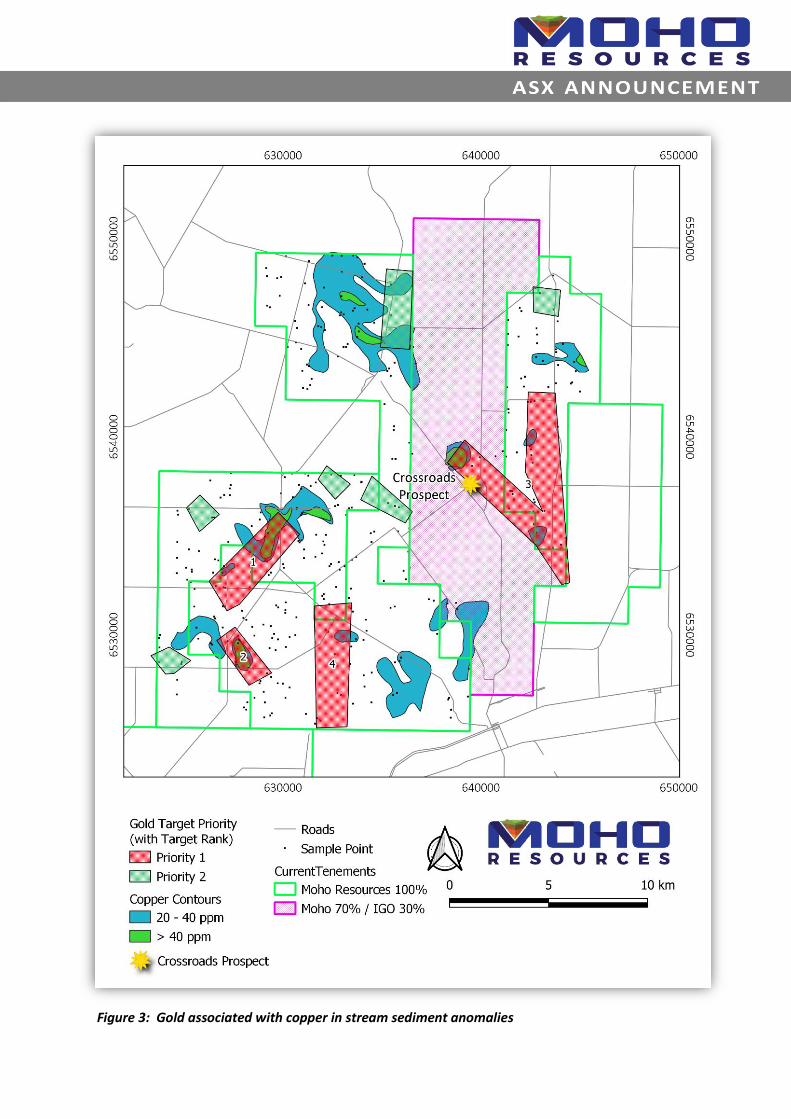
Figure 3: Gold associated with copper in stream sediment anomalies

Figure 4: Location of Burracoppin Project, with recently granted tenements
New Exploration Licences Granted: The grant of E70/5299 and E77/2671 adds an additional 12% of tenure to the Burracoppin Project, increasing its size to 307 subblocks (Figure 4). Two of the gold anomalies reported in this announcement are located on E70/5299. Next steps
• Soil sampling on a 400x100m pattern to cover the higher priority anomalies
• Interpretation of gravity data on E70/5300
• Diamond core assays due this quarter
• Project scale geological interpretation
• Aircore drilling to test anomalies Q1 2022
Moho’s Interest in the Burracoppin Project Tenements: Moho and IGO Limited (ASX:IGO) have now formed an unincorporated joint venture for the purposes of exploring and, if warranted, developing and mining on E70/4688. IGO’s 30% interest will be free carried until completion of a pre-feasibility study, at which time IGO may elect to contribute pro-rata to ongoing work or convert its 30% interest to a 10% free carried interest. In addition to Moho’s 70% interest in E70/4688, the Company owns a 100% interest in granted
exploration tenements E70/5154, E70/5299, E70/5300-5302, E70/5739 and E77/2671 The Burracoppin
tenements now cover 899km2.
COMPETENT PERSON’S STATEMENT The information in this announcement that relates to Exploration Results is based on information and supporting documentation compiled by Lyndal Money, who is a Competent Person and Member of the Australian Institute of Mining and Metallurgy (AUSIMM). Ms Money is a full-time employee and Technical Manager of Moho Resources Ltd. Ms Money has sufficient experience relevant to the style of mineralisation under consideration and to the activity which is being undertaking to qualify as a Competent Person as defined in the 2012 edition of the “Australasian Code for Reporting of Exploration Results, Mineral Resources and Ore Reserves”. Ms Money consents to the inclusion in this announcement of the matters based on this information in the form and context in which it appears.

ABOUT MOHO RESOURCES LTD
Moho Resources Ltd is an Australian mining company which listed on the ASX in November 2018. The Company is focused on gold and nickel exploration at Empress Springs, Silver Swan North and Burracoppin. Moho’s Board is chaired by Mr Terry Streeter, a well-known and highly successful West Australian businessman with extensive experience in funding and overseeing exploration and mining companies, including Jubilee Mines NL, Western Areas NL and Midas Resources Ltd. Moho has a strong and experienced Board lead by geoscientist Shane Sadleir as Managing Director, Commercial Director Ralph Winter and Adrian Larking, lawyer and geologist, as Non-Executive Director.
Highly experienced geologist Lyndal Money (Technical Manager) is supported by leading industry consultant geophysicist Kim Frankcombe (ExploreGeo Pty Ltd) and experienced consultant geochemists Richard Carver (GCXplore Pty Ltd). Dr Jon Hronsky (OA) provides high level strategic and technical advice to Moho. ENDS The Board of Directors of Moho Resources Ltd authorised this announcement to be given to ASX.
For further information please contact:
Media Relations Shane Sadleir, Managing Director Ralph Winter, Commercial Director David Tasker T: +61 411 704 498 T: +61 435 336 538 Chapter One Advisors E: [email protected] E: [email protected] T: +61 433 112 936 E:[email protected]

JORC Code, 2012 Edition – Table 1: Burracoppin Project
Section 1 Sampling Techniques and Data
(Criteria in this section apply to all succeeding sections.) Criteria JORC Code explanation Commentary
Sampling techniques • Nature and quality of sampling (eg cut channels, random chips, or specific specialized industry standard measurement tools appropriate to the minerals under investigation, such as down hole gamma sondes, or handheld XRF instruments, etc). These examples should not be taken as limiting the broad meaning of sampling.
• Include reference to measures taken to ensure sample representivity and the appropriate calibration of any measurement tools or systems used.
• Aspects of the determination of mineralisation that are Material to the Public Report. In cases where ‘industry standard’ work has been done this would be relatively simple (eg ‘reverse circulation drilling was used to obtain 1 m samples from which 3 kg was pulverised to produce a 30 g charge for fire assay’). In other cases more explanation may be required, such as where there is coarse gold that has inherent sampling problems. Unusual commodities or mineralisation types (eg submarine nodules) may warrant disclosure of detailed information.
• 369 stream sediment samples were
taken in drainage lines and
creekbeds.
• Duplicate samples were taken at
every 49th site.
• Samples were sieved to -75μm at the
Intertek Laboratory.
• 5g of each sample was digested by
Aqua Regia digest. Samples were
determined for Au, Ag, Al, As, B, Ba,
Be, Bi, Ca, Cd, Ce, Co, Cr, Cs, Cu, Fe,
Ga, Ge, Hf, Hg, In, K, La, Li, Mg, Mn,
Mo, Na, Nb, Ni, P, Pb, Pd, Pt, Rb, Re,
S, Sb, Sc, Se, Sn, Sr, Ta, Te, Th, Ti, Tl,
U, V, W, Y, Zn, Zr by ICP-MS.
Drilling techniques • Drill type (eg core, reverse circulation, open-hole hammer, rotary air blast, auger, Bangka, sonic, etc) and details (eg core diameter, triple or standard tube, depth of diamond tails, face-sampling bit or other type, whether core is oriented and if so, by what method, etc).
• Not applicable.
Drill sample recovery • Method of recording and assessing core and chip sample recoveries and results assessed.
• Measures taken to maximise sample recovery and ensure representative nature of the samples.
• Whether a relationship exists between sample recovery and grade and whether sample bias may have occurred due to preferential loss/gain of fine/coarse material.
• Not applicable.
• Not applicable.
• Not applicable.
Logging • Whether core and chip samples have been geologically and geotechnically logged to a level of detail to support appropriate Mineral Resource estimation, mining studies and metallurgical studies.
• Whether logging is qualitative or quantitative in nature. Core (or costean, channel, etc) photography.
• The total length and percentage of the relevant intersections logged.
• Logging of stream sediment samples was qualitative, based on the subjective observations of the field crew
• Field notes were recorded for each samples

Criteria JORC Code explanation Commentary
Sub-sampling techniques and sample preparation
• If core, whether cut or sawn and whether quarter, half or all core taken.
• If non-core, whether riffled, tube sampled, rotary split, etc and whether sampled wet or dry.
• For all sample types, the nature, quality and appropriateness of the sample preparation technique.
• Quality control procedures adopted for all sub-sampling stages to maximise representivity of samples.
• Measures taken to ensure that the sampling is representative of the in situ material collected, including for instance results for field duplicate/second-half sampling.
• Whether sample sizes are appropriate to the grain size of the material being sampled.
• Not applicable.
• Not applicable.
• Not applicable.
• Certified Reference Material (CRM) standards were inserted at regular intervals in the sample process. Duplicates were taken in the field and by the labs, which also inserted their own standards and blanks. CRM’s were inserted at regular intervals into the sample stream (1:50 ratio) as well as field duplicates (1:50 ratio).
• Stream sediment sampling is an industry standard technique utilised in first pass geochemical sampling over suitable regolith landform regions.
• Sample sizes (250g) are considered appropriate for the technique.
Quality of assay data and laboratory tests
• The nature, quality and appropriateness of the assaying and laboratory procedures used and whether the technique is considered partial or total.
• For geophysical tools, spectrometers, handheld XRF instruments, etc, the parameters used in determining the analysis including instrument make and model, reading times, calibrations factors applied and their derivation, etc.
• Nature of quality control procedures adopted (eg standards, blanks, duplicates, external laboratory checks) and whether acceptable levels of accuracy (ie lack of bias) and precision have been established.
• All samples were submitted to Intertek Laboratory where they were dried and sieved to -75μm, with 5g digested using Aqua Regia. A comprehensive multi-element suite (Au, Ag, Al, As, B, Ba, Be, Bi, Ca, Cd, Ce, Co, Cr, Cs, Cu, Fe, Ga, Ge, Hf, Hg, In, K, La, Li, Mg, Mn, Mo, Na, Nb, Ni, P, Pb, Pd, Pt, Rb, Re, S, Sb, Sc, Se, Sn, Sr, Ta, Te, Th, Ti, Tl, U, V, W, Y, Zn, Zr) was determined using an ICP-MS. Aqua Regia is a partial digest although it is extremely efficient for extraction of gold. Easily digested elements show good recoveries however others (particularly the refractory oxides and silicates) are poorly extracted.
• No geophysical instruments were used during the soil sampling.
• QAQC procedures in the laboratory are in line with industry best practice including the use of CRM’s, blanks, duplicate and replicate analyses that were conducted as part of internal laboratory checks. External laboratory checks have not been conducted as they are not deemed material to these results.
Verification of sampling and assaying
• The verification of significant intersections by either independent or alternative company personnel.
• The use of twinned holes.
• Documentation of primary data, data entry procedures, data verification, data storage (physical and electronic) protocols.
• Discuss any adjustment to assay data.
• Assay results from the stream sediment sampling program were reviewed by a consultant geochemist.
• Data was collected in the field on GPS and paper records. The location of sample sites was validated using 2D GIS software (QGIS).
Location of data points • Accuracy and quality of surveys used to locate drill holes (collar and down-hole surveys), trenches, mine workings and other locations used in Mineral Resource estimation.
• Specification of the grid system used.
• Quality and adequacy of topographic
• Sample locations were recorded by handheld Garmin GPS with ~3-5m accuracy.
• MGA94 Zone 50.
• Topographic control was by Garmin GPS with ~5-10m accuracy for AHD.
Criteria JORC Code explanation Commentary
control.
Data spacing and distribution • Data spacing for reporting of Exploration Results.
• Whether the data spacing and distribution is sufficient to establish the degree of geological and grade continuity appropriate for the Mineral Resource and Ore Reserve estimation procedure(s) and classifications applied.
• Whether sample compositing has been applied.
• The stream sediment sampling was completed over an area of about 330km2, representing a sampling density of about 1 sample per km2. Sample sites was selected based on drainage patterns.
• Not applicable as no resource estimates are quoted.
• Samples have not been composited.
Orientation of data in relation to geological structure
• Whether the orientation of sampling achieves unbiased sampling of possible structures and the extent to which this is known, considering the deposit type.
• If the relationship between the drilling orientation and the orientation of key mineralised structures is considered to have introduced a sampling bias, this should be assessed and reported if material.
• Not applicable.
• Not applicable.
Sample security • The measures taken to ensure sample security.
• All samples were collected and transported to the lab in Perth by company and/or contractor personnel. A chain of control was maintained from the field to the lab.
Audits or reviews • The results of any audits or reviews of sampling techniques and data.
• Available data has been reviewed by a consultant geochemist before reporting. Internal review by various company personnel has occurred.
Section 2 Reporting of Exploration Results
(Criteria listed in the preceding section also apply to this section.) Criteria JORC Code explanation Commentary
Mineral tenement and land tenure status
• Type, reference name/number, location and ownership including agreements or material issues with third parties such as joint ventures, partnerships, overriding royalties, native title interests, historical sites, wilderness or national park and environmental settings.
• The security of the tenure held at the time of reporting along with any known impediments to obtaining a licence to operate in the area.
• The Burracoppin project consists of E70/4688 and E70/5154, E70/5299, E70/5300, E70/5301, E70/5302, E705739 and E77/2671 covering a total of 307 blocks. E70/4688 is owned 100% by Independence Newsearch Pty Ltd, a fully owned subsidiary of Independence Group Ltd (IGO). In November 2015, Moho signed an agreement with IGO to earn up to a 70% interest by farming into tenement E70/4688. E70/5154, E70/5299, E70/5300, E70/5301, E70/5302, E705739 and E77/2671 are owned 100% by Moho. All tenements are located on privately owned agricultural land, with land access and compensation agreements signed and access approved by land owners for many lots.
• An ILUA has been signed with the Ballardong People.
• No other known impediments.
Exploration done by other parties • Acknowledgment and appraisal of exploration by other parties.
• Scant historical exploration has been completed within the area covered by Moho’s tenements. Much of the work focused on the Westonia greenstone

Criteria JORC Code explanation Commentary
belt to the east. Companies working in the area include:
Valiant Consolidated Ltd 1981
Billiton 1987
Aurex 1986-1988
Astro Mining N.L. 1997
Cambrian Resources 1997
Enterprise Metals 2010-2013
Independence Group 2014
Geology • Deposit type, geological setting and style of mineralisation.
• Metamorphosed orogenic gold deposits of the Southwest Terrane of the Yilgarn Craton. High grade metamorphosed greenstone sequences have been targeted for their gold potential with success at Griffins Find, Katanning and Tampia. The gold mineralisation at Tampia is hosted in mafic gneiss bedrock and is associated with a bullseye gravity anomaly. The Tampia Hill gold mineralisation is associated with non-magnetic pyrrhotite, arsenopyrite, chalcopyrite and rare pyrite. The Burracoppin project is underlain by Archaean granite and greenstone that were metamorphosed to amphibolite and granulite facies grade. Moho has recognised key elements from exploration within the Southwest Terrane, and particularly around Tampia, that may assist in the exploration for gold at Burracoppin.
Drill hole Information • A summary of all information material to the understanding of the exploration results including a tabulation of the following information for all Material drill holes: o easting and northing of the
drill hole collar o elevation or RL (Reduced Level
– elevation above sea level in metres) of the drill hole collar
o dip and azimuth of the hole o down hole length and
interception depth o hole length.
• If the exclusion of this information is justified on the basis that the information is not Material and this exclusion does not detract from the understanding of the report, the Competent Person should clearly explain why this is the case.
• Not applicable.
• Not applicable.
Data aggregation methods • In reporting Exploration Results, weighting averaging techniques, maximum and/or minimum grade truncations (eg cutting of high grades) and cut-off grades are usually Material and should be stated.
• No averaging or cut offs have been applied to the data.
• Not applicable.
Criteria JORC Code explanation Commentary
• Where aggregate intercepts incorporate short lengths of high grade results and longer lengths of low grade results, the procedure used for such aggregation should be stated and some typical examples of such aggregations should be shown in detail.
• The assumptions used for any reporting of metal equivalent values should be clearly stated.
• No metal equivalents have been reported.
Relationship between mineralisation widths and intercept lengths
• These relationships are particularly important in the reporting of Exploration Results.
• If the geometry of the mineralisation with respect to the drill hole angle is known, its nature should be reported.
• If it is not known and only the down hole lengths are reported, there should be a clear statement to this effect (eg ‘down hole length, true width not known’).
• Not applicable.
• Not applicable.
• Not applicable.
Diagrams • Appropriate maps and sections (with scales) and tabulations of intercepts should be included for any significant discovery being reported These should include, but not be limited to a plan view of drill hole collar locations and appropriate sectional views.
• Refer to diagrams within this release.
Balanced reporting • Where comprehensive reporting of all Exploration Results is not practicable, representative reporting of both low and high grades and/or widths should be practiced to avoid misleading reporting of Exploration Results.
• All stream sediment sample results taken as part of this field program have been reported in this release and results are representative of the medium sampled in this area.
Other substantive exploration data • Other exploration data, if meaningful and material, should be reported including (but not limited to): geological observations; geophysical survey results; geochemical survey results; bulk samples – size and method of treatment; metallurgical test results; bulk density, groundwater, geotechnical and rock characteristics; potential deleterious or contaminating substances.
• Topographic information has been used to assist the interpretation of the target areas.
Further work • The nature and scale of planned further work (eg tests for lateral extensions or depth extensions or large-scale step-out drilling).
• Diagrams clearly highlighting the areas of possible extensions, including the main geological interpretations and future drilling areas, provided this information is not commercially sensitive.
• Follow up air core drilling of gold anomalies and additional surface geochemical sampling in areas not previously sampled