external gis viewer help file - forsyth county,...
TRANSCRIPT
External GIS Viewer Help File
Introduction The GIS Viewer is an application that helps view mapping information in Forsyth County. The Application is divided into 5 main parts. On the left side of the application is the navigation toolset which include the zoom, extent and map type tools. The tools on the top are selection tool sets that return locations based on a query. The Tools on the top right are information tools that will help print a result map, identify information on the map, and identify coordinate information about a location on the map. The right side of the application is the input output area that allows users to enter information for a tool, view the tabular results of a tool, and turn layers on and off in the layers tab. The final part of the application is the mapping area which displays all the mapping information and the results from the query tools.
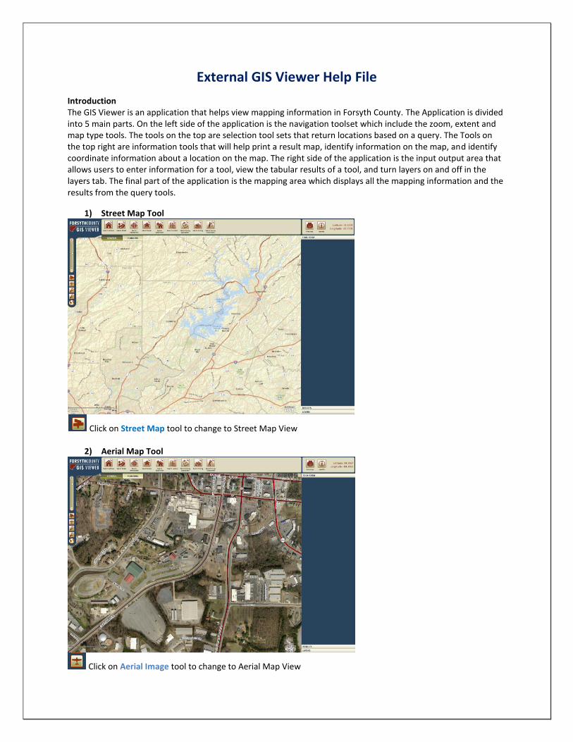
1) Street Map Tool
Click on Street Map tool to change to Street Map View
2) Aerial Map Tool
Click on Aerial Image tool to change to Aerial Map View
3) Zoom Slider Bar Tool The Zoom Slider tool allows the user to zoom in and out from a central location on the map. This
functionality can also be performed with the roller wheel on a mouse to help with navigation
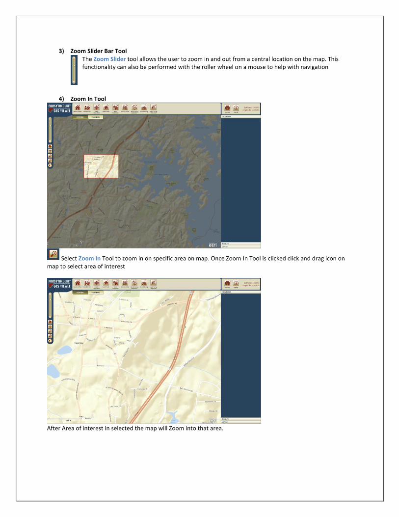
4) Zoom In Tool
Select Zoom In Tool to zoom in on specific area on map. Once Zoom In Tool is clicked click and drag icon on map to select area of interest
After Area of interest in selected the map will Zoom into that area.

5) Zoom Out Tool
Select Zoom Out Tool to select area to Zoom Out on specific area on the map. Once Zoom Out Tool is clicked click and drag icon on map to select area of interest.
After Area of interest in selected the map will Zoom out to that area.
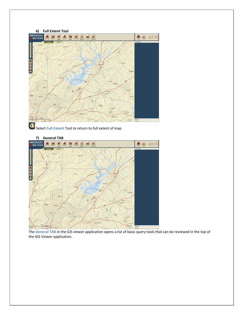
6) Full Extent Tool
Select Full Extent Tool to return to full extent of map
7) General TAB
The General TAB in the GIS viewer application opens a list of basic query tools that can be reviewed in the top of the GIS Viewer application.
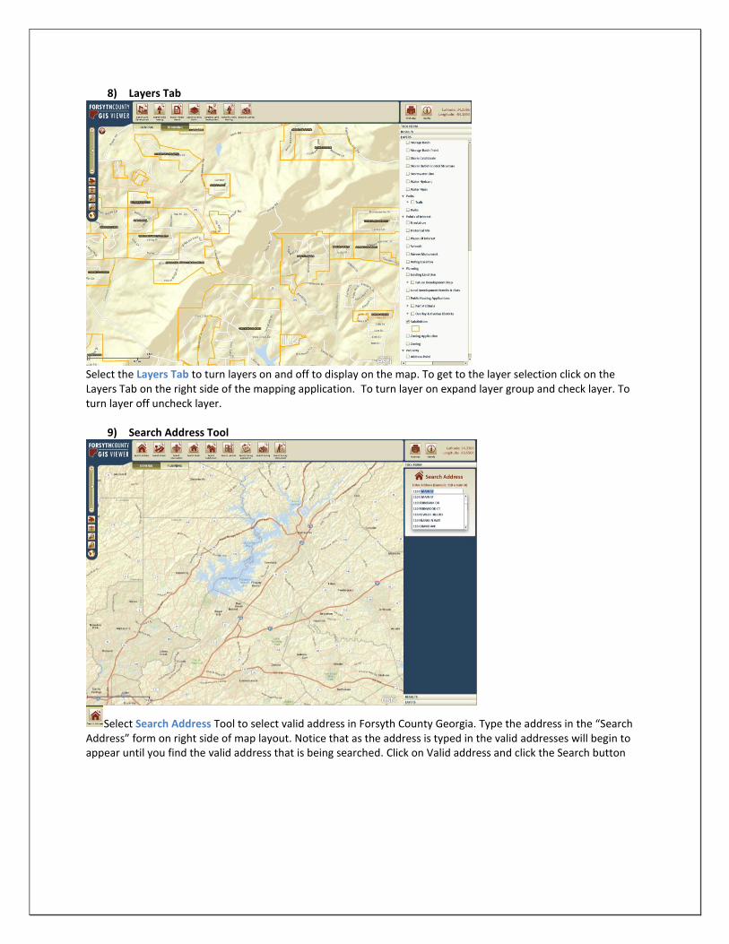
8) Layers Tab
Select the Layers Tab to turn layers on and off to display on the map. To get to the layer selection click on the Layers Tab on the right side of the mapping application. To turn layer on expand layer group and check layer. To turn layer off uncheck layer.
9) Search Address Tool
Select Search Address Tool to select valid address in Forsyth County Georgia. Type the address in the “Search Address” form on right side of map layout. Notice that as the address is typed in the valid addresses will begin to appear until you find the valid address that is being searched. Click on Valid address and click the Search button

Once the Search button is clicked the map will zoom into the address location and display related information in the Results box on the right side of the map layout
10) Search Street Tool
Select the Search Street tool to select a valid street in Forsyth County Georgia. Type the street name in the Street Search form on the right side of the map layout. Notice that as the street is typed in the valid streets will begin to appear until you find the valid street that is being searched. Select the Valid street name and click the Search button.

11) Search Intersection Tool
Select the Search Intersection tool to select a valid intersection point in Forsyth County Georgia. Type a street name in the Street box and the intersecting street in the Cross Street box in the Search Intersection form on the right side of the map layout. Click on Search button.
Once the Search button is clicked the map will zoom into the intersection location.
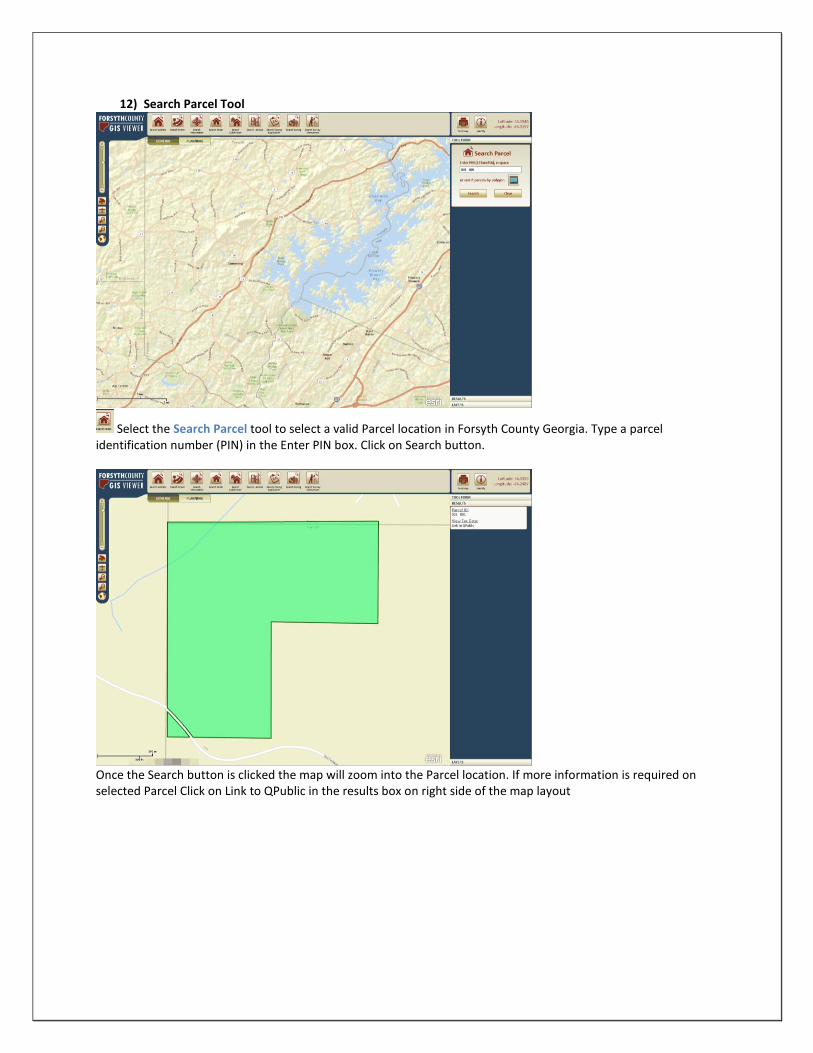
12) Search Parcel Tool
Select the Search Parcel tool to select a valid Parcel location in Forsyth County Georgia. Type a parcel identification number (PIN) in the Enter PIN box. Click on Search button.
Once the Search button is clicked the map will zoom into the Parcel location. If more information is required on selected Parcel Click on Link to QPublic in the results box on right side of the map layout

When QPublic link is clicked the QPublic webpage will open with related information from the selected parcel
Another way to select a parcel is the use the select parcel by polygon tool within the Search Parcel form. Zoom to area of interest and select parcels of interest by creating an area polygon touching all parcels that need to be selected.
Selected Parcels are highlighted in green and associated information including link to QPublic appears in Results area on the right side of the map layout.
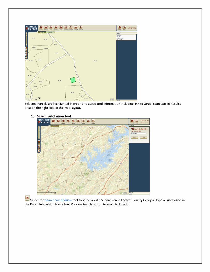
13) Search Subdivision Tool
Select the Search Subdivision tool to select a valid Subdivision in Forsyth County Georgia. Type a Subdivision in the Enter Subdivision Name box. Click on Search button to zoom to location.

14) Search Landlot Tool
Select the Search Landlot tool to select valid landlot in Forsyth County Georgia. Select a District and Landlot Number from the Search Landlot form and click Search to zoom to the selected Landlot.
15) Search ZA (Zoning Application) Tool
Select the Search ZA tool to select valid Zoning Application in Forsyth County Georgia. Enter a valid ZA number in the Search ZA form on the right side of the map layout and click Search to zoom to the selected Zoning Application.

Once the Search button is clicked the map will zoom into the ZA location. If more information is required on selected Zoning Application, Click on Link to eStatus in the results box on right side of the map layout.
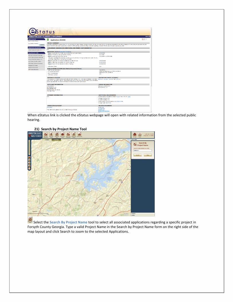
When eStatus link is clicked the eStatus webpage will open with related information from the selected Zoning Application.
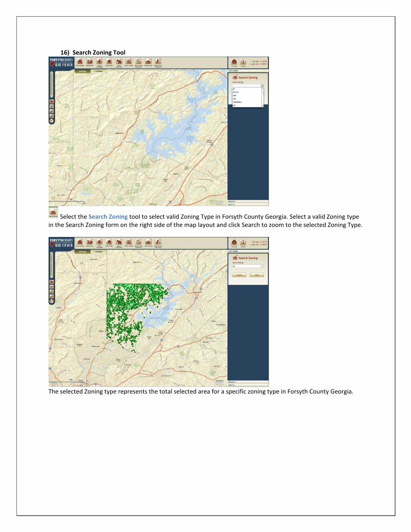
16) Search Zoning Tool
Select the Search Zoning tool to select valid Zoning Type in Forsyth County Georgia. Select a valid Zoning type in the Search Zoning form on the right side of the map layout and click Search to zoom to the selected Zoning Type.
The selected Zoning type represents the total selected area for a specific zoning type in Forsyth County Georgia.
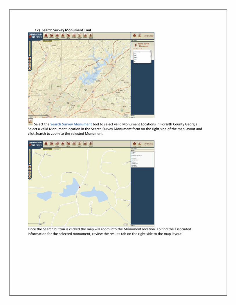
17) Search Survey Monument Tool
Select the Search Survey Monument tool to select valid Monument Locations in Forsyth County Georgia. Select a valid Monument location in the Search Survey Monument form on the right side of the map layout and click Search to zoom to the selected Monument.
Once the Search button is clicked the map will zoom into the Monument location. To find the associated information for the selected monument, review the results tab on the right side to the map layout

18) Planning TAB
The Planning TAB in the GIS viewer application opens a list of planning related tools that can be reviewed in the top of the GIS Viewer application.
19) Search Land Development Tool
Select the Search Land Development tool to select valid Land Development Permit in Forsyth County Georgia. Type a valid Land Development Permit in the Search Land Development form on the right side of the map layout and click Search to zoom to the selected Land Development Permit.

Once the Search button is clicked the map will zoom into the Land Development Permit location. To find additional information for the selected Permit, review the results tab on the right side to the map layout and click on the eStatus link.
When eStatus link is clicked the eStatus webpage will open with related information from the selected land development permit.

20) Search Public hearing Tool
Select the Search Public Hearing tool to select valid Public Hearing applications in Forsyth County Georgia. Type a valid public hearing application number in the Search Public Hearing form on the right side of the map layout and click Search to zoom to the selected Monument.
Once the Search button is clicked the map will zoom into the Public Hearing application location. To find additional information for the selected application, review the results tab on the right side to the map layout and click on the eStatus link.
When eStatus link is clicked the eStatus webpage will open with related information from the selected public hearing.
21) Search by Project Name Tool
Select the Search By Project Name tool to select all associated applications regarding a specific project in Forsyth County Georgia. Type a valid Project Name in the Search by Project Name form on the right side of the map layout and click Search to zoom to the selected Applications.

Once the Search button is clicked the map will zoom into the selected applications for the specific project. To find additional information for one of the selected applications, review the results tab on the right side to the map layout and click on the eStatus link.
When eStatus link is clicked the eStatus webpage will open with related information from the selected application.

22) Search Overlay District Tool
Select the Search Overlay District tool to select a valid Overlay District Type in Forsyth County Georgia. Search a valid Overlay District from the pull down menu in the Search Overlay District form on the right side of the map layout and click Search to zoom to the selected Overlay District.
Once the Search button is clicked the map will zoom into the selected Overlay District
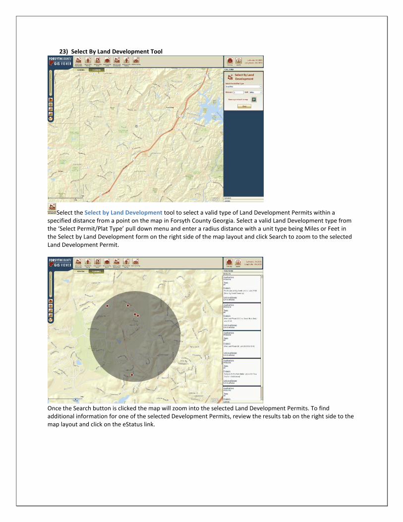
23) Select By Land Development Tool
Select the Select by Land Development tool to select a valid type of Land Development Permits within a specified distance from a point on the map in Forsyth County Georgia. Select a valid Land Development type from the ‘Select Permit/Plat Type’ pull down menu and enter a radius distance with a unit type being Miles or Feet in the Select by Land Development form on the right side of the map layout and click Search to zoom to the selected Land Development Permit.
Once the Search button is clicked the map will zoom into the selected Land Development Permits. To find additional information for one of the selected Development Permits, review the results tab on the right side to the map layout and click on the eStatus link.

When eStatus link is clicked the eStatus webpage will open with related information from the selected land development permit.
24) Select by Public Hearing Tool
Select the Select by Public Hearing tool to select a valid type of Public Hearing Application within a specified distance from a point on the map in Forsyth County Georgia. Select a valid Public Hearing type from the ‘Select Permit/Plat Type’ pull down menu and enter a radius distance with a unit type being Miles or Feet in the Select by Public Hearing form on the right side of the map layout. Click Search to zoom to the selected Public Hearing.

Once a location in clicked on the map a script will run in the background and return all Public Hearing Applications within a specific distance and type. To find additional information for one of the selected Public Hearings, review the results tab on the right side to the map layout and click on the eStatus link.
When eStatus link is clicked the eStatus webpage will open with related information from the selected land Public Hearings.

25) Select by Zoning Tool
Select the Select by Zoning tool to select a valid Zoning type within a specified distance from a point on the map in Forsyth County Georgia. Select a Zoning type from the ‘Select Zoning’ pull down menu and enter a radius distance with a unit type being Miles or Feet in the Select by Land Zoning form on the right side of the map layout. Click Search to zoom to view the selected Zoning.
Once a location in clicked on the map a script will run in the background and return all Zoning Locations within a specific distance and type.

26) Print Map Tool
Click on Print Map tool to print 8.5x11 area of interest map
27) Identify Tool
Click on the Identify tool to query information from a selected feature on the map. After zooming into the area with the feature that will be identified, select a layer from the dropdown menu from the Identify Layer form. Identify the feature by clicking it on the map.

Once a feature has been clicked on, a Callout box will appear with the associated information in the callout.
28) Finding Latitude and Longitude for location on map
To Locate Coordinates on the map hover over a location on map and take note of coordinated in top right corner of mapping layout.