eyes - minnesota department of transportation / … glassed-in room (called a tower cab) on top of a...
TRANSCRIPT


Minnesota Department of Transportation • Office of Aeronautics • Aviation Education Section222 E. Plato Boulevard, St. Paul, MN 55107-1618 • www.mndot.gov • 800-657-3922
Eyes in the SkyWritten by
Landice Wilson
Illustrated and Designed byShalette Cauley-Wandrick
Edited byDarlene Dahlseide
Special Thanks toKent Seibert
© 2006 Minnesota Department of Transportation, Office of Aeronautics

IInnttrroodduuccttiioonnThis book introduces students of all ages to an exciting career as an air traffic controller. Everyday, over two million people
travel across the skies of the United States while air traffic controllers are working to keep all air travelers safe. In this book, students can explore air traffic control centers, the National Airspace, and take a simulated flight to help them understand how theair traffic control system works. Learning activities are also included that utilize math, science, and reading skills. After readingand completing the activities in this book, students will be able to interpret a data block of numerical information into meaningfulinformation, describe air traffic control centers and positions, state the International Aviation Phonetic Alphabet, calculate milesper hour from knots, identify phases of flight, and understand air traffic control vocabulary.
ContentsEYES IN THE SKY 1
WHO DOES WHAT 2
AIR ROUTE TRAFFIC CONTROL CENTERS 5
ATC WORD SEARCH 6
RADAR 7
DATA BLOCKS 9
DATA BLOCK ACTIVITY 10
LET’S TAKE A FLIGHT 11
ATC CROSSWORD PUZZLE 15
INTERNATIONAL CIVIL AVIATION
ORGANIZATION PHONETIC ALPHABET 16
KNOW YOUR ABC’S AND 123’S ACTIVITY 17
ANSWERS TO ACTIVITIES 18
GLOSSARY 19

Look up in the sky, and chances are there will be airplanes flying by. Have you ever wondered where they’re going, or why they don’t get lost? How do airplanes remain safely in the sky when there are over 50,000 of them flying at one time?
It takes many well-trained people to safely guide airplanes through the skies. These trained professionals are called Air Traffic Controllers(ATC). Their job is to keep airplanes a safe distance apart within the airspace they’reassigned to monitor. Air traffic controllers call this safe distance, separation.
Twenty-four hours a day, seven days a week, controllers are on duty across the country keeping a watchful “eye in the sky.” While manypeople would find it hard to even imagine, airtraffic controllers are guiding airplanes travelingoverhead at 500 miles an hour. Some of theseairplanes are carrying hundreds of passengers.There are even a few super-jumbo jets that cancarry up to 800 passengers, flying overhead!
Most controllers work for the Federal Aviation Administration (FAA) in three air traffic control (ATC) facilities: Control Towers, Terminal Radar Approach Control,and En Route Centers.
Let’s see how the air traffic system works and then take a flight together!
page 1
E y e s i n t h e S k y
* Look in the glossary for the words in bold.

Terminal FacilitiesAir Traffic Controllers that work in Control Towers andRadar Approach Control Centers are called TerminalControllers. They help to separate airplanes at andaround airports. There are two positions a terminal controller may work: Tower and Radar.Tower Controllers separate airplanes by looking outthe window and seeing them with their eyes or usingfield glasses. When controllers cannot see airplanes, orif the planes are just too far away, they will “see” themusing radar. These men and women are called RadarControllers. They work in the TRACON (TerminalRadar Approach Control).
1. Air Traffic Control Tower (ATCT)When thinking of an Air Traffic Control Tower, picturea glassed-in room (called a tower cab) on top of a tall,narrow building (a control tower) at an airport. The tower cab gives controllers a clear view of the airport. Tower controllers use their eyes or binocularsto see or guide airplanes and motor vehicles on airporttaxiways and runways, as well as airplanes landing, or taking off. Most busy airports have a control tower.
WWhhoo DDooeess WWhhaatt
page 2

30 to 50 miles
10,000 ft or higher
Used by:control tower
page 3
2. Terminal Radar Approach Control (TRACON)
The TRACON is a dark, windowless room usuallylocated in the control tower below the tower cab.It’s called the radar room and is filled withradarscopes that show the locations, ground speeds, and other details of the airplanesin their area.
The TRACON has authority over airspace that looks like an upsidedown wedding cake (see diagram above). This airspace usually starts atthe ground and stretches out from the airport for about 30 miles and upto 10,000 feet high. The air traffic control tower controls the airspace 5 miles around the airport and up to 2,500 feet above the ground.
“Upside Down Wedding Cake”
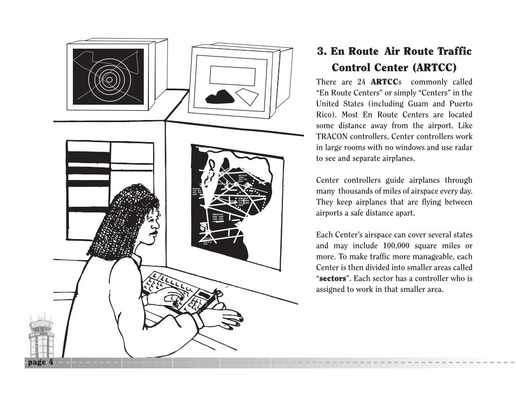
There are 24 ARTCCs commonly called “En Route Centers” or simply “Centers” in theUnited States (including Guam and PuertoRico). Most En Route Centers are locatedsome distance away from the airport. LikeTRACON controllers, Center controllers workin large rooms with no windows and use radarto see and separate airplanes.
Center controllers guide airplanes throughmany thousands of miles of airspace every day.They keep airplanes that are flying between airports a safe distance apart.
Each Center’s airspace can cover several statesand may include 100,000 square miles ormore. To make traffic more manageable, eachCenter is then divided into smaller areas called“sectors”. Each sector has a controller who isassigned to work in that smaller area.
N5191R100C023 120RAP
N67883130 090203 180LNK
UAL353210 200111 388RST
N22144170C074 210FSD
NWA164350 180198 420LAX
C
C
CC
C
page 4
3. En Route Air Route TrafficControl Center (ARTCC)

Seattle
Oakland
Los Angeles
Albuquerque
Denver
Minneapolis
Kansas City
Fort Worth
Memphis
Atlanta
Miami
Puerto RicoGuam
Houston
Salt Lake City
Alaska
Hawaii
Traffic Control Centers
Chicago
Jacksonville
Boston
ClevelandNew York
Washington
AIR ROUTE
Indianapolis
page 5

AATTCC WWoorrdd SSeeaarrcchh
page 6
page 7
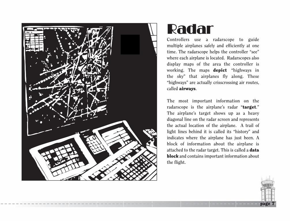
RRaaddaarrControllers use a radarscope to guide multiple airplanes safely and efficiently at onetime. The radarscope helps the controller “see”where each airplane is located. Radarscopes alsodisplay maps of the area the controller is working. The maps depict “highways in the sky” that airplanes fly along. These “highways” are actually crisscrossing air routes, called airways.
The most important information on theradarscope is the airplane’s radar “target.” The airplane’s target shows up as a heavy diagonal line on the radar screen and representsthe actual location of the airplane. A trail oflight lines behind it is called its “history” andindicates where the airplane has just been. Ablock of information about the airplane isattached to the radar target. This is called a datablock and contains important information aboutthe flight.

The data block shows four lines of information which arewritten in a “controller’s” language. An example of a center controller’s radarscope is on the following pagewhich shows a map, radar targets, and data blocks. Lookat the data block information on UAL353 (see page 15) todiscovery what each line of information means.
The first line is the call sign of the airplane. This is simply what the airplane or flight is called, like a name.For the flight known as UAL353, it is a United Airlinesflight: “United three-fifty-three”.
The second line is for altitude. Airplanes are climbing,descending, or in level flight at an altitude (called anassigned altitude), given to the pilot by ATC. If the airplane is climbing or descending, the arrow will point upor down. To the right of the arrow will be the airplane’spresent reported altitude. To find the actual altitude of the airplane multiply the altitude number by 100. Forinstance: UAL353 has been assigned an altitude by air traffic control of 210 (210 x 100 = 21,000 feet.) It is at 200 (200 x 100 = 20,000 feet) and still climbing.
When the airplane reaches its assigned altitude, a ‘C’ appears next to the altitude. An example ofthis is target N5191R on the north side of the radarscope.The third line is the computer ID / ground speed. The first
three digits of this line are computer generated random numbers that are assigned to keep track of the airplane during its flight. The next three numbers show the groundspeed of the airplane, which is 388 knots per hour (similar to miles per hour, see conversion below).
The fourth line is the airport destination. All airports have a three-letter code to quickly and easily identify them. In this data block, RST means Rochester, Minnesota.
Activity: Convert Knots Per Hour to Miles Per Hour
Use the ground speed of each airplane listed on the datablock and convert the ground speed from knots per hoursinto miles per hour. Simply multiply the ground speed inknots per hour by 1.15 to get the ground speed in miles perhour. For example, airplane N67883 is traveling 180 knotsper hour. Converting the ground speed to miles per hour,the answer would be 207. 180 kph x 1.15 = 207 mph.
1. How many miles per hour is N5191R traveling? 2. How many miles per hour is UAL353 traveling?3. How many miles per hour is N22144 traveling?
page 8
DDaattaa BBlloocckkss

NB191R 100C 023 120 RAP
N5191R100C023 120RAP
N67883 130 090 203 180 LNK
N67883 130 090 203 180 LNK
UAL353 210 200 111 388 RST
UAL353 210 200 111 388 RST
UAL353 210 200 111 388 RST
UAL353 210 200 111 388 RST
N22144 170C 074 210 FSD
N22144 170C 074 210 FSD
NWA164 350 180 198 420 LAX
NWA164 350 180 198 420 LAX
Assigned Altitude Aircraft Call Sign
Computer ID Destination
Ground Speed
Reported Altitude
NORTHW
ES
T
EA
ST
SOUTH
Radar Target
Target History(where aircraft has been)
Airplane is at assigned altitude(Next to assigned altitude)
Airplane is climbing or descending to assigned altitude
Line linking target to correct data block
CC
page 9

DDaattaa BBlloocckk AAccttiivviittyySee if you can answer the following questions by using the information from the radarscope data block on page 9. The compass directions: north, south, east, and west are given. Answers are on page 18 of this book.
1. Which airplane is going the slowest speed? ____________________________
2. What is the aircraft call sign of the airplane that is at 100 (10,000 feet)? ____________________________
3. Which airplane is farthest north? (Use the airplane target, not the data block.) ____________________________
4. Which two airplanes are climbing to a higher altitude? ____________________________
5. Which airplane’s destination is the FSD airport? ____________________________
6. What is the aircraft call sign of the airplane that is at 170 (17,000 feet)? ____________________________
7. Which airplane has a ground speed of 180 knots per hour? ____________________________
8. Which airplane is the farthest west? (Use the airplane target, not the data block.) ____________________________
9. Which airplane is the farthest east? (Use the airplane target, not the data block.) ____________________________
10. Which two airplanes are heading in opposite directions? ____________________________
page 10

Perhaps the best way to understand how the air traffic control system works is to take a flight. Are you readyfor a little “flight of discovery”? To make it easier to understand, the flight has been divided into seven phases:
TRACON
ARTCC
ATC Tower
TRACON
ATC Tower
Preflight and Takeoff
Departure
En Route
Descent
Approach
LandingATC = Air Traffic Control TowerARTCC = Air Route Traffic Control CenterTRACON = Terminal Radar Approach Control
Local and Ground ControlDeparture ControlApproach Control
ARTCC
page 11
LLeett’’ss TTaakkee AA FFlliigghhtt
preflight, takeoff, departure, En Route, descent,approach, and landing. The example above shows thephases of flight and the airspace the airplane will fly through.

page 12
Preflight“We are ready to board the flight!” With excited anticipation passengers arrive at the airport terminal tocheck their bags. At the same time the flight crew isalready checking the airplane to be sure it is ready to fly.Based on the weather for that day, the pilot will plan thebest and most efficient route and altitude for the flight. Thepilot’s flight plan is then communicated to a controller whochecks traffic along that route to see if the request can begranted. Having the flight information ahead of time, the controllers can safely guide the flight from one city to another.
While passengers find their seats and stow their carry-onluggage, the pilot starts the radio communication with thetower. The cockpit flight crew informs the controller,located in the tower cab, that they are about ready to beginthe flight. The controller will guide the airplane from thegate along the taxiways to the runway.
TakeoffAt the end of the runway, the tower controller tells the pilotto stop and wait for further instructions. The controller isresponsible for all airplanes taking off, landing, or flyingclose to the airport. When the pilot radios for permissionto take off, the controller visually checks the runways andsurrounding area for other traffic that might be in the way.When the controller determines that the runway area is
clear, the pilot is permitted to taxi onto the runway andtake off.
The airplane will start to move down the runway, and whenit reaches a specific speed, it will lift off the ground.Passengers may feel like they are being pushed back intheir seat as the airplane accelerates. They will also hearthe landing gear rumble as it retracts into the airplane’swheel wells. Now airborne, the airplane is on its way toits destination. At this point, the controller tells the pilotto, “Contact Departure Control.”
Departure“Look at the ants!” As the airplane climbs to its assignedaltitude, one can see the earth below and maybe even theclouds above. The cars on the highways appear as if theyare tiny ants slowly crawling along. The houses look likeminiature houses.
At this point of the flight passengers are settling in to read,take a nap, or just relax, however, this is a very busy timefor the pilots. The pilots must listen carefully to theinstructions from ATC while flying the airplane and monitoring all its gauges and instruments.
The TRACON controller responsible for this phase of flightis called the departure controller. This controller uses allthe information on the radarscope to safely guide the flight

page 13
through TRACON airspace. As the airplane climbs higher,departure control might give the pilots a new compassheading or altitude change to avoid other aircraft or hazards.
Once the flight reaches the outer limits of the TRACON airspace, the departure controller passes the flight on to the En Route Center. The controller will then say: “Contact Center.”
En RouteThe airplane may still be climbing to an altitude of over30,000 feet when it enters En Route Center airspace. Atsome point during the flight phase, the airplane will reachits assigned altitude. If a passenger is going to be servedanything to eat or drink, this is the time that will happen.The captain may turn off the seat belt sign so passengerscan move about and stretch their legs.
Like TRACON controllers, En Route Center controllerstrack airplane radar targets and data blocks. The centermay tell the pilot about any significant weather such asthunderstorms or turbulence along the way. If it becomesnecessary, the controller will request that the pilots adjusttheir flight’s altitude, speed, or direction to avoid weatheror other airplanes. The airplane is quietly passed from onecontroller to the next as the flights progresses toward it’sintended destination
DescentThe “Fasten Seat Belt” sign is turned on when the airplane is about 200 miles from its destination, as the pilotprepares to descend. Some passengers may feel a little likethey are floating in their seat for a moment as the airplanebegins to descend for its arrival at the airport.Approximately 50 miles from the airport, the radar controlis passed on to the TRACON and the controller tells thepilot to “Contact Approach Control.”
Approach“Wedding cake?” The airplane isentering TRACON airspace whichis shaped like an upside down wedding cake (see diagram on theright). This time it’s the ApproachController who guides the airplane closer to the runway. The approach controller will direct the pilot to graduallylower the airplane’s altitude. The pilot may make severalturns until the airplane is lined up with the center of therunway. Working in this airspace is no ‘piece of cake’ forpilots and controllers, as airplanes fly at quickly changingairspeeds and altitudes. The approach controller often hasa long line of airplanes descending in sequence for landing. In fact, this line of airplanes in the sky may extendout 50 miles or more! When the airplane is about 10 milesfrom the airport, the pilot is told to “Contact Tower.”
30 to 50 miles
10,000 ft or higher
Used by:control tower
“Upside Down Wedding Cake”

Landing “Well this has been a great flight.” At this point, the pilotwill receive instructions from the tower controller in thetower cab. When clearance to land is received the pilotwill announce to passengers we are cleared to land. Thepassengers will feel the airplane’s wheels touch down onthe runway. As the pilot applies the brakes, they will alsofeel the airplane quickly slow down.
After the airplane taxis off the runway, the tower controller will direct the airplane around the airport tothe gate where the passengers will exits. The pilot willremind everyone to remain seated until the airplanecomes to a complete stop at the gate. Remember, the pilot
is responsible for everyone’s safety while they are insidethe airplane.
The next time anyone who has read this book looks upinto the sky and sees an airplane flying by, they will knowthat skilled and knowledgeable people are watching everymove that airplanes makes.
Now, readers should have a newly found respect for themen and women whose job is to be the “Eyes in the Sky”to keep us safe when we fly. Who knows? Maybe some day,the voice on the other end of the radio giving instructionsto pilots, may be yours!
page 14

AATTCC CCrroosssswwoorrdd PPuuzzzzllee
ACROSS2. The last controller to talk to the pilot before the flight gets to the gate
3. What controllers use to “see” airplanes
4. The TRACON controller in charge of an airplane in the
descending phase
5. The phase of flight where the assigned altitude is usually reached
6. Before takeoff, airplanes must ______ to the runway
7. ARTCCs are also called
8. The phase of flight when the airplane lifts off the ground
9. _______ controllers give pilots permission to land
DOWN1. The facility that handles airplanes at the airport
2. One of 24 centers
3. ARTCCs are subdivided into smaller work areas called ____
4. The facility responsible for en route airplanes
5. ATC stands for
6. Aircraft information that is shown on the radarscope
7. The phase at the end of the flight when the airplane is being guided
by the tower
8. This center controls the airspace that looks like an upside
down wedding cake
9. The phase of flight when passengers are boarding the airplane
10. When 200 miles from its destination, the flight is entering this phase
11. Most controllers work for which government agency
page 15

IInntteerrnnaattiioonnaall CCiivviill AAvviiaattiioonnOOrrggaanniizzaattiioonn PPhhoonneettiicc AAllpphhaabbeett
page 16
Pilots, flight dispatchers, air traffic controllers, and others who need to communicate with aircraft use the International CivilAviation Organization (ICAO) phonetic alphabet. This special alphabet is used to ensure that one letter sounding like another doesn’t get confused during communications. The letters “M” and “N” sound almost the same. Over the radio it might be hard toknow exactly which letter was being said, so “Mike” and “November” are used instead.
By using these words of the phonetic alphabet radio messages that contain a series of letters and numbers, such as aircraft identification numbers, are less confusing. Also, when numbers are used over the radio, each number is spoken the same way onewould pronounce it, with the exception of the number nine which is pronounced “niner.”
* All pilots, aircraft dispatchers, and air traffic controllers must be able to speak, read, and understand the English language.
A Alpha
B Bravo
C Charlie
D Delta
E Echo
F Foxtrot
G Golf
H Hotel
I India
J Juliet
K Kilo
L Lima
M Mike
N November
O Oscar
P Papa
Q Quebec
R Romeo
S Sierra
T Tango
U Uniform
V Victor
W Whiskey
X X-ray
Y Yankee
Z Zulu

page 17
KKNNOOWW YYOOUURR AA––BB––CC‘‘ss aanndd 11--22--33‘‘ssDirections: Use the International Civil Aviation Phonetic Alphabet
to help you spell out the words below.
1. Alpha-India-Romeo-Papa-Lima-Alpha-November-Echo
2. Romeo-Uniform-November-Whiskey-Alpha-Yankee
3. Charlie-Oscar-November-Tango-Romeo-Oscar-Lima-Lima-Echo-Romeo
4. Tango-Oscar-Whiskey-Echo-Romeo Charlie-Alpha-Bravo
5. Alpha-India-Romeo-Sierra-Papa-Alpha-Charlie-Echo
6. Delta-Alpha-Tango-Alpha Bravo-Lima-Oscar-Charlie-Kilo
7. November-One-Three-Niner-Five
Directions: Use the International Civil Aviation Phonetic Alphabet to say
each word below.
8. P-I-L-O-T
9. T-A-K-E-O-F-F
10. R-A-D-A-R
11. T-R-A-C-O-N
12. S-E-C-T-O-R-S
13. N-1-6-4-9-D
14. S-A-F-E-T-Y
page 18
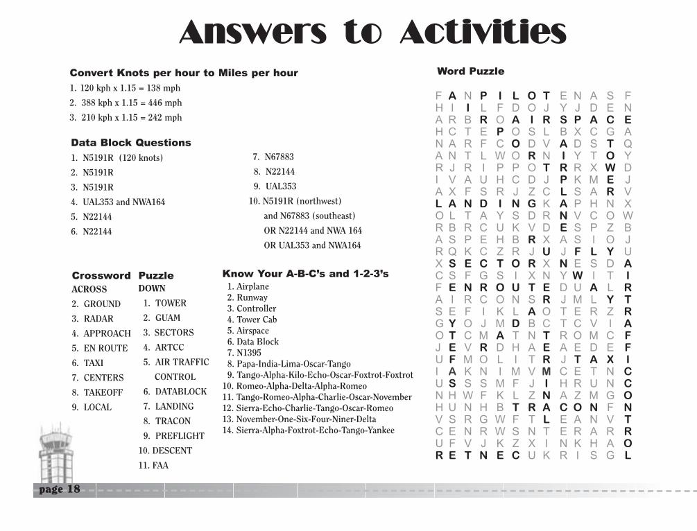
AAnnsswweerrss ttoo AAccttiivviittiieessConvert Knots per hour to Miles per hour
1. 120 kph x 1.15 = 138 mph
2. 388 kph x 1.15 = 446 mph
3. 210 kph x 1.15 = 242 mph
Data Block Questions
1. N5191R (120 knots)
2. N5191R
3. N5191R
4. UAL353 and NWA164
5. N22144
6. N22144
7. N67883
8. N22144
9. UAL353
10. N5191R (northwest)
and N67883 (southeast)
OR N22144 and NWA 164
OR UAL353 and NWA164
Crossword PuzzleACROSS
2. GROUND
3. RADAR
4. APPROACH
5. EN ROUTE
6. TAXI
7. CENTERS
8. TAKEOFF
9. LOCAL
F A N P I L O T E N A S FH I I L F D O J Y J D E NA R B R O A I R S P A C EH C T E P O S L B X C G AN A R F C O D V A D S T QA N T L W O R N I Y T O YR J R I P P O T R R X W DI V A U H C D J P K M E JA X F S R J Z C L S A R VL A N D I N G K A P H N XO L T A Y S D R N V C O WR B R C U K V D E S P Z BA S P E H B R X A S I O JR Q K C Z R J U J F L Y UX S E C T O R X N E S D AC S F G S I X N Y W I T IF E N R O U T E D U A L RA I R C O N S R J M L Y TS E F I K L A O T E R Z RG Y O J M D B C T C V I AO T C M A T N T R O M C FJ E V R D H A E A E D E FU F M O L I T R J T A X II A K N I M V M C E T N CU S S S M F J I H R U N CN H W F K L Z N A Z M G OH U N H B T R A C O N F NV S R G W F T L E A N V TC E N R W S N T E R A R RU F V J K Z X I N K H A OR E T N E C U K R I S G L
Word Puzzle
DOWN
1. TOWER
2. GUAM
3. SECTORS
4. ARTCC
5. AIR TRAFFIC
CONTROL
6. DATABLOCK
7. LANDING
8. TRACON
9. PREFLIGHT
10. DESCENT
11. FAA
Know Your A-B-C’s and 1-2-3’s1. Airplane2. Runway3. Controller4. Tower Cab5. Airspace6. Data Block7. N13958. Papa-India-Lima-Oscar-Tango9. Tango-Alpha-Kilo-Echo-Oscar-Foxtrot-Foxtrot
10. Romeo-Alpha-Delta-Alpha-Romeo11. Tango-Romeo-Alpha-Charlie-Oscar-November12. Sierra-Echo-Charlie-Tango-Oscar-Romeo13. November-One-Six-Four-Niner-Delta14. Sierra-Alpha-Foxtrot-Echo-Tango-Yankee

GG ll oo ss ss aa rr yyAir Traffic Controller – A person who communicates with a pilot, usually by radio, directing the movement of aircraft, especially close to an airport.
Airport Terminal – The area where airplanes are parked to allow passengers to get on or off an airplane.
Airspace – Any portion of the atmosphere above the earth.
Airways – Highways in the sky.
Altitude – The height that an aircraft is flying above the ground, usually expressed in the number of feet above sea level.
Approach – The phase of flight in which an aircraft has started its descent toward its destination. The pilot aligns the airplane with the designated landing runway.
Approach Controller – Controllers that are responsible for separating aircraft as they approach busy airports.
ARTCC – Air Route Traffic Control Centers. Each ARTCC manages traffic within all sectors of its center except for tower and TRACON.
Call Sign – The name used by the pilot or air traffic controller to identify an airplane or flight.
Captain – The pilot in command in charge of the flight, who usually sits in the left seat of the flight deck.
Compass Heading – The course or direction in which an aircraft is moving, generally expressed in degrees of a circle (from zero to 360) North, East, South, West.
Control Tower – A tall building from which air traffic controllers direct the movement of airplanes on and around an airport.
Data Block – Information used by an air traffic controller to identify an airplane on their radarscope.
Departure – The portion of the flight when the plane lifts off the ground and climbs to a cruising altitude.
Depict – To represent in pictures or words.
Descent – The portion of the flight in which an airplane has started to return to the earth.
En Route – The portion of the flight in which an airplane travels on the way to its destination airport.
En Route Center – A Center from which controllers separate airplanes going between airports and airspace that are not controlled by other facilities. Also called ARTCC.
Federal Aviation Administration (FAA) – The branch of the U.S. government that establishes and enforces rules for aviation.
Flight Crew – Two pilots, a captain and first officer, who are responsible for the safety of the airplane and flight.
Gate – A doorway through which passengers proceed when boarding or leaving an airplane.
page 19

Ground Speed – The actual speed that an aircraft travels over the ground corrected for windspeed and direction.
Landing – When an airplane touches down or lands after being in flight.
Landing Gear – A system of wheels that are used to support an aircraft when it is on the ground.
Preflight – Before a pilot gets into the airplane, he or she will check that the aircraft’s equipment and systems are working properly.
Radar – A system that uses electronic pulses to track the direction and speed of aircraft.
Radar Controller – Air traffic controllers that use radar to help them track airplanes.
Radarscope – A viewing screen that displays information from the radar to keep track of airplanes.
Retracts – Landing gear that fold up inside the airplane once it becomes airborne.
Runway – A strip of level, usually paved ground on which airplanes take off and land.
Sectors – Smaller areas of airspace controlled by a Center.
Separation – Keeping airplanes a safe distance apart.
Sequence – To organize and arrange in a specific order.
Takeoff –The point in a flight when the airplane leaves the ground or runway and becomes airborne.
Target – A radar signal that shows the position of an airplane.
Taxi – To move an airplane slowly on the ground before takeoff or after landing.
Taxiway – A paved strip on the airport that links the airplane parking areas and the runways.
Terminal Facility – A facility located on the airport where tower controllers and radar approach controllers work.
Tower Cab – Glass enclosed room on top of the airport tower.
Tower Controller - A person who communicates with a pilot, usually by radio, directing the movement of aircraft taking off or landing at an airport.
TRACON – Radar rooms which are located either at the base of the tower or in a building completely separate from the airport where departing and approaching aircraft are controlled.
Turbulence – A disturbance or uneven flow of air that causes an airplane to bounce in flight.
Wheel Wells – The part of the airplane that stores the landing gear after it retracts.

Office of Aeronautics
For more aviation information and learning activities,
please visit our website at www.mndot.gov,
then click on the airplane icon.