eyre mountains/ taka rä haka conservation park · the eyre mountains/taka rä haka conservation...
TRANSCRIPT
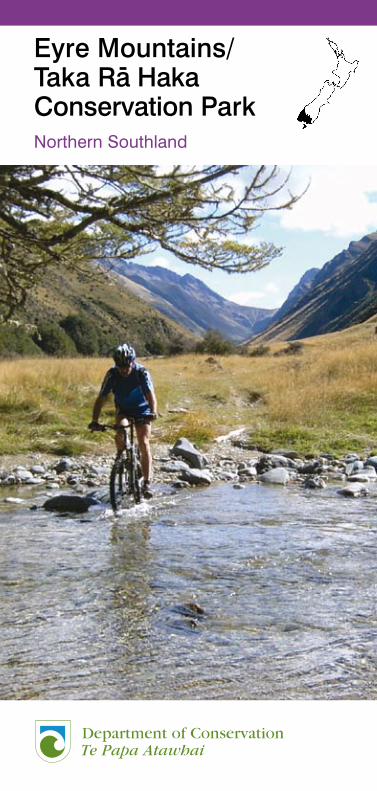
Eyre Mountains/ Taka Rä Haka Conservation ParkNorthern Southland
� �
�
Published byDepartment of ConservationSouthland ConservancyPO Box 743Invercargill, New Zealand.April 2007
ISBN 978-0-478-14201-3 (Hardcopy)ISBN 978-0-478-14202-0 (Web pdf)
© Copyright, New Zealand Department of Conservation
ConTEnTs
Introduction 5
Park Access 5
Recreation Opportunities 6
Important Information 9
Huts and Hut Fees 10
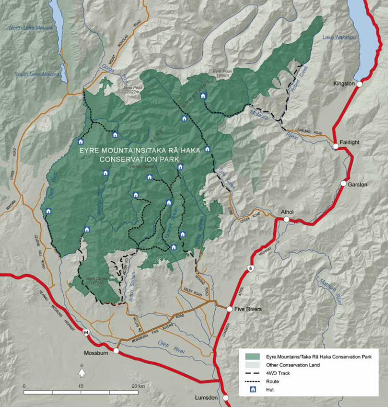
Oreti Valley 11
Windley Valley 13
Acton Valley 15
Cromel Valley 16
Irthing Valley 19
Eyre Creek 21
Upper Mataura River 23
Further Information 24
Cover – A mountain biker crossing Eyre Creek. Photo: Rob McMurdo
IntroductionThe Eyre Mountains/Taka Rä Haka Conservation Park is situated to the south west of Lake Wakatipu, between the distinctive wet granite mountains of Fiordland and the classic drier schist landscape of Central Otago.
Mäori named the area Taka Rä Haka O Te Rä in reference to the setting sun on the mountain tops at day’s end.
The Eyre Mountains were named after the explorer Edward John Eyre, Lieutenant-Governor of New Zealand (South Island and lower North Island) from 1848-��.
The Eyre Mountains/Taka Rä Haka Conservation Park covers 6�,160 hectares of rugged, mountainous country, interspersed with long, narrow river valleys and a great variety of flora and fauna, some of which are unique to Southland. The park was officially opened on 1� June �00� by the Hon. Chris Carter, Minister of Conservation.
Park AccessThe park is approximately an hour’s drive from either Invercargill or Queenstown. Access is from a number of points along State Highway 6 (between Kingston and Five Rivers), the Five Rivers – Mossburn Road and from State Highway 94 (Mossburn – Te Anau Road). Note that many access routes into the park are on public access easements through private property. Please respect local land-owners by keeping to formed tracks and complying with access information posted on signs.
Forestry harvesting operations on private land may occur from time to time and result in road closures to ensure public safety.
The tracks into the Acton Valley, Windley Valley, Eyre Creek and the upper Mataura River cross rivers that need to be forded.
6 �
Recreation opportunitiesThe Eyre Mountains/Taka Rä Haka Conservation Park provides unique opportunities for visitors to enjoy a back-country experience in a remote setting. This experience is enhanced by a network of tracks and basic huts (two – eight bunks). The area is isolated and, for the most part, physi-cally demanding. Weather patterns can change dramati-cally with little warning. Snow and heavy rain can be particularly hazardous as none of the streams are bridged and can quickly become impassable.
Tramping and climbing options are plentiful within the park and trout fishing opportunities can be found in the rivers on the park boundaries. Hunting, four wheel driving, mountain biking, horse riding, picnicking and camping are also popular options in this remote and scenic landscape.
Please note that many tracks within the park are shared use. Expect to share with other types of users including walkers, mountain bikers, hunters, fishermen, 4-wheel drive users and horse riders. People travelling uphill should give way to those travelling down and allow plenty of space.
Tramping Opportunites
Tramping opportunities in the park are along marked and unmarked routes. Routes are unformed and may have a rough surface. They are suitable only for people with a high level of backcountry navigation and river crossing skills. Cairns, poles or triangle markers are provided on marked routes only.
The park has several challenging climbs. These include Eyre Peak (1969m), Jane Peak (�0��m) and the Helen Peaks. Eyre and Jane Peaks are the highest peaks in Southland outside of Fiordland.
All times shown in the route guides are for tramping and are for one way travel only.
Fishing
Trout fishing is particularly popular on the Oreti and Mataura Rivers, situated on the edge of the park. Within the park the Windley and Mataura Rivers also provide opportunities for anglers. Contact Southland Fish and Game for more information and fishing licences.
Hunting
Low numbers of red deer are found in the forest areas of the Eyre Mountains. Chamois have occasionally been seen along the bush line and tops and a few pigs remain within the Oreti – Five Rivers catchments. Year round hunting is available in certain areas. Hunting permits are required and can be obtained from Department of Conservation offices. Hunting dogs are permitted but must be kept under control at all times.
Four Wheel Driving
There is 4WD access to all the main valleys in the Eyre Mountains. These range from formed, metal roads to off-road tracks, with conditions varying from easy to difficult. Most of the access routes to the park are surrounded by pastoral runs or plantation forestry. Please respect private land and leave gates as you find them. Unless otherwise stated, there is legal public access through most of the stations surrounding the Eyre Mountains. These are generally well marked with green and gold posts – refer to the DOC signage enroute.
Mountain Biking
There are good options for mountain biking throughout the park, with 4WD access roads in most valleys. There are also many routes in open valleys such as the Oreti, Eyre and Mataura, that offer a good variety of scenery and cycling terrain. Refer to the relevant track descriptions.
Horse Riding
Horse riding is permitted in the Eyre Creek and Upper Mataura River. Refer to the relevant track descriptions.
Camping
There are good camping opportunities throughout the park. The Irthing Valley Picnic Area has a toilet and barbeque areas are provided. Elsewhere campers must be more self-sufficient. There are several beech clearings near hut sites suitable for pitching tents, as well as oppor-tunities to camp in the open valleys.

8 9
Rec
reat
ion
op
por
tuni
ties
at a
Gla
nce
The
tab
le b
elow
iden
tifie
s tr
acks
sui
tab
le fo
r tr
amp
ing
, fou
r w
heel
driv
ing
, hor
se r
idin
g, m
ount
ain
bik
ing
, fis
hing
and
hu
ntin
g (
by
per
mit
only
) w
ithin
the
Eyr
e M
ount
ains
/Tak
a R
ä H
aka
Con
serv
atio
n P
ark.
Loca
tio
nTr
ack
Tram
pin
g
4W
DH
ors
e R
idin
gM
ou
nta
in B
ikin
g H
un
tin
g F
ish
ing
Ore
ti Va
lley
Up
per
Ore
ti ac
cess
poi
nt –
Lin
coln
Hut
, unm
arke
d r
oute
Ore
ti R
iver
/Ash
ton
Bur
n Ju
nctio
n –
Ash
ton
Hut
, unm
arke
d ro
ute
Cen
tre
Hill
Roa
d -
Ore
ti H
ut, u
nmar
ked
rou
te
Win
dle
y Va
lley
Win
dle
y Va
lley
Roa
d e
nd –
Low
er W
ind
ley
Hut
, unm
arke
d r
oute
Low
er W
ind
ley
Hut
– U
pp
er W
ind
ley
Hut
Unm
arke
d R
oute
Act
on V
alle
yA
cton
Roa
d e
nd –
Cro
mel
Bra
nch
Hut
Rou
te
Act
on R
oad
end
– Is
land
s H
ut R
oute
Cro
mel
Val
ley
Act
on R
oad
end
– C
rom
el B
ase
Hut
Rou
te
Cro
mel
Bas
e H
ut –
Cro
mel
Bra
nch
Hut
Rou
te
Cro
mel
Bra
nch
Hut
– U
pp
er C
rom
el H
ut R
oute
Cro
mel
Bra
nch
Hut
– Ir
thin
g H
ut R
oute
Irthi
ng V
alle
yIrt
hing
Val
ley
- M
ansi
on H
ut R
oute
Mou
nt B
ee 4
WD
Tra
ck
Mou
nt B
ee R
idg
e Tr
ack
Eyr
e C
reek
She
phe
rd C
reek
Hut
4W
D T
rack
She
phe
rd C
reek
Hut
– D
og B
ox H
ut, u
nmar
ked
rou
te
Up
per
Mat
aura
Riv
erM
atau
ra R
iver
– B
eech
Hut
, unm
arke
d r
oute
Important InformationThe Eyre Mountain/Taka Rä Haka Conservation Park is a remote, backcountry area. It is recommended visitors to this area have good back-country experience and are well prepared.
Planning Prior to Leaving Home
• This brochure describes general recreation opportunities within the park. Topographical maps nZMs 260: sheets D43, E42 and E43 of the Eyre Mountain/Taka Rä Haka Conservation Park should be used by all visitors to the park.
• Let someone know where you are going before you leave home. Leave trip intentions with someone responsible and remember to check in with that person when you return.
• Weather conditions are very changeable and difficult to predict. Strong winds, hail, snow and heavy rain can occur at all times of year. Visitors should come prepared for the very worst weather conditions. Remember, exposure and hypothermia can affect anyone and can kill.
• Take adequate food, clothing and equipment, and allow for weather changes and possible delays. Portable stoves and fuel must be carried.
• Mobile phone coverage in the area is extremely limited. It is recommended that visitors carry an Emergency Person Locator Beacon (EPERB) or a Mountain Radio.
Protect plants and animals
Remove rubbish
Bury toilet waste
Keep streams and lakes clean
Take care with fires
Camp carefully
Keep to the track
Consider others
Respect our cultural heritage
Enjoy your visit
Toitu te whenua (Leave the land undisturbed)
9
10 11
Visiting the Park
• Ground surfaces are varied and may involve sections of mud. Rivers and streams are prone to unpredictable flooding. There are no bridged sections of stream or river within the park. Always cross streams and rivers with care - if in doubt, sit it out.
• Visitors who wish to drive (4WD) or mountain bike within the park must travel on the formed tracks. Vehicles must carry a winch or some form of extraction device, in case of boggy conditions.
• If you become lost – stop, find shelter, stay calm and wait for searchers to arrive.
• It is recommended that drinking water is filtered, chemically treated or boiled for a minimum of three minutes.
• Reduce the spread of weeds by checking for seeds and plant material on footwear, clothing and vehicles.
• When a total fire ban is in force, fires are not permitted. This includes heating and cooking.
• When moving between waterways and catchments prevent the spread of the water weed Didymo (Didymosphenia geminata) by following the three step process of check, clean and dry. See www.biosecurity.govt.nz for further information.
• Dogs are allowed in the park provided they have a permit, available from the Department of Conservation office in Invercargill.
Huts and Hut FeesAll huts in the Eyre Mountains/Taka Rä Haka Conservation Park are classified as ‘basic huts’. They are free of charge and have matresses and a fireplace. Be aware that dry firewood may be difficult to find in some areas, especially after rain. Some huts in the park do not have toilet facilities.
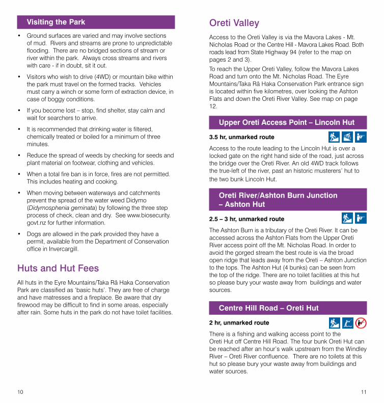
oreti ValleyAccess to the Oreti Valley is via the Mavora Lakes - Mt. Nicholas Road or the Centre Hill - Mavora Lakes Road. Both roads lead from State Highway 94 (refer to the map on pages � and �).
To reach the Upper Oreti Valley, follow the Mavora Lakes Road and turn onto the Mt. Nicholas Road. The Eyre Mountains/Taka Rä Haka Conservation Park entrance sign is located within five kilometres, over looking the Ashton Flats and down the Oreti River Valley. See map on page 1�.
Upper Oreti Access Point – Lincoln Hut
3.5 hr, unmarked route
Access to the route leading to the Lincoln Hut is over a locked gate on the right hand side of the road, just across the bridge over the Oreti River. An old 4WD track follows the true-left of the river, past an historic musterers’ hut to the two bunk Lincoln Hut.
Oreti River/Ashton Burn Junction – Ashton Hut
2.5 – 3 hr, unmarked route
The Ashton Burn is a tributary of the Oreti River. It can be accessed across the Ashton Flats from the Upper Oreti River access point off the Mt. Nicholas Road. In order to avoid the gorged stream the best route is via the broad open ridge that leads away from the Oreti – Ashton Junction to the tops. The Ashton Hut (4 bunks) can be seen from the top of the ridge. There are no toilet facilities at this hut so please bury your waste away from buildings and water sources.
Centre Hill Road – Oreti Hut
2 hr, unmarked route
There is a fishing and walking access point to the Oreti Hut off Centre Hill Road. The four bunk Oreti Hut can be reached after an hour’s walk upstream from the Windley River – Oreti River confluence. There are no toilets at this hut so please bury your waste away from buildings and water sources.
1� 1�
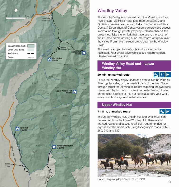
Windley ValleyThe Windley Valley is accessed from the Mossburn – Five Rivers Road, via Hillas Road (see map on pages � and �). Within ten minutes the road forks to either side of West Dome. A Department of Conservation sign provides access information through private property – please observe the guidelines. Take the left fork that traverses to the south of West Dome before arriving at an impressive viewpoint over the valley. From here the road drops down to the Windley River.
This road is subject to washouts and access can be restricted. Four wheel drive vehicles are recommended. Please drive with caution.
Windley Valley Road end – Lower Windley Hut
20 min, unmarked route
Leave the Windley Valley Road end and follow the Windley River up the valley on the true-left bank of the river. Travel through forest for �0 minutes before reaching the two bunk Lower Windley hut, which is set in a bush clearing. There are no toilet facilities at this hut so please bury your waste away from buildings and water sources.
Upper Windley Hut
7 – 8 hr, unmarked route
The Upper Windley Hut, Lincoln Hut and Oreti River can be reached from the Lower Windley Hut. There are no marked routes and access is difficult, recommended for experienced trampers only using topographic maps NZMS �60, D4� and E4�.
Horse riding along Eyre Creek. Photo: DOC
14 1�
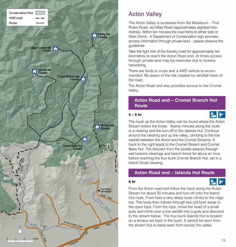
Acton ValleyThe Acton Valley is accessed from the Mossburn – Five Rivers Road, via Hillas Road (approximately eighteen kilo-metres). Within ten minutes the road forks to either side of West Dome. A Department of Conservation sign provides access information through private land – please observe the guidelines.
Take the right fork of the forestry road for approximately ten kilometres to reach the Acton Road end. At times access through private land may be restricted due to forestry harvesting.
There are fords to cross and a 4WD vehicle is recom-mended. Be aware of the risk created by windfall trees on the road.
The Acton Road end also provides access to the Cromel Valley.
Acton Road end – Cromel Branch Hut Route
4 – 5 hr
The route up the Acton Valley can be found where the Acton Stream enters the forest. Twenty minutes along the route is a clearing and the turn-off to the Islands Hut. Continue around the clearing and up the valley, climbing to the low saddle between the Acton and the Cromel Streams. A track to the right leads to the Cromel Stream and Cromel Base Hut. The descent from the saddle weaves through wet tussock clearings and beech forest for about an hour, before reaching the four bunk Cromel Branch Hut, set in a beech forest clearing.
Acton Road end – Islands Hut Route
6 hr
From the Acton road end follow the track along the Acton Stream for about �0 minutes and turn off onto the Island Hut route. From here a very steep route climbs to the ridge top. The route then follows through two old burn areas to the open tops. From the tops, cross the head of a small gully and climb over a low saddle into a gully and descend to the stream below. The four bunk Islands Hut is located on a terrace set back in the bush. It cannot be seen from the stream but is easily seen from across the valley.
16 1�
Cromel ValleyThe Cromel Valley can be accessed from the Acton Road end as described on page 1�. Refer to the map on page 14 for Cromel Valley tramping routes.
Acton Road end – Cromel Base Hut Route
3 hr
Approximately ��0 metres along the bush edge of the Acton Stream lies the Acton Hut (privately owned). A well marked track leads into the bush about �0 metres from the hut door. The track ascends steeply up the ridge to the saddle. After walking about 400 metres to the north east, the track drops down the ridge to the south east. An old burnt-out area is passed after about �0 minutes then the track descends to the Cromel Stream which can be crossed just north of the Cromel Base Hut (6 bunks).
Cromel Base Hut – Cromel Branch Hut Route
4.5 – 5.5 hr
The route leads from below the hut through grassy clearings for about �0 minutes, before crossing to the true-right of the stream. Follow the stream for 10 minutes to reach the remains of an old post-cutters hut – a reminder of the farming days. It is a further four hour walk through red beech forest to the saddle that divides the Acton Route from the Cromel Branch Route. The descent from the saddle weaves through wet tussock clearings and forest for about an hour, before reaching the four bunk Cromel Branch Hut, set in a forest clearing.
Cromel Branch Hut – Upper Cromel Hut Route
2.5 – 3 hr
The start of the route to the Upper Cromel Hut (� bunks) is ten minutes walk from the Cromel Branch Hut, diagonally across the valley to the bush edge, on the true-left of the stream. A marked route then follows the true-right of the Cromel Stream. The two bunk Upper Cromel Hut can be found hidden behind beech forest in the upper part of the clearing. There are no toilet facilities at this hut so please bury your waste well away from buildings and water sources.
This is an ideal point for experienced trampers and climbers to access the impressive Helen Peaks, which are situated at the head of the Cromel Valley.
Cromel Branch Hut – Irthing Hut Route
4 hr
The route leads from the Upper Cromel Hut before following the true-right of the Cromel Stream for a kilometre. The track leads to a bushy saddle on the northern extremes of the Mt. Bee Ridge (�.� hours). It then branches right to continue along the ridge, or left and down through the beech forest to the two bunk Irthing Hut. There are no toilet facilities at this hut so please bury your waste away from buildings and water sources.
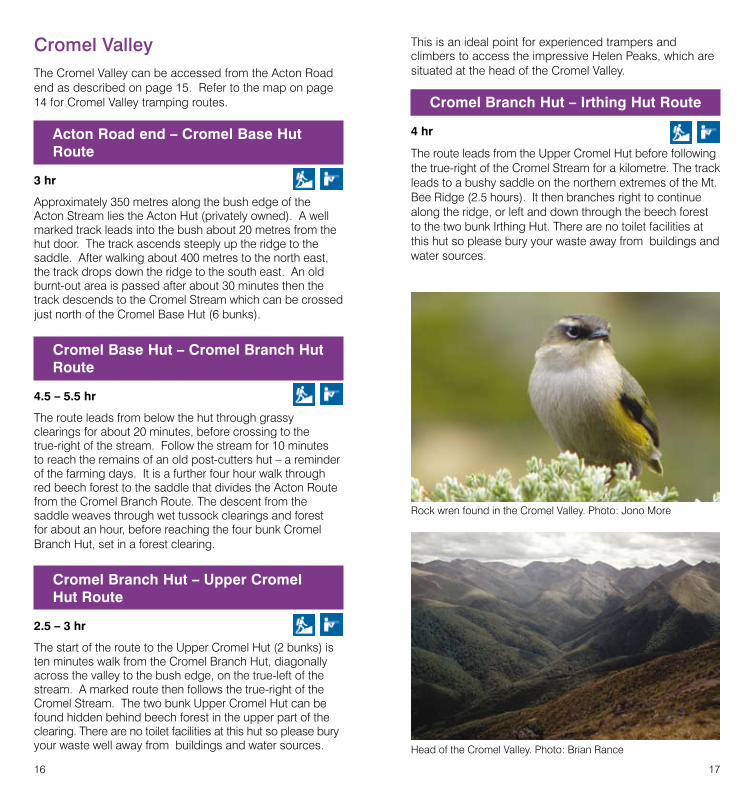
Head of the Cromel Valley. Photo: Brian Rance
Rock wren found in the Cromel Valley. Photo: Jono More

18 19
Irthing ValleyThe Irthing Valley is accessed from the Mossburn – Five Rivers Road, via Irthing Road. Turn right onto Mulholland Road to access the Irthing Picnic Area, or continue on for 4WD and mountain bike access to the Mount Bee huts. Access to the Mt. Bee Huts is through private land and at times may be restricted due to forestry operations. Be aware of the risk created by windfall trees on the road.
Irthing Picnic Area
Set into a beech forest glade next to the Irthing Stream, the picnic area provides opportunities for camping and picnicking.
Irthing Valley – Mansion Hut Route
1.5 – 2 hr
The track begins at the northern end of the picnic area and is an easy wander through mountain beech forest, following the Irthing Stream. After an hour the track crosses to the true-right of the stream and follows easy terrain for another �0 minutes, before arriving at the two bunk hut set in a small clearing known as ‘The Mansion’. There are no toilet facilities at this hut so please bury your waste away from buildings and water sources. Further upstream, the river becomes gorged and travel becomes difficult. It is advisable to take one of the alterna-tive routes through the Cromel Valley to access the Irthing Hut, rather than follow this gorge.
Mount Bee 4WD Track
4 km
Mount Bee provides an excellent vantage point of the Eyre Mountains and is well worth a trip when weather condi-tions are favourable. Four wheel driving is advisable only in summer. The 4WD track climbs to over 900 metres in altitude to the Mt. Bee Huts (8 bunks).
Mount Bee Ridge Track
1.5 hr
Beyond the huts, the track is suitable for mountain bikes and tramping only. The track continues along the ridge to a saddle, where the Upper Irthing and Cromel Valleys can be accessed by foot. There are no marked routes from this point.
�0 �1
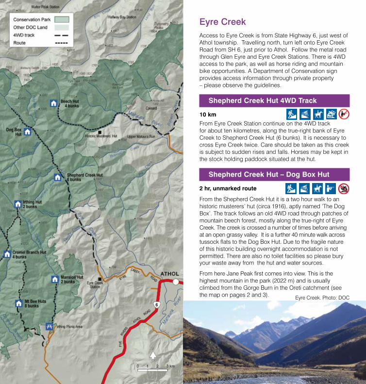
Eyre Creek Access to Eyre Creek is from State Highway 6, just west of Athol township. Travelling north, turn left onto Eyre Creek Road from SH 6, just prior to Athol. Follow the metal road through Glen Eyre and Eyre Creek Stations. There is 4WD access to the park, as well as horse riding and mountain bike opportunities. A Department of Conservation sign provides access information through private property – please observe the guidelines.
Shepherd Creek Hut 4WD Track
10 km
From Eyre Creek Station continue on the 4WD track for about ten kilometres, along the true-right bank of Eyre Creek to Shepherd Creek Hut (6 bunks). It is necessary to cross Eyre Creek twice. Care should be taken as this creek is subject to sudden rises and falls. Horses may be kept in the stock holding paddock situated at the hut.
Shepherd Creek Hut – Dog Box Hut
2 hr, unmarked route
From the Shepherd Creek Hut it is a two hour walk to an historic musterers’ hut (circa 1916), aptly named ‘The Dog Box’. The track follows an old 4WD road through patches of mountain beech forest, mostly along the true-right of Eyre Creek. The creek is crossed a number of times before arriving at an open grassy valley. It is a further 40 minute walk across tussock flats to the Dog Box Hut. Due to the fragile nature of this historic building overnight accommodation is not permitted. There are also no toilet facilities so please bury your waste away from the hut and water sources.
From here Jane Peak first comes into view. This is the highest mountain in the park (�0�� m) and is usually climbed from the Gorge Burn in the Oreti catchment (see the map on pages � and �). Eyre Creek. Photo: DOC

�� ��
Upper Mataura River The Upper Mataura River is accessible via Cainard Road, off SH6 at Fairlight. Follow the road through Cainard Station to Robert Creek, a tributary of the Mataura River. A Department of Conservation sign provides access information through private property – please observe the guidelines.
Access to Upper Robert Creek is along the 4WD track on the true-left of Robert Creek. Follow the green and yellow marker posts for three kilometres to the airstrip. The track then follows through open flats for another seven and a half kilometres, providing access to the most northerly part of the conservation park.
Access to Beech Hut and the Upper Mataura River is along the true-left of the Mataura River. Follow the green and yellow marker posts for approximately five kilometres. From here the route is unmarked and not suitable for 4WD vehicles. The unmarked park boundary is approximately 40 minutes walk along the Mataura River from the last marker post.
Mataura River – Beech Hut
4 hr, unmarked route
From the last marker post travel along the Mataura River for about four hours, reaching a large patch of bush near the head of the valley. The historic beech hut (4 bunks) is visible on the true right of the river at the edge of the bush. This character hut is one of the oldest musterers’ huts (circa 191�) remaining in Southland. There are no toilets situated at the hut so please bury your waste away from buildings and water sources.
Further Information
Beech Hut. Photo: Brian Murphy

�4
I
Further Information
For further information please contact:
Department of Conservation Southland Conservancy Office �� Don Street PO Box �4� INVERCARGILL Tel. 0� �11 �400, Fax 0� �14 4486 Email: [email protected] Website: www.doc.govt.nz
Fiordland National Park Visitor Centre Department of Conservation Lakefront Drive PO Box �9 TE ANAU Tel.. 0� �49 �9�4, Fax 0� �49 0257 Email: [email protected] Website: www.doc.govt.nz