f geology and soils - los angeleseng2.lacity.org/techdocs/emg/docs/taylor_yard/f. geology... ·...
TRANSCRIPT

F Geology and Soils


PRELIMINARY GEOTECHNICAL EVALUATION TAYLOR YARD BIKEWAY/PEDESTRIAN BRIDGE
LOS ANGELES DEPARTMENT OF PUBLIC WORKS LOS ANGELES, CALIFORNIA
PREPARED FOR: ICF International
601 W. Fifth Street, Suite 900 Los Angeles, California 90071
PREPARED BY: Ninyo & Moore
Geotechnical and Environmental Sciences Consultants 475 Goddard, Suite 200 Irvine, California 92618
May 26, 2016 Project No. 209403005


May 26, 2016 Project No. 209403005
Ms. Tamseel Mir ICF International 601 W. Fifth Street, Suite 900 Los Angeles, California 90071
Subject: Preliminary Geotechnical Evaluation Taylor Yard Bikeway/Pedestrian Bridge Los Angeles Department of Public Works Los Angeles, California
Dear Ms. Mir:
In accordance with your request and authorization, Ninyo & Moore has performed a preliminary geotechnical evaluation for the Taylor Yard Bikeway/Pedestrian Bridge project located in Los Angeles, California. Our evaluation was conducted in general accordance with the scope of services presented in our proposal dated May 29, 2015. This report presents our findings and conclusions regarding the subject site. We understand that the results of this evaluation will be utilized in the preparation of an Initial Study/Mitigated Negative Declaration for the project.
We appreciate the opportunity to provide geotechnical consulting services for this project.
Sincerely, NINYO & MOORE
Michael Rogers, PG, CEG Senior Geologist
Soumitra Guha, PhD, PE, GE Principal Engineer
SCM/MER/CAP/SG/mtf
Distribution: (1) Addressee (via e-mail)


Taylor Yard Bikeway/Pedestrian Bridge May 26, 2016 Los Angeles, California Project No. 209403005
TABLE OF CONTENTS
Page 1. INTRODUCTION ....................................................................................................................1
2. SCOPE OF SERVICES ............................................................................................................1
3. SITE DESCRIPTION ...............................................................................................................2
4. PROJECT DESCRIPTION ......................................................................................................3
5. GEOLOGY ...............................................................................................................................3 5.1. Regional Geology .........................................................................................................3 5.2. Site Geology .................................................................................................................4 5.3. Groundwater .................................................................................................................4
6. FAULTING AND SEISMICITY .............................................................................................5 6.1. Regional Fault Setting ..................................................................................................5
7. METHODOLOGY FOR GEOLOGIC IMPACT AND HAZARD ANALYSES ....................7
8. THRESHOLDS OF SIGNIFICANCE .....................................................................................7
9. CONCLUSIONS AND RECOMMENDATIONS FOR POTENTIAL GEOLOGIC AND SEISMIC IMPACTS/HAZARDS ............................................................................................8 9.1. Surface Fault Rupture ...................................................................................................9 9.2. Seismic Ground Shaking ..............................................................................................9 9.3. Liquefaction ................................................................................................................10 9.4. Landslides ...................................................................................................................11 9.5. Soil Erosion ................................................................................................................11 9.6. Subsidence ..................................................................................................................12 9.7. Compressible/Collapsible Soils ..................................................................................13 9.8. Expansive Soils ...........................................................................................................13 9.9. Groundwater and Excavations ....................................................................................14
10. LIMITATIONS .......................................................................................................................15
11. REFERENCES .......................................................................................................................16
Tables Table 1 – Principal Regional Active Faults ......................................................................................6 Table 2 – Summary of Potential Geologic Impacts/Hazards ...........................................................8
Figures Figure 1 – Site Location Figure 2 – Site Plan Figure 3 – Regional Geology Figure 4 – Fault Locations Figure 5 – Seismic Hazard Zones
209403005 R Prelim Geo Eval i


Taylor Yard Bikeway/Pedestrian Bridge May 26, 2016 Los Angeles, California Project No. 209403005
1. INTRODUCTION
In accordance with your request and authorization, we have performed a preliminary
geotechnical evaluation for the Taylor Yard Bikeway/Pedestrian Bridge project (project) located
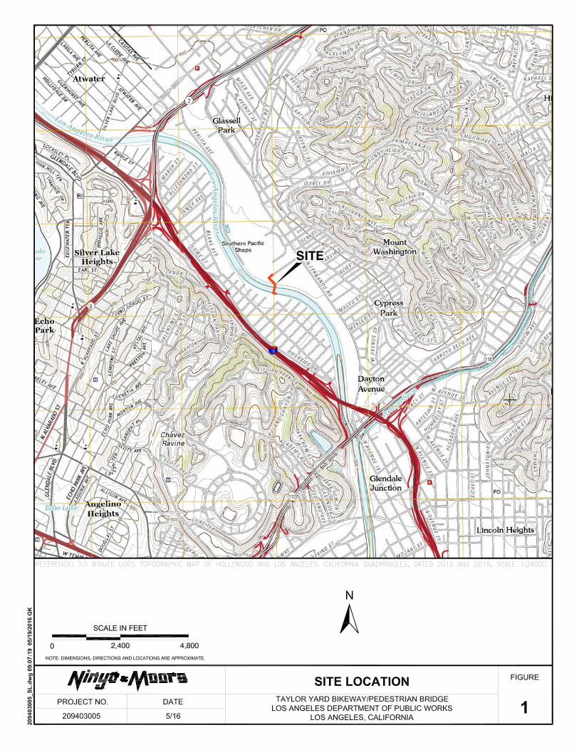
in Los Angeles, California (Figure 1). The project involves the construction of a steel bridge
across the Los Angeles River for bike and pedestrian traffic. The project site is located north of
downtown Los Angeles at the location of the abandoned Taylor Yard railyard property on the
north side of the river (Figure 2). The project is proposed by the City of Los Angeles Department
of Public Works (LADPW) in cooperation with the Los Angeles Metropolitan Transportation
Authority as part of the Los Angeles River Revitalization Master Plan. We have performed a
geotechnical evaluation of the site geologic conditions and the impacts associated with potential
geologic and seismic hazards for inclusion in the Initial Study/Mitigated Negative Declaration
(IS/MND) for the project.
The purpose of our evaluation was to assess the geologic conditions at the site and develop
preliminary conclusions regarding potential geologic and seismic impacts associated with the
project in accordance with the California Environmental Quality Act (CEQA). Where
appropriate, recommendations to mitigate potential geologic hazards, as noted in this report,
have been provided. Our evaluation was based on review of readily available geologic and
seismic data, geotechnical literature and reports, and site reconnaissance. Subsurface exploration
was not conducted as part of our evaluation.
2. SCOPE OF SERVICES
Ninyo & Moore’s scope of services has included review of geotechnical background materials,
geologic reconnaissance of the project area, and geotechnical analysis. Specifically, we have
performed the following tasks:
• Review of readily available topographic and geologic maps, published geotechnical literature, geologic and seismic data, groundwater data, and aerial photographs.
• Review of the geotechnical aspects of the preliminary project plans and project description documents pertaining to the site provided to us by ICF International (ICF).
209403005 R Prelim Geo Eval 1

Taylor Yard Bikeway/Pedestrian Bridge May 26, 2016 Los Angeles, California Project No. 209403005
• Review of a geotechnical engineering report for the project prepared by the LADPW dated June 9, 2015.
• Geotechnical reconnaissance by a representative from Ninyo & Moore conducted on April 21, 2016, to observe and document the existing surface conditions at the project site.
• Compilation and analysis of existing geotechnical data pertaining to the site.
• Assessment of the general geologic conditions and seismic hazards affecting the area and evaluation of their potential impacts on the project.
• Preparation of this report presenting the results of our study, as well as our conclusions regarding the geologic and seismic impacts on the project, and preliminary recommendations to address the impacts to be included in the IS/MND.
3. SITE DESCRIPTION
The project site is located east of Interstate 5 and north of Interstate 110 situated between the
Elysian Valley community to the west and Mount Washington community to the east (Figure 1).
The proposed northern bridge abutment is located adjacent to Kerr Road and an abandoned
railroad track at the former Taylor Yard property. The proposed southern abutment is located at
the Los Angeles River Bikeway trail between Altman Street and Dorris Place adjacent to a
sanitation district equipment yard (Figure 2).
The site is located in a relatively flat valley bottom along the Los Angeles River drainage course.
Topography of the river drainage slopes gently down toward the south/southeast. The northern
river bank abutment location is situated at an elevation of approximately 340 feet above mean
sea level (MSL) and the southern river bank abutment location is situated at an elevation of ap-
proximately 330 feet above MSL. The river channel bottom is elevated approximately 310 feet
above MSL (Google Earth, 2016). The river channel bottom is unlined and is covered with
coarse-grained gravel and sand deposits, vegetation and flowing water. The channel embank-
ments are approximately 20 feet high, inclined at a gradient of approximately 3:1 (horizontal to
vertical) and are lined with concrete (Google Earth, 2016).
209403005 R Prelim Geo Eval 2

Taylor Yard Bikeway/Pedestrian Bridge May 26, 2016 Los Angeles, California Project No. 209403005
4. PROPOSED PROJECT
The proposed Taylor Yard Bikeway/Pedestrian Bridge will connect the Elysian Valley
neighborhood on the south side of the Los Angeles River with the Taylor Yard site and residential
communities on the north side of the river. On the south side, the bridge will connect with an
existing bikeway along the river channel, and on the north side, a new bikeway will be
constructed along Kerr Road to connect with an existing bikeway along San Fernando Road. A
proposed site plan is presented on Figure 2 (Tetra Tech, 2016).
Based on our review of the preliminary project plans and project description, we understand that
the project entails construction of a multi-modal steel bridge over the Los Angeles River
approximately 400 feet long and 30 feet high primarily for bicycle and pedestrian use. The
bridge will be supported on abutments along the top of the channel and on a single bent in the
central portion of the channel. The factored vertical and lateral loads at the abutments will range
from approximately 600 to 900 kips and 140 to 1,200 kips, respectively. The factored vertical
and lateral loads at the bent will be on the order of approximately 1,400 kips and 400 kips,
respectively. A retaining wall, ranging in height from 5 to 15 feet, is planned for construction on
the north abutment.
New bikeways will connect to existing bikeways along the Los Angeles River and on San
Fernando Road. Additionally, the bridge will be designed to carry two Department of Water and
Power reclaimed water pipelines, which will be placed underground on the east side and connect
with a pipeline near San Fernando Road. An at-grade crossing of the existing railroad will be
located on the north side.
5. GEOLOGY
5.1. Regional Geology
The subject site is located within the northeastern block of the Los Angeles Basin within the
Transverse ranges geomorphic province of southern California (Norris and Webb, 1990).
Geologically, the Los Angeles Basin and vicinity is divided into four blocks that include
uplifted portions and synclinal depressions. The northeastern block is situated between the
209403005 R Prelim Geo Eval 3

Taylor Yard Bikeway/Pedestrian Bridge May 26, 2016 Los Angeles, California Project No. 209403005
Whittier fault zone and the base of the San Gabriel Mountains and is separated from the
northwestern block by the Raymond Hill fault (Norris and Webb, 1990). The predominant
structural feature is the deep synclinal basin that is comprised mostly of marine Cenozoic
sedimentary rocks and includes some Miocene volcanic rocks. (Norris and Webb, 1990).
5.2. Site Geology
Regional geologic mapping indicates that the bridge abutments are underlain by Holocene-
age alluvium and the bridge bent is underlain by Holocene-age stream channel deposits
associated with deposition of sediments from the Los Angeles River (Dibblee, 1989). The
alluvium is described as consisting of unconsolidated flood plain deposits of silt, sand, and
gravel. The stream channel deposits are described as consisting of gravel, sand, and silt. A
regional geologic map of the site vicinity is shown on Figure 3.
Fugro Consultants, Inc. (Fugro), performed a subsurface evaluation of the site in March
2014, for the LADPW consisting of drilling two mud rotary exploratory borings to depths of
approximately 82 feet along both river bank abutment locations (Fugro, 2014a). In
November 2014, Fugro drilled an additional mud rotary boring to a depth of approximately
67 feet in the river channel (Fugro, 2014a).
Fill and alluvium were encountered in the exploratory borings to the total depths explored.
Fill was encountered to depths of approximately 19 and 20 feet at the location of the
southern and northern abutments, respectively. The fill generally consisted of moist to wet,
loose to very dense, silty sand and sand with variable amounts of gravel. Alluvium was
encountered at the ground surface in the river channel bottom and underlying the fill at the
abutment locations. The alluvium generally consisted of interbedded layers of wet, dense to
very dense, silty sand, clayey sand, and sand with variable amounts of gravel.
5.3. Groundwater
Based on the subsurface exploration performed by Fugro in 2014 (Fugro, 2014a, 2014b),
groundwater was encountered at depths of approximately 16½ and 18 feet below the river
bank ground surface at the northern and southern abutment locations, respectively.
209403005 R Prelim Geo Eval 4

Taylor Yard Bikeway/Pedestrian Bridge May 26, 2016 Los Angeles, California Project No. 209403005
Groundwater was encountered at the surface in the river channel bottom. Based on our
review of the California Geological Survey’s (CGS’s) (formerly known as California
Division of Mines and Geology [CDMG]) State of California Seismic Hazard Zone report
(1998), the historical high depth to groundwater is generally mapped at a depth of
approximately 20 feet below the river banks in the site vicinity. Our review of readily
available groundwater data on the State of California Water Resources Control Board’s
GeoTracker website (GeoTracker, 2016), indicates that the groundwater depth based on
thirteen monitoring wells located within three miles of the site ranges from 5 to 57 feet
below the ground surface.
Groundwater levels may be influenced by seasonal variations, precipitation, subsurface
stratification, groundwater pumping, irrigation practices, and other factors and are subject to
fluctuations. Shallow perched conditions may be present.
6. FAULTING AND SEISMICITY
6.1. Regional Fault Setting
The proposed bridge is located in a seismically active area, as is the majority of Southern
California, and the potential for strong ground motion at the site is considered significant
during the design life of the proposed bridge. The numerous faults in Southern California
include active, potentially active, and inactive faults. As defined by the CGS, active faults
are faults that have ruptured within Holocene time, or within approximately the last 11,000
years. Potentially active faults are those that show evidence of movement during Quaternary
time (approximately the last 1.6 million years) but for which evidence of Holocene
movement has not been established. Inactive faults have not ruptured in the last
approximately 1.6 million years.
Table 1 lists selected principal known active faults within approximately 30 miles of the
project area and the maximum moment magnitude (Mmax) as published by the United
States Geological Survey (USGS, 2008) in general accordance with the Uniform California
209403005 R Prelim Geo Eval 5

Taylor Yard Bikeway/Pedestrian Bridge May 26, 2016 Los Angeles, California Project No. 209403005
Earthquake Rupture Forecast, version 3 (UCERF) (Field, et al., 2013). The fault distances in
Table 1 are measured from the approximate center of the bridge.
Table 1 – Principal Regional Active Faults
Fault Approximate
Fault-to-Site Distance miles (kilometers)
Maximum Moment Magnitude
(Mmax) Upper Elysian Park Blind Thrust 1.4 (2.2) 6.7 Hollywood 1.7 (2.8) 6.7 Raymond 2.0 (3.3) 6.8 Santa Monica 3.0 (4.9) 7.4 Verdugo 4.2 (6.8) 6.9 Puente Hills Blind Thrust 6.7 (10.8) 7.0 Sierra Madre 8.5 (13.7) 7.3 Newport-Inglewood (Los Angeles Basin) 9.5 (15.2) 7.5 Elsinore 12.7 (20.4) 7.9 Clamshell-Sawpit 14.7 (23.7) 6.7 San Gabriel 15.7 (25.2) 7.3 Northridge 17.0 (27.3) 6.9 Malibu Coast 17.2 (27.8) 7.0 Anacapa-Dume 18.9 (30.4) 7.2 Palos Verdes 19.7 (31.7) 7.7 San Jose 20.8 (33.4) 6.7 Santa Susana 21.8 (35.1) 6.9 Chino 28.4 (45.7) 6.8 Cucamonga 29.1 (46.8) 6.7 Simi-Santa Rosa 30.1 (48.5) 6.9 San Andreas 31.4 (50.5) 8.2
Figure 4 shows the approximate site location relative to the principal faults in the region
based on the Fault Activity Map of California (Jennings, C.W., and Bryant, W.A., 2010). The
Upper Elysian Park Blind Thrust Fault and the Hollywood Fault are located approximately
1.4 miles southwest and 1.7 miles northwest of the site, respectively. Blind thrust faults are
low-angle faults at depths that do not break the surface and are, therefore, not shown on
Figure 4. Although blind thrust faults do not have a surface trace, they can be capable of
generating damaging earthquakes and are included in Table 1.
209403005 R Prelim Geo Eval 6

Taylor Yard Bikeway/Pedestrian Bridge May 26, 2016 Los Angeles, California Project No. 209403005
7. METHODOLOGY FOR GEOLOGIC IMPACT AND HAZARD ANALYSES
As outlined by the CEQA, the proposed project has been evaluated with respect to potential
geologic and seismic impacts associated with the project. Evaluation of impacts due to potential
geologic and seismic hazards is based on our review of readily available published geotechnical
literature and geologic and seismic data pertinent to the proposed project, and site
reconnaissance. The references and data reviewed include, but are not limited to, the following:
• Geologic maps and fault maps from the CDMG, CGS and USGS.
• Topographic maps from the USGS.
• Seismic data from the CGS and USGS.
• Geotechnical publications by the CDMG, CGS and USGS.
• State of California EFZ Maps (formerly Alquist-Priolo Special Studies Zones Maps).
• State of California Seismic Hazards Zones Reports and Maps.
• Aerial photographs.
• Safety Element of the Los Angeles City General Plan.
• Site-specific geotechnical reports and plans prepared for the project, as indicated in the References section of this report.
8. THRESHOLDS OF SIGNIFICANCE
According to Appendix G of the CEQA guidelines (California Environmental Resources
Evaluation System [CERES], 2005a, 2005b), a project is considered to have a geologic impact if
its implementation would result in or expose people/structures to potential substantial adverse
effects, including the risk of loss, injury, or death from hazards involving one or more of the
geologic conditions presented in Table 2. Table 2 also presents the impact potential as defined by
CEQA associated with each of the geologic conditions discussed in the following sections.
209403005 R Prelim Geo Eval 7

Taylor Yard Bikeway/Pedestrian Bridge May 26, 2016 Los Angeles, California Project No. 209403005
Table 2 – Summary of Potential Geologic Impacts/Hazards
Geologic Condition
Impact Potential1 Potentially Significant
Impact
Less than Significant with Mitigation Incorporation
Less than Significant
Impact No
Impact
Earthquake Fault Rupture x Strong Seismic Ground Shaking x Seismically Related Ground Failure, Including Liquefaction and Dynamic Compaction
x
Landslides x Substantial Soil Erosion (excludes scour) x Subsidence x Compressible/Collapsible Soils x Expansive Soils x Groundwater and Excavations x Note: 1Reference: CERES, 2005b, Appendix G – Environmental Checklist Form, Final Text, dated May 25. Website: http://ceres.ca.gov/topic/envlaw/ceqa/guidelines/appendices.html
9. CONCLUSIONS AND RECOMMENDATIONS FOR POTENTIAL GEOLOGIC
AND SEISMIC IMPACTS/HAZARDS
Based on our review of geologic and seismic background information, and geotechnical
reconnaissance, implementation of the proposed project is not anticipated to have a significant
impact on the geologic environment. However, future development at the project site may be
subjected to potential impacts from geologic and seismic hazards. Potential impacts on the
proposed project based on our preliminary evaluation are provided in the following sections.
The potential geologic and seismic hazards described below may be addressed by employing
sound engineering practice in the design and construction of the proposed project elements. This
practice includes the implementation of appropriate geotechnical recommendations prior to the
design and construction of the facilities at the project site. Typical methods to reduce potential
hazards that may be encountered during the construction of improvements are described in the
following sections. Where appropriate, recommendations to mitigate potential geologic hazards
are provided.
209403005 R Prelim Geo Eval 8

Taylor Yard Bikeway/Pedestrian Bridge May 26, 2016 Los Angeles, California Project No. 209403005
9.1. Surface Fault Rupture
Surface fault rupture is the offset or rupturing of the ground surface by relative displacement
across a fault during an earthquake. Based on our review of referenced geologic and fault
hazard data, the project site is not transected by known active or potentially active faults.
The active Upper Elysian Park Blind Thrust Fault and the Hollywood Fault are located
approximately 1.4 miles southwest and 1.7 miles northwest of the site, respectively. The site
is not located within a State of California Earthquake Fault Zone (Hart, E.W., and Bryant,
W.A., 1997). Therefore, the potential for surface rupture is relatively low. However, lurching
or cracking of the ground surface as a result of nearby seismic events is possible.
9.2. Seismic Ground Shaking
Earthquake events from one of the regional active or potentially active faults near the project
area could result in strong ground shaking which could affect the project site. The level of
ground shaking at a given location depends on many factors, including the size and type of
earthquake, distance from the earthquake, and subsurface geologic conditions. The type of
construction also affects how particular structures and improvements perform during ground
shaking.
The 2013 California Building Code (CBC) recommends that the design of structures be
based on spectral response accelerations in the direction of maximum horizontal response (5
percent damped) having a 1 percent probability of collapse in 50 years. Such spectral
response accelerations represent the Risk-Targeted Maximum Considered Earthquake
(MCER) ground motion. The horizontal peak ground acceleration (PGA) that corresponds to
the MCER for the site was calculated as 1.13g using the USGS (2014b) seismic design tool
(web-based). The mapped PGA (PGAM) which is defined as the Maximum Considered
Earthquake Geometric Mean (MCEG) PGA with adjustment for site class effects in
accordance with the American Society of Civil Engineers (ASCE) 7-10 Standard was
estimated to be 1.08g using the USGS (2014b) seismic design tool in accordance with the
ASCE 7-10 Standard. These estimates of ground motion do not include near-source factors
that may be applicable to the design of structures on site.
209403005 R Prelim Geo Eval 9

Taylor Yard Bikeway/Pedestrian Bridge May 26, 2016 Los Angeles, California Project No. 209403005
This potential level of ground shaking could have high impacts on project improvements
without appropriate design mitigation, and should be considered during the detailed design
phase of the project. Mitigation of the potential impacts of seismic ground shaking can be
achieved through project structural design. Structural elements of planned improvements can
be designed to resist or accommodate appropriate site-specific ground motions and to
conform to the current seismic design standards, including CBC and County of Los Angeles
building regulations. Appropriate structural design and mitigation techniques would reduce
the impacts related to seismic ground shaking.
9.3. Liquefaction
Liquefaction is the phenomenon in which loosely deposited granular soils located below the
water table undergo rapid loss of shear strength due to excess pore pressure generation when
subjected to strong earthquake-induced ground shaking. Ground shaking of sufficient
duration results in the loss of grain-to-grain contact due to rapid rise in pore water pressure
causing the soil to behave as a fluid for a short period of time. Liquefaction is known
generally to occur in saturated or near-saturated cohesionless soils at depths shallower than
50 feet. Factors known to influence liquefaction potential include composition and thickness
of soil layers, grain size, relative density, groundwater level, degree of saturation, and both
intensity and duration of ground shaking. The potential damaging effects of liquefaction
include differential settlement, loss of ground support for foundations, ground cracking,
heaving and cracking of slabs due to sand boiling, buckling of deep foundations due to
liquefaction-induced ground settlement.
According to Seismic Hazard Zones Maps published by the State of California (CDMG,
1999), the project area is located within an area considered susceptible to liquefaction
(Figure 5). This site was mapped as potentially liquefiable due to the shallow groundwater
conditions in loose, younger alluvial sediments. The historical high depth to groundwater is
mapped at a depth of approximately 20 feet below the river banks. Groundwater was
encountered at the ground surface in the channel bottom and at a depth of approximately
16½ to 18 feet at the bridge abutments in 2014 (Fugro, 2014a, 2014b).
209403005 R Prelim Geo Eval 10

Taylor Yard Bikeway/Pedestrian Bridge May 26, 2016 Los Angeles, California Project No. 209403005
Assessment of the liquefaction potential at the project site was evaluated by LADPW in their
report for the project dated June 9, 2015. The LADPW study found that, based on the
subsurface exploration performed by Fugro, there are potentially liquefiable soils at the
project site. A post-liquefaction settlement of approximately 1¼ inches was estimated based
on the analysis by LADPW. To mitigate the potential impacts of seismically-induced
settlement at the project site, LADPW recommended that the proposed bridge abutments be
supported on a deep foundation system. Therefore, the potential impacts due to liquefaction
are considered to be less than significant due to the mitigating effects of the deep foundation
design recommended by LADPW.
9.4. Landslides
Landslides, slope failures, and mudflows of earth materials generally occur where slopes are
steep and/or the earth materials are too weak to support themselves. Earthquake-induced
landslides may also occur due to seismic ground shaking. The project site comprises a
relatively flat river channel bottom and flat river banks separated by a moderately inclined,
concrete-lined channel embankment approximately 20 feet high. Due to the covering of the
river embankment with concrete, there is no potential for landslides or mudflows to affect
the project site.
9.5. Soil Erosion
Erosion is a process by which soil or earth material is loosened or dissolved and removed
from its original location. Future construction at the site will result in ground surface
disruption during demolition, excavation, grading, and trenching that would create the
potential for erosion to occur. Erosion can occur by varying processes and may occur at the
site where bare soil is exposed to wind or moving water (both rainfall and surface runoff).
The processes of erosion are generally a function of material type, terrain steepness, rainfall
or irrigation levels, surface drainage conditions, and general land uses.
Based on our review of geologic references, previous site exploration and site
reconnaissance, the materials exposed at the surface of the project site consist of sandy
materials. Sandy soils typically have low cohesion, and have a relatively higher potential for
209403005 R Prelim Geo Eval 11

Taylor Yard Bikeway/Pedestrian Bridge May 26, 2016 Los Angeles, California Project No. 209403005
erosion from surface runoff when exposed in cut slopes or utilized near the face of fill
embankments. Surface soils with higher amounts of clay tend to be less erodible as the clay
acts as a binder to hold the soil particles together. The potential impacts on the project
related to scour in the river channel were not a part of our services. Scour potential should
be evaluated during the design phase of the project.
Construction activities at the site may create the potential for soil erosion during excavation,
grading, and trenching activities. However, a Storm Water Pollution Prevention Program
incorporating Best Management Practices (BMPs) for erosion control is typically prepared
prior to the start of construction to mitigate erosion during site construction. Typical BMPs
include erosion prevention mats or geofabrics, silt fencing, sandbags, plastic sheeting,
temporary drainage devices, and positive surface drainage to allow surface runoff to flow
away from site improvements or areas susceptible to erosion. Surface drainage design
provisions and site maintenance practices would reduce potential soil erosion following site
development.
9.6. Subsidence
Subsidence is characterized as a sinking of the ground surface relative to surrounding areas,
and can generally occur where deep soil deposits are present. Subsidence in areas of deep
soil deposits is typically associated with regional groundwater withdrawal or other fluid
withdrawal from the ground such as oil and natural gas. Subsidence can result in the
development of ground cracks and damage to site improvements.
The City of Los Angeles and County of Los Angeles references do not indicate mapped
areas of subsidence. Historic subsidence is not known to have occurred or been reported in
the site region. The Safety Element of the Los Angeles City General Plan (1996) includes
information regarding the City’s program to preclude potential subsidence within the City.
Subsurface extraction activities within the City of Los Angeles are regulated by the Oil
Drilling District procedures, which contain provisions for monitoring and imposing
measures to preclude subsidence related to oil and gas extraction. Therefore, the potential
for subsidence in the project area is low.
209403005 R Prelim Geo Eval 12

Taylor Yard Bikeway/Pedestrian Bridge May 26, 2016 Los Angeles, California Project No. 209403005
9.7. Compressible/Collapsible Soils
Compressible soils are generally comprised of soils that undergo a decrease in volume when
exposed to new loading, such as fill or foundation loads. Soil collapse is a phenomenon
where the soils undergo a significant decrease in volume upon increase in moisture content,
with or without an increase in external loads. Buildings, bridges and other structure
foundations may be subject to excessive settlement-related distress when compressible soils
or collapsible soils are present.
Based on our background review, existing fill was encountered at the abutment locations to
depths ranging from approximately 19 to 20 feet. LADPW concluded that the existing,
undocumented fill may be prone to static settlement. Additionally, the project area is
underlain by alluvial deposits that are generally unconsolidated to weakly consolidated,
based on the young nature of the deposits, reflecting a depositional history without
substantial loading, and may be subject to collapse. Due to the presence of potentially
compressible/collapsible soils at the site, there is a potential for differential settlement to
cause damage to project improvements. The potential impacts of settlement are significant
without appropriate mitigation during detailed project design and construction.
To mitigate the potential impacts of both static settlement and seismically-induced
settlement at the project site, LADPW recommended that the proposed bridge abutments be
supported on a deep foundation system. Therefore, the potential impacts due to settlement
are considered to be low due to the mitigating effects of the deep foundation design
recommended by LADPW.
9.8. Expansive Soils
Expansive soils include clay minerals that are characterized by their ability to undergo
significant volume change (shrink or swell) due to variations in moisture content. Sandy
soils are generally not expansive. Changes in soil moisture content can result from rainfall,
irrigation, pipeline leakage, surface drainage, perched groundwater, drought, or other
factors. Volumetric change of expansive soil may cause excessive cracking and heaving of
209403005 R Prelim Geo Eval 13

Taylor Yard Bikeway/Pedestrian Bridge May 26, 2016 Los Angeles, California Project No. 209403005
structures with shallow foundations, concrete slabs-on-grade, or pavements supported on
these materials.
Based on our background review and site reconnaissance, the near-surface soils in the
project site are predominantly comprised of sandy, coarse-grained materials. Fugro
encountered predominantly sandy soils in their borings at the site. These soils typically have
a low expansion potential. However, clayey soils may be present in other areas of the project
site. Due to the deep foundation system anticipated for the bridge, expansive soils are not
anticipated to have a significant impact on the project. Provisions should be made during
project construction so that shallow improvements, such as pavements or hardscape features,
are not constructed upon highly expansive soils without appropriate mitigation.
9.9. Groundwater and Excavations
The depth of historic high groundwater at the project site is on the order of 20 feet below the
ground surface of the river bank area (CDMG, 1998). Based on the subsurface evaluations
performed by Fugro in 2014, groundwater was encountered at a depth ranging from
approximately 16½ to 18 feet at the bridge abutment locations after the completion of
drilling and groundwater was encountered at the ground surface in the river channel (Fugro,
2014a, 2014b).
Proposed future improvements at the project site are anticipated to consist of excavations
and site grading for the bridge foundations and other miscellaneous improvements. Based on
the shallow groundwater levels reported in the site region and the anticipated depth of
construction activities, groundwater will be encountered in excavations for the planned
project improvements, particularly during construction of the bent in the river channel.
Wet or saturated soil conditions encountered in excavations during construction for the
project can cause instability of the excavations, and present a constraint to construction
activities. Mitigation techniques should be developed during project design and construction
to reduce the impacts of groundwater during construction. Excavations in areas with shallow
groundwater may need to be cased/shored and/or dewatered to maintain stability of the
209403005 R Prelim Geo Eval 14

Taylor Yard Bikeway/Pedestrian Bridge May 26, 2016 Los Angeles, California Project No. 209403005
excavations and adjacent improvements and provide access for construction. Construction
of the bent in the river channel will need to have provisions to mitigate possible surface
water and shallow groundwater impacts.
10. LIMITATIONS
The purpose of this study was to evaluate geotechnical conditions and potential geologic and
seismic hazards at the site using readily available geotechnical data and site reconnaissance in
order to provide a preliminary geotechnical report which can be utilized in the preparation of an
IS/MND for the project.
The geotechnical analyses presented in this report have been conducted in general accordance
with current engineering practice and the standard of care exercised by reputable geotechnical
consultants performing similar tasks in this area. No other warranty, implied or expressed, is
made regarding the conclusions, recommendations, and professional opinions expressed in this
report. Our preliminary conclusions and recommendations are based on a review of readily
available geotechnical literature, geologic and seismic data, and an analysis of the observed
conditions. Variations may exist and conditions not observed or described in this report may be
encountered.
209403005 R Prelim Geo Eval 15

Taylor Yard Bikeway/Pedestrian Bridge May 26, 2016 Los Angeles, California Project No. 209403005
11. REFERENCES
ARUP, 2015a, Structural Report, Taylor Yard Bikeway Pedestrian Bridge, Issue 1, dated April 20.
ARUP, 2015b, Structural Report, Taylor Yard Bikeway Pedestrian Bridge, Issue 2, dated May 5.
California Building Standards Commission, 2013, California Building Code (CBC): California Code of Regulations, Title 24, Part 2, Volumes 1 and 2.
California Department of Conservation, Division of Mines and Geology, State of California, 1998, Seismic Hazard Evaluation of the Los Angeles 7.5-Minute Quadrangle, Los Angeles County, California: Open-File Report 98-20.
California Department of Conservation, Division of Mines and Geology, State of California, 1999, Seismic Hazard Zones Official Map, Los Angeles Quadrangle, 7.5-Minute Series: Scale 1:24,000, Open-File Report 98-20, dated March 25.
California Department of Transportation, 2016, Caltrans ARS Online (V2.3.07), http://dap3.dot.ca.gov/ARS_Online/.
California Environmental Resources Evaluation System (CERES), 2005a, The California Environmental Quality Act, Title 14; California Code of Regulations, Chapter 3; Guidelines for Implementation of the California Environmental Quality Act, Article 9; Contents of Environmental Impact Reports, Final Text dated May 25, Website: http://ceres.ca.gov/ topic/env_law/ceqa/guidelines/art9.html.
California Environmental Resources Evaluation System (CERES), 2005b, The California Environmental Quality Act, CEQA Guidelines Appendices, Appendix G – Environmental Checklist Form, Final Text dated May 25, Website: http://ceres.ca.gov/topic/env_law/ ceqa/guidelines/appendices.html.
Campbell, R.H., Willis, C.J., Irvine, P.J., and Swanson, B.J., 2014, Preliminary Geologic Map of the Los Angeles 30’ x 60’ Quadrangle, Southern California, Version 2.0: United States Geological Survey, Scale 1:100,000.
City of Los Angeles, 2015a, Task Order Solicitation EMGD-015, Taylor Yard Bikeway/Pedestrian Bridge Over LA River CEQA and NEPA Environmental Review, dated May 19.
City of Los Angeles, 2015b, Geotechnical Engineering Report, Taylor Yard Bikeway/Pedestrian Bridge Over the Los Angeles River Adjacent to 2331 Dorris Place, Los Angeles, California, W.O. #E1907487, Geo File #12-073, dated June 9.
County of Los Angeles, Department of Regional Planning, 1990, Los Angeles County Safety Element.
County of Los Angeles, Department of Public Works, 2016, Flood Zone Determination Website, http://dpw.lacounty.gov/wmd/floodzone/.
209403005 R Prelim Geo Eval 16

Taylor Yard Bikeway/Pedestrian Bridge May 26, 2016 Los Angeles, California Project No. 209403005
Dibblee, T.W., Jr., 1989, Geologic Map of the Los Angeles Quadrangle, Los Angeles County, California: Dibblee Foundation, DF-22, Scale 1:24,000.
Field, E.H., Biasi, G.P., Bird, P., Dawson, T.E., Felzer, K.R., Jackson, D.D., Johnson, K.M., Jordan, T.H., Madden, C., Michael, A.J., Milner, K.R., Page, M.T., Parsons, T., Powers, P.M., Shaw, B.E., Thatcher, W.R., Weldon, R.J., II, and Zeng, Y., 2013, Uniform California Earthquake Rupture Forecast, Version 3 (UCERF3) — The time-independent model: U.S. Geological Survey Open-File Report 2013–1165, California Geological Survey Special Report 228, and Southern California Earthquake Center Publication 1792, http://pubs.usgs.gov/of/2013/1165/.
Fugro Consultants, Inc., 2014a, Geotechnical Data Report, Taylor Yard Bikeway/Pedestrian Bridge Project, Los Angeles, California, Fugro Project No. 04.61130006, Phase 4, dated April.
Fugro Consultants, Inc., 2014b, Geotechnical Data Report, Taylor Yard Bikeway/Pedestrian Bridge Project, Los Angeles, California, Fugro Project No. 04.61130006, Phase 4, dated November.
Google Earth, 2016, Website: http://earth.google.com.
Hart, E.W., and Bryant, W.A., 1997, Fault-Rupture Hazard Zones in California, Alquist-Priolo Special Studies Zone Act of 1972 with Index to Special Studies Zones Maps: California Division of Mines and Geology, Special Publication 42.
Jennings, C.W., and Bryant, W.A., 2010, Fault Activity Map of California: California Division of Mines and Geology, California Geologic Data Map Series, Map No. 6, Scale 1:750,000.
Los Angeles Department of City Planning, 1996, Safety Element of the Los Angeles City General Plan, dated November 26.
Ninyo & Moore, 2015, Proposal for Peer Review of Geotechnical Report and Hazardous Materials Assessment for Initial Study and Mitigated Negative Declaration, Taylor Yard Bikeway and Pedestrian Bridge, Los Angeles, California, Proposal No. P04-00332, dated May 29.
Norris, R.M., and Webb, R.W., 1990, Geology of California: John Wiley & Sons, 541 pp.
State of California, 1977, Special Studies Zones, Los Angeles Quadrangle, 7.5 Minute Series: Scale 1:24,000, dated January 1.
State of California, State Water Resources Control Board, 2016a, GeoTracker Database System, http://geotracker.swrcb.ca.gov/.
State of California, State Water Resources Control Board, 2016b, Water Data Library, http://www.water.ca.gov/waterdatalibrary/.
Studio Pali Fekete Architects, 2016, Architectural Rendering, Rumble Fish, Taylor Yard Bikeway & Pedestrian Bridge Over the L.A. River.
Tetra Tech, 2016, Taylor Yard Bridge Plan Exhibit, dated March 23.
209403005 R Prelim Geo Eval 17

Taylor Yard Bikeway/Pedestrian Bridge May 26, 2016 Los Angeles, California Project No. 209403005
United States Geological Survey, 2008 National Seismic Hazard Maps – Fault Parameters; http://geohazards.usgs.gov/efusion/hazardfaults_search/hf_search_main.efm.
United States Geological Survey, 2014a, National Seismic Hazard Maps – Interactive Fault Map, http://earthquake.usgs.gov/hazards/qfaults/map/hazfault2014.html.
United States Geological Survey, 2014b, US Seismic Design Maps, US Seismic Design Maps Ground Motion Calculator – Version 3.1.0; http://earthquake.usgs.gov/designmaps/ us/application.php.
United States Geological Survey, 2015, Los Angeles, California Quadrangle Map, 7.5 Minute Series: Scale 1:24,000.
Yerkes, R.F., and Campbell, R.H., 2005, Preliminary Geologic Map of the Los Angeles 30’ x 60’ Quadrangle, Southern California, Version 1.0: United States Geological Survey, Open File Report 2005-1019, Scale 1:100,000
AERIAL PHOTOGRAPHS
Source Date Scale Flight Numbers
USDA 12-4-52 1:20,000 AXJ-7K 90 & 91
209403005 R Prelim Geo Eval 18


PacificOcean
NEWPORT-INGLEWOOD FAULT ZONE
PALOS VERDES FAULT ZONE
SANTA MONICA
FAULT
HOLLYWOOD
FAULT RAYMOND FAULT
WHITTIER FAULT
SIERRA MADRE FAULT ZONE CLAMSHELL SAWPIT
CANYON FAULT
SAN ANDREAS FAULT ZONE
SAN FERNANDO FAULT
VERDUGO FAULT
MALIBU COAST FAULT
NORTHRIDGE HILLS FAULT
SIMI FAULT
OAKRIDGEFAULT
SAN CAYETANO
FAULT SAN GABRIEL FAULT ZONE
SIERRA MADREFAULT ZONE
60710
5
10
5
405
405
110
710
10
105
SANTA SUSANA FAULT
CHATSWORTH FAULT
CHARNOCK FAULT
CHINO - CENTRAL AVE. FAULT
SAN JOSE FAULT
CUCAMONGA FAULTSITE
Irvine
Orange
Pomona
Downey
Ontario
Van Nuys
Alhambra
Pasadena
Torrance
El Monte
Fullerton
Santa Ana
Inglewood
West CovinaLos Angeles
Simi Valley
Santa Monica
Newport Beach
GIS DATA SOURCE: CALIFORNIA GEOLOGICAL SURVEY (CGS); ENVIRONMENTAL SYSTEMS RESEARCH INSTITUTE (ESRI)REFERENCE: JENNINGS, C.W. AND BRYANT, W.A., 2010, FAULT ACTIVITY MAP OF CALIFORNIA.
10 0 10
MilesNOTE: DIMENSIONS, DIRECTIONS, AND LOCATIONS ARE APPROXIMATE
LEGENDFAULT ACTIVITY:
QUATERNARY HISTORICALLY ACTIVEHOLOCENE ACTIVE
LATE QUATERNARY
COUNTY BOUNDARIES
FAULT LOCATIONS FIGURE
PROJECT NO. DATE209403005 5/16
TAYLOR YARD BIKEWAY/PEDESTRIAN BRIDGELOS ANGELES DEPARTMENT OF PUBLIC WORKS
LOS ANGELES, CALIFORNIA 4
2094
0300
5_FL
........
.GK

