facts about electronic charts section 1 - sjöfartsverket · pliant with the imo ecdis performance...
TRANSCRIPT

I/1
Facts about electronic chartsand carriage requirements
Prepared by
Primar Stavanger & IC-ENC Joint Information Working Group (JIWG)
2nd edition 2007

I/2
1st edition - November 2004 Kort & Matrikelstyrelsen
Compiled by the Hydrographic Offices of: Denmark, Finland, France (SHOM), Germany, Norway, Sweden and the United Kingdom.
2nd edition - May 2007 Finnish Maritime Administration
Revised by the Hydrographic Offices of: Finland, France, Germany, Norway, and the United Kingdom.
This document may be reproduced in whole or in part provided that all extracts quoted are reproduced verbatim without adaptation and the source and date are stated. Primar Stavanger and IC-ENC shall be acknowledged as the originators.

I/3
CONTENTS
Section 1: Overview of electronic charting and regulations
Introduction . . . . . . . . . . . . . . . . . . . . . . . . . . . . . . . . . . . . . . . . . . . . . . . . . . . . I/5
What is an Electronic chart display system? . . . . . . . . . . . . . . . . . . . . . . . . . . . . . . I/7
Where are the rules for professional marine navigation written down? . . . . . . . . . . . I/7
What are the IMO requirements for the carriage of nautical charts? . . . . . . . . . . . . . I/8
What kinds of electronic charts are available? . . . . . . . . . . . . . . . . . . . . . . . . . . . . I/9
What is an ENC? . . . . . . . . . . . . . . . . . . . . . . . . . . . . . . . . . . . . . . . . . . . . . . . I/10
What is an RNC? . . . . . . . . . . . . . . . . . . . . . . . . . . . . . . . . . . . . . . . . . . . . . . . I/13
How are ENCs and RNCs kept up to date? . . . . . . . . . . . . . . . . . . . . . . . . . . . . . . I/14
What is ECDIS? . . . . . . . . . . . . . . . . . . . . . . . . . . . . . . . . . . . . . . . . . . . . . . . . I/14
Meeting Carriage Requirements with ECDIS . . . . . . . . . . . . . . . . . . . . . . . . . . . . I/15
Is there a mandatory requirement to carry ECDIS? . . . . . . . . . . . . . . . . . . . . . . . . I/21
What is ECS? . . . . . . . . . . . . . . . . . . . . . . . . . . . . . . . . . . . . . . . . . . . . . . . . . . I/21
Annexes . . . . . . . . . . . . . . . . . . . . . . . . . . . . . . . . . . . . . . . . . . . . . . . . . . . . I/23
Section 2: Compendium of Flag State ECDIS requirements
Part 1 - Summary of Flag State Requirements . . . . . . . . . . . . . . . . . . . . . . . . . . . II/3
Part 2 - Detailed National Information . . . . . . . . . . . . . . . . . . . . . . . . . . . . . . . . II/6
Section 3: Training requirements
Introduction . . . . . . . . . . . . . . . . . . . . . . . . . . . . . . . . . . . . . . . . . . . . . . . . . . . III/3
Legal aspects with respect to ECDIS training - STCW 95 . . . . . . . . . . . . . . . . . . . . III/3
Section 4: Technical details of electronic charts
Official electronic chart data and private chart data . . . . . . . . . . . . . . . . . . . . . . . IV/3
Electronic Navigational Charts (ENCs) . . . . . . . . . . . . . . . . . . . . . . . . . . . . . . . . . IV/3
Raster Navigational Charts (RNCs) . . . . . . . . . . . . . . . . . . . . . . . . . . . . . . . . . . IV/10
Private chart data . . . . . . . . . . . . . . . . . . . . . . . . . . . . . . . . . . . . . . . . . . . . . . IV/13
Section 5: Appendix: References and glossary
References . . . . . . . . . . . . . . . . . . . . . . . . . . . . . . . . . . . . . . . . . . . . . . . . . . . .V/3
Glossary/list of abbreviations . . . . . . . . . . . . . . . . . . . . . . . . . . . . . . . . . . . . . . . .V/3
Further reading . . . . . . . . . . . . . . . . . . . . . . . . . . . . . . . . . . . . . . . . . . . . . .V/5
Endorsement of this Document . . . . . . . . . . . . . . . . . . . . . . . . . . . . . . . . . . . . . . .V/5

I/4
CONTENTS OF SECTION 1
Overview of electronic charting and regulations
Introduction . . . . . . . . . . . . . . . . . . . . . . . . . . . . . . . . . . . . . . . . . . . . . . . . . . . . I/5 Maintenance of this document . . . . . . . . . . . . . . . . . . . . . . . . . . . . . . . . . . . . . I/5 Acknowledgements . . . . . . . . . . . . . . . . . . . . . . . . . . . . . . . . . . . . . . . . . . . . I/6
What is an Electronic chart display system? . . . . . . . . . . . . . . . . . . . . . . . . . . . . . . I/7 ECDIS . . . . . . . . . . . . . . . . . . . . . . . . . . . . . . . . . . . . . . . . . . . . . . . . . . . . . I/7 ECS . . . . . . . . . . . . . . . . . . . . . . . . . . . . . . . . . . . . . . . . . . . . . . . . . . . . . I/7
Where are the rules for professional marine navigation written down? . . . . . . . . . . . I/7
What are the IMO requirements for the carriage of nautical charts? . . . . . . . . . . . . . I/8 What is a nautical chart? . . . . . . . . . . . . . . . . . . . . . . . . . . . . . . . . . . . . . . . . I/8 IMO SOLAS V/2 . . . . . . . . . . . . . . . . . . . . . . . . . . . . . . . . . . . . . . . . . . . . . . . I/8 IMO SOLAS V/19 . . . . . . . . . . . . . . . . . . . . . . . . . . . . . . . . . . . . . . . . . . . . . . I/8 IMO SOLAS V/27 . . . . . . . . . . . . . . . . . . . . . . . . . . . . . . . . . . . . . . . . . . . . . . I/8
What kinds of electronic charts are available? . . . . . . . . . . . . . . . . . . . . . . . . . . . . I/9 What are official charts? . . . . . . . . . . . . . . . . . . . . . . . . . . . . . . . . . . . . . . . I/10
What is an ENC? . . . . . . . . . . . . . . . . . . . . . . . . . . . . . . . . . . . . . . . . . . . . . . . I/10 How do I recognise an ENC? . . . . . . . . . . . . . . . . . . . . . . . . . . . . . . . . . . . . . I/11 When I am buying . . . . . . . . . . . . . . . . . . . . . . . . . . . . . . . . . . . . . . . . . I/11 When used in an ECDIS . . . . . . . . . . . . . . . . . . . . . . . . . . . . . . . . . . . . . I/11 How are ENCs distributed? . . . . . . . . . . . . . . . . . . . . . . . . . . . . . . . . . . . . . . I/12 How are ENCs protected? . . . . . . . . . . . . . . . . . . . . . . . . . . . . . . . . . . . . . . . I/13 Are there other ways that ENCs can be distributed? . . . . . . . . . . . . . . . . . . . . . I/13
What is an RNC? . . . . . . . . . . . . . . . . . . . . . . . . . . . . . . . . . . . . . . . . . . . . . . . I/13
How are ENCs and RNCs kept up to date? . . . . . . . . . . . . . . . . . . . . . . . . . . . . . . I/14 Is it possible to check that all updates have been applied to the ENC? . . . . . . . . I/14
What is ECDIS? . . . . . . . . . . . . . . . . . . . . . . . . . . . . . . . . . . . . . . . . . . . . . . . . I/14 How is an ECDIS approved and by whom? . . . . . . . . . . . . . . . . . . . . . . . . . . . I/15
Meeting Carriage Requirements with ECDIS . . . . . . . . . . . . . . . . . . . . . . . . . . . . I/15 Back up requirements . . . . . . . . . . . . . . . . . . . . . . . . . . . . . . . . . . . . . . . . . I/16 What to do in areas without ENC coverage? . . . . . . . . . . . . . . . . . . . . . . . . . . I/16 Does your ECDIS system Meet Carriage Requirements? . . . . . . . . . . . . . . . . . . I/17 Can chart format names indicate carriage compliance? . . . . . . . . . . . . . . . . . I/18 Acceptance of ECDIS by Port State control . . . . . . . . . . . . . . . . . . . . . . . . . . . I/19 Is there a need for ECDIS training? . . . . . . . . . . . . . . . . . . . . . . . . . . . . . . . . I/19 What are the requirements for ECDIS training? . . . . . . . . . . . . . . . . . . . . . . . I/20 What are the operational considerations when using ECDIS? . . . . . . . . . . . . . . I/20 Voyage Planning . . . . . . . . . . . . . . . . . . . . . . . . . . . . . . . . . . . . . . . . . . . I/20 Voyage execution . . . . . . . . . . . . . . . . . . . . . . . . . . . . . . . . . . . . . . . . . . I/21 Over reliance on ECDIS . . . . . . . . . . . . . . . . . . . . . . . . . . . . . . . . . . . . . . I/21
Is there a mandatory requirement to carry ECDIS? . . . . . . . . . . . . . . . . . . . . . . . . I/21
What is ECS? . . . . . . . . . . . . . . . . . . . . . . . . . . . . . . . . . . . . . . . . . . . . . . . . . . I/21
Annexes . . . . . . . . . . . . . . . . . . . . . . . . . . . . . . . . . . . . . . . . . . . . . . . . . . . . I/23 Annex 1 IMO SN/ Circ.207 Differences between RCDS and ECDIS . . . . . . . . . . . I/23 Annex 2 IMO SN/ Circ. 255 Additional guidance on chart datum and accuracy of position on charts . . . . . . . . . . . . . . . . . . . . . . . . . . . . . . . . . . . . . . . . . . . . I/25

I/5
Overview of electronic charting and regulations
IntroductionThe SOLAS Convention includes a requirement for all ships to carry to up to date nautical charts and publications for the intended voyage. This carriage requirement may be satis-fied fully or partly by electronic means.
Feed back from people involved in the use of charts and electronic chart display equipment covering manufacturers, distributors, users, ship owners, regulatory authorities, pilots, harbour authorities and others reveal a significant uncertainty about status and regula-tions applying to the products and equipment available in the market today. In particular the differences between the status of the various types of equipment and the differences between the various types of data offered to the users are unclear with respect to the regulations in place.
This document has been compiled to serve as a reference frame to help resolve some of these uncertainties. It does not replace or amend national or international rules and regu-lations. Ship owners should always refer to their national administrations / Flag States for the latest information.
This document consists of a number of interrelated sections. This main section (Section 1: Overview of electronic charting and regulations) contains information on various aspects of electronic charts and electronic chart display systems in the form of questions and an-swers. The main emphasis is on what can be used to satisfy the SOLAS carriage require-ments for charts. The other sections are:
Section 2: A Compendium of Flag State ECDIS requirements
Section 3: ECDIS Training
Section 4: Technical aspects of electronic Charts
Section 5: Appendix: References, glossary, further reading, endorsements
The references and interpretation of the international regulations in this document have been verified by the maritime administrations of Denmark, Finland, France, Germany, Nor-way, Sweden, and the UK.
This document may be downloaded from the following websites, www.primar-stavanger.org, www.ic-enc.org . Some national Hydrographic Offices (e.g. France, Spain and Finland) also provide this capability.
The first edition of this document is available in other languages e.g. French and Spanish language. This revised edition will be available in other languages at a later date.
This document may be reproduced in whole or in part provided that all extracts quoted are reproduced verbatim without adaptation and the source and date are stated. Primar Stavanger and IC-ENC shall be acknowledged as the originators.
Maintenance of this document
This is the second edition of “Facts about Charts and Carriage requirements”. The main ar-eas of revision have been an extension to information on Flag State requirements, ECDIS training and a clarification of terms used. Information relating to use of paper charts included in the first edition is now available in a separate document, Facts about paper charts.
I/6
It is intended to update and develop the document further. Feedback from readers on any aspect of this document is welcomed. Please send feedback to the Joint Information Working Group (JIWG) via any of the Hydrographic Offices listed on page 2 or directly to the International Hydrographic Organisation (www.iho.int)
Acknowledgements
Kind assistance to ensure relevance and readability provided by: BIMCO, Primar Stavanger and IC-ENC.

I/7
What is an Electronic chart display system?An electronic chart display system is a general term for all electronic equipment that is capable of displaying a vessel’s position on a chart image on a screen.
There are two classes of electronic chart display systems. The first is an ECDIS (Electronic Chart Display and Information System), which can meet IMO/SOLAS chart carriage re-quirements. The second is an ECS (Electronic Chart System), which can be used to assist navigation, but does not meet IMO/SOLAS chart carriage requirements.
ECDIS
ECDIS equipment is specified in the IMO ECDIS Performance Standards as follows:
Electronic Chart Display and Information System (ECDIS) means a navigation information system which, with adequate back up arrangements, can be accepted as complying with the up-to-date chart required by regulation V/19 & V/27 of the 1974 SOLAS Convention.
Where the term ECDIS is used in this document, this is to be understood as those naviga-tional electronic chart systems, which have been tested, approved and certified as com-pliant with the IMO ECDIS Performance Standards and other relevant IMO Performance Standards and thus is compliant with SOLAS ECDIS requirements.
ECS
ECS is specified in ISO 19379 as follows:
ECS is a navigation information system that electronically displays vessel position and relevant nautical chart data and information from an ECS Database on a display screen, but does not meet all the IMO requirements for ECDIS and is not intended to satisfy the SOLAS Chapter V require-ments to carry a navigational chart.
ECS equipment ranges from simple hand held GPS enabled devices to sophisticated stand-alone computer equipment interfaced to ship systems.
Where are the rules for professional marine navigation written down? The 1974 International Convention for the Safety of Life at Sea (SOLAS 1974), subse-quently amended in 2000 and 2002, specifies the requirements for the navigational equip-ment to be used onboard ships entitled to fly the flag of a party to the convention. This Convention was adopted by the International Maritime Organisation (IMO), the United Nations Organisation that is concerned with maritime transportation.
IMO member states are obliged to adopt IMO rules and regulations into their national leg-islation. However, only when the convention text has been incorporated into national leg-islation does it take effect for the individual ships registered in that country. This process of incorporation into national legislation may vary from a few months to several years.
The country in which a ship is registered and hence which flag it is flying is known as the Flag State. It is the national maritime administration representing the Flag State, which controls the adherence to the SOLAS carriage requirements (Flag State control).
The national maritime administration is also responsible for Port State control. Ships arriv-ing at a port may be subject to Port State control by local officials (Port State Control Of-ficers - PSCOs) based on Flag State regulations and international agreements. Port states

I/8
cooperate within regions to apply consistent standards, for example the European nations and Canada cooperate under the umbrella of the Paris Memorandum of Understanding (Paris MOU).
What are the IMO requirements for the carriage of nautical charts?
What is a nautical chart?
Nautical charts are special purpose maps specifically designed to meet the requirements of marine navigation, showing amongst other things depths, nature of bottom, elevations, configuration and characteristics of coast, dangers and aids to navigation.
Nautical charts offer a graphical representation of relevant information to mariners for executing safe navigation.
Nautical charts can be distributed in analogue form, as paper charts or digitally, and are available from a variety of sources, both governmental and private. For information on paper charts see the separate document “Facts about paper charts”
The requirements for carriage of nautical charts are laid down in SOLAS Chapter V.
The relevant regulations are:
- Regulation 2, defines the nautical chart
- Regulation 19, specifies the equipment to be carried on different types of ships and
- Regulation 27, specifies the requirement to keep charts and publications up to date.
IMO SOLAS V/22.2 Nautical chart or nautical publication is a special-purpose map or book, or a specially com-
piled database from which such a map or book is derived, that is issued officially by or on the authority of a Government, authorized Hydrographic Office or other relevant govern-ment institution and is designed to meet the requirements of marine navigation.
The nautical charts and nautical publications referred to in regulation V/2 are commonly referred to as “official charts and publications”
IMO SOLAS V/19 2.1 All ships irrespective of size shall have:2.1.4 nautical charts and nautical publications to plan and display the ship’s route for the intend-
ed voyage and to plot and monitor positions throughout the voyage; an Electronic Chart Display and Information System (ECDIS) may be accepted as meeting the chart carriage requirements of this subparagraph;
2.1.5 back-up arrangements to meet the functional requirements of subparagraph 2.1.4, if this function is partly or fully fulfilled by electronic means; 1
IMO SOLAS V/27Nautical charts and nautical publications, such as sailing directions, lists of lights, notices to mari-ners, tide tables and all other nautical publications necessary for the intended voyage, shall be adequate and up to date.
I/9
Most vessels still satisfy carriage requirements for charts and publications by the use of paper products, however amendments to SOLAS regulations that came into force in July 2002 allow these carriage requirements to be satisfied solely by electronic means so long as a suitable back up is provided.
The three regulations referred to above show that the carriage requirement for charts and publications can be fulfilled by:
- Carriage of official and up to date paper charts, or
- Carriage of a type-approved ECDIS (in accordance with the requirements of the IMO ECDIS Performance Standards – i.e. using up to date Electronic Navigational Charts (ENC) supplemented by an appropriate back up arrangement).
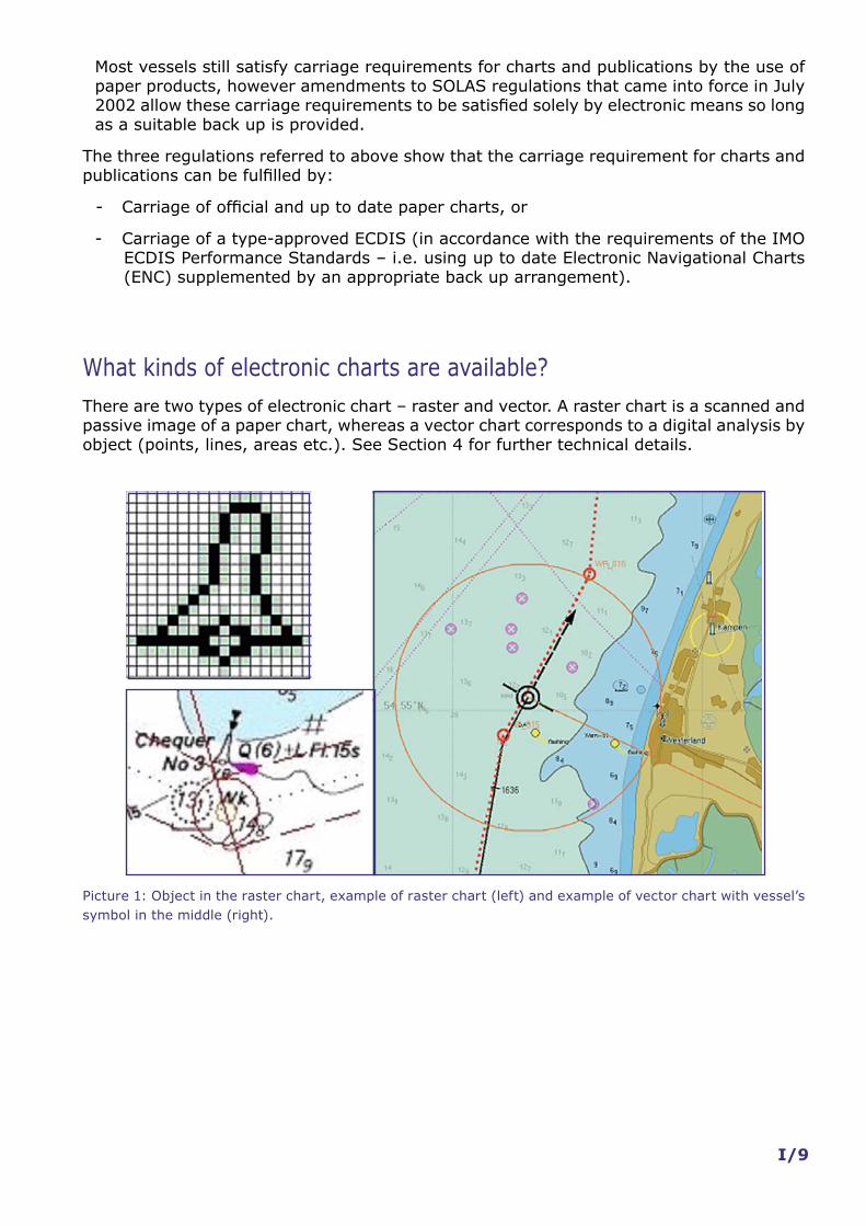
What kinds of electronic charts are available? There are two types of electronic chart – raster and vector. A raster chart is a scanned and passive image of a paper chart, whereas a vector chart corresponds to a digital analysis by object (points, lines, areas etc.). See Section 4 for further technical details.
Picture 1: Object in the raster chart, example of raster chart (left) and example of vector chart with vessel’s symbol in the middle (right).

I/10
What are official charts?
Charts issued by or on the authority of a Government, authorized Hydrographic Office or other relevant government institutions are official and may be used to fulfil carriage re-quirements (provided they are kept up to date).
All other nautical charts are by definition not official and are often referred to as private charts. These charts are not accepted as the basis for navigation under the SOLAS con-vention.
There are two kinds of official digital charts commonly available; Electronic Navigational Charts (ENC) and Raster Navigational Charts (RNC).
What is an ENC? ENC stands for “Electronic Navigational Chart”. The term was originally introduced for dig-ital chart data complying with the IHO chart data transfer standard S-57. By IMO definition ENCs can only be produced by or on the authority of a government, authorised Hydro-graphic Office or other relevant government institution. Any other vector data is unofficial and does not meet carriage requirements.
ENCs have the following attributes:
- ENC content is based on source data or official charts of the responsible Hydrographic Office;
- ENCs are compiled and coded according to international standards;
- ENCs are referred to World Geodetic System 1984 Datum (WGS84);
- ENC content is the responsibility and liability of the issuing Hydrographic Office;
- ENCs are issued only by the responsible Hydrographic Office; and
- ENCs are regularly updated with official update information distributed digitally.
See section “Meeting carriage requirements for ECDIS” below and Section 4 for further details.

I/11
Picture 2: ENC data displayed on a type approved ECDIS.
How do I recognise an ENC?
When I am buying Only authorized distributors sell ENCs in ENC services which include the delivery of update information. The distributors are authorized either directly by the originating Hydrographic Office or by a cooperation of Hydrographic Offices.
When used in an ECDIS ECDIS distinguishes an ENC from unofficial data. When unofficial data is used, ECDIS in-forms mariners that they must navigate by means of an official, up to date, paper chart by a continuous warning on the screen.
If unofficial data is shown on the ECDIS display, its boundary is to be identified by a special line style. This boundary is visualized as a “one-sided” RED line with the diagonal stroke on the unofficial side of the line.

I/12
Picture 3: Limit between ENC and unofficial data.
Further the mariner can use an ECDIS function to interrogate the chart display to obtain the chart details like information on originator, edition number and status of updating.
How are ENCs distributed?
The International Hydrographic Organisation (IHO) provides an interactive web catalogue (www.iho.int) displaying the status of worldwide ENC production. This system has point-ers for guiding users to ENC suppliers and distributors. A three-colour scheme is used to distinguish between degrees of accessibility.
This catalogue shows that many common shipping routes are already covered by ENCs.
The illustration below shows the front page of the catalogue, which can be found at the IHO web-site at www.iho.int, look under “ENC”.
Some HOs (eg Canada and Australia) make their RNCs and ENCs available to users via their own distributor networks; these distributors often offer additional folio services to shipping companies.
Picture 4: IHO Global ENC Catalogue, March 2007.

I/13
How are ENCs protected?
A majority of all ENCs are only made available to the end-users in a protected form com-pliant with the IHO S-63 Data Protection scheme. The standard maintains the integrity in all transactions between the service provider and the end-user. The protection scheme enables the end user systems to check the authenticity of the supplied information.
The S-63 protection scheme defines a mechanism for encrypting ENC information and ap-plying a digital signature to enable authentication of the chart data by the end-user. The end-user will require a decryption key to access and view the ENC data protected by the scheme. Each ENC chart is encrypted with a different key, and the decryption keys are is-sued to specific end-user systems and can consequently not be exchanged or shared by different systems. The required decryption keys are distributed to the end-users as ‘Cell Permits’ by the service provider.
The operation of a protection scheme should not add any operational overhead for the end-users since all aspects of ENC decryption and authentication are handled automati-cally by the chart system. The end-user will occasionally receive new Cell Permits from their service provider when their ENC subscription is renewed or there are changes to the ENC chart outfit. The updated Cell Permits must be imported into the chart system to en-able it to automatically process new ENC deliveries and updates.
A majority of all ECDIS and ECS suppliers have developed support for IHO S-63 and can read protected ENCs.
A few nations distribute their ENCs without using encryption; all ECDIS systems are able to access and display these ENCs.
Are there other ways that ENCs can be distributed?
The International Hydrographic Organisation has approved the distribution of ENCs in the internal format used by the individual ECDIS manufacturer. The generic name of this for-mat is SENC – System-ENC. Depending on the make of ECDIS this can increase the speed of loading of ENC-data. The IHO requires service providers using this method of SENC-dis-tribution to gain the agreement of the Hydrographic Offices supplying the ENCs and to use type approved software to ensure that the integrity of the SENC data is maintained.
What is an RNC? RNC means “Raster Navigational Chart”. RNCs are digital raster copies of official paper charts conforming to IHO Product Specifications RNC (S-61). By definition RNCs can only be issued by, or on the authority of, a national Hydrographic Office.
RNCs have the following attributes:
- RNCs are a facsimile of official paper charts;
- RNCs are produced according to international standards;
- RNC content is the responsibility of the issuing Hydrographic Office; and
- RNCs are regularly updated with official update information distributed digitally.
The IMO performance standards for ECDIS states that where ENCs are not available, RNCs may be used in ECDIS to meet carriage requirements. However, when the ECDIS is us-ing RNCs it should be used together with an appropriate folio of up to date paper charts. See section “Meeting carriage requirements for ECDIS” below and Section 2 for further details.

I/14
Because of their nature, RNCs when used in ECDIS do not provide the same level of func-tionality that is provided by ENCs; the limitations of operating with RNCs are outlined in IMO SN Circulars 207 and 255 (see Annex to this section).
How are ENCs and RNCs kept up to date? In order to meet carriage requirements, official charts must be kept corrected by Notices to Mariners issued by Hydrographic Offices.
ENCs and RNCs are kept up to date by applying regular, for example weekly, update in-formation to the chart data via a data file. The update file may be transferred by wireless transmission, or by a suitable media e.g. CD. The actual updating is applied automatically by the ECDIS to its chart database. Another standard function of ECDIS is the capability of updating the ENC manually which may be used if the digital update is not available.
At present most ENC and RNC updates are supplied to ships on CD but ‘remote updating’ using satellite (or, when in port, shore based) telecommunications is becoming more and more common. A number of ENC service providers already have updating services using e-mail and web and other means; details may be obtained from ENC distributors.
Is it possible to check that all updates have been applied to the ENC?
Updates to ENCs are sequential, and the sequence is unique to each ENC. During the up-dating process ECDIS always checks that all updates in the sequence have been applied. If an update is missing then the ECDIS will indicate this; it is not possible to load later updates until the missing update is applied.
The ECDIS maintains a list of updates applied and the date of application. This list can be used to check the update status of the ENCs loaded. Should all available ENCs show the same date for the latest update, it is likely that they have not been updated regularly, and the distributor should be contacted for verification. Furthermore it is possible to use tradi-tional sources of information, such as Notices to Mariners, to verify updates.
Port State Control officers may use the ECDIS listing to ensure that ENCs are being kept up to date in accordance with SOLAS V Regulation 27.
What is ECDIS? ECDIS equipment is specified in the IMO ECDIS Performance Standards (IMO Resolution A.817 (19)) as follows:
Electronic Chart Display and Information System (ECDIS) means a navigation information system which, with adequate back up arrangements, can be accepted as complying with the up-to-date chart required by regulation V/19 & V/27 of the 1974 SOLAS Convention, by displaying selected information from a system electronic navigational chart (SENC) with positional information from navigation sensors to assist the mariner in route planning and route monitoring, and by displaying additional navigation-related information if required.
ECDIS is a ship borne navigational device and as such it is the responsibility of IMO. It must support the whole range of navigational functions that make use of the characteris-tics of the chart data and their specific presentation. Moreover, to be an ECDIS the equip-ment must be shown to meet all the requirements of the IMO Performance Standards (IMO Resolution A.817(19)) and offer, besides the graphic presentation of chart data, additional information about the characteristics of the displayed features.
I/15
Within the ECDIS, the ENC database stores the chart information in the form of geographic objects represented by point, line and area shapes, carrying individual attributes, which make any of these objects unique. Appropriate mechanisms are built into the system to query the data, and then to use the obtained information to perform certain navigational functions (e.g. the anti-grounding surveillance).
The presentation of the current position, range/bearing functions and route planning ca-pabilities are other examples of the minimum ECDIS requirements laid down in the IMO Performance Standards for ECDIS.
The presentation of ENCs on the screen is specified in another IHO standard, the “Colours and Symbols Specifications for ECDIS IHO S-52”, i.e. in its Appendix 2, called ”ECDIS Presentation Library”. This style of presentation is mandatory.
The use of ENCs in a tested, approved and certified ECDIS and with appropriate back up arrangements, is the only paperless chart option for vessel navigation.
How is an ECDIS approved and by whom?
To ensure that ECDIS equipment intended for onboard use is seaworthy, it must pass type approval and test procedures developed by the International Electrotechnical Commission (IEC) based on the ECDIS Performance Standards of IMO and applying the IHO require-ments, S-52 and S-57 in particular.
Type approval is a method to show conformance with IMO requirements on a legal basis – it is initiated and required by all Flag States which are Member States of the European Union and by many others outside including United States, Japan and Australia. ECDIS type approval is the certifications process that ECDIS equipment must undergo before it will be considered to comply with the IMO Performance Standards for ECDIS by the inter-national shipping community.
Type approval is normally conducted by recognized organisations or by marine classifica-tion societies nominated by Flag States. Some maritime nations also have type approval programs within their maritime safety administration or Department of Marine Transporta-tion. European Governments have agreed about mutual recognition of their ECDIS type approval certificates – indicated by the so-called “Wheel Mark” sign showing conformity with the Maritime Equipment Directive of the European Union.
Meeting Carriage Requirements with ECDIS Only a type approved ECDIS operating with up to date ENCs and with appropriate back up may be used to replace all paper charts on a vessel. Where ENCs are not yet available, IMO regulations allow Flag States to authorise the use of RNCs (together with an appropri-ate folio of paper charts) - see below. Note that in all other cases the vessel must carry all paper charts necessary for its intended voyage.
From the regulatory perspective, the most important statement about the legal status of ECDIS is contained in the amended Chapter V of the SOLAS Convention set into force on 1 July 2002. As stated earlier in this section, ECDIS is specifically referred to in Regulation 19 ”Carriage requirements for ship borne navigational systems and equipment”.
However, in order to replace paper charts, such systems must fulfil considerable technical requirements laid down in ECDIS Performance Standards:
- The chart data in use must be official - ENCs where these are available;
- The graphic display on the screen must meet the equipment-independent specifica-tion; and

I/16
- The equipment must support the full range of navigational functions that can be per-formed on the traditional paper charts.
Back up requirements
No electronic system is completely failsafe. IMO Performance Standards therefore require that the “overall system” include both a primary ECDIS and an adequate independent back up arrangement that provides:
- Independent facilities enabling a safe take over of the ECDIS functions in order to ensure that a system failure does not result in a critical situation; and
- A means to provide for safe navigation for the remaining part of the voyage in case of ECDIS failure.
However, these rather basic statements allow considerable leeway and there are various interpretations as to what are the minimum functional requirements, or what constitute ”adequate” back up arrangements.
There are two commonly accepted options:
- A second ECDIS, connected to an independent power supply and a separate GPS po-sition input;
- An appropriate up to date folio of official paper charts for the intended voyage
Some Flag States may permit other options (e.g. radar-based systems such as ”Chart-Radar”). Ship owners should consult their national maritime administration for specific advice.
At the request of IMO the IHO is currently seeking information from their member states on which paper charts covering their territorial waters would be appropriate to serve as a back up to ECDIS. IHO will compile this information and present it on its web site in the form of a catalogue.
Information on different maritime administrations’ accepted back up arrangements can be found in Section 2.
What to do in areas without ENC coverage?
In 1998 the IMO recognised that it would take some years to complete the world’s cover-age of ENCs. As a consequence IMO ECDIS Performance Standards were amended add-ing a new optional mode of operation of ECDIS, the Raster Chart Display System (RCDS) mode. In this mode RNCs can be used in ECDIS to meet SOLAS carriage requirements for nautical charts. However, this is only allowed if approved by the Flag State. The intention of those changes was to allow the ECDIS to operate as far as possible on official chart data; ENCs where they were available and RNCs to fill in the gaps.
IMO took note of the limitations of RNCs as compared to ENCs (see IMO SN Circular 207 at Annex), and the revised ECDIS Performance Standards require that the ECDIS must be used together with “an appropriate folio of up to date paper charts” for the areas where RCDS mode is employed. The intention was to allow the number of paper charts carried by a vessel to be reduced where RCDS mode was employed, but only to a level compat-ible with safe navigation. No definition of an “appropriate folio” was provided by IMO and consequently different Flag States developed individual interpretations.
As there is no common interpretation of the term “appropriate” ship owners should consult their Flag State as to whether RCDS mode is allowed and under what conditions.

I/17
A web-based catalogue showing world coverage of all ENCs, RNCs and paper charts avail-able is currently under preparation by the IHO.
In areas where ENCs or RNCs are not available vessels must carry all paper charts neces-sary for the intended voyage.
Section 2 gives details of the implementation by specific maritime administrations.
Does your ECDIS system Meet Carriage Requirements?
Table 1: ECDIS Carriage Requirements – a summary
Notes to table above:
- (1) Some Flag States may require specific documentation to allow this.
- (2) Requires approval of vessel’s Flag State – Flag State defines meaning of ‘appropri-ate’
- (3) Back up system is only required if ECDIS is intended to meet carriage require-ments
- (4) For ECDIS to fulfil Carriage requirements vessels must use ENCs where these are available
Are ENCs YES NO YES NO available for area of operation?
What Digital ENC (coverage RNC (coverage at RNC Private charts Charts are being at an an appropriate (6)used in the ECDIS appropriate scale for by the mariner? scale for navigation) navigation)
What back up Independent Independent None required None requiredsystem is ECDIS or other ECDIS or other (3) (3) required? back up back up solution solution required required
What are the None needed An “appropriate” All up to date All up to daterequirements for (1) (except if folio of up to date paper charts paper chartsthe carriage of back up is a paper charts to be required for required forOfficial paper folio of paper used in conjunction safe navigation safe charts? charts) with the ECDIS in in areas where navigation for RCDS mode ENCs are the intended available voyage
How is the ECDIS As an ECDIS As an ECDIS in As an ECDIS in As an ECSoperating ? RCDS mode RCDS mode
Does the ECDIS YES (1) YES (2) NO (4) NO (5)fulfil ChartCarriageRequirements?

I/18
Picture 5: Examples of Electronic Chart Formats. Many ECS systems are able to use ENC or RNC data, how-ever even when using official charts they may not be used to fulfil carriage requirements.
- (5) Paper charts (not the ECDIS) must remain the primary means of navigation
- (6) If private charts are used in an ECDIS the system is regarded as operating as an ECS. ECDIS operating as ECS, ECS systems meeting RTCM standards or Private charts meeting ISO standards being used in ECDIS do not meet carriage require-ments.
Can chart format names indicate carriage compliance?
There has been much confusion with regard to the names used to describe electronic chart distribution formats; the diagram below is designed to clarify the situation. From the dia-gram it can be seen that the same distribution format can be used for the delivery of both private and official chart data. For instance ’BSB’ is the term used for the distribution for-mat of US and Canadian RNCs; the same term is used for the distribution of private raster chart data in other areas (for example in European waters). There can also be confusion with ENCs; private vector chart data delivered in S-57 format does not meet IMO require-ments and should never be named as ENC. Similarly private vector data delivered in SENC format can be mistaken for ENCs delivered in the same SENC format.
Therefore the most important factor to consider is the source of the electronic chart data; this determines its status and the purpose for which it may be used. However, only the combination between the status of the chart data and the functionality of the particular device finally decides if its practical operation can be stated as ECDIS-mode or as ECS-mode.
ECDIS or ECS
Private Official
ECS mode RCDS mode ECDIS mode
Chartoriginator
Charttype
Examples of distribution formats
Display system ECS mode
ECS
ECS mode
ECSECDIS
VectorRaster ENC (Vector)RNC (Raster)
S-57
CM93
TX97
Others
BSB
Mapmedia
Others
HCRF
BSB
ENCS-57 encrypted (S-63)
ENCS-57 non-encrypted
SENCE.g. : CM93,
7CB,DirectENC

I/19
Acceptance of ECDIS by Port State control
Ships arriving at a port may be subject to Port State control by local officials based on Flag State regulations and international agreements. Nations have formed a number of regional groups to ensure consistent application of Port State controls.
In Europe the Port State control acts on the regulations set out in the Paris Memorandum of Understanding. Its ECDIS guidelines explain how a PSCO should assess whether a ship is using electronic charts in accordance with SOLAS requirements. Checks may include whether:
- The ship has documentation indicating that the system complies with IMO Perform-ance Standards for ECDIS. In the absence of such documentation, the PSCO should seek confirmation from the Flag State that the system does meet the statutory re-quirements;
- The system is being used for primary navigation. It should be established if ECDIS is used in the ENC mode or RCDS mode or in both modes;
- There are written procedures onboard the vessel for using ECDIS;
- The master and watch-keeping officers are able to produce appropriate documenta-tion that generic and type-specific ECDIS familiarisation has been undertaken;
- The charts used for the intended voyage are the latest official editions;
- The charts in use are updated; and
- There are approved back up arrangements available to ensure a safe transfer of the ECDIS functions in the event of ECDIS failure and to provide safe navigation for the remaining part of the voyage.
Is there a need for ECDIS training?
Unlike the paper chart, ECDIS is a highly sophisticated system which, besides the naviga-tional functions, includes components of a complex, computer-based information system. In total, the system includes hardware, operating system, ECDIS software (kernel and user interface), sensor input interfacing, electronic chart data, rules for presentation and display, status and parameters of alarms and indications, etc. All these items are accessed through an appropriate human-machine interface. As such, care must be taken when navi-gating with ECDIS to avoid
- False operation
- Misinterpretation
- Malfunction or, even worse,
- Over-reliance on this highly-automated navigation system
As with any type of shipboard navigation equipment, it can only be as good as those who use it and what it is being used for. In the case of ECDIS and electronic charts, if the mari-ner is well trained then the system provides the information flow that the mariner needs to make good decisions and therefore contributes significantly to safe and efficient naviga-tion. Stated another way, an electronic chart system is another tool to enable mariners to perform their job better. However, just having some “knowledge” about “functions” and “operational controls” is insufficient to maximise the benefits of ECDIS; proper training is absolutely necessary.

I/20
What are the requirements for ECDIS training?
ECDIS and other electronic charting systems have become increasingly important to ship navigation and are already widely used either as a primary navigation tool or as an aid to navigation. The systems are increasingly complex, and require adequate and appropriate training in order to be operated correctly and safely. Without proper training, these sys-tems will not be used to their full potential and could under some circumstances increase the hazard to navigation. The STCW (Standards of Training, Certification and Watch-keep-ing) and ISM (International Safety Management) codes put the responsibility firmly on the shipowner to ensure that mariners on their vessels are competent to carry out the duties they are expected to perform. If a ship is fitted with ECDIS, the shipowner has a duty to ensure that users of such a system are properly trained in the operation and use of elec-tronic charts and are familiar with the shipboard equipment before using it operationally at sea.
There is no specific regulation or reference to ECDIS systems in the STCW Convention. However, since ECDIS systems are related to electronic charts, references about them are considered to be included in the material covered by the word “chart”:
- To encourage effective ECDIS education, the IMO approved a standardised model course for ECDIS training on the operational use of ECDIS in 1999 (IMO course 1.27). This course is offered by approved training institutions and maritime academies. Maritime administrations can provide information on approved institutions. Some Flag States have developed their own training courses in ECDIS in order to be able to recognise the training certificates.
- Type specific ECDIS training is provided by equipment manufacturers.
Further details on ECDIS training are to be found in Section 3.
What are the operational considerations when using ECDIS?
Navigating with ECDIS is fundamentally different from navigating with paper charts. Im-portant bridge work-processes are significantly affected, in particular, voyage planning and voyage execution task. These require careful analysis and consideration:
Voyage PlanningECDIS provides a number of additional planning functions and features such as safety contours, alarms, click-and-drop facilities for waypoints and markers, etc. Whilst in many ways ECDIS makes voyage planning easier it is still possible to make errors, however these are likely to be of a different type to those encountered when using paper charts.
Even though ENC coverage is increasing rapidly, many vessels will, to some degree, have to operate a dual – or even triple – system with ENCs paper and raster charts. Planning and validation of the route has therefore to consider issues such as which chart types are available for the various segments of the voyage. The format of the voyage plan is likely to differ from the traditional alphanumeric lists of waypoints used with paper charts and should include information on the usability of connected electronic navigational devices such as GPS and AIS and their actual alarm settings.
It is essential to make use of the in-built automatic check functions provided by ECDIS when validating and approving the voyage plan. Thought also needs to be given to ensur-ing that a backup to the voyage plan on the ECDIS is available in case of equipment failure of the ECDIS itself or the connected sensors.
It is important that there is good communication of the voyage plan to all bridge officers so that they are prepared for the intended voyage. This should include information on equipment status and backup procedures

I/21
Voyage executionAt the beginning of the voyage, as well as at any change of watch, the officers should re-view the voyage plan and agree the selected pre-settings of functions, alarms and indica-tors to be used on the ECDIS.
Where vessels carry paper charts as well as an ECDIS the role of the ECDIS and the charts should be considered. If the ECDIS is used for real time navigation, the statutory require-ments regarding monitoring of the progress of the voyage and marking of positions will need to be considered:
• are positions marked in paper charts solely for record keeping purposes?
• what steps are taken to ensure that intended tracks marked on the paper charts cor-respond with the ECDIS information?
• have the bridge procedures set in place by the shipping company been adapted for the use of ECDIS and are all persons concerned with the navigation familiar with these adaptations
Over reliance on ECDISThere is a tendency to put too much trust in computer based systems and believe what-ever is on the display. It is essential that officers remember to cross check the information displayed by all other means available; especially by looking out the window and watching the radar! Bridge-procedures must be adapted appropriately and ENC training must be carried out to alleviate these concerns.
Is there a mandatory requirement to carry ECDIS?- In December 2006 the Marine Safety Committee (MSC) of IMO agreed amendments
to the High Speed Craft (HSC) regulations requiring all HSC craft built after 2008 to be fitted with ECDIS and existing HSC to be retrofitted by 2010.
- At the same meeting MSC also accepted the findings of a Formal Safety Assessment (FSA) on ECDIS presented by Norway and other nations showing the positive benefit of fitting ECDIS. As a result of this study MSC has instructed the NAV sub-committee to discuss the extension of mandatory carriage of ECDIS to other classes of vessel and to report back to them in 2008.
What is ECS? All systems, which are not tested to show compliance with the ECDIS Performance Stand-ards, can be generically designated as ”Electronic Chart Systems” (ECS). An ECS may be able to use either ENCs, RNCs or other chart data produced privately and could have functionality similar to ECDIS.
Some ECS equipment manufacturers also produce vector and raster data to use in their products. These suppliers have been producing private chart data for a number of years and have established themselves in the market. They were the pioneers and have estab-lished the idea and the use of electronic chart systems on vessels. Their charts are derived from Hydrographic Office paper charts or Hydrographic Office digital data.
Hydrographic Offices do not take any responsibility for the accuracy or reliability of pri-vately produced charts.

I/22
Where the vessel operates with ECS, the paper chart remains the official basis for naviga-tion onboard. The vessel must retain and use a full folio of up to date paper charts on-board, regardless of the type of electronic charts used.
Because ECS is not intended to meet SOLAS requirements, there are no IMO Performance Standards for ECS.
Some ECS manufacturers also use the term RCDS to describe their systems. In this case the manufacturer is stating that the system uses RNCs and possibly that it has the same functionality as required by the ECDIS Performance Standards. However, such systems cannot be used to meet carriage requirements.
The STCW and ISM codes put the responsibility firmly on the shipowner to ensure that mariners on their vessels are competent to carry out the duties they are expected to per-form. If a ship has ECS fitted, the shipowner has a duty to ensure that users of such a system are properly trained in the operation and use of electronic charts, are aware of the limitations compared to ECDIS and are familiar with the shipboard equipment before using it operationally at sea.

I/23
Annexes
Annex 1 IMO SN/ Circ.207 Differences between RCDS and ECDIS
I:\CIRC\SN\207.WPD
INTERNATIONAL MARITIME ORGANIZATION E4 ALBERT EMBANKMENTLONDON SE1 7SR
Telephone: 0171-735 7611Fax: 0171-587 3210Telex: 23588 IMOLDN G
IMO
Ref. T2/6.01 SN/Circ.2077 January 1999
DIFFERENCES BETWEEN RCDS AND ECDIS
1 The Maritime Safety Committee, at its seventieth session (7 to 11 December 1998), adoptedamendments to the performance standards for Electronic Chart Display and Information Systems (ECDIS)to include the use of Raster Chart Display Systems (RCDS).
2 These amendments permit ECDIS equipment to operate in two modes:
.1 the ECDIS mode when ENC data is used; and
.2 the RCDS mode when ENC data is not available.
However, the RCDS mode does not have the full functionality of ECDIS, and can only be used togetherwith an appropriate portfolio of up-to-date paper charts.
3 The mariners' attention is therefore drawn to the following limitations of the RCDS mode:
.1 unlike ECDIS where there are no chart boundaries, RCDS is a chart-based system similarto a portfolio of paper charts;
.2 Raster navigational chart (RNC) data, itself, will not trigger automatic alarms(e.g. anti-grounding). However, some alarms can be generated by the RCDS fromuser-inserted information. These can include:
- clearing lines- ship safety contour lines- isolated dangers- danger areas
.3 horizontal datums and chart projections may differ between RNCs. Mariners shouldunderstand how the chart horizontal datum relates to the datum of the position fixingsystem. In some instances, this may appear as a shift in position. This difference may bemost noticeable at grid intersections and during route monitoring;
.4 chart features cannot be simplified or removed to suit a particular navigationalcircumstance or task at hand. This could affect the superimposition of radar/ARPA;
.5 without selecting different scale charts, the look-ahead capability may be somewhatlimited. This may lead to some inconvenience when determining range and bearing or theidentity of distant objects;

I/24
SN/Circ.207 - 2 -
I:\CIRC\SN\207.WPD
.6 orientation of the RCDS display to other than chart-up, may affect the readability of charttext and symbols (e.g., course-up, route-up);
.7 it may not be possible to interrogate RNC features to gain additional information aboutcharted objects;
.8 it is not possible to display a ship's safety contour or safety depth and highlight it on thedisplay, unless these features are manually entered during route planning;
.9 depending on the source of the RNC, different colours may be used to show similar chartinformation. There may also be differences in colours used during day and nighttime;
.10 an RNC should be displayed at the scale of the paper chart. Excessive zooming in orzooming out can seriously degrade RCDS capability, for example, by degrading thelegibility of the chart image; and
.11 mariners should be aware that in confined waters, the accuracy of chart data (i.e., papercharts, ENC or RNC data) may be less than that of the position-fixing system in use. Thismay be the case when using differential GNSS. ECDIS provides an indication in the ENCwhich allows a determination of the quality of the data.
3 Member Governments are requested to bring this information to the attention of the relevantauthorities and all seafarers for guidance and action, as appropriate.
________

I/25
Annex 2 IMO SN/ Circ. 255 Additional guidance on chart datum and accu-racy of position on charts
*

I/26