fairfield inn and suites 21 n wineow ... - tom's run relay · 21 n wineow street cumberland,...
TRANSCRIPT

Fairfield Inn and Suites 21 N Wineow Street Cumberland, MD 21502 Phone: 1-301-722-0340
Tom's Run 2018 Course Map

Useful Information
National Park Service C & O Canal Web site: http://www.nps.gov/choh/index.htm C and O Canal Access Points GPS Coordinates: http://www.candocanal.org/access.html Tom’s Run Website: http://tomsrunrelay.org
This is a mile marker on the C&O Canal towpath. They can be hard to spot, particularly at night.
IMPORTANT! Runners and bikers should STOP at their designated transition point, even if their team is not there. If you do not stop, it can be very challenging for your team to meet up with you at a later point. At a minimum, bikers should be carrying a cell phone and water.
If needed, ask another team for help or call the race director: Roger Butturini, 703-999-0047.

C & O Canal Trail Start to Spring Gap (39.564306, -78.719289) Run Distance: 11.0 miles From parking lot, turn Left onto Canal St 95 feet Turn Left onto Howard St 328 feet Turn Right onto S Mechanic St .1 miles Continue onto MD-51 S/Industrial Blvd 7.6 miles Turn Right shortly after passing Kirk Hollow Road on the left
230 feet
Turn Right into parking lot 361 feet End at Spring Gap (Total Distance) 7.9 miles NOTES: Grills, bathrooms, and camping are available at Spring Gap


Spring Gap to Town Creek Aqueduct (39.523862, -78.543122) Run Distance: 11.4 miles From the parking area, head back in the direction you came from Turn Right onto MD 51 S (Oldtown Road) You will cross over the Town Creek Bridge
12.5 miles
Turn Right onto Town Creek C&O Aqueduct Road
.2 miles
Drive past the first access point .4 miles End at Town Creek Aqueduct (Total Distance) 12.6 miles NOTES: There is no bathroom and a small parking lot at Town Creek Aqueduct

This is the turn from MD 51 S onto Town Creek C&O Aqueduct Road


Town Creek Aqueduct to Paw Paw (39.544450, -78.460806) Run Distance: 5.8 miles From the parking area, head back to Town Creek C&O Aqueduct Road
.5 miles
Turn Right onto MD 51 S (Oldtown Road) 4.8 miles Turn Left at Paw Paw sign Do not pass under the railroad bridge just past the turn
.1 miles
End at Paw Paw (Total Distance) 5.4 miles NOTES: Runner and biker will each need a light for the tunnel along the towpath.
Paw Paw has port-a-potties and camping.
If you drive past the left turn into Paw Paw, there is a Liberty Gas station with a convenience store about 1 mile down the road. You’ll cross into West Virginia shortly before arriving at the gas station.

This is the railroad bridge just past the left turn for Paw Paw

Paw Paw to Bond’s Landing (39.582848, -78.411246) Run Distance: 6.5 miles From the Paw Paw parking lot, head back towards MD 51
Turn Right onto MD 51 N (Oldtown Road) Drive past the Green Ridge Forest sign
.9 miles
Turn Right onto Malcolm Road (dirt/gravel road) There is no street sign; instead you should look for the United Methodist Church sign
1.2 miles
Bear Left at the fork to stay on Malcolm Road You will be driving up a very steep hill
2.1 miles
Turn Right onto Oldtown Orleans Road Look for the stop sign
2.3 miles
Turn Right onto Mertens Avenue 2.6 miles Turn Sharp Right onto Kasekamp Road You will drive through two creeks
1.4 miles
Turn Sharp Right onto Bond’s Landing Road There is no street sign, instead look for the Bond’s Landing sign
.1 miles
End at Bond’s Landing (Total Distance) The towpath crosses the road
10.6 miles
NOTES: A 4WD or AWD vehicle is recommended for driving to Bond’s Landing. Bond’s Landing is very difficult to find for both drivers and runners/bikers. It also has very limited parking. Teams may want to have their runners/bikers continue on to 15 Mile Creek. There are no bathrooms at Bond’s Landing.


This is the sign where you turn right onto Malcolm Road

This is the sign at the turn for Bond’s Landing Road

Bond’s Landing to 15 Mile Creek (39.625648, -78.385868) Run Distance: 9.0 miles From Bond’s Landing, follow Bond’s Landing Road back towards Kasekamp Road
.1 miles
Turn Right onto Kasekamp Road 2.4 miles Turn Left onto Mertens Avenue 2.6 miles Turn Right onto Oldtown Orleans Road Look for the stop sign
2.4 miles
Bear Right at the fork to stay on Oldtown Orleans Road Drive past the Little Orleans Campground
3.3 miles
Turn Left onto Orleans Road You will cross a bridge
.1 miles
Turn Right onto High Germany Road .1 miles Turn Right immediately after crossing under the bridge and follow the road into the parking lot
>.1 miles
End at 15 Mile Creek (Total Distance) The towpath crosses the road
11 miles
NOTES: Just after turning onto High Germany Road, there is a full-service restaurant that also offers to-go snacks and drinks.
There are bathrooms in the restaurant and the parking lot as well as grills.

This is the sign at the right turn onto High Germany Road

15 Mile Creek to Deneen Road (39.645446, -78.251711) Run Distance: 10.8 miles From the parking lot, head back to High Germany Road Do NOT cross under the bridge; stay straight
1.3 miles
Turn Right onto Ziegler Road Ziegler Road changes names to Pearre Road at the Aaron Straus National Guard Base
You will cross over a one-lane bridge after the road changes names
4.3 miles
Bear Left onto Woodmont Road You will be driving uphill
6.2 miles
Turn Right onto MD 144 East (Western Pike) You will turn at the stop sign Turn Right onto Willow Road 2.8 miles Bear Right at the fork to stay on Willow Road You will be driving up hill
You will cross under a bridge
1.7 miles
End at Deneen Road (Total Distance) 17.2 Miles NOTES: No bathrooms

This is the parking area at Deneen Road. The towpath is just across the wooden bridge.

Deneen Road to Little Tonolaway (Hancock) (39.698253, -78.181036) Run Distance: 5.7 miles From the parking lot, head back up Deneen Road and cross under the bridge
.1 miles
Stay straight to get onto Willow Road 1.5 miles Bear Left to stay on Willow Road 2.8 miles Turn Right onto MD 144 East (National Pike)
3.0 miles
Turn Right onto Pennsylvania Avenue The turn is at a stop light and there is a sign for the C&O Canal
.1 miles
Turn Right, then Left to cross over the wooden bridge into the parking lot
.1 miles
End at Little Tonolaway (Hancock) (Total Distance)
7.6 Miles
NOTES: There are bathrooms and grills at Little Tonolaway. There is also a bike shop on Pennsylvania Avenue by the wooden bridge into the parking lot.
Shortly before the turn onto Pennsylvania Avenue, you will pass a Sheetz with a gas station on your left.


Little Tonolaway (Hancock) to Licking Creek (39.655987, -78.053946) Run Distance: 8.3 miles From the parking lot return to Pennsylvania Avenue
.2 miles
Turn Right onto MD 144 East 1.2 miles Merge onto I70 East 5.5 miles Take the Left Exit to US 40 Indian Springs Exit is for southbound only
.3 miles
Turn Right onto Mile Marker Road Turn immediately before bridge
Mile Marker Road is only wide enough for one car
You will cross under I70
.7 miles
End at Licking Creek (Total Distance) 7.9 miles NOTES: The parking lot is very small.


This is the parking area at Licking Creek.

Licking Creek to Four Locks (39.615311, -77.947494) Run Distance: 7.0 miles From the parking lot, take Mile Marker Road towards US 40
.7 miles
Turn Right onto US 40 East 2.5 miles Turn Right onto MD 56 East (Big Pool Road) Cross over I70
Pass the sign for McCoy’s Ferry Road (C&O Canal)
5.7 miles
Turn Sharp Right onto Four Locks Road .7 miles Bear Right onto Hasset Road Follow sign for the boat ramp
Pass through the tunnel
.2 miles
End at Four Locks (Total Distance) 9.8 miles NOTES: There are grills and a bathroom at Four Locks

Four Locks to Dam 5 (39.607079, -77.921117) Run Distance: 2.5 miles From the parking lot, head back through the tunnel to Four Locks Road
.9 miles
Turn Right onto MD 56 East (Big Pool Road)
.5 miles
Bear Right at the fork to stay on MD 56 East 2.3 miles Turn Right onto Dam 5 Road Cross a one-lane bridge
There is a country market at the stop sign
Pass the first C&O access
2.7 miles
End at Dam 5 6.4 miles NOTES: No bathrooms


Dam 5 to Williamsport (Cushwa Basin) (39.600996, -77.826927) Run Distance: 6.7 miles From the parking lot, take Dam 5 Road towards MD 56 East
2.7 miles
Turn Right onto MD 56 East (Big Pool Road)
.5 miles
Turn Right onto MD 68 (Clear Springs Road) Look for the stop sign
4.2 miles
Turn Right onto US 11 South Stop light at the turn
The entrance to the Williamsport parking lot will be in front of you right before the road curves to the left
.2 miles
End at Williamsport (Total Distance) 7.6 miles NOTES: There are bathrooms at Williamsport.

This shows the entrance to the Williamsport parking lot.

Williamsprt (Cushwa Basin) to Avis Mill Road (McMahon’s Mill) (39.530654, -77.823522) Run Distance: 11.7 miles From the Williamsport parking lot, take US 11 North towards MD 68
.2 miles
Turn Right onto MD 68 East Pass under I81
1.2 miles
Turn Right onto MD 63 South (Spielman Road) Stop light at the turn
2.8 miles
Turn Right onto MD 632 (Dam 4 Road) .8 miles Turn Right onto Dellinger Road .4 miles Turn Left onto Avis Mill Road Pass the McMahon’s Mill Camping sign to the end of the road
.7 miles
End at McMahon’s Mill (Total Distance) 6.1 miles NOTES: There is a port-a-potty at Avis Mill Road.


Avis Mill Road (McMahon’s Mill) to Big Slackwater (39.501346, -77.845385) Run Distance: 3.7 miles From the parking lot, take Avis Mill Road towards Dellinger Road
.7 miles
Turn Right onto Dellinger Road .4 miles Turn Right onto MD 632 (Dam 4 Road) Look for the stop sign
3.6 miles
Bear Left to Dam 4 area 1.0 mile Drive past the first parking area 1.0 mile End at Big Slackwater (Total Distance) 6.7 miles NOTES: There is a port-a-potty at Big Slackwater.

This is the parking area at Big Slackwater

17
Table Key: BL/BR = Bear Left/Right L = Left R = Right Rtn = Return Str = Straight TZ = Transition Zone X = Cross
P-__ = Park S = Small - 1 vehicle/team, M = Medium - 2 /team, L = Large - 3 /team
Leg 14: Big Slackwater to Taylor’s Landing C&O Mile marker: 84.4– 81.0 Run Distance: 3.4 mi
Driver Directions
Dir Route Dist Cum Begin Big Slackwater Recreation
Area 0.0 0.0
Rtn MD 632 (Dam 4 Rd) 2.7 2.7 R Woburn Rd 1.3 4.0 R Taylor’s Landing Rd 1.9 5.9 End Taylor’s Landing @ C&O
Sign 0.0 5.9
P-S On side of Rd TZ On towpath via bridge (boat ramp access)
N 39 29.753 W 77 49.588

18
Table Key: BL/BR = Bear Left/Right L = Left R = Right Rtn = Return Str = Straight TZ = Transition Zone X = Cross
P-__ = Park S = Small - 1 vehicle/team, M = Medium - 2 /team, L = Large - 3 /team
Leg 15: Taylor’s Landing to Snyder’s Landing C&O Mile marker: 81.0 – 76.8 Run Distance: 4.2 mi Driver Directions
Leg 16: Snyder’s Landing to Lock 38 C&O Mile marker: 76.8 – 72.8 Run Distance: 4.0 mi Driver Directions
Dir Route Dist Cum Dir Route Dist Cum Begin Taylor’s Landing 0.0 0.0 Begin Snyder’s Landing 0.0 0.0 Str Taylor’s Landing Rd 0.0 0.0 Rtn Snyder’s Landing Rd 4.2 4.2 BR Bowie Rd; parallel to
towpath 0.5 0.5 R Mondell Rd @ stop sign 0.1 4.3
X Creek, BR @ Remsburg Rd to remain on Bowie Rd
0.2 0.7 R MD 34 (Main St) 3.2 7.5 L Canal Rd across from C&O
Admin HQ on R; (if you X Potomac River, too far)
0.4 8.0 BR Mondell Rd 2.8 3.5 R W Chapline St @ stop sign
(If you hit MD 34, too far) 0.2 3.7
R @ bottom of hill into parking lot
0.0 8.0
BR Snyder’s Landing Rd 4.0 7.7 End Lock 38 0.0 8.0 R Into parking lot on R 0.0 7.7 P-M In parking lot End Snyder’s Landing 7.7 TZ On towpath X footbridge P-M In parking lot TZ On towpath via wooden bridge (boat ramp
access)
N 39 27.884 W77 46.591 N39 26.187
W77 47.976

19
Table Key: BL/BR = Bear Left/Right L = Left R = Right Rtn = Return Str = Straight TZ = Transition Zone X = Cross
P-__ = Park S = Small - 1 vehicle/team, M = Medium - 2 /team, L = Large - 3 /team

20
Table Key: BL/BR = Bear Left/Right L = Left R = Right Rtn = Return Str = Straight TZ = Transition Zone X = Cross
P-__ = Park S = Small - 1 vehicle/team, M = Medium - 2 /team, L = Large - 3 /team
Leg 17: Lock 38 to Dargan Bend C&O Mile marker: 72.8 – 64.9 Run Distance: 7.9 mi Driver Directions
Leg 18: Dargan Bend to Lock 31 C&O Mile marker: 64.9 – 58.0 Run Distance: 6.9 mi Driver Directions
Dir Route Dist Cum Dir Route Dist Cum Begin Lock 38 0.0 0.0 Begin Dargan Bend 0.0 0.0 Str Canal Rd (not L up hill) 1.9 1.9 Rtn Back Rd 0.9 0.9 BR To remain on Canal Rd 1.5 3.4 R Harper’s Ferry Rd 1.3 2.2 R Harpers Ferry Rd 0.3 3.7 BL Road bears L @ C&O Canal
Lock 34 2.6 4.8
X Bridge, BL to remain on Harpers Ferry Rd
4.2 7.9 R Keep Tryst Rd 0.9 5.7
BR @ Hoffmaster Rd to remain on Harpers Ferry Rd
1.6 9.5 Str @ corner into parking lot (rd bends sharp to L)
0.0 5.7
R sharp
Back Rd not marked (approx. .5 mi after “Mandokin” sign)
0.9 10.4 End Lock 31 0.0 5.7
L @ C&O sign “Dargan Bend”
0.0 10.4
End Dargan Bend 10.4 P-M In parking lot P-L In parking lot TZ On towpath. Caution when X live RR
tracks TZ On towpath
N 39 19.793 W77 40.925
N 39 21.805 W77 44.403

21
Table Key: BL/BR = Bear Left/Right L = Left R = Right Rtn = Return Str = Straight TZ = Transition Zone X = Cross
P-__ = Park S = Small - 1 vehicle/team, M = Medium - 2 /team, L = Large - 3 /team

22
Table Key: BL/BR = Bear Left/Right L = Left R = Right Rtn = Return Str = Straight TZ = Transition Zone X = Cross
P-__ = Park S = Small - 1 vehicle/team, M = Medium - 2 /team, L = Large - 3 /team
Leg 19: Lock 31 to Lock 30 - Brunswick C&O Mile marker: 58.0 – 55.0 Run Distance: 3.0 mi Driver Directions
Leg 20: Lock 30-Brunswick to Point of Rocks C&O Mile marker: 55.0 – 48.2 Run Distance: 6.8 mi Driver Directions
Dir Route Dist Cum Dir Route Dist Cum Begin Lock 31 0.0 0.0 Begin Lock 30-Brunswick 0.0 0.0 Str On Keep Tryst Rd (up hill) 0.2 0.2 Rtn Service rd 0.2 0.2 R US 340 E 0.6 0.8 X Train tracks & parking lot 0.1 0.3 R MD 180 0.5 1.3 R E. Potomac St 1.1 1.4 R MD 478 (Knoxville Rd) 2.3 3.6 R @ flashing yellow light (Ninth
St) 0.4 1.8
R Maple Ave @ stop light 0.1 3.7 Str @ stop light (becomes MD 464 E)
3.7 5.5
X Parking lot & train tracks 0.1 3.8 R Highway 15 6.8 14.3 R Service rd 0.2 4.0 L Clay Rd (MD 28) 1.0 15.3 X Towpath to parking lot 0.0 4.0 R Immediate right at C&O sign 0.0 15.3 End Lock 30-Brunswick (under
highway Bridge) 0.0 4.0 End Point of Rocks 0.0 15.3
P-L In parking lot under highway bridge P-M In parking lot across bridge TZ On towpath @ C&O milepost 55 TZ On towpath at brown sign by bridge
N 39 18.660 W 77 37.825
N39 16.399 W77 32.475

23
Table Key: BL/BR = Bear Left/Right L = Left R = Right Rtn = Return Str = Straight TZ = Transition Zone X = Cross
P-__ = Park S = Small - 1 vehicle/team, M = Medium - 2 /team, L = Large - 3 /team

24
Table Key: BL/BR = Bear Left/Right L = Left R = Right Rtn = Return Str = Straight TZ = Transition Zone X = Cross
P-__ = Park S = Small - 1 vehicle/team, M = Medium - 2 /team, L = Large - 3 /team
Leg 21: Point of Rocks to Mouth of MonocacyC&O Mile marker: 48.2 – 42.2Run Distance: 6.0 miDO NOT run/bike on the aqueduct due to support beams & rebar causing dangerous footing; Walk across aqueduct!Driver Directions
Leg 22: Mouth of Monocacy to White’s FerryC&O Mile marker: 42.2 – 35.5Run Distance: 6.7 mi
Driver Directions
Dir Route Dist Cum Dir Route Dist CumBegin Point of Rocks 0.0 0.0 Begin Mouth of Monocacy 0.0 0.0Rtn Parking lot to MD 28E 0.0 0.0 Rtn Mouth of Monocacy Rd 1.1 1.1R MD 28E 0.0 0.0 R MD 28 E (Dickerson Rd) 0.4 1.5R @ MD 85 to remain on
MD 28 3.3 3.3 BR On MD 28 1.2 2.7
BL On MD 28 (Damestown Rd) 2.3 5.0R Mouth of Monocacy Rd 1.1 4.4 R MD 109 (Beallsville Rd) 2.5 7.5
R MD 107 (Fisher Rd) 6.1 13.6End Mouth of Monocacy 4.4 R @ intersection River Rd &
White’s Ferry Rd0.0 13.6
P-M In parking lotTZ On towpath End White’s Ferry 13.6
P-L In parking lotTZ Where towpath X rd

25
Table Key: BL/BR = Bear Left/Right L = Left R = Right Rtn = Return Str = Straight TZ = Transition Zone X = Cross
P-__ = Park S = Small - 1 vehicle/team, M = Medium - 2 /team, L = Large - 3 /team

26
Table Key: BL/BR = Bear Left/Right L = Left R = Right Rtn = Return Str = Straight TZ = Transition Zone X = Cross
P-__ = Park S = Small - 1 vehicle/team, M = Medium - 2 /team, L = Large - 3 /team
Leg 23: White’s Ferry to Edwards Ferry C&O Mile marker: 35.5 – 30.8 Run Distance: 4.7 mi Driver Directions
Leg 24: Edwards Ferry to Sycamore Landing Rd C&O Mile marker: 30.8 – 27.2 Run Distance: 3.6 mi Driver Directions
Dir Route Dist Cum Dir Route Dist Cum Begin White’s Ferry 0.0 0.0 Begin Edwards Ferry 0.0 0.0 L/Rtn White’s Ferry Rd 4.0 4.0 Rtn Edwards Ferry Rd) 1.0 1.0 R Edwards Ferry Rd(1) 4.5 8.5 R W. Offutt Rd – brick pillar on
the left. 0.9 1.9
Turn right at the fork and left at the T towards gate. Stay on paved road.
End Edwards Ferry 5.5 Str Becomes Mt. Nebo Rd (2) 1.5 3.4 P-S In parking lot – Decent toilets BL Becomes River Rd when the
road narrows to one lane near brown Poolesville sign.
1.5 4.9
TZ On towpath Str Pass W. Willard Rd on L 0.2 5.1 R Sycamore Landing Rd (may
be muddy/slippery 0.8 5.9
End Sycamore Landing Rd 5.9 P-M In parking lot TZ On towpath
(1) As an alternative, you could take River Road, the first right out of the White’s Ferry parking lot. This is a gravel country road that will also go to Edwards Ferry Road. See map inset.
(2) W. Offutt Rd. turns to the left here. Go straight.

27
Table Key: BL/BR = Bear Left/Right L = Left R = Right Rtn = Return Str = Straight TZ = Transition Zone X = Cross
P-__ = Park S = Small - 1 vehicle/team, M = Medium - 2 /team, L = Large - 3 /team
Leg 25: Sycamore Landing Rd to Riley’s Lock Rd C&O Mile marker: 27.2 – 22.8 Run Distance: 4.4 mi Driver Directions
Leg 26: Riley’s Lock Rd to Swain’s Lock C&O Mile marker: 22.8 – 16.7 Run Distance: 6.1 mi Driver Directions
Dir Route Dist Cum Dir Route Dist Cum Begin Sycamore Landing Rd 0.0 0.0 Begin Riley’s Lock Rd 0.0 0.0 Rtn Sycamore Landing Rd 0.8 0.8 Rtn Riley’s Lock Rd 0.7 0.7 R River Rd 4.0 4.8 R River Rd 0.6 1.3 R Riley’s Lock Rd (Note: do
not use Tschiffley Mill Rd) 0.7 5.5 R MD 190 (River Rd)) 5.9 7.2
End Riley’s Lock Rd 5.5 Str Pass Admiral’s Way 0.1 7.3 P-L In parking lot R Swain’s Lock Rd 0.4 7.7 TZ On towpath End Swain’s Lock 7.7
P-S In parking lot TZ On towpath

28
Table Key: BL/BR = Bear Left/Right L = Left R = Right Rtn = Return Str = Straight TZ = Transition Zone X = Cross
P-__ = Park S = Small - 1 vehicle/team, M = Medium - 2 /team, L = Large - 3 /team
Leg 27: Swain’s Lock to Lock 10 C&O Mile marker: 16.7 – 8.8 Run Distance: 7.9 mi Driver Directions
Leg 28: Lock 10 to Fletcher’s Boathouse C&O Mile marker: 8.8 – 3.2 Run Distance: 5.6 mi Driver Directions
Dir Route Dist Cum Dir Route Dist Cum Begin Swain’s Lock 0.0 0.0 Begin Lock 10 0.0 0.0 Rtn Swain’s Lock Rd 0.4 0.4 Str Clara Barton Parkway 4.7 4.7 R MD 190 (River Rd) 2.0 2.4 Str Pass Chain Bridge Rd 0.5 5.2 R MD 189 (Falls Rd) 1.9 4.3 Str X under train trestle 0.5 5.7 L Macarthur Blvd 2.0 6.3 R
sharp Fletcher’s Boathouse 0.1 5.8
R Clara Barton Parkway Note: after X under I-495 you will see a sign for Lock 10; although called Persimmon Tree Rd, there is NO direct access from that rd.
2.4 8.7 Note: SHARP R turn @ white building; entrance is 180 degree turn, very narrow, poorly marked. Tall vehicles must park in 1st parking lot; tunnel with low clearance to lower lot. If you miss the initial turn, BL onto Reservoir Rd 0.5 mi; R onto Macarthur Blvd 1.0 mi; R onto Canal Rd 1.5 mi; Fletcher’s entrance will be on your L. R Lock 10 0.0 8.7
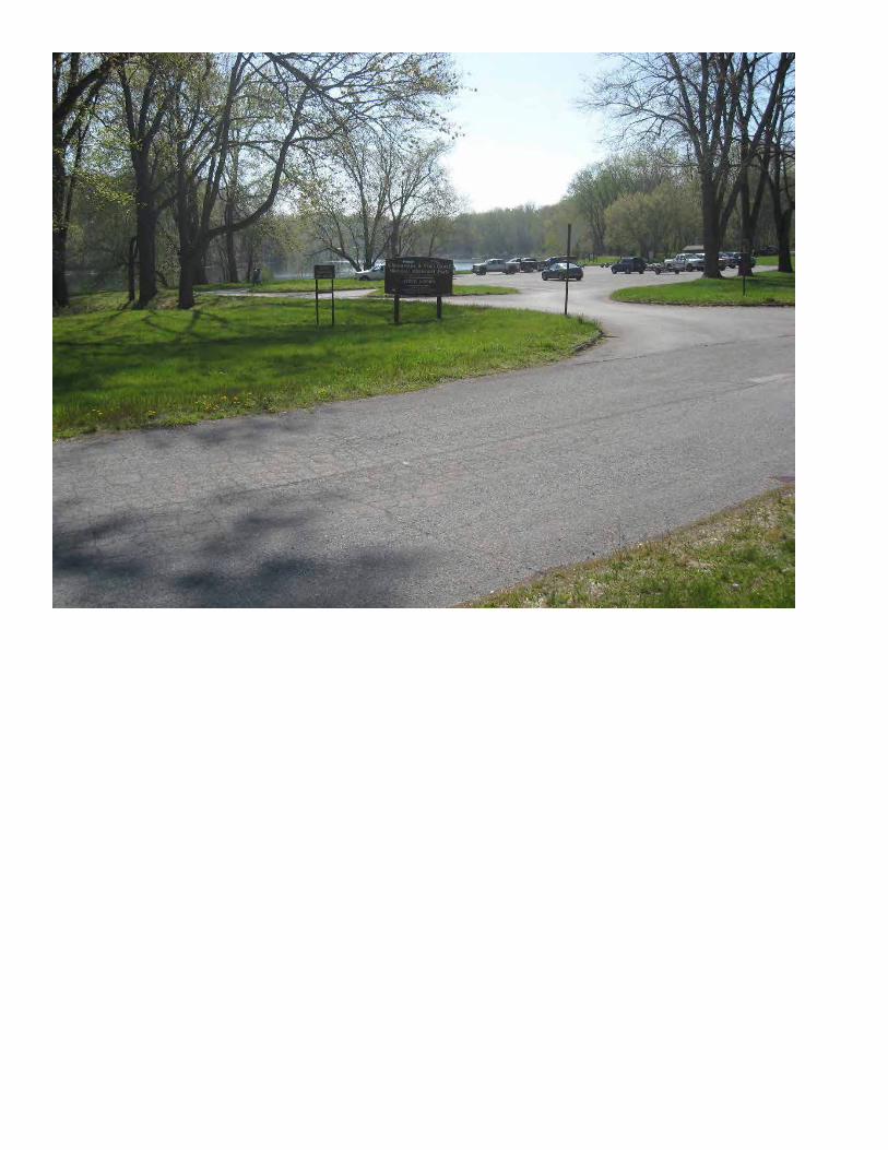
End Lock 10 8.7 End Fletcher’s Boathouse 5.8 P-M In parking lot P-M In parking lot TZ On towpath, follow trail from parking lot X
lock TZ On towpath X footbridge
Running and Driving Directions from Fletcher’s Boathouse to the Finish
As you enter Georgetown, the trail has several areas that split off to form other trails. Ensure you stay on the C&O trail. There is some construction on the trail and you have to cross over the canal at one point. When crossing streets with traffic, look both ways and remember that even though you have the right of way, cars do not always stop. The trial ends in Georgetown and intersects the Rock Creek trail. When you get to this point on the trail, turn to the right and proceed down the trail toward the Potomac River. Be mindful of traffic merging onto side streets. They don’t always stop for runners.
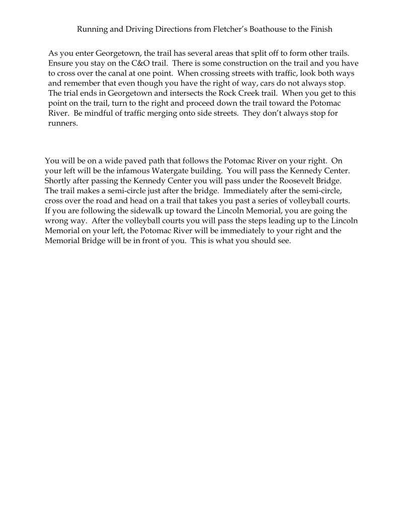
You will be on a wide paved path that follows the Potomac River on your right. On your left will be the infamous Watergate building. You will pass the Kennedy Center. Shortly after passing the Kennedy Center you will pass under the Roosevelt Bridge. The trail makes a semi-circle just after the bridge. Immediately after the semi-circle, cross over the road and head on a trail that takes you past a series of volleyball courts. If you are following the sidewalk up toward the Lincoln Memorial, you are going the wrong way. After the volleyball courts you will pass the steps leading up to the Lincoln Memorial on your left, the Potomac River will be immediately to your right and the Memorial Bridge will be in front of you. This is what you should see.

The Memorial Bridge heading toward West Potomac Park
After you pass under the Memorial Bridge you will be entering West Potomac Park. Here is the sign for the park.
Follow the path through West Potomac Park to the end. You will cross over a small bridge that leads you into the East Potomac Park. The Thomas Jefferson Memorial is off to your left as you pass over this bridge. Continue on the path toward the East. Before you pass under the 14th St Bridge you will see a set of steps that go up next to the bridge. Here is a picture of the steps.

Up these steps to access the bridge for Potomac crossing
These steps get you up to the trail that leads over the bridge. You must carry or push the bicycle up the path next to the steps. At the top of the steps, make a U-turn to cross over the bridge. On the other side of the bridge, you will have to loop around and down toward the Potomac River. You will pass under the bridge you just crossed and run toward Regan National Airport. This trail is the Mt. Vernon trail. From this point onward, you will remain on the Mt. Vernon trail.
NOTE: Pay close attention to the signs so that you do not veer off the trail onto another intersecting trail.
As you pass Regan National Airport last parking lot, the trail splits. Bear to the RIGHT onto the Mt. Vernon trail. Run along the George Washington Parkway following the trail toward Old Town Alexandria.
After passing Daingerfield Island, the trail will split again. Bear to the left and follow the trail along the Potomac River. As the trail gets closer into town, you will have to follow the railroad tracks. The Mt. Vernon trail appears to end at Pendleton Street. Turn to the left and follow the road to N. Union Street. This is the trail through Old Town Alexandria. There is a Starbucks at the corner of King Street and N. Union Street. (no product endorsement here…just information)
NOTE: The road is not closed to traffic. Exercise caution while running/riding through Old Town Alexandria on N. Union Street.
Due to construction, the trail follows a side street as opposed to a true trail. Run along Union Street following the signs for the Mt. Vernon detour signs. Turn RIGHT on

Franklin Street. Continue to follow the detour signs until you return to the paved trail. After you pass Old Town Alexandria, you will pass under I-495. The trail picks up as a paved trail adjacent to George Washington Parkway and the Potomac River. The trail markers start at mile 9. You will be only 7 miles from the finish. Your next exchange point is a rest area and parking lot just past mile marker 8; Belle Haven Marina.
The trail can become very congested after this point. Be careful of other runners/walkers as well as cyclists using the trail. After mile marker 6, you will enter a residential area. The trail follows the road. At the first intersection, the trail crosses over the small bridge and then you will make a hard left onto the trail. FOLLOW THE SIGNS.
After mile marker 3, you will follow the trail to Fort Hunt Park and the finish. There is a water fountain at the bottom of the curve of the trail that is adjacent to the entrance for the park. If you run back under George Washington Parkway and see mile marker 2….you have gone too far. Turn around and come back to us.

Driving Directions and Check points Exchange point Fletcher’s Boat House: Nearest intersections are Canal Road NW and Reservoir Road NW N 380 55.172’ W 0770 06.063’ Elev 76 ft Depart Fletcher’s Boat House/Landing heading SE on Canal Road. Stay RIGHT on Canal Road toward Georgetown/DC. After 2 miles, follow signs to M Street (LEFT lane). You will pass Georgetown University on your left as you come into Georgetown. Landmarks - Key Bridge & Potomac River on right Dixie Liquor on left Drive through Georgetown on M street. Do not merge onto Key Bridge or Whitehurst Freeway. You will pass the famous “Georgetown Cupcakes” store on your left. Unfortunately, they do not open until 10 a.m. Turn RIGHT onto 30th Street. At four-way Stop Sign, turn LEFT onto K Street. Turn RIGHT at next Stop Sign onto Rock Creek Parkway. Thompson Boat Center is on your right as you make the turn. The paved path on the right is the trail the runners will be taking. Pass by the Watergate buildings and the Kennedy Center on your left as you drive along Rock Creek Parkway. After you pass under the Roosevelt Bridge, just past the Kennedy Center, follow Rock Creek Parkway to the LEFT toward downtown. WARNING: Do not go straight up the road toward the Lincoln Memorial. Stay in RIGHT hand lane to follow the Potomac River, pass under the Memorial Bridge and arrive at West Potomac Park. Exchange Point in West Potomac Park: N 380 52.827’ W 0770 02.508’ Elev 2 ft This is located at the eastern end of the West Potomac Park. After exchange of runner/biker, you will be making a U-turn to head back out of the park to Independence Avenue. The runner/biker will continue eastward to the bridge for crossing over the Potomac River.

Depart West Potomac Park by making a U-turn and follow signs for I-395/Washington Memorial. Make RIGHT turn out of park. Stay in right lane. After crossing small bridge, bear RIGHT toward Jefferson Memorial and signs to I-395. LEFT lane to merge onto I-395 South. Cross over Potomac River on 14th Street bridge/I-395. After the bridge, merge onto George Washington Parkway South toward Reagan National Airport and Old Town Alexandria. Exchange point in Daingerfield Island/Washington Sailing Marina: N 380 49.851’ W 0770 02.514’ Elev -5 ft Turn LEFT into parking lot of Washington Sailing Marina. Exit parking lot LEFT onto George Washington Parkway south toward Old Town Alexandria. As you enter Old Town Alexandria George Washington Parkway becomes N. Washington Street. As you pass through Old Town Alexandria, S. Washington Street turns back into George Washington Parkway. Exchange point in Belle Haven Marina: N 380 46.804’ W 0770 03.185’ Elev 2 ft Nearest address is 6317 10th Street Alexandria, VA 22307. There is a Shell gas station near here. Turn LEFT into Belle Haven Marina. If you have a trailer in tow or a larger vehicle, park along the road as you approach the marina. Cars and trucks without trailers can turn left into the parking area at Belle Haven Park. There are restrooms and a water fountain at this park. It is 6 miles to the finish area. This parking area may be busy as several local running groups utilize this area for their training runs. Exit Belle Haven Marina and turn LEFT onto George Washington Parkway. Follow George Washington Parkway until the exit for Fort Hunt Park/Fort Hunt Road on your RIGHT. Follow the signs to the park and look for the finish celebration. CONGRATULATIONS!!!