fal & helford - natural england
TRANSCRIPT

FAL & HELFORD SAC MANAGEMENT SCHEME i
Fal & Helford
Special Area of Conservation
Management Scheme
Table of Contents
EXECUTIVE SUMMARY 1
Table 1. Management actions (example) 6
1. INTRODUCTION 7
1.1 Background to the Habitats Directive and the Habitats Regulations 7
1.2 Special Areas of Conservation (SACs) 8
1.3 Aims of the management scheme 9
1.4 Relevant Authorities responsible for this site 10
Table 2. Fal & Helford SAC Management Forum 10
2. REASONS FOR DESIGNATION AS A 12
SPECIAL AREA OF CONSERVATION (SAC) 2.1 Description of site and interest features 12
2.2 Maps showing site details 17
2.3 Current condition of interest features 17
Fig. 1a. SAC boundary: Fal Estuary 19
Fig. 1b. SAC boundary: Helford River & Falmouth Bay 20
Fig. 2. Key interest features in Helford River and Falmouth Bay 21
Fig. 3. Key interest features in Fal Estuary 22
3. HUMAN ACTIVITIES IN AND AROUND THE SAC 23
3.1 Commercial activities 23
3.2 Recreational activities 23
Table 3. Commercial activities in and around the SAC 24
Table 4. Recreational activities in and around the SAC 27
3.3 Development 29 3.4 Role of Fal & Helford SAC Advisory Group 29
4. CONSERVATION OBJECTIVES 31
4.1 Introduction 31
4.2 Zoning map 31
Fig. 4. Zoning map of SAC 32
4.3 Conservation Objectives 33
4.4 Advice on management implications 34
4.5 Outline of monitoring requirements 36
Table 5. Monitoring for ‘favourable condition’ of site 37

FAL & HELFORD SAC MANAGEMENT SCHEME ii
5. OPERATIONS LIST AND SITE MANAGEMENT 53
5.1 Introduction 53
5.2 List of operations including location and potential impact 53
Table 6. Operations list 54
5.3 Site management 58
5.4 Existing management of operations and future management options 58
6. ACTION PLAN FOR FAL & HELFORD SAC 67
6.1 Introduction 67
6.2 Action plan structure 67
6.3 Reporting and review 68
Table 7. Management actions including timetable and 69
responsibilities for implementing new management measures
SELECTED BIBLIOGRAPHY 77
APPENDICES
Appendix 1. List of other relevant management covering the Falmouth Bay area
Appendix 2. English Nature‟s statutory advice package for Regulation 33
Appendix 3. Terms of reference for Fal & Helford SAC Management Forum

FAL & HELFORD SAC MANAGEMENT SCHEME 1
Fal & Helford
Special Area of Conservation
Management Scheme
Executive Summary
Introduction This management scheme has been developed to help deliver the requirements of the UK Habitats
Regulations for the Fal & Helford Special Area of Conservation (SAC). It is not designed to guide
every aspect of the management of this area but is tightly focused on specific issues. Production of this
management scheme is based on voluntary co-operation and a partnership arising from the work of
the Falmouth Bay & Estuaries Initiative. This work was supported by several key organisations
responsible for the management of this area and has provided the basis for the development of this new
management scheme.
1. Background to the Habitats Directive and the Habitats
Regulations
The Habitats Directive The Habitats Directive
1 is a piece of legislation that was adopted by the European Community in 1992
as a major contribution to the Rio Biodiversity Convention. Its main aim is to highlight the need to
maintain biodiversity, the range of plant and animal life and the habitats in which they are found,
throughout all Member States. There is special emphasis on rare or threatened habitats and species,
which are listed as part of the Directive.
Special Areas of Conservation (SAC) The main mechanism used to protect these listed habitats and species is the selection and subsequent
designation of Special Areas of Conservation (SAC). Each SAC will contain one or more examples
of rare habitats or species, referred to as the site‟s interest features. Together, across Europe, the sites
form a network called Natura 2000.
One crucial aspect of the Habitats Directive is that it covers both the terrestrial and the marine
environment. Where sites include the sea or the foreshore, they can also be referred to as European
marine sites.
The main aim of SACs is to provide a stronghold for the habitats and species they contain, through
appropriate management measures achieved by co-operation between the regulating relevant
authorities, landowners, industry and the public who use these areas. They are not intended to be “no
go” areas, particularly as many sites, including the Fal & Helford, are extensively used for industry and
recreation.
The Habitats Regulations The Habitats Directive was incorporated into UK legislation in 1994 by the Habitats Regulations
2.
With respect to marine SACs, the Regulations have several important features. Responsibility for the
management of the site falls to relevant authorities, those organisations which have statutory powers
and duties on the marine environment, within, or adjacent to a European marine site. For the Fal &
Helford SAC, the relevant authorities are Falmouth Docks & Engineering Co (which is currently
administered by A&P Falmouth Ltd), Carrick and Kerrier District Councils, Cornwall County Council,
Cornwall Sea Fisheries Committee, English Nature, Environment Agency, Falmouth Harbour
1 Council Directive 92/43/EEC on the conservation of natural habitats and of wild flora and fauna. 2 The Conservation (Natural Habitats, &c.) Regulations, Statutory Instrument No. 2716.
FAL & HELFORD SAC MANAGEMENT SCHEME 2
Commissioners, Falmouth & Truro Port Health Authority, Ports of Truro & Penryn, St. Mawes Pier &
Harbour Company and South West Water. These organisations are all equal members of the Fal &
Helford SAC Management Forum (FHMF), which elects a Chair in line with Cornwall County
Council elections and has secretariat support from the County Council.
An advisory group has also been established to reflect the views of local communities and user
groups.
The Regulations also suggest that a management scheme is established for each site, which has been
prepared and agreed by all the relevant authorities. This approach is seen as the best way to direct the
future management of the Fal & Helford SAC site. The main aim of the management scheme is to
publicly set out the commitments of the relevant authorities to achieve favourable condition of the
site. It is essential that this management scheme is actively implemented and supported by the relevant
authorities responsible for the site and that any management measures established take into
consideration the views and needs of the users of this area.
The management scheme takes account of the advice given under Regulation 33 of the Conservation
(Natural Habitats &c) Regulations 1994, issued by English Nature in January 2000 and included as
Appendix 2 in this document.
The Regulations do not affect the existing statutory powers of relevant authorities, but require that they
apply them to ensure the protection of the site. They also require planning issues to be included in this
process, and the review of extant permissions, licenses and consents and the granting of new ones.
2. Reasons for designation as a Special Area of Conservation
The Fal & Helford has been selected as a SAC for the following interest features:
saltmarsh e.g. top of Fal & Ruan Creeks at Ruan Lanihorne.
intertidal mudflats e.g. upper reaches of Polwheveral and Frenchman‟s Creeks.
subtidal sandbanks e.g. maerl beds in the Fal Estuary, particularly the live bed on St. Mawes
Bank.
large shallow inlets and bays e.g. the whole bay from Manacle Point to Zone Point, within this
area are habitats such as reefs and rocky shores.
estuaries e.g. the Fal Estuary and the Helford Estuary.
reefs e.g. St Anthony‟s Head and inshore around Manacle Point.
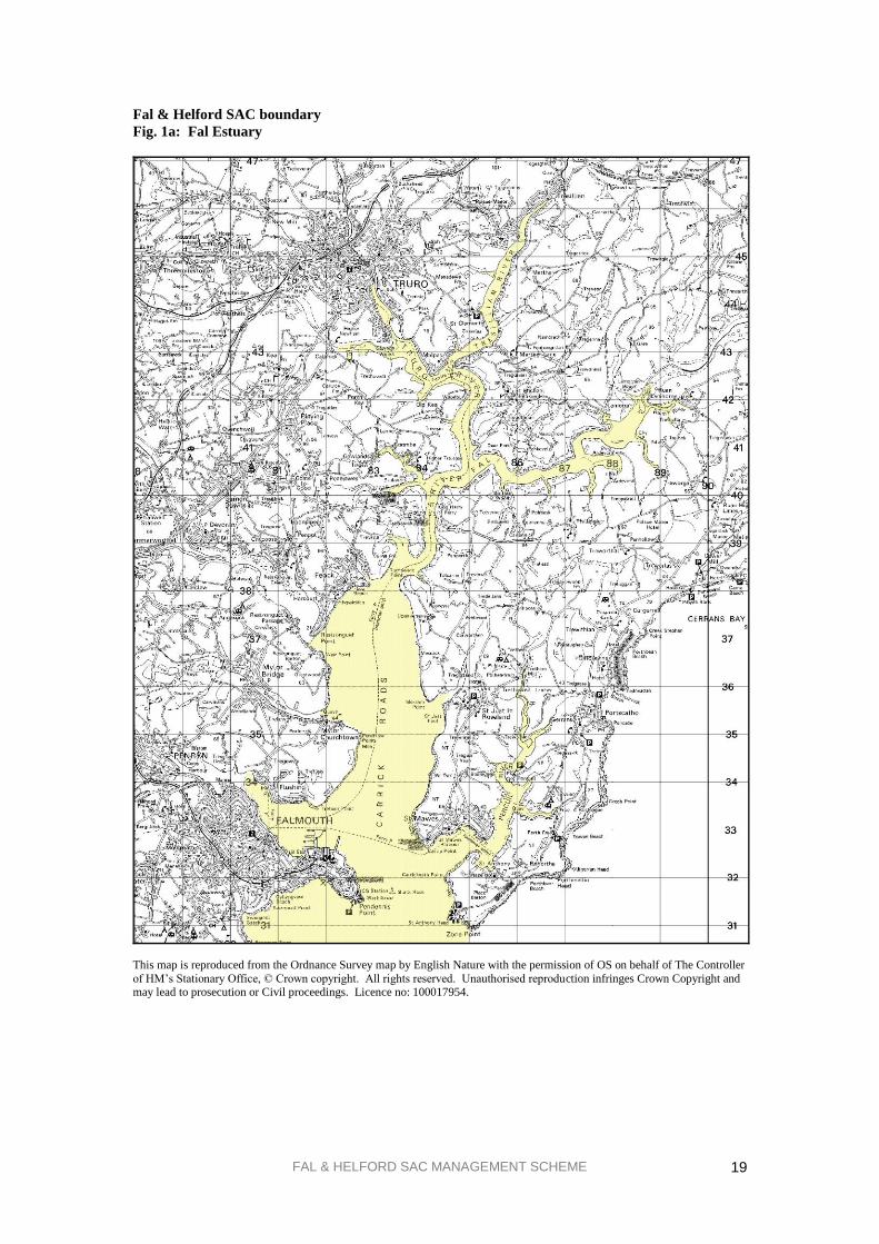
The Fal & Helford site encompasses the two rias (drowned river valleys) of the Fal Estuary and the
Helford River and the inner part of Falmouth Bay between Zone Point on the Roseland Peninsula and
Manacle Point on the Lizard Peninsula. For a site boundary map see Figure 1.
The Fal and Helford SAC also qualifies for the Annex II species (rare, endangered or vulnerable
species) shore dock Rumex rupestris. However as this only occurs above Highest Astronomical Tide,
and not within the European marine site, it is not dealt with by this management scheme. Objectives to
maintain shore dock in favourable condition are found within English Nature‟s conservation objectives
for the relevant SSSI within the SAC boundary and will be dealt with through procedures outlined in
the Conservation (Natural Habitats, &c.) Regulations 1994. Relevant authorities need to have regard to
such adjacent European interest, as they might be affected by activities taking place within or adjacent
to the European marine site.
3. Human activities
In common with other estuaries, the Fal & Helford SAC site has a long history of human activity and
use, both around its shores and on its waters. It is important that this wide range of activities continues
to be accommodated within the overall management of the SAC whilst ensuring that the quality of the
site and its habitats does not deteriorate. Uses of this area are both commercial, for example shipping
and ship repair, bunkering, lay-ups, scalloping, oyster dredging, sewage discharges and moorings, and

FAL & HELFORD SAC MANAGEMENT SCHEME 3
recreational, for example diving, canoeing, sailing and water skiing. Not all activities occur across the
site and most tend to be focused within the harbour areas.
4. Conservation objectives
English Nature, as the Government‟s nature conservation adviser in England, has a statutory
responsibility for developing conservation objectives to guide the management of the Fal & Helford
SAC. The role of these conservation objectives is to set targets for what needs to be achieved by all the
relevant authorities in order to protect the site‟s interest features. These objectives act as a starting
point around which the management scheme can be developed. They also provide the basis for
assessing what types of activities are likely to have a significant effect upon the interest features of the
site, including new planning or license applications.
In order to establish whether or not the conservation objectives are being met, a monitoring programme
needs to be established and carried out. The scope of the monitoring must be sufficient that it covers
all the different habitats of importance but wherever possible it builds on existing monitoring work to
reduce costs. The responsibilities for this condition monitoring will predominantly fall to English
Nature, but a key aspect of ensuring that the objectives are met will be to incorporate results of
compliance monitoring, whose responsibilities will fall to the relevant authorities.
5. Operations list and site management
In section 3, there is an overview of the range of commercial and recreational activities taking place
within and around the SAC. This does not however address the potential impact that these activities
may have upon the interest features of the site. The Habitats Regulations require English Nature to
advise relevant authorities as to any operations that may cause deterioration of the habitats or
disturbance to the species for which the site has been selected and designated. The operations list in
this management scheme includes activities referred to as plans and projects as the relevant
authorities felt that this provided a more complete picture of the situation within the site. Plans and
projects are those requiring any licenses or consents alongside the commercial and recreational
activities that occur on or adjacent to the site
The list of operations identified in the management scheme is not a list of prohibitions. It is designed
to be a checklist of activities which may need to be subject to some form of management if none
already exists, or further measures where actions are already in force. In some cases activities are
listed as a precautionary measure to highlight the need to consider their potential impact in the event of
a failure of existing practices or changes in management policy, for example fuel bunkering, transfer of
chemical cargoes or future increases in moorings. For each operation, its current management has been
assessed and future options identified to reduce any potential or actual impacts upon the SAC. After
agreement within the Management Forum, some or all of the options for each operation have been put
forward into the Action Plan.
6. Action plan
This section details the actions to be undertaken by the individual relevant authorities, either working
alone or in partnership, to manage the Fal & Helford SAC. As far as possible, these actions link to
existing activities and plans, both to avoid duplication of effort and to emphasise the linkages that
already exist between the relevant authorities.

FAL & HELFORD SAC MANAGEMENT SCHEME 4
The table is arranged as follows:
ACTIVITY ACTION RESPONSIBILITY TIMEFRAME
1. 1.1.
1.2.
ACTIVITY
Activities 1-15 are derived from the operations list, which comprises all operations identified by the
relevant authorities that may cause deterioration of the habitats or disturbance to the species, for which
the site was designated. Some of these have been amalgamated, for example water quality, which
includes several different operations. Also included as an activity is the actual process of running the
management scheme and the actions necessary to support that process. Planning is also included as an
activity to indicate how it fits in with the rest of the scheme.
The activities covered by the Action Plan, and numbers of actions planned for each, are as follows:
1. Water quality (8 actions)
2. Bulk chemical transfer in Carrick Roads (3 actions) see e.g. below
3. Bunkering of fuel within Carrick Roads and Falmouth Bay (3 actions) see e.g. below
4. Discharge of fish wastes from factory ships in Carrick Roads (2 actions)
5. Anchoring of oil rigs on St. Mawes Bank (4 actions)
6. Laying of new moorings (5 actions)
7. Anchoring in the Fal & Helford Estuaries (4 actions)
8. Recreational Activities ( 2 actions)
9. Oyster dredging on St. Mawes Bank live maerl bed (4 actions)
10. Scalloping in Falmouth Bay, inshore from Rosemullion Head to Manacle Point (4 actions)
11. Commercial bait-digging and shore collection of molluscs (1 action)
12. Maintenance dredging and seabed levelling (6 actions)
13. Planning and development control (2 actions)
14. SAC management scheme (6 actions)
15. Management of ship repair and laid up shipping (2 actions)
“SMILE”
This column indicates the type of action proposed; these fall into one of the following five categories:
S = SURVEY & RESEARCH e.g. new surveys, new research work or studies
required to fill in information gaps.
M = MONITORING & REVIEW e.g. monitoring the condition of the site or the extent
of activities; reviewing existing plans.
I = INFORMATION & TRAINING e.g. provision of information to other relevant
authorities or public; training of staff.
L = LIAISON e.g. communicating with other partners,
Management Forum meetings.
E = ENFORCEMENT & ENABLING e.g. enforcing bylaws, undertaking projects.
RESPONSIBILITY
For each action one or more relevant authorities may be responsible, in addition to other partner
organisations.

FAL & HELFORD SAC MANAGEMENT SCHEME 5
TIMEFRAME
The timeframe shown covers from designation until the financial years 2007/2008. The Habitats
Directive requires that each member state report back to the EC every 6 years. The timeframe used for
the Fal & Helford SAC covers the reporting cycle up to 2006, and then leads up to the following cycle
in 2012. Many of the actions listed are only timetabled to happen at certain points within this 6 year
period although others may occur annually (this is in Table 1).
REPORTING AND REVIEW
It is proposed that all relevant authorities report to the Management Forum on a 3-year cycle, at which
point the plan is also reviewed to assess its effectiveness with possible revisions of the contents. The
responsibility for gathering together the reported information and revising the management scheme will
have to be agreed by the Management Forum at that point in the process.
The following example in Table 1 shows how the Action Plan has addressed an activity; actions
dates are indicated by a ●, whilst those actions completed since designation are given a tick.

FAL & HELFORD SAC MANAGEMENT SCHEME
6
Table 1. Management Actions (example)
ACTIVITY
ACTION
(not in priority order)
RESPONSIBILITY
TIMEFRAME (Financial Years)
** 04/05 05/06 06/07 07/08
2. Bulk chemical transfer in
Carrick Roads
2.1. Update information provided to
visiting ships to include SAC.
I Falmouth Harbour
Commissioners
2.3. Maintain record of spills.
M Falmouth Harbour
Commissioners
3. Bunkering of fuel within
Carrick Roads, King Harry
Reach and Falmouth Bay
3.1. Update information provided to
visiting ships to include SAC.
I Falmouth Harbour
Commissioners
Falmouth Oil Services
Ports of Truro & Penryn
3.2. Update Oil Spill Contingency
Plans to meet OPRC Regulations and
include SAC. Undertake periodic
testing of plan.
I / L Oil Spill Contingency
Plan partners
3.3. Maintain record of spills.
M Falmouth Harbour
Commissioners
Falmouth Oil Services

FAL & HELFORD SAC MANAGEMENT SCHEME
7
Fal & Helford Special Area of Conservation
Management Scheme
1. INTRODUCTION
This management scheme has been developed to help deliver the requirements of the UK Habitats
Regulations1 for the Fal & Helford Special Area of Conservation. It is not designed to guide every
aspect of the management of this area but is tightly focused on specific issues. Whilst it is the
responsibility of the relevant statutory organisations to implement this scheme, all users of this area can
play a part in making this management scheme a success.
Production of this management scheme is based on voluntary co-operation and a partnership arising
from the work of the Falmouth Bay & Estuaries Initiative. In 1997, the Falmouth Bay & Estuaries
Initiative published a set of Strategic Guidelines2 for the voluntary management of the marine and
coastal waters of Falmouth Bay. This work was supported by several key organisations responsible for
the management of this area and has provided the basis for the development of this new management
scheme. There is also a wide range of other plans, both statutory and non-statutory, covering this area
and those relevant to this management scheme are listed in Appendix 1.
1.1. Background to the Habitats Directive and the Habitats
Regulations
The Habitats Directive The Habitats Directive
3 is a piece of legislation that was adopted by the European Community in 1992
as a major contribution to the Biodiversity Convention signed at the Rio Earth Summit. Its main aim is
to highlight the need to maintain biodiversity, the range of plant and animal life and the habitats in
which they are found, throughout all Member States. Good representative examples of the range of
habitats found in the area are selected and therefore encompass rare or threatened habitats and species,
which are listed as Annexes within the Directive. Bird species are covered by complementary
legislation under the Birds Directive4.
The main mechanism used to protect the habitats and species listed in the Habitats Directive is the
selection and subsequent designation of Special Areas of Conservation (SAC). Sites classified under
the Birds Directive are Special Protection Areas (SPA). Sites designated under these two Directives
collectively form a network across the EC called Natura 2000. The term Natura 2000 comes from the
Habitats Directive and symbolises the conservation of precious natural resources for the year 2000 and
beyond. Site selection and designation are explained further in section 1.2.
One crucial aspect of this Directive is that it covers both the terrestrial and the marine environment,
which is particularly important to the UK with its extensive coastline and inshore waters. As this
management scheme covers a marine site, it will focus on the way in which the Directive operates
within the UK‟s marine environment and the particular issues this raises with regard to its
implementation.
Another important feature of the Habitats Directive is that it mentions the need to take account of the
economic, cultural, social and recreational needs of local people when managing the site. A majority
of the sites already chosen have been subject to human use for hundreds or thousands of years and their
1 The Conservation (Natural Habitats, &c.) Regulations, Statutory Instrument No. 2716. 2 Falmouth Bay & Estuaries Initiative Strategic Guidelines. 3 Council Directive 92/43/EEC on the conservation of natural habitats and of wild flora and fauna.
4 Council Directive 79/409/EEC on the conservation of wild birds

FAL & HELFORD SAC MANAGEMENT SCHEME
8
selection as SACs has occurred against this background of human use. The implications of the
Directive on those patterns of use have to be considered as part of the whole management process.
The Habitats Regulations: Regulatory and policy framework The Habitats Directive was incorporated into UK legislation in 1994 by the Habitats Regulations.
These Regulations are designed to translate the requirements of the Directive into what needs to be
achieved in the UK and the mechanisms required to make it work at both an administrative and a
practical level.
With respect to marine SACs, the Regulations contain the following important features:
1. Responsibility for the development and implementation of a management scheme for the site falls
to relevant authorities, those organisations which have statutory powers and duties on the marine
environment, within, or adjacent to, a European marine site. For a more detailed explanation, see
Regulations 5 & 6 or the DETR/WO Guidance for European marine sites in England & Wales1.
The relevant authorities for the Fal & Helford SAC are listed in section 1.4 & Appendix 3.
2. Relevant authorities should work together, ideally in a management group, with a lead
organisation if appropriate. An advisory group should also be established to reflect the views of
local communities and user groups.
Both of the above groups have been established in the Fal & Helford SAC as it was thought to be
the best way forward.
3. The establishment of a management scheme for each site if thought appropriate, which has been
prepared and agreed by all the relevant authorities (Regulation 34). For a more detailed
explanation, see section 1.3.
A management scheme was seen as the most practical option to direct the future management of
this site.
4. The Regulations do not affect the existing statutory powers of relevant authorities, but require that
they apply them to ensure the protection of the site.
5. Sites that include substantial areas of sea or foreshore can be referred to as European marine sites.
This term is sometimes used to describe the Fal & Helford SAC.
The Regulations also require planning issues to be included in this process, in particular the review of
extant permissions, licenses and consents and the granting of new ones (Regulations 48 - 50). For
more information please refer to Appendix 3. This process is not strictly part of the management
scheme but will be mentioned further in Section 3 relating to human use of the site.
1.2. Special Areas of Conservation (SAC)
Special Areas of Conservation (SAC) are selected initially by each Member State on the basis of the
habitats and species listed in Annexes 1 and 2 to the Habitats Directive. The habitats and/or species
found on each site are referred to as interest features. The best examples in each country, once agreed
locally and nationally through consultation, are then submitted to the EC for consideration. At this
stage, they are referred to as candidate sites. After adoption by the EC, these candidate sites are
formally designated by their Member States to become Special Areas of Conservation (SAC). The
reasons for selection of this site are given in section 2.1.
In addition to its SAC status, parts of the Fal & Helford are also designated and subject to agreements
under other conservation legislation. Sites of Special Scientific Interest (SSSI) are designated under
the Wildlife and Countryside Act 1981 (as amended by the Countryside and Rights of Way Act 2000)
and cover the intertidal areas to mean low water.
1 European marine sites in England & Wales: A guide to the Conservation (Natural Habitats, &c.) Regulations
1994 and to the Preparation and Application of Management Schemes, DETR London 1998.
FAL & HELFORD SAC MANAGEMENT SCHEME
9
Marine sites vary in size, from the Wash and North Norfolk at over 62 200 ha to the Fal & Helford
which covers 3800 ha. Sites may be chosen for just one interest feature, for example Cardigan Bay
(bottlenose dolphins) or for several features, for example, Fal & Helford (subtidal sandbanks, shallow
bays and inlets, mudflats, salt marsh, estuaries, reefs and shore dock).
The main aim of SACs is to provide a stronghold for the habitats and species they contain through
appropriate management measures achieved by co-operation between the regulating relevant
authorities, landowners, industry and the public who use these areas. They are not intended to be “no
go” areas, particularly as many sites, including the Fal & Helford, are extensively used for industry and
recreation.
1.3. Aims of the management scheme
The main aim of the management scheme is to protect the site‟s interest features, those habitats and
species for which it is an important area. The Directive specifically mentions the need to avoid the
deterioration of habitats and the disturbance to species by whatever means necessary, including the
establishment of management schemes. The actual style and content of a management scheme is up to
the relevant authorities to decide.
This management scheme has the following aim:
To maintain the features of the site: salt marsh, mudflats, subtidal sandbanks,
and large, shallow bays and inlets, estuaries and reefs, whilst enabling its
continued and diverse human use.
The objectives of the management scheme are based on the conservation objectives provided in English
Nature‟s Regulation 33 advice. These conservation objectives will be explained in greater detail in
section 4; see also Appendix 2.
In addition to these the following, more general, principles are proposed:
Guiding Principle 1.
Integration of the management of the SAC wherever possible with both existing
and future plans and initiatives, to avoid duplication of effort.
Guiding Principle 2.
Ensure that the users of the area are kept informed and where possible involved
in the management of the SAC through the Advisory Group, public consultation
and the wider provision of information.
Guiding Principle 3.
Undertake monitoring and periodic review of the management scheme to ensure
its successful implementation.
It is essential that this management scheme is actively implemented and supported by the relevant
authorities responsible for the site and that any management measures established take into
consideration the views and needs of the users of this area.

FAL & HELFORD SAC MANAGEMENT SCHEME
10
1.4. Relevant authorities responsible for this site
Section 1.1., Regulation 5 of the Habitats Regulations identifies the statutory organisations who
“...have functions in relation to land or waters within or adjacent to the site”. Regulation 34 enables
these organisations to establish and implement a management scheme in order to fulfil the requirements
of the Habitats Directive for the site, as guided by English Nature‟s conservation objectives. Falmouth
& Truro Port Health Authority is not identified as a relevant authority but plays an important role in
this area so has been included in the Management Forum.
Table 2. Fal & Helford SAC Management Forum
Relevant authority Responsibilities Area covered
Falmouth Docks & Engineering
Company
(currently administered by A & P
Falmouth)
Operate Falmouth Docks,
harbour authority
Immediate area around
Falmouth Docks.
Carrick District Council Local planning authority Carrick District down to mean
low water (also operate beach
safety). Includes Fal and coast
east from Maenporth beach.
Cornwall County Council County planning authority County of Cornwall down to
mean low water.
Cornwall Sea Fisheries Committee Fisheries regulation and
enforcement
County of Cornwall‟s water out
to 6 miles, excluding estuaries.
English Nature Conservation agency for
England
England - out to 12 mile limit
of territorial sea.
Environment Agency
www.environment-agency.gov.uk
Environmental Regulation;
The Environment Agency is
the fisheries authority in
Cornish estuaries.
England & Wales - out to 3
miles.
Falmouth Harbour Commissioners Harbour authority Mid to lower Fal estuary and
part of Falmouth Bay.
Falmouth & Truro Port Health
Authority
Environmental health All port areas and waters within
the SAC up to mean high water.
Kerrier District Council Local planning authority Kerrier District down to mean
low water. Helford river and
coast west from Maenporth
Beach.
Ports of Truro & Penryn Harbour authority Truro River, upper to mid Fal
estuary and upper Penryn
River.
St. Mawes Pier & Harbour Co. Harbour authority Lower Percuil River.
South West Water Ltd. Water and sewerage
undertaker
Southwest region.
These 12 organisations are all equal members of the Fal & Helford SAC Management Forum
(FHMF), which elects a Chair in line with Cornwall County Council elections. This group has Terms of
Reference (see Appendix 3) but no powers, as it is purely a representative body to involve all relevant
authorities in the ongoing management of the SAC. Each relevant authority has to undertake its powers
and duties with respect to the Habitats Directive and will need to act accordingly on an individual basis.
However, it has been agreed within the Management Forum that each relevant authority will inform all

FAL & HELFORD SAC MANAGEMENT SCHEME
11
members of the group as to their organisation‟s position on any issue. Appendix 3 has further details and
responsibilities of all relevant authorities for the SAC, including those not represented on the
Management Forum.
In addition to this group there is an Advisory Group, comprising representatives from other non-
statutory interests in the area. Further details can be found in section 3.4.

FAL & HELFORD SAC MANAGEMENT SCHEME
12
2. REASONS FOR DESIGNATION AS A SPECIAL AREA OF
CONSERVATION (SAC)
As outlined in section 1.2 SACs are selected as candidate sites by individual Member States on the
basis that they support rare, endangered or vulnerable habitats and/or species, as listed in Annexes I and
II of the Habitats Directive. In addition, some sites may be selected because they support outstanding
examples of habitats characteristic of that particular region. The habitats or species that a site has been
selected for are referred to as its interest features. Whilst some sites are only selected for one habitat
or species, others are multi-interest and represent extremely valuable wildlife areas.
The Fal & Helford has been selected as a SAC for the following habitats or interest features:
large shallow inlets and bays
estuaries
subtidal sandbanks
intertidal mudflats
saltmarsh (this includes „Atlantic Salt Meadows‟)
reefs
The Fal & Helford SAC also qualifies for the Annex II species shore dock Rumex rupestris. However
as this only occurs above Highest Astronomical Tide, and not within the European marine site, it is not
dealt with by this management scheme. Objectives to maintain shore dock in „favourable condition‟
are found within English Nature's conservation objectives for the relevant SSSI within the SAC
boundary and will be dealt with through procedures outlined in the Conservation (Natural Habitats,
&c.) Regulations 1994.
In section 2.1. there is a series of descriptions and examples of the main habitat types that make up
these interest features and their locations are shown in Figures 2 & 3.
The Fal & Helford SAC encompasses the two rias (drowned river valleys) of the Fal Estuary and the
Helford River and the inner part of Falmouth Bay between Zone Point on the Roseland Peninsula and
Manacle Point on the Lizard Peninsula. For an overall site boundary map see Figure 1, section 2.2.
2.1. Description of main features of site
Falmouth Bay is a relatively shallow and exposed section of the South Cornwall coast, although it is
protected from prevailing southwesterly winds. Both the estuaries are examples of drowned river
valleys or rias, which explains their general sinuous shape. Whilst the Helford is quite shallow, with a
depth of only 8 - 10 m at its mouth, the Fal is well known as a deep-water anchorage, with up to 33 m
in the central channel.
Rias are important areas for marine life because of the range of habitats found along their length, from
extremely sheltered mudflats, for example upper Fal; to the wave-exposed, rocky open coasts, for
example Mawnan Shear to Rosemullion Head in the mouth of the Helford River. Unusually, all these
habitats are fully marine as there is very little freshwater input into either estuary. The rocky coastline
of Falmouth Bay, particularly where reefs are always covered by the tide, and the rare rocky areas
within the estuaries are also valuable sites for marine life. Sections 2.1.1 to 2.1.6 outline the most
important of these habitat.

FAL & HELFORD SAC MANAGEMENT SCHEME
13
2.1.1. Large shallow inlets and bays
Natura 2000 Definition – Large shallow inlets and bays
Large indentations of the coast where, in contrast to estuaries, the influence of freshwater is generally
limited. These shallow indentations are generally sheltered from wave action and contain a great
diversity of sediments and substrates with a well developed zonation of benthic communities. These
communities generally have a high biodiversity. The limit of shallow water is sometimes defined by
the distribution of the Zosteretea and Potametea associations. Several physiographic types may be
included under this category provided the water is shallow over a major part of the area: embayments,
fjords, rias and voes.
The rias of the Fal and Helford have a low freshwater input and as a result the area contains an unusual
range of fully marine habitats. Large shallow inlets and bays are a physiographic habitat as well as
being an interest feature and as such support a wide diversity of habitats and species. Key sub-features
are identified below, and in most cases expanded upon under the relevant interest feature habitat.
(i) Rocky shore communities A description of this sub-feature is given under the interest feature „Reefs‟, covered in section 2.1.6.
(ii) Subtidal rock and boulder communities A description of this sub-feature is given under the interest feature „Reefs‟, covered in section 2.1.6.
(iii) Subtidal sandbank communities The extensive subtidal sediments form a significant proportion of the shallow inlet and bay; they are
also integral to maintaining the intertidal areas and are important feeding grounds for fish.
(iv) Kelp forest communities A description of this sub-feature is given under the interest feature „Reefs‟, covered in section 2.1.6.
(v) Intertidal mudflats
A description of this sub-feature is given under the interest feature „Intertidal Mudflats‟, covered in
section 2.1.4.
(vi) Saltmarsh
A description of this sub-feature is given under the interest feature „Atlantic Salt Meadows‟, covered in
section 2.1.5.
Example sites for rocky shores: St. Anthony Head, Trefusis Point to Penarrow Point, Toll Point to
Rosemullion Head.
Example sites for subtidal rock: Nare Point to Manacle Point, Carrick Carlys Rock (off Restronguet
Point), lower Percuil River.
2.1.2. Estuaries
Natura 2000 Definition - Estuaries
Downstream part of a river valley, subject to the tide and extending from the limit of brackish waters.
River estuaries are coastal inlets where, unlike „large shallow inlets and bays‟, there is generally a
substantial freshwater influence. The mixing of freshwater and sea water and the reduced current flows
in the shelter of the estuary lead to deposition of fine sediments, often forming extensive Intertidal sand
and mud flats. Where the tidal currents are faster than flood tides, most sediments deposit to form a
delta at the mouth of the estuary.
In reality estuaries, and the wildlife they support, are amongst our most threatened maritime habitats.
Where they are relatively undeveloped, as in the Fal & Helford, they are often seen as the last
remaining source of development land, and can have pressures from land-claim and from cumulative
FAL & HELFORD SAC MANAGEMENT SCHEME
14
effects of numerous small scale projects. Even though the estuaries have been extensively changed by
human activities, they still remain productive habitats, with a diverse range of wildlife. Estuaries are a
physiographic habitat as well as being an interest feature and as such supports a wide diversity of
habitats and species. Key sub-features are identified below, and in most cases expanded upon under
the relevant interest feature habitat.
(i) Intertidal mud communities A description of this sub-feature is given under the interest feature „Intertidal mudflats‟, covered in
section 2.1.4.
(ii) Subtidal mud communities In the subtidal, muddy sediments are important as feeding grounds for fish such as juvenile sole Solea
solea. These muddy sediments are even more productive than intertidal mud communities and
contribute significantly to the overall functioning of the system. They are also integral to maintaining
the intertidal areas
(iii) Intertidal mixed muddy sediment communities A description of this sub-feature is given under the interest feature „Intertidal mudflats‟, covered in
section 2.1.4.
(iv) Subtidal mixed muddy sediment communities Filamentous algae, including some rarities, are abundant on cobbles, shells and muddy sediments. The
structures of these subtidal communities are different to the intertidal communities outlined above, due
primarily to the more mixed substrate providing niches for different plants and animals.
(v) Estuarine bedrock, boulder and cobble communities A description of this sub-feature is given under the interest feature „Reefs‟, covered in section 2.1.6.
(vi) Subtidal sandbank communities As an interest feature in its own right, this feature is described in more detail in section 2.1.3.
(vii) Saltmarsh communities As an interest feature in its own right, this feature is described in more detail in section 2.1.5.
(viii) Reedbed communities Reedbeds are nationally scarce, with many of these sites being small. The reedbeds are inundated at
high water providing nursery areas for fish. These habitats are of great importance to the structure and
function of the estuaries and their dynamic nature; they are heavily interdependent with the intertidal
mudflat communities. The benefit they provide in the form of natural sea defences should also not be
overlooked.
Example sites for estuaries: Upper parts of the Fal Estuary and Truro River and upper parts of the
Helford Estuary and associated creeks.
2.1.3. Subtidal sandbanks
Natura 2000 Definition – Sandbanks which are slightly covered by sea water all the time
Sublittoral sandbanks, permanently submerged. Water depth is seldom more than 20m below Chart
Datum. Non-vegetated sandbanks or sandbanks with vegetaition belonging to the Zosteretum marinae
and Cymodoceion nodosae.
These cover a large part of the lower Carrick Roads and extend across Falmouth Bay and into the
mouth of the Helford. Subtidal sandbanks are habitats included within the Cornwall Biodiversity
Action Plan. Key sub-features are listed below:

FAL & HELFORD SAC MANAGEMENT SCHEME
15
(i) Maerl bed communities Maerl beds are composed of accumulations of living and dead unattached coralline algae. Live maerl is
pink and is found in the largest quantities in England and Wales on St Mawes Bank and offers shelter
to a large number of other species of plants and animals. There are also extensive areas of dead maerl
and these sediments are also species rich and provide an important habitat for deep burrowing species,
attached seaweed and large areas of brittle stars.
(ii) Eelgrass beds Eelgrass is important in its own right, as a habitat for invertebrates, sea slugs and cuttlefish, and also as
nursery areas for various fish species, including seahorses. Eelgrass beds are included within the
Cornwall Biodiversity Action Plan (BAP).
(iii) Gravel and sand communities Fine sand and gravel support large numbers of invertebrates, bivalves, molluscs and other sand
dwelling species such as polychaetes.
(iv) Mixed sediment communities These contain a range of invertebrates and may support surface dwelling animals and plants.
Example sites for sandbanks: St. Mawes (Vilt) Bank, Falmouth Bank, inner Falmouth Bay (off
Maenporth).
Example sites for mud/shell/gravel: The Bar, Helford and Place Cove, Percuil.
Example sites for eelgrass: between Durgan and Toll Point (Helford), in St. Mawes Harbour
particularly between Carricknath Point and Amsterdam Point, and on the inside of St. Mawes Bank
(Fal).
2.1.4. Intertidal mudflats
Natura 2000 Definition – Mudflats and sandflats not covered by sea water at low tide
Sands and muds of the coasts of the oceans, their connected seas and associated lagoons, not covered
by sea water at low tide, devoid of vascular plants, usually coated by blue algae and diatoms. They are
of particular importance as feeding grounds for wildfowl and waders.
Mudflats are exposed at low water in the majority of side creeks of both estuaries. They support a rich
and diverse range of invertebrate species including molluscs and worms, and also many larger species
such as bass and heron and nationally important populations of waterfowl. Mudflats are identified as a
priority habitat within the Cornwall BAP. Key sub-features are identified below:
(i) Intertidal sand and gravel The sheltered sandy shores at the mouth of the Fal are rich in species such as certain amphipods and
polychaete worms, and some bivalve molluscs.
(ii) Intertidal muddy sand communities Dense beds of the sand mason worm Lanice conchilega are found in the lower shore muddy sand at
Amsterdam Point and at Treath on the Helford. In Place Cove the muddy sand is dominated by the
lugworm Arenicola marina. These areas are extensive and highly productive, supporting nationally
important bird species.
(iii) Intertidal mud communities The extensive mudflats present throughout the complex are a highly productive system forming a
critical part of the food chain. The mudflats contain extensive and varied infaunal communities
(comprising species living within the sediment), rich in bivalves and other invertebrates, and provide
important feeding grounds for internationally important numbers of waterfowl.

FAL & HELFORD SAC MANAGEMENT SCHEME
16
(iv) Intertidal mixed muddy sediment communities The mixed intertidal muddy sediments of the estuaries provide a habitat for a variety of species,
primarily bivalves such as cockles Cerastoderma edule and native oysters Ostrea edulis. These can be
found on the substrata containing more gravel and slates. The native oyster is also the subject of a UK
BAP species action plan.
Example site for mudflats: upper Fal around Ardevora Veor; Place Cove in the Percuil,
Polwheveral Creek in the Helford River.
2.1.5 Saltmarsh (Atlantic Salt Meadows)
Natura 2000 Definition – Atlantic Salt Meadows Salt meadows of Baltic, North Sea, English Channel and Atlantic shores. Aster tripolium can be present
or abundant in most subdivisions.
Saltmarshes are found fringing the upper creeks of the Fal and Helford and offer important feeding,
roosting and nesting areas for wading birds, as well as providing a natural form of sea defence. The
more open edges of the saltmarsh are ideal nursery areas for young bass and other fish. There are also
areas of transition from new saltmarsh through established saltmarsh to scrub and finally oak
woodland, for example at Sett Bridge, an unusual and rare habitat in the UK. Typical plant species in
saltmarshes include saltmarsh and red fescue grasses, thrift and sea aster. Saltmarshes are another
priority habitat with action included in the Cornwall BAP. The key sub-features are listed below:
(i) Low and low-mid marsh communities This area experiences the greatest number of tidal inundations and is often species poor, composed of
halophytes (salt tolerant plants) that can withstand such conditions.
(ii) Mid and mid-upper marsh communities Transition zone between lower and upper marsh; as tidal inundations become less frequent, the
vegetation becomes more diverse.
Example sites for saltmarsh: head of Fal & Ruan creeks near Sett Bridge, Calenick Creek,
Tresillian river and the upper portion of Restronguet Creek, and Perranarworthal Creek. The latter
two sites are not within the SAC boundary, however the Management Forum is committed to
supporting the voluntary inclusion of these areas within the management scheme to enhance their
conservation and protection..
2.1.6 Reefs
Natura 2000 Defintion – Reefs
Submarine, or exposed at low tide, rocky substrates and biogenic concretions, which arise from the
seafloor in the sublittoral zone but may extend into the littoral zone where there is an uninterrupted
zonation of benthic communities of algae and animal species including concretions, encrustations and
corallogenic concretions.
This includes underwater and intertidal rock which typically fringes the coastline and extends offshore
to varying degrees. Usually subtidal, or exposed at low tide, rocky substrates may extend into the
littoral zone where there is an uninterrupted zonation of plant and animal communities. These reefs
generally support a zonation of benthic communities (bottom-living) of algae and animals. Although
rocky reefs can appear robust and resilient, the communities which live on them can be delicate,
particularly in areas which are sheltered from strong wave action. Typically, rock surfaces in shallow
water are dominated by leafy seaweeds such as kelps. In deeper water there are fewer seaweeds and
rock surfaces are covered by encrusting animals such as anemones, sponges and hydroids. The
presence and continued well-being of species such as the pink seafan are important indicators of the
general health of the rocky seabed. The pink seafan is large and easily damaged by modern

FAL & HELFORD SAC MANAGEMENT SCHEME
17
commercial fishing gear, breaking down the reef structure and reducing habitat diversity. This in turn
can reduce the suitability of the reef for commercial species such as crabs and lobsters. The key sub-
features are listed below:
(i) Rocky shore communities The majority of the open coast including both the mouths of both the Fal and Helford are rocky, with a
wide range of habitats such as overhangs and rocky platforms, rock pools and boulder shores. These
habitats are important for their high diversity of communities and species richness, as well as their high
productivity, they support a wide range of both common and rare plant and animal species, including
the rare Giant Goby in shallow pools near Rosemullion Head.
(ii) Kelp forest communities Kelp forests are highly productive ecosystems, found in the shallow subtidal and are the major primary
producers in the coastal waters of the UK. They have been compared with rainforests in terms of their
productivity and species richness. Kelp forests have considerable conservation value because they
harbour a very high diversity of organisms, confined to a narrow coastal fringe. For example, a single
kelp holdfast may be home to several thousand small animals and the habitat plays a significant role as
nursery areas for a wide variety of species, including commercial species such as crab and lobster.
They are therefore key structural and functional components of this embayment (bay).
(iii) Subtidal rock and boulder communities These are important areas for soft and hard corals (including pink sea fans), particularly between Nare
Point and Manacle Point, also rich sponge and sea squirt communities and kelp forests. Rare patches
of subtidal rock occur in Percuil and King Harry Passage which are unusual within ria systems and are
important for sponges, sea mats and seaweeds.
(iv) Estuarine bedrock, boulder and cobble communities Subtidal rock communities are typical of sheltered estuarine areas. The animal communities are
dominated by the breadcrumb sponge Halichondria panacea, with a high abundance of the barnacle
Balanus crenatus and abundant shore crabs Carcinus maenas.
Example sites for reefs: St. Anthony’s Head; inshore round Manacle Point, fringing reefs round
Falmouth Bay and the Helford.
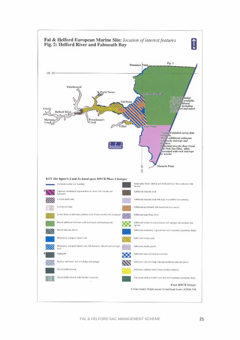
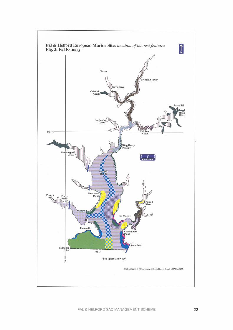
2.2. Maps showing site details
Fig. 1a. SAC Boundary: Fal Estuary
Fig. 1b. SAC Boundary: Helford River and Falmouth Bay
Fig. 2. Location of key interest features: Helford River and Falmouth Bay
Fig. 3. Location of key interest features: Fal Estuary
Fig. 1a&b is consistent with existing citation maps and the planning map already supplied to FHMF
members. The location of the interest features and key sub-features are mapped at Figs. 2 and 3 which
show their distribution and extent. They are based upon existing survey information collated and
mapped by the Joint Nature Conservation Committee (JNCC).
2.3. Current condition of interest features
The term „condition‟ refers to the „health‟ of these habitats and species and whether or not they are
capable of sustaining themselves on a long-term basis. The assessment of current condition has to be
based upon existing knowledge of the site. Due to the huge costs associated with marine surveys,
especially subtidal work, there are gaps in current information on particular habitats and even where
records exist, these may require updating. As further survey work is undertaken, these gaps will be
filled and older work updated, with priority wherever feasible, given to the most sensitive or threatened
habitats.

FAL & HELFORD SAC MANAGEMENT SCHEME
18
English Nature is undertaking „condition assessment monitoring‟ which will improve our
understanding of the current condition of the site. Current scientific evidence suggests that many of the
habitats present are in „favourable condition‟ although specific areas are showing signs of measurable
damage, for example the eelgrass beds off Durgan. Areas believed to be in unfavourable condition
when assessed will then be the subject of management efforts to improve their status to favourable
condition. See section 4.5.3 and Table 5. for more details on what constitutes „favourable condition‟.
FAL & HELFORD SAC MANAGEMENT SCHEME
19
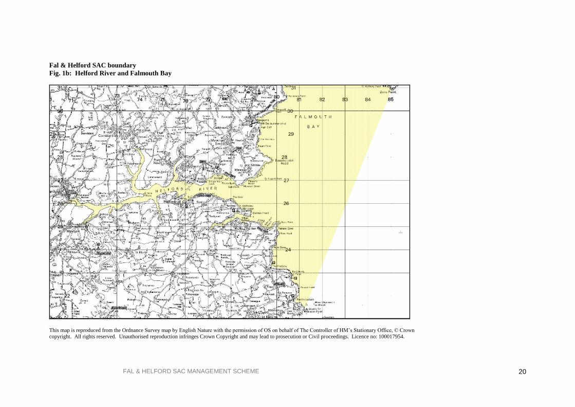
Fal & Helford SAC boundary
Fig. 1a: Fal Estuary
This map is reproduced from the Ordnance Survey map by English Nature with the permission of OS on behalf of The Controller
of HM‟s Stationary Office, © Crown copyright. All rights reserved. Unauthorised reproduction infringes Crown Copyright and may lead to prosecution or Civil proceedings. Licence no: 100017954.
FAL & HELFORD SAC MANAGEMENT SCHEME
20
Fal & Helford SAC boundary
Fig. 1b: Helford River and Falmouth Bay
This map is reproduced from the Ordnance Survey map by English Nature with the permission of OS on behalf of The Controller of HM‟s Stationary Office, © Crown
copyright. All rights reserved. Unauthorised reproduction infringes Crown Copyright and may lead to prosecution or Civil proceedings. Licence no: 100017954.
FAL & HELFORD SAC MANAGEMENT SCHEME
21
FAL & HELFORD SAC MANAGEMENT SCHEME
22

FAL & HELFORD SAC MANAGEMENT SCHEME
23
3. HUMAN ACTIVITIES IN AND AROUND THE SAC
In common with other estuaries, the Fal & Helford SAC site has a long history of human activity and
use, both around its shores and on its waters. Whilst the dominance of different activities has shifted,
from mining and the transport of goods and people, to ship repair and leisure, the area is still vitally
important to the economy of west Cornwall. In addition it provides a valuable recreational resource
both for local residents and visitors alike. It is important that this wide range of activities continues to
be accommodated within the overall management of the SAC whilst ensuring that the quality of the site
does not deteriorate.
This section briefly describes the ranges of activities, both commercial and recreational, that are known
to take place within the site and are relevant to the management and use of the SAC. More detail on all
these activities can be found in the Issues Reports and Strategic Guidelines produced by the Falmouth
Bay & Estuaries Initiative1.
Some activities that occur outside the SAC boundary are also of relevance, for example the discharge
of mine effluent from Wheal Jane into the Carnon River, and the potential eutrophication of waters
receiving agricultural run-off from around the catchments of both estuaries. These issues are dealt with
either through projects like Cycleau (www.cycleau.com) or through the ongoing work of the
Environment Agency.
Development issues are mentioned as an activity within the SAC although as section 3.3 explains these
do not form part of this plan as there are existing mechanisms for their resolution.
The role and composition of the Advisory Group, who represent the diverse range of both commercial
and recreational interests in this area, is explained below in section 3.4. Section 3.5 endeavours to
highlight the needs of users of this area, both recreational and commercial, and their aims for the SAC
site.
3.1. Commercial activities
Table 3 lists the commercial activities occurring in and around the SAC. Commercial activities that
support recreational or leisure pursuits, for example marinas and moorings, are also listed in this table.
3.2. Recreational activities
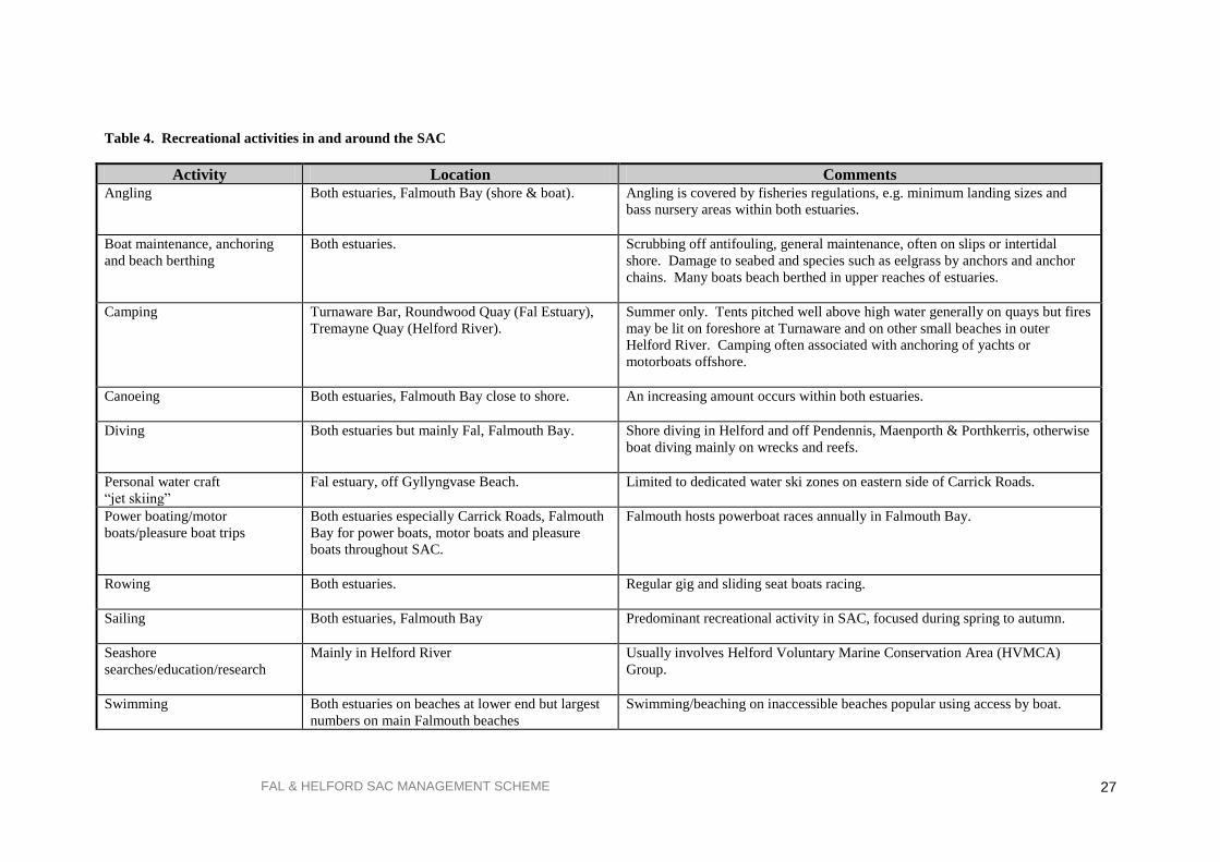
Table 4 lists the recreational activities occurring in and around the SAC in alphabetical order. As their
potential impact is generally less than for commercial activities, an assessment of their significance for
the SAC has not been made. However, an action has been included within Table 7 of this scheme to
monitor the level and pattern of recreational activities to inform future management decisions as
necessary. This list is not exhaustive but covers the main activities that occur on or adjacent to the
water.
1 Issues Report: Falmouth Bay & Estuaries Initiative 1995: Responses to Issues Report: Falmouth Bay & Estuaries
Initiative 1995: Strategic Guidelines Final Report: Falmouth Bay & Estuaries Initiative 1997.

FAL & HELFORD SAC MANAGEMENT SCHEME
24
Table 3. Commercial activities in and around the SAC
Activity Location Comments
1. Port activities & shipping
1.1. Bunkering (refuelling) and
ship-to-ship transfer of oil
Mainly in Carrick Roads & Falmouth Bay, light fuels only in King
Harry Passage.
One of largest bunkering facilities in W. Europe. Regulated by
UK Regulations and local Oil Spill Contingency Plan.
1.2. Ship maintenance and
repair
Falmouth Docks. Mainly in FD&EC‟s dry docks which are subject to Integrated
Pollution Control (IPC) Authorisation. Refit of luxury yachts and
other boats by Pendennis Shipyard. Some work alongside
wharves.
1.3. Shipping movements inc.
anchoring of ships, and laying
up of ships and oil rigs
Shipping movements and temporary anchoring mainly in Carrick
Roads, Falmouth Bay and King Harry Reach with coasters visiting
Truro. Ferries operate across Fal Estuary to St. Mawes and
Flushing and from Feock to the Roseland Peninsula on the King
Harry Ferry. Ferries also cross Helford River to Helford and
through a new park and float scheme go to the National Maritime
Museum and Trelissick National Trust Gardens. Lay-ups in King
Harry Passage for shipping, Carrick Roads for oil rigs.
No oilrigs currently present, but there have been up to two.
An Environmental Code of Conduct exists for laid up ships.
1.5. Dredging: maintenance and
capital
Small amounts of maintenance dredging in Truro & Penryn Rivers,
within Docks Basin and at Mylor Yacht Harbour. Capital dredging
related to specific projects.
Disposal site in Falmouth Bay, approx. 6 km from SAC
boundary. Only dredged material with low levels of
contamination is licensed for sea disposal.
1.4. Cargo handling Falmouth Docks.
Lighterage & Newham Quays, Truro.
Variety of packaged and bulk cargoes.
Transfer of bulk chemicals in Carrick Roads.
2. Fishing and mariculture
2.1. Factory ships Carrick Roads. Occasional disposal of fish wastes from onboard processing
activities
2.2. Scalloping Falmouth Bay. Trawling is illegal within the estuaries. A byelaw to ban the use
of scallop dredges in the Fal & Helford Estuaries was introduced
in 2005.

FAL & HELFORD SAC MANAGEMENT SCHEME
25
Activity Location Comments
2.3. Oyster dredging Upper Fal Estuary, Carrick Roads, Helford River. Licensed fishery for native oysters in Fal, dredging for re-laid
oysters by owner of beds in Helford.
2.4. Trawling Falmouth Bay. Limited amounts of trawling takes place in Falmouth Bay, but the
activity is banned within the estuaries.
2.5. Netting, potting, hand lining
& long lining
Falmouth Bay with some potting within the estuaries. Inshore boats mainly from Coverack, but also Mylor, St. Mawes,
Flushing, Falmouth, Cadgwith & Helford. Most boats will
alternate between these methods throughout the year.
2.6. Mariculture of oysters &
mussels
Carrick Roads, upper Fal Estuary, Percuil and Helford Rivers. Mussels grown on ropes off Truro Harbour pontoons, oysters
relaid on foreshore in Carrick Roads & upper Fal in Restronguet
Creek and on trestles in Percuil, subtidally in Helford. Mussel
mariculture regulated by Port of Truro and Falmouth & Truro
Port Health Authority.
2.7. Winkle, whelk, bait
collection & crab tiling
Fal & Helford estuaries. Ports of Truro & Penryn record bait digging in Truro area as part
of their Environmental Management System (EMS). A watching
brief should be kept on crab tiling developments.
3. Sewage/trade discharges Throughout SAC and catchment. Major discharges owned by SWWL but also from Falmouth
Docks and other private discharges.
3.1 Sewage Treatment Works Newham, Falmouth and St Mawes plus smaller works at
Constantine and Gweek
New STW brought on line at Falmouth in August 2000.
3.2 Combined Storm overflow Locations include Black Rock, Newham, Flushing, Falmouth & St
Mawes plus others
Brought on line by Clean Sweep programme
3.3 Trade discharges Throughout the catchment.
Regulated by the Environment Agency

FAL & HELFORD SAC MANAGEMENT SCHEME
26
Activity Location Comments
4. Maritime industries
4.1. Marinas, pontoons &
slipways
Falmouth Harbour, Penryn River, upper Truro River and lower
Tresillian River and Mylor harbour
Numerous small pontoons and slipways also associated with
yacht clubs, private dwellings and businesses in both estuaries, in
addition to marinas.
4.2. Boat maintenance and
repair
Boatyards in Truro, Falmouth, Penryn River, Mylor, Percuil,
Gweek and Devoran.
The Waste Management Plan covers boatyard activities within the
ports of Truro and Penryn. There may be potential, and funding,
to improve facilities for waste minimisation.
4.3. Moorings Both estuaries in upper reaches, concentrated in the lower reaches
and in harbour areas.
Variety of owners/managers, mainly harbour authorities. Ports of
Truro & Penryn have a moorings policy to maintain current
moorings levels.
5. Agriculture Widespread in catchments of both estuaries. Dairy, beef, sheep, vegetables and arable farms can be found.
6. Quarrying – China Clay Upper Fal Catchment China Clay Industry relevant to upper Fal catchment
FAL & HELFORD SAC MANAGEMENT SCHEME
27
Table 4. Recreational activities in and around the SAC
Activity Location Comments Angling Both estuaries, Falmouth Bay (shore & boat). Angling is covered by fisheries regulations, e.g. minimum landing sizes and
bass nursery areas within both estuaries.
Boat maintenance, anchoring
and beach berthing
Both estuaries. Scrubbing off antifouling, general maintenance, often on slips or intertidal
shore. Damage to seabed and species such as eelgrass by anchors and anchor
chains. Many boats beach berthed in upper reaches of estuaries.
Camping Turnaware Bar, Roundwood Quay (Fal Estuary),
Tremayne Quay (Helford River).
Summer only. Tents pitched well above high water generally on quays but fires
may be lit on foreshore at Turnaware and on other small beaches in outer
Helford River. Camping often associated with anchoring of yachts or
motorboats offshore.
Canoeing Both estuaries, Falmouth Bay close to shore.
An increasing amount occurs within both estuaries.
Diving Both estuaries but mainly Fal, Falmouth Bay. Shore diving in Helford and off Pendennis, Maenporth & Porthkerris, otherwise
boat diving mainly on wrecks and reefs.
Personal water craft
“jet skiing”
Fal estuary, off Gyllyngvase Beach. Limited to dedicated water ski zones on eastern side of Carrick Roads.
Power boating/motor
boats/pleasure boat trips
Both estuaries especially Carrick Roads, Falmouth
Bay for power boats, motor boats and pleasure
boats throughout SAC.
Falmouth hosts powerboat races annually in Falmouth Bay.
Rowing Both estuaries.
Regular gig and sliding seat boats racing.
Sailing Both estuaries, Falmouth Bay Predominant recreational activity in SAC, focused during spring to autumn.
Seashore
searches/education/research
Mainly in Helford River Usually involves Helford Voluntary Marine Conservation Area (HVMCA)
Group.
Swimming Both estuaries on beaches at lower end but largest
numbers on main Falmouth beaches
Swimming/beaching on inaccessible beaches popular using access by boat.

FAL & HELFORD SAC MANAGEMENT SCHEME
28
Activity Location Comments “Trigging” Muddy shores of Helford River and Gillan. Traditional Good Friday activity, involves collection of bivalves with
rakes/forks, often by 200+ people. This is monitored by the HVMCA Group.
Walking / dog walking / bird
watching
Around entire area where access possible, on
shores also at low water.
Access limited in upper sections of both estuaries.
Water skiing / Jet Skiing Carrick Roads, outer Helford River, off
Gyllyngvase Beach and occasionally off Godrevy
Beach near Manacle Point.
Limited to dedicated zones in Carrick Roads and off Gyllyngvase and seawards
of the speed limit in Helford.
Wildfowling Fal/Ruan Creek on Tregothnan Estate, around Pill
Creek and on south side of Restronguet Creek.
Shooting takes place on private foreshores/land. 3-4 shoots per year.
Windsurfing Both estuaries, mainly lower sections and off
Falmouth and Loe beach.
St. Mawes to Falmouth and Helford Passage to Helford busiest areas.

FAL & HELFORD SAC MANAGEMENT SCHEME
29
3.3. Development
In addition to the above activities, the Fal and Helford estuaries in particular are subject to development
pressure for new buildings, marinas, pontoons, land claim and slips, as well as development unrelated
to maritime activities. The Habitats Regulations deals with development issues and planning in Part
IV, in particular Regulations 48 -50. These Regulations are designed to ensure that any development,
referred to by the Regulations as a plan or project, does not have a adverse effect upon the interest
features of the site, through the undertaking of an appropriate assessment.
Under Regulation 48 (1), an appropriate assessment needs to be undertaken in respect of any plan or
project which:
(i) either alone or in combination with other plans or projects would be likely to have a
significant effect on the site; and
(ii) is not directly connected with the management of the site for nature conservation.
English Nature‟s guidance note is included as Appendix 2 for further information.
Regulation 50 requires competent authorities to undertake a review of all existing consents and
permissions affecting SACs as soon as is reasonably practical.
Carrick District Council‟s Planning Department has produced a publication1 to help their planning and
development control officers respond to the requirements of this legislation. This was backed up with a
seminar attended by officers from both Carrick and Kerrier to introduce the process and provide
background on SACs in general. English Nature also provided further guidance2 and an accompanying
seminar to all interested relevant authorities. There have already been a number of successful planning
applications within the SAC boundary, showing that this process will not necessarily prevent
development, but will ensure that it does not damage the important wildlife features of the site.
Cumulative small scale land claim has led to significant loss of estuarine habitats in the past. English
Nature, are currently producing a planning leaflet as guidance for developers on small intertidal
developments, for example slipways and jetties, and their cumulative effects.
The Shoreline Management Plan (SMP, written by the coastal group consisting of all Cornwall‟s Local
Planning Authorities – see bibliography) identifies the loss of intertidal and subtidal habitats to
inappropriate developments as a major threat in the Fal and Helford estuaries. The SMP identifies few
areas within the coastal zone appropriate for new defences and developments.
Development issues will be resolved on a case by case basis, and on their own merits relating to
relevant planning policies and legislation. Many of the relevant authorities and other interested
organisations will be consulted as part of normal planning procedures or as statutory consultees on
FEPA3 license and discharge consent applications.
3.4. Role of the Fal & Helford SAC Advisory Group
Both within the Habitats Directive and the 1998 DETR Guidance for marine sites, there is emphasis on
the need to take account of socio-economic and cultural issues when considering the future
management of the site. Decision-making should involve interested bodies other than the relevant
authorities and the views of local communities and users of this area should be considered when
developing and implementing any management measures.
In order to ensure that this happens an Advisory Group has been established. There are already a large
number of groups in existence whose remits cover various aspects of the uses of this area, either
1 Special Areas of Conservation: A Guide for Development Control, Carrick DC 1998. 2 The Habitats Directive & the Habitats Regulations: Notes of a presentation to local and other competent
authorities and English Nature, Truro, Nov. 1997. 3 License applications made through the Food & Environmental Protection Act 1985 usually to regulate the
disposal of dredged material or placing of structures below low water.

FAL & HELFORD SAC MANAGEMENT SCHEME
30
commercially or for recreation,. In many cases a group covers all uses of a specific part of the SAC, for
example the Helford Voluntary Marine Conservation Area Group covers the Helford River. Other
bodies, for example Carrick Harbour Sub-Committee, support the statutory management of, in this
case, the harbours of Penryn & Truro. There are also organisations which represent one sector of
activity, for example the Port of Truro Oystermen‟s Association. Historically there has not been one
body, which encompasses all sectors of interest across the entire SAC area.
The Fal & Helford SAC Advisory Group was established in April 1997. Its membership consists of
representatives from a range of interests including:
fishing & oyster fishing conservation recreation
commercial/shipping maritime industry landowners and residents
angling coastal management Parish & Town Councils
Further members may be co-opted onto the Advisory Group to ensure that the group is representative
of all estuary users. A member of the Advisory Group is nominated as Chair on a yearly basis and this
person attends the Management Forum meetings to represent the views of the Advisory Group and to
feedback.
The role of the Advisory Group is as follows:
to represent the interests of the users of the SAC within the development of the management
scheme
to represent the above interests in the ongoing management of the SAC
to act as a forum for general discussion of issues relevant to the group
to advise the Management Forum as necessary regarding issues relating to the SAC
to report back to other groups within each area of interest.
FAL & HELFORD SAC MANAGEMENT SCHEME
31
4. CONSERVATION OBJECTIVES
4.1. Introduction
English Nature, as the Government‟s nature conservation adviser in England, has a statutory
responsibility for developing conservation objectives to guide the management of the Fal & Helford
SAC.
The role of the conservation objectives is to express what needs to be achieved by all the relevant
authorities in order to maintain the „favourable condition‟ of the site, including both the habitats and
species it contains and thus deliver the aims of the Habitats Directive.
They act as a starting point from which the management scheme can be developed.
They provide the basis for assessing what types of activities are likely to have a significant effect
upon the interest features of the site
They form the basis for determining the scope of appropriate assessment for plans or projects
proposed within the SAC.
They provide a base for monitoring the condition of the site/features.
In addition to conservation objectives, English Nature, in collaboration with the other relevant
authorities, must also provide advice on any operations or activities, which may cause deterioration or
disturbance to the interest features of the site. Whilst these operations are listed in Section 5 of this
management scheme, they have previously been published, along with the conservation objectives and
supporting information within a stand alone document issued to the relevant authorities by English
Nature as their statutory advice under Regulation 33 of the Habitats Regulations. The following
sections are abbreviated from this advice, which is provided in full in Appendix 2.
4.2. Zoning map
The following sensitivity zoning map, Fig. 4, has been developed in addition to the conservation
objectives to provide a simple reference guide showing areas of differing sensitivity. The purpose of
these zones is to support the management of the site by identifying areas with similar management
needs and pressures.
Zone 1 contains generally the least sensitive habitats, whilst zone 4 identifies habitats that are generally
very sensitive:
1. Wider bay environment: mixed sand through to cobbles with mobile fish species and scallops.
2. Reef areas: rocky reefs with associated species e.g. pink sea fans, ross coral and kelp.
3. Intertidal mud and sand: finer sediments with associated burrowing species e.g. cockles and
lugworms.
4. Maerl and eelgrass beds on top of mixed shell and sandy sediments.

FAL & HELFORD SAC MANAGEMENT SCHEME
32

FAL & HELFORD SAC MANAGEMENT SCHEME
33
4.3. Conservation objectives
For each of the interest features, which for this site are all broad habitat types, there is one over-arching
conservation objective. In addition to the broad habitat type, there is a secondary list of sub-features
found within that habitat, to which the conservation objective also applies. The purpose of this is to
provide some reference points, against which the success of the conservation objectives and the
management plan can be measured. For example by looking at the distribution of subtidal kelp forests
within the large, shallow inlet and bay, or sand and muddy sand within intertidal sand and mudflats.
By monitoring the attributes of these features and sub-features, which have been identified to provide
an indication of the condition of the feature, it should be possible to identify trends or changes in these
habitats and whether or not these changes are natural or caused by human activities. This monitoring is
essential in order to ensure that these habitats are being kept in „favourable condition‟, the condition in
which the habitat or species is capable of sustaining itself on a long-term basis.
The conservation objectives for the Fal and Helford SAC are:
Conservation Objective 1 To maintain the LARGE SHALLOW INLET AND BAY in „favourable condition‟, taking account of
natural change, with particular reference to:
Rocky shore communities
Subtidal rock and boulder communities
Subtidal sandbank communities
Kelp forest communities
Intertidal mudflats
Saltmarsh
Conservation Objective 3 To maintain the SUBTIDAL SANDBANKS in „favourable condition‟, taking account of natural
change, with particular reference to:
Eelgrass bed communities
Maerl bed communities
Gravel and sand communities
Mixed sediment communities
Conservation Objective 2 To maintain the ESTUARIES in „favourable condition‟, taking account of natural change, with
particular reference to:
Intertidal mud communities
Subtidal mud communities
Intertidal mixed muddy sediment communities
Subtidal mixed muddy sediment communities
Estuarine bedrock, boulder and cobble communities
Subtidal sandbank communities
Saltmarsh communities
Reedbed communities

FAL & HELFORD SAC MANAGEMENT SCHEME
34
Conservation Objective 4 To maintain the INTERTIDAL SAND AND MUDFLATS in „favourable condition‟, taking account of
natural change, with particular reference to:
Intertidal sand and gravel communities
Intertidal muddy sand communities
Intertidal mud communities
Intertidal mixed muddy sediment communities
Conservation Objective 5 To maintain the SALTMARSH (ATLANTIC SALT MEADOW) in „favourable condition‟, taking
account of natural change, with particular reference to:
Low and low-mid marsh communities
Mid and mid-upper marsh communities
4.4. Advice on management implications
This section is designed to expand upon the conservation objectives listed above by highlighting the
major types of impact that may arise from operations or human activities that could affect the condition
of its habitats and species. In many cases these impacts can be regarded as processes, for example
smothering of the seabed, or changes in the tidal or wave regime, which may have resulted from one or
more operations or activities.
For each group of potential impacts or processes there may already be a variety of management
measures taking place to address these particular issues, for example contamination of waters and
sediments by an oil spill will be dealt with by implementation of the local Oil Spill Contingency Plan.
Section 5 on operations gives more detail in this respect, including the organisations involved in these
existing management measures.
Summary of advice on operations In order to meet the conservation objectives listed above the relevant and competent authorities are
advised to manage activities within their remit to avoid significant loss, damage or change to the
interest features of the site.
4.4.1. Large shallow inlets and bays In order to meet the above objectives, relevant and competent authorities are advised to manage
activities within their remit such that they do not result in:
removal and/or smothering
physical damage resulting from abrasion, siltation and/or selective extraction
Conservation Objective 6 To maintain the REEFS in „favourable condition‟, taking account of natural change, with particular
reference to:
Rocky shore communities
Kelp forest communities
Subtidal rock and boulder communities
Estuarine bedrock, boulder and cobble communities

FAL & HELFORD SAC MANAGEMENT SCHEME
35
increased synthetic (e.g. TBT, PCBs) and/or non synthetic toxic contamination (e.g. heavy metals
and oil)
nutrient and/or organic enrichment
increases in turbidity
biological disturbance through introduction and/or translocation of non-native species
4.4.2. Estuaries In order to meet the above objectives, relevant and competent authorities are advised to manage
activities within their remit such that they do not result in:
removal of habitat
physical damage including siltation and abrasion
toxic contamination of synthetic compounds (e.g. TBT, PCBs)
toxic contamination of non-synthetic compounds (e.g. heavy metals, hydrocarbons)
non-toxic contamination by nutrient or organic enrichment
biological disturbance by selective extraction of species
4.4.3. Subtidal sandbanks In order to meet the above objectives, relevant and competent authorities are advised to manage
activities within their remit such that they do not result in:
removal and/or smothering
physical damage resulting from siltation, abrasion and/or selective extraction
increased synthetic and/or non-synthetic toxic contamination
nutrient and/or organic enrichment
increases in turbidity
4.4.4. Intertidal mud and sandflats In order to meet the above objectives, relevant and competent authorities are advised to manage
activities within their remit such that they do not result in:
removal of habitats
physical damage resulting from selective extraction
increased synthetic and/or non-synthetic toxic contamination
nutrient and/or organic enrichment
4.4.5. Saltmarsh (Atlantic salt meadow) In order to meet the above objectives, relevant and competent authorities are advised to manage
activities within their remit such that they do not result in:
removal of habitat
increased synthetic and/or non-synthetic toxic contamination
4.4.6. Reefs In order to meet the above objectives, relevant and competent authorities are advised to manage
activities within their remit such that they do not result in:
removal of habitat
decrease to the extent, distribution, diversity and species richness of reef communities
Most of the above are likely to arise through development, coastal defence works or the siting of large
offshore structures. Consequently most of these issues will be resolved through the assessment of plans
and projects under the Habitats Regulations.

FAL & HELFORD SAC MANAGEMENT SCHEME
36
The remainder from above should be addressed by the following measures:
(i) Compliance with relevant EC Directives, UK Regulations and standards on water quality.
(ii) Updating and implementation of the Oil Spill Contingency Plans through enaction of the new
Oil Pollution Preparedness, Response & Co-operation (OPRC) Regulations.
(iii) Implementation of the harbour authority environmental management systems and waste
management plans, where they exist.
4.5. Outline of monitoring requirements
4.5.1. Introduction
In order to establish whether or not the above conservation objectives are being met, a monitoring
programme needs to be established and executed. The scope of the monitoring must be sufficient that
it covers all the conservation features and sub-features of interest, and wherever possible builds on
existing monitoring work to reduce costs. As this is a complex task, only an outline of the monitoring
requirements and approach are given in this management scheme.
The „favourable condition‟ table in English Nature's Regulation 33 advice (see Appendix 2)
supplements the conservation objectives and supports the identification of future monitoring
requirements of the condition of the site and its features.
Other data such as results from compliance monitoring and appropriate assessments will also have an
important role in assessing condition, and contribute to monitoring of the site.
4.5.2. SAC monitoring priorities
Monitoring will add to the existing baseline of information and where appropriate existing survey work
will be repeated in order to ensure that it conforms to the agreed monitoring methods. The following
areas or habitats are priorities for monitoring. Initial condition monitoring of subtidal interest features
has been undertaken by English Nature and this, along with other existing data, will form the baseline
against which future changes will be assessed.
Live maerl and eelgrass For habitats like eelgrass or live maerl a survey of its distribution and species counts in sample
areas will probably provide sufficient information. Information was collected in the mid 1980s on
the St. Mawes Bank area, and eelgrass has been monitored for the last 3 years in the Helford River.
Further work on establishing extent of eelgrass beds in the Percuil River and St. Mawes Harbour
was carried out in August 1999, in addition to a survey of the live maerl beds in this area and on St.
Mawes Bank. This monitoring of maerl habitats has been undertaken by English Nature.
Dead maerl The survey by English Nature of dead maerl species (1997) provided information on species present
in specific areas of dead maerl within the Fal Estuary. Complementary information of a reasonable
quality is available from the RoxAnn (acoustic mapping) survey (1994) for the Fal Estuary and
inner Falmouth Bay. Further work has been undertaken by Falmouth Harbour Commissioners.
Rocky shores Rocky shores can be assessed for the types of species or groups of species (biotopes) using Marine
Nature Conservation Review (MNCR) techniques. Survey work (September-November 1998) has
established baseline information for all rocky shores around the SAC. Maps and digital outputs
from this survey are available from English Nature.

FAL & HELFORD SAC MANAGEMENT SCHEME
37
Saltmarsh Survey information on saltmarshes dates back to 1986 and has since been revisited by English
Nature using well established techniques (National Vegetation Classification). Of all the habitats
present within the SAC, this is the most straightforward to monitor.
Intertidal mudflats The existing extent of intertidal mudflats has been documented using 1:10 000 aerial photographs
flown in winter 2000/01. This will need supplementing by sediment cores to look at the structure of
the mudflats and the species that they contain in order to provide information on the quality of the
habitat.
Reefs Little detailed information exists for the kelp beds and subtidal reef habitats in Falmouth Bay,
however survey work undertaken in 2002 established baseline information for these areas, and
defined areas for future monitoring.
Estuaries
Monitoring of estuarine interest will be undertaken during monitoring of other interest features
(such as intertidal reefs, mudflats and subtidal sandbanks).
4.5.3. Monitoring for „favourable condition‟
Determining the level of detail required for monitoring the SAC is the responsibility of English Nature,
who is also charged with leading on „condition monitoring‟. The following table (Table 5) outlines the
various types of monitoring that English Nature feel are necessary in order to be able to assess the
„condition‟ of the SAC‟s interest features (habitats and species). „Condition‟ is essentially a measure of
the health of the habitats and species and whether or not they are capable of sustaining themselves on a
long-term basis. It can show where existing strongholds are maintained, or where they are increasing or
showing signs of damage and/or loss. By monitoring various aspects or „attributes‟ of these features, it
is possible to build up a picture of what is happening to the site and whether or not there needs to be
changes made to the ways in which it is managed. The aim is to ensure that the interest features remain
in a „favourable condition‟, which can be said to occur when the target for each attribute is reached.
In addition to condition monitoring carried out by English Nature, compliance monitoring (where the
relevant authorities are responsible for monitoring enforcement of those measures within the
management scheme that fall within their functions) will also contribute to ongoing assessment of
„favourable condition‟. Table 6, which identifies management actions for the site, identifies any
actions required for compliance monitoring and the relevant authorities in each case.

FAL & HELFORD SAC MANAGEMENT SCHEME
38
Table 5. „Favourable condition‟ table for the Fal and Helford SAC
Feature
Sub-feature
Attribute
Measure
Target
Comments
Large shallow
inlet and bay
Extent
Area (ha) of the large
shallow inlet and bay,
measured periodically
(frequency to be
determined).
No decrease in extent from
an established baseline,
subject to natural change.
Extent is an attribute on which reporting is required by
the Habitats Directive. The extent of the large shallow
inlet and bay will not change significantly over time
unless due to some human activity but nevertheless
needs to be measured periodically.
Water clarity
Average light attenuation
measured periodically
throughout the reporting
cycle (frequency to be
determined).
Average light attenuation
should not deviate
significantly from the
established baseline,
subject to natural change.
Water clarity is important for maintaining extent and
density of algal and plant dominated communities.
Clarity decreases through increases in amounts of
suspended organic/inorganic matter.
Nutrient status -
phytoplankton
concentration
Average phytoplankton
concentration in summer
measured annually.
No significant increase in
phytoplankton
concentration from the
established baseline,
subject to natural change.
Nutrient enrichment stimulating excessive growth of
phytoplankton is a common factor contributing to a
reduction in water clarity. Single species-dominated
phytoplankton blooms can also have harmful effects on
shellfish and are known to occur in the Fal.
Saltmarsh
communities
Attributes and targets for this sub-feature are listed under the „Atlantic Salt Meadows‟ interest feature covered in other sections of this
table.
Intertidal
mudflat and
sandflat
communities
Attributes and targets for this sub-feature are listed under the „Intertidal mudflats and sandflats‟ interest feature covered in other sections
of this table.
Rocky shore
communities,
Kelp forest
communities,
Subtidal rock
+ boulders
Attributes and targets for this sub-feature are listed under the „Reefs‟ interest feature covered in other sections of this table.

FAL & HELFORD SAC MANAGEMENT SCHEME
39
Feature
Sub-feature
Attribute
Measure
Target
Comments
Large shallow
inlet and bay (cont.)
Subtidal
sandbank
communities
Attributes and targets for this sub-feature are listed under the „Subtidal sandbanks‟ interest feature covered in other sections of this table.
Subtidal mud
communities
Species
composition of
characteristic
biotopes
Presence and occurrence of
composite species from
some or all of the biotopes.
Measured during summer,
once during reporting
cycle.
Presence and abundance of
composite species should
not deviate significantly
from an established
baseline, subject to natural
change.
Species composition is an important contributor to the
structure of the biotopes within the sub-feature. The
presence and relative abundance of characterising
species gives an indication of the quality of the
biotopes and change in composition may indicate
cyclic change/trend in subtidal mud communities. Subtidal
sandbanks
Extent
Area (ha) of the subtidal
sandbanks measured
periodically (frequency to
be determined).
No decrease in extent from
an established baseline,
subject to natural change.
Extent of the feature is a reporting requirement of the
Habitats Directive. Monitoring will need to take
account of the dynamic nature of the feature but
reduction in extent may indicate long term changes in
the physical conditions influencing the feature.
Sediment
character
Particle size analysis
(PSA). Parameters include
percentage sand/silt/gravel,
mean & median grain size,
and sorting coefficient,
used to characterise
sediment type. Sediment
character to be measured
during summer once
during reporting cycle.
Average PSA parameters
should not deviate
significantly from an
established baseline,
subject to natural change.
Sediment character defined by PSA is key to the
structure of the feature, and reflects all of the physical
processes acting on it. Particle size composition varies
across the feature and can be used to indicate spatial
distribution of sediment types thus reflecting the
stability of the feature and the processes supporting it.
Topography
Depth distribution of
sandbanks from selected
sites, measured
periodically (frequency to
be determined).
Depth distribution should
not deviate significantly
from an established
baseline, subject to natural
change.
Depth and distribution of the sandbanks reflects the
energy conditions and stability of the sediment, which
is key to the structure of the feature. Depth of the
feature is a major influence on the distribution of
communities throughout.

FAL & HELFORD SAC MANAGEMENT SCHEME
40
Feature
Sub-feature
Attribute
Measure
Target
Comments
Subtidal
sandbanks
(cont.)
Water density
Average temperature/
salinity in the subtidal
measured periodically
throughout the reporting
cycle (frequency to be
determined).
Average temperature/
salinity should not deviate
significantly from an
established baseline,
subject to natural change.
Temperature and salinity are characteristic of the
overall hydrography of the area. Changes in
temperature and salinity influences the presence and
distribution of species (along with recruitment
processes and spawning behaviour) including those at
the edge of their geographic ranges and non-natives.
Eelgrass bed
communities
(Zostera
marina)
Extent
Area (ha) of eelgrass beds
measured during peak
growth period twice during
reporting cycle.
No decrease in extent from
an established baseline,
subject to natural change.
The extent and distribution of eelgrass beds provides a
long-term integrated measure of environmental
conditions.
Characteristic
epiphytic species -
density of Zostera
marina
Average density, measured
during peak growth period
twice during reporting
cycle.
Average density should not
deviate significantly from
an established baseline,
subject to natural change.
An early indicator of seagrass under stress is a
reduction in biomass, i.e. the number and length of
leaves. Density is preferred as a surrogate for biomass,
being less destructive, based on baseline survey to
establish the relationship between density and biomass
at a site.
Characteristic
species - epiphytic
community
Presence and abundance of
epiphytic species
measured during summer
twice during reporting
cycle.
Presence and abundance of
epiphytic species should
not deviate significantly
from the established
baseline, subject to natural
change.
The occurrence and frequency of epiphytes is
indicative of the structure of the eelgrass bed
communities. It gives an indication of their quality and
changes in epiphytic composition may indicate cyclic
change/trend in the host biotope or the subtidal
sandbank communities as a whole.
Nutrient status -
green algal mat
Extent across whole or
parts of site, measured
during peak growth period
every 3 years during
reporting cycle.
No increase in extent of
green algal mats from an
established baseline,
subject to natural change.
Nutrient status is a key functional factor that influences
the sub-feature as opportunistic macroalage compete
with seagrass and affect the associated species.
Increase in filamentous green algae may be a related
natural phenomenon or may indicate eutrophication.

FAL & HELFORD SAC MANAGEMENT SCHEME
41
Feature
Sub-feature
Attribute
Measure
Target
Comments
Subtidal
sandbanks
(cont.)
Maerl bed
communities
Extent
Area (ha) of maerl (live &
dead maerl), measured
once during reporting
cycle.
No decrease in extent of
maerl as whole, or of
either dead or live maerl,
from an established
baseline, subject to natural
change.
The extent of maerl beds (and distribution of live and
dead components within the beds) is key to their
structural and functional importance. Extent provides a
long-term integrated measure of environmental
conditions and any loss is likely to be long-term.
Distribution of
maerl bed
communities
Distribution of maerl bed
communities. Measured
once per reporting cycle.
Distribution of maerl bed
communities should not
deviate significantly from
an established baseline,
subject to natural change.
The relative distribution of the biotopes is an important
structural aspect of the feature. Changes in relative
extent and distribution may indicate long term changes
in the physical conditions influencing the feature.
Species
composition of
maerl bed
communities
Presence and abundance of
composite species of
biotopes from maerl areas.
Measured during summer,
one during reporting cycle.
Presence and abundance of
composite species should
not deviate significantly
from an established
baseline, subject to natural
change.
Species composition is an important contributor to the
structure of the live maerl bed. The presence and
relative abundance of characterising species gives an
indication of the quality of the biotopes and change in
composition may indicate cyclic change/trend in
sediment communities. Live maerl is species rich and
contains rare algal species which are relatively stable,
making this habitat a good indicator of the condition of
the subtidal sandbanks.
Nutrient status -
green algal mats
Extent measured during
peak growth period.
Measured once during
reporting cycle.
No increase in extent of
algal mats from an
established baseline,
subject to natural change.
Heavy overgrowth of filamentous green algae, in
response to nutrient enrichment, will reduce light
levels to maerl and is therefore likely to affect maerl
growth rates and may affect associated algal diversity.

FAL & HELFORD SAC MANAGEMENT SCHEME
42
Feature
Sub-feature
Attribute
Measure
Target
Comments
Subtidal
sandbanks
(cont.)
Gravel and
sand
communities
Species
composition of
characteristic
biotopes
Presence and abundance of
composite species from
some or all of the biotopes.
Measured during summer,
once during reporting
cycle.
Presence and abundance of
composite species should
not deviate significantly
from an established
baseline, subject to natural
change.
Species composition is an important contributor to the
structure of the biotopes within the sub-feature. The
presence and relative abundance of characterising
species gives an indication of the quality of the
biotopes and change in composition may indicate
cyclic change/trend in subtidal sandbank communities.
Mixed
sediment
communities
Species
composition of
characteristic
biotopes
Frequency and occurrence
of composite species from
some or all of the biotopes.
Measured during summer,
once during reporting
cycle.
Presence and abundance of
composite species from
some or all of the biotopes.
Measured during summer,
once during reporting
cycle.
Species composition is an important contributor to the
structure of the biotopes within the sub-feature. The
presence and relative abundance of characterising
species gives an indication of the quality of the
biotopes and change in composition may indicate
cyclic change/trend in subtidal sandbank communities. Intertidal
mudflats and
sandflats
Extent
Area of intertidal mudflats
and sandflats measured
periodically (frequency to
be determined).
No decrease in extent from
an established baseline,
subject to natural change.
Extent is an attribute on which reporting is required by
the Habitats Directive. Loss of intertidal mud
communities is likely to be detrimental to the structure
of the feature, e.g. associated with a change in
sediment budget or geomorphological regime, and may
indicate long term changes in the physical conditions
of the feature.
Sediment
character
1. Particle size analysis.
Parameters include
percentage sand/silt/gravel,
mean and median grain
size, and sorting
coefficient, used to
characterise sediment type.
Measured in summer once
during reporting cycle.
Particle size parameters
should not deviate
significantly from an
established baseline,
subject to natural change.
Sediment character defined by particle size analysis is
key to the structure of the feature, and reflects all of the
physical processes acting on it. Particle size
composition varies across the feature and can be used
to indicate spatial distribution of sediment types thus
reflecting the stability of the feature and the processes
supporting it.

FAL & HELFORD SAC MANAGEMENT SCHEME
43
Feature
Sub-feature
Attribute
Measure
Target
Comments
Intertidal
mudflats and
sandflats (cont.)
2. Sediment penetrability.
Degree of sinking.
Average measure should
not deviate significantly
from an established
baseline, subject to natural
change.
Penetrability is an indicator of sediment stability,
degree of compaction indicates the shear strength of
the sediment and thus the susceptibility of that
sediment type to erosion. Compaction of the sediment
influences the biological community within the
sediment.
Topography
Tidal elevation and shore
slope, measured
periodically (frequency to
be determined).
Shore profile
measurements should not
deviate significantly from
an established baseline,
subject to natural change.
In the intertidal topography reflects the energy
conditions and stability of the sediment, which is key
to the structure of the feature. Topography is a major
influence on the distribution of communities
throughout the feature. Measuring topography may
also indicate the position of channels through the
feature, which is another important indicator of the
processes influencing the feature.
Nutrient status -
green algal mats
Extent of green algal mats,
measured during summer,
annually throughout the
summer.
Extent of green algal mats
should not increase from
an established baseline,
subject to natural change.
Nutrient status is a key functional factor that influences
biota associated with sediments including infauna as
well as plants/algae at the surface. Green algae provide
an indication of elevated nutrient levels since they
respond by increased extent or abundance. Further,
mats of green algae, where they increase, both directly
and indirectly affect sediment structure and function,
primarily through smothering and associated
deoxygenation.
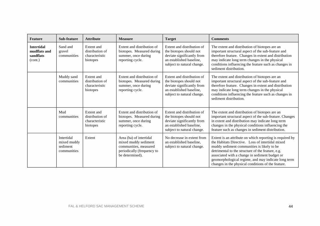
FAL & HELFORD SAC MANAGEMENT SCHEME
44
Feature
Sub-feature
Attribute
Measure
Target
Comments
Intertidal
mudflats and
sandflats
(cont.)
Sand and
gravel
communities
Extent and
distribution of
characteristic
biotopes
Extent and distribution of
biotopes. Measured during
summer, once during
reporting cycle.
Extent and distribution of
the biotopes should not
deviate significantly from
an established baseline,
subject to natural change.
The extent and distribution of biotopes are an
important structural aspect of the sub-feature and
therefore feature. Changes in extent and distribution
may indicate long term changes in the physical
conditions influencing the feature such as changes in
sediment distribution.
Muddy sand
communities
Extent and
distribution of
characteristic
biotopes
Extent and distribution of
biotopes. Measured during
summer, once during
reporting cycle.
Extent and distribution of
the biotopes should not
deviate significantly from
an established baseline,
subject to natural change.
The extent and distribution of biotopes are an
important structural aspect of the sub-feature and
therefore feature. Changes in extent and distribution
may indicate long term changes in the physical
conditions influencing the feature such as changes in
sediment distribution.
Mud
communities
Extent and
distribution of
characteristic
biotopes
Extent and distribution of
biotopes. Measured during
summer, once during
reporting cycle.
Extent and distribution of
the biotopes should not
deviate significantly from
an established baseline,
subject to natural change.
The extent and distribution of biotopes are an
important structural aspect of the sub-feature. Changes
in extent and distribution may indicate long term
changes in the physical conditions influencing the
feature such as changes in sediment distribution.
Intertidal
mixed muddy
sediment
communities
Extent
Area (ha) of intertidal
mixed muddy sediment
communities, measured
periodically (frequency to
be determined).
No decrease in extent from
an established baseline,
subject to natural change.
Extent is an attribute on which reporting is required by
the Habitats Directive. Loss of intertidal mixed
muddy sediment communities is likely to be
detrimental to the structure of the feature, e.g.
associated with a change in sediment budget or
geomorphological regime, and may indicate long term
changes in the physical conditions of the feature.

FAL & HELFORD SAC MANAGEMENT SCHEME
45
Feature
Sub-feature
Attribute
Measure
Target
Comments
Atlantic salt
meadows*
Extent
Area (ha) of Atlantic salt
meadows measured once
during the reporting cycle.
No decrease in extent of
Atlantic salt meadows
from an established
baseline, subject to natural
change.
Monitoring will need to take account of the dynamic
nature of some of these habitats. A reduction in extent
could be further indicated by ground survey to assess
for signs of erosion-toppled vegetated blocks; stepping
of saltmarsh edge; signs of stress/damage to plants.
Extent needs to be measured at low tide.
Creek patterns Creek density and
morphology measured
periodically during
reporting cycle (frequency
to be determined).
No significant alteration of
creek patterns from an
established baseline,
subject to natural change.
Creeks absorb tidal energy and assist with the delivery
of sediment into saltmarshes. The efficiency of this
process depends on creek pattern. Density is
controlled by vegetation cover, suspended sediment
load and tidal influence. Creeks allow pioneer
vegetation to be established along their banks higher
into the saltmarsh system.
Range and
distribution of
characteristic
NVC saltmarsh
communities.
Presence and distribution
of characteristic saltmarsh
communities measured
once during reporting
cycle.
Range and distribution of
characteristic saltmarsh
communities should not
deviate significantly from
the established baseline,
subject to natural change.
Sites with the greatest range of community types
considered typical for the site from low, mid to upper
saltmarsh and transition to other habitats are in most
favourable condition. (NVC communities: SM8,
SM10, SM11, SM13, SM15, SM16, SM18, SM24).
Vegetation
structure
Range and distribution of
varying heights of
vegetation measured
periodically (frequency to
be determined).
Vegetation structure
should not deviate
significantly from an
established baseline,
subject to natural change.
Vegetation structure is largely affected by the impact
of grazing interacting with different vegetation
communities. Not all saltmarshes are grazed; removal
or introduction of grazing can result in changes to plant
community composition. *Low, mid and upper saltmarsh and zonations between these are considered to be sub-features of Atlantic salt meadows. These may exhibit considerable variation, and NVC
communities have been assigned to each sub-feature, according to The Saltmarsh Survey of Great Britain (Burd 1989). The presence of these on an individual site and their
position within the saltmarsh zonation will need to be established by surveys which may also identify sub-communities typical of that site

FAL & HELFORD SAC MANAGEMENT SCHEME
46
Feature
Sub-feature
Attribute
Measure
Target
Comments
Atlantic salt
meadows
(cont.)
Low Marsh
and Low-Mid
Marsh
communities
Characterising
species of:
1.Transitional low
marsh vegetation
with Puccinellia
maritima, annual
Salicornia species
and Sueda
maritima SM10.
Frequency and abundance
of characterising species,
particularly of:
1. Puccinellia
maritima, annual
Salicornia species and
Sueda maritima. Measured
once during reporting
cycle.
Frequency and abundance
of characteristic species of
low and low-mid marsh
communities should not
deviate significantly from
an established baseline
subject to natural change
1. Tends to be species -poor, with the three main
species often co-dominant. Cover of vegetation can be
quite variable and may have up to 50% cover of an
algal mat. Grazing can affect stands by selective
removal of some species and causing loss of structural
diversity.
2. Aster tripolium
var. discoides
saltmarsh SM11.
2. A.tripolium var.
discoides. 2. Occurs in extensive stands in low marsh or on creek
sides throughout the marsh. Usually on ungrazed sites.
3. Puccinellia
maritima
saltmarsh SM13
3. P. maritima with
Triglochin maritima,
Plantago maritima,
Armeria maritime.
3. Most widespread type of saltmarsh vegetation in the
UK. Grazing determines species composition and type
of sub-community and structural variation. Can often
develop after damage, turf -cutting etc. Also found in
mid-upper marsh.
Mid and Mid-
Upper marsh
Characterising
species of:
1. Juncus
maritimus-
Triglochin
maritima
saltmarsh SM15.
Frequency and abundance
of characterising species,
particularly of:
1. Juncus maritimus
Frequency and abundance
of characteristic species of
low and low-mid marsh
communities should not
deviate significantly from
an established baseline
subject to natural change.
1. Can occur at all levels in a saltmarsh. Tussocky
nature of J. maritimus discourages grazing by stock.
Widespread in England.
2 .Festuca rubra
saltmarsh SM16
2. Festuca rubra and
Juncus gerardii 2. Covers extensive areas of saltmarsh. Usually present
on grazed marshes. Can be variable according to local
conditions.
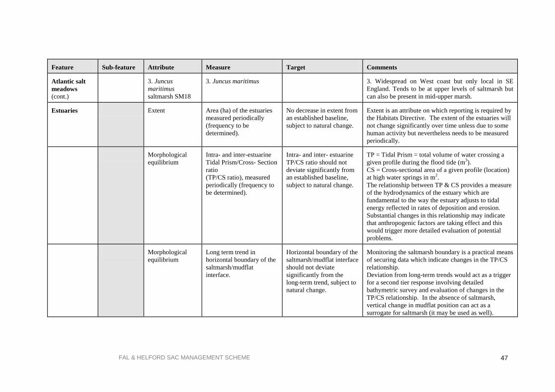
FAL & HELFORD SAC MANAGEMENT SCHEME
47
Feature
Sub-feature
Attribute
Measure
Target
Comments
Atlantic salt
meadows
(cont.)
3. Juncus
maritimus
saltmarsh SM18
3. Juncus maritimus
3. Widespread on West coast but only local in SE
England. Tends to be at upper levels of saltmarsh but
can also be present in mid-upper marsh. Estuaries
Extent
Area (ha) of the estuaries
measured periodically
(frequency to be
determined).
No decrease in extent from
an established baseline,
subject to natural change.
Extent is an attribute on which reporting is required by
the Habitats Directive. The extent of the estuaries will
not change significantly over time unless due to some
human activity but nevertheless needs to be measured
periodically.
Morphological
equilibrium
Intra- and inter-estuarine
Tidal Prism/Cross- Section
ratio
(TP/CS ratio), measured
periodically (frequency to
be determined).
Intra- and inter- estuarine
TP/CS ratio should not
deviate significantly from
an established baseline,
subject to natural change.
TP = Tidal Prism = total volume of water crossing a
given profile during the flood tide (m3).
CS = Cross-sectional area of a given profile (location)
at high water springs in m2.
The relationship between TP & CS provides a measure
of the hydrodynamics of the estuary which are
fundamental to the way the estuary adjusts to tidal
energy reflected in rates of deposition and erosion.
Substantial changes in this relationship may indicate
that anthropogenic factors are taking effect and this
would trigger more detailed evaluation of potential
problems.
Morphological
equilibrium
Long term trend in
horizontal boundary of the
saltmarsh/mudflat
interface.
Horizontal boundary of the
saltmarsh/mudflat interface
should not deviate
significantly from the
long-term trend, subject to
natural change.
Monitoring the saltmarsh boundary is a practical means
of securing data which indicate changes in the TP/CS
relationship.
Deviation from long-term trends would act as a trigger
for a second tier response involving detailed
bathymetric survey and evaluation of changes in the
TP/CS relationship. In the absence of saltmarsh,
vertical change in mudflat position can act as a
surrogate for saltmarsh (it may be used as well).

FAL & HELFORD SAC MANAGEMENT SCHEME
48
Feature
Sub-feature
Attribute
Measure
Target
Comments
Estuaries (cont.)
Nutrient status
Average phytoplankton
concentration in summer,
measured annually.
No significant deviation
from an established
baseline, subject to natural
change.
Nutrient enrichment stimulating excessive growth of
phytoplankton is a common factor contributing to a
reduction in water clarity. Single species-dominated
phytoplankton blooms can also have harmful effects on
shellfish.
Intertidal mud
communities
& intertidal
mixed muddy
sediment
communities
Attributes and targets for this sub-feature are listed under the „Intertidal mudflats‟ interest feature covered in other sections of this table.
Subtidal mud
communities
Extent
Area (ha) of subtidal mud
communities, measured
periodically (frequency to
be determined).
No decrease in extent from
an established baseline,
subject to natural change.
Extent is an attribute on which reporting is required by
the Habitats Directive. Loss of subtidal mud
communities is likely to be detrimental to the structure
of the feature, e.g. leading to associated loss of
intertidal sediments, and may indicate long term
changes in the physical conditions of the feature.
Subtidal
mixed muddy
sediment
communities
Extent
Area (ha) of subtidal
mixed muddy sediment
communities, measured
periodically (frequency to
be determined).
No decrease in extent from
an established baseline,
subject to natural change.
Extent is an attribute on which reporting is required by
the Habitats Directive. Loss of subtidal mixed
sediment communities is likely to be detrimental to the
structure of the feature, e.g. leading to associated loss
of intertidal sediments, and may indicate long term
changes in the physical conditions of the feature.
Extent and
distribution of
characteristic
biotopes (CuSH,
HarCon)
Extent and distribution of
biotopes (CuSH, HarCon),
measured once during
reporting cycle.
Extent and distribution of
biotopes should not deviate
significantly from an
established baseline,
subject to natural change.
The extent of these biotopes and their relative
distribution is an important structural aspect of the
feature. Changes in their extent and distribution may
indicate long term changes in the physical conditions
of the estuarine complex.
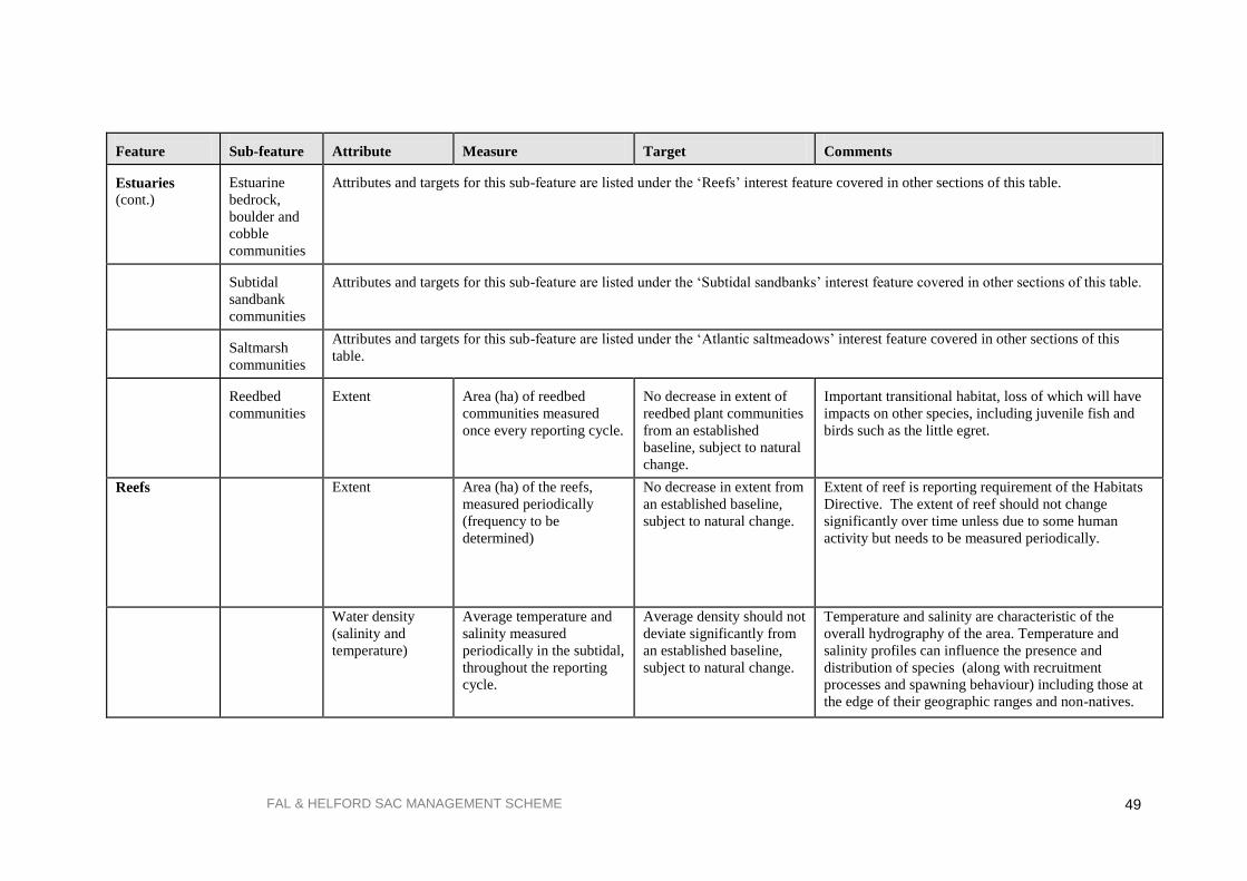
FAL & HELFORD SAC MANAGEMENT SCHEME
49
Feature
Sub-feature
Attribute
Measure
Target
Comments
Estuaries (cont.)
Estuarine
bedrock,
boulder and
cobble
communities
Attributes and targets for this sub-feature are listed under the „Reefs‟ interest feature covered in other sections of this table.
Subtidal
sandbank
communities
Attributes and targets for this sub-feature are listed under the „Subtidal sandbanks‟ interest feature covered in other sections of this table.
Saltmarsh
communities
Attributes and targets for this sub-feature are listed under the „Atlantic saltmeadows‟ interest feature covered in other sections of this
table.
Reedbed
communities
Extent
Area (ha) of reedbed
communities measured
once every reporting cycle.
No decrease in extent of
reedbed plant communities
from an established
baseline, subject to natural
change.
Important transitional habitat, loss of which will have
impacts on other species, including juvenile fish and
birds such as the little egret.
Reefs
Extent Area (ha) of the reefs,
measured periodically
(frequency to be
determined)
No decrease in extent from
an established baseline,
subject to natural change.
Extent of reef is reporting requirement of the Habitats
Directive. The extent of reef should not change
significantly over time unless due to some human
activity but needs to be measured periodically.
Water density
(salinity and
temperature)
Average temperature and
salinity measured
periodically in the subtidal,
throughout the reporting
cycle.
Average density should not
deviate significantly from
an established baseline,
subject to natural change.
Temperature and salinity are characteristic of the
overall hydrography of the area. Temperature and
salinity profiles can influence the presence and
distribution of species (along with recruitment
processes and spawning behaviour) including those at
the edge of their geographic ranges and non-natives.

FAL & HELFORD SAC MANAGEMENT SCHEME
50
Feature
Sub-feature
Attribute
Measure
Target
Comments
Reefs (cont.) Water clarity
Average light attenuation
measured periodically
throughout the reporting
cycle (frequency to be
determined).
Average light attenuation
should not deviate
significantly from an
established baseline,
subject to natural change.
Water clarity is a key process influencing algal/plant
growth, density and extent and hence, algal/plant
dominated biotopes. Changes in water clarity may be
caused by increases in suspended material due to a
range of processes.
Rocky shore
communities
Distribution of
rocky shore
communities
Distribution of intertidal
rocky shore biotopes
measured using littoral
extent during the summer,
once during reporting
cycle.
Distribution of intertidal
rocky shore biotopes
should not deviate
significantly from an
established baseline,
subject to natural change.
The distribution of rocky shore biotopes is an
important structural aspect of the site. Changes in
extent and distribution may indicate long term changes
in the physical conditions at the site.
Species
composition of
low-shore boulder
communities
Presence and abundance of
composite species from
biotope MLR.Fse.Bo.
Measured during summer,
twice during reporting
cycle.
Presence and abundance of
composite species should
not deviate significantly
from the established
baseline, subject to natural
change.
The presence and relative abundance of characterising
species gives an indication of the quality of
MLR.Fse.Bo (Fucus serratus and under-boulder fauna
on lower eulittoral boulders) and change in
composition may indicate cyclic change/trend in rocky
shore communities. Change in composition may also
indicate changes in hydrography, salinity and/or
siltation.
Species
composition of
rockpool
communities
Presence and abundance of
composite species and
percentage cover of
Sargassum muticum
(Japweed) from a
representative series of
rockpools, measured
during summer twice
during reporting cycle.
Presence and abundance of
composite species should
not deviate significantly
from the established
baseline, subject to natural
change. Average
percentage cover of
Sargassum should not
increase from the
established baseline.
Composite species of rockpools include many
southwestern species, their relative abundance gives an
indication of the quality of the rockpools and are key
structural components of the intertidal rocky shores.
Increased Sargassum is believed to compete with
native species and would thus be detrimental to
favourable condition.

FAL & HELFORD SAC MANAGEMENT SCHEME
51
Feature
Sub-feature
Attribute
Measure
Target
Comments
Reefs
(cont.)
Kelp forest
communities
Distribution of
characteristic
communities
Distribution of kelp
dominated biotopes
measured once during
reporting cycle.
Distribution of kelp
dominated biotopes should
not deviate significantly
from an established
baseline, subject to natural
change.
The distribution of kelp biotopes is an important
structural aspect of the feature. Changes in extent and
distribution may indicate long term changes in the
physical conditions at the site.
Species
composition of
characteristic
communities
Presence and abundance of
composite species (in
particular, red algal
species, for example
LhypR.Ft biotope),
measured during summer,
once during reporting
cycle.
Presence and abundance of
composite species should
not deviate significantly
from an established
baseline, subject to natural
change.
Species composition is an important contributor to the
structure of the kelp forests and therefore the reef as a
whole. The presence and relative abundance of
characterising species gives an indication of the quality
of the kelp forests and change in composition may
indicate cyclic change/trend in reef communities.
Characteristic
species -
Laminaria
hyperborea & L.
ochroleuca
population size
Relative proportions and
density of each species in
kelp forests at
representative series of
sites. Measure during
summer, twice during
reporting cycle.
Average ratio of
Laminaria hyperborea: L.
ochroleuca should not
deviate significantly from
an established baseline,
subject to natural change.
Average density of each
species should not deviate
significantly from an
established baseline,
subject to natural change.
L. ochroleuca is a south-western species, the relative
proportion of this species to L. hyperborea, may also
be indicative of long-term changes in water
temperature, clarity or wave exposure. Both species
contribute to the productivity and structure of the
feature.
Characteristic
species - Distomus
variolosus
population size
Average abundance on
kelp stipes (percentage of
stipe length over which
present and density of
cover) measured twice
during reporting cycle.
Average percentage cover
should not deviate
significantly from an
established baseline,
subject to natural change.
This is a south-western species of colonial tunicate and
is indicative of the supporting processes as it is
sensitive to deviations in salinity and siltation.

FAL & HELFORD SAC MANAGEMENT SCHEME
52
Feature
Sub-feature
Attribute
Measure
Target
Comments
Reefs (cont.)
Subtidal rock
and boulder
communities
Species
composition of
characteristic
biotopes
MCR.ErSEun and
ECR.AlcMas
Presence and abundance of
composite species from
biotopes MCR.ErSEun and
ECR.AlcMas. Measured
during summer, once
during reporting cycle.
Presence and abundance of
composite species should
not deviate significantly
from an established
baseline, subject to natural
change.
Species composition is an important contributor to the
structure of the sub-feature and is indicative of the
health of the feature as a whole. The presence and
relative abundance of characterising species gives an
indication of the quality of the biotopes and changes in
composition may indicate cyclic change/trend in
communities. One of the characterising species is
Eunicella, which is a long-lived and nationally
important species.
Estuarine
bedrock,
boulder and
cobble
communities
Extent and
distribution of
characteristic
biotopes
SIR.Cor.Ele -
LsacRS.FiR
Extent and distribution of
biotopes SIR.Cor.Ele -
LsacRS.FiR. Measured
during summer, once
during reporting cycle.
Extent and distribution of
Cor.Ele and LSacRS.FiR
should not deviate
significantly from an
established baseline,
subject to natural change.
The extent and distribution of these biotopes
contributes to the structure of the estuaries, and
changes in distribution may indicate long term changes
in the physical conditions of the estuarine complex,
such as changes in salinity gradients or siltation
patterns.

FAL & HELFORD SAC MANAGEMENT SCHEME
53
5. OPERATIONS LIST AND SITE MANAGEMENT
5.1. Introduction
In section 3 there is a brief overview of the range of commercial and recreational activities taking place
within and around the SAC. However, this does not address the potential impact that these activities
may have upon the interest features of the site. Regulation 33 of the Habitats Regulations requires
English Nature to ‘advise relevant authorities as to...any operations that may cause deterioration of
natural habitats or the habitats of species, or disturbance of species, for which the site has been
designated’. This definition of operations strictly refers to activities, which are not subject to any
licenses, consents or permissions, although the list shown in Table 4 (section 3) includes activities that
fall into this latter category as the relevant authorities felt that this provided a more complete picture of
the situation within the SAC.
This section does not include any reference to future development works that may be proposed for the
site. These will be resolved through assessment of plans and projects under Regulations 48-50 of the
Habitats Regulations, to ensure any new development does not have a significant effect upon the
interest features of the site. English Nature has produced its package of statutory conservation advice
under Regulation 33, issued January 2000. This management scheme's advice is consistent with the
information in the Regulation 33 package, which can be viewed in full in Appendix 2.
In addition to management of the site as a SAC, parts of the Fal & Helford catchments and intertidal
areas are subject to management under other conservation legislation, including designation as Sites of
Special Scientific Interest (SSSI) under the Wildlife and Countryside Act 1981 (as amended).
Tables 3 and 4 (section 3) identify commercial and recreational activities around the Fal & Helford.
From this list the relevant authorities have identified a priority list of activities which may need some
form of management, if none already exists, or further measures where actions are already in force. In
some cases activities are listed as a precautionary measure, to highlight the need to consider their
potential impact in the event of a failure of existing practises or changes in management policy, for
example, fuel bunkering, transfer of chemical cargoes or future increases in moorings. Table 6 on the
following page shows the list of activities identified for this site. The activities list is not a list of
prohibitions, merely a checklist for future management.
5.2. List of activities including location and potential impact
The following table showing a matrix of operations will need to be referred to together with the map in
Figure 4, showing the location of the operations relative to the sensitivity zones 1-4.
The matrix of operations cross-references the following:
the operation or activity and its location, with
the potential impact on the interest features of the site, with
the control mechanism for the operation, and
the relevant authority or other organisation responsible for that control mechanism.
If there is no impact from an operation on a zone, the box is shaded. Where an impact is either known
to happen or has the potential to happen, there is a , followed by a description of the nature of the
impact on the habitats and species within that zone. The precautionary approach has been employed to
highlight either an impact observed or where it is anticipated. Reference is also made to any control
mechanism, e.g. licences, bylaws, commercial agreements or consents, where relevant, followed by the
organisation responsible for their implementation.
Following the table, section 5.2 expands upon its detail in relation to the existing management of these
operations. For each operation there is also a list of future management options, including potential
monitoring needs.

FAL & HELFORD SAC MANAGEMENT SCHEME
54
Table 6. Operations list including operations that require consents/licenses/permissions
KEY:
NO IMPACT
IMPACT OBSERVED OR ANTICIPATED
CSFC
EA
Cornwall Sea Fisheries Committee
Environment Agency FHC
FOS
Falmouth Harbour Commissioners
Falmouth Oil Services
EN English Nature PTOF Port of Truro Oyster Fishery (under jurisdiction of PT&P)
DEFRA/RDS Department for Environment, Food & Rural Affairs/ Rural
Development service (note: this is a competent, not relevant authority). PT&P
St MP & H Co.
Ports of Truro & Penryn
St. Mawes Pier & Harbour Company
FD&EC Falmouth Docks & Engineering Company N/A Not applicable
Zone of interest
Operation and location
ZONE
1
ZONE
2
ZONE
3
ZONE
4
Potential impact on interest
features
Type of control mechanism
Relevant
authority
1. Discharge of trade effluent containing
tributyltin to tidal waters: Falmouth
Docks, Fal Estuary.
Disturbance to invertebrate species found in
these zones e.g. whelks, oysters, by tributyl
tin.
IPC Authorisation. EA
2. Discharge of sewage effluent,
including trade effluent and private
discharges, to tidal waters.
Increase in sediment loading above natural
variability, resulting in smothering of maerl
and eelgrass beds and inhibition of growth.
Increase in nutrient loading, leading to
eutrophication.
Excessive algal growth on maerl beds would
result in deterioration of this habitat.
Consent under Water Resources
Act.
Compliance with Urban Waste
Water Treatment Directive.
Compliance with future
requirements under Water
Framework Directive.
EA
3. Diffuse inputs including agricultural
run-off into water courses within the
catchment.
Increase in sediment loading above natural
variability, resulting in smothering of maerl
and eelgrass beds and inhibition of growth.
Codes of practice issued to
farmers, very little action taken
Target advice on low input
DEFRA/
RDS

FAL & HELFORD SAC MANAGEMENT SCHEME
55
Zone of interest
Operation and location
ZONE
1
ZONE
2
ZONE
3
ZONE
4
Potential impact on interest
features
Type of control mechanism
Relevant
authority
Increase in nutrient loading, leading to
eutrophication. Excessive algal growth on
maerl beds would result deterioration of this
habitat.
farming and control of run-off.
4. Ship to ship transfer of bulk
chemicals: Carrick Roads, Fal Estuary.
Potential lethal or sub-lethal effects of toxic
chemicals in spillages on intertidal and
subtidal species.
Procedures as laid down by
competent authority, including
contingency plans.
FHC
FOS
5. Bunkering and ship to ship transfer of
oil: Carrick Roads, Fal Estuary.
Potential deterioration of interest features
caused by smothering of intertidal rocky and
sediment shores and saltmarsh vegetation,
eelgrass beds and maerl beds, as a result of
oil from spillages. Additional impact of
clean-up measures, e.g. removal of intertidal
sediment; impact from dispersant use, if
used.
Procedures as laid down by
competent authority, including
contingency plans.
FHC
PT&P
DEFRA
EN
6. Discharge of fish wastes from factory
ships: Carrick Roads.
Smothering of seabed and creation of anoxic
conditions as a result of the decay of fish
wastes. Possible localised nutrient
enrichment of surrounding waters.
FHC bylaws 32, 37 & 53
prohibit or regulate the
discharge, spilling and disposal
of wastes into harbour.
FEPA license required under the
Waste Management Licensing
Regulations 1994. Where
licensing authority (DEFRA)
believes the deposit could
endanger human health or harm
the environment, a FEPA
license would be required.
FHC

FAL & HELFORD SAC MANAGEMENT SCHEME
56
Zone of interest
Operation and location
ZONE
1
ZONE
2
ZONE
3
ZONE
4
Potential impact on interest
features
Type of control mechanism
Relevant
authority
7. Anchoring of oil rigs: siting of anchor
point on St. Mawes Bank, Fal Estuary.
Disturbance to live maerl by crushing and
scouring caused by siting of anchor point
and subsequent movement of chain. This
has been shown to leave bare patches within
live bed.
None present. N/A
FHC
(responsible
for oil rigs as
a harbour
authority).
8. Laying of moorings in Fal and
Helford estuaries. Particularly sensitive
locations include between Toll Point and
Durgan in the Helford River; on St.
Mawes Bank and between Carricknath
Point and Amsterdam Point in the Fal
Estuary.
Disturbance to eelgrass beds by laying of
mooring blocks and mowing effect of
mooring chains. This has been shown to
leave bare patches within eelgrass beds.
Disturbance of live maerl by laying of
mooring blocks and movement of chains.
Disturbance to gravel communities.
Licences. FHC,
Helford
moorings
companies,
St MP & H
Co.
9. Anchoring in the Fal and Helford
SAC, particularly sensitive locations
include: between Toll Point and Durgan
in the Helford River; on St. Mawes
Bank and between Carricknath Point
and Amsterdam Point in the Fal
Estuary.
Disturbance to eelgrass beds by laying and
dragging of anchors and mowing effect of
anchor chains. This has been shown to leave
bare patches within eelgrass beds.
Disturbance to live maerl by laying of
anchors and movement of chains.
Disturbance to subtidal sandbank habitats by
heavy or large vessels anchoring in
Falmouth Bay.
Voluntary Exclusion Zone in
the Helford.
Port of
Falmouth
Sailing
Association
(for
awareness
raising
only).
10. Oyster dredging: on St. Mawes
Bank, Fal Estuary
Disturbance to live maerl by action of
dredges, although activity is infrequent and
live maerl is returned to area of bed after
dredging.
Licences. PTOF
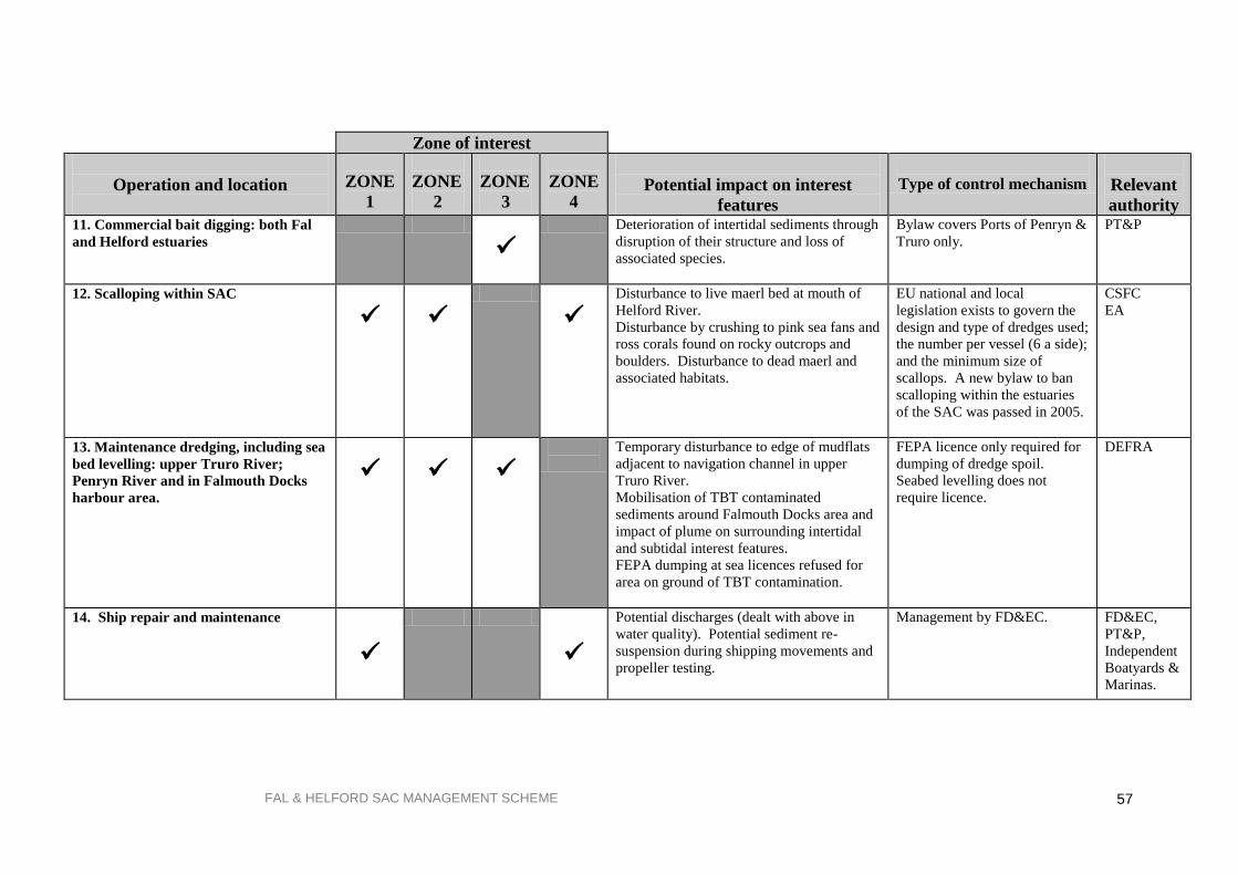
FAL & HELFORD SAC MANAGEMENT SCHEME
57
Zone of interest
Operation and location
ZONE
1
ZONE
2
ZONE
3
ZONE
4
Potential impact on interest
features
Type of control mechanism
Relevant
authority
11. Commercial bait digging: both Fal
and Helford estuaries
Deterioration of intertidal sediments through
disruption of their structure and loss of
associated species.
Bylaw covers Ports of Penryn &
Truro only.
PT&P
12. Scalloping within SAC
Disturbance to live maerl bed at mouth of
Helford River.
Disturbance by crushing to pink sea fans and
ross corals found on rocky outcrops and
boulders. Disturbance to dead maerl and
associated habitats.
EU national and local
legislation exists to govern the
design and type of dredges used;
the number per vessel (6 a side);
and the minimum size of
scallops. A new bylaw to ban
scalloping within the estuaries
of the SAC was passed in 2005.
CSFC
EA
13. Maintenance dredging, including sea
bed levelling: upper Truro River;
Penryn River and in Falmouth Docks
harbour area.
Temporary disturbance to edge of mudflats
adjacent to navigation channel in upper
Truro River.
Mobilisation of TBT contaminated
sediments around Falmouth Docks area and
impact of plume on surrounding intertidal
and subtidal interest features.
FEPA dumping at sea licences refused for
area on ground of TBT contamination.
FEPA licence only required for
dumping of dredge spoil.
Seabed levelling does not
require licence.
DEFRA
14. Ship repair and maintenance
Potential discharges (dealt with above in
water quality). Potential sediment re-
suspension during shipping movements and
propeller testing.
Management by FD&EC. FD&EC,
PT&P,
Independent
Boatyards &
Marinas.

FAL & HELFORD SAC MANAGEMENT SCHEME
58
5.3. Site management
This section expands upon the information in the Operations List in order to clarify the current
management situation regarding these activities within the SAC. In many cases there are well-defined
duties and responsibilities already established. For other operations there are currently no management
mechanisms, either because there is no relevant authority whose remit covers this activity or because
management of a particular operation has not been necessary prior to the area becoming a candidate
SAC. In these instances, the Management Forum will need to decide how best to address these issues
in order to fulfil the requirements of the legislation. For some operations that are already under
management control, it may be necessary only to change minor details in order to ensure that there is
no adverse impact on the site‟s interest features. For other operations, the changes in management are
potentially larger in scale. For example changes in land use practices to alleviate diffuse input of
contaminants to the site.
The following list of operations includes activities that may be dealt with under Regulations 48 - 50 of
the Habitats Regulations as „plans or projects‟. These are identified within the text by Plans &
Projects.
In this management scheme, the Options for Change in this section are suggestions for how these
issues could be addressed. It is the responsibility of the relevant authorities concerned to discuss and
resolve these issues individually and within the Management Forum. In some instances, further
research and survey work may be required before a conclusion can be reached.
After discussion, this section will form the basis of the required actions by the relevant authorities
and will include reference to compliance monitoring requirements.
5.4. Existing management of operations and future management
options
For each of the operations, information is provided on its location and frequency, the organisation(s)
responsible for its management (if there are any), the management procedures and any gaps in the
management used. Suggestions for new management measures or improvements to existing ones are
shown under Management options.
Operation 1: Discharges of tributyl tin (TBT) (Plans & Projects)
Location:
Falmouth Docks
Feature affected:
All
Frequency:
Continuous
Organisation(s) responsible for
management:
Falmouth Docks & Engineering Co.
Environment Agency (EA)
Existing management: Integrated Pollution Control consent issued by Environment
Agency for dry dock discharges. Contaminated effluent from
the docks is now being collected for treatment on site. EA
have completed survey of TBT contamination of sediments
within Fal estuary. Report available.
Gaps in management: None with respect to Docks.
Management options: Consent to be reviewed by EA
1(a) Comply with new consent regime through installation
of new processes.

FAL & HELFORD SAC MANAGEMENT SCHEME
59
Operation 2: Discharge of sewage and trade effluent (Plans &
Projects)
Location:
Feature affected:
Throughout catchment of SAC and directly to SAC waters
All
Frequency: Continuous and intermittent
Organisation(s) responsible for
management:
Environment Agency (EA)
South West Water Ltd.
Falmouth Docks & Engineering Co.
Private dischargers
Existing management: Consents issued by EA under Water Resources Act (WRA).
Gaps in management: None.
Management options: 2(a) Consents likely to have significant effects to be
reviewed by EA by 2006 for Habitats Directive and end of
2000-2005 for Urban Waste Water Treatment Directive.
Operation 3: Diffuse and unregulated inputs including agricultural
run-off and mine waste
Location:
Feature affected:
Throughout catchment of SAC and directly to SAC waters.
All
Frequency:
Continuous and intermittent.
Organisation(s) responsible for
management:
Environment Agency (EA)
DEFRA
ADAS
Existing management: Highlighting of issues and relevant actions through the
Cycleau Project and the work of the Environment Agency.
DEFRA‟s agri-environment schemes as promoted by Farming
and Wildlife Advisory Group and West Country Rivers Trust.
Gaps in management: Few mechanisms to assess or address diffuse inputs.
Management options: 3(a) DEFRA has confirmed Sensitive Area status for upper
Fal estuary. Some of the catchments draining into the
Upper Estuary are Nitrate Vulnerable Zones, which control
the application of fertiliser. Nutrient reduction has been
implemented at Truro Newham sewage treatment works in
2003.
3(b) Long-term mine water treatment plant (Wheal Jane)
installed to reduce heavy metals.
3(c) EA & English Nature have undertaken site
characterisation, to document known water quality
information.
3(d) More active encouragement required for landowners
to improve practises: slurry management, field margins. EA
Environmental Protection Officers also visit farms and
encourage use of DEFRA Codes of Conduct for Water,

FAL & HELFORD SAC MANAGEMENT SCHEME
60
Soil & Air. The Cycleau Project and the West Country
Rivers Trust are assisting this work in the Fal & Helford
catchments.
3(e) EA reviewing waste spreading to land operations
within catchment.
Operation 4:
Ship to ship transfer of bulk chemicals, e.g. caustic
soda, chloroform.
Location:
Feature affected:
Carrick Roads, Fal Estuary
All
Frequency: Infrequent
Organisation(s) responsible for
management:
Falmouth Harbour Commissioners (FHC)
Existing management: FHC have an agreement with each individual ship wishing to
transfer cargoes, in addition to providing regulations governing
this operation, including treatment of spillages during this
operation. This cargo transfer is part of normal shipping
operations within the port and does not require licensing or a
permit. A Harbour Authority Permit is issues for chemical
transfers.
Gaps in management: No gaps perceived.
Management options: 4(a) Update information provided for discharging ships (or
provide info. if not present) on sensitivity of SAC and
emphasise need for due diligence.
4(b) Periodically test emergency drills for dealing with
spillage of hazardous cargo.
4(c) Record any spillages.
Operation 5: Ship to ship transfer of oil for bunkering
Location:
Feature affected:
Carrick Roads, Fal Estuary
Inner Fal Bay (within FHC Boundary)
All
Frequency Daily
Organisation(s) responsible for
management:
Falmouth Harbour Commissioners
Falmouth Oil Services (FOS)
DEFRA
English Nature (as consultees on DEFRA Licence)
Existing management: Oil Transfer Procedures and Contingency Plans in place.
Contingency planning dealt with through national planning
legislation.
Only DERFA approved oil treatment products (dispersants)
may be used to treat oil at sea. DEFRA must also approve any
proposed use of dispersants in shallow waters and will consult
EN before granting such an approval.

FAL & HELFORD SAC MANAGEMENT SCHEME
61
Gaps in management: No gaps identified.
Management options: 5(a) Update information on sensitivity of site within
standard procedures guidance provided to ships and FOS
staff.
5(b) Ensure that the Oil Spill Contingency Plans are
maintained up to date with respect to sensitivity of SAC
and adequately resourced and periodically tested by lead
partners.
Operation 6: Anchoring of ships: siting of anchor points on maerl
habitats
Location: Carrick Roads & Falmouth Bay
Feature affected:
Subtidal sandbanks
Frequency: Ship anchoring frequent, depending on operations and weather.
Organisation(s) responsible for
management:
Falmouth Harbour Commissioners (FHC)
Existing management: Anchoring of ships takes place in Falmouth Bay and Carrick
Roads.
Gaps in management: No mechanism for assessment of the impact of anchoring on
condition of maerl habitats.
Management options: 6(a) Assessment of any impacts of anchoring should form
part of EN Condition Assessment
6(b). Explore alternative anchoring regime, if practicable
and if demonstrable damage is noted.
Operation 7: Laying of additional/new moorings
Location:
Throughout SAC but in particular between Toll Point and
Durgan in Helford River. Between Polvart Point and
Amsterdam Point in Percuil River.
Feature affected: Subtidal sandbanks
Frequency: Not applicable but moorings would be present all year.
Organisation (s) responsible for
management:
Ports of Truro & Penryn (PT&P)
Falmouth Harbour Commissioners (FHC)
St. Mawes Pier & Harbour Company (St MP & HCo.)
Percuil River Moorings Ltd. (PRM Ltd)
Existing management: PT&P) have a moorings policy for their waters.
Moorings laid in Falmouth Harbour Commissioners area are
either under control of FHC or private fundus owners.
Moorings laid and licensed in Helford by Helford River
Moorings Ltd (HRML) on fundus leased from the Duchy Of
Cornwall. Anchoring is an issue on the eelgrass bed off
Durgan. Helford Voluntary Marine Conservation Area group

FAL & HELFORD SAC MANAGEMENT SCHEME
62
taken voluntary action to restrict anchoring on Durgan.
Moorings concentrated between Durgan and Grebe Point.
Moorings in St. Mawes Harbour laid and licensed by St MP &
HCo. up to a line between Amsterdam Point and Polvarth
Point. Upstream of this line moorings are administered by
PRMLtd. Currently only a few moorings present in area of
eelgrass beds which are related to stored scalloping gear, as
location is exposed to prevailing winds.
Gaps in management: Lack of relevant authority control in Helford River. Duchy of
Cornwall have no direct requirements under the Habitats
Directive as they are not a relevant authority, however an
agreement has been reached to co-operate with the relevant
authorities within the Helford River.
Management options: 8(a) Maintain close liaison between English Nature,
HRML and the Duchy of Cornwall over siting of new
moorings in eelgrass bed.
8(b) Survey eelgrass beds in St. Mawes Harbour and notify
SMPHC of location and liase over new moorings proposals
in this area.
8(c) Continue monitoring of Helford eelgrass beds through
HVMCA Group.
8(d) Develop moorings strategy/policy to inform future
management.
8(e) Report any additional laying or rationalisation of
moorings.
Operation 8: Anchoring on eelgrass beds
Location:
Between Toll Point and Durgan in Helford River
Between Carricknath Point and Amsterdam Point in Percuil
River.
On landward side of St. Mawes Bank.
Feature affected: Subtidal sandbanks
Frequency: Dependant upon sea conditions and wind direction. Daily
during summer months within Helford River with up to 10
boats; 1-3 boats weekly on inside of St. Mawes Bank; similar
frequency in St. Mawes Harbour but probably up to 5 boats
present.
Organisations responsible for
management:
No organisation responsible for Helford River.
St. Mawes Pier & Harbour Co. (St MP & HCo.) are
responsible for St. Mawes Harbour.
Falmouth Harbour Commisssioners are responsible for St.
Mawes Bank.
Existing management: Voluntary code of conduct publicised throughout both
estuaries but needs wider and more active publicity.
No other management known. Anchoring partially deterred on
St. Mawes Bank due to water ski zone. Buoys laid to identify
eelgrass beds in Helford River, accompanied by information
leaflet.

FAL & HELFORD SAC MANAGEMENT SCHEME
63
Gaps in management: Lack of relevant authority control in Helford River.
Impact of anchoring in eelgrass beds in St. Mawes Harbour not
known.
Management options 9(a) Survey eelgrass beds in St. Mawes Harbour and notify
St MP & HCo. of location and liaise over methods of
reducing anchoring pressure if it is damaging the beds. St
MP & HCo have offered to investigate laying visitor
moorings if appropriate.
9(b) Continue monitoring of Helford eelgrass beds through
Helford Voluntary Marine Conservation Area Group
(HVMCA Group).
9(c) Ensure that the Duchy of Cornwall is fully involved in
this issue in the Helford River.
9(d) Continue to promote voluntary code of practice
through HVMCA Group, and Advisory Group/yacht
clubs/sailing publications to reduce anchoring pressure.
9(e) Establish monitoring scheme to estimate numbers of
boats anchoring in all 3 locations.
Operation 9: Oyster dredging on live maerl bed
Location: Northern edge of St. Mawes Bank
Feature affected:
Subtidal sandbanks
Frequency: Infrequent and only within oyster dredging season (1 October -
31 March).
Organisation (s) responsible for
management:
Port of Truro Oyster Fishery (administered by Carrick District
Council‟s (CDC) Maritime department through the Ports of
Truro & Penryn)
Existing management: The Truro Port Fishery (Variation) Order, 1975, authorises
CDC to regulate a mussel and oyster fishery within the Fal
Estuary. Restrictions are placed upon the dredging, fishing for
and taking of oysters and mussels. Oyster dredging is limited
to boats powered by sail or oars only and each dredge used
must have a license. Operation is monitored during the season
by harbour staff to check number of dredges being employed
and size of oysters retained.
Oysters are native and arise from natural spat fall.
The Falmouth & Truro Port Health Authority monitors the
suitability of the oysters for human consumption.
Gaps in management: The oyster fishery area includes St. Mawes Bank upon which
the oysters appear to be slowly encroaching from the north,
hence the occasional dredging. Any maerl retained in dredge
is returned to vicinity of the bed causing minor disturbance.
Management options: 10(a) Ongoing monitoring to assess condition of live maerl
bed and ascertain the extent of oysters spreading onto the
bed.
10(b) Voluntary agreement between CDC and oyster
fishermen not to dredge this area if damage to the live
maerl beds is shown.
10(c) Voluntary agreement not forthcoming, English
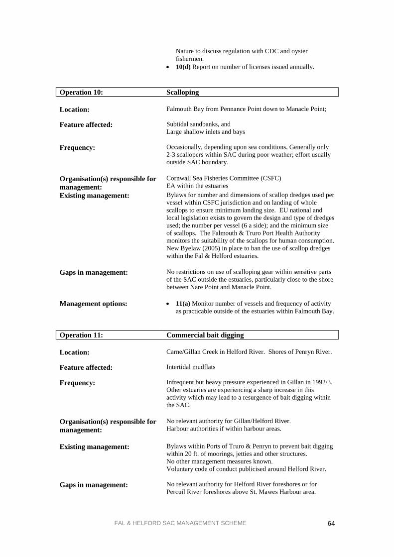
FAL & HELFORD SAC MANAGEMENT SCHEME
64
Nature to discuss regulation with CDC and oyster
fishermen.
10(d) Report on number of licenses issued annually.
Operation 10: Scalloping
Location: Falmouth Bay from Pennance Point down to Manacle Point;
Feature affected: Subtidal sandbanks, and
Large shallow inlets and bays
Frequency: Occasionally, depending upon sea conditions. Generally only
2-3 scallopers within SAC during poor weather; effort usually
outside SAC boundary.
Organisation(s) responsible for
management:
Cornwall Sea Fisheries Committee (CSFC)
EA within the estuaries
Existing management: Bylaws for number and dimensions of scallop dredges used per
vessel within CSFC jurisdiction and on landing of whole
scallops to ensure minimum landing size. EU national and
local legislation exists to govern the design and type of dredges
used; the number per vessel (6 a side); and the minimum size
of scallops. The Falmouth & Truro Port Health Authority
monitors the suitability of the scallops for human consumption.
New Byelaw (2005) in place to ban the use of scallop dredges
within the Fal & Helford estuaries.
Gaps in management: No restrictions on use of scalloping gear within sensitive parts
of the SAC outside the estuaries, particularly close to the shore
between Nare Point and Manacle Point.
Management options: 11(a) Monitor number of vessels and frequency of activity
as practicable outside of the estuaries within Falmouth Bay.
Operation 11: Commercial bait digging
Location: Carne/Gillan Creek in Helford River. Shores of Penryn River.
Feature affected: Intertidal mudflats
Frequency: Infrequent but heavy pressure experienced in Gillan in 1992/3.
Other estuaries are experiencing a sharp increase in this
activity which may lead to a resurgence of bait digging within
the SAC.
Organisation(s) responsible for
management:
No relevant authority for Gillan/Helford River.
Harbour authorities if within harbour areas.
Existing management: Bylaws within Ports of Truro & Penryn to prevent bait digging
within 20 ft. of moorings, jetties and other structures.
No other management measures known.
Voluntary code of conduct publicised around Helford River.
Gaps in management: No relevant authority for Helford River foreshores or for
Percuil River foreshores above St. Mawes Harbour area.

FAL & HELFORD SAC MANAGEMENT SCHEME
65
Management options: 12(a) Duchy of Cornwall is not a relevant or competent
authority for the Helford River but is willing to participate
in resolving this issue.
12(b) Continue to promote voluntary codes of conduct
throughout SAC.
12(c) Maintain watching brief on resurgence of commercial
bait digging throughout SAC.
12(d) Undertake survey of current levels of activity to
inform future management decisions.
Operation 12: Maintenance dredging & sea bed levelling
Capital dredging (Plans & Projects)
Location: Channel in upper Truro River between Sunny Corner and
Lighterage Quay.
Main channel in Penryn River and around sill of Falmouth
Marina. Depth of main channel into Falmouth Harbour
maintained by shipping activity.
Sea bed levelling around mouth of No. 2 dry dock in Falmouth
Docks and inside Eastern Breakwater by Falmouth Oil
Services (FOS).
St Mawes harbour.
Plans and projects as and where they arise.
Feature affected: All
Frequency: Biennially in upper Truro River (approx. 5 000 tonnes, now
disposed to land for soil manufacture)
Every 3-4 years in Penryn River, in addition to dredging
undertaken by Falmouth Marina.
Frequency of seabed levelling approximately annual.
Plans and projects as and where they arise.
Organisation(s) responsible for
management:
Ports of Truro & Penryn (PT&P)
Falmouth Docks & Engineering Co. (FD&EC)
Falmouth Harbour Commissioners
As appropriate for location of any plans & projects.
Existing management: DEFRA issue licences required for dredge spoil dumping only.
PTP have surveyed bathymetry in upper Truro River and
record amounts dredged. Regular liaison with English Nature
regarding dredging activity resulting in production of
Maintenance Dredging Protocol in 2005.
Gaps in management: Assessment of environmental impact of sea bed levelling
activity now being addressed through the trial of Maintenance
Dredging Protocol (2005).
Assessment of environmental impact of dumping at disposal
site in Falmouth Bay, undertaken by CEFAS.
Management options: 13(a) Continue liaison regarding dredging issues between
Harbour Authorities and English
Nature/DEFRA/Environment Agency.
13(b) Establish formal monitoring of silt movement
resulting from seabed levelling activity by FD&EC and
establish recognised procedure through liaison with EN and
via the trial of Maintenance Dredging Protocol (2004).
13(c) DEFRA have issued consultation paper to industry on
inclusion of ploughing activities within remit of FEPA
licensing process.

FAL & HELFORD SAC MANAGEMENT SCHEME
66
13(d) Update the Maintenance Dredging Protocol (2004) as
necessary, to report on frequency, quantity and methods
used for maintenance dredging.
Operation 13: Ship Repair & Maintenance
Location: Falmouth Docks & smaller marinas / boatyards around Fal &
Helford
Feature affected: All through water quality
Frequency: Ongoing
Organisation(s) responsible for
management:
Falmouth Docks & Engineering Co. (FD&EC)
Ports of Truro & Penryn (PT&P)
Independent Boatyards & Marinas
Existing management: Environmental Management System for PT&P, and FD&EC.
Gaps in management: The need to spread good practice to smaller marinas &
boatyards around the Fal & Helford Estuaries.
Management options: 14(a) Continue liaison regarding environmental
management issues between Harbour Authorities and
English Nature/DEFRA/Environment Agency.

FAL & HELFORD SAC MANAGEMENT SCHEME
67
6. ACTION PLAN FOR THE FAL & HELFORD SAC
6.1. Introduction
This section details the actions to be undertaken by the individual relevant authorities, either working
alone or in partnership, to manage the Fal & Helford SAC. As far as possible these actions link to
existing activities and plans, both to avoid duplication of effort and to emphasise the linkages that
already exist between the relevant authorities.
The contents of the Action Plan are derived from a consideration of the existing management of the
area in relation to its interest features (described in more detail in section 5.3.). The Management
Forum, as part of the planning process, should review actions for the forthcoming year.
6.2. Action plan structure
The following tables list the management actions for the relevant authorities and where appropriate,
other partners. They are grouped into activities to reflect the order shown in the previous Operations
Table (Table 5 in section 5.1). Many activities may only involve action to be taken by one relevant
authority whilst others may involve some or all members of the Management Forum.
The table is arranged as follows:
ACTIVITY ACTION RESPONSIBILITY TIMEFRAME
1. 1.1.
1.2.
ACTIVITY
Activities 1 to 12 are derived from the Operations Table (Table 5 in section 5.1), with some being
amalgamated, for example water quality, which includes several different operations listed in section
5.1.
Also included as an activity is the actual process of running the management scheme, and the actions
necessary to support that process. Planning is also included as an activity to indicate how it fits in with
the rest of the scheme, although strictly speaking, it is a separate process from the management scheme
as it is covered by different parts of the Habitats Regulations.
ACTION
The actions listed have arisen from detailed discussions about the existing management of the
operations listed in section 5.1. and their current management as detailed in section 5.2. In many cases,
particularly for Activity 1: Water quality, several of these actions have been copied from existing
plans, where these actions are appropriate to management of the SAC‟s interest features. Where other
plans have differing timescales to the management scheme, the Management Forum will input to other
plans to ensure delivery of the objectives.
“SMILE” This column indicates the type of action proposed; these fall into one of the following five categories:
S = SURVEY & RESEARCH e.g. new surveys, new research work or studies
required to fill in information gaps
M = MONITORING & REVIEW e.g. monitoring the condition of the site or the extent
of activities; reviewing existing plans.
I = INFORMATION & TRAINING e.g. provision of information to other relevant
authorities or public; training of staff.

FAL & HELFORD SAC MANAGEMENT SCHEME
68
L = LIAISON e.g. communicating with other partners,
Management Forum meetings.
E = ENFORCEMENT & ENABLING e.g. enforcing bylaws, undertaking projects.
* = New activity Any new research/training/liaison activities that
have arisen from the SAC designation.
RESPONSIBILITY
For each action one or more relevant authorities may be responsible, in addition to other partner
organisations. Relevant authorities titles have been abbreviated in Table 7 as follows:
CCC Cornwall County Council
CSFC Cornwall Sea Fisheries Committee
DEFRA Department of the Environment Food and Rural Affairs
EN English Nature
EA Environment Agency
FD&EC Falmouth Docks & Engineering Company
F&TPHA Falmouth & Truro Port Health Authority
FHC Falmouth Harbour Commissioners
HVMCA Helford Voluntary Marine Conservation Area Group
PT&P Ports of Truro & Penryn
St MP & HCo. St. Mawes Pier & Harbour Company
SWW South West Water Ltd
TIMEFRAME
The timeframe shown covers from designation until the financial years 2007/2008. The Habitats
Directive requires that each Member State report back to the EC every 6 years. The last reporting cycle
was in 2001, with the following cycle in 2006.
Many of the actions listed are only timetabled to happen at certain points within the next 6 years
although others may occur annually. The frequency is indicated by the dots (●). If an action is
ongoing a dash (–) is used to indicate this. A tick () in the two stars (**) column is used to indicate
that the activity has been completed since designation; where there is a dot in this column this means
that the activity is ongoing.
6.3. Reporting and review
The frequency of reviewing the management scheme is indicated within the timetable. It is proposed
that all relevant authorities report to the Management Forum on a 3-year cycle, at which point the plan
will also be reviewed to assess its effectiveness with possible revisions of the contents. The
responsibility for gathering together the reported information and revising the management scheme will
need to be agreed by the Management Forum at that point in the process.
Distinction has been made between condition and compliance monitoring and identified within Table 7.
Condition monitoring will be lead by English Nature, whereas compliance monitoring is the
responsibility of the relevant authority licensing the activity.

FAL & HELFORD SAC MANAGEMENT SCHEME 69
Table 7. Management actions including timetable and responsibilities for implementing new management measures
ACTIVITY
ACTION (not in priority order)
RESPONSIBILITY
TIMEFRAME (Financial
Years) ** 05/06 06/07 07/08
1. Water quality 1.1. Review discharge consents, licences
and operations that may impact on SAC,
including cumulative effects of small scale
discharges.
E
EA
1.2. Ongoing monitoring and assessment of
catchment inputs. S EA
1.3. Installation of nutrient stripping at
Truro Newham STW by 2004. E SWW
1.4. Compliance monitoring of nutrient
status of upper Fal. M EA
1.5. Implementation of long term solution
for mine waste water treatment for Wheal
Jane.
E EA
DEFRA
United Mines
1.6. Implementation and monitoring of TBT
treatment system Falmouth Docks &
Engineering Co.
E FD&EC
EA
1.7. Ongoing trend compliance monitoring
of TBT contamination in sediments within
the Fal Estuary. Baseline survey complete,
next survey planned 2005.
M EA
1.8. Monitor bacteriological water quality
as required under the Shellfish Waters
Directive and the Bathing Waters Directive.
M EA
F&TPHO
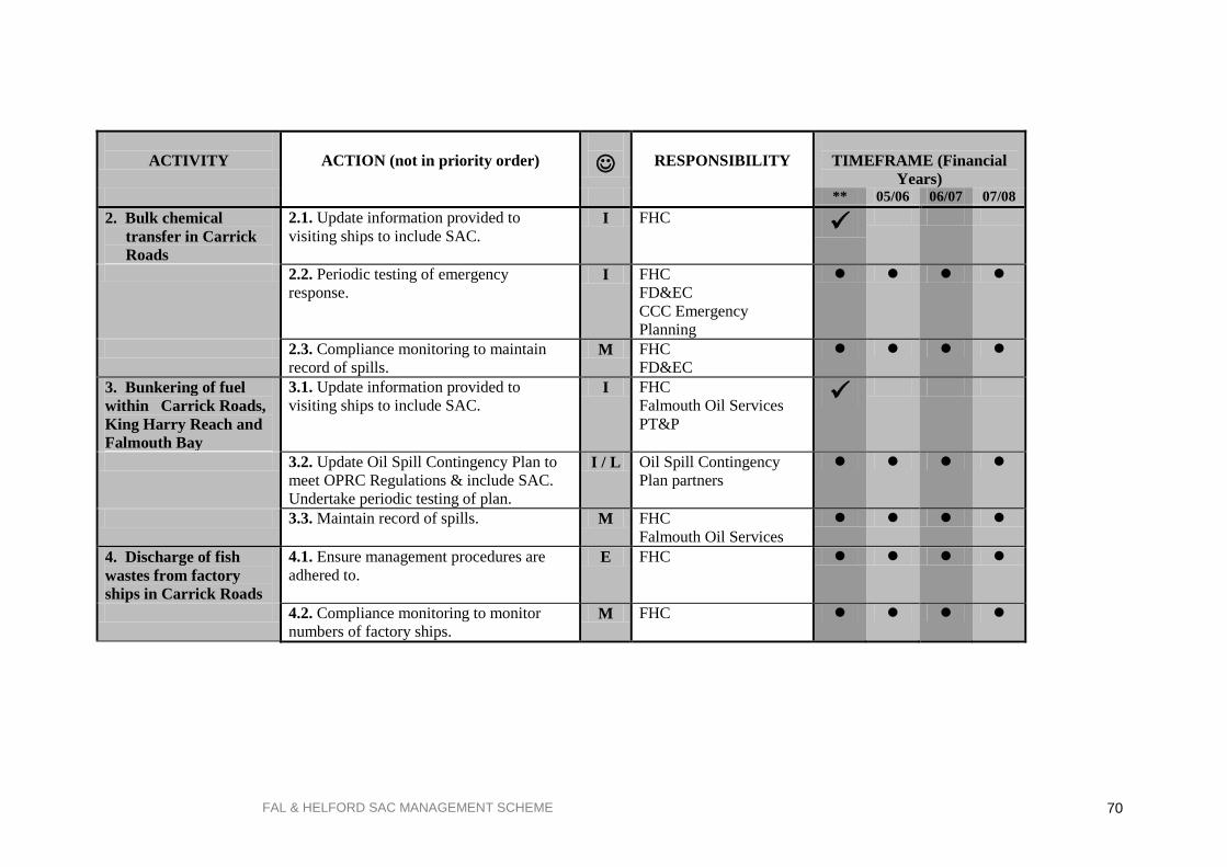
FAL & HELFORD SAC MANAGEMENT SCHEME 70
ACTIVITY
ACTION (not in priority order)
RESPONSIBILITY
TIMEFRAME (Financial
Years)
** 05/06 06/07 07/08
2. Bulk chemical
transfer in Carrick
Roads
2.1. Update information provided to
visiting ships to include SAC. I FHC
2.2. Periodic testing of emergency
response. I FHC
FD&EC
CCC Emergency
Planning
2.3. Compliance monitoring to maintain
record of spills. M FHC
FD&EC
3. Bunkering of fuel
within Carrick Roads,
King Harry Reach and
Falmouth Bay
3.1. Update information provided to
visiting ships to include SAC.
I FHC
Falmouth Oil Services
PT&P
3.2. Update Oil Spill Contingency Plan to
meet OPRC Regulations & include SAC.
Undertake periodic testing of plan.
I / L Oil Spill Contingency
Plan partners
3.3. Maintain record of spills.
M FHC
Falmouth Oil Services
4. Discharge of fish
wastes from factory
ships in Carrick Roads
4.1. Ensure management procedures are
adhered to. E FHC
4.2. Compliance monitoring to monitor
numbers of factory ships. M FHC
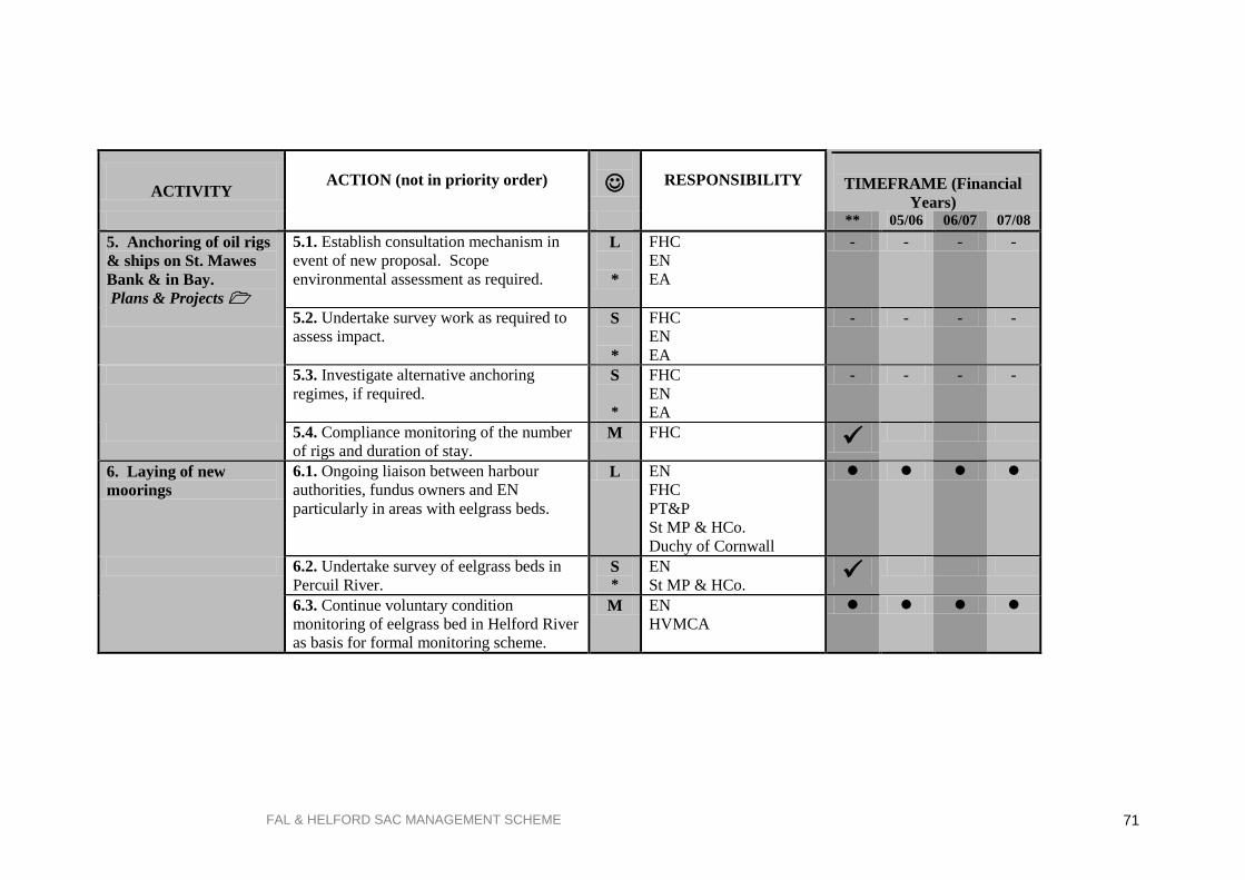
FAL & HELFORD SAC MANAGEMENT SCHEME 71
ACTIVITY
ACTION (not in priority order)
RESPONSIBILITY
TIMEFRAME (Financial
Years)
** 05/06 06/07 07/08
5. Anchoring of oil rigs
& ships on St. Mawes
Bank & in Bay.
Plans & Projects
5.1. Establish consultation mechanism in
event of new proposal. Scope
environmental assessment as required.
L
*
FHC
EN
EA
- - - -
5.2. Undertake survey work as required to
assess impact.
S
*
FHC
EN
EA
- - - -
5.3. Investigate alternative anchoring
regimes, if required. S
*
FHC
EN
EA
- - - -
5.4. Compliance monitoring of the number
of rigs and duration of stay. M FHC
6. Laying of new
moorings
6.1. Ongoing liaison between harbour
authorities, fundus owners and EN
particularly in areas with eelgrass beds.
L EN
FHC
PT&P
St MP & HCo.
Duchy of Cornwall
6.2. Undertake survey of eelgrass beds in
Percuil River. S *
EN
St MP & HCo.
6.3. Continue voluntary condition
monitoring of eelgrass bed in Helford River
as basis for formal monitoring scheme.
M EN
HVMCA
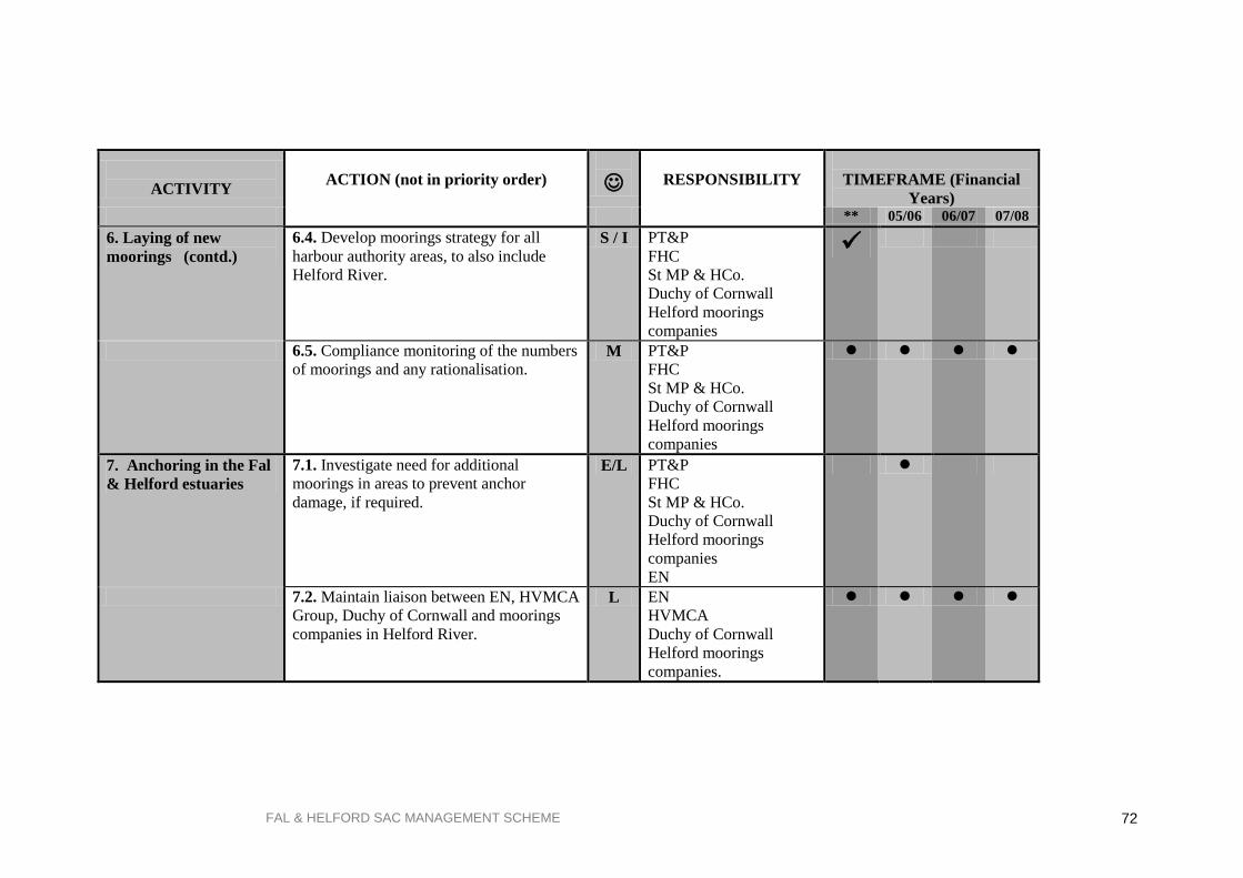
FAL & HELFORD SAC MANAGEMENT SCHEME 72
ACTIVITY
ACTION (not in priority order)
RESPONSIBILITY
TIMEFRAME (Financial
Years)
** 05/06 06/07 07/08
6. Laying of new
moorings (contd.)
6.4. Develop moorings strategy for all
harbour authority areas, to also include
Helford River.
S / I PT&P
FHC
St MP & HCo.
Duchy of Cornwall
Helford moorings
companies
6.5. Compliance monitoring of the numbers
of moorings and any rationalisation. M PT&P
FHC
St MP & HCo.
Duchy of Cornwall
Helford moorings
companies
7. Anchoring in the Fal
& Helford estuaries
7.1. Investigate need for additional
moorings in areas to prevent anchor
damage, if required.
E/L PT&P
FHC
St MP & HCo.
Duchy of Cornwall
Helford moorings
companies
EN
7.2. Maintain liaison between EN, HVMCA
Group, Duchy of Cornwall and moorings
companies in Helford River.
L EN
HVMCA
Duchy of Cornwall
Helford moorings
companies.

FAL & HELFORD SAC MANAGEMENT SCHEME 73
ACTIVITY
ACTION (not in priority order)
RESPONSIBILITY
TIMEFRAME (Financial
Years)
** 05/06 06/07 07/08
7. Anchoring in the Fal
& Helford estuaries
(contd.)
7.3. Promote voluntary code of conduct for
mooring near eelgrass. I All partners as
appropriate
7.4. Continue voluntary condition
monitoring of eelgrass bed in Helford River
as basis for formal monitoring scheme.
Establish monitoring scheme in St. Mawes
Harbour and St. Mawes Bank.
M EN
HVMCA
8. Recreational
activities
8.1 Monitor levels of recreational activities
to provide necessary management
information.
M Planning Authorities
FHC
PT&P
St MP & HCo.
8.2 Provide information to various user
groups, as required. I As above
9. Oyster dredging on
St. Mawes Bank live
maerl bed
9.1. Condition monitoring to survey live
maerl bed and extent of oysters on St.
Mawes Bank and assess potential impact of
dredging.
S/ M
*
EN
9.2. Investigate need and feasibility for
voluntary exclusion zone on St. Mawes
Bank, if required.
S/ L
*
PT&P
Oyster fishermen
EN
9.3. If voluntary agreement not
forthcoming, investigate need for
regulation.
L/ E
*
PT&P
Oyster fishermen
9.4. Compliance monitoring of the number
of licences issued. M PT&P

FAL & HELFORD SAC MANAGEMENT SCHEME 74
ACTIVITY
ACTION (not in priority order)
RESPONSIBILITY
TIMEFRAME (Financial
Years)
** 05/06 06/07 07/08
10. Scalloping inshore
in Falmouth Bay
(outside estuaries)
10.1. Investigate potential impacts of
scalloping on subtidal habitats.
S
*
CSFC
EN
10.2. Investigate need and feasibility for
voluntary exclusion zone in this area, if
required.
S/ L
*
CSFC
EN
fishermen
10.3. If voluntary agreement not
forthcoming, investigate need for
regulation.
S/ L
*
CSFC
fishermen
10.4. Compliance monitoring of the
number of scallopers working and areas
worked.
M CSFC
11. Commercial bait-
digging
11.1. Promote voluntary codes of conduct
for bait digging. I All relevant partners
12. Maintenance
dredging and sea bed
levelling.
12.1. Maintain liaison between harbour
authorities, EN and EA on dredging issues.
Capital dredging will be dealt with on a
case-by-case basis.
L Harbour authorities
EN
EA
(Capital dredging =
Plans & Projects )
12.2. Compliance monitoring to survey of
dredge spoil disposal site in Falmouth Bay,
including fate of disposed contaminants.
S/ M
*
DEFRA
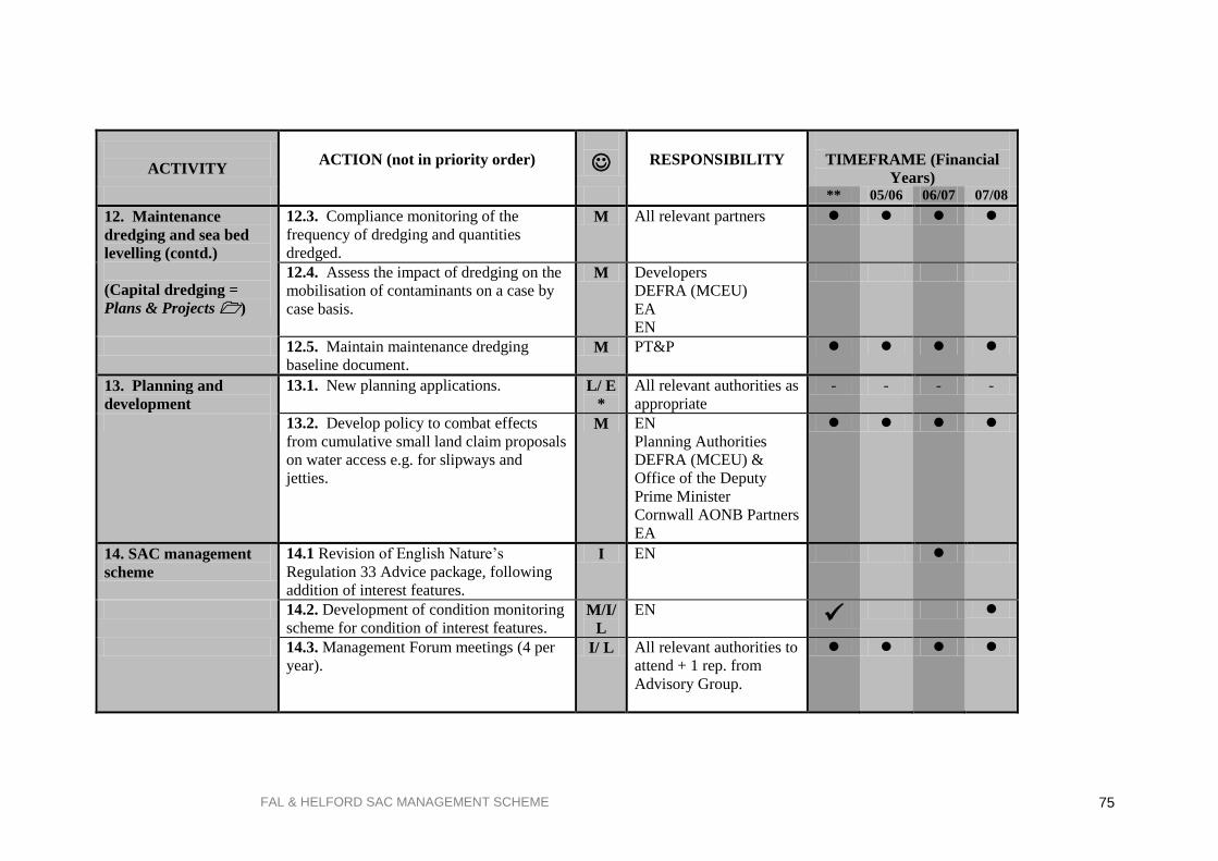
FAL & HELFORD SAC MANAGEMENT SCHEME 75
ACTIVITY
ACTION (not in priority order)
RESPONSIBILITY
TIMEFRAME (Financial
Years)
** 05/06 06/07 07/08
12. Maintenance
dredging and sea bed
levelling (contd.)
(Capital dredging =
Plans & Projects )
12.3. Compliance monitoring of the
frequency of dredging and quantities
dredged.
M All relevant partners
12.4. Assess the impact of dredging on the
mobilisation of contaminants on a case by
case basis.
M Developers
DEFRA (MCEU)
EA
EN
12.5. Maintain maintenance dredging
baseline document. M PT&P
13. Planning and
development
13.1. New planning applications.
L/ E
*
All relevant authorities as
appropriate
- - - -
13.2. Develop policy to combat effects
from cumulative small land claim proposals
on water access e.g. for slipways and
jetties.
M EN
Planning Authorities
DEFRA (MCEU) &
Office of the Deputy
Prime Minister
Cornwall AONB Partners
EA
14. SAC management
scheme
14.1 Revision of English Nature‟s
Regulation 33 Advice package, following
addition of interest features.
I EN
14.2. Development of condition monitoring
scheme for condition of interest features. M/I/
L
EN
14.3. Management Forum meetings (4 per
year).
I/ L All relevant authorities to
attend + 1 rep. from
Advisory Group.

FAL & HELFORD SAC MANAGEMENT SCHEME 76
ACTIVITY
ACTION (not in priority order)
RESPONSIBILITY
TIMEFRAME (Financial
Years)
** 05/06 06/07 07/08
14. SAC management
scheme (contd.)
14.4. Advisory Group meetings (4 per
year). I/ L EN
All Advisory Group
members to attend
14.5. Reporting of condition and
compliance monitoring to Management
Forum
M/ I/
L
All relevant authorities
14.6. Review of management scheme M All relevant authorities
15. Ship Maintenance
& Repair
15.1. Update and maintain Environmental
Management System already in place at
Falmouth Docks & Engineering Co.
M FD&EC

FAL & HELFORD SAC MANAGEMENT SCHEME 77
Selected Bibliography
ABP Research (1999) Good practice guidelines for ports and harbours operating within or near
UK European marine sites. English Nature, UK Marine SACs Project.
Barne JH, Robson CF, Kaznowska SS, Doody JP, Davidson NC, & Buck AL (eds) (1996) Coasts and
seas of the UK, Region 10 Southwest England: Seaton to the Roseland Peninsula. JNCC,
Peterborough.
Barne JH, Robson CF, Kaznowska SS, Doody JP, Davidson NC, & Buck AL (eds) (1996) Coasts and
seas of the UK, Region 11 The Western Approaches: Falmouth Bay to Kenfig. JNCC,
Peterborough.
Birkett DA, Maggs CA, Dring MJ, & Boaden PJS (1998) Infralittoral reef biotopes with kelp species
(volume VII). An overview of dynamics and sensitivity characteristics for conservation
management of marine SACs. Scottish Association of Marine Science (UK Marine SACs Project).
Birkett DA, Maggs CA, & Dring MJ (1998) Maerl (Volume V). An overview of dynamics and
sensitivity characteristics for conservation management of marine SACs. Scottish Association of
Marine Science (UK Marine SACs Project).
Brown AE, Burn AJ, Hopkins JJ, & Way SF (1997) The Habitats Directive: selection of Special
Areas of Conservation in the UK. JNCC Report, No.270.
Carrick District Council (1994) District Wide Local Plan Deposit Draft. CDC, Truro.
Carrick District Council (1998) Special Areas of Conservation: A Guide for Development Control.
CDC, Truro.
Carrick Maritime (2004) Dredging Protocol: Baseline Document Fal and Helford Estuaries. CDC.
Truro.
Cole S, Codling ID, Parr W, & Zabel T, (1999). Guidelines for managing water quality impacts
within UK European marine sites. English Nature UK Marine SACs Project.
Cornwall Archaeological Unit (1997) Fal Estuary Historic Audit. CCC, Truro.
Davies J & Sotheran I (1995) Mapping the distribution of benthic biotopes in Falmouth Bay and
the lower Fal Estuary. English Nature Research Reports No. 119a, English Nature, Peterborough.
Davidson D & Hughes D (1998) Zostera Biotopes (Volume I) An overview of dynamics and
sensitivity characteristics for conservation management of marine SACs. Scottish Association of
Marine Science (UK Marine SACs Project).
DETR (1998) European Marine Sites in England and Wales: A Guide to the Conservation
(Natural Habitats &c.) Regulations 1994 and the Preparation and Application of Management Schemes, DETR, London.
Department of the Environment (1994) Planning Policy Guidance Note 9 (PPG 9) Nature
Conservation. HMSO, London.
Elliott M, Nedwell S, Jones NV, Read SJ, Cutts ND, & Hemingway KL (1998) Intertidal sand and
mudflats & sudtidal mobile sandbank (Volume II). An overview of dynamics and sensitivity
characteristics for conservation management of SACs. Scottish Association of Marine Science (UK
Marine SACs Project).
English Nature (1999) Fal and Helford European Marine Site: English Nature's advice given
under Regulation 33(2) of the Conservation (Natural Habitats &c.) Regulations 1994.
Consultation draft, 1999, Truro.

FAL & HELFORD SAC MANAGEMENT SCHEME 78
Environment Agency (1997) Fal and St Austell Streams Local Environment Agency Plan -
Consultation Report. Environment Agency, Bodmin.
Environment Agency (1997) Fal and St Austell Streams Local Environment Agency Plan - Action
Plan. Environment Agency, Bodmin.
Environmental Consultants (CTNC) Ltd. (1996) Falmouth Bay & Estuaries Initiative: A nature
conservation overview. Report to Falmouth Bay and Estuaries Initiative. Environmental Consultants
Ltd. Truro.
Falmouth Bay & Estuaries Initiative (1997) Strategic Guidelines: Final draft. CCC Truro.
Falmouth Bay & Estuaries Initiative (1995) Issues Report. CCC Truro.
Falmouth Bay & Estuaries Initiative (1995) Response to Issues Report. CCC, Truro.
Farnham WF & Bishop GM (1985) Survey of the Fal Estuary, Cornwall. Progress in Underwater
Science, 10: 53-63.
Gubbay S & Knapman PA (1999) A Review of the effects of fishing within UK European marine
sites. English Nature UK Marine SACs Project.
Hill S, Burrows MT, & Hawkins SJ (1998) Intertidal reef biotopes (Volume II) An overview of
dynamics and sensitivity characteristics for conservation and management of marine SACs.
Scottish Association of Marine Science (UK Marine SACs Project).
Institute of Estuarine & Coastal Studies (1996) The Fal Estuary: Coastal Processes and
Conservation. Report to English Nature No. Z058-9-F, Peterborough.
Langston, W.J., Chesman, B.S., Burt, G.R., Hawkins, S.J., Readman, J. and Worsfold, P (2003)
Characterisation of the South West European Marine Sites. The Fal and Helford cSAC. Occasional Publication of the MBA No.8.
Perrins JM, Bunker F, & Bishop GM (1995) A comparison of the maerl beds of the Fal Estuary
between 1982 and 1992. Report to English Nature.
Ports of Falmouth, Truro & Penryn (1995) Environmental Management System. CDC/FHC, Truro.
Ports of Falmouth, Truro & Penryn (1996) Waste Management Plan, CDC/FHC, Truro.
Posford Haskoning Ltd (2003) Marine Ecological Survey of the Fal Estuary: Effects of Maerl
Extraction. Report to Falmouth Harbour Commissioners.
Posford Haskoning Ltd (2004) Monitoring Survey of the Fal Estuary: Effects of Maerl Extraction.
Report to Falmouth Harbour Commissioners.
Restormel Borough Council (1995) Local Plan Deposit Draft. RBC, St Austell.