fall 2013 operation icebridge p-3 flight plans 1 october ... · strategy for flying the selected...
TRANSCRIPT

Fall 2013 Operation IceBridge P-3 Flight Plans1 October 2013 Draft
compiled by
John Sonntag

Introduction to Flight PlansThis document is a translation of the NASA Operation IceBridge (OIB) scientific objectives articulated in the Level 1 OIB Science Requirements, at the June IceBridge Antarctic planning meeting held at UC Irvine, through official science team telecons and through e-mail communication and iterations into a series of operationally realistic flight plans, intended to be flown by NASA's P-3 aircraft, beginning in late October and ending in early December 2013. The missions are planned to be flown from McMurdo Station. The material is shown on the following pages in the distilled form of a map and brief text description of each science flight. Google Earth (KML) versions of these flight plans are available via anonymous FTP at the following address: ftp://atm.wff.nasa.gov/outgoing/oibscienceteam/. Note that some users have reported problems connecting to this address with certain browsers. Command-line FTP and software tools such as Filezilla may be of help in such situations.
We present the sea ice missions first, followed by the land ice flights, both ordered in, very roughly, east to west order. For each planned mission, we give a map and brief text description for the mission. At the end of the document we add an Appendix 1 of composite maps portraying several distinct regions of Antarctica with all missions shown in context with each other and superimposed on the Rignot et. al. InSAR surface velocity map. We also present an Appendix 2, which gives details of our strategy for flying the selected IceSat-2 calibration and validation sites in the McMurdo Dry Valleys. A careful reader may notice that some of the mission maps in the main part of the document highlight flightlines in green, yellow, and red colors, while other only show the black (or sometimes thick green) lines. The colors are a refinement added to the flight plans at a late stage of design which help the field team navigate the aircraft properly to achieve specific science goals. The colors represent the degree of “straightness” of each flight segment, where straight segments are steered using an automated technique and curved sections using a specialized manual method. Not all of the flight plans shown here have necessarily reached that mature stage of design.
In fact, as a general rule the flight plans depicted here are all at varying stages of completeness. For each mission we note “Remaining Design Issues” to be resolved, if any exist. In most cases these are minor. CryoSat underflights are a major exception, since these have to be re-planned for each potential flight day (for sea ice) or within a window of several potential flight days (for land ice).
Note that this document shows 31 planned land ice and 6 planned sea ice missions, which is more than we expect to fly this year. The extra flight plans give us operational flexibility to fly as much as possible, and scientifically productive, while we are in the field.
Each flight has a priority assigned to it by the OIB science team, either high, medium or low, and these are listed below with each mission. For the sea ice flights, we also note that the Ross Sea Flux Gate flight is the highest priority of all the sea ice flights . But for land ice, which usually has many more mission candidates for any given day, the field team sometimes requires more guidance regarding relative importance of the missions than these simple priorities alone provide. To address this, the land ice science team has identified a set of six “baseline” missions which they consider to represent the most desirable minimum set of land ice missions to be accomplished from McMurdo in 2013, and which should be considered as the highest priority land ice missions by the field team. These missions are Victoria 01, TAM West, Kamb Bulge 01, Pole Hole 88, Dome C – Vostok, and Siple Coast 03. These baseline missions are identified in the mission descriptions below as well.

IceBridge Mission Statement Operation IceBridge will employ aircraft to monitor the most sensitive and critical areas of sea ice, ice sheets and glaciers during the gap in satellite coverage caused by the failure of ICESat-1, in 2009, and the launch of ICESat-2, planned for 2016. Sensitive and critical areas include coastal Greenland and especially its outlet glaciers, costal Antarctica including the Antarctic Peninsula and ice shelves, the sea ice of the Arctic and Antarctic and the southeast Alaskan glaciers. Data collected by IceBridge will improve our knowledge of the contribution of the Greenland and Antarctic ice sheets to sea level rise and will make fundamental contributions to the understanding of changes occurring in the extent and thickness of the polar sea ice cover. Given the societal importance of understanding changes in sea level rise and sea ice extent, IceBridge data will monitor and improve modeling efforts for sea ice, ice sheet and glaciers. IceBridge will also prepare for the future of airborne monitoring efforts of the cryosphere by adapting existing instruments for high altitude unmanned aerial systems such as the NASA Global Hawk.
IceBridge Science ObjectivesThe following are the major science objectives of Operation IceBridge in priority order and are meet by the following flight plans:1) Make airborne laser altimetry measurements over the ice sheets and sea ice to fill in the data gap between the failure of ICESat-1 in 2009 and the launch of ICESat-2 planned for 2015.
2) Link measurements made by ICESat, ICESat-2, and CryoSat-2 to allow their comparison and the production of a long-term, ice sheet altimetry record.
3) Use airborne altimetry and radar to monitor key, rapidly changing areas of ice, including sea ice, ice sheets and glaciers, in the Arctic and Antarctic to maintain a long term observation record, improve understanding of glacial dynamics, and augment predictive models of sea level rise and sea ice cover.
4) In conjunction with altimetry measurements, collect other remotely sensed data to improve predictive models of sea level rise and sea ice cover, especially the following:
Ice sheet and sea ice thickness, structure and extent; Bed topography underlying land-based ice; Bathymetry beneath floating ice shelves; Snow accumulation and firn structure; and Other geophysical constraints that will improve estimates of the geothermal and oceanic heat
flux
5) Adapt existing instruments for airborne remote sensing of ice by high altitude unmanned aerial systems such as the NASA Global Hawk.

All 31 land ice and 6 sea ice planned flights, color-coded by scientific priority of the missions Orange lines depict 2009-2012 OIB missions flown by the NASA DC-8 from Punta Arenas. Gray circles represent practical maximum science mission radii for 8 hour (inner circle) and 10 hour (outer circle) P-3 missions. 2013 missions are limited to 8 hours or perhaps less depending on a variety of conditions, but longer missions may be possible in future years.

Sea Ice – DiscoveryThis new mission is designed to provide broad coverage of the relatively thick sea ice that typically forms along the coastal margin, east of McMurdo Sound. Depending on date of mission the north-south leg (waypoint SID05 – SID06) can be modified slightly to fly along a contemporaneous (preferably within 2 hours) CryoSat-2 orbit.
Flight Priority: HighICESat Tracks: noneLast Flown: new missionRemaining Design Issues: replace SID05-SID06 line with contemporaneous CryoSat-2 line if one falls nearby on day of flight (two consecutive days of representative CS-2 groundtracks shown below)

Sea Ice – Amundsen ConnectorThis is a new mission. The easternmost, north-south leg (waypoint SIAC02 to SIAC03) is positioned across the sea ice flux gate where ice moves between the Ross Sea and the Amundsen Sea. As such, this leg will provide observations of the ice thickness gradient across the flux gate, where the sea ice is thicker closer to the coast. The east-west leg (SIAC01 to SIAC02) is positioned north of the ‘Discovery’ mission, to sample a region of relatively thin ice. The westerly north-south leg of this mission (SIAC01 to SIAC02) is a good candidate for a CryoSat-2 underflight, if a nearly contemporaneous (preferably within 2 hours) CS-2 track is available when this flight is conducted.
Flight Priority: MediumICESat Tracks: noneLast Flown: new missionRemaining Design Issues: replace westerly NS line with contemporaneous CryoSat-2 lines if it falls nearby on day of flight (two consecutive days of representative CS-2 groundtracks shown below)

Sea Ice – Ross ZigzagThis new mission is designed to sample the north-south sea ice thickness gradient along, and just seaward of, the face of the Ross Ice Shelf, in the region where the Ross Sea Polynya typically forms earlier in the season. The SIRZ02 waypoint provides a land-based tie point, west of Roosevelt Island. The SIRZ02, or similar, waypoint should ideally be 50 to 75 km south of the RIS edge to afford OIB data continuity from sea to shelf ; e.g. AIRGrav data along such line(s) would be useful for stitching together surface gravity on the RIS with marine gravity just north of the RIS. This mission is a good candidate for a CryoSat-2 underflight along the SIRZ01-SIRZ02, SIRZ02-SIRZ03, and/or the SIRZ04-SIRZ05 legs, if a nearly contemporaneous (preferably within 2 hours) CS-2 track is available when this flight is conducted.
Flight Priority: LowICESat Tracks: noneLast Flown: new missionRemaining Design Issues: replace NS lines with contemporaneous CryoSat-2 lines if they fall nearby on day of flight (two consecutive days of representative CS-2 groundtracks shown below)

Sea Ice – Ross Sea FluxgateThis is a new mission, given the highest priority by the sea ice science team. The northerly east-west leg (waypoint SIMF01 to SIMF02) crosses a flux gate, were the sea ice is streaming northward from McMurdo Sound into the Ross Sea. The western end of the flux gate (SIMF01) is at Cape Adare. A second east-west line (SIMF05 to SIMF04) runs parallel to SIMF01-SIMF02, capturing the ice condition south of the flux gate. This IceBridge mission complements a ship-based mission anticipated for the austral spring 2015, which will focus on a detailed survey of the sea ice and snow conditions in this same area.
Flight Priority: Highest Priority for sea ice effortsICESat Tracks: noneLast Flown: new missionRemaining Design Issues: none

Sea Ice – McMurdo TriangleThis new mission is designed to sample a large region of sea ice north of McMurdo, getting as close to the ice edge as possible. As such, it provides observations of the north-south gradient in sea ice conditions in the Ross Sea. If possible, one of the north-south legs should be flown under a contemporaneous (preferably within 2 hours) CS-2 track. Should the ice edge be south of the leg from SIMT01-SIMT02 on the day of flight, ~50 km of the flight should be dedicated to capturing measurements of the marginal ice zone (MIZ) and open ocean to provide for instrument calibration/validation, before returning south.
Flight Priority: HighICESat Tracks: noneLast Flown: new missionRemaining Design Issues: replace one of NS segments with CryoSat-2 groundtrack if one is nearby on day of flight (two consecutive days of representative CS-2 groundtracks shown below)

Sea Ice – Terra NovaThis new mission is designed to provide broad coverage of the relatively thick sea ice that typically forms along the coastal margin, west of the Adare Pennisula. The two lines that run along the coast west of the Adare Penisula, one closer to the coast (SITN09 to SITN10) than the other (SITN08-SITN04) are intended to capture any gradient in ice thickness that might occur away from the coast in this region. The north-south leg (from waypoint SITN01 to SIT102), ending at McMurdo Station, is positioned along Terra Nova Bay where a polynya typically forms earlier in the season.
Flight Priority: HighICESat Tracks: noneLast Flown: new missionRemaining Design Issues: none
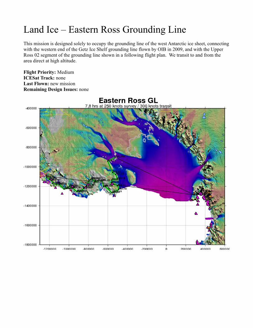
Land Ice – Eastern Ross Grounding LineThis mission is designed solely to occupy the grounding line of the west Antarctic ice sheet, connecting with the western end of the Getz Ice Shelf grounding line flown by OIB in 2009, and with the Upper Ross 02 segment of the grounding line shown in a following flight plan. We transit to and from the area direct at high altitude.
Flight Priority: MediumICESat Track: noneLast Flown: new missionRemaining Design Issues: none

Land Ice – Hull-Land 01This mission is one of a suite of five designed primarily to map the little-explored Ruppert Coast area around the Hull and Land Glaciers, and connect with the series of Getz Ice Shelf missions previously flown by OIB from Punta Arenas. This mission is the most seaward of the suite. It also includes the third and fourth lines, working inland, of the suite of 12 Ross Ice Shelf front-parallel lines.
Flight Priority: HighICESat Track: noneLast Flown: new missionRemaining Design Issues: none

Land Ice – Hull-Land 02This mission is one of a suite of five designed primarily to map the little-explored Ruppert Coast area around the Hull and Land Glaciers, and connect with the series of Getz Ice Shelf missions previously flown by OIB from Punta Arenas. This mission is the second-most seaward of the suite, and it also includes a pass over the Roosevelt Island core site. It also includes the fifth and sixth lines, working inland, of the suite of 12 Ross Ice Shelf front-parallel lines.
Flight Priority: HighICESat Track: noneLast Flown: new missionRemaining Design Issues: none

Land Ice – Hull-Land 03This mission is one of a suite of five designed primarily to map the little-explored Ruppert Coast area around the Hull and Land Glaciers, and connect with the series of Getz Ice Shelf missions previously flown by OIB from Punta Arenas. This mission is the third-most seaward of the suite. It also includes the seventh and eighth lines, working inland, of the suite of 12 Ross Ice Shelf front-parallel lines.
Flight Priority: LowICESat Track: noneLast Flown: new missionRemaining Design Issues: none

Land Ice – Hull-Land 04This mission is one of a suite of five designed primarily to map the little-explored Ruppert Coast area around the Hull and Land Glaciers, and connect with the series of Getz Ice Shelf missions previously flown by OIB from Punta Arenas. This mission is the fourth-most seaward of the suite, and it includes a centerline run of the Land Glacier and nearby tie line, mainly for gravity purposes. It also includes the ninth and tenth lines, working inland, of the suite of 12 Ross Ice Shelf front-parallel lines.
Flight Priority: LowICESat Track: noneLast Flown: new missionRemaining Design Issues: none

Land Ice – Hull-Land 05This mission is one of a suite of five designed primarily to map the little-explored Ruppert Coast area around the Hull and Land Glaciers, and connect with the series of Getz Ice Shelf missions previously flown by OIB from Punta Arenas. This mission is the most landward of the suite, approaching the peaks of the Flood Range, and it includes a centerline run of the Berry Glacier. It also includes the 11th and 12th lines, working inland, of the suite of 12 Ross Ice Shelf front-parallel lines.
Flight Priority: LowICESat Track: noneLast Flown: new missionRemaining Design Issues: none

Land Ice – Kamb Bulge 01This mission is primarily designed to sample the bimodal area of adjacent thickening and thinning on the upper parts of the Kamb and Whillans Ice Streams. The two lines which sample the area are coincident with CASERTZ (UTIG) flightlines for most of their lengths. We transit to the area first along the “P” line of RIGGS stations across the Ross Ice Shelf (overflying stations P5-P17), and then along ICESat track 1316, which itself supplements the suite of ICESat tracks flown in the Siple Coast missions. The return to McMurdo is direct at high altitude.
Flight Priority: High - BASELINEICESat Track: 1316Last Flown: new missionRemaining Design Issues: none

Land Ice – Siple Coast 01This mission is part of a suite of five missions (including Kamb Bulge 01) which occupy a series of ascending ICESat tracks along the major Siple Coast ice streams. This particular mission is the most downstream of the missions. It transits to and from the Siple Coast at low altitude along the “Q” and “R” lines of RIGGS stations (overflying stations Q5-Q17 and R10-R17).
Flight Priority: MediumICESat Track: 0112,1317Last Flown: new missionRemaining Design Issues: none

Land Ice – Siple Coast 02This mission is part of a suite of five missions (including Kamb Bulge 01) which occupy a series of ascending ICESat tracks along the major Siple Coast ice streams. This particular mission is the second most downstream of the missions, after Siple Coast 01. It transits to and from the Siple Coast at low altitude along the most coastal of the suite of 12 Ross Ice Shelf front-parallel lines (which are completed with the Hull-Land missions).
Flight Priority: MediumICESat Track: 0156,0305Last Flown: new missionRemaining Design Issues: none

Land Ice – Siple Coast 03This mission is part of a suite of five missions (including Kamb Bulge 01) which occupy a series of ascending ICESat tracks along the major Siple Coast ice streams. This particular mission is the second-most upstream of the missions after Kamb Bulge 01. It transits to and from the Siple Coast at low altitude along the “N” and “O” lines of RIGGS stations (overflying stations N5-N17 and O5-O19).
Flight Priority: High - BASELINEICESat Track: 0230,0379Last Flown: new missionRemaining Design Issues: none

Land Ice – Siple Coast 04This mission is part of a suite of five missions (including Kamb Bulge 01) which occupy a series of ascending ICESat tracks along the major Siple Coast ice streams. This particular mission extends the ICESat lines from the Siple Coast 02 mission farther to the south, flies along the shear margins of the lower Whillans Ice Stream, and re-occupies a pair of SOAR flight lines on upper Whillans as well. Transit to the area is at low altitude along the “H” line of RIGGS stations (overflying stations H6-H13), and the return transit is direct at high-altitude.
Flight Priority: HighICESat Track: 0156,0305Last Flown: new missionRemaining Design Issues: none

Land Ice – Upper Ross 01This mission forms a grid over the ice plain at the confluence of the Mercer and Whillans Ice Streams consisting of ICESat ground tracks, along with two east-west lines designed to conform to the orientation and spacing of the RIGGS east-west grid and overflying RIGGS stations E5, E6, E7 and F7. We also briefly divert from one of the ICESat tracks to overfly the RIGGS J9 “master” sites. Transits to and from the area are at low altitude along the “K” and “S” lines of RIGGS stations (overflying stations K4-K17 and S14-S17), with a high-altitude transit from McMurdo to the waypoint K17.
Flight Priority: HighICESat Track: 0142,0262,0291,1303Last Flown: new missionRemaining Design Issues: none

Land Ice – Upper Ross 02This mission overflies the part of the Siple Coast grounding line between the portions covered in the Eastern Ross Grounding Line and TAM Grounding Line missions. It also overflies several high-priority RIGGS sites in the vicinity, including G4, G5, G6, G8, H5, H6, I5, J4, K3, and K5. We transit to and from the area along RIGGS lines “L” and “M”, overflying stations L4-L18 and M2-M19. Transit to waypoint L18 is at high-altitude.
Flight Priority: LowICESat Track: noneLast Flown: new missionRemaining Design Issues: none

Land Ice – Pole Hole 86 WestThis mission occupies the highest southern latitude of half of all ICESat groundtracks, yielding baseline surface altimetry measurements which can potentially be compared with measurements from a portion of those many ICESat tracks. This mission occupies the West Antarctica half of the pole hole. This mission repeats portions of high-altitude OIB flights conducted from Punta Arenas in 2009 and 2010, and the repeat measurements should yield knowledge about the multi-year surface changes on the Antarctic plateau.
Flight Priority: LowICESat Track: small portions half of all ICESat tracksLast Flown: portions in 2009 and 2010Remaining Design Issues: none

Land Ice – Pole Hole 86 EastThis mission occupies the highest southern latitude of half of all ICESat groundtracks, yielding baseline surface altimetry measurements which can potentially be compared with measurements from a portion of those many ICESat tracks. This mission occupies the East Antarctica half of the pole hole. This mission repeats portions of high-altitude OIB flights conducted from Punta Arenas in 2009 and 2010, and the repeat measurements should yield knowledge about the multi-year surface changes on the Antarctic plateau.
Flight Priority: MediumICESat Track: small portions half of all ICESat tracksLast Flown: portions in 2009 and 2010Remaining Design Issues: none

Land Ice – Pole Hole 88This mission occupies the highest southern latitude of every IceSat-II groundtrack, yielding baseline surface altimetry measurements which can then be compared with measurements from a portion of every IceSat-II track once the spacecraft is in operation. This may prove to be a powerful tool for tracking the accuracy and evolution of the spacecraft's altimetry measurements. The actual latitude to be flown is 87.98 deg S, which was selected to maximize coincident coverage with the spacecraft's multiple altimeter beams. We overfly several RIGGS seismic sites and the centerline of the Beardmore Glacier during transit to the pole hole, and we return direct at high-altitude.
Flight Priority: High - BASELINEICESat Track: small portions of all IceSat-II tracksLast Flown: new missionRemaining Design Issues: none

Land Ice – TAM Grounding LineThis mission includes an approximation of the grounding line along the Transantarctic Mountains, and returns along a line spaced offshore of the grounding line at approximately 20 km. The grounding line connects at its eastern end with a continuation in the Upper Ross 02 flight. The offshore line is intended primarily to allow the potential fields instruments to measure troughs lying beneath the Ross Ice Shelf which may extend from the major TAM glaciers.
Flight Priority: High ICESat Track: noneLast Flown: new missionRemaining Design Issues: none

Land Ice – TAM EastThis mission is designed to continue the plateau-side lower TAM fluxgate started in the TAM West mission to the eastern end of the mountains, and to fly the centerlines of the Beardmore Glacier and Reedy Glacier / Mercer Ice Stream. It also overflies several subglacial lakes, the Crary Ice Rise along its length, and an ICESat track which serves as a tie line for the many east-west flightlines crossing the Ross Ice Shelf. Finally, we overfly several RIGGS seismic sites during the transit to Beardmore Glacier.
Flight Priority: HighICESat Track: 0232Last Flown: new missionRemaining Design Issues: none

Land Ice – TAM WestThis mission is designed to establish a pair of fluxgates for the glaciers passing through the western Transantarctic Mountains, on the upstream side of the mountains, and spaced at 20 km. It also includes the centerline of a secondary channel of the Beardmore Glacier, the two main branches of the Nimrod Glaciers, and the Lennox-King Glacier.
Flight Priority: High - BASELINEICESat Track: noneLast Flown: new missionRemaining Design Issues: none

Land Ice – McMurdo 01This mission is designed as a catch-all for science targets very close to McMurdo Sound. These targets may be flown together as an integrated mission as shown here, or they may be flown piecemeal at the start or end of long-range missions which have extra time in them, as circumstances warrant. These targets include a number of community requests such as Dry Valleys sites (Fountain), the Erebus Ice Tongue (Bassis), and supraglacial lakes near Pegasus (MacAyeal). The last may be near a protected wildlife area which bears close scrutiny when actually flown to avoid noise impacts to the wildlife. We also include IceSat-2 cal/val sites in the Dry Valleys, which will ideally by flown multiple times on several different flights. See Appendix 2 for a more detailed description of the strategy regarding the IceSat-2 cal/val lines. The IceSat-2 lines should be flown at 2000' AGL, and the rest at the normal 1500' AGL.
Flight Priority: N/A (these are opportunistic targets but the IS-2 lines are a high priority)ICESat Track: noneLast Flown: new missionRemaining Design Issues: MacAyeal supraglacial lake sites not yet available

Land Ice – David 01This mission is designed to refly ICECAP flightlines over the David Glacier and Drygalski Ice Tongue which were adversely affected by instrumentation problems in those earlier flights. We supplement those lines with a series of short ICESat groundtracks across three subglacial lakes in the upper David Glacier catchment.
Flight Priority: HighICESat Track: 0039,0075,0158,0194,0292,0328Last Flown: new missionRemaining Design Issues: none

Land Ice – Victoria 01This mission is designed to sample three ICESat tracks stretching across Victoria Land from David Glacier to the northern coast. It also flies the centerlines of the Rennick, Aviator, Priestley and Matusevich Glaciers, and the Slava Ice Shelf.
Flight Priority: High - BASELINEICESat Track: 0009,0128,0381Last Flown: new missionRemaining Design Issues: none

Land Ice – George V Gap 01This mission, along with its companion George V Gap 02, fills a gap in all-sensor coverage of this portion of Antarctica between prior BAS and ICECAP airborne surveys. The lines in this particular mission lie closer to the the existing coverage on both sides of the gap than those in George V Gap 02. We transit to and from the area on ICESat groundtracks across Victoria Land.
Flight Priority: MediumICESat Track: 0143,0262Last Flown: new missionRemaining Design Issues: none

Land Ice – George V Gap 02This mission, along with its companion George V Gap 01, fills a gap in all-sensor coverage of this portion of Antarctica between prior BAS and ICECAP airborne surveys. The lines in this particular mission lie in the center of the coverage gap. We transit to and from the area on ICESat groundtracks across Victoria Land.
Flight Priority: HighICESat Track: 0024,0396Last Flown: new missionRemaining Design Issues: none

Land Ice – Ninnis 01This mission samples the Ninnis Glacier from its upper catchment to its ice shelf along the centerline. It overflies a subglacial lake near the upper Ninnis trunk along an ICESat track. It also samples the lower Ninnis along a coast-parallel grid parallel to, and interspersed with, ICECAP flight lines in the vicinity. The combined grid in this area will be spaced at 10 km. Finally we depart the lower Ninnis along a coincident ICECAP coast-parallel line and join an ICESat track for the low-altitude transit back to McMurdo.
Flight Priority: HighICESat Track: 0277,0284Last Flown: new missionRemaining Design Issues: none

Land Ice – Ninnis 02This mission continues the sampling of the lower Ninnis Glacier started with flight Ninnis 01, primarily along lines parallel to the lower centerline and spaced at 5 km. It also overflies two ICECAP coast-parallel lines to facilitate intercomparison between OIB and ICECAP measurements. We transit to and from the area direct at high-altitude.
Flight Priority: MediumICESat Track: noneLast Flown: new missionRemaining Design Issues: none

Land Ice – Dome C - VostokThis mission connects Dome C and Vostok along the dividing ridge between them, overflying Lake Vostok in the process. We also overfly the Vostok 5G deep core along a flowline. On transits to and from the area, we overfly several core sites associated with the ITASE traverse (including one at Taylor Dome, and a subglacial lake on the approach to Dome C.
Flight Priority: High - BASELINEICESat Track: noneLast Flown: new missionRemaining Design Issues: none

Land Ice – Byrd-Totten ICESatThis mission connects the upper drainages of the Byrd and Totten Glaciers along a pair of ICESat tracks, which should allow determination of dh/dt, accumulation, and other firn properties on the East Antarctic Plateau. Track 0026 also passes directly over a suspicious high spot in the Bedmap-2 compilation, which may be an artifact and which MCoRDS data should help resolve. We also fly the centerline of the Byrd Glacier at high-altitude during the transit to the plateau.
Flight Priority: LowICESat Track: 0026,1350Last Flown: new missionRemaining Design Issues: none

Land Ice – Dome A - VostokThis mission connects Dome A / Kunlun Station and Vostok along the dividing ridge between them. We also overfly the Vostok 5G deep core along a flowline. On the transits to the area, we overfly several core sites associated with the ITASE traverse, as well as the centerline of Byrd Glacier. The return transit from Vostok is direct at high-altitude.
Flight Priority: MediumICESat Track: noneLast Flown: new missionRemaining Design Issues: none

Land Ice – Moscow-Totten 01This mission is designed to overfly a pair of ICESat tracks over Totten Glacier, and also includes a lengthy tie line which connects these two ICESat tracks, the Moscow Ice Shelf, and the ICESat tracks in the Moscow-Totten 02 mission. We transit to and from the area at high-altitude, and in one of these high-altitude transits we also reoccupy an ICECAP flight track out of McMurdo from the 2012 season, which is a companion line to the one flown in Moscow-Totten 02.
Flight Priority: HighICESat Track: 0338,1320Last Flown: new missionRemaining Design Issues: none

Land Ice – Moscow-Totten 02This mission is designed to overfly four ICESat tracks over the vicinity of the Moscow Ice Shelf. We transit to and from the area at high-altitude, and in one of these high-altitude transits we also reoccupy an ICECAP flight track out of McMurdo from the 2012 season, which is a companion line to the one flown in Moscow-Totten 01.
Flight Priority: MediumICESat Track: 0070,0189,0308,0323Last Flown: new missionRemaining Design Issues: none

Appendix 1 - Composite Regional MapsComposite maps of specific regions of particular interest are shown below.

Prioritized missions in the vicinity of the Ruppert Coast. Prior OIB flights shown in orange.

Prioritized missions in the vicinity of the Mercer, Whillans and upper Kamb Ice Streams.

Prioritized missions over the Ross Ice Shelf. RIGGS seismic stations shown in white.

Prioritized missions in the vicinity of Ninnis Glacier and George V Coast.

Prioritized missions over the Moscow Ice Shelf and Totten Glacier.

Appendix 2 – The ICESat-2 Cal/Val EffortThe OIB science team and ATM team collaborated to plan a set of OIB measurements, suitable for long-term calibration and validation of the IceSat-2 spacecraft measurements. The primary instruments supporting this effort are the two ATM scanners (narrow- and wide-scan). The plan is to repeatedly overfly the measurement tracks of all six IceSat-2 beams along a single reference ground track in the Dry Valleys. The specific line was chosen based on its geography. This line crosses the Dry Valleys at a point where several valleys connect to form a broader valley which should be wide enough (almost 30 km) to allow the P-3 aircraft to maintain good altitude control for most of the lines, and still provide a broad regime of surface slopes suitable for IceSat-2 cal/val for both ranging and attitude.
ATM data were collected along almost the entire length of these lines as part of the ICESat calibration effort in 2001-2002. This coverage will allow us to identify regions where significant topographic changes occurred during the last 12 years and exclude them future data collection and ICESat-2 cal/val.
The IceSat-2 beam pattern includes six beams arranged in three pairs: two near-nadir, two centered approximately 3.3 km to the left of nadir and two more the same distance to the right. The beams of each pair are separated by 90 m cross-track. The IceSat-2 team has established a lexicon for the naming of the constituent parts of this pattern which is independent of the optical hardware aboard the spacecraft and thus is valid regardless of the specific orientation of the spacecraft (which will change regularly). The beams to the left of nadir are called “1L” and “1R” with L and R standing for the left and right beams of the pair. The near-nadir beams are called 2L and 2R, and the right-of-nadir beams are called 3L and 3R. The beam separations above are given at sea level at the equator, and these change with topography and with latitude due to the earth's oblateness. Oblateness drives the left and right beam pairs farther from nadir by over 100 m near the poles, while topography has a smaller effect and which has an opposite sign from the oblateness effect.
We plan to fly each of the six lines several times on several different days, in order to obtain averaging benefits to help deal with small, short- and long-wavelength errors in the ATM measurements. The latter include error sources including GPS multipath and poorly-modeled tropospheric delay, which have wavelengths near to or greater than the length of these flight lines but which tend to decorrelate over multiple days. We specify a minimum of three passes along the nadir pair (two in one direction and one in the other), and two passes in alternating directions for each of the left and right pairs. This yields a total of seven passes, although more passes will improve the results of the effort through averaging.
We specify an altitude of 600m (2000 ft) above the surface for these lines, in order to ensure that the wide-swath ATM scanner captures both beams of a given pair. The narrow-swath scanner will be centered on a specific beam and will not cover its partner. We recognize that the abrupt topography surrounding the Dry Valleys will make AGL altitude control challenging, and we simply ask for best effort to be made.
Finally, we hope to extend the time series of altimetry measurements along these lines in future years.

Appendix 3 – Avoidance of Wildlife and Other Protected AreasFlight operations over Antarctica in general and near McMurdo Station in particular are restricted by several factors unique to Antarctica. Many of these factors stem from the fact that the United States is a signatory of the Antarctic treaty, and certain portions of the Treaty require the signatories to protect wildlife and other areas of particular value. In practice, this means that OIB must avoid overflying known wildlife colonies, Antarctic Specially Protected Areas (ASPAs) , and certain other sites, below specified AGL altitudes. During August 2013, the OIB Project Science Office submitted our flight lines to a UK-based private company known as Environmental Research & Assessment (ERA), which identified a number of potential overflights of both wildlife colonies and ASPAs. Based on that analysis, we adjusted all flight lines to avoid the indicated areas with explicit maneuvers and waypoints. The waypoints are labeled “AVOIDx” to cue navigators and flight crews to the urgency of avoiding the nearby areas.
Even with these adjustments, however, it is impossible to predict the exact flight path of the aircraft in advance, and for this reason we specify a plan here to avoid all known areas with relevant flight restrictions. We also specify a procedure to avoid radio-frequency interference (RFI) from OIB science instruments with McMurdo-area telecommunications facilities, which was negotiated with National Science Foundation representatives.
The OIB science navigators will display point locations of all known wildlife colonies, and polygons defining the ASPA boundaries, on an instance of the Soxmap navigation display and will monitor it carefully, calling out to the flight crew when an undesired upcoming overflight is foreseen. For the wildlife colonies, we use a lateral “stay-out” radius and a minimum overflight altitude somewhat more conservative than the ones used by ERA for their analysis. Thus, each colony location will be at the base of a three-dimensional cylinder which the aircraft will remain well-clear of. For the ASPA polygons, each one has its own overflight restrictions, and a comprehensive database listing these details may not be available in-flight. Thus we plan to steer clear of all ASPAs unless we know the permissible minimum altitude for a particular ASPA. In addition, we negotiated a procedure to avoid overflights and RFI with the Black Island Telecommunications Facility (BITF). This procedure defines a “cone” beginning at the BITF and extending due north for approximately 6 miles, which we plan to remain clear of while below 1000 ft AGL. We also agreed to cease all radar transmissions from science instruments within 20 nautical miles of both McMurdo and the BITF.
Our procedures for avoiding wildlife, ASPAs, the BITF and RFI problems are summarized below:
1. No overflights of wildlife colonies below 3300 ft AGL within a radius of 1 nm2. No overflights of ASPAs at any altitude unless we know overflight is permitted for that
particular ASPA at a particular altitude.3. Treat “cone” north of the Black Island Telecommunications Facility as a low-altitude (1000'
AGL) ASPA4. Science radars off within 20 nm of McMurdo and BITF
We also expect that the P-3 flight crew can display the wildlife locations and ASPAs on their flight instruments, providing an independent and redundant avoidance technique.