far southeast ii - ddot · r t t ' a 9 i s 'r e / t r t ' t t t e t ' e s u ......
TRANSCRIPT

R ST
M ST
ALA
BA
MA
AV
E
O ST
W ST
V ST
PENNSYLVANIA AVE
BR
AN
CH
AVE
30TH
ST
T ST
28TH
ST
K ST
ANACOSTIA FWY
SOUTHERN AVE
32N
D S
T
GOOD HOPE RD
P ST
ERIE ST
36TH ST
N ST
27TH
ST
U ST
G ST
34TH ST
FORT DAVIS DR
FAIRLAWN AVE
M PL
18TH
ST
ANACOSTIA DR
22N
D S
T
RIDG
E RD
14TH
ST
L ST
Q ST
MASSACHUSETTS AVE
13TH
ST
NAYLOR RD
MINNESOTA AVE
SUITLAND PKWY
STANTON RD
U PL
T PL
PARK DR
MORRIS RD
CAMDEN ST
BURNS ST
16TH
ST
25TH
ST
19TH
ST
41ST
ST
BANGOR ST
V PL
RIDGE PL
38TH ST
FORT DUPONT DR
31ST
PL
28TH
PL
CARPENTER ST
S ST
TEXAS A
VE
32N
D P
L
FORT
DAVIS
ST
IRVING ST
WATER ST
POPE ST
ELVA N S RD
40TH
ST
42N
D S
T
ANACOSTIA R D
SUITLAND RD
PARK PL
AINGER PL
31ST
ST
41ST
PL
GALEN ST
SOUTHEAST FREEWAY
NASH PL
15TH
ST
I ST
29TH
ST
FOR
T D
UPONT ST
HIG
H
WOOD DR
NICHOLSON ST
H ST
NASH ST
P OMEROY RD
ADRIAN ST
DENVER ST
HILL CREST DR
FOR
T BA
KE
R DR
HOWARD RD
33 R D S
T
BRUCE PL
JA
SPER ST
36TH PL
35TH ST
37TH
ST
24TH
ST
HARTFORD ST
JASPER RD
LANGSTON PL
W
AGNER ST
23RD
ST
KN
O X ST
PITTS PL
IV E S PLHIL LTOP TER
POTOMAC AVE
FORT
DAVIS PL
TERRACE RD
FORT PL
AUSTIN ST
YOU
N
G ST18
TH P
L
VALLEY PL
GREEN
ST
KNOX TER
HUNTER PL
12TH
PL
33RD PL
34TH
PL
20TH
ST
15TH PL
21ST
PL
GAINESVILLE ST
17TH
PL
FRANKFORD ST
11TH ST BRIDGE
ROBINSON PLJASPER PL
SKY LAND PL
LOUD PL
CEDAR ST
CR
OIS
SAN
T PL
WE S TOVER D
R
FEN
DA
LL S
T
24TH
PL
ALTA
MONT PL
23RD PL
17TH
ST
BAY
LEY
PL
HILDRETH ST
IRVING PL
L'EN
FA
NT SQ
19TH
PL
GORMAN TER
LYNDALE PL
BARNEY CIR
BUTLER ST
37TH
PL
HIGH ST
PALMER PL
SKYLAND TER
42N
D P
L
HIGHVIE
W TER
BRY
AN
PL
BARKER LN
JASPER ST
P ST
18TH
ST
Q ST
30TH
ST
17TH
ST
N ST36TH PL
34TH
ST
BANGOR ST
NASH ST
W ST
M ST
32N
D S
T
30TH
ST
22N
D S
T
31ST
ST
23R
D S
T
S ST
N ST
19TH
ST
S ST
31ST
PL
13TH
ST
GAINESVILLE ST
16TH
ST
T ST
S ST
M ST
GAINESVILLE ST
21ST
PL
T ST
33R
D S
T
RIDGE PL
28TH ST
15TH
ST
31ST
ST
W ST
T ST
NASH PL
POPE ST
18TH
ST
V ST
S ST
G ST
NAYLOR RD
ERIE ST
29TH
ST
GAINESVILLE ST
30TH
ST
POPE ST
31ST
ST
DENVER ST
R ST
ERIE ST
O ST
H ST
23R
D S
T
BURNS ST
Q ST
W ST29
TH S
T
U ST
ANACOSTIA FWY
38T
H S
T
NASH ST
25TH
ST
K ST
34TH ST
S ST
38TH
ST
U ST
34TH ST
TEXAS AVE
16TH
ST
H ST
SuitlandRd
SuitlandPkyNaylorRd
Fort Dupont Park
Anacostia River
Hillcrest Hillcrest
Far Southeast II Livability Study STUDY AREA
Fort Davis Park
Fort Stanton Park
Dupont ParkDupont Park
Naylor Gardens Naylor
Gardens
Fairfax VillageFairfax Village
RandleHighlands
RandleHighlands
Penn Branch Penn Branch
Fort DavisFort Davis
FairlawnFairlawn
Legend
Streets
Study Area Boundary
Ward 7
Ward 8
0 540 1,080 1,620 2,160270Feet
Ma r y l a
n d
Ma r y l a
n d
Southern
Ave SE
Pennsylvania Ave SE
Massachusetts Ave SE
Good Hope Rd SE
Naylor Rd SE
Fairlawn Ave SE TwiningTwining
Good HopeGood Hope
Marbury PlazaMarbury Plaza
West Over View
West Over View
Anaco
stia F
wy
Branch Ave SE
Pope Branch Park
Anacostia Park
Anacostia Park
Fort Davis Park
Minnesota Ave SE
River
Parks
Alabama Ave SE
FAR SOUTHEAST IILIVABILITY STUDY REPORTNovember 2011

FAR SOUTH
122 C S
ShuJohnJo
HEAST II LIVA
KCI AssocStreet, NW Suite 82Angela Jones, P.Eubha Adhikari, LEEn Borkowski, P.E., oost van Boekhold,
Tiffany Winters,
BILITY STUDY
F
5
Charles ThChris Delfs, Christ
iates of DC 20 |Washington, D., Project ManageED GA, Project PlanPTOE, Project Eng, EIT, Traffic EngineGraphic Designer
PlanInfraProg
DC Office of the
Wa
Y
FAR SOUTHEAFinal Rep
PrDistrict Depa
Policy, Planning an55 M Street, SE, Sui
homas, Project Matopher Delfs, AICP
Pr
DC 20001 r nner gineer eer
Particinning, Policy and Sustructure Project Mressive TransportaTransportation Op
Urban ForesDC Offic
Deputy Mayor for Federal Highw
Nationaashington Metropo
AST II LIVABILport, November 2
repared for: artment of Transpond Sustainability Adite 400 | Washingt
anager, TransportaP, LEED GA, Branch
repared by:
ipating Agencieustainability AdminManagement Admiation Services Admperations Administstry Administratione of Planning (DCOPlanning and Econ
way Administrational Park Service (NPSolitan Area Transit
LITY STUDY 2011
ortation dministration ton, DC 20003
ation Planner, Wah Manager, Strateg
R. 740 6th Street,
AmoyDenise
es: nistration (PPSA) inistration (IPMA)inistration (PTSA)ration (TOA) n (UFA) OP) nomic Developmen (FHWA) S) Area (WMATA)
ard 8 gic Planning
McGhee & AssNW ‐ Suite 302 |Wy McGhee, Public Ine Johnson, Public I
nt (DMPED)
sociates Washington, DC 200nvolvement Involvement
001

FAR SOUTHEAST II LIVABILITY STUDY
Table of Contents
Executive Summary ..................................................................................................................................................................................................... 1 Introduction to the Study ........................................................................................................................................................................................... 2 Vision for the Study Area .......................................................................................................................................................................................... 2 Public Involvement and Agency Coordination .......................................................................................................................................................... 3 Selection of Livability Corridors for Further Study ................................................................................................................................................... 4 Results from Public Survey ....................................................................................................................................................................................... 5 Proposed Recommendations for Improvements ........................................................................................................................................................ 5 Implementation Plan and Costs ................................................................................................................................................................................. 8 Conclusion ............................................................................................................................................................................................................... 10
Chapter 1: Introduction ............................................................................................................................................................................................ 11 What is Livability? ................................................................................................................................................................................................... 11 Introduction to the Study ......................................................................................................................................................................................... 15 Study Goals and Objectives ..................................................................................................................................................................................... 15 Study Methodology .................................................................................................................................................................................................. 16 Public Involvement and Agency Coordination ........................................................................................................................................................ 18
Chapter 2: The Study Area ....................................................................................................................................................................................... 19 Study Area Overview ............................................................................................................................................................................................... 19 Land Use .................................................................................................................................................................................................................. 20 Parks and Recreational Centers................................................................................................................................................................................ 21 Demographics .......................................................................................................................................................................................................... 23 Educational Facilities ............................................................................................................................................................................................... 23 Community Facilities ............................................................................................................................................................................................... 24 Police and Fire (EMS) ............................................................................................................................................................................................. 24 Religious Facilities ................................................................................................................................................................................................... 24
Chapter 3: Existing Plans, Programs and Studies .................................................................................................................................................. 25 Existing Plans and Programs ................................................................................................................................................................................... 25 Traffic and Transportation Studies .......................................................................................................................................................................... 26 Recent Improvements .............................................................................................................................................................................................. 28
Chapter 4: Existing Transportation Conditions ..................................................................................................................................................... 30 Pedestrian Facilities ................................................................................................................................................................................................. 30 Bicycle Facilities ...................................................................................................................................................................................................... 30 Transit Services ........................................................................................................................................................................................................ 32 Traffic Conditions .................................................................................................................................................................................................... 33

FAR SOUTHEAST II LIVABILITY STUDY
Accident Locations .................................................................................................................................................................................................. 35 Public Issues and Concerns ...................................................................................................................................................................................... 36
Chapter 5: Livability Corridors ............................................................................................................................................................................... 38 Vision for the Study Area ........................................................................................................................................................................................ 38 Identifying and Linking Major Activity Centers ..................................................................................................................................................... 39 General Characteristics of Livability Corridors: ...................................................................................................................................................... 42 Selection of Livability Corridors for Further Study ................................................................................................................................................. 45 Other Improvement Locations ................................................................................................................................................................................. 48
Chapter 6: Recommended Improvements for Livability Corridors ..................................................................................................................... 49 Results from Public Survey ..................................................................................................................................................................................... 49 Field Observations ................................................................................................................................................................................................... 50 Profiles of selected Livability Corridors: ................................................................................................................................................................. 52 Proposed Recommendations for Improvements ...................................................................................................................................................... 56
Chapter 7: Implementation Plan and Costs (Short, Mid, Long Term) ................................................................................................................. 70 Short Term Implementation ..................................................................................................................................................................................... 70 Mid Term/Mid-Long Term Implementation ............................................................................................................................................................ 70 Long Term Implementation ..................................................................................................................................................................................... 70 Total Costs ............................................................................................................................................................................................................... 70
Chapter 8: Conclusion ............................................................................................................................................................................................... 72 Performance Measures ............................................................................................................................................................................................. 72 Funding .................................................................................................................................................................................................................... 73
APPENDICES
A. Proposed Improvements .................................................................................................................................................................................... A-1
B. Survey Results .................................................................................................................................................................................................. B-1
C. Traffic Counts .................................................................................................................................................................................................. C-1
D. Design Criteria ................................................................................................................................................................................................. D-1
E. Estimated Cost .................................................................................................................................................................................................. E-1
F. References .......................................................................................................................................................................................................... F-1
G. Public Outreach Report and Stakeholder List .................................................................................................................................................. G-1

FAR SOUTHEAST II LIVABILITY STUDY
1
Executive Summary
Livability is a term that refers to a community’s quality of life as experienced by the people who live, work and recreate there. Livability recognizes that strong communities rely on the interplay among key areas including transportation, urban development, public health, housing, cultural resources and the natural environment.
The U.S. Department of Housing and Urban Development (HUD), the U.S. Department of Transportation (DOT), and the U.S. Environmental Protection Agency (EPA) formed a Partnership for Sustainable Communities in 2009. The Partnership for Sustainable Communities conveyed the overall understanding of livability by identifying the Six Principles of Livability. These principles guide decision makers to make investments that improve the quality of life of Americans in communities throughout the country.
The six principles are:
1. Provide more transportation choices.
2. Promote equitable, affordable housing.
3. Enhance economic competitiveness.
4. Support existing communities.
5. Coordinate policies and leverage investment.
6. Value communities and neighborhoods.
Transportation is central to livability. Livability in transportation guides the development of safe, reliable and economical transportation choices that decrease transportation costs, reduce the nation’s dependence on foreign oil and greenhouse gas emissions, improve air quality and promote public health. It requires planning and funding of a balanced system of transportation options. The net result is a multimodal transportation system with intermodal connections to local communities, the rest of the city and the region that are economically feasible and environmentally friendly.
Livability in transportation is also about providing economic alternatives to driving. According to the Transportation Affordability Index 2004, Bureau of Labor Statistics, on average, the average American family spends 19 percent of their total household income on transportation. Households in auto dependent communities spend 25 percent of their income on transportation, while households with good access to alternative

FAR SOUTHEAST II LIVABILITY STUDY
2
modes such as transit spend only nine percent. Family savings made possible by developing alternative transportation systems can be spent on things more important to families such as health and education
Introduction to the Study
The District of Columbia recognizes that many of their neighborhoods and communities can attract new residents and tourists and generate local economic, social, cultural, and leisure activities by offering a variety of reliable transportation options and user friendly and attractive public spaces. The District’s 2006 Comprehensive Plan placed an emphasis on creating greater transportation choices for residents and connecting the city with stronger physical and social links. To further the efforts of the comprehensive plan, the District Department of Transportation (DDOT) launched three Livability Studies in 2011 that support DDOT’s desire to create more ―livable‖ spaces for residents and US DOT’s Livability Initiative to provide more transportation choices and improve the quality of life for citizens.
One of the three studies, entitled the Far Southeast II Livability Study, identified tangible, on-the-ground solutions that foster a safe and balanced transportation system. The primary objectives of the study are to:
• Devise a neighborhood-wide comprehensive approach for the implementation of a balanced system of multimodal improvements.
• Identify specific issues that impact safety of pedestrians, motorists, bicyclists, and transit riders.
• Design cost-effective, measurable system-wide improvements that benefit all users.
• Reduce vehicle speed where problems have been measured or observed by identifying traffic calming and safety improvements.
• Emphasize safety / access improvements around public facilities.
Vision for the Study Area
The study area for the Far Southeast II Livability Study is located in the southeast section of the District of Columbia. The majority of the study area lies in Ward 7. The neighborhood of Fairlawn is located in Ward 8. The study area is bounded by Massachusetts Avenue to the north; Good Hope Road and Naylor Road to the south; Anacostia Freeway to the west and Southern Avenue to the east. Prince Georges County, Maryland is directly adjacent to its eastern boundary. The study area encompasses twelve distinct neighborhoods. They are:
• Fairlawn
• Marbury Plaza
• Randle Highlands
• West Over View
• Good Hope

FAR SOUTHEAST II LIVABILITY STUDY
3
• Twining
• Penn Branch
• Dupont Park
• Fort Davis
• Fairfax Village
• Hillcrest
• Naylor Gardens
A vision was formed for these neighborhoods in the Far Southeast study area to guide the identification of Livability Corridors and development of transportation solutions along these corridors that improve the quality of life for people who live, work and recreate there.
The Vision for the Study Area is to:
Provide better access to social and economic opportunities by efficiently connecting major activity centers (employment centers, retails, education, recreation, and community facilities) within and around the study area.
Strengthen connections to regional transportation network and park corridors.
Provide a variety of transportation options by making walking, wheeling, bicycling and transit use safe and convenient.
Support existing communities in the study area by preserving and enhancing community characteristics.
Public Involvement and Agency Coordination
Community involvement and coordination consisted of input from neighborhood groups, community organizations and governmental agencies. Since people have different ideas about what makes their community livable, this study included three public workshops for residents, Advisory Neighborhood Commissioners (ANC), council members, community leaders, commercial property owners and concerned citizens. Participants were encouraged to provide input on transportation related issues in the community and to identify improvements they would like to see implemented.
Three public meetings were held during the course of the study. The study team solicited comments from citizens during Public Meeting #1 on transportation related issues and concerns and on improvements that they would like to see in their community. The more common concerns are:

FAR SOUTHEAST II LIVABILITY STUDY
4
• Better lighting
• Areas around the Francis Library need to be more pedestrian friendly
• Park improvements (more recreational opportunity, playground, benches, etc.) on the area north of the library
• More bus shelters
• Removal of flexible mounted pedestrian signing at crosswalk locations because they are ineffective
• Unattractive streetscape
Selection of Livability Corridors for Further Study
The study team selected livability corridors for further study using a high-level method of evaluation. The evaluation consisted of a screening of the nine potential corridors to determine if they meet key criteria for designation as a livability corridor. Key criteria are:
• Connectivity to major activity centers
• Access to schools, parks, and other community facilities
• Area issues not studied or recommended for improvements by other existing studies and plans
• Corridors with deficiencies identified by the public during Public Meeting #1
• Recommendation from Technical Advisory Committee
Results of the evaluation in Table 6, yielded the following six livability corridors for further:
1) Good Hope Road (Between Minnesota Avenue and Naylor Road)
2) Naylor Road (Between Fairlawn Avenue and Southern Avenue)
3) Minnesota Avenue (Between Good Hope Road and Randle Circle)
4) Alabama Avenue (Between Branch Avenue and Pennsylvania Avenue)
5) Branch Avenue (Southern Avenue and Pennsylvania Avenue)
6) Southern Avenue (Between Branch Avenue and Pennsylvania Avenue)
In addition to the six livability corridors mentioned above, the following locations were selected for spot improvements in support of the Safe Routes to School Program.

FAR SOUTHEAST II LIVABILITY STUDY
5
• 27th Street, between Naylor Road and Texas Avenue
• Altamont Place, between Good Hope Road and Naylor Road
• 30th Street at S Street
• Park Drive, From 31st Place to Branch Avenue
• 16th Street at T Street
• 17th Street at T Street
Results from Public Survey
The team gathered input from neighborhood groups, community organizations and governmental agencies by conducting a survey on the types of improvements they would like to see along the six livability corridors. The survey was conducted during Public Meeting #2 and consisted of a questionnaire asking residents what type of improvements they valued most for each selected corridor. Improved lighting, pedestrian traffic control, mid-block crossing, traffic calming measures and bus stop amenities were among the top improvements that residents of the area desired to see. There was some interest in bicycle improvements, but it did not rise to the top of importance for respondents.
Proposed Recommendations for Improvements
Site specific as well as corridor wide recommendations were derived for each selected corridor that improves the quality of life for residents, workers and visitors in the study area. These recommendations were derived from observations identified during field observation, information collected from the public during Public Meetings, and guidance from the Technical Advisory Committee consisting of various governmental agencies in the District. Good Hope Road (Between Minnesota Avenue and Naylor Road)
Proposed improvements in the corridor section between Minnesota Avenue and 18th Street will occur within the confines of the existing pavement and include a 10 - 11 foot shared use lane to be used by both vehicles and bicycles and an 8 foot parking lane in each direction. The corridor section between 18th Street to 24th Street includes a 13 foot shared use travel lane in each direction, separated by a 12 foot turn lane. On-street parking is available in sections where space is available within the existing pavement and existing off-street parking lots serve adjacent apartment buildings for residents and guest.
In an effort to promote bicycle activity in the Far Southeast community, a shared use lane or sharrow street marking is proposed in the center of a travel lane to indicate that a bicyclist may use the full lane. The shared use lane will be coupled with signing warning motorists to share the road with bicyclists.

FAR SOUTHEAST II LIVABILITY STUDY
6
Naylor Road (Between Fairlawn Avenue and Southern Avenue)
The section between Good Hope Road and Altamont Place includes a 14 foot shared use travel lane in each direction and an 8 foot parking lane on one side.
The section between Altamont Place and T Street will include a 14 foot shared use travel lane in each direction separated by an 8 foot median. This section will be constructed in two phases: Phase 1 will include a striped median. Following an evaluation of large vehicular operations, a decision will made to construct a raised/landscape median.
Corridor improvements include additional bus stop amenities such as an enlarged landing pad area, trash receptacles, transit information signs and/or benches for passengers to experience improved waiting areas and safer and easier access to buses.
Minnesota Avenue (between Good Hope Road and Randle Circle) Proposed improvements will occur within the confines of the existing pavement and include 12 foot shared use lanes to be used by both vehicles and bicycles and an 8 foot parking lane in each direction.
Additional bus stop amenities such as enlarged landing pad areas, trash receptacles, transit information signs, and/or benches are proposed at selected locations along the corridor.
Additional intersection improvements are proposed at R Street and S Street applying similar improvements as those shown for intersections above for crosswalk/curb ramp improvements. A rapid flashing beacon is proposed at the intersection of Minnesota Avenue and N Street.
Alabama Avenue (Between Branch Avenue and Pennsylvania Avenue)
Proposed improvements will occur within the confines of the existing pavement and include 13 foot shared use lanes to be used by both vehicles and bicycles and an 8 foot parking lane in each direction. Additional bus stop amenities such as enlarged landing pad areas, trash receptacles, transit information signs, and/or benches are proposed at selected locations along the corridor.
Painted and marked crosswalks are proposed for highly visible street crossings. Safety treatments were added by the addition of proposed refuge islands on Alabama Avenue at 36th Street. This allows pedestrians to cross half of the street at a time. Other improvements in the vicinity of the school include advanced signing for motorist and bus relocations from approximately one-half block west of the school to in front of the school. A rapid flashing beacon is proposed at the intersection of Alabama Avenue and 36th Place.
Additional intersection improvements are proposed on Alabama Avenue at 31st Street, 32nd Street and 37th Streets involving the connection of sidewalks to crosswalks by paving the buffer area for improved accessibility, particularly for persons with disabilities.

FAR SOUTHEAST II LIVABILITY STUDY
7
Branch Avenue
The existing typical section remains the same at two 10 foot lanes in each direction. Additional bus stop amenities such as enlarged landing pad areas, trash receptacles, transit information signs, and/or benches are proposed at the intersections of Camden Street, W Street, U Street and T Street.
Proposed improvements include signing for pedestrians and a proposed HAWK Signal. HAWK stands for High intensity Activated crossWalK. These signals have been used for more than five years. It is a ―beacon‖ that remains dark for traffic unless a pedestrian activates the push button. When the pedestrian presses the button, approaching drivers will see a flashing yellow beacon for a few seconds, indicating that they should reduce speed and be prepared to stop for a pedestrian in the crosswalk. The flashing yellow is followed by a solid yellow, then a solid red beacon requiring vehicles to stop. Another HAWK signal is proposed at the intersection of Branch Avenue and Fort Circle Park Crossing.
Additional pedestrian improvements are proposed including proposed sidewalks on the east and west sides of Branch Avenue, between Highwood Drive and Nash Place; the east Side of Branch Avenue between Nash Place and Pope Street; and the west Side of Branch Avenue, between Park Drive and Pennsylvania Avenue.
Southern Avenue Proposed improvements will occur within the confines of the existing pavement and include 14 foot shared use lanes to be used by both vehicles and bicycles and an 8 foot parking lane in each direction. Bus stop amenities such as an enlarged landing pad area, trash receptacles, transit information signs, and/or benches are proposed at the intersections of 34th Street, 36th Place/Oxon Run Place and Suitland Road. Additional pedestrian improvements consisting of crosswalks and curb ramp improvements are proposed at Fairhill Drive, 34th Street, Forest Glade Lane and the south leg of Pennsylvania Avenue.
Safe Routes to School Improvements
Safe Routes to School proposed improvements were made on the immediate surroundings of the school and include the following recommendations for sidewalk, signing and crosswalk pavement markings:
Good Hope Road at 15th Street (Reduce Crossing Distance) - Ketcham Elementary School
30th Street at S Street (Pedestrian Warning Signs at Crosswalk) - Randle Highlands Elementary School
Alabama Avenue at 36th Place (Rapid Flash Beacon) - Beers Elementary School
Minnesota Avenue at S Street & 18th Street (Realign Crosswalk) - Anacostia High School
Minnesota Avenue at Nicholson Street & White Place (Pedestrian Refuge Area) - Orr Elementary School

FAR SOUTHEAST II LIVABILITY STUDY
8
Spot Improvements
Proposed spot improvements are:
Roadway Lighting along 27th Street, between Naylor Road and Texas Avenue
Sidewalks along the west side of Alabama Avenue, north of Pennsylvania Avenue
Sidewalks along Branch Avenue, north of Pennsylvania Avenue
Replace damaged, non-standard signing and faded pavement markings along main roadways
Transit Stop Improvements
Sidewalk improvements on Park Drive from 31st Place to Branch Avenue; Altamont Place from Naylor Road to Good Hope Road; and
27th Street from Naylor Road to Trail Entrance
Intersection improvements at Minnesota Avenue and N Street (see Appendix A, Page A12)
Signing improvements on 18th Street between Minnesota Avenue and Good Hope Road (Appendix A, Page A13)*
Proposed sidewalk locations are subject to available right-of-way. Pedestrian hybrid signals must meet warrants prior to implementation. Warrant analyses are not included in this study.
*Signing improvements on 18th Street between Minnesota Avenue was proposed in order to eliminate traffic from Good Hope Road that wanted to use 18th Street as a cut-through to access Minnesota Avenue. However, this improvement was requested to be removed from proposed recommendations by a citizen in the third public meeting because it did not benefit the overall traffic flow in the area. Instead, for safety reasons, it was requested that an all-way stop controlled intersection be included as a spot improvement alternative at the intersections of 16th Street/T Street, and 17th Street/T Street, with no change to the overall flow patterns on these streets.
Implementation Plan and Costs
Implementation of transportation improvements is scheduled to occur over a 48-month timeframe in three phases, pending the availability of funding. The three phases are short term, mid-term and long term. Short term is defined as occurring between 5 months and 12 months. Mid-term is defined as occurring between 12 months and 24 months. Long term is defined as occurring between 24 months and 48 months.
Transportation improvements to occur over a short term period (5 to 12 months) include signing, pavement marking for parking boxes, shared lanes and medians, and bus stop improvements including bus stop consolidation and amenities. The total cost for short-term improvements is estimated at $128,000 or less per roadway section.

FAR SOUTHEAST II LIVABILITY STUDY
9
Transportation improvements to occur over a mid-term period (12 to 24 months) include curbs, ramps, sidewalks and pedestrian refugee islands. The total cost for mid-term improvements is estimated as $150,001 to $400,000 or less per roadway section, similar to the cost of mid to long term improvements.
Transportation improvements to occur over a long term period (24 to 48 months) include roadway improvements. The total cost for long-term improvements is estimated as greater than $400,000 per roadway section.
The total cost of improvements is highest for the Branch Avenue livability corridor at $611,136, followed by the Alabama Avenue corridor at $545,203. The Good Hope Road corridor is $509,612, followed by Naylor Road at $289,907 and Minnesota Avenue at $238,100. Southern Avenue is the least costs corridor at $172,213.
The total costs of improvements for the six livability corridors and improvements outside of the corridors are included in the table below.

FAR SOUTHEAST II LIVABILITY STUDY
10
Conclusion
Communities where people have access to multi-modal and safe travel options, affordable housing, healthy economic conditions are where people want to be!
Transportation improvements in this report address aspects of livability that achieve a more balanced plan of mode choices. In the past, more attention was given to improving operational performance by way of proposing roadway improvements with lesser attention given to improving bicycle, pedestrian and transit performance. Communities are beginning to see how property values might increase, a healthier lifestyle might be achieved, and the environment might be better protected through the application of livability principles to transportation solutions.
Funding is available to advance Livability transportation projects from planning to design to construction. Sources include regular FHWA and FTA programs and TIGER Grants as well. The most recent announcement of available funding came in June 2011, when U.S. Transportation Secretary Ray LaHood announced the availability of up to $175 million in livability grants to help urban, suburban and rural communities develop transit options to better connect people to where they live, work and play. The announcement comes on the second anniversary of the creation of the Federal Partnership for Sustainable Communities.

FAR SOUTHEAST II LIVABILITY STUDY
11
Chapter 1: Introduction
What is Livability?
Livability is a term that refers to a community’s quality of life as experienced by the people who live, work and recreate there. Livability recognizes that strong communities rely on the interplay among key areas including transportation, urban development, public health, housing, cultural resources and the natural environment.
U.S. Department of Transportation Secretary Ray LaHood has identified livability as a key priority for transportation. The Secretary's vision is the implementation of "transportation policies that focus on people and communities who use the transportation system."
In June 2009, the U.S. Department of Housing and Urban Development (HUD), the U.S. Department of Transportation (DOT), and the U.S. Environmental Protection Agency (EPA) joined together to form the Partnership for Sustainable Communities, an unprecedented agreement to coordinate federal housing, transportation and environmental investments, for protection of public health and the environment, promotion of equitable development, and helping to address the challenges of climate change.
A goal of the HUD-DOT-EPA Partnership for Sustainable Communities is to help communities develop and support neighborhoods that provide transportation choices and affordable housing while lowering transportation costs, increasing economic competitiveness, and protecting the environment. The partnership will develop measures that indicate the livability of communities, neighborhoods, and metropolitan areas. These measures will benchmark existing conditions, measure progress toward achieving community visions, and increase accountability.
The overall understanding of livability can be conveyed by six principles of the Partnership for Sustainable Communities. These principles guide decision makers to make investments that improve the quality of life of Americans in communities throughout the country.

FAR SOUTHEAST II LIVABILITY STUDY
12
The six principles of livability are:
1. Provide more transportation choices.
Develop safe, reliable and economical transportation choices to decrease household transportation costs, reduce our nation’s dependence on foreign oil, improve air quality, reduce greenhouse gas emissions and promote public health.
2. Promote equitable, affordable housing.
Expand location- and energy-efficient housing choices for people of all ages, incomes, races and ethnicities to increase mobility and lower the combined cost of housing and transportation.
3. Enhance economic competitiveness.
Improve economic competitiveness through reliable and timely access to employment centers, educational opportunities, services and other basic needs by workers as well as expanded business access to markets.
4. Support existing communities.
Target federal funding toward existing communities – through such strategies as transit-oriented, mixed-use development and land recycling – to increase community revitalization, improve the efficiency of public works investments, and safeguard rural landscapes.
5. Coordinate policies and leverage investment.
Align federal policies and funding to remove barriers to collaboration, leverage funding and increase the accountability and effectiveness of all levels of government to plan for future growth, including making smart energy choices such as locally generated renewable energy.
6. Value communities and neighborhoods.
Enhance the unique characteristics of all communities by investing in healthy, safe and walkable neighborhoods – rural, urban or suburban.
SIX LIVABILITY PRINCIPLES
1. Provide more transportation choices.
2. Promote equitable, affordable housing.
3. Enhance economic competitiveness.
4. Support existing communities.
5. Coordinate policies and leverage investment.
6. Value communities and neighborhoods.
Source: The Role of FHWA Programs in Livability, State of the Practice Summary, 2011

FAR SOUTHEAST II LIVABILITY STUDY
13
Table 1 highlights a few of the definitions used by DOT and national organizations to describe livability and livable communities.
Source: The Role of FHWA Programs in Livability, State of the Practice Summary, 2011
Livability in Transportation
Transportation is central to livability. Livability in transportation guides the development of safe, reliable and economical transportation choices that decrease transportation costs, reduce the nation’s dependence on foreign oil and greenhouse gas emissions, improve air quality and promote public health. It requires planning and funding of a balanced system of transportation options. The net result is a multimodal transportation
TABLE 1: LIVABILITY DEFINITIONS
U.S. DOT Secretary LaHood. Livability means being able to take your kids to school, go to work, see a doctor, drop by the grocery or post office, go out to dinner and a movie, and play with your kids in a park, all without having to get in your car.
U.S. DOT Strategic Plan FY 2010-FY 2015. Livable communities are places where transportation, housing and commercial development investments have been coordinated so that people have access to adequate, affordable and environmentally sustainable travel options.
U.S. DOT Deputy Assistant Secretary Beth Osborne. Livable communities have transportation options, housing options, destinations nearby, and save money for families and taxpayers (from TRB Transportation Systems for Livable Communities Conference presentation, October 18, 2010).
AASHTO ‘Road to Livability.’ AASHTO’s ‘livability’ objective is to use transportation investments to improve the standard of living, the environment, and quality of life for all communities, rural, suburban, and urban… providing more transportation choices for families , by walking, biking, and transit; driving is also a legitimate transportation choice.
American Institute of Architects. Livability is best defined at the local level. Broadly speaking, a livable community recognizes its own unique identity and places a high value on the planning processes that help manage growth and change to maintain and enhance its community character.
AARP Beyond 50.05. A livable community is one that has affordable and appropriate housing, supportive community features and services, and adequate mobility options, which together facilitate personal independence and the engagement of residents in civic and social life.

FAR SOUTHEAST II LIVABILITY STUDY
14
system with intermodal connections to local communities, the rest of the city and the region that are economically feasible and environmentally friendly.
The following definition is contained in the FHWA/FTA Livability in Transportation Guidebook: Planning Approaches that Promote Livability. ―Livability in transportation is about using the quality, location, and type of transportation facilities and services available to help achieve broader community goals such as access to good jobs, affordable housing, quality schools, and safe streets. This includes addressing road safety and capacity issues through better planning and design, maximizing and expanding new technologies such as intelligent transportation systems (ITS) and quiet pavements, and using travel demand management (TDM) approaches in system planning and operations. It also includes developing high quality public transportation to foster economic development, and community design that offers residents and workers the full range of transportation choices. And, it involves strategically connecting the modal pieces—bikeways, pedestrian facilities, transit services and roadways—into a truly intermodal, interconnected system.‖
Livability in transportation is also about providing economic alternatives to driving. According to the Transportation Affordability Index, 2004 Bureau of Labor Statistics, on average, the average American family spends 19 percent of their total household income on transportation. Households in auto dependent communities spend 25 percent of their income on transportation, while households with good access to alternative modes such as transit spend only nine percent. Family savings made possible by developing alternative transportation systems can be spent on things more important to families such as health and education.
Livability in transportation is about using the quality,
location, and type of transportation facilities and
services to help achieve broader community goals
such as access to good jobs, affordable housing, quality schools, and safe streets.
Source: The Role of FHWA Programs in Livability, State of the Practice Summary, 2011
Source: Transportation Affordability Index, 2004 Bureau of Labor Statistics

FAR SOUTHEAST II LIVABILITY STUDY
15
Introduction to the Study
Many local governments must spend large sums of money on an interconnected local road and street system, however, a lesser amount of money is available for completing similar systems for pedestrians, bicyclists and transit users. However, the District of Columbia recognizes that many of their neighborhoods and communities can attract new residents and tourists and generate local economic, social, cultural, and leisure activities by offering a variety of reliable transportation options and user friendly and attractive public spaces. Mayor Vincent Gray’s ―One City‖ vision emphasizes the importance of improving connections so that residents can have safe, convenient, and reliable access to their homes, jobs, businesses, and services.
The District’s 2006 Comprehensive Plan placed an emphasis on creating greater transportation choices for residents and connecting the city with stronger physical and social links. The city’s investments in sidewalks, street crossings, bicycle, and transit facilities have provided more options for reaching neighborhood and citywide destinations. These connections are illustrated by recent statistics showing that car trips and car registrations in the city have decreased over the past decade. At the same time the share of transit, walking and bicycling have increased from 40% to 46% between 1994 and 2008.
To further the efforts of the comprehensive plan, the District Department of Transportation (DDOT) launched a series of Livability Studies in 2011 that support DDOT’s desire to create more ―livable‖ spaces for residents and US DOT’s Livability Initiative to provide more transportation choices and improve the quality of life for citizens. These studies focused on identifying improvements that address transportation aspects of livability including providing safer, more reliable and economical transportation choices to decrease household transportation costs, while improving the surrounding natural environment. Each study included a team of transportation practitioners who applied research, planning principles and engineering practices to livability principles to develop a more balanced plan of transportation improvements that address a range of modes (walking, bicycling, transit, and automobiles).
Study Goals and Objectives
One of the three studies is the Far Southeast II Livability Study. The study identified tangible, on-the-ground solutions that foster a safe and balanced transportation system. The primary objectives of the study are to:
• Devise a neighborhood-wide comprehensive approach for the implementation of a balanced system of multimodal improvements. • Identify specific issues that impact safety of pedestrians, motorists, bicyclists, and transit riders.

FAR SOUTHEAST II LIVABILITY STUDY
16
• Design cost-effective, measurable system-wide improvements that benefit all users. • Reduce vehicle speed where problems have been measured or observed by identifying traffic calming and safety improvements. • Emphasize safety / access improvements around public facilities.
The study emphasized safety measures to help protect pedestrians, bicyclists and motorists traveling in the area and facilitate improved accessibility near public facilities including schools, transit facilities, churches, parks and recreational centers. Special attention was given to the most vulnerable users of the system (pedestrians, bicyclists, children, and the elderly); and taming traffic while maintaining overall mobility.
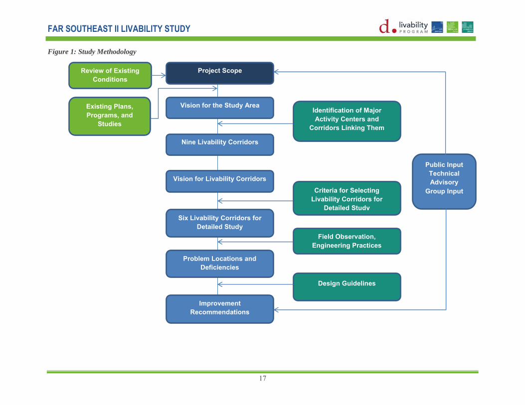
Study Methodology
The methodology of the study is outlined in the flowchart in Figure 1 on the next page.
The initial activities consisted of literature reviews and desk top reviews of existing conditions on maps. The literature review was conducted on several transportation studies within and around the study area that identified key issues and proposed improvements that were incorporated as appropriate in this study.
The team presented the vision for the study area based on an analysis of land uses, community facilities, recent developments and the identification of major trip generators in the area. Considering these trip generators as nodes, the vision was to establish links along existing corridors that would connect activity centers to each other and to the residential areas around the centers. Lines were identified that encourage walking, biking and transit use.
The team addressed safety, operational and roadway aspects of the study area by utilizing a combination of field observations and engineering practices and guidelines to analyze transportation conditions in the study area. Safety conditions primarily included speeding and the location of pedestrian crossings particularly near schools and community facilities. Operational conditions included intersection operations, pedestrian circulation, signing, bus stop locations and bicycle activities. The team utilized standard engineering practices for an analysis of roadway conditions (alignments, sight distance and lane widths).
Following analyses above, the study team recommended short, mid and long range multi-modal transportation improvements to increase mobility, safety, social and economic opportunities and accessibility to employment centers, retail areas and community and recreational facilities. Improvements were developed as conceptual designs incorporating both conventional standard designs and ―off the shelf‖ designs for speed tables and humps, signage and crosswalks.
The study concluded with the identification of performance measures to determine the effectiveness of proposed improvements. It is recommended that this follow-up study of before and after conditions be conducted using identified performance measures.
Public involvement and agency coordination were key elements throughout the process and took place during various stages of the project.
FAR SOUTHEAST II LIVABILITY STUDY
17
Figure 1: Study Methodology
Project Scope
Vision for the Study Area
Problem Locations and Deficiencies
Six Livability Corridors for Detailed Study
Vision for Livability Corridors
Improvement Recommendations
Nine Livability Corridors
Identification of Major Activity Centers and
Corridors Linking Them
Criteria for Selecting Livability Corridors for
Detailed Study
Field Observation, Engineering Practices
Design Guidelines
Review of Existing Conditions
Existing Plans, Programs, and
Studies
Public Input Technical Advisory
Group Input

FAR SOUTHEAST II LIVABILITY STUDY
18
Public Involvement and Agency Coordination
Community involvement and coordination consisted of input from neighborhood groups, community organizations and governmental agencies. Since people have different ideas about what makes their community livable, this study included three public workshops for residents, Advisory Neighborhood Commissioners (ANC), council members, community leaders, commercial property owners and concerned citizens. Participants were encouraged to provide input on transportation related issues in the community and to identify improvements they would like to see implemented. Input on existing transportation conditions collected during Public Meeting #1 included safety concerns and aesthetics, sidewalks, crosswalks, bus stops, bicycle facilities, traffic signal operations, travel speeds and green spaces.
Comments were received during Public Meeting #2 to guide the team on the types of transportation improvements they would like to see in their neighborhoods. For instance would they like to see more pedestrian or bicycle related improvements? How can a balance be achieved to satisfy all concerned citizens? The public was also presented with potential improvement locations based largely on the input provided during the first public meeting.
Finally, proposed improvements were presented during Public Meeting #3 to obtain citizen comments. Comments were incorporated in the final results.
The study also included input and coordination with representatives from multiple administrations within and outside of DDOT who were concerned with land use, environmental protection, historic preservation, economic development, housing, transit, and emergency management. Representatives discussed strategies for planning, funding and implementing livability improvements across various administrations. Administrations within DDOT included the Planning, Policy and Sustainability Administration (PPSA), the Infrastructure Project Management Administration (IPMA), the Progressive Transportation Services Administration (PTSA), the Transportation Operations Administration (TOA), and the Urban Forestry Administration (UFA). Agencies outside DDOT included the DC Office of Planning (DCOP), the DC Office of the Deputy Mayor for Planning and Economic Development (DMPED), the Federal Highway Administration (FHWA), the National Park Service (NPS) and the Washington Metropolitan Area Transit Area (WMATA).
Creating livable transportation systems require an interdisciplinary
approach

FAR SOUTHEAST II LIVABILITY STUDY
19
Chapter 2: The Study Area
Study Area Overview
The study area for the Far Southeast II Livability Study is located in the southeast section of the District of Columbia. The majority of the study area lies in Ward 7. The neighborhood of Fairlawn is located in Ward 8. It’s designated as Far Southeast II due to its location east of the Anacostia River. The study area is bounded by Massachusetts Avenue to the north; Good Hope Road and Naylor Road to the south; Anacostia Freeway to the west and Southern Avenue to the east. Prince Georges County, Maryland is directly adjacent to its eastern boundary.
The study area encompasses twelve distinct neighborhoods as shown in Figure 2 on the next page. They are:
• Fairlawn • Marbury Plaza • Randle Highlands • West Over View
• Good Hope • Twining • Penn Branch • Dupont Park
• Fort Davis • Fairfax Village • Hillcrest • Naylor Gardens
Of the twelve neighborhoods, Randle Highlands, Penn Branch, Hillcrest and Fort Davis have addressed operational and safety problems and quality of life issues primarily through the use of traffic calming solutions.
Study area neighborhoods have a strong sense of community spirit, due in part to a well-organized network of community associations, churches, and interest groups. For years, activities like the Fort Dupont Summer Concert Series have built community pride and entertained residents and visitors.
Although the study area has experienced a decline in population and increase in its poverty and unemployment rates between years 1990 and 2000, there has been a significant change during recent years with more housing units being constructed since 2000 and many more being renovated.

FAR SOUTHEAST II LIVABILITY STUDY
20
Figure 2: Study Area

FAR SOUTHEAST II LIVABILITY STUDY
21
Land Use
The existing land use for the Far Southeast II study area is shown in Figure 3. Approximately 47 percent of the Far Southeast land area is residential. Together, commercial and mixed use developments represent just 4 percent of the Far Southeast’s land area. Open space and parks comprise about 13 percent of the study
area. Streets and public rights of way comprise 32 percent of the study area.
The majority of the study area is designated as low density to moderate density residential land uses characterized by single family homes, row homes, and apartment buildings. The majority of the moderate density apartment buildings are located closer to commercial land uses adjacent Good Hope Road and Naylor Road and the eastern end of Pennsylvania Avenue.
There are some commercial areas throughout the study area. The majority of them are concentrated along the major roads of Good Hope Road and Pennsylvania Avenue. A large mixed use development, the Skyline Development, with 448 apartment units, 20 townhouses, and 315,000 sq.
ft. of retail space, is planned on the site north of the intersection of Good Hope Road, Alabama Avenue, and Naylor Road. There are several commercial and institutional developments planned along the western section of Good Hope Road under the Anacostia Gateway Commercial Revitalization and Anacostia Investment Plan and along Pennsylvania Avenue under the Pennsylvania Avenue SE Corridor Development Plan.
Parks and Recreational Centers
Several large and small parks traverse the study area. The chain of historic Ford Circle Parks, owned by the National Park Service, includes Fort Dupont Park, Fort Davis Park and Fort Stanton Park. Fort Davis Park is within the study area while Fort Dupont and Fort Stanton Parks are at the northern and southern limits of the study area respectively. Fort Dupont Park is one of the largest parks in the city, while Alger Park and the Pope Branch Park are smaller parks that connect to the Fort Circle Parks. These parks carry tremendous potential to provide recreational opportunities to the residents of the area and to bring communities together by providing attractive and safe pedestrian and bicycle connections.
There are two major recreational facilities in the study area; the Fort Davis Recreational Center and the Hillcrest Recreational Center. Alabama Avenue serves as the main access road to both recreational centers. Two additional recreational facilities are located just outside the project boundary within a half mile distance. The DC Therapeutic Recreational center is located north of the study area and is accessible via Minnesota Avenue. The Anacostia Fitness center is located in the western section of the study area.

FAR SOUTHEAST II LIVABILITY STUDY
22
Figure 3: Existing Land Use

FAR SOUTHEAST II LIVABILITY STUDY
23
Source: DC Data and Maps; http://planning.dc.gov/DC/Planning/DC+Data+and+Maps/DC+Data/Tables/Data+by+Geography/Census+Tracts
Demographics
Population in the area has been declining for over 40 years. In 2005, the area had a population of 22,845, or about 4 percent of the city’s total. The number of households in 2005 was 10,477. Approximately 96 percent of the area’s population is African-American, which is significantly higher than the citywide average of 60 percent.
More than one third (36.25%) of the population in the study area is either elderly (age 65 or over) or children below age 18. About 22 percent of the residents were under 18 in 2000, compared to a citywide average of 20 percent and about 14 percent were over 65, compared to the citywide average of 12 percent. (Table 2)
Educational Facilities
There are four elementary schools, one middle school, one high school and one K through 8 school in the study area. The study area also has private schools, preschools and day care centers run by local organizations. The majority of schools are concentrated in the western section of the study area. Minnesota Avenue, Good Hope Road, Naylor Road, Pennsylvania Avenue, Alabama Avenue and Naylor Road are the major roads that provide access to these schools.
In academic year 2006/2007, nearly 3,183 students were enrolled in District of Columbia Public Schools and Charter Schools. Among those enrolled, the majority of students (1,432) were enrolled in Elementary school, 762 were enrolled in middle school and 989 were enrolled in high school. One of the focuses of this plan is to increase bicycle and pedestrian safety around schools.
Table 2: Demographics of Study Area Population (Estimates) , 2005 22,845
Household (Estimates), 2005 10,477
Unemployment Rate, 2000 10.35%
Median Household Income, 2000 $36,870
Children (Under 18 Years Old), 2000 22.10%
Elderly (65+ Years Old), 2000 14.15%
DCPS/ Public Charter School Enrollment, 2006/2007 3,183
PK – 5 1,432
6 to 8 762
9 to 12 989

FAR SOUTHEAST II LIVABILITY STUDY
24
Community Facilities
There are two libraries in the study area. The newly built Anacostia Library is located on Good Hope Road in the southern part of the study area and the Francis A. George Library is located on 36th Place. Alabama Avenue serves as the major access road to the Francis A. Gregory Library.
There are three post offices in the study area. One is located near the intersection of Good Hope Road, Alabama Avenue and Naylor Road. Two others are located along Pennsylvania Avenue at the intersections of Alabama Avenue and Minnesota Avenue.
Police and Fire (EMS)
There are two police stations, both located on Pennsylvania Avenue. The one fire station in the study area is also located on Pennsylvania Avenue. There are two other fire stations south of the study area within a half mile distance.
Religious Facilities
There are several churches in the study area. The majority of churches are concentrated along Minnesota Avenue, Pennsylvania Avenue, Alabama Avenue, Good Hope Road and Naylor Road.

FAR SOUTHEAST II LIVABILITY STUDY
25
Chapter 3: Existing Plans, Programs and Studies
A literature review of existing plans, programs and studies conducted within the study area resulted in the identification of key issues and identification of proposed improvements consistent with previous studies. A description of each of these documents is summarized below.
Existing Plans and Programs
Creative DC Action Agenda (May 2010): The Creative DC Action Agenda examined ways to support creative employment and business opportunities, to promote revitalization and enlivening of underserved areas through arts and creative uses, and to better utilize and connect the District’s creative economy assets and support systems (such as education and workforce development). The Action Agenda also sought to leverage planning and public investment efforts, such as neighborhood and revitalization initiatives.
DC 2006 Comprehensive Plan: This Plan is a general policy document that provides overall guidance for future planning and development of the city. The first Comprehensive Plan was adopted in 1984 and 1985. The Plan is updated periodically. The District's Comprehensive Plan constitutes the District Elements, while the National Capital Planning Commission develops the Federal Elements. The District Elements contain eleven citywide elements that provide goals, objectives and policies for land use issues that impact the whole city, e.g. transportation, environment, parks and open space, arts and culture. There are also 10 Area Elements which provide goals, objectives and policies that are specific to geographic areas of the city.
Capital Space, A Park System for the Nation’s Capital, Ideas to Achieve the Full Potential of Washington’s Parks and Open Space: This combined document of the National Capital Planning Commission, the government of the District of Columbia, and the National Park Service
provides a comprehensive plan for the District of Columbia Parks. One of the six big ideas in the plan is to link the Fort Circle Parks by implementing a greenway and making a park destination.
The District of Columbia Pedestrian Master Plan 2009: This plan is a city wide comprehensive effort to address pedestrian issues. The plan provides guidelines and recommendations to reduce accidents and fatalities involving pedestrians and also to increase pedestrian activities by making walking a comfortable and accessible mode of travel throughout all parts of the District.
The District of Columbia Bicycle Master Plan 2005: The Bicycle Mater Plan aims to make the District even more bicycle friendly as a part of a broader initiative to create a sustainable, multi-modal transportation system. The plan provides a guide to establish high quality bicycle facilities and programs over the next ten years.

FAR SOUTHEAST II LIVABILITY STUDY
26
DC’s Transit Future 2007: This study looks at long term transit investments by examining various bus and rail technologies, and recommending corridors for implementing streetcars, bus rapid transit (BRT), or Metro Extra services based on results of corridor evaluations. Within our study area, Minnesota Avenue, Pennsylvania Avenue and a section of Southern Avenue from Pennsylvania Avenue to Branch Avenue are recommended for Metro Extra Service.
Great Streets Initiative: This initiative is a multiyear, multi-agency effort to transform under-invested corridors into thriving neighborhood centers. The Office of the Deputy Mayor for Planning and Economic Development (DMPED) is partnering with the District Department of Transportation (DDOT) and the Office of Planning (OP) to manage the program. Pennsylvania Avenue and Minnesota Avenue are identified under this initiative for development.
The DC Safe Routes to School Program: This program works to improve walking and biking infrastructure conditions and safety to and from middle and elementary schools in the District of Columbia.
The DC Capital Bikeshare Program: – The program provides automated, public, bicycle rentals. There are 5 bike share stations in the study area.
Traffic and Transportation Studies
Results of the following transportation and traffic studies were incorporated in the study as applicable. Their locations are shown in Figure 4.
DDOT 11th Street Bridges DDOT Minnesota Avenue Great Street
Framework Plan DDOT Anacostia Gateway
Transportation Study, 2004
Fairlawn Estates Development Randle Highlands Transportation Audit,
2009 Skyland Town Center Ford Davis Traffic Calming Study
Hillcreast/ Branch Avenue Traffic Calming Study, 2003
Pennsylvania Avenue Great Streets Project
Penn Branch Traffic Calming Study

FAR SOUTHEAST II LIVABILITY STUDY
27
Figure 4: Traffic and Transportation Studies

FAR SOUTHEAST II LIVABILITY STUDY
28
Recent Improvements
It is important to note that several recent improvements have been made in the study area. The improvement types include installation of All Way Stop Signs, Pedestrian Crossings, Truck Restrictions, Speed Humps, Quick Curbs and Flex Posts.
Figure 5 and the lists below identify the location of these improvements, located primarily along residential streets and near commercial establishments. There are also upcoming signal improvements proposed along Pennsylvania Avenue as part of the Pennsylvania Avenue Great Streets Project.

FAR SOUTHEAST II LIVABILITY STUDY
29
Figure 5: Recent Improvements

FAR SOUTHEAST II LIVABILITY STUDY
30
Chapter 4: Existing Transportation Conditions
The study team identified existing transportation facilities and services along selected corridors in the study area. The results were considered in developing proposed improvements.
Pedestrian Facilities
The study area has pretty good sidewalk coverage. A majority of streets have sidewalks on at least one side of the street. There are small pockets of neighborhoods that are missing sidewalks on both sides. Figure 6 shows the Hillcrest neighborhood bounded by Branch Avenue, Alabama Avenue, and Southern Avenue where missing sidewalks exist in the east section of the study area.
Similarly in the south section, between Naylor Road, Alabama Avenue and Hill Crest Drive are missing sidewalks. Large gaps in the sidewalks are also noted in the area between Pennsylvania Avenue and Massachusetts Avenue on either side of the Branch Avenue.
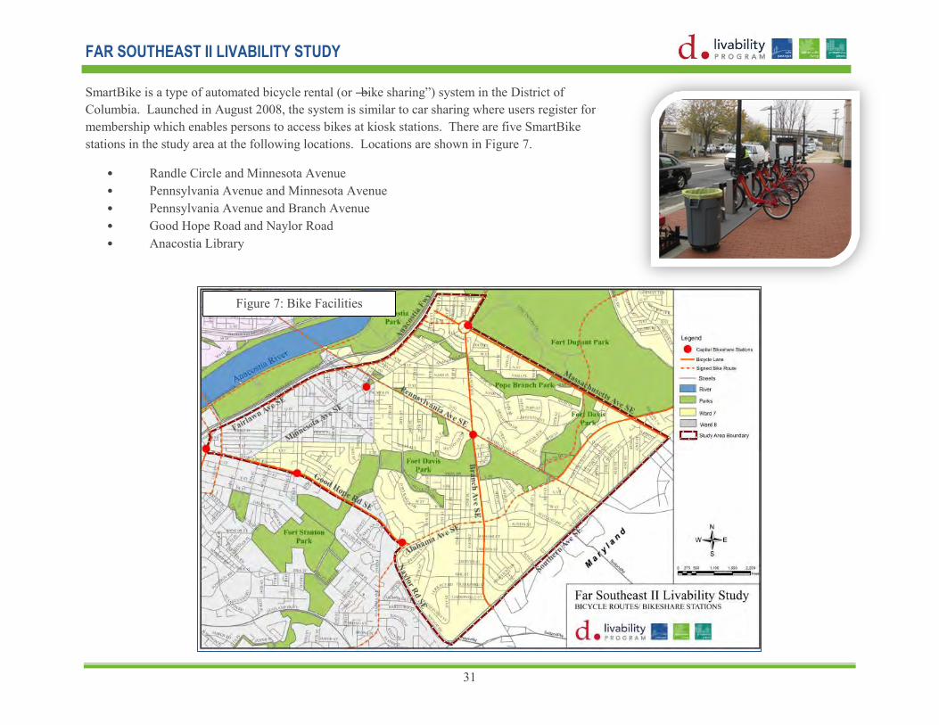
Bicycle Facilities
Bicycle facilities in the study area were referenced from DDOT’s 2010 Bicycle Map. Each facility in the study area is listed in Table 3 including the type of facility and an assessment of good, fair or poor in adjacent columns. Figure 7 shows the location of each route.
Figure 6: Sidewalks
FAR SOUTHEAST II LIVABILITY STUDY
31
SmartBike is a type of automated bicycle rental (or ―bike sharing‖) system in the District of Columbia. Launched in August 2008, the system is similar to car sharing where users register for membership which enables persons to access bikes at kiosk stations. There are five SmartBike stations in the study area at the following locations. Locations are shown in Figure 7.
• Randle Circle and Minnesota Avenue • Pennsylvania Avenue and Minnesota Avenue • Pennsylvania Avenue and Branch Avenue • Good Hope Road and Naylor Road • Anacostia Library
Figure 7: Bicycle Facilities Figure 7: Bike Facilities

FAR SOUTHEAST II LIVABILITY STUDY
32
Table 3: Bicycles Facilities
Bicycle Facilities Type Condition
Branch Avenue between Southern Avenue and Randle Circle Bike Lanes Fair 25th Street between Minnesota Avenue and Naylor Road Bike Lanes Not Rated 27th Street between Pennsylvania Avenue and Naylor Road Bike Lanes Fair Pennsylvania Avenue between Southern Avenue and Branch Avenue Bike Lanes Fair Pennsylvania Avenue between Branch Avenue and DC 295 Bike Lanes/Signed Bike Route Poor Alabama Avenue between Good Hope Road and 36
th Street Bike Lanes Fair
Alabama between Pennsylvania Avenue and Massachusetts Avenue Bike Lanes/Signed Bike Route Not Rated Suitland Road between Southern Avenue and Alabama Avenue Bike Lanes Fair Massachusetts Avenue between Randle Circle and Alabama Avenue Bike Lanes/Signed Bike Route Not Rated Southern Avenue between Branch Avenue and Pennsylvania Avenue Bike Lanes Fair Fairlawn Avenue between Pennsylvania Avenue and 16
th Street. Signed Bike Route Not Rated
The Fort Circle Park Hiker Biker Trail Off Street Trail Not Rated
Transit Services
Transit services are shown in Figure 8. The study area is served by the twenty-two Metro bus routes listed below with services to and from Prince Georges County Maryland. A majority of buses from Maryland enter the study area via Marlboro Pike and connect to Southern Avenue from the north or Branch Avenue from the east. Express commuter bus services run through Southern Avenue and Pennsylvania Avenue leading to Downtown DC.
Some stakeholders commented why Maryland buses are coming into the District of Columbia instead of stopping at metro stations and park and ride facilities near the Maryland line and transferring passengers to local buses and trains.
Although there are no metro stations within the study area, it has easy access to the Blue, Orange, and Green metro lines. There are three metro stations within a one mile radius of the study area. They are the Anacostia, Congress Heights and Naylor Road Metro Stations, on the Green Line.

FAR SOUTHEAST II LIVABILITY STUDY
33
Traffic Conditions
Traffic conditions are shown in Figure 9. The study area has good transportation access via a street network consisting of a freeway (DC 295), two major arterials (Pennsylvania Avenue and Branch Avenue south of Pennsylvania Avenue), and a number of minor arterials and collector streets including Minnesota Avenue, Southern Avenue, Good Hope Road, Massachusetts Avenue and Naylor Road. These streets link neighborhoods east of the Anacostia River to Central Washington and Prince Georges County, Maryland.
Many streets in the study area carry high volumes of traffic. According to DDOT Average Annual Weekday Traffic (AAWDT) Maps (2006 through 2008), Minnesota Avenue between Pennsylvania Avenue to Randle Circle carried the heaviest volumes of traffic (25,800 AAWDT) followed by Branch Avenue from Pennsylvania Avenue to Alabama Avenue (20,000 AAWDT). The majority of the remaining corridors have AAWDT’s higher than 10,000.
Bus Routes
Pennsylvania Avenue - 30 32 34 35 36 Minnesota Avenue - ANAC* U2 Bladensburg Road - Anacostia B2 Sheriff Road-Capitol Heights - F14 Minnesota Avenue/M Street - V7 V8 V9 U Street/Garfield - 90 92 93 Garfield ANAC* - Loop W8 United Medical Center - Anacostia W2 W3 Anacostia High School - A31 A32 A33 Fairfax Village - M6 Forestville - K11 K12 K13 Sousa Middle School - S35 Duke Ellington School of Arts - D51 Fairfax Village-L'Enfant Plaza - V5 Anacostia - Eckington - P1 P2 P6 Pennsylvania Avenue Express Service - 39 Fairfax Village-Naylor Road - M2 Marlboro Pike - J11 J12 J13 District Heights/Suitland - V12 Martin Luther King Jr. Highway - A11 A12` Deanwood/Alabama Ave - W4 Anacostia - Congress Heights - A2-8 A42-48
Figure 8: Bus Lines and Stops Facilities

FAR SOUTHEAST II LIVABILITY STUDY
34
DDOT conducted speed studies on principal and minor arterials in 2006 to determine the 85th Percentile Speed (PS) or the speed at or below which 85% of the vehicles are moving. Speeding was recorded at various locations shown in Table 4.
Many residents in Far Southeast neighborhoods complain about speeding which resulted in the Traffic Calming Studies previously conducted in the study area. Since some neighborhoods now have speed tables and humps, this study addressed possible diversion routes that travelers might use to avoid streets with speed tables and humps listed in Figure 9.
Figure 9: Traffic Conditions

FAR SOUTHEAST II LIVABILITY STUDY
35
Accident Locations
Data from 2000 through 2006 was aggregated to identify intersections with safety issues. Table 5 lists the six locations that were identified as high accident locations.
Intersection Total Crashes Total Pedestrian Crashes Total fatalities
Pennsylvania Avenue and Alabama Avenue 53 1 0 Pennsylvania Avenue and 27
th Street 44 1 0
Alabama Avenue and Branch Avenue 46 0 0 Good Hope Road and 25
th Street 29 6 0
Good Hope Road and Naylor Road 55 3 0 Good Hope Road and Alabama Avenue 30 1 0 Alabama Avenue and Naylor Road 30 0 0
Table 4: Speed Table
Table 5: high Accident Locations

FAR SOUTHEAST II LIVABILITY STUDY
36
Public Issues and Concerns
The study team solicited comments from citizens during Public Meeting #1 on transportation related issues and concerns and on improvements that they would like to see in their community. A list of the more common concerns is below. Figure 10 displays their comments at appropriate locations.
• Better lighting • Areas around the Francis Library need to be more pedestrian friendly • Park improvements (more recreational opportunity, playground, benches,
etc.) on the area north of the library. • More bus shelters • Removal of flexible mounted pedestrian signing at crosswalk locations
because they are ineffective.
Many commenters expressed concern about the unattractiveness of the streetscape, i.e. landscaping, lighting, pavement and sidewalk conditions, mainly along Naylor Road at Fort Davis Park.
Very few comments were received from residents and community leaders in Fort Davis and Penn Branch neighborhoods, probably due to the fact that two traffic calming studies were conducted there in 2008. The study included multiple improvements proposed along Good Hope Road, ranging from signage to roadway geometry to speeding.

FAR SOUTHEAST II LIVABILITY STUDY
37
Figure 10: Public Comments Conditions
Figure 10: Public Comments Lines and Stops Facilities

FAR SOUTHEAST II LIVABILITY STUDY
38
Chapter 5: Livability Corridors
Vision for the Study Area
We begin by defining a Livability Corridor. A Livability Corridor is a travel route that people take to complete their trips within the community. They are the routes that people take on a daily basis to get to work, to drop their kids off at schools, to get to shopping malls, and to get to restaurants and movies. In other words, these are the routes that people take to get to the activity center that meets their daily needs. They are characterized by their ability to connect major activity centers to residential areas, provide good access to side streets, serve as a bus route and is of sufficient width for construction of sidewalks if there are none.
A vision for neighborhoods in the Far Southeast study area was formed to guide the identification of Livability Corridors and development of transportation solutions along these corridors that improve the quality of life for people who live, work and recreate there. The vision resulted from stakeholder input and dialogue, reviews of existing conditions, plans, programs and studies, and field observations of current travel conditions. This vision supports the larger vision elements including safe passages, sustainable living and prosperous places contained in DDOT’s Action Agenda 2010 and USDOT’s Livability Initiative which includes principles to provide more transportation choices, sustainable alternatives, safer streets, and improved quality of life for citizens.
The vision supports the recreational needs of neighborhoods in the study area by incorporating results from NCPC’s ―Capital Space, A Park System for the Nation’s Capital, Ideas to Achieve the Full Potential of Washington’s Parks and Open Space.‖ Finally, it guides the implementation of a variety of travel options and safety solutions through its incorporation of results from the District of Columbia Pedestrian Master Plan 2009, the District of Columbia Bicycle Master Plan 2005, DC’s Transit Future 2007, the DC Safe Routes to School Program, the Bicycle Sharing Program, and the latest District of Columbia Comprehensive plan.
The Vision for the Study Area is to: Provide better access to social and economic opportunities by efficiently connecting major activity centers (employment
centers, retails, education, recreation, and community facilities) within and around the study area.
Strengthen connections to regional transportation network and park corridors.
Provide a variety of transportation options by making walking, wheeling, bicycling and transit use safe and convenient.
Support existing communities in the study area by preserving and enhancing community characteristics.
A Livability Corridor is a route that people
take on a daily basis to an activity center(s)
that meets their daily needs.
Shubha Adhikari, LEED GA

FAR SOUTHEAST II LIVABILITY STUDY
39
Identifying and Linking Major Activity
Centers
In order to identify potential Livability Corridors that would provide a variety of safe and convenient modes of travel, it is necessary to understand why people travel and what generates their trips. People travel to work, places of worship, grocery and convenient stores, schools, etc., as part of their day to day life. A Livability corridor would contain a concentration of these activities as a major trip generator.
The following seven areas shown in Figure 11 were identified in the study area as major trip generators that have high concentrations of commercial, employment and recreational activities.
1. Area around the intersection of Good Hope Road, Naylor Road, and Alabama Avenue
2. Western section of Good Hope Road 3. Area around intersection of Pennsylvania
Avenue and Minnesota Avenue 4. Area around intersection of Pennsylvania
Avenue and Branch Avenue 5. Area around intersection of Pennsylvania
Avenue and Alabama Avenue 6. Naylor Road Metro Station 7. Fort Dupont Park
A large mix of activities including retail, commercial, office complexes, instructional buildings and government facilities are concentrated along the western segment of Good Hope Road,
Figure 11: Activity Centers

FAR SOUTHEAST II LIVABILITY STUDY
40
particularly around its intersections with Martin Luther King Jr. Boulevard and Minnesota Avenue.
An abundance of retail and commercial activities are concentrated around the intersection of Good Hope Road, Naylor Road, and Alabama Avenue. The Skyline Development, a large mixed-use development complex, is proposed at the site.
The intersections of Pennsylvania Avenue at Minnesota Avenue and Branch Avenue at Alabama Aveneue have some commercial, institutional and govenrnament activies. There is a commuter stop planned at the intersection of Pennsylvania Avenue and Branch Avenue as described in the District of Columbia 2006 Comprehensive Plan.
Adjoining the study area to the north is the regional recreational area, Fort Dupont Park. The nearest metro station is the Naylor Road Metro Station, which is located about 0.2 miles east of the study area’s eastern boundary. These are places that Far South East community residents visit frequently, thus generating trips.
Using information collected during the site observation, the study team identified potential livability corridors in the study area listed below. Their general characterics are described in the next section.
1. Fort Circle Parks 2. Pennsylvania Avenue 3. Massachussetts Avenue 4. Good Hope Road 5. Minnesota Avenue 6. Southern Avenue 7. Alabama Avenue 8. Branch Avenue 9. Naylor Road
Figure 12: Activity
Center Links

FAR SOUTHEAST II LIVABILITY STUDY
41
The Fort Circle Parks corridor runs north and south through the middle of the study area, and beyond. The central location of the park corridor gives it tremendous potential for development as a major destination for recreational activity as well as an off road bicycle and pedestrian connection. Recognizing its potential, the Fort Circle Parks corridor is identified as a livability corridor, even though it does not function as a transportation corridor currently.
Pennsylvania Avenue, Massachusetts Avenue, and Good Hope Road are three major corridors that provide east and west connections to activity centers. Similarly, Minnesota Avenue and Southern Avenue provide north and south connections.
Alabama Avenue, Branch Avenue, and Naylor Road are major secondary routes that interconnect neighborhoods with the major corridors or activity centers.
A hierarchical pattern is seen on these livability corridors based on their regional and local significance, land use pattern and streetscape characteristics.
The study team also analyzed streets within a ¼ mile walking radius of schools, a ½ miles radius of public libraries and the Naylor Road Metro Station. This analysis helped identify routes that are used to access these essential community services. Figure 13 shows the ¼ mile radius around the schools in green, ½ mile radius around libraries in blue and ½ mile radius around metro station in brown.
Figure 13: Comfortable Walking Distance
around Schools, Libraries, and Metro
Stations

FAR SOUTHEAST II LIVABILITY STUDY
42
General Characteristics of Livability Corridors:
Pennsylvania Avenue: Pennsylvania Avenue is a regional corridor that connects the District of Columbia to Prince Georges County, Maryland. The corridor is planned as a major commuter route and is commercial in nature. The District’s long range transportation plan describes a plan for a transit hub to allow commuters to transfer from a regional transit network to a local network. Pennsylvania Avenue also provides access to the Fort Circle Parks.
Vision: The vision for this livability corridor is to maintain its function as a regional corridor, consistent with DC’s Comprehensive Plan and DC’s Transit Future, that will provide efficient access to and egress from the District of Columbia. The vision is to develop it as a multimodal commuter route that allows for the transfer to a local mode from an express mode or to an alternative mode of transportation.
Massachusetts Avenue: Massachusetts Avenue provides an east-west connection in the study area. Lack of a direct connection across the Anacostia River to downtown DC renders it incapable of functioning as a regional corridor. The northern side of Massachusetts Avenue is bordered by Fort Dupont Park and the southern side is mostly residential with single family homes with deep setbacks of approximately 50 feet or more. This corridor is further characterized by low traffic volumes and lies in a park-like setting.
Vision: The vision for this livability corridor is to preserve its scenic vista and park like environment and to develop bicycle and pedestrian facilities around the park facility.
Good Hope Road: Good Hope Road is a mixed use corridor with retail and commercial, high to moderate density residential, and institutional uses. Good Hope Road also provides good access to the Fort Circle Parks. A variety of land uses and building types combined with existing sidewalks and transit service on this road provides for a good multimodal environment.
Figure 13: Pennsylvania Avenue
Figure 14: Good Hope Road

FAR SOUTHEAST II LIVABILITY STUDY
43
Vision: The vision is to develop Good Hope Road as a multimodal corridor with a variety of transportation choices including pedestrian and transit use, a variety of land uses that support activities 24-hours a day, and streetscape features to support a walkable environment and enhance access to the Fort Circle Parks.
Minnesota Avenue: Minnesota Avenue is also a mixed use corridor with residential neighborhoods and commercial activities. Commercial activities are concentrated at the intersection of Minnesota Avenue and Good Hope Road and at the intersection of Minnesota Avenue and Pennsylvania Avenue. The remainder of the corridor is lined with detached single family homes and row houses with relatively shallow setbacks of 10 to 20 feet from the curb. The corridor provides access to three public schools and includes several churches and community activity centers.
Vision: The vision is to develop a corridor that will provide convenient and safe access to local community facilities such as schools and churches and provide a variety of mode choices such as walking, cycling, and transit use.
Southern Avenue: Southern Avenue provides a north and south connection and borders Prince Georges County, Maryland to the east. Southern Avenue is mostly residential with some light commercial activities. It terminates at Branch Avenue and emerges at Naylor Road further south at the southern end of the study area. The existing section of Southern Avenue underwent a successful road diet by implementation of a striped parking box in place of the outside travel lane.
Vision: The vision for this corridor is to maintain its existing characteristics while enhancing transit facilities and increasing pedestrian and bicycle safety. The District of Columbia is exploring the possibility of extending its limits from Branch Avenue to Naylor Road as part of a separate effort outside of the scope of this study.
Alabama Avenue: Land use along Alabama Avenue is mostly residential with some institutional facilities. There are a few clusters of commercial activities on Alabama Avenue at the intersection of Naylor Road and Good Hope Road, and at its intersection with Pennsylvania Avenue. Alabama Avenue also provides access to Beers Elementary School, Francis A. Gregory Public Library, and the Fort Circle Parks. The north section of Alabama Avenue has existing bike lanes on each side from Pennsylvania Avenue to Massachusetts Avenue.
Vision: The vision for this corridor is to maintain its existing characteristics with enhanced transit facilities, improved bicycle and pedestrian facilities, and develop it as a continuous bike route by extending the limits from Pennsylvania Avenue to Naylor Road.
Figure 15: Massachusetts Avenue

FAR SOUTHEAST II LIVABILITY STUDY
44
Naylor Road: The land use composition of Naylor Road is mostly residential. A segment of Naylor Road runs through the Fort Circle Parks providing good access.
Vision: The vision for this corridor is to develop a shared use bicycle route, enhance transit facilities, and increase pedestrian safety while maintaining the characteristics of Naylor Road as a residential street.
Branch Avenue: The land use composition of Branch Avenue is mostly residential. The southeast section of Branch Avenue has been recently improved with the construction of a raised median and left turn lanes at each intersection between Alabama Avenue and Southern Avenue. Branch Avenue provides access to Fort Circle Parks and has a direct connection to the Naylor Road Metro Station.
Vision: The vision for this corridor is to enhance its connection to Fort Circle Parks, increase bicycle and pedestrian safety and develop it as a transit link that connects the planned transit hub at Pennsylvania Avenue to the Naylor Road Metro station with frequent shuttle service.
Fort Circle Parks: The Fort Circle Parks provide an excellent opportunity to act as a central livability feature of the Far Southeast Community. The central location of the park can be a uniting feature of the community bringing the community together by offering a variety of opportunities for active and passive recreation. The park corridor also has the potential for a continuous bike and pedestrian trail that will connect the north side of the community and the Fort Dupont Park to the Fort Stanton Park on the South.
Vision: The vision for Fort Circle Parks is to develop it as a uniting feature of the community by providing a variety of opportunities for active and passive recreation and making it safe and accessible. The vision is to develop a continuous off street bicycle and pedestrian path along the park while preserving its natural resources.
Figure 16: Fort Circle Parks

FAR SOUTHEAST II LIVABILITY STUDY
45
Selection of Livability Corridors for Further Study
The study team selected livability corridors for further study using a high-level method of evaluation. The evaluation consisted of a screening of the nine potential corridors identified in the previous section to determine if they meet key criteria for designation as a livability corridor. It was determined that if the corridor addressed a minimum of four out of five selection criteria, it would be selected for further study.
Key criteria are:
- Connectivity to major activity centers - Access to schools, parks, and other community facilities - Area issues not studied or recommended for improvements by other existing studies and plans - Corridors with deficiencies identified by the public during Public Meeting #1 - Recommendation from Technical Advisory Committee
Results of the evaluation included in Table 6, yielded the following six livability corridors for further:
- Good Hope Road (Between Minnesota Avenue and Naylor Road) - Naylor Road (Between Fairlawn Avenue and Southern Avenue) - Minnesota Avenue (Between Good Hope Road and Randle Circle) - Alabama Avenue (Between Branch Avenue and Pennsylvania Avenue) - Branch Avenue (Southern Avenue and Pennsylvania Avenue) - Southern Avenue (Between Branch Avenue and Pennsylvania Avenue)
Recommendations of transportation improvements were developed for these six livability corridors and are described in the next chapter.

FAR SOUTHEAST II LIVABILITY STUDY
46
Connectivity to
major activity
centers
Access to schools,
parks, and other
community
facilities
Issues not
covered under
other studies
Public Input Technical
Advisory
Group Input
Pennsylvania Avenue
Good Hope Road
Massachusetts
Avenue
Minnesota Avenue
Southern Avenue
Branch Avenue
Alabama Avenue
Naylor Road
Fort Circle Parks*
Table 6: Evaluation of Livability Corridors

FAR SOUTHEAST II LIVABILITY STUDY
47
Figure 17: Improvement Locations
FAR SOUTHEAST II LIVABILITY STUDY
48
The following corridors were not selected for further study for the reasons described below:
- Pennsylvania Avenue - Massachusetts Avenue - Fort Circle Parks
Pennsylvania Avenue: There are several studies including the Pennsylvania Avenue, SE Corridor Development Plan and the Pennsylvania Avenue Great Streets Project that studied the issues associated with this corridor. In addition, reconstruction of the roadway and the sidewalks is currently underway. In order to avoid duplication of work and conflicting recommendations from what is already being constructed on Pennsylvania Avenue, the Far Southeast study team concentrated its efforts on other corridors in the study area.
Massachusetts Avenue: Massachusetts Avenue was not selected for further study because there were no deficiencies identified by the general public or the Technical Advisory Committee.
Fort Circle Parks: The Capital Space, A Park System for Nation’s Capital, Ideas to Achieve the Full Potential of Washington’s Parks and Open Space already describes a long term plan to develop Fort Circle Parks as a system of continuous parks around the District of Columbia. The Far Southeast Livability Study strengthens the corridor vision by proposing bicycle and pedestrian accessibility improvements to the parks from other livability corridors.
Other Improvement Locations
In addition to the six livability corridors mentioned above, the project team selected the following four locations for spot improvements. Selection of these locations were based on public input as well as input from the Technical Advisory Committee. The project team also identified streets adjacent to schools in the study area. These streets were recommended for spot improvements in support of the Safe Routes to School Program.
27th Street, between Naylor Road and Texas Avenue Altamont Place, between Good Hope Road and Naylor Road 30th Street at S Street Park Drive, From 31st Place to Branch Avenue 16th Street at T Street 17th Street at T Street

FAR SOUTHEAST II LIVABILITY STUDY
49
Chapter 6: Recommended Improvements for Livability Corridors
Results from Public Survey
The team conducted a survey on the livability corridors selected for further study. The purpose of the survey was to gather input from stakeholders on the types of improvements they would like to see along these corridors. The survey consisted of a questionnaire asking residents what type of improvements they valued most for each selected corridor. The improvements were organized under five main categories:
1. Pedestrian;
2. Bicycle;
3. Transit;
4. Traffic calming; and
5. Other design considerations.
For each type of improvement, citizens were asked to circle the number (ranging from 1 for least desired to 5 for most desired) that they would like to see improved. A total of 16 surveys were received at Public Meeting #2.
Improved lighting, pedestrian traffic control, mid-block crossing, traffic calming measures and bus stop amenities were among the top improvements that residents of the area desired to see. There was some interest in bicycle improvements, but it did not rise to the top of importance for respondents. Detail survey results for each livability corridor is located in Appendix B.
A summary of findings is below.
• Good Hope Road – Improved lighting and pedestrian Improvements are most important
• Naylor Road – Improved lighting, pedestrian improvements and various other topics are most important
• Minnesota Avenue – Improved lighting, pedestrian improvements, stop signs and bus stop amenities are most important
• Alabama Avenue – Pedestrian improvements, traffic calming, and improved lighting are most important
• Branch Avenue – Improved lighting and pedestrian improvements are most important
• Southern Avenue – Improved lighting, relocating overhead utilities, streetscape and pedestrian improvements are most important
Corridors Selected for Further Study
Good Hope Road Naylor Road Minnesota Avenue Alabama Avenue Branch Avenue Southern Avenue

FAR SOUTHEAST II LIVABILITY STUDY
50
The study team utilized public input from this survey to determine the recommended improvements for each livability corridor.
Field Observations
Field observations were conducted by walking and driving livability corridors for observation of existing conditions. The team observed corridor operations, neighborhood setting and characteristics, and physical conditions, including those conditions that necessitated improvements that were most important to respondents. The team also observed conditions near schools, commercial areas, libraries and recreation areas. A list of more common conditions observed for each corridor is below:
• Street lighting
• Pedestrian traffic control measures (for instance presence and condition of pedestrian signals and signing)
• Bus stops and amenities
• Overhead utilities
• Midblock crossings
• Crosswalk pavement markings
• Sidewalks, handicap ramps
• Medians
• Streetscape improvements
The team also evaluated potential cut-through streets. Cut-through street are oftentimes used by motorists to avoid traffic signals or queuing associated from signals, to increase speeds due to lower traffic volumes, or act as a parallel route to a higher functional classification roadway. Figure 18 shows eleven candidate cut-through street locations overlaid with intersection locations that traffic is trying to avoid.

FAR SOUTHEAST II LIVABILITY STUDY
51
Figure 18: Speed Data/ Potential Cut Through Streets

FAR SOUTHEAST II LIVABILITY STUDY
52
Profiles of selected Livability Corridors:
Results of field observations were used to determine a profile of each of the livability corridors. Profiles are presented in the following paragraphs.
Alabama Avenue
Functional Classification: Minor Arterial Snow Emergency Route Average Daily Traffic: 11,600 vehicles per day Roadway Width: 40 Feet Posted Speed Limit: 25 MPH
o 85th Percentile Speed: 35 MPH On-Street Parking Present During Off-Peak between Suitland Road
and Pennsylvania Avenue (In General), Sidewalks Present on both sides of street Bus Routes and Stops Present
Branch Avenue
Functional Classification: o Minor Arterial (north of Pennsylvania Avenue) o Principal Arterial (south of Pennsylvania Avenue)
Snow Emergency Route - south of Pennsylvania Avenue Average Daily Traffic:
o About 10,000 vehicles per day (north of Pennsylvania Avenue)
o About 20,000 vehicles per day (south of Pennsylvania Avenue)
Roadway Width: 40 Feet Posted Speed Limit: 25 MPH
o 85th Percentile Speed: 45 MPH (north of Pennsylvania Ave) 36 MPH (south of Pennsylvania Ave) On-Street Parking Present During Off-Peak between Suitland Road and Pennsylvania Avenue (In General) Sidewalks Present on east side only

FAR SOUTHEAST II LIVABILITY STUDY
53
Bus Routes and Stops Present (Stops located south of Pennsylvania Avenue)
PM Peak Period Turn Restrictions to cross streets
Good Hope Road
Functional Classification: Minor Arterial Snow Emergency Route Average Daily Traffic:
o About 17,000 vehicles per day (13th Street to Naylor Road)
o About 14,700 vehicles per day (Naylor Road to Alabama Avenue)
Roadway Width: 36 - 40 Feet Posted Speed Limit: 25 MPH
o 85th Percentile Speed: 41 MPH (between 24th Street and Altamont Place)
On-Street Parking Present During Off-Peak Sidewalks Present Bus Routes and Stops Present

FAR SOUTHEAST II LIVABILITY STUDY
54
Minnesota Avenue
Functional Classification: Minor Arterial Average Daily Traffic:
o About 10,000 vehicles per day (Good Hope Road to Pennsylvania Avenue)
o About 25,300 vehicles per day (Pennsylvania Avenue to Randle Circle)
Roadway Width: 40 - 42 Feet Posted Speed Limit: 25 MPH
o 85th Percentile Speed: 30 MPH (between 19th Street and 22nd Street); 36 MPH (between N Street and Anacostia Road)
No On-Street Parking Restrictions Sidewalks Present Bus Routes and Stops Present
Naylor Road
Functional Classification: Minor Arterial Average Daily Traffic:
o About 16,000 vehicles per day (25th Street to Good Hope Road)
o About 14,700 vehicles per day (Good Hope Road to Southern Avenue)
Roadway Width: 36 - 40 Feet Posted Speed Limit: 25 MPH
o 85th Percentile Speed: 40 MPH (between 27th Street and Altamont Place)
(In General) No On-Street Parking Restrictions Sidewalks Present Bus Routes and Stops Present
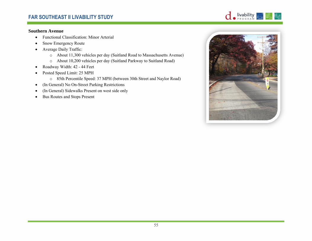
FAR SOUTHEAST II LIVABILITY STUDY
55
Southern Avenue
Functional Classification: Minor Arterial Snow Emergency Route Average Daily Traffic:
o About 11,300 vehicles per day (Suitland Road to Massachusetts Avenue) o About 10,200 vehicles per day (Suitland Parkway to Suitland Road)
Roadway Width: 42 - 44 Feet Posted Speed Limit: 25 MPH
o 85th Percentile Speed: 37 MPH (between 30th Street and Naylor Road) (In General) No On-Street Parking Restrictions (In General) Sidewalks Present on west side only Bus Routes and Stops Present

FAR SOUTHEAST II LIVABILITY STUDY
56
Proposed Recommendations for Improvements
Site specific as well as corridor wide recommendations were derived for each selected corridor that improves the quality of life for residents, workers and visitors in the study area. These recommendations were derived from observations identified during field observation, information collected from the public during Public Meetings, and guidance from the Technical Advisory Committee consisting of various governmental agencies in the District. Accident locations, traffic and pedestrian volumes and speed data were also analyzed to come up with several pedestrian safety and traffic calming type improvements. The following paragraphs provide a description of proposed improvements for each selected livability corridor accompanied by typical existing and proposed sections and a table listing of improvements along the corridor.
Good Hope Road (Between Minnesota Avenue and Naylor Road)
Figures 19 and 20 show existing and proposed typical sections of Good Hope Road between Minnesota Avenue and 18th Street and between 18th Street and 24th Street. Proposed improvements in the corridor section between Minnesota Avenue and 18th Street will occur within the confines of the existing pavement and include a 10 - 11 foot shared use lane to be used by both vehicles and bicycles and an 8 foot parking lane in each direction.
The corridor section between 18th Street to 24th Street includes a 13 foot shared use travel lane in each direction, separated by a 12 foot turn lane. On-street parking is available in sections where space is available within the existing pavement and existing off-street parking lots serve adjacent apartment buildings for residents and guest.
In an effort to promote bicycle activity in the Far Southeast community, a shared use lane or sharrow street marking is proposed in the center of a travel lane to indicate that a bicyclist may use the full lane. The shared use lane will be coupled with signing warning motorists to share the road with bicyclists.
Appendix A, Pages A1-A4, shows proposed intersection improvements along Good Hope Road at Minnesota Avenue, 15th Street, 18thStreet, and the Fort Circle Park Crossing.

FAR SOUTHEAST II LIVABILITY STUDY
57
Figure 19
Figure 20

FAR SOUTHEAST II LIVABILITY STUDY
58
Table 7 lists proposed improvements on Good Hope Road by improvement type, location or limits of the improvement, detailed description, and the anticipated time frame for implementation.
Table 7
Proposed Improvements
Good Hope Road Type Location/ Limits Description Time Frame
Buses •16th Street •22nd Street Bus stop consolidation Mid •15th Street Bus stop relocation Mid Roadway Safety/
Operational/ Traffic
Calming
•Between Minnesota Avenue and 18th Street (approximate)
8-ft on-street parking lanes on each side, 10-ft (min.) or 11-ft (max.) travel lanes (1 each direction)
Long
•Between 18th Street and east of 24th Street (approximate)
13-ft shared travel lanes (1 each direction) and 12-ft turn lanes/pedestrian refuge areas. 8-ft on-street parking provided where space is available
Long
•Between 24th Street and Naylor Road Speed Cameras Mid Bicycles •Between 19th Place and Fort Circle Park Crossing Shared use lane pavement markings Mid/Long •Between Minnesota Avenue and Naylor Road Capital Bikeshare Informational Signing
along route Mid/Long
Pedestrians • Minnesota Avenue •15th Street •18th Street •19th Place
•22nd Street •Altamont Place •24th Street
Crosswalk and/or curb ramp improvements Mid/Long
•Fort Circle Park Hiker/Biker Trail (west of Altamont Place)
Proposed crosswalks/curb ramps Long
•16th Street •17th Street •Fendall Street •18th Street •23rd Street •22nd Street •Fort Circle Park Crossing
•24th Street
Pedestrian refuge island Mid

FAR SOUTHEAST II LIVABILITY STUDY
59
Naylor Road (Between Fairlawn Avenue and Southern
Avenue)
Figures 21 and 22 show existing and proposed typical sections of Naylor Road between Good Hope Road and Altamont Place and between Altamont Place and T Street. The section between Good Hope Road and Altamont Place includes a 14 foot shared use travel lane in each direction and an 8 foot parking lane on one side.
The section between Altamont Place and T Street will include a 14 foot shared use travel lane in each direction separated by an 8 foot median. This section will be constructed in two phases: Phase 1 will include a striped median. Following an evaluation of large vehicular operations, a decision will made to construct a raised/landscape median.
Corridor improvements include additional bus stop amenities such as an enlarged landing pad area, trash receptacles, transit information signs and/or benches for passengers to experience improved waiting areas and safer and easier access to buses.
Other improvements include speed cameras; proposed crosswalk/curb ramps, signing, pedestrian refuge islands and proposed sidewalks in selected locations.
Appendix A, Pages A5-A6, show intersection improvements along Naylor Road at the intersections of Altamont Place and 27th Street.
Figure 21
Figure 22

FAR SOUTHEAST II LIVABILITY STUDY
60
Table 8 list proposed improvements on Naylor Road by improvement type, location or limits of the improvement, detailed description, and the anticipated time frame for implementation.
Table 8: Proposed Improvements, Naylor Road Type Location/ Limits Description Time Frame
Buses •South of 27th Street •S Street
Additional bus stop amenities1, such as enlarged landing pad area, trash receptacles, transit information signs, and/or benches
Mid/Long
•Altamont Place Bus stop relocation Mid Roadway Safety/
Operational/
Traffic Calming
•Between 27th Street and Altamont Place Speed Cameras Mid
•Between Good Hope Road and Altamont Place
8-ft parking lane (1 side), 14-ft shared travel lanes (1 each direction)
Short
•Between Altamont Place and S Street 8-ft median, 14-ft shared travel lanes (1 each direction)
Mid
Bicycles •Between Good Hope Road and Altamont Place •Between Altamont Place and T Street •Between T Street and S Street
Shared use lane pavement markings Short
Pedestrian •Altamont Place •27th Street •S Street
Midblock crossing at bus stops between 27th and Altamont
Crosswalk and/or curb ramp improvements
Mid/Long
•Fort Circle Park Hiker/Biker Trail (south of 27th Street) Proposed crosswalk/curb ramps and pedestrian refuge island
Long
•Altamont Place •27th Street •T Street •S Street
Pedestrian crossing warning signs and advance signing
Short
•East side of Naylor Road between S Street and R Street Proposed sidewalks Long

FAR SOUTHEAST II LIVABILITY STUDY
61
Minnesota Avenue (between Good Hope Road and Randle Circle) Figure 23 shows the typical section of Minnesota Avenue between Good Hope Road and Pennsylvania Avenue. Proposed improvements will occur within the confines of the existing pavement and include 12 foot shared use lanes to be used by both vehicles and bicycles and an 8 foot parking lane in each direction.
Additional bus stop amenities such as enlarged landing pad areas, trash receptacles, transit information signs, and/or benches are proposed at selected locations along the corridor.
Appendix A, Pages A7-A8, shows intersection improvements along Minnesota Avenue at Q Street and Nicholson Street/ White Place. Additional intersection improvements are proposed at R Street and S Street applying similar improvements as those shown for intersections above for crosswalk/curb ramp improvements. A rapid flashing beacon is proposed at the intersection of Minnesota Avenue and N Street.
Figure 23

FAR SOUTHEAST II LIVABILITY STUDY
62
Table 9 list proposed improvements on Minnesota Avenue by improvement type, location or limits of the improvement, detailed description, and the anticipated time frame for implementation.
Table 9: Proposed Improvements Minnesota Avenue
Type Location/ Limits Description Time Frame Buses •19th Street
•Naylor Road •Nicholson Street/White Place •N Street •M Street
Additional bus stop amenities1, such as enlarged landing pad area, trash receptacles, transit information signs, and/or benches
Mid/Long
Roadway
Safety/
Operational/
Traffic
Calming
•Q Street •R Street/18th Street •S Street/17th Street •Nicholson Street/ White Place
Intersection reconfiguration Long
•Between Good Hope Road and Nicholson/White Place
8-ft designated on-street parking lanes on each side, 12-ft shared use lanes (1 lane in each direction).
Short/Mid
Bicycles •Between Good Hope Road and Nicholson Street & White Place
Shared use lane pavement markings Short
Pedestrian •Anacostia Road – removed one crosswalk and two ramps •Burns Street - removed one crosswalk and one ramp •R Street •S Street
Crosswalk/curb ramp improvements Short/Mid
•Q Street Proposed crosswalk/curb ramps Long
•Nicholson Street/White Place Pedestrian refuge island Long
•N Street Rapid Flash Beacon Mid/Long

FAR SOUTHEAST II LIVABILITY STUDY
63
Alabama Avenue (Between Branch Avenue and Pennsylvania Avenue)
Figure 24 shows the typical section on Alabama Avenue between 36th Street and 38th Street. Proposed improvements will occur within the confines of the existing pavement and include 13 foot shared use lanes to be used by both vehicles and bicycles and an 8 foot parking lane in each direction. Additional bus stop amenities such as enlarged landing pad areas, trash receptacles, transit information signs, and/or benches are proposed at selected locations along the corridor.
Appendix A, Page A9, shows an intersection improvement at Alabama Avenue and 36th Place in front of Beers Elementary School. Proposed improvements include painted and marked crosswalks for highly visible street crossings. Safety treatments were added by the addition of proposed refuge islands on Alabama Avenue at 36th Street. This allows pedestrians to cross half of the street at a time. Other improvements in the vicinity of the school include advanced signing for motorist and bus relocations from approximately one-half block west of the school to in front of the school. A rapid flashing beacon is proposed at the intersection of Alabama Avenue and 36th Place.
Additional intersection improvements are proposed on Alabama Avenue at 31st Street, 32nd Street and 37th Streets involving the connection of sidewalks to crosswalks by paving the buffer area for improved accessibility, particularly for persons with disabilities.
Figure 24

FAR SOUTHEAST II LIVABILITY STUDY
64
Table 10 lists proposed improvements on Alabama Avenue by improvement type, location or limits of the improvement, detailed description, and the anticipated time frame for implementation
Table 10: Proposed Improvements Alabama Avenue Type Location/ Limits Description Time Frame
Buses •32nd Street •34th Street
Additional bus stop amenities1, such as enlarged landing pad area, trash receptacles, transit information signs, and/or benches
Mid
•36th Street Bus stop consolidation Mid •31st Street
•36th Place Bus stop relocation Mid
Roadway Safety/
Operational/
Traffic Calming
•Between 36th Street and 38th Street 8-ft on-street parking lanes on each side, 13-ft shared use travel lanes (1 lane in each direction).
Mid/Long
Bicycles •Between 36th Street and 38th Street Share use lane pavement markings Mid/Long Pedestrian •31st Street
•31st Place •32nd Street •32nd Place •36th Place •37th Street
Crosswalk/curb ramp improvements
Mid/Long
•31st Place •32nd Place
Connecting crosswalks to sidewalk by paving buffer areas
Mid/Long
•31st Street •31st Place •32nd Street •36th Street •36th Place •37th Street
Pedestrian/school crossing warning signs and advance signing
Short
•36th Place Rapid Flash Beacon Mid/Long

FAR SOUTHEAST II LIVABILITY STUDY
65
Branch Avenue
Figure 25 shows Branch Avenue between Alabama Avenue and Anacostia Road. The existing typical section remains the same at two 10 foot lanes in each direction. Additional bus stop amenities such as enlarged landing pad areas, trash receptacles, transit information signs, and/or benches are proposed at the intersections of Camden Street, W Street, U Street and T Street.
Appendix A, Page A10, shows an intersection improvement at Branch Avenue and U Street/Park Drive. Proposed improvements include signing for pedestrians and a proposed HAWK Signal. HAWK stands for High intensity Activated crossWalK. These signals have been used for more than five years. It is a ―beacon‖ that remains dark for traffic unless a pedestrian activates the push button. When the pedestrian presses the button, approaching drivers will see a flashing yellow beacon for a few seconds, indicating that they should reduce speed and be prepared to stop for a pedestrian in the crosswalk. The flashing yellow is followed by a solid yellow, then a solid red beacon requiring vehicles to stop.
Another HAWK signal is proposed at the intersection of Branch Avenue and Fort Circle Park Crossing.
Additional pedestrian improvements are proposed including proposed sidewalks on the east and west sides of Branch Avenue, between Highwood Drive and Nash Place; the east Side of Branch Avenue between Nash Place and Pope Street; and the west Side of Branch Avenue, between Park Drive and Pennsylvania Avenue.
Figure 25

FAR SOUTHEAST II LIVABILITY STUDY
66
Table 11 lists proposed improvements on Branch Avenue by improvement type, location or limits of the improvement, detailed description, and the anticipated time frame for implementation.
Table 11:Proposed Improvements Branch Avenue
Type Location/ Limits Description Time Frame
Buses •Camden Street •North of W Street •U Street •T Street
Additional bus stop amenities1, such as enlarged landing pad area, trash receptacles, transit information
signs, and/or benches
Mid/Long
•Bangor Street Bus stop relocation Mid/Long
•Erie Street Proposed bus stop Long
Roadway
Safety/
Operational/
Traffic
Calming
•Between P Street and O Street •Between 33rd Street and Park Drive
Speed Camera Mid
Pedestrian •Fort Circle Park Crossing •W Street
Park Drive
New crosswalks/curb ramps Long
•East/West Sides of Branch Avenue, between Highwood Drive and Nash Place •East Side of Branch Avenue, between Nash Place and Pope Street •West Side of Branch Avenue, between Park Drive and Pennsylvania Avenue
Proposed sidewalks* Long
•U Street and Park Drive •Fort Circle Park Crossing
Pedestrian Hybrid Signal** Long
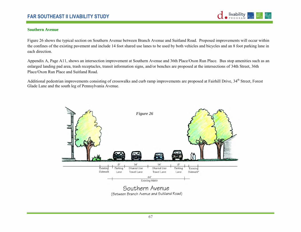
FAR SOUTHEAST II LIVABILITY STUDY
67
Southern Avenue
Figure 26 shows the typical section on Southern Avenue between Branch Avenue and Suitland Road. Proposed improvements will occur within the confines of the existing pavement and include 14 foot shared use lanes to be used by both vehicles and bicycles and an 8 foot parking lane in each direction.
Appendix A, Page A11, shows an intersection improvement at Southern Avenue and 36th Place/Oxon Run Place. Bus stop amenities such as an enlarged landing pad area, trash receptacles, transit information signs, and/or benches are proposed at the intersections of 34th Street, 36th Place/Oxon Run Place and Suitland Road.
Additional pedestrian improvements consisting of crosswalks and curb ramp improvements are proposed at Fairhill Drive, 34th Street, Forest Glade Lane and the south leg of Pennsylvania Avenue.
Figure 26

FAR SOUTHEAST II LIVABILITY STUDY
68
Table 12 lists proposed improvements on Southern Avenue by improvement type, location or limits of the improvement, detailed description, and the anticipated time frame for implementation.
Table 12: Proposed Improvements Southern Avenue
Type Location/ Limits Description Time Frame
Buses •34th Street •36th Place/Oxon Run Place •Suitland Road
Additional bus stop amenities1, such as enlarged landing pad area, trash receptacles, transit information signs, and/or benches
Mid/Long
Roadway Safety/
Operational/
Traffic Calming
•Between Branch Avenue and Suitland Road 8-ft parking lanes on each side, 14-ft shared use lanes (1 each direction).
Long
•36th Street/ Oxon Run Place Intersection reconfiguration Long
Bicycles •Between Branch Avenue and Pennsylvania Avenue Shared use lane pavement markings Short
Pedestrian •Fairhill Drive •34th Street •36th Place/Oxon Run Place •Forest Glade Lane •Pennsylvania Avenue (south leg)
Crosswalk/curb ramp improvements
Mid/Long

FAR SOUTHEAST II LIVABILITY STUDY
69
Safe Routes to School Improvements
Safe Routes to School proposed improvements were located around 7 Schools within the study Area. Many of the schools have complete sidewalk networks to and from the school property. Observations were made on the immediate surroundings of the school and the following recommendations for sidewalk, signing and crosswalk pavement marking improvements were made:
Good Hope Road at 15th Street (Reduce Crossing Distance) - Ketcham Elementary School 30th Street at S Street (Pedestrian Warning Signs at Crosswalk) - Randle Highlands Elementary School Alabama Avenue at 36th Place (Rapid Flash Beacon) - Beers Elementary School Minnesota Avenue at S Street & 18th Street (Realign Crosswalk) - Anacostia High School Minnesota Avenue at Nicholson Street & White Place (Pedestrian Refuge Area) - Orr Elementary School
Spot Improvements
In addition to corridor improvements, spot improvements were also proposed. They are:
Roadway Lighting along 27th Street, between Naylor Road and Texas Avenue Sidewalks along the west side of Alabama Avenue, north of Pennsylvania Avenue Sidewalks along Branch Avenue, north of Pennsylvania Avenue Replace damaged, non-standard signing and faded pavement markings along main roadways Transit Stop Improvements Sidewalk improvements on Park Drive from 31st Place to Branch Avenue; Altamont Place from Naylor Road to Good Hope Road; and
27th Street from Naylor Road to Trail Entrance Intersection improvements at Minnesota Avenue and N Street (see Appendix A, Page A12) Signing improvements on 18th Street between Minnesota Avenue and Good Hope Road (Appendix A, Page A13)*
Proposed sidewalk locations are subject to available right-of-way. Pedestrian hybrid signals must meet warrants prior to implementation. Warrant analyses are not included in this study.
*Signing improvements on 18th Street between Minnesota Avenue was proposed in order to eliminate traffic from Good Hope Road that wanted to use 18th Street as a cut-through to access Minnesota Avenue. However, this improvement was requested to be removed from proposed recommendations by a citizen in the third public meeting because it did not benefit the overall traffic flow in the area. Instead, for safety reasons, it was requested that an all-way stop controlled intersection be included as a spot improvement alternative at the intersections of 16th Street/T Street, and 17th Street/T Street, with no change to the overall flow patterns on these streets.

FAR SOUTHEAST II LIVABILITY STUDY
70
Chapter 7: Implementation Plan and Costs (Short, Mid, Long Term)
Implementation of transportation improvements is scheduled to occur over a 48-month timeframe in three phases, pending the availability of funding. The three phases are short term, mid-term and long term. Short term is defined as occurring between 5 months and 12 months. Mid-term is defined as occurring between 12 months and 24 months. Long term is defined as occurring between 24 months and 48 months.
Short Term Implementation
Transportation improvements to occur over a short term period (5 to 12 months) include signing, pavement marking for parking boxes, shared lanes and medians, and bus stop improvements including bus stop consolidation and amenities. The total cost for short-term improvements is estimated at $128,000 or less per roadway section.
Mid Term/Mid-Long Term Implementation
Transportation improvements to occur over a mid-term period (12 to 24 months) include curbs, ramps, sidewalks and pedestrian refugee islands. The total cost for mid-term improvements is estimated as $150,001 to $400,000 or less per roadway section, similar to the cost of mid to long term improvements.
Long Term Implementation
Transportation improvements to occur over a long term period (24 to 48 months) include roadway improvements. The total cost for long-term improvements is estimated as greater than $400,000 per roadway section.
Total Costs
The total cost of improvements is highest for the Branch Avenue livability corridor at $611,136, followed by the Alabama Avenue corridor at $545,203. The Good Hope Road corridor is $509,612, followed by Naylor Road at $289,907 and Minnesota Avenue at $238,100. Southern Avenue is the least costs corridor at $172,213.
The total costs of improvements for the six livability corridors and improvements outside of the corridors are included in the table on the following page.
Timeframes for Implementation:
Short Term – Between 5 months and 12 months
Mid Term – Between 12 months and 24 months
Long term – Between 24 months and 48 months

FAR SOUTHEAST II LIVABILITY STUDY
71

FAR SOUTHEAST II LIVABILITY STUDY
72
Chapter 8: Conclusion
Communities where people have access to multi-modal and safe travel options, affordable housing, healthy economic conditions are where people want to be!
Transportation improvements in this report address aspects of livability that achieve a more balanced plan of mode choices. In the past, more attention was given to improving operational performance by way of proposing roadway improvements with lesser attention given to improving bicycle, pedestrian and transit performance. Communities are beginning to see how property values might increase, a healthier lifestyle might be achieved, and the environment might be better protected through the application of livability principles to transportation solutions.
Through the identification of livability corridors that represent direct connections to key activity centers in the Far Southeast study area, the project team was able to determine what was needed to improve safety and mobility along these corridors. Following that, the team applied the latest principles and practices for development of cost effective multi-modal transportation improvements that were implementable over a 48-month period. Improvements like continuous sidewalks, improved pedestrian crossings, shared use lanes, bus stop improvements and better lighting along corridors offer improved conditions for walking, biking and transit accessibility while minimizing construction costs and time.
Performance Measures
It has already been shown that the family that is automobile dependent spends 25% of their household budget on transportation, while the family with good access to transit spends just 9% of their budget on transportation. Performance characteristics that look at other areas as well should be the subject of additional research.
Future studies will need to determine the effectiveness of these proposals for improving to the quality of life in Far Southeast communities. Therefore, performance measures were identified that can be applied to a future ―before and after‖ study.
• Speed (defined by reductions in speed as a result of traffic calming measures) • Safety (defined by reductions in crash parameters) • Bicycle and pedestrian level of service • More balanced bicycle, pedestrian, transit and automobile mode splits • Vehicle miles traveled reduction • Lower transportation costs • Property value increases • Development opportunities • Job creation and growth • Greenhouse gas reduction

FAR SOUTHEAST II LIVABILITY STUDY
73
The first three measures allow an operational comparison of before and after transportation conditions. It can be achieved with the collection of mechanical/continuous vehicle volumes and speed information at pre-determined test sites to evaluate the before and after (three to six months) effects of traffic calming devices. Volume information will be used to determine if there is a reduction in volume, signaling that drivers may have decided to use other routes since the installation of the calming devices. Accident data will be compared with data from the previous three years to determine if reductions (or increases) occurred.
Funding
Funding is available to advance Livability transportation projects from planning to design to construction. Sources include regular FHWA and FTA programs and TIGER Grants as well. The most recent announcement of available funding came in June 2011, when U.S. Transportation Secretary Ray LaHood announced the availability of up to $175 million in livability grants to help urban, suburban and rural communities develop transit options to better connect people to where they live, work and play.
The announcement comes on the second anniversary of the creation of the Federal Partnership for Sustainable Communities. Livability grants are aimed at assuring that transportation and housing decisions are made jointly and recognize the unique character of each community.