farm to forest - the andrews community forest
TRANSCRIPT
University of VermontScholarWorks @ UVM
Environmental Studies Electronic Thesis Collection Undergraduate Theses
2019
Farm to Forest - The Andrews Community ForestAngus Bisgard CummingsUniversity of Vermont
Follow this and additional works at: https://scholarworks.uvm.edu/envstheses
This Undergraduate Thesis is brought to you for free and open access by the Undergraduate Theses at ScholarWorks @ UVM. It has been accepted forinclusion in Environmental Studies Electronic Thesis Collection by an authorized administrator of ScholarWorks @ UVM. For more information,please contact [email protected].
Recommended CitationCummings, Angus Bisgard, "Farm to Forest - The Andrews Community Forest" (2019). Environmental Studies Electronic ThesisCollection. 59.https://scholarworks.uvm.edu/envstheses/59

Farm to Forest
The Andrews Community Forest
Angus Bisgard Cummings
May 1, 2019
Submitted in partial fulfillment of the requirements of the
Bachelor of Science degree in Environmental Studies
at the University of Vermont

Table of Contents:
Table of Contents: 2
Acknowledgements: 3 Author’s Statement: 3
Introduction: 4 Background: 4
Goals: 4
Products: 5
Names: 5
Approach: 7
Research/Literature Review: 7
Event Attendance: 7
Interviews: 8
Maps: 9
Written Narrative: 13 I. Chittenden Conservation Importance 13
II. The Andrews Land 14
III. Vermont Community Forests 16
IV. Competing Visions 20
Hunting 21
Trails 22
Forest Management 26
V. What it all Means 28
Photo Narrative: 30 Names/Locations: 30
Photographs: 31
References 64
2

Acknowledgements:
Advisors:
Prof. Cecilia Danks & Prof. Robert McCullough
Interviewees:
Abigail Allard, Amy Wagner, Bob Heiser, Ethan Tapper, Sue Morse, Tyler Merritt, & Wright
Preston
Andrews Family:
Abigail Allard, Amy Wagner, Kate Couture, Jennifer Gilligan, Everett Bertrand and Mary Jo
Andrews.
Community Partners:
The Town of Richmond
Personal Acknowledgement:
As a culmination and the final project of my formal education for the foreseeable future, I
would like to thank two individuals who made my education possible -
Walter and Karen Alexander
Author’s Statement:
I am grateful to the individuals who have shared their time, experiences and expertise
with me, and I credit them throughout this document. However, I am completely responsible
for this product, the creative choices I have made, and the information it contains. I
acknowledge that I have taken license as the author in the creation of this document. For
further queries about this project I can be reached by email at [email protected].
3

Introduction:
Background:
I am currently a senior at the University of Vermont pursuing a bachelor of science in
environmental studies from the Rubenstein School of Environment and Natural Resources as
well as a bachelor of arts in history from the College of Arts and Science. My interest in
environmental studies has been centered around points of intersection of humans and the
environment, with a focus on local land management and community-based conservation
efforts. This interest has been reflected in the courses I have taken in pursuit of my
self-created concentration of Ecology, Community, and Conservation. I have also explored
this interest through jobs and internships.
My interest in history is broad, but during my time at University of Vermont, it has
been centered around my concentration of the history of the Americas. Of particular interest
to me has been the history and struggle of indigenous groups within the Americas. In this
specific subject matter I have found there is a great deal of crossover with my interest in local
land management since indigenous sovereignty and land rights issues often intertwine with
conservation movements.
Goals:
This project is intended to be the capstone of my college education and a combination
of my interests in communities, conservation, and American history. In this paper, I set out to
explore the relationship that community forests have on their surrounding communities and
the wider conservation efforts within Vermont. I intend to address these ideas through the
story of the formation of the Andrews Community Forest (ACF) in Richmond, Vermont. At
the same time, I aim to create a useful product for Richmond that highlights the cultural,
historical, and environmental significance of their new community forest. Overall, I hope to
capture and record the development of the Andrews Community Forest, chronicling both its
formation and framing it within the larger contexts of Vermont conservation efforts and
Vermont history.
4

Products:
This project contains two main products: a written narrative and a photographic
narrative. The written narrative is an article that serves to provide a historical and
conservation lens to explore the significance of the creation of the Andrews Community
Forest. Additionally, it serves to record the ongoing process of stewarding the Andrews
Community Forest. Furthermore, it acts to highlight some of the strengths and weaknesses of
the institution of town forests as a form of local land management by focusing on the
experiences of key stakeholders in the formation and management planning processes of the
Andrews Community Forest.
The second product is a photographic narrative. The photo narrative was created in
response to the Andrews Community Forest Committee’s expressed desire for a product that
emphasized the cultural history of Andrews Community Forest. The photos are a collection
of pictures provided by the Andrews sisters that I have gathered to display the farm’s
agricultural history The Andrews sisters are the former owners of the farm that now
comprises the Andrews Community Forest. The photos are captioned with background
information from a selection of literature about Vermont, stories shared with me via email by
the Andrews sisters, and interviews of the Andrews sisters regarding their personal
experiences on the land that now comprises the Andrews Community Forest. All of the
material I have gathered as sources; the Andrews sisters’ emails regarding their experiences
on the Andrews farm, interview transcripts and recordings, and photos from the Andrews
sisters will be archived and made publically available by the Andrews Community Forest
Committee
Names:
The Andrews Community Forest has had several different names throughout the
process of its development from a family farm into a community forest. In the early stages of
their involvement, the Vermont Land Trust (VLT) refers to the land as the Andrews
Forestland or Richmond Town Forest. The Richmond community also utilized several
different names for the space before ultimately deciding to call it the Andrews Community
Forest in honor of the Andrews Family. However, colloquially, many people still call it the
Richmond Town Forest. The terms “town forest” and “community forest” are both used by
5

the interviewees and in documents I have consulted. I use the term “community forest” as
often as possible to avoid confusion, but in some locations in the document I also use the
term town forests.
6

Approach:
Research/Literature Review:
In order to familiarize myself with conservation issues in the state of Vermont, the
trends and history of the relationship that Vermonters have with the landscape, and the
history and issues surrounding the institution of community forests in New England I have
done extensive research. During the past semester, I read a wide variety of resources, mainly
scientific journal articles, that discussed the benefits and issues that arise with managing
urban and community forestry projects for conservation, recreation, health, and economic
goals. I have also consulted the websites and literature provided by numerous state and
federal environmental agencies to understand the trends of conservation efforts in Vermont. I
have also read literature created to act as guides for communities attempting to establish
community forests. I utilized obituaries to learn more about specific individuals in the
Andrews family and documents from the University of Vermont Historic Preservation
Program discussing the importance of the Andrews Farm. In the earlier stages of the project I
also heavily referred to the Draft Management Plan, the plan established for the management
of the Andrews Community Forest by the Richmond Town Forest Interim Steering
Committee. Finally, two texts in particular have been instrumental in providing historical
information. The first of which, Hands on the Land: a History of the Vermont Landscape, by
Jan Albers, which was instrumental at providing an overview of the history of the changing
relationship that Vermonters have had with the landscape. The second is The Landscape of
Community: A History of Communal Forests in New England , by Robert McCullough, which
was essential for providing me with a history of the institution of community forests.
Altogether, I relied heavily on my research and literature review for establishing a
background in which to frame the significance of the Andrews Community Forest.
Event Attendance:
Throughout the fall and spring semesters of this academic year I have attended several
events regarding the Andrews Community Forest formation. They provided me with an
opportunity to meet key individuals from the Richmond public that have been involved in the
process of the formation of Andrews Community Forest. Through these events I also got the
7

opportunity to witness how the public has and continues to be involved in the management
planning process for the Andrews Community Forest.
The first meeting I attended was a public outreach event held at the Richmond Town
Hall on September 20, 2018. Officially I served as a notetaker and photographer for this
particular meeting. The second event I attended was the Town Forest Recreation Planning
and Implementation Summit held on November 9, 2018 at the Vermont Youth Conservation
Corps (VYCC) West Monitor Barn in Richmond, Vermont. During this meeting, stakeholders
in the management of nearly a dozen community forests in Vermont gathered to share their
experiences in order to aid one another in future management goals. This meeting provided a
valuable opportunity to meet stakeholders involved with community forests around the state
of Vermont, as well as learn about some of the challenges faced and management strategies
being utilized in community forests around the state. The third meeting I attended was an
Andrews Community Forest Committee meeting in January 28, 2019. At this meeting, I
presented and received feedback on my plans for this thesis project, as well as received
feedback on what information and deliverables would be helpful or desirable for the
Committee.
Interviews:
In order to capture the experiences of various stakeholders in the continuing process
of developing the Andrews Community Forest, I conducted seven key informant interviews.
Since the uses and management of community forests is meant to reflect the various interests
and priorities of the community itself I wanted to capture a range of various perspectives and
desires of different community members. The interviewees I selected were chosen because of
their essential role in the formation of the Andrews Community Forest or because they
represented an important viewpoint in the management decision making process. Before
conducting each interview, I created interview guides with my main target questions for each
specific person. The interviews ranged in length from half an hour to an hour and a half and
were conducted in locations chosen by the interviewees. Every interview was conducted in
person with the exception of one with Sue Morse that took place over the phone. The written
narrative relies more extensively on my in person interviews. The photographic narrative
relies on quotes provided to me via email by the Andrews sisters.
8
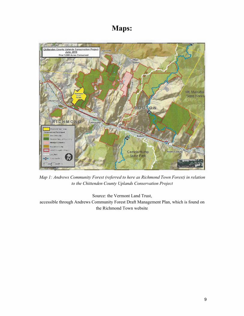
Maps:
Map 1: Andrews Community Forest (referred to here as Richmond Town Forest) in relation to the Chittenden County Uplands Conservation Project
Source: the Vermont Land Trust,
accessible through Andrews Community Forest Draft Management Plan, which is found on the Richmond Town website
9

Map 2: Andrews Community Forest (referred to here as Richmond Town Forest) the
surrounding trail systems, areas of cultural, and ecological importance.
Source: the Vermont Land Trust, accessible through Andrews Community Forest Draft Management Plan, which is found on
the Richmond Town website
10

Map 3: Andrews Community Forest (referred to here as Andrews Forestland) and
surrounding conserved lands.
Source: the Vermont Land Trust, accessible through Andrews Community Forest Draft Management Plan, which is found on
the Richmond Town website
11
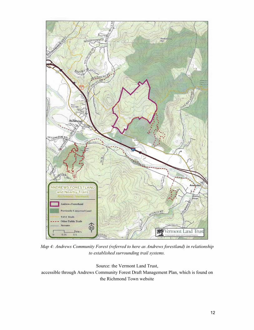
Map 4: Andrews Community Forest (referred to here as Andrews forestland) in relationship
to established surrounding trail systems.
Source: the Vermont Land Trust, accessible through Andrews Community Forest Draft Management Plan, which is found on
the Richmond Town website
12

Written Narrative:
I. Chittenden Conservation Importance
The Chittenden County that many Vermonters are familiar with is that seen from the
I-89 highway or the streets of Burlington. It is a space for humans, with “nature” relegated to
the vistas of the Adirondacks and the Green Mountains. This view of Chittenden County,
however, is not shared by everyone.
“From the top of Mount Mansfield and Bolton all the way to Camel’s Hump the entire
west-facing flank of the Green Mountains is a vast and biodiverse core habitat of statewide
significance,” and “there are few of these unfragmented relatively remote habitats left in the
state,” said Susan Morse, founder and science director of Keeping Track. After spending
decades conducting research and tracking wildlife in Chittenden County, Sue had drawn two
conclusions: Chittenden County is home to a richer collection of wildlife and wildlife habitat
than many are aware of and that the development of the County puts that wildlife in danger.
In true Vermonter can-do fashion, she decided to take action.
Sue Morse contacted a wide array of stakeholders that met quarterly to discuss how to
best preserve the wildlife of Chittenden County. These stakeholders included various town
and local land trusts, the Vermont Land Trust, outdoor recreation groups, the Chittenden
County forester, a representative from Senator Leahy’s office, and local private landowners.
They decided the best method would be to conserve the large forested parcels of private land
in between already protected areas within Chittenden County such as Camel’s Hump State
Park, Mt. Mansfield State Forest, and the Underhill Firing Range (see map 1, page 10). The
stakeholders hoped to create one large block of unfragmented protected landscape through
which the wildlife could move freely without being hampered by major human development.
They called this target region the Chittenden Uplands and their effort to protect it the
Chittenden County Uplands Conservation Project (CCUCP).
Ultimately, through the efforts of Senator Leahy, the project received a 4.2 million
dollar grant from the Federal Forest Legacy Program that paid for the establishment of
various types of protection on stakeholders’ land. Among those pieces of land identified as
13

most critical for conserving the Chittenden Uplands was the land belonging to the Andrews
Family.
II. The Andrews Land
Over the years, Everett and Mary Jo Andrews had been approached many times about
the possibility of conserving their land in Richmond, Vermont. On that land they had
operated a dairy farm for the larger part of the 20th century and raised four daughters:
Jennifer Gilligan, Amy Wagner, Kate Couture, and Abigail Allard. They had a deep love for
the land that had supported them. Kate Couture stated that the land “was part of my father’s
very being” and, according to Abigail Allard, he generously allowed the surrounding
community to access it.
Given their relationship with their land, it seemed natural that the Andrews would
have agreed to the establishment of a conservation plan on the property, but they never
would. Abigail Allard believed this decision probably reflected Everett’s discomfort with
change, as Everett often said that he wished “things would stay the same.”
However, things do change, and in 2010, Everett passed and then in 2011, Mary Jo
Andrews also passed away, leaving the over 600 acre parcel of land to their children.
The Andrews property is sandwiched between the Winooski River and the foothills of
the Green Mountains. To the West, towards the Winooski is prime agricultural land that is
separated from the rest of the property by Route 2 and I-89. Toward the East and the Green
Mountains the land elevates sharply, becoming steep and hilly. Here, like a giant’s game of
marbles, its surface is littered with grey rocks from which the former owners, the Rhodes
family, take the name: Gray Rocks Farm.
Deciding what to do with this parcel of land they inherited presented a hurdle for the
sisters. Abigail recalled that the sisters eventually worked out a plan through discussing,
fighting, making up and doing it all over again. While they were undecided on the exact
method they wanted to pursue, they were united on several goals: conserving the land,
keeping it in continued agricultural use and out of the hands of developers, and doing it in
way that honored their parents.
14

Their first attempt to get the land conserved through the Vermont Fish and Wildlife
(VFW) was unsuccessful since VFW was unable to raise the necessary funds to purchase the
land. Therefore, the sisters looked at establishing a conservation easement through the
Vermont Land Trust instead.
Bob Heiser, the Regional Director of Champlain Valley for the Vermont Land Trust
(VLT), had long been involved in efforts to conserve the Andrews property through his
involvement with the CCUCP and he jumped at the chance to conserve this parcel. The VLT
was interested in conserving this property for a variety of reasons, the foremost of which was
its conservation importance as a conduit for wildlife. Additionally, Vermont Land Trust
viewed it as a potentially important location for recreation and connecting with nature. Bob
Heiser also shared that, if purchased by the public, the Andrews’s land could provide a great
opportunity for those living in the town of Richmond who do not own land to have a chance
to develop a stronger land ethic through participating in land management.
After the sisters got the parcel of land appraised, the Vermont Land Trust found they
were unlikely to be able to raise the funds to protect the entire 600 acres as a single parcel.
The VLT and the sisters decided to conserve the land in two portions; a farmland parcel and a
forestland parcel.
The Andrews sisters sold the farmland parcel, 187 acres of high quality farmland on
either side of Route 2 along the Winooski River in 2013, with a conservation easement put in
place through Vermont Land Trust to Maple Wind Farm, which had rented acreage from the
Andrews family for the past decade. The farmhouse on the farmland property was subdivided
and sold separately. This left a stretch of 428 acres of forestland. The Andrews sisters set up a
18 month to 2 year option agreement to allow Vermont Land Trust to explore conservation
options buy it at the bargain sale price of $450,000.
The Vermont Land Trust wanted to see if the town of Richmond was interested in
purchasing the land. They organized outreach events with the help of the Richmond Trails
Committee and the Conservation Commission. This included a survey that showed the
majority of residents supported the town’s acquisition and a following town vote resulted in a
4:1 majority supporting its purchase and establishment as a community forest. Even with
15

overwhelming public support, raising the necessary funds still presented the town of
Richmond with a significant challenge.
The Vermont Land Trust, the Richmond Trails Committee, and the Conservation
Commission began the effort of raising the necessary $450,000 that had been agreed upon as
the bargain sale price. Many sources of funding were courted; the most ambitious was a grant
from the Federal Community Forest Program. This grant was a longshot since it was open to
community forests grant requests from across the country.
Against the odds, the Andrews Community Forest received a grant for $256,000 from
the Federal Community Forest Program, which, along with other sources of funding, gave the
town of Richmond more than the $450,000 needed to buy the property.
Abigail Allard recalled that the entire process was not easy. She shared that “it felt
like everytime we felt like we got this accomplished something else would pop up and then
we were like oh my god we need to go fix that, it was like whack a mole with problems.”
However, even with the town’s purchase, the process is far from over as the community still
needs to decide exactly how they want to manage the property, which, in itself, has been no
small task.
After finalizing the purchase in 2018, the Richmond Town Forest Interim Steering
Committee was established by the Town of Richmond to create a management plan for the
Andrews Community Forest. The Interim Steering Committee got further assistance from a
grant they received from the Vermont Urban and Community Forestry Program, which
partnered the Committee with the SE and Arrowwood Environmental consultancy groups.
Bimonthly meetings of the Interim Steering Committee and numerous public outreach events
were held, which gave the public opportunities to share their opinions and participate in the
planning process. By the end of 2018, a management plan had been established.
III. Vermont Community Forests
Community forests in Vermont followed a different path of establishment than those
in neighboring states. This was mainly due, initially, to the state’s settlement pattern. It was
not until after the Revolutionary War was concluded in 1783 that settlement in Vermont
16
began to gain significant momentum. The French and Indian War, the Revolutionary War,
cold winters, Vermont’s hilly topography, and resistance from the Western Abenaki had all
discouraged settlement of the region up to this point. However, population pressure in
Southern New England encouraged a boom in settlement of the region between 1760 to 1800.
In Southern New England, many towns had been established through charters and
grants. These towns were nucleated around close-knit town communities. Often these early
settlements would set aside a portion of land for communal uses such as a meetinghouses,
schools, parsonages, cemeteries, commons for livestock grazing and woodlots (McCullough,
1995). These common spaces differed from town to town, but they shared the characteristic
of being locally managed to serve the local needs of the community. The word “common”
comes from English law that allows for one or multiple individuals to act as a tenant or
tenants in unison (McCullough, 1995). Early English colonists used this method of land
management and ownership in their early towns. Some of these common spaces would
eventually become town forests, but many others were divided under mounting population
pressures and town development over the centuries. These town commons did, however, act
as a beginning point for the establishment of community managed landscapes for Europeans
in New England.
This pattern of nucleated settlements had been essential for the success of early
colonies in New England. By the 1700s, Southern New England colonies such as
Massachusetts, Connecticut, and Rhode Island no longer prioritized the creation of common
areas of land. This was largely because speculative interests tended to dominate settlement
patterns after the 1700s as proprietors only established the minimum public lots required by
early governing bodies. Additionally, incoming waves of European immigrants arriving in
the New World sought to purchase individual lots of land. Thus, by 1700, much of the land
that had been held in common ownership was divided and sold to those newly arriving
Europeans so common lands were depleted across Southern New England. The settlement of
Vermont itself more closely followed settlement patterns of Southern New England states
after 1700s with proprietors’ interest in land sales taking priority over communal settlement.
The settlement of Vermont was largely motivated by speculative interests of
proprietors, who received grants of land in what would become Vermont. The proprietors had
a significant impact on the village and town structure through their allocation of land and
17

surveying of boundaries. However, absentee proprietors were generally only involved in the
settlement of the lands they were selling to the extent necessary to receive a return on their
investment of the land grant. Since proprietors were motivated to sell as much land as
possible, they were not as interested in setting aside common lands as was seen elsewhere in
New England. At the same time, the settlers in Vermont also shaped these early communities.
These individuals were actually responsible for shaping and establishing the town’s
institutions such as village greens, cemeteries, meeting houses, and roads, all of which not
only served important functions of the town, but helped establish a sense of community.
During this early stage of settlement, most Vermonters established themselves as individual
farmers, spreading across the landscape. They did not prioritize the establishment of
communal town institutions, as “frenzied land speculation and absentee proprietorships had
tended to encourage individual rights over community-building” (Albers, 2000). As a result,
in the early stages of settlement of Vermont, there were far fewer examples of communal
land allocation.
This settlement pattern would begin to change around the turn of the 18th century.
The Republic of Vermont, and then as of 1791, the state of Vermont, required that town
charters included five types of public lots: the first settled minister, a town school, a gospel
lot, a county grammar school, and a college (McCullough, 1995). These communal lands that
were established in the late 18th century were also different than those found in many other
parts of New England, since they were formed as public lands instead of as common lands.
The distinction between the two lies in the fact that common lands were set aside for the use
of entire community, but “public lands” were set aside to serve a specific function as a piece
of community structure. These public lands in Vermont were known as lease lands. Lease
lands had mixed results as many proprietors placed them in isolated difficult to access regions
or designated parcels that were ineffectively small. However, many of these lease lots would
eventually become municipal forests. During the early 19th century more towns in Vermont
became nucleated and began to take shape with the development of village commerce and
industry. The development of town centered economies also generated a greater desire for
institutions and services that were provided by the institutions constructed on lease lands.
The influx of settlers greatly diminished Vermont’s forestland, which disappeared at
an alarming rate throughout the 19th century. By the end of the Civil War, in 1865, logging
had become the most economically productive industry in Vermont, contributing greatly to
18

deforestation across the state. A survey in 1870 showed that 67% of Vermont had been
“improved” and by 1880, Chittenden County was 80% deforested (Albers, 2000). Vermont at
the turn of the 20th century was one we would not recognize, a land largely devoid of its
forests. This pattern was not unique to just Vermont and across the country there was
growing public concern about impacts of forest depletion. At the same time forest
management as a scientific approach was developing with a rise in federal involvement in the
management of the nation’s forest resources. As a result of these processes and anxieties,
support for community forestry grew.
By the beginning of the 20th century, the trend of deforestation in the state of
Vermont was being reversed as the conservationist movement swept the nation and
management of forest resources across different levels of governance increased. There was
initially, a lack of federal support for community forests since lead policy makers, such as
Gifford Pinchot, were reluctant to intervene in local management affairs. However,
community forest initiatives in Vermont did benefit from “regional, state, and local
governments as well as private interests and organizations” (Baker & Kusel, 2003). Interest
in municipal forests grew in both the private and public sectors from “concerns about the
negative effects of timber shortages on timber and wood products-dependent local
economies, as well as growing interest in recreational and aesthetic value of
forests”(McCullough, 1995). The results of this shift in concerns were visible at the state
level with the first state forest being conserved in Vermont in 1909. Additionally, in 1915,
towns throughout Vermont, New Hampshire, and Massachusetts all received permission to
legally establish community forests. These changes triggered a resurgence of community
forests throughout Vermont and by 1931, Vermont had 19 state forests and 42 municipal
forests (Albers, 2000). Most of the municipal forests established before 1930 were on
watershed lands created for protecting reservoirs. The interest in creating municipal forests in
watershed lands reflected a growing body of literature at the turn of the 19th century showing
that forests increased water quality. The other municipal forests established before 1930 were
sourced as “occasional gifts, [the conversion of] poor-farm woodlots, and outright
purchases”(McCullough, 1995).
The greatest rate of development of community forests came after WWII in Vermont.
This was partially an outcome of a further increase in state support resulting in legislative
amendments in 1945 and 1951 that authorized partial state subsidization of the costs of
19

acquiring land for municipal forests. This was coupled with a growth in the public interest as
a reaction to the processes of suburbanization and population growth in Vermont from the
1950s into the 1970s, which raised fears amongst many in the state that they would lose the
forests they had so recently begun to reacquire. In response to the increasing levels of
development that was fragmenting Vermont's forests local groups with conservation goals
such as the Vermont Land Trust and the Vermont Housing and Conservation Board formed.
These groups were particularly instrumental in gathering financial and political support for
the creation of municipal forests, which they did by lobbying for legislation changes for
incentivising sustainable forestland management and advocating for the government
purchasement of parcels of forest land. These initiatives were instrumental in the
establishment of another wave of community forests geared towards local landscape
stewardship and conservation that has taken place in the latter half of the 20th century.
The uses of community forests, however, are not limited to conservation, but true to
their utilitarian and community oriented origins they also serve to meet a variety of needs of
Vermont’s communities. Although, deciding which community goal should take precedence
in community forests is not always easy, as there are often a myriad of opinions to reflect the
diversity of desired land uses within a community. The Andrews Community Forest is no
exception to this pattern and while the impetus for its creation may have begun with a
conservation goal, its other potential uses are still being determined.
IV. Competing Visions
The Richmond community has the unique opportunity to guide the development, uses,
and management of the Andrews Community Forest. The plan for how the community forest
is going to be used and managed engages individuals from across the community with a
diversity of different interests. According to the public input process led by the SE Group and
the Richmond Town Forest Interim Steering Committee the main uses that the Richmond
community wants to prioritize are conservation, recreation, and forestry management. The
plan for how these various resource uses will coincide in the same physical space is still
being deliberated by the community. The role of humans on the landscape has been a
particularly contentious subject. The main areas of disagreement have centered around the
scale and types of trail development that will be established on the landscape, and what the
role of hunting should be on the property. Additionally, while not as controversial, plans for
20

forest management are also very important, especially in light of the utilitarian origin of town
forests.
Hunting
Gathered in the Richmond Town Hall on September 20, 2018 was an eclectic group
of Vermonters united by a shared interest, the Andrews Community Forest. The Richmond
community was assembled for a chance to share their opinions on the draft management plan
for the community forest. Hannah Phillips, who led the Interim Steering Committee for the
community forest, went through the main points of the draft management plan in a
powerpoint. The calm that had dominated the room during her presentation was immediately
broken when she opened the floor for comments. Hands shot up from different corners of the
room as person after person voiced concerns with the plans that had been made for hunting
on the land.
Hunting can be contentious and divisive. Its association with gun ownership and
questions about the morality of killing animals has resulted in some people viewing it as an
unsavory activity. Yet, it is also steeped in tradition with a long history that reaches back to
our earliest ancestors. Furthermore, it acts as an important way for many people in interact
with the landscape and a useful tool for managing wildlife. There are massive lobbying
efforts both supporting and combating hunting, directing national politics. And here in a
small corner of the United States, in a small town hall, we see the same zealousness in a
microcosmic scale.
The Interim Steering Committee had proposed to create a large zone within the
Andrews Community Forest that would be open to hunting during the main deer seasons, but
would be off limits to other trail users during those weeks. In turn, hunting would be
prohibited throughout the property during the rest of the year when other species were in
season. This policy stemmed from a concern expressed by a hunter who worried about the
danger of suddenly encountering hikers or bikers who might not be wearing orange. It was
intended to encourage recreational users to feel safe in the forest and to decrease the
likelihood of a hunter’s prey being spooked by unaware pedestrians. The decision also
reflected the Committee’s desire to acknowledge the long history of hunting on the Andrews
property. A nephew of Everett Andrews had established a deer hunting camp on the property
decades ago that was used until recently, when it was torn down after the deaths of Everett
21

and Mary Jo. There was a hunter present on the Interim Steering Committee, but until this
point the majority of hunters who had utilized the land had not participated in the community
meetings, despite efforts made by committee members to reach out to them. As Wright
Preston, a member of the Interim Steering Committee and owner of the conserved land
abutting the Andrews Community Forest, said to me “early on it was very difficult to get
hunters to come to meetings. Hunters do not want to go to meetings; they want to hunt. But in
the end they came out and it was great.”
The hunters at the public meeting informed the Committee that while they appreciated
the fact that the zoning idea was intended to help prevent their prey from being disturbed,
they did not want restrictions imposed upon them, and instead were happy to coexist with
other recreational users. Many of the hunters had been hunting on the Andrews’ property for
a long time and wanted to be able to continue to use the land in the same way. For other
hunters, it was simply important not to lose those rights and privileges
After it became clear that the community was not happy with the established plans for
hunting, the meeting broke up into focus groups to discuss the plans in more detail. In the
end, based on the discussions that took place at the meeting, the community decided to alter
the policy. It was decided that hunters would be able to hunt throughout the forest and that
they would be responsible for providing hunter safety information to other recreational users.
The process of deliberation around the issue of hunting provided an example of the active
role that the communities play in deciding the uses of community forests. This particular
problem around hunting was quickly resolved, but some issues such as the extent of trail use
on the Andrews Community Forest remain far more difficult to wrestle with.
Trails
The plan for the creation of trails in the Andrews Community Forest brings two of
the main values of the forest envisaged by the Richmond Community into confrontation,
conservation and recreation. According to Bob Heiser, planning for future trails caused
tension not only in the community, but also in the Committee. The Federal Country Forest
Program that the Andrews Community Forest received and the easement established by
Vermont Land Trust stipulates that community forest needs to provide recreational
opportunities, but does not specify exactly what those would look like.
22

Bob Heiser shared that in Vermont “a lot of town forests have grown organically
without a starting point with thoughtful planning.” As a result, in many of the surrounding
town forests recreation trails grew without a master plan. Unlike these examples, the town of
Richmond has a unique opportunity to start with a blank slate or at least an almost blank slate
when it comes to planning the uses of the Andrews Community Forest.
On the property there is already some infrastructure in the form of an established
logging road, a VAST (Vermont Association of Snow Travelers) trail, and two utility lines
bisecting the property (see map 2, page 11). These developments currently provide an
established pathway that can be used by walkers on the property. Some community members
have advocated for not constructing additional trails and just using the pre-existing roads as
trails instead.
Tyler Merritt, shared with me that he does not think constructing trails on the
established logging roads is a great idea. Tyler Merritt, is an outdoor sports gear
representative and has played an active role on both the Richmond Trails Committee as well
as on the Richmond Mountain Trails group, and now serves on the Andrews Community
Forest Committee. Tyler remains opposed to the plan of using logging roads for trails, stating
that, in his experience, trails created by logging skidders “typically [are] fall-line, erode
quickly, trap water, and are not optimal for long term sustainability of trails and people's
enjoyment of trails”. This opinion was echoed by the environmental and recreation
consultancy firm, the SE Group. Both Tyler and the SE Group have advocated for the
creation of new trails.
The current proposal for trail building has two main parts. The first of which is a
walking loop on the flatter portion of the land south of the utility lines. On this lower portion
of land, Tyler sees the possibility for more engineered trails that would cater to visitors that
are physically restricted to a more gradual pitch. While on the upper part of the trail, north of
the utility lines, Tyler shares that he has envisaged a more minimalist set of multi-use trails.
Which he describes as being more “primitive” and probably being along the lines of
“glorified deerpaths.” Although for different reasons, the idea of creating new trails was also
supported by Ethan Tapper.
23

Ethan Tapper is the Chittenden County Forester and has played a large role in the
development of the Andrews Community Forest, providing technical assistance to the
community. Ethan Tapper shared with me that using pre-existing logging trails as
recreational trails can create unnecessary conflicts between recreation users and forest
management efforts. Ethan wants recreation and active forest management to both be options
on the land and does not want to have to relocate or create new logging roads to do so. Not
only would the construction of new logging roads be an additional expense to the town, but
their use and construction also has large impacts on soils. As a result he would like to be able
to use the established logging roads for forest management in the long term and not
unnecessarily impede recreational activities.
Two vertical wrinkles, marks of a lifetime spent outdoors, formed on either end of
Tyler’s mouth as he excitedly talked about the potential for creating interconnected trail
systems across Vermont. An adjacent property owner to the Andrews Community Forest,
David Sunshine, has already established a multi-use trail on his privately conserved land (see
map 2, page 11 and map 3, page 12). Plans have been proposed to create a trail on the
Andrews Community Forest that would connect to David’s forming a pathway that runners,
bikers, and hikers could use to travel all the way from Richmond to Jericho. Additionally,
there has been discussion of creating bike paths from the Andrews Community Forest to the
Richmond village center to increase accessibility to the community forest. Bob Heiser shares
that creating interconnectivity could also have the additional benefit of alleviating the amount
of human use on any particular part of the forest and decreasing the overall density of trails
needed on the property.
Wright Preston, along with other community members, shared that they are worried
about the impact that a lot of recreating humans on the property might have on the wildlife. In
particular, there has been expressed concern about the impact of mountain biking. Wright
stated diplomatically that while he thinks mountain biking is great, he does not allow it on his
own land since he thinks it can have undesirable impacts on wildlife and their habitat. As
seen on neighbouring community forests and protected spaces across the country there is a
historic pattern of mountain bikers creating a proliferation of unplanned trails. There is also a
lack of hard data on what exactly, if any, impact trails have on wildlife beyond potentially
exposing them to more human traffic. Wright shared that he believes that the topography of
the property itself could help mitigate intense human use, especially above the utility lines
24

where the topography is steep. Sue Morse also had some warning words about trail systems,
stating that “we are all guilty on many levels of overusing and overloving the woods that we
love; witness some of our national parks that are just overrun by people.”
Sue also described what she feels is the new and profound conservation planning
paradigm of our time—cumulative effects. She observed, “Throughout space and time, the
collective impacts of countless small and seemingly inconsequential anthropogenic events
compromises wildlife well-being.” She shared that she thinks responsible wildlife and habitat
management today should include spaces that humans don’t access “lest we unwittingly
disturb and harm the animals that live there.” Morse acknowledges the many scientific
studies that show how our trails, vehicles, and frequent intrusions into wildlife habitat are
increasing soil erosion, the spread of invasive species, and the displacement of many bird and
mammal species from their preferred habitats. “Even poaching and accidental wildlife
mortality increase as more people have the opportunity to remove them (turtles, for example)
and literally run into them.”
Morse is particularly concerned about how our recreational disturbances impact the
energy budgets of many animals--compromising their security, reproductive success, and
overall fitness. “I can imagine a sorry future,” Morse concluded, “a hundred years from now
when the Andrews Farm and all adjoining forest lands will be laced with trails and full of
hundreds of happy people recreating in many ways. However, the land will be devoid of the
wildlife that exists there today. Some might reason that the animals could certainly move
somewhere else. But where will that be, exactly, if we don’t exercise considerable restraint?
Conservation is not just about the creation of parks. It should afford us the appropriate
opportunity to permanently designate whole landscapes that we agree shall not be developed
in any way, and that includes trails.” Ultimately, she advises Richmond decision makers to be
thoughtful and deliberative, a policy that Wright Preston echoed in conversation with me,
vocally advocating for the slow methodical creation of trails.
Tyler Merritt, on the other hand, shared that while he understands the cautious
approach of the Committee he thinks a master trail plan should be used to expedite the
process instead of developing the trails in a piecemeal fashion. He voiced that a lot of
communities fears could be alleviated by greater education about the environmental impacts
of mountain biking and trail use that he thinks have been greatly inflated. Although, Bob
25

Heiser shared that he thinks that when it comes to deliberately creating trail systems that
“there aren’t as many great models starting from scratch as we would like and there is not a
lot of great data of the impacts on wildlife habitat by trails and different uses of trails and
density of trails.” While the actual impact of trail systems can and are being deliberated there
remains other real benefits to developing recreation opportunities for the town of Richmond
to be considered.
Recreation in the Andrews Community Forest provides greater access to the outdoors
and economic opportunities for the town of Richmond. Tyler shared that the addition of bike
trails in nearby Cochrans and the Preston Loop resulted in an influx of runners and bikers
utilizing Richmond’s establishments and having a positive economic impact on the town. He
also shared that the trails are an important way to get children away from screens and
engaged with the outdoors. Beyond the joy that outdoor recreation brings people, the
establishment of more trails provides an important opportunity to economically benefit the
town and develop an appreciation for nature.
While it is clear that there are very different visions for what the community forest
should look like, the fact that those multiple visions even exist shows how much the
community cares and is dedicated to making the most out of this parcel of land. Furthermore,
Bob Heiser shared that, even though there has already been some conflict between different
resource group users, there is real value in the community forest planning process as it brings
“a lot of people in one room together that would not normally be in a room together and
having conversations.” Building those connections has and will go beyond the 428 acres of
forestland and seep into other community interactions. The Richmond community is also
lucky to have a wealth of knowledge and expertise, which will undoubtedly allow them to
weather any conflicts that may arise. Another way that Richmond and Ethan Tapper hope to
engage the community is through forestry management in the Andrews Community Forest.
Forest Management
An important aspect of planning for human use of this space is forestry management.
Although recreation and conservation uses have eclipsed the production of timber products as
the main use of many community forests across the nation, this has not been the case in
Vermont where “town forests are still utilized primarily for their timber and wood”
26

(McCullough, 1995). The Richmond community has emphasized a desire to continue the
legacy of this utilitarian use in the Andrews Community Forest.
Ethan Tapper shared with me that his vision for active management of the Andrews
Community Forest is to create a variety of different conditions to promote a range of different
forest and habitat opportunities for wildlife. This approach is called “ecological forestry,”
“new forestry,” or “disturbance-based forestry,” and it mimics natural disturbance events that
promote the growth of a wide array of species, age groups, and both living and dead wood in
effort to support the greatest potential for biodiversity. This management approach would
involve managing some parts of the forest actively and leaving others untouched. He shares
that this type of forestry, while maybe not the most economically productive in the short
term, offers the greatest ecological and economic benefits in the long term as it keeps the
forest healthy and productive.
Active management of the Andrews Community Forest could provide economic
benefits for the community through the harvest of wood products, which could generate an
income for the community to use to fund non-commercial restoration and
habitat-improvement projects. However, Ethan shares that the main management goal would
be to demonstrate what thoughtful, modern forestry management looks like and provide the
opportunity for the community to interact with the process. In the event of active forest
management at the Andrews Community Forest, Ethan wants the community to be involved
in every step of planning and implementation process. He intends to engage the public
through press releases, articles in community newspapers, public walks, local events, and
social media. Ethan also shared that he wants to cultivate the idea that “it is ok to harvest
local renewable resources from our forests, and we can do it while also considering other
resources like clean air, clean water, carbon sequestration and storage, climate change
resilience and wildlife habitat.” Ethan hopes to reach out to and educate community members
both who own forest land themselves and those who do not to provide them with the
opportunity to become engaged in the process of forest management. Ultimately, the goal of
forest management on the landscape would be to build an understanding of our forests in the
community.
27

V. What it all Means
Cars, trains, and airplanes, not to mention lines of communication through telephones
and the Internet have brought people together. Yet, in one of the greatest ironies of the 21st
century, these same modes of connecting far off places and people have often isolated us
from our neighbors. Many people have lost touch with the close-knit community of people
they live alongside in favor of those physically distant from them. Community forests offer
an opportunity to forge a different type of connection. At their heart, community forests are
about connecting people to the land, caring for it through conservation, and creating a love
and understanding of it through recreation. Perhaps greater than building a link to the land,
community forests also serve us by bringing people together.
Community forests offer valuable benefits to their local communities. The need for
multiple land-users to coexist in a physical space brings members of the community together.
Additionally, instead of having a public space, which the community uses, directed and
controlled by a faceless acronym or government entity, local management empowers the
community to control and to direct the use of the land. As direct stakeholders, community
members also often have a strong sense of place on the landscape that can act as a powerful
motivator for responsible management.
The fate of many community forests over the centuries has been simply to remain
unused or unmanaged by humans or quietly to make their way into the hands of private
owners. The time and care shown by the Richmond community on deliberating the role of
this community forest fuels confidence that this community forest will have a different fate -
to be responsibly cherished. For who is better suited to care for the land than those who love
and use the land? Who will love the Andrews Community Forest more than those who make
up the Richmond community? I can only think of four individuals that might have a better
claim to loving this parcel of land: the Andrews sisters.
Abigail Allard sat across from me, in a booth at Rosie’s Diner in Middlebury,
Vermont. Both her hands were clasped around her mug of hot cocoa with a tall tower of
whipped cream powdered with cocoa. The inside of Rosie’s Diner was decorated with
combination of wood paneling and quilted patterns. The walls were covered with depictions
28

of Vermont tourist attractions. The entire place seemed to be intentionally projecting a feeling
of nostalgia. It was the kind of place where you expect to see elderly people, seeking the
familiarity of the past, dining.
The white light filtering through the window behind me caught the mistiness of
Abigail’s lively blue-green eyes as she spoke of the property. She talked of the beauty of the
land, its brooks, trees, and animals. It was almost like she was trying to convince herself that
she and her sisters had made the right decision. She told me, “I hope it was the right thing to
do. I feel it was and we can still go there and our kids can, and cousins, and we can share it.
Well, we cannot share it anymore; it’s out of our hands. Well, I hope people enjoy and
respect it. It was hard to part with.” Letting go of this piece of land meant more than a
transfer of ownership. It marked a passage of responsibility and stewardship from these
sisters to the Richmond community. The sisters hope that, in the Richmond community’s
stewardship, they will uphold their father’s desire: to keep things the same.
29

Photo Narrative:
Names/Locations:
When referring to Abigail Allard, Amy Wagner, Jennifer Gilligan, and Kate Couture
collectively I call them the Andrews sisters.
According to Kate Couture, the land that now makes up the property known as the
Andrews Community Forest was referred to as the Andrews Farm during most their lifetimes.
Historically, the farm was called the “Gray Rocks Farm” while it was owned by the Rhodes
family and other people referred to it as the Gray Rocks during Everett Andrews’ lifetime. In
order to avoid confusion I will refer to the property as the Andrews Farm, unless I am talking
about it when it operated as an inn under the name of Gray Rocks Inn.
The farm referred to as “The Big Farm” was a farm owned and run by Sheldon
Whitcomb (husband in law of Ina Fuller Andrews). It is now very recognizable as the farm
surrounding the East Monitor Barn seen from Route 2 and I-89. The property was bought in
2008 by Vermont Youth Conservation Corps (VYCC).
Many of the photos of Andrews family members were taken by what the Andrews
sisters referred to as the rock garden. The rock garden is an outcrop of rocks near the
driveway of the brickhouse. In my captions I will just refer to this area as the rock garden.
Unless otherwise stated all the photos were taken in Richmond Vermont and therefore
I will only cite the town location in the caption if it is different.
30

Photographs:
“The Big Farm” farmhouse
Clarence Bertrand Andrews and Ina Ruth Fuller Andrews helped run the farm of
Sheldon Whitcomb, Ina’s brother in law, for twenty years until 1921-1922. Clarence then
worked at the Richmond Creamery Co-op for a year before purchasing the Gray Rocks Farm,
which eventually became known as the Andrews Farm.
Uncle Sheldon Whitcomb owned both “The Big Farm” and an adjacent farm that
would eventually both be bought by the Vermont Youth Conservation Corps. Between 1900
and 1920 he built a monitor bars on each farm that are now visible from 1-89. They are now
known as the East and West Monitor Barns. The farmhouse in the photo burned down around
the 1972.
31

Photo of a postcard of Gray Rocks Inn, 1942
In 1923, Clarence and Ina bought the Gray Rocks Farm from Edward Rhodes. The
farm had been established by James Butler in 1800 and then sold to the Rhodes family in
1813. On the property the Andrews family ran not only a successful dairy farm, but also an
inn called the Gray Rocks Inn.
The major purchase of the farm right before the the 1929 stock market crash left the
family in a financially vulnerable position. According to Amy Wagner, “the depression was
very difficult” and the income brought in by Gray Rocks Inn was very important in order to
meet the payments for the purchase of the property to the Rhodes family.
32

Trainwreck on railroad passing through Richmond, 1919
In 1848, the first railroad was constructed in Vermont and the following year the first
railway was built in Richmond (“Richmond Vermont,” 2019). The construction of the
railroad through Richmond benefited the town’s economy. The railroad gave dairy farmers
easy access to urban markets throughout the east coast. The ice industry similarly benefited
from the railroad, a big ice house was constructed next to the railyard. Altogether the
introduction of the train to town made “transportation much easier, faster, and more
comfortable” shared Amy. Additionally, the telegraph office in Richmond was located in the
railroad station and the rail was used to deliver mail.
Amy shared that when she was 4, the family went by railroad all the way to Kansas
and Utah to visit her mother’s family. Clarence also used the train while attending high
school at Mount Hermon School for Boys in Massachusetts and later in his life to commute to
the state legislature in Montpelier.
33

Andrews family photo, (Left to Right) Back row- Lillian, Kenneth, and Ruth,
Front row- Ellen, Clarence, Everett, Ina, and Sumner (Fuller).
Amy Wagner shared fond memories of her and Jen sitting on Clarence’s lap while he
sat in his favorite rocking chair by the window of the brick house. Amy said that Clarence
loved to smoke cigars and would save his granddaughters the the cigar bands, which they
proudly wore as rings on their fingers “as if they were the finest jewelry.”
Sumner Fuller Andrews, whom the Andrews sisters called Uncle Fuller was a skilled
musician. According to Amy, Fuller sang and “played a mean saxophone” for a band he had
with his buddies. Fuller attended Green Mountain college in Poultney, Vermont. He also
served in WWII. Fuller and his wife, Edna, were co-owners of the local grocery store, the
Richmond Cash Market, with Trumand and Margaret Powell. Sumner also worked as the
butcher at that market. He and Edna had two sons, Steve and Rodney. Rodney built a deer
hunting camp that stood on the Andrews property for decades until he tore it down after the
passing of Everett and Mary Jo. This hunting camp was used by some locals and various
family members including Fuller, Rodney, Steve, and their children and grandchildren.
34

Ruth graduated from UVM in 1928 before working as a teacher. She worked at
schoolhouses in Jericho, Richmond, and Jonesville. When Clarence died, she moved back to
the Andrews farm. On the farm she took up the vital role of running the kitchen. This job was
especially important because not only did the Andrews family need to be fed, but the workers
on the farm also were fed three meals a day. The Andrews sisters recalled that they would
eagerly run errands over to Ruth’s home for their parents since Ruth was always ready for
them with various treats.
Lillian graduated from University of Vermont in 1931 and then taught at schools in
the towns of Shelburne and Montgomery. From 1942 to 1960, Lillian worked as a 4-H
Extension Agent in Franklin County. Kate Couture recalls being mesmerized by stories and
photographs of Lillian’s travels. According to the Andrews sisters she was also skilled at
sewing, knitting, quilting, rug hooking and cooking.
Ellen graduated from Johnson State College in 1942. Afterwards she become a teacher
in Bolton and then in Richmond. She and her husband had seven children. For the Andrews
sisters, their visits to the farm provided chaotic but exciting opportunities to play with
cousins.
35

Everett Andrews, 1923-1930
Here is childhood photo of Everett B. Andrews who was just 6 months old when
Clarence and Ina moved into the Gray Rocks Farm. Everett was born in the house of Aunt
Josie, a sister of Ina Andrews, in Richmond Village. Home birth was generally practiced in
the 1920s and Everett and all of his siblings were born at home.
36

Postcard written from Clarence B. Andrews (CBA) to Everett B. Andrews (EBA), January 19, 1927
Clarence spent a period of time representing Richmond in the state legislature. When
serving the state legislature he lived in Montpelier and communicated with his family via
letter. Here is a letter he sent to home to Everett, who at the time of this postcard was 4.
37

(Top Left) Newspaper clipping reporting on University of Vermont victory over Williams in which Everett participated, Williamstown, Massachusetts, 1942 (Bottom Right) Attendance Award for Everett, May 25, 1934
After graduating high school, Everett left Gray Rocks Farm to go to UVM. According
to Amy Wagner, he stayed in a small apartment at the UVM farm, caring for the chickens in
return for room and board. He left college prior to graduating to volunteer to fight in World
War II. Before deployment, while training in Kansas, he met Mary Jo Bradshaw, whom he
married after completing his three years of military service. After World War II, he used the
GI Bill to pay for the completion of his degree in agricultural science from UVM. While at
UVM he and Mary Jo lived in the campuses “married student housing” on what is now
Centennial Field. After graduating from UVM he moved back to Richmond where he became
a very active member of the Richmond community.
38

Watercolor painting by Ina Fuller Andrews, around 1898, Richmond, Vermont
As exemplified in this piece, Ina Andrews was a talented artist. She left many oil
paintings behind for her family. According to Amy Wagner this watercolor was painted by
Ina Andrews (at the time Ina Fuller) before she married Clarence Andrews, probably while
she was studying at the Montpelier Seminary. The painting portrays Ina's grandfather as he
walked along the river in Starksboro, Vermont on his way home. After she married and
started a family, she never painted again. This was probably because most of Ina’s time went
into running the Gray Rocks Inn from 1928 until she died of a stroke on the porch of the
Richmond Congressional Church in 1941. Ruth, Lil, and Ellen all helped Ina run the the inn
by preparing food, doing laundry and dishes. While tourists stayed in the main house, the
Andrews children would sleep in the attic of the brick house. During the first half of the 20th
century, inns were appearing all along the state’s main roads as Vermont became a rustic
vacation destination for those seeking to escape urban life in Massachusetts and New York.
According to the National Register of Historic Places, in which the Gray Rocks Inn and farm
is registered, it only costed visitors 35 cents a meal and $1.50 for a room per night.
39

Family photo taken with old Brownie box camera,
(Left to Right) Back row - Clarence, Ina, and Kenneth, middle Row - Ruth and Lillian Front row - Everett, Ellen, and Sumner Andrews,
1925
Ellen and Everett on bicycles, 1938, rock garden
According to Amy Wagner, Everett thought his bicycle was the best birthday present
ever. During the winter, he would keep it in the dining room - clean and ready for good
weather. Everett’s birthday was on Valentine’s Day.
40
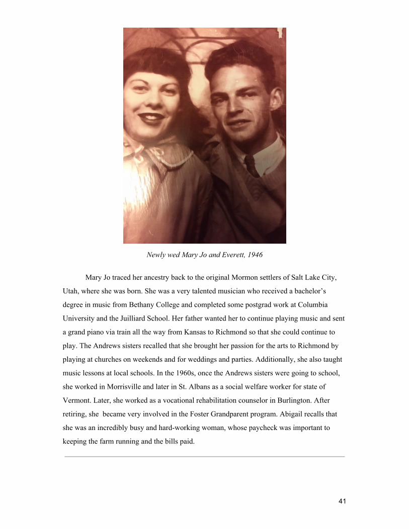
Newly wed Mary Jo and Everett, 1946
Mary Jo traced her ancestry back to the original Mormon settlers of Salt Lake City,
Utah, where she was born. She was a very talented musician who received a bachelor’s
degree in music from Bethany College and completed some postgrad work at Columbia
University and the Juilliard School. Her father wanted her to continue playing music and sent
a grand piano via train all the way from Kansas to Richmond so that she could continue to
play. The Andrews sisters recalled that she brought her passion for the arts to Richmond by
playing at churches on weekends and for weddings and parties. Additionally, she also taught
music lessons at local schools. In the 1960s, once the Andrews sisters were going to school,
she worked in Morrisville and later in St. Albans as a social welfare worker for state of
Vermont. Later, she worked as a vocational rehabilitation counselor in Burlington. After
retiring, she became very involved in the Foster Grandparent program. Abigail recalls that
she was an incredibly busy and hard-working woman, whose paycheck was important to
keeping the farm running and the bills paid.
41

The family getting ready to take a drive to see the fall foliage, (Left to Right) Ruth, Everett, Kenneth, and Lillian MacWilliams (Aunt Lil),
1970, front porch of brick house
When Clarence died in 1953, he left the farm to his children. Everett, Mary Jo, and
Kenneth bought the farm from their other siblings and took over running it. After Ruth
moved back to the farm, she and Ken would live in the brick house. While Everett, Mary Jo
and their four daughters lived in the white clapboard house.
42

Andrews sisters waiting for school bus, (Left to Right) Back row - Amy Wagner and Jennifer Gilligan,
Front Row - Abigail Allard and Kate Couture, 1966, end of driveway on farm
At the time when this photo was taken, all 12 grades were in the same building at the
Richmond Schoolhouse, which the Andrews sisters attended. The Richmond Schoolhouse
was renovated around 1953 in order to make room for the baby boom generation. Before
being renovated, the school building had four classrooms on the first floor with two grades
meeting in each and four classrooms for the high school on the second floor. Amy’s class was
the first to use the renovated school in the fall of 1953. Amy was also the last class to
graduate from Richmond High School in 1966. There is an 11 year age gap between the
oldest sister, Jennifer and the youngest, Abigail.
43

Top photo: Everett driving his Massey Ferguson tractor in foreground and Ken walking back
towards truck in midground, 1973, back pasture Bottom photo: Everett driving a tractor, 1976-1980, hills west of farmhouse
The farm became increasingly automated over the years with the purchase of new
vehicles. The Andrews sisters helped with farm chores and would drive the truck, which is in
the background of the top photo as soon as “their legs were long enough to reach the pedal
and clutch” shared Kate Couture. Additionally, the Andrews family had a number of cars.
Amy recalls that she learned to drive the “Ford and farm trucks in the fields, and the Chevy
on the road”.
44

Everett on his favorite tractor, the Massey-Ferguson, 1930s, cornfields in bottom cove pasture
Everett loved his tractors. His favorite was his Massey-Ferguson tractor since it was
more maneuverable than its counterparts. Everett was hesitant to let others drive the tractors
on the farm after an accident occured in 1950, when Mary Jo was driving the International
Harvester tractor and hit a patch of ground that had heaved where a telephone base had been
cut. This collision “sent her driving on one wheel” according Amy Wagner.
Amy also recalled that Everett fashioned a wooden snow plow that he would attach to
the back of the tractor. He would use this plow not only on his own farm, but those of Aunt
Jenny’s and others in town as well.
45

Kenneth with his team of horses in the corn fields, 1930-40s
According to the sisters, Kenneth and Everett had a special relationship. Despite Ken
being Everett’s senior by 20 years they were very close and operated the farm well together.
Kate Couture shared that Kenneth and Everett “seemed to just know what the other was
thinking without going through a lot of conversation,” developing a kind of affinity that came
from working together over the decades.
Ken loved horses, especially his Belgian horses. He attended Norwich University for
a short time because they had a cavalry unit. Afterwards, he worked on the University of
Vermont farm for a few years before returning in the early 1950s to run the Andrews Farm
with Everett. He also worked a carrier route that he was quite fond of. He kept horses on the
farm until the 1960s.
46

Richmond Co-Operative Creamery, 1940s or earlier, Richmond Vermont
Throughout the 20th century, the Richmond Co-operative Creamery contributed
significantly to the economy of the town of Richmond. Richmond was an important source of
dairy products such as milk and butter for large cities throughout the east coast, especially
after the 1880s when refrigerated train cars were introduced. Throughout Vermont,
creameries were formed for quality control of products and to make the labor intensive
manufacturing of dairy products more cost effective (Albers, 2000). Both Clarence and then
Everett served on the board of the Creamery at different times.
Running the dairy farm required a lot of work. Everett and Kenneth began their work
days at 3:45 a.m., when they would go to the barn to milk the cows. In the summer, they had
to wake even earlier to move the herd of cows from the pasture to the barn. They collected
the milk in 100 pound spring cooled cans that they loaded onto their truck to take to the
Richmond Co-operative Creamery. At the Richmond Co-operative Creamery, the milk cans
would then be loaded on a metal conveyor system that dumped the milk into a vat. After this,
the cans were cleaned and returned. Amy fondly remembers riding on the back of the truck
going to the Co-Op Creamery in the summer.
The mid 20th century brought large changes in Vermont’s dairy industry and the
Andrews Farm. The first bulk tank arrived in Champlain Valley in 1953 and soon after their
47

introduction the use of bulk tanks became required within the state(Albers, 2000). Bulk tanks
presented a financial challenge for many dairy farmers. Installing bulk tanks was expensive
for farmers and for the milk to be removed from the bulk tank large tanker trucks had to
access the bulk tanks. However, many bulk tank trucks could not pick up milk from farms on
hills to take to creameries, which resulted in many small hill dairy farms going out of
business.
On the Andrews Farm, the process of milking on the farm also changed slightly with
the advent of bulk tank technology and milking machines. Two milking machines were used
on the farm. They were attached to the cows and once full, would be dumped into a stainless
steel bulk tank. According to Kate after “they had removed the milk machine Dad and Ken
would milk the cows by hand to get every bit of milk from the cows.” The cows were milked
twice a day, once early in the morning and again later in the afternoon. A milk truck would
come to pick up the milk from the bulk tank. Kate also shared that “Dad and Uncle Ken were
very, very proud that their milk consistently tested high quality, good butterfat”.
On the Andrews Farm the family kept Holsteins since they produced good milk. The
Holsteins were bred with an Angus breed since they had smaller calves that were easier to
give birth to, decreasing the likelihood of birthing complications. On the farm, they had 65
cows including calves, dry cattle, young cattle, and 35 to 40 milking cows.
Beside milking, there were also a number of other chores associated with caring for
the cows. The cows were kept in stanchions in the barn, where they were given grain, hay or
corn silage to eat. They also had a water bowl in the barn that they could refill by pushing a
lever with their noses. After the cows were returned to the barnyard or pasture the barn
needed to be cleaned, which was done by shovel. The manure gathered while cleaning the
barn was then dumped in a manure spreader, attached to a tractor, and dispersed across the
fields.
Amy recalls that Everett was thrilled when artificial insemination was invented
because it meant he did not have to deal with the farm’s Jersey bull any longer. One time the
Jersey bull escaped and dragged Everett almost half a mile down the road by a rope attached
to the bull’s nose, breaking some of Everett’s ribs along the way.
48

The cows were sold in 1978, when Everett and Ken realized that they were not getting
a good return on their milking operation anymore. By 1978, the dairy industry in Vermont
had changed significantly. A drive for more efficiency in the dairy industry had pushed
farmers to buy more cows, better breeds, and incorporate more machinery that all raised the
costs of running a dairy farm. These high costs of modernization, as well as increasing
globalization and changing market demands throughout the latter half of 20th century forced
many dairy farms in Vermont out of business.
49

Kenneth harvesting corn, 1930-40s
Come fall, corn for the cows had to be harvested. Harvesting the corn was a large task
and neighbours would get together to assist one another. First, the corn had to be gathered
from the fields. The corn stalks were cut off at the base and then they were loaded on a
wagon to bring to the silos. At the silos, the stalks were loaded by pitchfork into a machine
that chopped up the stalks and ears, releasing the silage into the silo. Somebody stood in the
silo to spread around the silage. Standing in the silo was potentially dangerous because of the
off-gassing in the confined space of the silo.
The Andrews family grew vegetables in a large garden on the property. They
cultivated potatoes, tomatoes, and blackberries to be sold as produce. Those vegetables that
they did not sell or eat immediately were kept in cold storage or canned.
Haying was a significant task on the farm. Amy recalls that haying was mostly done
with a baler machine during her lifetime, but prior to that, they had hired men come and
scythe and fork the hay. Amy also shared that forking hay into the wagon would sometimes
result in “little surprises, as I once saw a snake fall out of a raised forkful and drop down
Daddy’s back.”
50

The hay loaded on the wagon was brought in loose to the U shaped barn on the
property. In the U shaped barn a horse-powered contraption removed the hay from the wagon
in bunches and unloaded it into a haymow.
Abigail recalled that the process of haying became more automated during her
lifetime. Everett cut the hay into rows, and then fluffed it by machine and hand. The hay was
then baled and gathered into groups. The bales were stacked and tied down in the old farm
truck, and brought back to the barn to be re-stacked and stored.
The Andrews family generally hired men to help them with these labor intensive farm
jobs. According to Amy, before the chores became more automated on the farm they
generally had two hired hands and one hired girl to help out.
51

Everett’s skates and sleigh bells (pre-1920s), 2019
Everett used to skate on the cove while harvesting ice. According to Amy Wagner,
the ice would rise and fall since the cove was part of the Winooski River. This made skating
on the cove particularly dangerous and Everett did not let his daughters ice skate there. Ice
that was gathered at the cove was loaded on a horse pulled carriage and taken into town.
Clarence and Everett both sold ice to a company in Richmond until around the 1950s when
demand for pond ice fell.
The Andrews family also had a sleigh stored in their blacksmith shop. The blacksmith
shop was mostly a place for the children to play since the farrier that came to make horse
shoes for the Andrews family used his own equipment. The sleigh bells themselves were
important for warning people of the sleighs whereabouts when traveling at night.
Winter brought with it additional chores. Wood had to brought up from the cellar for
easy access to the furnace. Potatoes and winter squash also needed to be stored in the root
cellar of the brick house basement. Amy recalls that Ruth had a unique method of preparing
the squash for cooking, Ruth would take the squash out to sidewalk and smash them on the
ground to break them open.
During spring ice jams would form on the Winooski River. The town cleared the ice
jams with explosives.
52
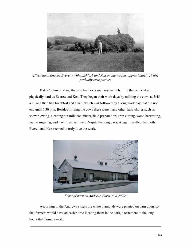
Hired hand (maybe Everett) with pitchfork and Ken on the wagon, approximately 1940s,
probably cove pasture
Kate Couture told me that she has never met anyone in her life that worked as
physically hard as Everett and Ken. They began their work days by milking the cows at 3:45
a.m. and then had breakfast and a nap, which was followed by a long work day that did not
end until 6:30 p.m. Besides milking the cows there were many other daily chores such as
snow plowing, cleaning out milk containers, field preparation, crop cutting, wood harvesting,
maple sugaring, and haying all summer. Despite the long days, Abigail recalled that both
Everett and Ken seemed to truly love the work.
Front of barn on Andrews Farm, mid 2000s
According to the Andrews sisters the white diamonds were painted on barn doors so
that farmers would have an easier time locating them in the dark, a testament to the long
hours that farmers work.
53

The Andrews family sitting together for family dinner, fall of 1954, (Left to Right) Photo on left: Patty Walker, Mary Jo (holding Kate), Everett, Sumner, Ken
Photo on right: Amy, Lillian, Ellen (holding Vicky Walker), Craig Walker, Ruth, Rodney Andrews
Sundays were a very important day for the Andrews family. Once they completed
morning farm chores, the family drove into town for a 10 o’clock church service. Along the
way they picked up extended family members that could not drive. After the service, the
family would go on an outing together - taking a picnic, going for an afternoon drive, visiting
relatives, or grabbing a creemee. They would then gather at their home for a large dinner. The
Andrews sisters all emphasized that family time was immensely important and that they truly
cherished the opportunity they had to spend so much time together.
Abigail recalls that the Richmond Congregational Church attended served as a social
center for the entire community. The Andrews sisters shared that as a kid it was a big deal to
be selected as the “greeter” at the church, charged with the responsibility of handing
churchgoers a bulletin as they entered. There were also nickel-a-dip church suppers that Kate
Couture recalls had fantastic food and were well attended by the community.
54

Rob Hirss (friend of the Coutures) helping with the sugaring effort in the sugarbush stand on the property, 1976, sugarbush stand
Kate Couture recalled that the Andrews family did some sugaring on the Andrews
Farm when she was young, but that they stopped when the sugarhouse burned down. In 1975,
after taking a class at UVM, Kate and her husband, Richard, built a brick hearth to make
maple syrup again on the property.
1975 was also the year that Kate and Richard moved back to Richmond. They came
back to assist Kate’s parents and stayed in Richmond until 1984. They lived in a house they
built on a lot on Route 2 near the Richmond Village that they bought from Ken, Everett, and
Mary Jo. Living nearby to the Andrews Farm, Richard would help Everett with farm chores.
Abigail recalls that Richard and Kate’s return brought “a lot of life to the place”, which
probably helped raise the melancholic mood of mourning that Everett felt for the loss of Ken
after he passed away.
Jennifer also moved back to the farm in the late 1990’s to assist Everett and Mary Jo
in their advanced age. Jen lived in the white clapboard house that the Andrews sisters had
grown up in since Everett and Mary Jo have moved into the brick house. Jen helped care for
her parents, grew vegetables, raised sheep and chickens, ran a farm store through the barn,
assisted with barn repairs, and helped run general business operations. She lived on the
Andrews Farm until 2011.
55

Aunt Lil, Hazel Berry (cousin who lived with them) and Aunt Ruth in swimming clothes, 1910-1915
Swimming was a favorite activity for multiple generations of Andrews. Amy Wagner
recalled fond memories of playing in the brook on the property, but the Andrews girls’
favorite places to swim were the Huntington River up by Moultroup's or down by
Bombardier's in Jonesville. Mary Jo also loved to swim and would take the kids to swim
lessons at the town beach at Hinesburg Pond (now Lake Iroquois).
56

View of Andrew’s Farm, Fall 1976, near Couture’s house
The Andrews sisters shared that some of their fondest memories of the Andrews Farm
are from playing outside during their childhoods.
The Andrews Farm is covered with large gray rocks, from which the Rhodes family
gave the land the name, Gray Rocks Farm. The sisters shared that they loved to play on these
rocks and that one in particular was their favorite. It is a large rock down by the yellow gate
in the parking area of what is now the Andrews Community Forest. The sisters shared how
they had campfires by that rock roasting marshmallows and making popcorn.
Kate Couture also shared that she and Abigail loved to play with the animals on the
farm. Since Everett was always working, if the girls wanted to spend time with him they
would go to the barn, where many of the farm’s animals could be found. She and Abigail
spent a great deal of time in the barn loft building forts with hay bales, searching for kittens,
or down on the main barn floor feeding calves. They also had horses that they would ride
with friends.
All of the sisters also helped out with chores around the farm, especially as they got
older. Throughout the year they helped out with chores in the barn such as giving grain and
57

water to the cows, shoveling walkways, and helping dump pails of milk into the bulk tank.
During the summer, they had additional chores helping with haying, feeding the horses, and
moving the cows to the fields. Their least favorite chore was bringing the cows back out to
pasture across Route 2 after they had been milked in the morning. They would stand in the
middle of Route 2 and hold up orange flags to stop traffic while the cows crossed the road.
The sisters recalled pretending to be asleep in their beds when they heard Everett coming to
their rooms to choose one of them to help with chores in hopes they wouldn’t be chosen.
Amy recalls that this chore became more embarrassing as they got older since they ran the
risk of classmates on their way to school seeing them.
58

Lillian’s first and second grade combined photo, Lillian is 2nd row fourth from left, Richmond School House (now Richmond Town Hall), around 1920
Kate, Everett, and Mary Jo walking through the farm to pick blackberries, 1974-1977, upper fields of Andrews Farm
59

View of Camel’s Hump and I-89 from the Andrews Property, 1974-1977, upper fields of farm
In 1963, the length of I-89 passing through Richmond was completed. Its construction
had a large impact on the Andrews Farm, because the government took “50 acres of his
[Everett’s] best bottomland” through eminent domain, Amy Wagner shared with me. Everett,
Ken, and Mary Jo went to court to challenge the seizure since they believed they had not
received a fair price for the taken land. They won the case and received more money after
they got the land that was taken away re-appraised. Amy shared that she was one of the first,
if not the very first person, to use I-89 when she and a friend snuck onto the highway. They
rode their bikes along it soon after the concrete had been laid.
60

( Left to Right) Everett, Kenneth, and Sumner, in front of a lilac bush by the driveway,
1940-1941
Ina and Everett, 1939-1940
61

Ken and Clarence, 1920-23, rock garden
(Left to Right) Lillian and Ruth, 1947-50, driveway of farmhouse
(Left to Right) Lillian, Ruth, and Ellen, 1938-1941, rock garden
62

(Left to Right) Everett, Clarence, Sumner Fuller, Probably taken at Ina’s funeral in 1941, rock garden
Clarence passed away in 1953. Amy shared that, at the time of his passing, the bodies
of the dead were often embalmed and brought back to the homes of the deceased for vigils,
during which time family members would stay up all night until the funeral, having calling
hours in their homes.
Aunt Lillian also had a vigil in the parlor of the Andrews Farm, despite the practice
becoming uncommon by the time of her death in the 1990s. However, her casket was too
large to pass through the door, so a window had to be removed to get the casket into the
parlor. This was not the first time the family had to remove windows to fit a coffin into the
house.
When Ken passed away, the Andrews family also had to remove the windows to the
parlor. Abbie recalls that Ken’s funeral had been a large event and that “most of the town of
Richmond must have come out,” and that she “didn’t realize everybody knew him because he
was quietly at home in my lifetime . . . that he was a lot more well known than I knew, and
was very well respected.”
63

References
Akbari, H.; Huang, J.; Martien, P.; Rainier, L.; Rosenfeld, A.; Taha, H. 1988. The impact of summer heat islands on cooling energy consumption and global CO2 concentrations . In: Proceedings of ACEEE 1988 summer study in energy efficiency in buildings Vol 5. August 1988. Washington DC: American Council for an Energy Efficient Economy: 11-23.
Albers, J. (2000) Hands on the land - a history of the Vermont landscape. Rutland, Vermont:
Orton Family Foundation. Alig, R.; Kline, J.; Lichtenstein, M. 2004. Urbanization on the U.S. landscape: looking ahead
in the 21st century. Landscape and Urban Planning . 69(2-3): 219-234. Anderson, L.M.; Cordell, H.K. 1988. Influence of trees on residential property values in
Athens, Georgia (USA): a survey based on actual sales prices. Landscape and Urban Planning . 15: 153-164.
Baker, M., & Kusel, J. (2003). Community forestry in the United States: Learning from the
past, crafting the future . Washington, DC: Island Press. Ballantyne, M., & Pickering, C. M. (2015). Differences in the impacts of formal and informal
recreational trails on urban forest loss and tree structure. Journal of Environmental Management, 159, 94-105. doi:10.1016/j.jenvman.2015.05.007.
The Richmond Town Forest Interim Steering Committee. (November 19, 2018). Andrews
Community Forest Management Plan: Richmond, Vermont. Berry, D. 1976. Preservation of open space and the concept of value. American Journal of
Economics & Sociology . 35(2):113–123. Community Forest Collaborative. (2007). Community Forests: A Community Investment
Strategy. Retrieved from http://www.communitiescommittee.org/pdfs/Community_Forests_Report_web.pdf.
Corrill, M.; Lillydahl, J.; Single, L. 1978. The effects of greenbelts on residential property
values: some findings on the political economy of open space. Land Economics . 54: 207-217.
DeHaven-Smith, L. 1988. Environmental belief systems: Public opinion on land use
regulation in Florida. Environmental Behavior . 20(3):276–299. Donovan, G.H.; Butry, D. 2008. Market-based approaches to tree valuation. Arborist News .
August: 52-55. Retrieved from www.isa-arbor.com. Donovan, G.H.; Butry, D. 2009. The value of shade: estimating the effect of urban trees on
summertime electricity use. Energy and Buildings . 41(6): 662-668.
64

Everett B. Andrews. (2010, December 30). Burlington Free Press . Retrieved from https://www.legacy.com/obituaries/burlingtonfreepress/obituary.aspx?n=everett-b-andrews&pid=147491744 .
Federal Land Ownership and Management: Background and Current Issues. (2017).
Congressional Digest, 96(6), 3-5. Freemuth, J. (2018). A Happy Combination? Great Interests, Particular Interests, and
State-Federal Conflicts over Public Lands. Publius: The Journal of Federalism , 48(3), 454–468. https://doi-org.ezproxy.uvm.edu/10.1093/publius/pjy008.
Gobster, P. H. 2004. Introduction: The social aspects of landscape change: Protecting open
space under pressure of development. Landscape Urban Plan. 69(2–3):149–151. Hardiman, N., & Burgin, S. (2013). Mountain biking: downhill for the environment or chance
to up a gear? International Journal of Environmental Studies , 70(6), 976-986. doi:10.1080/00207233.2013.848531.
History. (2019). Richmond Vermont. Retrieved from
http://www.richmondvt.gov/about-richmond/history/ Hoger, J. L., & Chavez, D. J. (1998). Conflict and management tactics on the trail. Parks &
Recreation, 33(9), 41. Howenstine, W.L. 1993. Urban forests as part of the whole ecosystem. In: Kollin, C.; Mahon,
J.; Frame, L., eds. Proceedings: 6th national urban forest conference. Washington, DC: American Forests: 118-120.
Jackson, E.L. (1986). Outdoor recreation participation and attitudes to the environment.
Leisure Studies, 9, 235-250. Jan Albers, Hands of the Land - A History of the Vermont Landscape, Rutland, Vermont,
MIT Press for The Orton Family Foundation, 2000. Jeffery D. Kline (2006) Public Demand for Preserving Local Open Space. Society and
Natural Resources , 19:7, 645-659. Kuo, F.E; Sullivan, W.C. 2001a. Environment and crime in the inner city: does vegetation
reduce crime? Environment and Behavior . 33(3): 343-365. Kuo, F.E.; Sullivan, W.C. 2001b. Aggression and violence in the inner city: impacts of
environment via mental fatigue. Environment and Behavior . 33(4): 543-571. Kline, J. D. (2006). Public Demand for Preserving Local Open Space. Society & Natural
Resources , 19(7), 645-659. doi:10.1080/08941920600742419. Lyman, M., Grimm, C., & Evans, J. (2014). Community forests as a wealth creation strategy
for rural communities. Community Development, 45(5), 1-16. Mary Jo Andrews. (2011, February 25). Burlington Free Press. Retrieved from
https://www.legacy.com/obituaries/burlingtonfreepress/obituary.aspx?n=mary-jo-andrews&pid=148839467.
65
McCullough, R. (1995). The landscape of community : A history of communal forests in New
England . Hanover, NH: University Press of New England. Mockrin, M. H., Stewart, S. I., Matonis, M. S., Johnson, K. M., Hammer, R. B., & Radeloff,
V. C. (2018). Sprawling and diverse: The changing U.S. population and implications for public lands in the 21st Century. Journal of Environmental Management , 215 , 153–165. Retrieved from https://doi-org.ezproxy.uvm.edu/10.1016/j.jenvman.2018.03.053.
More, T. A., Stevens, T. and Allen, P. (1988.) Valuation of urban parks. Landscape and
Urban Planning , 15(1-2), 139-152. Mowen, A. J., Graefe, A. R., Barrett, A. G., Roth, K., & Godbey, G. C. (2016). Americans'
broad-based support for local recreation and park services: results from a nationwide study. Ashburn, VA: National Recreation and Park Association. 2016.
Nomination to the national register of historic places - Gray Rocks Richmond, Vermont.
(1996). University of Vermont Historic Preservation Program . Retrieved from http://www.uvm.edu/histpres/HPJ/NR/mb/history.html .
Nowak, D.J.; Crane, D.E.; Dwyer, J.F. 2002. Compensatory value of urban trees in the
United States. Journal of Arboriculture . 28(4): 194-199. Nowak, D.J.; Crane, D.E.; Stevens, J.C. 2006. Air pollution removal by urban trees and
shrubs in the United States. Urban Forestry and Urban Greening. 4: 115-123. Nowak, David J., Greenfield, Eric J., Hoehn, Robert E., & Lapoint, Elizabeth. (2013). Carbon
storage and sequestration by trees in urban and community areas of the United States. Environmental Pollution, 178, 229-236.
Nowak, David J.; Stein, Susan M.; Randler, Paula B.; Greenfield, Eric J.; Comas, Sara J.;
Carr, Mary A.; Alig, Ralph J. (2010). Sustaining America’s urban trees and forests: a Forests on the Edge report. Gen. Tech. Rep. NRS-62. Newtown Square, PA: U.S. Department of Agriculture, Forest Service, Northern Research Station.
Nowak, D.J.; Hirabayashi, Bodine, & Greenfield. (2014). Tree and forest effects on air
quality and human health in the United States. Environmental Pollution. 193 (C), 119-129.
Nowak, D.J.; Hirabayashi, Doyle, Mcgovern, & Pasher. (2018). Air pollution removal by
urban forests in Canada and its effect on air quality and human health. Urban Forestry & Urban Greening. 29, 40-48.
Nowak, D.J.; Hoehn, R., Bodine, A., Greenfield, E., & O'Neil-Dunne, J. (2016). Urban forest
structure, ecosystem services and change in Syracuse, NY. Urban Ecosystems . 19(4), 1455-1477. doi:10.1007/s11252-013-0326-z.
Nowak, D.J.; Noble, M.H.; Sisinni, S.M.; Dwyer, J.F. 2001. Assessing the U.S. urban forest
resource. Journal of Forestry. 99(3): 37-42.
66

Nowak, D.J.; Walton, J.T. 2005. Projected urban growth and its estimated impact on the U.S. forest resource (2000–2050). Journal of Forestry. 103(8): 383-389.
Ostrom, E. (1990). Governing the commons : The evolution of institutions for collective
action. . Cambridge ; New York: Cambridge University Press. Parisi, D., M. Taquino, S. M. Grice, and D. A. Gill. 2004. Civic responsibility and the
environment: Linking local conditions to community environmental activeness. Natural Resources. 17(2):97–112.
Peterson, M. N. (2004). An Approach for Demonstrating the Social Legitimacy of Hunting.
Wildlife Society Bulletin (1973-2006), 32(2), 310-321. Promoting Parks and Recreation’s Role in Economic Development . (2018). National
Recreation and Park Association & the George Mason University for Regional Analysis. Retrieved from https://www.nrpa.org/siteassets/nrpa-economic-development-report.pdf.
Sell, J. L. and E. H. Zube. 1986. Perception of and response to environmental change .
J. Architect. Plan. Res. 3(1):33–54. Snyder, M. C., & Sinclair, S. J. (2017). 2017 Vermont Forest Action Plan . Vermont
Department of Forests, Parks and Recreation. Retrieved from https://fpr.vermont.gov/sites/fpr/files/Forest_and_Forestry/Vermont_Forests/Library/2017_VT_ForestActionPlan.pdf.
Sommer, R.; Learey, F.; Summit, J.; Tirell, M. (1994). Social benefits of resident
involvement in tree planting: compressions with developer planted trees. Journal of Arboriculture. 20(6): 323-328.
Stout, D. M. (2018). Uncommon Lands: Public Property and the Rise of the Individual.
Victorian Studies , 60(2), 269–278. Retrieved from https://doi-org.ezproxy.uvm.edu/10.2979/victo rianstudies.60.2.12.
Support for Local Recreation and Park Services: Results From a Nationwide Study. (2016).
Ashburn, VA: National Recreation and Park Association. Retrieved from https://www.nrpa.org/uploadedFiles/nrpa.org/Publications_and_Research/Research/Park-Perception-Study-NRPA-summary.pdf.
Thapa, B., & Graefe, A. R. (2003). Forest Recreationists and Environmentalism. Journal of
Park & Recreation Administration , 21(1), 75-103. Thompson, E. H., & Sorenson, E. R. (2000). Wetland, woodland, wildland : a guide to the
natural communities of Vermont. [Montpelier]; Hanover, NH: Vermont Dept. of Fish and Wildlife and the Nature Conservancy ; Distributed by University Press of New England.
The Vermont Town Forest Stewardship Guide: A Community Users’ Manual for Town
Forests. In Northern Forest Alliance (Ed.), Northern Forest Alliance (pp. 89): Queen City Printers, Inc.
67
Twarkins, M., Fisher, L., & Robertson, T. (2001). Public involvement in forest management planning a view from the northeast. Journal of Sustainable Forestry, 13 (1/2), 237.
U.S. Department of Commerce, Census Bureau [U.S. Census Bureau]. 2001. Statistical
abstract of the United States, 2001. Table 1046. Retrieved from http://www.census.gov/prod/www /statistical-abstract-us.html
U.S. Department of Commerce, Census Bureau [U.S. Census Bureau]. 2007. U.S census data.
Retrieved from www. census.gov. (15 January 2007). Urban & Community Forestry Program. In USDA Forests Service (Ed.), United States
Forestry Service. Retrieved from https://www.fs.fed.us/managing-land/urban-forests/ucf.
Vaske, J. J. and M. P. Donnelly. 1999. A value-attitude-behavior model predicting wildland
preservation voting intentions. Society & Natural Resources. 12(6):523–537. Westphal, L.M.; Isebrands, J.G. 2001. Phytoremediation of Chicago’s brownfields:
consideration of ecological approaches to social issues . In: Brownfields 2001 Proceedings, Chicago IL. Retrieved from http://nrs.fs.fed.us/pubs/jrnl/2001/nc_2001_ Westphal_001.pdf. (29 April 2008).
Westphal, L.M. 1999. Empowering people through urban greening projects: does it happen?
In: Kollin, C., ed. Proceedings: 1999 national urban forest conference. Washington, DC: American Forests: 60-63.
Westphal, L.M. 2003. Urban greening and social benefits: a study of empowerment
outcomes. Journal of Arboriculture. 29(3): 137-147. Wolf, K.L. 2003. Public response to the urban forest in inner-city business districts. Journal
of Arboriculture. 29(3): 117-126. Wolf, K.L. 2004. Trees and business district preferences: a case study of Athens, Georgia US.
Journal of Arboriculture. 30(6): 336-346.
68