feasib il it y for the proposed minÎo dam...feasib il it y study for the proposed minÎo water...
TRANSCRIPT

PRELIMINARY ENGINEERING REPORÎ
FEASIB IL IT Y STUDY
FOR THE PROPOSED
MINÎO WATER SUPPLY DAM
+t
tllht
'ir'l
l'tt,ßg
uú
I
I
iiI
C¡TY OFrtilTo ú
I
!In
sEc 3rT 156NR 52W
DAM SITE
toËt1 ilvEl
EXISTING DAM
NORTH DAKOTASTATE WATER COMMISSON
MARCH I98O swc PRoJECT 418
I
PRELII.IINARY ENGINEËR¡ NG REPOR,T
MINTO WATER SUPPLY DAHs!.,c PRoJEcr #448
l{arch 4, lg80
,Ê* -æ
PREPARED BY:
DESIGN ENGINEER
SIJBT,IITTED BY:
t
.E
PREPAREÐ BY:
NORTH EAK0TA STATE I'TATER CCIt"tt4tSStONSTATE OFFICE BUILD¡NG9OO EAST BCIULEVARDBtsMARrK, NoRTH DAK0TA 59505
PREPARED FOR:
ctTY 0F M|NTO, NoRTH DAKoTAD
DIRECTOR OF ENGINEERI
APPROVED BY:
I
vERNoN FAHI ,, (gl.L.STATE ENIGNEER
H¡STOR¡CAL BACKGROUND
PROPOSED T''ATER SUPPLY
TAB.LE OF CONTENTS
DAI4
I
2
2
4
9
9
¡0
t2
l2
I
vt.vil.un I
lx
Fìgure I
Figure 2
F rgure J.t
F I gure ¿t
Figure j
ENVIRONMENTAL SURYEY . -
REC0MilENDATI oNS . . . . . ¡ . i r . . . . . . . . . i . . i - .
LIST OF FIGURES
Pr.oject Site Map ...,.lsometric View of Dam .
Stage-Discharge Curves ....,Sectional Vieu¡ of Dam
Plan Vîew of Dam .
APPENDICIES
lJater Supply ALter"natives :13Appendix A
Appendix B Invest i gat i on Agreernent l9
I. INTRODUCTION
Purpose and Scope
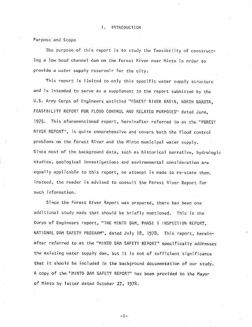
The purpose of this report is to study the feas¡b¡lity of construct-ing a low head channel dam on the Forest River near Minto in order toprovîde a water supply reservoir for the city.
This report is limited to only this specific water supply structureand is intended to serve as a supplement to the report submitted by the
U.S. Army Corps of Engineers entitled "F0REST RIVER BASIN, NORTH DAKSTA,
FEASIBILITY REP0RT FOR FL00D CONTROL AND RELATED PURPOSES" dated June,
1975. This aforementioned report, hereînafter referred to as the "FoREST
RIVER REPORT'r, is quîte comprehensive and covers both the flood controlproblems on the Forest River and the Minto munîcipal water supply.
Since most of the background data, such as historical narrative, hydrologicstudies, geological investigations and environmental consideration are
equaìly applicable to this report, no attempt is made to re-stête them.
lnstead, the reader is advised to consult the Forest River Report forsuch information.
Since the Forest River Report was prepared, there has been one
additional study made that should be briefly mentioned. This is the
corps of Engineers report, rrTHE MINTO DAM, PHASE I lNSPEcrloN REPoRT,
NATIONAL DAM SAFETY PROGRAMTT, dared July lB, 1978. This reporr, herein-after referred to as the'¡MlNTO DAM SAFETY REP0RT" speqifically addresses
the existing water supply dam, but ¡t is not of sufficient significancethat it should be included in the background documentation of our study.
A copy of the I'MlNTO DAM SAFETY REPORT' has been provided to the Mayor
of Minto by letter dated October 2/, 1978.
-t-
I I. HISTORICAL BACKGROUND
The existing Minto Dam was constructed in l93B under the works
Progress Administration (tr./PA) Program, ln 1956, repairs of an undis-closed nature were made to the structure by the city of Minto and the
North Dakota State \,later Commission.
0n February l, 1973, the structure washed out. Repairs began on
February 21, 1973. These consisted of driving steel sheet piling up-
stream of the remaining concrete section, adding rock and concretebetween sheet piling and the remaining section and at a later date,adding a concrete cap along the crest.
III. PROPOSED I^'ATER SUPPLY DAM
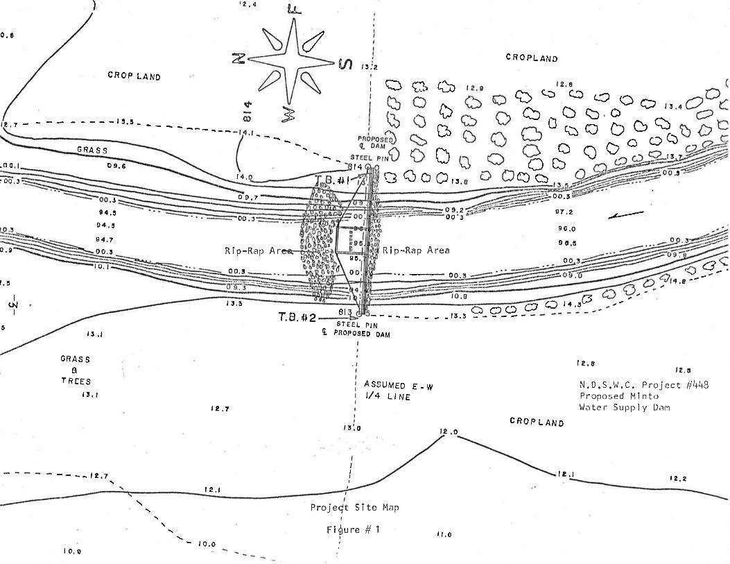
The proposed dam is to be located in Section 31, Township 156
North, Range !2 west, approximately 2200 feet downstream from the
existing water supply dam, as shown in Figure No. l.The site was cl'iosen over the other two alternatîve locatîons
mentioned in the Forest River Report because of several reasons, (l) the
addÌtional storage available downstream, (z) the existing sediment
deposits in the upstream pool, (3) the downstream site offers greaterease of construction away from city congestîon. The varÌous alternativesare discussed in Append¡x ¡¡Arrwhich is an excerpted portion of tThe
Forest River Reportrr.
These advantages of the downstreåm sìte are not offset by any
specïfîc advantages of the upstream sites. The other factors, such as
soils and geological conditions are equal at all Iocations. The structuraltype and size of a dam at any site would be the same.
-2-
) t2,4 k
0.8 dztl
¡4,
o 9,7
V, l5 2CROPLAND
()bq)Õ
CROP LAND
L26c3(Ða)
A)B ,-Ò b ouq)Ð ÞoÕao
iÐf3
t4 DCO
Rip-Rap Area
CD
bCb
Dc,,
2
() Ðo ñ
c)CI
,!
sGRA ss
,5 .l
GRAS Sa
TREES15.,
----12.7
.0 0,1 o 9,6
.+l
8t
o 9.200'3
o o,5
97,2
96.o9 6.ã
o
.l
4,a "-G C
a9 Q 6J ,4. 5G
CROPLAND
B1 3.5
T.B.lt2 STE€L PINQ pnopos¡o olÄl
AS9UMED E - WI/4 LINE
l8's rs,6
N.D.S.Ìt.C. Project #448Proposed Mlntol./.rter Supply D.rmt2,t
0 o
IIIII
#I
Fl0ure
I e,t
ProjeÇt SÏte Map
85
oot.7
to.
5
I(NI
0.9
:OO,!
o0 .5
0 0.5
Rîp-Rap Ar
9{.394, tI4.7o 0.5
.J
lo.0- lo.o
I l.o
l8.t t 2.2
One additional factor considered rvas the retention of the existingdam to act as a siltation collection basin in order to maintain the
storage effectiveness of the downstream reservo¡r and aìso to thereby
improve the qual ity of the urater stored within. This v¿ould, of course,
require that some maintenance work be performed periodically upon the
existíng dam in order to keep it functionîng as a settling basin.
The repairs, however, should be of a minor nature since the hydraulichead difference between the upstream and downstream face would become
smaìl due to the presence of the downstream reservoir.
IV. HYDRAULIC DES¡GN
A low head channel dam such as shown in Figure No. 2 is designed so
that it has greater weir capacity than the normal channeì. Therefore,as the discharge increases, the control of river flows will change from
wei r control to downstream channel control . Thus there wi I I not be an
increase in upstream flooding occurring with the new dam Ìn place greater
than there îs now with the existing dam (see Figure No. 3), The per-manent storage pool wîll remain within the river channel and the water
surface profiles of the various flood stage will not be increased.
This conservative design has the drawback of reducing the storage
capacity of the reservoir. The design capacity of the proposed reservoiris 68 acre-feet or 22,000,000 gallons. At a possîble water supply
demand of 100,000 gallons per day, this would be a 220 day supply,
assuming no losses or inflow. However, a better estimate would be thatit would only contain a I l0 to 150 day supply. This means that ev-en
with the new dam in place, the water supply îs of a marginal quantityand vigilant monitoring of use would still be required during dry periods.
-4-

y\i./)
{
Iùth,i;
\-{{
{#.¡l
{
{
.¡/
ri)rivÇDc/
It
a,
JJ {
J
4/ r"'
ft
J
.1"¡lu'
.t
!-
i{I
{-{Il.¡t
I
.v
-t.
t
ì{
{ .I
í)
v
à/ -a
,rJ).,*, li '.V '' úf r/'
-¡, !.J-st4t' ,l/ \( tI¡1/
.v. v Ì/v v .\Y iú/ l'¡.D.S.\^/.C.
Project #448Proposed Minro \y'atr:rSupp I y Dam
{¡/
,- )t'
'{1/ .l/
( .¿'
I sometric VíewFigure ll 2
, ¡...
tlrt I f,r'
.t/
t^¡l'4,Ì'
J

813
812
8il
810
Elevat lonl,l . S. L.
oqrl
811.1 ¡,1.S.1
sas árnu ,r, Polnt of changefrom wler coRtrolto channel control
InI êbø
r./,{ld7
*'r'*/
"""*809
$\
//
rf N.D.S.Ll ,G.Project #l+48Proposed Minto Water Supply DamStage-Dl scharge Curve
308
,a7
6r{/d:/t
/
0Dlscharge ln C.F.S.
Flgure #3
1061 000 3000 5000
806.0
I!I
798.0
.o ôr0:'0
dI oú00 0ro:ë¿.. 0ì,
, .
'..(,Ò..b "; ð i.'o. *..i u...".
t t,o,no/3 '.:.:..4,'Õ
a':' n ,l'þ.o-,1.I þ .
,1"o..,:d'0Òbea.¡ d.Õ a
to ð¿ëo.'l o
ô; d0 Ò'o^v o a
tÒ
¡.ô.
Å oo,
å,,: i¡o\Aù.
.Þ
,Y,! ,
,.1.t(..
,{.ÍA
r<l
v
0
Þ
A
VÁ
A
tr,
A
v
:6I, .Þ
ViÞ
'' ;--- _.. .Y t --:4-' :'...: y.::' ;.v.r
: v,;.:Y
t
Nv.
.V :lÞ
Þ A. èù.. \71 v
û
0 ;; ,1.^Ò.,p .,
Sect ion ViewScale V2tt=1t
N. D. S .1,/. C .Proj ect #4tEProposed M i ntol,/ater Supply Dam
Flgure ll \

I
l-
Zo'-ci'
trEltrtrgtrl0tr
Plan Víew
ry'-o' ?l-ú' ?0:Ú 2ú- o*
Elevation View
Sca le U32t =1 t
zo-6'
7qA.o
20-
N.D.S.VJ.C.Project #448Propo5ed M.lntoVlater Supply Dam
¿l-d
I@
I
2,5
Flgure # 5
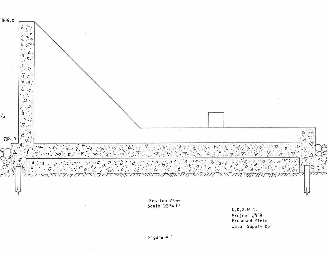
V. STRUCTURAL DES I GN
since the time of 'rThe Forest R¡ver Reportr,, findings have shown
that the gated type structure previously proposed, besides being much
more costly also becomes too much of a channel obstruction during floodflows. A clean cut, low head channel dam is now considered to be theproper structure for this purpose. Therefore, the cost estimate shown
in Section Vl is lower than that shown in Appendix,rA,r.
The low head channel dam is to be constructed of reinforced con-
crete within the channel of the Forest River with a structural steelsheet piling cutoff wall along the upstream face running from abutment
to abutment, wÎth a shorter sheet piling wall along the downstream faceto prevent undercutting. The upstream and downstream approaches to thedam wíìl be shaped and covered with rock rîprap erosion protectîon. The
details and dimensions of the structure shall be as shown on the attachedFîgures No. 4 and 5.
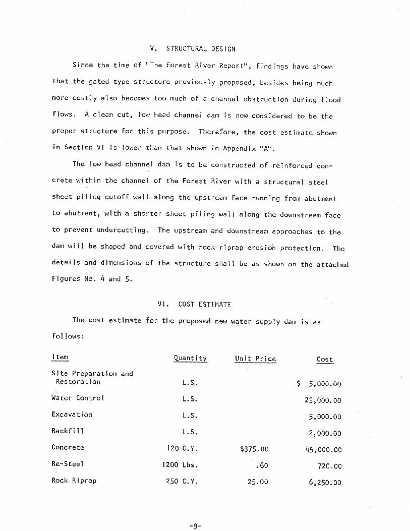
VI. COST ESTIMATE
The cost estimate forfol lows:
I tem
Site Preparat¡on andRestoration
llater Control
Excava t i on
Backf i I I
Concrete
Re-Stee I
Rock Ri prap
the proposed new water supply dam is as
Quant î tv Unit Price
L. S.
L. S.
L.S.
L.S.
t20 c.Y.
1200 Lbs.
250 C.Y.
$321. oo
.60
25.OO
Cos t
$ 5, ooo. oo
25, 000. 00
5,000.00
2, 000. 00
45 , 000. 00
720.00
6, 250 . oo
-9-
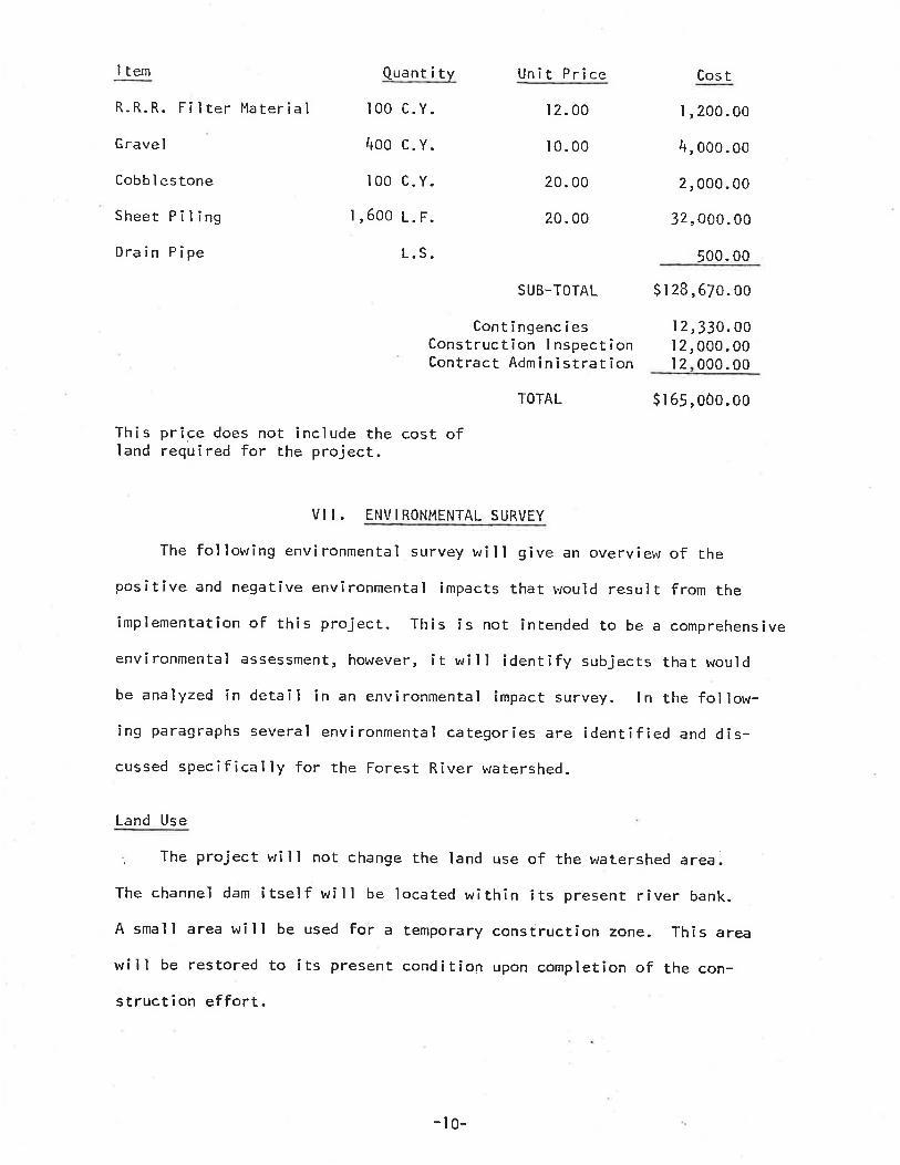
I tem
R.R.R. Filter Material
G rave I
Cobb I estone
Sheet PilingDrain Pipe
Quant i ty
100 c.Y.
4oo c.v.100 c.Y.
I ,600 L. F.
Unit Price
12. 00
10. 00
20. 00
20. 00
ContingenciesConstruction I nspectionContract Admin i strat ion
L.S.
Cos tI,200.00
4, ooo. oo
2,000.00
32, O00. 00
500. 00
I 2,330.00I 2, 000. 00l2 000.00
suB-TorAL $ I 28,670.00
TOTAL $.l65,0ôo.oo
This price does not ìnclude the cost ofland required for the project.
VI I . ENVI RONMENTAL SURVEY
The following environmental survey wîll give an overvîew of thepositive and negative environmental impacts that would result from theîmplementation of this project. This is not intended to be a comprehensive
environmental assessment, however, it will identify subjects that would
be analyzed in detail in an environmental impact survey. ln the follow-ing paragraphs several environmental categories are identîfied and dis-cussed specîfically for the Forest River watershed.
Land Use
. The project will not change the land use of the watershed area.
The channel dam itself will be located within its present river bank.
A smalI area will be used for a temporary constructîon zone. This area
will be restored to its present condition upon completion of the con-
struction effort.
-t0-
Aes thet i cs
The project is I imited to a smal I area,
change I ittle. The dam, after seeding, wi I I
env î ronment.
therefore aesthetics r.¡i I I
conform to the natural
Effects on Downstream Flood Fì ows
The proposed channel dam will have no effect upon the downstream
flows. The duration and quantities will remain the same as before thedam construction.
Ef fects on Downstream l^/ater Qual itvHigh velocity flows generally have a high sediment load which is
deposited as velocity begins to slow. This project will have a negligibleeffect upon the downstream water qual îty. The existing dam will contînueto act as a sediment trap, causing some of the transported material tosettle out. There will be a small amount of additional material de-posited within the pool of the proposed dam, but the effects thereofwill be minor.
Effects on Fish and VJildl ifeThere is no existing water within the watershed that is suitable
for maintaining a fish habitat, and the proposed project will nor pro-duce a body of b/ater that would support significant fish lÌfe. There
will perhaps be some mìnor improvement of fishing due to the new pool ofclearer water. The project will not destroy any exîsting wildlifehabitat. l.r¡ldlife will be temporarily driven from the area by theconstruction operatÎons, but will return in due time. Degradation willnot increase with the implementation of this project.
-l t-
I rreversible and I rretriebable Commitment of Resources
Fossiì fuel, construction materials, and labor used in the construc-
tion of the project will be irretrievably committed.
vilt. coNcLUStoNs
As specíf ied in the Agreement between the North Dakota State t¡Jater
Commission and the City of Minto, see Appendix B, the preliminary investi-gation as to the feasibility of constructing a new water suppìy dam has
been made.
This study shows that a urater supply dam can indeed be constructed
and that the downstream site is the preferred location.It is feasible from a structural, geological and hydraulic standpoint.
It is somewhat questionable from a meterological viewpoint. This is due
to the fact that during a drought or even a semi-arid weather cycìe, the
available river channel storage capacity is too small to guarantee a
satisfactory carry over for a wînter season.
Also, the economic feas¡b¡l¡ty may be of a somewhat marginaì value.
I X. RECOMMENDATI ONS
It is recommended that the City again review all the alternativesdiscussed in Appendix A. Also, the city should determine what financialcapabil ity it possesses and which alternatives fall within its resources.
The cost of the various alternatives is such that all options should be
given serious consideration.
-12-

tØ!U9ozIJJo.o.

APPENDIX IIAII(Excerpted from I'The Forest River Report")
ALTERNATIVE WATER SUPPLY FOR THE CITY OF HINTO
Municipal l,Jater Supply
Six alternatives were ìnvestigated for supplying ì¡rater to the cityof Minto; two using water directly from the Forest River, tv/o us¡ng
ground water supply and two using water f rom the Red River. Al I r¡¡ater
system alternatives were based on population estimated at 750 by ?020,
and an average daily consumption of 100,000 gal/day. The present
average daily consumption is 55,000 ga1/day and a peak demand of 80,000
gal/day. The present water plant and distrîbution system has a ratedcapacity of t50 gpm (Z't6,000 gpd) with a storage capacíty of 7O,0OO
galìons. The treatment plant is in good conditîon and is presently
treating for hardness and biological agent.
Presently the cÌty of Minto has a two inch feeder line to the
existing lJalsh County Rural l^Jater District I ine, one mile north of the
cîty. The pipeline north of Minto is a four inch líne and does not have
the cqpacity to meet existing or projected needs of Minto.
Alternative l: Main Stream Forest River At M¡nto
The city of Minto currently receives its municipal water suppry
from the maìn stream of the Forest River. The water is stored withinthe channel of the Forest River by a lor,.¡head channel dam. The existingdam ís in a state of temporary repair and construction of a new dam has
been proposed.
-13-
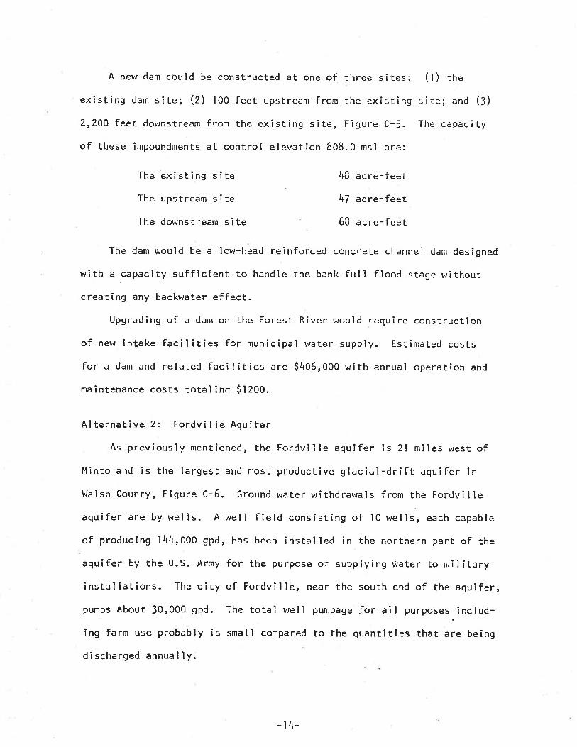
A new dam couìd be constructed at one of three sites: (l) the
existing dam site; L2) 100 feet upstream from the exîstìng site; and (3)
2,20A feet downstream from tbe existing site, Figure C-!. The capacity
of these impoundments at control elevation 808.0 msl are:
The exîsting sïteThe upstream siteThe downstream site
48 acre-feet
47 acre-feet
68 acre-feet
The dam would be a low-head reinforced concrete channel dam designed
with a ,capacity suff icient to handle the bank ful I f lood stage withoutcreating any backwater effect.
Upgrading of a dam on the Forest River would require construction
of new intake facil ities for municipal water supply. Estimated costs
for a dam and related facilities are $406,000 with annual operation and
maÌntenance costs total inS $1200.
Alternative 2: Fordville Aquifer
As previously mentioned, the Fordville aquifer is 2l miles west ofMinto and is the largest and most productive glacial-drift aquifer inWalsh County, Figure C-6. Ground r¡rater withdrawals f rom the Fordvil Ie
aquifer are by wells. A well fîeld consÌsting of l0 wells, each capable
of producing l44,O0O gpd, has been installed in the northern part of the
aquifer by the U.S. Army for the purpose of supplying water to militaryinstallations. The city of Fordville, near the south end of the aquifer,pumps about 30,000 gpd. The total well pumpage for all purposes-includ-
ing farm use probably is small compared to the quantities that are being
discharged annual ly.
-r4-
The aquifer-test data and test drilling indicate that yieìds ofmore than 100 gpm are obtaÌnable from the northeastern part of the
Fordvi I le aquifer.
Based on an areal extent of 33 square miles, an average saturated
thickness of 20 feet and a storage coefficient of 0.1!, about 63,000
acre-feet of water is în storage.
Vlater from the Fordville aquifer is a calcîum sodium bîcarbonate
type of relatively good quality. Dissolved solids range from 3.l5 msll
to 595 ns/\.Based on studies by the North Dakota State Water Commïssion, addi-
tional development of the Fordville aquifer for the Minto city water
supply Îs feasible. The system serving Minto would have two production
wells located in the northeastern portion of the aquifer with a rated
caPacity of 75 Spn for each well. Pumping and control facilîties would
be constructed at the Fordville site. Twenty one miles of four inch
plastic pipe brould be required to connect the well field to the city ofMinto. Roadway right-of-way would undoubtedly have to be purchased forpipel îne construction. The estimated cost for this plan is $2.l l,oo0with operat¡ng and maîntenance averaging $2,/00 per year. project
location is shown on Figure C-6.
Alternative 3: Red River Direct To Minto
This alternative involves the diversion of water from the Red River
of the north twelve miles east to Minto. A lowhead dam would be con-
structed on the Red R¡ver to provide a pumping pool. A pumping stationwith a rated capacity of t50 gpm (two 75 gpm pumps) would be constructed
-r5-
adjacent to the river and within the pumping poor. tn addítion, twopumps would be installed to increase the reliability of the system and atolemeteríng system instaìled to provide for constant monitoring at thecity water works- A four inch prastic ìine running east from the pumpingstation, paral ìer to existing roadways, rnrourd connect the pump site toMíntors existing treatment plant, Fígure C_/. The water quality in theRed and Forest Rivers is basicaily the same; therefore, the presenttreatment system should be adequate to treat b/ater from the Red River.The estimated costs for this arternative ar $566,000 with annuar oper_ating and maintenance costs averaginS $3700.
Alternative 4: City of Grafton
At the present time, the city of Grafton is considering instailinga water supply system from the Red River. The proposed pìan wouldinvolve construction of a check dam on the Red River to serve as apumping forebay, pumping facilitÏes and a 20 inch, 14 mile pipeline todeliver water to the water treatment plant at Grafton. The system wouldprovide Grafton with an assured suppry of r.6 miilion gaHons per day.The estimated cost of this system is g3,r00,000 prus an additîonar$500,000 to upgrade the water treatment pìant.
construction of this diversion system may ailow the city of Mintoto purchase treated water from Grafton. Minto would have to construct apipel ine from Grafton to the existing distributîon system. A four inchI ine could parailer existing roadways between Grafton and Minto, asshown in Figure c-8. The estimated costs for the piperine are $73,ooowith average annuar operation and maintenance costs of s5oo. The
-16-

est¡mated average monthly cost for treated water deliveredof Minto is $IZOO at a rate of lOO,000 gpd. This does not
charges for the u/ater which Grafton may choose to apply.
to the cityinclude any
Al terna t ive 5: Desa ì inat ion of G round l.la terThe Dakota Fo¡'mation which underl ies the Minto area is a possible
v,/ater supply source; however, the v,ater from this aquifer is highlysal ine, a T.D.S. of 4,000 mg/ì, and would requi re desal inåtion. The
reverse osmosis process was used to estimate the cost of this aìternativeThe salt brine from the desalting process could be disposed of by
expanding the current sewage lagoon system. The estimated costs forthÎs project are s550,000 with annuaì operatîng and maintenance costsaverag ing $46,000.
Aì ternat ive 6: Upstream Reservoi r
The Soil Conservation Service has constructed six reservoirs and
plans to construct one additional reservo.ir in the upper reaches of the
f:orest River. 0f these seven reservoirs, only three have suffÌcÌentstorage to meet Minto's requirements of lll acre-feet per year. Whitman
Dam,4l miles southwest and I'latejcek Dam, 3l miles southwest of Minto,have sufficÌent storage to meet Mintors present and future needs.
Dam No.4 located on the Middle-South Branch of the Forest River in
the SEå of Sectìon 6 and the NEå of Section 7, Township 154 North, Range
JJ tJest, in Grand Forks county, is scheduled for construction in 1976.
The structure is primarily flood control and recreation. However, the
dam could provide municipal water supply to the city of llinto. A pump-
ing station would be located along the reservoir above the maxímum pool
_17_

elevation. A plastic pipeline would connect the pumping plant at thedam sÍte to l,lintors existing treåtn¡ent plant. The I ine would ma,ke useof exíst!ng road r.ights-of-way wherever possi.bre. The estimated qostfor.this alternatîve is $320,000 with averaEe annual operation and
rnaintenance costs of $5000.
'r8-
r\LHT.tHEI¡T
Prel irninary lnvest i gationby the
Èlorth Dakota State l,/aLer Connission
I . PARTI ES
APPEND I X B
TH¡S AGREEI'tENT is betureen the North Da!<ota State t¿iater Cornissicn,hereinafter referred to as the comnission, acting through the sta¡eEngineer, Vern Fahy, and the city of r-lînto, hereinafter referred toas the City, acting throuqh ìts Mayor, Gerald Hisialek.
II. PROJECT, LOCATIOI¡ AI.|D PURPOSE
The Cíty has requested an investigatíon to deÈerr¡ine the feasibilityand design for a nerv water supply dam on the Forest River. Subsurfaceinvestîgations have been concucted by the commission at two .proposed
sites on the Forest River, near the city of Hinto. The proposed locationsare as follows:
(a) tmnediately upstream from the exísting dam structure approxir*ately125 feet in section ll , Township r56 North, Range 52 \.rest.
(b) Dot'rnstream from the exísting dam structure along the assumed
East-west quarter I i ne between sect ions ll and Jz, Toivnsh i p 156 liôrth ,
Range 52 )lest.For the purpose of thís investigation and any hereafter, the proposed
dam site upstream is referred to as Dar¡ lio. I and the proposed dam sîtedownstrean as Darn No. 2.
The city currently receives i ts rnunicipal v¡ater supply f ron theForest River. The water is stored within the channel of the river by
a lowhead channel dam. The exÌsting dam is in a state of temporary_repair and Îs structurally unsound. The repairs made are not consideredadequate to meet future water supply demands.
I I I. PRELIHiNARY INVESTIGATION
The parties agree that further infornation is necessary concerningthe proposed project- Therefore, the Conmissïon shall conduct prelimînaryinvestiqationq .ônç,i<tin. nf thc fnlln,.,i^-. -Ìq-
(o) Hydrologic studies and ceterrnin¿tîon of rcri;rbirity ofr.rater strpply-
(b) Prel imînary design studies(.) Prelirninary cost estinate report(d) Recomnrendations and concì us ions
Detailed field investigations, surveys and additional subsurfaceinvestigations for the 'Feas¡b¡ r ity and Specification Desiqn stages,,of the investigation, shail not be made under thîs agreement.
¡V. DEPOSIT - REFUND
The city shall deposit $5oo-00 r'¡îth the commission. upon cornpletionof the prelimìnary învestigation, upon receipt of a request from the cityto terminate proceeding f urther 'rrith thè prel iminary investigation, orupcn a breach of thîs agreement by the city, the commission shall providethe city lvith a statement of alì expenses incurred in the prelimînaryinvestigatìon and sharr return any unexpended deposit funds.
V. RIGHTS OF ENTRY
The cìty agrees to obtaín vrritten perm.ission from any affectedlando'nrner for surveys by the commissÌon (or any contractor) vrhich arerequi red for the prel iminary investigations.
VI. INDEHNIF¡CATION
The city hereby accepts responsibility for, and holds the comnÌssïonfree frorn, all claims and damages to pubríc or prîvate properties, rights,or persons arîsïng out of this investigatíon. tn the event a suit isinitiated or judgment entered against the commission, thq Boa¡d shallindemnify it for any judgment arrîved at or judgment sat¡sfied. -
clrY 0F MINTO NoRTH DAKoTA srATE ri/ATER commrssioru
r þr ern Fahytate Engineer
z-É/ yl -20-
S
13 F11q

TIIIIEIIIIIIEIrrrl