feasibility study on the use of personal gps devices in ... · the use of personal mobile gps...
TRANSCRIPT

FFeeaassiibbiilliittyy SSttuuddyy oonn tthhee UUssee ooff PPeerrssoonnaall GGPPSS DDeevviicceess iinn PPaarraattrraannssiitt
MMaayy 22000099 httpwwwftadotgovresearch
DISCLAIMER NOTICE
This document is disseminated under the sponsorship of the US Department of Transportation in the interest of information exchange The United States Government assumes no liability for its contents or use thereof
The United States Government does not endorse products of manufacturers Trade or manufacturersrsquo names appear herein solely because they are considered essential to the objective of this report
REPORT DOCUMENTATION PAGE Form Approved OMB No 0704-0188
Public reporting burden for this collection of information is estimated to average 1 hour per response including the time for reviewing instructions searching existing data sources gathering and maintaining the data needed and completing and reviewing the collection of information Send comments regarding this burden estimate or any other aspect of this collection of information including suggestions for reducing this burden to Washington Headquarters Services Directorate for Information Operations and Reports 1215 Jefferson Davis Highway Suite 1204 Arlington VA 22202-4302 and to the Office of Management and Budget Paperwork Reduction Project (0704-0188) Washington DC 20503 1 AGENCY USE ONLY (Leave blank) 2 REPORT DATE
May 18 2009 3 REPORT TYPE AND DATES COVERED
4 TITLE AND SUBTITLE
Feasibility Study on the Use of Personal GPS Devices in Paratransit 5 FUNDING NUMBERS
6 AUTHOR(S) Fabian Cevallos Quan Yuan Xiaobo Wang Jon Skinner and Albert Gan 7 PERFORMING ORGANIZATION NAME(S) AND ADDRESS(ES) Lehman Center for Transportation Research Engineering Center EC 3715 10555 W Flagler Street Miami FL 33174
8 PERFORMING ORGANIZATION REPORT NUMBER
9 SPONSORINGMONITORING AGENCY NAME(S) AND ADDRESS(ES) Federal Transit Administration US Department of Transportation Washington DC 20590
10 SPONSORINGMONITORING AGENCY REPORT NUMBER
11 SUPPLEMENTARY NOTES Task Order Manager Ms Charlene Wilder Office of Mobility Innovation Federal Transit Administration 400 7th Street SW Room 9402 Washington DC 20590 12a DISTRIBUTIONAVAILABILITY STATEMENT In addition to FTArsquos method of distribution document will be made available though the Lehman Center for Transportation Researchrsquos (LCTR) website lctrengfiuedu
12b DISTRIBUTION CODE
13 ABSTRACT (Maximum 200 words) The use of personal mobile GPS devices offers a potentially powerful use for paratransit The conventional pickup procedure requires reservations via telephone or through the Internet for the paratransit driver to meet passengers In this case the potential problem is that a missed pickup may occur due to the ambiguity of the address information or the inability to find a specific location However with the availability of existing mobile GPS devices passengers and vehicles can be located instantly thereby facilitating the pickup process This research project explores the feasibility of using personal mobile GPS devices to help develop more efficient paratransit services Four different GPS-tracking devices were examined and a prototype was developed Using the prototype the vehicle operator and passengers are able to know each otherrsquos location through the help of an agency dispatcher With this additional information it is expected that the number of missed pickups will be reduced Surveys were also distributed to collect opinions and concerns from different agencies Results indicated that a majority of transit agencies showed interest in adopting GPS devices to improve paratransit services
14 SUBJECT TERMS Global Positioning Systems Application of Personal GPS Devices Paratransit Feasibility Study Transit Operations Management
15 NUMBER OF PAGES 67
16 PRICE CODE
17 SECURITY CLASSIFICATION OF REPORT Unclassified
18 SECURITY CLASSIFICATION OF THIS PAGE
Unclassified
19 SECURITY CLASSIFICATION OF ABSTRACT
Unclassified
20 LIMITATION OF ABSTRACT
NSN 7540-01-280-5500 Standard Form 298 (Rev 2-89) Prescribed by ANSI Std 239-18298-102
FFeeaassiibbiilliittyy SSttuuddyy oonn tthhee UUssee ooff PPeerrssoonnaall GGPPSS DDeevviicceess iinn PPaarraattrraannssiitt
MMaayy 22000099
Prepared by Fabian Cevallos PhD
Lehman Center for Transportation Research Civil and Environmental Engineering
Engineering Center EC 3715 10555 W Flagler Street
Miami FL 33174 [httplctrengfiuedu]
Sponsored by Federal Transit Administration Office of Mobility Innovation
400 7th Street SW Room 9402 Washington DC 20590
Available Online at [httpwwwftadotgovresearch]
Feasibility Study on the Use of Final Report Personal GPS Devices in Paratransit Foreword and Preface
Foreword
The Federal Transit Administration (FTA) sponsored this research to determine the feasibility of using new technologies to aid and improve the paratransit pickup procedure The research evaluated personal mobile GPS devices and analyzed their ability to function within a computer application A prototype application was developed and tested with two of the GPS devices While feasibility of the prototype program is high a pilot program is needed to assess the net benefits of such an application
Preface
The information developed and presented in this document was prepared for the Federal Transit Administration (FTA) by researchers from the Lehman Center for Transportation Research at Florida International University The project team included Dr Fabian Cevallos Quan Yuan Xiaobo Wang Jon Skinner and Dr Albert Gan The project was contracted through December 31 2008
The project was managed through the FTA Office of Mobility Innovation Overall guidance was provided by the FTA project manager Charlene Wilder These contributions were important to the direction and quality of this research study
The project team would also like to thank the employees of various transit agencies who willingly replied to the projectrsquos paratransit survey instrument This information was valuable in assessing the interest in and need for GPS devices in paratransit
Federal Transit Administration v
Feasibility Study on the Use of Final Report Personal GPS Devices in Paratransit Table of Contents
TABLE OF CONTENTS EXECUTIVE SUMMARY10
PARATRANSIT PICKUP PROCEDURE AND THE POTENTIAL USE OF GPS TECHNOLOGY 10 STUDY OBJECTIVES11 LOCATION BASED SERVICE TECHNOLOGY11 COMPARISON TESTING OF DEVICES 12 PROTOTYPE DEVELOPMENT13 FUTURE APPLICATIONS AND ENHANCEMENTS 13
10 INTRODUCTION 14
11 EXPANSION OF PARATRANSIT SERVICES 14 12 MISSED TRIPS ISSUE15 13 TRACKING TECHNOLOGY TO MINIMIZE MISSED TRIPS 16
20 AGENCY SUPPORT19
30 BACKGROUND24
31 GPS FUNDAMENTAL SYNOPSIS 24 32 EXTENSIVE GPS APPLICATIONS 25 33 LOCATION BASED SERVICE (LBS)26
40 LOCATING METHODOLOGY 27
41 LOCATION INTERPRETATION 27 42 CRITERIA FOR SELECTING GPS DEVICES 28 43 MOTOROLA I41529 44 GEMTEK TRACKING DEVICE 32 45 GARMIN FORERUNNER 305 35 46 HP IPAQ HW6945 38 47 ACCURACY TESTS41 48 BENEFIT COST ANALYSIS 42
50 GPS PROTOTYPE44
51 PROTOTYPE DEVELOPMENT44 52 FUNCTIONALITY44 53 PROTOTYPE APPLICATION IN USE 45
60 CONCLUSION 49
70 FUTURE RESEARCH 50
71 PROTOTYPE IMPROVEMENTS50 72 COST amp BENEFIT RATIO EVALUATION 51 73 FINDING NEWER SUITABLE DEVICES52 74 ATTEMPTING A PILOT PROGRAM 52
REFERENCES 53
GLOSSARY56
APPENDIX A ADDITIONAL SURVEY RESULTS 58
APPENDIX B SURVEY INSTRUMENT62
APPENDIX C GPS READINGS64
Federal Transit Administration vi
Feasibility Study on the Use of Final Report Personal GPS Devices in Paratransit Table of Tables
TABLE OF TABLES
Table 1 Size of Agencies Responding to Survey by Total Yearly Paratransit Trips 19
Table 2 Different Impact on the Precision of GPS Signals 24
Table 3 Uncertainty Based on Coordinate Precision Using WGS84 Ref Ellipsoid 27
Table 4 Devices Accuracy Performance 42
Table 5 Devicesrsquo Confidence Intervals Around the Mean 42
Table 6 Devicesrsquo Costs Comparisons 43
Table 7 Statistical Summary of Survey Variables 60
Table 8 Classification of Trip Purposes 61
Federal Transit Administration vii
Feasibility Study on the Use of Final Report Personal GPS Devices in Paratransit Table of Figures
TABLE OF FIGURES
Figure 1 MDT Profile of Paratransit Riders by Disability Type April 2008 17
Figure 2 Agency Interest in Applying GPS in Paratransit Services 20
Figure 3 Agency Interest Levels in GPS Technology vs Paratransit Passengers 20
Figure 4 Current Technologies in Use for Paratransit Service Operations 21
Figure 5 Average Cost of Each No-Show Trip 22
Figure 6 Percent of No-Show Trips to Total Passenger Trips 23
Figure 7 Motorola i415 29
Figure 8 Frequency Histogram for the Motorola i415 31
Figure 9 Real Distance Deviation for the Motorola i415 (distance in meters) 32
Figure 10 Gemtek Tracking Device 33
Figure 11 Gemtek Frequency Histogram and Estimated Distance Deviation 35
Figure 12 Garmin Forerunner 305 36
Figure 13 Frequency Histogram for the Garmin Forerunner 305 37
Figure 14 Garmin Forerunner 305 Real Distance Deviation (distance in meters) 38
Figure 15 HP iPAQ hw6945 39
Figure 16 Frequency Histogram for the HP iPAQ hw6945 40
Figure 17 HP iPAQ hw6945 Real Distance Deviation (distance in meters) 40
Figure 18 Image of the Survey Control Marker 41
Figure 19 Total Cost of Each Device for a 12 Month Period 43
Figure 20 Graphical Display of the Prototype 45
Figure 21 Screen Captures of Motorola i415 46
Figure 22 Screen Captures of HP iPAQ hw6945 47
Figure 23 Device Locations Map for Dispatcher 47
Figure 24 Paratransit Agency Service Evaluations 58
Figure 25 Comparison of Instructed Wait Times and Time Windows for Pick-up 59
Figure 26 Average Hourly Pay for Paratransit Operators (in Dollars) 59
Federal Transit Administration viii
Feasibility Study on the Use of Final Report Personal GPS Devices in Paratransit Abstract
Abstract
As transit agencies continue to improve service efficiency the availability of new technologies offer innovative solutions One innovation is the use of personal mobile Global Positioning System (GPS) devices in paratransit The conventional pickup procedure requires reservations via telephone or through the Internet for the paratransit driver to meet passengers at designated locations In this case the potential problem is that a missed pickup may occur due to the ambiguity of the address information or the inability to find a specific location However with the availability of existing mobile GPS devices passengers and vehicles can be located instantly thereby facilitating the pickup process
This research project explores the feasibility of using personal mobile GPS devices to help with the development of a more efficient paratransit service Four different GPS-tracking devices were examined and a prototype was developed Using the prototype the vehicle operators and passengers are able to know each otherrsquos location and the agency dispatcher can see both the operator and the passenger With this additional information it is expected that the number of missed pickups will be reduced Surveys were also distributed to collect opinions and concerns from different agencies Results indicated that a majority of transit agencies showed interest in adopting GPS devices to improve paratransit services The methodologies as well as data flows are described and suggestions for further research are presented
Federal Transit Administration ix
Feasibility Study on the Use of Final Report Personal GPS Devices in Paratransit Executive Summary
EXECUTIVE SUMMARY
The objective of this research was to determine the feasibility of applying GPS tracking technology to the paratransit pickup procedure Study efforts consisted of assessing the need for personal GPS comparing suitable GPS devices and developing a prototype application
Paratransit Pickup Procedure and the Potential Use of GPS Technology
Paratransit service has experienced a rapid rate of growth since the ADA was passed in 1990 Although paratransit only serves a small group of people the average operating costs are much higher than most other public transit services Presently the operating expenses of paratransit in the US are largely paid by government subsidies Therefore ensuring that monetary support is used efficiently and not squandered is a top priority for transportation providers and policy makers
Compared with other public transit modes the appointed pickup locations and schedules are flexible in paratransit service Occasionally missed trips occur because the vehicle operator has difficulty finding passengers at a previously indicated pickup location ndash an event termed as a missed pickup in this paper For instance at a large mall hospital or residential facility having multiple entrances distinguishing the appropriate waiting area can be confusing for paratransit passengers In this situation a missed pickup is likely to occur if the vehicle operator and passengers are waiting for each other at different exits of the building
However this situation can be avoided if the passengerrsquos exact location is instantaneously known by either the vehicle operator or the transit agencyrsquos dispatch personnel If either of these paratransit employees is aware of the waiting passengerrsquos location the situation can be corrected immediately and a missed pickup may be avoided Exact location information can aid in promoting a punctual accurate and efficient transportation service These efforts would help promote a more efficient alternative to the current pickup procedure
Although customary cell phone devices may seem like a feasible solution paratransit ridersrsquo varying abilities make this option impractical Significant numbers of paratransit riders have sensory cognitive neurological or motor disabilities that make using a cellular phone difficult or impossible GPS technology is necessary to create an instrument which can be used universally With a mobile GPS tracking device that informs the paratransit service provider where passengers are waiting the odds of a missed pickup can be minimized Compared with the conventional method of looking for passengers in a defined area a mobile GPS device provides a more reliable approach the GPS instructions will lead the driver to the exact location of the passenger
Federal Transit Administration 10
Feasibility Study on the Use of Final Report Personal GPS Devices in Paratransit Executive Summary
Study Objectives
The principle objectives of this research focused on examining the feasibility of using GPS devices to improve the paratransit pickup procedure Several tasks were completed in order to properly assess the main objective Transit agency interest levels in GPS were assessed through a survey instrument Surveys were completed by a total of 36 US transit agencies of varying size and geographic location To best understand the complexities of developing a GPS system a review of current GPS fundamentals was performed Since GPS technology has improved and expanded significantly during the past few years an up-to-date synopsis is included within the report
The next significant objective focused on determining the most suitable GPS devices for assisting with paratransit Four devices were examined for their accuracy portability reliability durability and user friendliness After selecting the two preferred GPS devices a prototype application was developed by the research team to test the coordination of the pickup procedure To further assess the devices and prototype application testing simulations were carried out under different scenarios For this purpose each simulation incorporated the use of three fictitious parties the passenger the vehicle operator and the agency dispatcher
Interest Levels in Using GPS to Aid the Pickup Procedure
Survey responses overwhelmingly indicated that most agencies are very interested in applying new technologies to paratransit operations From the valid 36 responses 26 transit agencies were strongly or somewhat interested in incorporating new GPS technology to help improve their services Five agencies were indifferent to making changes in their current modes of operation A total of five agencies were unenthusiastic about utilizing new GPS technologies
In attempts to determine which agencies were more interested in using new GPS technologies interest levels were compared and analyzed against virtually all other data obtained from the survey Surprisingly there were no associations found between interests in using the new technologies and number of missed trips missed connections percentage of trip purposes etc Although there was no association with agency size all of the larger agencies those that had above 200000 paratransit trips per year were interested in experimenting with new GPS technologies
Location Based Service Technology and Assisted GPS
Utilizing personal GPS devices for paratransit is essentially dependant on locating technologies Location Based Service (LBS) technology enables the instant identification of an exact position from a mobile device There are four measuring approaches all of which offer opportunities to ameliorate the current paratransit passenger pickup cell
Federal Transit Administration 11
Feasibility Study on the Use of Final Report Personal GPS Devices in Paratransit Executive Summary
identification angle of arrival time of arrival and enhanced observed time difference Cell identification is one of the most common approaches and greatly ties into Assisted GPS (A-GPS)
Unlike regular GPS which requires a complete download of data from satellites and may take up to several minutes A-GPS relays information already obtained by the cell phone network and processes location data in a much faster and reliable manner minimizing the impacts whenever the GPS signal is poor Assisted GPS is important since large buildings and dense tree coverage can often impede or delay receiving satellite signals In this project since passenger location needs to be known instantly any lapse in information could cause delay and frustration for drivers and passengers
In real practice the accuracy obtained with a Global System for Mobile communication (GSM) network ranges up to several hundred meters and is not sufficient to precisely describe a pickup location However accuracy can be improved by retrieving GPS signals from satellites regarding existing GSM network information Without a GSM network a mobile GPS device requires more information from the satellites and more calculations are involved Under the existing GSM network because the mobile phone is already approximated in a certain zone the final location will be obtained much faster even if partial GPS information is not obtainable
Comparison Testing of Devices
Four mobile GPS devices were purchased for comparison analyses the Motorola i415 the Gemtek tracking device the HP iPAQ hw6945 and the Garmin Forerunner 305 The following criteria were considered as a way to compare the four units among several important factors
bull Portability - a smaller sized device without the need for a power outlet is preferred so that it can be easily transported
bull Reliability ndash GPS signals should be successfully acquired and free from other disturbance factors such as those occurring at different times in various places or under inconsistent weather conditions
bull User friendliness - users should be able to easily operate the device bull Durability - the product should have a relatively long usable life and a sustainable
battery bull Compatibility ndash the device needs to be adaptable with room for future hardware
upgrades and functionality expansions bull Accuracy - the passengerrsquos exact location must be calculated precisely so that the
vehicle will arrive directly in front of the passenger with little effort
Upon device testing and comparison the Motorola i415 and the HP iPAQ hw6945 were deemed to be best suited for the development of a GPS prototype These devices both
Federal Transit Administration 12
Feasibility Study on the Use of Final Report Personal GPS Devices in Paratransit Executive Summary
had acceptable costs and accuracy comparisons Furthermore these two devices supported programming capabilities
Prototype Development
Next a GPS prototype was developed to explore the feasibility of developing a complete working system The best possible solution involved use of both the GPS enabled Motorola i415 cell phone and the HP iPAQ hw6945 Personal Digital Assistant (PDA) This prototype connects the passenger vehicle operator and the agency dispatcher together via a central computer To synchronize these devices separate programs written by the research team were created for each device
Once the devices are turned on the programs automatically initiate and send positional information continuously acquired from satellites to a server The server translates the position coordinate numbers to point marks on Microsoft and Google maps so that the agency dispatcher can track both the passengers and vehicles by view On the driverrsquos PDA screen the vehicle operator is able to see driving directions and the passengerrsquos location on a digital map The passenger is able to receive the waiting time and vehicle distance At the same time a service log of all activities is recorded into the system database Aspects of the prototype were determined to show significant promise for improving the punctuality and predictability of the pickup process
Future Applications and Enhancements
The project team was able to successfully develop a working prototype but it has yet to be tested at a paratransit program Although initial software installation and program familiarization might require additional time and energy there is evidence that this prototype system can be replicated at any paratransit agency A pilot program is the next logical step for evaluating feasibility By testing the prototype on an actual paratransit system cost and benefit evaluations may eventually be conducted answering important feasibility questions
In the long term other advancements will improve the proposed prototype The pickup process can potentially be combined with service vehicle assignments If a change is requested from a passenger the system will immediately determine the most economical way to rearrange the service schedule Potential benefits include less time needed for reservations and more adaptable services Technology upgrades to GPS-enabled cellular phones and other newly developed GPS devices may further improve the existing prototype Future options for alarm notification voice capabilities and message services will also enhance the attractiveness of a GPS tracking system for paratransit
Federal Transit Administration 13
Feasibility Study on the Use of Final Report Personal GPS Devices in Paratransit 1 Introduction
10 INTRODUCTION
11 Expansion of Paratransit Services
Paratransit within the US offers on-demand transportation services for qualified senior citizens and people with disabilities Under the Americans with Disabilities Act (ADA) paratransit has become the well known demand-responsive service system embedded within the regular public transit network Paratransit service is a transportation alternative that provides a high degree of accessibility for individuals with almost no mobility
Although paratransit only serves a small group of people the average operating costs are much higher than most other public transit services Presently the operating expenses of paratransit in the US are largely paid by government subsidies Since these subsidies often come under intense scrutiny during budget shortfalls ensuring that monetary support is used efficiently is a priority for transportation providers and policy makers
Historically paratransit service has experienced rapid growth since the ADA was passed in 1990 ADA requires that public transit providers also provide complementary paratransit service to origins and destinations within corridors having a width of three fourths (frac34) of a mile on each side of each fixed route (1) In addition many agencies offer paratransit services beyond those required by ADA Sometimes called Dial-a-Ride these services are especially popular in small cities or rural areas where no fixed route services are available
In 1986 there were about 6300 private paratransit companies in the United States Together these agencies operated more than 200000 vehicles representing more than 350000 drivers and other staff In September 1998 twelve years later an estimated 22884 private paratransit companies operated more than 370000 vehicles During the same year some 500+ transit agencies made 886 billion passenger trips of which 68 million or 077 of total trips were demand-responsive trips Reports from the Federal Transit Administration (FTA) National Transit Database indicate that in 2006 the number of passenger trips had stretched to 940 billion of which 88 million or 094 of total trips were demand responsive trips
The database clearly shows that there has been tremendous growth in paratransit use However this is not the complete picture since the data do not include growth aspects attributed to increased transportation spending for Medicaid transportation airport shuttle operations or human services all of which are paid for through other non-FTA grant programs (2)
Federal Transit Administration 14
Feasibility Study on the Use of Final Report Personal GPS Devices in Paratransit 1 Introduction
12 Missed Trips Issue
Because paratransit has undergone rapid expansion and requires significant subsidies agencies are continually under pressure to efficiently utilize budgets and reduce waste A missed trip is one example of a wasted resource since a missed trip occasionally referred to as a missed pickup is a scheduled trip that did not complete This missed pickup may happen for a variety of reasons including things such as operator absence a vehicle failure a dispatch error traffic congestion or failure of the driver to find the passenger It may also occur if a passenger simply does not show up on time for the paratransit ride In this case the event is typically referred to as a no-show
Drivers also have difficulties picking up a passenger if there are location ambiguities These problems can occur when passengers submit inaccurate address information or are unsure of their exact location Pickup requests in residential alleys also can create locational ambiguities More commonly at very large facilities like hospitals retirement homes and mall complexes multiple exits exist and the passenger may be more likely to miss a pickup due to the ambiguity of which door is the appropriate waiting location
Although there is no specific industry terminology for this specific type of missed trip in this document we will use the term connection failure For the remainder of the report a connection failure will refer to occasions where the paratransit driver and waiting passenger are unable to find each other
Because of connection failures or even a delay in making the connection with the passenger both driver and passenger end up wasting time leading to deterioration in the level of service When the driver cannot find the passengers within a designated amount of time (a connection failure) the scheduled request has to be canceled leaving the passenger stranded On many occasions the vehicle operator and passenger may be very close to one another but are simply unable to physically see each other Whatever the cause missed trips result in significant financial consequences for both the passenger and service provider
One consequence of a connection failure is that the passenger may have to spend money on a last minute taxicab If the destination is far away it could easily cost in excess of $2000 whereas the price of paratransit is usually between $200 and $400 Alternatively the passenger may be forced to stay home and perhaps be charged for missing a doctorrsquos appointment or miss out on money earned from working at their job
The costs suffered by the service provider include additional labor gas and associated vehicle maintenance costs that agencies must pay while vehicles are driven around searching for passengers The extra financial burdens eventually fall onto the shoulders
Federal Transit Administration 15
Feasibility Study on the Use of Final Report Personal GPS Devices in Paratransit 1 Introduction
of passengers agencies and taxpayers These costs can be easily quantified when the connection failure results in a missed trip Costs are likely to vary depending on agency size Results from a 1997 survey of 28 paratransit providers determined that the average cost of a missed trip was $1090 for small-urban systems $1433 for mid-sized systems and $2603 for large agencies (3) It is important to note that according to the US Energy Information Administration the average cost of gasoline in 1997 was $124 With gasoline prices that went over $400 per gallon in July of 2008 the costs for missed trips can be significant As late as 2004 the Utah Transit Authority (UTA) a medium to large sized agency calculated that each missed trip cost $2418 (4)
13 Tracking Technology to Minimize Missed Trips
If service providers have a way to accurately identify a passengerrsquos location in real time the frequency of connection failures can be reduced With the ever growing popularity of the Global Positioning System (GPS) market in civilian applications incorporating new technologies such as ITS GPS and computerized systems will become more realistic for agencies with a limited amount of funds These technologies can help prevent connection failures thereby saving time and resources
The varying degree of ridersrsquo disabilities may exclude the normal use of regular cellular phones as a solution for locating riders Significant numbers of paratransit riders have sensory cognitive neurological or motor disabilities that make using a cellular phone difficult or impossible For instance individuals who are mute deaf or blind may be unable to answer a phone listen to the instructions or describe their surroundings to the paratransit driver Individuals with cognitive problems may forget to answer a phone or how to answer and become confused by a conversation with the driver or dispatcher Furthermore the actual answering and handling of a cellular phone may be impossible for someone with neurological problems or a person who has suffered a stroke
While some paratransit riders may be able to communicate effectively with a regular cellular phone such a device could not be used as a uniform method for improving connection failures Based upon the classification of disabilities at Miami-Dade Transit (MDT) it is estimated that roughly half of all paratransit riders may have difficulty using a cellular phone (Figure 1) Paratransit users with sensory cognitive neurological or motor disabilities comprise 45 of all persons authorized for travel (5) Furthermore it is debatable whether paratransit riders in other categories could use a cellular phone As a result GPS devices which eliminate the need for additional communication are likely to be better suited for determining locational information While the use of GPS devices may at first glance seem to be difficult these devices can be pre-programmed to be user friendly (eg pushing the on button can start sending the location information at one minute intervals)
Federal Transit Administration 16
Feasibility Study on the Use of Final Report Personal GPS Devices in Paratransit 1 Introduction
Without having to call or contact waiting riders GPS technology may allow paratransit drivers to find their passengers more quickly thereby saving time and resources GPS also eliminates the need for a rider to explain directions over the phone ndash a request that could potentially lead to erroneous instructions for the driver especially when asked to riders with a cognitive disability The passenger may be further comforted knowing that with GPS the driver will be able to locate him or her no matter the circumstances With some GPS-enabled devices the waiting rider can even track the driverrsquos location on a local map and judge the remaining wait time This may provide reassurance to the passenger and potentially reduce the number of calls to the agency about late drivers
Figure 1 MDT Profile of Paratransit Riders by Disability Type April 2008
Sensory Blind Other Medical 7764
Pulmonary Cognitive 28
116Cardiac
86 Dialysis 52
Chemo Rad 12
HIV Arthritis 04
306 Neurological MS MD CP
106 Motor Stroke Amputee Spine
149
To test the feasibility of this new concept four mobile GPS devices were purchased to examine their capabilities They are a GPS enabled cell phone Motorola i415 a Gemtek tracking device a Garmin Forerunner 305 and an HP iPAQ hw6945 All instruments were selected based on six major criteria portability reliability user friendliness durability compatibilities and accuracy Both the advantages and disadvantages of each device are presented for comparison and contrast
In this research a prototype was developed to demonstrate the use of these devices in paratransit operations The mobile GPS devices combined with a computerized system would eliminate the possibility of the actual pickup location being inconsistent with the one that had been previously scheduled thus minimizing potential human errors
Federal Transit Administration 17
Feasibility Study on the Use of Final Report Personal GPS Devices in Paratransit 1 Introduction
Instead of finding passengers based entirely on information received during the reservation step which heavily depends on manual operations a mobile GPS device will be carried by each passenger so that his or her real-time current location can be instantly tracked The passengerrsquos and paratransit vehiclersquos location is processed by a computer to generate a digital map showing where the passenger and driver are located This allows vehicle operators to efficiently reach passengers by following precise instructions from the dispatch center
The prototype brings with it a series of significant operational changes For agencies it introduces a systematic operational flow that uses fewer manual procedures allowing for lower labor costs and fewer human-made errors More importantly improvements in service quality can be achieved For passengers the location system guarantees a more predictable pickup As long as the device is working regardless of whether a passenger knows his or her exact location or whether any previous mistakes were made in the reservation process the passenger will benefit from a shorter waiting time
Although advanced technologies usually lead to innovations improved services inevitably will have minor initial flaws These deficiencies must be modified before further improvements can be made toward customer satisfaction in the long run In the future transit agencies will have an opportunity to hear feedback from customers and so improvements can be always made However agencies will have to address several new issues Problems such as the durability of the devices insurance and legal tracking activity will be carefully evaluated in order to maintain efficient operations and a good rapport with customers
Federal Transit Administration 18
Feasibility Study on the Use of Final Report Personal GPS Devices in Paratransit 2 Background
20 AGENCY SUPPORT
A survey was conducted to understand more about transit agency interests and feasibility of using GPS technology to assist paratransit services A fifteen question online survey was developed inquiring about typical paratransit service characteristics and the agencyrsquos willingness to utilize new technology A link to the online survey was emailed to 65 transit agencies of various sizes around the country Follow up emails were then sent out to encourage response
A total of 36 agencies responded for a survey response rate of 554 Responding agencies ranged in size and geographic area representing 16 states Survey respondents had annual paratransit passenger trips ranging from 746 to 1584382 (Table 1)
Table 1 Size of Agencies Responding to Survey by Total Yearly Paratransit Trips Paratransit Passenger
Trips per Year Number of Agencies
Responding to Survey 0 - 20000 8
20001 - 40000 6 40001 - 100000 7 100001 - 300000 8 300001 - 800000 3
800001 ndash 1600000 4
Survey responses overwhelmingly indicated that most agencies are very interested in applying new technologies to paratransit operations From the valid 36 responses 26 transit agencies were strongly or somewhat interested in incorporating new GPS technology to help improve their services (Figure 2) Five agencies were indifferent to making changes in their current modes of operation A total of five agencies were unenthusiastic about utilizing new GPS technologies
In attempts to determine which agencies were more interested in using new GPS technologies interest levels were compared and analyzed against virtually all other data obtained from the survey Surprisingly there were no associations found between interests in using the new technologies and number of missed trips missed connections percentage of trip purposes etc Although there was no association with agency size all of the larger agencies those that had above 200000 paratransit trips per year were interested in experimenting with new GPS technologies
Figure 3 displays this information graphically The numeric interest levels correspond to the following survey answers about how interested agencies are in applying GPS technologies 5 = strongly interested 4 = somewhat interested 3 = neutral 2 = not very interested 1 = strongly not interested Eight agencies had more than 200000 paratransit trips per year and each was either lsquostrongly interestedrsquo or lsquosomewhat interestedrsquo
Federal Transit Administration 19
Feasibility Study on the Use of Final Report Personal GPS Devices in Paratransit 2 Background
Figure 2 Agency Interest in Applying GPS in Paratransit Services
16
10
5 4
1
0
2
4
6
8
10
12
14
16 R
espo
nden
ts
Strongly Somewhat Neutral Not Very Strongly Not Interested Interested Interested Interested
Attitude
Figure 3 Agency Interest Levels in GPS Technology vs Paratransit Passengers
500
Num
eric
Inte
rest
Lev
el
400
300
200
100
Number of Passenger Trips During Last Year 0 400000 800000 1200000 1600000
Federal Transit Administration 20
Feasibility Study on the Use of Final Report Personal GPS Devices in Paratransit 2 Background
Responding agencies currently use a variety of technologies to communicate between the dispatch center and the vehicle operator (Figure 4) Of the 36 agencies responding to this question 73 exclusively use radio for communication About 19 of responding agencies utilize radios and another device ndash either GPS or Cellular Phones Eight percent of agencies only use Cellular Phone Agencies showed high interest in using new technologies even those already using GPS technologies
Current communication methods reflect how easily a new system could be incorporated into the existing ones A compatible system is always more realistic due to its low investment cost for upgrading Though Figure 4 groups technologies into 4 discrete categories data showed that many agencies use a mix of systems to coordinate with field vehicles including walkie-talkie mobile data terminal cell phone automatic vehicle locator GPS telemetry and special dispatch software Consequently using a GPS enabled cell phone to aid the operation procedure is not completely new More extensive use of GPS devices may not be far away
Figure 4 Current Technologies in Use for Paratransit Service Operations
Radio amp
Cellular
Radio 73
Cellular Phone
8
Radio amp GPS 11
Phone 8
Another key purpose of the survey was to help quantify financial losses resulting from no-show trips With this information in hand a more accurate estimation about the benefits of using GPS tracking devices can be made Survey results showed that losses from no-show trips are substantial and implementing personal GPS location technology would be cost effective
The annual financial loss due to no-shows ranged from $60 at a small agency in Puerto Rico up to over $700000 at a large agency on the west coast Of the 20 agencies responding to this question the mean value of losses per year was close to $89000
Federal Transit Administration 21
Feasibility Study on the Use of Final Report Personal GPS Devices in Paratransit 2 Background
Looking at all agencies the average cost for each no-show ranged from roughly $1000 to $3250 However most agencies lost between $1500 and $2200 per no-show trip (Figure 5) On average the financial cost of each no-show trip was $1821
Figure 5 Average Cost of Each No-Show Trip R
espo
nden
ts
6
5
4
3
2
1
0 1000 1500 2000 2500 3000 3500
Average Cost (in Dollars)
Thirty-five of the survey respondents provided information on their total number of no-shows each year and the total number of paratransit trips provided Using this information the percentage of no-show trips to total passenger trips was calculated Most agencies had fewer than 3 of total trips due to no-shows However two agencies had a no-show rate of over 8 (Figure 6)
It is important to note that some of these percentages may also include late cancellations Late cancellations are defined differently based on each agencyrsquos own internal policies and regulations and may have overlapped our no-show definition To that extent these cancellations may or may not impact our no-show data collected in our survey
To specifically investigate the connection failure phenomenon agencies were asked to estimate the percentage of no-show trips that occurred due to the passenger and driver being unable to find each other Of the 25 agencies responding to this inquiry 20 stated that connection failures constituted less than 8 of all no-shows Five agencies indicated that connection failures constitute greater than 20 of all no-shows and of those two agencies reported 75 and 80
Federal Transit Administration 22
Feasibility Study on the Use of Final Report Personal GPS Devices in Paratransit 2 Background
Figure 6 Percent of No-Show Trips to Total Passenger Trips
Res
pond
ents
10
8
6
4
2
0 000 200 400 600 800 1000
Percent of Trips
While most agencies only have a small number of connection failures five agencies indicated real difficulties locating passengers within an allotted amount of time These five agencies were medium to small in size and according to estimates had total connection failures ranging between 2 and 1225 These results indicate that significant benefit could be derived from implementing new technology targeted at improving the performance of the paratransit service
For additional survey data and analysis please refer to Appendix A
Federal Transit Administration 23
Feasibility Study on the Use of Final Report Personal GPS Devices in Paratransit 3 Background
30 BACKGROUND
31 GPS Fundamental Synopsis
The Global Positioning System uses 24 navigation satellites in orbit around the Earth ndash six groups of four evenly spaced satellites per orbit All satellites constantly emit square waves or enciphered codes in different patterns For accurate geolocation performance the ground based GPS devices must receive these codes from at least three satellites simultaneously and decipher them to compute spatial positions However the precision of GPS signals depends upon many factors which can accumulate to generate large errors that have an impact on locational accuracy Multiple sources of error and deviation are listed in Table 2 (6 7 8 9 10) Usually error range of GPS measurements are less than 15 meters depending on the ultimate offsets of all impacts
Table 2 Error Sources Impacting the Precision of GPS Signals Source Error Range Explanation
Ionospheric Effects plusmn 5 meter
The ultraviolet rays from the sun ionize a portion of gas molecules to release free electrons in the atmosphere distorting the propagation of GPS broadcasts
Ephemeris Errors plusmn 25 meter This is a difference between the expected and
actual orbital position of a GPS satellite Satellite Clock Errors plusmn 2 meter The small inconsistency of time deviation in
different satellite entities
Multipath Distortion plusmn 1 meter
This distortion varies depending on the environment within which the receiver is located satellite elevation angle receiver signal processing antenna gain pattern and signal characteristics
Tropospheric Effects plusmn 05 meter
Delay of the GPS signal waves with respect to free space propagation due to the effect of troposphere properties including temperature pressure and humidity
Numerical Errors lt plusmn 1 meter
Based on the theory of relativity the wave speed generates a different frame from the Earth reference frame
Cumulative Errors gt plusmn13 meter The total theoretical errors listed above excluding
the receiver device bias Sources (6 7 8 9 10)
The GPS locating method heavily depends on satellite visibility so the failure rates vary under many different circumstances Sometimes the electromagnetic wave signal is reflected and though the signal is still ultimately redirected to the satellite minor distortion occurs Most GPS devices do not lose their signals completely if there is only
Federal Transit Administration 24
Feasibility Study on the Use of Final Report Personal GPS Devices in Paratransit 3 Background
minor shielding because the sensitivity of antennas and receivers has been continuously improved For instance if the passenger is waiting next to a tall building or under the eaves the reading fluctuations may create some problems for the driver in determining the actual location of the passenger
Assisted GPS is an enhancement to a mobile phonersquos locating ability The development of A-GPS was accelerated by the US FCCs E911 mandate requiring the position of a cell phone to be available to emergency call dispatchers (11 12) A-GPS uses both GPS and a terrestrial cellular network to obtain geographic position Assisted GPS plays an important role in most contemporary mobile GPS devices
Unlike regular GPS which requires a complete download of data from satellites which may take up to several minutes A-GPS relays information already obtained by the cell phone network and processes location data in a much faster and reliable manner minimizing the impacts whenever the GPS signal is poor Without a Global System for Mobile communications (GSM) a mobile GPS device requires more information from satellites as well as further calculations so the locating time is much longer However under the existing GSM network the cell phone signal tower offers a rough locational estimation in a range from 100 meters to 300 meters Therefore within this limited area location information is readily obtainable even if only partial GPS data can be downloaded from the satellites
A higher spatial accuracy level is obtainable using the Wide Area Augmentation System (WAAS) By referring to ground control stations WAAS corrects any detected discrepancies in the GPS results The achievable accuracy limitation is within 76 meters in the worst case scenario With ongoing technology improvements future mobile devices may have the potential to apply WAAS to obtain higher accuracy levels (13 14)
32 Extensive GPS Applications
Because GPS can almost instantly locate a ground target many aspects of our civilian life have been recently improved For example the functioning of industrial production organizations including agriculture ecology commerce politics etc are all now influenced significantly by GPS
The agricultural industry in the State of Kansas employed GPS technology in beef production management in order to control the spread of Bovine Spongiform Encephalopathy (BCE) All cattle are tracked by GPS and thus their movements are recorded With the aid of a Geographic Information System (GIS) a quarantine map showing potential disease threatened areas can be plotted Tracking the animalsrsquo positions provides effective immunization management and improves the security of food supplies Additionally the tagging of the cattle from birth to death makes conventional farm administration more systematic (15)
Federal Transit Administration 25
Feasibility Study on the Use of Final Report Personal GPS Devices in Paratransit 3 Background
In commercial businesses applications extend much further For instance car rental companies now have reliable methods for locating their vehicles at any instant for safety and security reasons By installing Automatic Vehicle Locating technology (AVL) rental companies have prevented improper usage reduced insurance costs and deterred theft In fact most major car rental companies have already implemented GPS navigation service as an optional accessory for their clientele Cargo tracking technology allows businesses to oversee cargorsquos movement by attaching a GPS tracker to containers and trucks This also enhances the security of transportation
Environmental scientists employ GPS in many research projects Many species have been extinguished because of encroachment and the consequent necessity to adapt to new habitats In Africa researchers from wildlife protection organizations use GPS trackers to collect data on elephant activity (16) With the database showing the living boundaries of these animals land use patterns can be modified to minimize the impact of human activities GPS also serves as a valid tool for vegetation management In Scotland researchers relied on GPS data to analyze and monitor herbivoresrsquo grazing locations Researchers determined with relative GPS modules affixed to roving animals had a mean accuracy of 10 m and precision was lt 10 m 95 of the time (17)
33 Location Based Service (LBS)
According to the definition provided by the SENSEable City Lab at the Massachusetts Institute of Technology (MIT) Location Based Service is the technology that allows instant identification of a mobile devicersquos exact position (18) There are generally four measures involved in achieving this goal cell identification angle of arrival time of arrival and enhanced observed time difference (19)
bull Cell identification determines the location based on the wireless network Usually a mobile phone communicates with the nearest signal tower and its location falls into the cell that the tower serves Due to the difference in shape or size of each cell the accuracy ranges from 100 meters to 600 meters
bull The angle of arrival calculation depends on the signal receiving direction At minimum two base stations are required to monitor the signal path and calculate the senderrsquos location using trigonometry principles The obtainable accuracy limits range from 50 meters to 150 meters varying due to signal travel path deflections
bull The time of arrival approach emits signals in all directions from three base stations The signals leave each station simultaneously and are reflected back Once they reach the device distances to the three stations are all known for positioning
bull The observed enhanced time difference approach is relatively complicated A mobile device is preinstalled with locating software that computes its own position and later the position is generated by nearby base stations
Federal Transit Administration 26
Feasibility Study on the Use of Final Report Personal GPS Devices in Paratransit 4 Locating Methodology
40 LOCATING METHODOLOGY
41 Location Interpretation
Only a limited amount of spatial distance deviation may be allowed to avoid missing a passenger who might be waiting on the other side of a building or merely a block away from a specified pickup location The most popular way to express a geographic position is using longitudelatitude coordinates These coordinate numbers can be converted to actual distances using a scale factor By converting sets of coordinates to linear distance users will have a better sense of whether the distance errors are acceptable
The conversion from coordinates to actual distances becomes more complicated as accuracy requirements become more demanding There are ways to depict distance on the Earthrsquos surface to a very exact degree if sufficient investment and equipment support are provided In fact the equipotential surface also referred as mean sea level is an irregular surface relative to an ideal ellipsoid surface so there is no universal mathematical formula to perform the algorithms to a very high degree of accuracy Yet an acceptable approximation method can be found on the Internet to complete the interpretation The Internet resource MaNISHerpNetORNIS Georeferencing Guidelines (20) provides a simplified conversion factor table as shown in Table 3
Table 3 Uncertainty Based on Coordinate Precision Using WGS84 Ref Ellipsoid
Precision 0 degrees Latitude
30 degrees Latitude
60 degrees Latitude
85 degrees Latitude
(all values in meters) 10 degrees 156904 146962 124605 112109 01 degrees 15691 14697 12461 11211 001 degrees 1570 1470 1247 1122 0001 degrees 157 147 125 113 00001 degrees 16 15 13 12 10 minutes 2615 2450 2077 1869 01 minutes 262 245 208 187 001 minutes 27 25 21 19 0001 minutes 3 3 3 2 10 seconds 44 41 35 32 01 seconds 5 5 4 4 001 seconds 1 1 1 1
From the above table it can be seen that the same degree of longitudelatitude differences equate to different real distances at different latitudes Because all our experiments were performed in Miami Florida where latitude is around North 25
Federal Transit Administration 27
Feasibility Study on the Use of Final Report Personal GPS Devices in Paratransit 4 Locating Methodology
degrees the second column data are employed because they are the closest conversion factors Here 1 minute is approximately equal to 2450 meters likewise 1 second is equal to 41 meters
42 Criteria for Selecting GPS Devices
To select the most appropriate mobile GPS devices for our paratransit pickup system the following criteria were considered portability reliability user friendliness durability compatibility and accuracy
bull Portability is one of the most basic requirements reflecting the necessary convenience since the device must be carried by users Generally speaking to satisfy this requirement a smaller sized device without the need for a power outlet is preferred so that it can be easily transported
bull Reliability ensures that GPS signals are acquired successfully free from other disturbance factors as GPS readings can vary due to time differences geographic location and weather conditions This criterion has no absolute quantitative measurements Therefore comparisons are performed among the different candidates to determine a relatively better choice after actual testing for a period of time
bull User friendliness is determined by how easily users can manipulate the device It would not be beneficial to spend large amounts of time on tutoring paratransit passengers how to use it In addition a nice-looking device is a plus
bull Durability concerns the usable life of the product including maintenance and future reoccurring costs It includes a study of the sustainability of the battery the fragility of the device and comparisons of administrative costs after the new system is implemented Note that using a single device for one year without problems is not enough evidence to declare a device durable
bull Compatibility requires that the newly developed operating platform has good adaptability and thus provides savings on overall expenditures and equipment Furthermore there should be a large enough margin for future hardware upgrades and functionality expansions
bull Accuracy is really the core criterion of employing GPS devices It ensures that the passengerrsquos exact location is known so that the vehicle will arrive directly in front of the passenger with little effort Each GPS device was tested a total of 40 times to retrieve position information at a control point for longitude and latitude readings
Federal Transit Administration 28
Feasibility Study on the Use of Final Report Personal GPS Devices in Paratransit 4 Locating Methodology
All tests were conducted within the course of two hours during a single day These data were then statistically examined and quantitatively compared With the aforementioned criteria in mind four mobile GPS devices were purchased for comparison analyses the Motorola i415 the Gemtek tracking device the HP iPAQ hw6945 and the Garmin Forerunner 305 Each device is discussed in the following sections Selection procedures provide typical examples of how the candidacy of a new device was evaluated It is unlikely that all criteria will be simultaneously embodied in one device Consequently positives and negatives had to be considered when determining device eligibility Among all criteria accuracy was the only parameter where the four devices could be compared quantitatively As a result further accuracy tests were conducted to draw a dependable conclusion
43 Motorola i415
431 Overview
The Motorola i415 (Figure 7) is a GPS enabled mobile phone Basic features include the regular Bluetooth cell phone walkie-talkie and GPS navigator The GPS locating service in this test is offered by Boost Mobile Company and an approximately $30 monthly service fee was charged at the time of this research for unlimited data transfers This does not include voice communication A service fee is necessary because Internet access is required to send location information Additionally the cell phone supports Java coding allowing for the implementation of potential applications to extend its adaptability and compatibility
Figure 7 Motorola i415
Federal Transit Administration 29
Feasibility Study on the Use of Final Report Personal GPS Devices in Paratransit 4 Locating Methodology
The voice communication offers another way to re-coordinate the pickup and can be used as an aid whenever the GPS fails For instance there may be cases when passengers experience technical problems and need to communicate with the service provider
432 Criteria Judgment
bull Portability As a regular mobile phone with dimensions 140 times 48 times 22 mm the Motorola i415 is convenient to carry A carrying case is generally available as an accessory option
bull Reliability There are still some reliability improvements that the manufactures can make There have been no breakdowns since testing however at low battery levels the GPS location readings are far beyond an acceptable range with deviations up to 500 meters As a consequence it is important to make sure that the device is always operated at a sufficient battery level According to a similar phonersquos support center the unreliability is due to several factors For instance a low battery cannot provide sufficient wireless signal strength or surrounding radio noises may be so strong as to cause interference When the GPS signal is weak or satellite visibility is low the locating method falls back to the GSM network (21) There is no significant evidence showing that cloudy weather had a significant impact on the readings Another deficiency is that text messages were occasionally difficult to send due to a failure to connect with the server It is expected that in the future GPS enabled cell phones will perform better
bull User Friendliness The Motorola i415 generally follows the typical cell phone panel arrangement hence people with experience using cell phones should become easily acquainted Tracking functions were able to be performed automatically with few manual operations once the research team designed and implemented a Java program code
bull Durability There was not sufficient time nor a sufficient sample size to draw conclusions as to the durability of this type of phone However the cell phone has a hard plastic texture and was still in good condition after one yearrsquos usage The power consumption is relatively short it only lasts about 8 hours in GPS active mode Yet this is still sufficient for a normal one-day service span
bull Compatibility The Java programmability of the Motorola i415 provides excellent compatibility and codes can be implemented into the device for user-defined tracking activities The project team created a program to simplify the tracking procedure so that only one press of the button is needed and rest of the task will be automatically completed
Federal Transit Administration 30
Feasibility Study on the Use of Final Report Personal GPS Devices in Paratransit 4 Locating Methodology
bull Accuracy Results from the 40 longitudelatitude readings were converted to real distance deviations in meters The results summarized in Figure 8 and Figure 9 represent readings obtained during the two hour period of testing Outliers resulting from low battery levels are excluded in the following analysis
Figure 8 Frequency Histogram for the Motorola i415
Freq
uenc
y
10
8
6
4
2
0 000 500 1000 1500 2000
Distance from Control Marker (meters)
Federal Transit Administration 31
Feasibility Study on the Use of Final Report Personal GPS Devices in Paratransit 4 Locating Methodology
Figure 9 Real Distance Deviation for the Motorola i415 (distance in meters)
-20
-15
-10
-5
0
5
10
15
20
-20 -15 -10 -5 0 5 10 15 20
Sout
h lt
----gt
Nor
th
West lt ---- gt East
The histogram shows that the majority of measurements had a deviation of less than 10 meters All of the results were within a distance of 20 meters from the center of the control point (survey marker) These observations seem accurate enough to provide a vehicle operator with confidence that his or her passenger is very near
44 Gemtek Tracking Device
441 Overview
The Gemtek tracking device (
Figure 10) allows for instant location queries as well as traveling path log recordin g Besides the wireless GPS communication channel a voice communication channel is also included A customer service phone number plus two user-defined phone numbe rs are preset The voice communication is enabled by pressing the corresponding speed dialing keys In case passengers cannot find the vehicle operator they can this function to contact the service provider Except for the two phone number limitation this device functions the same as a regular cell phone
Federal Transit Administration 32
Feasibility Study on the Use of Final Report Personal GPS Devices in Paratransit 4 Locating Methodology
Figure 10 Gemtek Tracking Device
Two other features worth mentioning are the SOS alarm and geofencing When the SOS alarm button is pr essed location information will be sent immediately to the pre-stored phone numbers for emergency assistance Another optional feature geofencing mode can be used to alert the designated contacts if the carrier goes beyond a predefined geographic zone
This device uses three colored indicator lights to show operating status The blu e flash starts when the device is turned on If the flash changes to green it indicates that i t is under GSM coverage If there is sufficient clearance the flash finally turns to red meaning the GPS satellite signal is being received The signal light provides an advantage since the user knows to move around for better satellite visibility The development of the Gemtek device was aimed at tracking seniors primarily for their own safety therefore many special functions are incorporated into the design
442 Criteria Judgment
bull Portability The Gemtekrsquos size is approximately 90 times 45 times 20 mm It comes with a leather bag in the package and is readily attachable to the wrist or belt
bull Reliability In both cool and warm starting modes it normally tak es about one minute for the GPS satellite signal to be acquired in an open environment As long as the red flashing light is on which indicates the device is in GPS coverage area the position information was instantly available upon a query entry
Federal Transit Administration 33
Feasibility Study on the Use of Final Report Personal GPS Devices in Paratransit 4 Locating Methodology
bull User Friendliness Because there are only seven buttons on the panel users are neither required to memorize phone numbers nor spend time familiarizing themselves with usage Appropriate phone numbers would be pre-programmed into the Gemtek device by transit agency staff
bull Durability During testing the device worked properly The battery lasted more than 20 hours if no voice calls were made and it supported up to four hours of talk time on a full battery charge
bull Compatibility Becaus e the Gemtek device is provided as a packaged end product including the service plan changes cannot be made internally As a result it is impossible to create customized applications since there is no way to load or implement programs
bull Accuracy The accuracy description of the Gemtek tracking device is different from the others Unlike the conventional longitudelatitude coordinates that define a point in a numerical manner the web application only provides a digital map or at most an aerial image for some urban areas With no obtainable numerical loc ation information there was no way to quantify the degree of accuracy As a result a rough estimation was performed Using high-resolution aerial images an estimate of 5 meters was chosen as the minimum distance interval and the data were grouped into four categories
Note in Figure 11 that none of the 40 test results fall outside of a 20-meter range an d 38 out of 40 trials are concentrated within a radius of 15 meters Only 2 out of 40 or 5 of the trials were located between a 15 and 20-meter interval Therefore the accuracy is likely to be satisfactory in real field applications of the paratransit pickup system
Federal Transit Administration 34
Feasibility Study on the Use of Final Report Personal GPS Devices in Paratransit 4 Locating Methodology
Figure 11 Gemtek Frequency Histogram and Estimated Distance Deviation
20
15
10
5
0
Freq
uenc
y
000 500 1000 1500 2000
Estimated Distance from Control Marker (meters)
45 Garmin Forerunner 305
451 Overview
The Garmin Forerunner 305 (Figure 12) is a multiple function electronic watch with GPS tracking capability This device was designed to monitor the userrsquos physical exercise conditions and thereby offer training guidance Some basic features include a stop watch palpitation measurement calorie consumption and route distance calculation Users are able to preset their exercise schedules into the watch including running distance heart rate and calorie consumption An alarm reminds the user whenever a certain goal is achieved Besides the watch component there is a band that can be worn on the userrsquos chest for measuring the heart rate This communicates with the watch wirelessly via Bluetooth
The watch records the longitudelatitude position continuously and all of the data can be later downloaded to computer by a USB cable From these data logs users can compare their exercise activities on a daily basis The Garmin Forerunner 305 has the best accuracy because it is World Wide Augmentation System (WAAS) supported Additionally the high sensitivity SiRFstar III antenna gives it extraordinary dependability Yet a lack of wireless communication channels excludes it from the candidate pool essentially no position information can be transmitted instantly via
Federal Transit Administration 35
Feasibility Study on the Use of Final Report Personal GPS Devices in Paratransit 4 Locating Methodology
wireless Because there is no wireless communication channel there is no way to instantly send back location information to an agency Hence it is not feasible to use the Garmin Forerunner 305 in this project
Figure 12 Garmin Forerunner 305
452 Criteria Judgment
bull Portability The Garmin Forerunner 305 easily satisfies the portability requirement because it is a wristwatch size and unlikely to inconvenience users
bull Reliability One of the shining points of this product is the integration of a high sensitivity SiRFstar III GPS antenna The extraordinary signal detectability is superior to the other three devices and takes significantly less time to retrieve position coordinates
bull User Friendliness With more user functions available the device requires extra learning time for users to familiarize themselves
bull Durability A disadvantage is that the battery life only lasts about 4 hours This is much shorter than a typical service day or even the service span of a round trip If a passenger has to stay somewhere for more than 4 hours it would be necessary to turn off the device to reserve sufficient battery power for the return trip
bull Compatibility Lack of compatibility is the major flaw of the Garmin Forerunner 305 for this project The current cost of implanting a wireless communication chip into a small watch is not yet popular for civilian use but may become more realistic in the future More importantly this watch is non-programmable and no alternations can be made to accommodate a custom application for this device
bull Accuracy Accuracy is perhaps the most outstanding feature of this product because of its integration with Wide Area Augmentation System (WAAS) technology The
Federal Transit Administration 36
Feasibility Study on the Use of Final Report Personal GPS Devices in Paratransit 4 Locating Methodology
majority of GPS measurements fall within six meters of the control point regardless of the battery level or sky conditions The maximum distance deviation was only eleven meters (Figure 13) Combined with its high reliability the Forerunner 305 proves WAAS has a better locating accuracy than ordinary GPS technology
Coincidentally all points are aligned perfectly in both vertical and horizontal directions this is because the reading digits can only reach the third decimal in seconds Several points overlap and thus appear as fewer dots on the distance deviation chart (Figure 14) In terms of actual distance there is a systematic error approximately larger than 13 meters because of the number of decimals The interspaces between points are always multiples of 13 meters
Figure 13 Frequency Histogram for the Garmin Forerunner 305
10
8
6
4
2
0
Freq
uenc
y
000 200 400 600 800 1000 1200
Distance from Control Marker (meters)
Federal Transit Administration 37
Feasibility Study on the Use of Final Report Personal GPS Devices in Paratransit 4 Locating Methodology
Figure 14 Garmin Forerunner 305 Real Distance Deviation (distance in meters)
-10
-75
-5
-25
0
25
5
75
10
-10 -75 -5 -25 0 25 5 75 10
Sout
h lt
---- gt
Nor
th
West lt ---- gt East
46 HP iPAQ hw6945
461 Overview
The HP iPAQ hw6945 (Figure 15) is a powerful Personal Digital Assistant (PDA) that uses the Windows Mobile 5 operating platform Its volume is slightly larger than a regular cell phone however its powerful capabilities by far exceed those of the other handheld devices reviewed here Many advanced technologies are integrated into the device making it a versatile choice but also an expensive one
Examining the feasibility of the iPAQ is quite different from examining the other devices because its capabilities can assist beyond the role as a pickup connection assistant The HP iPAQ hw6945 supports wireless Internet access allowing users to check email send text messages and read news if desired The software platform provides plenty of personalization options However the same adaptability that can be seen as an advantage will lead to slower implementation because an agency may have to spend significant amounts of time training users on how to manipulate the device to its full capability The HP iPAQ hw6945 is versatile in different fields A small screen shows driving directions and a digital map image leading to the correct path Overall this device seems more suitable for use at the vehicle operatorrsquos terminal since it can offer very specific navigation instructions
Federal Transit Administration 38
Feasibility Study on the Use of Final Report Personal GPS Devices in Paratransit 4 Locating Methodology
Figure 15 HP iPAQ hw6945
462 Criteria Judgment
bull Portability The HP iPAQ hw6945 is approximately 71 times 18 times 118 mm - slightly larger than other devices A clip is included that can easily hold the device to a belt
bull Reliability The HP iPAQ hw6945 is programmable but problems may arise due to conflicts among software applications The antenna sensitivity is similar to the Motorola i415 Unlike the previously tested cell phone no significant positioning errors were found due to a low battery level
bull User Friendliness Loaded with multi-media players games daily planning tools and a number of other software applications users are able to fully utilize their time for work study and leisure However for users who are less acquainted with PDAs this device may be a challenge Seniors with visual impairments may have difficulty reading the small fonts on the screen Users might press the wrong button and have problems returning to the original application The high cost may make agencies and passengers reluctant to use this device
bull Durability Even though this device has a higher price and requires strict handling it promises a longer usable life It is advisable to insure the device for damage maintenance or replacement
bull Compatibility Compatibility is the most promising feature of this product The device is readily adaptable because program coding can be easily implemented into the operating environment
Accuracy Although the PDA is more expensive than most mobile GPS devices it does not guarantee better accuracy The majority of measurements fell within a radius of 20 meters with only two measurements were greater than 20 meters from the control marker (Figure 16 amp Figure 17) The accuracy of HP iPAQ hw6945 performance was comparable to the other devices tested in this project
Federal Transit Administration 39
Feasibility Study on the Use of Final Report Personal GPS Devices in Paratransit 4 Locating Methodology
Figure 16 Frequency Histogram for the HP iPAQ hw6945
Freq
uenc
y 6
4
2
0 000 500 1000 1500 2000 2500
Distance from Control Marker (meters)
Figure 17 HP iPAQ hw6945 Real Distance Deviation (distance in meters)
-25
-20
-15
-10
-5
0
5
10
15
20
25
-25 -20 -15 -10 -5 0 5 10 15 20 25
Sout
h lt
---- gt
Nor
th
West lt ---- gt East
Federal Transit Administration 40
Feasibility Study on the Use of Final Report Personal GPS Devices in Paratransit 4 Locating Methodology
47 Accuracy Tests
All accuracy tests were performed at a fixed survey marker (Figure 18) The local control point for this testing was the Florida Department of Transportation survey marker (identification number PN04A) that has a standard longitudelatitude value of W8036888 and N2576909 as defined by geodic authorities All readings were collected uniformly to provide an adequate basis for comparison The data were analyzed with the t test in order to calculate confidence interval comparing accuracy limitations
Figure 18 Image of the Survey Control Marker
Equation 1 was used to estimate the probability that a GPS reading will fall within a certain distance based on a specified confidence level Because the sample size is greater than 30 and the data are normally distributed the sample mean can be approximated to the population mean Similarly the population variance can be substituted by the sample variance in the calculation
Equation 1 x minus μ = z sdotδ
where x = the average from the experiment μ = the population mean δ = the standard deviation z = the z score associated with the degree of confidence selected
Table 4 shows the Deviation distance ranges at different confidence levels it also provides the probability that an observation will be less than or equal to the specified distances 10 m 15 m and 20 m The Gemtek device was not included in the accuracy test because the device did not give the user latitudelongitude information It is designed to provide users with only address information and digital map images The
Federal Transit Administration 41
Feasibility Study on the Use of Final Report Personal GPS Devices in Paratransit 4 Locating Methodology
Garmin 305 was excluded from testing for its lack of communication abilities GPS information cannot be sent from the device it can only be downloaded
In Table 4 δ is the standard deviation of the observed readings and the numbers in the confidence interval columns list the corresponding deviated distance at the 85 90 and 95 confidence intervals
Table 4 Devices Accuracy Performance Motorola i415 HP iPAQ hw6945
X 938 m 1178 m δ 445 547
Deviation distance ranges at different confidence levels
85 1525 1900 90 1697 2111 95 2030 2520
Probability of GPS observations within a certain range
10 m 5557 3725 15 m 8969 7224 20 m 9914 9368
To further estimate the accuracy performance of the two selected devices confidence intervals around the mean were calculated Equation 2 was used to provide the confidence interval of the population mean at a specified level of confidence (Table 5)
Equation 2
X minus z 2α times n
S le μ le X + z 2α times
n S
Table 5 Devicesrsquo Confidence Intervals Around the Mean
Confidence Level Motorola i415 HP iPAQ hw6945
Lower Bound
Upper Bound
Lower Bound
Upper Bound
85 z α2 ~144 837 1039 1053 1303
90 z α2 ~1645 822 1054 1036 1320
95 z α2 ~196 800 1076 1008 1348
48 Benefit Cost Analysis
The total cost of each device in operation is critical in determining whether agencies will accept them Table 6 and Figure 19 show the starting and operating expenses of the
Federal Transit Administration 42
Feasibility Study on the Use of Final Report Personal GPS Devices in Paratransit 4 Locating Methodology
three devices The cost of each device is an influential factor that may govern the willingness of transit agencies to adopt the new concept in real applications The cost is not limited to the initial investment but also to the recurring operating costs Higher costs are usually associated with more functionality and so a compromise between cost and capability is typical
Table 6 Devicesrsquo Costs Comparisons Device Motorola i415 Gemtek Device HP iPAQ hw6945 Device cost $40 $400 $600 Monthly fee $10 $20 $50 First year total costs $160 $640 $1200
Figure 19 Total Cost of Each Device for a 12 Month Period
0
300
600
900
1200
1500
1 2 3 4 5 6 7 8 9 10 11 12 13
Month
Tot
al C
osts
($)
HP iPAQ h 6945
Gemtek Device
Motorola i415
Federal Transit Administration 43
Feasibility Study on the Use of Final Report Personal GPS Devices in Paratransit 5 GPS Prototype
50 GPS PROTOTYPE
51 Prototype Development
After all devices were tested for their specific functionalities a GPS prototype was developed to explore the feasibility of integrating multiple devices into a complete working system The best solutions combined use of the GPS enabled Motorola i415 cell phone and the HP iPAQ hw6945 PDA This prototype connects the passenger vehicle operator and the agency dispatcher together via a central computer To synchronize these devices separate programs namely iTrack and LocateYou were created The iTrack application was written in Java for the Motorola i415 and the LocateYou application was written in C for the HP iPAQ hw6945 The web application prototype was developed in ASP Net These software applications were specifically created by LCTR staff to test the capabilities of these GPS devices
No prior knowledge is required to operate the system Once the devices are turned on the iTrack and LocateYou programs are automatically initiated and position information is continuously acquired from satellites and sent to the server The server translates the position coordinate numbers to point marks on the Microsoft Live Map and Google Map so that the agency dispatcher can track both the passengers and vehicles The HP iPAQ hw6945 uses Google Map as a background to indicate locations on its screen Likewise the central server computer screen employs Google Earth including a three-dimensional view and Microsoft Live Map to display locations Consequently both the agency dispatcher and the PDA carrier are able to view the carrierrsquos location in digital map form
52 Functionality
It is important to know how the iTrack and LocateYou programs work with each other Basically the mobile device must be GPS enabled and support Java to run this program The iTrack program is a J2ME MIDlet (22 23) application that supports any J2ME platform of mobile phones The iTrack has three basic steps in its running thread
bull First it communicates with the internal GPS device through a serial port and acquires the GPS signal If the GPS signal is successfully connected the screen displays a message reading ldquoMy GPSOnrdquo Once the signal connection succeeds the location queries are made automatically every few minutes depending on how the program is defined
bull Second an HTTP request is formed and is sent to the server describing the current status of the device In the case wherein a GPS signal is obtained this HTTP request includes the current longitude and latitude coordinates Additionally moving speed
Federal Transit Administration 44
Feasibility Study on the Use of Final Report Personal GPS Devices in Paratransit 5 GPS Prototype
and time information are also appended to the request and sent to the server On the other hand if a GPS signal connection fails to connect an HTTP request describing the current failure status is sent to the server The server stores all of these data to a database as an activity log for future reference
bull Lastly the server produces three similar location data packages for the dispatcher the passengers and the vehicle operator upon receiving the HTTP request For the dispatcher the locations of all mobile devices are marked on Internet maps specifically Google Earth and the Microsoft MapPoint web service (23) Similar data packages are also sent to the vehicle operator and the passenger
A detailed data flow of the prototype is summarized in Figure 20 The central server functions as a hub to effectively maintain communications among the dispatcher vehicle operator and passenger All information from these three parties is initially received modified and shared in the central server
Figure 20 Graphical Display of the Prototype
53 Prototype Application in Use
During the pickup process the geographical locations of both the Motorola i415 and the HP iPAQ hw6945 are obtained from satellites and sent to the nearest wireless signal tower The central server combines the Internet map service and location information from the GPS devices to generate an individual data package for the dispatcher the vehicle operator and the passenger From the PDA screen the vehicle operator is able to see driving directions as well as the passengerrsquos location on a digital map Similarly
Federal Transit Administration 45
Feasibility Study on the Use of Final Report Personal GPS Devices in Paratransit 5 GPS Prototype
the passenger receives the waiting time a nd vehicle distance Therefore pickups can become more punctual and predictable with the aid of this new approach At the same time a service log of all activities is recorded into the system database
In the historical log two types of tracking logs are available real time tracking and historical tracking Real time tracking means the indicated location markers shown in the iPAQ screen are automatically refreshed as updated information is received This is very helpful in the middle of the service task when the vehicle operator cannot find a passenger on local streets Historical tracking as the name suggests is the tracking log of the previous services These datasets are readily accessible whenever evaluation or references for past services are required
If the Motorola i415 is used by the driver as an option driving instructions are provided An example of the data packages received by the device is shown in Figure 21 The screen presents the estimated driving time and distance By clicking the ldquoDirectiordquo button detailed directions are displayed Sometimes the other device is not connected to the GPS signal and the screen displays the text Tracked ldquoGPSOffrdquo Upon seeing this message users should move around to restore a better GPS signal reception The dispatcher is also aware of the status of the passengerrsquos mobile GPS and this information allows the dispatcher to call the user or driver with additional instructions if necessary However when lacking a map image only verbal instructions can be communicated to the users
Figure 21 Screen Captures of Motorola i415
The HP iPAQ hw6945 device was also considered for use by the paratransit driver because complex images on a bigger screen can provide a more detailed passenger location map The LocateYou program works differently from iTrack by integrating the Google Map application as the mapping template Hence directions are provided and users can switch to a digital map image that is returned by the server Screen captures of the PDA are shown in Figure 22 The first screen depicts the passengerrsquos location in longitudelatitude coordinates and the second screen shows where the passenger is waiting on a digital map
Federal Transit Administration 46
Feasibility Study on the Use of Final Report Personal GPS Devices in Paratransit 5 GPS Prototype
Figure 22 Screen Captures of HP iPAQ hw6945
The dispatcherrsquos computer shows the vehiclesrsquo and passengersrsquo information such as route path travel distance direct distance and estimated driving time An example of the dispatcherrsquos computer is shown in Figure 23 The digital map image updates whenever a device reports a new location With the aid of the tracking platform it is expected that the occurrence of missed trips will be avoided in some situations
Figure 23 Device Locations Map for Dispatcher
For demonstration purposes in this prototype the passenger carries the Motorola i415 mobile phone and the driver carries either another Motorola i415 mobile phone or the
Federal Transit Administration 47
Feasibility Study on the Use of Final Report Personal GPS Devices in Paratransit 5 GPS Prototype
HP iPAQ hw6945 Users need only turn on the mobile GPS devices to ensure that their work status is active Because the locations of all mobile devices are known instantly the vehicle operator can promptly arrive at the passengerrsquos location by following the driving directions
A more detailed demonstration example of this prototype application can be viewed at the following URL httpgpstranspolctrorg
Federal Transit Administration 48
Feasibility Study on the Use of Final Report Personal GPS Devices in Paratransit 6 Conclusion
60 CONCLUSION
Because missed trips commonly occur at all paratransit agencies advanced GPS technology may have a role in relieving such problems in the future The methodology and prototype developed in this project offer a completely new pickup concept compared with current operation methods GPS location technology offers an accurate fast dependable and feasible alternative tool to help avoid missed pickups resulting from operational errors or pickup requests at ambiguous locations
After examining the features of four GPS mobile devices it became evident that some devices are not feasible for assisting with paratransit operations Two of the devices were considered to be less suitable than their counterparts The Gemtek device has a good design in many respects but loses its candidacy due to poor compatibility it is not programmable and cannot be coded to work with a peer device The Garmin Forerunner 305 by taking advantage of WAAS achieves the best accuracy performance among all of the devices But it has no wireless channel to communicate with a server and is unable to inform location information to other receptors
On the other hand the two programmable GPS devices the Motorola i415 and the HP iPAQ hw6945 were ready to be used in the development of a computer controlled pickup system The prototype integrates these two devices and synchronizes them by installing the iTrack and LocateYou programs Simulations were performed to show that this prototype methodology could be applied in the real world This prototype presents a potential solution to missed pickups by using GPS tracking technology
Additionally the use of programmable devices may assist with other service improvements Many personal GPS mobile devices come with optional features that can potentially be leveraged to provide further improvements in the future To attract more passengers transit agencies might consider exploring additional functionalities such as medical care alarms and appointment reminders In the future agencies will have the freedom to decide the most suitable technology based on desired functionalities
There are indeed further challenges to the real world usage of this kind of paratransit pickup service methodology The complexity of the system requires trained personnel and individuals who are familiar with computer information and technology The high initial costs of design and purchase lack of agreed upon data standards privacy issues and legal concerns are all barriers to deployment The initial phase of set up and operation may be so complex that even minor employee turnover may spark major setback However if these obstacles can be overcome bringing personal mobile GPS technology into the paratransit industry is a feasible solution for improving the conventional pickup procedure Implementation of GPS technologies can help improve the level of service and reduce agenciesrsquo operating expenses in the long run
Federal Transit Administration 49
Feasibility Study on the Use of Final Report Personal GPS Devices in Paratransit 7 Future Research
70 FUTURE RESEARCH
71 Prototype Improvements
Assisting features were also studied to highlight additional potential advantages of the prototype All of the following options are available depending on local transit agency preferences
711 Alarm Notification
To enhance the prototype performance alarm notifications can be implemented A ringing notification will sound if the passenger is close to the driver or the driver is out of the expected path to the passengers This feature can help the vehicle operator to reach the passenger and gain his or her attention immediately if necessary
712 Administrator Website
The administrator webpage is an application built to help transit agencies improve management and operation It can be integrated with GIS to show the closest vehicles upon request In this application all mobility devices can be shown on a single screen map With the assistance of computer programs agency dispatchers can send the closest vacant vehicle immediately to finish the service task thereby optimizing vehicle management
713 Voice and SMS
The Skype and Microsoft text-to-speech service as well as the Short Message Service (SMS) can potentially be incorporated to offer voice service An automated voice service is capable of handling simple phone queries made by vehicle operators or passengers It can also be used to direct users to the most appropriate personnel SMS is another alternative communication technique in which users can read and review important instructions in case they are forgotten For arrangements coming from the agency to the vehicle operator agency staff can send text messages manually to give instructions and the message is kept as a reference until the task is finished This function can help minimize human error
714 Historical Log
The communication information for each task including short messages location data and pickup arrangements can be saved into a historical database for future reference The historical log collects all statistical information which agencies can periodically use to evaluate and improve their performance
Federal Transit Administration 50
Feasibility Study on the Use of Final Report Personal GPS Devices in Paratransit 7 Future Research
715 Use as a Tracking Device for Persons with Cognitive Disabilities
Although the GPS device is primarily intended to aid with the paratransit pickup process the system also holds promise for serving as a locating device for persons who suffer from cognitive disabilities A small but significant percentage of existing paratransit riders suffer from dementia Alzheimerrsquos disease or another cognitive problem Some of these riders may be willing to utilize the tracking device for additional hours during the day In this situation the tracking device would then also serve as a valuable tool for locating the individual if he or she becomes lost or confused
Currently there are several variations of the aforementioned device available in the market The idea of tracking and monitoring of persons with cognitive disabilities has become more of a popular idea over the last few years Such a system allows individual with mental disabilities to maintain a high degree of freedom but provides a safety net in the event of an emergency If an appropriate prototype GPS website can be developed ridersrsquo friends and family members may be able to determine the exact location of a lost or confused individual on their own there by circumventing the need to contact emergency personnel
Certain issues still remain such as how to continuously power some of the GPS devices Additional battery technology may need to be developed before additional tracking is feasible Furthermore privacy issues and concerns would need to be addressed by all involved parties
72 Cost amp Benefit Ratio Evaluation
In business whether a new alternative is cost effective or not determines its future applicability In order to determine the value of applying personal GPS devices in paratransit more information about transit agenciesrsquo operational expenses needs to be collected and examined This will ensure that a cost efficient method of employing new technologies is selected
One factor which needs to be studied further relates to the pricing of wireless services Currently several of the cell phoneGPS service providers charge a standard rate for a specific number of voice calls or minutes of talk time However this project depends on sending data wirelessly for an undetermined amount of time Few wireless service providers have structured plans for sending data over their network The cost of applying personal GPS devices in paratransit may well depend on negotiated rates for sending constant locational data for long periods of time
Federal Transit Administration 51
Feasibility Study on the Use of Final Report Personal GPS Devices in Paratransit 7 Future Research
73 Finding Newer Suitable Devices
All of the testing devices were ready-available technologies when this project commenced As the civilian GPS market develops the debut of more powerful GPS devices will provide extra options and support for new operating systems Newer units and technology may enable the GPS signal to be picked up better in certain environments Currently signal problems are often experienced if the user is inside a large building or in a dense urban environment with a substantial number of tall buildings Problems have also been noted using GPS devices in heavily forested locations In the future newer devices and the increased usage of assisted GPS will ensure that a clear signal is continuously received
74 Attempting a Pilot Program
In the long run the pickup process can possibly be combined with service vehicle assignments If there is a change request from a passenger the system will immediately determine the most economical way to rearrange the service schedule Potential benefits include less time needed for reservations and services that are more adaptable to instantaneous changes
Federal Transit Administration 52
Feasibility Study on the Use of Final Report Personal GPS Devices in Paratransit References
REFERENCES
1 Weiner R (1998) ADA paratransit eligibility certification practices In Transportation Cooperative Research Program Synthesis of Transit Practice 30 Transportation Research Board of the National Academies Washington DC Retrieved August 8 2008 from httponlinepubstrborgonlinepubstcrptsyn30pdf
2 Lave R and R Mathias (2000) State of the art of paratransit In Transportation in the New Millennium State of the Art and Future Directions Perspectives from Transportation Research Board Standing Committees Transportation Research Board of the National Academies Washington DC pp 1-7 Retrieved August 1 2008 from httponlinepubstrborgonlinepubsmillennium00107pdf
3 Simon R M (1998) Paratransit contracting and service delivery methods In Transportation Cooperative Research Program Synthesis of Transit Practice 31 Transportation Research Board of the National Academies Washington DC Retrieved October 2 2008 from httpgullivertrborgpublicationstcrptsyn31pdf
4 Mathias R G and R E Smith (2005) Practices in no-show and late cancellation policies for ADA paratransit Transportation Cooperative Research Program Synthesis 60 Transportation Research Board of the National Academies Washington DC Retrieved August 4 2008 from httponlinepubstrborgOnlinepubstcrptcrp_syn_60pdf
5 Miami-Dade Transit (2008) Miami-Dade County transit paratransit operations monthly report April 2008 Retrieved July 31 2008 from httpwwwmiamidadegovtransitparatransitaspmdt_reports
6 Nelson R A (1999) The global positioning system A national resource Via Satellite November Retrieved on October 1 2008 from httpwwwaticoursescomglobal_positioning_systemhtm
7 Langley RB (1997) The GPS error budget GPS World 8(3) 51-56
8 Hofmann-Wellenhof B Lichtenegger H amp Collins J (1997) GPS Theory and practice New York Springer
9 Kaplan E D and C Hegarty (Eds) (2005) Performance of stand-alone GPS In Understanding GPS Principles and Applications (pp 301-378) Norwood MA Artech House Inc
10 Global positioning system (October 2008) Retrieved October 3 2008 from the Wikipedia Encyclopedia httpenwikipediaorgwikiGlobal_Positioning_System
Federal Transit Administration 53
Feasibility Study on the Use of Final Report Personal GPS Devices in Paratransit References
11 LaMance J Jarvinen J amp DeSalas J (2002 March 1) Assisted GPS A low-infrastructure approach GPS World 46-51
12 Assisted GPS (September 23 2008) Retrieved October 1 2008 from the Wikipedia Encyclopedia httpenwikipediaorgwikiA-GPS
13 US Department of Transportation (2001 August 13) Federal Aviation Administration specification for the wide area augmentation system (WAAS) Specification FAA-E-2892b Retrieved October 3 2008 from httpwwwfaagovaboutoffice_orgheadquarters_officesato
service_unitstechopsnavservicesgnsslibrarydocuments
14 Wide area augmentation system (September 29 2008) Retrieved October 3 2008 from the Wikipedia Encyclopedia httpenwikipediaorgwikiWide_Area_Augmentation_System
15 Stewart M A (September 2005) Tracking cattle in the heartland Geospatial Solutions Retrieved July 16 2008 from httpwwwgeospatialshyonlinecomgeospatialsolutionsarticlearticleDetailjspid=177059ampsk=ampdate=amppag eID=4
16 GPS tracking Save the Elephants Retrieved July 16 2007 from httpwwwsavetheelephantsorgdisplayasplinkID=59ampdisplayID=58
17 Hulbert I A R amp French J (2001) The accuracy of GPS for wildlife telemetry and habitat mapping Journal of Applied Ecology 38(4) 869-878 Retrieved on August 17 2008 from httpwww3intersciencewileycomcgi-binfulltext118869609PDFSTART
18 Ratti C R M Pulselli S Williams and D Frenchman (2006) Mobile landscapes Using location data from cell-phones for urban analysis Environment and Planning B Planning and Design 33(5) pp 727-748
19 Axel Kuumlpper (2005) Location-based services Fundamentals and operation Chichester West Sussex England John Wiley amp Sons Ltd
20 Wieczorek J (September 2001) MaNISHerpNetORNIS Georeferencing Guidelines The Regents of the University of California Retrieved July 28 2008 from httpmanisnetorgGeorefGuidehtml
21 Frequently asked questions Wireless Location Services Retrieved September 20 2007 from httpwwwwherifycomhtmlfaqasppageId=133
Federal Transit Administration 54
Feasibility Study on the Use of Final Report Personal GPS Devices in Paratransit References
22 Zahakiel J2ME MIDlet (2007) Retrieved March 10 2007 from the Wikipedia Encyclopedia httpenwikipediaorgwikiMIDlet
23 Microsoft MapPoint Microsoft MapPoint web service (2008) Retrieved March 10 2008 from httpwwwmicrosoftcommappointproductswebservicedefaultmspx
Federal Transit Administration 55
Feasibility Study on the Use of Final Report Personal GPS Devices in Paratransit Glossary
GLOSSARY
Cool Start - Cool start occurs when a GPS device initiates without any memory about Ephemeris data such as a completely new start For more information refer to hot start
Differential Global Positioning System (DPGS) - An enhancement to GPS that uses a network of fixed ground-based reference stations to broadcast the difference between positions indicated by the satellite systems and known fixed positions
Global Positioning System (GPS) - Developed by the US Department of Defense GPS is a fully functional Global Navigation Satellite System (GNSS) More than two dozen GPS satellites are in medium earth orbit transmitting signals that allow receivers to determine their locations speeds and moving directions
Global System for Mobile communications (GSM) - is a digital mobile telephony system that is widely used in Europe and other parts of the world GSM uses a variation of time division multiple access and is the most widely used of the three digital wireless telephony technologies
Hot Start - A Warm or Hot Start state occurs when a GPS unit has some knowledge of the current Ephemeris data Only a minor update is required for a warm start and possibly no update for a hot start Little or no information is required since nearly a complete set of information is present in the unit
Paratransit ndash Several types of paratransit services exist ADA Paratransit the service most commonly referred to is mandated by the Americans with Disabilities Act and requires that public transportation agencies provide complementary public transportation for individuals who are physically or mentally unable to ride fixed route transit Other hybrid paratransit services which go above and beyond ADA requirements are often referred to as demand response or dial-a-ride services These services may vary considerably on the degree of flexibility they provide their customers
Personal Digital Assistant (PDA) - Also known as pocket computers or palmtop computers PDAs are handheld computers that have both color screens and audio capabilities enabling them to be used as mobile phones (smart phones) web browsers or portable media players Many PDAs can access the Internet intranets or extranets via Wi-Fi or Wireless Wide-Area Networks
SiRFStar III Receiver - SiRFstar III is the latest GPS microcontroller chip manufactured by SiRF Technology It is distinguished from earlier SiRF chips and other brand chipsets
Federal Transit Administration 56
Feasibility Study on the Use of Final Report Personal GPS Devices in Paratransit Glossary
largely due to its faster Time to First Fix (TTFF) and its ability to acquire and maintain a signal lock in urban or densely covered forest environments
Wide Area Augmentation System (WAAS) - An extremely accurate navigation system developed for civil aviation by the Federal Aviation Administration (FAA) a division of the U S Department of Transportation Originally developed to allow aircraft greater reliance on GPS the system augments GPS to provide additional accuracy integrity and availability within the WAAS coverage area
Wi-Fi - The trade name of a wireless technology Originally licensed by the Wi-Fi Alliance it describes the underlying technology of wireless local area networks (WLAN) based on the IEEE 80211 specifications It is currently used for mobile computing devices Internet and VoIP phone access gaming and basic connectivity of consumer electronics
Federal Transit Administration 57
Feasibility Study on the Use of Final Report Personal GPS Devices in Paratransit Appendix B
APPENDIX A Additional Survey Results
This Appendix contains extra information obtained from the paratransit survey The survey was discussed in Section 20 however additional specifics are provided below
Inquiries about service performance found that most transit agencies rated their paratransit operating characteristics as being either good or very good Rarely did agencies rate their services as not good or even neutral (Figure 24)
Figure 24 Paratransit Agency Service Evaluations
Not Neutral Good 3
3 Very Good
Good Very44
44 Good Good 53 53
On Time Performance Availability in Community
Cleanliness amp Comfort
Very Good 50
Good 44
Neutral 6
Service Time Span
Good 52
Very Good 42
Not Good
3
Neutral 3
Passenger instructed waiting time and the time window for vehicle pick up vary considerably among agencies (Figure 25) Though not indicative of cost these two measurements give an indication of paratransit service standards A short instructed wait time and a more specific time window are likely to be greatly appreciated by paratransit passengers
Federal Transit Administration 58
Feasibility Study on the Use of Final Report Personal GPS Devices in Paratransit Appendix B
Figure 25 Comparison of Instructed Wait Times and Time Windows for Pick-up
0
2
4
6
8
10
12
14
16
0 min 5 min 10 min 15 min 20 min 30 min 45 min 60 min
Num
ber o
f Age
ncie
s
Passenger Instructed Wait Time n=30 Time Window of Vehicle for Pick-up Time n=36
Average pay rates for a paratransit vehicle operator ranged between $8 and $18 dollars per hour but one agencyrsquos average hourly pay for drivers was over $20 (Figure 26) For the 31 agencies reporting the average hourly pay for a paratransit driver was $1286
Figure 26 Average Hourly Pay for Paratransit Operators (in Dollars)
5
4
800 1000 1200 1400 1600 1800 2000 2200
Res
pond
ents
3
2
1
0
Average Hourly Pay (in Dollars)
Federal Transit Administration 59
Feasibility Study on the Use of Final Report Personal GPS Devices in Paratransit Appendix B
Statistical information obtained from the remaining survey questions is located in Table 7 The number of agencies responding to the question along with minimums maximums means and standard deviations are provided Since most of the results have fewer than 30 respondents the data is not preferable for further statistical analysis
Table 7 Statistical Summary of Survey Variables Variable N Min Max Mean Std D
Instructed Time to Wait before Veh Arrival (mins) 31 0 60 177 152
Time Window Vehicles are Scheduled to Arrive (mins) 36 0 60 236 134
Mins Driver is Allowed to Spend Finding Passenger 16 3 15 63 37
Total Number of No-Shows During Last Year 34 4 108371 8023 19656
Total Number of Passenger Trips During Last Year 35 746 1584382 234992 397705
of No-Show Trips to Total Passenger Trips 34 002 923 253 226
Estimated of No-Shows due to Connection Failures 25 000 8000 1102 2313
Total No-Show Losses per Year 23 $60 $716000 $88892 $184989
Average No-Show Losses per Month 16 $19 $48922 $6435 $12166
Average No-Show Losses per Trip 20 $1000 $3015 $1903 $556
Average Hourly Pay for Paratransit Vehicle Driver 31 $778 $2021 $1286 $296
Suspended Passengers 33 0 1293 59 228
Total Passengers 34 0 692000 85552 166477
of Suspensions to Total Passengers 30 000 444 026 084
Federal Transit Administration 60
Feasibility Study on the Use of Final Report Personal GPS Devices in Paratransit Appendix B
Passenger trip purposes are an important factor known to influence no-show trips Shopping and medical trips tend to have higher no-show rates because pickup location and appointed pickup time can vary considerably Visiting or social trips and work trips have slightly higher trip completion rates since residential addresses are more easily found and work trips are often routine appointments at a particular location and time Results are summarized in Table 8
Table 8 Classification of Trip Purposes
Agency Shopping Medical Visiting amp Recreation Work Other
1 20 55 10 10 5 2 38 50 5 7 -3 20 25 20 35 -4 16 65 1 18 -5 10 20 15 27 28 6 10 40 10 30 10 7 13 65 2 20 -8 1 7 15 77 -9 15 50 5 30 -10 23 53 1 7 16 11 10 50 5 30 5 12 15 50 30 5 -13 35 40 2 3 20 14 15 45 - 35 5 15 4 28 2 18 48 16 10 85 1 2 2 17 12 40 9 2 37 18 22 52 14 12 -19 10 70 10 10 -20 5 50 5 20 20 21 16 19 15 50 -22 10 30 5 40 15 23 3 95 1 1 -24 17 39 - 17 27 25 18 30 5 45 2 26 40 30 10 20 -27 5 30 10 55 -28 6 20 30 42 2 29 5 23 33 27 11 30 25 50 10 10 5 Summarized Statistical Values Min 1 7 0 1 0 Max 40 95 33 77 48 Avg 1499 4355 937 2350 860
Federal Transit Administration 61
Feasibility Study on the Use of Final Report Personal GPS Devices in Paratransit Appendix B
APPENDIX B Survey Instrument
1 Please fill out the following information Full Name of Transit Agency Address Contact Person Phone Number Email
2 What technology does your agency currently use to communicate between the dispatch center and the vehicle operator (eg telecommunication walkie-talkie or wireless internet etc)
3 How interested is your agency in applying new technology such as GPS to minimize the numbers of connection failures when picking up passengers
4 How would you rate your agencys service performance Please use a 1 to 5 scale with 1 being the poorest and 5 representing the best
(5) (4) (3) (2) (1) On-Time Performance Availability in the Community Cleanliness and Comfort Service Time Span
5 How many minutes is a passenger instructed to wait prior to the arrival of the paratransit vehicle
6 How many minutes is the time window your vehicles are scheduled to arrive at the appointed pickup time
7 If a driver has difficulty finding the address or pickup location how much time in minutes is shehe instructed to spend trying to find the passenger before leaving without picking up the passenger
8 How many no-shows occurred during the most recent fiscal year And what were the total passenger trips for that year Number of no-shows Total number of passenger trips
9 Among all the no-shows please give an estimation of the percentage that are due to connection failures
Federal Transit Administration 62
Feasibility Study on the Use of Final Report Personal GPS Devices in Paratransit Appendix B
10 What is the approximate financial loss per month due to no-shows And what is the average cost of each no-show (Answer as many as possible) $ Per Year $ Per Month $ Per Trip
11 Approximately how many passengers had their paratransit privileges suspended in the most recent fiscal year And how many passengers did you carry last year Suspended number Total passengers
12 What is the average hourly salary of a paratransit vehicle operator in your agency
13 Other than the funds from your own agency are there other agencies that share the paratransit cost Please provide a rough estimation for each and answer all that possible Hospitals they share Rehabilitation Clinic(s) they share Insurance agencies they share Other please specify
14 In general what are the main purposes for paratransit trips Please provide an estimated percentage for each type of trip Shopping Medical trip Visiting Working Other please specify
15 The box below is for any additional comments
Federal Transit Administration 63
-
Feasibility Study on the Use of Final Report Personal GPS Devices in Paratransit Appendix C
APPENDIX C GPS Readings
The measurements of the GPS readings of each device are listed in the tables below The longitude and latitude of the control point is (W8036888889 N2576909091)
Garmin Forerunner 305
Trial Longitude Latitude Deviated
Distance in N-S Direction
Deviated Distance in E W
Direction
Spatial Deviate Distance to
Control Point 1 8036888333 2576908333 0817109 -111382 138140247 2 8036886667 2576911667 3265496 3785888 499964102 3 8036886667 2576915 3265496 8684132 927780159 4 803689 2576911667 -163275 3785888 41229618 5 803689 2576911667 -163275 3785888 41229618 6 8036888333 257691 0817109 1336032 156609289 7 8036895 257691 -898085 1336032 907968104 8 8036886667 2576906667 3265496 -356221 483247509 9 8036886667 2576911667 3265496 3785888 499964102
10 8036888333 2576908333 0817109 -111382 138140247 11 8036886667 2576913333 3265496 6234275 703773021 12 803689 257691 -163275 1336032 210970276 13 8036893333 2576906667 -653099 -356221 74393011 14 8036891667 2576911667 -40826 3785888 556781887 15 803689 2576906667 -163275 -356221 391857362 16 8036893333 2576913333 -653099 6234275 902884444 17 8036885 2576906667 5715352 -356221 673458271 18 8036886667 2576908333 3265496 -111382 345022722 19 803689 2576908333 -163275 -111382 197647959 20 8036883333 2576913333 8165209 6234275 102731114 21 8036888333 2576911667 0817109 3785888 387306277 22 8036885 257691 5715352 1336032 58694319 23 803689 2576908333 -163275 -111382 197647959 24 8036888333 257691 0817109 1336032 156609289 25 8036886667 2576908333 3265496 -111382 345022722 26 8036888333 2576908333 0817109 -111382 138140247 27 8036893333 2576908333 -653099 -111382 662528892 28 8036883333 2576911667 8165209 3785888 9000199 29 803689 257691 -163275 1336032 210970276 30 8036886667 257691 3265496 1336032 352823498 31 8036886667 2576908333 3265496 -111382 345022722 32 803689 2576905 -163275 -601207 622983407 33 8036886667 2576911667 3265496 3785888 499964102 34 8036886667 257691 3265496 1336032 352823498 35 803689 257691 -163275 1336032 210970276 36 8036888333 257691 0817109 1336032 156609289 37 8036886667 257691 3265496 1336032 352823498 38 8036886667 257691 3265496 1336032 352823498 39 8036888333 2576911667 0817109 3785888 387306277 40 803689 2576908333 -163275 -111382 197647959
Federal Transit Administration 64
-
Feasibility Study on the Use of Final Report Personal GPS Devices in Paratransit Appendix C
Motorola i415 GPS Enabled Mobile Phone
Trial Longitude Latitude Deviated
Distance in N-S Direction
Deviated Distance in E W
Direction
Spatial Deviate Distance to
Control Point 1 8036882667 2576920533 9144465521 1681602887 1914157978 2 8036891733 2576919467 -4180089149 152484342 1581100537 3 8036885333 25769184 522547885 1368083954 1464482843 4 8036887 25769184 2776112179 1368083954 1395966222 5 8036881067 2576917333 1149585752 1211324487 1669986352 6 80368896 25769152 -1044899822 8978055542 9038655705 7 80368944 2576914133 -8099075821 7410460871 1097770283 8 8036887467 2576913067 2090289522 5842866199 6205513332 9 8036898133 2576913067 -1358565715 5842866199 1478881894
10 8036885333 25769138 522547885 6920587542 8671802647 11 8036887467 2576912 2090289522 4275271542 4758913431 12 80368896 2576902133 -1044899822 -1022498402 1027823496 13 80368944 2576912 -8099075821 4275271542 9158219036 14 8036886122 2576910667 4066438539 2315778199 467961014 15 80368896 2576910667 -1044899822 2315778199 2540599202 16 8036882667 2576909867 9144465521 1140082199 9215261097 17 803689152 2576909867 -3866570221 1140082199 4031147814 18 8036885333 25769088 522547885 -0427512458 5242937737 19 80368896 25769078 -1044899822 -1897132458 2165854843 20 8036896 25769 -1045046782 -1336016846 1696190965 21 8036882667 2576907733 9144465521 -1995107129 9359578096 22 8036887467 2576907733 2090289522 -1995107129 2889595602 23 8036896 2576907733 -1045046782 -1995107129 1063920721 24 8036878933 2576906667 1463104685 -3562701801 1505856487 25 8036896333 2576906667 -1093985128 -3562701801 1150535485 26 8036894933 2576906667 -8882868255 -3562701801 9570694466 27 8036887267 2576905333 2384164524 -5522195129 6014888156 28 80368944 2576905333 -8099075821 -5522195129 9802533764 29 80368896 2576904533 -1044899822 -669789113 6778905606 30 8036888267 2576904533 0914544526 -669789113 6760039739 31 8036887467 2576903467 2090289522 -8265485801 8525700312 32 8036895823 2576902133 -1019034508 -1022497913 1443583496 33 8036889617 2576909867 -1070030323 1140072412 1563563237 34 8036891733 2576912 -4180040167 4275271542 5979187449 35 8036882667 2576913067 9144465521 5842768234 1085169067 36 8036882667 2576906666 9144466492 -3563681538 9814331028 37 8036896 2576909867 -1045046782 1140082111 1051247187 38 803688311 2576909867 849293398 1140072412 8569112713 39 8036894418 2576916 -8126219702 1015375154 1300515732 40 8036891733 2576907733 -4180040167 -1995112023 4631760765
Federal Transit Administration 65
-
Feasibility Study on the Use of Final Report Personal GPS Devices in Paratransit Appendix C
HP iPAQ hw6945
Trial Longitude Latitude Deviated
Distance in N-S Direction
Deviated Distance in E W
Direction
Spatial Deviate Distance to
Control Point 1 2576902385 8036898708 -15619524 -9684036 1837797821 2 2576907135 8036888848 -1066163995 -2673036 2877816381 3 2576911808 8036888875 -1105524 4224803995 4367053024 4 2576916907 803687937 12923856 11749944 1746674664 5 2576907538 8036879373 12918936 -2077716005 1308494598 6 2576908438 803688954 -2087064001 -0749316005 2217500985 7 2576905998 80368875 0923975999 -4350756005 444778703 8 2576904353 8036894462 -9351936 -6779268 1155063555 9 25769134 8036885365 4075235998 6574104 7734752216
10 2576904198 8036880198 11701728 -7008048 1363976448 11 2576915068 8036897128 -13287444 9036563995 160690901 12 2576912142 8036887408 1059276005 4716804005 4834284401 13 2576911098 8036900398 -18113964 3176843995 1839043309 14 2576912938 8036890252 -3137976002 5892192 6675688725 15 2576917487 8036891315 -4706964 12606516 1345658782 16 2576913067 8036892262 -6104736002 6082596 8617759323 17 2576912343 8036895325 -10625724 5013972 1174929469 18 2576908183 8036886422 2515595995 -1125696005 2755977995 19 2576906247 8036893112 -7358844006 -3984215995 836818751 20 2576912343 8036895325 -10625724 5013972 1174929469 21 2576904492 80368916 -5127624001 -6574595995 8337735927 22 2576910935 8036893638 -8136203997 2935764 864965466 23 2576914353 8036878462 1426455599 7981223995 1634556497 24 2576904198 8036900198 -17818272 -7008048 191468941 25 2576904353 8036894462 -9351444005 -6778776005 1154994845 26 25769134 8036895365 -10684764 6574104 1254523914 27 257691615 8036885413 4003896004 10633104 1136195775 28 2576913067 8036892262 -6104244005 6082104005 8617063537 29 2576912938 8036890252 -3137484005 5892683995 6675891742 30 2576912343 8036895325 -10625724 5014463995 1174950466 31 2576908225 8036871963 23856096 -1064196 2387982055 32 2576917487 8036891315 -4706964 12606516 1345658782 33 2576913067 8036892262 -6104736002 6082596 8617759323 34 25768964 8036896198 -11914764 -18517896 2201985634 35 2576901388 8036896268 -1201808399 -11155116 1639728502 36 2576904198 8036900198 -17818764 -7007556005 1914717189 37 2576897925 8036885727 3541415995 -16266996 1664802649 38 2576899657 8036881767 9386375994 -1371105599 1661617016 39 257691348 8036886692 2117075994 6692184 7019069557 40 2576912052 8036879162 1323135599 4583964005 1400291068
Federal Transit Administration 66
Office of Mobility Innovation US Department of Transportation
400 7th Street SW Room 9402 Washington DC 20590
wwwftadotgovresearch
- Feasibility Study on the Use of Personal GPS Devices in Paratransit
-
- EXECUTIVE SUMMARY
- PARATRANSIT PICKUP PROCEDURE AND THE POT
- STUDY OBJECTIVES
- LOCATION BASED SERVICE TECHNOLOGY
- COMPARISON TESTING OF DEVICES
- PROTOTYPE DEVELOPMENT
- FUTURE APPLICATIONS AND ENHANCEMENTS
- 10 INTRODUCTION
- 11 EXPANSION OF PARATRANSIT SERVICES
- 12 MISSED TRIPS ISSUE
- 13 TRACKING TECHNOLOGY TO MINIMIZE MISS
- 20 AGENCY SUPPORT
- 30 BACKGROUND
- 31 GPS FUNDAMENTAL SYNOPSIS
- 32 EXTENSIVE GPS APPLICATIONS
- 33 LOCATION BASED SERVICE (LBS)
- 40 LOCATING METHODOLOGY
- 41 LOCATION INTERPRETATION
- 42 CRITERIA FOR SELECTING GPS DEVICES
- 43 MOTOROLA I415
- 44 GEMTEK TRACKING DEVICE
- 45 GARMIN FORERUNNER 305
- 46 HP IPAQ HW6945
- 47 ACCURACY TESTS
- 48 BENEFIT COST ANALYSIS
- 50 GPS PROTOTYPE
- 51 PROTOTYPE DEVELOPMENT
- 52 FUNCTIONALITY
- 53 PROTOTYPE APPLICATION IN USE
- 60 CONCLUSION
- 70 FUTURE RESEARCH
- 71 PROTOTYPE IMPROVEMENTS
- 72 COST amp BENEFIT RATIO EVALUATION
- 73 FINDING NEWER SUITABLE DEVICES
- 74 ATTEMPTING A PILOT PROGRAM
- REFERENCES
- GLOSSARY
- APPENDIX A ADDITIONAL SURVEY RESULTS
- APPENDIX B SURVEY INSTRUMENT
- APPENDIX C GPS READINGS
-
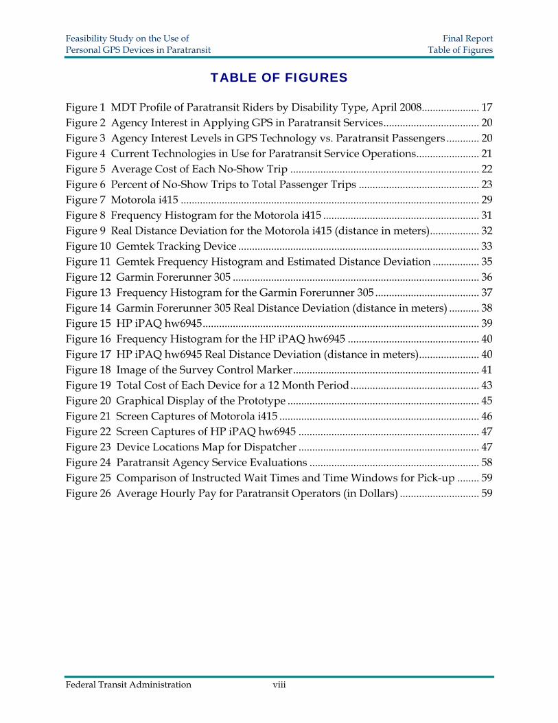

Feasibility Study on the Use of Final Report Personal GPS Devices in Paratransit Executive Summary
had acceptable costs and accuracy comparisons Furthermore these two devices supported programming capabilities
Prototype Development
Next a GPS prototype was developed to explore the feasibility of developing a complete working system The best possible solution involved use of both the GPS enabled Motorola i415 cell phone and the HP iPAQ hw6945 Personal Digital Assistant (PDA) This prototype connects the passenger vehicle operator and the agency dispatcher together via a central computer To synchronize these devices separate programs written by the research team were created for each device
Once the devices are turned on the programs automatically initiate and send positional information continuously acquired from satellites to a server The server translates the position coordinate numbers to point marks on Microsoft and Google maps so that the agency dispatcher can track both the passengers and vehicles by view On the driverrsquos PDA screen the vehicle operator is able to see driving directions and the passengerrsquos location on a digital map The passenger is able to receive the waiting time and vehicle distance At the same time a service log of all activities is recorded into the system database Aspects of the prototype were determined to show significant promise for improving the punctuality and predictability of the pickup process
Future Applications and Enhancements
The project team was able to successfully develop a working prototype but it has yet to be tested at a paratransit program Although initial software installation and program familiarization might require additional time and energy there is evidence that this prototype system can be replicated at any paratransit agency A pilot program is the next logical step for evaluating feasibility By testing the prototype on an actual paratransit system cost and benefit evaluations may eventually be conducted answering important feasibility questions
In the long term other advancements will improve the proposed prototype The pickup process can potentially be combined with service vehicle assignments If a change is requested from a passenger the system will immediately determine the most economical way to rearrange the service schedule Potential benefits include less time needed for reservations and more adaptable services Technology upgrades to GPS-enabled cellular phones and other newly developed GPS devices may further improve the existing prototype Future options for alarm notification voice capabilities and message services will also enhance the attractiveness of a GPS tracking system for paratransit
Federal Transit Administration 13
Feasibility Study on the Use of Final Report Personal GPS Devices in Paratransit 1 Introduction
10 INTRODUCTION
11 Expansion of Paratransit Services
Paratransit within the US offers on-demand transportation services for qualified senior citizens and people with disabilities Under the Americans with Disabilities Act (ADA) paratransit has become the well known demand-responsive service system embedded within the regular public transit network Paratransit service is a transportation alternative that provides a high degree of accessibility for individuals with almost no mobility
Although paratransit only serves a small group of people the average operating costs are much higher than most other public transit services Presently the operating expenses of paratransit in the US are largely paid by government subsidies Since these subsidies often come under intense scrutiny during budget shortfalls ensuring that monetary support is used efficiently is a priority for transportation providers and policy makers
Historically paratransit service has experienced rapid growth since the ADA was passed in 1990 ADA requires that public transit providers also provide complementary paratransit service to origins and destinations within corridors having a width of three fourths (frac34) of a mile on each side of each fixed route (1) In addition many agencies offer paratransit services beyond those required by ADA Sometimes called Dial-a-Ride these services are especially popular in small cities or rural areas where no fixed route services are available
In 1986 there were about 6300 private paratransit companies in the United States Together these agencies operated more than 200000 vehicles representing more than 350000 drivers and other staff In September 1998 twelve years later an estimated 22884 private paratransit companies operated more than 370000 vehicles During the same year some 500+ transit agencies made 886 billion passenger trips of which 68 million or 077 of total trips were demand-responsive trips Reports from the Federal Transit Administration (FTA) National Transit Database indicate that in 2006 the number of passenger trips had stretched to 940 billion of which 88 million or 094 of total trips were demand responsive trips
The database clearly shows that there has been tremendous growth in paratransit use However this is not the complete picture since the data do not include growth aspects attributed to increased transportation spending for Medicaid transportation airport shuttle operations or human services all of which are paid for through other non-FTA grant programs (2)
Federal Transit Administration 14
Feasibility Study on the Use of Final Report Personal GPS Devices in Paratransit 1 Introduction
12 Missed Trips Issue
Because paratransit has undergone rapid expansion and requires significant subsidies agencies are continually under pressure to efficiently utilize budgets and reduce waste A missed trip is one example of a wasted resource since a missed trip occasionally referred to as a missed pickup is a scheduled trip that did not complete This missed pickup may happen for a variety of reasons including things such as operator absence a vehicle failure a dispatch error traffic congestion or failure of the driver to find the passenger It may also occur if a passenger simply does not show up on time for the paratransit ride In this case the event is typically referred to as a no-show
Drivers also have difficulties picking up a passenger if there are location ambiguities These problems can occur when passengers submit inaccurate address information or are unsure of their exact location Pickup requests in residential alleys also can create locational ambiguities More commonly at very large facilities like hospitals retirement homes and mall complexes multiple exits exist and the passenger may be more likely to miss a pickup due to the ambiguity of which door is the appropriate waiting location
Although there is no specific industry terminology for this specific type of missed trip in this document we will use the term connection failure For the remainder of the report a connection failure will refer to occasions where the paratransit driver and waiting passenger are unable to find each other
Because of connection failures or even a delay in making the connection with the passenger both driver and passenger end up wasting time leading to deterioration in the level of service When the driver cannot find the passengers within a designated amount of time (a connection failure) the scheduled request has to be canceled leaving the passenger stranded On many occasions the vehicle operator and passenger may be very close to one another but are simply unable to physically see each other Whatever the cause missed trips result in significant financial consequences for both the passenger and service provider
One consequence of a connection failure is that the passenger may have to spend money on a last minute taxicab If the destination is far away it could easily cost in excess of $2000 whereas the price of paratransit is usually between $200 and $400 Alternatively the passenger may be forced to stay home and perhaps be charged for missing a doctorrsquos appointment or miss out on money earned from working at their job
The costs suffered by the service provider include additional labor gas and associated vehicle maintenance costs that agencies must pay while vehicles are driven around searching for passengers The extra financial burdens eventually fall onto the shoulders
Federal Transit Administration 15
Feasibility Study on the Use of Final Report Personal GPS Devices in Paratransit 1 Introduction
of passengers agencies and taxpayers These costs can be easily quantified when the connection failure results in a missed trip Costs are likely to vary depending on agency size Results from a 1997 survey of 28 paratransit providers determined that the average cost of a missed trip was $1090 for small-urban systems $1433 for mid-sized systems and $2603 for large agencies (3) It is important to note that according to the US Energy Information Administration the average cost of gasoline in 1997 was $124 With gasoline prices that went over $400 per gallon in July of 2008 the costs for missed trips can be significant As late as 2004 the Utah Transit Authority (UTA) a medium to large sized agency calculated that each missed trip cost $2418 (4)
13 Tracking Technology to Minimize Missed Trips
If service providers have a way to accurately identify a passengerrsquos location in real time the frequency of connection failures can be reduced With the ever growing popularity of the Global Positioning System (GPS) market in civilian applications incorporating new technologies such as ITS GPS and computerized systems will become more realistic for agencies with a limited amount of funds These technologies can help prevent connection failures thereby saving time and resources
The varying degree of ridersrsquo disabilities may exclude the normal use of regular cellular phones as a solution for locating riders Significant numbers of paratransit riders have sensory cognitive neurological or motor disabilities that make using a cellular phone difficult or impossible For instance individuals who are mute deaf or blind may be unable to answer a phone listen to the instructions or describe their surroundings to the paratransit driver Individuals with cognitive problems may forget to answer a phone or how to answer and become confused by a conversation with the driver or dispatcher Furthermore the actual answering and handling of a cellular phone may be impossible for someone with neurological problems or a person who has suffered a stroke
While some paratransit riders may be able to communicate effectively with a regular cellular phone such a device could not be used as a uniform method for improving connection failures Based upon the classification of disabilities at Miami-Dade Transit (MDT) it is estimated that roughly half of all paratransit riders may have difficulty using a cellular phone (Figure 1) Paratransit users with sensory cognitive neurological or motor disabilities comprise 45 of all persons authorized for travel (5) Furthermore it is debatable whether paratransit riders in other categories could use a cellular phone As a result GPS devices which eliminate the need for additional communication are likely to be better suited for determining locational information While the use of GPS devices may at first glance seem to be difficult these devices can be pre-programmed to be user friendly (eg pushing the on button can start sending the location information at one minute intervals)
Federal Transit Administration 16
Feasibility Study on the Use of Final Report Personal GPS Devices in Paratransit 1 Introduction
Without having to call or contact waiting riders GPS technology may allow paratransit drivers to find their passengers more quickly thereby saving time and resources GPS also eliminates the need for a rider to explain directions over the phone ndash a request that could potentially lead to erroneous instructions for the driver especially when asked to riders with a cognitive disability The passenger may be further comforted knowing that with GPS the driver will be able to locate him or her no matter the circumstances With some GPS-enabled devices the waiting rider can even track the driverrsquos location on a local map and judge the remaining wait time This may provide reassurance to the passenger and potentially reduce the number of calls to the agency about late drivers
Figure 1 MDT Profile of Paratransit Riders by Disability Type April 2008
Sensory Blind Other Medical 7764
Pulmonary Cognitive 28
116Cardiac
86 Dialysis 52
Chemo Rad 12
HIV Arthritis 04
306 Neurological MS MD CP
106 Motor Stroke Amputee Spine
149
To test the feasibility of this new concept four mobile GPS devices were purchased to examine their capabilities They are a GPS enabled cell phone Motorola i415 a Gemtek tracking device a Garmin Forerunner 305 and an HP iPAQ hw6945 All instruments were selected based on six major criteria portability reliability user friendliness durability compatibilities and accuracy Both the advantages and disadvantages of each device are presented for comparison and contrast
In this research a prototype was developed to demonstrate the use of these devices in paratransit operations The mobile GPS devices combined with a computerized system would eliminate the possibility of the actual pickup location being inconsistent with the one that had been previously scheduled thus minimizing potential human errors
Federal Transit Administration 17
Feasibility Study on the Use of Final Report Personal GPS Devices in Paratransit 1 Introduction
Instead of finding passengers based entirely on information received during the reservation step which heavily depends on manual operations a mobile GPS device will be carried by each passenger so that his or her real-time current location can be instantly tracked The passengerrsquos and paratransit vehiclersquos location is processed by a computer to generate a digital map showing where the passenger and driver are located This allows vehicle operators to efficiently reach passengers by following precise instructions from the dispatch center
The prototype brings with it a series of significant operational changes For agencies it introduces a systematic operational flow that uses fewer manual procedures allowing for lower labor costs and fewer human-made errors More importantly improvements in service quality can be achieved For passengers the location system guarantees a more predictable pickup As long as the device is working regardless of whether a passenger knows his or her exact location or whether any previous mistakes were made in the reservation process the passenger will benefit from a shorter waiting time
Although advanced technologies usually lead to innovations improved services inevitably will have minor initial flaws These deficiencies must be modified before further improvements can be made toward customer satisfaction in the long run In the future transit agencies will have an opportunity to hear feedback from customers and so improvements can be always made However agencies will have to address several new issues Problems such as the durability of the devices insurance and legal tracking activity will be carefully evaluated in order to maintain efficient operations and a good rapport with customers
Federal Transit Administration 18
Feasibility Study on the Use of Final Report Personal GPS Devices in Paratransit 2 Background
20 AGENCY SUPPORT
A survey was conducted to understand more about transit agency interests and feasibility of using GPS technology to assist paratransit services A fifteen question online survey was developed inquiring about typical paratransit service characteristics and the agencyrsquos willingness to utilize new technology A link to the online survey was emailed to 65 transit agencies of various sizes around the country Follow up emails were then sent out to encourage response
A total of 36 agencies responded for a survey response rate of 554 Responding agencies ranged in size and geographic area representing 16 states Survey respondents had annual paratransit passenger trips ranging from 746 to 1584382 (Table 1)
Table 1 Size of Agencies Responding to Survey by Total Yearly Paratransit Trips Paratransit Passenger
Trips per Year Number of Agencies
Responding to Survey 0 - 20000 8
20001 - 40000 6 40001 - 100000 7 100001 - 300000 8 300001 - 800000 3
800001 ndash 1600000 4
Survey responses overwhelmingly indicated that most agencies are very interested in applying new technologies to paratransit operations From the valid 36 responses 26 transit agencies were strongly or somewhat interested in incorporating new GPS technology to help improve their services (Figure 2) Five agencies were indifferent to making changes in their current modes of operation A total of five agencies were unenthusiastic about utilizing new GPS technologies
In attempts to determine which agencies were more interested in using new GPS technologies interest levels were compared and analyzed against virtually all other data obtained from the survey Surprisingly there were no associations found between interests in using the new technologies and number of missed trips missed connections percentage of trip purposes etc Although there was no association with agency size all of the larger agencies those that had above 200000 paratransit trips per year were interested in experimenting with new GPS technologies
Figure 3 displays this information graphically The numeric interest levels correspond to the following survey answers about how interested agencies are in applying GPS technologies 5 = strongly interested 4 = somewhat interested 3 = neutral 2 = not very interested 1 = strongly not interested Eight agencies had more than 200000 paratransit trips per year and each was either lsquostrongly interestedrsquo or lsquosomewhat interestedrsquo
Federal Transit Administration 19
Feasibility Study on the Use of Final Report Personal GPS Devices in Paratransit 2 Background
Figure 2 Agency Interest in Applying GPS in Paratransit Services
16
10
5 4
1
0
2
4
6
8
10
12
14
16 R
espo
nden
ts
Strongly Somewhat Neutral Not Very Strongly Not Interested Interested Interested Interested
Attitude
Figure 3 Agency Interest Levels in GPS Technology vs Paratransit Passengers
500
Num
eric
Inte
rest
Lev
el
400
300
200
100
Number of Passenger Trips During Last Year 0 400000 800000 1200000 1600000
Federal Transit Administration 20
Feasibility Study on the Use of Final Report Personal GPS Devices in Paratransit 2 Background
Responding agencies currently use a variety of technologies to communicate between the dispatch center and the vehicle operator (Figure 4) Of the 36 agencies responding to this question 73 exclusively use radio for communication About 19 of responding agencies utilize radios and another device ndash either GPS or Cellular Phones Eight percent of agencies only use Cellular Phone Agencies showed high interest in using new technologies even those already using GPS technologies
Current communication methods reflect how easily a new system could be incorporated into the existing ones A compatible system is always more realistic due to its low investment cost for upgrading Though Figure 4 groups technologies into 4 discrete categories data showed that many agencies use a mix of systems to coordinate with field vehicles including walkie-talkie mobile data terminal cell phone automatic vehicle locator GPS telemetry and special dispatch software Consequently using a GPS enabled cell phone to aid the operation procedure is not completely new More extensive use of GPS devices may not be far away
Figure 4 Current Technologies in Use for Paratransit Service Operations
Radio amp
Cellular
Radio 73
Cellular Phone
8
Radio amp GPS 11
Phone 8
Another key purpose of the survey was to help quantify financial losses resulting from no-show trips With this information in hand a more accurate estimation about the benefits of using GPS tracking devices can be made Survey results showed that losses from no-show trips are substantial and implementing personal GPS location technology would be cost effective
The annual financial loss due to no-shows ranged from $60 at a small agency in Puerto Rico up to over $700000 at a large agency on the west coast Of the 20 agencies responding to this question the mean value of losses per year was close to $89000
Federal Transit Administration 21
Feasibility Study on the Use of Final Report Personal GPS Devices in Paratransit 2 Background
Looking at all agencies the average cost for each no-show ranged from roughly $1000 to $3250 However most agencies lost between $1500 and $2200 per no-show trip (Figure 5) On average the financial cost of each no-show trip was $1821
Figure 5 Average Cost of Each No-Show Trip R
espo
nden
ts
6
5
4
3
2
1
0 1000 1500 2000 2500 3000 3500
Average Cost (in Dollars)
Thirty-five of the survey respondents provided information on their total number of no-shows each year and the total number of paratransit trips provided Using this information the percentage of no-show trips to total passenger trips was calculated Most agencies had fewer than 3 of total trips due to no-shows However two agencies had a no-show rate of over 8 (Figure 6)
It is important to note that some of these percentages may also include late cancellations Late cancellations are defined differently based on each agencyrsquos own internal policies and regulations and may have overlapped our no-show definition To that extent these cancellations may or may not impact our no-show data collected in our survey
To specifically investigate the connection failure phenomenon agencies were asked to estimate the percentage of no-show trips that occurred due to the passenger and driver being unable to find each other Of the 25 agencies responding to this inquiry 20 stated that connection failures constituted less than 8 of all no-shows Five agencies indicated that connection failures constitute greater than 20 of all no-shows and of those two agencies reported 75 and 80
Federal Transit Administration 22
Feasibility Study on the Use of Final Report Personal GPS Devices in Paratransit 2 Background
Figure 6 Percent of No-Show Trips to Total Passenger Trips
Res
pond
ents
10
8
6
4
2
0 000 200 400 600 800 1000
Percent of Trips
While most agencies only have a small number of connection failures five agencies indicated real difficulties locating passengers within an allotted amount of time These five agencies were medium to small in size and according to estimates had total connection failures ranging between 2 and 1225 These results indicate that significant benefit could be derived from implementing new technology targeted at improving the performance of the paratransit service
For additional survey data and analysis please refer to Appendix A
Federal Transit Administration 23
Feasibility Study on the Use of Final Report Personal GPS Devices in Paratransit 3 Background
30 BACKGROUND
31 GPS Fundamental Synopsis
The Global Positioning System uses 24 navigation satellites in orbit around the Earth ndash six groups of four evenly spaced satellites per orbit All satellites constantly emit square waves or enciphered codes in different patterns For accurate geolocation performance the ground based GPS devices must receive these codes from at least three satellites simultaneously and decipher them to compute spatial positions However the precision of GPS signals depends upon many factors which can accumulate to generate large errors that have an impact on locational accuracy Multiple sources of error and deviation are listed in Table 2 (6 7 8 9 10) Usually error range of GPS measurements are less than 15 meters depending on the ultimate offsets of all impacts
Table 2 Error Sources Impacting the Precision of GPS Signals Source Error Range Explanation
Ionospheric Effects plusmn 5 meter
The ultraviolet rays from the sun ionize a portion of gas molecules to release free electrons in the atmosphere distorting the propagation of GPS broadcasts
Ephemeris Errors plusmn 25 meter This is a difference between the expected and
actual orbital position of a GPS satellite Satellite Clock Errors plusmn 2 meter The small inconsistency of time deviation in
different satellite entities
Multipath Distortion plusmn 1 meter
This distortion varies depending on the environment within which the receiver is located satellite elevation angle receiver signal processing antenna gain pattern and signal characteristics
Tropospheric Effects plusmn 05 meter
Delay of the GPS signal waves with respect to free space propagation due to the effect of troposphere properties including temperature pressure and humidity
Numerical Errors lt plusmn 1 meter
Based on the theory of relativity the wave speed generates a different frame from the Earth reference frame
Cumulative Errors gt plusmn13 meter The total theoretical errors listed above excluding
the receiver device bias Sources (6 7 8 9 10)
The GPS locating method heavily depends on satellite visibility so the failure rates vary under many different circumstances Sometimes the electromagnetic wave signal is reflected and though the signal is still ultimately redirected to the satellite minor distortion occurs Most GPS devices do not lose their signals completely if there is only
Federal Transit Administration 24
Feasibility Study on the Use of Final Report Personal GPS Devices in Paratransit 3 Background
minor shielding because the sensitivity of antennas and receivers has been continuously improved For instance if the passenger is waiting next to a tall building or under the eaves the reading fluctuations may create some problems for the driver in determining the actual location of the passenger
Assisted GPS is an enhancement to a mobile phonersquos locating ability The development of A-GPS was accelerated by the US FCCs E911 mandate requiring the position of a cell phone to be available to emergency call dispatchers (11 12) A-GPS uses both GPS and a terrestrial cellular network to obtain geographic position Assisted GPS plays an important role in most contemporary mobile GPS devices
Unlike regular GPS which requires a complete download of data from satellites which may take up to several minutes A-GPS relays information already obtained by the cell phone network and processes location data in a much faster and reliable manner minimizing the impacts whenever the GPS signal is poor Without a Global System for Mobile communications (GSM) a mobile GPS device requires more information from satellites as well as further calculations so the locating time is much longer However under the existing GSM network the cell phone signal tower offers a rough locational estimation in a range from 100 meters to 300 meters Therefore within this limited area location information is readily obtainable even if only partial GPS data can be downloaded from the satellites
A higher spatial accuracy level is obtainable using the Wide Area Augmentation System (WAAS) By referring to ground control stations WAAS corrects any detected discrepancies in the GPS results The achievable accuracy limitation is within 76 meters in the worst case scenario With ongoing technology improvements future mobile devices may have the potential to apply WAAS to obtain higher accuracy levels (13 14)
32 Extensive GPS Applications
Because GPS can almost instantly locate a ground target many aspects of our civilian life have been recently improved For example the functioning of industrial production organizations including agriculture ecology commerce politics etc are all now influenced significantly by GPS
The agricultural industry in the State of Kansas employed GPS technology in beef production management in order to control the spread of Bovine Spongiform Encephalopathy (BCE) All cattle are tracked by GPS and thus their movements are recorded With the aid of a Geographic Information System (GIS) a quarantine map showing potential disease threatened areas can be plotted Tracking the animalsrsquo positions provides effective immunization management and improves the security of food supplies Additionally the tagging of the cattle from birth to death makes conventional farm administration more systematic (15)
Federal Transit Administration 25
Feasibility Study on the Use of Final Report Personal GPS Devices in Paratransit 3 Background
In commercial businesses applications extend much further For instance car rental companies now have reliable methods for locating their vehicles at any instant for safety and security reasons By installing Automatic Vehicle Locating technology (AVL) rental companies have prevented improper usage reduced insurance costs and deterred theft In fact most major car rental companies have already implemented GPS navigation service as an optional accessory for their clientele Cargo tracking technology allows businesses to oversee cargorsquos movement by attaching a GPS tracker to containers and trucks This also enhances the security of transportation
Environmental scientists employ GPS in many research projects Many species have been extinguished because of encroachment and the consequent necessity to adapt to new habitats In Africa researchers from wildlife protection organizations use GPS trackers to collect data on elephant activity (16) With the database showing the living boundaries of these animals land use patterns can be modified to minimize the impact of human activities GPS also serves as a valid tool for vegetation management In Scotland researchers relied on GPS data to analyze and monitor herbivoresrsquo grazing locations Researchers determined with relative GPS modules affixed to roving animals had a mean accuracy of 10 m and precision was lt 10 m 95 of the time (17)
33 Location Based Service (LBS)
According to the definition provided by the SENSEable City Lab at the Massachusetts Institute of Technology (MIT) Location Based Service is the technology that allows instant identification of a mobile devicersquos exact position (18) There are generally four measures involved in achieving this goal cell identification angle of arrival time of arrival and enhanced observed time difference (19)
bull Cell identification determines the location based on the wireless network Usually a mobile phone communicates with the nearest signal tower and its location falls into the cell that the tower serves Due to the difference in shape or size of each cell the accuracy ranges from 100 meters to 600 meters
bull The angle of arrival calculation depends on the signal receiving direction At minimum two base stations are required to monitor the signal path and calculate the senderrsquos location using trigonometry principles The obtainable accuracy limits range from 50 meters to 150 meters varying due to signal travel path deflections
bull The time of arrival approach emits signals in all directions from three base stations The signals leave each station simultaneously and are reflected back Once they reach the device distances to the three stations are all known for positioning
bull The observed enhanced time difference approach is relatively complicated A mobile device is preinstalled with locating software that computes its own position and later the position is generated by nearby base stations
Federal Transit Administration 26
Feasibility Study on the Use of Final Report Personal GPS Devices in Paratransit 4 Locating Methodology
40 LOCATING METHODOLOGY
41 Location Interpretation
Only a limited amount of spatial distance deviation may be allowed to avoid missing a passenger who might be waiting on the other side of a building or merely a block away from a specified pickup location The most popular way to express a geographic position is using longitudelatitude coordinates These coordinate numbers can be converted to actual distances using a scale factor By converting sets of coordinates to linear distance users will have a better sense of whether the distance errors are acceptable
The conversion from coordinates to actual distances becomes more complicated as accuracy requirements become more demanding There are ways to depict distance on the Earthrsquos surface to a very exact degree if sufficient investment and equipment support are provided In fact the equipotential surface also referred as mean sea level is an irregular surface relative to an ideal ellipsoid surface so there is no universal mathematical formula to perform the algorithms to a very high degree of accuracy Yet an acceptable approximation method can be found on the Internet to complete the interpretation The Internet resource MaNISHerpNetORNIS Georeferencing Guidelines (20) provides a simplified conversion factor table as shown in Table 3
Table 3 Uncertainty Based on Coordinate Precision Using WGS84 Ref Ellipsoid
Precision 0 degrees Latitude
30 degrees Latitude
60 degrees Latitude
85 degrees Latitude
(all values in meters) 10 degrees 156904 146962 124605 112109 01 degrees 15691 14697 12461 11211 001 degrees 1570 1470 1247 1122 0001 degrees 157 147 125 113 00001 degrees 16 15 13 12 10 minutes 2615 2450 2077 1869 01 minutes 262 245 208 187 001 minutes 27 25 21 19 0001 minutes 3 3 3 2 10 seconds 44 41 35 32 01 seconds 5 5 4 4 001 seconds 1 1 1 1
From the above table it can be seen that the same degree of longitudelatitude differences equate to different real distances at different latitudes Because all our experiments were performed in Miami Florida where latitude is around North 25
Federal Transit Administration 27
Feasibility Study on the Use of Final Report Personal GPS Devices in Paratransit 4 Locating Methodology
degrees the second column data are employed because they are the closest conversion factors Here 1 minute is approximately equal to 2450 meters likewise 1 second is equal to 41 meters
42 Criteria for Selecting GPS Devices
To select the most appropriate mobile GPS devices for our paratransit pickup system the following criteria were considered portability reliability user friendliness durability compatibility and accuracy
bull Portability is one of the most basic requirements reflecting the necessary convenience since the device must be carried by users Generally speaking to satisfy this requirement a smaller sized device without the need for a power outlet is preferred so that it can be easily transported
bull Reliability ensures that GPS signals are acquired successfully free from other disturbance factors as GPS readings can vary due to time differences geographic location and weather conditions This criterion has no absolute quantitative measurements Therefore comparisons are performed among the different candidates to determine a relatively better choice after actual testing for a period of time
bull User friendliness is determined by how easily users can manipulate the device It would not be beneficial to spend large amounts of time on tutoring paratransit passengers how to use it In addition a nice-looking device is a plus
bull Durability concerns the usable life of the product including maintenance and future reoccurring costs It includes a study of the sustainability of the battery the fragility of the device and comparisons of administrative costs after the new system is implemented Note that using a single device for one year without problems is not enough evidence to declare a device durable
bull Compatibility requires that the newly developed operating platform has good adaptability and thus provides savings on overall expenditures and equipment Furthermore there should be a large enough margin for future hardware upgrades and functionality expansions
bull Accuracy is really the core criterion of employing GPS devices It ensures that the passengerrsquos exact location is known so that the vehicle will arrive directly in front of the passenger with little effort Each GPS device was tested a total of 40 times to retrieve position information at a control point for longitude and latitude readings
Federal Transit Administration 28
Feasibility Study on the Use of Final Report Personal GPS Devices in Paratransit 4 Locating Methodology
All tests were conducted within the course of two hours during a single day These data were then statistically examined and quantitatively compared With the aforementioned criteria in mind four mobile GPS devices were purchased for comparison analyses the Motorola i415 the Gemtek tracking device the HP iPAQ hw6945 and the Garmin Forerunner 305 Each device is discussed in the following sections Selection procedures provide typical examples of how the candidacy of a new device was evaluated It is unlikely that all criteria will be simultaneously embodied in one device Consequently positives and negatives had to be considered when determining device eligibility Among all criteria accuracy was the only parameter where the four devices could be compared quantitatively As a result further accuracy tests were conducted to draw a dependable conclusion
43 Motorola i415
431 Overview
The Motorola i415 (Figure 7) is a GPS enabled mobile phone Basic features include the regular Bluetooth cell phone walkie-talkie and GPS navigator The GPS locating service in this test is offered by Boost Mobile Company and an approximately $30 monthly service fee was charged at the time of this research for unlimited data transfers This does not include voice communication A service fee is necessary because Internet access is required to send location information Additionally the cell phone supports Java coding allowing for the implementation of potential applications to extend its adaptability and compatibility
Figure 7 Motorola i415
Federal Transit Administration 29
Feasibility Study on the Use of Final Report Personal GPS Devices in Paratransit 4 Locating Methodology
The voice communication offers another way to re-coordinate the pickup and can be used as an aid whenever the GPS fails For instance there may be cases when passengers experience technical problems and need to communicate with the service provider
432 Criteria Judgment
bull Portability As a regular mobile phone with dimensions 140 times 48 times 22 mm the Motorola i415 is convenient to carry A carrying case is generally available as an accessory option
bull Reliability There are still some reliability improvements that the manufactures can make There have been no breakdowns since testing however at low battery levels the GPS location readings are far beyond an acceptable range with deviations up to 500 meters As a consequence it is important to make sure that the device is always operated at a sufficient battery level According to a similar phonersquos support center the unreliability is due to several factors For instance a low battery cannot provide sufficient wireless signal strength or surrounding radio noises may be so strong as to cause interference When the GPS signal is weak or satellite visibility is low the locating method falls back to the GSM network (21) There is no significant evidence showing that cloudy weather had a significant impact on the readings Another deficiency is that text messages were occasionally difficult to send due to a failure to connect with the server It is expected that in the future GPS enabled cell phones will perform better
bull User Friendliness The Motorola i415 generally follows the typical cell phone panel arrangement hence people with experience using cell phones should become easily acquainted Tracking functions were able to be performed automatically with few manual operations once the research team designed and implemented a Java program code
bull Durability There was not sufficient time nor a sufficient sample size to draw conclusions as to the durability of this type of phone However the cell phone has a hard plastic texture and was still in good condition after one yearrsquos usage The power consumption is relatively short it only lasts about 8 hours in GPS active mode Yet this is still sufficient for a normal one-day service span
bull Compatibility The Java programmability of the Motorola i415 provides excellent compatibility and codes can be implemented into the device for user-defined tracking activities The project team created a program to simplify the tracking procedure so that only one press of the button is needed and rest of the task will be automatically completed
Federal Transit Administration 30
Feasibility Study on the Use of Final Report Personal GPS Devices in Paratransit 4 Locating Methodology
bull Accuracy Results from the 40 longitudelatitude readings were converted to real distance deviations in meters The results summarized in Figure 8 and Figure 9 represent readings obtained during the two hour period of testing Outliers resulting from low battery levels are excluded in the following analysis
Figure 8 Frequency Histogram for the Motorola i415
Freq
uenc
y
10
8
6
4
2
0 000 500 1000 1500 2000
Distance from Control Marker (meters)
Federal Transit Administration 31
Feasibility Study on the Use of Final Report Personal GPS Devices in Paratransit 4 Locating Methodology
Figure 9 Real Distance Deviation for the Motorola i415 (distance in meters)
-20
-15
-10
-5
0
5
10
15
20
-20 -15 -10 -5 0 5 10 15 20
Sout
h lt
----gt
Nor
th
West lt ---- gt East
The histogram shows that the majority of measurements had a deviation of less than 10 meters All of the results were within a distance of 20 meters from the center of the control point (survey marker) These observations seem accurate enough to provide a vehicle operator with confidence that his or her passenger is very near
44 Gemtek Tracking Device
441 Overview
The Gemtek tracking device (
Figure 10) allows for instant location queries as well as traveling path log recordin g Besides the wireless GPS communication channel a voice communication channel is also included A customer service phone number plus two user-defined phone numbe rs are preset The voice communication is enabled by pressing the corresponding speed dialing keys In case passengers cannot find the vehicle operator they can this function to contact the service provider Except for the two phone number limitation this device functions the same as a regular cell phone
Federal Transit Administration 32
Feasibility Study on the Use of Final Report Personal GPS Devices in Paratransit 4 Locating Methodology
Figure 10 Gemtek Tracking Device
Two other features worth mentioning are the SOS alarm and geofencing When the SOS alarm button is pr essed location information will be sent immediately to the pre-stored phone numbers for emergency assistance Another optional feature geofencing mode can be used to alert the designated contacts if the carrier goes beyond a predefined geographic zone
This device uses three colored indicator lights to show operating status The blu e flash starts when the device is turned on If the flash changes to green it indicates that i t is under GSM coverage If there is sufficient clearance the flash finally turns to red meaning the GPS satellite signal is being received The signal light provides an advantage since the user knows to move around for better satellite visibility The development of the Gemtek device was aimed at tracking seniors primarily for their own safety therefore many special functions are incorporated into the design
442 Criteria Judgment
bull Portability The Gemtekrsquos size is approximately 90 times 45 times 20 mm It comes with a leather bag in the package and is readily attachable to the wrist or belt
bull Reliability In both cool and warm starting modes it normally tak es about one minute for the GPS satellite signal to be acquired in an open environment As long as the red flashing light is on which indicates the device is in GPS coverage area the position information was instantly available upon a query entry
Federal Transit Administration 33
Feasibility Study on the Use of Final Report Personal GPS Devices in Paratransit 4 Locating Methodology
bull User Friendliness Because there are only seven buttons on the panel users are neither required to memorize phone numbers nor spend time familiarizing themselves with usage Appropriate phone numbers would be pre-programmed into the Gemtek device by transit agency staff
bull Durability During testing the device worked properly The battery lasted more than 20 hours if no voice calls were made and it supported up to four hours of talk time on a full battery charge
bull Compatibility Becaus e the Gemtek device is provided as a packaged end product including the service plan changes cannot be made internally As a result it is impossible to create customized applications since there is no way to load or implement programs
bull Accuracy The accuracy description of the Gemtek tracking device is different from the others Unlike the conventional longitudelatitude coordinates that define a point in a numerical manner the web application only provides a digital map or at most an aerial image for some urban areas With no obtainable numerical loc ation information there was no way to quantify the degree of accuracy As a result a rough estimation was performed Using high-resolution aerial images an estimate of 5 meters was chosen as the minimum distance interval and the data were grouped into four categories
Note in Figure 11 that none of the 40 test results fall outside of a 20-meter range an d 38 out of 40 trials are concentrated within a radius of 15 meters Only 2 out of 40 or 5 of the trials were located between a 15 and 20-meter interval Therefore the accuracy is likely to be satisfactory in real field applications of the paratransit pickup system
Federal Transit Administration 34
Feasibility Study on the Use of Final Report Personal GPS Devices in Paratransit 4 Locating Methodology
Figure 11 Gemtek Frequency Histogram and Estimated Distance Deviation
20
15
10
5
0
Freq
uenc
y
000 500 1000 1500 2000
Estimated Distance from Control Marker (meters)
45 Garmin Forerunner 305
451 Overview
The Garmin Forerunner 305 (Figure 12) is a multiple function electronic watch with GPS tracking capability This device was designed to monitor the userrsquos physical exercise conditions and thereby offer training guidance Some basic features include a stop watch palpitation measurement calorie consumption and route distance calculation Users are able to preset their exercise schedules into the watch including running distance heart rate and calorie consumption An alarm reminds the user whenever a certain goal is achieved Besides the watch component there is a band that can be worn on the userrsquos chest for measuring the heart rate This communicates with the watch wirelessly via Bluetooth
The watch records the longitudelatitude position continuously and all of the data can be later downloaded to computer by a USB cable From these data logs users can compare their exercise activities on a daily basis The Garmin Forerunner 305 has the best accuracy because it is World Wide Augmentation System (WAAS) supported Additionally the high sensitivity SiRFstar III antenna gives it extraordinary dependability Yet a lack of wireless communication channels excludes it from the candidate pool essentially no position information can be transmitted instantly via
Federal Transit Administration 35
Feasibility Study on the Use of Final Report Personal GPS Devices in Paratransit 4 Locating Methodology
wireless Because there is no wireless communication channel there is no way to instantly send back location information to an agency Hence it is not feasible to use the Garmin Forerunner 305 in this project
Figure 12 Garmin Forerunner 305
452 Criteria Judgment
bull Portability The Garmin Forerunner 305 easily satisfies the portability requirement because it is a wristwatch size and unlikely to inconvenience users
bull Reliability One of the shining points of this product is the integration of a high sensitivity SiRFstar III GPS antenna The extraordinary signal detectability is superior to the other three devices and takes significantly less time to retrieve position coordinates
bull User Friendliness With more user functions available the device requires extra learning time for users to familiarize themselves
bull Durability A disadvantage is that the battery life only lasts about 4 hours This is much shorter than a typical service day or even the service span of a round trip If a passenger has to stay somewhere for more than 4 hours it would be necessary to turn off the device to reserve sufficient battery power for the return trip
bull Compatibility Lack of compatibility is the major flaw of the Garmin Forerunner 305 for this project The current cost of implanting a wireless communication chip into a small watch is not yet popular for civilian use but may become more realistic in the future More importantly this watch is non-programmable and no alternations can be made to accommodate a custom application for this device
bull Accuracy Accuracy is perhaps the most outstanding feature of this product because of its integration with Wide Area Augmentation System (WAAS) technology The
Federal Transit Administration 36
Feasibility Study on the Use of Final Report Personal GPS Devices in Paratransit 4 Locating Methodology
majority of GPS measurements fall within six meters of the control point regardless of the battery level or sky conditions The maximum distance deviation was only eleven meters (Figure 13) Combined with its high reliability the Forerunner 305 proves WAAS has a better locating accuracy than ordinary GPS technology
Coincidentally all points are aligned perfectly in both vertical and horizontal directions this is because the reading digits can only reach the third decimal in seconds Several points overlap and thus appear as fewer dots on the distance deviation chart (Figure 14) In terms of actual distance there is a systematic error approximately larger than 13 meters because of the number of decimals The interspaces between points are always multiples of 13 meters
Figure 13 Frequency Histogram for the Garmin Forerunner 305
10
8
6
4
2
0
Freq
uenc
y
000 200 400 600 800 1000 1200
Distance from Control Marker (meters)
Federal Transit Administration 37
Feasibility Study on the Use of Final Report Personal GPS Devices in Paratransit 4 Locating Methodology
Figure 14 Garmin Forerunner 305 Real Distance Deviation (distance in meters)
-10
-75
-5
-25
0
25
5
75
10
-10 -75 -5 -25 0 25 5 75 10
Sout
h lt
---- gt
Nor
th
West lt ---- gt East
46 HP iPAQ hw6945
461 Overview
The HP iPAQ hw6945 (Figure 15) is a powerful Personal Digital Assistant (PDA) that uses the Windows Mobile 5 operating platform Its volume is slightly larger than a regular cell phone however its powerful capabilities by far exceed those of the other handheld devices reviewed here Many advanced technologies are integrated into the device making it a versatile choice but also an expensive one
Examining the feasibility of the iPAQ is quite different from examining the other devices because its capabilities can assist beyond the role as a pickup connection assistant The HP iPAQ hw6945 supports wireless Internet access allowing users to check email send text messages and read news if desired The software platform provides plenty of personalization options However the same adaptability that can be seen as an advantage will lead to slower implementation because an agency may have to spend significant amounts of time training users on how to manipulate the device to its full capability The HP iPAQ hw6945 is versatile in different fields A small screen shows driving directions and a digital map image leading to the correct path Overall this device seems more suitable for use at the vehicle operatorrsquos terminal since it can offer very specific navigation instructions
Federal Transit Administration 38
Feasibility Study on the Use of Final Report Personal GPS Devices in Paratransit 4 Locating Methodology
Figure 15 HP iPAQ hw6945
462 Criteria Judgment
bull Portability The HP iPAQ hw6945 is approximately 71 times 18 times 118 mm - slightly larger than other devices A clip is included that can easily hold the device to a belt
bull Reliability The HP iPAQ hw6945 is programmable but problems may arise due to conflicts among software applications The antenna sensitivity is similar to the Motorola i415 Unlike the previously tested cell phone no significant positioning errors were found due to a low battery level
bull User Friendliness Loaded with multi-media players games daily planning tools and a number of other software applications users are able to fully utilize their time for work study and leisure However for users who are less acquainted with PDAs this device may be a challenge Seniors with visual impairments may have difficulty reading the small fonts on the screen Users might press the wrong button and have problems returning to the original application The high cost may make agencies and passengers reluctant to use this device
bull Durability Even though this device has a higher price and requires strict handling it promises a longer usable life It is advisable to insure the device for damage maintenance or replacement
bull Compatibility Compatibility is the most promising feature of this product The device is readily adaptable because program coding can be easily implemented into the operating environment
Accuracy Although the PDA is more expensive than most mobile GPS devices it does not guarantee better accuracy The majority of measurements fell within a radius of 20 meters with only two measurements were greater than 20 meters from the control marker (Figure 16 amp Figure 17) The accuracy of HP iPAQ hw6945 performance was comparable to the other devices tested in this project
Federal Transit Administration 39
Feasibility Study on the Use of Final Report Personal GPS Devices in Paratransit 4 Locating Methodology
Figure 16 Frequency Histogram for the HP iPAQ hw6945
Freq
uenc
y 6
4
2
0 000 500 1000 1500 2000 2500
Distance from Control Marker (meters)
Figure 17 HP iPAQ hw6945 Real Distance Deviation (distance in meters)
-25
-20
-15
-10
-5
0
5
10
15
20
25
-25 -20 -15 -10 -5 0 5 10 15 20 25
Sout
h lt
---- gt
Nor
th
West lt ---- gt East
Federal Transit Administration 40
Feasibility Study on the Use of Final Report Personal GPS Devices in Paratransit 4 Locating Methodology
47 Accuracy Tests
All accuracy tests were performed at a fixed survey marker (Figure 18) The local control point for this testing was the Florida Department of Transportation survey marker (identification number PN04A) that has a standard longitudelatitude value of W8036888 and N2576909 as defined by geodic authorities All readings were collected uniformly to provide an adequate basis for comparison The data were analyzed with the t test in order to calculate confidence interval comparing accuracy limitations
Figure 18 Image of the Survey Control Marker
Equation 1 was used to estimate the probability that a GPS reading will fall within a certain distance based on a specified confidence level Because the sample size is greater than 30 and the data are normally distributed the sample mean can be approximated to the population mean Similarly the population variance can be substituted by the sample variance in the calculation
Equation 1 x minus μ = z sdotδ
where x = the average from the experiment μ = the population mean δ = the standard deviation z = the z score associated with the degree of confidence selected
Table 4 shows the Deviation distance ranges at different confidence levels it also provides the probability that an observation will be less than or equal to the specified distances 10 m 15 m and 20 m The Gemtek device was not included in the accuracy test because the device did not give the user latitudelongitude information It is designed to provide users with only address information and digital map images The
Federal Transit Administration 41
Feasibility Study on the Use of Final Report Personal GPS Devices in Paratransit 4 Locating Methodology
Garmin 305 was excluded from testing for its lack of communication abilities GPS information cannot be sent from the device it can only be downloaded
In Table 4 δ is the standard deviation of the observed readings and the numbers in the confidence interval columns list the corresponding deviated distance at the 85 90 and 95 confidence intervals
Table 4 Devices Accuracy Performance Motorola i415 HP iPAQ hw6945
X 938 m 1178 m δ 445 547
Deviation distance ranges at different confidence levels
85 1525 1900 90 1697 2111 95 2030 2520
Probability of GPS observations within a certain range
10 m 5557 3725 15 m 8969 7224 20 m 9914 9368
To further estimate the accuracy performance of the two selected devices confidence intervals around the mean were calculated Equation 2 was used to provide the confidence interval of the population mean at a specified level of confidence (Table 5)
Equation 2
X minus z 2α times n
S le μ le X + z 2α times
n S
Table 5 Devicesrsquo Confidence Intervals Around the Mean
Confidence Level Motorola i415 HP iPAQ hw6945
Lower Bound
Upper Bound
Lower Bound
Upper Bound
85 z α2 ~144 837 1039 1053 1303
90 z α2 ~1645 822 1054 1036 1320
95 z α2 ~196 800 1076 1008 1348
48 Benefit Cost Analysis
The total cost of each device in operation is critical in determining whether agencies will accept them Table 6 and Figure 19 show the starting and operating expenses of the
Federal Transit Administration 42
Feasibility Study on the Use of Final Report Personal GPS Devices in Paratransit 4 Locating Methodology
three devices The cost of each device is an influential factor that may govern the willingness of transit agencies to adopt the new concept in real applications The cost is not limited to the initial investment but also to the recurring operating costs Higher costs are usually associated with more functionality and so a compromise between cost and capability is typical
Table 6 Devicesrsquo Costs Comparisons Device Motorola i415 Gemtek Device HP iPAQ hw6945 Device cost $40 $400 $600 Monthly fee $10 $20 $50 First year total costs $160 $640 $1200
Figure 19 Total Cost of Each Device for a 12 Month Period
0
300
600
900
1200
1500
1 2 3 4 5 6 7 8 9 10 11 12 13
Month
Tot
al C
osts
($)
HP iPAQ h 6945
Gemtek Device
Motorola i415
Federal Transit Administration 43
Feasibility Study on the Use of Final Report Personal GPS Devices in Paratransit 5 GPS Prototype
50 GPS PROTOTYPE
51 Prototype Development
After all devices were tested for their specific functionalities a GPS prototype was developed to explore the feasibility of integrating multiple devices into a complete working system The best solutions combined use of the GPS enabled Motorola i415 cell phone and the HP iPAQ hw6945 PDA This prototype connects the passenger vehicle operator and the agency dispatcher together via a central computer To synchronize these devices separate programs namely iTrack and LocateYou were created The iTrack application was written in Java for the Motorola i415 and the LocateYou application was written in C for the HP iPAQ hw6945 The web application prototype was developed in ASP Net These software applications were specifically created by LCTR staff to test the capabilities of these GPS devices
No prior knowledge is required to operate the system Once the devices are turned on the iTrack and LocateYou programs are automatically initiated and position information is continuously acquired from satellites and sent to the server The server translates the position coordinate numbers to point marks on the Microsoft Live Map and Google Map so that the agency dispatcher can track both the passengers and vehicles The HP iPAQ hw6945 uses Google Map as a background to indicate locations on its screen Likewise the central server computer screen employs Google Earth including a three-dimensional view and Microsoft Live Map to display locations Consequently both the agency dispatcher and the PDA carrier are able to view the carrierrsquos location in digital map form
52 Functionality
It is important to know how the iTrack and LocateYou programs work with each other Basically the mobile device must be GPS enabled and support Java to run this program The iTrack program is a J2ME MIDlet (22 23) application that supports any J2ME platform of mobile phones The iTrack has three basic steps in its running thread
bull First it communicates with the internal GPS device through a serial port and acquires the GPS signal If the GPS signal is successfully connected the screen displays a message reading ldquoMy GPSOnrdquo Once the signal connection succeeds the location queries are made automatically every few minutes depending on how the program is defined
bull Second an HTTP request is formed and is sent to the server describing the current status of the device In the case wherein a GPS signal is obtained this HTTP request includes the current longitude and latitude coordinates Additionally moving speed
Federal Transit Administration 44
Feasibility Study on the Use of Final Report Personal GPS Devices in Paratransit 5 GPS Prototype
and time information are also appended to the request and sent to the server On the other hand if a GPS signal connection fails to connect an HTTP request describing the current failure status is sent to the server The server stores all of these data to a database as an activity log for future reference
bull Lastly the server produces three similar location data packages for the dispatcher the passengers and the vehicle operator upon receiving the HTTP request For the dispatcher the locations of all mobile devices are marked on Internet maps specifically Google Earth and the Microsoft MapPoint web service (23) Similar data packages are also sent to the vehicle operator and the passenger
A detailed data flow of the prototype is summarized in Figure 20 The central server functions as a hub to effectively maintain communications among the dispatcher vehicle operator and passenger All information from these three parties is initially received modified and shared in the central server
Figure 20 Graphical Display of the Prototype
53 Prototype Application in Use
During the pickup process the geographical locations of both the Motorola i415 and the HP iPAQ hw6945 are obtained from satellites and sent to the nearest wireless signal tower The central server combines the Internet map service and location information from the GPS devices to generate an individual data package for the dispatcher the vehicle operator and the passenger From the PDA screen the vehicle operator is able to see driving directions as well as the passengerrsquos location on a digital map Similarly
Federal Transit Administration 45
Feasibility Study on the Use of Final Report Personal GPS Devices in Paratransit 5 GPS Prototype
the passenger receives the waiting time a nd vehicle distance Therefore pickups can become more punctual and predictable with the aid of this new approach At the same time a service log of all activities is recorded into the system database
In the historical log two types of tracking logs are available real time tracking and historical tracking Real time tracking means the indicated location markers shown in the iPAQ screen are automatically refreshed as updated information is received This is very helpful in the middle of the service task when the vehicle operator cannot find a passenger on local streets Historical tracking as the name suggests is the tracking log of the previous services These datasets are readily accessible whenever evaluation or references for past services are required
If the Motorola i415 is used by the driver as an option driving instructions are provided An example of the data packages received by the device is shown in Figure 21 The screen presents the estimated driving time and distance By clicking the ldquoDirectiordquo button detailed directions are displayed Sometimes the other device is not connected to the GPS signal and the screen displays the text Tracked ldquoGPSOffrdquo Upon seeing this message users should move around to restore a better GPS signal reception The dispatcher is also aware of the status of the passengerrsquos mobile GPS and this information allows the dispatcher to call the user or driver with additional instructions if necessary However when lacking a map image only verbal instructions can be communicated to the users
Figure 21 Screen Captures of Motorola i415
The HP iPAQ hw6945 device was also considered for use by the paratransit driver because complex images on a bigger screen can provide a more detailed passenger location map The LocateYou program works differently from iTrack by integrating the Google Map application as the mapping template Hence directions are provided and users can switch to a digital map image that is returned by the server Screen captures of the PDA are shown in Figure 22 The first screen depicts the passengerrsquos location in longitudelatitude coordinates and the second screen shows where the passenger is waiting on a digital map
Federal Transit Administration 46
Feasibility Study on the Use of Final Report Personal GPS Devices in Paratransit 5 GPS Prototype
Figure 22 Screen Captures of HP iPAQ hw6945
The dispatcherrsquos computer shows the vehiclesrsquo and passengersrsquo information such as route path travel distance direct distance and estimated driving time An example of the dispatcherrsquos computer is shown in Figure 23 The digital map image updates whenever a device reports a new location With the aid of the tracking platform it is expected that the occurrence of missed trips will be avoided in some situations
Figure 23 Device Locations Map for Dispatcher
For demonstration purposes in this prototype the passenger carries the Motorola i415 mobile phone and the driver carries either another Motorola i415 mobile phone or the
Federal Transit Administration 47
Feasibility Study on the Use of Final Report Personal GPS Devices in Paratransit 5 GPS Prototype
HP iPAQ hw6945 Users need only turn on the mobile GPS devices to ensure that their work status is active Because the locations of all mobile devices are known instantly the vehicle operator can promptly arrive at the passengerrsquos location by following the driving directions
A more detailed demonstration example of this prototype application can be viewed at the following URL httpgpstranspolctrorg
Federal Transit Administration 48
Feasibility Study on the Use of Final Report Personal GPS Devices in Paratransit 6 Conclusion
60 CONCLUSION
Because missed trips commonly occur at all paratransit agencies advanced GPS technology may have a role in relieving such problems in the future The methodology and prototype developed in this project offer a completely new pickup concept compared with current operation methods GPS location technology offers an accurate fast dependable and feasible alternative tool to help avoid missed pickups resulting from operational errors or pickup requests at ambiguous locations
After examining the features of four GPS mobile devices it became evident that some devices are not feasible for assisting with paratransit operations Two of the devices were considered to be less suitable than their counterparts The Gemtek device has a good design in many respects but loses its candidacy due to poor compatibility it is not programmable and cannot be coded to work with a peer device The Garmin Forerunner 305 by taking advantage of WAAS achieves the best accuracy performance among all of the devices But it has no wireless channel to communicate with a server and is unable to inform location information to other receptors
On the other hand the two programmable GPS devices the Motorola i415 and the HP iPAQ hw6945 were ready to be used in the development of a computer controlled pickup system The prototype integrates these two devices and synchronizes them by installing the iTrack and LocateYou programs Simulations were performed to show that this prototype methodology could be applied in the real world This prototype presents a potential solution to missed pickups by using GPS tracking technology
Additionally the use of programmable devices may assist with other service improvements Many personal GPS mobile devices come with optional features that can potentially be leveraged to provide further improvements in the future To attract more passengers transit agencies might consider exploring additional functionalities such as medical care alarms and appointment reminders In the future agencies will have the freedom to decide the most suitable technology based on desired functionalities
There are indeed further challenges to the real world usage of this kind of paratransit pickup service methodology The complexity of the system requires trained personnel and individuals who are familiar with computer information and technology The high initial costs of design and purchase lack of agreed upon data standards privacy issues and legal concerns are all barriers to deployment The initial phase of set up and operation may be so complex that even minor employee turnover may spark major setback However if these obstacles can be overcome bringing personal mobile GPS technology into the paratransit industry is a feasible solution for improving the conventional pickup procedure Implementation of GPS technologies can help improve the level of service and reduce agenciesrsquo operating expenses in the long run
Federal Transit Administration 49
Feasibility Study on the Use of Final Report Personal GPS Devices in Paratransit 7 Future Research
70 FUTURE RESEARCH
71 Prototype Improvements
Assisting features were also studied to highlight additional potential advantages of the prototype All of the following options are available depending on local transit agency preferences
711 Alarm Notification
To enhance the prototype performance alarm notifications can be implemented A ringing notification will sound if the passenger is close to the driver or the driver is out of the expected path to the passengers This feature can help the vehicle operator to reach the passenger and gain his or her attention immediately if necessary
712 Administrator Website
The administrator webpage is an application built to help transit agencies improve management and operation It can be integrated with GIS to show the closest vehicles upon request In this application all mobility devices can be shown on a single screen map With the assistance of computer programs agency dispatchers can send the closest vacant vehicle immediately to finish the service task thereby optimizing vehicle management
713 Voice and SMS
The Skype and Microsoft text-to-speech service as well as the Short Message Service (SMS) can potentially be incorporated to offer voice service An automated voice service is capable of handling simple phone queries made by vehicle operators or passengers It can also be used to direct users to the most appropriate personnel SMS is another alternative communication technique in which users can read and review important instructions in case they are forgotten For arrangements coming from the agency to the vehicle operator agency staff can send text messages manually to give instructions and the message is kept as a reference until the task is finished This function can help minimize human error
714 Historical Log
The communication information for each task including short messages location data and pickup arrangements can be saved into a historical database for future reference The historical log collects all statistical information which agencies can periodically use to evaluate and improve their performance
Federal Transit Administration 50
Feasibility Study on the Use of Final Report Personal GPS Devices in Paratransit 7 Future Research
715 Use as a Tracking Device for Persons with Cognitive Disabilities
Although the GPS device is primarily intended to aid with the paratransit pickup process the system also holds promise for serving as a locating device for persons who suffer from cognitive disabilities A small but significant percentage of existing paratransit riders suffer from dementia Alzheimerrsquos disease or another cognitive problem Some of these riders may be willing to utilize the tracking device for additional hours during the day In this situation the tracking device would then also serve as a valuable tool for locating the individual if he or she becomes lost or confused
Currently there are several variations of the aforementioned device available in the market The idea of tracking and monitoring of persons with cognitive disabilities has become more of a popular idea over the last few years Such a system allows individual with mental disabilities to maintain a high degree of freedom but provides a safety net in the event of an emergency If an appropriate prototype GPS website can be developed ridersrsquo friends and family members may be able to determine the exact location of a lost or confused individual on their own there by circumventing the need to contact emergency personnel
Certain issues still remain such as how to continuously power some of the GPS devices Additional battery technology may need to be developed before additional tracking is feasible Furthermore privacy issues and concerns would need to be addressed by all involved parties
72 Cost amp Benefit Ratio Evaluation
In business whether a new alternative is cost effective or not determines its future applicability In order to determine the value of applying personal GPS devices in paratransit more information about transit agenciesrsquo operational expenses needs to be collected and examined This will ensure that a cost efficient method of employing new technologies is selected
One factor which needs to be studied further relates to the pricing of wireless services Currently several of the cell phoneGPS service providers charge a standard rate for a specific number of voice calls or minutes of talk time However this project depends on sending data wirelessly for an undetermined amount of time Few wireless service providers have structured plans for sending data over their network The cost of applying personal GPS devices in paratransit may well depend on negotiated rates for sending constant locational data for long periods of time
Federal Transit Administration 51
Feasibility Study on the Use of Final Report Personal GPS Devices in Paratransit 7 Future Research
73 Finding Newer Suitable Devices
All of the testing devices were ready-available technologies when this project commenced As the civilian GPS market develops the debut of more powerful GPS devices will provide extra options and support for new operating systems Newer units and technology may enable the GPS signal to be picked up better in certain environments Currently signal problems are often experienced if the user is inside a large building or in a dense urban environment with a substantial number of tall buildings Problems have also been noted using GPS devices in heavily forested locations In the future newer devices and the increased usage of assisted GPS will ensure that a clear signal is continuously received
74 Attempting a Pilot Program
In the long run the pickup process can possibly be combined with service vehicle assignments If there is a change request from a passenger the system will immediately determine the most economical way to rearrange the service schedule Potential benefits include less time needed for reservations and services that are more adaptable to instantaneous changes
Federal Transit Administration 52
Feasibility Study on the Use of Final Report Personal GPS Devices in Paratransit References
REFERENCES
1 Weiner R (1998) ADA paratransit eligibility certification practices In Transportation Cooperative Research Program Synthesis of Transit Practice 30 Transportation Research Board of the National Academies Washington DC Retrieved August 8 2008 from httponlinepubstrborgonlinepubstcrptsyn30pdf
2 Lave R and R Mathias (2000) State of the art of paratransit In Transportation in the New Millennium State of the Art and Future Directions Perspectives from Transportation Research Board Standing Committees Transportation Research Board of the National Academies Washington DC pp 1-7 Retrieved August 1 2008 from httponlinepubstrborgonlinepubsmillennium00107pdf
3 Simon R M (1998) Paratransit contracting and service delivery methods In Transportation Cooperative Research Program Synthesis of Transit Practice 31 Transportation Research Board of the National Academies Washington DC Retrieved October 2 2008 from httpgullivertrborgpublicationstcrptsyn31pdf
4 Mathias R G and R E Smith (2005) Practices in no-show and late cancellation policies for ADA paratransit Transportation Cooperative Research Program Synthesis 60 Transportation Research Board of the National Academies Washington DC Retrieved August 4 2008 from httponlinepubstrborgOnlinepubstcrptcrp_syn_60pdf
5 Miami-Dade Transit (2008) Miami-Dade County transit paratransit operations monthly report April 2008 Retrieved July 31 2008 from httpwwwmiamidadegovtransitparatransitaspmdt_reports
6 Nelson R A (1999) The global positioning system A national resource Via Satellite November Retrieved on October 1 2008 from httpwwwaticoursescomglobal_positioning_systemhtm
7 Langley RB (1997) The GPS error budget GPS World 8(3) 51-56
8 Hofmann-Wellenhof B Lichtenegger H amp Collins J (1997) GPS Theory and practice New York Springer
9 Kaplan E D and C Hegarty (Eds) (2005) Performance of stand-alone GPS In Understanding GPS Principles and Applications (pp 301-378) Norwood MA Artech House Inc
10 Global positioning system (October 2008) Retrieved October 3 2008 from the Wikipedia Encyclopedia httpenwikipediaorgwikiGlobal_Positioning_System
Federal Transit Administration 53
Feasibility Study on the Use of Final Report Personal GPS Devices in Paratransit References
11 LaMance J Jarvinen J amp DeSalas J (2002 March 1) Assisted GPS A low-infrastructure approach GPS World 46-51
12 Assisted GPS (September 23 2008) Retrieved October 1 2008 from the Wikipedia Encyclopedia httpenwikipediaorgwikiA-GPS
13 US Department of Transportation (2001 August 13) Federal Aviation Administration specification for the wide area augmentation system (WAAS) Specification FAA-E-2892b Retrieved October 3 2008 from httpwwwfaagovaboutoffice_orgheadquarters_officesato
service_unitstechopsnavservicesgnsslibrarydocuments
14 Wide area augmentation system (September 29 2008) Retrieved October 3 2008 from the Wikipedia Encyclopedia httpenwikipediaorgwikiWide_Area_Augmentation_System
15 Stewart M A (September 2005) Tracking cattle in the heartland Geospatial Solutions Retrieved July 16 2008 from httpwwwgeospatialshyonlinecomgeospatialsolutionsarticlearticleDetailjspid=177059ampsk=ampdate=amppag eID=4
16 GPS tracking Save the Elephants Retrieved July 16 2007 from httpwwwsavetheelephantsorgdisplayasplinkID=59ampdisplayID=58
17 Hulbert I A R amp French J (2001) The accuracy of GPS for wildlife telemetry and habitat mapping Journal of Applied Ecology 38(4) 869-878 Retrieved on August 17 2008 from httpwww3intersciencewileycomcgi-binfulltext118869609PDFSTART
18 Ratti C R M Pulselli S Williams and D Frenchman (2006) Mobile landscapes Using location data from cell-phones for urban analysis Environment and Planning B Planning and Design 33(5) pp 727-748
19 Axel Kuumlpper (2005) Location-based services Fundamentals and operation Chichester West Sussex England John Wiley amp Sons Ltd
20 Wieczorek J (September 2001) MaNISHerpNetORNIS Georeferencing Guidelines The Regents of the University of California Retrieved July 28 2008 from httpmanisnetorgGeorefGuidehtml
21 Frequently asked questions Wireless Location Services Retrieved September 20 2007 from httpwwwwherifycomhtmlfaqasppageId=133
Federal Transit Administration 54
Feasibility Study on the Use of Final Report Personal GPS Devices in Paratransit References
22 Zahakiel J2ME MIDlet (2007) Retrieved March 10 2007 from the Wikipedia Encyclopedia httpenwikipediaorgwikiMIDlet
23 Microsoft MapPoint Microsoft MapPoint web service (2008) Retrieved March 10 2008 from httpwwwmicrosoftcommappointproductswebservicedefaultmspx
Federal Transit Administration 55
Feasibility Study on the Use of Final Report Personal GPS Devices in Paratransit Glossary
GLOSSARY
Cool Start - Cool start occurs when a GPS device initiates without any memory about Ephemeris data such as a completely new start For more information refer to hot start
Differential Global Positioning System (DPGS) - An enhancement to GPS that uses a network of fixed ground-based reference stations to broadcast the difference between positions indicated by the satellite systems and known fixed positions
Global Positioning System (GPS) - Developed by the US Department of Defense GPS is a fully functional Global Navigation Satellite System (GNSS) More than two dozen GPS satellites are in medium earth orbit transmitting signals that allow receivers to determine their locations speeds and moving directions
Global System for Mobile communications (GSM) - is a digital mobile telephony system that is widely used in Europe and other parts of the world GSM uses a variation of time division multiple access and is the most widely used of the three digital wireless telephony technologies
Hot Start - A Warm or Hot Start state occurs when a GPS unit has some knowledge of the current Ephemeris data Only a minor update is required for a warm start and possibly no update for a hot start Little or no information is required since nearly a complete set of information is present in the unit
Paratransit ndash Several types of paratransit services exist ADA Paratransit the service most commonly referred to is mandated by the Americans with Disabilities Act and requires that public transportation agencies provide complementary public transportation for individuals who are physically or mentally unable to ride fixed route transit Other hybrid paratransit services which go above and beyond ADA requirements are often referred to as demand response or dial-a-ride services These services may vary considerably on the degree of flexibility they provide their customers
Personal Digital Assistant (PDA) - Also known as pocket computers or palmtop computers PDAs are handheld computers that have both color screens and audio capabilities enabling them to be used as mobile phones (smart phones) web browsers or portable media players Many PDAs can access the Internet intranets or extranets via Wi-Fi or Wireless Wide-Area Networks
SiRFStar III Receiver - SiRFstar III is the latest GPS microcontroller chip manufactured by SiRF Technology It is distinguished from earlier SiRF chips and other brand chipsets
Federal Transit Administration 56
Feasibility Study on the Use of Final Report Personal GPS Devices in Paratransit Glossary
largely due to its faster Time to First Fix (TTFF) and its ability to acquire and maintain a signal lock in urban or densely covered forest environments
Wide Area Augmentation System (WAAS) - An extremely accurate navigation system developed for civil aviation by the Federal Aviation Administration (FAA) a division of the U S Department of Transportation Originally developed to allow aircraft greater reliance on GPS the system augments GPS to provide additional accuracy integrity and availability within the WAAS coverage area
Wi-Fi - The trade name of a wireless technology Originally licensed by the Wi-Fi Alliance it describes the underlying technology of wireless local area networks (WLAN) based on the IEEE 80211 specifications It is currently used for mobile computing devices Internet and VoIP phone access gaming and basic connectivity of consumer electronics
Federal Transit Administration 57
Feasibility Study on the Use of Final Report Personal GPS Devices in Paratransit Appendix B
APPENDIX A Additional Survey Results
This Appendix contains extra information obtained from the paratransit survey The survey was discussed in Section 20 however additional specifics are provided below
Inquiries about service performance found that most transit agencies rated their paratransit operating characteristics as being either good or very good Rarely did agencies rate their services as not good or even neutral (Figure 24)
Figure 24 Paratransit Agency Service Evaluations
Not Neutral Good 3
3 Very Good
Good Very44
44 Good Good 53 53
On Time Performance Availability in Community
Cleanliness amp Comfort
Very Good 50
Good 44
Neutral 6
Service Time Span
Good 52
Very Good 42
Not Good
3
Neutral 3
Passenger instructed waiting time and the time window for vehicle pick up vary considerably among agencies (Figure 25) Though not indicative of cost these two measurements give an indication of paratransit service standards A short instructed wait time and a more specific time window are likely to be greatly appreciated by paratransit passengers
Federal Transit Administration 58
Feasibility Study on the Use of Final Report Personal GPS Devices in Paratransit Appendix B
Figure 25 Comparison of Instructed Wait Times and Time Windows for Pick-up
0
2
4
6
8
10
12
14
16
0 min 5 min 10 min 15 min 20 min 30 min 45 min 60 min
Num
ber o
f Age
ncie
s
Passenger Instructed Wait Time n=30 Time Window of Vehicle for Pick-up Time n=36
Average pay rates for a paratransit vehicle operator ranged between $8 and $18 dollars per hour but one agencyrsquos average hourly pay for drivers was over $20 (Figure 26) For the 31 agencies reporting the average hourly pay for a paratransit driver was $1286
Figure 26 Average Hourly Pay for Paratransit Operators (in Dollars)
5
4
800 1000 1200 1400 1600 1800 2000 2200
Res
pond
ents
3
2
1
0
Average Hourly Pay (in Dollars)
Federal Transit Administration 59
Feasibility Study on the Use of Final Report Personal GPS Devices in Paratransit Appendix B
Statistical information obtained from the remaining survey questions is located in Table 7 The number of agencies responding to the question along with minimums maximums means and standard deviations are provided Since most of the results have fewer than 30 respondents the data is not preferable for further statistical analysis
Table 7 Statistical Summary of Survey Variables Variable N Min Max Mean Std D
Instructed Time to Wait before Veh Arrival (mins) 31 0 60 177 152
Time Window Vehicles are Scheduled to Arrive (mins) 36 0 60 236 134
Mins Driver is Allowed to Spend Finding Passenger 16 3 15 63 37
Total Number of No-Shows During Last Year 34 4 108371 8023 19656
Total Number of Passenger Trips During Last Year 35 746 1584382 234992 397705
of No-Show Trips to Total Passenger Trips 34 002 923 253 226
Estimated of No-Shows due to Connection Failures 25 000 8000 1102 2313
Total No-Show Losses per Year 23 $60 $716000 $88892 $184989
Average No-Show Losses per Month 16 $19 $48922 $6435 $12166
Average No-Show Losses per Trip 20 $1000 $3015 $1903 $556
Average Hourly Pay for Paratransit Vehicle Driver 31 $778 $2021 $1286 $296
Suspended Passengers 33 0 1293 59 228
Total Passengers 34 0 692000 85552 166477
of Suspensions to Total Passengers 30 000 444 026 084
Federal Transit Administration 60
Feasibility Study on the Use of Final Report Personal GPS Devices in Paratransit Appendix B
Passenger trip purposes are an important factor known to influence no-show trips Shopping and medical trips tend to have higher no-show rates because pickup location and appointed pickup time can vary considerably Visiting or social trips and work trips have slightly higher trip completion rates since residential addresses are more easily found and work trips are often routine appointments at a particular location and time Results are summarized in Table 8
Table 8 Classification of Trip Purposes
Agency Shopping Medical Visiting amp Recreation Work Other
1 20 55 10 10 5 2 38 50 5 7 -3 20 25 20 35 -4 16 65 1 18 -5 10 20 15 27 28 6 10 40 10 30 10 7 13 65 2 20 -8 1 7 15 77 -9 15 50 5 30 -10 23 53 1 7 16 11 10 50 5 30 5 12 15 50 30 5 -13 35 40 2 3 20 14 15 45 - 35 5 15 4 28 2 18 48 16 10 85 1 2 2 17 12 40 9 2 37 18 22 52 14 12 -19 10 70 10 10 -20 5 50 5 20 20 21 16 19 15 50 -22 10 30 5 40 15 23 3 95 1 1 -24 17 39 - 17 27 25 18 30 5 45 2 26 40 30 10 20 -27 5 30 10 55 -28 6 20 30 42 2 29 5 23 33 27 11 30 25 50 10 10 5 Summarized Statistical Values Min 1 7 0 1 0 Max 40 95 33 77 48 Avg 1499 4355 937 2350 860
Federal Transit Administration 61
Feasibility Study on the Use of Final Report Personal GPS Devices in Paratransit Appendix B
APPENDIX B Survey Instrument
1 Please fill out the following information Full Name of Transit Agency Address Contact Person Phone Number Email
2 What technology does your agency currently use to communicate between the dispatch center and the vehicle operator (eg telecommunication walkie-talkie or wireless internet etc)
3 How interested is your agency in applying new technology such as GPS to minimize the numbers of connection failures when picking up passengers
4 How would you rate your agencys service performance Please use a 1 to 5 scale with 1 being the poorest and 5 representing the best
(5) (4) (3) (2) (1) On-Time Performance Availability in the Community Cleanliness and Comfort Service Time Span
5 How many minutes is a passenger instructed to wait prior to the arrival of the paratransit vehicle
6 How many minutes is the time window your vehicles are scheduled to arrive at the appointed pickup time
7 If a driver has difficulty finding the address or pickup location how much time in minutes is shehe instructed to spend trying to find the passenger before leaving without picking up the passenger
8 How many no-shows occurred during the most recent fiscal year And what were the total passenger trips for that year Number of no-shows Total number of passenger trips
9 Among all the no-shows please give an estimation of the percentage that are due to connection failures
Federal Transit Administration 62
Feasibility Study on the Use of Final Report Personal GPS Devices in Paratransit Appendix B
10 What is the approximate financial loss per month due to no-shows And what is the average cost of each no-show (Answer as many as possible) $ Per Year $ Per Month $ Per Trip
11 Approximately how many passengers had their paratransit privileges suspended in the most recent fiscal year And how many passengers did you carry last year Suspended number Total passengers
12 What is the average hourly salary of a paratransit vehicle operator in your agency
13 Other than the funds from your own agency are there other agencies that share the paratransit cost Please provide a rough estimation for each and answer all that possible Hospitals they share Rehabilitation Clinic(s) they share Insurance agencies they share Other please specify
14 In general what are the main purposes for paratransit trips Please provide an estimated percentage for each type of trip Shopping Medical trip Visiting Working Other please specify
15 The box below is for any additional comments
Federal Transit Administration 63
-
Feasibility Study on the Use of Final Report Personal GPS Devices in Paratransit Appendix C
APPENDIX C GPS Readings
The measurements of the GPS readings of each device are listed in the tables below The longitude and latitude of the control point is (W8036888889 N2576909091)
Garmin Forerunner 305
Trial Longitude Latitude Deviated
Distance in N-S Direction
Deviated Distance in E W
Direction
Spatial Deviate Distance to
Control Point 1 8036888333 2576908333 0817109 -111382 138140247 2 8036886667 2576911667 3265496 3785888 499964102 3 8036886667 2576915 3265496 8684132 927780159 4 803689 2576911667 -163275 3785888 41229618 5 803689 2576911667 -163275 3785888 41229618 6 8036888333 257691 0817109 1336032 156609289 7 8036895 257691 -898085 1336032 907968104 8 8036886667 2576906667 3265496 -356221 483247509 9 8036886667 2576911667 3265496 3785888 499964102
10 8036888333 2576908333 0817109 -111382 138140247 11 8036886667 2576913333 3265496 6234275 703773021 12 803689 257691 -163275 1336032 210970276 13 8036893333 2576906667 -653099 -356221 74393011 14 8036891667 2576911667 -40826 3785888 556781887 15 803689 2576906667 -163275 -356221 391857362 16 8036893333 2576913333 -653099 6234275 902884444 17 8036885 2576906667 5715352 -356221 673458271 18 8036886667 2576908333 3265496 -111382 345022722 19 803689 2576908333 -163275 -111382 197647959 20 8036883333 2576913333 8165209 6234275 102731114 21 8036888333 2576911667 0817109 3785888 387306277 22 8036885 257691 5715352 1336032 58694319 23 803689 2576908333 -163275 -111382 197647959 24 8036888333 257691 0817109 1336032 156609289 25 8036886667 2576908333 3265496 -111382 345022722 26 8036888333 2576908333 0817109 -111382 138140247 27 8036893333 2576908333 -653099 -111382 662528892 28 8036883333 2576911667 8165209 3785888 9000199 29 803689 257691 -163275 1336032 210970276 30 8036886667 257691 3265496 1336032 352823498 31 8036886667 2576908333 3265496 -111382 345022722 32 803689 2576905 -163275 -601207 622983407 33 8036886667 2576911667 3265496 3785888 499964102 34 8036886667 257691 3265496 1336032 352823498 35 803689 257691 -163275 1336032 210970276 36 8036888333 257691 0817109 1336032 156609289 37 8036886667 257691 3265496 1336032 352823498 38 8036886667 257691 3265496 1336032 352823498 39 8036888333 2576911667 0817109 3785888 387306277 40 803689 2576908333 -163275 -111382 197647959
Federal Transit Administration 64
-
Feasibility Study on the Use of Final Report Personal GPS Devices in Paratransit Appendix C
Motorola i415 GPS Enabled Mobile Phone
Trial Longitude Latitude Deviated
Distance in N-S Direction
Deviated Distance in E W
Direction
Spatial Deviate Distance to
Control Point 1 8036882667 2576920533 9144465521 1681602887 1914157978 2 8036891733 2576919467 -4180089149 152484342 1581100537 3 8036885333 25769184 522547885 1368083954 1464482843 4 8036887 25769184 2776112179 1368083954 1395966222 5 8036881067 2576917333 1149585752 1211324487 1669986352 6 80368896 25769152 -1044899822 8978055542 9038655705 7 80368944 2576914133 -8099075821 7410460871 1097770283 8 8036887467 2576913067 2090289522 5842866199 6205513332 9 8036898133 2576913067 -1358565715 5842866199 1478881894
10 8036885333 25769138 522547885 6920587542 8671802647 11 8036887467 2576912 2090289522 4275271542 4758913431 12 80368896 2576902133 -1044899822 -1022498402 1027823496 13 80368944 2576912 -8099075821 4275271542 9158219036 14 8036886122 2576910667 4066438539 2315778199 467961014 15 80368896 2576910667 -1044899822 2315778199 2540599202 16 8036882667 2576909867 9144465521 1140082199 9215261097 17 803689152 2576909867 -3866570221 1140082199 4031147814 18 8036885333 25769088 522547885 -0427512458 5242937737 19 80368896 25769078 -1044899822 -1897132458 2165854843 20 8036896 25769 -1045046782 -1336016846 1696190965 21 8036882667 2576907733 9144465521 -1995107129 9359578096 22 8036887467 2576907733 2090289522 -1995107129 2889595602 23 8036896 2576907733 -1045046782 -1995107129 1063920721 24 8036878933 2576906667 1463104685 -3562701801 1505856487 25 8036896333 2576906667 -1093985128 -3562701801 1150535485 26 8036894933 2576906667 -8882868255 -3562701801 9570694466 27 8036887267 2576905333 2384164524 -5522195129 6014888156 28 80368944 2576905333 -8099075821 -5522195129 9802533764 29 80368896 2576904533 -1044899822 -669789113 6778905606 30 8036888267 2576904533 0914544526 -669789113 6760039739 31 8036887467 2576903467 2090289522 -8265485801 8525700312 32 8036895823 2576902133 -1019034508 -1022497913 1443583496 33 8036889617 2576909867 -1070030323 1140072412 1563563237 34 8036891733 2576912 -4180040167 4275271542 5979187449 35 8036882667 2576913067 9144465521 5842768234 1085169067 36 8036882667 2576906666 9144466492 -3563681538 9814331028 37 8036896 2576909867 -1045046782 1140082111 1051247187 38 803688311 2576909867 849293398 1140072412 8569112713 39 8036894418 2576916 -8126219702 1015375154 1300515732 40 8036891733 2576907733 -4180040167 -1995112023 4631760765
Federal Transit Administration 65
-
Feasibility Study on the Use of Final Report Personal GPS Devices in Paratransit Appendix C
HP iPAQ hw6945
Trial Longitude Latitude Deviated
Distance in N-S Direction
Deviated Distance in E W
Direction
Spatial Deviate Distance to
Control Point 1 2576902385 8036898708 -15619524 -9684036 1837797821 2 2576907135 8036888848 -1066163995 -2673036 2877816381 3 2576911808 8036888875 -1105524 4224803995 4367053024 4 2576916907 803687937 12923856 11749944 1746674664 5 2576907538 8036879373 12918936 -2077716005 1308494598 6 2576908438 803688954 -2087064001 -0749316005 2217500985 7 2576905998 80368875 0923975999 -4350756005 444778703 8 2576904353 8036894462 -9351936 -6779268 1155063555 9 25769134 8036885365 4075235998 6574104 7734752216
10 2576904198 8036880198 11701728 -7008048 1363976448 11 2576915068 8036897128 -13287444 9036563995 160690901 12 2576912142 8036887408 1059276005 4716804005 4834284401 13 2576911098 8036900398 -18113964 3176843995 1839043309 14 2576912938 8036890252 -3137976002 5892192 6675688725 15 2576917487 8036891315 -4706964 12606516 1345658782 16 2576913067 8036892262 -6104736002 6082596 8617759323 17 2576912343 8036895325 -10625724 5013972 1174929469 18 2576908183 8036886422 2515595995 -1125696005 2755977995 19 2576906247 8036893112 -7358844006 -3984215995 836818751 20 2576912343 8036895325 -10625724 5013972 1174929469 21 2576904492 80368916 -5127624001 -6574595995 8337735927 22 2576910935 8036893638 -8136203997 2935764 864965466 23 2576914353 8036878462 1426455599 7981223995 1634556497 24 2576904198 8036900198 -17818272 -7008048 191468941 25 2576904353 8036894462 -9351444005 -6778776005 1154994845 26 25769134 8036895365 -10684764 6574104 1254523914 27 257691615 8036885413 4003896004 10633104 1136195775 28 2576913067 8036892262 -6104244005 6082104005 8617063537 29 2576912938 8036890252 -3137484005 5892683995 6675891742 30 2576912343 8036895325 -10625724 5014463995 1174950466 31 2576908225 8036871963 23856096 -1064196 2387982055 32 2576917487 8036891315 -4706964 12606516 1345658782 33 2576913067 8036892262 -6104736002 6082596 8617759323 34 25768964 8036896198 -11914764 -18517896 2201985634 35 2576901388 8036896268 -1201808399 -11155116 1639728502 36 2576904198 8036900198 -17818764 -7007556005 1914717189 37 2576897925 8036885727 3541415995 -16266996 1664802649 38 2576899657 8036881767 9386375994 -1371105599 1661617016 39 257691348 8036886692 2117075994 6692184 7019069557 40 2576912052 8036879162 1323135599 4583964005 1400291068
Federal Transit Administration 66
Office of Mobility Innovation US Department of Transportation
400 7th Street SW Room 9402 Washington DC 20590
wwwftadotgovresearch
- Feasibility Study on the Use of Personal GPS Devices in Paratransit
-
- EXECUTIVE SUMMARY
- PARATRANSIT PICKUP PROCEDURE AND THE POT
- STUDY OBJECTIVES
- LOCATION BASED SERVICE TECHNOLOGY
- COMPARISON TESTING OF DEVICES
- PROTOTYPE DEVELOPMENT
- FUTURE APPLICATIONS AND ENHANCEMENTS
- 10 INTRODUCTION
- 11 EXPANSION OF PARATRANSIT SERVICES
- 12 MISSED TRIPS ISSUE
- 13 TRACKING TECHNOLOGY TO MINIMIZE MISS
- 20 AGENCY SUPPORT
- 30 BACKGROUND
- 31 GPS FUNDAMENTAL SYNOPSIS
- 32 EXTENSIVE GPS APPLICATIONS
- 33 LOCATION BASED SERVICE (LBS)
- 40 LOCATING METHODOLOGY
- 41 LOCATION INTERPRETATION
- 42 CRITERIA FOR SELECTING GPS DEVICES
- 43 MOTOROLA I415
- 44 GEMTEK TRACKING DEVICE
- 45 GARMIN FORERUNNER 305
- 46 HP IPAQ HW6945
- 47 ACCURACY TESTS
- 48 BENEFIT COST ANALYSIS
- 50 GPS PROTOTYPE
- 51 PROTOTYPE DEVELOPMENT
- 52 FUNCTIONALITY
- 53 PROTOTYPE APPLICATION IN USE
- 60 CONCLUSION
- 70 FUTURE RESEARCH
- 71 PROTOTYPE IMPROVEMENTS
- 72 COST amp BENEFIT RATIO EVALUATION
- 73 FINDING NEWER SUITABLE DEVICES
- 74 ATTEMPTING A PILOT PROGRAM
- REFERENCES
- GLOSSARY
- APPENDIX A ADDITIONAL SURVEY RESULTS
- APPENDIX B SURVEY INSTRUMENT
- APPENDIX C GPS READINGS
-

Feasibility Study on the Use of Final Report Personal GPS Devices in Paratransit 1 Introduction
Instead of finding passengers based entirely on information received during the reservation step which heavily depends on manual operations a mobile GPS device will be carried by each passenger so that his or her real-time current location can be instantly tracked The passengerrsquos and paratransit vehiclersquos location is processed by a computer to generate a digital map showing where the passenger and driver are located This allows vehicle operators to efficiently reach passengers by following precise instructions from the dispatch center
The prototype brings with it a series of significant operational changes For agencies it introduces a systematic operational flow that uses fewer manual procedures allowing for lower labor costs and fewer human-made errors More importantly improvements in service quality can be achieved For passengers the location system guarantees a more predictable pickup As long as the device is working regardless of whether a passenger knows his or her exact location or whether any previous mistakes were made in the reservation process the passenger will benefit from a shorter waiting time
Although advanced technologies usually lead to innovations improved services inevitably will have minor initial flaws These deficiencies must be modified before further improvements can be made toward customer satisfaction in the long run In the future transit agencies will have an opportunity to hear feedback from customers and so improvements can be always made However agencies will have to address several new issues Problems such as the durability of the devices insurance and legal tracking activity will be carefully evaluated in order to maintain efficient operations and a good rapport with customers
Federal Transit Administration 18
Feasibility Study on the Use of Final Report Personal GPS Devices in Paratransit 2 Background
20 AGENCY SUPPORT
A survey was conducted to understand more about transit agency interests and feasibility of using GPS technology to assist paratransit services A fifteen question online survey was developed inquiring about typical paratransit service characteristics and the agencyrsquos willingness to utilize new technology A link to the online survey was emailed to 65 transit agencies of various sizes around the country Follow up emails were then sent out to encourage response
A total of 36 agencies responded for a survey response rate of 554 Responding agencies ranged in size and geographic area representing 16 states Survey respondents had annual paratransit passenger trips ranging from 746 to 1584382 (Table 1)
Table 1 Size of Agencies Responding to Survey by Total Yearly Paratransit Trips Paratransit Passenger
Trips per Year Number of Agencies
Responding to Survey 0 - 20000 8
20001 - 40000 6 40001 - 100000 7 100001 - 300000 8 300001 - 800000 3
800001 ndash 1600000 4
Survey responses overwhelmingly indicated that most agencies are very interested in applying new technologies to paratransit operations From the valid 36 responses 26 transit agencies were strongly or somewhat interested in incorporating new GPS technology to help improve their services (Figure 2) Five agencies were indifferent to making changes in their current modes of operation A total of five agencies were unenthusiastic about utilizing new GPS technologies
In attempts to determine which agencies were more interested in using new GPS technologies interest levels were compared and analyzed against virtually all other data obtained from the survey Surprisingly there were no associations found between interests in using the new technologies and number of missed trips missed connections percentage of trip purposes etc Although there was no association with agency size all of the larger agencies those that had above 200000 paratransit trips per year were interested in experimenting with new GPS technologies
Figure 3 displays this information graphically The numeric interest levels correspond to the following survey answers about how interested agencies are in applying GPS technologies 5 = strongly interested 4 = somewhat interested 3 = neutral 2 = not very interested 1 = strongly not interested Eight agencies had more than 200000 paratransit trips per year and each was either lsquostrongly interestedrsquo or lsquosomewhat interestedrsquo
Federal Transit Administration 19
Feasibility Study on the Use of Final Report Personal GPS Devices in Paratransit 2 Background
Figure 2 Agency Interest in Applying GPS in Paratransit Services
16
10
5 4
1
0
2
4
6
8
10
12
14
16 R
espo
nden
ts
Strongly Somewhat Neutral Not Very Strongly Not Interested Interested Interested Interested
Attitude
Figure 3 Agency Interest Levels in GPS Technology vs Paratransit Passengers
500
Num
eric
Inte
rest
Lev
el
400
300
200
100
Number of Passenger Trips During Last Year 0 400000 800000 1200000 1600000
Federal Transit Administration 20
Feasibility Study on the Use of Final Report Personal GPS Devices in Paratransit 2 Background
Responding agencies currently use a variety of technologies to communicate between the dispatch center and the vehicle operator (Figure 4) Of the 36 agencies responding to this question 73 exclusively use radio for communication About 19 of responding agencies utilize radios and another device ndash either GPS or Cellular Phones Eight percent of agencies only use Cellular Phone Agencies showed high interest in using new technologies even those already using GPS technologies
Current communication methods reflect how easily a new system could be incorporated into the existing ones A compatible system is always more realistic due to its low investment cost for upgrading Though Figure 4 groups technologies into 4 discrete categories data showed that many agencies use a mix of systems to coordinate with field vehicles including walkie-talkie mobile data terminal cell phone automatic vehicle locator GPS telemetry and special dispatch software Consequently using a GPS enabled cell phone to aid the operation procedure is not completely new More extensive use of GPS devices may not be far away
Figure 4 Current Technologies in Use for Paratransit Service Operations
Radio amp
Cellular
Radio 73
Cellular Phone
8
Radio amp GPS 11
Phone 8
Another key purpose of the survey was to help quantify financial losses resulting from no-show trips With this information in hand a more accurate estimation about the benefits of using GPS tracking devices can be made Survey results showed that losses from no-show trips are substantial and implementing personal GPS location technology would be cost effective
The annual financial loss due to no-shows ranged from $60 at a small agency in Puerto Rico up to over $700000 at a large agency on the west coast Of the 20 agencies responding to this question the mean value of losses per year was close to $89000
Federal Transit Administration 21
Feasibility Study on the Use of Final Report Personal GPS Devices in Paratransit 2 Background
Looking at all agencies the average cost for each no-show ranged from roughly $1000 to $3250 However most agencies lost between $1500 and $2200 per no-show trip (Figure 5) On average the financial cost of each no-show trip was $1821
Figure 5 Average Cost of Each No-Show Trip R
espo
nden
ts
6
5
4
3
2
1
0 1000 1500 2000 2500 3000 3500
Average Cost (in Dollars)
Thirty-five of the survey respondents provided information on their total number of no-shows each year and the total number of paratransit trips provided Using this information the percentage of no-show trips to total passenger trips was calculated Most agencies had fewer than 3 of total trips due to no-shows However two agencies had a no-show rate of over 8 (Figure 6)
It is important to note that some of these percentages may also include late cancellations Late cancellations are defined differently based on each agencyrsquos own internal policies and regulations and may have overlapped our no-show definition To that extent these cancellations may or may not impact our no-show data collected in our survey
To specifically investigate the connection failure phenomenon agencies were asked to estimate the percentage of no-show trips that occurred due to the passenger and driver being unable to find each other Of the 25 agencies responding to this inquiry 20 stated that connection failures constituted less than 8 of all no-shows Five agencies indicated that connection failures constitute greater than 20 of all no-shows and of those two agencies reported 75 and 80
Federal Transit Administration 22
Feasibility Study on the Use of Final Report Personal GPS Devices in Paratransit 2 Background
Figure 6 Percent of No-Show Trips to Total Passenger Trips
Res
pond
ents
10
8
6
4
2
0 000 200 400 600 800 1000
Percent of Trips
While most agencies only have a small number of connection failures five agencies indicated real difficulties locating passengers within an allotted amount of time These five agencies were medium to small in size and according to estimates had total connection failures ranging between 2 and 1225 These results indicate that significant benefit could be derived from implementing new technology targeted at improving the performance of the paratransit service
For additional survey data and analysis please refer to Appendix A
Federal Transit Administration 23
Feasibility Study on the Use of Final Report Personal GPS Devices in Paratransit 3 Background
30 BACKGROUND
31 GPS Fundamental Synopsis
The Global Positioning System uses 24 navigation satellites in orbit around the Earth ndash six groups of four evenly spaced satellites per orbit All satellites constantly emit square waves or enciphered codes in different patterns For accurate geolocation performance the ground based GPS devices must receive these codes from at least three satellites simultaneously and decipher them to compute spatial positions However the precision of GPS signals depends upon many factors which can accumulate to generate large errors that have an impact on locational accuracy Multiple sources of error and deviation are listed in Table 2 (6 7 8 9 10) Usually error range of GPS measurements are less than 15 meters depending on the ultimate offsets of all impacts
Table 2 Error Sources Impacting the Precision of GPS Signals Source Error Range Explanation
Ionospheric Effects plusmn 5 meter
The ultraviolet rays from the sun ionize a portion of gas molecules to release free electrons in the atmosphere distorting the propagation of GPS broadcasts
Ephemeris Errors plusmn 25 meter This is a difference between the expected and
actual orbital position of a GPS satellite Satellite Clock Errors plusmn 2 meter The small inconsistency of time deviation in
different satellite entities
Multipath Distortion plusmn 1 meter
This distortion varies depending on the environment within which the receiver is located satellite elevation angle receiver signal processing antenna gain pattern and signal characteristics
Tropospheric Effects plusmn 05 meter
Delay of the GPS signal waves with respect to free space propagation due to the effect of troposphere properties including temperature pressure and humidity
Numerical Errors lt plusmn 1 meter
Based on the theory of relativity the wave speed generates a different frame from the Earth reference frame
Cumulative Errors gt plusmn13 meter The total theoretical errors listed above excluding
the receiver device bias Sources (6 7 8 9 10)
The GPS locating method heavily depends on satellite visibility so the failure rates vary under many different circumstances Sometimes the electromagnetic wave signal is reflected and though the signal is still ultimately redirected to the satellite minor distortion occurs Most GPS devices do not lose their signals completely if there is only
Federal Transit Administration 24
Feasibility Study on the Use of Final Report Personal GPS Devices in Paratransit 3 Background
minor shielding because the sensitivity of antennas and receivers has been continuously improved For instance if the passenger is waiting next to a tall building or under the eaves the reading fluctuations may create some problems for the driver in determining the actual location of the passenger
Assisted GPS is an enhancement to a mobile phonersquos locating ability The development of A-GPS was accelerated by the US FCCs E911 mandate requiring the position of a cell phone to be available to emergency call dispatchers (11 12) A-GPS uses both GPS and a terrestrial cellular network to obtain geographic position Assisted GPS plays an important role in most contemporary mobile GPS devices
Unlike regular GPS which requires a complete download of data from satellites which may take up to several minutes A-GPS relays information already obtained by the cell phone network and processes location data in a much faster and reliable manner minimizing the impacts whenever the GPS signal is poor Without a Global System for Mobile communications (GSM) a mobile GPS device requires more information from satellites as well as further calculations so the locating time is much longer However under the existing GSM network the cell phone signal tower offers a rough locational estimation in a range from 100 meters to 300 meters Therefore within this limited area location information is readily obtainable even if only partial GPS data can be downloaded from the satellites
A higher spatial accuracy level is obtainable using the Wide Area Augmentation System (WAAS) By referring to ground control stations WAAS corrects any detected discrepancies in the GPS results The achievable accuracy limitation is within 76 meters in the worst case scenario With ongoing technology improvements future mobile devices may have the potential to apply WAAS to obtain higher accuracy levels (13 14)
32 Extensive GPS Applications
Because GPS can almost instantly locate a ground target many aspects of our civilian life have been recently improved For example the functioning of industrial production organizations including agriculture ecology commerce politics etc are all now influenced significantly by GPS
The agricultural industry in the State of Kansas employed GPS technology in beef production management in order to control the spread of Bovine Spongiform Encephalopathy (BCE) All cattle are tracked by GPS and thus their movements are recorded With the aid of a Geographic Information System (GIS) a quarantine map showing potential disease threatened areas can be plotted Tracking the animalsrsquo positions provides effective immunization management and improves the security of food supplies Additionally the tagging of the cattle from birth to death makes conventional farm administration more systematic (15)
Federal Transit Administration 25
Feasibility Study on the Use of Final Report Personal GPS Devices in Paratransit 3 Background
In commercial businesses applications extend much further For instance car rental companies now have reliable methods for locating their vehicles at any instant for safety and security reasons By installing Automatic Vehicle Locating technology (AVL) rental companies have prevented improper usage reduced insurance costs and deterred theft In fact most major car rental companies have already implemented GPS navigation service as an optional accessory for their clientele Cargo tracking technology allows businesses to oversee cargorsquos movement by attaching a GPS tracker to containers and trucks This also enhances the security of transportation
Environmental scientists employ GPS in many research projects Many species have been extinguished because of encroachment and the consequent necessity to adapt to new habitats In Africa researchers from wildlife protection organizations use GPS trackers to collect data on elephant activity (16) With the database showing the living boundaries of these animals land use patterns can be modified to minimize the impact of human activities GPS also serves as a valid tool for vegetation management In Scotland researchers relied on GPS data to analyze and monitor herbivoresrsquo grazing locations Researchers determined with relative GPS modules affixed to roving animals had a mean accuracy of 10 m and precision was lt 10 m 95 of the time (17)
33 Location Based Service (LBS)
According to the definition provided by the SENSEable City Lab at the Massachusetts Institute of Technology (MIT) Location Based Service is the technology that allows instant identification of a mobile devicersquos exact position (18) There are generally four measures involved in achieving this goal cell identification angle of arrival time of arrival and enhanced observed time difference (19)
bull Cell identification determines the location based on the wireless network Usually a mobile phone communicates with the nearest signal tower and its location falls into the cell that the tower serves Due to the difference in shape or size of each cell the accuracy ranges from 100 meters to 600 meters
bull The angle of arrival calculation depends on the signal receiving direction At minimum two base stations are required to monitor the signal path and calculate the senderrsquos location using trigonometry principles The obtainable accuracy limits range from 50 meters to 150 meters varying due to signal travel path deflections
bull The time of arrival approach emits signals in all directions from three base stations The signals leave each station simultaneously and are reflected back Once they reach the device distances to the three stations are all known for positioning
bull The observed enhanced time difference approach is relatively complicated A mobile device is preinstalled with locating software that computes its own position and later the position is generated by nearby base stations
Federal Transit Administration 26
Feasibility Study on the Use of Final Report Personal GPS Devices in Paratransit 4 Locating Methodology
40 LOCATING METHODOLOGY
41 Location Interpretation
Only a limited amount of spatial distance deviation may be allowed to avoid missing a passenger who might be waiting on the other side of a building or merely a block away from a specified pickup location The most popular way to express a geographic position is using longitudelatitude coordinates These coordinate numbers can be converted to actual distances using a scale factor By converting sets of coordinates to linear distance users will have a better sense of whether the distance errors are acceptable
The conversion from coordinates to actual distances becomes more complicated as accuracy requirements become more demanding There are ways to depict distance on the Earthrsquos surface to a very exact degree if sufficient investment and equipment support are provided In fact the equipotential surface also referred as mean sea level is an irregular surface relative to an ideal ellipsoid surface so there is no universal mathematical formula to perform the algorithms to a very high degree of accuracy Yet an acceptable approximation method can be found on the Internet to complete the interpretation The Internet resource MaNISHerpNetORNIS Georeferencing Guidelines (20) provides a simplified conversion factor table as shown in Table 3
Table 3 Uncertainty Based on Coordinate Precision Using WGS84 Ref Ellipsoid
Precision 0 degrees Latitude
30 degrees Latitude
60 degrees Latitude
85 degrees Latitude
(all values in meters) 10 degrees 156904 146962 124605 112109 01 degrees 15691 14697 12461 11211 001 degrees 1570 1470 1247 1122 0001 degrees 157 147 125 113 00001 degrees 16 15 13 12 10 minutes 2615 2450 2077 1869 01 minutes 262 245 208 187 001 minutes 27 25 21 19 0001 minutes 3 3 3 2 10 seconds 44 41 35 32 01 seconds 5 5 4 4 001 seconds 1 1 1 1
From the above table it can be seen that the same degree of longitudelatitude differences equate to different real distances at different latitudes Because all our experiments were performed in Miami Florida where latitude is around North 25
Federal Transit Administration 27
Feasibility Study on the Use of Final Report Personal GPS Devices in Paratransit 4 Locating Methodology
degrees the second column data are employed because they are the closest conversion factors Here 1 minute is approximately equal to 2450 meters likewise 1 second is equal to 41 meters
42 Criteria for Selecting GPS Devices
To select the most appropriate mobile GPS devices for our paratransit pickup system the following criteria were considered portability reliability user friendliness durability compatibility and accuracy
bull Portability is one of the most basic requirements reflecting the necessary convenience since the device must be carried by users Generally speaking to satisfy this requirement a smaller sized device without the need for a power outlet is preferred so that it can be easily transported
bull Reliability ensures that GPS signals are acquired successfully free from other disturbance factors as GPS readings can vary due to time differences geographic location and weather conditions This criterion has no absolute quantitative measurements Therefore comparisons are performed among the different candidates to determine a relatively better choice after actual testing for a period of time
bull User friendliness is determined by how easily users can manipulate the device It would not be beneficial to spend large amounts of time on tutoring paratransit passengers how to use it In addition a nice-looking device is a plus
bull Durability concerns the usable life of the product including maintenance and future reoccurring costs It includes a study of the sustainability of the battery the fragility of the device and comparisons of administrative costs after the new system is implemented Note that using a single device for one year without problems is not enough evidence to declare a device durable
bull Compatibility requires that the newly developed operating platform has good adaptability and thus provides savings on overall expenditures and equipment Furthermore there should be a large enough margin for future hardware upgrades and functionality expansions
bull Accuracy is really the core criterion of employing GPS devices It ensures that the passengerrsquos exact location is known so that the vehicle will arrive directly in front of the passenger with little effort Each GPS device was tested a total of 40 times to retrieve position information at a control point for longitude and latitude readings
Federal Transit Administration 28
Feasibility Study on the Use of Final Report Personal GPS Devices in Paratransit 4 Locating Methodology
All tests were conducted within the course of two hours during a single day These data were then statistically examined and quantitatively compared With the aforementioned criteria in mind four mobile GPS devices were purchased for comparison analyses the Motorola i415 the Gemtek tracking device the HP iPAQ hw6945 and the Garmin Forerunner 305 Each device is discussed in the following sections Selection procedures provide typical examples of how the candidacy of a new device was evaluated It is unlikely that all criteria will be simultaneously embodied in one device Consequently positives and negatives had to be considered when determining device eligibility Among all criteria accuracy was the only parameter where the four devices could be compared quantitatively As a result further accuracy tests were conducted to draw a dependable conclusion
43 Motorola i415
431 Overview
The Motorola i415 (Figure 7) is a GPS enabled mobile phone Basic features include the regular Bluetooth cell phone walkie-talkie and GPS navigator The GPS locating service in this test is offered by Boost Mobile Company and an approximately $30 monthly service fee was charged at the time of this research for unlimited data transfers This does not include voice communication A service fee is necessary because Internet access is required to send location information Additionally the cell phone supports Java coding allowing for the implementation of potential applications to extend its adaptability and compatibility
Figure 7 Motorola i415
Federal Transit Administration 29
Feasibility Study on the Use of Final Report Personal GPS Devices in Paratransit 4 Locating Methodology
The voice communication offers another way to re-coordinate the pickup and can be used as an aid whenever the GPS fails For instance there may be cases when passengers experience technical problems and need to communicate with the service provider
432 Criteria Judgment
bull Portability As a regular mobile phone with dimensions 140 times 48 times 22 mm the Motorola i415 is convenient to carry A carrying case is generally available as an accessory option
bull Reliability There are still some reliability improvements that the manufactures can make There have been no breakdowns since testing however at low battery levels the GPS location readings are far beyond an acceptable range with deviations up to 500 meters As a consequence it is important to make sure that the device is always operated at a sufficient battery level According to a similar phonersquos support center the unreliability is due to several factors For instance a low battery cannot provide sufficient wireless signal strength or surrounding radio noises may be so strong as to cause interference When the GPS signal is weak or satellite visibility is low the locating method falls back to the GSM network (21) There is no significant evidence showing that cloudy weather had a significant impact on the readings Another deficiency is that text messages were occasionally difficult to send due to a failure to connect with the server It is expected that in the future GPS enabled cell phones will perform better
bull User Friendliness The Motorola i415 generally follows the typical cell phone panel arrangement hence people with experience using cell phones should become easily acquainted Tracking functions were able to be performed automatically with few manual operations once the research team designed and implemented a Java program code
bull Durability There was not sufficient time nor a sufficient sample size to draw conclusions as to the durability of this type of phone However the cell phone has a hard plastic texture and was still in good condition after one yearrsquos usage The power consumption is relatively short it only lasts about 8 hours in GPS active mode Yet this is still sufficient for a normal one-day service span
bull Compatibility The Java programmability of the Motorola i415 provides excellent compatibility and codes can be implemented into the device for user-defined tracking activities The project team created a program to simplify the tracking procedure so that only one press of the button is needed and rest of the task will be automatically completed
Federal Transit Administration 30
Feasibility Study on the Use of Final Report Personal GPS Devices in Paratransit 4 Locating Methodology
bull Accuracy Results from the 40 longitudelatitude readings were converted to real distance deviations in meters The results summarized in Figure 8 and Figure 9 represent readings obtained during the two hour period of testing Outliers resulting from low battery levels are excluded in the following analysis
Figure 8 Frequency Histogram for the Motorola i415
Freq
uenc
y
10
8
6
4
2
0 000 500 1000 1500 2000
Distance from Control Marker (meters)
Federal Transit Administration 31
Feasibility Study on the Use of Final Report Personal GPS Devices in Paratransit 4 Locating Methodology
Figure 9 Real Distance Deviation for the Motorola i415 (distance in meters)
-20
-15
-10
-5
0
5
10
15
20
-20 -15 -10 -5 0 5 10 15 20
Sout
h lt
----gt
Nor
th
West lt ---- gt East
The histogram shows that the majority of measurements had a deviation of less than 10 meters All of the results were within a distance of 20 meters from the center of the control point (survey marker) These observations seem accurate enough to provide a vehicle operator with confidence that his or her passenger is very near
44 Gemtek Tracking Device
441 Overview
The Gemtek tracking device (
Figure 10) allows for instant location queries as well as traveling path log recordin g Besides the wireless GPS communication channel a voice communication channel is also included A customer service phone number plus two user-defined phone numbe rs are preset The voice communication is enabled by pressing the corresponding speed dialing keys In case passengers cannot find the vehicle operator they can this function to contact the service provider Except for the two phone number limitation this device functions the same as a regular cell phone
Federal Transit Administration 32
Feasibility Study on the Use of Final Report Personal GPS Devices in Paratransit 4 Locating Methodology
Figure 10 Gemtek Tracking Device
Two other features worth mentioning are the SOS alarm and geofencing When the SOS alarm button is pr essed location information will be sent immediately to the pre-stored phone numbers for emergency assistance Another optional feature geofencing mode can be used to alert the designated contacts if the carrier goes beyond a predefined geographic zone
This device uses three colored indicator lights to show operating status The blu e flash starts when the device is turned on If the flash changes to green it indicates that i t is under GSM coverage If there is sufficient clearance the flash finally turns to red meaning the GPS satellite signal is being received The signal light provides an advantage since the user knows to move around for better satellite visibility The development of the Gemtek device was aimed at tracking seniors primarily for their own safety therefore many special functions are incorporated into the design
442 Criteria Judgment
bull Portability The Gemtekrsquos size is approximately 90 times 45 times 20 mm It comes with a leather bag in the package and is readily attachable to the wrist or belt
bull Reliability In both cool and warm starting modes it normally tak es about one minute for the GPS satellite signal to be acquired in an open environment As long as the red flashing light is on which indicates the device is in GPS coverage area the position information was instantly available upon a query entry
Federal Transit Administration 33
Feasibility Study on the Use of Final Report Personal GPS Devices in Paratransit 4 Locating Methodology
bull User Friendliness Because there are only seven buttons on the panel users are neither required to memorize phone numbers nor spend time familiarizing themselves with usage Appropriate phone numbers would be pre-programmed into the Gemtek device by transit agency staff
bull Durability During testing the device worked properly The battery lasted more than 20 hours if no voice calls were made and it supported up to four hours of talk time on a full battery charge
bull Compatibility Becaus e the Gemtek device is provided as a packaged end product including the service plan changes cannot be made internally As a result it is impossible to create customized applications since there is no way to load or implement programs
bull Accuracy The accuracy description of the Gemtek tracking device is different from the others Unlike the conventional longitudelatitude coordinates that define a point in a numerical manner the web application only provides a digital map or at most an aerial image for some urban areas With no obtainable numerical loc ation information there was no way to quantify the degree of accuracy As a result a rough estimation was performed Using high-resolution aerial images an estimate of 5 meters was chosen as the minimum distance interval and the data were grouped into four categories
Note in Figure 11 that none of the 40 test results fall outside of a 20-meter range an d 38 out of 40 trials are concentrated within a radius of 15 meters Only 2 out of 40 or 5 of the trials were located between a 15 and 20-meter interval Therefore the accuracy is likely to be satisfactory in real field applications of the paratransit pickup system
Federal Transit Administration 34
Feasibility Study on the Use of Final Report Personal GPS Devices in Paratransit 4 Locating Methodology
Figure 11 Gemtek Frequency Histogram and Estimated Distance Deviation
20
15
10
5
0
Freq
uenc
y
000 500 1000 1500 2000
Estimated Distance from Control Marker (meters)
45 Garmin Forerunner 305
451 Overview
The Garmin Forerunner 305 (Figure 12) is a multiple function electronic watch with GPS tracking capability This device was designed to monitor the userrsquos physical exercise conditions and thereby offer training guidance Some basic features include a stop watch palpitation measurement calorie consumption and route distance calculation Users are able to preset their exercise schedules into the watch including running distance heart rate and calorie consumption An alarm reminds the user whenever a certain goal is achieved Besides the watch component there is a band that can be worn on the userrsquos chest for measuring the heart rate This communicates with the watch wirelessly via Bluetooth
The watch records the longitudelatitude position continuously and all of the data can be later downloaded to computer by a USB cable From these data logs users can compare their exercise activities on a daily basis The Garmin Forerunner 305 has the best accuracy because it is World Wide Augmentation System (WAAS) supported Additionally the high sensitivity SiRFstar III antenna gives it extraordinary dependability Yet a lack of wireless communication channels excludes it from the candidate pool essentially no position information can be transmitted instantly via
Federal Transit Administration 35
Feasibility Study on the Use of Final Report Personal GPS Devices in Paratransit 4 Locating Methodology
wireless Because there is no wireless communication channel there is no way to instantly send back location information to an agency Hence it is not feasible to use the Garmin Forerunner 305 in this project
Figure 12 Garmin Forerunner 305
452 Criteria Judgment
bull Portability The Garmin Forerunner 305 easily satisfies the portability requirement because it is a wristwatch size and unlikely to inconvenience users
bull Reliability One of the shining points of this product is the integration of a high sensitivity SiRFstar III GPS antenna The extraordinary signal detectability is superior to the other three devices and takes significantly less time to retrieve position coordinates
bull User Friendliness With more user functions available the device requires extra learning time for users to familiarize themselves
bull Durability A disadvantage is that the battery life only lasts about 4 hours This is much shorter than a typical service day or even the service span of a round trip If a passenger has to stay somewhere for more than 4 hours it would be necessary to turn off the device to reserve sufficient battery power for the return trip
bull Compatibility Lack of compatibility is the major flaw of the Garmin Forerunner 305 for this project The current cost of implanting a wireless communication chip into a small watch is not yet popular for civilian use but may become more realistic in the future More importantly this watch is non-programmable and no alternations can be made to accommodate a custom application for this device
bull Accuracy Accuracy is perhaps the most outstanding feature of this product because of its integration with Wide Area Augmentation System (WAAS) technology The
Federal Transit Administration 36
Feasibility Study on the Use of Final Report Personal GPS Devices in Paratransit 4 Locating Methodology
majority of GPS measurements fall within six meters of the control point regardless of the battery level or sky conditions The maximum distance deviation was only eleven meters (Figure 13) Combined with its high reliability the Forerunner 305 proves WAAS has a better locating accuracy than ordinary GPS technology
Coincidentally all points are aligned perfectly in both vertical and horizontal directions this is because the reading digits can only reach the third decimal in seconds Several points overlap and thus appear as fewer dots on the distance deviation chart (Figure 14) In terms of actual distance there is a systematic error approximately larger than 13 meters because of the number of decimals The interspaces between points are always multiples of 13 meters
Figure 13 Frequency Histogram for the Garmin Forerunner 305
10
8
6
4
2
0
Freq
uenc
y
000 200 400 600 800 1000 1200
Distance from Control Marker (meters)
Federal Transit Administration 37
Feasibility Study on the Use of Final Report Personal GPS Devices in Paratransit 4 Locating Methodology
Figure 14 Garmin Forerunner 305 Real Distance Deviation (distance in meters)
-10
-75
-5
-25
0
25
5
75
10
-10 -75 -5 -25 0 25 5 75 10
Sout
h lt
---- gt
Nor
th
West lt ---- gt East
46 HP iPAQ hw6945
461 Overview
The HP iPAQ hw6945 (Figure 15) is a powerful Personal Digital Assistant (PDA) that uses the Windows Mobile 5 operating platform Its volume is slightly larger than a regular cell phone however its powerful capabilities by far exceed those of the other handheld devices reviewed here Many advanced technologies are integrated into the device making it a versatile choice but also an expensive one
Examining the feasibility of the iPAQ is quite different from examining the other devices because its capabilities can assist beyond the role as a pickup connection assistant The HP iPAQ hw6945 supports wireless Internet access allowing users to check email send text messages and read news if desired The software platform provides plenty of personalization options However the same adaptability that can be seen as an advantage will lead to slower implementation because an agency may have to spend significant amounts of time training users on how to manipulate the device to its full capability The HP iPAQ hw6945 is versatile in different fields A small screen shows driving directions and a digital map image leading to the correct path Overall this device seems more suitable for use at the vehicle operatorrsquos terminal since it can offer very specific navigation instructions
Federal Transit Administration 38
Feasibility Study on the Use of Final Report Personal GPS Devices in Paratransit 4 Locating Methodology
Figure 15 HP iPAQ hw6945
462 Criteria Judgment
bull Portability The HP iPAQ hw6945 is approximately 71 times 18 times 118 mm - slightly larger than other devices A clip is included that can easily hold the device to a belt
bull Reliability The HP iPAQ hw6945 is programmable but problems may arise due to conflicts among software applications The antenna sensitivity is similar to the Motorola i415 Unlike the previously tested cell phone no significant positioning errors were found due to a low battery level
bull User Friendliness Loaded with multi-media players games daily planning tools and a number of other software applications users are able to fully utilize their time for work study and leisure However for users who are less acquainted with PDAs this device may be a challenge Seniors with visual impairments may have difficulty reading the small fonts on the screen Users might press the wrong button and have problems returning to the original application The high cost may make agencies and passengers reluctant to use this device
bull Durability Even though this device has a higher price and requires strict handling it promises a longer usable life It is advisable to insure the device for damage maintenance or replacement
bull Compatibility Compatibility is the most promising feature of this product The device is readily adaptable because program coding can be easily implemented into the operating environment
Accuracy Although the PDA is more expensive than most mobile GPS devices it does not guarantee better accuracy The majority of measurements fell within a radius of 20 meters with only two measurements were greater than 20 meters from the control marker (Figure 16 amp Figure 17) The accuracy of HP iPAQ hw6945 performance was comparable to the other devices tested in this project
Federal Transit Administration 39
Feasibility Study on the Use of Final Report Personal GPS Devices in Paratransit 4 Locating Methodology
Figure 16 Frequency Histogram for the HP iPAQ hw6945
Freq
uenc
y 6
4
2
0 000 500 1000 1500 2000 2500
Distance from Control Marker (meters)
Figure 17 HP iPAQ hw6945 Real Distance Deviation (distance in meters)
-25
-20
-15
-10
-5
0
5
10
15
20
25
-25 -20 -15 -10 -5 0 5 10 15 20 25
Sout
h lt
---- gt
Nor
th
West lt ---- gt East
Federal Transit Administration 40
Feasibility Study on the Use of Final Report Personal GPS Devices in Paratransit 4 Locating Methodology
47 Accuracy Tests
All accuracy tests were performed at a fixed survey marker (Figure 18) The local control point for this testing was the Florida Department of Transportation survey marker (identification number PN04A) that has a standard longitudelatitude value of W8036888 and N2576909 as defined by geodic authorities All readings were collected uniformly to provide an adequate basis for comparison The data were analyzed with the t test in order to calculate confidence interval comparing accuracy limitations
Figure 18 Image of the Survey Control Marker
Equation 1 was used to estimate the probability that a GPS reading will fall within a certain distance based on a specified confidence level Because the sample size is greater than 30 and the data are normally distributed the sample mean can be approximated to the population mean Similarly the population variance can be substituted by the sample variance in the calculation
Equation 1 x minus μ = z sdotδ
where x = the average from the experiment μ = the population mean δ = the standard deviation z = the z score associated with the degree of confidence selected
Table 4 shows the Deviation distance ranges at different confidence levels it also provides the probability that an observation will be less than or equal to the specified distances 10 m 15 m and 20 m The Gemtek device was not included in the accuracy test because the device did not give the user latitudelongitude information It is designed to provide users with only address information and digital map images The
Federal Transit Administration 41
Feasibility Study on the Use of Final Report Personal GPS Devices in Paratransit 4 Locating Methodology
Garmin 305 was excluded from testing for its lack of communication abilities GPS information cannot be sent from the device it can only be downloaded
In Table 4 δ is the standard deviation of the observed readings and the numbers in the confidence interval columns list the corresponding deviated distance at the 85 90 and 95 confidence intervals
Table 4 Devices Accuracy Performance Motorola i415 HP iPAQ hw6945
X 938 m 1178 m δ 445 547
Deviation distance ranges at different confidence levels
85 1525 1900 90 1697 2111 95 2030 2520
Probability of GPS observations within a certain range
10 m 5557 3725 15 m 8969 7224 20 m 9914 9368
To further estimate the accuracy performance of the two selected devices confidence intervals around the mean were calculated Equation 2 was used to provide the confidence interval of the population mean at a specified level of confidence (Table 5)
Equation 2
X minus z 2α times n
S le μ le X + z 2α times
n S
Table 5 Devicesrsquo Confidence Intervals Around the Mean
Confidence Level Motorola i415 HP iPAQ hw6945
Lower Bound
Upper Bound
Lower Bound
Upper Bound
85 z α2 ~144 837 1039 1053 1303
90 z α2 ~1645 822 1054 1036 1320
95 z α2 ~196 800 1076 1008 1348
48 Benefit Cost Analysis
The total cost of each device in operation is critical in determining whether agencies will accept them Table 6 and Figure 19 show the starting and operating expenses of the
Federal Transit Administration 42
Feasibility Study on the Use of Final Report Personal GPS Devices in Paratransit 4 Locating Methodology
three devices The cost of each device is an influential factor that may govern the willingness of transit agencies to adopt the new concept in real applications The cost is not limited to the initial investment but also to the recurring operating costs Higher costs are usually associated with more functionality and so a compromise between cost and capability is typical
Table 6 Devicesrsquo Costs Comparisons Device Motorola i415 Gemtek Device HP iPAQ hw6945 Device cost $40 $400 $600 Monthly fee $10 $20 $50 First year total costs $160 $640 $1200
Figure 19 Total Cost of Each Device for a 12 Month Period
0
300
600
900
1200
1500
1 2 3 4 5 6 7 8 9 10 11 12 13
Month
Tot
al C
osts
($)
HP iPAQ h 6945
Gemtek Device
Motorola i415
Federal Transit Administration 43
Feasibility Study on the Use of Final Report Personal GPS Devices in Paratransit 5 GPS Prototype
50 GPS PROTOTYPE
51 Prototype Development
After all devices were tested for their specific functionalities a GPS prototype was developed to explore the feasibility of integrating multiple devices into a complete working system The best solutions combined use of the GPS enabled Motorola i415 cell phone and the HP iPAQ hw6945 PDA This prototype connects the passenger vehicle operator and the agency dispatcher together via a central computer To synchronize these devices separate programs namely iTrack and LocateYou were created The iTrack application was written in Java for the Motorola i415 and the LocateYou application was written in C for the HP iPAQ hw6945 The web application prototype was developed in ASP Net These software applications were specifically created by LCTR staff to test the capabilities of these GPS devices
No prior knowledge is required to operate the system Once the devices are turned on the iTrack and LocateYou programs are automatically initiated and position information is continuously acquired from satellites and sent to the server The server translates the position coordinate numbers to point marks on the Microsoft Live Map and Google Map so that the agency dispatcher can track both the passengers and vehicles The HP iPAQ hw6945 uses Google Map as a background to indicate locations on its screen Likewise the central server computer screen employs Google Earth including a three-dimensional view and Microsoft Live Map to display locations Consequently both the agency dispatcher and the PDA carrier are able to view the carrierrsquos location in digital map form
52 Functionality
It is important to know how the iTrack and LocateYou programs work with each other Basically the mobile device must be GPS enabled and support Java to run this program The iTrack program is a J2ME MIDlet (22 23) application that supports any J2ME platform of mobile phones The iTrack has three basic steps in its running thread
bull First it communicates with the internal GPS device through a serial port and acquires the GPS signal If the GPS signal is successfully connected the screen displays a message reading ldquoMy GPSOnrdquo Once the signal connection succeeds the location queries are made automatically every few minutes depending on how the program is defined
bull Second an HTTP request is formed and is sent to the server describing the current status of the device In the case wherein a GPS signal is obtained this HTTP request includes the current longitude and latitude coordinates Additionally moving speed
Federal Transit Administration 44
Feasibility Study on the Use of Final Report Personal GPS Devices in Paratransit 5 GPS Prototype
and time information are also appended to the request and sent to the server On the other hand if a GPS signal connection fails to connect an HTTP request describing the current failure status is sent to the server The server stores all of these data to a database as an activity log for future reference
bull Lastly the server produces three similar location data packages for the dispatcher the passengers and the vehicle operator upon receiving the HTTP request For the dispatcher the locations of all mobile devices are marked on Internet maps specifically Google Earth and the Microsoft MapPoint web service (23) Similar data packages are also sent to the vehicle operator and the passenger
A detailed data flow of the prototype is summarized in Figure 20 The central server functions as a hub to effectively maintain communications among the dispatcher vehicle operator and passenger All information from these three parties is initially received modified and shared in the central server
Figure 20 Graphical Display of the Prototype
53 Prototype Application in Use
During the pickup process the geographical locations of both the Motorola i415 and the HP iPAQ hw6945 are obtained from satellites and sent to the nearest wireless signal tower The central server combines the Internet map service and location information from the GPS devices to generate an individual data package for the dispatcher the vehicle operator and the passenger From the PDA screen the vehicle operator is able to see driving directions as well as the passengerrsquos location on a digital map Similarly
Federal Transit Administration 45
Feasibility Study on the Use of Final Report Personal GPS Devices in Paratransit 5 GPS Prototype
the passenger receives the waiting time a nd vehicle distance Therefore pickups can become more punctual and predictable with the aid of this new approach At the same time a service log of all activities is recorded into the system database
In the historical log two types of tracking logs are available real time tracking and historical tracking Real time tracking means the indicated location markers shown in the iPAQ screen are automatically refreshed as updated information is received This is very helpful in the middle of the service task when the vehicle operator cannot find a passenger on local streets Historical tracking as the name suggests is the tracking log of the previous services These datasets are readily accessible whenever evaluation or references for past services are required
If the Motorola i415 is used by the driver as an option driving instructions are provided An example of the data packages received by the device is shown in Figure 21 The screen presents the estimated driving time and distance By clicking the ldquoDirectiordquo button detailed directions are displayed Sometimes the other device is not connected to the GPS signal and the screen displays the text Tracked ldquoGPSOffrdquo Upon seeing this message users should move around to restore a better GPS signal reception The dispatcher is also aware of the status of the passengerrsquos mobile GPS and this information allows the dispatcher to call the user or driver with additional instructions if necessary However when lacking a map image only verbal instructions can be communicated to the users
Figure 21 Screen Captures of Motorola i415
The HP iPAQ hw6945 device was also considered for use by the paratransit driver because complex images on a bigger screen can provide a more detailed passenger location map The LocateYou program works differently from iTrack by integrating the Google Map application as the mapping template Hence directions are provided and users can switch to a digital map image that is returned by the server Screen captures of the PDA are shown in Figure 22 The first screen depicts the passengerrsquos location in longitudelatitude coordinates and the second screen shows where the passenger is waiting on a digital map
Federal Transit Administration 46
Feasibility Study on the Use of Final Report Personal GPS Devices in Paratransit 5 GPS Prototype
Figure 22 Screen Captures of HP iPAQ hw6945
The dispatcherrsquos computer shows the vehiclesrsquo and passengersrsquo information such as route path travel distance direct distance and estimated driving time An example of the dispatcherrsquos computer is shown in Figure 23 The digital map image updates whenever a device reports a new location With the aid of the tracking platform it is expected that the occurrence of missed trips will be avoided in some situations
Figure 23 Device Locations Map for Dispatcher
For demonstration purposes in this prototype the passenger carries the Motorola i415 mobile phone and the driver carries either another Motorola i415 mobile phone or the
Federal Transit Administration 47
Feasibility Study on the Use of Final Report Personal GPS Devices in Paratransit 5 GPS Prototype
HP iPAQ hw6945 Users need only turn on the mobile GPS devices to ensure that their work status is active Because the locations of all mobile devices are known instantly the vehicle operator can promptly arrive at the passengerrsquos location by following the driving directions
A more detailed demonstration example of this prototype application can be viewed at the following URL httpgpstranspolctrorg
Federal Transit Administration 48
Feasibility Study on the Use of Final Report Personal GPS Devices in Paratransit 6 Conclusion
60 CONCLUSION
Because missed trips commonly occur at all paratransit agencies advanced GPS technology may have a role in relieving such problems in the future The methodology and prototype developed in this project offer a completely new pickup concept compared with current operation methods GPS location technology offers an accurate fast dependable and feasible alternative tool to help avoid missed pickups resulting from operational errors or pickup requests at ambiguous locations
After examining the features of four GPS mobile devices it became evident that some devices are not feasible for assisting with paratransit operations Two of the devices were considered to be less suitable than their counterparts The Gemtek device has a good design in many respects but loses its candidacy due to poor compatibility it is not programmable and cannot be coded to work with a peer device The Garmin Forerunner 305 by taking advantage of WAAS achieves the best accuracy performance among all of the devices But it has no wireless channel to communicate with a server and is unable to inform location information to other receptors
On the other hand the two programmable GPS devices the Motorola i415 and the HP iPAQ hw6945 were ready to be used in the development of a computer controlled pickup system The prototype integrates these two devices and synchronizes them by installing the iTrack and LocateYou programs Simulations were performed to show that this prototype methodology could be applied in the real world This prototype presents a potential solution to missed pickups by using GPS tracking technology
Additionally the use of programmable devices may assist with other service improvements Many personal GPS mobile devices come with optional features that can potentially be leveraged to provide further improvements in the future To attract more passengers transit agencies might consider exploring additional functionalities such as medical care alarms and appointment reminders In the future agencies will have the freedom to decide the most suitable technology based on desired functionalities
There are indeed further challenges to the real world usage of this kind of paratransit pickup service methodology The complexity of the system requires trained personnel and individuals who are familiar with computer information and technology The high initial costs of design and purchase lack of agreed upon data standards privacy issues and legal concerns are all barriers to deployment The initial phase of set up and operation may be so complex that even minor employee turnover may spark major setback However if these obstacles can be overcome bringing personal mobile GPS technology into the paratransit industry is a feasible solution for improving the conventional pickup procedure Implementation of GPS technologies can help improve the level of service and reduce agenciesrsquo operating expenses in the long run
Federal Transit Administration 49
Feasibility Study on the Use of Final Report Personal GPS Devices in Paratransit 7 Future Research
70 FUTURE RESEARCH
71 Prototype Improvements
Assisting features were also studied to highlight additional potential advantages of the prototype All of the following options are available depending on local transit agency preferences
711 Alarm Notification
To enhance the prototype performance alarm notifications can be implemented A ringing notification will sound if the passenger is close to the driver or the driver is out of the expected path to the passengers This feature can help the vehicle operator to reach the passenger and gain his or her attention immediately if necessary
712 Administrator Website
The administrator webpage is an application built to help transit agencies improve management and operation It can be integrated with GIS to show the closest vehicles upon request In this application all mobility devices can be shown on a single screen map With the assistance of computer programs agency dispatchers can send the closest vacant vehicle immediately to finish the service task thereby optimizing vehicle management
713 Voice and SMS
The Skype and Microsoft text-to-speech service as well as the Short Message Service (SMS) can potentially be incorporated to offer voice service An automated voice service is capable of handling simple phone queries made by vehicle operators or passengers It can also be used to direct users to the most appropriate personnel SMS is another alternative communication technique in which users can read and review important instructions in case they are forgotten For arrangements coming from the agency to the vehicle operator agency staff can send text messages manually to give instructions and the message is kept as a reference until the task is finished This function can help minimize human error
714 Historical Log
The communication information for each task including short messages location data and pickup arrangements can be saved into a historical database for future reference The historical log collects all statistical information which agencies can periodically use to evaluate and improve their performance
Federal Transit Administration 50
Feasibility Study on the Use of Final Report Personal GPS Devices in Paratransit 7 Future Research
715 Use as a Tracking Device for Persons with Cognitive Disabilities
Although the GPS device is primarily intended to aid with the paratransit pickup process the system also holds promise for serving as a locating device for persons who suffer from cognitive disabilities A small but significant percentage of existing paratransit riders suffer from dementia Alzheimerrsquos disease or another cognitive problem Some of these riders may be willing to utilize the tracking device for additional hours during the day In this situation the tracking device would then also serve as a valuable tool for locating the individual if he or she becomes lost or confused
Currently there are several variations of the aforementioned device available in the market The idea of tracking and monitoring of persons with cognitive disabilities has become more of a popular idea over the last few years Such a system allows individual with mental disabilities to maintain a high degree of freedom but provides a safety net in the event of an emergency If an appropriate prototype GPS website can be developed ridersrsquo friends and family members may be able to determine the exact location of a lost or confused individual on their own there by circumventing the need to contact emergency personnel
Certain issues still remain such as how to continuously power some of the GPS devices Additional battery technology may need to be developed before additional tracking is feasible Furthermore privacy issues and concerns would need to be addressed by all involved parties
72 Cost amp Benefit Ratio Evaluation
In business whether a new alternative is cost effective or not determines its future applicability In order to determine the value of applying personal GPS devices in paratransit more information about transit agenciesrsquo operational expenses needs to be collected and examined This will ensure that a cost efficient method of employing new technologies is selected
One factor which needs to be studied further relates to the pricing of wireless services Currently several of the cell phoneGPS service providers charge a standard rate for a specific number of voice calls or minutes of talk time However this project depends on sending data wirelessly for an undetermined amount of time Few wireless service providers have structured plans for sending data over their network The cost of applying personal GPS devices in paratransit may well depend on negotiated rates for sending constant locational data for long periods of time
Federal Transit Administration 51
Feasibility Study on the Use of Final Report Personal GPS Devices in Paratransit 7 Future Research
73 Finding Newer Suitable Devices
All of the testing devices were ready-available technologies when this project commenced As the civilian GPS market develops the debut of more powerful GPS devices will provide extra options and support for new operating systems Newer units and technology may enable the GPS signal to be picked up better in certain environments Currently signal problems are often experienced if the user is inside a large building or in a dense urban environment with a substantial number of tall buildings Problems have also been noted using GPS devices in heavily forested locations In the future newer devices and the increased usage of assisted GPS will ensure that a clear signal is continuously received
74 Attempting a Pilot Program
In the long run the pickup process can possibly be combined with service vehicle assignments If there is a change request from a passenger the system will immediately determine the most economical way to rearrange the service schedule Potential benefits include less time needed for reservations and services that are more adaptable to instantaneous changes
Federal Transit Administration 52
Feasibility Study on the Use of Final Report Personal GPS Devices in Paratransit References
REFERENCES
1 Weiner R (1998) ADA paratransit eligibility certification practices In Transportation Cooperative Research Program Synthesis of Transit Practice 30 Transportation Research Board of the National Academies Washington DC Retrieved August 8 2008 from httponlinepubstrborgonlinepubstcrptsyn30pdf
2 Lave R and R Mathias (2000) State of the art of paratransit In Transportation in the New Millennium State of the Art and Future Directions Perspectives from Transportation Research Board Standing Committees Transportation Research Board of the National Academies Washington DC pp 1-7 Retrieved August 1 2008 from httponlinepubstrborgonlinepubsmillennium00107pdf
3 Simon R M (1998) Paratransit contracting and service delivery methods In Transportation Cooperative Research Program Synthesis of Transit Practice 31 Transportation Research Board of the National Academies Washington DC Retrieved October 2 2008 from httpgullivertrborgpublicationstcrptsyn31pdf
4 Mathias R G and R E Smith (2005) Practices in no-show and late cancellation policies for ADA paratransit Transportation Cooperative Research Program Synthesis 60 Transportation Research Board of the National Academies Washington DC Retrieved August 4 2008 from httponlinepubstrborgOnlinepubstcrptcrp_syn_60pdf
5 Miami-Dade Transit (2008) Miami-Dade County transit paratransit operations monthly report April 2008 Retrieved July 31 2008 from httpwwwmiamidadegovtransitparatransitaspmdt_reports
6 Nelson R A (1999) The global positioning system A national resource Via Satellite November Retrieved on October 1 2008 from httpwwwaticoursescomglobal_positioning_systemhtm
7 Langley RB (1997) The GPS error budget GPS World 8(3) 51-56
8 Hofmann-Wellenhof B Lichtenegger H amp Collins J (1997) GPS Theory and practice New York Springer
9 Kaplan E D and C Hegarty (Eds) (2005) Performance of stand-alone GPS In Understanding GPS Principles and Applications (pp 301-378) Norwood MA Artech House Inc
10 Global positioning system (October 2008) Retrieved October 3 2008 from the Wikipedia Encyclopedia httpenwikipediaorgwikiGlobal_Positioning_System
Federal Transit Administration 53
Feasibility Study on the Use of Final Report Personal GPS Devices in Paratransit References
11 LaMance J Jarvinen J amp DeSalas J (2002 March 1) Assisted GPS A low-infrastructure approach GPS World 46-51
12 Assisted GPS (September 23 2008) Retrieved October 1 2008 from the Wikipedia Encyclopedia httpenwikipediaorgwikiA-GPS
13 US Department of Transportation (2001 August 13) Federal Aviation Administration specification for the wide area augmentation system (WAAS) Specification FAA-E-2892b Retrieved October 3 2008 from httpwwwfaagovaboutoffice_orgheadquarters_officesato
service_unitstechopsnavservicesgnsslibrarydocuments
14 Wide area augmentation system (September 29 2008) Retrieved October 3 2008 from the Wikipedia Encyclopedia httpenwikipediaorgwikiWide_Area_Augmentation_System
15 Stewart M A (September 2005) Tracking cattle in the heartland Geospatial Solutions Retrieved July 16 2008 from httpwwwgeospatialshyonlinecomgeospatialsolutionsarticlearticleDetailjspid=177059ampsk=ampdate=amppag eID=4
16 GPS tracking Save the Elephants Retrieved July 16 2007 from httpwwwsavetheelephantsorgdisplayasplinkID=59ampdisplayID=58
17 Hulbert I A R amp French J (2001) The accuracy of GPS for wildlife telemetry and habitat mapping Journal of Applied Ecology 38(4) 869-878 Retrieved on August 17 2008 from httpwww3intersciencewileycomcgi-binfulltext118869609PDFSTART
18 Ratti C R M Pulselli S Williams and D Frenchman (2006) Mobile landscapes Using location data from cell-phones for urban analysis Environment and Planning B Planning and Design 33(5) pp 727-748
19 Axel Kuumlpper (2005) Location-based services Fundamentals and operation Chichester West Sussex England John Wiley amp Sons Ltd
20 Wieczorek J (September 2001) MaNISHerpNetORNIS Georeferencing Guidelines The Regents of the University of California Retrieved July 28 2008 from httpmanisnetorgGeorefGuidehtml
21 Frequently asked questions Wireless Location Services Retrieved September 20 2007 from httpwwwwherifycomhtmlfaqasppageId=133
Federal Transit Administration 54
Feasibility Study on the Use of Final Report Personal GPS Devices in Paratransit References
22 Zahakiel J2ME MIDlet (2007) Retrieved March 10 2007 from the Wikipedia Encyclopedia httpenwikipediaorgwikiMIDlet
23 Microsoft MapPoint Microsoft MapPoint web service (2008) Retrieved March 10 2008 from httpwwwmicrosoftcommappointproductswebservicedefaultmspx
Federal Transit Administration 55
Feasibility Study on the Use of Final Report Personal GPS Devices in Paratransit Glossary
GLOSSARY
Cool Start - Cool start occurs when a GPS device initiates without any memory about Ephemeris data such as a completely new start For more information refer to hot start
Differential Global Positioning System (DPGS) - An enhancement to GPS that uses a network of fixed ground-based reference stations to broadcast the difference between positions indicated by the satellite systems and known fixed positions
Global Positioning System (GPS) - Developed by the US Department of Defense GPS is a fully functional Global Navigation Satellite System (GNSS) More than two dozen GPS satellites are in medium earth orbit transmitting signals that allow receivers to determine their locations speeds and moving directions
Global System for Mobile communications (GSM) - is a digital mobile telephony system that is widely used in Europe and other parts of the world GSM uses a variation of time division multiple access and is the most widely used of the three digital wireless telephony technologies
Hot Start - A Warm or Hot Start state occurs when a GPS unit has some knowledge of the current Ephemeris data Only a minor update is required for a warm start and possibly no update for a hot start Little or no information is required since nearly a complete set of information is present in the unit
Paratransit ndash Several types of paratransit services exist ADA Paratransit the service most commonly referred to is mandated by the Americans with Disabilities Act and requires that public transportation agencies provide complementary public transportation for individuals who are physically or mentally unable to ride fixed route transit Other hybrid paratransit services which go above and beyond ADA requirements are often referred to as demand response or dial-a-ride services These services may vary considerably on the degree of flexibility they provide their customers
Personal Digital Assistant (PDA) - Also known as pocket computers or palmtop computers PDAs are handheld computers that have both color screens and audio capabilities enabling them to be used as mobile phones (smart phones) web browsers or portable media players Many PDAs can access the Internet intranets or extranets via Wi-Fi or Wireless Wide-Area Networks
SiRFStar III Receiver - SiRFstar III is the latest GPS microcontroller chip manufactured by SiRF Technology It is distinguished from earlier SiRF chips and other brand chipsets
Federal Transit Administration 56
Feasibility Study on the Use of Final Report Personal GPS Devices in Paratransit Glossary
largely due to its faster Time to First Fix (TTFF) and its ability to acquire and maintain a signal lock in urban or densely covered forest environments
Wide Area Augmentation System (WAAS) - An extremely accurate navigation system developed for civil aviation by the Federal Aviation Administration (FAA) a division of the U S Department of Transportation Originally developed to allow aircraft greater reliance on GPS the system augments GPS to provide additional accuracy integrity and availability within the WAAS coverage area
Wi-Fi - The trade name of a wireless technology Originally licensed by the Wi-Fi Alliance it describes the underlying technology of wireless local area networks (WLAN) based on the IEEE 80211 specifications It is currently used for mobile computing devices Internet and VoIP phone access gaming and basic connectivity of consumer electronics
Federal Transit Administration 57
Feasibility Study on the Use of Final Report Personal GPS Devices in Paratransit Appendix B
APPENDIX A Additional Survey Results
This Appendix contains extra information obtained from the paratransit survey The survey was discussed in Section 20 however additional specifics are provided below
Inquiries about service performance found that most transit agencies rated their paratransit operating characteristics as being either good or very good Rarely did agencies rate their services as not good or even neutral (Figure 24)
Figure 24 Paratransit Agency Service Evaluations
Not Neutral Good 3
3 Very Good
Good Very44
44 Good Good 53 53
On Time Performance Availability in Community
Cleanliness amp Comfort
Very Good 50
Good 44
Neutral 6
Service Time Span
Good 52
Very Good 42
Not Good
3
Neutral 3
Passenger instructed waiting time and the time window for vehicle pick up vary considerably among agencies (Figure 25) Though not indicative of cost these two measurements give an indication of paratransit service standards A short instructed wait time and a more specific time window are likely to be greatly appreciated by paratransit passengers
Federal Transit Administration 58
Feasibility Study on the Use of Final Report Personal GPS Devices in Paratransit Appendix B
Figure 25 Comparison of Instructed Wait Times and Time Windows for Pick-up
0
2
4
6
8
10
12
14
16
0 min 5 min 10 min 15 min 20 min 30 min 45 min 60 min
Num
ber o
f Age
ncie
s
Passenger Instructed Wait Time n=30 Time Window of Vehicle for Pick-up Time n=36
Average pay rates for a paratransit vehicle operator ranged between $8 and $18 dollars per hour but one agencyrsquos average hourly pay for drivers was over $20 (Figure 26) For the 31 agencies reporting the average hourly pay for a paratransit driver was $1286
Figure 26 Average Hourly Pay for Paratransit Operators (in Dollars)
5
4
800 1000 1200 1400 1600 1800 2000 2200
Res
pond
ents
3
2
1
0
Average Hourly Pay (in Dollars)
Federal Transit Administration 59
Feasibility Study on the Use of Final Report Personal GPS Devices in Paratransit Appendix B
Statistical information obtained from the remaining survey questions is located in Table 7 The number of agencies responding to the question along with minimums maximums means and standard deviations are provided Since most of the results have fewer than 30 respondents the data is not preferable for further statistical analysis
Table 7 Statistical Summary of Survey Variables Variable N Min Max Mean Std D
Instructed Time to Wait before Veh Arrival (mins) 31 0 60 177 152
Time Window Vehicles are Scheduled to Arrive (mins) 36 0 60 236 134
Mins Driver is Allowed to Spend Finding Passenger 16 3 15 63 37
Total Number of No-Shows During Last Year 34 4 108371 8023 19656
Total Number of Passenger Trips During Last Year 35 746 1584382 234992 397705
of No-Show Trips to Total Passenger Trips 34 002 923 253 226
Estimated of No-Shows due to Connection Failures 25 000 8000 1102 2313
Total No-Show Losses per Year 23 $60 $716000 $88892 $184989
Average No-Show Losses per Month 16 $19 $48922 $6435 $12166
Average No-Show Losses per Trip 20 $1000 $3015 $1903 $556
Average Hourly Pay for Paratransit Vehicle Driver 31 $778 $2021 $1286 $296
Suspended Passengers 33 0 1293 59 228
Total Passengers 34 0 692000 85552 166477
of Suspensions to Total Passengers 30 000 444 026 084
Federal Transit Administration 60
Feasibility Study on the Use of Final Report Personal GPS Devices in Paratransit Appendix B
Passenger trip purposes are an important factor known to influence no-show trips Shopping and medical trips tend to have higher no-show rates because pickup location and appointed pickup time can vary considerably Visiting or social trips and work trips have slightly higher trip completion rates since residential addresses are more easily found and work trips are often routine appointments at a particular location and time Results are summarized in Table 8
Table 8 Classification of Trip Purposes
Agency Shopping Medical Visiting amp Recreation Work Other
1 20 55 10 10 5 2 38 50 5 7 -3 20 25 20 35 -4 16 65 1 18 -5 10 20 15 27 28 6 10 40 10 30 10 7 13 65 2 20 -8 1 7 15 77 -9 15 50 5 30 -10 23 53 1 7 16 11 10 50 5 30 5 12 15 50 30 5 -13 35 40 2 3 20 14 15 45 - 35 5 15 4 28 2 18 48 16 10 85 1 2 2 17 12 40 9 2 37 18 22 52 14 12 -19 10 70 10 10 -20 5 50 5 20 20 21 16 19 15 50 -22 10 30 5 40 15 23 3 95 1 1 -24 17 39 - 17 27 25 18 30 5 45 2 26 40 30 10 20 -27 5 30 10 55 -28 6 20 30 42 2 29 5 23 33 27 11 30 25 50 10 10 5 Summarized Statistical Values Min 1 7 0 1 0 Max 40 95 33 77 48 Avg 1499 4355 937 2350 860
Federal Transit Administration 61
Feasibility Study on the Use of Final Report Personal GPS Devices in Paratransit Appendix B
APPENDIX B Survey Instrument
1 Please fill out the following information Full Name of Transit Agency Address Contact Person Phone Number Email
2 What technology does your agency currently use to communicate between the dispatch center and the vehicle operator (eg telecommunication walkie-talkie or wireless internet etc)
3 How interested is your agency in applying new technology such as GPS to minimize the numbers of connection failures when picking up passengers
4 How would you rate your agencys service performance Please use a 1 to 5 scale with 1 being the poorest and 5 representing the best
(5) (4) (3) (2) (1) On-Time Performance Availability in the Community Cleanliness and Comfort Service Time Span
5 How many minutes is a passenger instructed to wait prior to the arrival of the paratransit vehicle
6 How many minutes is the time window your vehicles are scheduled to arrive at the appointed pickup time
7 If a driver has difficulty finding the address or pickup location how much time in minutes is shehe instructed to spend trying to find the passenger before leaving without picking up the passenger
8 How many no-shows occurred during the most recent fiscal year And what were the total passenger trips for that year Number of no-shows Total number of passenger trips
9 Among all the no-shows please give an estimation of the percentage that are due to connection failures
Federal Transit Administration 62
Feasibility Study on the Use of Final Report Personal GPS Devices in Paratransit Appendix B
10 What is the approximate financial loss per month due to no-shows And what is the average cost of each no-show (Answer as many as possible) $ Per Year $ Per Month $ Per Trip
11 Approximately how many passengers had their paratransit privileges suspended in the most recent fiscal year And how many passengers did you carry last year Suspended number Total passengers
12 What is the average hourly salary of a paratransit vehicle operator in your agency
13 Other than the funds from your own agency are there other agencies that share the paratransit cost Please provide a rough estimation for each and answer all that possible Hospitals they share Rehabilitation Clinic(s) they share Insurance agencies they share Other please specify
14 In general what are the main purposes for paratransit trips Please provide an estimated percentage for each type of trip Shopping Medical trip Visiting Working Other please specify
15 The box below is for any additional comments
Federal Transit Administration 63
-
Feasibility Study on the Use of Final Report Personal GPS Devices in Paratransit Appendix C
APPENDIX C GPS Readings
The measurements of the GPS readings of each device are listed in the tables below The longitude and latitude of the control point is (W8036888889 N2576909091)
Garmin Forerunner 305
Trial Longitude Latitude Deviated
Distance in N-S Direction
Deviated Distance in E W
Direction
Spatial Deviate Distance to
Control Point 1 8036888333 2576908333 0817109 -111382 138140247 2 8036886667 2576911667 3265496 3785888 499964102 3 8036886667 2576915 3265496 8684132 927780159 4 803689 2576911667 -163275 3785888 41229618 5 803689 2576911667 -163275 3785888 41229618 6 8036888333 257691 0817109 1336032 156609289 7 8036895 257691 -898085 1336032 907968104 8 8036886667 2576906667 3265496 -356221 483247509 9 8036886667 2576911667 3265496 3785888 499964102
10 8036888333 2576908333 0817109 -111382 138140247 11 8036886667 2576913333 3265496 6234275 703773021 12 803689 257691 -163275 1336032 210970276 13 8036893333 2576906667 -653099 -356221 74393011 14 8036891667 2576911667 -40826 3785888 556781887 15 803689 2576906667 -163275 -356221 391857362 16 8036893333 2576913333 -653099 6234275 902884444 17 8036885 2576906667 5715352 -356221 673458271 18 8036886667 2576908333 3265496 -111382 345022722 19 803689 2576908333 -163275 -111382 197647959 20 8036883333 2576913333 8165209 6234275 102731114 21 8036888333 2576911667 0817109 3785888 387306277 22 8036885 257691 5715352 1336032 58694319 23 803689 2576908333 -163275 -111382 197647959 24 8036888333 257691 0817109 1336032 156609289 25 8036886667 2576908333 3265496 -111382 345022722 26 8036888333 2576908333 0817109 -111382 138140247 27 8036893333 2576908333 -653099 -111382 662528892 28 8036883333 2576911667 8165209 3785888 9000199 29 803689 257691 -163275 1336032 210970276 30 8036886667 257691 3265496 1336032 352823498 31 8036886667 2576908333 3265496 -111382 345022722 32 803689 2576905 -163275 -601207 622983407 33 8036886667 2576911667 3265496 3785888 499964102 34 8036886667 257691 3265496 1336032 352823498 35 803689 257691 -163275 1336032 210970276 36 8036888333 257691 0817109 1336032 156609289 37 8036886667 257691 3265496 1336032 352823498 38 8036886667 257691 3265496 1336032 352823498 39 8036888333 2576911667 0817109 3785888 387306277 40 803689 2576908333 -163275 -111382 197647959
Federal Transit Administration 64
-
Feasibility Study on the Use of Final Report Personal GPS Devices in Paratransit Appendix C
Motorola i415 GPS Enabled Mobile Phone
Trial Longitude Latitude Deviated
Distance in N-S Direction
Deviated Distance in E W
Direction
Spatial Deviate Distance to
Control Point 1 8036882667 2576920533 9144465521 1681602887 1914157978 2 8036891733 2576919467 -4180089149 152484342 1581100537 3 8036885333 25769184 522547885 1368083954 1464482843 4 8036887 25769184 2776112179 1368083954 1395966222 5 8036881067 2576917333 1149585752 1211324487 1669986352 6 80368896 25769152 -1044899822 8978055542 9038655705 7 80368944 2576914133 -8099075821 7410460871 1097770283 8 8036887467 2576913067 2090289522 5842866199 6205513332 9 8036898133 2576913067 -1358565715 5842866199 1478881894
10 8036885333 25769138 522547885 6920587542 8671802647 11 8036887467 2576912 2090289522 4275271542 4758913431 12 80368896 2576902133 -1044899822 -1022498402 1027823496 13 80368944 2576912 -8099075821 4275271542 9158219036 14 8036886122 2576910667 4066438539 2315778199 467961014 15 80368896 2576910667 -1044899822 2315778199 2540599202 16 8036882667 2576909867 9144465521 1140082199 9215261097 17 803689152 2576909867 -3866570221 1140082199 4031147814 18 8036885333 25769088 522547885 -0427512458 5242937737 19 80368896 25769078 -1044899822 -1897132458 2165854843 20 8036896 25769 -1045046782 -1336016846 1696190965 21 8036882667 2576907733 9144465521 -1995107129 9359578096 22 8036887467 2576907733 2090289522 -1995107129 2889595602 23 8036896 2576907733 -1045046782 -1995107129 1063920721 24 8036878933 2576906667 1463104685 -3562701801 1505856487 25 8036896333 2576906667 -1093985128 -3562701801 1150535485 26 8036894933 2576906667 -8882868255 -3562701801 9570694466 27 8036887267 2576905333 2384164524 -5522195129 6014888156 28 80368944 2576905333 -8099075821 -5522195129 9802533764 29 80368896 2576904533 -1044899822 -669789113 6778905606 30 8036888267 2576904533 0914544526 -669789113 6760039739 31 8036887467 2576903467 2090289522 -8265485801 8525700312 32 8036895823 2576902133 -1019034508 -1022497913 1443583496 33 8036889617 2576909867 -1070030323 1140072412 1563563237 34 8036891733 2576912 -4180040167 4275271542 5979187449 35 8036882667 2576913067 9144465521 5842768234 1085169067 36 8036882667 2576906666 9144466492 -3563681538 9814331028 37 8036896 2576909867 -1045046782 1140082111 1051247187 38 803688311 2576909867 849293398 1140072412 8569112713 39 8036894418 2576916 -8126219702 1015375154 1300515732 40 8036891733 2576907733 -4180040167 -1995112023 4631760765
Federal Transit Administration 65
-
Feasibility Study on the Use of Final Report Personal GPS Devices in Paratransit Appendix C
HP iPAQ hw6945
Trial Longitude Latitude Deviated
Distance in N-S Direction
Deviated Distance in E W
Direction
Spatial Deviate Distance to
Control Point 1 2576902385 8036898708 -15619524 -9684036 1837797821 2 2576907135 8036888848 -1066163995 -2673036 2877816381 3 2576911808 8036888875 -1105524 4224803995 4367053024 4 2576916907 803687937 12923856 11749944 1746674664 5 2576907538 8036879373 12918936 -2077716005 1308494598 6 2576908438 803688954 -2087064001 -0749316005 2217500985 7 2576905998 80368875 0923975999 -4350756005 444778703 8 2576904353 8036894462 -9351936 -6779268 1155063555 9 25769134 8036885365 4075235998 6574104 7734752216
10 2576904198 8036880198 11701728 -7008048 1363976448 11 2576915068 8036897128 -13287444 9036563995 160690901 12 2576912142 8036887408 1059276005 4716804005 4834284401 13 2576911098 8036900398 -18113964 3176843995 1839043309 14 2576912938 8036890252 -3137976002 5892192 6675688725 15 2576917487 8036891315 -4706964 12606516 1345658782 16 2576913067 8036892262 -6104736002 6082596 8617759323 17 2576912343 8036895325 -10625724 5013972 1174929469 18 2576908183 8036886422 2515595995 -1125696005 2755977995 19 2576906247 8036893112 -7358844006 -3984215995 836818751 20 2576912343 8036895325 -10625724 5013972 1174929469 21 2576904492 80368916 -5127624001 -6574595995 8337735927 22 2576910935 8036893638 -8136203997 2935764 864965466 23 2576914353 8036878462 1426455599 7981223995 1634556497 24 2576904198 8036900198 -17818272 -7008048 191468941 25 2576904353 8036894462 -9351444005 -6778776005 1154994845 26 25769134 8036895365 -10684764 6574104 1254523914 27 257691615 8036885413 4003896004 10633104 1136195775 28 2576913067 8036892262 -6104244005 6082104005 8617063537 29 2576912938 8036890252 -3137484005 5892683995 6675891742 30 2576912343 8036895325 -10625724 5014463995 1174950466 31 2576908225 8036871963 23856096 -1064196 2387982055 32 2576917487 8036891315 -4706964 12606516 1345658782 33 2576913067 8036892262 -6104736002 6082596 8617759323 34 25768964 8036896198 -11914764 -18517896 2201985634 35 2576901388 8036896268 -1201808399 -11155116 1639728502 36 2576904198 8036900198 -17818764 -7007556005 1914717189 37 2576897925 8036885727 3541415995 -16266996 1664802649 38 2576899657 8036881767 9386375994 -1371105599 1661617016 39 257691348 8036886692 2117075994 6692184 7019069557 40 2576912052 8036879162 1323135599 4583964005 1400291068
Federal Transit Administration 66
Office of Mobility Innovation US Department of Transportation
400 7th Street SW Room 9402 Washington DC 20590
wwwftadotgovresearch
- Feasibility Study on the Use of Personal GPS Devices in Paratransit
-
- EXECUTIVE SUMMARY
- PARATRANSIT PICKUP PROCEDURE AND THE POT
- STUDY OBJECTIVES
- LOCATION BASED SERVICE TECHNOLOGY
- COMPARISON TESTING OF DEVICES
- PROTOTYPE DEVELOPMENT
- FUTURE APPLICATIONS AND ENHANCEMENTS
- 10 INTRODUCTION
- 11 EXPANSION OF PARATRANSIT SERVICES
- 12 MISSED TRIPS ISSUE
- 13 TRACKING TECHNOLOGY TO MINIMIZE MISS
- 20 AGENCY SUPPORT
- 30 BACKGROUND
- 31 GPS FUNDAMENTAL SYNOPSIS
- 32 EXTENSIVE GPS APPLICATIONS
- 33 LOCATION BASED SERVICE (LBS)
- 40 LOCATING METHODOLOGY
- 41 LOCATION INTERPRETATION
- 42 CRITERIA FOR SELECTING GPS DEVICES
- 43 MOTOROLA I415
- 44 GEMTEK TRACKING DEVICE
- 45 GARMIN FORERUNNER 305
- 46 HP IPAQ HW6945
- 47 ACCURACY TESTS
- 48 BENEFIT COST ANALYSIS
- 50 GPS PROTOTYPE
- 51 PROTOTYPE DEVELOPMENT
- 52 FUNCTIONALITY
- 53 PROTOTYPE APPLICATION IN USE
- 60 CONCLUSION
- 70 FUTURE RESEARCH
- 71 PROTOTYPE IMPROVEMENTS
- 72 COST amp BENEFIT RATIO EVALUATION
- 73 FINDING NEWER SUITABLE DEVICES
- 74 ATTEMPTING A PILOT PROGRAM
- REFERENCES
- GLOSSARY
- APPENDIX A ADDITIONAL SURVEY RESULTS
- APPENDIX B SURVEY INSTRUMENT
- APPENDIX C GPS READINGS
-

Feasibility Study on the Use of Final Report Personal GPS Devices in Paratransit 2 Background
Figure 2 Agency Interest in Applying GPS in Paratransit Services
16
10
5 4
1
0
2
4
6
8
10
12
14
16 R
espo
nden
ts
Strongly Somewhat Neutral Not Very Strongly Not Interested Interested Interested Interested
Attitude
Figure 3 Agency Interest Levels in GPS Technology vs Paratransit Passengers
500
Num
eric
Inte
rest
Lev
el
400
300
200
100
Number of Passenger Trips During Last Year 0 400000 800000 1200000 1600000
Federal Transit Administration 20
Feasibility Study on the Use of Final Report Personal GPS Devices in Paratransit 2 Background
Responding agencies currently use a variety of technologies to communicate between the dispatch center and the vehicle operator (Figure 4) Of the 36 agencies responding to this question 73 exclusively use radio for communication About 19 of responding agencies utilize radios and another device ndash either GPS or Cellular Phones Eight percent of agencies only use Cellular Phone Agencies showed high interest in using new technologies even those already using GPS technologies
Current communication methods reflect how easily a new system could be incorporated into the existing ones A compatible system is always more realistic due to its low investment cost for upgrading Though Figure 4 groups technologies into 4 discrete categories data showed that many agencies use a mix of systems to coordinate with field vehicles including walkie-talkie mobile data terminal cell phone automatic vehicle locator GPS telemetry and special dispatch software Consequently using a GPS enabled cell phone to aid the operation procedure is not completely new More extensive use of GPS devices may not be far away
Figure 4 Current Technologies in Use for Paratransit Service Operations
Radio amp
Cellular
Radio 73
Cellular Phone
8
Radio amp GPS 11
Phone 8
Another key purpose of the survey was to help quantify financial losses resulting from no-show trips With this information in hand a more accurate estimation about the benefits of using GPS tracking devices can be made Survey results showed that losses from no-show trips are substantial and implementing personal GPS location technology would be cost effective
The annual financial loss due to no-shows ranged from $60 at a small agency in Puerto Rico up to over $700000 at a large agency on the west coast Of the 20 agencies responding to this question the mean value of losses per year was close to $89000
Federal Transit Administration 21
Feasibility Study on the Use of Final Report Personal GPS Devices in Paratransit 2 Background
Looking at all agencies the average cost for each no-show ranged from roughly $1000 to $3250 However most agencies lost between $1500 and $2200 per no-show trip (Figure 5) On average the financial cost of each no-show trip was $1821
Figure 5 Average Cost of Each No-Show Trip R
espo
nden
ts
6
5
4
3
2
1
0 1000 1500 2000 2500 3000 3500
Average Cost (in Dollars)
Thirty-five of the survey respondents provided information on their total number of no-shows each year and the total number of paratransit trips provided Using this information the percentage of no-show trips to total passenger trips was calculated Most agencies had fewer than 3 of total trips due to no-shows However two agencies had a no-show rate of over 8 (Figure 6)
It is important to note that some of these percentages may also include late cancellations Late cancellations are defined differently based on each agencyrsquos own internal policies and regulations and may have overlapped our no-show definition To that extent these cancellations may or may not impact our no-show data collected in our survey
To specifically investigate the connection failure phenomenon agencies were asked to estimate the percentage of no-show trips that occurred due to the passenger and driver being unable to find each other Of the 25 agencies responding to this inquiry 20 stated that connection failures constituted less than 8 of all no-shows Five agencies indicated that connection failures constitute greater than 20 of all no-shows and of those two agencies reported 75 and 80
Federal Transit Administration 22
Feasibility Study on the Use of Final Report Personal GPS Devices in Paratransit 2 Background
Figure 6 Percent of No-Show Trips to Total Passenger Trips
Res
pond
ents
10
8
6
4
2
0 000 200 400 600 800 1000
Percent of Trips
While most agencies only have a small number of connection failures five agencies indicated real difficulties locating passengers within an allotted amount of time These five agencies were medium to small in size and according to estimates had total connection failures ranging between 2 and 1225 These results indicate that significant benefit could be derived from implementing new technology targeted at improving the performance of the paratransit service
For additional survey data and analysis please refer to Appendix A
Federal Transit Administration 23
Feasibility Study on the Use of Final Report Personal GPS Devices in Paratransit 3 Background
30 BACKGROUND
31 GPS Fundamental Synopsis
The Global Positioning System uses 24 navigation satellites in orbit around the Earth ndash six groups of four evenly spaced satellites per orbit All satellites constantly emit square waves or enciphered codes in different patterns For accurate geolocation performance the ground based GPS devices must receive these codes from at least three satellites simultaneously and decipher them to compute spatial positions However the precision of GPS signals depends upon many factors which can accumulate to generate large errors that have an impact on locational accuracy Multiple sources of error and deviation are listed in Table 2 (6 7 8 9 10) Usually error range of GPS measurements are less than 15 meters depending on the ultimate offsets of all impacts
Table 2 Error Sources Impacting the Precision of GPS Signals Source Error Range Explanation
Ionospheric Effects plusmn 5 meter
The ultraviolet rays from the sun ionize a portion of gas molecules to release free electrons in the atmosphere distorting the propagation of GPS broadcasts
Ephemeris Errors plusmn 25 meter This is a difference between the expected and
actual orbital position of a GPS satellite Satellite Clock Errors plusmn 2 meter The small inconsistency of time deviation in
different satellite entities
Multipath Distortion plusmn 1 meter
This distortion varies depending on the environment within which the receiver is located satellite elevation angle receiver signal processing antenna gain pattern and signal characteristics
Tropospheric Effects plusmn 05 meter
Delay of the GPS signal waves with respect to free space propagation due to the effect of troposphere properties including temperature pressure and humidity
Numerical Errors lt plusmn 1 meter
Based on the theory of relativity the wave speed generates a different frame from the Earth reference frame
Cumulative Errors gt plusmn13 meter The total theoretical errors listed above excluding
the receiver device bias Sources (6 7 8 9 10)
The GPS locating method heavily depends on satellite visibility so the failure rates vary under many different circumstances Sometimes the electromagnetic wave signal is reflected and though the signal is still ultimately redirected to the satellite minor distortion occurs Most GPS devices do not lose their signals completely if there is only
Federal Transit Administration 24
Feasibility Study on the Use of Final Report Personal GPS Devices in Paratransit 3 Background
minor shielding because the sensitivity of antennas and receivers has been continuously improved For instance if the passenger is waiting next to a tall building or under the eaves the reading fluctuations may create some problems for the driver in determining the actual location of the passenger
Assisted GPS is an enhancement to a mobile phonersquos locating ability The development of A-GPS was accelerated by the US FCCs E911 mandate requiring the position of a cell phone to be available to emergency call dispatchers (11 12) A-GPS uses both GPS and a terrestrial cellular network to obtain geographic position Assisted GPS plays an important role in most contemporary mobile GPS devices
Unlike regular GPS which requires a complete download of data from satellites which may take up to several minutes A-GPS relays information already obtained by the cell phone network and processes location data in a much faster and reliable manner minimizing the impacts whenever the GPS signal is poor Without a Global System for Mobile communications (GSM) a mobile GPS device requires more information from satellites as well as further calculations so the locating time is much longer However under the existing GSM network the cell phone signal tower offers a rough locational estimation in a range from 100 meters to 300 meters Therefore within this limited area location information is readily obtainable even if only partial GPS data can be downloaded from the satellites
A higher spatial accuracy level is obtainable using the Wide Area Augmentation System (WAAS) By referring to ground control stations WAAS corrects any detected discrepancies in the GPS results The achievable accuracy limitation is within 76 meters in the worst case scenario With ongoing technology improvements future mobile devices may have the potential to apply WAAS to obtain higher accuracy levels (13 14)
32 Extensive GPS Applications
Because GPS can almost instantly locate a ground target many aspects of our civilian life have been recently improved For example the functioning of industrial production organizations including agriculture ecology commerce politics etc are all now influenced significantly by GPS
The agricultural industry in the State of Kansas employed GPS technology in beef production management in order to control the spread of Bovine Spongiform Encephalopathy (BCE) All cattle are tracked by GPS and thus their movements are recorded With the aid of a Geographic Information System (GIS) a quarantine map showing potential disease threatened areas can be plotted Tracking the animalsrsquo positions provides effective immunization management and improves the security of food supplies Additionally the tagging of the cattle from birth to death makes conventional farm administration more systematic (15)
Federal Transit Administration 25
Feasibility Study on the Use of Final Report Personal GPS Devices in Paratransit 3 Background
In commercial businesses applications extend much further For instance car rental companies now have reliable methods for locating their vehicles at any instant for safety and security reasons By installing Automatic Vehicle Locating technology (AVL) rental companies have prevented improper usage reduced insurance costs and deterred theft In fact most major car rental companies have already implemented GPS navigation service as an optional accessory for their clientele Cargo tracking technology allows businesses to oversee cargorsquos movement by attaching a GPS tracker to containers and trucks This also enhances the security of transportation
Environmental scientists employ GPS in many research projects Many species have been extinguished because of encroachment and the consequent necessity to adapt to new habitats In Africa researchers from wildlife protection organizations use GPS trackers to collect data on elephant activity (16) With the database showing the living boundaries of these animals land use patterns can be modified to minimize the impact of human activities GPS also serves as a valid tool for vegetation management In Scotland researchers relied on GPS data to analyze and monitor herbivoresrsquo grazing locations Researchers determined with relative GPS modules affixed to roving animals had a mean accuracy of 10 m and precision was lt 10 m 95 of the time (17)
33 Location Based Service (LBS)
According to the definition provided by the SENSEable City Lab at the Massachusetts Institute of Technology (MIT) Location Based Service is the technology that allows instant identification of a mobile devicersquos exact position (18) There are generally four measures involved in achieving this goal cell identification angle of arrival time of arrival and enhanced observed time difference (19)
bull Cell identification determines the location based on the wireless network Usually a mobile phone communicates with the nearest signal tower and its location falls into the cell that the tower serves Due to the difference in shape or size of each cell the accuracy ranges from 100 meters to 600 meters
bull The angle of arrival calculation depends on the signal receiving direction At minimum two base stations are required to monitor the signal path and calculate the senderrsquos location using trigonometry principles The obtainable accuracy limits range from 50 meters to 150 meters varying due to signal travel path deflections
bull The time of arrival approach emits signals in all directions from three base stations The signals leave each station simultaneously and are reflected back Once they reach the device distances to the three stations are all known for positioning
bull The observed enhanced time difference approach is relatively complicated A mobile device is preinstalled with locating software that computes its own position and later the position is generated by nearby base stations
Federal Transit Administration 26
Feasibility Study on the Use of Final Report Personal GPS Devices in Paratransit 4 Locating Methodology
40 LOCATING METHODOLOGY
41 Location Interpretation
Only a limited amount of spatial distance deviation may be allowed to avoid missing a passenger who might be waiting on the other side of a building or merely a block away from a specified pickup location The most popular way to express a geographic position is using longitudelatitude coordinates These coordinate numbers can be converted to actual distances using a scale factor By converting sets of coordinates to linear distance users will have a better sense of whether the distance errors are acceptable
The conversion from coordinates to actual distances becomes more complicated as accuracy requirements become more demanding There are ways to depict distance on the Earthrsquos surface to a very exact degree if sufficient investment and equipment support are provided In fact the equipotential surface also referred as mean sea level is an irregular surface relative to an ideal ellipsoid surface so there is no universal mathematical formula to perform the algorithms to a very high degree of accuracy Yet an acceptable approximation method can be found on the Internet to complete the interpretation The Internet resource MaNISHerpNetORNIS Georeferencing Guidelines (20) provides a simplified conversion factor table as shown in Table 3
Table 3 Uncertainty Based on Coordinate Precision Using WGS84 Ref Ellipsoid
Precision 0 degrees Latitude
30 degrees Latitude
60 degrees Latitude
85 degrees Latitude
(all values in meters) 10 degrees 156904 146962 124605 112109 01 degrees 15691 14697 12461 11211 001 degrees 1570 1470 1247 1122 0001 degrees 157 147 125 113 00001 degrees 16 15 13 12 10 minutes 2615 2450 2077 1869 01 minutes 262 245 208 187 001 minutes 27 25 21 19 0001 minutes 3 3 3 2 10 seconds 44 41 35 32 01 seconds 5 5 4 4 001 seconds 1 1 1 1
From the above table it can be seen that the same degree of longitudelatitude differences equate to different real distances at different latitudes Because all our experiments were performed in Miami Florida where latitude is around North 25
Federal Transit Administration 27
Feasibility Study on the Use of Final Report Personal GPS Devices in Paratransit 4 Locating Methodology
degrees the second column data are employed because they are the closest conversion factors Here 1 minute is approximately equal to 2450 meters likewise 1 second is equal to 41 meters
42 Criteria for Selecting GPS Devices
To select the most appropriate mobile GPS devices for our paratransit pickup system the following criteria were considered portability reliability user friendliness durability compatibility and accuracy
bull Portability is one of the most basic requirements reflecting the necessary convenience since the device must be carried by users Generally speaking to satisfy this requirement a smaller sized device without the need for a power outlet is preferred so that it can be easily transported
bull Reliability ensures that GPS signals are acquired successfully free from other disturbance factors as GPS readings can vary due to time differences geographic location and weather conditions This criterion has no absolute quantitative measurements Therefore comparisons are performed among the different candidates to determine a relatively better choice after actual testing for a period of time
bull User friendliness is determined by how easily users can manipulate the device It would not be beneficial to spend large amounts of time on tutoring paratransit passengers how to use it In addition a nice-looking device is a plus
bull Durability concerns the usable life of the product including maintenance and future reoccurring costs It includes a study of the sustainability of the battery the fragility of the device and comparisons of administrative costs after the new system is implemented Note that using a single device for one year without problems is not enough evidence to declare a device durable
bull Compatibility requires that the newly developed operating platform has good adaptability and thus provides savings on overall expenditures and equipment Furthermore there should be a large enough margin for future hardware upgrades and functionality expansions
bull Accuracy is really the core criterion of employing GPS devices It ensures that the passengerrsquos exact location is known so that the vehicle will arrive directly in front of the passenger with little effort Each GPS device was tested a total of 40 times to retrieve position information at a control point for longitude and latitude readings
Federal Transit Administration 28
Feasibility Study on the Use of Final Report Personal GPS Devices in Paratransit 4 Locating Methodology
All tests were conducted within the course of two hours during a single day These data were then statistically examined and quantitatively compared With the aforementioned criteria in mind four mobile GPS devices were purchased for comparison analyses the Motorola i415 the Gemtek tracking device the HP iPAQ hw6945 and the Garmin Forerunner 305 Each device is discussed in the following sections Selection procedures provide typical examples of how the candidacy of a new device was evaluated It is unlikely that all criteria will be simultaneously embodied in one device Consequently positives and negatives had to be considered when determining device eligibility Among all criteria accuracy was the only parameter where the four devices could be compared quantitatively As a result further accuracy tests were conducted to draw a dependable conclusion
43 Motorola i415
431 Overview
The Motorola i415 (Figure 7) is a GPS enabled mobile phone Basic features include the regular Bluetooth cell phone walkie-talkie and GPS navigator The GPS locating service in this test is offered by Boost Mobile Company and an approximately $30 monthly service fee was charged at the time of this research for unlimited data transfers This does not include voice communication A service fee is necessary because Internet access is required to send location information Additionally the cell phone supports Java coding allowing for the implementation of potential applications to extend its adaptability and compatibility
Figure 7 Motorola i415
Federal Transit Administration 29
Feasibility Study on the Use of Final Report Personal GPS Devices in Paratransit 4 Locating Methodology
The voice communication offers another way to re-coordinate the pickup and can be used as an aid whenever the GPS fails For instance there may be cases when passengers experience technical problems and need to communicate with the service provider
432 Criteria Judgment
bull Portability As a regular mobile phone with dimensions 140 times 48 times 22 mm the Motorola i415 is convenient to carry A carrying case is generally available as an accessory option
bull Reliability There are still some reliability improvements that the manufactures can make There have been no breakdowns since testing however at low battery levels the GPS location readings are far beyond an acceptable range with deviations up to 500 meters As a consequence it is important to make sure that the device is always operated at a sufficient battery level According to a similar phonersquos support center the unreliability is due to several factors For instance a low battery cannot provide sufficient wireless signal strength or surrounding radio noises may be so strong as to cause interference When the GPS signal is weak or satellite visibility is low the locating method falls back to the GSM network (21) There is no significant evidence showing that cloudy weather had a significant impact on the readings Another deficiency is that text messages were occasionally difficult to send due to a failure to connect with the server It is expected that in the future GPS enabled cell phones will perform better
bull User Friendliness The Motorola i415 generally follows the typical cell phone panel arrangement hence people with experience using cell phones should become easily acquainted Tracking functions were able to be performed automatically with few manual operations once the research team designed and implemented a Java program code
bull Durability There was not sufficient time nor a sufficient sample size to draw conclusions as to the durability of this type of phone However the cell phone has a hard plastic texture and was still in good condition after one yearrsquos usage The power consumption is relatively short it only lasts about 8 hours in GPS active mode Yet this is still sufficient for a normal one-day service span
bull Compatibility The Java programmability of the Motorola i415 provides excellent compatibility and codes can be implemented into the device for user-defined tracking activities The project team created a program to simplify the tracking procedure so that only one press of the button is needed and rest of the task will be automatically completed
Federal Transit Administration 30
Feasibility Study on the Use of Final Report Personal GPS Devices in Paratransit 4 Locating Methodology
bull Accuracy Results from the 40 longitudelatitude readings were converted to real distance deviations in meters The results summarized in Figure 8 and Figure 9 represent readings obtained during the two hour period of testing Outliers resulting from low battery levels are excluded in the following analysis
Figure 8 Frequency Histogram for the Motorola i415
Freq
uenc
y
10
8
6
4
2
0 000 500 1000 1500 2000
Distance from Control Marker (meters)
Federal Transit Administration 31
Feasibility Study on the Use of Final Report Personal GPS Devices in Paratransit 4 Locating Methodology
Figure 9 Real Distance Deviation for the Motorola i415 (distance in meters)
-20
-15
-10
-5
0
5
10
15
20
-20 -15 -10 -5 0 5 10 15 20
Sout
h lt
----gt
Nor
th
West lt ---- gt East
The histogram shows that the majority of measurements had a deviation of less than 10 meters All of the results were within a distance of 20 meters from the center of the control point (survey marker) These observations seem accurate enough to provide a vehicle operator with confidence that his or her passenger is very near
44 Gemtek Tracking Device
441 Overview
The Gemtek tracking device (
Figure 10) allows for instant location queries as well as traveling path log recordin g Besides the wireless GPS communication channel a voice communication channel is also included A customer service phone number plus two user-defined phone numbe rs are preset The voice communication is enabled by pressing the corresponding speed dialing keys In case passengers cannot find the vehicle operator they can this function to contact the service provider Except for the two phone number limitation this device functions the same as a regular cell phone
Federal Transit Administration 32
Feasibility Study on the Use of Final Report Personal GPS Devices in Paratransit 4 Locating Methodology
Figure 10 Gemtek Tracking Device
Two other features worth mentioning are the SOS alarm and geofencing When the SOS alarm button is pr essed location information will be sent immediately to the pre-stored phone numbers for emergency assistance Another optional feature geofencing mode can be used to alert the designated contacts if the carrier goes beyond a predefined geographic zone
This device uses three colored indicator lights to show operating status The blu e flash starts when the device is turned on If the flash changes to green it indicates that i t is under GSM coverage If there is sufficient clearance the flash finally turns to red meaning the GPS satellite signal is being received The signal light provides an advantage since the user knows to move around for better satellite visibility The development of the Gemtek device was aimed at tracking seniors primarily for their own safety therefore many special functions are incorporated into the design
442 Criteria Judgment
bull Portability The Gemtekrsquos size is approximately 90 times 45 times 20 mm It comes with a leather bag in the package and is readily attachable to the wrist or belt
bull Reliability In both cool and warm starting modes it normally tak es about one minute for the GPS satellite signal to be acquired in an open environment As long as the red flashing light is on which indicates the device is in GPS coverage area the position information was instantly available upon a query entry
Federal Transit Administration 33
Feasibility Study on the Use of Final Report Personal GPS Devices in Paratransit 4 Locating Methodology
bull User Friendliness Because there are only seven buttons on the panel users are neither required to memorize phone numbers nor spend time familiarizing themselves with usage Appropriate phone numbers would be pre-programmed into the Gemtek device by transit agency staff
bull Durability During testing the device worked properly The battery lasted more than 20 hours if no voice calls were made and it supported up to four hours of talk time on a full battery charge
bull Compatibility Becaus e the Gemtek device is provided as a packaged end product including the service plan changes cannot be made internally As a result it is impossible to create customized applications since there is no way to load or implement programs
bull Accuracy The accuracy description of the Gemtek tracking device is different from the others Unlike the conventional longitudelatitude coordinates that define a point in a numerical manner the web application only provides a digital map or at most an aerial image for some urban areas With no obtainable numerical loc ation information there was no way to quantify the degree of accuracy As a result a rough estimation was performed Using high-resolution aerial images an estimate of 5 meters was chosen as the minimum distance interval and the data were grouped into four categories
Note in Figure 11 that none of the 40 test results fall outside of a 20-meter range an d 38 out of 40 trials are concentrated within a radius of 15 meters Only 2 out of 40 or 5 of the trials were located between a 15 and 20-meter interval Therefore the accuracy is likely to be satisfactory in real field applications of the paratransit pickup system
Federal Transit Administration 34
Feasibility Study on the Use of Final Report Personal GPS Devices in Paratransit 4 Locating Methodology
Figure 11 Gemtek Frequency Histogram and Estimated Distance Deviation
20
15
10
5
0
Freq
uenc
y
000 500 1000 1500 2000
Estimated Distance from Control Marker (meters)
45 Garmin Forerunner 305
451 Overview
The Garmin Forerunner 305 (Figure 12) is a multiple function electronic watch with GPS tracking capability This device was designed to monitor the userrsquos physical exercise conditions and thereby offer training guidance Some basic features include a stop watch palpitation measurement calorie consumption and route distance calculation Users are able to preset their exercise schedules into the watch including running distance heart rate and calorie consumption An alarm reminds the user whenever a certain goal is achieved Besides the watch component there is a band that can be worn on the userrsquos chest for measuring the heart rate This communicates with the watch wirelessly via Bluetooth
The watch records the longitudelatitude position continuously and all of the data can be later downloaded to computer by a USB cable From these data logs users can compare their exercise activities on a daily basis The Garmin Forerunner 305 has the best accuracy because it is World Wide Augmentation System (WAAS) supported Additionally the high sensitivity SiRFstar III antenna gives it extraordinary dependability Yet a lack of wireless communication channels excludes it from the candidate pool essentially no position information can be transmitted instantly via
Federal Transit Administration 35
Feasibility Study on the Use of Final Report Personal GPS Devices in Paratransit 4 Locating Methodology
wireless Because there is no wireless communication channel there is no way to instantly send back location information to an agency Hence it is not feasible to use the Garmin Forerunner 305 in this project
Figure 12 Garmin Forerunner 305
452 Criteria Judgment
bull Portability The Garmin Forerunner 305 easily satisfies the portability requirement because it is a wristwatch size and unlikely to inconvenience users
bull Reliability One of the shining points of this product is the integration of a high sensitivity SiRFstar III GPS antenna The extraordinary signal detectability is superior to the other three devices and takes significantly less time to retrieve position coordinates
bull User Friendliness With more user functions available the device requires extra learning time for users to familiarize themselves
bull Durability A disadvantage is that the battery life only lasts about 4 hours This is much shorter than a typical service day or even the service span of a round trip If a passenger has to stay somewhere for more than 4 hours it would be necessary to turn off the device to reserve sufficient battery power for the return trip
bull Compatibility Lack of compatibility is the major flaw of the Garmin Forerunner 305 for this project The current cost of implanting a wireless communication chip into a small watch is not yet popular for civilian use but may become more realistic in the future More importantly this watch is non-programmable and no alternations can be made to accommodate a custom application for this device
bull Accuracy Accuracy is perhaps the most outstanding feature of this product because of its integration with Wide Area Augmentation System (WAAS) technology The
Federal Transit Administration 36
Feasibility Study on the Use of Final Report Personal GPS Devices in Paratransit 4 Locating Methodology
majority of GPS measurements fall within six meters of the control point regardless of the battery level or sky conditions The maximum distance deviation was only eleven meters (Figure 13) Combined with its high reliability the Forerunner 305 proves WAAS has a better locating accuracy than ordinary GPS technology
Coincidentally all points are aligned perfectly in both vertical and horizontal directions this is because the reading digits can only reach the third decimal in seconds Several points overlap and thus appear as fewer dots on the distance deviation chart (Figure 14) In terms of actual distance there is a systematic error approximately larger than 13 meters because of the number of decimals The interspaces between points are always multiples of 13 meters
Figure 13 Frequency Histogram for the Garmin Forerunner 305
10
8
6
4
2
0
Freq
uenc
y
000 200 400 600 800 1000 1200
Distance from Control Marker (meters)
Federal Transit Administration 37
Feasibility Study on the Use of Final Report Personal GPS Devices in Paratransit 4 Locating Methodology
Figure 14 Garmin Forerunner 305 Real Distance Deviation (distance in meters)
-10
-75
-5
-25
0
25
5
75
10
-10 -75 -5 -25 0 25 5 75 10
Sout
h lt
---- gt
Nor
th
West lt ---- gt East
46 HP iPAQ hw6945
461 Overview
The HP iPAQ hw6945 (Figure 15) is a powerful Personal Digital Assistant (PDA) that uses the Windows Mobile 5 operating platform Its volume is slightly larger than a regular cell phone however its powerful capabilities by far exceed those of the other handheld devices reviewed here Many advanced technologies are integrated into the device making it a versatile choice but also an expensive one
Examining the feasibility of the iPAQ is quite different from examining the other devices because its capabilities can assist beyond the role as a pickup connection assistant The HP iPAQ hw6945 supports wireless Internet access allowing users to check email send text messages and read news if desired The software platform provides plenty of personalization options However the same adaptability that can be seen as an advantage will lead to slower implementation because an agency may have to spend significant amounts of time training users on how to manipulate the device to its full capability The HP iPAQ hw6945 is versatile in different fields A small screen shows driving directions and a digital map image leading to the correct path Overall this device seems more suitable for use at the vehicle operatorrsquos terminal since it can offer very specific navigation instructions
Federal Transit Administration 38
Feasibility Study on the Use of Final Report Personal GPS Devices in Paratransit 4 Locating Methodology
Figure 15 HP iPAQ hw6945
462 Criteria Judgment
bull Portability The HP iPAQ hw6945 is approximately 71 times 18 times 118 mm - slightly larger than other devices A clip is included that can easily hold the device to a belt
bull Reliability The HP iPAQ hw6945 is programmable but problems may arise due to conflicts among software applications The antenna sensitivity is similar to the Motorola i415 Unlike the previously tested cell phone no significant positioning errors were found due to a low battery level
bull User Friendliness Loaded with multi-media players games daily planning tools and a number of other software applications users are able to fully utilize their time for work study and leisure However for users who are less acquainted with PDAs this device may be a challenge Seniors with visual impairments may have difficulty reading the small fonts on the screen Users might press the wrong button and have problems returning to the original application The high cost may make agencies and passengers reluctant to use this device
bull Durability Even though this device has a higher price and requires strict handling it promises a longer usable life It is advisable to insure the device for damage maintenance or replacement
bull Compatibility Compatibility is the most promising feature of this product The device is readily adaptable because program coding can be easily implemented into the operating environment
Accuracy Although the PDA is more expensive than most mobile GPS devices it does not guarantee better accuracy The majority of measurements fell within a radius of 20 meters with only two measurements were greater than 20 meters from the control marker (Figure 16 amp Figure 17) The accuracy of HP iPAQ hw6945 performance was comparable to the other devices tested in this project
Federal Transit Administration 39
Feasibility Study on the Use of Final Report Personal GPS Devices in Paratransit 4 Locating Methodology
Figure 16 Frequency Histogram for the HP iPAQ hw6945
Freq
uenc
y 6
4
2
0 000 500 1000 1500 2000 2500
Distance from Control Marker (meters)
Figure 17 HP iPAQ hw6945 Real Distance Deviation (distance in meters)
-25
-20
-15
-10
-5
0
5
10
15
20
25
-25 -20 -15 -10 -5 0 5 10 15 20 25
Sout
h lt
---- gt
Nor
th
West lt ---- gt East
Federal Transit Administration 40
Feasibility Study on the Use of Final Report Personal GPS Devices in Paratransit 4 Locating Methodology
47 Accuracy Tests
All accuracy tests were performed at a fixed survey marker (Figure 18) The local control point for this testing was the Florida Department of Transportation survey marker (identification number PN04A) that has a standard longitudelatitude value of W8036888 and N2576909 as defined by geodic authorities All readings were collected uniformly to provide an adequate basis for comparison The data were analyzed with the t test in order to calculate confidence interval comparing accuracy limitations
Figure 18 Image of the Survey Control Marker
Equation 1 was used to estimate the probability that a GPS reading will fall within a certain distance based on a specified confidence level Because the sample size is greater than 30 and the data are normally distributed the sample mean can be approximated to the population mean Similarly the population variance can be substituted by the sample variance in the calculation
Equation 1 x minus μ = z sdotδ
where x = the average from the experiment μ = the population mean δ = the standard deviation z = the z score associated with the degree of confidence selected
Table 4 shows the Deviation distance ranges at different confidence levels it also provides the probability that an observation will be less than or equal to the specified distances 10 m 15 m and 20 m The Gemtek device was not included in the accuracy test because the device did not give the user latitudelongitude information It is designed to provide users with only address information and digital map images The
Federal Transit Administration 41
Feasibility Study on the Use of Final Report Personal GPS Devices in Paratransit 4 Locating Methodology
Garmin 305 was excluded from testing for its lack of communication abilities GPS information cannot be sent from the device it can only be downloaded
In Table 4 δ is the standard deviation of the observed readings and the numbers in the confidence interval columns list the corresponding deviated distance at the 85 90 and 95 confidence intervals
Table 4 Devices Accuracy Performance Motorola i415 HP iPAQ hw6945
X 938 m 1178 m δ 445 547
Deviation distance ranges at different confidence levels
85 1525 1900 90 1697 2111 95 2030 2520
Probability of GPS observations within a certain range
10 m 5557 3725 15 m 8969 7224 20 m 9914 9368
To further estimate the accuracy performance of the two selected devices confidence intervals around the mean were calculated Equation 2 was used to provide the confidence interval of the population mean at a specified level of confidence (Table 5)
Equation 2
X minus z 2α times n
S le μ le X + z 2α times
n S
Table 5 Devicesrsquo Confidence Intervals Around the Mean
Confidence Level Motorola i415 HP iPAQ hw6945
Lower Bound
Upper Bound
Lower Bound
Upper Bound
85 z α2 ~144 837 1039 1053 1303
90 z α2 ~1645 822 1054 1036 1320
95 z α2 ~196 800 1076 1008 1348
48 Benefit Cost Analysis
The total cost of each device in operation is critical in determining whether agencies will accept them Table 6 and Figure 19 show the starting and operating expenses of the
Federal Transit Administration 42
Feasibility Study on the Use of Final Report Personal GPS Devices in Paratransit 4 Locating Methodology
three devices The cost of each device is an influential factor that may govern the willingness of transit agencies to adopt the new concept in real applications The cost is not limited to the initial investment but also to the recurring operating costs Higher costs are usually associated with more functionality and so a compromise between cost and capability is typical
Table 6 Devicesrsquo Costs Comparisons Device Motorola i415 Gemtek Device HP iPAQ hw6945 Device cost $40 $400 $600 Monthly fee $10 $20 $50 First year total costs $160 $640 $1200
Figure 19 Total Cost of Each Device for a 12 Month Period
0
300
600
900
1200
1500
1 2 3 4 5 6 7 8 9 10 11 12 13
Month
Tot
al C
osts
($)
HP iPAQ h 6945
Gemtek Device
Motorola i415
Federal Transit Administration 43
Feasibility Study on the Use of Final Report Personal GPS Devices in Paratransit 5 GPS Prototype
50 GPS PROTOTYPE
51 Prototype Development
After all devices were tested for their specific functionalities a GPS prototype was developed to explore the feasibility of integrating multiple devices into a complete working system The best solutions combined use of the GPS enabled Motorola i415 cell phone and the HP iPAQ hw6945 PDA This prototype connects the passenger vehicle operator and the agency dispatcher together via a central computer To synchronize these devices separate programs namely iTrack and LocateYou were created The iTrack application was written in Java for the Motorola i415 and the LocateYou application was written in C for the HP iPAQ hw6945 The web application prototype was developed in ASP Net These software applications were specifically created by LCTR staff to test the capabilities of these GPS devices
No prior knowledge is required to operate the system Once the devices are turned on the iTrack and LocateYou programs are automatically initiated and position information is continuously acquired from satellites and sent to the server The server translates the position coordinate numbers to point marks on the Microsoft Live Map and Google Map so that the agency dispatcher can track both the passengers and vehicles The HP iPAQ hw6945 uses Google Map as a background to indicate locations on its screen Likewise the central server computer screen employs Google Earth including a three-dimensional view and Microsoft Live Map to display locations Consequently both the agency dispatcher and the PDA carrier are able to view the carrierrsquos location in digital map form
52 Functionality
It is important to know how the iTrack and LocateYou programs work with each other Basically the mobile device must be GPS enabled and support Java to run this program The iTrack program is a J2ME MIDlet (22 23) application that supports any J2ME platform of mobile phones The iTrack has three basic steps in its running thread
bull First it communicates with the internal GPS device through a serial port and acquires the GPS signal If the GPS signal is successfully connected the screen displays a message reading ldquoMy GPSOnrdquo Once the signal connection succeeds the location queries are made automatically every few minutes depending on how the program is defined
bull Second an HTTP request is formed and is sent to the server describing the current status of the device In the case wherein a GPS signal is obtained this HTTP request includes the current longitude and latitude coordinates Additionally moving speed
Federal Transit Administration 44
Feasibility Study on the Use of Final Report Personal GPS Devices in Paratransit 5 GPS Prototype
and time information are also appended to the request and sent to the server On the other hand if a GPS signal connection fails to connect an HTTP request describing the current failure status is sent to the server The server stores all of these data to a database as an activity log for future reference
bull Lastly the server produces three similar location data packages for the dispatcher the passengers and the vehicle operator upon receiving the HTTP request For the dispatcher the locations of all mobile devices are marked on Internet maps specifically Google Earth and the Microsoft MapPoint web service (23) Similar data packages are also sent to the vehicle operator and the passenger
A detailed data flow of the prototype is summarized in Figure 20 The central server functions as a hub to effectively maintain communications among the dispatcher vehicle operator and passenger All information from these three parties is initially received modified and shared in the central server
Figure 20 Graphical Display of the Prototype
53 Prototype Application in Use
During the pickup process the geographical locations of both the Motorola i415 and the HP iPAQ hw6945 are obtained from satellites and sent to the nearest wireless signal tower The central server combines the Internet map service and location information from the GPS devices to generate an individual data package for the dispatcher the vehicle operator and the passenger From the PDA screen the vehicle operator is able to see driving directions as well as the passengerrsquos location on a digital map Similarly
Federal Transit Administration 45
Feasibility Study on the Use of Final Report Personal GPS Devices in Paratransit 5 GPS Prototype
the passenger receives the waiting time a nd vehicle distance Therefore pickups can become more punctual and predictable with the aid of this new approach At the same time a service log of all activities is recorded into the system database
In the historical log two types of tracking logs are available real time tracking and historical tracking Real time tracking means the indicated location markers shown in the iPAQ screen are automatically refreshed as updated information is received This is very helpful in the middle of the service task when the vehicle operator cannot find a passenger on local streets Historical tracking as the name suggests is the tracking log of the previous services These datasets are readily accessible whenever evaluation or references for past services are required
If the Motorola i415 is used by the driver as an option driving instructions are provided An example of the data packages received by the device is shown in Figure 21 The screen presents the estimated driving time and distance By clicking the ldquoDirectiordquo button detailed directions are displayed Sometimes the other device is not connected to the GPS signal and the screen displays the text Tracked ldquoGPSOffrdquo Upon seeing this message users should move around to restore a better GPS signal reception The dispatcher is also aware of the status of the passengerrsquos mobile GPS and this information allows the dispatcher to call the user or driver with additional instructions if necessary However when lacking a map image only verbal instructions can be communicated to the users
Figure 21 Screen Captures of Motorola i415
The HP iPAQ hw6945 device was also considered for use by the paratransit driver because complex images on a bigger screen can provide a more detailed passenger location map The LocateYou program works differently from iTrack by integrating the Google Map application as the mapping template Hence directions are provided and users can switch to a digital map image that is returned by the server Screen captures of the PDA are shown in Figure 22 The first screen depicts the passengerrsquos location in longitudelatitude coordinates and the second screen shows where the passenger is waiting on a digital map
Federal Transit Administration 46
Feasibility Study on the Use of Final Report Personal GPS Devices in Paratransit 5 GPS Prototype
Figure 22 Screen Captures of HP iPAQ hw6945
The dispatcherrsquos computer shows the vehiclesrsquo and passengersrsquo information such as route path travel distance direct distance and estimated driving time An example of the dispatcherrsquos computer is shown in Figure 23 The digital map image updates whenever a device reports a new location With the aid of the tracking platform it is expected that the occurrence of missed trips will be avoided in some situations
Figure 23 Device Locations Map for Dispatcher
For demonstration purposes in this prototype the passenger carries the Motorola i415 mobile phone and the driver carries either another Motorola i415 mobile phone or the
Federal Transit Administration 47
Feasibility Study on the Use of Final Report Personal GPS Devices in Paratransit 5 GPS Prototype
HP iPAQ hw6945 Users need only turn on the mobile GPS devices to ensure that their work status is active Because the locations of all mobile devices are known instantly the vehicle operator can promptly arrive at the passengerrsquos location by following the driving directions
A more detailed demonstration example of this prototype application can be viewed at the following URL httpgpstranspolctrorg
Federal Transit Administration 48
Feasibility Study on the Use of Final Report Personal GPS Devices in Paratransit 6 Conclusion
60 CONCLUSION
Because missed trips commonly occur at all paratransit agencies advanced GPS technology may have a role in relieving such problems in the future The methodology and prototype developed in this project offer a completely new pickup concept compared with current operation methods GPS location technology offers an accurate fast dependable and feasible alternative tool to help avoid missed pickups resulting from operational errors or pickup requests at ambiguous locations
After examining the features of four GPS mobile devices it became evident that some devices are not feasible for assisting with paratransit operations Two of the devices were considered to be less suitable than their counterparts The Gemtek device has a good design in many respects but loses its candidacy due to poor compatibility it is not programmable and cannot be coded to work with a peer device The Garmin Forerunner 305 by taking advantage of WAAS achieves the best accuracy performance among all of the devices But it has no wireless channel to communicate with a server and is unable to inform location information to other receptors
On the other hand the two programmable GPS devices the Motorola i415 and the HP iPAQ hw6945 were ready to be used in the development of a computer controlled pickup system The prototype integrates these two devices and synchronizes them by installing the iTrack and LocateYou programs Simulations were performed to show that this prototype methodology could be applied in the real world This prototype presents a potential solution to missed pickups by using GPS tracking technology
Additionally the use of programmable devices may assist with other service improvements Many personal GPS mobile devices come with optional features that can potentially be leveraged to provide further improvements in the future To attract more passengers transit agencies might consider exploring additional functionalities such as medical care alarms and appointment reminders In the future agencies will have the freedom to decide the most suitable technology based on desired functionalities
There are indeed further challenges to the real world usage of this kind of paratransit pickup service methodology The complexity of the system requires trained personnel and individuals who are familiar with computer information and technology The high initial costs of design and purchase lack of agreed upon data standards privacy issues and legal concerns are all barriers to deployment The initial phase of set up and operation may be so complex that even minor employee turnover may spark major setback However if these obstacles can be overcome bringing personal mobile GPS technology into the paratransit industry is a feasible solution for improving the conventional pickup procedure Implementation of GPS technologies can help improve the level of service and reduce agenciesrsquo operating expenses in the long run
Federal Transit Administration 49
Feasibility Study on the Use of Final Report Personal GPS Devices in Paratransit 7 Future Research
70 FUTURE RESEARCH
71 Prototype Improvements
Assisting features were also studied to highlight additional potential advantages of the prototype All of the following options are available depending on local transit agency preferences
711 Alarm Notification
To enhance the prototype performance alarm notifications can be implemented A ringing notification will sound if the passenger is close to the driver or the driver is out of the expected path to the passengers This feature can help the vehicle operator to reach the passenger and gain his or her attention immediately if necessary
712 Administrator Website
The administrator webpage is an application built to help transit agencies improve management and operation It can be integrated with GIS to show the closest vehicles upon request In this application all mobility devices can be shown on a single screen map With the assistance of computer programs agency dispatchers can send the closest vacant vehicle immediately to finish the service task thereby optimizing vehicle management
713 Voice and SMS
The Skype and Microsoft text-to-speech service as well as the Short Message Service (SMS) can potentially be incorporated to offer voice service An automated voice service is capable of handling simple phone queries made by vehicle operators or passengers It can also be used to direct users to the most appropriate personnel SMS is another alternative communication technique in which users can read and review important instructions in case they are forgotten For arrangements coming from the agency to the vehicle operator agency staff can send text messages manually to give instructions and the message is kept as a reference until the task is finished This function can help minimize human error
714 Historical Log
The communication information for each task including short messages location data and pickup arrangements can be saved into a historical database for future reference The historical log collects all statistical information which agencies can periodically use to evaluate and improve their performance
Federal Transit Administration 50
Feasibility Study on the Use of Final Report Personal GPS Devices in Paratransit 7 Future Research
715 Use as a Tracking Device for Persons with Cognitive Disabilities
Although the GPS device is primarily intended to aid with the paratransit pickup process the system also holds promise for serving as a locating device for persons who suffer from cognitive disabilities A small but significant percentage of existing paratransit riders suffer from dementia Alzheimerrsquos disease or another cognitive problem Some of these riders may be willing to utilize the tracking device for additional hours during the day In this situation the tracking device would then also serve as a valuable tool for locating the individual if he or she becomes lost or confused
Currently there are several variations of the aforementioned device available in the market The idea of tracking and monitoring of persons with cognitive disabilities has become more of a popular idea over the last few years Such a system allows individual with mental disabilities to maintain a high degree of freedom but provides a safety net in the event of an emergency If an appropriate prototype GPS website can be developed ridersrsquo friends and family members may be able to determine the exact location of a lost or confused individual on their own there by circumventing the need to contact emergency personnel
Certain issues still remain such as how to continuously power some of the GPS devices Additional battery technology may need to be developed before additional tracking is feasible Furthermore privacy issues and concerns would need to be addressed by all involved parties
72 Cost amp Benefit Ratio Evaluation
In business whether a new alternative is cost effective or not determines its future applicability In order to determine the value of applying personal GPS devices in paratransit more information about transit agenciesrsquo operational expenses needs to be collected and examined This will ensure that a cost efficient method of employing new technologies is selected
One factor which needs to be studied further relates to the pricing of wireless services Currently several of the cell phoneGPS service providers charge a standard rate for a specific number of voice calls or minutes of talk time However this project depends on sending data wirelessly for an undetermined amount of time Few wireless service providers have structured plans for sending data over their network The cost of applying personal GPS devices in paratransit may well depend on negotiated rates for sending constant locational data for long periods of time
Federal Transit Administration 51
Feasibility Study on the Use of Final Report Personal GPS Devices in Paratransit 7 Future Research
73 Finding Newer Suitable Devices
All of the testing devices were ready-available technologies when this project commenced As the civilian GPS market develops the debut of more powerful GPS devices will provide extra options and support for new operating systems Newer units and technology may enable the GPS signal to be picked up better in certain environments Currently signal problems are often experienced if the user is inside a large building or in a dense urban environment with a substantial number of tall buildings Problems have also been noted using GPS devices in heavily forested locations In the future newer devices and the increased usage of assisted GPS will ensure that a clear signal is continuously received
74 Attempting a Pilot Program
In the long run the pickup process can possibly be combined with service vehicle assignments If there is a change request from a passenger the system will immediately determine the most economical way to rearrange the service schedule Potential benefits include less time needed for reservations and services that are more adaptable to instantaneous changes
Federal Transit Administration 52
Feasibility Study on the Use of Final Report Personal GPS Devices in Paratransit References
REFERENCES
1 Weiner R (1998) ADA paratransit eligibility certification practices In Transportation Cooperative Research Program Synthesis of Transit Practice 30 Transportation Research Board of the National Academies Washington DC Retrieved August 8 2008 from httponlinepubstrborgonlinepubstcrptsyn30pdf
2 Lave R and R Mathias (2000) State of the art of paratransit In Transportation in the New Millennium State of the Art and Future Directions Perspectives from Transportation Research Board Standing Committees Transportation Research Board of the National Academies Washington DC pp 1-7 Retrieved August 1 2008 from httponlinepubstrborgonlinepubsmillennium00107pdf
3 Simon R M (1998) Paratransit contracting and service delivery methods In Transportation Cooperative Research Program Synthesis of Transit Practice 31 Transportation Research Board of the National Academies Washington DC Retrieved October 2 2008 from httpgullivertrborgpublicationstcrptsyn31pdf
4 Mathias R G and R E Smith (2005) Practices in no-show and late cancellation policies for ADA paratransit Transportation Cooperative Research Program Synthesis 60 Transportation Research Board of the National Academies Washington DC Retrieved August 4 2008 from httponlinepubstrborgOnlinepubstcrptcrp_syn_60pdf
5 Miami-Dade Transit (2008) Miami-Dade County transit paratransit operations monthly report April 2008 Retrieved July 31 2008 from httpwwwmiamidadegovtransitparatransitaspmdt_reports
6 Nelson R A (1999) The global positioning system A national resource Via Satellite November Retrieved on October 1 2008 from httpwwwaticoursescomglobal_positioning_systemhtm
7 Langley RB (1997) The GPS error budget GPS World 8(3) 51-56
8 Hofmann-Wellenhof B Lichtenegger H amp Collins J (1997) GPS Theory and practice New York Springer
9 Kaplan E D and C Hegarty (Eds) (2005) Performance of stand-alone GPS In Understanding GPS Principles and Applications (pp 301-378) Norwood MA Artech House Inc
10 Global positioning system (October 2008) Retrieved October 3 2008 from the Wikipedia Encyclopedia httpenwikipediaorgwikiGlobal_Positioning_System
Federal Transit Administration 53
Feasibility Study on the Use of Final Report Personal GPS Devices in Paratransit References
11 LaMance J Jarvinen J amp DeSalas J (2002 March 1) Assisted GPS A low-infrastructure approach GPS World 46-51
12 Assisted GPS (September 23 2008) Retrieved October 1 2008 from the Wikipedia Encyclopedia httpenwikipediaorgwikiA-GPS
13 US Department of Transportation (2001 August 13) Federal Aviation Administration specification for the wide area augmentation system (WAAS) Specification FAA-E-2892b Retrieved October 3 2008 from httpwwwfaagovaboutoffice_orgheadquarters_officesato
service_unitstechopsnavservicesgnsslibrarydocuments
14 Wide area augmentation system (September 29 2008) Retrieved October 3 2008 from the Wikipedia Encyclopedia httpenwikipediaorgwikiWide_Area_Augmentation_System
15 Stewart M A (September 2005) Tracking cattle in the heartland Geospatial Solutions Retrieved July 16 2008 from httpwwwgeospatialshyonlinecomgeospatialsolutionsarticlearticleDetailjspid=177059ampsk=ampdate=amppag eID=4
16 GPS tracking Save the Elephants Retrieved July 16 2007 from httpwwwsavetheelephantsorgdisplayasplinkID=59ampdisplayID=58
17 Hulbert I A R amp French J (2001) The accuracy of GPS for wildlife telemetry and habitat mapping Journal of Applied Ecology 38(4) 869-878 Retrieved on August 17 2008 from httpwww3intersciencewileycomcgi-binfulltext118869609PDFSTART
18 Ratti C R M Pulselli S Williams and D Frenchman (2006) Mobile landscapes Using location data from cell-phones for urban analysis Environment and Planning B Planning and Design 33(5) pp 727-748
19 Axel Kuumlpper (2005) Location-based services Fundamentals and operation Chichester West Sussex England John Wiley amp Sons Ltd
20 Wieczorek J (September 2001) MaNISHerpNetORNIS Georeferencing Guidelines The Regents of the University of California Retrieved July 28 2008 from httpmanisnetorgGeorefGuidehtml
21 Frequently asked questions Wireless Location Services Retrieved September 20 2007 from httpwwwwherifycomhtmlfaqasppageId=133
Federal Transit Administration 54
Feasibility Study on the Use of Final Report Personal GPS Devices in Paratransit References
22 Zahakiel J2ME MIDlet (2007) Retrieved March 10 2007 from the Wikipedia Encyclopedia httpenwikipediaorgwikiMIDlet
23 Microsoft MapPoint Microsoft MapPoint web service (2008) Retrieved March 10 2008 from httpwwwmicrosoftcommappointproductswebservicedefaultmspx
Federal Transit Administration 55
Feasibility Study on the Use of Final Report Personal GPS Devices in Paratransit Glossary
GLOSSARY
Cool Start - Cool start occurs when a GPS device initiates without any memory about Ephemeris data such as a completely new start For more information refer to hot start
Differential Global Positioning System (DPGS) - An enhancement to GPS that uses a network of fixed ground-based reference stations to broadcast the difference between positions indicated by the satellite systems and known fixed positions
Global Positioning System (GPS) - Developed by the US Department of Defense GPS is a fully functional Global Navigation Satellite System (GNSS) More than two dozen GPS satellites are in medium earth orbit transmitting signals that allow receivers to determine their locations speeds and moving directions
Global System for Mobile communications (GSM) - is a digital mobile telephony system that is widely used in Europe and other parts of the world GSM uses a variation of time division multiple access and is the most widely used of the three digital wireless telephony technologies
Hot Start - A Warm or Hot Start state occurs when a GPS unit has some knowledge of the current Ephemeris data Only a minor update is required for a warm start and possibly no update for a hot start Little or no information is required since nearly a complete set of information is present in the unit
Paratransit ndash Several types of paratransit services exist ADA Paratransit the service most commonly referred to is mandated by the Americans with Disabilities Act and requires that public transportation agencies provide complementary public transportation for individuals who are physically or mentally unable to ride fixed route transit Other hybrid paratransit services which go above and beyond ADA requirements are often referred to as demand response or dial-a-ride services These services may vary considerably on the degree of flexibility they provide their customers
Personal Digital Assistant (PDA) - Also known as pocket computers or palmtop computers PDAs are handheld computers that have both color screens and audio capabilities enabling them to be used as mobile phones (smart phones) web browsers or portable media players Many PDAs can access the Internet intranets or extranets via Wi-Fi or Wireless Wide-Area Networks
SiRFStar III Receiver - SiRFstar III is the latest GPS microcontroller chip manufactured by SiRF Technology It is distinguished from earlier SiRF chips and other brand chipsets
Federal Transit Administration 56
Feasibility Study on the Use of Final Report Personal GPS Devices in Paratransit Glossary
largely due to its faster Time to First Fix (TTFF) and its ability to acquire and maintain a signal lock in urban or densely covered forest environments
Wide Area Augmentation System (WAAS) - An extremely accurate navigation system developed for civil aviation by the Federal Aviation Administration (FAA) a division of the U S Department of Transportation Originally developed to allow aircraft greater reliance on GPS the system augments GPS to provide additional accuracy integrity and availability within the WAAS coverage area
Wi-Fi - The trade name of a wireless technology Originally licensed by the Wi-Fi Alliance it describes the underlying technology of wireless local area networks (WLAN) based on the IEEE 80211 specifications It is currently used for mobile computing devices Internet and VoIP phone access gaming and basic connectivity of consumer electronics
Federal Transit Administration 57
Feasibility Study on the Use of Final Report Personal GPS Devices in Paratransit Appendix B
APPENDIX A Additional Survey Results
This Appendix contains extra information obtained from the paratransit survey The survey was discussed in Section 20 however additional specifics are provided below
Inquiries about service performance found that most transit agencies rated their paratransit operating characteristics as being either good or very good Rarely did agencies rate their services as not good or even neutral (Figure 24)
Figure 24 Paratransit Agency Service Evaluations
Not Neutral Good 3
3 Very Good
Good Very44
44 Good Good 53 53
On Time Performance Availability in Community
Cleanliness amp Comfort
Very Good 50
Good 44
Neutral 6
Service Time Span
Good 52
Very Good 42
Not Good
3
Neutral 3
Passenger instructed waiting time and the time window for vehicle pick up vary considerably among agencies (Figure 25) Though not indicative of cost these two measurements give an indication of paratransit service standards A short instructed wait time and a more specific time window are likely to be greatly appreciated by paratransit passengers
Federal Transit Administration 58
Feasibility Study on the Use of Final Report Personal GPS Devices in Paratransit Appendix B
Figure 25 Comparison of Instructed Wait Times and Time Windows for Pick-up
0
2
4
6
8
10
12
14
16
0 min 5 min 10 min 15 min 20 min 30 min 45 min 60 min
Num
ber o
f Age
ncie
s
Passenger Instructed Wait Time n=30 Time Window of Vehicle for Pick-up Time n=36
Average pay rates for a paratransit vehicle operator ranged between $8 and $18 dollars per hour but one agencyrsquos average hourly pay for drivers was over $20 (Figure 26) For the 31 agencies reporting the average hourly pay for a paratransit driver was $1286
Figure 26 Average Hourly Pay for Paratransit Operators (in Dollars)
5
4
800 1000 1200 1400 1600 1800 2000 2200
Res
pond
ents
3
2
1
0
Average Hourly Pay (in Dollars)
Federal Transit Administration 59
Feasibility Study on the Use of Final Report Personal GPS Devices in Paratransit Appendix B
Statistical information obtained from the remaining survey questions is located in Table 7 The number of agencies responding to the question along with minimums maximums means and standard deviations are provided Since most of the results have fewer than 30 respondents the data is not preferable for further statistical analysis
Table 7 Statistical Summary of Survey Variables Variable N Min Max Mean Std D
Instructed Time to Wait before Veh Arrival (mins) 31 0 60 177 152
Time Window Vehicles are Scheduled to Arrive (mins) 36 0 60 236 134
Mins Driver is Allowed to Spend Finding Passenger 16 3 15 63 37
Total Number of No-Shows During Last Year 34 4 108371 8023 19656
Total Number of Passenger Trips During Last Year 35 746 1584382 234992 397705
of No-Show Trips to Total Passenger Trips 34 002 923 253 226
Estimated of No-Shows due to Connection Failures 25 000 8000 1102 2313
Total No-Show Losses per Year 23 $60 $716000 $88892 $184989
Average No-Show Losses per Month 16 $19 $48922 $6435 $12166
Average No-Show Losses per Trip 20 $1000 $3015 $1903 $556
Average Hourly Pay for Paratransit Vehicle Driver 31 $778 $2021 $1286 $296
Suspended Passengers 33 0 1293 59 228
Total Passengers 34 0 692000 85552 166477
of Suspensions to Total Passengers 30 000 444 026 084
Federal Transit Administration 60
Feasibility Study on the Use of Final Report Personal GPS Devices in Paratransit Appendix B
Passenger trip purposes are an important factor known to influence no-show trips Shopping and medical trips tend to have higher no-show rates because pickup location and appointed pickup time can vary considerably Visiting or social trips and work trips have slightly higher trip completion rates since residential addresses are more easily found and work trips are often routine appointments at a particular location and time Results are summarized in Table 8
Table 8 Classification of Trip Purposes
Agency Shopping Medical Visiting amp Recreation Work Other
1 20 55 10 10 5 2 38 50 5 7 -3 20 25 20 35 -4 16 65 1 18 -5 10 20 15 27 28 6 10 40 10 30 10 7 13 65 2 20 -8 1 7 15 77 -9 15 50 5 30 -10 23 53 1 7 16 11 10 50 5 30 5 12 15 50 30 5 -13 35 40 2 3 20 14 15 45 - 35 5 15 4 28 2 18 48 16 10 85 1 2 2 17 12 40 9 2 37 18 22 52 14 12 -19 10 70 10 10 -20 5 50 5 20 20 21 16 19 15 50 -22 10 30 5 40 15 23 3 95 1 1 -24 17 39 - 17 27 25 18 30 5 45 2 26 40 30 10 20 -27 5 30 10 55 -28 6 20 30 42 2 29 5 23 33 27 11 30 25 50 10 10 5 Summarized Statistical Values Min 1 7 0 1 0 Max 40 95 33 77 48 Avg 1499 4355 937 2350 860
Federal Transit Administration 61
Feasibility Study on the Use of Final Report Personal GPS Devices in Paratransit Appendix B
APPENDIX B Survey Instrument
1 Please fill out the following information Full Name of Transit Agency Address Contact Person Phone Number Email
2 What technology does your agency currently use to communicate between the dispatch center and the vehicle operator (eg telecommunication walkie-talkie or wireless internet etc)
3 How interested is your agency in applying new technology such as GPS to minimize the numbers of connection failures when picking up passengers
4 How would you rate your agencys service performance Please use a 1 to 5 scale with 1 being the poorest and 5 representing the best
(5) (4) (3) (2) (1) On-Time Performance Availability in the Community Cleanliness and Comfort Service Time Span
5 How many minutes is a passenger instructed to wait prior to the arrival of the paratransit vehicle
6 How many minutes is the time window your vehicles are scheduled to arrive at the appointed pickup time
7 If a driver has difficulty finding the address or pickup location how much time in minutes is shehe instructed to spend trying to find the passenger before leaving without picking up the passenger
8 How many no-shows occurred during the most recent fiscal year And what were the total passenger trips for that year Number of no-shows Total number of passenger trips
9 Among all the no-shows please give an estimation of the percentage that are due to connection failures
Federal Transit Administration 62
Feasibility Study on the Use of Final Report Personal GPS Devices in Paratransit Appendix B
10 What is the approximate financial loss per month due to no-shows And what is the average cost of each no-show (Answer as many as possible) $ Per Year $ Per Month $ Per Trip
11 Approximately how many passengers had their paratransit privileges suspended in the most recent fiscal year And how many passengers did you carry last year Suspended number Total passengers
12 What is the average hourly salary of a paratransit vehicle operator in your agency
13 Other than the funds from your own agency are there other agencies that share the paratransit cost Please provide a rough estimation for each and answer all that possible Hospitals they share Rehabilitation Clinic(s) they share Insurance agencies they share Other please specify
14 In general what are the main purposes for paratransit trips Please provide an estimated percentage for each type of trip Shopping Medical trip Visiting Working Other please specify
15 The box below is for any additional comments
Federal Transit Administration 63
-
Feasibility Study on the Use of Final Report Personal GPS Devices in Paratransit Appendix C
APPENDIX C GPS Readings
The measurements of the GPS readings of each device are listed in the tables below The longitude and latitude of the control point is (W8036888889 N2576909091)
Garmin Forerunner 305
Trial Longitude Latitude Deviated
Distance in N-S Direction
Deviated Distance in E W
Direction
Spatial Deviate Distance to
Control Point 1 8036888333 2576908333 0817109 -111382 138140247 2 8036886667 2576911667 3265496 3785888 499964102 3 8036886667 2576915 3265496 8684132 927780159 4 803689 2576911667 -163275 3785888 41229618 5 803689 2576911667 -163275 3785888 41229618 6 8036888333 257691 0817109 1336032 156609289 7 8036895 257691 -898085 1336032 907968104 8 8036886667 2576906667 3265496 -356221 483247509 9 8036886667 2576911667 3265496 3785888 499964102
10 8036888333 2576908333 0817109 -111382 138140247 11 8036886667 2576913333 3265496 6234275 703773021 12 803689 257691 -163275 1336032 210970276 13 8036893333 2576906667 -653099 -356221 74393011 14 8036891667 2576911667 -40826 3785888 556781887 15 803689 2576906667 -163275 -356221 391857362 16 8036893333 2576913333 -653099 6234275 902884444 17 8036885 2576906667 5715352 -356221 673458271 18 8036886667 2576908333 3265496 -111382 345022722 19 803689 2576908333 -163275 -111382 197647959 20 8036883333 2576913333 8165209 6234275 102731114 21 8036888333 2576911667 0817109 3785888 387306277 22 8036885 257691 5715352 1336032 58694319 23 803689 2576908333 -163275 -111382 197647959 24 8036888333 257691 0817109 1336032 156609289 25 8036886667 2576908333 3265496 -111382 345022722 26 8036888333 2576908333 0817109 -111382 138140247 27 8036893333 2576908333 -653099 -111382 662528892 28 8036883333 2576911667 8165209 3785888 9000199 29 803689 257691 -163275 1336032 210970276 30 8036886667 257691 3265496 1336032 352823498 31 8036886667 2576908333 3265496 -111382 345022722 32 803689 2576905 -163275 -601207 622983407 33 8036886667 2576911667 3265496 3785888 499964102 34 8036886667 257691 3265496 1336032 352823498 35 803689 257691 -163275 1336032 210970276 36 8036888333 257691 0817109 1336032 156609289 37 8036886667 257691 3265496 1336032 352823498 38 8036886667 257691 3265496 1336032 352823498 39 8036888333 2576911667 0817109 3785888 387306277 40 803689 2576908333 -163275 -111382 197647959
Federal Transit Administration 64
-
Feasibility Study on the Use of Final Report Personal GPS Devices in Paratransit Appendix C
Motorola i415 GPS Enabled Mobile Phone
Trial Longitude Latitude Deviated
Distance in N-S Direction
Deviated Distance in E W
Direction
Spatial Deviate Distance to
Control Point 1 8036882667 2576920533 9144465521 1681602887 1914157978 2 8036891733 2576919467 -4180089149 152484342 1581100537 3 8036885333 25769184 522547885 1368083954 1464482843 4 8036887 25769184 2776112179 1368083954 1395966222 5 8036881067 2576917333 1149585752 1211324487 1669986352 6 80368896 25769152 -1044899822 8978055542 9038655705 7 80368944 2576914133 -8099075821 7410460871 1097770283 8 8036887467 2576913067 2090289522 5842866199 6205513332 9 8036898133 2576913067 -1358565715 5842866199 1478881894
10 8036885333 25769138 522547885 6920587542 8671802647 11 8036887467 2576912 2090289522 4275271542 4758913431 12 80368896 2576902133 -1044899822 -1022498402 1027823496 13 80368944 2576912 -8099075821 4275271542 9158219036 14 8036886122 2576910667 4066438539 2315778199 467961014 15 80368896 2576910667 -1044899822 2315778199 2540599202 16 8036882667 2576909867 9144465521 1140082199 9215261097 17 803689152 2576909867 -3866570221 1140082199 4031147814 18 8036885333 25769088 522547885 -0427512458 5242937737 19 80368896 25769078 -1044899822 -1897132458 2165854843 20 8036896 25769 -1045046782 -1336016846 1696190965 21 8036882667 2576907733 9144465521 -1995107129 9359578096 22 8036887467 2576907733 2090289522 -1995107129 2889595602 23 8036896 2576907733 -1045046782 -1995107129 1063920721 24 8036878933 2576906667 1463104685 -3562701801 1505856487 25 8036896333 2576906667 -1093985128 -3562701801 1150535485 26 8036894933 2576906667 -8882868255 -3562701801 9570694466 27 8036887267 2576905333 2384164524 -5522195129 6014888156 28 80368944 2576905333 -8099075821 -5522195129 9802533764 29 80368896 2576904533 -1044899822 -669789113 6778905606 30 8036888267 2576904533 0914544526 -669789113 6760039739 31 8036887467 2576903467 2090289522 -8265485801 8525700312 32 8036895823 2576902133 -1019034508 -1022497913 1443583496 33 8036889617 2576909867 -1070030323 1140072412 1563563237 34 8036891733 2576912 -4180040167 4275271542 5979187449 35 8036882667 2576913067 9144465521 5842768234 1085169067 36 8036882667 2576906666 9144466492 -3563681538 9814331028 37 8036896 2576909867 -1045046782 1140082111 1051247187 38 803688311 2576909867 849293398 1140072412 8569112713 39 8036894418 2576916 -8126219702 1015375154 1300515732 40 8036891733 2576907733 -4180040167 -1995112023 4631760765
Federal Transit Administration 65
-
Feasibility Study on the Use of Final Report Personal GPS Devices in Paratransit Appendix C
HP iPAQ hw6945
Trial Longitude Latitude Deviated
Distance in N-S Direction
Deviated Distance in E W
Direction
Spatial Deviate Distance to
Control Point 1 2576902385 8036898708 -15619524 -9684036 1837797821 2 2576907135 8036888848 -1066163995 -2673036 2877816381 3 2576911808 8036888875 -1105524 4224803995 4367053024 4 2576916907 803687937 12923856 11749944 1746674664 5 2576907538 8036879373 12918936 -2077716005 1308494598 6 2576908438 803688954 -2087064001 -0749316005 2217500985 7 2576905998 80368875 0923975999 -4350756005 444778703 8 2576904353 8036894462 -9351936 -6779268 1155063555 9 25769134 8036885365 4075235998 6574104 7734752216
10 2576904198 8036880198 11701728 -7008048 1363976448 11 2576915068 8036897128 -13287444 9036563995 160690901 12 2576912142 8036887408 1059276005 4716804005 4834284401 13 2576911098 8036900398 -18113964 3176843995 1839043309 14 2576912938 8036890252 -3137976002 5892192 6675688725 15 2576917487 8036891315 -4706964 12606516 1345658782 16 2576913067 8036892262 -6104736002 6082596 8617759323 17 2576912343 8036895325 -10625724 5013972 1174929469 18 2576908183 8036886422 2515595995 -1125696005 2755977995 19 2576906247 8036893112 -7358844006 -3984215995 836818751 20 2576912343 8036895325 -10625724 5013972 1174929469 21 2576904492 80368916 -5127624001 -6574595995 8337735927 22 2576910935 8036893638 -8136203997 2935764 864965466 23 2576914353 8036878462 1426455599 7981223995 1634556497 24 2576904198 8036900198 -17818272 -7008048 191468941 25 2576904353 8036894462 -9351444005 -6778776005 1154994845 26 25769134 8036895365 -10684764 6574104 1254523914 27 257691615 8036885413 4003896004 10633104 1136195775 28 2576913067 8036892262 -6104244005 6082104005 8617063537 29 2576912938 8036890252 -3137484005 5892683995 6675891742 30 2576912343 8036895325 -10625724 5014463995 1174950466 31 2576908225 8036871963 23856096 -1064196 2387982055 32 2576917487 8036891315 -4706964 12606516 1345658782 33 2576913067 8036892262 -6104736002 6082596 8617759323 34 25768964 8036896198 -11914764 -18517896 2201985634 35 2576901388 8036896268 -1201808399 -11155116 1639728502 36 2576904198 8036900198 -17818764 -7007556005 1914717189 37 2576897925 8036885727 3541415995 -16266996 1664802649 38 2576899657 8036881767 9386375994 -1371105599 1661617016 39 257691348 8036886692 2117075994 6692184 7019069557 40 2576912052 8036879162 1323135599 4583964005 1400291068
Federal Transit Administration 66
Office of Mobility Innovation US Department of Transportation
400 7th Street SW Room 9402 Washington DC 20590
wwwftadotgovresearch
- Feasibility Study on the Use of Personal GPS Devices in Paratransit
-
- EXECUTIVE SUMMARY
- PARATRANSIT PICKUP PROCEDURE AND THE POT
- STUDY OBJECTIVES
- LOCATION BASED SERVICE TECHNOLOGY
- COMPARISON TESTING OF DEVICES
- PROTOTYPE DEVELOPMENT
- FUTURE APPLICATIONS AND ENHANCEMENTS
- 10 INTRODUCTION
- 11 EXPANSION OF PARATRANSIT SERVICES
- 12 MISSED TRIPS ISSUE
- 13 TRACKING TECHNOLOGY TO MINIMIZE MISS
- 20 AGENCY SUPPORT
- 30 BACKGROUND
- 31 GPS FUNDAMENTAL SYNOPSIS
- 32 EXTENSIVE GPS APPLICATIONS
- 33 LOCATION BASED SERVICE (LBS)
- 40 LOCATING METHODOLOGY
- 41 LOCATION INTERPRETATION
- 42 CRITERIA FOR SELECTING GPS DEVICES
- 43 MOTOROLA I415
- 44 GEMTEK TRACKING DEVICE
- 45 GARMIN FORERUNNER 305
- 46 HP IPAQ HW6945
- 47 ACCURACY TESTS
- 48 BENEFIT COST ANALYSIS
- 50 GPS PROTOTYPE
- 51 PROTOTYPE DEVELOPMENT
- 52 FUNCTIONALITY
- 53 PROTOTYPE APPLICATION IN USE
- 60 CONCLUSION
- 70 FUTURE RESEARCH
- 71 PROTOTYPE IMPROVEMENTS
- 72 COST amp BENEFIT RATIO EVALUATION
- 73 FINDING NEWER SUITABLE DEVICES
- 74 ATTEMPTING A PILOT PROGRAM
- REFERENCES
- GLOSSARY
- APPENDIX A ADDITIONAL SURVEY RESULTS
- APPENDIX B SURVEY INSTRUMENT
- APPENDIX C GPS READINGS
-
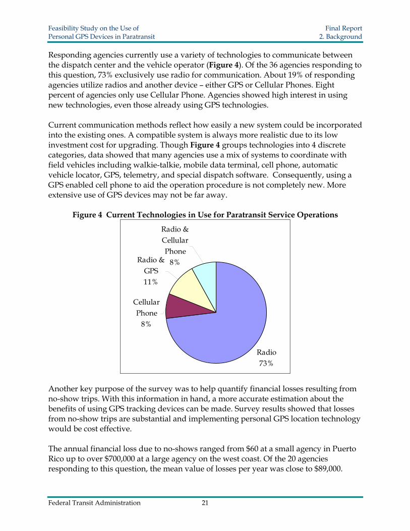
Feasibility Study on the Use of Final Report Personal GPS Devices in Paratransit 2 Background
Figure 6 Percent of No-Show Trips to Total Passenger Trips
Res
pond
ents
10
8
6
4
2
0 000 200 400 600 800 1000
Percent of Trips
While most agencies only have a small number of connection failures five agencies indicated real difficulties locating passengers within an allotted amount of time These five agencies were medium to small in size and according to estimates had total connection failures ranging between 2 and 1225 These results indicate that significant benefit could be derived from implementing new technology targeted at improving the performance of the paratransit service
For additional survey data and analysis please refer to Appendix A
Federal Transit Administration 23
Feasibility Study on the Use of Final Report Personal GPS Devices in Paratransit 3 Background
30 BACKGROUND
31 GPS Fundamental Synopsis
The Global Positioning System uses 24 navigation satellites in orbit around the Earth ndash six groups of four evenly spaced satellites per orbit All satellites constantly emit square waves or enciphered codes in different patterns For accurate geolocation performance the ground based GPS devices must receive these codes from at least three satellites simultaneously and decipher them to compute spatial positions However the precision of GPS signals depends upon many factors which can accumulate to generate large errors that have an impact on locational accuracy Multiple sources of error and deviation are listed in Table 2 (6 7 8 9 10) Usually error range of GPS measurements are less than 15 meters depending on the ultimate offsets of all impacts
Table 2 Error Sources Impacting the Precision of GPS Signals Source Error Range Explanation
Ionospheric Effects plusmn 5 meter
The ultraviolet rays from the sun ionize a portion of gas molecules to release free electrons in the atmosphere distorting the propagation of GPS broadcasts
Ephemeris Errors plusmn 25 meter This is a difference between the expected and
actual orbital position of a GPS satellite Satellite Clock Errors plusmn 2 meter The small inconsistency of time deviation in
different satellite entities
Multipath Distortion plusmn 1 meter
This distortion varies depending on the environment within which the receiver is located satellite elevation angle receiver signal processing antenna gain pattern and signal characteristics
Tropospheric Effects plusmn 05 meter
Delay of the GPS signal waves with respect to free space propagation due to the effect of troposphere properties including temperature pressure and humidity
Numerical Errors lt plusmn 1 meter
Based on the theory of relativity the wave speed generates a different frame from the Earth reference frame
Cumulative Errors gt plusmn13 meter The total theoretical errors listed above excluding
the receiver device bias Sources (6 7 8 9 10)
The GPS locating method heavily depends on satellite visibility so the failure rates vary under many different circumstances Sometimes the electromagnetic wave signal is reflected and though the signal is still ultimately redirected to the satellite minor distortion occurs Most GPS devices do not lose their signals completely if there is only
Federal Transit Administration 24
Feasibility Study on the Use of Final Report Personal GPS Devices in Paratransit 3 Background
minor shielding because the sensitivity of antennas and receivers has been continuously improved For instance if the passenger is waiting next to a tall building or under the eaves the reading fluctuations may create some problems for the driver in determining the actual location of the passenger
Assisted GPS is an enhancement to a mobile phonersquos locating ability The development of A-GPS was accelerated by the US FCCs E911 mandate requiring the position of a cell phone to be available to emergency call dispatchers (11 12) A-GPS uses both GPS and a terrestrial cellular network to obtain geographic position Assisted GPS plays an important role in most contemporary mobile GPS devices
Unlike regular GPS which requires a complete download of data from satellites which may take up to several minutes A-GPS relays information already obtained by the cell phone network and processes location data in a much faster and reliable manner minimizing the impacts whenever the GPS signal is poor Without a Global System for Mobile communications (GSM) a mobile GPS device requires more information from satellites as well as further calculations so the locating time is much longer However under the existing GSM network the cell phone signal tower offers a rough locational estimation in a range from 100 meters to 300 meters Therefore within this limited area location information is readily obtainable even if only partial GPS data can be downloaded from the satellites
A higher spatial accuracy level is obtainable using the Wide Area Augmentation System (WAAS) By referring to ground control stations WAAS corrects any detected discrepancies in the GPS results The achievable accuracy limitation is within 76 meters in the worst case scenario With ongoing technology improvements future mobile devices may have the potential to apply WAAS to obtain higher accuracy levels (13 14)
32 Extensive GPS Applications
Because GPS can almost instantly locate a ground target many aspects of our civilian life have been recently improved For example the functioning of industrial production organizations including agriculture ecology commerce politics etc are all now influenced significantly by GPS
The agricultural industry in the State of Kansas employed GPS technology in beef production management in order to control the spread of Bovine Spongiform Encephalopathy (BCE) All cattle are tracked by GPS and thus their movements are recorded With the aid of a Geographic Information System (GIS) a quarantine map showing potential disease threatened areas can be plotted Tracking the animalsrsquo positions provides effective immunization management and improves the security of food supplies Additionally the tagging of the cattle from birth to death makes conventional farm administration more systematic (15)
Federal Transit Administration 25
Feasibility Study on the Use of Final Report Personal GPS Devices in Paratransit 3 Background
In commercial businesses applications extend much further For instance car rental companies now have reliable methods for locating their vehicles at any instant for safety and security reasons By installing Automatic Vehicle Locating technology (AVL) rental companies have prevented improper usage reduced insurance costs and deterred theft In fact most major car rental companies have already implemented GPS navigation service as an optional accessory for their clientele Cargo tracking technology allows businesses to oversee cargorsquos movement by attaching a GPS tracker to containers and trucks This also enhances the security of transportation
Environmental scientists employ GPS in many research projects Many species have been extinguished because of encroachment and the consequent necessity to adapt to new habitats In Africa researchers from wildlife protection organizations use GPS trackers to collect data on elephant activity (16) With the database showing the living boundaries of these animals land use patterns can be modified to minimize the impact of human activities GPS also serves as a valid tool for vegetation management In Scotland researchers relied on GPS data to analyze and monitor herbivoresrsquo grazing locations Researchers determined with relative GPS modules affixed to roving animals had a mean accuracy of 10 m and precision was lt 10 m 95 of the time (17)
33 Location Based Service (LBS)
According to the definition provided by the SENSEable City Lab at the Massachusetts Institute of Technology (MIT) Location Based Service is the technology that allows instant identification of a mobile devicersquos exact position (18) There are generally four measures involved in achieving this goal cell identification angle of arrival time of arrival and enhanced observed time difference (19)
bull Cell identification determines the location based on the wireless network Usually a mobile phone communicates with the nearest signal tower and its location falls into the cell that the tower serves Due to the difference in shape or size of each cell the accuracy ranges from 100 meters to 600 meters
bull The angle of arrival calculation depends on the signal receiving direction At minimum two base stations are required to monitor the signal path and calculate the senderrsquos location using trigonometry principles The obtainable accuracy limits range from 50 meters to 150 meters varying due to signal travel path deflections
bull The time of arrival approach emits signals in all directions from three base stations The signals leave each station simultaneously and are reflected back Once they reach the device distances to the three stations are all known for positioning
bull The observed enhanced time difference approach is relatively complicated A mobile device is preinstalled with locating software that computes its own position and later the position is generated by nearby base stations
Federal Transit Administration 26
Feasibility Study on the Use of Final Report Personal GPS Devices in Paratransit 4 Locating Methodology
40 LOCATING METHODOLOGY
41 Location Interpretation
Only a limited amount of spatial distance deviation may be allowed to avoid missing a passenger who might be waiting on the other side of a building or merely a block away from a specified pickup location The most popular way to express a geographic position is using longitudelatitude coordinates These coordinate numbers can be converted to actual distances using a scale factor By converting sets of coordinates to linear distance users will have a better sense of whether the distance errors are acceptable
The conversion from coordinates to actual distances becomes more complicated as accuracy requirements become more demanding There are ways to depict distance on the Earthrsquos surface to a very exact degree if sufficient investment and equipment support are provided In fact the equipotential surface also referred as mean sea level is an irregular surface relative to an ideal ellipsoid surface so there is no universal mathematical formula to perform the algorithms to a very high degree of accuracy Yet an acceptable approximation method can be found on the Internet to complete the interpretation The Internet resource MaNISHerpNetORNIS Georeferencing Guidelines (20) provides a simplified conversion factor table as shown in Table 3
Table 3 Uncertainty Based on Coordinate Precision Using WGS84 Ref Ellipsoid
Precision 0 degrees Latitude
30 degrees Latitude
60 degrees Latitude
85 degrees Latitude
(all values in meters) 10 degrees 156904 146962 124605 112109 01 degrees 15691 14697 12461 11211 001 degrees 1570 1470 1247 1122 0001 degrees 157 147 125 113 00001 degrees 16 15 13 12 10 minutes 2615 2450 2077 1869 01 minutes 262 245 208 187 001 minutes 27 25 21 19 0001 minutes 3 3 3 2 10 seconds 44 41 35 32 01 seconds 5 5 4 4 001 seconds 1 1 1 1
From the above table it can be seen that the same degree of longitudelatitude differences equate to different real distances at different latitudes Because all our experiments were performed in Miami Florida where latitude is around North 25
Federal Transit Administration 27
Feasibility Study on the Use of Final Report Personal GPS Devices in Paratransit 4 Locating Methodology
degrees the second column data are employed because they are the closest conversion factors Here 1 minute is approximately equal to 2450 meters likewise 1 second is equal to 41 meters
42 Criteria for Selecting GPS Devices
To select the most appropriate mobile GPS devices for our paratransit pickup system the following criteria were considered portability reliability user friendliness durability compatibility and accuracy
bull Portability is one of the most basic requirements reflecting the necessary convenience since the device must be carried by users Generally speaking to satisfy this requirement a smaller sized device without the need for a power outlet is preferred so that it can be easily transported
bull Reliability ensures that GPS signals are acquired successfully free from other disturbance factors as GPS readings can vary due to time differences geographic location and weather conditions This criterion has no absolute quantitative measurements Therefore comparisons are performed among the different candidates to determine a relatively better choice after actual testing for a period of time
bull User friendliness is determined by how easily users can manipulate the device It would not be beneficial to spend large amounts of time on tutoring paratransit passengers how to use it In addition a nice-looking device is a plus
bull Durability concerns the usable life of the product including maintenance and future reoccurring costs It includes a study of the sustainability of the battery the fragility of the device and comparisons of administrative costs after the new system is implemented Note that using a single device for one year without problems is not enough evidence to declare a device durable
bull Compatibility requires that the newly developed operating platform has good adaptability and thus provides savings on overall expenditures and equipment Furthermore there should be a large enough margin for future hardware upgrades and functionality expansions
bull Accuracy is really the core criterion of employing GPS devices It ensures that the passengerrsquos exact location is known so that the vehicle will arrive directly in front of the passenger with little effort Each GPS device was tested a total of 40 times to retrieve position information at a control point for longitude and latitude readings
Federal Transit Administration 28
Feasibility Study on the Use of Final Report Personal GPS Devices in Paratransit 4 Locating Methodology
All tests were conducted within the course of two hours during a single day These data were then statistically examined and quantitatively compared With the aforementioned criteria in mind four mobile GPS devices were purchased for comparison analyses the Motorola i415 the Gemtek tracking device the HP iPAQ hw6945 and the Garmin Forerunner 305 Each device is discussed in the following sections Selection procedures provide typical examples of how the candidacy of a new device was evaluated It is unlikely that all criteria will be simultaneously embodied in one device Consequently positives and negatives had to be considered when determining device eligibility Among all criteria accuracy was the only parameter where the four devices could be compared quantitatively As a result further accuracy tests were conducted to draw a dependable conclusion
43 Motorola i415
431 Overview
The Motorola i415 (Figure 7) is a GPS enabled mobile phone Basic features include the regular Bluetooth cell phone walkie-talkie and GPS navigator The GPS locating service in this test is offered by Boost Mobile Company and an approximately $30 monthly service fee was charged at the time of this research for unlimited data transfers This does not include voice communication A service fee is necessary because Internet access is required to send location information Additionally the cell phone supports Java coding allowing for the implementation of potential applications to extend its adaptability and compatibility
Figure 7 Motorola i415
Federal Transit Administration 29
Feasibility Study on the Use of Final Report Personal GPS Devices in Paratransit 4 Locating Methodology
The voice communication offers another way to re-coordinate the pickup and can be used as an aid whenever the GPS fails For instance there may be cases when passengers experience technical problems and need to communicate with the service provider
432 Criteria Judgment
bull Portability As a regular mobile phone with dimensions 140 times 48 times 22 mm the Motorola i415 is convenient to carry A carrying case is generally available as an accessory option
bull Reliability There are still some reliability improvements that the manufactures can make There have been no breakdowns since testing however at low battery levels the GPS location readings are far beyond an acceptable range with deviations up to 500 meters As a consequence it is important to make sure that the device is always operated at a sufficient battery level According to a similar phonersquos support center the unreliability is due to several factors For instance a low battery cannot provide sufficient wireless signal strength or surrounding radio noises may be so strong as to cause interference When the GPS signal is weak or satellite visibility is low the locating method falls back to the GSM network (21) There is no significant evidence showing that cloudy weather had a significant impact on the readings Another deficiency is that text messages were occasionally difficult to send due to a failure to connect with the server It is expected that in the future GPS enabled cell phones will perform better
bull User Friendliness The Motorola i415 generally follows the typical cell phone panel arrangement hence people with experience using cell phones should become easily acquainted Tracking functions were able to be performed automatically with few manual operations once the research team designed and implemented a Java program code
bull Durability There was not sufficient time nor a sufficient sample size to draw conclusions as to the durability of this type of phone However the cell phone has a hard plastic texture and was still in good condition after one yearrsquos usage The power consumption is relatively short it only lasts about 8 hours in GPS active mode Yet this is still sufficient for a normal one-day service span
bull Compatibility The Java programmability of the Motorola i415 provides excellent compatibility and codes can be implemented into the device for user-defined tracking activities The project team created a program to simplify the tracking procedure so that only one press of the button is needed and rest of the task will be automatically completed
Federal Transit Administration 30
Feasibility Study on the Use of Final Report Personal GPS Devices in Paratransit 4 Locating Methodology
bull Accuracy Results from the 40 longitudelatitude readings were converted to real distance deviations in meters The results summarized in Figure 8 and Figure 9 represent readings obtained during the two hour period of testing Outliers resulting from low battery levels are excluded in the following analysis
Figure 8 Frequency Histogram for the Motorola i415
Freq
uenc
y
10
8
6
4
2
0 000 500 1000 1500 2000
Distance from Control Marker (meters)
Federal Transit Administration 31
Feasibility Study on the Use of Final Report Personal GPS Devices in Paratransit 4 Locating Methodology
Figure 9 Real Distance Deviation for the Motorola i415 (distance in meters)
-20
-15
-10
-5
0
5
10
15
20
-20 -15 -10 -5 0 5 10 15 20
Sout
h lt
----gt
Nor
th
West lt ---- gt East
The histogram shows that the majority of measurements had a deviation of less than 10 meters All of the results were within a distance of 20 meters from the center of the control point (survey marker) These observations seem accurate enough to provide a vehicle operator with confidence that his or her passenger is very near
44 Gemtek Tracking Device
441 Overview
The Gemtek tracking device (
Figure 10) allows for instant location queries as well as traveling path log recordin g Besides the wireless GPS communication channel a voice communication channel is also included A customer service phone number plus two user-defined phone numbe rs are preset The voice communication is enabled by pressing the corresponding speed dialing keys In case passengers cannot find the vehicle operator they can this function to contact the service provider Except for the two phone number limitation this device functions the same as a regular cell phone
Federal Transit Administration 32
Feasibility Study on the Use of Final Report Personal GPS Devices in Paratransit 4 Locating Methodology
Figure 10 Gemtek Tracking Device
Two other features worth mentioning are the SOS alarm and geofencing When the SOS alarm button is pr essed location information will be sent immediately to the pre-stored phone numbers for emergency assistance Another optional feature geofencing mode can be used to alert the designated contacts if the carrier goes beyond a predefined geographic zone
This device uses three colored indicator lights to show operating status The blu e flash starts when the device is turned on If the flash changes to green it indicates that i t is under GSM coverage If there is sufficient clearance the flash finally turns to red meaning the GPS satellite signal is being received The signal light provides an advantage since the user knows to move around for better satellite visibility The development of the Gemtek device was aimed at tracking seniors primarily for their own safety therefore many special functions are incorporated into the design
442 Criteria Judgment
bull Portability The Gemtekrsquos size is approximately 90 times 45 times 20 mm It comes with a leather bag in the package and is readily attachable to the wrist or belt
bull Reliability In both cool and warm starting modes it normally tak es about one minute for the GPS satellite signal to be acquired in an open environment As long as the red flashing light is on which indicates the device is in GPS coverage area the position information was instantly available upon a query entry
Federal Transit Administration 33
Feasibility Study on the Use of Final Report Personal GPS Devices in Paratransit 4 Locating Methodology
bull User Friendliness Because there are only seven buttons on the panel users are neither required to memorize phone numbers nor spend time familiarizing themselves with usage Appropriate phone numbers would be pre-programmed into the Gemtek device by transit agency staff
bull Durability During testing the device worked properly The battery lasted more than 20 hours if no voice calls were made and it supported up to four hours of talk time on a full battery charge
bull Compatibility Becaus e the Gemtek device is provided as a packaged end product including the service plan changes cannot be made internally As a result it is impossible to create customized applications since there is no way to load or implement programs
bull Accuracy The accuracy description of the Gemtek tracking device is different from the others Unlike the conventional longitudelatitude coordinates that define a point in a numerical manner the web application only provides a digital map or at most an aerial image for some urban areas With no obtainable numerical loc ation information there was no way to quantify the degree of accuracy As a result a rough estimation was performed Using high-resolution aerial images an estimate of 5 meters was chosen as the minimum distance interval and the data were grouped into four categories
Note in Figure 11 that none of the 40 test results fall outside of a 20-meter range an d 38 out of 40 trials are concentrated within a radius of 15 meters Only 2 out of 40 or 5 of the trials were located between a 15 and 20-meter interval Therefore the accuracy is likely to be satisfactory in real field applications of the paratransit pickup system
Federal Transit Administration 34
Feasibility Study on the Use of Final Report Personal GPS Devices in Paratransit 4 Locating Methodology
Figure 11 Gemtek Frequency Histogram and Estimated Distance Deviation
20
15
10
5
0
Freq
uenc
y
000 500 1000 1500 2000
Estimated Distance from Control Marker (meters)
45 Garmin Forerunner 305
451 Overview
The Garmin Forerunner 305 (Figure 12) is a multiple function electronic watch with GPS tracking capability This device was designed to monitor the userrsquos physical exercise conditions and thereby offer training guidance Some basic features include a stop watch palpitation measurement calorie consumption and route distance calculation Users are able to preset their exercise schedules into the watch including running distance heart rate and calorie consumption An alarm reminds the user whenever a certain goal is achieved Besides the watch component there is a band that can be worn on the userrsquos chest for measuring the heart rate This communicates with the watch wirelessly via Bluetooth
The watch records the longitudelatitude position continuously and all of the data can be later downloaded to computer by a USB cable From these data logs users can compare their exercise activities on a daily basis The Garmin Forerunner 305 has the best accuracy because it is World Wide Augmentation System (WAAS) supported Additionally the high sensitivity SiRFstar III antenna gives it extraordinary dependability Yet a lack of wireless communication channels excludes it from the candidate pool essentially no position information can be transmitted instantly via
Federal Transit Administration 35
Feasibility Study on the Use of Final Report Personal GPS Devices in Paratransit 4 Locating Methodology
wireless Because there is no wireless communication channel there is no way to instantly send back location information to an agency Hence it is not feasible to use the Garmin Forerunner 305 in this project
Figure 12 Garmin Forerunner 305
452 Criteria Judgment
bull Portability The Garmin Forerunner 305 easily satisfies the portability requirement because it is a wristwatch size and unlikely to inconvenience users
bull Reliability One of the shining points of this product is the integration of a high sensitivity SiRFstar III GPS antenna The extraordinary signal detectability is superior to the other three devices and takes significantly less time to retrieve position coordinates
bull User Friendliness With more user functions available the device requires extra learning time for users to familiarize themselves
bull Durability A disadvantage is that the battery life only lasts about 4 hours This is much shorter than a typical service day or even the service span of a round trip If a passenger has to stay somewhere for more than 4 hours it would be necessary to turn off the device to reserve sufficient battery power for the return trip
bull Compatibility Lack of compatibility is the major flaw of the Garmin Forerunner 305 for this project The current cost of implanting a wireless communication chip into a small watch is not yet popular for civilian use but may become more realistic in the future More importantly this watch is non-programmable and no alternations can be made to accommodate a custom application for this device
bull Accuracy Accuracy is perhaps the most outstanding feature of this product because of its integration with Wide Area Augmentation System (WAAS) technology The
Federal Transit Administration 36
Feasibility Study on the Use of Final Report Personal GPS Devices in Paratransit 4 Locating Methodology
majority of GPS measurements fall within six meters of the control point regardless of the battery level or sky conditions The maximum distance deviation was only eleven meters (Figure 13) Combined with its high reliability the Forerunner 305 proves WAAS has a better locating accuracy than ordinary GPS technology
Coincidentally all points are aligned perfectly in both vertical and horizontal directions this is because the reading digits can only reach the third decimal in seconds Several points overlap and thus appear as fewer dots on the distance deviation chart (Figure 14) In terms of actual distance there is a systematic error approximately larger than 13 meters because of the number of decimals The interspaces between points are always multiples of 13 meters
Figure 13 Frequency Histogram for the Garmin Forerunner 305
10
8
6
4
2
0
Freq
uenc
y
000 200 400 600 800 1000 1200
Distance from Control Marker (meters)
Federal Transit Administration 37
Feasibility Study on the Use of Final Report Personal GPS Devices in Paratransit 4 Locating Methodology
Figure 14 Garmin Forerunner 305 Real Distance Deviation (distance in meters)
-10
-75
-5
-25
0
25
5
75
10
-10 -75 -5 -25 0 25 5 75 10
Sout
h lt
---- gt
Nor
th
West lt ---- gt East
46 HP iPAQ hw6945
461 Overview
The HP iPAQ hw6945 (Figure 15) is a powerful Personal Digital Assistant (PDA) that uses the Windows Mobile 5 operating platform Its volume is slightly larger than a regular cell phone however its powerful capabilities by far exceed those of the other handheld devices reviewed here Many advanced technologies are integrated into the device making it a versatile choice but also an expensive one
Examining the feasibility of the iPAQ is quite different from examining the other devices because its capabilities can assist beyond the role as a pickup connection assistant The HP iPAQ hw6945 supports wireless Internet access allowing users to check email send text messages and read news if desired The software platform provides plenty of personalization options However the same adaptability that can be seen as an advantage will lead to slower implementation because an agency may have to spend significant amounts of time training users on how to manipulate the device to its full capability The HP iPAQ hw6945 is versatile in different fields A small screen shows driving directions and a digital map image leading to the correct path Overall this device seems more suitable for use at the vehicle operatorrsquos terminal since it can offer very specific navigation instructions
Federal Transit Administration 38
Feasibility Study on the Use of Final Report Personal GPS Devices in Paratransit 4 Locating Methodology
Figure 15 HP iPAQ hw6945
462 Criteria Judgment
bull Portability The HP iPAQ hw6945 is approximately 71 times 18 times 118 mm - slightly larger than other devices A clip is included that can easily hold the device to a belt
bull Reliability The HP iPAQ hw6945 is programmable but problems may arise due to conflicts among software applications The antenna sensitivity is similar to the Motorola i415 Unlike the previously tested cell phone no significant positioning errors were found due to a low battery level
bull User Friendliness Loaded with multi-media players games daily planning tools and a number of other software applications users are able to fully utilize their time for work study and leisure However for users who are less acquainted with PDAs this device may be a challenge Seniors with visual impairments may have difficulty reading the small fonts on the screen Users might press the wrong button and have problems returning to the original application The high cost may make agencies and passengers reluctant to use this device
bull Durability Even though this device has a higher price and requires strict handling it promises a longer usable life It is advisable to insure the device for damage maintenance or replacement
bull Compatibility Compatibility is the most promising feature of this product The device is readily adaptable because program coding can be easily implemented into the operating environment
Accuracy Although the PDA is more expensive than most mobile GPS devices it does not guarantee better accuracy The majority of measurements fell within a radius of 20 meters with only two measurements were greater than 20 meters from the control marker (Figure 16 amp Figure 17) The accuracy of HP iPAQ hw6945 performance was comparable to the other devices tested in this project
Federal Transit Administration 39
Feasibility Study on the Use of Final Report Personal GPS Devices in Paratransit 4 Locating Methodology
Figure 16 Frequency Histogram for the HP iPAQ hw6945
Freq
uenc
y 6
4
2
0 000 500 1000 1500 2000 2500
Distance from Control Marker (meters)
Figure 17 HP iPAQ hw6945 Real Distance Deviation (distance in meters)
-25
-20
-15
-10
-5
0
5
10
15
20
25
-25 -20 -15 -10 -5 0 5 10 15 20 25
Sout
h lt
---- gt
Nor
th
West lt ---- gt East
Federal Transit Administration 40
Feasibility Study on the Use of Final Report Personal GPS Devices in Paratransit 4 Locating Methodology
47 Accuracy Tests
All accuracy tests were performed at a fixed survey marker (Figure 18) The local control point for this testing was the Florida Department of Transportation survey marker (identification number PN04A) that has a standard longitudelatitude value of W8036888 and N2576909 as defined by geodic authorities All readings were collected uniformly to provide an adequate basis for comparison The data were analyzed with the t test in order to calculate confidence interval comparing accuracy limitations
Figure 18 Image of the Survey Control Marker
Equation 1 was used to estimate the probability that a GPS reading will fall within a certain distance based on a specified confidence level Because the sample size is greater than 30 and the data are normally distributed the sample mean can be approximated to the population mean Similarly the population variance can be substituted by the sample variance in the calculation
Equation 1 x minus μ = z sdotδ
where x = the average from the experiment μ = the population mean δ = the standard deviation z = the z score associated with the degree of confidence selected
Table 4 shows the Deviation distance ranges at different confidence levels it also provides the probability that an observation will be less than or equal to the specified distances 10 m 15 m and 20 m The Gemtek device was not included in the accuracy test because the device did not give the user latitudelongitude information It is designed to provide users with only address information and digital map images The
Federal Transit Administration 41
Feasibility Study on the Use of Final Report Personal GPS Devices in Paratransit 4 Locating Methodology
Garmin 305 was excluded from testing for its lack of communication abilities GPS information cannot be sent from the device it can only be downloaded
In Table 4 δ is the standard deviation of the observed readings and the numbers in the confidence interval columns list the corresponding deviated distance at the 85 90 and 95 confidence intervals
Table 4 Devices Accuracy Performance Motorola i415 HP iPAQ hw6945
X 938 m 1178 m δ 445 547
Deviation distance ranges at different confidence levels
85 1525 1900 90 1697 2111 95 2030 2520
Probability of GPS observations within a certain range
10 m 5557 3725 15 m 8969 7224 20 m 9914 9368
To further estimate the accuracy performance of the two selected devices confidence intervals around the mean were calculated Equation 2 was used to provide the confidence interval of the population mean at a specified level of confidence (Table 5)
Equation 2
X minus z 2α times n
S le μ le X + z 2α times
n S
Table 5 Devicesrsquo Confidence Intervals Around the Mean
Confidence Level Motorola i415 HP iPAQ hw6945
Lower Bound
Upper Bound
Lower Bound
Upper Bound
85 z α2 ~144 837 1039 1053 1303
90 z α2 ~1645 822 1054 1036 1320
95 z α2 ~196 800 1076 1008 1348
48 Benefit Cost Analysis
The total cost of each device in operation is critical in determining whether agencies will accept them Table 6 and Figure 19 show the starting and operating expenses of the
Federal Transit Administration 42
Feasibility Study on the Use of Final Report Personal GPS Devices in Paratransit 4 Locating Methodology
three devices The cost of each device is an influential factor that may govern the willingness of transit agencies to adopt the new concept in real applications The cost is not limited to the initial investment but also to the recurring operating costs Higher costs are usually associated with more functionality and so a compromise between cost and capability is typical
Table 6 Devicesrsquo Costs Comparisons Device Motorola i415 Gemtek Device HP iPAQ hw6945 Device cost $40 $400 $600 Monthly fee $10 $20 $50 First year total costs $160 $640 $1200
Figure 19 Total Cost of Each Device for a 12 Month Period
0
300
600
900
1200
1500
1 2 3 4 5 6 7 8 9 10 11 12 13
Month
Tot
al C
osts
($)
HP iPAQ h 6945
Gemtek Device
Motorola i415
Federal Transit Administration 43
Feasibility Study on the Use of Final Report Personal GPS Devices in Paratransit 5 GPS Prototype
50 GPS PROTOTYPE
51 Prototype Development
After all devices were tested for their specific functionalities a GPS prototype was developed to explore the feasibility of integrating multiple devices into a complete working system The best solutions combined use of the GPS enabled Motorola i415 cell phone and the HP iPAQ hw6945 PDA This prototype connects the passenger vehicle operator and the agency dispatcher together via a central computer To synchronize these devices separate programs namely iTrack and LocateYou were created The iTrack application was written in Java for the Motorola i415 and the LocateYou application was written in C for the HP iPAQ hw6945 The web application prototype was developed in ASP Net These software applications were specifically created by LCTR staff to test the capabilities of these GPS devices
No prior knowledge is required to operate the system Once the devices are turned on the iTrack and LocateYou programs are automatically initiated and position information is continuously acquired from satellites and sent to the server The server translates the position coordinate numbers to point marks on the Microsoft Live Map and Google Map so that the agency dispatcher can track both the passengers and vehicles The HP iPAQ hw6945 uses Google Map as a background to indicate locations on its screen Likewise the central server computer screen employs Google Earth including a three-dimensional view and Microsoft Live Map to display locations Consequently both the agency dispatcher and the PDA carrier are able to view the carrierrsquos location in digital map form
52 Functionality
It is important to know how the iTrack and LocateYou programs work with each other Basically the mobile device must be GPS enabled and support Java to run this program The iTrack program is a J2ME MIDlet (22 23) application that supports any J2ME platform of mobile phones The iTrack has three basic steps in its running thread
bull First it communicates with the internal GPS device through a serial port and acquires the GPS signal If the GPS signal is successfully connected the screen displays a message reading ldquoMy GPSOnrdquo Once the signal connection succeeds the location queries are made automatically every few minutes depending on how the program is defined
bull Second an HTTP request is formed and is sent to the server describing the current status of the device In the case wherein a GPS signal is obtained this HTTP request includes the current longitude and latitude coordinates Additionally moving speed
Federal Transit Administration 44
Feasibility Study on the Use of Final Report Personal GPS Devices in Paratransit 5 GPS Prototype
and time information are also appended to the request and sent to the server On the other hand if a GPS signal connection fails to connect an HTTP request describing the current failure status is sent to the server The server stores all of these data to a database as an activity log for future reference
bull Lastly the server produces three similar location data packages for the dispatcher the passengers and the vehicle operator upon receiving the HTTP request For the dispatcher the locations of all mobile devices are marked on Internet maps specifically Google Earth and the Microsoft MapPoint web service (23) Similar data packages are also sent to the vehicle operator and the passenger
A detailed data flow of the prototype is summarized in Figure 20 The central server functions as a hub to effectively maintain communications among the dispatcher vehicle operator and passenger All information from these three parties is initially received modified and shared in the central server
Figure 20 Graphical Display of the Prototype
53 Prototype Application in Use
During the pickup process the geographical locations of both the Motorola i415 and the HP iPAQ hw6945 are obtained from satellites and sent to the nearest wireless signal tower The central server combines the Internet map service and location information from the GPS devices to generate an individual data package for the dispatcher the vehicle operator and the passenger From the PDA screen the vehicle operator is able to see driving directions as well as the passengerrsquos location on a digital map Similarly
Federal Transit Administration 45
Feasibility Study on the Use of Final Report Personal GPS Devices in Paratransit 5 GPS Prototype
the passenger receives the waiting time a nd vehicle distance Therefore pickups can become more punctual and predictable with the aid of this new approach At the same time a service log of all activities is recorded into the system database
In the historical log two types of tracking logs are available real time tracking and historical tracking Real time tracking means the indicated location markers shown in the iPAQ screen are automatically refreshed as updated information is received This is very helpful in the middle of the service task when the vehicle operator cannot find a passenger on local streets Historical tracking as the name suggests is the tracking log of the previous services These datasets are readily accessible whenever evaluation or references for past services are required
If the Motorola i415 is used by the driver as an option driving instructions are provided An example of the data packages received by the device is shown in Figure 21 The screen presents the estimated driving time and distance By clicking the ldquoDirectiordquo button detailed directions are displayed Sometimes the other device is not connected to the GPS signal and the screen displays the text Tracked ldquoGPSOffrdquo Upon seeing this message users should move around to restore a better GPS signal reception The dispatcher is also aware of the status of the passengerrsquos mobile GPS and this information allows the dispatcher to call the user or driver with additional instructions if necessary However when lacking a map image only verbal instructions can be communicated to the users
Figure 21 Screen Captures of Motorola i415
The HP iPAQ hw6945 device was also considered for use by the paratransit driver because complex images on a bigger screen can provide a more detailed passenger location map The LocateYou program works differently from iTrack by integrating the Google Map application as the mapping template Hence directions are provided and users can switch to a digital map image that is returned by the server Screen captures of the PDA are shown in Figure 22 The first screen depicts the passengerrsquos location in longitudelatitude coordinates and the second screen shows where the passenger is waiting on a digital map
Federal Transit Administration 46
Feasibility Study on the Use of Final Report Personal GPS Devices in Paratransit 5 GPS Prototype
Figure 22 Screen Captures of HP iPAQ hw6945
The dispatcherrsquos computer shows the vehiclesrsquo and passengersrsquo information such as route path travel distance direct distance and estimated driving time An example of the dispatcherrsquos computer is shown in Figure 23 The digital map image updates whenever a device reports a new location With the aid of the tracking platform it is expected that the occurrence of missed trips will be avoided in some situations
Figure 23 Device Locations Map for Dispatcher
For demonstration purposes in this prototype the passenger carries the Motorola i415 mobile phone and the driver carries either another Motorola i415 mobile phone or the
Federal Transit Administration 47
Feasibility Study on the Use of Final Report Personal GPS Devices in Paratransit 5 GPS Prototype
HP iPAQ hw6945 Users need only turn on the mobile GPS devices to ensure that their work status is active Because the locations of all mobile devices are known instantly the vehicle operator can promptly arrive at the passengerrsquos location by following the driving directions
A more detailed demonstration example of this prototype application can be viewed at the following URL httpgpstranspolctrorg
Federal Transit Administration 48
Feasibility Study on the Use of Final Report Personal GPS Devices in Paratransit 6 Conclusion
60 CONCLUSION
Because missed trips commonly occur at all paratransit agencies advanced GPS technology may have a role in relieving such problems in the future The methodology and prototype developed in this project offer a completely new pickup concept compared with current operation methods GPS location technology offers an accurate fast dependable and feasible alternative tool to help avoid missed pickups resulting from operational errors or pickup requests at ambiguous locations
After examining the features of four GPS mobile devices it became evident that some devices are not feasible for assisting with paratransit operations Two of the devices were considered to be less suitable than their counterparts The Gemtek device has a good design in many respects but loses its candidacy due to poor compatibility it is not programmable and cannot be coded to work with a peer device The Garmin Forerunner 305 by taking advantage of WAAS achieves the best accuracy performance among all of the devices But it has no wireless channel to communicate with a server and is unable to inform location information to other receptors
On the other hand the two programmable GPS devices the Motorola i415 and the HP iPAQ hw6945 were ready to be used in the development of a computer controlled pickup system The prototype integrates these two devices and synchronizes them by installing the iTrack and LocateYou programs Simulations were performed to show that this prototype methodology could be applied in the real world This prototype presents a potential solution to missed pickups by using GPS tracking technology
Additionally the use of programmable devices may assist with other service improvements Many personal GPS mobile devices come with optional features that can potentially be leveraged to provide further improvements in the future To attract more passengers transit agencies might consider exploring additional functionalities such as medical care alarms and appointment reminders In the future agencies will have the freedom to decide the most suitable technology based on desired functionalities
There are indeed further challenges to the real world usage of this kind of paratransit pickup service methodology The complexity of the system requires trained personnel and individuals who are familiar with computer information and technology The high initial costs of design and purchase lack of agreed upon data standards privacy issues and legal concerns are all barriers to deployment The initial phase of set up and operation may be so complex that even minor employee turnover may spark major setback However if these obstacles can be overcome bringing personal mobile GPS technology into the paratransit industry is a feasible solution for improving the conventional pickup procedure Implementation of GPS technologies can help improve the level of service and reduce agenciesrsquo operating expenses in the long run
Federal Transit Administration 49
Feasibility Study on the Use of Final Report Personal GPS Devices in Paratransit 7 Future Research
70 FUTURE RESEARCH
71 Prototype Improvements
Assisting features were also studied to highlight additional potential advantages of the prototype All of the following options are available depending on local transit agency preferences
711 Alarm Notification
To enhance the prototype performance alarm notifications can be implemented A ringing notification will sound if the passenger is close to the driver or the driver is out of the expected path to the passengers This feature can help the vehicle operator to reach the passenger and gain his or her attention immediately if necessary
712 Administrator Website
The administrator webpage is an application built to help transit agencies improve management and operation It can be integrated with GIS to show the closest vehicles upon request In this application all mobility devices can be shown on a single screen map With the assistance of computer programs agency dispatchers can send the closest vacant vehicle immediately to finish the service task thereby optimizing vehicle management
713 Voice and SMS
The Skype and Microsoft text-to-speech service as well as the Short Message Service (SMS) can potentially be incorporated to offer voice service An automated voice service is capable of handling simple phone queries made by vehicle operators or passengers It can also be used to direct users to the most appropriate personnel SMS is another alternative communication technique in which users can read and review important instructions in case they are forgotten For arrangements coming from the agency to the vehicle operator agency staff can send text messages manually to give instructions and the message is kept as a reference until the task is finished This function can help minimize human error
714 Historical Log
The communication information for each task including short messages location data and pickup arrangements can be saved into a historical database for future reference The historical log collects all statistical information which agencies can periodically use to evaluate and improve their performance
Federal Transit Administration 50
Feasibility Study on the Use of Final Report Personal GPS Devices in Paratransit 7 Future Research
715 Use as a Tracking Device for Persons with Cognitive Disabilities
Although the GPS device is primarily intended to aid with the paratransit pickup process the system also holds promise for serving as a locating device for persons who suffer from cognitive disabilities A small but significant percentage of existing paratransit riders suffer from dementia Alzheimerrsquos disease or another cognitive problem Some of these riders may be willing to utilize the tracking device for additional hours during the day In this situation the tracking device would then also serve as a valuable tool for locating the individual if he or she becomes lost or confused
Currently there are several variations of the aforementioned device available in the market The idea of tracking and monitoring of persons with cognitive disabilities has become more of a popular idea over the last few years Such a system allows individual with mental disabilities to maintain a high degree of freedom but provides a safety net in the event of an emergency If an appropriate prototype GPS website can be developed ridersrsquo friends and family members may be able to determine the exact location of a lost or confused individual on their own there by circumventing the need to contact emergency personnel
Certain issues still remain such as how to continuously power some of the GPS devices Additional battery technology may need to be developed before additional tracking is feasible Furthermore privacy issues and concerns would need to be addressed by all involved parties
72 Cost amp Benefit Ratio Evaluation
In business whether a new alternative is cost effective or not determines its future applicability In order to determine the value of applying personal GPS devices in paratransit more information about transit agenciesrsquo operational expenses needs to be collected and examined This will ensure that a cost efficient method of employing new technologies is selected
One factor which needs to be studied further relates to the pricing of wireless services Currently several of the cell phoneGPS service providers charge a standard rate for a specific number of voice calls or minutes of talk time However this project depends on sending data wirelessly for an undetermined amount of time Few wireless service providers have structured plans for sending data over their network The cost of applying personal GPS devices in paratransit may well depend on negotiated rates for sending constant locational data for long periods of time
Federal Transit Administration 51
Feasibility Study on the Use of Final Report Personal GPS Devices in Paratransit 7 Future Research
73 Finding Newer Suitable Devices
All of the testing devices were ready-available technologies when this project commenced As the civilian GPS market develops the debut of more powerful GPS devices will provide extra options and support for new operating systems Newer units and technology may enable the GPS signal to be picked up better in certain environments Currently signal problems are often experienced if the user is inside a large building or in a dense urban environment with a substantial number of tall buildings Problems have also been noted using GPS devices in heavily forested locations In the future newer devices and the increased usage of assisted GPS will ensure that a clear signal is continuously received
74 Attempting a Pilot Program
In the long run the pickup process can possibly be combined with service vehicle assignments If there is a change request from a passenger the system will immediately determine the most economical way to rearrange the service schedule Potential benefits include less time needed for reservations and services that are more adaptable to instantaneous changes
Federal Transit Administration 52
Feasibility Study on the Use of Final Report Personal GPS Devices in Paratransit References
REFERENCES
1 Weiner R (1998) ADA paratransit eligibility certification practices In Transportation Cooperative Research Program Synthesis of Transit Practice 30 Transportation Research Board of the National Academies Washington DC Retrieved August 8 2008 from httponlinepubstrborgonlinepubstcrptsyn30pdf
2 Lave R and R Mathias (2000) State of the art of paratransit In Transportation in the New Millennium State of the Art and Future Directions Perspectives from Transportation Research Board Standing Committees Transportation Research Board of the National Academies Washington DC pp 1-7 Retrieved August 1 2008 from httponlinepubstrborgonlinepubsmillennium00107pdf
3 Simon R M (1998) Paratransit contracting and service delivery methods In Transportation Cooperative Research Program Synthesis of Transit Practice 31 Transportation Research Board of the National Academies Washington DC Retrieved October 2 2008 from httpgullivertrborgpublicationstcrptsyn31pdf
4 Mathias R G and R E Smith (2005) Practices in no-show and late cancellation policies for ADA paratransit Transportation Cooperative Research Program Synthesis 60 Transportation Research Board of the National Academies Washington DC Retrieved August 4 2008 from httponlinepubstrborgOnlinepubstcrptcrp_syn_60pdf
5 Miami-Dade Transit (2008) Miami-Dade County transit paratransit operations monthly report April 2008 Retrieved July 31 2008 from httpwwwmiamidadegovtransitparatransitaspmdt_reports
6 Nelson R A (1999) The global positioning system A national resource Via Satellite November Retrieved on October 1 2008 from httpwwwaticoursescomglobal_positioning_systemhtm
7 Langley RB (1997) The GPS error budget GPS World 8(3) 51-56
8 Hofmann-Wellenhof B Lichtenegger H amp Collins J (1997) GPS Theory and practice New York Springer
9 Kaplan E D and C Hegarty (Eds) (2005) Performance of stand-alone GPS In Understanding GPS Principles and Applications (pp 301-378) Norwood MA Artech House Inc
10 Global positioning system (October 2008) Retrieved October 3 2008 from the Wikipedia Encyclopedia httpenwikipediaorgwikiGlobal_Positioning_System
Federal Transit Administration 53
Feasibility Study on the Use of Final Report Personal GPS Devices in Paratransit References
11 LaMance J Jarvinen J amp DeSalas J (2002 March 1) Assisted GPS A low-infrastructure approach GPS World 46-51
12 Assisted GPS (September 23 2008) Retrieved October 1 2008 from the Wikipedia Encyclopedia httpenwikipediaorgwikiA-GPS
13 US Department of Transportation (2001 August 13) Federal Aviation Administration specification for the wide area augmentation system (WAAS) Specification FAA-E-2892b Retrieved October 3 2008 from httpwwwfaagovaboutoffice_orgheadquarters_officesato
service_unitstechopsnavservicesgnsslibrarydocuments
14 Wide area augmentation system (September 29 2008) Retrieved October 3 2008 from the Wikipedia Encyclopedia httpenwikipediaorgwikiWide_Area_Augmentation_System
15 Stewart M A (September 2005) Tracking cattle in the heartland Geospatial Solutions Retrieved July 16 2008 from httpwwwgeospatialshyonlinecomgeospatialsolutionsarticlearticleDetailjspid=177059ampsk=ampdate=amppag eID=4
16 GPS tracking Save the Elephants Retrieved July 16 2007 from httpwwwsavetheelephantsorgdisplayasplinkID=59ampdisplayID=58
17 Hulbert I A R amp French J (2001) The accuracy of GPS for wildlife telemetry and habitat mapping Journal of Applied Ecology 38(4) 869-878 Retrieved on August 17 2008 from httpwww3intersciencewileycomcgi-binfulltext118869609PDFSTART
18 Ratti C R M Pulselli S Williams and D Frenchman (2006) Mobile landscapes Using location data from cell-phones for urban analysis Environment and Planning B Planning and Design 33(5) pp 727-748
19 Axel Kuumlpper (2005) Location-based services Fundamentals and operation Chichester West Sussex England John Wiley amp Sons Ltd
20 Wieczorek J (September 2001) MaNISHerpNetORNIS Georeferencing Guidelines The Regents of the University of California Retrieved July 28 2008 from httpmanisnetorgGeorefGuidehtml
21 Frequently asked questions Wireless Location Services Retrieved September 20 2007 from httpwwwwherifycomhtmlfaqasppageId=133
Federal Transit Administration 54
Feasibility Study on the Use of Final Report Personal GPS Devices in Paratransit References
22 Zahakiel J2ME MIDlet (2007) Retrieved March 10 2007 from the Wikipedia Encyclopedia httpenwikipediaorgwikiMIDlet
23 Microsoft MapPoint Microsoft MapPoint web service (2008) Retrieved March 10 2008 from httpwwwmicrosoftcommappointproductswebservicedefaultmspx
Federal Transit Administration 55
Feasibility Study on the Use of Final Report Personal GPS Devices in Paratransit Glossary
GLOSSARY
Cool Start - Cool start occurs when a GPS device initiates without any memory about Ephemeris data such as a completely new start For more information refer to hot start
Differential Global Positioning System (DPGS) - An enhancement to GPS that uses a network of fixed ground-based reference stations to broadcast the difference between positions indicated by the satellite systems and known fixed positions
Global Positioning System (GPS) - Developed by the US Department of Defense GPS is a fully functional Global Navigation Satellite System (GNSS) More than two dozen GPS satellites are in medium earth orbit transmitting signals that allow receivers to determine their locations speeds and moving directions
Global System for Mobile communications (GSM) - is a digital mobile telephony system that is widely used in Europe and other parts of the world GSM uses a variation of time division multiple access and is the most widely used of the three digital wireless telephony technologies
Hot Start - A Warm or Hot Start state occurs when a GPS unit has some knowledge of the current Ephemeris data Only a minor update is required for a warm start and possibly no update for a hot start Little or no information is required since nearly a complete set of information is present in the unit
Paratransit ndash Several types of paratransit services exist ADA Paratransit the service most commonly referred to is mandated by the Americans with Disabilities Act and requires that public transportation agencies provide complementary public transportation for individuals who are physically or mentally unable to ride fixed route transit Other hybrid paratransit services which go above and beyond ADA requirements are often referred to as demand response or dial-a-ride services These services may vary considerably on the degree of flexibility they provide their customers
Personal Digital Assistant (PDA) - Also known as pocket computers or palmtop computers PDAs are handheld computers that have both color screens and audio capabilities enabling them to be used as mobile phones (smart phones) web browsers or portable media players Many PDAs can access the Internet intranets or extranets via Wi-Fi or Wireless Wide-Area Networks
SiRFStar III Receiver - SiRFstar III is the latest GPS microcontroller chip manufactured by SiRF Technology It is distinguished from earlier SiRF chips and other brand chipsets
Federal Transit Administration 56
Feasibility Study on the Use of Final Report Personal GPS Devices in Paratransit Glossary
largely due to its faster Time to First Fix (TTFF) and its ability to acquire and maintain a signal lock in urban or densely covered forest environments
Wide Area Augmentation System (WAAS) - An extremely accurate navigation system developed for civil aviation by the Federal Aviation Administration (FAA) a division of the U S Department of Transportation Originally developed to allow aircraft greater reliance on GPS the system augments GPS to provide additional accuracy integrity and availability within the WAAS coverage area
Wi-Fi - The trade name of a wireless technology Originally licensed by the Wi-Fi Alliance it describes the underlying technology of wireless local area networks (WLAN) based on the IEEE 80211 specifications It is currently used for mobile computing devices Internet and VoIP phone access gaming and basic connectivity of consumer electronics
Federal Transit Administration 57
Feasibility Study on the Use of Final Report Personal GPS Devices in Paratransit Appendix B
APPENDIX A Additional Survey Results
This Appendix contains extra information obtained from the paratransit survey The survey was discussed in Section 20 however additional specifics are provided below
Inquiries about service performance found that most transit agencies rated their paratransit operating characteristics as being either good or very good Rarely did agencies rate their services as not good or even neutral (Figure 24)
Figure 24 Paratransit Agency Service Evaluations
Not Neutral Good 3
3 Very Good
Good Very44
44 Good Good 53 53
On Time Performance Availability in Community
Cleanliness amp Comfort
Very Good 50
Good 44
Neutral 6
Service Time Span
Good 52
Very Good 42
Not Good
3
Neutral 3
Passenger instructed waiting time and the time window for vehicle pick up vary considerably among agencies (Figure 25) Though not indicative of cost these two measurements give an indication of paratransit service standards A short instructed wait time and a more specific time window are likely to be greatly appreciated by paratransit passengers
Federal Transit Administration 58
Feasibility Study on the Use of Final Report Personal GPS Devices in Paratransit Appendix B
Figure 25 Comparison of Instructed Wait Times and Time Windows for Pick-up
0
2
4
6
8
10
12
14
16
0 min 5 min 10 min 15 min 20 min 30 min 45 min 60 min
Num
ber o
f Age
ncie
s
Passenger Instructed Wait Time n=30 Time Window of Vehicle for Pick-up Time n=36
Average pay rates for a paratransit vehicle operator ranged between $8 and $18 dollars per hour but one agencyrsquos average hourly pay for drivers was over $20 (Figure 26) For the 31 agencies reporting the average hourly pay for a paratransit driver was $1286
Figure 26 Average Hourly Pay for Paratransit Operators (in Dollars)
5
4
800 1000 1200 1400 1600 1800 2000 2200
Res
pond
ents
3
2
1
0
Average Hourly Pay (in Dollars)
Federal Transit Administration 59
Feasibility Study on the Use of Final Report Personal GPS Devices in Paratransit Appendix B
Statistical information obtained from the remaining survey questions is located in Table 7 The number of agencies responding to the question along with minimums maximums means and standard deviations are provided Since most of the results have fewer than 30 respondents the data is not preferable for further statistical analysis
Table 7 Statistical Summary of Survey Variables Variable N Min Max Mean Std D
Instructed Time to Wait before Veh Arrival (mins) 31 0 60 177 152
Time Window Vehicles are Scheduled to Arrive (mins) 36 0 60 236 134
Mins Driver is Allowed to Spend Finding Passenger 16 3 15 63 37
Total Number of No-Shows During Last Year 34 4 108371 8023 19656
Total Number of Passenger Trips During Last Year 35 746 1584382 234992 397705
of No-Show Trips to Total Passenger Trips 34 002 923 253 226
Estimated of No-Shows due to Connection Failures 25 000 8000 1102 2313
Total No-Show Losses per Year 23 $60 $716000 $88892 $184989
Average No-Show Losses per Month 16 $19 $48922 $6435 $12166
Average No-Show Losses per Trip 20 $1000 $3015 $1903 $556
Average Hourly Pay for Paratransit Vehicle Driver 31 $778 $2021 $1286 $296
Suspended Passengers 33 0 1293 59 228
Total Passengers 34 0 692000 85552 166477
of Suspensions to Total Passengers 30 000 444 026 084
Federal Transit Administration 60
Feasibility Study on the Use of Final Report Personal GPS Devices in Paratransit Appendix B
Passenger trip purposes are an important factor known to influence no-show trips Shopping and medical trips tend to have higher no-show rates because pickup location and appointed pickup time can vary considerably Visiting or social trips and work trips have slightly higher trip completion rates since residential addresses are more easily found and work trips are often routine appointments at a particular location and time Results are summarized in Table 8
Table 8 Classification of Trip Purposes
Agency Shopping Medical Visiting amp Recreation Work Other
1 20 55 10 10 5 2 38 50 5 7 -3 20 25 20 35 -4 16 65 1 18 -5 10 20 15 27 28 6 10 40 10 30 10 7 13 65 2 20 -8 1 7 15 77 -9 15 50 5 30 -10 23 53 1 7 16 11 10 50 5 30 5 12 15 50 30 5 -13 35 40 2 3 20 14 15 45 - 35 5 15 4 28 2 18 48 16 10 85 1 2 2 17 12 40 9 2 37 18 22 52 14 12 -19 10 70 10 10 -20 5 50 5 20 20 21 16 19 15 50 -22 10 30 5 40 15 23 3 95 1 1 -24 17 39 - 17 27 25 18 30 5 45 2 26 40 30 10 20 -27 5 30 10 55 -28 6 20 30 42 2 29 5 23 33 27 11 30 25 50 10 10 5 Summarized Statistical Values Min 1 7 0 1 0 Max 40 95 33 77 48 Avg 1499 4355 937 2350 860
Federal Transit Administration 61
Feasibility Study on the Use of Final Report Personal GPS Devices in Paratransit Appendix B
APPENDIX B Survey Instrument
1 Please fill out the following information Full Name of Transit Agency Address Contact Person Phone Number Email
2 What technology does your agency currently use to communicate between the dispatch center and the vehicle operator (eg telecommunication walkie-talkie or wireless internet etc)
3 How interested is your agency in applying new technology such as GPS to minimize the numbers of connection failures when picking up passengers
4 How would you rate your agencys service performance Please use a 1 to 5 scale with 1 being the poorest and 5 representing the best
(5) (4) (3) (2) (1) On-Time Performance Availability in the Community Cleanliness and Comfort Service Time Span
5 How many minutes is a passenger instructed to wait prior to the arrival of the paratransit vehicle
6 How many minutes is the time window your vehicles are scheduled to arrive at the appointed pickup time
7 If a driver has difficulty finding the address or pickup location how much time in minutes is shehe instructed to spend trying to find the passenger before leaving without picking up the passenger
8 How many no-shows occurred during the most recent fiscal year And what were the total passenger trips for that year Number of no-shows Total number of passenger trips
9 Among all the no-shows please give an estimation of the percentage that are due to connection failures
Federal Transit Administration 62
Feasibility Study on the Use of Final Report Personal GPS Devices in Paratransit Appendix B
10 What is the approximate financial loss per month due to no-shows And what is the average cost of each no-show (Answer as many as possible) $ Per Year $ Per Month $ Per Trip
11 Approximately how many passengers had their paratransit privileges suspended in the most recent fiscal year And how many passengers did you carry last year Suspended number Total passengers
12 What is the average hourly salary of a paratransit vehicle operator in your agency
13 Other than the funds from your own agency are there other agencies that share the paratransit cost Please provide a rough estimation for each and answer all that possible Hospitals they share Rehabilitation Clinic(s) they share Insurance agencies they share Other please specify
14 In general what are the main purposes for paratransit trips Please provide an estimated percentage for each type of trip Shopping Medical trip Visiting Working Other please specify
15 The box below is for any additional comments
Federal Transit Administration 63
-
Feasibility Study on the Use of Final Report Personal GPS Devices in Paratransit Appendix C
APPENDIX C GPS Readings
The measurements of the GPS readings of each device are listed in the tables below The longitude and latitude of the control point is (W8036888889 N2576909091)
Garmin Forerunner 305
Trial Longitude Latitude Deviated
Distance in N-S Direction
Deviated Distance in E W
Direction
Spatial Deviate Distance to
Control Point 1 8036888333 2576908333 0817109 -111382 138140247 2 8036886667 2576911667 3265496 3785888 499964102 3 8036886667 2576915 3265496 8684132 927780159 4 803689 2576911667 -163275 3785888 41229618 5 803689 2576911667 -163275 3785888 41229618 6 8036888333 257691 0817109 1336032 156609289 7 8036895 257691 -898085 1336032 907968104 8 8036886667 2576906667 3265496 -356221 483247509 9 8036886667 2576911667 3265496 3785888 499964102
10 8036888333 2576908333 0817109 -111382 138140247 11 8036886667 2576913333 3265496 6234275 703773021 12 803689 257691 -163275 1336032 210970276 13 8036893333 2576906667 -653099 -356221 74393011 14 8036891667 2576911667 -40826 3785888 556781887 15 803689 2576906667 -163275 -356221 391857362 16 8036893333 2576913333 -653099 6234275 902884444 17 8036885 2576906667 5715352 -356221 673458271 18 8036886667 2576908333 3265496 -111382 345022722 19 803689 2576908333 -163275 -111382 197647959 20 8036883333 2576913333 8165209 6234275 102731114 21 8036888333 2576911667 0817109 3785888 387306277 22 8036885 257691 5715352 1336032 58694319 23 803689 2576908333 -163275 -111382 197647959 24 8036888333 257691 0817109 1336032 156609289 25 8036886667 2576908333 3265496 -111382 345022722 26 8036888333 2576908333 0817109 -111382 138140247 27 8036893333 2576908333 -653099 -111382 662528892 28 8036883333 2576911667 8165209 3785888 9000199 29 803689 257691 -163275 1336032 210970276 30 8036886667 257691 3265496 1336032 352823498 31 8036886667 2576908333 3265496 -111382 345022722 32 803689 2576905 -163275 -601207 622983407 33 8036886667 2576911667 3265496 3785888 499964102 34 8036886667 257691 3265496 1336032 352823498 35 803689 257691 -163275 1336032 210970276 36 8036888333 257691 0817109 1336032 156609289 37 8036886667 257691 3265496 1336032 352823498 38 8036886667 257691 3265496 1336032 352823498 39 8036888333 2576911667 0817109 3785888 387306277 40 803689 2576908333 -163275 -111382 197647959
Federal Transit Administration 64
-
Feasibility Study on the Use of Final Report Personal GPS Devices in Paratransit Appendix C
Motorola i415 GPS Enabled Mobile Phone
Trial Longitude Latitude Deviated
Distance in N-S Direction
Deviated Distance in E W
Direction
Spatial Deviate Distance to
Control Point 1 8036882667 2576920533 9144465521 1681602887 1914157978 2 8036891733 2576919467 -4180089149 152484342 1581100537 3 8036885333 25769184 522547885 1368083954 1464482843 4 8036887 25769184 2776112179 1368083954 1395966222 5 8036881067 2576917333 1149585752 1211324487 1669986352 6 80368896 25769152 -1044899822 8978055542 9038655705 7 80368944 2576914133 -8099075821 7410460871 1097770283 8 8036887467 2576913067 2090289522 5842866199 6205513332 9 8036898133 2576913067 -1358565715 5842866199 1478881894
10 8036885333 25769138 522547885 6920587542 8671802647 11 8036887467 2576912 2090289522 4275271542 4758913431 12 80368896 2576902133 -1044899822 -1022498402 1027823496 13 80368944 2576912 -8099075821 4275271542 9158219036 14 8036886122 2576910667 4066438539 2315778199 467961014 15 80368896 2576910667 -1044899822 2315778199 2540599202 16 8036882667 2576909867 9144465521 1140082199 9215261097 17 803689152 2576909867 -3866570221 1140082199 4031147814 18 8036885333 25769088 522547885 -0427512458 5242937737 19 80368896 25769078 -1044899822 -1897132458 2165854843 20 8036896 25769 -1045046782 -1336016846 1696190965 21 8036882667 2576907733 9144465521 -1995107129 9359578096 22 8036887467 2576907733 2090289522 -1995107129 2889595602 23 8036896 2576907733 -1045046782 -1995107129 1063920721 24 8036878933 2576906667 1463104685 -3562701801 1505856487 25 8036896333 2576906667 -1093985128 -3562701801 1150535485 26 8036894933 2576906667 -8882868255 -3562701801 9570694466 27 8036887267 2576905333 2384164524 -5522195129 6014888156 28 80368944 2576905333 -8099075821 -5522195129 9802533764 29 80368896 2576904533 -1044899822 -669789113 6778905606 30 8036888267 2576904533 0914544526 -669789113 6760039739 31 8036887467 2576903467 2090289522 -8265485801 8525700312 32 8036895823 2576902133 -1019034508 -1022497913 1443583496 33 8036889617 2576909867 -1070030323 1140072412 1563563237 34 8036891733 2576912 -4180040167 4275271542 5979187449 35 8036882667 2576913067 9144465521 5842768234 1085169067 36 8036882667 2576906666 9144466492 -3563681538 9814331028 37 8036896 2576909867 -1045046782 1140082111 1051247187 38 803688311 2576909867 849293398 1140072412 8569112713 39 8036894418 2576916 -8126219702 1015375154 1300515732 40 8036891733 2576907733 -4180040167 -1995112023 4631760765
Federal Transit Administration 65
-
Feasibility Study on the Use of Final Report Personal GPS Devices in Paratransit Appendix C
HP iPAQ hw6945
Trial Longitude Latitude Deviated
Distance in N-S Direction
Deviated Distance in E W
Direction
Spatial Deviate Distance to
Control Point 1 2576902385 8036898708 -15619524 -9684036 1837797821 2 2576907135 8036888848 -1066163995 -2673036 2877816381 3 2576911808 8036888875 -1105524 4224803995 4367053024 4 2576916907 803687937 12923856 11749944 1746674664 5 2576907538 8036879373 12918936 -2077716005 1308494598 6 2576908438 803688954 -2087064001 -0749316005 2217500985 7 2576905998 80368875 0923975999 -4350756005 444778703 8 2576904353 8036894462 -9351936 -6779268 1155063555 9 25769134 8036885365 4075235998 6574104 7734752216
10 2576904198 8036880198 11701728 -7008048 1363976448 11 2576915068 8036897128 -13287444 9036563995 160690901 12 2576912142 8036887408 1059276005 4716804005 4834284401 13 2576911098 8036900398 -18113964 3176843995 1839043309 14 2576912938 8036890252 -3137976002 5892192 6675688725 15 2576917487 8036891315 -4706964 12606516 1345658782 16 2576913067 8036892262 -6104736002 6082596 8617759323 17 2576912343 8036895325 -10625724 5013972 1174929469 18 2576908183 8036886422 2515595995 -1125696005 2755977995 19 2576906247 8036893112 -7358844006 -3984215995 836818751 20 2576912343 8036895325 -10625724 5013972 1174929469 21 2576904492 80368916 -5127624001 -6574595995 8337735927 22 2576910935 8036893638 -8136203997 2935764 864965466 23 2576914353 8036878462 1426455599 7981223995 1634556497 24 2576904198 8036900198 -17818272 -7008048 191468941 25 2576904353 8036894462 -9351444005 -6778776005 1154994845 26 25769134 8036895365 -10684764 6574104 1254523914 27 257691615 8036885413 4003896004 10633104 1136195775 28 2576913067 8036892262 -6104244005 6082104005 8617063537 29 2576912938 8036890252 -3137484005 5892683995 6675891742 30 2576912343 8036895325 -10625724 5014463995 1174950466 31 2576908225 8036871963 23856096 -1064196 2387982055 32 2576917487 8036891315 -4706964 12606516 1345658782 33 2576913067 8036892262 -6104736002 6082596 8617759323 34 25768964 8036896198 -11914764 -18517896 2201985634 35 2576901388 8036896268 -1201808399 -11155116 1639728502 36 2576904198 8036900198 -17818764 -7007556005 1914717189 37 2576897925 8036885727 3541415995 -16266996 1664802649 38 2576899657 8036881767 9386375994 -1371105599 1661617016 39 257691348 8036886692 2117075994 6692184 7019069557 40 2576912052 8036879162 1323135599 4583964005 1400291068
Federal Transit Administration 66
Office of Mobility Innovation US Department of Transportation
400 7th Street SW Room 9402 Washington DC 20590
wwwftadotgovresearch
- Feasibility Study on the Use of Personal GPS Devices in Paratransit
-
- EXECUTIVE SUMMARY
- PARATRANSIT PICKUP PROCEDURE AND THE POT
- STUDY OBJECTIVES
- LOCATION BASED SERVICE TECHNOLOGY
- COMPARISON TESTING OF DEVICES
- PROTOTYPE DEVELOPMENT
- FUTURE APPLICATIONS AND ENHANCEMENTS
- 10 INTRODUCTION
- 11 EXPANSION OF PARATRANSIT SERVICES
- 12 MISSED TRIPS ISSUE
- 13 TRACKING TECHNOLOGY TO MINIMIZE MISS
- 20 AGENCY SUPPORT
- 30 BACKGROUND
- 31 GPS FUNDAMENTAL SYNOPSIS
- 32 EXTENSIVE GPS APPLICATIONS
- 33 LOCATION BASED SERVICE (LBS)
- 40 LOCATING METHODOLOGY
- 41 LOCATION INTERPRETATION
- 42 CRITERIA FOR SELECTING GPS DEVICES
- 43 MOTOROLA I415
- 44 GEMTEK TRACKING DEVICE
- 45 GARMIN FORERUNNER 305
- 46 HP IPAQ HW6945
- 47 ACCURACY TESTS
- 48 BENEFIT COST ANALYSIS
- 50 GPS PROTOTYPE
- 51 PROTOTYPE DEVELOPMENT
- 52 FUNCTIONALITY
- 53 PROTOTYPE APPLICATION IN USE
- 60 CONCLUSION
- 70 FUTURE RESEARCH
- 71 PROTOTYPE IMPROVEMENTS
- 72 COST amp BENEFIT RATIO EVALUATION
- 73 FINDING NEWER SUITABLE DEVICES
- 74 ATTEMPTING A PILOT PROGRAM
- REFERENCES
- GLOSSARY
- APPENDIX A ADDITIONAL SURVEY RESULTS
- APPENDIX B SURVEY INSTRUMENT
- APPENDIX C GPS READINGS
-
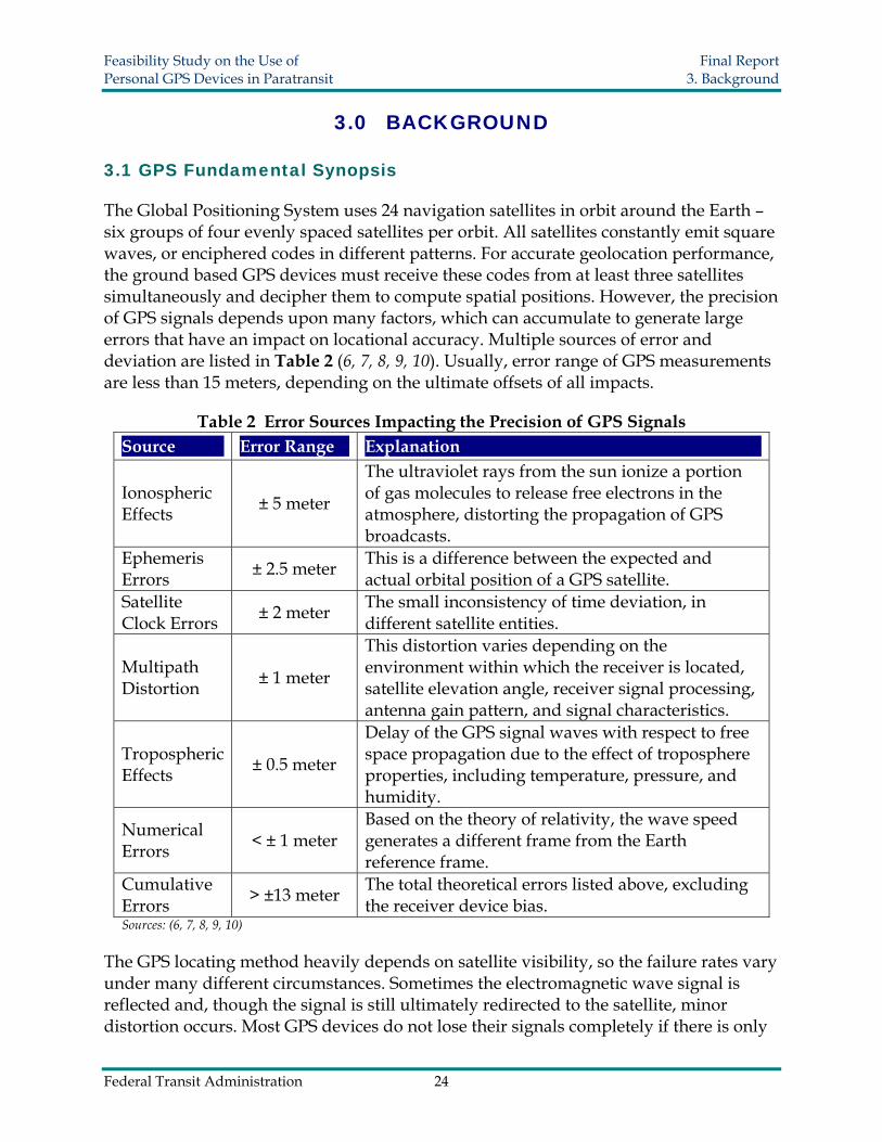
Feasibility Study on the Use of Final Report Personal GPS Devices in Paratransit 3 Background
In commercial businesses applications extend much further For instance car rental companies now have reliable methods for locating their vehicles at any instant for safety and security reasons By installing Automatic Vehicle Locating technology (AVL) rental companies have prevented improper usage reduced insurance costs and deterred theft In fact most major car rental companies have already implemented GPS navigation service as an optional accessory for their clientele Cargo tracking technology allows businesses to oversee cargorsquos movement by attaching a GPS tracker to containers and trucks This also enhances the security of transportation
Environmental scientists employ GPS in many research projects Many species have been extinguished because of encroachment and the consequent necessity to adapt to new habitats In Africa researchers from wildlife protection organizations use GPS trackers to collect data on elephant activity (16) With the database showing the living boundaries of these animals land use patterns can be modified to minimize the impact of human activities GPS also serves as a valid tool for vegetation management In Scotland researchers relied on GPS data to analyze and monitor herbivoresrsquo grazing locations Researchers determined with relative GPS modules affixed to roving animals had a mean accuracy of 10 m and precision was lt 10 m 95 of the time (17)
33 Location Based Service (LBS)
According to the definition provided by the SENSEable City Lab at the Massachusetts Institute of Technology (MIT) Location Based Service is the technology that allows instant identification of a mobile devicersquos exact position (18) There are generally four measures involved in achieving this goal cell identification angle of arrival time of arrival and enhanced observed time difference (19)
bull Cell identification determines the location based on the wireless network Usually a mobile phone communicates with the nearest signal tower and its location falls into the cell that the tower serves Due to the difference in shape or size of each cell the accuracy ranges from 100 meters to 600 meters
bull The angle of arrival calculation depends on the signal receiving direction At minimum two base stations are required to monitor the signal path and calculate the senderrsquos location using trigonometry principles The obtainable accuracy limits range from 50 meters to 150 meters varying due to signal travel path deflections
bull The time of arrival approach emits signals in all directions from three base stations The signals leave each station simultaneously and are reflected back Once they reach the device distances to the three stations are all known for positioning
bull The observed enhanced time difference approach is relatively complicated A mobile device is preinstalled with locating software that computes its own position and later the position is generated by nearby base stations
Federal Transit Administration 26
Feasibility Study on the Use of Final Report Personal GPS Devices in Paratransit 4 Locating Methodology
40 LOCATING METHODOLOGY
41 Location Interpretation
Only a limited amount of spatial distance deviation may be allowed to avoid missing a passenger who might be waiting on the other side of a building or merely a block away from a specified pickup location The most popular way to express a geographic position is using longitudelatitude coordinates These coordinate numbers can be converted to actual distances using a scale factor By converting sets of coordinates to linear distance users will have a better sense of whether the distance errors are acceptable
The conversion from coordinates to actual distances becomes more complicated as accuracy requirements become more demanding There are ways to depict distance on the Earthrsquos surface to a very exact degree if sufficient investment and equipment support are provided In fact the equipotential surface also referred as mean sea level is an irregular surface relative to an ideal ellipsoid surface so there is no universal mathematical formula to perform the algorithms to a very high degree of accuracy Yet an acceptable approximation method can be found on the Internet to complete the interpretation The Internet resource MaNISHerpNetORNIS Georeferencing Guidelines (20) provides a simplified conversion factor table as shown in Table 3
Table 3 Uncertainty Based on Coordinate Precision Using WGS84 Ref Ellipsoid
Precision 0 degrees Latitude
30 degrees Latitude
60 degrees Latitude
85 degrees Latitude
(all values in meters) 10 degrees 156904 146962 124605 112109 01 degrees 15691 14697 12461 11211 001 degrees 1570 1470 1247 1122 0001 degrees 157 147 125 113 00001 degrees 16 15 13 12 10 minutes 2615 2450 2077 1869 01 minutes 262 245 208 187 001 minutes 27 25 21 19 0001 minutes 3 3 3 2 10 seconds 44 41 35 32 01 seconds 5 5 4 4 001 seconds 1 1 1 1
From the above table it can be seen that the same degree of longitudelatitude differences equate to different real distances at different latitudes Because all our experiments were performed in Miami Florida where latitude is around North 25
Federal Transit Administration 27
Feasibility Study on the Use of Final Report Personal GPS Devices in Paratransit 4 Locating Methodology
degrees the second column data are employed because they are the closest conversion factors Here 1 minute is approximately equal to 2450 meters likewise 1 second is equal to 41 meters
42 Criteria for Selecting GPS Devices
To select the most appropriate mobile GPS devices for our paratransit pickup system the following criteria were considered portability reliability user friendliness durability compatibility and accuracy
bull Portability is one of the most basic requirements reflecting the necessary convenience since the device must be carried by users Generally speaking to satisfy this requirement a smaller sized device without the need for a power outlet is preferred so that it can be easily transported
bull Reliability ensures that GPS signals are acquired successfully free from other disturbance factors as GPS readings can vary due to time differences geographic location and weather conditions This criterion has no absolute quantitative measurements Therefore comparisons are performed among the different candidates to determine a relatively better choice after actual testing for a period of time
bull User friendliness is determined by how easily users can manipulate the device It would not be beneficial to spend large amounts of time on tutoring paratransit passengers how to use it In addition a nice-looking device is a plus
bull Durability concerns the usable life of the product including maintenance and future reoccurring costs It includes a study of the sustainability of the battery the fragility of the device and comparisons of administrative costs after the new system is implemented Note that using a single device for one year without problems is not enough evidence to declare a device durable
bull Compatibility requires that the newly developed operating platform has good adaptability and thus provides savings on overall expenditures and equipment Furthermore there should be a large enough margin for future hardware upgrades and functionality expansions
bull Accuracy is really the core criterion of employing GPS devices It ensures that the passengerrsquos exact location is known so that the vehicle will arrive directly in front of the passenger with little effort Each GPS device was tested a total of 40 times to retrieve position information at a control point for longitude and latitude readings
Federal Transit Administration 28
Feasibility Study on the Use of Final Report Personal GPS Devices in Paratransit 4 Locating Methodology
All tests were conducted within the course of two hours during a single day These data were then statistically examined and quantitatively compared With the aforementioned criteria in mind four mobile GPS devices were purchased for comparison analyses the Motorola i415 the Gemtek tracking device the HP iPAQ hw6945 and the Garmin Forerunner 305 Each device is discussed in the following sections Selection procedures provide typical examples of how the candidacy of a new device was evaluated It is unlikely that all criteria will be simultaneously embodied in one device Consequently positives and negatives had to be considered when determining device eligibility Among all criteria accuracy was the only parameter where the four devices could be compared quantitatively As a result further accuracy tests were conducted to draw a dependable conclusion
43 Motorola i415
431 Overview
The Motorola i415 (Figure 7) is a GPS enabled mobile phone Basic features include the regular Bluetooth cell phone walkie-talkie and GPS navigator The GPS locating service in this test is offered by Boost Mobile Company and an approximately $30 monthly service fee was charged at the time of this research for unlimited data transfers This does not include voice communication A service fee is necessary because Internet access is required to send location information Additionally the cell phone supports Java coding allowing for the implementation of potential applications to extend its adaptability and compatibility
Figure 7 Motorola i415
Federal Transit Administration 29
Feasibility Study on the Use of Final Report Personal GPS Devices in Paratransit 4 Locating Methodology
The voice communication offers another way to re-coordinate the pickup and can be used as an aid whenever the GPS fails For instance there may be cases when passengers experience technical problems and need to communicate with the service provider
432 Criteria Judgment
bull Portability As a regular mobile phone with dimensions 140 times 48 times 22 mm the Motorola i415 is convenient to carry A carrying case is generally available as an accessory option
bull Reliability There are still some reliability improvements that the manufactures can make There have been no breakdowns since testing however at low battery levels the GPS location readings are far beyond an acceptable range with deviations up to 500 meters As a consequence it is important to make sure that the device is always operated at a sufficient battery level According to a similar phonersquos support center the unreliability is due to several factors For instance a low battery cannot provide sufficient wireless signal strength or surrounding radio noises may be so strong as to cause interference When the GPS signal is weak or satellite visibility is low the locating method falls back to the GSM network (21) There is no significant evidence showing that cloudy weather had a significant impact on the readings Another deficiency is that text messages were occasionally difficult to send due to a failure to connect with the server It is expected that in the future GPS enabled cell phones will perform better
bull User Friendliness The Motorola i415 generally follows the typical cell phone panel arrangement hence people with experience using cell phones should become easily acquainted Tracking functions were able to be performed automatically with few manual operations once the research team designed and implemented a Java program code
bull Durability There was not sufficient time nor a sufficient sample size to draw conclusions as to the durability of this type of phone However the cell phone has a hard plastic texture and was still in good condition after one yearrsquos usage The power consumption is relatively short it only lasts about 8 hours in GPS active mode Yet this is still sufficient for a normal one-day service span
bull Compatibility The Java programmability of the Motorola i415 provides excellent compatibility and codes can be implemented into the device for user-defined tracking activities The project team created a program to simplify the tracking procedure so that only one press of the button is needed and rest of the task will be automatically completed
Federal Transit Administration 30
Feasibility Study on the Use of Final Report Personal GPS Devices in Paratransit 4 Locating Methodology
bull Accuracy Results from the 40 longitudelatitude readings were converted to real distance deviations in meters The results summarized in Figure 8 and Figure 9 represent readings obtained during the two hour period of testing Outliers resulting from low battery levels are excluded in the following analysis
Figure 8 Frequency Histogram for the Motorola i415
Freq
uenc
y
10
8
6
4
2
0 000 500 1000 1500 2000
Distance from Control Marker (meters)
Federal Transit Administration 31
Feasibility Study on the Use of Final Report Personal GPS Devices in Paratransit 4 Locating Methodology
Figure 9 Real Distance Deviation for the Motorola i415 (distance in meters)
-20
-15
-10
-5
0
5
10
15
20
-20 -15 -10 -5 0 5 10 15 20
Sout
h lt
----gt
Nor
th
West lt ---- gt East
The histogram shows that the majority of measurements had a deviation of less than 10 meters All of the results were within a distance of 20 meters from the center of the control point (survey marker) These observations seem accurate enough to provide a vehicle operator with confidence that his or her passenger is very near
44 Gemtek Tracking Device
441 Overview
The Gemtek tracking device (
Figure 10) allows for instant location queries as well as traveling path log recordin g Besides the wireless GPS communication channel a voice communication channel is also included A customer service phone number plus two user-defined phone numbe rs are preset The voice communication is enabled by pressing the corresponding speed dialing keys In case passengers cannot find the vehicle operator they can this function to contact the service provider Except for the two phone number limitation this device functions the same as a regular cell phone
Federal Transit Administration 32
Feasibility Study on the Use of Final Report Personal GPS Devices in Paratransit 4 Locating Methodology
Figure 10 Gemtek Tracking Device
Two other features worth mentioning are the SOS alarm and geofencing When the SOS alarm button is pr essed location information will be sent immediately to the pre-stored phone numbers for emergency assistance Another optional feature geofencing mode can be used to alert the designated contacts if the carrier goes beyond a predefined geographic zone
This device uses three colored indicator lights to show operating status The blu e flash starts when the device is turned on If the flash changes to green it indicates that i t is under GSM coverage If there is sufficient clearance the flash finally turns to red meaning the GPS satellite signal is being received The signal light provides an advantage since the user knows to move around for better satellite visibility The development of the Gemtek device was aimed at tracking seniors primarily for their own safety therefore many special functions are incorporated into the design
442 Criteria Judgment
bull Portability The Gemtekrsquos size is approximately 90 times 45 times 20 mm It comes with a leather bag in the package and is readily attachable to the wrist or belt
bull Reliability In both cool and warm starting modes it normally tak es about one minute for the GPS satellite signal to be acquired in an open environment As long as the red flashing light is on which indicates the device is in GPS coverage area the position information was instantly available upon a query entry
Federal Transit Administration 33
Feasibility Study on the Use of Final Report Personal GPS Devices in Paratransit 4 Locating Methodology
bull User Friendliness Because there are only seven buttons on the panel users are neither required to memorize phone numbers nor spend time familiarizing themselves with usage Appropriate phone numbers would be pre-programmed into the Gemtek device by transit agency staff
bull Durability During testing the device worked properly The battery lasted more than 20 hours if no voice calls were made and it supported up to four hours of talk time on a full battery charge
bull Compatibility Becaus e the Gemtek device is provided as a packaged end product including the service plan changes cannot be made internally As a result it is impossible to create customized applications since there is no way to load or implement programs
bull Accuracy The accuracy description of the Gemtek tracking device is different from the others Unlike the conventional longitudelatitude coordinates that define a point in a numerical manner the web application only provides a digital map or at most an aerial image for some urban areas With no obtainable numerical loc ation information there was no way to quantify the degree of accuracy As a result a rough estimation was performed Using high-resolution aerial images an estimate of 5 meters was chosen as the minimum distance interval and the data were grouped into four categories
Note in Figure 11 that none of the 40 test results fall outside of a 20-meter range an d 38 out of 40 trials are concentrated within a radius of 15 meters Only 2 out of 40 or 5 of the trials were located between a 15 and 20-meter interval Therefore the accuracy is likely to be satisfactory in real field applications of the paratransit pickup system
Federal Transit Administration 34
Feasibility Study on the Use of Final Report Personal GPS Devices in Paratransit 4 Locating Methodology
Figure 11 Gemtek Frequency Histogram and Estimated Distance Deviation
20
15
10
5
0
Freq
uenc
y
000 500 1000 1500 2000
Estimated Distance from Control Marker (meters)
45 Garmin Forerunner 305
451 Overview
The Garmin Forerunner 305 (Figure 12) is a multiple function electronic watch with GPS tracking capability This device was designed to monitor the userrsquos physical exercise conditions and thereby offer training guidance Some basic features include a stop watch palpitation measurement calorie consumption and route distance calculation Users are able to preset their exercise schedules into the watch including running distance heart rate and calorie consumption An alarm reminds the user whenever a certain goal is achieved Besides the watch component there is a band that can be worn on the userrsquos chest for measuring the heart rate This communicates with the watch wirelessly via Bluetooth
The watch records the longitudelatitude position continuously and all of the data can be later downloaded to computer by a USB cable From these data logs users can compare their exercise activities on a daily basis The Garmin Forerunner 305 has the best accuracy because it is World Wide Augmentation System (WAAS) supported Additionally the high sensitivity SiRFstar III antenna gives it extraordinary dependability Yet a lack of wireless communication channels excludes it from the candidate pool essentially no position information can be transmitted instantly via
Federal Transit Administration 35
Feasibility Study on the Use of Final Report Personal GPS Devices in Paratransit 4 Locating Methodology
wireless Because there is no wireless communication channel there is no way to instantly send back location information to an agency Hence it is not feasible to use the Garmin Forerunner 305 in this project
Figure 12 Garmin Forerunner 305
452 Criteria Judgment
bull Portability The Garmin Forerunner 305 easily satisfies the portability requirement because it is a wristwatch size and unlikely to inconvenience users
bull Reliability One of the shining points of this product is the integration of a high sensitivity SiRFstar III GPS antenna The extraordinary signal detectability is superior to the other three devices and takes significantly less time to retrieve position coordinates
bull User Friendliness With more user functions available the device requires extra learning time for users to familiarize themselves
bull Durability A disadvantage is that the battery life only lasts about 4 hours This is much shorter than a typical service day or even the service span of a round trip If a passenger has to stay somewhere for more than 4 hours it would be necessary to turn off the device to reserve sufficient battery power for the return trip
bull Compatibility Lack of compatibility is the major flaw of the Garmin Forerunner 305 for this project The current cost of implanting a wireless communication chip into a small watch is not yet popular for civilian use but may become more realistic in the future More importantly this watch is non-programmable and no alternations can be made to accommodate a custom application for this device
bull Accuracy Accuracy is perhaps the most outstanding feature of this product because of its integration with Wide Area Augmentation System (WAAS) technology The
Federal Transit Administration 36
Feasibility Study on the Use of Final Report Personal GPS Devices in Paratransit 4 Locating Methodology
majority of GPS measurements fall within six meters of the control point regardless of the battery level or sky conditions The maximum distance deviation was only eleven meters (Figure 13) Combined with its high reliability the Forerunner 305 proves WAAS has a better locating accuracy than ordinary GPS technology
Coincidentally all points are aligned perfectly in both vertical and horizontal directions this is because the reading digits can only reach the third decimal in seconds Several points overlap and thus appear as fewer dots on the distance deviation chart (Figure 14) In terms of actual distance there is a systematic error approximately larger than 13 meters because of the number of decimals The interspaces between points are always multiples of 13 meters
Figure 13 Frequency Histogram for the Garmin Forerunner 305
10
8
6
4
2
0
Freq
uenc
y
000 200 400 600 800 1000 1200
Distance from Control Marker (meters)
Federal Transit Administration 37
Feasibility Study on the Use of Final Report Personal GPS Devices in Paratransit 4 Locating Methodology
Figure 14 Garmin Forerunner 305 Real Distance Deviation (distance in meters)
-10
-75
-5
-25
0
25
5
75
10
-10 -75 -5 -25 0 25 5 75 10
Sout
h lt
---- gt
Nor
th
West lt ---- gt East
46 HP iPAQ hw6945
461 Overview
The HP iPAQ hw6945 (Figure 15) is a powerful Personal Digital Assistant (PDA) that uses the Windows Mobile 5 operating platform Its volume is slightly larger than a regular cell phone however its powerful capabilities by far exceed those of the other handheld devices reviewed here Many advanced technologies are integrated into the device making it a versatile choice but also an expensive one
Examining the feasibility of the iPAQ is quite different from examining the other devices because its capabilities can assist beyond the role as a pickup connection assistant The HP iPAQ hw6945 supports wireless Internet access allowing users to check email send text messages and read news if desired The software platform provides plenty of personalization options However the same adaptability that can be seen as an advantage will lead to slower implementation because an agency may have to spend significant amounts of time training users on how to manipulate the device to its full capability The HP iPAQ hw6945 is versatile in different fields A small screen shows driving directions and a digital map image leading to the correct path Overall this device seems more suitable for use at the vehicle operatorrsquos terminal since it can offer very specific navigation instructions
Federal Transit Administration 38
Feasibility Study on the Use of Final Report Personal GPS Devices in Paratransit 4 Locating Methodology
Figure 15 HP iPAQ hw6945
462 Criteria Judgment
bull Portability The HP iPAQ hw6945 is approximately 71 times 18 times 118 mm - slightly larger than other devices A clip is included that can easily hold the device to a belt
bull Reliability The HP iPAQ hw6945 is programmable but problems may arise due to conflicts among software applications The antenna sensitivity is similar to the Motorola i415 Unlike the previously tested cell phone no significant positioning errors were found due to a low battery level
bull User Friendliness Loaded with multi-media players games daily planning tools and a number of other software applications users are able to fully utilize their time for work study and leisure However for users who are less acquainted with PDAs this device may be a challenge Seniors with visual impairments may have difficulty reading the small fonts on the screen Users might press the wrong button and have problems returning to the original application The high cost may make agencies and passengers reluctant to use this device
bull Durability Even though this device has a higher price and requires strict handling it promises a longer usable life It is advisable to insure the device for damage maintenance or replacement
bull Compatibility Compatibility is the most promising feature of this product The device is readily adaptable because program coding can be easily implemented into the operating environment
Accuracy Although the PDA is more expensive than most mobile GPS devices it does not guarantee better accuracy The majority of measurements fell within a radius of 20 meters with only two measurements were greater than 20 meters from the control marker (Figure 16 amp Figure 17) The accuracy of HP iPAQ hw6945 performance was comparable to the other devices tested in this project
Federal Transit Administration 39
Feasibility Study on the Use of Final Report Personal GPS Devices in Paratransit 4 Locating Methodology
Figure 16 Frequency Histogram for the HP iPAQ hw6945
Freq
uenc
y 6
4
2
0 000 500 1000 1500 2000 2500
Distance from Control Marker (meters)
Figure 17 HP iPAQ hw6945 Real Distance Deviation (distance in meters)
-25
-20
-15
-10
-5
0
5
10
15
20
25
-25 -20 -15 -10 -5 0 5 10 15 20 25
Sout
h lt
---- gt
Nor
th
West lt ---- gt East
Federal Transit Administration 40
Feasibility Study on the Use of Final Report Personal GPS Devices in Paratransit 4 Locating Methodology
47 Accuracy Tests
All accuracy tests were performed at a fixed survey marker (Figure 18) The local control point for this testing was the Florida Department of Transportation survey marker (identification number PN04A) that has a standard longitudelatitude value of W8036888 and N2576909 as defined by geodic authorities All readings were collected uniformly to provide an adequate basis for comparison The data were analyzed with the t test in order to calculate confidence interval comparing accuracy limitations
Figure 18 Image of the Survey Control Marker
Equation 1 was used to estimate the probability that a GPS reading will fall within a certain distance based on a specified confidence level Because the sample size is greater than 30 and the data are normally distributed the sample mean can be approximated to the population mean Similarly the population variance can be substituted by the sample variance in the calculation
Equation 1 x minus μ = z sdotδ
where x = the average from the experiment μ = the population mean δ = the standard deviation z = the z score associated with the degree of confidence selected
Table 4 shows the Deviation distance ranges at different confidence levels it also provides the probability that an observation will be less than or equal to the specified distances 10 m 15 m and 20 m The Gemtek device was not included in the accuracy test because the device did not give the user latitudelongitude information It is designed to provide users with only address information and digital map images The
Federal Transit Administration 41
Feasibility Study on the Use of Final Report Personal GPS Devices in Paratransit 4 Locating Methodology
Garmin 305 was excluded from testing for its lack of communication abilities GPS information cannot be sent from the device it can only be downloaded
In Table 4 δ is the standard deviation of the observed readings and the numbers in the confidence interval columns list the corresponding deviated distance at the 85 90 and 95 confidence intervals
Table 4 Devices Accuracy Performance Motorola i415 HP iPAQ hw6945
X 938 m 1178 m δ 445 547
Deviation distance ranges at different confidence levels
85 1525 1900 90 1697 2111 95 2030 2520
Probability of GPS observations within a certain range
10 m 5557 3725 15 m 8969 7224 20 m 9914 9368
To further estimate the accuracy performance of the two selected devices confidence intervals around the mean were calculated Equation 2 was used to provide the confidence interval of the population mean at a specified level of confidence (Table 5)
Equation 2
X minus z 2α times n
S le μ le X + z 2α times
n S
Table 5 Devicesrsquo Confidence Intervals Around the Mean
Confidence Level Motorola i415 HP iPAQ hw6945
Lower Bound
Upper Bound
Lower Bound
Upper Bound
85 z α2 ~144 837 1039 1053 1303
90 z α2 ~1645 822 1054 1036 1320
95 z α2 ~196 800 1076 1008 1348
48 Benefit Cost Analysis
The total cost of each device in operation is critical in determining whether agencies will accept them Table 6 and Figure 19 show the starting and operating expenses of the
Federal Transit Administration 42
Feasibility Study on the Use of Final Report Personal GPS Devices in Paratransit 4 Locating Methodology
three devices The cost of each device is an influential factor that may govern the willingness of transit agencies to adopt the new concept in real applications The cost is not limited to the initial investment but also to the recurring operating costs Higher costs are usually associated with more functionality and so a compromise between cost and capability is typical
Table 6 Devicesrsquo Costs Comparisons Device Motorola i415 Gemtek Device HP iPAQ hw6945 Device cost $40 $400 $600 Monthly fee $10 $20 $50 First year total costs $160 $640 $1200
Figure 19 Total Cost of Each Device for a 12 Month Period
0
300
600
900
1200
1500
1 2 3 4 5 6 7 8 9 10 11 12 13
Month
Tot
al C
osts
($)
HP iPAQ h 6945
Gemtek Device
Motorola i415
Federal Transit Administration 43
Feasibility Study on the Use of Final Report Personal GPS Devices in Paratransit 5 GPS Prototype
50 GPS PROTOTYPE
51 Prototype Development
After all devices were tested for their specific functionalities a GPS prototype was developed to explore the feasibility of integrating multiple devices into a complete working system The best solutions combined use of the GPS enabled Motorola i415 cell phone and the HP iPAQ hw6945 PDA This prototype connects the passenger vehicle operator and the agency dispatcher together via a central computer To synchronize these devices separate programs namely iTrack and LocateYou were created The iTrack application was written in Java for the Motorola i415 and the LocateYou application was written in C for the HP iPAQ hw6945 The web application prototype was developed in ASP Net These software applications were specifically created by LCTR staff to test the capabilities of these GPS devices
No prior knowledge is required to operate the system Once the devices are turned on the iTrack and LocateYou programs are automatically initiated and position information is continuously acquired from satellites and sent to the server The server translates the position coordinate numbers to point marks on the Microsoft Live Map and Google Map so that the agency dispatcher can track both the passengers and vehicles The HP iPAQ hw6945 uses Google Map as a background to indicate locations on its screen Likewise the central server computer screen employs Google Earth including a three-dimensional view and Microsoft Live Map to display locations Consequently both the agency dispatcher and the PDA carrier are able to view the carrierrsquos location in digital map form
52 Functionality
It is important to know how the iTrack and LocateYou programs work with each other Basically the mobile device must be GPS enabled and support Java to run this program The iTrack program is a J2ME MIDlet (22 23) application that supports any J2ME platform of mobile phones The iTrack has three basic steps in its running thread
bull First it communicates with the internal GPS device through a serial port and acquires the GPS signal If the GPS signal is successfully connected the screen displays a message reading ldquoMy GPSOnrdquo Once the signal connection succeeds the location queries are made automatically every few minutes depending on how the program is defined
bull Second an HTTP request is formed and is sent to the server describing the current status of the device In the case wherein a GPS signal is obtained this HTTP request includes the current longitude and latitude coordinates Additionally moving speed
Federal Transit Administration 44
Feasibility Study on the Use of Final Report Personal GPS Devices in Paratransit 5 GPS Prototype
and time information are also appended to the request and sent to the server On the other hand if a GPS signal connection fails to connect an HTTP request describing the current failure status is sent to the server The server stores all of these data to a database as an activity log for future reference
bull Lastly the server produces three similar location data packages for the dispatcher the passengers and the vehicle operator upon receiving the HTTP request For the dispatcher the locations of all mobile devices are marked on Internet maps specifically Google Earth and the Microsoft MapPoint web service (23) Similar data packages are also sent to the vehicle operator and the passenger
A detailed data flow of the prototype is summarized in Figure 20 The central server functions as a hub to effectively maintain communications among the dispatcher vehicle operator and passenger All information from these three parties is initially received modified and shared in the central server
Figure 20 Graphical Display of the Prototype
53 Prototype Application in Use
During the pickup process the geographical locations of both the Motorola i415 and the HP iPAQ hw6945 are obtained from satellites and sent to the nearest wireless signal tower The central server combines the Internet map service and location information from the GPS devices to generate an individual data package for the dispatcher the vehicle operator and the passenger From the PDA screen the vehicle operator is able to see driving directions as well as the passengerrsquos location on a digital map Similarly
Federal Transit Administration 45
Feasibility Study on the Use of Final Report Personal GPS Devices in Paratransit 5 GPS Prototype
the passenger receives the waiting time a nd vehicle distance Therefore pickups can become more punctual and predictable with the aid of this new approach At the same time a service log of all activities is recorded into the system database
In the historical log two types of tracking logs are available real time tracking and historical tracking Real time tracking means the indicated location markers shown in the iPAQ screen are automatically refreshed as updated information is received This is very helpful in the middle of the service task when the vehicle operator cannot find a passenger on local streets Historical tracking as the name suggests is the tracking log of the previous services These datasets are readily accessible whenever evaluation or references for past services are required
If the Motorola i415 is used by the driver as an option driving instructions are provided An example of the data packages received by the device is shown in Figure 21 The screen presents the estimated driving time and distance By clicking the ldquoDirectiordquo button detailed directions are displayed Sometimes the other device is not connected to the GPS signal and the screen displays the text Tracked ldquoGPSOffrdquo Upon seeing this message users should move around to restore a better GPS signal reception The dispatcher is also aware of the status of the passengerrsquos mobile GPS and this information allows the dispatcher to call the user or driver with additional instructions if necessary However when lacking a map image only verbal instructions can be communicated to the users
Figure 21 Screen Captures of Motorola i415
The HP iPAQ hw6945 device was also considered for use by the paratransit driver because complex images on a bigger screen can provide a more detailed passenger location map The LocateYou program works differently from iTrack by integrating the Google Map application as the mapping template Hence directions are provided and users can switch to a digital map image that is returned by the server Screen captures of the PDA are shown in Figure 22 The first screen depicts the passengerrsquos location in longitudelatitude coordinates and the second screen shows where the passenger is waiting on a digital map
Federal Transit Administration 46
Feasibility Study on the Use of Final Report Personal GPS Devices in Paratransit 5 GPS Prototype
Figure 22 Screen Captures of HP iPAQ hw6945
The dispatcherrsquos computer shows the vehiclesrsquo and passengersrsquo information such as route path travel distance direct distance and estimated driving time An example of the dispatcherrsquos computer is shown in Figure 23 The digital map image updates whenever a device reports a new location With the aid of the tracking platform it is expected that the occurrence of missed trips will be avoided in some situations
Figure 23 Device Locations Map for Dispatcher
For demonstration purposes in this prototype the passenger carries the Motorola i415 mobile phone and the driver carries either another Motorola i415 mobile phone or the
Federal Transit Administration 47
Feasibility Study on the Use of Final Report Personal GPS Devices in Paratransit 5 GPS Prototype
HP iPAQ hw6945 Users need only turn on the mobile GPS devices to ensure that their work status is active Because the locations of all mobile devices are known instantly the vehicle operator can promptly arrive at the passengerrsquos location by following the driving directions
A more detailed demonstration example of this prototype application can be viewed at the following URL httpgpstranspolctrorg
Federal Transit Administration 48
Feasibility Study on the Use of Final Report Personal GPS Devices in Paratransit 6 Conclusion
60 CONCLUSION
Because missed trips commonly occur at all paratransit agencies advanced GPS technology may have a role in relieving such problems in the future The methodology and prototype developed in this project offer a completely new pickup concept compared with current operation methods GPS location technology offers an accurate fast dependable and feasible alternative tool to help avoid missed pickups resulting from operational errors or pickup requests at ambiguous locations
After examining the features of four GPS mobile devices it became evident that some devices are not feasible for assisting with paratransit operations Two of the devices were considered to be less suitable than their counterparts The Gemtek device has a good design in many respects but loses its candidacy due to poor compatibility it is not programmable and cannot be coded to work with a peer device The Garmin Forerunner 305 by taking advantage of WAAS achieves the best accuracy performance among all of the devices But it has no wireless channel to communicate with a server and is unable to inform location information to other receptors
On the other hand the two programmable GPS devices the Motorola i415 and the HP iPAQ hw6945 were ready to be used in the development of a computer controlled pickup system The prototype integrates these two devices and synchronizes them by installing the iTrack and LocateYou programs Simulations were performed to show that this prototype methodology could be applied in the real world This prototype presents a potential solution to missed pickups by using GPS tracking technology
Additionally the use of programmable devices may assist with other service improvements Many personal GPS mobile devices come with optional features that can potentially be leveraged to provide further improvements in the future To attract more passengers transit agencies might consider exploring additional functionalities such as medical care alarms and appointment reminders In the future agencies will have the freedom to decide the most suitable technology based on desired functionalities
There are indeed further challenges to the real world usage of this kind of paratransit pickup service methodology The complexity of the system requires trained personnel and individuals who are familiar with computer information and technology The high initial costs of design and purchase lack of agreed upon data standards privacy issues and legal concerns are all barriers to deployment The initial phase of set up and operation may be so complex that even minor employee turnover may spark major setback However if these obstacles can be overcome bringing personal mobile GPS technology into the paratransit industry is a feasible solution for improving the conventional pickup procedure Implementation of GPS technologies can help improve the level of service and reduce agenciesrsquo operating expenses in the long run
Federal Transit Administration 49
Feasibility Study on the Use of Final Report Personal GPS Devices in Paratransit 7 Future Research
70 FUTURE RESEARCH
71 Prototype Improvements
Assisting features were also studied to highlight additional potential advantages of the prototype All of the following options are available depending on local transit agency preferences
711 Alarm Notification
To enhance the prototype performance alarm notifications can be implemented A ringing notification will sound if the passenger is close to the driver or the driver is out of the expected path to the passengers This feature can help the vehicle operator to reach the passenger and gain his or her attention immediately if necessary
712 Administrator Website
The administrator webpage is an application built to help transit agencies improve management and operation It can be integrated with GIS to show the closest vehicles upon request In this application all mobility devices can be shown on a single screen map With the assistance of computer programs agency dispatchers can send the closest vacant vehicle immediately to finish the service task thereby optimizing vehicle management
713 Voice and SMS
The Skype and Microsoft text-to-speech service as well as the Short Message Service (SMS) can potentially be incorporated to offer voice service An automated voice service is capable of handling simple phone queries made by vehicle operators or passengers It can also be used to direct users to the most appropriate personnel SMS is another alternative communication technique in which users can read and review important instructions in case they are forgotten For arrangements coming from the agency to the vehicle operator agency staff can send text messages manually to give instructions and the message is kept as a reference until the task is finished This function can help minimize human error
714 Historical Log
The communication information for each task including short messages location data and pickup arrangements can be saved into a historical database for future reference The historical log collects all statistical information which agencies can periodically use to evaluate and improve their performance
Federal Transit Administration 50
Feasibility Study on the Use of Final Report Personal GPS Devices in Paratransit 7 Future Research
715 Use as a Tracking Device for Persons with Cognitive Disabilities
Although the GPS device is primarily intended to aid with the paratransit pickup process the system also holds promise for serving as a locating device for persons who suffer from cognitive disabilities A small but significant percentage of existing paratransit riders suffer from dementia Alzheimerrsquos disease or another cognitive problem Some of these riders may be willing to utilize the tracking device for additional hours during the day In this situation the tracking device would then also serve as a valuable tool for locating the individual if he or she becomes lost or confused
Currently there are several variations of the aforementioned device available in the market The idea of tracking and monitoring of persons with cognitive disabilities has become more of a popular idea over the last few years Such a system allows individual with mental disabilities to maintain a high degree of freedom but provides a safety net in the event of an emergency If an appropriate prototype GPS website can be developed ridersrsquo friends and family members may be able to determine the exact location of a lost or confused individual on their own there by circumventing the need to contact emergency personnel
Certain issues still remain such as how to continuously power some of the GPS devices Additional battery technology may need to be developed before additional tracking is feasible Furthermore privacy issues and concerns would need to be addressed by all involved parties
72 Cost amp Benefit Ratio Evaluation
In business whether a new alternative is cost effective or not determines its future applicability In order to determine the value of applying personal GPS devices in paratransit more information about transit agenciesrsquo operational expenses needs to be collected and examined This will ensure that a cost efficient method of employing new technologies is selected
One factor which needs to be studied further relates to the pricing of wireless services Currently several of the cell phoneGPS service providers charge a standard rate for a specific number of voice calls or minutes of talk time However this project depends on sending data wirelessly for an undetermined amount of time Few wireless service providers have structured plans for sending data over their network The cost of applying personal GPS devices in paratransit may well depend on negotiated rates for sending constant locational data for long periods of time
Federal Transit Administration 51
Feasibility Study on the Use of Final Report Personal GPS Devices in Paratransit 7 Future Research
73 Finding Newer Suitable Devices
All of the testing devices were ready-available technologies when this project commenced As the civilian GPS market develops the debut of more powerful GPS devices will provide extra options and support for new operating systems Newer units and technology may enable the GPS signal to be picked up better in certain environments Currently signal problems are often experienced if the user is inside a large building or in a dense urban environment with a substantial number of tall buildings Problems have also been noted using GPS devices in heavily forested locations In the future newer devices and the increased usage of assisted GPS will ensure that a clear signal is continuously received
74 Attempting a Pilot Program
In the long run the pickup process can possibly be combined with service vehicle assignments If there is a change request from a passenger the system will immediately determine the most economical way to rearrange the service schedule Potential benefits include less time needed for reservations and services that are more adaptable to instantaneous changes
Federal Transit Administration 52
Feasibility Study on the Use of Final Report Personal GPS Devices in Paratransit References
REFERENCES
1 Weiner R (1998) ADA paratransit eligibility certification practices In Transportation Cooperative Research Program Synthesis of Transit Practice 30 Transportation Research Board of the National Academies Washington DC Retrieved August 8 2008 from httponlinepubstrborgonlinepubstcrptsyn30pdf
2 Lave R and R Mathias (2000) State of the art of paratransit In Transportation in the New Millennium State of the Art and Future Directions Perspectives from Transportation Research Board Standing Committees Transportation Research Board of the National Academies Washington DC pp 1-7 Retrieved August 1 2008 from httponlinepubstrborgonlinepubsmillennium00107pdf
3 Simon R M (1998) Paratransit contracting and service delivery methods In Transportation Cooperative Research Program Synthesis of Transit Practice 31 Transportation Research Board of the National Academies Washington DC Retrieved October 2 2008 from httpgullivertrborgpublicationstcrptsyn31pdf
4 Mathias R G and R E Smith (2005) Practices in no-show and late cancellation policies for ADA paratransit Transportation Cooperative Research Program Synthesis 60 Transportation Research Board of the National Academies Washington DC Retrieved August 4 2008 from httponlinepubstrborgOnlinepubstcrptcrp_syn_60pdf
5 Miami-Dade Transit (2008) Miami-Dade County transit paratransit operations monthly report April 2008 Retrieved July 31 2008 from httpwwwmiamidadegovtransitparatransitaspmdt_reports
6 Nelson R A (1999) The global positioning system A national resource Via Satellite November Retrieved on October 1 2008 from httpwwwaticoursescomglobal_positioning_systemhtm
7 Langley RB (1997) The GPS error budget GPS World 8(3) 51-56
8 Hofmann-Wellenhof B Lichtenegger H amp Collins J (1997) GPS Theory and practice New York Springer
9 Kaplan E D and C Hegarty (Eds) (2005) Performance of stand-alone GPS In Understanding GPS Principles and Applications (pp 301-378) Norwood MA Artech House Inc
10 Global positioning system (October 2008) Retrieved October 3 2008 from the Wikipedia Encyclopedia httpenwikipediaorgwikiGlobal_Positioning_System
Federal Transit Administration 53
Feasibility Study on the Use of Final Report Personal GPS Devices in Paratransit References
11 LaMance J Jarvinen J amp DeSalas J (2002 March 1) Assisted GPS A low-infrastructure approach GPS World 46-51
12 Assisted GPS (September 23 2008) Retrieved October 1 2008 from the Wikipedia Encyclopedia httpenwikipediaorgwikiA-GPS
13 US Department of Transportation (2001 August 13) Federal Aviation Administration specification for the wide area augmentation system (WAAS) Specification FAA-E-2892b Retrieved October 3 2008 from httpwwwfaagovaboutoffice_orgheadquarters_officesato
service_unitstechopsnavservicesgnsslibrarydocuments
14 Wide area augmentation system (September 29 2008) Retrieved October 3 2008 from the Wikipedia Encyclopedia httpenwikipediaorgwikiWide_Area_Augmentation_System
15 Stewart M A (September 2005) Tracking cattle in the heartland Geospatial Solutions Retrieved July 16 2008 from httpwwwgeospatialshyonlinecomgeospatialsolutionsarticlearticleDetailjspid=177059ampsk=ampdate=amppag eID=4
16 GPS tracking Save the Elephants Retrieved July 16 2007 from httpwwwsavetheelephantsorgdisplayasplinkID=59ampdisplayID=58
17 Hulbert I A R amp French J (2001) The accuracy of GPS for wildlife telemetry and habitat mapping Journal of Applied Ecology 38(4) 869-878 Retrieved on August 17 2008 from httpwww3intersciencewileycomcgi-binfulltext118869609PDFSTART
18 Ratti C R M Pulselli S Williams and D Frenchman (2006) Mobile landscapes Using location data from cell-phones for urban analysis Environment and Planning B Planning and Design 33(5) pp 727-748
19 Axel Kuumlpper (2005) Location-based services Fundamentals and operation Chichester West Sussex England John Wiley amp Sons Ltd
20 Wieczorek J (September 2001) MaNISHerpNetORNIS Georeferencing Guidelines The Regents of the University of California Retrieved July 28 2008 from httpmanisnetorgGeorefGuidehtml
21 Frequently asked questions Wireless Location Services Retrieved September 20 2007 from httpwwwwherifycomhtmlfaqasppageId=133
Federal Transit Administration 54
Feasibility Study on the Use of Final Report Personal GPS Devices in Paratransit References
22 Zahakiel J2ME MIDlet (2007) Retrieved March 10 2007 from the Wikipedia Encyclopedia httpenwikipediaorgwikiMIDlet
23 Microsoft MapPoint Microsoft MapPoint web service (2008) Retrieved March 10 2008 from httpwwwmicrosoftcommappointproductswebservicedefaultmspx
Federal Transit Administration 55
Feasibility Study on the Use of Final Report Personal GPS Devices in Paratransit Glossary
GLOSSARY
Cool Start - Cool start occurs when a GPS device initiates without any memory about Ephemeris data such as a completely new start For more information refer to hot start
Differential Global Positioning System (DPGS) - An enhancement to GPS that uses a network of fixed ground-based reference stations to broadcast the difference between positions indicated by the satellite systems and known fixed positions
Global Positioning System (GPS) - Developed by the US Department of Defense GPS is a fully functional Global Navigation Satellite System (GNSS) More than two dozen GPS satellites are in medium earth orbit transmitting signals that allow receivers to determine their locations speeds and moving directions
Global System for Mobile communications (GSM) - is a digital mobile telephony system that is widely used in Europe and other parts of the world GSM uses a variation of time division multiple access and is the most widely used of the three digital wireless telephony technologies
Hot Start - A Warm or Hot Start state occurs when a GPS unit has some knowledge of the current Ephemeris data Only a minor update is required for a warm start and possibly no update for a hot start Little or no information is required since nearly a complete set of information is present in the unit
Paratransit ndash Several types of paratransit services exist ADA Paratransit the service most commonly referred to is mandated by the Americans with Disabilities Act and requires that public transportation agencies provide complementary public transportation for individuals who are physically or mentally unable to ride fixed route transit Other hybrid paratransit services which go above and beyond ADA requirements are often referred to as demand response or dial-a-ride services These services may vary considerably on the degree of flexibility they provide their customers
Personal Digital Assistant (PDA) - Also known as pocket computers or palmtop computers PDAs are handheld computers that have both color screens and audio capabilities enabling them to be used as mobile phones (smart phones) web browsers or portable media players Many PDAs can access the Internet intranets or extranets via Wi-Fi or Wireless Wide-Area Networks
SiRFStar III Receiver - SiRFstar III is the latest GPS microcontroller chip manufactured by SiRF Technology It is distinguished from earlier SiRF chips and other brand chipsets
Federal Transit Administration 56
Feasibility Study on the Use of Final Report Personal GPS Devices in Paratransit Glossary
largely due to its faster Time to First Fix (TTFF) and its ability to acquire and maintain a signal lock in urban or densely covered forest environments
Wide Area Augmentation System (WAAS) - An extremely accurate navigation system developed for civil aviation by the Federal Aviation Administration (FAA) a division of the U S Department of Transportation Originally developed to allow aircraft greater reliance on GPS the system augments GPS to provide additional accuracy integrity and availability within the WAAS coverage area
Wi-Fi - The trade name of a wireless technology Originally licensed by the Wi-Fi Alliance it describes the underlying technology of wireless local area networks (WLAN) based on the IEEE 80211 specifications It is currently used for mobile computing devices Internet and VoIP phone access gaming and basic connectivity of consumer electronics
Federal Transit Administration 57
Feasibility Study on the Use of Final Report Personal GPS Devices in Paratransit Appendix B
APPENDIX A Additional Survey Results
This Appendix contains extra information obtained from the paratransit survey The survey was discussed in Section 20 however additional specifics are provided below
Inquiries about service performance found that most transit agencies rated their paratransit operating characteristics as being either good or very good Rarely did agencies rate their services as not good or even neutral (Figure 24)
Figure 24 Paratransit Agency Service Evaluations
Not Neutral Good 3
3 Very Good
Good Very44
44 Good Good 53 53
On Time Performance Availability in Community
Cleanliness amp Comfort
Very Good 50
Good 44
Neutral 6
Service Time Span
Good 52
Very Good 42
Not Good
3
Neutral 3
Passenger instructed waiting time and the time window for vehicle pick up vary considerably among agencies (Figure 25) Though not indicative of cost these two measurements give an indication of paratransit service standards A short instructed wait time and a more specific time window are likely to be greatly appreciated by paratransit passengers
Federal Transit Administration 58
Feasibility Study on the Use of Final Report Personal GPS Devices in Paratransit Appendix B
Figure 25 Comparison of Instructed Wait Times and Time Windows for Pick-up
0
2
4
6
8
10
12
14
16
0 min 5 min 10 min 15 min 20 min 30 min 45 min 60 min
Num
ber o
f Age
ncie
s
Passenger Instructed Wait Time n=30 Time Window of Vehicle for Pick-up Time n=36
Average pay rates for a paratransit vehicle operator ranged between $8 and $18 dollars per hour but one agencyrsquos average hourly pay for drivers was over $20 (Figure 26) For the 31 agencies reporting the average hourly pay for a paratransit driver was $1286
Figure 26 Average Hourly Pay for Paratransit Operators (in Dollars)
5
4
800 1000 1200 1400 1600 1800 2000 2200
Res
pond
ents
3
2
1
0
Average Hourly Pay (in Dollars)
Federal Transit Administration 59
Feasibility Study on the Use of Final Report Personal GPS Devices in Paratransit Appendix B
Statistical information obtained from the remaining survey questions is located in Table 7 The number of agencies responding to the question along with minimums maximums means and standard deviations are provided Since most of the results have fewer than 30 respondents the data is not preferable for further statistical analysis
Table 7 Statistical Summary of Survey Variables Variable N Min Max Mean Std D
Instructed Time to Wait before Veh Arrival (mins) 31 0 60 177 152
Time Window Vehicles are Scheduled to Arrive (mins) 36 0 60 236 134
Mins Driver is Allowed to Spend Finding Passenger 16 3 15 63 37
Total Number of No-Shows During Last Year 34 4 108371 8023 19656
Total Number of Passenger Trips During Last Year 35 746 1584382 234992 397705
of No-Show Trips to Total Passenger Trips 34 002 923 253 226
Estimated of No-Shows due to Connection Failures 25 000 8000 1102 2313
Total No-Show Losses per Year 23 $60 $716000 $88892 $184989
Average No-Show Losses per Month 16 $19 $48922 $6435 $12166
Average No-Show Losses per Trip 20 $1000 $3015 $1903 $556
Average Hourly Pay for Paratransit Vehicle Driver 31 $778 $2021 $1286 $296
Suspended Passengers 33 0 1293 59 228
Total Passengers 34 0 692000 85552 166477
of Suspensions to Total Passengers 30 000 444 026 084
Federal Transit Administration 60
Feasibility Study on the Use of Final Report Personal GPS Devices in Paratransit Appendix B
Passenger trip purposes are an important factor known to influence no-show trips Shopping and medical trips tend to have higher no-show rates because pickup location and appointed pickup time can vary considerably Visiting or social trips and work trips have slightly higher trip completion rates since residential addresses are more easily found and work trips are often routine appointments at a particular location and time Results are summarized in Table 8
Table 8 Classification of Trip Purposes
Agency Shopping Medical Visiting amp Recreation Work Other
1 20 55 10 10 5 2 38 50 5 7 -3 20 25 20 35 -4 16 65 1 18 -5 10 20 15 27 28 6 10 40 10 30 10 7 13 65 2 20 -8 1 7 15 77 -9 15 50 5 30 -10 23 53 1 7 16 11 10 50 5 30 5 12 15 50 30 5 -13 35 40 2 3 20 14 15 45 - 35 5 15 4 28 2 18 48 16 10 85 1 2 2 17 12 40 9 2 37 18 22 52 14 12 -19 10 70 10 10 -20 5 50 5 20 20 21 16 19 15 50 -22 10 30 5 40 15 23 3 95 1 1 -24 17 39 - 17 27 25 18 30 5 45 2 26 40 30 10 20 -27 5 30 10 55 -28 6 20 30 42 2 29 5 23 33 27 11 30 25 50 10 10 5 Summarized Statistical Values Min 1 7 0 1 0 Max 40 95 33 77 48 Avg 1499 4355 937 2350 860
Federal Transit Administration 61
Feasibility Study on the Use of Final Report Personal GPS Devices in Paratransit Appendix B
APPENDIX B Survey Instrument
1 Please fill out the following information Full Name of Transit Agency Address Contact Person Phone Number Email
2 What technology does your agency currently use to communicate between the dispatch center and the vehicle operator (eg telecommunication walkie-talkie or wireless internet etc)
3 How interested is your agency in applying new technology such as GPS to minimize the numbers of connection failures when picking up passengers
4 How would you rate your agencys service performance Please use a 1 to 5 scale with 1 being the poorest and 5 representing the best
(5) (4) (3) (2) (1) On-Time Performance Availability in the Community Cleanliness and Comfort Service Time Span
5 How many minutes is a passenger instructed to wait prior to the arrival of the paratransit vehicle
6 How many minutes is the time window your vehicles are scheduled to arrive at the appointed pickup time
7 If a driver has difficulty finding the address or pickup location how much time in minutes is shehe instructed to spend trying to find the passenger before leaving without picking up the passenger
8 How many no-shows occurred during the most recent fiscal year And what were the total passenger trips for that year Number of no-shows Total number of passenger trips
9 Among all the no-shows please give an estimation of the percentage that are due to connection failures
Federal Transit Administration 62
Feasibility Study on the Use of Final Report Personal GPS Devices in Paratransit Appendix B
10 What is the approximate financial loss per month due to no-shows And what is the average cost of each no-show (Answer as many as possible) $ Per Year $ Per Month $ Per Trip
11 Approximately how many passengers had their paratransit privileges suspended in the most recent fiscal year And how many passengers did you carry last year Suspended number Total passengers
12 What is the average hourly salary of a paratransit vehicle operator in your agency
13 Other than the funds from your own agency are there other agencies that share the paratransit cost Please provide a rough estimation for each and answer all that possible Hospitals they share Rehabilitation Clinic(s) they share Insurance agencies they share Other please specify
14 In general what are the main purposes for paratransit trips Please provide an estimated percentage for each type of trip Shopping Medical trip Visiting Working Other please specify
15 The box below is for any additional comments
Federal Transit Administration 63
-
Feasibility Study on the Use of Final Report Personal GPS Devices in Paratransit Appendix C
APPENDIX C GPS Readings
The measurements of the GPS readings of each device are listed in the tables below The longitude and latitude of the control point is (W8036888889 N2576909091)
Garmin Forerunner 305
Trial Longitude Latitude Deviated
Distance in N-S Direction
Deviated Distance in E W
Direction
Spatial Deviate Distance to
Control Point 1 8036888333 2576908333 0817109 -111382 138140247 2 8036886667 2576911667 3265496 3785888 499964102 3 8036886667 2576915 3265496 8684132 927780159 4 803689 2576911667 -163275 3785888 41229618 5 803689 2576911667 -163275 3785888 41229618 6 8036888333 257691 0817109 1336032 156609289 7 8036895 257691 -898085 1336032 907968104 8 8036886667 2576906667 3265496 -356221 483247509 9 8036886667 2576911667 3265496 3785888 499964102
10 8036888333 2576908333 0817109 -111382 138140247 11 8036886667 2576913333 3265496 6234275 703773021 12 803689 257691 -163275 1336032 210970276 13 8036893333 2576906667 -653099 -356221 74393011 14 8036891667 2576911667 -40826 3785888 556781887 15 803689 2576906667 -163275 -356221 391857362 16 8036893333 2576913333 -653099 6234275 902884444 17 8036885 2576906667 5715352 -356221 673458271 18 8036886667 2576908333 3265496 -111382 345022722 19 803689 2576908333 -163275 -111382 197647959 20 8036883333 2576913333 8165209 6234275 102731114 21 8036888333 2576911667 0817109 3785888 387306277 22 8036885 257691 5715352 1336032 58694319 23 803689 2576908333 -163275 -111382 197647959 24 8036888333 257691 0817109 1336032 156609289 25 8036886667 2576908333 3265496 -111382 345022722 26 8036888333 2576908333 0817109 -111382 138140247 27 8036893333 2576908333 -653099 -111382 662528892 28 8036883333 2576911667 8165209 3785888 9000199 29 803689 257691 -163275 1336032 210970276 30 8036886667 257691 3265496 1336032 352823498 31 8036886667 2576908333 3265496 -111382 345022722 32 803689 2576905 -163275 -601207 622983407 33 8036886667 2576911667 3265496 3785888 499964102 34 8036886667 257691 3265496 1336032 352823498 35 803689 257691 -163275 1336032 210970276 36 8036888333 257691 0817109 1336032 156609289 37 8036886667 257691 3265496 1336032 352823498 38 8036886667 257691 3265496 1336032 352823498 39 8036888333 2576911667 0817109 3785888 387306277 40 803689 2576908333 -163275 -111382 197647959
Federal Transit Administration 64
-
Feasibility Study on the Use of Final Report Personal GPS Devices in Paratransit Appendix C
Motorola i415 GPS Enabled Mobile Phone
Trial Longitude Latitude Deviated
Distance in N-S Direction
Deviated Distance in E W
Direction
Spatial Deviate Distance to
Control Point 1 8036882667 2576920533 9144465521 1681602887 1914157978 2 8036891733 2576919467 -4180089149 152484342 1581100537 3 8036885333 25769184 522547885 1368083954 1464482843 4 8036887 25769184 2776112179 1368083954 1395966222 5 8036881067 2576917333 1149585752 1211324487 1669986352 6 80368896 25769152 -1044899822 8978055542 9038655705 7 80368944 2576914133 -8099075821 7410460871 1097770283 8 8036887467 2576913067 2090289522 5842866199 6205513332 9 8036898133 2576913067 -1358565715 5842866199 1478881894
10 8036885333 25769138 522547885 6920587542 8671802647 11 8036887467 2576912 2090289522 4275271542 4758913431 12 80368896 2576902133 -1044899822 -1022498402 1027823496 13 80368944 2576912 -8099075821 4275271542 9158219036 14 8036886122 2576910667 4066438539 2315778199 467961014 15 80368896 2576910667 -1044899822 2315778199 2540599202 16 8036882667 2576909867 9144465521 1140082199 9215261097 17 803689152 2576909867 -3866570221 1140082199 4031147814 18 8036885333 25769088 522547885 -0427512458 5242937737 19 80368896 25769078 -1044899822 -1897132458 2165854843 20 8036896 25769 -1045046782 -1336016846 1696190965 21 8036882667 2576907733 9144465521 -1995107129 9359578096 22 8036887467 2576907733 2090289522 -1995107129 2889595602 23 8036896 2576907733 -1045046782 -1995107129 1063920721 24 8036878933 2576906667 1463104685 -3562701801 1505856487 25 8036896333 2576906667 -1093985128 -3562701801 1150535485 26 8036894933 2576906667 -8882868255 -3562701801 9570694466 27 8036887267 2576905333 2384164524 -5522195129 6014888156 28 80368944 2576905333 -8099075821 -5522195129 9802533764 29 80368896 2576904533 -1044899822 -669789113 6778905606 30 8036888267 2576904533 0914544526 -669789113 6760039739 31 8036887467 2576903467 2090289522 -8265485801 8525700312 32 8036895823 2576902133 -1019034508 -1022497913 1443583496 33 8036889617 2576909867 -1070030323 1140072412 1563563237 34 8036891733 2576912 -4180040167 4275271542 5979187449 35 8036882667 2576913067 9144465521 5842768234 1085169067 36 8036882667 2576906666 9144466492 -3563681538 9814331028 37 8036896 2576909867 -1045046782 1140082111 1051247187 38 803688311 2576909867 849293398 1140072412 8569112713 39 8036894418 2576916 -8126219702 1015375154 1300515732 40 8036891733 2576907733 -4180040167 -1995112023 4631760765
Federal Transit Administration 65
-
Feasibility Study on the Use of Final Report Personal GPS Devices in Paratransit Appendix C
HP iPAQ hw6945
Trial Longitude Latitude Deviated
Distance in N-S Direction
Deviated Distance in E W
Direction
Spatial Deviate Distance to
Control Point 1 2576902385 8036898708 -15619524 -9684036 1837797821 2 2576907135 8036888848 -1066163995 -2673036 2877816381 3 2576911808 8036888875 -1105524 4224803995 4367053024 4 2576916907 803687937 12923856 11749944 1746674664 5 2576907538 8036879373 12918936 -2077716005 1308494598 6 2576908438 803688954 -2087064001 -0749316005 2217500985 7 2576905998 80368875 0923975999 -4350756005 444778703 8 2576904353 8036894462 -9351936 -6779268 1155063555 9 25769134 8036885365 4075235998 6574104 7734752216
10 2576904198 8036880198 11701728 -7008048 1363976448 11 2576915068 8036897128 -13287444 9036563995 160690901 12 2576912142 8036887408 1059276005 4716804005 4834284401 13 2576911098 8036900398 -18113964 3176843995 1839043309 14 2576912938 8036890252 -3137976002 5892192 6675688725 15 2576917487 8036891315 -4706964 12606516 1345658782 16 2576913067 8036892262 -6104736002 6082596 8617759323 17 2576912343 8036895325 -10625724 5013972 1174929469 18 2576908183 8036886422 2515595995 -1125696005 2755977995 19 2576906247 8036893112 -7358844006 -3984215995 836818751 20 2576912343 8036895325 -10625724 5013972 1174929469 21 2576904492 80368916 -5127624001 -6574595995 8337735927 22 2576910935 8036893638 -8136203997 2935764 864965466 23 2576914353 8036878462 1426455599 7981223995 1634556497 24 2576904198 8036900198 -17818272 -7008048 191468941 25 2576904353 8036894462 -9351444005 -6778776005 1154994845 26 25769134 8036895365 -10684764 6574104 1254523914 27 257691615 8036885413 4003896004 10633104 1136195775 28 2576913067 8036892262 -6104244005 6082104005 8617063537 29 2576912938 8036890252 -3137484005 5892683995 6675891742 30 2576912343 8036895325 -10625724 5014463995 1174950466 31 2576908225 8036871963 23856096 -1064196 2387982055 32 2576917487 8036891315 -4706964 12606516 1345658782 33 2576913067 8036892262 -6104736002 6082596 8617759323 34 25768964 8036896198 -11914764 -18517896 2201985634 35 2576901388 8036896268 -1201808399 -11155116 1639728502 36 2576904198 8036900198 -17818764 -7007556005 1914717189 37 2576897925 8036885727 3541415995 -16266996 1664802649 38 2576899657 8036881767 9386375994 -1371105599 1661617016 39 257691348 8036886692 2117075994 6692184 7019069557 40 2576912052 8036879162 1323135599 4583964005 1400291068
Federal Transit Administration 66
Office of Mobility Innovation US Department of Transportation
400 7th Street SW Room 9402 Washington DC 20590
wwwftadotgovresearch
- Feasibility Study on the Use of Personal GPS Devices in Paratransit
-
- EXECUTIVE SUMMARY
- PARATRANSIT PICKUP PROCEDURE AND THE POT
- STUDY OBJECTIVES
- LOCATION BASED SERVICE TECHNOLOGY
- COMPARISON TESTING OF DEVICES
- PROTOTYPE DEVELOPMENT
- FUTURE APPLICATIONS AND ENHANCEMENTS
- 10 INTRODUCTION
- 11 EXPANSION OF PARATRANSIT SERVICES
- 12 MISSED TRIPS ISSUE
- 13 TRACKING TECHNOLOGY TO MINIMIZE MISS
- 20 AGENCY SUPPORT
- 30 BACKGROUND
- 31 GPS FUNDAMENTAL SYNOPSIS
- 32 EXTENSIVE GPS APPLICATIONS
- 33 LOCATION BASED SERVICE (LBS)
- 40 LOCATING METHODOLOGY
- 41 LOCATION INTERPRETATION
- 42 CRITERIA FOR SELECTING GPS DEVICES
- 43 MOTOROLA I415
- 44 GEMTEK TRACKING DEVICE
- 45 GARMIN FORERUNNER 305
- 46 HP IPAQ HW6945
- 47 ACCURACY TESTS
- 48 BENEFIT COST ANALYSIS
- 50 GPS PROTOTYPE
- 51 PROTOTYPE DEVELOPMENT
- 52 FUNCTIONALITY
- 53 PROTOTYPE APPLICATION IN USE
- 60 CONCLUSION
- 70 FUTURE RESEARCH
- 71 PROTOTYPE IMPROVEMENTS
- 72 COST amp BENEFIT RATIO EVALUATION
- 73 FINDING NEWER SUITABLE DEVICES
- 74 ATTEMPTING A PILOT PROGRAM
- REFERENCES
- GLOSSARY
- APPENDIX A ADDITIONAL SURVEY RESULTS
- APPENDIX B SURVEY INSTRUMENT
- APPENDIX C GPS READINGS
-

Feasibility Study on the Use of Final Report Personal GPS Devices in Paratransit 4 Locating Methodology
wireless Because there is no wireless communication channel there is no way to instantly send back location information to an agency Hence it is not feasible to use the Garmin Forerunner 305 in this project
Figure 12 Garmin Forerunner 305
452 Criteria Judgment
bull Portability The Garmin Forerunner 305 easily satisfies the portability requirement because it is a wristwatch size and unlikely to inconvenience users
bull Reliability One of the shining points of this product is the integration of a high sensitivity SiRFstar III GPS antenna The extraordinary signal detectability is superior to the other three devices and takes significantly less time to retrieve position coordinates
bull User Friendliness With more user functions available the device requires extra learning time for users to familiarize themselves
bull Durability A disadvantage is that the battery life only lasts about 4 hours This is much shorter than a typical service day or even the service span of a round trip If a passenger has to stay somewhere for more than 4 hours it would be necessary to turn off the device to reserve sufficient battery power for the return trip
bull Compatibility Lack of compatibility is the major flaw of the Garmin Forerunner 305 for this project The current cost of implanting a wireless communication chip into a small watch is not yet popular for civilian use but may become more realistic in the future More importantly this watch is non-programmable and no alternations can be made to accommodate a custom application for this device
bull Accuracy Accuracy is perhaps the most outstanding feature of this product because of its integration with Wide Area Augmentation System (WAAS) technology The
Federal Transit Administration 36
Feasibility Study on the Use of Final Report Personal GPS Devices in Paratransit 4 Locating Methodology
majority of GPS measurements fall within six meters of the control point regardless of the battery level or sky conditions The maximum distance deviation was only eleven meters (Figure 13) Combined with its high reliability the Forerunner 305 proves WAAS has a better locating accuracy than ordinary GPS technology
Coincidentally all points are aligned perfectly in both vertical and horizontal directions this is because the reading digits can only reach the third decimal in seconds Several points overlap and thus appear as fewer dots on the distance deviation chart (Figure 14) In terms of actual distance there is a systematic error approximately larger than 13 meters because of the number of decimals The interspaces between points are always multiples of 13 meters
Figure 13 Frequency Histogram for the Garmin Forerunner 305
10
8
6
4
2
0
Freq
uenc
y
000 200 400 600 800 1000 1200
Distance from Control Marker (meters)
Federal Transit Administration 37
Feasibility Study on the Use of Final Report Personal GPS Devices in Paratransit 4 Locating Methodology
Figure 14 Garmin Forerunner 305 Real Distance Deviation (distance in meters)
-10
-75
-5
-25
0
25
5
75
10
-10 -75 -5 -25 0 25 5 75 10
Sout
h lt
---- gt
Nor
th
West lt ---- gt East
46 HP iPAQ hw6945
461 Overview
The HP iPAQ hw6945 (Figure 15) is a powerful Personal Digital Assistant (PDA) that uses the Windows Mobile 5 operating platform Its volume is slightly larger than a regular cell phone however its powerful capabilities by far exceed those of the other handheld devices reviewed here Many advanced technologies are integrated into the device making it a versatile choice but also an expensive one
Examining the feasibility of the iPAQ is quite different from examining the other devices because its capabilities can assist beyond the role as a pickup connection assistant The HP iPAQ hw6945 supports wireless Internet access allowing users to check email send text messages and read news if desired The software platform provides plenty of personalization options However the same adaptability that can be seen as an advantage will lead to slower implementation because an agency may have to spend significant amounts of time training users on how to manipulate the device to its full capability The HP iPAQ hw6945 is versatile in different fields A small screen shows driving directions and a digital map image leading to the correct path Overall this device seems more suitable for use at the vehicle operatorrsquos terminal since it can offer very specific navigation instructions
Federal Transit Administration 38
Feasibility Study on the Use of Final Report Personal GPS Devices in Paratransit 4 Locating Methodology
Figure 15 HP iPAQ hw6945
462 Criteria Judgment
bull Portability The HP iPAQ hw6945 is approximately 71 times 18 times 118 mm - slightly larger than other devices A clip is included that can easily hold the device to a belt
bull Reliability The HP iPAQ hw6945 is programmable but problems may arise due to conflicts among software applications The antenna sensitivity is similar to the Motorola i415 Unlike the previously tested cell phone no significant positioning errors were found due to a low battery level
bull User Friendliness Loaded with multi-media players games daily planning tools and a number of other software applications users are able to fully utilize their time for work study and leisure However for users who are less acquainted with PDAs this device may be a challenge Seniors with visual impairments may have difficulty reading the small fonts on the screen Users might press the wrong button and have problems returning to the original application The high cost may make agencies and passengers reluctant to use this device
bull Durability Even though this device has a higher price and requires strict handling it promises a longer usable life It is advisable to insure the device for damage maintenance or replacement
bull Compatibility Compatibility is the most promising feature of this product The device is readily adaptable because program coding can be easily implemented into the operating environment
Accuracy Although the PDA is more expensive than most mobile GPS devices it does not guarantee better accuracy The majority of measurements fell within a radius of 20 meters with only two measurements were greater than 20 meters from the control marker (Figure 16 amp Figure 17) The accuracy of HP iPAQ hw6945 performance was comparable to the other devices tested in this project
Federal Transit Administration 39
Feasibility Study on the Use of Final Report Personal GPS Devices in Paratransit 4 Locating Methodology
Figure 16 Frequency Histogram for the HP iPAQ hw6945
Freq
uenc
y 6
4
2
0 000 500 1000 1500 2000 2500
Distance from Control Marker (meters)
Figure 17 HP iPAQ hw6945 Real Distance Deviation (distance in meters)
-25
-20
-15
-10
-5
0
5
10
15
20
25
-25 -20 -15 -10 -5 0 5 10 15 20 25
Sout
h lt
---- gt
Nor
th
West lt ---- gt East
Federal Transit Administration 40
Feasibility Study on the Use of Final Report Personal GPS Devices in Paratransit 4 Locating Methodology
47 Accuracy Tests
All accuracy tests were performed at a fixed survey marker (Figure 18) The local control point for this testing was the Florida Department of Transportation survey marker (identification number PN04A) that has a standard longitudelatitude value of W8036888 and N2576909 as defined by geodic authorities All readings were collected uniformly to provide an adequate basis for comparison The data were analyzed with the t test in order to calculate confidence interval comparing accuracy limitations
Figure 18 Image of the Survey Control Marker
Equation 1 was used to estimate the probability that a GPS reading will fall within a certain distance based on a specified confidence level Because the sample size is greater than 30 and the data are normally distributed the sample mean can be approximated to the population mean Similarly the population variance can be substituted by the sample variance in the calculation
Equation 1 x minus μ = z sdotδ
where x = the average from the experiment μ = the population mean δ = the standard deviation z = the z score associated with the degree of confidence selected
Table 4 shows the Deviation distance ranges at different confidence levels it also provides the probability that an observation will be less than or equal to the specified distances 10 m 15 m and 20 m The Gemtek device was not included in the accuracy test because the device did not give the user latitudelongitude information It is designed to provide users with only address information and digital map images The
Federal Transit Administration 41
Feasibility Study on the Use of Final Report Personal GPS Devices in Paratransit 4 Locating Methodology
Garmin 305 was excluded from testing for its lack of communication abilities GPS information cannot be sent from the device it can only be downloaded
In Table 4 δ is the standard deviation of the observed readings and the numbers in the confidence interval columns list the corresponding deviated distance at the 85 90 and 95 confidence intervals
Table 4 Devices Accuracy Performance Motorola i415 HP iPAQ hw6945
X 938 m 1178 m δ 445 547
Deviation distance ranges at different confidence levels
85 1525 1900 90 1697 2111 95 2030 2520
Probability of GPS observations within a certain range
10 m 5557 3725 15 m 8969 7224 20 m 9914 9368
To further estimate the accuracy performance of the two selected devices confidence intervals around the mean were calculated Equation 2 was used to provide the confidence interval of the population mean at a specified level of confidence (Table 5)
Equation 2
X minus z 2α times n
S le μ le X + z 2α times
n S
Table 5 Devicesrsquo Confidence Intervals Around the Mean
Confidence Level Motorola i415 HP iPAQ hw6945
Lower Bound
Upper Bound
Lower Bound
Upper Bound
85 z α2 ~144 837 1039 1053 1303
90 z α2 ~1645 822 1054 1036 1320
95 z α2 ~196 800 1076 1008 1348
48 Benefit Cost Analysis
The total cost of each device in operation is critical in determining whether agencies will accept them Table 6 and Figure 19 show the starting and operating expenses of the
Federal Transit Administration 42
Feasibility Study on the Use of Final Report Personal GPS Devices in Paratransit 4 Locating Methodology
three devices The cost of each device is an influential factor that may govern the willingness of transit agencies to adopt the new concept in real applications The cost is not limited to the initial investment but also to the recurring operating costs Higher costs are usually associated with more functionality and so a compromise between cost and capability is typical
Table 6 Devicesrsquo Costs Comparisons Device Motorola i415 Gemtek Device HP iPAQ hw6945 Device cost $40 $400 $600 Monthly fee $10 $20 $50 First year total costs $160 $640 $1200
Figure 19 Total Cost of Each Device for a 12 Month Period
0
300
600
900
1200
1500
1 2 3 4 5 6 7 8 9 10 11 12 13
Month
Tot
al C
osts
($)
HP iPAQ h 6945
Gemtek Device
Motorola i415
Federal Transit Administration 43
Feasibility Study on the Use of Final Report Personal GPS Devices in Paratransit 5 GPS Prototype
50 GPS PROTOTYPE
51 Prototype Development
After all devices were tested for their specific functionalities a GPS prototype was developed to explore the feasibility of integrating multiple devices into a complete working system The best solutions combined use of the GPS enabled Motorola i415 cell phone and the HP iPAQ hw6945 PDA This prototype connects the passenger vehicle operator and the agency dispatcher together via a central computer To synchronize these devices separate programs namely iTrack and LocateYou were created The iTrack application was written in Java for the Motorola i415 and the LocateYou application was written in C for the HP iPAQ hw6945 The web application prototype was developed in ASP Net These software applications were specifically created by LCTR staff to test the capabilities of these GPS devices
No prior knowledge is required to operate the system Once the devices are turned on the iTrack and LocateYou programs are automatically initiated and position information is continuously acquired from satellites and sent to the server The server translates the position coordinate numbers to point marks on the Microsoft Live Map and Google Map so that the agency dispatcher can track both the passengers and vehicles The HP iPAQ hw6945 uses Google Map as a background to indicate locations on its screen Likewise the central server computer screen employs Google Earth including a three-dimensional view and Microsoft Live Map to display locations Consequently both the agency dispatcher and the PDA carrier are able to view the carrierrsquos location in digital map form
52 Functionality
It is important to know how the iTrack and LocateYou programs work with each other Basically the mobile device must be GPS enabled and support Java to run this program The iTrack program is a J2ME MIDlet (22 23) application that supports any J2ME platform of mobile phones The iTrack has three basic steps in its running thread
bull First it communicates with the internal GPS device through a serial port and acquires the GPS signal If the GPS signal is successfully connected the screen displays a message reading ldquoMy GPSOnrdquo Once the signal connection succeeds the location queries are made automatically every few minutes depending on how the program is defined
bull Second an HTTP request is formed and is sent to the server describing the current status of the device In the case wherein a GPS signal is obtained this HTTP request includes the current longitude and latitude coordinates Additionally moving speed
Federal Transit Administration 44
Feasibility Study on the Use of Final Report Personal GPS Devices in Paratransit 5 GPS Prototype
and time information are also appended to the request and sent to the server On the other hand if a GPS signal connection fails to connect an HTTP request describing the current failure status is sent to the server The server stores all of these data to a database as an activity log for future reference
bull Lastly the server produces three similar location data packages for the dispatcher the passengers and the vehicle operator upon receiving the HTTP request For the dispatcher the locations of all mobile devices are marked on Internet maps specifically Google Earth and the Microsoft MapPoint web service (23) Similar data packages are also sent to the vehicle operator and the passenger
A detailed data flow of the prototype is summarized in Figure 20 The central server functions as a hub to effectively maintain communications among the dispatcher vehicle operator and passenger All information from these three parties is initially received modified and shared in the central server
Figure 20 Graphical Display of the Prototype
53 Prototype Application in Use
During the pickup process the geographical locations of both the Motorola i415 and the HP iPAQ hw6945 are obtained from satellites and sent to the nearest wireless signal tower The central server combines the Internet map service and location information from the GPS devices to generate an individual data package for the dispatcher the vehicle operator and the passenger From the PDA screen the vehicle operator is able to see driving directions as well as the passengerrsquos location on a digital map Similarly
Federal Transit Administration 45
Feasibility Study on the Use of Final Report Personal GPS Devices in Paratransit 5 GPS Prototype
the passenger receives the waiting time a nd vehicle distance Therefore pickups can become more punctual and predictable with the aid of this new approach At the same time a service log of all activities is recorded into the system database
In the historical log two types of tracking logs are available real time tracking and historical tracking Real time tracking means the indicated location markers shown in the iPAQ screen are automatically refreshed as updated information is received This is very helpful in the middle of the service task when the vehicle operator cannot find a passenger on local streets Historical tracking as the name suggests is the tracking log of the previous services These datasets are readily accessible whenever evaluation or references for past services are required
If the Motorola i415 is used by the driver as an option driving instructions are provided An example of the data packages received by the device is shown in Figure 21 The screen presents the estimated driving time and distance By clicking the ldquoDirectiordquo button detailed directions are displayed Sometimes the other device is not connected to the GPS signal and the screen displays the text Tracked ldquoGPSOffrdquo Upon seeing this message users should move around to restore a better GPS signal reception The dispatcher is also aware of the status of the passengerrsquos mobile GPS and this information allows the dispatcher to call the user or driver with additional instructions if necessary However when lacking a map image only verbal instructions can be communicated to the users
Figure 21 Screen Captures of Motorola i415
The HP iPAQ hw6945 device was also considered for use by the paratransit driver because complex images on a bigger screen can provide a more detailed passenger location map The LocateYou program works differently from iTrack by integrating the Google Map application as the mapping template Hence directions are provided and users can switch to a digital map image that is returned by the server Screen captures of the PDA are shown in Figure 22 The first screen depicts the passengerrsquos location in longitudelatitude coordinates and the second screen shows where the passenger is waiting on a digital map
Federal Transit Administration 46
Feasibility Study on the Use of Final Report Personal GPS Devices in Paratransit 5 GPS Prototype
Figure 22 Screen Captures of HP iPAQ hw6945
The dispatcherrsquos computer shows the vehiclesrsquo and passengersrsquo information such as route path travel distance direct distance and estimated driving time An example of the dispatcherrsquos computer is shown in Figure 23 The digital map image updates whenever a device reports a new location With the aid of the tracking platform it is expected that the occurrence of missed trips will be avoided in some situations
Figure 23 Device Locations Map for Dispatcher
For demonstration purposes in this prototype the passenger carries the Motorola i415 mobile phone and the driver carries either another Motorola i415 mobile phone or the
Federal Transit Administration 47
Feasibility Study on the Use of Final Report Personal GPS Devices in Paratransit 5 GPS Prototype
HP iPAQ hw6945 Users need only turn on the mobile GPS devices to ensure that their work status is active Because the locations of all mobile devices are known instantly the vehicle operator can promptly arrive at the passengerrsquos location by following the driving directions
A more detailed demonstration example of this prototype application can be viewed at the following URL httpgpstranspolctrorg
Federal Transit Administration 48
Feasibility Study on the Use of Final Report Personal GPS Devices in Paratransit 6 Conclusion
60 CONCLUSION
Because missed trips commonly occur at all paratransit agencies advanced GPS technology may have a role in relieving such problems in the future The methodology and prototype developed in this project offer a completely new pickup concept compared with current operation methods GPS location technology offers an accurate fast dependable and feasible alternative tool to help avoid missed pickups resulting from operational errors or pickup requests at ambiguous locations
After examining the features of four GPS mobile devices it became evident that some devices are not feasible for assisting with paratransit operations Two of the devices were considered to be less suitable than their counterparts The Gemtek device has a good design in many respects but loses its candidacy due to poor compatibility it is not programmable and cannot be coded to work with a peer device The Garmin Forerunner 305 by taking advantage of WAAS achieves the best accuracy performance among all of the devices But it has no wireless channel to communicate with a server and is unable to inform location information to other receptors
On the other hand the two programmable GPS devices the Motorola i415 and the HP iPAQ hw6945 were ready to be used in the development of a computer controlled pickup system The prototype integrates these two devices and synchronizes them by installing the iTrack and LocateYou programs Simulations were performed to show that this prototype methodology could be applied in the real world This prototype presents a potential solution to missed pickups by using GPS tracking technology
Additionally the use of programmable devices may assist with other service improvements Many personal GPS mobile devices come with optional features that can potentially be leveraged to provide further improvements in the future To attract more passengers transit agencies might consider exploring additional functionalities such as medical care alarms and appointment reminders In the future agencies will have the freedom to decide the most suitable technology based on desired functionalities
There are indeed further challenges to the real world usage of this kind of paratransit pickup service methodology The complexity of the system requires trained personnel and individuals who are familiar with computer information and technology The high initial costs of design and purchase lack of agreed upon data standards privacy issues and legal concerns are all barriers to deployment The initial phase of set up and operation may be so complex that even minor employee turnover may spark major setback However if these obstacles can be overcome bringing personal mobile GPS technology into the paratransit industry is a feasible solution for improving the conventional pickup procedure Implementation of GPS technologies can help improve the level of service and reduce agenciesrsquo operating expenses in the long run
Federal Transit Administration 49
Feasibility Study on the Use of Final Report Personal GPS Devices in Paratransit 7 Future Research
70 FUTURE RESEARCH
71 Prototype Improvements
Assisting features were also studied to highlight additional potential advantages of the prototype All of the following options are available depending on local transit agency preferences
711 Alarm Notification
To enhance the prototype performance alarm notifications can be implemented A ringing notification will sound if the passenger is close to the driver or the driver is out of the expected path to the passengers This feature can help the vehicle operator to reach the passenger and gain his or her attention immediately if necessary
712 Administrator Website
The administrator webpage is an application built to help transit agencies improve management and operation It can be integrated with GIS to show the closest vehicles upon request In this application all mobility devices can be shown on a single screen map With the assistance of computer programs agency dispatchers can send the closest vacant vehicle immediately to finish the service task thereby optimizing vehicle management
713 Voice and SMS
The Skype and Microsoft text-to-speech service as well as the Short Message Service (SMS) can potentially be incorporated to offer voice service An automated voice service is capable of handling simple phone queries made by vehicle operators or passengers It can also be used to direct users to the most appropriate personnel SMS is another alternative communication technique in which users can read and review important instructions in case they are forgotten For arrangements coming from the agency to the vehicle operator agency staff can send text messages manually to give instructions and the message is kept as a reference until the task is finished This function can help minimize human error
714 Historical Log
The communication information for each task including short messages location data and pickup arrangements can be saved into a historical database for future reference The historical log collects all statistical information which agencies can periodically use to evaluate and improve their performance
Federal Transit Administration 50
Feasibility Study on the Use of Final Report Personal GPS Devices in Paratransit 7 Future Research
715 Use as a Tracking Device for Persons with Cognitive Disabilities
Although the GPS device is primarily intended to aid with the paratransit pickup process the system also holds promise for serving as a locating device for persons who suffer from cognitive disabilities A small but significant percentage of existing paratransit riders suffer from dementia Alzheimerrsquos disease or another cognitive problem Some of these riders may be willing to utilize the tracking device for additional hours during the day In this situation the tracking device would then also serve as a valuable tool for locating the individual if he or she becomes lost or confused
Currently there are several variations of the aforementioned device available in the market The idea of tracking and monitoring of persons with cognitive disabilities has become more of a popular idea over the last few years Such a system allows individual with mental disabilities to maintain a high degree of freedom but provides a safety net in the event of an emergency If an appropriate prototype GPS website can be developed ridersrsquo friends and family members may be able to determine the exact location of a lost or confused individual on their own there by circumventing the need to contact emergency personnel
Certain issues still remain such as how to continuously power some of the GPS devices Additional battery technology may need to be developed before additional tracking is feasible Furthermore privacy issues and concerns would need to be addressed by all involved parties
72 Cost amp Benefit Ratio Evaluation
In business whether a new alternative is cost effective or not determines its future applicability In order to determine the value of applying personal GPS devices in paratransit more information about transit agenciesrsquo operational expenses needs to be collected and examined This will ensure that a cost efficient method of employing new technologies is selected
One factor which needs to be studied further relates to the pricing of wireless services Currently several of the cell phoneGPS service providers charge a standard rate for a specific number of voice calls or minutes of talk time However this project depends on sending data wirelessly for an undetermined amount of time Few wireless service providers have structured plans for sending data over their network The cost of applying personal GPS devices in paratransit may well depend on negotiated rates for sending constant locational data for long periods of time
Federal Transit Administration 51
Feasibility Study on the Use of Final Report Personal GPS Devices in Paratransit 7 Future Research
73 Finding Newer Suitable Devices
All of the testing devices were ready-available technologies when this project commenced As the civilian GPS market develops the debut of more powerful GPS devices will provide extra options and support for new operating systems Newer units and technology may enable the GPS signal to be picked up better in certain environments Currently signal problems are often experienced if the user is inside a large building or in a dense urban environment with a substantial number of tall buildings Problems have also been noted using GPS devices in heavily forested locations In the future newer devices and the increased usage of assisted GPS will ensure that a clear signal is continuously received
74 Attempting a Pilot Program
In the long run the pickup process can possibly be combined with service vehicle assignments If there is a change request from a passenger the system will immediately determine the most economical way to rearrange the service schedule Potential benefits include less time needed for reservations and services that are more adaptable to instantaneous changes
Federal Transit Administration 52
Feasibility Study on the Use of Final Report Personal GPS Devices in Paratransit References
REFERENCES
1 Weiner R (1998) ADA paratransit eligibility certification practices In Transportation Cooperative Research Program Synthesis of Transit Practice 30 Transportation Research Board of the National Academies Washington DC Retrieved August 8 2008 from httponlinepubstrborgonlinepubstcrptsyn30pdf
2 Lave R and R Mathias (2000) State of the art of paratransit In Transportation in the New Millennium State of the Art and Future Directions Perspectives from Transportation Research Board Standing Committees Transportation Research Board of the National Academies Washington DC pp 1-7 Retrieved August 1 2008 from httponlinepubstrborgonlinepubsmillennium00107pdf
3 Simon R M (1998) Paratransit contracting and service delivery methods In Transportation Cooperative Research Program Synthesis of Transit Practice 31 Transportation Research Board of the National Academies Washington DC Retrieved October 2 2008 from httpgullivertrborgpublicationstcrptsyn31pdf
4 Mathias R G and R E Smith (2005) Practices in no-show and late cancellation policies for ADA paratransit Transportation Cooperative Research Program Synthesis 60 Transportation Research Board of the National Academies Washington DC Retrieved August 4 2008 from httponlinepubstrborgOnlinepubstcrptcrp_syn_60pdf
5 Miami-Dade Transit (2008) Miami-Dade County transit paratransit operations monthly report April 2008 Retrieved July 31 2008 from httpwwwmiamidadegovtransitparatransitaspmdt_reports
6 Nelson R A (1999) The global positioning system A national resource Via Satellite November Retrieved on October 1 2008 from httpwwwaticoursescomglobal_positioning_systemhtm
7 Langley RB (1997) The GPS error budget GPS World 8(3) 51-56
8 Hofmann-Wellenhof B Lichtenegger H amp Collins J (1997) GPS Theory and practice New York Springer
9 Kaplan E D and C Hegarty (Eds) (2005) Performance of stand-alone GPS In Understanding GPS Principles and Applications (pp 301-378) Norwood MA Artech House Inc
10 Global positioning system (October 2008) Retrieved October 3 2008 from the Wikipedia Encyclopedia httpenwikipediaorgwikiGlobal_Positioning_System
Federal Transit Administration 53
Feasibility Study on the Use of Final Report Personal GPS Devices in Paratransit References
11 LaMance J Jarvinen J amp DeSalas J (2002 March 1) Assisted GPS A low-infrastructure approach GPS World 46-51
12 Assisted GPS (September 23 2008) Retrieved October 1 2008 from the Wikipedia Encyclopedia httpenwikipediaorgwikiA-GPS
13 US Department of Transportation (2001 August 13) Federal Aviation Administration specification for the wide area augmentation system (WAAS) Specification FAA-E-2892b Retrieved October 3 2008 from httpwwwfaagovaboutoffice_orgheadquarters_officesato
service_unitstechopsnavservicesgnsslibrarydocuments
14 Wide area augmentation system (September 29 2008) Retrieved October 3 2008 from the Wikipedia Encyclopedia httpenwikipediaorgwikiWide_Area_Augmentation_System
15 Stewart M A (September 2005) Tracking cattle in the heartland Geospatial Solutions Retrieved July 16 2008 from httpwwwgeospatialshyonlinecomgeospatialsolutionsarticlearticleDetailjspid=177059ampsk=ampdate=amppag eID=4
16 GPS tracking Save the Elephants Retrieved July 16 2007 from httpwwwsavetheelephantsorgdisplayasplinkID=59ampdisplayID=58
17 Hulbert I A R amp French J (2001) The accuracy of GPS for wildlife telemetry and habitat mapping Journal of Applied Ecology 38(4) 869-878 Retrieved on August 17 2008 from httpwww3intersciencewileycomcgi-binfulltext118869609PDFSTART
18 Ratti C R M Pulselli S Williams and D Frenchman (2006) Mobile landscapes Using location data from cell-phones for urban analysis Environment and Planning B Planning and Design 33(5) pp 727-748
19 Axel Kuumlpper (2005) Location-based services Fundamentals and operation Chichester West Sussex England John Wiley amp Sons Ltd
20 Wieczorek J (September 2001) MaNISHerpNetORNIS Georeferencing Guidelines The Regents of the University of California Retrieved July 28 2008 from httpmanisnetorgGeorefGuidehtml
21 Frequently asked questions Wireless Location Services Retrieved September 20 2007 from httpwwwwherifycomhtmlfaqasppageId=133
Federal Transit Administration 54
Feasibility Study on the Use of Final Report Personal GPS Devices in Paratransit References
22 Zahakiel J2ME MIDlet (2007) Retrieved March 10 2007 from the Wikipedia Encyclopedia httpenwikipediaorgwikiMIDlet
23 Microsoft MapPoint Microsoft MapPoint web service (2008) Retrieved March 10 2008 from httpwwwmicrosoftcommappointproductswebservicedefaultmspx
Federal Transit Administration 55
Feasibility Study on the Use of Final Report Personal GPS Devices in Paratransit Glossary
GLOSSARY
Cool Start - Cool start occurs when a GPS device initiates without any memory about Ephemeris data such as a completely new start For more information refer to hot start
Differential Global Positioning System (DPGS) - An enhancement to GPS that uses a network of fixed ground-based reference stations to broadcast the difference between positions indicated by the satellite systems and known fixed positions
Global Positioning System (GPS) - Developed by the US Department of Defense GPS is a fully functional Global Navigation Satellite System (GNSS) More than two dozen GPS satellites are in medium earth orbit transmitting signals that allow receivers to determine their locations speeds and moving directions
Global System for Mobile communications (GSM) - is a digital mobile telephony system that is widely used in Europe and other parts of the world GSM uses a variation of time division multiple access and is the most widely used of the three digital wireless telephony technologies
Hot Start - A Warm or Hot Start state occurs when a GPS unit has some knowledge of the current Ephemeris data Only a minor update is required for a warm start and possibly no update for a hot start Little or no information is required since nearly a complete set of information is present in the unit
Paratransit ndash Several types of paratransit services exist ADA Paratransit the service most commonly referred to is mandated by the Americans with Disabilities Act and requires that public transportation agencies provide complementary public transportation for individuals who are physically or mentally unable to ride fixed route transit Other hybrid paratransit services which go above and beyond ADA requirements are often referred to as demand response or dial-a-ride services These services may vary considerably on the degree of flexibility they provide their customers
Personal Digital Assistant (PDA) - Also known as pocket computers or palmtop computers PDAs are handheld computers that have both color screens and audio capabilities enabling them to be used as mobile phones (smart phones) web browsers or portable media players Many PDAs can access the Internet intranets or extranets via Wi-Fi or Wireless Wide-Area Networks
SiRFStar III Receiver - SiRFstar III is the latest GPS microcontroller chip manufactured by SiRF Technology It is distinguished from earlier SiRF chips and other brand chipsets
Federal Transit Administration 56
Feasibility Study on the Use of Final Report Personal GPS Devices in Paratransit Glossary
largely due to its faster Time to First Fix (TTFF) and its ability to acquire and maintain a signal lock in urban or densely covered forest environments
Wide Area Augmentation System (WAAS) - An extremely accurate navigation system developed for civil aviation by the Federal Aviation Administration (FAA) a division of the U S Department of Transportation Originally developed to allow aircraft greater reliance on GPS the system augments GPS to provide additional accuracy integrity and availability within the WAAS coverage area
Wi-Fi - The trade name of a wireless technology Originally licensed by the Wi-Fi Alliance it describes the underlying technology of wireless local area networks (WLAN) based on the IEEE 80211 specifications It is currently used for mobile computing devices Internet and VoIP phone access gaming and basic connectivity of consumer electronics
Federal Transit Administration 57
Feasibility Study on the Use of Final Report Personal GPS Devices in Paratransit Appendix B
APPENDIX A Additional Survey Results
This Appendix contains extra information obtained from the paratransit survey The survey was discussed in Section 20 however additional specifics are provided below
Inquiries about service performance found that most transit agencies rated their paratransit operating characteristics as being either good or very good Rarely did agencies rate their services as not good or even neutral (Figure 24)
Figure 24 Paratransit Agency Service Evaluations
Not Neutral Good 3
3 Very Good
Good Very44
44 Good Good 53 53
On Time Performance Availability in Community
Cleanliness amp Comfort
Very Good 50
Good 44
Neutral 6
Service Time Span
Good 52
Very Good 42
Not Good
3
Neutral 3
Passenger instructed waiting time and the time window for vehicle pick up vary considerably among agencies (Figure 25) Though not indicative of cost these two measurements give an indication of paratransit service standards A short instructed wait time and a more specific time window are likely to be greatly appreciated by paratransit passengers
Federal Transit Administration 58
Feasibility Study on the Use of Final Report Personal GPS Devices in Paratransit Appendix B
Figure 25 Comparison of Instructed Wait Times and Time Windows for Pick-up
0
2
4
6
8
10
12
14
16
0 min 5 min 10 min 15 min 20 min 30 min 45 min 60 min
Num
ber o
f Age
ncie
s
Passenger Instructed Wait Time n=30 Time Window of Vehicle for Pick-up Time n=36
Average pay rates for a paratransit vehicle operator ranged between $8 and $18 dollars per hour but one agencyrsquos average hourly pay for drivers was over $20 (Figure 26) For the 31 agencies reporting the average hourly pay for a paratransit driver was $1286
Figure 26 Average Hourly Pay for Paratransit Operators (in Dollars)
5
4
800 1000 1200 1400 1600 1800 2000 2200
Res
pond
ents
3
2
1
0
Average Hourly Pay (in Dollars)
Federal Transit Administration 59
Feasibility Study on the Use of Final Report Personal GPS Devices in Paratransit Appendix B
Statistical information obtained from the remaining survey questions is located in Table 7 The number of agencies responding to the question along with minimums maximums means and standard deviations are provided Since most of the results have fewer than 30 respondents the data is not preferable for further statistical analysis
Table 7 Statistical Summary of Survey Variables Variable N Min Max Mean Std D
Instructed Time to Wait before Veh Arrival (mins) 31 0 60 177 152
Time Window Vehicles are Scheduled to Arrive (mins) 36 0 60 236 134
Mins Driver is Allowed to Spend Finding Passenger 16 3 15 63 37
Total Number of No-Shows During Last Year 34 4 108371 8023 19656
Total Number of Passenger Trips During Last Year 35 746 1584382 234992 397705
of No-Show Trips to Total Passenger Trips 34 002 923 253 226
Estimated of No-Shows due to Connection Failures 25 000 8000 1102 2313
Total No-Show Losses per Year 23 $60 $716000 $88892 $184989
Average No-Show Losses per Month 16 $19 $48922 $6435 $12166
Average No-Show Losses per Trip 20 $1000 $3015 $1903 $556
Average Hourly Pay for Paratransit Vehicle Driver 31 $778 $2021 $1286 $296
Suspended Passengers 33 0 1293 59 228
Total Passengers 34 0 692000 85552 166477
of Suspensions to Total Passengers 30 000 444 026 084
Federal Transit Administration 60
Feasibility Study on the Use of Final Report Personal GPS Devices in Paratransit Appendix B
Passenger trip purposes are an important factor known to influence no-show trips Shopping and medical trips tend to have higher no-show rates because pickup location and appointed pickup time can vary considerably Visiting or social trips and work trips have slightly higher trip completion rates since residential addresses are more easily found and work trips are often routine appointments at a particular location and time Results are summarized in Table 8
Table 8 Classification of Trip Purposes
Agency Shopping Medical Visiting amp Recreation Work Other
1 20 55 10 10 5 2 38 50 5 7 -3 20 25 20 35 -4 16 65 1 18 -5 10 20 15 27 28 6 10 40 10 30 10 7 13 65 2 20 -8 1 7 15 77 -9 15 50 5 30 -10 23 53 1 7 16 11 10 50 5 30 5 12 15 50 30 5 -13 35 40 2 3 20 14 15 45 - 35 5 15 4 28 2 18 48 16 10 85 1 2 2 17 12 40 9 2 37 18 22 52 14 12 -19 10 70 10 10 -20 5 50 5 20 20 21 16 19 15 50 -22 10 30 5 40 15 23 3 95 1 1 -24 17 39 - 17 27 25 18 30 5 45 2 26 40 30 10 20 -27 5 30 10 55 -28 6 20 30 42 2 29 5 23 33 27 11 30 25 50 10 10 5 Summarized Statistical Values Min 1 7 0 1 0 Max 40 95 33 77 48 Avg 1499 4355 937 2350 860
Federal Transit Administration 61
Feasibility Study on the Use of Final Report Personal GPS Devices in Paratransit Appendix B
APPENDIX B Survey Instrument
1 Please fill out the following information Full Name of Transit Agency Address Contact Person Phone Number Email
2 What technology does your agency currently use to communicate between the dispatch center and the vehicle operator (eg telecommunication walkie-talkie or wireless internet etc)
3 How interested is your agency in applying new technology such as GPS to minimize the numbers of connection failures when picking up passengers
4 How would you rate your agencys service performance Please use a 1 to 5 scale with 1 being the poorest and 5 representing the best
(5) (4) (3) (2) (1) On-Time Performance Availability in the Community Cleanliness and Comfort Service Time Span
5 How many minutes is a passenger instructed to wait prior to the arrival of the paratransit vehicle
6 How many minutes is the time window your vehicles are scheduled to arrive at the appointed pickup time
7 If a driver has difficulty finding the address or pickup location how much time in minutes is shehe instructed to spend trying to find the passenger before leaving without picking up the passenger
8 How many no-shows occurred during the most recent fiscal year And what were the total passenger trips for that year Number of no-shows Total number of passenger trips
9 Among all the no-shows please give an estimation of the percentage that are due to connection failures
Federal Transit Administration 62
Feasibility Study on the Use of Final Report Personal GPS Devices in Paratransit Appendix B
10 What is the approximate financial loss per month due to no-shows And what is the average cost of each no-show (Answer as many as possible) $ Per Year $ Per Month $ Per Trip
11 Approximately how many passengers had their paratransit privileges suspended in the most recent fiscal year And how many passengers did you carry last year Suspended number Total passengers
12 What is the average hourly salary of a paratransit vehicle operator in your agency
13 Other than the funds from your own agency are there other agencies that share the paratransit cost Please provide a rough estimation for each and answer all that possible Hospitals they share Rehabilitation Clinic(s) they share Insurance agencies they share Other please specify
14 In general what are the main purposes for paratransit trips Please provide an estimated percentage for each type of trip Shopping Medical trip Visiting Working Other please specify
15 The box below is for any additional comments
Federal Transit Administration 63
-
Feasibility Study on the Use of Final Report Personal GPS Devices in Paratransit Appendix C
APPENDIX C GPS Readings
The measurements of the GPS readings of each device are listed in the tables below The longitude and latitude of the control point is (W8036888889 N2576909091)
Garmin Forerunner 305
Trial Longitude Latitude Deviated
Distance in N-S Direction
Deviated Distance in E W
Direction
Spatial Deviate Distance to
Control Point 1 8036888333 2576908333 0817109 -111382 138140247 2 8036886667 2576911667 3265496 3785888 499964102 3 8036886667 2576915 3265496 8684132 927780159 4 803689 2576911667 -163275 3785888 41229618 5 803689 2576911667 -163275 3785888 41229618 6 8036888333 257691 0817109 1336032 156609289 7 8036895 257691 -898085 1336032 907968104 8 8036886667 2576906667 3265496 -356221 483247509 9 8036886667 2576911667 3265496 3785888 499964102
10 8036888333 2576908333 0817109 -111382 138140247 11 8036886667 2576913333 3265496 6234275 703773021 12 803689 257691 -163275 1336032 210970276 13 8036893333 2576906667 -653099 -356221 74393011 14 8036891667 2576911667 -40826 3785888 556781887 15 803689 2576906667 -163275 -356221 391857362 16 8036893333 2576913333 -653099 6234275 902884444 17 8036885 2576906667 5715352 -356221 673458271 18 8036886667 2576908333 3265496 -111382 345022722 19 803689 2576908333 -163275 -111382 197647959 20 8036883333 2576913333 8165209 6234275 102731114 21 8036888333 2576911667 0817109 3785888 387306277 22 8036885 257691 5715352 1336032 58694319 23 803689 2576908333 -163275 -111382 197647959 24 8036888333 257691 0817109 1336032 156609289 25 8036886667 2576908333 3265496 -111382 345022722 26 8036888333 2576908333 0817109 -111382 138140247 27 8036893333 2576908333 -653099 -111382 662528892 28 8036883333 2576911667 8165209 3785888 9000199 29 803689 257691 -163275 1336032 210970276 30 8036886667 257691 3265496 1336032 352823498 31 8036886667 2576908333 3265496 -111382 345022722 32 803689 2576905 -163275 -601207 622983407 33 8036886667 2576911667 3265496 3785888 499964102 34 8036886667 257691 3265496 1336032 352823498 35 803689 257691 -163275 1336032 210970276 36 8036888333 257691 0817109 1336032 156609289 37 8036886667 257691 3265496 1336032 352823498 38 8036886667 257691 3265496 1336032 352823498 39 8036888333 2576911667 0817109 3785888 387306277 40 803689 2576908333 -163275 -111382 197647959
Federal Transit Administration 64
-
Feasibility Study on the Use of Final Report Personal GPS Devices in Paratransit Appendix C
Motorola i415 GPS Enabled Mobile Phone
Trial Longitude Latitude Deviated
Distance in N-S Direction
Deviated Distance in E W
Direction
Spatial Deviate Distance to
Control Point 1 8036882667 2576920533 9144465521 1681602887 1914157978 2 8036891733 2576919467 -4180089149 152484342 1581100537 3 8036885333 25769184 522547885 1368083954 1464482843 4 8036887 25769184 2776112179 1368083954 1395966222 5 8036881067 2576917333 1149585752 1211324487 1669986352 6 80368896 25769152 -1044899822 8978055542 9038655705 7 80368944 2576914133 -8099075821 7410460871 1097770283 8 8036887467 2576913067 2090289522 5842866199 6205513332 9 8036898133 2576913067 -1358565715 5842866199 1478881894
10 8036885333 25769138 522547885 6920587542 8671802647 11 8036887467 2576912 2090289522 4275271542 4758913431 12 80368896 2576902133 -1044899822 -1022498402 1027823496 13 80368944 2576912 -8099075821 4275271542 9158219036 14 8036886122 2576910667 4066438539 2315778199 467961014 15 80368896 2576910667 -1044899822 2315778199 2540599202 16 8036882667 2576909867 9144465521 1140082199 9215261097 17 803689152 2576909867 -3866570221 1140082199 4031147814 18 8036885333 25769088 522547885 -0427512458 5242937737 19 80368896 25769078 -1044899822 -1897132458 2165854843 20 8036896 25769 -1045046782 -1336016846 1696190965 21 8036882667 2576907733 9144465521 -1995107129 9359578096 22 8036887467 2576907733 2090289522 -1995107129 2889595602 23 8036896 2576907733 -1045046782 -1995107129 1063920721 24 8036878933 2576906667 1463104685 -3562701801 1505856487 25 8036896333 2576906667 -1093985128 -3562701801 1150535485 26 8036894933 2576906667 -8882868255 -3562701801 9570694466 27 8036887267 2576905333 2384164524 -5522195129 6014888156 28 80368944 2576905333 -8099075821 -5522195129 9802533764 29 80368896 2576904533 -1044899822 -669789113 6778905606 30 8036888267 2576904533 0914544526 -669789113 6760039739 31 8036887467 2576903467 2090289522 -8265485801 8525700312 32 8036895823 2576902133 -1019034508 -1022497913 1443583496 33 8036889617 2576909867 -1070030323 1140072412 1563563237 34 8036891733 2576912 -4180040167 4275271542 5979187449 35 8036882667 2576913067 9144465521 5842768234 1085169067 36 8036882667 2576906666 9144466492 -3563681538 9814331028 37 8036896 2576909867 -1045046782 1140082111 1051247187 38 803688311 2576909867 849293398 1140072412 8569112713 39 8036894418 2576916 -8126219702 1015375154 1300515732 40 8036891733 2576907733 -4180040167 -1995112023 4631760765
Federal Transit Administration 65
-
Feasibility Study on the Use of Final Report Personal GPS Devices in Paratransit Appendix C
HP iPAQ hw6945
Trial Longitude Latitude Deviated
Distance in N-S Direction
Deviated Distance in E W
Direction
Spatial Deviate Distance to
Control Point 1 2576902385 8036898708 -15619524 -9684036 1837797821 2 2576907135 8036888848 -1066163995 -2673036 2877816381 3 2576911808 8036888875 -1105524 4224803995 4367053024 4 2576916907 803687937 12923856 11749944 1746674664 5 2576907538 8036879373 12918936 -2077716005 1308494598 6 2576908438 803688954 -2087064001 -0749316005 2217500985 7 2576905998 80368875 0923975999 -4350756005 444778703 8 2576904353 8036894462 -9351936 -6779268 1155063555 9 25769134 8036885365 4075235998 6574104 7734752216
10 2576904198 8036880198 11701728 -7008048 1363976448 11 2576915068 8036897128 -13287444 9036563995 160690901 12 2576912142 8036887408 1059276005 4716804005 4834284401 13 2576911098 8036900398 -18113964 3176843995 1839043309 14 2576912938 8036890252 -3137976002 5892192 6675688725 15 2576917487 8036891315 -4706964 12606516 1345658782 16 2576913067 8036892262 -6104736002 6082596 8617759323 17 2576912343 8036895325 -10625724 5013972 1174929469 18 2576908183 8036886422 2515595995 -1125696005 2755977995 19 2576906247 8036893112 -7358844006 -3984215995 836818751 20 2576912343 8036895325 -10625724 5013972 1174929469 21 2576904492 80368916 -5127624001 -6574595995 8337735927 22 2576910935 8036893638 -8136203997 2935764 864965466 23 2576914353 8036878462 1426455599 7981223995 1634556497 24 2576904198 8036900198 -17818272 -7008048 191468941 25 2576904353 8036894462 -9351444005 -6778776005 1154994845 26 25769134 8036895365 -10684764 6574104 1254523914 27 257691615 8036885413 4003896004 10633104 1136195775 28 2576913067 8036892262 -6104244005 6082104005 8617063537 29 2576912938 8036890252 -3137484005 5892683995 6675891742 30 2576912343 8036895325 -10625724 5014463995 1174950466 31 2576908225 8036871963 23856096 -1064196 2387982055 32 2576917487 8036891315 -4706964 12606516 1345658782 33 2576913067 8036892262 -6104736002 6082596 8617759323 34 25768964 8036896198 -11914764 -18517896 2201985634 35 2576901388 8036896268 -1201808399 -11155116 1639728502 36 2576904198 8036900198 -17818764 -7007556005 1914717189 37 2576897925 8036885727 3541415995 -16266996 1664802649 38 2576899657 8036881767 9386375994 -1371105599 1661617016 39 257691348 8036886692 2117075994 6692184 7019069557 40 2576912052 8036879162 1323135599 4583964005 1400291068
Federal Transit Administration 66
Office of Mobility Innovation US Department of Transportation
400 7th Street SW Room 9402 Washington DC 20590
wwwftadotgovresearch
- Feasibility Study on the Use of Personal GPS Devices in Paratransit
-
- EXECUTIVE SUMMARY
- PARATRANSIT PICKUP PROCEDURE AND THE POT
- STUDY OBJECTIVES
- LOCATION BASED SERVICE TECHNOLOGY
- COMPARISON TESTING OF DEVICES
- PROTOTYPE DEVELOPMENT
- FUTURE APPLICATIONS AND ENHANCEMENTS
- 10 INTRODUCTION
- 11 EXPANSION OF PARATRANSIT SERVICES
- 12 MISSED TRIPS ISSUE
- 13 TRACKING TECHNOLOGY TO MINIMIZE MISS
- 20 AGENCY SUPPORT
- 30 BACKGROUND
- 31 GPS FUNDAMENTAL SYNOPSIS
- 32 EXTENSIVE GPS APPLICATIONS
- 33 LOCATION BASED SERVICE (LBS)
- 40 LOCATING METHODOLOGY
- 41 LOCATION INTERPRETATION
- 42 CRITERIA FOR SELECTING GPS DEVICES
- 43 MOTOROLA I415
- 44 GEMTEK TRACKING DEVICE
- 45 GARMIN FORERUNNER 305
- 46 HP IPAQ HW6945
- 47 ACCURACY TESTS
- 48 BENEFIT COST ANALYSIS
- 50 GPS PROTOTYPE
- 51 PROTOTYPE DEVELOPMENT
- 52 FUNCTIONALITY
- 53 PROTOTYPE APPLICATION IN USE
- 60 CONCLUSION
- 70 FUTURE RESEARCH
- 71 PROTOTYPE IMPROVEMENTS
- 72 COST amp BENEFIT RATIO EVALUATION
- 73 FINDING NEWER SUITABLE DEVICES
- 74 ATTEMPTING A PILOT PROGRAM
- REFERENCES
- GLOSSARY
- APPENDIX A ADDITIONAL SURVEY RESULTS
- APPENDIX B SURVEY INSTRUMENT
- APPENDIX C GPS READINGS
-
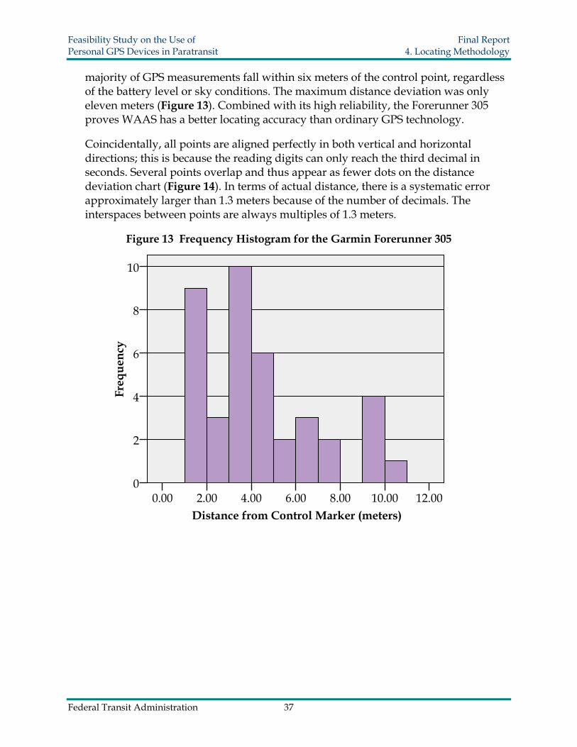
Feasibility Study on the Use of Final Report Personal GPS Devices in Paratransit 4 Locating Methodology
three devices The cost of each device is an influential factor that may govern the willingness of transit agencies to adopt the new concept in real applications The cost is not limited to the initial investment but also to the recurring operating costs Higher costs are usually associated with more functionality and so a compromise between cost and capability is typical
Table 6 Devicesrsquo Costs Comparisons Device Motorola i415 Gemtek Device HP iPAQ hw6945 Device cost $40 $400 $600 Monthly fee $10 $20 $50 First year total costs $160 $640 $1200
Figure 19 Total Cost of Each Device for a 12 Month Period
0
300
600
900
1200
1500
1 2 3 4 5 6 7 8 9 10 11 12 13
Month
Tot
al C
osts
($)
HP iPAQ h 6945
Gemtek Device
Motorola i415
Federal Transit Administration 43
Feasibility Study on the Use of Final Report Personal GPS Devices in Paratransit 5 GPS Prototype
50 GPS PROTOTYPE
51 Prototype Development
After all devices were tested for their specific functionalities a GPS prototype was developed to explore the feasibility of integrating multiple devices into a complete working system The best solutions combined use of the GPS enabled Motorola i415 cell phone and the HP iPAQ hw6945 PDA This prototype connects the passenger vehicle operator and the agency dispatcher together via a central computer To synchronize these devices separate programs namely iTrack and LocateYou were created The iTrack application was written in Java for the Motorola i415 and the LocateYou application was written in C for the HP iPAQ hw6945 The web application prototype was developed in ASP Net These software applications were specifically created by LCTR staff to test the capabilities of these GPS devices
No prior knowledge is required to operate the system Once the devices are turned on the iTrack and LocateYou programs are automatically initiated and position information is continuously acquired from satellites and sent to the server The server translates the position coordinate numbers to point marks on the Microsoft Live Map and Google Map so that the agency dispatcher can track both the passengers and vehicles The HP iPAQ hw6945 uses Google Map as a background to indicate locations on its screen Likewise the central server computer screen employs Google Earth including a three-dimensional view and Microsoft Live Map to display locations Consequently both the agency dispatcher and the PDA carrier are able to view the carrierrsquos location in digital map form
52 Functionality
It is important to know how the iTrack and LocateYou programs work with each other Basically the mobile device must be GPS enabled and support Java to run this program The iTrack program is a J2ME MIDlet (22 23) application that supports any J2ME platform of mobile phones The iTrack has three basic steps in its running thread
bull First it communicates with the internal GPS device through a serial port and acquires the GPS signal If the GPS signal is successfully connected the screen displays a message reading ldquoMy GPSOnrdquo Once the signal connection succeeds the location queries are made automatically every few minutes depending on how the program is defined
bull Second an HTTP request is formed and is sent to the server describing the current status of the device In the case wherein a GPS signal is obtained this HTTP request includes the current longitude and latitude coordinates Additionally moving speed
Federal Transit Administration 44
Feasibility Study on the Use of Final Report Personal GPS Devices in Paratransit 5 GPS Prototype
and time information are also appended to the request and sent to the server On the other hand if a GPS signal connection fails to connect an HTTP request describing the current failure status is sent to the server The server stores all of these data to a database as an activity log for future reference
bull Lastly the server produces three similar location data packages for the dispatcher the passengers and the vehicle operator upon receiving the HTTP request For the dispatcher the locations of all mobile devices are marked on Internet maps specifically Google Earth and the Microsoft MapPoint web service (23) Similar data packages are also sent to the vehicle operator and the passenger
A detailed data flow of the prototype is summarized in Figure 20 The central server functions as a hub to effectively maintain communications among the dispatcher vehicle operator and passenger All information from these three parties is initially received modified and shared in the central server
Figure 20 Graphical Display of the Prototype
53 Prototype Application in Use
During the pickup process the geographical locations of both the Motorola i415 and the HP iPAQ hw6945 are obtained from satellites and sent to the nearest wireless signal tower The central server combines the Internet map service and location information from the GPS devices to generate an individual data package for the dispatcher the vehicle operator and the passenger From the PDA screen the vehicle operator is able to see driving directions as well as the passengerrsquos location on a digital map Similarly
Federal Transit Administration 45
Feasibility Study on the Use of Final Report Personal GPS Devices in Paratransit 5 GPS Prototype
the passenger receives the waiting time a nd vehicle distance Therefore pickups can become more punctual and predictable with the aid of this new approach At the same time a service log of all activities is recorded into the system database
In the historical log two types of tracking logs are available real time tracking and historical tracking Real time tracking means the indicated location markers shown in the iPAQ screen are automatically refreshed as updated information is received This is very helpful in the middle of the service task when the vehicle operator cannot find a passenger on local streets Historical tracking as the name suggests is the tracking log of the previous services These datasets are readily accessible whenever evaluation or references for past services are required
If the Motorola i415 is used by the driver as an option driving instructions are provided An example of the data packages received by the device is shown in Figure 21 The screen presents the estimated driving time and distance By clicking the ldquoDirectiordquo button detailed directions are displayed Sometimes the other device is not connected to the GPS signal and the screen displays the text Tracked ldquoGPSOffrdquo Upon seeing this message users should move around to restore a better GPS signal reception The dispatcher is also aware of the status of the passengerrsquos mobile GPS and this information allows the dispatcher to call the user or driver with additional instructions if necessary However when lacking a map image only verbal instructions can be communicated to the users
Figure 21 Screen Captures of Motorola i415
The HP iPAQ hw6945 device was also considered for use by the paratransit driver because complex images on a bigger screen can provide a more detailed passenger location map The LocateYou program works differently from iTrack by integrating the Google Map application as the mapping template Hence directions are provided and users can switch to a digital map image that is returned by the server Screen captures of the PDA are shown in Figure 22 The first screen depicts the passengerrsquos location in longitudelatitude coordinates and the second screen shows where the passenger is waiting on a digital map
Federal Transit Administration 46
Feasibility Study on the Use of Final Report Personal GPS Devices in Paratransit 5 GPS Prototype
Figure 22 Screen Captures of HP iPAQ hw6945
The dispatcherrsquos computer shows the vehiclesrsquo and passengersrsquo information such as route path travel distance direct distance and estimated driving time An example of the dispatcherrsquos computer is shown in Figure 23 The digital map image updates whenever a device reports a new location With the aid of the tracking platform it is expected that the occurrence of missed trips will be avoided in some situations
Figure 23 Device Locations Map for Dispatcher
For demonstration purposes in this prototype the passenger carries the Motorola i415 mobile phone and the driver carries either another Motorola i415 mobile phone or the
Federal Transit Administration 47
Feasibility Study on the Use of Final Report Personal GPS Devices in Paratransit 5 GPS Prototype
HP iPAQ hw6945 Users need only turn on the mobile GPS devices to ensure that their work status is active Because the locations of all mobile devices are known instantly the vehicle operator can promptly arrive at the passengerrsquos location by following the driving directions
A more detailed demonstration example of this prototype application can be viewed at the following URL httpgpstranspolctrorg
Federal Transit Administration 48
Feasibility Study on the Use of Final Report Personal GPS Devices in Paratransit 6 Conclusion
60 CONCLUSION
Because missed trips commonly occur at all paratransit agencies advanced GPS technology may have a role in relieving such problems in the future The methodology and prototype developed in this project offer a completely new pickup concept compared with current operation methods GPS location technology offers an accurate fast dependable and feasible alternative tool to help avoid missed pickups resulting from operational errors or pickup requests at ambiguous locations
After examining the features of four GPS mobile devices it became evident that some devices are not feasible for assisting with paratransit operations Two of the devices were considered to be less suitable than their counterparts The Gemtek device has a good design in many respects but loses its candidacy due to poor compatibility it is not programmable and cannot be coded to work with a peer device The Garmin Forerunner 305 by taking advantage of WAAS achieves the best accuracy performance among all of the devices But it has no wireless channel to communicate with a server and is unable to inform location information to other receptors
On the other hand the two programmable GPS devices the Motorola i415 and the HP iPAQ hw6945 were ready to be used in the development of a computer controlled pickup system The prototype integrates these two devices and synchronizes them by installing the iTrack and LocateYou programs Simulations were performed to show that this prototype methodology could be applied in the real world This prototype presents a potential solution to missed pickups by using GPS tracking technology
Additionally the use of programmable devices may assist with other service improvements Many personal GPS mobile devices come with optional features that can potentially be leveraged to provide further improvements in the future To attract more passengers transit agencies might consider exploring additional functionalities such as medical care alarms and appointment reminders In the future agencies will have the freedom to decide the most suitable technology based on desired functionalities
There are indeed further challenges to the real world usage of this kind of paratransit pickup service methodology The complexity of the system requires trained personnel and individuals who are familiar with computer information and technology The high initial costs of design and purchase lack of agreed upon data standards privacy issues and legal concerns are all barriers to deployment The initial phase of set up and operation may be so complex that even minor employee turnover may spark major setback However if these obstacles can be overcome bringing personal mobile GPS technology into the paratransit industry is a feasible solution for improving the conventional pickup procedure Implementation of GPS technologies can help improve the level of service and reduce agenciesrsquo operating expenses in the long run
Federal Transit Administration 49
Feasibility Study on the Use of Final Report Personal GPS Devices in Paratransit 7 Future Research
70 FUTURE RESEARCH
71 Prototype Improvements
Assisting features were also studied to highlight additional potential advantages of the prototype All of the following options are available depending on local transit agency preferences
711 Alarm Notification
To enhance the prototype performance alarm notifications can be implemented A ringing notification will sound if the passenger is close to the driver or the driver is out of the expected path to the passengers This feature can help the vehicle operator to reach the passenger and gain his or her attention immediately if necessary
712 Administrator Website
The administrator webpage is an application built to help transit agencies improve management and operation It can be integrated with GIS to show the closest vehicles upon request In this application all mobility devices can be shown on a single screen map With the assistance of computer programs agency dispatchers can send the closest vacant vehicle immediately to finish the service task thereby optimizing vehicle management
713 Voice and SMS
The Skype and Microsoft text-to-speech service as well as the Short Message Service (SMS) can potentially be incorporated to offer voice service An automated voice service is capable of handling simple phone queries made by vehicle operators or passengers It can also be used to direct users to the most appropriate personnel SMS is another alternative communication technique in which users can read and review important instructions in case they are forgotten For arrangements coming from the agency to the vehicle operator agency staff can send text messages manually to give instructions and the message is kept as a reference until the task is finished This function can help minimize human error
714 Historical Log
The communication information for each task including short messages location data and pickup arrangements can be saved into a historical database for future reference The historical log collects all statistical information which agencies can periodically use to evaluate and improve their performance
Federal Transit Administration 50
Feasibility Study on the Use of Final Report Personal GPS Devices in Paratransit 7 Future Research
715 Use as a Tracking Device for Persons with Cognitive Disabilities
Although the GPS device is primarily intended to aid with the paratransit pickup process the system also holds promise for serving as a locating device for persons who suffer from cognitive disabilities A small but significant percentage of existing paratransit riders suffer from dementia Alzheimerrsquos disease or another cognitive problem Some of these riders may be willing to utilize the tracking device for additional hours during the day In this situation the tracking device would then also serve as a valuable tool for locating the individual if he or she becomes lost or confused
Currently there are several variations of the aforementioned device available in the market The idea of tracking and monitoring of persons with cognitive disabilities has become more of a popular idea over the last few years Such a system allows individual with mental disabilities to maintain a high degree of freedom but provides a safety net in the event of an emergency If an appropriate prototype GPS website can be developed ridersrsquo friends and family members may be able to determine the exact location of a lost or confused individual on their own there by circumventing the need to contact emergency personnel
Certain issues still remain such as how to continuously power some of the GPS devices Additional battery technology may need to be developed before additional tracking is feasible Furthermore privacy issues and concerns would need to be addressed by all involved parties
72 Cost amp Benefit Ratio Evaluation
In business whether a new alternative is cost effective or not determines its future applicability In order to determine the value of applying personal GPS devices in paratransit more information about transit agenciesrsquo operational expenses needs to be collected and examined This will ensure that a cost efficient method of employing new technologies is selected
One factor which needs to be studied further relates to the pricing of wireless services Currently several of the cell phoneGPS service providers charge a standard rate for a specific number of voice calls or minutes of talk time However this project depends on sending data wirelessly for an undetermined amount of time Few wireless service providers have structured plans for sending data over their network The cost of applying personal GPS devices in paratransit may well depend on negotiated rates for sending constant locational data for long periods of time
Federal Transit Administration 51
Feasibility Study on the Use of Final Report Personal GPS Devices in Paratransit 7 Future Research
73 Finding Newer Suitable Devices
All of the testing devices were ready-available technologies when this project commenced As the civilian GPS market develops the debut of more powerful GPS devices will provide extra options and support for new operating systems Newer units and technology may enable the GPS signal to be picked up better in certain environments Currently signal problems are often experienced if the user is inside a large building or in a dense urban environment with a substantial number of tall buildings Problems have also been noted using GPS devices in heavily forested locations In the future newer devices and the increased usage of assisted GPS will ensure that a clear signal is continuously received
74 Attempting a Pilot Program
In the long run the pickup process can possibly be combined with service vehicle assignments If there is a change request from a passenger the system will immediately determine the most economical way to rearrange the service schedule Potential benefits include less time needed for reservations and services that are more adaptable to instantaneous changes
Federal Transit Administration 52
Feasibility Study on the Use of Final Report Personal GPS Devices in Paratransit References
REFERENCES
1 Weiner R (1998) ADA paratransit eligibility certification practices In Transportation Cooperative Research Program Synthesis of Transit Practice 30 Transportation Research Board of the National Academies Washington DC Retrieved August 8 2008 from httponlinepubstrborgonlinepubstcrptsyn30pdf
2 Lave R and R Mathias (2000) State of the art of paratransit In Transportation in the New Millennium State of the Art and Future Directions Perspectives from Transportation Research Board Standing Committees Transportation Research Board of the National Academies Washington DC pp 1-7 Retrieved August 1 2008 from httponlinepubstrborgonlinepubsmillennium00107pdf
3 Simon R M (1998) Paratransit contracting and service delivery methods In Transportation Cooperative Research Program Synthesis of Transit Practice 31 Transportation Research Board of the National Academies Washington DC Retrieved October 2 2008 from httpgullivertrborgpublicationstcrptsyn31pdf
4 Mathias R G and R E Smith (2005) Practices in no-show and late cancellation policies for ADA paratransit Transportation Cooperative Research Program Synthesis 60 Transportation Research Board of the National Academies Washington DC Retrieved August 4 2008 from httponlinepubstrborgOnlinepubstcrptcrp_syn_60pdf
5 Miami-Dade Transit (2008) Miami-Dade County transit paratransit operations monthly report April 2008 Retrieved July 31 2008 from httpwwwmiamidadegovtransitparatransitaspmdt_reports
6 Nelson R A (1999) The global positioning system A national resource Via Satellite November Retrieved on October 1 2008 from httpwwwaticoursescomglobal_positioning_systemhtm
7 Langley RB (1997) The GPS error budget GPS World 8(3) 51-56
8 Hofmann-Wellenhof B Lichtenegger H amp Collins J (1997) GPS Theory and practice New York Springer
9 Kaplan E D and C Hegarty (Eds) (2005) Performance of stand-alone GPS In Understanding GPS Principles and Applications (pp 301-378) Norwood MA Artech House Inc
10 Global positioning system (October 2008) Retrieved October 3 2008 from the Wikipedia Encyclopedia httpenwikipediaorgwikiGlobal_Positioning_System
Federal Transit Administration 53
Feasibility Study on the Use of Final Report Personal GPS Devices in Paratransit References
11 LaMance J Jarvinen J amp DeSalas J (2002 March 1) Assisted GPS A low-infrastructure approach GPS World 46-51
12 Assisted GPS (September 23 2008) Retrieved October 1 2008 from the Wikipedia Encyclopedia httpenwikipediaorgwikiA-GPS
13 US Department of Transportation (2001 August 13) Federal Aviation Administration specification for the wide area augmentation system (WAAS) Specification FAA-E-2892b Retrieved October 3 2008 from httpwwwfaagovaboutoffice_orgheadquarters_officesato
service_unitstechopsnavservicesgnsslibrarydocuments
14 Wide area augmentation system (September 29 2008) Retrieved October 3 2008 from the Wikipedia Encyclopedia httpenwikipediaorgwikiWide_Area_Augmentation_System
15 Stewart M A (September 2005) Tracking cattle in the heartland Geospatial Solutions Retrieved July 16 2008 from httpwwwgeospatialshyonlinecomgeospatialsolutionsarticlearticleDetailjspid=177059ampsk=ampdate=amppag eID=4
16 GPS tracking Save the Elephants Retrieved July 16 2007 from httpwwwsavetheelephantsorgdisplayasplinkID=59ampdisplayID=58
17 Hulbert I A R amp French J (2001) The accuracy of GPS for wildlife telemetry and habitat mapping Journal of Applied Ecology 38(4) 869-878 Retrieved on August 17 2008 from httpwww3intersciencewileycomcgi-binfulltext118869609PDFSTART
18 Ratti C R M Pulselli S Williams and D Frenchman (2006) Mobile landscapes Using location data from cell-phones for urban analysis Environment and Planning B Planning and Design 33(5) pp 727-748
19 Axel Kuumlpper (2005) Location-based services Fundamentals and operation Chichester West Sussex England John Wiley amp Sons Ltd
20 Wieczorek J (September 2001) MaNISHerpNetORNIS Georeferencing Guidelines The Regents of the University of California Retrieved July 28 2008 from httpmanisnetorgGeorefGuidehtml
21 Frequently asked questions Wireless Location Services Retrieved September 20 2007 from httpwwwwherifycomhtmlfaqasppageId=133
Federal Transit Administration 54
Feasibility Study on the Use of Final Report Personal GPS Devices in Paratransit References
22 Zahakiel J2ME MIDlet (2007) Retrieved March 10 2007 from the Wikipedia Encyclopedia httpenwikipediaorgwikiMIDlet
23 Microsoft MapPoint Microsoft MapPoint web service (2008) Retrieved March 10 2008 from httpwwwmicrosoftcommappointproductswebservicedefaultmspx
Federal Transit Administration 55
Feasibility Study on the Use of Final Report Personal GPS Devices in Paratransit Glossary
GLOSSARY
Cool Start - Cool start occurs when a GPS device initiates without any memory about Ephemeris data such as a completely new start For more information refer to hot start
Differential Global Positioning System (DPGS) - An enhancement to GPS that uses a network of fixed ground-based reference stations to broadcast the difference between positions indicated by the satellite systems and known fixed positions
Global Positioning System (GPS) - Developed by the US Department of Defense GPS is a fully functional Global Navigation Satellite System (GNSS) More than two dozen GPS satellites are in medium earth orbit transmitting signals that allow receivers to determine their locations speeds and moving directions
Global System for Mobile communications (GSM) - is a digital mobile telephony system that is widely used in Europe and other parts of the world GSM uses a variation of time division multiple access and is the most widely used of the three digital wireless telephony technologies
Hot Start - A Warm or Hot Start state occurs when a GPS unit has some knowledge of the current Ephemeris data Only a minor update is required for a warm start and possibly no update for a hot start Little or no information is required since nearly a complete set of information is present in the unit
Paratransit ndash Several types of paratransit services exist ADA Paratransit the service most commonly referred to is mandated by the Americans with Disabilities Act and requires that public transportation agencies provide complementary public transportation for individuals who are physically or mentally unable to ride fixed route transit Other hybrid paratransit services which go above and beyond ADA requirements are often referred to as demand response or dial-a-ride services These services may vary considerably on the degree of flexibility they provide their customers
Personal Digital Assistant (PDA) - Also known as pocket computers or palmtop computers PDAs are handheld computers that have both color screens and audio capabilities enabling them to be used as mobile phones (smart phones) web browsers or portable media players Many PDAs can access the Internet intranets or extranets via Wi-Fi or Wireless Wide-Area Networks
SiRFStar III Receiver - SiRFstar III is the latest GPS microcontroller chip manufactured by SiRF Technology It is distinguished from earlier SiRF chips and other brand chipsets
Federal Transit Administration 56
Feasibility Study on the Use of Final Report Personal GPS Devices in Paratransit Glossary
largely due to its faster Time to First Fix (TTFF) and its ability to acquire and maintain a signal lock in urban or densely covered forest environments
Wide Area Augmentation System (WAAS) - An extremely accurate navigation system developed for civil aviation by the Federal Aviation Administration (FAA) a division of the U S Department of Transportation Originally developed to allow aircraft greater reliance on GPS the system augments GPS to provide additional accuracy integrity and availability within the WAAS coverage area
Wi-Fi - The trade name of a wireless technology Originally licensed by the Wi-Fi Alliance it describes the underlying technology of wireless local area networks (WLAN) based on the IEEE 80211 specifications It is currently used for mobile computing devices Internet and VoIP phone access gaming and basic connectivity of consumer electronics
Federal Transit Administration 57
Feasibility Study on the Use of Final Report Personal GPS Devices in Paratransit Appendix B
APPENDIX A Additional Survey Results
This Appendix contains extra information obtained from the paratransit survey The survey was discussed in Section 20 however additional specifics are provided below
Inquiries about service performance found that most transit agencies rated their paratransit operating characteristics as being either good or very good Rarely did agencies rate their services as not good or even neutral (Figure 24)
Figure 24 Paratransit Agency Service Evaluations
Not Neutral Good 3
3 Very Good
Good Very44
44 Good Good 53 53
On Time Performance Availability in Community
Cleanliness amp Comfort
Very Good 50
Good 44
Neutral 6
Service Time Span
Good 52
Very Good 42
Not Good
3
Neutral 3
Passenger instructed waiting time and the time window for vehicle pick up vary considerably among agencies (Figure 25) Though not indicative of cost these two measurements give an indication of paratransit service standards A short instructed wait time and a more specific time window are likely to be greatly appreciated by paratransit passengers
Federal Transit Administration 58
Feasibility Study on the Use of Final Report Personal GPS Devices in Paratransit Appendix B
Figure 25 Comparison of Instructed Wait Times and Time Windows for Pick-up
0
2
4
6
8
10
12
14
16
0 min 5 min 10 min 15 min 20 min 30 min 45 min 60 min
Num
ber o
f Age
ncie
s
Passenger Instructed Wait Time n=30 Time Window of Vehicle for Pick-up Time n=36
Average pay rates for a paratransit vehicle operator ranged between $8 and $18 dollars per hour but one agencyrsquos average hourly pay for drivers was over $20 (Figure 26) For the 31 agencies reporting the average hourly pay for a paratransit driver was $1286
Figure 26 Average Hourly Pay for Paratransit Operators (in Dollars)
5
4
800 1000 1200 1400 1600 1800 2000 2200
Res
pond
ents
3
2
1
0
Average Hourly Pay (in Dollars)
Federal Transit Administration 59
Feasibility Study on the Use of Final Report Personal GPS Devices in Paratransit Appendix B
Statistical information obtained from the remaining survey questions is located in Table 7 The number of agencies responding to the question along with minimums maximums means and standard deviations are provided Since most of the results have fewer than 30 respondents the data is not preferable for further statistical analysis
Table 7 Statistical Summary of Survey Variables Variable N Min Max Mean Std D
Instructed Time to Wait before Veh Arrival (mins) 31 0 60 177 152
Time Window Vehicles are Scheduled to Arrive (mins) 36 0 60 236 134
Mins Driver is Allowed to Spend Finding Passenger 16 3 15 63 37
Total Number of No-Shows During Last Year 34 4 108371 8023 19656
Total Number of Passenger Trips During Last Year 35 746 1584382 234992 397705
of No-Show Trips to Total Passenger Trips 34 002 923 253 226
Estimated of No-Shows due to Connection Failures 25 000 8000 1102 2313
Total No-Show Losses per Year 23 $60 $716000 $88892 $184989
Average No-Show Losses per Month 16 $19 $48922 $6435 $12166
Average No-Show Losses per Trip 20 $1000 $3015 $1903 $556
Average Hourly Pay for Paratransit Vehicle Driver 31 $778 $2021 $1286 $296
Suspended Passengers 33 0 1293 59 228
Total Passengers 34 0 692000 85552 166477
of Suspensions to Total Passengers 30 000 444 026 084
Federal Transit Administration 60
Feasibility Study on the Use of Final Report Personal GPS Devices in Paratransit Appendix B
Passenger trip purposes are an important factor known to influence no-show trips Shopping and medical trips tend to have higher no-show rates because pickup location and appointed pickup time can vary considerably Visiting or social trips and work trips have slightly higher trip completion rates since residential addresses are more easily found and work trips are often routine appointments at a particular location and time Results are summarized in Table 8
Table 8 Classification of Trip Purposes
Agency Shopping Medical Visiting amp Recreation Work Other
1 20 55 10 10 5 2 38 50 5 7 -3 20 25 20 35 -4 16 65 1 18 -5 10 20 15 27 28 6 10 40 10 30 10 7 13 65 2 20 -8 1 7 15 77 -9 15 50 5 30 -10 23 53 1 7 16 11 10 50 5 30 5 12 15 50 30 5 -13 35 40 2 3 20 14 15 45 - 35 5 15 4 28 2 18 48 16 10 85 1 2 2 17 12 40 9 2 37 18 22 52 14 12 -19 10 70 10 10 -20 5 50 5 20 20 21 16 19 15 50 -22 10 30 5 40 15 23 3 95 1 1 -24 17 39 - 17 27 25 18 30 5 45 2 26 40 30 10 20 -27 5 30 10 55 -28 6 20 30 42 2 29 5 23 33 27 11 30 25 50 10 10 5 Summarized Statistical Values Min 1 7 0 1 0 Max 40 95 33 77 48 Avg 1499 4355 937 2350 860
Federal Transit Administration 61
Feasibility Study on the Use of Final Report Personal GPS Devices in Paratransit Appendix B
APPENDIX B Survey Instrument
1 Please fill out the following information Full Name of Transit Agency Address Contact Person Phone Number Email
2 What technology does your agency currently use to communicate between the dispatch center and the vehicle operator (eg telecommunication walkie-talkie or wireless internet etc)
3 How interested is your agency in applying new technology such as GPS to minimize the numbers of connection failures when picking up passengers
4 How would you rate your agencys service performance Please use a 1 to 5 scale with 1 being the poorest and 5 representing the best
(5) (4) (3) (2) (1) On-Time Performance Availability in the Community Cleanliness and Comfort Service Time Span
5 How many minutes is a passenger instructed to wait prior to the arrival of the paratransit vehicle
6 How many minutes is the time window your vehicles are scheduled to arrive at the appointed pickup time
7 If a driver has difficulty finding the address or pickup location how much time in minutes is shehe instructed to spend trying to find the passenger before leaving without picking up the passenger
8 How many no-shows occurred during the most recent fiscal year And what were the total passenger trips for that year Number of no-shows Total number of passenger trips
9 Among all the no-shows please give an estimation of the percentage that are due to connection failures
Federal Transit Administration 62
Feasibility Study on the Use of Final Report Personal GPS Devices in Paratransit Appendix B
10 What is the approximate financial loss per month due to no-shows And what is the average cost of each no-show (Answer as many as possible) $ Per Year $ Per Month $ Per Trip
11 Approximately how many passengers had their paratransit privileges suspended in the most recent fiscal year And how many passengers did you carry last year Suspended number Total passengers
12 What is the average hourly salary of a paratransit vehicle operator in your agency
13 Other than the funds from your own agency are there other agencies that share the paratransit cost Please provide a rough estimation for each and answer all that possible Hospitals they share Rehabilitation Clinic(s) they share Insurance agencies they share Other please specify
14 In general what are the main purposes for paratransit trips Please provide an estimated percentage for each type of trip Shopping Medical trip Visiting Working Other please specify
15 The box below is for any additional comments
Federal Transit Administration 63
-
Feasibility Study on the Use of Final Report Personal GPS Devices in Paratransit Appendix C
APPENDIX C GPS Readings
The measurements of the GPS readings of each device are listed in the tables below The longitude and latitude of the control point is (W8036888889 N2576909091)
Garmin Forerunner 305
Trial Longitude Latitude Deviated
Distance in N-S Direction
Deviated Distance in E W
Direction
Spatial Deviate Distance to
Control Point 1 8036888333 2576908333 0817109 -111382 138140247 2 8036886667 2576911667 3265496 3785888 499964102 3 8036886667 2576915 3265496 8684132 927780159 4 803689 2576911667 -163275 3785888 41229618 5 803689 2576911667 -163275 3785888 41229618 6 8036888333 257691 0817109 1336032 156609289 7 8036895 257691 -898085 1336032 907968104 8 8036886667 2576906667 3265496 -356221 483247509 9 8036886667 2576911667 3265496 3785888 499964102
10 8036888333 2576908333 0817109 -111382 138140247 11 8036886667 2576913333 3265496 6234275 703773021 12 803689 257691 -163275 1336032 210970276 13 8036893333 2576906667 -653099 -356221 74393011 14 8036891667 2576911667 -40826 3785888 556781887 15 803689 2576906667 -163275 -356221 391857362 16 8036893333 2576913333 -653099 6234275 902884444 17 8036885 2576906667 5715352 -356221 673458271 18 8036886667 2576908333 3265496 -111382 345022722 19 803689 2576908333 -163275 -111382 197647959 20 8036883333 2576913333 8165209 6234275 102731114 21 8036888333 2576911667 0817109 3785888 387306277 22 8036885 257691 5715352 1336032 58694319 23 803689 2576908333 -163275 -111382 197647959 24 8036888333 257691 0817109 1336032 156609289 25 8036886667 2576908333 3265496 -111382 345022722 26 8036888333 2576908333 0817109 -111382 138140247 27 8036893333 2576908333 -653099 -111382 662528892 28 8036883333 2576911667 8165209 3785888 9000199 29 803689 257691 -163275 1336032 210970276 30 8036886667 257691 3265496 1336032 352823498 31 8036886667 2576908333 3265496 -111382 345022722 32 803689 2576905 -163275 -601207 622983407 33 8036886667 2576911667 3265496 3785888 499964102 34 8036886667 257691 3265496 1336032 352823498 35 803689 257691 -163275 1336032 210970276 36 8036888333 257691 0817109 1336032 156609289 37 8036886667 257691 3265496 1336032 352823498 38 8036886667 257691 3265496 1336032 352823498 39 8036888333 2576911667 0817109 3785888 387306277 40 803689 2576908333 -163275 -111382 197647959
Federal Transit Administration 64
-
Feasibility Study on the Use of Final Report Personal GPS Devices in Paratransit Appendix C
Motorola i415 GPS Enabled Mobile Phone
Trial Longitude Latitude Deviated
Distance in N-S Direction
Deviated Distance in E W
Direction
Spatial Deviate Distance to
Control Point 1 8036882667 2576920533 9144465521 1681602887 1914157978 2 8036891733 2576919467 -4180089149 152484342 1581100537 3 8036885333 25769184 522547885 1368083954 1464482843 4 8036887 25769184 2776112179 1368083954 1395966222 5 8036881067 2576917333 1149585752 1211324487 1669986352 6 80368896 25769152 -1044899822 8978055542 9038655705 7 80368944 2576914133 -8099075821 7410460871 1097770283 8 8036887467 2576913067 2090289522 5842866199 6205513332 9 8036898133 2576913067 -1358565715 5842866199 1478881894
10 8036885333 25769138 522547885 6920587542 8671802647 11 8036887467 2576912 2090289522 4275271542 4758913431 12 80368896 2576902133 -1044899822 -1022498402 1027823496 13 80368944 2576912 -8099075821 4275271542 9158219036 14 8036886122 2576910667 4066438539 2315778199 467961014 15 80368896 2576910667 -1044899822 2315778199 2540599202 16 8036882667 2576909867 9144465521 1140082199 9215261097 17 803689152 2576909867 -3866570221 1140082199 4031147814 18 8036885333 25769088 522547885 -0427512458 5242937737 19 80368896 25769078 -1044899822 -1897132458 2165854843 20 8036896 25769 -1045046782 -1336016846 1696190965 21 8036882667 2576907733 9144465521 -1995107129 9359578096 22 8036887467 2576907733 2090289522 -1995107129 2889595602 23 8036896 2576907733 -1045046782 -1995107129 1063920721 24 8036878933 2576906667 1463104685 -3562701801 1505856487 25 8036896333 2576906667 -1093985128 -3562701801 1150535485 26 8036894933 2576906667 -8882868255 -3562701801 9570694466 27 8036887267 2576905333 2384164524 -5522195129 6014888156 28 80368944 2576905333 -8099075821 -5522195129 9802533764 29 80368896 2576904533 -1044899822 -669789113 6778905606 30 8036888267 2576904533 0914544526 -669789113 6760039739 31 8036887467 2576903467 2090289522 -8265485801 8525700312 32 8036895823 2576902133 -1019034508 -1022497913 1443583496 33 8036889617 2576909867 -1070030323 1140072412 1563563237 34 8036891733 2576912 -4180040167 4275271542 5979187449 35 8036882667 2576913067 9144465521 5842768234 1085169067 36 8036882667 2576906666 9144466492 -3563681538 9814331028 37 8036896 2576909867 -1045046782 1140082111 1051247187 38 803688311 2576909867 849293398 1140072412 8569112713 39 8036894418 2576916 -8126219702 1015375154 1300515732 40 8036891733 2576907733 -4180040167 -1995112023 4631760765
Federal Transit Administration 65
-
Feasibility Study on the Use of Final Report Personal GPS Devices in Paratransit Appendix C
HP iPAQ hw6945
Trial Longitude Latitude Deviated
Distance in N-S Direction
Deviated Distance in E W
Direction
Spatial Deviate Distance to
Control Point 1 2576902385 8036898708 -15619524 -9684036 1837797821 2 2576907135 8036888848 -1066163995 -2673036 2877816381 3 2576911808 8036888875 -1105524 4224803995 4367053024 4 2576916907 803687937 12923856 11749944 1746674664 5 2576907538 8036879373 12918936 -2077716005 1308494598 6 2576908438 803688954 -2087064001 -0749316005 2217500985 7 2576905998 80368875 0923975999 -4350756005 444778703 8 2576904353 8036894462 -9351936 -6779268 1155063555 9 25769134 8036885365 4075235998 6574104 7734752216
10 2576904198 8036880198 11701728 -7008048 1363976448 11 2576915068 8036897128 -13287444 9036563995 160690901 12 2576912142 8036887408 1059276005 4716804005 4834284401 13 2576911098 8036900398 -18113964 3176843995 1839043309 14 2576912938 8036890252 -3137976002 5892192 6675688725 15 2576917487 8036891315 -4706964 12606516 1345658782 16 2576913067 8036892262 -6104736002 6082596 8617759323 17 2576912343 8036895325 -10625724 5013972 1174929469 18 2576908183 8036886422 2515595995 -1125696005 2755977995 19 2576906247 8036893112 -7358844006 -3984215995 836818751 20 2576912343 8036895325 -10625724 5013972 1174929469 21 2576904492 80368916 -5127624001 -6574595995 8337735927 22 2576910935 8036893638 -8136203997 2935764 864965466 23 2576914353 8036878462 1426455599 7981223995 1634556497 24 2576904198 8036900198 -17818272 -7008048 191468941 25 2576904353 8036894462 -9351444005 -6778776005 1154994845 26 25769134 8036895365 -10684764 6574104 1254523914 27 257691615 8036885413 4003896004 10633104 1136195775 28 2576913067 8036892262 -6104244005 6082104005 8617063537 29 2576912938 8036890252 -3137484005 5892683995 6675891742 30 2576912343 8036895325 -10625724 5014463995 1174950466 31 2576908225 8036871963 23856096 -1064196 2387982055 32 2576917487 8036891315 -4706964 12606516 1345658782 33 2576913067 8036892262 -6104736002 6082596 8617759323 34 25768964 8036896198 -11914764 -18517896 2201985634 35 2576901388 8036896268 -1201808399 -11155116 1639728502 36 2576904198 8036900198 -17818764 -7007556005 1914717189 37 2576897925 8036885727 3541415995 -16266996 1664802649 38 2576899657 8036881767 9386375994 -1371105599 1661617016 39 257691348 8036886692 2117075994 6692184 7019069557 40 2576912052 8036879162 1323135599 4583964005 1400291068
Federal Transit Administration 66
Office of Mobility Innovation US Department of Transportation
400 7th Street SW Room 9402 Washington DC 20590
wwwftadotgovresearch
- Feasibility Study on the Use of Personal GPS Devices in Paratransit
-
- EXECUTIVE SUMMARY
- PARATRANSIT PICKUP PROCEDURE AND THE POT
- STUDY OBJECTIVES
- LOCATION BASED SERVICE TECHNOLOGY
- COMPARISON TESTING OF DEVICES
- PROTOTYPE DEVELOPMENT
- FUTURE APPLICATIONS AND ENHANCEMENTS
- 10 INTRODUCTION
- 11 EXPANSION OF PARATRANSIT SERVICES
- 12 MISSED TRIPS ISSUE
- 13 TRACKING TECHNOLOGY TO MINIMIZE MISS
- 20 AGENCY SUPPORT
- 30 BACKGROUND
- 31 GPS FUNDAMENTAL SYNOPSIS
- 32 EXTENSIVE GPS APPLICATIONS
- 33 LOCATION BASED SERVICE (LBS)
- 40 LOCATING METHODOLOGY
- 41 LOCATION INTERPRETATION
- 42 CRITERIA FOR SELECTING GPS DEVICES
- 43 MOTOROLA I415
- 44 GEMTEK TRACKING DEVICE
- 45 GARMIN FORERUNNER 305
- 46 HP IPAQ HW6945
- 47 ACCURACY TESTS
- 48 BENEFIT COST ANALYSIS
- 50 GPS PROTOTYPE
- 51 PROTOTYPE DEVELOPMENT
- 52 FUNCTIONALITY
- 53 PROTOTYPE APPLICATION IN USE
- 60 CONCLUSION
- 70 FUTURE RESEARCH
- 71 PROTOTYPE IMPROVEMENTS
- 72 COST amp BENEFIT RATIO EVALUATION
- 73 FINDING NEWER SUITABLE DEVICES
- 74 ATTEMPTING A PILOT PROGRAM
- REFERENCES
- GLOSSARY
- APPENDIX A ADDITIONAL SURVEY RESULTS
- APPENDIX B SURVEY INSTRUMENT
- APPENDIX C GPS READINGS
-

Feasibility Study on the Use of Final Report Personal GPS Devices in Paratransit 5 GPS Prototype
Figure 22 Screen Captures of HP iPAQ hw6945
The dispatcherrsquos computer shows the vehiclesrsquo and passengersrsquo information such as route path travel distance direct distance and estimated driving time An example of the dispatcherrsquos computer is shown in Figure 23 The digital map image updates whenever a device reports a new location With the aid of the tracking platform it is expected that the occurrence of missed trips will be avoided in some situations
Figure 23 Device Locations Map for Dispatcher
For demonstration purposes in this prototype the passenger carries the Motorola i415 mobile phone and the driver carries either another Motorola i415 mobile phone or the
Federal Transit Administration 47
Feasibility Study on the Use of Final Report Personal GPS Devices in Paratransit 5 GPS Prototype
HP iPAQ hw6945 Users need only turn on the mobile GPS devices to ensure that their work status is active Because the locations of all mobile devices are known instantly the vehicle operator can promptly arrive at the passengerrsquos location by following the driving directions
A more detailed demonstration example of this prototype application can be viewed at the following URL httpgpstranspolctrorg
Federal Transit Administration 48
Feasibility Study on the Use of Final Report Personal GPS Devices in Paratransit 6 Conclusion
60 CONCLUSION
Because missed trips commonly occur at all paratransit agencies advanced GPS technology may have a role in relieving such problems in the future The methodology and prototype developed in this project offer a completely new pickup concept compared with current operation methods GPS location technology offers an accurate fast dependable and feasible alternative tool to help avoid missed pickups resulting from operational errors or pickup requests at ambiguous locations
After examining the features of four GPS mobile devices it became evident that some devices are not feasible for assisting with paratransit operations Two of the devices were considered to be less suitable than their counterparts The Gemtek device has a good design in many respects but loses its candidacy due to poor compatibility it is not programmable and cannot be coded to work with a peer device The Garmin Forerunner 305 by taking advantage of WAAS achieves the best accuracy performance among all of the devices But it has no wireless channel to communicate with a server and is unable to inform location information to other receptors
On the other hand the two programmable GPS devices the Motorola i415 and the HP iPAQ hw6945 were ready to be used in the development of a computer controlled pickup system The prototype integrates these two devices and synchronizes them by installing the iTrack and LocateYou programs Simulations were performed to show that this prototype methodology could be applied in the real world This prototype presents a potential solution to missed pickups by using GPS tracking technology
Additionally the use of programmable devices may assist with other service improvements Many personal GPS mobile devices come with optional features that can potentially be leveraged to provide further improvements in the future To attract more passengers transit agencies might consider exploring additional functionalities such as medical care alarms and appointment reminders In the future agencies will have the freedom to decide the most suitable technology based on desired functionalities
There are indeed further challenges to the real world usage of this kind of paratransit pickup service methodology The complexity of the system requires trained personnel and individuals who are familiar with computer information and technology The high initial costs of design and purchase lack of agreed upon data standards privacy issues and legal concerns are all barriers to deployment The initial phase of set up and operation may be so complex that even minor employee turnover may spark major setback However if these obstacles can be overcome bringing personal mobile GPS technology into the paratransit industry is a feasible solution for improving the conventional pickup procedure Implementation of GPS technologies can help improve the level of service and reduce agenciesrsquo operating expenses in the long run
Federal Transit Administration 49
Feasibility Study on the Use of Final Report Personal GPS Devices in Paratransit 7 Future Research
70 FUTURE RESEARCH
71 Prototype Improvements
Assisting features were also studied to highlight additional potential advantages of the prototype All of the following options are available depending on local transit agency preferences
711 Alarm Notification
To enhance the prototype performance alarm notifications can be implemented A ringing notification will sound if the passenger is close to the driver or the driver is out of the expected path to the passengers This feature can help the vehicle operator to reach the passenger and gain his or her attention immediately if necessary
712 Administrator Website
The administrator webpage is an application built to help transit agencies improve management and operation It can be integrated with GIS to show the closest vehicles upon request In this application all mobility devices can be shown on a single screen map With the assistance of computer programs agency dispatchers can send the closest vacant vehicle immediately to finish the service task thereby optimizing vehicle management
713 Voice and SMS
The Skype and Microsoft text-to-speech service as well as the Short Message Service (SMS) can potentially be incorporated to offer voice service An automated voice service is capable of handling simple phone queries made by vehicle operators or passengers It can also be used to direct users to the most appropriate personnel SMS is another alternative communication technique in which users can read and review important instructions in case they are forgotten For arrangements coming from the agency to the vehicle operator agency staff can send text messages manually to give instructions and the message is kept as a reference until the task is finished This function can help minimize human error
714 Historical Log
The communication information for each task including short messages location data and pickup arrangements can be saved into a historical database for future reference The historical log collects all statistical information which agencies can periodically use to evaluate and improve their performance
Federal Transit Administration 50
Feasibility Study on the Use of Final Report Personal GPS Devices in Paratransit 7 Future Research
715 Use as a Tracking Device for Persons with Cognitive Disabilities
Although the GPS device is primarily intended to aid with the paratransit pickup process the system also holds promise for serving as a locating device for persons who suffer from cognitive disabilities A small but significant percentage of existing paratransit riders suffer from dementia Alzheimerrsquos disease or another cognitive problem Some of these riders may be willing to utilize the tracking device for additional hours during the day In this situation the tracking device would then also serve as a valuable tool for locating the individual if he or she becomes lost or confused
Currently there are several variations of the aforementioned device available in the market The idea of tracking and monitoring of persons with cognitive disabilities has become more of a popular idea over the last few years Such a system allows individual with mental disabilities to maintain a high degree of freedom but provides a safety net in the event of an emergency If an appropriate prototype GPS website can be developed ridersrsquo friends and family members may be able to determine the exact location of a lost or confused individual on their own there by circumventing the need to contact emergency personnel
Certain issues still remain such as how to continuously power some of the GPS devices Additional battery technology may need to be developed before additional tracking is feasible Furthermore privacy issues and concerns would need to be addressed by all involved parties
72 Cost amp Benefit Ratio Evaluation
In business whether a new alternative is cost effective or not determines its future applicability In order to determine the value of applying personal GPS devices in paratransit more information about transit agenciesrsquo operational expenses needs to be collected and examined This will ensure that a cost efficient method of employing new technologies is selected
One factor which needs to be studied further relates to the pricing of wireless services Currently several of the cell phoneGPS service providers charge a standard rate for a specific number of voice calls or minutes of talk time However this project depends on sending data wirelessly for an undetermined amount of time Few wireless service providers have structured plans for sending data over their network The cost of applying personal GPS devices in paratransit may well depend on negotiated rates for sending constant locational data for long periods of time
Federal Transit Administration 51
Feasibility Study on the Use of Final Report Personal GPS Devices in Paratransit 7 Future Research
73 Finding Newer Suitable Devices
All of the testing devices were ready-available technologies when this project commenced As the civilian GPS market develops the debut of more powerful GPS devices will provide extra options and support for new operating systems Newer units and technology may enable the GPS signal to be picked up better in certain environments Currently signal problems are often experienced if the user is inside a large building or in a dense urban environment with a substantial number of tall buildings Problems have also been noted using GPS devices in heavily forested locations In the future newer devices and the increased usage of assisted GPS will ensure that a clear signal is continuously received
74 Attempting a Pilot Program
In the long run the pickup process can possibly be combined with service vehicle assignments If there is a change request from a passenger the system will immediately determine the most economical way to rearrange the service schedule Potential benefits include less time needed for reservations and services that are more adaptable to instantaneous changes
Federal Transit Administration 52
Feasibility Study on the Use of Final Report Personal GPS Devices in Paratransit References
REFERENCES
1 Weiner R (1998) ADA paratransit eligibility certification practices In Transportation Cooperative Research Program Synthesis of Transit Practice 30 Transportation Research Board of the National Academies Washington DC Retrieved August 8 2008 from httponlinepubstrborgonlinepubstcrptsyn30pdf
2 Lave R and R Mathias (2000) State of the art of paratransit In Transportation in the New Millennium State of the Art and Future Directions Perspectives from Transportation Research Board Standing Committees Transportation Research Board of the National Academies Washington DC pp 1-7 Retrieved August 1 2008 from httponlinepubstrborgonlinepubsmillennium00107pdf
3 Simon R M (1998) Paratransit contracting and service delivery methods In Transportation Cooperative Research Program Synthesis of Transit Practice 31 Transportation Research Board of the National Academies Washington DC Retrieved October 2 2008 from httpgullivertrborgpublicationstcrptsyn31pdf
4 Mathias R G and R E Smith (2005) Practices in no-show and late cancellation policies for ADA paratransit Transportation Cooperative Research Program Synthesis 60 Transportation Research Board of the National Academies Washington DC Retrieved August 4 2008 from httponlinepubstrborgOnlinepubstcrptcrp_syn_60pdf
5 Miami-Dade Transit (2008) Miami-Dade County transit paratransit operations monthly report April 2008 Retrieved July 31 2008 from httpwwwmiamidadegovtransitparatransitaspmdt_reports
6 Nelson R A (1999) The global positioning system A national resource Via Satellite November Retrieved on October 1 2008 from httpwwwaticoursescomglobal_positioning_systemhtm
7 Langley RB (1997) The GPS error budget GPS World 8(3) 51-56
8 Hofmann-Wellenhof B Lichtenegger H amp Collins J (1997) GPS Theory and practice New York Springer
9 Kaplan E D and C Hegarty (Eds) (2005) Performance of stand-alone GPS In Understanding GPS Principles and Applications (pp 301-378) Norwood MA Artech House Inc
10 Global positioning system (October 2008) Retrieved October 3 2008 from the Wikipedia Encyclopedia httpenwikipediaorgwikiGlobal_Positioning_System
Federal Transit Administration 53
Feasibility Study on the Use of Final Report Personal GPS Devices in Paratransit References
11 LaMance J Jarvinen J amp DeSalas J (2002 March 1) Assisted GPS A low-infrastructure approach GPS World 46-51
12 Assisted GPS (September 23 2008) Retrieved October 1 2008 from the Wikipedia Encyclopedia httpenwikipediaorgwikiA-GPS
13 US Department of Transportation (2001 August 13) Federal Aviation Administration specification for the wide area augmentation system (WAAS) Specification FAA-E-2892b Retrieved October 3 2008 from httpwwwfaagovaboutoffice_orgheadquarters_officesato
service_unitstechopsnavservicesgnsslibrarydocuments
14 Wide area augmentation system (September 29 2008) Retrieved October 3 2008 from the Wikipedia Encyclopedia httpenwikipediaorgwikiWide_Area_Augmentation_System
15 Stewart M A (September 2005) Tracking cattle in the heartland Geospatial Solutions Retrieved July 16 2008 from httpwwwgeospatialshyonlinecomgeospatialsolutionsarticlearticleDetailjspid=177059ampsk=ampdate=amppag eID=4
16 GPS tracking Save the Elephants Retrieved July 16 2007 from httpwwwsavetheelephantsorgdisplayasplinkID=59ampdisplayID=58
17 Hulbert I A R amp French J (2001) The accuracy of GPS for wildlife telemetry and habitat mapping Journal of Applied Ecology 38(4) 869-878 Retrieved on August 17 2008 from httpwww3intersciencewileycomcgi-binfulltext118869609PDFSTART
18 Ratti C R M Pulselli S Williams and D Frenchman (2006) Mobile landscapes Using location data from cell-phones for urban analysis Environment and Planning B Planning and Design 33(5) pp 727-748
19 Axel Kuumlpper (2005) Location-based services Fundamentals and operation Chichester West Sussex England John Wiley amp Sons Ltd
20 Wieczorek J (September 2001) MaNISHerpNetORNIS Georeferencing Guidelines The Regents of the University of California Retrieved July 28 2008 from httpmanisnetorgGeorefGuidehtml
21 Frequently asked questions Wireless Location Services Retrieved September 20 2007 from httpwwwwherifycomhtmlfaqasppageId=133
Federal Transit Administration 54
Feasibility Study on the Use of Final Report Personal GPS Devices in Paratransit References
22 Zahakiel J2ME MIDlet (2007) Retrieved March 10 2007 from the Wikipedia Encyclopedia httpenwikipediaorgwikiMIDlet
23 Microsoft MapPoint Microsoft MapPoint web service (2008) Retrieved March 10 2008 from httpwwwmicrosoftcommappointproductswebservicedefaultmspx
Federal Transit Administration 55
Feasibility Study on the Use of Final Report Personal GPS Devices in Paratransit Glossary
GLOSSARY
Cool Start - Cool start occurs when a GPS device initiates without any memory about Ephemeris data such as a completely new start For more information refer to hot start
Differential Global Positioning System (DPGS) - An enhancement to GPS that uses a network of fixed ground-based reference stations to broadcast the difference between positions indicated by the satellite systems and known fixed positions
Global Positioning System (GPS) - Developed by the US Department of Defense GPS is a fully functional Global Navigation Satellite System (GNSS) More than two dozen GPS satellites are in medium earth orbit transmitting signals that allow receivers to determine their locations speeds and moving directions
Global System for Mobile communications (GSM) - is a digital mobile telephony system that is widely used in Europe and other parts of the world GSM uses a variation of time division multiple access and is the most widely used of the three digital wireless telephony technologies
Hot Start - A Warm or Hot Start state occurs when a GPS unit has some knowledge of the current Ephemeris data Only a minor update is required for a warm start and possibly no update for a hot start Little or no information is required since nearly a complete set of information is present in the unit
Paratransit ndash Several types of paratransit services exist ADA Paratransit the service most commonly referred to is mandated by the Americans with Disabilities Act and requires that public transportation agencies provide complementary public transportation for individuals who are physically or mentally unable to ride fixed route transit Other hybrid paratransit services which go above and beyond ADA requirements are often referred to as demand response or dial-a-ride services These services may vary considerably on the degree of flexibility they provide their customers
Personal Digital Assistant (PDA) - Also known as pocket computers or palmtop computers PDAs are handheld computers that have both color screens and audio capabilities enabling them to be used as mobile phones (smart phones) web browsers or portable media players Many PDAs can access the Internet intranets or extranets via Wi-Fi or Wireless Wide-Area Networks
SiRFStar III Receiver - SiRFstar III is the latest GPS microcontroller chip manufactured by SiRF Technology It is distinguished from earlier SiRF chips and other brand chipsets
Federal Transit Administration 56
Feasibility Study on the Use of Final Report Personal GPS Devices in Paratransit Glossary
largely due to its faster Time to First Fix (TTFF) and its ability to acquire and maintain a signal lock in urban or densely covered forest environments
Wide Area Augmentation System (WAAS) - An extremely accurate navigation system developed for civil aviation by the Federal Aviation Administration (FAA) a division of the U S Department of Transportation Originally developed to allow aircraft greater reliance on GPS the system augments GPS to provide additional accuracy integrity and availability within the WAAS coverage area
Wi-Fi - The trade name of a wireless technology Originally licensed by the Wi-Fi Alliance it describes the underlying technology of wireless local area networks (WLAN) based on the IEEE 80211 specifications It is currently used for mobile computing devices Internet and VoIP phone access gaming and basic connectivity of consumer electronics
Federal Transit Administration 57
Feasibility Study on the Use of Final Report Personal GPS Devices in Paratransit Appendix B
APPENDIX A Additional Survey Results
This Appendix contains extra information obtained from the paratransit survey The survey was discussed in Section 20 however additional specifics are provided below
Inquiries about service performance found that most transit agencies rated their paratransit operating characteristics as being either good or very good Rarely did agencies rate their services as not good or even neutral (Figure 24)
Figure 24 Paratransit Agency Service Evaluations
Not Neutral Good 3
3 Very Good
Good Very44
44 Good Good 53 53
On Time Performance Availability in Community
Cleanliness amp Comfort
Very Good 50
Good 44
Neutral 6
Service Time Span
Good 52
Very Good 42
Not Good
3
Neutral 3
Passenger instructed waiting time and the time window for vehicle pick up vary considerably among agencies (Figure 25) Though not indicative of cost these two measurements give an indication of paratransit service standards A short instructed wait time and a more specific time window are likely to be greatly appreciated by paratransit passengers
Federal Transit Administration 58
Feasibility Study on the Use of Final Report Personal GPS Devices in Paratransit Appendix B
Figure 25 Comparison of Instructed Wait Times and Time Windows for Pick-up
0
2
4
6
8
10
12
14
16
0 min 5 min 10 min 15 min 20 min 30 min 45 min 60 min
Num
ber o
f Age
ncie
s
Passenger Instructed Wait Time n=30 Time Window of Vehicle for Pick-up Time n=36
Average pay rates for a paratransit vehicle operator ranged between $8 and $18 dollars per hour but one agencyrsquos average hourly pay for drivers was over $20 (Figure 26) For the 31 agencies reporting the average hourly pay for a paratransit driver was $1286
Figure 26 Average Hourly Pay for Paratransit Operators (in Dollars)
5
4
800 1000 1200 1400 1600 1800 2000 2200
Res
pond
ents
3
2
1
0
Average Hourly Pay (in Dollars)
Federal Transit Administration 59
Feasibility Study on the Use of Final Report Personal GPS Devices in Paratransit Appendix B
Statistical information obtained from the remaining survey questions is located in Table 7 The number of agencies responding to the question along with minimums maximums means and standard deviations are provided Since most of the results have fewer than 30 respondents the data is not preferable for further statistical analysis
Table 7 Statistical Summary of Survey Variables Variable N Min Max Mean Std D
Instructed Time to Wait before Veh Arrival (mins) 31 0 60 177 152
Time Window Vehicles are Scheduled to Arrive (mins) 36 0 60 236 134
Mins Driver is Allowed to Spend Finding Passenger 16 3 15 63 37
Total Number of No-Shows During Last Year 34 4 108371 8023 19656
Total Number of Passenger Trips During Last Year 35 746 1584382 234992 397705
of No-Show Trips to Total Passenger Trips 34 002 923 253 226
Estimated of No-Shows due to Connection Failures 25 000 8000 1102 2313
Total No-Show Losses per Year 23 $60 $716000 $88892 $184989
Average No-Show Losses per Month 16 $19 $48922 $6435 $12166
Average No-Show Losses per Trip 20 $1000 $3015 $1903 $556
Average Hourly Pay for Paratransit Vehicle Driver 31 $778 $2021 $1286 $296
Suspended Passengers 33 0 1293 59 228
Total Passengers 34 0 692000 85552 166477
of Suspensions to Total Passengers 30 000 444 026 084
Federal Transit Administration 60
Feasibility Study on the Use of Final Report Personal GPS Devices in Paratransit Appendix B
Passenger trip purposes are an important factor known to influence no-show trips Shopping and medical trips tend to have higher no-show rates because pickup location and appointed pickup time can vary considerably Visiting or social trips and work trips have slightly higher trip completion rates since residential addresses are more easily found and work trips are often routine appointments at a particular location and time Results are summarized in Table 8
Table 8 Classification of Trip Purposes
Agency Shopping Medical Visiting amp Recreation Work Other
1 20 55 10 10 5 2 38 50 5 7 -3 20 25 20 35 -4 16 65 1 18 -5 10 20 15 27 28 6 10 40 10 30 10 7 13 65 2 20 -8 1 7 15 77 -9 15 50 5 30 -10 23 53 1 7 16 11 10 50 5 30 5 12 15 50 30 5 -13 35 40 2 3 20 14 15 45 - 35 5 15 4 28 2 18 48 16 10 85 1 2 2 17 12 40 9 2 37 18 22 52 14 12 -19 10 70 10 10 -20 5 50 5 20 20 21 16 19 15 50 -22 10 30 5 40 15 23 3 95 1 1 -24 17 39 - 17 27 25 18 30 5 45 2 26 40 30 10 20 -27 5 30 10 55 -28 6 20 30 42 2 29 5 23 33 27 11 30 25 50 10 10 5 Summarized Statistical Values Min 1 7 0 1 0 Max 40 95 33 77 48 Avg 1499 4355 937 2350 860
Federal Transit Administration 61
Feasibility Study on the Use of Final Report Personal GPS Devices in Paratransit Appendix B
APPENDIX B Survey Instrument
1 Please fill out the following information Full Name of Transit Agency Address Contact Person Phone Number Email
2 What technology does your agency currently use to communicate between the dispatch center and the vehicle operator (eg telecommunication walkie-talkie or wireless internet etc)
3 How interested is your agency in applying new technology such as GPS to minimize the numbers of connection failures when picking up passengers
4 How would you rate your agencys service performance Please use a 1 to 5 scale with 1 being the poorest and 5 representing the best
(5) (4) (3) (2) (1) On-Time Performance Availability in the Community Cleanliness and Comfort Service Time Span
5 How many minutes is a passenger instructed to wait prior to the arrival of the paratransit vehicle
6 How many minutes is the time window your vehicles are scheduled to arrive at the appointed pickup time
7 If a driver has difficulty finding the address or pickup location how much time in minutes is shehe instructed to spend trying to find the passenger before leaving without picking up the passenger
8 How many no-shows occurred during the most recent fiscal year And what were the total passenger trips for that year Number of no-shows Total number of passenger trips
9 Among all the no-shows please give an estimation of the percentage that are due to connection failures
Federal Transit Administration 62
Feasibility Study on the Use of Final Report Personal GPS Devices in Paratransit Appendix B
10 What is the approximate financial loss per month due to no-shows And what is the average cost of each no-show (Answer as many as possible) $ Per Year $ Per Month $ Per Trip
11 Approximately how many passengers had their paratransit privileges suspended in the most recent fiscal year And how many passengers did you carry last year Suspended number Total passengers
12 What is the average hourly salary of a paratransit vehicle operator in your agency
13 Other than the funds from your own agency are there other agencies that share the paratransit cost Please provide a rough estimation for each and answer all that possible Hospitals they share Rehabilitation Clinic(s) they share Insurance agencies they share Other please specify
14 In general what are the main purposes for paratransit trips Please provide an estimated percentage for each type of trip Shopping Medical trip Visiting Working Other please specify
15 The box below is for any additional comments
Federal Transit Administration 63
-
Feasibility Study on the Use of Final Report Personal GPS Devices in Paratransit Appendix C
APPENDIX C GPS Readings
The measurements of the GPS readings of each device are listed in the tables below The longitude and latitude of the control point is (W8036888889 N2576909091)
Garmin Forerunner 305
Trial Longitude Latitude Deviated
Distance in N-S Direction
Deviated Distance in E W
Direction
Spatial Deviate Distance to
Control Point 1 8036888333 2576908333 0817109 -111382 138140247 2 8036886667 2576911667 3265496 3785888 499964102 3 8036886667 2576915 3265496 8684132 927780159 4 803689 2576911667 -163275 3785888 41229618 5 803689 2576911667 -163275 3785888 41229618 6 8036888333 257691 0817109 1336032 156609289 7 8036895 257691 -898085 1336032 907968104 8 8036886667 2576906667 3265496 -356221 483247509 9 8036886667 2576911667 3265496 3785888 499964102
10 8036888333 2576908333 0817109 -111382 138140247 11 8036886667 2576913333 3265496 6234275 703773021 12 803689 257691 -163275 1336032 210970276 13 8036893333 2576906667 -653099 -356221 74393011 14 8036891667 2576911667 -40826 3785888 556781887 15 803689 2576906667 -163275 -356221 391857362 16 8036893333 2576913333 -653099 6234275 902884444 17 8036885 2576906667 5715352 -356221 673458271 18 8036886667 2576908333 3265496 -111382 345022722 19 803689 2576908333 -163275 -111382 197647959 20 8036883333 2576913333 8165209 6234275 102731114 21 8036888333 2576911667 0817109 3785888 387306277 22 8036885 257691 5715352 1336032 58694319 23 803689 2576908333 -163275 -111382 197647959 24 8036888333 257691 0817109 1336032 156609289 25 8036886667 2576908333 3265496 -111382 345022722 26 8036888333 2576908333 0817109 -111382 138140247 27 8036893333 2576908333 -653099 -111382 662528892 28 8036883333 2576911667 8165209 3785888 9000199 29 803689 257691 -163275 1336032 210970276 30 8036886667 257691 3265496 1336032 352823498 31 8036886667 2576908333 3265496 -111382 345022722 32 803689 2576905 -163275 -601207 622983407 33 8036886667 2576911667 3265496 3785888 499964102 34 8036886667 257691 3265496 1336032 352823498 35 803689 257691 -163275 1336032 210970276 36 8036888333 257691 0817109 1336032 156609289 37 8036886667 257691 3265496 1336032 352823498 38 8036886667 257691 3265496 1336032 352823498 39 8036888333 2576911667 0817109 3785888 387306277 40 803689 2576908333 -163275 -111382 197647959
Federal Transit Administration 64
-
Feasibility Study on the Use of Final Report Personal GPS Devices in Paratransit Appendix C
Motorola i415 GPS Enabled Mobile Phone
Trial Longitude Latitude Deviated
Distance in N-S Direction
Deviated Distance in E W
Direction
Spatial Deviate Distance to
Control Point 1 8036882667 2576920533 9144465521 1681602887 1914157978 2 8036891733 2576919467 -4180089149 152484342 1581100537 3 8036885333 25769184 522547885 1368083954 1464482843 4 8036887 25769184 2776112179 1368083954 1395966222 5 8036881067 2576917333 1149585752 1211324487 1669986352 6 80368896 25769152 -1044899822 8978055542 9038655705 7 80368944 2576914133 -8099075821 7410460871 1097770283 8 8036887467 2576913067 2090289522 5842866199 6205513332 9 8036898133 2576913067 -1358565715 5842866199 1478881894
10 8036885333 25769138 522547885 6920587542 8671802647 11 8036887467 2576912 2090289522 4275271542 4758913431 12 80368896 2576902133 -1044899822 -1022498402 1027823496 13 80368944 2576912 -8099075821 4275271542 9158219036 14 8036886122 2576910667 4066438539 2315778199 467961014 15 80368896 2576910667 -1044899822 2315778199 2540599202 16 8036882667 2576909867 9144465521 1140082199 9215261097 17 803689152 2576909867 -3866570221 1140082199 4031147814 18 8036885333 25769088 522547885 -0427512458 5242937737 19 80368896 25769078 -1044899822 -1897132458 2165854843 20 8036896 25769 -1045046782 -1336016846 1696190965 21 8036882667 2576907733 9144465521 -1995107129 9359578096 22 8036887467 2576907733 2090289522 -1995107129 2889595602 23 8036896 2576907733 -1045046782 -1995107129 1063920721 24 8036878933 2576906667 1463104685 -3562701801 1505856487 25 8036896333 2576906667 -1093985128 -3562701801 1150535485 26 8036894933 2576906667 -8882868255 -3562701801 9570694466 27 8036887267 2576905333 2384164524 -5522195129 6014888156 28 80368944 2576905333 -8099075821 -5522195129 9802533764 29 80368896 2576904533 -1044899822 -669789113 6778905606 30 8036888267 2576904533 0914544526 -669789113 6760039739 31 8036887467 2576903467 2090289522 -8265485801 8525700312 32 8036895823 2576902133 -1019034508 -1022497913 1443583496 33 8036889617 2576909867 -1070030323 1140072412 1563563237 34 8036891733 2576912 -4180040167 4275271542 5979187449 35 8036882667 2576913067 9144465521 5842768234 1085169067 36 8036882667 2576906666 9144466492 -3563681538 9814331028 37 8036896 2576909867 -1045046782 1140082111 1051247187 38 803688311 2576909867 849293398 1140072412 8569112713 39 8036894418 2576916 -8126219702 1015375154 1300515732 40 8036891733 2576907733 -4180040167 -1995112023 4631760765
Federal Transit Administration 65
-
Feasibility Study on the Use of Final Report Personal GPS Devices in Paratransit Appendix C
HP iPAQ hw6945
Trial Longitude Latitude Deviated
Distance in N-S Direction
Deviated Distance in E W
Direction
Spatial Deviate Distance to
Control Point 1 2576902385 8036898708 -15619524 -9684036 1837797821 2 2576907135 8036888848 -1066163995 -2673036 2877816381 3 2576911808 8036888875 -1105524 4224803995 4367053024 4 2576916907 803687937 12923856 11749944 1746674664 5 2576907538 8036879373 12918936 -2077716005 1308494598 6 2576908438 803688954 -2087064001 -0749316005 2217500985 7 2576905998 80368875 0923975999 -4350756005 444778703 8 2576904353 8036894462 -9351936 -6779268 1155063555 9 25769134 8036885365 4075235998 6574104 7734752216
10 2576904198 8036880198 11701728 -7008048 1363976448 11 2576915068 8036897128 -13287444 9036563995 160690901 12 2576912142 8036887408 1059276005 4716804005 4834284401 13 2576911098 8036900398 -18113964 3176843995 1839043309 14 2576912938 8036890252 -3137976002 5892192 6675688725 15 2576917487 8036891315 -4706964 12606516 1345658782 16 2576913067 8036892262 -6104736002 6082596 8617759323 17 2576912343 8036895325 -10625724 5013972 1174929469 18 2576908183 8036886422 2515595995 -1125696005 2755977995 19 2576906247 8036893112 -7358844006 -3984215995 836818751 20 2576912343 8036895325 -10625724 5013972 1174929469 21 2576904492 80368916 -5127624001 -6574595995 8337735927 22 2576910935 8036893638 -8136203997 2935764 864965466 23 2576914353 8036878462 1426455599 7981223995 1634556497 24 2576904198 8036900198 -17818272 -7008048 191468941 25 2576904353 8036894462 -9351444005 -6778776005 1154994845 26 25769134 8036895365 -10684764 6574104 1254523914 27 257691615 8036885413 4003896004 10633104 1136195775 28 2576913067 8036892262 -6104244005 6082104005 8617063537 29 2576912938 8036890252 -3137484005 5892683995 6675891742 30 2576912343 8036895325 -10625724 5014463995 1174950466 31 2576908225 8036871963 23856096 -1064196 2387982055 32 2576917487 8036891315 -4706964 12606516 1345658782 33 2576913067 8036892262 -6104736002 6082596 8617759323 34 25768964 8036896198 -11914764 -18517896 2201985634 35 2576901388 8036896268 -1201808399 -11155116 1639728502 36 2576904198 8036900198 -17818764 -7007556005 1914717189 37 2576897925 8036885727 3541415995 -16266996 1664802649 38 2576899657 8036881767 9386375994 -1371105599 1661617016 39 257691348 8036886692 2117075994 6692184 7019069557 40 2576912052 8036879162 1323135599 4583964005 1400291068
Federal Transit Administration 66
Office of Mobility Innovation US Department of Transportation
400 7th Street SW Room 9402 Washington DC 20590
wwwftadotgovresearch
- Feasibility Study on the Use of Personal GPS Devices in Paratransit
-
- EXECUTIVE SUMMARY
- PARATRANSIT PICKUP PROCEDURE AND THE POT
- STUDY OBJECTIVES
- LOCATION BASED SERVICE TECHNOLOGY
- COMPARISON TESTING OF DEVICES
- PROTOTYPE DEVELOPMENT
- FUTURE APPLICATIONS AND ENHANCEMENTS
- 10 INTRODUCTION
- 11 EXPANSION OF PARATRANSIT SERVICES
- 12 MISSED TRIPS ISSUE
- 13 TRACKING TECHNOLOGY TO MINIMIZE MISS
- 20 AGENCY SUPPORT
- 30 BACKGROUND
- 31 GPS FUNDAMENTAL SYNOPSIS
- 32 EXTENSIVE GPS APPLICATIONS
- 33 LOCATION BASED SERVICE (LBS)
- 40 LOCATING METHODOLOGY
- 41 LOCATION INTERPRETATION
- 42 CRITERIA FOR SELECTING GPS DEVICES
- 43 MOTOROLA I415
- 44 GEMTEK TRACKING DEVICE
- 45 GARMIN FORERUNNER 305
- 46 HP IPAQ HW6945
- 47 ACCURACY TESTS
- 48 BENEFIT COST ANALYSIS
- 50 GPS PROTOTYPE
- 51 PROTOTYPE DEVELOPMENT
- 52 FUNCTIONALITY
- 53 PROTOTYPE APPLICATION IN USE
- 60 CONCLUSION
- 70 FUTURE RESEARCH
- 71 PROTOTYPE IMPROVEMENTS
- 72 COST amp BENEFIT RATIO EVALUATION
- 73 FINDING NEWER SUITABLE DEVICES
- 74 ATTEMPTING A PILOT PROGRAM
- REFERENCES
- GLOSSARY
- APPENDIX A ADDITIONAL SURVEY RESULTS
- APPENDIX B SURVEY INSTRUMENT
- APPENDIX C GPS READINGS
-

Feasibility Study on the Use of Final Report Personal GPS Devices in Paratransit 7 Future Research
73 Finding Newer Suitable Devices
All of the testing devices were ready-available technologies when this project commenced As the civilian GPS market develops the debut of more powerful GPS devices will provide extra options and support for new operating systems Newer units and technology may enable the GPS signal to be picked up better in certain environments Currently signal problems are often experienced if the user is inside a large building or in a dense urban environment with a substantial number of tall buildings Problems have also been noted using GPS devices in heavily forested locations In the future newer devices and the increased usage of assisted GPS will ensure that a clear signal is continuously received
74 Attempting a Pilot Program
In the long run the pickup process can possibly be combined with service vehicle assignments If there is a change request from a passenger the system will immediately determine the most economical way to rearrange the service schedule Potential benefits include less time needed for reservations and services that are more adaptable to instantaneous changes
Federal Transit Administration 52
Feasibility Study on the Use of Final Report Personal GPS Devices in Paratransit References
REFERENCES
1 Weiner R (1998) ADA paratransit eligibility certification practices In Transportation Cooperative Research Program Synthesis of Transit Practice 30 Transportation Research Board of the National Academies Washington DC Retrieved August 8 2008 from httponlinepubstrborgonlinepubstcrptsyn30pdf
2 Lave R and R Mathias (2000) State of the art of paratransit In Transportation in the New Millennium State of the Art and Future Directions Perspectives from Transportation Research Board Standing Committees Transportation Research Board of the National Academies Washington DC pp 1-7 Retrieved August 1 2008 from httponlinepubstrborgonlinepubsmillennium00107pdf
3 Simon R M (1998) Paratransit contracting and service delivery methods In Transportation Cooperative Research Program Synthesis of Transit Practice 31 Transportation Research Board of the National Academies Washington DC Retrieved October 2 2008 from httpgullivertrborgpublicationstcrptsyn31pdf
4 Mathias R G and R E Smith (2005) Practices in no-show and late cancellation policies for ADA paratransit Transportation Cooperative Research Program Synthesis 60 Transportation Research Board of the National Academies Washington DC Retrieved August 4 2008 from httponlinepubstrborgOnlinepubstcrptcrp_syn_60pdf
5 Miami-Dade Transit (2008) Miami-Dade County transit paratransit operations monthly report April 2008 Retrieved July 31 2008 from httpwwwmiamidadegovtransitparatransitaspmdt_reports
6 Nelson R A (1999) The global positioning system A national resource Via Satellite November Retrieved on October 1 2008 from httpwwwaticoursescomglobal_positioning_systemhtm
7 Langley RB (1997) The GPS error budget GPS World 8(3) 51-56
8 Hofmann-Wellenhof B Lichtenegger H amp Collins J (1997) GPS Theory and practice New York Springer
9 Kaplan E D and C Hegarty (Eds) (2005) Performance of stand-alone GPS In Understanding GPS Principles and Applications (pp 301-378) Norwood MA Artech House Inc
10 Global positioning system (October 2008) Retrieved October 3 2008 from the Wikipedia Encyclopedia httpenwikipediaorgwikiGlobal_Positioning_System
Federal Transit Administration 53
Feasibility Study on the Use of Final Report Personal GPS Devices in Paratransit References
11 LaMance J Jarvinen J amp DeSalas J (2002 March 1) Assisted GPS A low-infrastructure approach GPS World 46-51
12 Assisted GPS (September 23 2008) Retrieved October 1 2008 from the Wikipedia Encyclopedia httpenwikipediaorgwikiA-GPS
13 US Department of Transportation (2001 August 13) Federal Aviation Administration specification for the wide area augmentation system (WAAS) Specification FAA-E-2892b Retrieved October 3 2008 from httpwwwfaagovaboutoffice_orgheadquarters_officesato
service_unitstechopsnavservicesgnsslibrarydocuments
14 Wide area augmentation system (September 29 2008) Retrieved October 3 2008 from the Wikipedia Encyclopedia httpenwikipediaorgwikiWide_Area_Augmentation_System
15 Stewart M A (September 2005) Tracking cattle in the heartland Geospatial Solutions Retrieved July 16 2008 from httpwwwgeospatialshyonlinecomgeospatialsolutionsarticlearticleDetailjspid=177059ampsk=ampdate=amppag eID=4
16 GPS tracking Save the Elephants Retrieved July 16 2007 from httpwwwsavetheelephantsorgdisplayasplinkID=59ampdisplayID=58
17 Hulbert I A R amp French J (2001) The accuracy of GPS for wildlife telemetry and habitat mapping Journal of Applied Ecology 38(4) 869-878 Retrieved on August 17 2008 from httpwww3intersciencewileycomcgi-binfulltext118869609PDFSTART
18 Ratti C R M Pulselli S Williams and D Frenchman (2006) Mobile landscapes Using location data from cell-phones for urban analysis Environment and Planning B Planning and Design 33(5) pp 727-748
19 Axel Kuumlpper (2005) Location-based services Fundamentals and operation Chichester West Sussex England John Wiley amp Sons Ltd
20 Wieczorek J (September 2001) MaNISHerpNetORNIS Georeferencing Guidelines The Regents of the University of California Retrieved July 28 2008 from httpmanisnetorgGeorefGuidehtml
21 Frequently asked questions Wireless Location Services Retrieved September 20 2007 from httpwwwwherifycomhtmlfaqasppageId=133
Federal Transit Administration 54
Feasibility Study on the Use of Final Report Personal GPS Devices in Paratransit References
22 Zahakiel J2ME MIDlet (2007) Retrieved March 10 2007 from the Wikipedia Encyclopedia httpenwikipediaorgwikiMIDlet
23 Microsoft MapPoint Microsoft MapPoint web service (2008) Retrieved March 10 2008 from httpwwwmicrosoftcommappointproductswebservicedefaultmspx
Federal Transit Administration 55
Feasibility Study on the Use of Final Report Personal GPS Devices in Paratransit Glossary
GLOSSARY
Cool Start - Cool start occurs when a GPS device initiates without any memory about Ephemeris data such as a completely new start For more information refer to hot start
Differential Global Positioning System (DPGS) - An enhancement to GPS that uses a network of fixed ground-based reference stations to broadcast the difference between positions indicated by the satellite systems and known fixed positions
Global Positioning System (GPS) - Developed by the US Department of Defense GPS is a fully functional Global Navigation Satellite System (GNSS) More than two dozen GPS satellites are in medium earth orbit transmitting signals that allow receivers to determine their locations speeds and moving directions
Global System for Mobile communications (GSM) - is a digital mobile telephony system that is widely used in Europe and other parts of the world GSM uses a variation of time division multiple access and is the most widely used of the three digital wireless telephony technologies
Hot Start - A Warm or Hot Start state occurs when a GPS unit has some knowledge of the current Ephemeris data Only a minor update is required for a warm start and possibly no update for a hot start Little or no information is required since nearly a complete set of information is present in the unit
Paratransit ndash Several types of paratransit services exist ADA Paratransit the service most commonly referred to is mandated by the Americans with Disabilities Act and requires that public transportation agencies provide complementary public transportation for individuals who are physically or mentally unable to ride fixed route transit Other hybrid paratransit services which go above and beyond ADA requirements are often referred to as demand response or dial-a-ride services These services may vary considerably on the degree of flexibility they provide their customers
Personal Digital Assistant (PDA) - Also known as pocket computers or palmtop computers PDAs are handheld computers that have both color screens and audio capabilities enabling them to be used as mobile phones (smart phones) web browsers or portable media players Many PDAs can access the Internet intranets or extranets via Wi-Fi or Wireless Wide-Area Networks
SiRFStar III Receiver - SiRFstar III is the latest GPS microcontroller chip manufactured by SiRF Technology It is distinguished from earlier SiRF chips and other brand chipsets
Federal Transit Administration 56
Feasibility Study on the Use of Final Report Personal GPS Devices in Paratransit Glossary
largely due to its faster Time to First Fix (TTFF) and its ability to acquire and maintain a signal lock in urban or densely covered forest environments
Wide Area Augmentation System (WAAS) - An extremely accurate navigation system developed for civil aviation by the Federal Aviation Administration (FAA) a division of the U S Department of Transportation Originally developed to allow aircraft greater reliance on GPS the system augments GPS to provide additional accuracy integrity and availability within the WAAS coverage area
Wi-Fi - The trade name of a wireless technology Originally licensed by the Wi-Fi Alliance it describes the underlying technology of wireless local area networks (WLAN) based on the IEEE 80211 specifications It is currently used for mobile computing devices Internet and VoIP phone access gaming and basic connectivity of consumer electronics
Federal Transit Administration 57
Feasibility Study on the Use of Final Report Personal GPS Devices in Paratransit Appendix B
APPENDIX A Additional Survey Results
This Appendix contains extra information obtained from the paratransit survey The survey was discussed in Section 20 however additional specifics are provided below
Inquiries about service performance found that most transit agencies rated their paratransit operating characteristics as being either good or very good Rarely did agencies rate their services as not good or even neutral (Figure 24)
Figure 24 Paratransit Agency Service Evaluations
Not Neutral Good 3
3 Very Good
Good Very44
44 Good Good 53 53
On Time Performance Availability in Community
Cleanliness amp Comfort
Very Good 50
Good 44
Neutral 6
Service Time Span
Good 52
Very Good 42
Not Good
3
Neutral 3
Passenger instructed waiting time and the time window for vehicle pick up vary considerably among agencies (Figure 25) Though not indicative of cost these two measurements give an indication of paratransit service standards A short instructed wait time and a more specific time window are likely to be greatly appreciated by paratransit passengers
Federal Transit Administration 58
Feasibility Study on the Use of Final Report Personal GPS Devices in Paratransit Appendix B
Figure 25 Comparison of Instructed Wait Times and Time Windows for Pick-up
0
2
4
6
8
10
12
14
16
0 min 5 min 10 min 15 min 20 min 30 min 45 min 60 min
Num
ber o
f Age
ncie
s
Passenger Instructed Wait Time n=30 Time Window of Vehicle for Pick-up Time n=36
Average pay rates for a paratransit vehicle operator ranged between $8 and $18 dollars per hour but one agencyrsquos average hourly pay for drivers was over $20 (Figure 26) For the 31 agencies reporting the average hourly pay for a paratransit driver was $1286
Figure 26 Average Hourly Pay for Paratransit Operators (in Dollars)
5
4
800 1000 1200 1400 1600 1800 2000 2200
Res
pond
ents
3
2
1
0
Average Hourly Pay (in Dollars)
Federal Transit Administration 59
Feasibility Study on the Use of Final Report Personal GPS Devices in Paratransit Appendix B
Statistical information obtained from the remaining survey questions is located in Table 7 The number of agencies responding to the question along with minimums maximums means and standard deviations are provided Since most of the results have fewer than 30 respondents the data is not preferable for further statistical analysis
Table 7 Statistical Summary of Survey Variables Variable N Min Max Mean Std D
Instructed Time to Wait before Veh Arrival (mins) 31 0 60 177 152
Time Window Vehicles are Scheduled to Arrive (mins) 36 0 60 236 134
Mins Driver is Allowed to Spend Finding Passenger 16 3 15 63 37
Total Number of No-Shows During Last Year 34 4 108371 8023 19656
Total Number of Passenger Trips During Last Year 35 746 1584382 234992 397705
of No-Show Trips to Total Passenger Trips 34 002 923 253 226
Estimated of No-Shows due to Connection Failures 25 000 8000 1102 2313
Total No-Show Losses per Year 23 $60 $716000 $88892 $184989
Average No-Show Losses per Month 16 $19 $48922 $6435 $12166
Average No-Show Losses per Trip 20 $1000 $3015 $1903 $556
Average Hourly Pay for Paratransit Vehicle Driver 31 $778 $2021 $1286 $296
Suspended Passengers 33 0 1293 59 228
Total Passengers 34 0 692000 85552 166477
of Suspensions to Total Passengers 30 000 444 026 084
Federal Transit Administration 60
Feasibility Study on the Use of Final Report Personal GPS Devices in Paratransit Appendix B
Passenger trip purposes are an important factor known to influence no-show trips Shopping and medical trips tend to have higher no-show rates because pickup location and appointed pickup time can vary considerably Visiting or social trips and work trips have slightly higher trip completion rates since residential addresses are more easily found and work trips are often routine appointments at a particular location and time Results are summarized in Table 8
Table 8 Classification of Trip Purposes
Agency Shopping Medical Visiting amp Recreation Work Other
1 20 55 10 10 5 2 38 50 5 7 -3 20 25 20 35 -4 16 65 1 18 -5 10 20 15 27 28 6 10 40 10 30 10 7 13 65 2 20 -8 1 7 15 77 -9 15 50 5 30 -10 23 53 1 7 16 11 10 50 5 30 5 12 15 50 30 5 -13 35 40 2 3 20 14 15 45 - 35 5 15 4 28 2 18 48 16 10 85 1 2 2 17 12 40 9 2 37 18 22 52 14 12 -19 10 70 10 10 -20 5 50 5 20 20 21 16 19 15 50 -22 10 30 5 40 15 23 3 95 1 1 -24 17 39 - 17 27 25 18 30 5 45 2 26 40 30 10 20 -27 5 30 10 55 -28 6 20 30 42 2 29 5 23 33 27 11 30 25 50 10 10 5 Summarized Statistical Values Min 1 7 0 1 0 Max 40 95 33 77 48 Avg 1499 4355 937 2350 860
Federal Transit Administration 61
Feasibility Study on the Use of Final Report Personal GPS Devices in Paratransit Appendix B
APPENDIX B Survey Instrument
1 Please fill out the following information Full Name of Transit Agency Address Contact Person Phone Number Email
2 What technology does your agency currently use to communicate between the dispatch center and the vehicle operator (eg telecommunication walkie-talkie or wireless internet etc)
3 How interested is your agency in applying new technology such as GPS to minimize the numbers of connection failures when picking up passengers
4 How would you rate your agencys service performance Please use a 1 to 5 scale with 1 being the poorest and 5 representing the best
(5) (4) (3) (2) (1) On-Time Performance Availability in the Community Cleanliness and Comfort Service Time Span
5 How many minutes is a passenger instructed to wait prior to the arrival of the paratransit vehicle
6 How many minutes is the time window your vehicles are scheduled to arrive at the appointed pickup time
7 If a driver has difficulty finding the address or pickup location how much time in minutes is shehe instructed to spend trying to find the passenger before leaving without picking up the passenger
8 How many no-shows occurred during the most recent fiscal year And what were the total passenger trips for that year Number of no-shows Total number of passenger trips
9 Among all the no-shows please give an estimation of the percentage that are due to connection failures
Federal Transit Administration 62
Feasibility Study on the Use of Final Report Personal GPS Devices in Paratransit Appendix B
10 What is the approximate financial loss per month due to no-shows And what is the average cost of each no-show (Answer as many as possible) $ Per Year $ Per Month $ Per Trip
11 Approximately how many passengers had their paratransit privileges suspended in the most recent fiscal year And how many passengers did you carry last year Suspended number Total passengers
12 What is the average hourly salary of a paratransit vehicle operator in your agency
13 Other than the funds from your own agency are there other agencies that share the paratransit cost Please provide a rough estimation for each and answer all that possible Hospitals they share Rehabilitation Clinic(s) they share Insurance agencies they share Other please specify
14 In general what are the main purposes for paratransit trips Please provide an estimated percentage for each type of trip Shopping Medical trip Visiting Working Other please specify
15 The box below is for any additional comments
Federal Transit Administration 63
-
Feasibility Study on the Use of Final Report Personal GPS Devices in Paratransit Appendix C
APPENDIX C GPS Readings
The measurements of the GPS readings of each device are listed in the tables below The longitude and latitude of the control point is (W8036888889 N2576909091)
Garmin Forerunner 305
Trial Longitude Latitude Deviated
Distance in N-S Direction
Deviated Distance in E W
Direction
Spatial Deviate Distance to
Control Point 1 8036888333 2576908333 0817109 -111382 138140247 2 8036886667 2576911667 3265496 3785888 499964102 3 8036886667 2576915 3265496 8684132 927780159 4 803689 2576911667 -163275 3785888 41229618 5 803689 2576911667 -163275 3785888 41229618 6 8036888333 257691 0817109 1336032 156609289 7 8036895 257691 -898085 1336032 907968104 8 8036886667 2576906667 3265496 -356221 483247509 9 8036886667 2576911667 3265496 3785888 499964102
10 8036888333 2576908333 0817109 -111382 138140247 11 8036886667 2576913333 3265496 6234275 703773021 12 803689 257691 -163275 1336032 210970276 13 8036893333 2576906667 -653099 -356221 74393011 14 8036891667 2576911667 -40826 3785888 556781887 15 803689 2576906667 -163275 -356221 391857362 16 8036893333 2576913333 -653099 6234275 902884444 17 8036885 2576906667 5715352 -356221 673458271 18 8036886667 2576908333 3265496 -111382 345022722 19 803689 2576908333 -163275 -111382 197647959 20 8036883333 2576913333 8165209 6234275 102731114 21 8036888333 2576911667 0817109 3785888 387306277 22 8036885 257691 5715352 1336032 58694319 23 803689 2576908333 -163275 -111382 197647959 24 8036888333 257691 0817109 1336032 156609289 25 8036886667 2576908333 3265496 -111382 345022722 26 8036888333 2576908333 0817109 -111382 138140247 27 8036893333 2576908333 -653099 -111382 662528892 28 8036883333 2576911667 8165209 3785888 9000199 29 803689 257691 -163275 1336032 210970276 30 8036886667 257691 3265496 1336032 352823498 31 8036886667 2576908333 3265496 -111382 345022722 32 803689 2576905 -163275 -601207 622983407 33 8036886667 2576911667 3265496 3785888 499964102 34 8036886667 257691 3265496 1336032 352823498 35 803689 257691 -163275 1336032 210970276 36 8036888333 257691 0817109 1336032 156609289 37 8036886667 257691 3265496 1336032 352823498 38 8036886667 257691 3265496 1336032 352823498 39 8036888333 2576911667 0817109 3785888 387306277 40 803689 2576908333 -163275 -111382 197647959
Federal Transit Administration 64
-
Feasibility Study on the Use of Final Report Personal GPS Devices in Paratransit Appendix C
Motorola i415 GPS Enabled Mobile Phone
Trial Longitude Latitude Deviated
Distance in N-S Direction
Deviated Distance in E W
Direction
Spatial Deviate Distance to
Control Point 1 8036882667 2576920533 9144465521 1681602887 1914157978 2 8036891733 2576919467 -4180089149 152484342 1581100537 3 8036885333 25769184 522547885 1368083954 1464482843 4 8036887 25769184 2776112179 1368083954 1395966222 5 8036881067 2576917333 1149585752 1211324487 1669986352 6 80368896 25769152 -1044899822 8978055542 9038655705 7 80368944 2576914133 -8099075821 7410460871 1097770283 8 8036887467 2576913067 2090289522 5842866199 6205513332 9 8036898133 2576913067 -1358565715 5842866199 1478881894
10 8036885333 25769138 522547885 6920587542 8671802647 11 8036887467 2576912 2090289522 4275271542 4758913431 12 80368896 2576902133 -1044899822 -1022498402 1027823496 13 80368944 2576912 -8099075821 4275271542 9158219036 14 8036886122 2576910667 4066438539 2315778199 467961014 15 80368896 2576910667 -1044899822 2315778199 2540599202 16 8036882667 2576909867 9144465521 1140082199 9215261097 17 803689152 2576909867 -3866570221 1140082199 4031147814 18 8036885333 25769088 522547885 -0427512458 5242937737 19 80368896 25769078 -1044899822 -1897132458 2165854843 20 8036896 25769 -1045046782 -1336016846 1696190965 21 8036882667 2576907733 9144465521 -1995107129 9359578096 22 8036887467 2576907733 2090289522 -1995107129 2889595602 23 8036896 2576907733 -1045046782 -1995107129 1063920721 24 8036878933 2576906667 1463104685 -3562701801 1505856487 25 8036896333 2576906667 -1093985128 -3562701801 1150535485 26 8036894933 2576906667 -8882868255 -3562701801 9570694466 27 8036887267 2576905333 2384164524 -5522195129 6014888156 28 80368944 2576905333 -8099075821 -5522195129 9802533764 29 80368896 2576904533 -1044899822 -669789113 6778905606 30 8036888267 2576904533 0914544526 -669789113 6760039739 31 8036887467 2576903467 2090289522 -8265485801 8525700312 32 8036895823 2576902133 -1019034508 -1022497913 1443583496 33 8036889617 2576909867 -1070030323 1140072412 1563563237 34 8036891733 2576912 -4180040167 4275271542 5979187449 35 8036882667 2576913067 9144465521 5842768234 1085169067 36 8036882667 2576906666 9144466492 -3563681538 9814331028 37 8036896 2576909867 -1045046782 1140082111 1051247187 38 803688311 2576909867 849293398 1140072412 8569112713 39 8036894418 2576916 -8126219702 1015375154 1300515732 40 8036891733 2576907733 -4180040167 -1995112023 4631760765
Federal Transit Administration 65
-
Feasibility Study on the Use of Final Report Personal GPS Devices in Paratransit Appendix C
HP iPAQ hw6945
Trial Longitude Latitude Deviated
Distance in N-S Direction
Deviated Distance in E W
Direction
Spatial Deviate Distance to
Control Point 1 2576902385 8036898708 -15619524 -9684036 1837797821 2 2576907135 8036888848 -1066163995 -2673036 2877816381 3 2576911808 8036888875 -1105524 4224803995 4367053024 4 2576916907 803687937 12923856 11749944 1746674664 5 2576907538 8036879373 12918936 -2077716005 1308494598 6 2576908438 803688954 -2087064001 -0749316005 2217500985 7 2576905998 80368875 0923975999 -4350756005 444778703 8 2576904353 8036894462 -9351936 -6779268 1155063555 9 25769134 8036885365 4075235998 6574104 7734752216
10 2576904198 8036880198 11701728 -7008048 1363976448 11 2576915068 8036897128 -13287444 9036563995 160690901 12 2576912142 8036887408 1059276005 4716804005 4834284401 13 2576911098 8036900398 -18113964 3176843995 1839043309 14 2576912938 8036890252 -3137976002 5892192 6675688725 15 2576917487 8036891315 -4706964 12606516 1345658782 16 2576913067 8036892262 -6104736002 6082596 8617759323 17 2576912343 8036895325 -10625724 5013972 1174929469 18 2576908183 8036886422 2515595995 -1125696005 2755977995 19 2576906247 8036893112 -7358844006 -3984215995 836818751 20 2576912343 8036895325 -10625724 5013972 1174929469 21 2576904492 80368916 -5127624001 -6574595995 8337735927 22 2576910935 8036893638 -8136203997 2935764 864965466 23 2576914353 8036878462 1426455599 7981223995 1634556497 24 2576904198 8036900198 -17818272 -7008048 191468941 25 2576904353 8036894462 -9351444005 -6778776005 1154994845 26 25769134 8036895365 -10684764 6574104 1254523914 27 257691615 8036885413 4003896004 10633104 1136195775 28 2576913067 8036892262 -6104244005 6082104005 8617063537 29 2576912938 8036890252 -3137484005 5892683995 6675891742 30 2576912343 8036895325 -10625724 5014463995 1174950466 31 2576908225 8036871963 23856096 -1064196 2387982055 32 2576917487 8036891315 -4706964 12606516 1345658782 33 2576913067 8036892262 -6104736002 6082596 8617759323 34 25768964 8036896198 -11914764 -18517896 2201985634 35 2576901388 8036896268 -1201808399 -11155116 1639728502 36 2576904198 8036900198 -17818764 -7007556005 1914717189 37 2576897925 8036885727 3541415995 -16266996 1664802649 38 2576899657 8036881767 9386375994 -1371105599 1661617016 39 257691348 8036886692 2117075994 6692184 7019069557 40 2576912052 8036879162 1323135599 4583964005 1400291068
Federal Transit Administration 66
Office of Mobility Innovation US Department of Transportation
400 7th Street SW Room 9402 Washington DC 20590
wwwftadotgovresearch
- Feasibility Study on the Use of Personal GPS Devices in Paratransit
-
- EXECUTIVE SUMMARY
- PARATRANSIT PICKUP PROCEDURE AND THE POT
- STUDY OBJECTIVES
- LOCATION BASED SERVICE TECHNOLOGY
- COMPARISON TESTING OF DEVICES
- PROTOTYPE DEVELOPMENT
- FUTURE APPLICATIONS AND ENHANCEMENTS
- 10 INTRODUCTION
- 11 EXPANSION OF PARATRANSIT SERVICES
- 12 MISSED TRIPS ISSUE
- 13 TRACKING TECHNOLOGY TO MINIMIZE MISS
- 20 AGENCY SUPPORT
- 30 BACKGROUND
- 31 GPS FUNDAMENTAL SYNOPSIS
- 32 EXTENSIVE GPS APPLICATIONS
- 33 LOCATION BASED SERVICE (LBS)
- 40 LOCATING METHODOLOGY
- 41 LOCATION INTERPRETATION
- 42 CRITERIA FOR SELECTING GPS DEVICES
- 43 MOTOROLA I415
- 44 GEMTEK TRACKING DEVICE
- 45 GARMIN FORERUNNER 305
- 46 HP IPAQ HW6945
- 47 ACCURACY TESTS
- 48 BENEFIT COST ANALYSIS
- 50 GPS PROTOTYPE
- 51 PROTOTYPE DEVELOPMENT
- 52 FUNCTIONALITY
- 53 PROTOTYPE APPLICATION IN USE
- 60 CONCLUSION
- 70 FUTURE RESEARCH
- 71 PROTOTYPE IMPROVEMENTS
- 72 COST amp BENEFIT RATIO EVALUATION
- 73 FINDING NEWER SUITABLE DEVICES
- 74 ATTEMPTING A PILOT PROGRAM
- REFERENCES
- GLOSSARY
- APPENDIX A ADDITIONAL SURVEY RESULTS
- APPENDIX B SURVEY INSTRUMENT
- APPENDIX C GPS READINGS
-

Feasibility Study on the Use of Final Report Personal GPS Devices in Paratransit References
22 Zahakiel J2ME MIDlet (2007) Retrieved March 10 2007 from the Wikipedia Encyclopedia httpenwikipediaorgwikiMIDlet
23 Microsoft MapPoint Microsoft MapPoint web service (2008) Retrieved March 10 2008 from httpwwwmicrosoftcommappointproductswebservicedefaultmspx
Federal Transit Administration 55
Feasibility Study on the Use of Final Report Personal GPS Devices in Paratransit Glossary
GLOSSARY
Cool Start - Cool start occurs when a GPS device initiates without any memory about Ephemeris data such as a completely new start For more information refer to hot start
Differential Global Positioning System (DPGS) - An enhancement to GPS that uses a network of fixed ground-based reference stations to broadcast the difference between positions indicated by the satellite systems and known fixed positions
Global Positioning System (GPS) - Developed by the US Department of Defense GPS is a fully functional Global Navigation Satellite System (GNSS) More than two dozen GPS satellites are in medium earth orbit transmitting signals that allow receivers to determine their locations speeds and moving directions
Global System for Mobile communications (GSM) - is a digital mobile telephony system that is widely used in Europe and other parts of the world GSM uses a variation of time division multiple access and is the most widely used of the three digital wireless telephony technologies
Hot Start - A Warm or Hot Start state occurs when a GPS unit has some knowledge of the current Ephemeris data Only a minor update is required for a warm start and possibly no update for a hot start Little or no information is required since nearly a complete set of information is present in the unit
Paratransit ndash Several types of paratransit services exist ADA Paratransit the service most commonly referred to is mandated by the Americans with Disabilities Act and requires that public transportation agencies provide complementary public transportation for individuals who are physically or mentally unable to ride fixed route transit Other hybrid paratransit services which go above and beyond ADA requirements are often referred to as demand response or dial-a-ride services These services may vary considerably on the degree of flexibility they provide their customers
Personal Digital Assistant (PDA) - Also known as pocket computers or palmtop computers PDAs are handheld computers that have both color screens and audio capabilities enabling them to be used as mobile phones (smart phones) web browsers or portable media players Many PDAs can access the Internet intranets or extranets via Wi-Fi or Wireless Wide-Area Networks
SiRFStar III Receiver - SiRFstar III is the latest GPS microcontroller chip manufactured by SiRF Technology It is distinguished from earlier SiRF chips and other brand chipsets
Federal Transit Administration 56
Feasibility Study on the Use of Final Report Personal GPS Devices in Paratransit Glossary
largely due to its faster Time to First Fix (TTFF) and its ability to acquire and maintain a signal lock in urban or densely covered forest environments
Wide Area Augmentation System (WAAS) - An extremely accurate navigation system developed for civil aviation by the Federal Aviation Administration (FAA) a division of the U S Department of Transportation Originally developed to allow aircraft greater reliance on GPS the system augments GPS to provide additional accuracy integrity and availability within the WAAS coverage area
Wi-Fi - The trade name of a wireless technology Originally licensed by the Wi-Fi Alliance it describes the underlying technology of wireless local area networks (WLAN) based on the IEEE 80211 specifications It is currently used for mobile computing devices Internet and VoIP phone access gaming and basic connectivity of consumer electronics
Federal Transit Administration 57
Feasibility Study on the Use of Final Report Personal GPS Devices in Paratransit Appendix B
APPENDIX A Additional Survey Results
This Appendix contains extra information obtained from the paratransit survey The survey was discussed in Section 20 however additional specifics are provided below
Inquiries about service performance found that most transit agencies rated their paratransit operating characteristics as being either good or very good Rarely did agencies rate their services as not good or even neutral (Figure 24)
Figure 24 Paratransit Agency Service Evaluations
Not Neutral Good 3
3 Very Good
Good Very44
44 Good Good 53 53
On Time Performance Availability in Community
Cleanliness amp Comfort
Very Good 50
Good 44
Neutral 6
Service Time Span
Good 52
Very Good 42
Not Good
3
Neutral 3
Passenger instructed waiting time and the time window for vehicle pick up vary considerably among agencies (Figure 25) Though not indicative of cost these two measurements give an indication of paratransit service standards A short instructed wait time and a more specific time window are likely to be greatly appreciated by paratransit passengers
Federal Transit Administration 58
Feasibility Study on the Use of Final Report Personal GPS Devices in Paratransit Appendix B
Figure 25 Comparison of Instructed Wait Times and Time Windows for Pick-up
0
2
4
6
8
10
12
14
16
0 min 5 min 10 min 15 min 20 min 30 min 45 min 60 min
Num
ber o
f Age
ncie
s
Passenger Instructed Wait Time n=30 Time Window of Vehicle for Pick-up Time n=36
Average pay rates for a paratransit vehicle operator ranged between $8 and $18 dollars per hour but one agencyrsquos average hourly pay for drivers was over $20 (Figure 26) For the 31 agencies reporting the average hourly pay for a paratransit driver was $1286
Figure 26 Average Hourly Pay for Paratransit Operators (in Dollars)
5
4
800 1000 1200 1400 1600 1800 2000 2200
Res
pond
ents
3
2
1
0
Average Hourly Pay (in Dollars)
Federal Transit Administration 59
Feasibility Study on the Use of Final Report Personal GPS Devices in Paratransit Appendix B
Statistical information obtained from the remaining survey questions is located in Table 7 The number of agencies responding to the question along with minimums maximums means and standard deviations are provided Since most of the results have fewer than 30 respondents the data is not preferable for further statistical analysis
Table 7 Statistical Summary of Survey Variables Variable N Min Max Mean Std D
Instructed Time to Wait before Veh Arrival (mins) 31 0 60 177 152
Time Window Vehicles are Scheduled to Arrive (mins) 36 0 60 236 134
Mins Driver is Allowed to Spend Finding Passenger 16 3 15 63 37
Total Number of No-Shows During Last Year 34 4 108371 8023 19656
Total Number of Passenger Trips During Last Year 35 746 1584382 234992 397705
of No-Show Trips to Total Passenger Trips 34 002 923 253 226
Estimated of No-Shows due to Connection Failures 25 000 8000 1102 2313
Total No-Show Losses per Year 23 $60 $716000 $88892 $184989
Average No-Show Losses per Month 16 $19 $48922 $6435 $12166
Average No-Show Losses per Trip 20 $1000 $3015 $1903 $556
Average Hourly Pay for Paratransit Vehicle Driver 31 $778 $2021 $1286 $296
Suspended Passengers 33 0 1293 59 228
Total Passengers 34 0 692000 85552 166477
of Suspensions to Total Passengers 30 000 444 026 084
Federal Transit Administration 60
Feasibility Study on the Use of Final Report Personal GPS Devices in Paratransit Appendix B
Passenger trip purposes are an important factor known to influence no-show trips Shopping and medical trips tend to have higher no-show rates because pickup location and appointed pickup time can vary considerably Visiting or social trips and work trips have slightly higher trip completion rates since residential addresses are more easily found and work trips are often routine appointments at a particular location and time Results are summarized in Table 8
Table 8 Classification of Trip Purposes
Agency Shopping Medical Visiting amp Recreation Work Other
1 20 55 10 10 5 2 38 50 5 7 -3 20 25 20 35 -4 16 65 1 18 -5 10 20 15 27 28 6 10 40 10 30 10 7 13 65 2 20 -8 1 7 15 77 -9 15 50 5 30 -10 23 53 1 7 16 11 10 50 5 30 5 12 15 50 30 5 -13 35 40 2 3 20 14 15 45 - 35 5 15 4 28 2 18 48 16 10 85 1 2 2 17 12 40 9 2 37 18 22 52 14 12 -19 10 70 10 10 -20 5 50 5 20 20 21 16 19 15 50 -22 10 30 5 40 15 23 3 95 1 1 -24 17 39 - 17 27 25 18 30 5 45 2 26 40 30 10 20 -27 5 30 10 55 -28 6 20 30 42 2 29 5 23 33 27 11 30 25 50 10 10 5 Summarized Statistical Values Min 1 7 0 1 0 Max 40 95 33 77 48 Avg 1499 4355 937 2350 860
Federal Transit Administration 61
Feasibility Study on the Use of Final Report Personal GPS Devices in Paratransit Appendix B
APPENDIX B Survey Instrument
1 Please fill out the following information Full Name of Transit Agency Address Contact Person Phone Number Email
2 What technology does your agency currently use to communicate between the dispatch center and the vehicle operator (eg telecommunication walkie-talkie or wireless internet etc)
3 How interested is your agency in applying new technology such as GPS to minimize the numbers of connection failures when picking up passengers
4 How would you rate your agencys service performance Please use a 1 to 5 scale with 1 being the poorest and 5 representing the best
(5) (4) (3) (2) (1) On-Time Performance Availability in the Community Cleanliness and Comfort Service Time Span
5 How many minutes is a passenger instructed to wait prior to the arrival of the paratransit vehicle
6 How many minutes is the time window your vehicles are scheduled to arrive at the appointed pickup time
7 If a driver has difficulty finding the address or pickup location how much time in minutes is shehe instructed to spend trying to find the passenger before leaving without picking up the passenger
8 How many no-shows occurred during the most recent fiscal year And what were the total passenger trips for that year Number of no-shows Total number of passenger trips
9 Among all the no-shows please give an estimation of the percentage that are due to connection failures
Federal Transit Administration 62
Feasibility Study on the Use of Final Report Personal GPS Devices in Paratransit Appendix B
10 What is the approximate financial loss per month due to no-shows And what is the average cost of each no-show (Answer as many as possible) $ Per Year $ Per Month $ Per Trip
11 Approximately how many passengers had their paratransit privileges suspended in the most recent fiscal year And how many passengers did you carry last year Suspended number Total passengers
12 What is the average hourly salary of a paratransit vehicle operator in your agency
13 Other than the funds from your own agency are there other agencies that share the paratransit cost Please provide a rough estimation for each and answer all that possible Hospitals they share Rehabilitation Clinic(s) they share Insurance agencies they share Other please specify
14 In general what are the main purposes for paratransit trips Please provide an estimated percentage for each type of trip Shopping Medical trip Visiting Working Other please specify
15 The box below is for any additional comments
Federal Transit Administration 63
-
Feasibility Study on the Use of Final Report Personal GPS Devices in Paratransit Appendix C
APPENDIX C GPS Readings
The measurements of the GPS readings of each device are listed in the tables below The longitude and latitude of the control point is (W8036888889 N2576909091)
Garmin Forerunner 305
Trial Longitude Latitude Deviated
Distance in N-S Direction
Deviated Distance in E W
Direction
Spatial Deviate Distance to
Control Point 1 8036888333 2576908333 0817109 -111382 138140247 2 8036886667 2576911667 3265496 3785888 499964102 3 8036886667 2576915 3265496 8684132 927780159 4 803689 2576911667 -163275 3785888 41229618 5 803689 2576911667 -163275 3785888 41229618 6 8036888333 257691 0817109 1336032 156609289 7 8036895 257691 -898085 1336032 907968104 8 8036886667 2576906667 3265496 -356221 483247509 9 8036886667 2576911667 3265496 3785888 499964102
10 8036888333 2576908333 0817109 -111382 138140247 11 8036886667 2576913333 3265496 6234275 703773021 12 803689 257691 -163275 1336032 210970276 13 8036893333 2576906667 -653099 -356221 74393011 14 8036891667 2576911667 -40826 3785888 556781887 15 803689 2576906667 -163275 -356221 391857362 16 8036893333 2576913333 -653099 6234275 902884444 17 8036885 2576906667 5715352 -356221 673458271 18 8036886667 2576908333 3265496 -111382 345022722 19 803689 2576908333 -163275 -111382 197647959 20 8036883333 2576913333 8165209 6234275 102731114 21 8036888333 2576911667 0817109 3785888 387306277 22 8036885 257691 5715352 1336032 58694319 23 803689 2576908333 -163275 -111382 197647959 24 8036888333 257691 0817109 1336032 156609289 25 8036886667 2576908333 3265496 -111382 345022722 26 8036888333 2576908333 0817109 -111382 138140247 27 8036893333 2576908333 -653099 -111382 662528892 28 8036883333 2576911667 8165209 3785888 9000199 29 803689 257691 -163275 1336032 210970276 30 8036886667 257691 3265496 1336032 352823498 31 8036886667 2576908333 3265496 -111382 345022722 32 803689 2576905 -163275 -601207 622983407 33 8036886667 2576911667 3265496 3785888 499964102 34 8036886667 257691 3265496 1336032 352823498 35 803689 257691 -163275 1336032 210970276 36 8036888333 257691 0817109 1336032 156609289 37 8036886667 257691 3265496 1336032 352823498 38 8036886667 257691 3265496 1336032 352823498 39 8036888333 2576911667 0817109 3785888 387306277 40 803689 2576908333 -163275 -111382 197647959
Federal Transit Administration 64
-
Feasibility Study on the Use of Final Report Personal GPS Devices in Paratransit Appendix C
Motorola i415 GPS Enabled Mobile Phone
Trial Longitude Latitude Deviated
Distance in N-S Direction
Deviated Distance in E W
Direction
Spatial Deviate Distance to
Control Point 1 8036882667 2576920533 9144465521 1681602887 1914157978 2 8036891733 2576919467 -4180089149 152484342 1581100537 3 8036885333 25769184 522547885 1368083954 1464482843 4 8036887 25769184 2776112179 1368083954 1395966222 5 8036881067 2576917333 1149585752 1211324487 1669986352 6 80368896 25769152 -1044899822 8978055542 9038655705 7 80368944 2576914133 -8099075821 7410460871 1097770283 8 8036887467 2576913067 2090289522 5842866199 6205513332 9 8036898133 2576913067 -1358565715 5842866199 1478881894
10 8036885333 25769138 522547885 6920587542 8671802647 11 8036887467 2576912 2090289522 4275271542 4758913431 12 80368896 2576902133 -1044899822 -1022498402 1027823496 13 80368944 2576912 -8099075821 4275271542 9158219036 14 8036886122 2576910667 4066438539 2315778199 467961014 15 80368896 2576910667 -1044899822 2315778199 2540599202 16 8036882667 2576909867 9144465521 1140082199 9215261097 17 803689152 2576909867 -3866570221 1140082199 4031147814 18 8036885333 25769088 522547885 -0427512458 5242937737 19 80368896 25769078 -1044899822 -1897132458 2165854843 20 8036896 25769 -1045046782 -1336016846 1696190965 21 8036882667 2576907733 9144465521 -1995107129 9359578096 22 8036887467 2576907733 2090289522 -1995107129 2889595602 23 8036896 2576907733 -1045046782 -1995107129 1063920721 24 8036878933 2576906667 1463104685 -3562701801 1505856487 25 8036896333 2576906667 -1093985128 -3562701801 1150535485 26 8036894933 2576906667 -8882868255 -3562701801 9570694466 27 8036887267 2576905333 2384164524 -5522195129 6014888156 28 80368944 2576905333 -8099075821 -5522195129 9802533764 29 80368896 2576904533 -1044899822 -669789113 6778905606 30 8036888267 2576904533 0914544526 -669789113 6760039739 31 8036887467 2576903467 2090289522 -8265485801 8525700312 32 8036895823 2576902133 -1019034508 -1022497913 1443583496 33 8036889617 2576909867 -1070030323 1140072412 1563563237 34 8036891733 2576912 -4180040167 4275271542 5979187449 35 8036882667 2576913067 9144465521 5842768234 1085169067 36 8036882667 2576906666 9144466492 -3563681538 9814331028 37 8036896 2576909867 -1045046782 1140082111 1051247187 38 803688311 2576909867 849293398 1140072412 8569112713 39 8036894418 2576916 -8126219702 1015375154 1300515732 40 8036891733 2576907733 -4180040167 -1995112023 4631760765
Federal Transit Administration 65
-
Feasibility Study on the Use of Final Report Personal GPS Devices in Paratransit Appendix C
HP iPAQ hw6945
Trial Longitude Latitude Deviated
Distance in N-S Direction
Deviated Distance in E W
Direction
Spatial Deviate Distance to
Control Point 1 2576902385 8036898708 -15619524 -9684036 1837797821 2 2576907135 8036888848 -1066163995 -2673036 2877816381 3 2576911808 8036888875 -1105524 4224803995 4367053024 4 2576916907 803687937 12923856 11749944 1746674664 5 2576907538 8036879373 12918936 -2077716005 1308494598 6 2576908438 803688954 -2087064001 -0749316005 2217500985 7 2576905998 80368875 0923975999 -4350756005 444778703 8 2576904353 8036894462 -9351936 -6779268 1155063555 9 25769134 8036885365 4075235998 6574104 7734752216
10 2576904198 8036880198 11701728 -7008048 1363976448 11 2576915068 8036897128 -13287444 9036563995 160690901 12 2576912142 8036887408 1059276005 4716804005 4834284401 13 2576911098 8036900398 -18113964 3176843995 1839043309 14 2576912938 8036890252 -3137976002 5892192 6675688725 15 2576917487 8036891315 -4706964 12606516 1345658782 16 2576913067 8036892262 -6104736002 6082596 8617759323 17 2576912343 8036895325 -10625724 5013972 1174929469 18 2576908183 8036886422 2515595995 -1125696005 2755977995 19 2576906247 8036893112 -7358844006 -3984215995 836818751 20 2576912343 8036895325 -10625724 5013972 1174929469 21 2576904492 80368916 -5127624001 -6574595995 8337735927 22 2576910935 8036893638 -8136203997 2935764 864965466 23 2576914353 8036878462 1426455599 7981223995 1634556497 24 2576904198 8036900198 -17818272 -7008048 191468941 25 2576904353 8036894462 -9351444005 -6778776005 1154994845 26 25769134 8036895365 -10684764 6574104 1254523914 27 257691615 8036885413 4003896004 10633104 1136195775 28 2576913067 8036892262 -6104244005 6082104005 8617063537 29 2576912938 8036890252 -3137484005 5892683995 6675891742 30 2576912343 8036895325 -10625724 5014463995 1174950466 31 2576908225 8036871963 23856096 -1064196 2387982055 32 2576917487 8036891315 -4706964 12606516 1345658782 33 2576913067 8036892262 -6104736002 6082596 8617759323 34 25768964 8036896198 -11914764 -18517896 2201985634 35 2576901388 8036896268 -1201808399 -11155116 1639728502 36 2576904198 8036900198 -17818764 -7007556005 1914717189 37 2576897925 8036885727 3541415995 -16266996 1664802649 38 2576899657 8036881767 9386375994 -1371105599 1661617016 39 257691348 8036886692 2117075994 6692184 7019069557 40 2576912052 8036879162 1323135599 4583964005 1400291068
Federal Transit Administration 66
Office of Mobility Innovation US Department of Transportation
400 7th Street SW Room 9402 Washington DC 20590
wwwftadotgovresearch
- Feasibility Study on the Use of Personal GPS Devices in Paratransit
-
- EXECUTIVE SUMMARY
- PARATRANSIT PICKUP PROCEDURE AND THE POT
- STUDY OBJECTIVES
- LOCATION BASED SERVICE TECHNOLOGY
- COMPARISON TESTING OF DEVICES
- PROTOTYPE DEVELOPMENT
- FUTURE APPLICATIONS AND ENHANCEMENTS
- 10 INTRODUCTION
- 11 EXPANSION OF PARATRANSIT SERVICES
- 12 MISSED TRIPS ISSUE
- 13 TRACKING TECHNOLOGY TO MINIMIZE MISS
- 20 AGENCY SUPPORT
- 30 BACKGROUND
- 31 GPS FUNDAMENTAL SYNOPSIS
- 32 EXTENSIVE GPS APPLICATIONS
- 33 LOCATION BASED SERVICE (LBS)
- 40 LOCATING METHODOLOGY
- 41 LOCATION INTERPRETATION
- 42 CRITERIA FOR SELECTING GPS DEVICES
- 43 MOTOROLA I415
- 44 GEMTEK TRACKING DEVICE
- 45 GARMIN FORERUNNER 305
- 46 HP IPAQ HW6945
- 47 ACCURACY TESTS
- 48 BENEFIT COST ANALYSIS
- 50 GPS PROTOTYPE
- 51 PROTOTYPE DEVELOPMENT
- 52 FUNCTIONALITY
- 53 PROTOTYPE APPLICATION IN USE
- 60 CONCLUSION
- 70 FUTURE RESEARCH
- 71 PROTOTYPE IMPROVEMENTS
- 72 COST amp BENEFIT RATIO EVALUATION
- 73 FINDING NEWER SUITABLE DEVICES
- 74 ATTEMPTING A PILOT PROGRAM
- REFERENCES
- GLOSSARY
- APPENDIX A ADDITIONAL SURVEY RESULTS
- APPENDIX B SURVEY INSTRUMENT
- APPENDIX C GPS READINGS
-

Feasibility Study on the Use of Final Report Personal GPS Devices in Paratransit Glossary
largely due to its faster Time to First Fix (TTFF) and its ability to acquire and maintain a signal lock in urban or densely covered forest environments
Wide Area Augmentation System (WAAS) - An extremely accurate navigation system developed for civil aviation by the Federal Aviation Administration (FAA) a division of the U S Department of Transportation Originally developed to allow aircraft greater reliance on GPS the system augments GPS to provide additional accuracy integrity and availability within the WAAS coverage area
Wi-Fi - The trade name of a wireless technology Originally licensed by the Wi-Fi Alliance it describes the underlying technology of wireless local area networks (WLAN) based on the IEEE 80211 specifications It is currently used for mobile computing devices Internet and VoIP phone access gaming and basic connectivity of consumer electronics
Federal Transit Administration 57
Feasibility Study on the Use of Final Report Personal GPS Devices in Paratransit Appendix B
APPENDIX A Additional Survey Results
This Appendix contains extra information obtained from the paratransit survey The survey was discussed in Section 20 however additional specifics are provided below
Inquiries about service performance found that most transit agencies rated their paratransit operating characteristics as being either good or very good Rarely did agencies rate their services as not good or even neutral (Figure 24)
Figure 24 Paratransit Agency Service Evaluations
Not Neutral Good 3
3 Very Good
Good Very44
44 Good Good 53 53
On Time Performance Availability in Community
Cleanliness amp Comfort
Very Good 50
Good 44
Neutral 6
Service Time Span
Good 52
Very Good 42
Not Good
3
Neutral 3
Passenger instructed waiting time and the time window for vehicle pick up vary considerably among agencies (Figure 25) Though not indicative of cost these two measurements give an indication of paratransit service standards A short instructed wait time and a more specific time window are likely to be greatly appreciated by paratransit passengers
Federal Transit Administration 58
Feasibility Study on the Use of Final Report Personal GPS Devices in Paratransit Appendix B
Figure 25 Comparison of Instructed Wait Times and Time Windows for Pick-up
0
2
4
6
8
10
12
14
16
0 min 5 min 10 min 15 min 20 min 30 min 45 min 60 min
Num
ber o
f Age
ncie
s
Passenger Instructed Wait Time n=30 Time Window of Vehicle for Pick-up Time n=36
Average pay rates for a paratransit vehicle operator ranged between $8 and $18 dollars per hour but one agencyrsquos average hourly pay for drivers was over $20 (Figure 26) For the 31 agencies reporting the average hourly pay for a paratransit driver was $1286
Figure 26 Average Hourly Pay for Paratransit Operators (in Dollars)
5
4
800 1000 1200 1400 1600 1800 2000 2200
Res
pond
ents
3
2
1
0
Average Hourly Pay (in Dollars)
Federal Transit Administration 59
Feasibility Study on the Use of Final Report Personal GPS Devices in Paratransit Appendix B
Statistical information obtained from the remaining survey questions is located in Table 7 The number of agencies responding to the question along with minimums maximums means and standard deviations are provided Since most of the results have fewer than 30 respondents the data is not preferable for further statistical analysis
Table 7 Statistical Summary of Survey Variables Variable N Min Max Mean Std D
Instructed Time to Wait before Veh Arrival (mins) 31 0 60 177 152
Time Window Vehicles are Scheduled to Arrive (mins) 36 0 60 236 134
Mins Driver is Allowed to Spend Finding Passenger 16 3 15 63 37
Total Number of No-Shows During Last Year 34 4 108371 8023 19656
Total Number of Passenger Trips During Last Year 35 746 1584382 234992 397705
of No-Show Trips to Total Passenger Trips 34 002 923 253 226
Estimated of No-Shows due to Connection Failures 25 000 8000 1102 2313
Total No-Show Losses per Year 23 $60 $716000 $88892 $184989
Average No-Show Losses per Month 16 $19 $48922 $6435 $12166
Average No-Show Losses per Trip 20 $1000 $3015 $1903 $556
Average Hourly Pay for Paratransit Vehicle Driver 31 $778 $2021 $1286 $296
Suspended Passengers 33 0 1293 59 228
Total Passengers 34 0 692000 85552 166477
of Suspensions to Total Passengers 30 000 444 026 084
Federal Transit Administration 60
Feasibility Study on the Use of Final Report Personal GPS Devices in Paratransit Appendix B
Passenger trip purposes are an important factor known to influence no-show trips Shopping and medical trips tend to have higher no-show rates because pickup location and appointed pickup time can vary considerably Visiting or social trips and work trips have slightly higher trip completion rates since residential addresses are more easily found and work trips are often routine appointments at a particular location and time Results are summarized in Table 8
Table 8 Classification of Trip Purposes
Agency Shopping Medical Visiting amp Recreation Work Other
1 20 55 10 10 5 2 38 50 5 7 -3 20 25 20 35 -4 16 65 1 18 -5 10 20 15 27 28 6 10 40 10 30 10 7 13 65 2 20 -8 1 7 15 77 -9 15 50 5 30 -10 23 53 1 7 16 11 10 50 5 30 5 12 15 50 30 5 -13 35 40 2 3 20 14 15 45 - 35 5 15 4 28 2 18 48 16 10 85 1 2 2 17 12 40 9 2 37 18 22 52 14 12 -19 10 70 10 10 -20 5 50 5 20 20 21 16 19 15 50 -22 10 30 5 40 15 23 3 95 1 1 -24 17 39 - 17 27 25 18 30 5 45 2 26 40 30 10 20 -27 5 30 10 55 -28 6 20 30 42 2 29 5 23 33 27 11 30 25 50 10 10 5 Summarized Statistical Values Min 1 7 0 1 0 Max 40 95 33 77 48 Avg 1499 4355 937 2350 860
Federal Transit Administration 61
Feasibility Study on the Use of Final Report Personal GPS Devices in Paratransit Appendix B
APPENDIX B Survey Instrument
1 Please fill out the following information Full Name of Transit Agency Address Contact Person Phone Number Email
2 What technology does your agency currently use to communicate between the dispatch center and the vehicle operator (eg telecommunication walkie-talkie or wireless internet etc)
3 How interested is your agency in applying new technology such as GPS to minimize the numbers of connection failures when picking up passengers
4 How would you rate your agencys service performance Please use a 1 to 5 scale with 1 being the poorest and 5 representing the best
(5) (4) (3) (2) (1) On-Time Performance Availability in the Community Cleanliness and Comfort Service Time Span
5 How many minutes is a passenger instructed to wait prior to the arrival of the paratransit vehicle
6 How many minutes is the time window your vehicles are scheduled to arrive at the appointed pickup time
7 If a driver has difficulty finding the address or pickup location how much time in minutes is shehe instructed to spend trying to find the passenger before leaving without picking up the passenger
8 How many no-shows occurred during the most recent fiscal year And what were the total passenger trips for that year Number of no-shows Total number of passenger trips
9 Among all the no-shows please give an estimation of the percentage that are due to connection failures
Federal Transit Administration 62
Feasibility Study on the Use of Final Report Personal GPS Devices in Paratransit Appendix B
10 What is the approximate financial loss per month due to no-shows And what is the average cost of each no-show (Answer as many as possible) $ Per Year $ Per Month $ Per Trip
11 Approximately how many passengers had their paratransit privileges suspended in the most recent fiscal year And how many passengers did you carry last year Suspended number Total passengers
12 What is the average hourly salary of a paratransit vehicle operator in your agency
13 Other than the funds from your own agency are there other agencies that share the paratransit cost Please provide a rough estimation for each and answer all that possible Hospitals they share Rehabilitation Clinic(s) they share Insurance agencies they share Other please specify
14 In general what are the main purposes for paratransit trips Please provide an estimated percentage for each type of trip Shopping Medical trip Visiting Working Other please specify
15 The box below is for any additional comments
Federal Transit Administration 63
-
Feasibility Study on the Use of Final Report Personal GPS Devices in Paratransit Appendix C
APPENDIX C GPS Readings
The measurements of the GPS readings of each device are listed in the tables below The longitude and latitude of the control point is (W8036888889 N2576909091)
Garmin Forerunner 305
Trial Longitude Latitude Deviated
Distance in N-S Direction
Deviated Distance in E W
Direction
Spatial Deviate Distance to
Control Point 1 8036888333 2576908333 0817109 -111382 138140247 2 8036886667 2576911667 3265496 3785888 499964102 3 8036886667 2576915 3265496 8684132 927780159 4 803689 2576911667 -163275 3785888 41229618 5 803689 2576911667 -163275 3785888 41229618 6 8036888333 257691 0817109 1336032 156609289 7 8036895 257691 -898085 1336032 907968104 8 8036886667 2576906667 3265496 -356221 483247509 9 8036886667 2576911667 3265496 3785888 499964102
10 8036888333 2576908333 0817109 -111382 138140247 11 8036886667 2576913333 3265496 6234275 703773021 12 803689 257691 -163275 1336032 210970276 13 8036893333 2576906667 -653099 -356221 74393011 14 8036891667 2576911667 -40826 3785888 556781887 15 803689 2576906667 -163275 -356221 391857362 16 8036893333 2576913333 -653099 6234275 902884444 17 8036885 2576906667 5715352 -356221 673458271 18 8036886667 2576908333 3265496 -111382 345022722 19 803689 2576908333 -163275 -111382 197647959 20 8036883333 2576913333 8165209 6234275 102731114 21 8036888333 2576911667 0817109 3785888 387306277 22 8036885 257691 5715352 1336032 58694319 23 803689 2576908333 -163275 -111382 197647959 24 8036888333 257691 0817109 1336032 156609289 25 8036886667 2576908333 3265496 -111382 345022722 26 8036888333 2576908333 0817109 -111382 138140247 27 8036893333 2576908333 -653099 -111382 662528892 28 8036883333 2576911667 8165209 3785888 9000199 29 803689 257691 -163275 1336032 210970276 30 8036886667 257691 3265496 1336032 352823498 31 8036886667 2576908333 3265496 -111382 345022722 32 803689 2576905 -163275 -601207 622983407 33 8036886667 2576911667 3265496 3785888 499964102 34 8036886667 257691 3265496 1336032 352823498 35 803689 257691 -163275 1336032 210970276 36 8036888333 257691 0817109 1336032 156609289 37 8036886667 257691 3265496 1336032 352823498 38 8036886667 257691 3265496 1336032 352823498 39 8036888333 2576911667 0817109 3785888 387306277 40 803689 2576908333 -163275 -111382 197647959
Federal Transit Administration 64
-
Feasibility Study on the Use of Final Report Personal GPS Devices in Paratransit Appendix C
Motorola i415 GPS Enabled Mobile Phone
Trial Longitude Latitude Deviated
Distance in N-S Direction
Deviated Distance in E W
Direction
Spatial Deviate Distance to
Control Point 1 8036882667 2576920533 9144465521 1681602887 1914157978 2 8036891733 2576919467 -4180089149 152484342 1581100537 3 8036885333 25769184 522547885 1368083954 1464482843 4 8036887 25769184 2776112179 1368083954 1395966222 5 8036881067 2576917333 1149585752 1211324487 1669986352 6 80368896 25769152 -1044899822 8978055542 9038655705 7 80368944 2576914133 -8099075821 7410460871 1097770283 8 8036887467 2576913067 2090289522 5842866199 6205513332 9 8036898133 2576913067 -1358565715 5842866199 1478881894
10 8036885333 25769138 522547885 6920587542 8671802647 11 8036887467 2576912 2090289522 4275271542 4758913431 12 80368896 2576902133 -1044899822 -1022498402 1027823496 13 80368944 2576912 -8099075821 4275271542 9158219036 14 8036886122 2576910667 4066438539 2315778199 467961014 15 80368896 2576910667 -1044899822 2315778199 2540599202 16 8036882667 2576909867 9144465521 1140082199 9215261097 17 803689152 2576909867 -3866570221 1140082199 4031147814 18 8036885333 25769088 522547885 -0427512458 5242937737 19 80368896 25769078 -1044899822 -1897132458 2165854843 20 8036896 25769 -1045046782 -1336016846 1696190965 21 8036882667 2576907733 9144465521 -1995107129 9359578096 22 8036887467 2576907733 2090289522 -1995107129 2889595602 23 8036896 2576907733 -1045046782 -1995107129 1063920721 24 8036878933 2576906667 1463104685 -3562701801 1505856487 25 8036896333 2576906667 -1093985128 -3562701801 1150535485 26 8036894933 2576906667 -8882868255 -3562701801 9570694466 27 8036887267 2576905333 2384164524 -5522195129 6014888156 28 80368944 2576905333 -8099075821 -5522195129 9802533764 29 80368896 2576904533 -1044899822 -669789113 6778905606 30 8036888267 2576904533 0914544526 -669789113 6760039739 31 8036887467 2576903467 2090289522 -8265485801 8525700312 32 8036895823 2576902133 -1019034508 -1022497913 1443583496 33 8036889617 2576909867 -1070030323 1140072412 1563563237 34 8036891733 2576912 -4180040167 4275271542 5979187449 35 8036882667 2576913067 9144465521 5842768234 1085169067 36 8036882667 2576906666 9144466492 -3563681538 9814331028 37 8036896 2576909867 -1045046782 1140082111 1051247187 38 803688311 2576909867 849293398 1140072412 8569112713 39 8036894418 2576916 -8126219702 1015375154 1300515732 40 8036891733 2576907733 -4180040167 -1995112023 4631760765
Federal Transit Administration 65
-
Feasibility Study on the Use of Final Report Personal GPS Devices in Paratransit Appendix C
HP iPAQ hw6945
Trial Longitude Latitude Deviated
Distance in N-S Direction
Deviated Distance in E W
Direction
Spatial Deviate Distance to
Control Point 1 2576902385 8036898708 -15619524 -9684036 1837797821 2 2576907135 8036888848 -1066163995 -2673036 2877816381 3 2576911808 8036888875 -1105524 4224803995 4367053024 4 2576916907 803687937 12923856 11749944 1746674664 5 2576907538 8036879373 12918936 -2077716005 1308494598 6 2576908438 803688954 -2087064001 -0749316005 2217500985 7 2576905998 80368875 0923975999 -4350756005 444778703 8 2576904353 8036894462 -9351936 -6779268 1155063555 9 25769134 8036885365 4075235998 6574104 7734752216
10 2576904198 8036880198 11701728 -7008048 1363976448 11 2576915068 8036897128 -13287444 9036563995 160690901 12 2576912142 8036887408 1059276005 4716804005 4834284401 13 2576911098 8036900398 -18113964 3176843995 1839043309 14 2576912938 8036890252 -3137976002 5892192 6675688725 15 2576917487 8036891315 -4706964 12606516 1345658782 16 2576913067 8036892262 -6104736002 6082596 8617759323 17 2576912343 8036895325 -10625724 5013972 1174929469 18 2576908183 8036886422 2515595995 -1125696005 2755977995 19 2576906247 8036893112 -7358844006 -3984215995 836818751 20 2576912343 8036895325 -10625724 5013972 1174929469 21 2576904492 80368916 -5127624001 -6574595995 8337735927 22 2576910935 8036893638 -8136203997 2935764 864965466 23 2576914353 8036878462 1426455599 7981223995 1634556497 24 2576904198 8036900198 -17818272 -7008048 191468941 25 2576904353 8036894462 -9351444005 -6778776005 1154994845 26 25769134 8036895365 -10684764 6574104 1254523914 27 257691615 8036885413 4003896004 10633104 1136195775 28 2576913067 8036892262 -6104244005 6082104005 8617063537 29 2576912938 8036890252 -3137484005 5892683995 6675891742 30 2576912343 8036895325 -10625724 5014463995 1174950466 31 2576908225 8036871963 23856096 -1064196 2387982055 32 2576917487 8036891315 -4706964 12606516 1345658782 33 2576913067 8036892262 -6104736002 6082596 8617759323 34 25768964 8036896198 -11914764 -18517896 2201985634 35 2576901388 8036896268 -1201808399 -11155116 1639728502 36 2576904198 8036900198 -17818764 -7007556005 1914717189 37 2576897925 8036885727 3541415995 -16266996 1664802649 38 2576899657 8036881767 9386375994 -1371105599 1661617016 39 257691348 8036886692 2117075994 6692184 7019069557 40 2576912052 8036879162 1323135599 4583964005 1400291068
Federal Transit Administration 66
Office of Mobility Innovation US Department of Transportation
400 7th Street SW Room 9402 Washington DC 20590
wwwftadotgovresearch
- Feasibility Study on the Use of Personal GPS Devices in Paratransit
-
- EXECUTIVE SUMMARY
- PARATRANSIT PICKUP PROCEDURE AND THE POT
- STUDY OBJECTIVES
- LOCATION BASED SERVICE TECHNOLOGY
- COMPARISON TESTING OF DEVICES
- PROTOTYPE DEVELOPMENT
- FUTURE APPLICATIONS AND ENHANCEMENTS
- 10 INTRODUCTION
- 11 EXPANSION OF PARATRANSIT SERVICES
- 12 MISSED TRIPS ISSUE
- 13 TRACKING TECHNOLOGY TO MINIMIZE MISS
- 20 AGENCY SUPPORT
- 30 BACKGROUND
- 31 GPS FUNDAMENTAL SYNOPSIS
- 32 EXTENSIVE GPS APPLICATIONS
- 33 LOCATION BASED SERVICE (LBS)
- 40 LOCATING METHODOLOGY
- 41 LOCATION INTERPRETATION
- 42 CRITERIA FOR SELECTING GPS DEVICES
- 43 MOTOROLA I415
- 44 GEMTEK TRACKING DEVICE
- 45 GARMIN FORERUNNER 305
- 46 HP IPAQ HW6945
- 47 ACCURACY TESTS
- 48 BENEFIT COST ANALYSIS
- 50 GPS PROTOTYPE
- 51 PROTOTYPE DEVELOPMENT
- 52 FUNCTIONALITY
- 53 PROTOTYPE APPLICATION IN USE
- 60 CONCLUSION
- 70 FUTURE RESEARCH
- 71 PROTOTYPE IMPROVEMENTS
- 72 COST amp BENEFIT RATIO EVALUATION
- 73 FINDING NEWER SUITABLE DEVICES
- 74 ATTEMPTING A PILOT PROGRAM
- REFERENCES
- GLOSSARY
- APPENDIX A ADDITIONAL SURVEY RESULTS
- APPENDIX B SURVEY INSTRUMENT
- APPENDIX C GPS READINGS
-

Feasibility Study on the Use of Final Report Personal GPS Devices in Paratransit Appendix B
10 What is the approximate financial loss per month due to no-shows And what is the average cost of each no-show (Answer as many as possible) $ Per Year $ Per Month $ Per Trip
11 Approximately how many passengers had their paratransit privileges suspended in the most recent fiscal year And how many passengers did you carry last year Suspended number Total passengers
12 What is the average hourly salary of a paratransit vehicle operator in your agency
13 Other than the funds from your own agency are there other agencies that share the paratransit cost Please provide a rough estimation for each and answer all that possible Hospitals they share Rehabilitation Clinic(s) they share Insurance agencies they share Other please specify
14 In general what are the main purposes for paratransit trips Please provide an estimated percentage for each type of trip Shopping Medical trip Visiting Working Other please specify
15 The box below is for any additional comments
Federal Transit Administration 63
-
Feasibility Study on the Use of Final Report Personal GPS Devices in Paratransit Appendix C
APPENDIX C GPS Readings
The measurements of the GPS readings of each device are listed in the tables below The longitude and latitude of the control point is (W8036888889 N2576909091)
Garmin Forerunner 305
Trial Longitude Latitude Deviated
Distance in N-S Direction
Deviated Distance in E W
Direction
Spatial Deviate Distance to
Control Point 1 8036888333 2576908333 0817109 -111382 138140247 2 8036886667 2576911667 3265496 3785888 499964102 3 8036886667 2576915 3265496 8684132 927780159 4 803689 2576911667 -163275 3785888 41229618 5 803689 2576911667 -163275 3785888 41229618 6 8036888333 257691 0817109 1336032 156609289 7 8036895 257691 -898085 1336032 907968104 8 8036886667 2576906667 3265496 -356221 483247509 9 8036886667 2576911667 3265496 3785888 499964102
10 8036888333 2576908333 0817109 -111382 138140247 11 8036886667 2576913333 3265496 6234275 703773021 12 803689 257691 -163275 1336032 210970276 13 8036893333 2576906667 -653099 -356221 74393011 14 8036891667 2576911667 -40826 3785888 556781887 15 803689 2576906667 -163275 -356221 391857362 16 8036893333 2576913333 -653099 6234275 902884444 17 8036885 2576906667 5715352 -356221 673458271 18 8036886667 2576908333 3265496 -111382 345022722 19 803689 2576908333 -163275 -111382 197647959 20 8036883333 2576913333 8165209 6234275 102731114 21 8036888333 2576911667 0817109 3785888 387306277 22 8036885 257691 5715352 1336032 58694319 23 803689 2576908333 -163275 -111382 197647959 24 8036888333 257691 0817109 1336032 156609289 25 8036886667 2576908333 3265496 -111382 345022722 26 8036888333 2576908333 0817109 -111382 138140247 27 8036893333 2576908333 -653099 -111382 662528892 28 8036883333 2576911667 8165209 3785888 9000199 29 803689 257691 -163275 1336032 210970276 30 8036886667 257691 3265496 1336032 352823498 31 8036886667 2576908333 3265496 -111382 345022722 32 803689 2576905 -163275 -601207 622983407 33 8036886667 2576911667 3265496 3785888 499964102 34 8036886667 257691 3265496 1336032 352823498 35 803689 257691 -163275 1336032 210970276 36 8036888333 257691 0817109 1336032 156609289 37 8036886667 257691 3265496 1336032 352823498 38 8036886667 257691 3265496 1336032 352823498 39 8036888333 2576911667 0817109 3785888 387306277 40 803689 2576908333 -163275 -111382 197647959
Federal Transit Administration 64
-
Feasibility Study on the Use of Final Report Personal GPS Devices in Paratransit Appendix C
Motorola i415 GPS Enabled Mobile Phone
Trial Longitude Latitude Deviated
Distance in N-S Direction
Deviated Distance in E W
Direction
Spatial Deviate Distance to
Control Point 1 8036882667 2576920533 9144465521 1681602887 1914157978 2 8036891733 2576919467 -4180089149 152484342 1581100537 3 8036885333 25769184 522547885 1368083954 1464482843 4 8036887 25769184 2776112179 1368083954 1395966222 5 8036881067 2576917333 1149585752 1211324487 1669986352 6 80368896 25769152 -1044899822 8978055542 9038655705 7 80368944 2576914133 -8099075821 7410460871 1097770283 8 8036887467 2576913067 2090289522 5842866199 6205513332 9 8036898133 2576913067 -1358565715 5842866199 1478881894
10 8036885333 25769138 522547885 6920587542 8671802647 11 8036887467 2576912 2090289522 4275271542 4758913431 12 80368896 2576902133 -1044899822 -1022498402 1027823496 13 80368944 2576912 -8099075821 4275271542 9158219036 14 8036886122 2576910667 4066438539 2315778199 467961014 15 80368896 2576910667 -1044899822 2315778199 2540599202 16 8036882667 2576909867 9144465521 1140082199 9215261097 17 803689152 2576909867 -3866570221 1140082199 4031147814 18 8036885333 25769088 522547885 -0427512458 5242937737 19 80368896 25769078 -1044899822 -1897132458 2165854843 20 8036896 25769 -1045046782 -1336016846 1696190965 21 8036882667 2576907733 9144465521 -1995107129 9359578096 22 8036887467 2576907733 2090289522 -1995107129 2889595602 23 8036896 2576907733 -1045046782 -1995107129 1063920721 24 8036878933 2576906667 1463104685 -3562701801 1505856487 25 8036896333 2576906667 -1093985128 -3562701801 1150535485 26 8036894933 2576906667 -8882868255 -3562701801 9570694466 27 8036887267 2576905333 2384164524 -5522195129 6014888156 28 80368944 2576905333 -8099075821 -5522195129 9802533764 29 80368896 2576904533 -1044899822 -669789113 6778905606 30 8036888267 2576904533 0914544526 -669789113 6760039739 31 8036887467 2576903467 2090289522 -8265485801 8525700312 32 8036895823 2576902133 -1019034508 -1022497913 1443583496 33 8036889617 2576909867 -1070030323 1140072412 1563563237 34 8036891733 2576912 -4180040167 4275271542 5979187449 35 8036882667 2576913067 9144465521 5842768234 1085169067 36 8036882667 2576906666 9144466492 -3563681538 9814331028 37 8036896 2576909867 -1045046782 1140082111 1051247187 38 803688311 2576909867 849293398 1140072412 8569112713 39 8036894418 2576916 -8126219702 1015375154 1300515732 40 8036891733 2576907733 -4180040167 -1995112023 4631760765
Federal Transit Administration 65
-
Feasibility Study on the Use of Final Report Personal GPS Devices in Paratransit Appendix C
HP iPAQ hw6945
Trial Longitude Latitude Deviated
Distance in N-S Direction
Deviated Distance in E W
Direction
Spatial Deviate Distance to
Control Point 1 2576902385 8036898708 -15619524 -9684036 1837797821 2 2576907135 8036888848 -1066163995 -2673036 2877816381 3 2576911808 8036888875 -1105524 4224803995 4367053024 4 2576916907 803687937 12923856 11749944 1746674664 5 2576907538 8036879373 12918936 -2077716005 1308494598 6 2576908438 803688954 -2087064001 -0749316005 2217500985 7 2576905998 80368875 0923975999 -4350756005 444778703 8 2576904353 8036894462 -9351936 -6779268 1155063555 9 25769134 8036885365 4075235998 6574104 7734752216
10 2576904198 8036880198 11701728 -7008048 1363976448 11 2576915068 8036897128 -13287444 9036563995 160690901 12 2576912142 8036887408 1059276005 4716804005 4834284401 13 2576911098 8036900398 -18113964 3176843995 1839043309 14 2576912938 8036890252 -3137976002 5892192 6675688725 15 2576917487 8036891315 -4706964 12606516 1345658782 16 2576913067 8036892262 -6104736002 6082596 8617759323 17 2576912343 8036895325 -10625724 5013972 1174929469 18 2576908183 8036886422 2515595995 -1125696005 2755977995 19 2576906247 8036893112 -7358844006 -3984215995 836818751 20 2576912343 8036895325 -10625724 5013972 1174929469 21 2576904492 80368916 -5127624001 -6574595995 8337735927 22 2576910935 8036893638 -8136203997 2935764 864965466 23 2576914353 8036878462 1426455599 7981223995 1634556497 24 2576904198 8036900198 -17818272 -7008048 191468941 25 2576904353 8036894462 -9351444005 -6778776005 1154994845 26 25769134 8036895365 -10684764 6574104 1254523914 27 257691615 8036885413 4003896004 10633104 1136195775 28 2576913067 8036892262 -6104244005 6082104005 8617063537 29 2576912938 8036890252 -3137484005 5892683995 6675891742 30 2576912343 8036895325 -10625724 5014463995 1174950466 31 2576908225 8036871963 23856096 -1064196 2387982055 32 2576917487 8036891315 -4706964 12606516 1345658782 33 2576913067 8036892262 -6104736002 6082596 8617759323 34 25768964 8036896198 -11914764 -18517896 2201985634 35 2576901388 8036896268 -1201808399 -11155116 1639728502 36 2576904198 8036900198 -17818764 -7007556005 1914717189 37 2576897925 8036885727 3541415995 -16266996 1664802649 38 2576899657 8036881767 9386375994 -1371105599 1661617016 39 257691348 8036886692 2117075994 6692184 7019069557 40 2576912052 8036879162 1323135599 4583964005 1400291068
Federal Transit Administration 66
Office of Mobility Innovation US Department of Transportation
400 7th Street SW Room 9402 Washington DC 20590
wwwftadotgovresearch
- Feasibility Study on the Use of Personal GPS Devices in Paratransit
-
- EXECUTIVE SUMMARY
- PARATRANSIT PICKUP PROCEDURE AND THE POT
- STUDY OBJECTIVES
- LOCATION BASED SERVICE TECHNOLOGY
- COMPARISON TESTING OF DEVICES
- PROTOTYPE DEVELOPMENT
- FUTURE APPLICATIONS AND ENHANCEMENTS
- 10 INTRODUCTION
- 11 EXPANSION OF PARATRANSIT SERVICES
- 12 MISSED TRIPS ISSUE
- 13 TRACKING TECHNOLOGY TO MINIMIZE MISS
- 20 AGENCY SUPPORT
- 30 BACKGROUND
- 31 GPS FUNDAMENTAL SYNOPSIS
- 32 EXTENSIVE GPS APPLICATIONS
- 33 LOCATION BASED SERVICE (LBS)
- 40 LOCATING METHODOLOGY
- 41 LOCATION INTERPRETATION
- 42 CRITERIA FOR SELECTING GPS DEVICES
- 43 MOTOROLA I415
- 44 GEMTEK TRACKING DEVICE
- 45 GARMIN FORERUNNER 305
- 46 HP IPAQ HW6945
- 47 ACCURACY TESTS
- 48 BENEFIT COST ANALYSIS
- 50 GPS PROTOTYPE
- 51 PROTOTYPE DEVELOPMENT
- 52 FUNCTIONALITY
- 53 PROTOTYPE APPLICATION IN USE
- 60 CONCLUSION
- 70 FUTURE RESEARCH
- 71 PROTOTYPE IMPROVEMENTS
- 72 COST amp BENEFIT RATIO EVALUATION
- 73 FINDING NEWER SUITABLE DEVICES
- 74 ATTEMPTING A PILOT PROGRAM
- REFERENCES
- GLOSSARY
- APPENDIX A ADDITIONAL SURVEY RESULTS
- APPENDIX B SURVEY INSTRUMENT
- APPENDIX C GPS READINGS
-

-
Feasibility Study on the Use of Final Report Personal GPS Devices in Paratransit Appendix C
HP iPAQ hw6945
Trial Longitude Latitude Deviated
Distance in N-S Direction
Deviated Distance in E W
Direction
Spatial Deviate Distance to
Control Point 1 2576902385 8036898708 -15619524 -9684036 1837797821 2 2576907135 8036888848 -1066163995 -2673036 2877816381 3 2576911808 8036888875 -1105524 4224803995 4367053024 4 2576916907 803687937 12923856 11749944 1746674664 5 2576907538 8036879373 12918936 -2077716005 1308494598 6 2576908438 803688954 -2087064001 -0749316005 2217500985 7 2576905998 80368875 0923975999 -4350756005 444778703 8 2576904353 8036894462 -9351936 -6779268 1155063555 9 25769134 8036885365 4075235998 6574104 7734752216
10 2576904198 8036880198 11701728 -7008048 1363976448 11 2576915068 8036897128 -13287444 9036563995 160690901 12 2576912142 8036887408 1059276005 4716804005 4834284401 13 2576911098 8036900398 -18113964 3176843995 1839043309 14 2576912938 8036890252 -3137976002 5892192 6675688725 15 2576917487 8036891315 -4706964 12606516 1345658782 16 2576913067 8036892262 -6104736002 6082596 8617759323 17 2576912343 8036895325 -10625724 5013972 1174929469 18 2576908183 8036886422 2515595995 -1125696005 2755977995 19 2576906247 8036893112 -7358844006 -3984215995 836818751 20 2576912343 8036895325 -10625724 5013972 1174929469 21 2576904492 80368916 -5127624001 -6574595995 8337735927 22 2576910935 8036893638 -8136203997 2935764 864965466 23 2576914353 8036878462 1426455599 7981223995 1634556497 24 2576904198 8036900198 -17818272 -7008048 191468941 25 2576904353 8036894462 -9351444005 -6778776005 1154994845 26 25769134 8036895365 -10684764 6574104 1254523914 27 257691615 8036885413 4003896004 10633104 1136195775 28 2576913067 8036892262 -6104244005 6082104005 8617063537 29 2576912938 8036890252 -3137484005 5892683995 6675891742 30 2576912343 8036895325 -10625724 5014463995 1174950466 31 2576908225 8036871963 23856096 -1064196 2387982055 32 2576917487 8036891315 -4706964 12606516 1345658782 33 2576913067 8036892262 -6104736002 6082596 8617759323 34 25768964 8036896198 -11914764 -18517896 2201985634 35 2576901388 8036896268 -1201808399 -11155116 1639728502 36 2576904198 8036900198 -17818764 -7007556005 1914717189 37 2576897925 8036885727 3541415995 -16266996 1664802649 38 2576899657 8036881767 9386375994 -1371105599 1661617016 39 257691348 8036886692 2117075994 6692184 7019069557 40 2576912052 8036879162 1323135599 4583964005 1400291068
Federal Transit Administration 66
Office of Mobility Innovation US Department of Transportation
400 7th Street SW Room 9402 Washington DC 20590
wwwftadotgovresearch
- Feasibility Study on the Use of Personal GPS Devices in Paratransit
-
- EXECUTIVE SUMMARY
- PARATRANSIT PICKUP PROCEDURE AND THE POT
- STUDY OBJECTIVES
- LOCATION BASED SERVICE TECHNOLOGY
- COMPARISON TESTING OF DEVICES
- PROTOTYPE DEVELOPMENT
- FUTURE APPLICATIONS AND ENHANCEMENTS
- 10 INTRODUCTION
- 11 EXPANSION OF PARATRANSIT SERVICES
- 12 MISSED TRIPS ISSUE
- 13 TRACKING TECHNOLOGY TO MINIMIZE MISS
- 20 AGENCY SUPPORT
- 30 BACKGROUND
- 31 GPS FUNDAMENTAL SYNOPSIS
- 32 EXTENSIVE GPS APPLICATIONS
- 33 LOCATION BASED SERVICE (LBS)
- 40 LOCATING METHODOLOGY
- 41 LOCATION INTERPRETATION
- 42 CRITERIA FOR SELECTING GPS DEVICES
- 43 MOTOROLA I415
- 44 GEMTEK TRACKING DEVICE
- 45 GARMIN FORERUNNER 305
- 46 HP IPAQ HW6945
- 47 ACCURACY TESTS
- 48 BENEFIT COST ANALYSIS
- 50 GPS PROTOTYPE
- 51 PROTOTYPE DEVELOPMENT
- 52 FUNCTIONALITY
- 53 PROTOTYPE APPLICATION IN USE
- 60 CONCLUSION
- 70 FUTURE RESEARCH
- 71 PROTOTYPE IMPROVEMENTS
- 72 COST amp BENEFIT RATIO EVALUATION
- 73 FINDING NEWER SUITABLE DEVICES
- 74 ATTEMPTING A PILOT PROGRAM
- REFERENCES
- GLOSSARY
- APPENDIX A ADDITIONAL SURVEY RESULTS
- APPENDIX B SURVEY INSTRUMENT
- APPENDIX C GPS READINGS
-