features of the coastal system 1. the coastal the coastal ... · destructive waves, tides sediment...
TRANSCRIPT

1. The coastal system
Constructive and destructive waves, Tides Sediment sources and cells.
Features of the Coastal System INPUTS PROCESSES OUTPUTS
Sediment 95% = 5% = 5% =
Sediment Cell = Sediment source = Sediment sink =
Draw a sketch map showing the sediment cells around the UK coastline
The Coastal System
Identify two sources of sediment at X 1. 2.
(a) Describe the characteristics of a sediment cell. (4 marks)

Constructive and Destructive Waves and Tides
Constructive Destructive Diagram Diagram
Features Features
What are waves? Factors influencing the size and nature of waves 1. 2. 3. Fetch =
Tides = Diagrams
Exam Questions 1. Describe the characteristics of waves shown in Photo X (3 marks) 2. Outline the effects of constructive waves such as those shown in Photo X (3 marks) 3. What are the differences between constructive and destructive waves? (4 marks)
What are tides? How do tides influence the formation of coastal
features? (4 marks) Tides are m_ _ _ _ _ _ _ _ up and down, about t_ _ _ _ daily, of the w_ _ _ _ adjacent to the coast. They are caused by the g______________ pull of the moon. The active area of coastal e_ _ _ _ _ _ lies more or less within the area between the points of lowest and highest tides Only if the h_ _ _ tides reach the c_ _ _ _ line the c_ _ _ _ _ will gradually be eroded back. Between high and low tide the main processes of transport, abrasion, attrition, sorting, etc. by marine processes will take place. Tides can create and shape b_ _ _ _; b_ r _ s which are ridges of sand at the h_ _ _ water mark and help shape micro features such as r_ _ _ _ _ _.
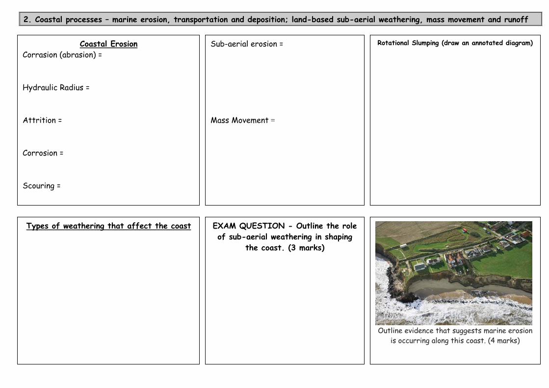
2. Coastal processes – marine erosion, transportation and deposition; land-based sub-aerial weathering, mass movement and runoff
Coastal Erosion Corrasion (abrasion) = Hydraulic Radius = Attrition =
Sub-aerial erosion = Mass Movement =
Rotational Slumping (draw an annotated diagram)
EXAM QUESTION - Outline the role of sub-aerial weathering in shaping
the coast. (3 marks)
Outline evidence that suggests marine erosion
is occurring along this coast. (4 marks)
Corrosion = Scouring =
Types of weathering that affect the coast

EXAM QUESTION - With specific reference to a case study of coastal erosion, assess the relative importance of its physical and socio-economic consequences. (15 marks)
Case study options = North Yorkshire coast (Whitby, Robin Hoods Bay) or Walton on the Naze or the Holderness Coast or Barton on Sea
Physical Consequences = Socio-economic consequences =
Transportation = Longshore Drift
EXAM QUESTION - Describe processes of transportation on a beach. (7 marks)
Description
Diagram
Remember: > other methods of transportation: Traction, saltation, suspension & solution > to use diagrams to support your answer

3. Landforms of erosion: headlands and bays, blow holes, arches and stacks, cliffs and wave cut platforms
Annotate the different types of rock Concordant coastline =
Discordant coastline =
EXAM QUESTION Explain the formation of headlands and bays. (6 marks) (Refer to geology as a key factor)
Draw a diagram to show how the coastline has changed owing to erosion to form headlands and bays
Geology map – Isle of Purbeck, Dorset
How has geology influence the shape of a Dorset coastline?

Label on the picture and define: Cliff = Wave cut notch = Wave cut platform =
Example Exam Questions Place different landforms in the
spaces to create your own questions
Picture provided - Describe the X and explain its/their formation. (7 marks)
Describe and explain the formation of landforms resulting from erosion/deposition. (15 marks)
Describe the characteristics of X and explain their formation. (7 marks)
Describe the landforms resulting from erosion/ deposition shown in Figure X (picture). (4 marks)
Choose one of the landforms of erosion shown in Figure X. Name the landform and explain its formation. (7 marks)
Explain the formation of X(6 marks)
Describe and explain the development of X (15 marks)
Describe the coastal landforms and explain how marine and sub-aerial processes have combined to produce these landforms (7 marks)
With reference to the photograph and using a diagram(s), describe and explain the formation of a wave cut platform and cliffs

Blowholes - A blow hole is formed when a joint between a sea cave and the land surface above the cave becomes enlarged and air can pass through it. As water flows into the cave, air is expelled through the pipe like joint, sometimes producing an impressive blast of air or spray which appears to emanate from the ground. A blowhole is formed as sea caves grow landwards and upwards into vertical shafts and expose themselves towards the surface
Study the two photographs of the Pembrokeshire Coast
EXAM QUESTION - Describe the characteristics of arches/stacks/stumps and explain their formation. (7 marks)
i) Label the coastal features shown
ii) Describe the coastal landforms and explain how marine and sub-aerial processes have combined to produce these landforms (7 marks)
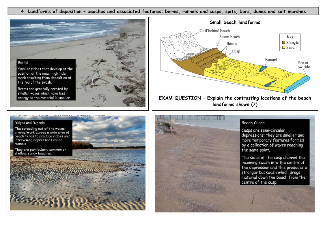
4. Landforms of deposition – beaches and associated features: berms, runnels and cusps, spits, bars, dunes and salt marshes
Small beach landforms
EXAM QUESTION – Explain the contrasting locations of the beach
landforms shown (7)

Beach sediment can include: 1. Clastic sediment: Comes from weathering of rock and varies from very small clay particles to sand/pebbles/boulders. 2. Biogenic sediment: Skeletons and sediments of marine organisms. 3. Non-cohesive sediment: Larger particles (for example, sand) moved grain by grain. 4. Cohesive sediment: Very small clay and mud particles that bond together.
BEACH PROFILES A beach profile is a c_ _ _ _ s_ _ _ _ _ _ of a beach from the h_ _ _ w_ _ _ _ m_ _ _ (HWM) to the l_ _ w_ _ _ _ m_ _ _ (LWM). Three of the key factors that influence beach profiles are: i) S_ _ _ _ _ _ _ size (grain size and percolation rates ii) w_ _ _ e_ _ _ _ (constructive or destructive) iii) Tidal range Deposition occurs when the supply of sediment exceeds the rate of removal. This normally takes place in low energy, sheltered environments. Beach profiles differ from winter to summer as storms tend to be frequent in the winter.
BEACHES Beaches are accumulations of s_ _ _, s_ _ _ _ _ _ and m_ _ deposited by waves in the nearshore, foreshore and backshore zone.
Swash-aligned beach =
1. Draw a beach profile for a) shingle beach & b) sandy beach 2. Highlight the key differences
Drift-aligned beach =

BARS (Case study = Slapton Sands, Devon)
Characteristics - remember you can comment on the length, width, material; land use, height etc when describing the characteristics of a landform
Why is Slapton Sands a predominantly swash-aligned landform? Explain you answer using an annotated diagram
SPITS (Case study = Dawlish Warren, Devon)
A spit is………………..
What conditions/factors are needed the formation of a spit? > > > > >
EXAM QUESTION - Describe the characteristics of spits and explain their formation. (7 marks) (Make sure you use a diagram)

Describe and explain the formation of a sand dune ecosystem (Psammosere)
Sand Dune Transect/Profile Draw a dune profile to show: the sea, strand line, embryo dunes; fore dunes; main ridge (yellow dune); fixed dunes (grey dune); dune slacks and mature dunes/dune scrub. Annotate key features and species.
Succession = Pioneer species = Xerophytic plants = Plagioclimax =
Features required for the formation of sand dunes: > > > >

1
2
3. M_ _ _ _ _ _ _ develop that are e_ _ _ _ _ _ at l_ _ tide
4. Pioneer Stage = Mudflats c_ _ _ _ _ _ _ _ by p_ _ _ _ _ _ species such as c_____ g______ and g_____ w____ (halophytes)
5. Over time the s_ _ _ tolerant plants trap more m_ _ and these spends a l_ _ _ _ _ period of time exposed. In addition, dying p_ _ _ _ _ add h_ _ _ _ and n_ _ _ _ _ _ _ to the soil making the conditions less h_ _ _ _ _ _.
6. Competition Stage = competition between p_ _ _ _ _ _ species which grow quickly and die young (opportunistic species) competing with those that may take longer to grow but are stronger and will eventually dominate (equilibrium species).
Halophyte = Climatic Climax ecosystem =
Succession of a Salt Marsh Ecosystem (Halosere)
A marsh is a d_ _ _ area with v_ _ _ _ _ _ _ _ _; salt marsh is v____________ associated with the shallow s_ _ _ _ _ waters near the coast. A salt marsh may be defined more precisely as the v_ _ _ _ _ _ _ _ _ that occurs on m_ _ _ y s_ _ r _ s between approximately mean h_ _ _ water neap and extreme high w_ _ _ _ spring tides. A halosere is a series of communities displaying a successional sequence where the p_ _ _ _ _ are adapted to s_ _ _ water.
The conditions needed for salt marsh development are:
i) A sea shore with very little w_ _ _ a_ _ _ _ _ so f_ _ _ p_ _ _ _ _ _ _ _ (i.e. clay) can fall out of s_ _ _ _ _ _ _ _ _ ii) S_ l_ _ _ conditions for flocculation to occur (neutralisation of clay particles so they cling together and are deposited) iii) S_ _ _ _ _ _ from exposure (wave action) e.g. a river estuary or behind a spit iv) A source of m_ _
7. Stabilisation = The number of species continues to increase as abiotic factors (n_ _ _ _ _ _ _ _, w_ _ _, pH) become more favourable. I.e. scurvy grass and sea lavender
8. As m_ _ levels r_ _ _, complex c_ _ _ _ systems that channel the flowing t_ _ _ _ develop.
9. Eventually the l_ _ _ r_ _ _ _ above s_ _ l_ _ _ _ and new species such as reeds and rushes become established.
10. Climax - the final stage of development on a salt marsh is called the climax stage. This may include t_ _ _ _ such as a_ _ and a_ _ _ _.

5a. Sea level change – Eustatic and Isostatic change
How and why do sea levels change? (Increase in height & Decrease in height)
• Absolute change = • Relative change = • Glacial stage = • Interglacial stage = • Epeirogeny =
Sea level change over the past 20,000 years
Define and explain the following terms:
Eustatic changes
Glacio-eustacy
Thermo-steric changes
Isostatic changes
Glacio-isostacy
Tectonic isostacy
Exam Question - Outline the impacts of present and predicted sea level increase (15 marks)

5b. Coastlines of submergence and emergence and associated landforms
Landforms of Submergence Landforms of Emergence Caused by sea levels……………………………………….
Caused by sea levels……………………………………….
R_ _ _ or D_ _ _ _ _ _ e_ _ _ _ _ _ _ _ R_ _ _ _ _ b_ _ _ _
F_ _ _ _ _ R_ _ _ _ _ s_ _ _ _ _ _ _ _ p_ _ _ _ _ _ _ _
F_ _ _ _ _ R_ _ _ _ c_ _ _ _ l_ _ _
Barrier beaches (B_ _ _ & T_ _ _ _ _ _ _) Barrier Islands Drowned forests
EXAM QUESTIONS
i) Explain the formation of landforms typical of coastlines of emergence. (6 marks)
ii) Explain the causes of sea level change and the formation of resultant coastal landforms. (15 marks)
NAME THE FEATURES SHOWN
LANDFORM DIAGRAM FORMATION – description and explanation

6. Case study of coastal flooding – specific physical and human cause(s) and its physical and socio-economic consequences
Physical Causes/Contributing Factors Human Causes/Contributing Factors Case studies
Choose one example to summarise from the list below
- East coast of England (1953) - New Orleans (2005) - Irawaddy delta, Burma (2008) - Bangladesh (numerous examples)
Flood = When = Areas impacted (Sketch map)
Physical and socio-economic impacts
Response and Management (Short and long term)
Causes

7a. Coastal protection objectives and management strategies – Hard engineering: sea walls, revetments, rip rap, gabions, groynes and barrages
Technique Description Diagram Advantages Disadvantages
Sea wall
Revetments
Rip rap or
rock armour
Gabions
Groynes
Barrages
EXAM QUESTION
The photo above shows revetments in
Happisburgh, Norfolk in 2007 Suggest reasons why revetments were ineffective in protecting this coast. (4 marks)
Key approaches
Do nothing Hold the line = Extend the line = Retreat the line =
EXAM QUESTION Why do we protect coastlines?
Choose one of the following coastal management strategies: ● Gabions ● Groynes ● Barrages Describe the technique and explain how it helps to protect the coastline. (4 marks)

7b. Soft engineering: beach nourishment, dune regeneration, marsh creation, land use/activity management
Beach Nourishment What? = Why =
Dune regeneration What? = Why =
Planning/ zoning and land use management What? = Why =
Managed Retreat/Realignment
What? How? Why? Advantages and Sustainability
Diagrams showing different approaches of managed retreat
15 MARK EXAM QUESTIONS
1. Evaluate the potential of soft engineering techniques for managing coasts in a sustainable way. Make reference to one or more case studies of coastal management where such techniques have been dominant. 2. Discuss issues relating to a coastal area where soft engineering management strategies have been adopted. 3. With reference to one or more case study of coastal management, discuss whether the benefits outweigh the costs.

7c. Case studies of two contrasting areas – one where hard engineering and one where soft engineering has been dominant To investigate issues relating to costs and benefits of schemes, including the potential for sustainable management
Case study of Hard engineering – North Yorkshire Case study of Soft Engineering (Managed Retreat) (Sandsend to Whitby and Robin Hood’s Bay) (Abbots Hall Farm, Essex)
Where (sketch map and description)
Why is the area being protected?
Where (sketch map and description)
Why is the area being protected?
Methods (describe and diagrams)
Evaluation Costs and benefits (Economic & environmental) Sustainability?
Methods (describe and diagrams)
Evaluation Costs and benefits (Economic & environmental) Sustainability?