federated states of micronesia - unfcccunfccc.int/resource/docs/natc/micnc1.pdf · *federated...
TRANSCRIPT

. . . . . . . . . .
..........
1997 Climate Change NationalCommunication
Federated States ofMicronesia
*FSM
Climate Change ProgramFSM National GovernmentP.O. Box PS-12Palikir, Pohnpei, FM 96941Tel 691.320.2646Fax 691.320.2Email [email protected]
..........
Climate Change NationalCommunication -- 1997*Federated States of Micronesia
Executive SummaryThe Federated States of Micronesia includes the most geographically and culturally diversepart of the greater Micronesian region. The nation is comprised of four states – Yap, Chuuk,Pohnpei, and Kosrae – lying along the equator in geographic sequence from west to east.The nation has a total population of about 106,000. Each state has considerable autonomywithin the federation and has devised its own strategy for development. An overall,integrated development vision for the federation is provided by the national government.
As a small islands developing nation, the Federated States of Micronesia is one of thecountries most directly threatened by long-term global warming resulting from an increasedlevel of greenhouse gases accumulating in the earth’s atmosphere. Regarding the effects ofglobal warming, as a coastal nation, the FSM is particularly vulnerable to accelerated sea-level rise. And, because of the country’s geographic location, future global warming holdsthe possibility of creating more frequent, intense, or longer-lasting El Nino droughts.
Yet, the nation’s human-sourced greenhouse gas emissions represent a negligible percentageof the world’s total human-sourced release of carbon dioxide, methane, nitrous oxide, andother greenhouse gases into the atmosphere. It has even been speculated that because of the“sink” capacity of its extensive forest and coral reef systems, the nation may produce a net“uptake” of greenhouse gases. Still, the FSM acknowledges an international obligation, andvalues the opportunity, to act in “good faith” by joining with other responsible nations in aconcerted effort to undertake reasonable source-oriented mitigation measures in order tocontrol the level of greenhouse gases emitted into the atmosphere.
The FSM is also affected by climate change phenomena over the short-term. Moderate tostrong El Nino episodes create drought conditions across the nation. And, La Nina eventsbring heavier than normal rainfall, flooding, and wave and storm surge to the FSM’s islands.
Taking into account the FSM’s unique climate change vulnerabilities, as well as otherdomestic and international considerations; the most effective national policy for theFederated States of Micronesia involves developing a response strategy that addresses boththe effects and sources of those climate change phenomena that are most likely to have anadverse impact on the FSM in the short-term and long-term. This national response strategywill emphasize (1) undertaking both effect-oriented adaptation and source-orientedmitigation measures, and recognize (2) the ‘value-added’ benefit of those “combined”measures that provide for both adaptation and mitigation outcomes at the same time.

Since changes in climate are likely to first create physical and biological impacts on theFSM, which in turn will have social and economic repercussions, a national responsestrategy oriented toward undertaking adaptation and mitigation measures that help preventor minimize biophysical impacts will also help to preclude or lessen socio-economic impacts.Therefore, the most prudent climate change response strategy will be for the FSM to focus itslimited resources on implementing measures involving environmental management.
Importantly, as the FSM begins to undertake a comprehensive environmental managementresponse strategy that includes implementation of both adaptation and mitigation measures,the nation will begin to maximize its potential contribution toward controlling globalgreenhouse gas emission levels by sustaining or increasing the “sink” (or “uptake”) capacityof its coral reefs, and coastal and upland forests. The reason for this is straightforward.Many of the effect-oriented adaptation measures outlined in this communication are bydefinition also source-oriented mitigation measures. That is, they are “combined” measuresthat will provide for both climate change adaptation and mitigation outcomes at the sametime.
In adopting a climate change response strategy that emphasizes environmental management,wherever possible, the FSM’s policy approach will be to encourage a combination ofincentives (or disincentives), and public awareness and “grass-roots” participatorycommunity development programs and methods in the design and implementation ofadaptation and mitigation measures.
The FSM national government’s ability to respond effectively to global and regional climatechange faces a major challenge in that, in the arena of environmental matters, the constitutionalallocation of responsibilities between the national and state governments is not clear. To date, inmost cases, management and enforcement of environmental resources has been delegated to orassumed by the states. Over the past few years, a tentative understanding has emerged between thenational and state governments. It is now generally accepted that the states have the primaryresponsibility for control and management of the environment, and the national governmenthas an important role to play in coordinating state activities and providing technicalassistance.
The national government has identified four climate change phenomena which, over theshort-term and long-term, represent a significant threat to the well-being of the environmentand people of the Federated States of Micronesia. These priority vulnerabilities are:Accelerated Sea-Level Rise, El Nino Events, La Nina Events, and Greenhouse GasEmissions.
Climate Change Priorities Short-term Long-term
Accelerated Sea-Level Rise X
El Nino Events X X
La Nina Events X X
Greenhouse Gas Emissions X
With regard to these four national climate change priorities, the FSM has concluded that:
• Over the long-term, if the FSM’s coral reefs do not remain intact andhealthy, Accelerated Sea-Level Rise represents a dire climate change

threat to the entire nation, both high islands and atolls, due to coastalinundation, erosion, and flooding due to wave and storm surge.
• Over both the short-term and long-term, El Nino episodes represent asignificant climate change threat to the FSM because of the droughtconditions they cause. And, due to global warming, El Nino events couldbecome more frequent, intense, or longer-lasting in the future. Thus, overnext century, El Nino episodes may come to pose an even greater threat tothe FSM.
• Over both the short-term and long-term, La Nina episodes represent aclimate change threat to the FSM because of the heavier than normalrainfall, flooding, and wave and storm surge conditions these events cause.
• Over the long-term, global warming caused by increased human release ofGreenhouse Gas Emissions into the atmosphere represents a graveclimate change threat to the FSM for two reasons: (1) The inevitableacceleration in the rise of sea-level that will be caused; and (2) thepotential increase in the number, strength, or duration of El Nino eventsand the resulting drought conditions these episodes cause.
The national government remains concerned about the potential influence of climate changephenomena on typhoon activity. However, typhoons were not selected as a national climatechange priority on the basis of the best available, but still inconclusive, scientific evidence onthe affects of El Nino episodes and global warming on typhoon activity in the FSM andadjacent regions.
The FSM has identified six interconnected sectoral and four cross-sectoral areas of interestin which effect-oriented adaptation and source-oriented mitigation measures need to beadopted to address the known and potential impacts of the above four national climatechange priorities. For each of the following areas of interest, a number of environmentalmanagement and other related measures have been outlined in this communication whichcould be cooperatively undertaken by the national and state governments to effectivelycontend with the FSM’s major climate change vulnerabilities.
Sectoral Areas Cross-Sectoral Areas
Coral Reef Ecosystems Public Awareness Programs
Coastal Zone Ecosystems Research Programs
Waste Management Technology Development & Transfer
Upland Forest Ecosystems Interagency Strengthening
Agriculture/Agroforestry
Water Supply
The environmental management focus of the sectoral and cross-sectoral climate changemeasures outlined in this FSM national communication has been selected based upon asimple truth: The social, cultural, and economic prosperity of the Federated States ofMicronesia has been and will continue to be directly dependent upon the health of its coralreefs and interconnected ecosystems. In the arena of climate change, this truth remainsparamount. If the FSM is to effectively cope with climate change impacts, the nation must
build an appropriate local strategy, capacity, and acceptance of responsibility formanagement of its coral reefs and other interrelated ecosystems. Successful localimplementation of such an effort will depend upon the support, cooperation, and fullparticipation of all important stakeholders, especially customary owners and users of theseresources.
As this national communication outlines in some detail, to effectively contend with theFSM’s major climate change vulnerabilities, both short-term and long-term, the nation mustwork cooperatively to achieve a common goal: The conservation and sustainable use of itscoral reefs and other associated ecosystems. This goal can be reached with the activesupport and involvement (i.e., commitment of financial, technical, manpower, and otherneeded resources) of stakeholders at all levels: international, regional, national, state,municipal, and community. Attaining this goal can be facilitated by the active participationof private sector businesses, and governmental, non-governmental, and other agencies,organizations, and institutions.
Ultimately however, the key to achieving the conservation and sustainable use of the FSM’scoral reefs and associated ecosystems resides within the local communities. The people wholive, physically and spiritually, as a natural part of these fragile ecosystems will have todecide whether or not to make the commitment for themselves, and on behalf of their futuregenerations, to adopt and implement a comprehensive, fully participatory, community-basedmanagement approach to their environment.
This figure is not available electronically
“Working together, caring for each other and the environment; that is our Micronesian culture.”

FSM OverviewThe Federated States of Micronesia is a young, independent nation created from part of theformer United States administered United Nations Trust Territory of the Pacific Islandsfollowing conclusion of a Compact of Free Association with its former administrator, theUnited States, in 1986. In 1991, the FSM became a member nation of the United Nations.The FSM includes the most geographically and culturally diverse part of the greaterMicronesian region. The nation is comprised of four states – Yap, Chuuk (formerly Truk),Pohnpei (formerly Ponape), and Kosrae (formerly Kusraie) – lying along the equator andstretching about 1,700 miles (2,700 kilometers) in geographic sequence from west to east.Specifically, the FSM is located in the western Pacific Ocean between the equator and 14degrees North latitude, and between 136 degrees and 166 degrees East longitude. The nationhas a total population of about 106,000. Each state has considerable autonomy within thefederation, but their unity provides greater resources with which to face the challenges ofdevelopment. The states have devised their own strategies for development, while anintegrated perspective for the federation is provided by the national government. Thisoverall national development vision is described in the most recent FSM NationalDevelopment Plan.
The marine area within the FSM’s Exclusive Economic Zone (EEZ) totals over one millionsquare miles (2.6 million square kilometers) and includes abundant and varied resources.The land area constituting the FSM’s 607 islands, however, is only 271 square miles (701square kilometers). Of these hundreds of islands, a number are relatively large andmountainous or hilly, while the rest are small, flat coral atolls or raised coralline islands.The diverse habitats and species of the natural environment have always had a profoundinfluence on the Micronesian people and their cultures. There are marked differencesamong and even within the four states, reflecting both the conditions of nature and the socialstructures that have evolved over the thousands of years since the islands were first settled.In both the communal subsistence and cash economies, the land and marine resources thatconstitute the natural environment of the FSM are essential to the physical and cultural lifeof the people.
This figure is not available electronically
National Circumstances
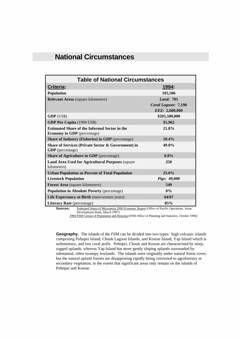
Table of National CircumstancesCriteria: 1994:Population 105,506
Relevant Areas (square kilometers) Land: 701Coral Lagoon: 7,190
EEZ: 2,600,000GDP (US$) $205,500,000
GDP Per Capita (1994 US$) $1,962
Estimated Share of the Informal Sector in theEconomy in GDP (percentage)
21.8%
Share of Industry (Fisheries) in GDP (percentage) 10.4%
Share of Services (Private Sector & Government) inGDP (percentage)
49.0%
Share of Agriculture in GDP (percentage) 0.8%
Land Area Used for Agricultural Purposes (squarekilometers)
250
Urban Population as Percent of Total Population 25.0%Livestock Population Pigs: 49,000
Forest Area (square kilometers) 549
Population in Absolute Poverty (percentage) 0%
Life Expectancy at Birth (men/women years) 64/67
Literacy Rate (percentage) 85%Sources: Federated States of Micronesia 1996 Economic Report (Office of Pacific Operations, Asian
Development Bank, March 1997)1994 FSM Census of Population and Housing (FSM Office of Planning and Statistics, October 1996)
Geography. The islands of the FSM can be divided into two types: high volcanic islandscomprising Pohnpei Island, Chuuk Lagoon Islands, and Kosrae Island, Yap Island which issedimentary, and low coral atolls. Pohnpei, Chuuk and Kosrae are characterised by steep,rugged uplands, whereas Yap Island has more gently sloping uplands surrounded bysubstantial, often swampy lowlands. The islands were originally under natural forest cover,but the natural upland forests are disappearing rapidly being converted to agroforestry orsecondary vegetation, to the extent that significant areas only remain on the islands ofPohnpei and Kosrae.

For any type of development planning activity in the FSM, including climate change,geographic dispersion is a critical feature to take into account. Each State must beconcerned with the demands of its main island population center and rural areas as well asthe unique requirements of its insular outer islands. These outer islands are differentdemographically, culturally and economically, and they are generally located at suchdistances that all aspects of central governance are expensive, demanding and generallyplagued by inefficiencies. The circumstances of these outer islands cannot be ignored byplanners.
Demography. Closely related to its geographic dispersion is the FSM's demography.Between 1989 and 1994, the population increased by 10 percent, with Pohnpei's andKosrae's share of the population increasing by 13 and 4 percent respectively. For Pohnpei,this increase represents the migration of the general population to the Nation's capital foreconomic opportunities.
Although the medium age of the population has increased over the last 30 years from 16 to18 years of age, the structure of the population remains the same. The FSM has one of theyoungest populations among Pacific Island nations. Almost 64 percent of the Nation'spopulation is under 24 years of age.
The average population density in 1994 was 389 persons per square mile. But this varies byState. It ranges from a high of 1,088 per square mile in Chuuk to 170 per square mile inKosrae. The matter of population density is important since it raises the issue of economiesof scale for a variety of development efforts, including climate change matters. Averagepopulation density on a statewide or nationwide basis may be misleading since the pattern ofpopulation density varies considerably.
Climate. The climate of the Federated States of Micronesia is typical of many tropicalislands. Temperatures are relatively uniform, averaging in the mid 70 to mid 80 degreesFahrenheit range; humidities average over 80 percent. Rainfall is high, varying from about120 inches on drier islands to over 400 inches per year in the mountainous interior ofPohnpei.
On most islands, there is a pronounced wet season (June to October) and dry season(November to May). On Pohnpei, the “dry” season contracts to January to March. Thewestern region of the FSM is subject to occasional (one in 20 years return period) typhoonswhich can cause severe damage. A recent typhoon on Pohnpei caused many landslides anddamage to vegetation as well as infrastructure.
Resource Ownership. Land ownership is the most valued right in Micronesia; thelandless person has much lower status than the landowner. Land ownership and tenure iscomplex within the FSM and varies from state to state. Traditionally, the use of terrestrialresources and all accessible marine resources was distributed among the people under thecontrol of chiefs. Rights could be given, earned and inherited either matrilineally orpatrilineally. Complex usage rights overlaid actual site ownerships; for example, owners ofa tree and users of its fruit might not be the owners of the land on which it grew.
Land tenure patterns generally involve communal ownership of a single plot, singleownership of several and separate plots, or usage right to land owned by traditional leaders.In the traditional economy, land is not a commodity to be sold or traded and, under the FSMConstitution, ownership of land is restricted to citizens. Land may be leased to non-citizens,the permissible lease periods varying from state to state. However, the attitude in someareas towards land is gradually changing, with sales and trades taking place as well asleases, especially near centers of development.

Some changes in land tenure resulted from the German, Japanese and American colonialoccupations where land was "acquired" by the administrations for public purposes or for the"public good". All such land was transferred to the State and Municipal governments. InPohnpei, the former colonial administrators interfered with traditional landownership byredistributing land titles to various people. Although many of the subsequent land disputeshave since been settled, ownership of much land is still contested. Although thegovernment has legal authority over land for "eminent domain and condemnation", thispractice is strongly avoided.
Shallow reefs and the intertidal flats and their resources were traditionally usually owned bythe nearby landowners, but this traditional ownership is no longer recognized in Kosrae andPohnpei; in Yap and Chuuk it persists and is a central consideration in marine resourcesmanagement.
Cultural & Historical Resources. Rich indeed is the Federated States of Micronesia inits varied cultural and historical resources -- prehistoric, pre-European historic, andEuropean-Asian historic.
Kosrae Island has a stone city (Lelu) built of basalt boulders, columnar basalt crystal logsand coral rubble in-fill on the intertidal flat. Construction of the city is believed to havecommenced about 1,500 years ago and it was still occupied in the 1820s. Kosrae also hashistorical shipwrecks from the whaling era.
Pohnpei Island has the much larger and better known stone city of Nan Madol which wasthe center of the Sau Daleur empire for some centuries (see picture below). This city wasalso built on the intertidal flat on 92 artificial islands connected by walled canals, with somealso connected by subterranean tunnels. This city is also believed to be over 1,500 years oldand may be much older. There are another two known stone cities and other megalithicstone edifices, petroglyphs and terraces in the rugged interior of Pohnpei Island. Pohnpeialso has numerous historical sites from the Spanish, German and Japanese colonial eras.
One of Nan Madol’s 92 artificial islands is shown below (photograph courtesy of Phoenix of Micronesia).
This figure is not available electronically

In Chuuk State, there are also a number of megalithic remains, including a walled enclosureon the island of Tol. Chuuk is famous for its "Ghost Fleet" of sunken Japanese ships andairplanes from World War II in the lagoon which are now a major attraction for divetourists.
Yap's traditional culture has been and remains very strong. This culture includes thefamous "stone money" of Yap. There are also a number of historical wrecks and othermaterial from the World War II period.
The identification and preservation of culturally and historically important sites areimportant when any development planning activity is undertaken, and climate changeplanning is no exception. While some sites have already suffered from developmentalvandalism by humans, perhaps of greater concern at present is the destructive encroachmentof nature on the stone cities. It is also quite evident that many more archaeological sitesremain to be studied and identified.
Water. Only Kosrae and Pohnpei have perennial streamflow; the large deltas of rivers withshort stream length and steep channel gradient attest to the very high rainfall which occursin the mountainous interiors of these islands.
All communities in Kosrae State are served with piped systems mainly from stream intakesvia gravity distribution. The central water supply system comprises about five miles ofdistribution mains drawing on a diverted river, a rapid sand filter, and a 40,000-gallonstorage tank.
In Pohnpei State, the capital center of Kolonia has a water supply system that consists of ariver source (the Nanpil Dam) supplemented by three drilled groundwater wells (bores)which feed 26 miles of distribution mains of the central water supply distribution system.Approximately 55 percent of connected households are on 24-hour water service. Ruralareas have a few community system such as that in Kitti where a filtration and chlorinationprocess precedes the distribution network.
Only in the capital center of Weno (Moen) and on parts of Tonoas (Dublon) in Chuuk Stateare there centralized water supply systems. Most of the State's population relies onindividual roof catchments and storage tanks for their water. This water supply issupplemented by fresh to brackish groundwater from springs and shallow hand-dug wells.
In Yap State, the Gitam Dam supplies more that 30 million gallons to the capital center ofColonia but demand exceeds the capacity of the filtration and chlorination plant. Themajority of the population relies on individual rainwater catchments. In addition, there aretwo deep well systems, one serving the northern part of Yap Island, while on the westernside of Yap (Map and Rumung municipalities) spring water is collected and fed to thevillage by gravity feed.
In the FSM’s atolls, raised coralline islands, and in those coastal areas composed of coralsand deposits and lagoon sediments, the freshwater lens which "floats" on the underlyingdenser seawater is tapped through shallow, hand-dug wells to supplement the rainwatercatchment and storage tanks which are widely used and commonly the main source ofdrinking water in the outer islands.
Land Resources: Flora & Forests. There are nine closely interconnected terrestrialecological zones in the Federated States of Micronesia:

Coastal/Littoral Beach Strand. The Beach Strand is comprised of vegetation thatis found commonly throughout the Pacific and that has adapted to sunny, salty, and windyconditions. Herbaceous strand such as Ipomoea littoralis and Vigna marina is found nearestthe beach. Littoral shrubland is located directly behind the beach with the dominant plantbeing Scaevola taccada. Littoral woods are located further back and make up the dominantcoastal vegetation. Common tree species include Calophyllum inophyllum, Hernandiasonora, Barringtonia asiatica and Pandanus tectorius, Hibiscus tiliaceus, Artocarpus(breadfruit), and Cocos nucifera (coconut), both planted and wild, and are found from theshoreline inland. Other important vegetation includes Casuarina littoralis, Cordia, Heritieralittoralis, , Messerschmidia, Morinda, Pisonia, Terminalia catappa and Derris, andThespesia populnea.
Mangrove Forest. Mangrove Forest is generally in muddy saltwater reef flatsalong coastal areas. Kosrae is fairly unique within the Pacific in that most of the mangrovesthere are located behind the barrier islands of the Beach Strand. Major mangrove speciesfound in the FSM include Rhizophora apiculata, R. mucronata, Sonneratia alba, andBruguiera gymnorhiza, Luminitzera littorea, and Xylocarpus granatum.
Swamp Forest. Swamp Forest occurs extensively on Kosrae and Pohnpei and isdefined largely by the presence of tropical swamp trees Barringtonia racemosa, Terminaliacarolinensis, Hibiscus tiliaceus, Metroxylon amicarum, Erythrina fusca, and Campnospermabrevipetiolata.
Freshwater Marsh. Freshwater Marsh occurs on almost all the islands across theFSM. It is located mainly in poorly drained areas behind the Beach Strand. Marshvegetation consists mainly of non-woody species like Phragmites karka, Scirpodendronghaeri, Rhynchospora corymbosa, Cyperus javanicus, and Ludwigia hyssopifolia andoctovalvis. These marshes are utilized for taro production in all the inhabited islands ofYap and Chuuk States as well as in all the outer islands of Pohnpei State.
Grassland. Human-induced Grassland is relatively extensive in the larger highislands of Yap, Chuuk and Pohnpei States, and is increasing in area due to frequent firingwhich destroys the forest edge and tree regeneration. Dominant grasses include Paspalum,Dimeria, Ischaemum, and Dicranopteris (staghorn ferns).
Secondary Forest. Secondary Forest is found wherever disturbance has occurredinland of the Mangrove and Swamp Forests and Beach Strands as a result of human activitythrough gardening or by nature through landslides, typhoons and strong storms. It is inthese areas that much of the agroforestry has traditionally been undertaken. Consequently, ahigh proportion of the plant species found in Secondary Forest areas are comprised of treesor other overstory and shrubs which yield food, fruit or other useful products.
Primary Forest. The use of the term Primary Forest is restricted to that area of theFSM’s high islands excluding Mangrove, Swamp, Secondary, Rain, and Crest Forests.Extremely little of this ecosystem remains in Chuuk and Yap, but extensive areas are stillfound in Pohnpei and Kosrae. Characteristic vegetation includes banyan figs, pandanus,climbing screwpine, the endemic palm (Clinostigma ponapensis) and a range of hardwoodtree species. This zone provides for a wide range of human needs including timber, fruit,medicines, handicrafts, and dyes.
Rain Forest. Rain Forest is restricted to the interior mountain peaks of Kosrae andPohnpei, generally being found in locations that exceed a 20 percent slope and have thinsoils overlying rock. Apart from the typical hardwood rain forest species, other common

plants include banyans, tree ferns, bird's-nest ferns, mosses, some 36 endemic orchids, andpepper vines.
Crest (Dwarf or Cloud) Forest. The dense and dwarfed vegetation of the unusualCrest Forest is found only on the generally cloud-covered, extremely wet mountain ridgesummits of Kosrae and Pohnpei. Trees are bent and stunted and support large growths ofmosses, ferns, and other epiphytes. Many of the plants are dwarfed specimens of speciesfound at lower elevations.
All States except Chuuk have large forested areas. Forests account for 63 percent of thetotal land area in Kosrae, 56 percent in Pohnpei (watershed forest reserve in the center ofthe island constituting about 30 percent of the total land area), and 33 percent in Yap,compared with about 10 percent in Chuuk. The forests of the central islands protectwatersheds and prevent erosion. The coastal mangrove, swamp, and marsh areas filter run-off sediments and act as nurseries for many marine species.
Land Resources: Fauna. Terrestrial mammals are mainly restricted to introducedspecies such as pigs, dogs, cats, and, in the Rain Forest zone of Pohnpei, Philippines deer.There are a number of bats and rats. Although rats are not considered of valued, they areenvironmentally significant animals and can cause considerable damage to crops and plants.
Birds comprise by far the greatest proportion of the FSM's animals and include a number ofendemic species. Shorebirds, egrets and terns are abundant in the Beach Strand. Ofendemic bird species, the Kosrae mountain starling and the Kosrae rail have become extinct.Three endemic species in the FSM that have been listed as endangered are the nightingalereed-warbler, the Pohnpei greater white-eye, and the Pohnpei mountain starling. Inaddition, several species or populations are considered candidate endangered species. Theseare the short-eared owl, the Chuuk population of the Micronesian pigeon, the Chuukmonarch, and the Chuuk greater white-eye.
The coconut crab is strictly limited to coastal habitats and this species has been mostlywiped out along inhabited coastal areas. Animals that depend on the Mangrove and SwampForests, or Freshwater Marsh for habitat include the mangrove crab, currently threatened byoverharvesting, and the introduced monitor lizard. The fruit bat, black noddy, brownnoddy, white or fairy tern, cardinal honeyeater, and Micronesian pigeon all forage and nestmainly in these locations. A number of animals and birds also live in or otherwise make useof the Grasslands and Secondary Forest including the cardinal honeyeater, Micronesianstarling, dusky white-eye, and blue-faced parrotfinch.
The Upand Forest (i.e., Primary and Rain Forests) ecosystems also provide a rich habitat fora number of animals and birds. The white-tailed tropic bird, audobon’s shearwater, cardinalhoneyeater, gray swiftlet, Micronesian starling, dusky white-eye, purple-capped fruit dove,red jungle fowl, and the endangered Micronesian pigeon all nest and forage in the UplandForest. The Crest Forest provides habitat for several species of tree snails, some found onlyin the FSM.
Marine Resources. The marine environment is of enormous importance to the people ofthe Federated States of Micronesia. For Chuuk, the marine environment is considered thebasis for Chuukese culture, being the principle source of subsistence, recreation andcommerce. The nation’s marine resources are extensive and in many ways central to thefuture social, cultural, and economic prospects of the FSM.
Historically, the inshore and near-shore marine environment is the source of a wide varietyof traditional foods. This remains true today. Also, the water sports of swimming, canoeing
and sailing are traditionally popular and remain so for both residents of the FSM andtourists. In addition, large numbers of divers are attracted to the coral reefs and wartimerelics, with Chuuk State being regarded as one of the top wreck diving locations in theworld.
Economic Development. The economy of the Federated States of Micronesia is small,based on a small domestic market of about 106,000 people with modest levels of income andscattered over large distances. Infrastructure is not well developed and is generallyinadequate for the increasing population; this is compounded by a low level of maintenancedue to severe limitations on recurrent expenditure funds.
With the exception of offshore fisheries, there is a limited resource base, and a seriousimbalance exists in external trade with as yet limited development of private sector activitiesoutside of wholesale/retail and service industry sectors. The FSM is largely dependent onexternal aid and government sector activity. The current FSM National Development Planrecognizes that there is a marked dichotomy between the cash and traditional economies butthat traditional values have been maintained.
The commercial and industrial sectors of the FMS consists primarily of small businesses,complemented by a few larger public companies, co-operatives and credit unions. Fewfamily-based businesses have entered the industrial sector, most being engaged incommercial import/export, wholesale and retail business or service enterprises such asrestaurants, taxis, car rentals, repair and maintenance etc.
While the FSM has preferential access to United States, Australian and New Zealandmarkets, the adjacent markets of Japan and the ASEAN countries also offer importantmarketing opportunities for FSM exports. However, there has been little growth in theFSM’s exports during the 1990s. Interstate trade is minimal and generally involvesagricultural produce.
Employment. For the FSM as a whole, subsistence and market jobs in agriculture andfisheries account for 28 percent of the work force. The major employer in the FSM is thepublic sector, accounting for one in every three jobs, slightly more than agriculture andfisheries sectors combined. Of the 14,381 persons estimated to be employed in the casheconomy, nearly half are engaged by National or State Governments to operate publicfacilities, perform construction work and provide community services. Public sector wagesand working conditions are said to be considerably superior to those of the private sector.This pattern has contributed to the low rate of development of those entrepreneurial andtechnical skills which are needed to increase efficiency in the production and export servicesectors of the economy.
Expatriate labor is still required to supplement the limited numbers of local personneltrained in technical and professional services. Some Micronesians go abroad for advancedtraining and do not return; others including unskilled laborers migrate to Guam or Hawaiiin search of employment and better pay. Meanwhile, hundreds of foreign workers areemployed in construction and other semiskilled trades which would use local labor wereadequate training programs available.
Private businesses provide employment mainly in the wholesale and retail trades, hotels,restaurants, light manufacturing, financial and business services, insurance andconstruction.
Forestry. The current main values of the forests are in their support of subsistenceagroforestry activities, and for their ecological and environmental protection roles, not as a

source of commercial timber. The dominant forest areas of the central islands protectwatersheds and prevent excessive erosion. The mangrove areas filter run-off sediments, andact as marine nurseries. The forest and mangroves also provide a protected natural habitatfor exotic species of plants and wildlife. Scattered use of forest resources occur throughout FSM, mostly for construction insubsistence homesteads and for firewood, but also for furniture. Mangrove timber is usedfor handicrafts and furniture.
The most serious environmental problem in the forestry sector is the extent of uplanddeforestation occurring on Pohnpei. The conservation and biodiversity values attached toPohnpei’s upland forests are as important as their hydrological buffering functions, in thatthe upland forests are habitat for 269 species of plants, 110 of which are endemic, as well as24 species of birds of which 5 are endemic. However, over the last 20 years the uplandforest has been threatened by increasing population pressure and exploitation, as a result of(1) conversion to agroforestry and agriculture (principally for sakau), (2) human settlement,(3) road construction, (4) hunting, and (5) tourism trails. Recent attempts to mitigate theseadverse impacts have centered on the promotion of community-based management regimeswhich combine local community and traditional institutions with municipal and stategovernments, through local Watershed Area Management Committees. Initial results ofthis approach are encouraging, and while the process is long and complex, the outcome isanticipated to be more sustainable than regulatory solutions. Similarly, the mangrove forests are important to the maintenance of the natural lagoonecosystem, but overharvesting is occurring. There has been extensive use of mangrovewood for cooking, housepoles, sawn timber, woodcarvings, and other purposes resulting inover-exploitation occurring in some localities on Kosrae, Pohnpei and Yap. Progress on these critical resource management issues will require legislation changes,public awareness education, and the investigation of alternative methods of resourcedevelopment which are more sympathetic to environmental constraints. An initialinvestigation of some of these low-impact options within a framework of sustainability,compatibility and profitability (the SCP criteria) has been recently undertaken for Pohnpei,and further extension of this approach is expected. Agriculture. Agriculture production in the FSM is primarily for subsistence, with somesemi-commercial and commercial activity. Almost every household engages at least part-time in agricultural activity. With one exception, the few current commercial fruit andvegetable production units are no larger than 20 acres in size. Subsistence production isbased mainly on shifting cultivation agroforestry systems. The agroforestry takes the formof garden areas for root-crops (e.g., taro, yam) and other vegetable production, interspersedwith a high proportion of food trees, particularly varieties of coconut and breadfruit. Mangoand a number of banana and papaya varieties are common with additions of varieties ofcitrus species in Yap and Kosrae (e.g., tangerines, limes, sweet and valencia oranges).Integrated with the mix of fruit and other food crops is an understory of plants and shrubsused for a number of other local purposes.
Bananas are one of the nation’s agricultural exports (photograph courtesy of Phoenix of Micronesia).
This figure is not available electronically
Numerous attempts have been made in the past to develop commercial agriculture. Exceptfor coconuts and bananas, none of these attempts succeeded in the long-term, althoughremnants exist, such as coffee on Pohnpei. The most notable recent success is the “opencanopy gardens” producing vegetables such as head cabbage, green onions, bell peppers,and corn for small-holder commercial enterprises. Other local cash crops includecucumbers, watermelons, gourds, sweet potatoes, eggplants, tomatoes, cassava, and somebetelnut, pineapple and sugarcane.
Copra remains the main cash and commercial export production crop throughout the FSM,but production has decreased dramatically. The decline is attributed to the low prices forcopra coupled with increasing senility of the coconut palms. In addition to copra, blackpepper is under cultivation in Pohnpei. Sakau (kava) has also become a cash crop onPohnpei primarily for sale at local sakau bars. In Kosrae, citrus and root-crops aresignificant with banana, limes, tangerines, and taro exported to Guam, the Republic of theMarshall Islands, or Pohnpei. Periodically, Yap exports bananas, other vegetables, fruitsand betelnut to Guam and Palau.
Farmstead livestock productions is increasingly important throughout the FSM, particularlypigs, poultry and eggs. Commercial egg production is reasonably well established now inall four States. Pigs remain the single most important animal raised by households forfood, ceremonial purposes and sale. The FSM imports large quantities of frozen meatsprincipally from the United States and Australia. However, these imports are smallcompared with those of frozen whole chicken, turkey and turkey tails.
Agricultural processing is limited to coconut products and gourmet pepper production. Theagricultural marketing system is not well developed. Small local produce markets exist inState centers, supplying fresh fruit and vegetables to high-density residential areas whereland scarcity or preference create a demand from salaried labor of the government orcommercial sectors. Restaurants provide a small market for selected fruits and vegetables.
Fisheries. The fisheries resource of the FSM can be divided into: (1) the offshore, deepsea marine resources of the EEZ which are mainly exploited by the Distant Water FishingNations (DWFNs) under license agreements; and (2) the inshore and near-shore marineresources, comprised of fisheries which are exploited mainly for food production(subsistence fishing) and, to a growing extent, for commercial purposes (artisanal fishing).The inshore fishery is the area between the shoreline and a depth of 50 meters along theouter reef slope, and the near-shore fishery is from the 50 meters depth limit to the nation’s12 nautical mile jurisdiction.
Inshore & Near-shore Fisheries. Reef resources are critical to artisanal fishingactivities. Data are obviously incomplete with the annual catch being variously estimatedfrom 1,000 to 5,000 tons. This catch is largely consumed locally as an essential source ofnutrition in the traditional Micronesian diet. Reef fish have tremendous importance to thehealthy sustenance and cultural heritage of Micronesians. So far, efforts to avoidoverfishing reef areas and to eliminate fishing with dynamite, bleach, cyanide, and otherpoisons have not been successful. Fish stocks in reef areas close to large urban populationshave now been seriously depleted.
There is negligible resource stock information available on the inshore marine resources ofthe FSM, although some stock data trials have been initiated in two States. Until reliableinformation is available, resource management programs cannot be planned andimplemented with confidence, so allocation of resources to data collection is a priority. In

the interim, it is generally accepted that the inshore fishery can only sustain a continuationof subsistence practices, with some small-scale commercial fishing in certain localities. Thenear-shore resource is also limited, and generally could only sustain fishing at the artisanallevel for the domestic market.
Natural populations of the giant clam (Tridacnidae) as well as small clam species and othershellfish are declining. The giant clam has been almost completely eliminated in some partsof the FSM. A market for juvenile clams and seeds has also developed from foreign zoosand aquariums. For a variety of reasons, giant clams have been given the highest priorityamong aquaculture species in government development plans, and a national mariculturecenter has been established in Kosrae.
Trochus harvesting is also an important contributor to the economy in all the FSM’s states.The trochus is harvested primarily for its shell, although some buyers also purchase themeat. The only marine reserve areas established to date are trochus sanctuaries.
The reefs, shallow passes, lagoons and other areas of the FSM provide many good sites for anumber of other environmentally compatible mariculture development to serve both localand export markets. Cultivation of rabbit fish, sea sponge, blacklip pearl oyster, soft livecorals for the aquarium trade, seaweed, and mangrove crabs are possibilities alreadyexploited in mariculture projects or under consideration by the four States’ MarineResources Divisions.
Over-exploitation of inshore and near-shore reef fish resources is occurring in certain areas,as a combination of increasing catch effort (due largely to increasing population) and thebreakdown of traditional resource management systems. Traditionally, a very complexsystem of responsibilities, rights and obligations set the framework for management of thesefisheries resources with restrictions on access, based largely on social control rather thanphysical resource management. More recently, the trend toward “open access” coupled withmodern technology has resulted in over-exploitation, and a breakdown in traditionalmanagement systems. However, there has been a recognition that different interventionstrategies are needed for inshore and near-shore resources, with the resources beingmanaged under a scheme of “co-operative management” using local fishery groups, andrepresentative of the local community, as custodians of the resource.
Offshore Fisheries. Tuna is the primary fisheries resource, including both surfaceschooling and deep-water species. Pelagic resources appear to offer great potential forfurther exploitation, although the full extent of these resources has not been assessedaccurately as yet. The annual fish catch within the EEZ was estimated at 230,000 tons in1995. More particularly, tuna catches have been increasing, and marine resource officialsbelieve that the catch of skipjack tuna can be increased without any significant risk ofdepleting that resource. Yellowfin and bigeye tuna are also targets of the foreign-licensedfishing effort. Lesser amounts of mahimahi, billfish, shark and other species are also caughtas byproducts of tuna harvesting.
The National and State Governments expect that activities related to pelagic fishing willprovide long-term economic benefits by creating hundreds of jobs and substantial exportrevenue. Offshore marine resources other than tuna are not considered likely to form thebasis of a sustainable commercial fishery. The governments have invested in fisheriesthrough joint ventures (e.g., transshipment and cold storage facilities as well as long-lineand purse-seiner fishing operations) and by undertaking feasibility studies to assess futureprospects. Tuna canneries have been proposed in all four States. However, there has as yetbeen no successful commercial processing of tuna, large-scale or small-scale, within the

FSM. Apart from intermittent landings of bycatch from transshipment operations, no fishfrom the commercial fisheries reaches the domestic market.
Tourism. Tourism is an infant industry but already a significant contributor to the FSMeconomy in terms of employment, exports, and income. The visitor industry on Pohnpei isthe single largest earner of foreign exchange in the State. All State economic developmentplans foresee considerable expansion of tourism activities for the coming decade and eachState is now represented in the PATA (Pacific Air Travel Association) Micronesian Chapterwhich is the only active regional tourist association offering support and technical assistancefor the development of international markets.
Current tourist activity emphasizes ecotourism, adventure tourism, and cultural tourism, andhas centered largely on the attraction of marine, coastal and reef resources, and wreck dives,and the special prehistoric cultural attractions of the Lelu Ruins in Kosrae and Nan MadolRuins in Pohnpei. Increased activity would continue to focus on these attractions, but theneed for careful planning and management to ensure the preservation of the cultural andhistorical treasures is recognized. A precursor to realization of the great potential forgrowth of the tourism sector is investment in tourist infrastructure, including additionalaccommodation, better transport connections, and improved recreational activities.
The nation’s coral reefs offer visitors the best snorkeling and scuba diving found anywherein the world (photograph courtesy of Phoenix of Micronesia).
This figure is not available electronically

Climate Change Response StrategyPolicy Orientation. As a small islands developing nation, the Federated States ofMicronesia is one of the countries most directly threatened by long-term global warmingresulting from an increased level of greenhouse gases accumulating in the earth’satmosphere. Regarding the effects of global warming, as a coastal nation, the FSM isparticularly vulnerable to accelerated sea-level rise. And, because of the country’sgeographic location, future global warming holds the possibility of creating more frequent,intense, or longer-lasting El Nino droughts.
Yet, as is obvious from the FSM’s GHG Emissions Inventory, the nation’s human-sourcedemissions represent a negligible percentage of the world’s total human-sourced release ofcarbon dioxide, methane, nitrous oxide, and other greenhouse gases into the atmosphere. Ithas even been speculated that because of the “sink” capacity of its extensive forest and coralreef systems, the nation may produce a net “uptake” of greenhouse gases.
The FSM is also affected by climate change phenomena over the short-term. Moderate tostrong El Nino episodes create drought conditions across the nation. And, La Nina eventsbring heavier than normal rainfall, flooding, and wave and storm surge to the FSM’s islands.
In formulating a FSM national policy response to climate change that would take intoaccount these circumstances, there were four main options to consider: (1) a source-orientedpolicy response of developing mitigation measures [i.e., control of greenhouse gasemissions]; (2) an effect-oriented policy response of developing adaptation measures [e.g.,coral reef protection, coastal protection, human resettlement]; (3) an effect-oriented andsource-oriented policy response of developing a mix of both adaptation and mitigationmeasures; and (4) “no action.”
Pursuing a climate change policy of “no action” would clearly be counterproductive to theFSM’s national interests over both the short-term and long-term. Given the circumstances, amore domestically attractive alternative would be to adopt a national policy response thatfocuses exclusively on effect-oriented adaptation measures. However, as an actively engagedmember of the world community, the FSM recognizes that it does not exist as a nation inisolation. The country acknowledges an international obligation, and values the opportunity,to act in “good faith” by joining with other responsible nations in a concerted effort toundertake reasonable source-oriented mitigation measures in order to control the level ofgreenhouse gases emitted into the atmosphere.
Therefore, given the FSM’s unique climate change vulnerabilities, as well as other domesticand international considerations, the most effective national policy for the FSM entailsdeveloping a response strategy that addresses both the effects and sources of those climatechange phenomena that are most likely to have an adverse impact on the FSM in the short-term and long-term. This response strategy will emphasize (1) undertaking both effect-oriented adaptation and source-oriented mitigation measures, and recognize (2) the ‘value-added’ benefit of those “combined” measures that provide for both adaptation and mitigationoutcomes at the same time.
As a final important point regarding the nation’s policy orientation; changes in climate arelikely to first create physical and biological impacts on the FSM, which in turn will havesocial and economic repercussions. Thus, a response strategy oriented toward undertakingclimate change adaptation and mitigation measures that aid in preventing or minimizingbiophysical impacts will also help to preclude or lessen socio-economic impacts. In this

regard, the most prudent climate change response strategy for the FSM will be to focus itslimited resources on implementing measures involving environmental management.
Importantly, as the FSM begins to undertake a comprehensive environmental managementresponse strategy that includes implementation of both adaptation and mitigation measures,the nation will begin to maximize its potential contribution toward controlling globalgreenhouse gas emission levels by sustaining or increasing the “sink” (or “uptake”) capacityof its coral reefs, and coastal and upland forests. The reason for this is straightforward.Many of the effect-oriented adaptation measures outlined in this communication are bydefinition also source-oriented mitigation measures. That is, they are “combined” measuresthat will provide for both climate change adaptation and mitigation outcomes at the sametime.
In adopting a climate change response strategy that emphasizes environmental management,wherever possible, the FSM’s policy approach will be to encourage a combination ofincentives (or disincentives), and public awareness and “grass-roots” participatorycommunity development programs and methods in the design and implementation ofadaptation and mitigation measures. The formulation of environmental managementmeasures that require overly restrictive legislation or other types of government regulatoryaction will be discouraged as much as possible.
Constitutional Jurisdiction. In assessing the capability of the FSM national government torespond effectively to global and regional climate change, one major challenge immediately comesto light: the allocation of responsibilities between national and state governments, especially in thearena of environmental matters.
The FSM National Constitution gives those powers to the states that are not expressly delegated tothe national government or prohibited to the states. National power is that which is expresslydelegated to the national government, or that which is clearly national in character and beyond thepower of the states to control. The FSM Constitution does not expressly delegate regulation of the“environment” to the national government, although it does express the power of the nationalgovernment to exclusively regulate education and health. To date, in most cases, control andmanagement of environmental resources have been delegated to or assumed by the states.
The lack of a clear constitutional allocation of power regarding environmental matters has in thepast led to jurisdictional disputes. Given the absence in the FSM Constitution of explicitdelegation of environmental control to the national government, proponents of state control arguethat by default the power belongs to the states. In the early 1990s, in an attempt to clarifyjurisdictional issues, the National and State Attorneys General met and formulated a tentative jointopinion regarding national and state jurisdiction over certain environmental concerns.
While this tentative joint opinion provides practical guidance on implementation of environmentalcontrols, the ultimate determination of jurisdiction over environmental matters still rests with thejudicial branch. The tentative joint opinion interprets the FSM Constitution as follows:
• The national government has the power to set minimum standards in allareas related to public health, including air quality, water quality, andwaste management. The states can adopt these standards or formulatestricter standards. The national government will intervene if a state isunable to ensure that the minimum standards are being met.
• The national government is responsible for coordinating all state activitiesrelated to or initiated through foreign assistance.

• The national government can be involved in any environmental mattersthat involve (1) a threat to public health; (2) the traditions of the people ofthe FSM; (3) clear effects on foreign or interstate commerce; (4) allmining, mineral, and marine resource issues 12-miles beyond islandbaselines; and (5) foreign technical or financial assistance for biodiversityprotection.
• The states generally have jurisdiction over (1) all mining, minerals, andmarine resources within 12-miles of island baselines; (2) zoning andregulation of earthmoving; (3) agriculture; (4) forestry; (5) watershedprotection; and (6) protection of ecosystems. The national government canintervene in most of the above areas when certain conditions are identified,such as threats to public health or clear effects on foreign and interstatecommerce.
• Both the national and state governments have jurisdiction over theprotection of endangered species and the establishment of wildlifepreserves. States are recognized as usually having the lead role in theseareas, however.
Additional guidance regarding jurisdiction over environmental matters can be found informer FSM President Bailey Olter’s official endorsement of the 1993 NationwideEnvironmental Management Strategies (NEMS) document prepared by SPREP. Theendorsement stated:
• [t]he primary responsibility for environmental protection lies with thestates. In implementing the recommendations of the NEMS, I direct allDepartments and Offices of the Executive Branch to limit theirinvolvement to coordinating state activities and providing technicalassistance to the states, except for those few areas of environmentalprotection which are entrusted exclusively to the national government bythe Constitution of the Federated States of Micronesia.
Therefore, while the states have the primary responsibility for control and management ofthe environment, the national government still has an important role to play in coordinatingstate activities and providing technical assistance.
The Sustainable Development Council. The FSM President’s Environmental Managementand Sustainable Development (SD) Council was created in the mid-1990s to address matters,including climate change, affecting the environmental management and sustainable developmentof the nation, and make recommendations to the FSM President. The Council is composed of theFSM Vice President as Council Chair, and representatives from all four states and eight executivebranch departments: The Office of Planning and Statistics, Department of Health Services,Department of Education, Department of Resources and Development, Department of ExternalAffairs, Office of the Attorney General, Micronesian Maritime Authority, and the Office ofDisaster Control. The purpose of the SD Council is to ensure that the national government takes aconsistent stand on development and the environment, and to ensure that all available resourcesand technical abilities are tapped when providing coordination services and technical assistance tothe states.
International Networks. In developing an appropriate national strategy for addressing climatechange matters at the national, regional, and global levels, the FSM works closely with the SouthPacific Regional Environmental Programme’s Pacific Islands Climate Change AssistanceProgramme (PICCAP), and the United States Environmental Protection Agency’s Country Studies

Program (USCSP). These two programs continue to provide the FSM national government withstrong financial support and technical assistance in the area of climate change planning.
Climate Change PrioritiesIntroduction. The national government has identified four climate change phenomenawhich, over the short-term and long-term, represent a significant threat to the well-being ofthe environment and people of the FSM. These priority vulnerabilities are: AcceleratedSea-Level Rise, El Nino Events, La Nina Events, and Greenhouse Gas Emissions. Somebackground on each is provided in this section along with a description of its significance forthe FSM.
The national government remains concerned about the potential influence of climate changephenomena on typhoon activity. However, typhoons were not selected as a national climatechange priority on the basis of the best available, but still inconclusive, scientific evidence onthe affects of El Nino episodes and global warming on typhoon activity in the FSM andadjacent regions. It has been determined that during an El Nino episode, typhoons will tendto form more to the east or northeast of the FSM than usual, and then track to the north,northwest, or west. According to one leading Pacific typhoon expert, during an El Ninoevent, the FSM is most vulnerable to typhoon activity during November and December. It isduring these two months that typhoons have the greatest likelihood of forming directly to theeast, and then tracking west, gathering strength before traveling across the FSM.
Whether or not global warming would likely cause more frequent and stronger (both meanand maximum intensity) typhoons, or affect their area of occurrence was the subject of a1993 international gathering of prominent typhoon scientists. These experts stated that awarmer climate could have some influence on typhoons, but that there is no reason to saythat it would cause more or stronger storms, or affect their area of occurrence. The mainreason for this is that climate change would affect other aspects of the weather as well. And,some of these other changes would likely work against more or stronger typhoons. Theexperts also stated that the number of typhoons varies so much from year to year that itwould be hard to even tell whether global warming was having an effect. Thus, theyconcluded that global warming induced changes (or lack thereof) in typhoon activity aroundthe globe may not be consistent, with some regions receiving more activity while others aregetting less or remain at normal levels. Research in this area needs to be pursued untilanswers are found regarding the influence of global warming on typhoon activity in the FSMand adjacent regions.
Climate Change Priorities Short-term Long-term
Accelerated Sea-Level Rise X
El Nino Events X X
La Nina Events X X
Greenhouse Gas Emissions X
Accelerated Sea-Level Rise
Background. Global warming (i.e., increasingly warmer global surface temperatures)caused by greenhouse gases building up in the atmosphere will lead to an “accelerated rate ofglobal sea-level rise” or ASLR. This sea-level rise will be mostly the result of thermal

expansion of the upper layers of the world’s oceans due to warming, though increasedmelting of glaciers, small ice-caps, and the relatively large Greenland ice-cap would alsocontribute. Global sea-level has risen an average of .07 inch (1.8 millimeters) per year overthe past 60 years. This is a rate of rise equal to about 7 inches (17.8 centimeters) percentury. This rate is expected to accelerate due to global warming. However, the exact rateof acceleration is not known with any certainty. The Intergovernmental Panel on ClimateChange (IPCC) estimates that, under a “Business-as Usual” scenario, sea-level will rise on aglobal range from 1.0 to 3.3 feet (0.3 to 1.0 meter) above present levels by the year 2100.Where and when this may occur remains unknown at this time.
Significance for the FSM. There could be many impacts of accelerated sea-level rise onthe FSM. Some of the major physical effects might include the loss of land due to saltwaterinundation, coastal erosion, salination of freshwater lenses, and increased occurrences ofcoastal flooding due to wave and storm surge. Any of these impacts would have majoradverse environmental, social, cultural, and economic repercussions.
All the islands of the FSM are vulnerable to the threat posed by ASLR. Throughout thenation, the coastal areas are typically the most heavily developed, providing homes,infrastructure, and economic opportunities for the majority of the population. On highislands, options for abandoning coastal areas affected by inundation or flooding and movinglandward are quite limited due to steep slopes and complex land tenure issues. On atolls,saltwater intrusion would destroy taro and other crops, and damage groundwater supplieseven before large-scale inundation necessitated the migration of islet inhabitants. And,across the FSM, major historical and cultural sites located along shorelines could be lostforever.
Comprehensive environmental management that ensures intact and healthy coral reefs,wetlands, and other landward and upland ecosystems is the most effective defense againstthe impacts of ASLR. For example, intact mangrove areas serve: (1) to build up the size ofcoastal lands, (2) as natural barriers that protect coastlines against destructive physical forcessuch as erosive wave action, strong coastal winds, and torrential storms, and (3) to filtersediment and runoff from upland areas, thereby protecting the health of the coral reefs. Inturn, if they remain healthy and undamaged, these reefs can permit the FSM’s islands togrow up with the projected rise in sea-level over the next century [coral has a .1 to .3 inch (3to 7 millimeters) or more per year growth rate].
That is, intact and healthy growing coral reefs can act as a protective barrier to projected sea-level rise and accompanying increases in wave and storm surge, and thereby, minimize orprevent coastal inundation, erosion, and flooding. Thus, a comprehensive environmentalmanagement program can be used as a proactive tool for implementing measures whicheffectively address the FSM’s potential vulnerability to ASLR. Likewise, awareness of theFSM’s potential vulnerability to ASLR should also highlight the need to manage growth anddevelopment in coastal areas, particularly locations vulnerable to inundation and flooding.
In summary, over the long-term, if the FSM’s coral reefs do not remain intact and healthy,ASLR represents a dire climate change threat to the entire nation, both high islands andatolls, due to coastal inundation, erosion, and flooding due to wave and storm surge.
The following four pages display inundation maps for the islands of Kosrae and Weno (Chuuk State). The firsttwo maps show inundation zones for Kosrae if sea-level were to rise 1.0 foot (0.3 meter) and 3.3 feet (1.0meter), respectively. Notice the large amount of roadway and other infrastructures lost under both inundationscenarios. The final two maps show inundation zones for Weno if sea-level were to rise 0.7 foot (0.2 meter)and 3.3 feet (1.0 meter), respectively. Notice the large areas of human settlement, roadway and otherinfrastructures lost. The 1.0 foot and 3.3 feet Kosrae maps show inundation areas for the year 2100 under theIPCC’s ‘low-estimate’ and ‘high-estimate’, respectively, for global average sea-level increase under a

“Business-as-Usual” scenario. Similarly, the 0.7 foot and 3.3 feet Weno maps show the ‘best-estimate’ and‘high-estimate’ for the years 2030 and 2100, respectively. It is important to note that these maps do not takeinto account wave and storm surge, or the growth rate of healthy, intact coral reefs which would increase ordecrease, respectively, the size of the red inundation zones shown.
El Nino Events
Background. The term “El Nino” is really shorthand for what weather forecasters andscientists call the “El Nino-Southern Oscillation” or ENSO. During non-El Nino years, theEarth’s warmest ocean water is in a huge pool in the western Pacific Ocean. East-to-Westtrade winds push water heated by the tropical sun westward, piling it up around Indonesia,Papua New Guinea, the Federated States of Micronesia, and other places west of theInternational Date Line.
From time to time -- for reasons that remain unknown -- the trade winds weaken and thewarm water travels eastward across the Pacific Ocean to South America. The migration ofthis huge pool of warm water to the east causes both sea-level and sea surface temperature torise in the eastern Pacific Ocean and fall in the western Pacific. So Pacific Ocean waterlevels and surface temperatures will be higher and warmer than normal in the easternPacific, and lower and cooler than normal in the western Pacific. When the warm waterreaches the South American Coast it spreads north and south along the coast, creating thewarmer than usual El Nino ocean surface temperatures that begin off the coast of Peru andextend far to the north and south.
What happens to the Pacific Ocean during an El Nino event also affects the atmosphere. Asthe Pacific Ocean’s warmest water spreads eastward, the region of active rainfall and stormformation moves with it. This creates drought conditions in the western Pacific Ocean, andtends to cause typhoons to form much farther to the east than they normally do – usually inthe central Pacific Ocean south of Hawaii.
Some scientists have speculated that global warming may cause an increase in the number,strength, or duration of El Nino episodes.
The chart below shows that major El Nino events have occurred during numerous years since the 1700s.There have been indications of El Nino dating as far back as the 1500s. Thus, it seems likely that El Ninoepisodes have been occurring throughout history. [Source: http://www.crseo.ucsb.edu/geos/gif/15.gif]
This figure is not available electronically

The maps below provide a detailed view of how El Nino rearranges the distribution of rainfall over the tropicalPacific. The colors indicate the distribution of sea-surface temperature for a normal month (top map) and a‘warm’ El Nino month (bottom map). Red indicates warmer water and blue indicates colder water. The regionsof heavy rainfall are indicated by the clouds. The surface trade winds are indicated by the pink arrows. Notehow during a normal month (top map), the strong easterly surface winds (arrow) along the equator keep thesurface waters of the central Pacific cool (blue). Heavy rainfall is confined to the warm (red) waters of thewestern Pacific Ocean, including the FSM. During an El Nino month (bottom map), the easterly surface tradewinds have weakened and withdrawn to the eastern Pacific, allowing the central Pacific to warm, and the rainarea to migrate eastward, outside the FSM. [Source: Reports to the Nation: El Nino and Climate ChangePrediction, Spring 1994. Boulder, Colorado: University Corporation for Atmospheric Research]
Significance for the FSM. Due to the region of active rainfall and storm formationfollowing the movement of warm water eastward, during a “typical” El Nino event, the FSMsuffers drought conditions during the Winter and Spring months. With a severe El Ninoepisode, drought can begin as early as late Fall and extend into the following Summer. Thestronger the El Nino, the longer-lasting the drought conditions will likely be. Whether an ElNino event is “typical” or stronger than usual, Yap and western Chuuk, being in the westernpart of the FSM, tend to be affected somewhat earlier and, in most cases, more harshly thaneastern Chuuk and the eastern FSM states of Pohnpei and Kosrae.
It has not been clearly established whether typhoon activity in the FSM tends to increasewith, decrease with, or not be affected by an El Nino event. However, it has been determinedthat typhoons will tend to form farther to the east and northeast than normal. The typicaldirections of the storm tracks taken by these typhoons are to the north, northwest, or west.According to one leading Pacific typhoon expert, during an El Nino event, the FSM is mostvulnerable to typhoon activity during November and December. It is during these twomonths that typhoons have the greatest likelihood of forming directly east, and then trackingwest, gathering strength before traveling across the FSM.
There has been some concern that strong El Nino events may lead to an increase in “coralbleaching” in some Pacific and Indian Ocean nations. However, at present, it is not at allclear [and seems unlikely] that the coral bleaching that was noticed represented a significantdeparture from what might occur during any normal year, nor that any such cases haveoccurred in the FSM during a severe El Nino episode. However, due to the aforementionedcritical role played by healthy, undamaged coral reefs in protecting the FSM fromvulnerability to accelerated sea-level rise, and wave and storm surge, the extent of any local“coral bleaching” effect due to a strong El Nino event needs to be carefully monitored andassessed.
In summary, over both the short-term and long-term, El Nino episodes represent asignificant climate change threat to the FSM because of the drought conditions they cause.And, due to global warming, El Nino events could become more frequent, intense, or longer-lasting in the future. Thus, over the next century, El Nino episodes may come to pose aneven greater threat to the FSM.
The brown “boomerang” shaped area of “DRY” (drought) on the map below shows that during the Wintermonths of a “typical” El Nino year, all the FSM’s main islands and almost all of its outer islands receive muchless rainfall than during a normal year. During a strong El Nino event, the brown “boomerang” shaped area ofdrought extends farther to the east, covering the entire FSM, and can remain in place into the late Springmonths. [Source: http://nic.fb4.noaa.gov/products/analysis_monitoring/impacts/warm.gif]
This figure is not available electronically

La Nina Events
Background. Sometimes, but not always, several months after a warm El Nino event, thetrade winds strength, sea-level heights, and sea surface temperatures in the Pacific Oceancan reverse dramatically in the other direction. The trade winds strengthen and warm watertravels back westward across the Pacific Ocean and piles up in the western Pacific aroundIndonesia, Papua New Guinea, and the Federated States of Micronesia. The migration ofthis huge pool of warm water to the west causes both sea-level and sea surface temperature torise in the western Pacific Ocean and fall in the eastern Pacific. So ocean water levels andsurface temperatures will be higher and warmer than normal in the western Pacific, andlower and cooler than normal in the eastern Pacific – just the opposite of an El Nino episode.Such an event is called a cold “La Nina” episode. As mentioned above, for reasons thatremain unclear, a La Nina event does not always follow a warm El Nino event.
As with an El Nino, what happens to the ocean during a La Nina event also affects theatmosphere. As the Pacific Ocean’s warmest water spreads westward, the region of activerainfall and storm formation moves with it. This creates heavier than normal rainfall,flooding, and wave and storm surge conditions in many parts of the western Pacific Ocean.The affect of a La Nina episode on typhoon formation and tracking is unclear at this time. Itis also not clear at this time whether global warming could result in an increase in thefrequency or strength of La Nina episodes.
The green “boomerang” shaped area of “WET” (rain) on the map below shows that during the Winter monthsof a “typical” La Nina year, all the FSM’s main islands and almost all of its outer islands receive much morerainfall than during a normal year. During a strong La Nina event, the green “boomerang” shaped area of rainextends farther to the east, covering the entire FSM, and can remain in place into the Spring months. [Source:http://nic.fb4.noaa.gov/products/analysis_monitoring/impacts/cold.gif]
This figure is not available electronically
Significance for the FSM. Due to the region of active rainfall and storm formationfollowing the movement of warm water westward, during a “typical” La Nina event, theFSM suffers heavier than normal rainfall, flooding, and wave and storm surge conditionsduring the Winter and Spring months. It has not been clearly established whether typhoonactivity in the FSM tends to increase with, decrease with, or not be affected by a La Ninaevent. There has been no evidence presented to date that would suggest strong La Ninaevents lead to an increase in coral bleaching in the FSM.
In summary, over both the short-term and long-term, La Nina episodes represent a climatechange threat to the FSM because of the heavier than normal rainfall, flooding, and waveand storm surge conditions these events cause.
Greenhouse Gas Emissions
Background. A natural greenhouse effect keeps the Earth at a temperature suitable forlife. Some of the gases responsible for the greenhouse effect are increasing at anunprecedented rate because of human activity. This increased level of greenhouse gases inthe atmosphere will strengthen the natural greenhouse effect, leading to an overall warmingof the Earth’s surface. This “global warming” resulting from the enhanced greenhouseeffect is likely to be obscured for another five to ten or more years.

The extent of human-caused global warming will depend largely on future concentrations ofgreenhouse gases that humans release into the atmosphere, particularly the levels of carbondioxide (CO2), methane (CH4), and nitrous oxide (N2O) that are put out. Such releases arehard to predict, because they require an understanding of future human activity.Furthermore, in addition to the amount of greenhouse gases released by natural and humansources, the concentration of these gases in the atmosphere also depends on natural processes(termed “sinks”) such as photosynthesis which remove greenhouse gases from it. And,assessing the relative contribution of each greenhouse gas to overall global warming isanother challenge to be faced. Thus, accurate prediction of the rate of future global warmingfaces numerous obstacles and this effort still remains at an early stage of development.
However, it can be stated that the rate at which global warming will occur is tied closely tofuture releases of greenhouse gases. According to the “Business-as-Usual” scenariodeveloped by the Intergovernmental Panel on Climate Change (IPCC) in 1990, the rate ofglobal warming is projected to be somewhere from 0.3 to 0.9 degrees Fahrenheit (0.2 to 0.5degrees Centigrade) per decade. This estimate is uncertain because it depends on economicand social development factors.
Significance for the FSM. As noted previously, under IPCC’s “Business-as-Usual”scenario, global warming will cause sea-level to rise on a global range from 1.0 to 3.3 feet(0.3 to 1.0 meter) above present levels by the year 2100. Translating global estimates topredictions of climate change on a regional level such as the western Pacific Ocean is adaunting task because the timing and magnitude of regional climate change remainsuncertain. However, it is clear that there will be marked regional variations from the globalaverages. Whatever this variability eventually comes to mean for one or another region; as asmall islands developing nation whose population and economic growth are almostexclusively centered in the coastal areas, projected sea-level rise poses a grave threat to theenvironment and people of the FSM.
There has been some speculation that global warming may lead to an increase in “coralbleaching” in the world’s tropical oceans. However, at present, it is not at all clear [andseems unlikely] that this would be the case in the FSM. Still, due to the aforementionedcritical role played by healthy, undamaged coral reefs in protecting the FSM fromvulnerability to accelerated sea-level rise, and wave and storm surge, the extent of any local“coral bleaching” effects due to global warming would want to be carefully monitored andassessed over time.
As noted previously, some scientists have speculated that global warming may result in anincrease in the frequency, strength, or duration of El Nino episodes. Recall that, due to theregion of active rainfall and storm formation following the movement of warm watereastward, during a “typical” El Nino event the FSM suffers drought conditions during theWinter and Spring months. And, with a severe El Nino episode, drought can begin as earlyas the late Fall and extend into the following Summer.
In summary, over the long-term, global warming caused by increased human release ofgreenhouse gas emissions into the atmosphere represents a grave climate change threat tothe FSM for two reasons: (1) The inevitable acceleration in the rise of sea-level that will becaused; and (2) the potential increase in the number, strength, or duration of El Nino eventsand the resulting drought conditions these episodes cause.
The photograph below shows a portion of Nukuoro Atoll in Pohnpei State. The land area (islets) of the FSM’smany atolls rarely exceeds 10 to 13 feet (3 to 4 meters) above present mean sea level.
This figure is not available electronically

Vulnerability and Sectoral AdaptationIntroduction. The FSM has identified six interconnected sectoral areas of interest inwhich effect-oriented adaptation measures need to be adopted to address the known andpotential impacts of the four priority climate change phenomena identified in the previoussection. For each of these areas of interest, a number of environmental management andother related measures have been outlined in this communication which could becooperatively undertaken by the national and state governments to effectively contend withthe FSM’s major climate change vulnerabilities.
Sectoral AreasCoral Reef Ecosystems
Coastal Zone Ecosystems
Waste Management
Upland Forest Ecosystems
Agriculture/Agroforestry
Water Supply
Coral Reef EcosystemsBackground. At present, the overall state of the FSM’s reef ecosystems can be describedas excellent to good. Inspection of numerous locations has shown communities of reef coralsto be generally healthy and composed of diverse coral species. What adverse impacts haveoccurred tend to be localized and for the most part reversible. For example, reef fisherieshave come under pressure from destructive fishing and gathering practices. This hasresulted in the overharvesting of some stocks of fish and other reef food sources.
However, human threats to the health of the nation’s fragile coral reef ecosystems areincreasing at an alarming rate. A rapidly growing population, increasing urban and ruralcoastal congestion, and stresses associated with modernization hold out the very real short-term danger of irreversible reef damage occurring in the near future. The direct sources ofthese pressures on the FSM’s coral reef ecosystems have been well documented: mechanicalcoral and sand dredging; blasting channels; siltation; pollution from garbage disposal,human sewage, animal waste from commercial operations; freshwater discharge; destructivefishing methods including the use of dynamite, bleach, cyanide and other poisons;overexploitation of reef fishery stocks resulting from the use of imported nets andovercollection of various other marine species such as sea cucumber, crab, shellfish and livecoral; damage to live coral from anchor dragging; construction of infrastructure on reefssuch as ports, airports and roads; and, a lack of marine protected areas.
Significance for Priority Climate Change Vulnerabilities. The nation’s coral reefecosystems are the first, best, and most effective line of defense against inundation fromprojected Sea-Level Rise over the next century. If the FSM protects its coral reefs, thesereefs will protect the country’s islands. The reason for this is straightforward. Healthy,undamaged corals grow at a rate that will let the FSM’s islands grow up with the Sea-LevelRise that has been estimated to occur here during the next 100 years due to climate change[.1 to .3 inch (3 to 7 millimeters) or more per year]. Thus, if climate change phenomena

such as Sea-Level Rise due to global warming, El Nino, and La Nina are the only majorclimate change factors affecting the future health of the nation’s coral reefs (that is, no majorhuman-caused stresses are placed on top of these climate change stresses); then, the FSMcan anticipate suffering minimal adverse impacts from Sea-Level Rise through the year2100.
Furthermore, in addition to providing both a continuing, sustainable source of subsistenceand livelihood, the plentiful stocks of fish and other food sources that characterize a healthy,productive coral reef ecosystem can serve as a natural food bank that can be accessed duringtimes of special need. For example, crop and livestock shortages that could result fromextended periods of drought associated with severe El Nino conditions could be compensatedfor through exploitation of a healthy, undamaged coral reef ecosystem’s variety of foodresources.
Succinctly stated, the FSM’s coral reef ecosystems must be actively protected. Naturalstresses on the nation’s reefs due to climate change phenomena are of less immediateconcern than direct human-caused stresses. In this regard, any major problems that could beanticipated over the long-term would result from the cumulative effect of these interactinghuman and natural stresses on the reefs. Therefore, adaptation measures need to beundertaken with a timely sense of urgency, but in a careful manner, to ensure the long-termprotection of the FSM’s coral reefs from threats resulting primarily from human activities.
Adaptation Measures.
Develop a sustainable community-based coral reef protection programmodeled upon Pohnpei’s Watershed Protection Program. Ensure this programintegrates protection components for coastal zones, forests, and other relevantareas.
Create marine protected areas that provide for the customary harvesting ofreef resources by Micronesians using traditional collection methods.
Assess which reef fishery stocks have been overexploited (e.g., rabbit fish andsea cucumber). During certain seasons prohibit harvesting of, place catchlimits on, or close specific fishing areas populated by those reef fishery stocksthat have been depleted due to this overexploitation.
Ban or permit only seasonal use of imported fishing nets.
Create a FSM “National Coral Reef Protection ‘Green Seal’ of Approval” toaward to private sector visitor industry and related businesses that undertakespecified measures to meet predetermined, strict coral reef ecosystemprotection criteria. Publicize through nationally controlled media sources(e.g., tourism literature, Internet websites) which businesses have earned thisaward. Give these businesses award decals to display at their sites and allowthem to publicize that they have earned this award in their own businessadvertisements and literature.

For existing and new residential and commercial building construction,provide a yearly rebate (i.e., a scaled percentage up to some maximum) of theowner’s total electric bill if the structure meets certain predetermined, strictcriteria for coral reef ecosystem protection. For example, one criterion mightbe the replanting of bulldozed or cleared hillsides or beach areas with trees,shrubs, and plants that have been identified as effective in preventing erosionand stablizing the particular land in question. Another criterion might bewhether or not a beach structure is built on stilts.
Enforce a strict ban on the use of dynamite, bleach, cyanide, and other poisonsfor fishing.
Develop market-driven (dis)incentives that discourage or minimize the large-scale commercial dredging of coral and sand.
At popular diving and fishing sites, work with private sector stakeholders toconstruct permanent mooring buoys to minimize the destruction of coral due tothe dragging of boat anchors. Two examples of this are the mooring buoyprojects undertaken in Kosrae and Yap States.
Coastal Zone (and Coral Reef) EcosystemsBackground. Coral reefs create sheltered lagoons and protect sand beaches, mangrovesand other shoreline areas against wave damage. In turn, stabilized coastlines, includingintact beaches, mangroves, and other areas lying directly inland from the shoreline such asfreshwater wetlands, protect reefs from excessive sedimentation due to erosion and from adetrimentally high level of nutrients forming in reef saltwater. For example, mangroveslocated in muddy reef flats trap sediments and filter out harmful nutrients, thus protectingcoral reefs. Mangroves also help preserve coastal lands by acting as natural barriers thatprotect against erosive wave action, strong coastal winds, and torrential storms. In addition,they promote growth in the size of coastal areas.
Freshwater wetlands such as swamp forests and marshes preserve coastal areas by absorbingexcess rainwater runoff from storms. This helps to contain flooding, trap sediments andfilter out nutrients, again protecting coral reef ecosystems. The vegetation growing along theback edge of and directly behind beaches -- mostly plants and shrubs adapted to sunny,windy and salty conditions -- helps prevent coastline erosion, once again protecting coralreefs from damaging siltation. In addition to playing an important role in coastal landstabilization, mangroves, freshwater wetlands, vegetation and seagrasses also provide a foodsource, and spawning, breeding, nursery, and nesting habitats for reef and ocean fish, crabs,shellfish, migratory birds, bats, lizards and a multitude of other marine and non-marine life.Mangroves and freshwater wetlands also provide an important food source for humans.
Significance for Priority Climate Change Vulnerabilities. The well-being of coralreef and adjacent coastal area ecosystems are intimately connected. Threats to thecoastline’s natural habitats represent direct threats to the health and productivity of the coralreefs, and vice versa. As emphasized previously, the nation’s coral reefs, if they remainhealthy and intact, are the best, most effective line of defense against inundation fromprojected Sea-Level Rise due to global warming and other factors over the next century.Further, because healthy coastline habitats such as mangroves and freshwater wetlandscontain a naturally occurring food source for the human population, like with healthy coral

reef habitats, these habitats’ food supply can be exploited during extended periods of droughtassociated with severe El Nino conditions.
Adaptation Measures.
Ensure that a community-based coral reef protection program encompassessustainable management of coastal areas adjacent to the shoreline.
Undertake widespread, large-scale mangrove reforestation.
The photograph below shows a mangrove area that has been clear-cut in front of Maslu Village on the northcoast of Kosrae. [Source: SOPAC Technical Report 228, July 1996]
This figure is not available electronically
Discourage the harvesting of mangroves for firewood and building material,and the clear-cutting of mangrove areas for home sites or to “open up a view”of the lagoon or ocean.
Place a nationwide moratorium on commercial mangrove logging untilsustainable yields can be determined and suitable regulations established toensure overharvesting does not take place.
Encourage maintenance or restoration of the natural vegetation that growsalong the back edge of and directly behind beaches -- mostly plants and shrubsadapted to sunny, windy and salty conditions.
Utilize Micronesian technologies and practices to promote shorelinestabilization and coastal area ecosystem preservation. Discourage the use ofcontemporary seawall, groyne, and revetment construction. Three examples ofthese types of local measures are (1) the nearshore “Sea Fences” in Yap, (2)the nearshore “Staggered-stone Sea Fences” in Yap, and (3) the use of stilts inconstruction of shoreline structures as in Kosrae.
The photograph below shows a traditional Yapese “Sea Fence”. For centuries they have been built to limitcoastal erosion and block excessive amounts of sediment from flowing out onto the coral reefs.
This figure is not available electronically
Create and strictly enforce a ban on the purchase for commercial resale of anysize female mangrove crab, and any male mangrove crab with a shell less thana prescribed number of inches across from “horn to horn.”
Complete climate change vulnerability assessments for each state in the FSM.Based on these studies, develop a comprehensive and detailed set of GIScoastal inundation zone maps for the FSM. Make this set of maps readilyavailable to citizens, the private sector, government agencies, and any otherstakeholders as a means of informing their decisions with respect to long-termcoastal planning and development efforts (e.g., infrastructure, humansettlement, cultural and historical site preservation, resort construction).

The photograph below shows two parallel rows (foreground and background) of traditional Yapese “Staggered-Stone Sea Fences” which for centuries have been built by placing large coral rock just offshore in a randomlyspaced arrangement that limits coastal erosion and blocks excessive amounts of sediment from flowing outonto the coral reefs.
This figure is not available electronically
Waste Management (and Coral Reef & Coastal Zone Ecosystems)Background. At present, solid and liquid waste pollution in the FSM comes primarilyfrom domestic sources. However, with the strong government emphasis on economicdevelopment, it is anticipated that the generation of both solid and liquid waste will increasein quantity and type in the near future.
Currently, there is no public solid waste collection system in the FSM. Consequently thedisposal of household garbage is a major concern. This situation is not restricted to urbancenters, but extends to main island rural areas and to the outer islands. Household garbageis often dumped in coastal area mangroves and freshwater wetlands to create land for familyand community use. In addition to being a health hazard and aesthetic eyesore, this methodof waste disposal reduces the size of important mangrove and freshwater wetland habitats inthe FSM. Leaching from this waste also causes marine pollution that represents a directthreat to the health and productivity of extensive portions of coastal area, and therefore, coralreef ecosystems.
The repair, maintenance, improvement and expansion of existing treatment plants forhuman sewage is a major concern for rapidly expanding coastal urban areas. Due to lessthan adequate sewage treatment and disposal, and the fact that no treatment systems areavailable to handle industrial waste; marine pollution is an increasing issue in all major FSMpopulation centers. Human sewage and animal waste along rural shoreline areas is alsobecoming a major concern due to the increasing density of human settlement and the recentdevelopment of commercial livestock operations such as piggeries and chicken farms. If notadequately addressed, marine pollution from these sources will contribute significantly todegradation of coastal area and coral reef habitats.
Significance for Priority Climate Change Vulnerabilities. The problems of solidwaste, human sewage, and to a growing extent animal waste disposal represent a majordanger to the health and productivity of coastal area ecosystems. In turn, degraded coastalhabitats directly threaten the health and productivity of coral reef ecosystems. And, dead orunhealthy coral reefs would leave the FSM’s islands vulnerable to coastal inundation fromSea-Level Rise due to global warming. As well, unhealthy coral reef and coastal areahabitats would mean less productive food sources for exploitation during times of specialneed such as extended periods of drought caused by severe El Nino events.

Adaptation Measures.
Identify suitable inland landfill sites for major dumps or local garbage pits forurban, rural and outer island communities throughout the nation. Shift solidwaste disposal to these more appropriate locations and ensure the sites areproperly managed. Facilitate the establishment of private sector refusecollection businesses to deliver garbage to these new dumps or garbage pits .
Undertake a comprehensive nationwide recycling program for packaging andother types of products made of plastic, aluminum, and glass. Subsidizefunding for this effort through a refundable deposit on major packagingproducts (e.g., aluminum cans, plastic and glass bottles, plastic bags).
Ban or create (dis)incentives that discourage the use or random discarding ofall plastic packaging products (e.g., plastic bags, plastic “six-pack” rings) thathave been shown to be detrimental to the reef ecosystem including corals,turtles, and sharks.
Develop and implement a long-range plan for the adequate treatment anddisposal of urban and rural area human sewage, and waste from rural areacommercial livestock operations.
Upland Forest (and Coral Reef & Coastal Zone) EcosystemsBackground. The upland forest areas found on the FSM’s highest islands serve severalimportant ecological functions. Perhaps most importantly, the extensive root systems of theforest trees and underlying plants and shrubs (aided by a ground layer of decomposingvegetation) serve to capture rainfall by slowing down surface runoff. This provides time forthe water to sink into the ground where it is filtered and slowly released into the streams andrivers that eventually make their way to the coastal zone mangroves, freshwater wetlands,and coral reef lagoon. Through this process of slowing down rainwater surface runoff, theupland forests act to significantly reduce soil erosion, and thus help protect freshwaterwetlands, mangrove areas and coral reefs from the degrading effects of sedimentation.
Furthermore, by slowing down surface runoff and allowing rainwater to gradually seep intothe ground, the upland forests facilitate the slow release of ground water which helps ensurestream flow during relatively dry periods. It also acts to reduce flood the severity of floodingwhen it occurs.
Significance for Priority Climate Change Vulnerabilities. As has been stressedthroughout this communication, protecting the health and productivity of the nation’s coralreef and coastal area ecosystems is essential to maintaining an effective line of defenseagainst projected Sea-Level Rise and coping with periods of drought caused by severe ElNino conditions. Further degradation of the upland forests on the FSM’s highest islandswould mean increased soil erosion, and consequently increased sedimentation of coral reefs,mangroves, and freshwater wetlands. This would obviously have an adverse impact on thehealth and productivity of these two crucial habitats.
Maintaining healthy upland forest ecosystems are also critically important during extendedand heavy periods of rain such as those associated with La Nina conditions. As noted above,by slowing down surface runoff and allowing rainwater to gradually seep into the ground,

the upland forests act to reduce the severity of flooding. As also mentioned, the forest trees,shrubs, and plants have extensive root systems which act to stabilize saturated hillsides andso lessen the risk of destructive landslides occurring – with sometimes deadly consequences.
The two Pohnpei Watershed maps below were taken from a very effective ‘in-venacular’ public awarenesscampaign poster that was displayed prominently outside most small, rural ‘family’ stores throughout Pohnpei in1997. It was part of the Pohnpei Watershed Protection Program’s continuing “grass-roots” communityoutreach activities. The Pohnpeian word “nanwel” means virgin forest land, and “nansapw” means land that isfarmed, lived on, or developed for other purposes. At the top of the maps, the sentences say: “In the year1975, 42 percent of our home, Pohnpei, was virgin forest land. In the year 1995, only 15 percent remained.”The words at the bottom say: “These maps are pictures of our home, Pohnpei, that were taken from anairplane flying overhead.” [Source: The Pohnpei Nature Conservancy]
This figure is not available electronically
Adaptation Measures.
Where appropriate, ensure that an upland forest (watershed) protectionprogram component (modeled after Pohnpei’s Watershed Protection Program)is integrated into any nationwide community-based coral reef protectionprogram (which would also have a component encompassing the sustainablemanagement of coastal areas adjacent to the shoreline).
Facilitate the further development of Pohnpei’s Watershed ProtectionProgram, and extend this program model to the other states.
Agriculture/AgroforestryBackground. Agricultural production in the FSM is primarily for subsistence, withgrowing commercial activity. Almost every household engages at least part-time inagricultural cultivation. One major aspect of this subsistence production takes the form ofgarden areas for root-crop cultivation, especially taro and yam. Taro, both dryland andwetland types, is cultivated throughout the FSM and is an important dietary staple. In theinhabited atolls, community taro patches are maintained by pit-culture in the central islandtrough, and represent a substantial local food resource.
Subsistence and commercial agricultural production also includes the cultivation ofvegetables such as bell pepper and green onion, interspersed with a high proportion of foodtrees, particularly coconut, breadfruit, banana, mango, and papaya. Other subsistence andcommercial cultivation includes fruit trees such as lime, tangerine, and orange, as well ascrops such as sugarcane, betel nut, pepper, sakau, and coffee. Integrated with the mix offood crops are a variety of plants and shrubs used for medicine, condiments, fiber,handicrafts, and ornaments.
Significance for Priority Climate Change Vulnerabilities. Protection of the nation’sirreplaceable food-production base is essential. Any climate change that adversely affects thecultivation of such local dietary staples as taro, banana, breadfruit, yam, and coconut is amajor threat to the health and well-being of the citizens of the FSM. When intense, an ElNino event produces drought conditions across the FSM that have severe negative impactson local agriculture. For example, increased saltwater intrusion resulting from drought-induced lowering of the freshwater lens on coral atolls can kill much of the taro crop. And,on all the FSM’s islands, reduction in crop yields can be staggering: losses of coconut from

50-55%, losses of breadfruit from 50-80%, losses of taro and yam from 60-70%, and lossesof banana from 25-75%.
Paradoxically, a strong La Nina event can also have damaging repercussions for the tarocrops of coral atolls and other low-lying coastal areas in the FSM. The temporary rise insea-level, and the increased frequency and magnitude of wave and storm surge thataccompanies a strong La Nina episode in the FSM can result in saltwater intrusion killing asubstantial portion the taro crop. Likewise, if the health of the coral reefs are not protectedso the nation’s islands can grow up with the projected long-term Sea-Level Rise caused byglobal warming; then, this sea rise in combination with wave and storm surge activity willresult in saltwater intrusion having a destructive impact on the taro crops of coral atolls andother low-lying coastal areas.
Adaptation Measures.
In a forecasted strong El Nino year, have state agricultural extension agentsencourage farmers to plant appropriate local, normally ‘dryland’ crops infreshwater wetland areas such as taro patches, marshes, and swamps .
Discourage widespread use of inorganic fertilizers and chemical pesticides.
Create taro patches better able to tolerate saltwater intrusion by encouragingfarmers to employ traditional taro patch composting practices on an extensiveand continuing basis in order to build up soil level and fertility.
The picture below was taken on Nukuoro Atoll in Pohnpei State. It shows a Nukuoro community taro patch invarious stages of restoration. The dark area of soil in the middle is an unrestored portion of the patch whichwas made infertile by saltwater intrusion. In the past, nearly the entire patch was in this condition. The portionof the taro patch in the picture’s foreground is in the process of being rehabilitated. Notice that this area hasbeen sectioned-off using stacked-up coconut husks, and then coconut, banana, and other types of leaves aswell as a variety of other biomass are piled up inside and composted. This simultaneously builds up the soilheight and fertility. In the background of the picture are fully rehabilitated sections of the patch with denselygrowing, healthy taro.
This figure is not available electronically
Water SupplyBackground. In the FSM, the majority of the public’s water supply comes from surfacewater sources such as rivers, streams, and individual roof rainwater catchments, or fresh tobrackish groundwater sources such as springs and shallow hand-dug wells. In severalplaces, groundwater from deep drilled wells (bores) is also available.
In the coral atolls and in those coastal areas composed of sand deposits and lagoonsediments, the fragile freshwater lens which “floats” on the underlying denser seawater istapped and used along with rainwater catchments as the main source of water for drinking,cooking, washing, and bathing.
Significance for Priority Climate Change Vulnerabilities. An adequate supply ofwater readily accessible for public consumption on a continuous basis is a goal that has not

yet been achieved in the FSM. Any climate change phenomenon that threatens the presentsupply of this critical, and at times, scarce resource represents a major threat to the healthand well-being of the citizens of the FSM. A strong El Nino episode produces droughtconditions in the FSM severe enough to: (1) completely dry up many of the springs, and notallow for adequate recharge of the shallow wells and roof rainwater catchments thatindividual village homes depend on for their water supply; (2) reduce river and stream flowsto levels insufficient to meet the community water demands of many other villages and largepopulation centers; and, (3) lower a coral atoll’s freshwater lens to the point where saltwaterpenetrates the lens making it too brackish or salty for human use.
Ironically, a strong La Nina event can also have a damaging effect on the fragile freshwaterlens of coral atolls and those coastal areas composed of sand deposits and lagoon sediments.The temporary rise in sea-level, and the increased frequency and magnitude of wave andstorm surge that accompanies a strong La Nina episode in the FSM can result in saltwaterintrusion of the lens making the water unfit for human consumption. Likewise, if the healthof the FSM’s coral reefs is not protected so that the nation’s islands can grow up with theestimated long-term Sea-Level Rise caused by global warming; then, this projected sea risein combination with wave and storm surge activity will result in the same destructivesaltwater penetration of the freshwater lens.
Adaptation Measures.
Increase the available public water supply on high volcanic islands byidentifying appropriate locations, drilling deep wells (bores), and constructingsuitable water system infrastructure.
Identify and construct appropriate (i.e., small-scale, low technology, lowmaintenance, inexpensive) solar desalination systems to increase the freshpotable water supply in atoll communities and other insular coastal areas.And, improve present community water systems on atolls and in other insularcoastal and rural areas by constructing additional roof rainwater catchments.

Vulnerability and Sectoral Mitigation
Greenhouse Gas InventoryBackground. The FSM Greenhouse Gas Inventory addressed national emission estimatesfor applicable sectors: Energy, Industrial Processes, Solvent Use, Agriculture, Land UseChange and Forestry, and Wastes. Succintly stated, the nation’s human-sourced greenhousegas emissions represent a negligible percentage of the world’s total human-sourced release ofcarbon dioxide (CO2), methane (CH4), nitrous oxide (N2O), and other greenhouse gases. Forexample, the country has estimated yearly emissions from the energy sector, its largestsource of greenhouse gas emissions, of about 146.0 Gigagrams of carbon dioxide. And,there are no greenhouse gases emitted from industrial sources. In fact, it has been speculatedthat because of the “sink” capacity of its extensive forest and coral reef systems, the nationmay produce a net “uptake” of greenhouse gases.
Significance for Priority Climate Change Vulnerabilities. As a deeply concernedmember of the international community, and one of the nations most directly threatened bythe adverse effects of global warming; the FSM recognizes the need to set an example bymaking every reasonable effort to control the level, no matter how negligible, of the human-sourced greenhouse gases it does emit into the atmosphere. In this regard, the FSM iscommitted to undertaking the mitigation measures necessary to develop as a model for othersto emulate.
As it begins to implement the sectoral effect-oriented adaptation measures previouslysuggested in this national communication; in most cases, the FSM will simultaneously beundertaking source-oriented [that is, greenhouse gases] mitigation measures. For example,extensive coral reefs actively protected will be photosynthesizing and converting carbondioxide into coral. Likewise, protected mangroves and other forest areas will bephotosynthesizing and converting carbon dioxide into biomass. Consequently, as the nationbegins to undertake climate change adaptation measures that focus on comprehensiveenvironmental management, it also begins to maximize it’s potential contribution towardcontrolling global greenhouse gas emission levels by sustaining or increasing the “sink” (or“uptake”) capacity of its coral reefs, and coastal and upland forests.
Mitigation Measures.
Implement programs for the reforestation of mangrove, upland forest, andother forest areas that have been clear-cut or overharvested.
Develop a sustainable community-based coral reef protection programmodeled upon Pohnpei’s Watershed Protection Program. Ensure the programintegrates protection components for coastal zones, forests, and other relevantareas.
Undertake the other Mitigation-related sectoral Adaptation Measures listedunder Coral Reefs, Coastal Zones, Waste Management, Upland Forests,Agriculture/Agroforestry, and Water Supply.
Continue to promote renewable energy alternatives, especially solar, in theouter islands and other insular areas of the nation.

Cross-Sectoral Measures
Introduction. Cross-sectoral measures refer to types of support measures that could be appliedacross the six sectors discussed earlier. Such measures can help to reinforce the implementation ofthe adaptation and mitigation measures that were listed under these different sectors. The FSMhas identified four cross-sectoral areas of interest in which measures need to be developed andadopted to address the known and potential impacts of the four priority climate changevulnerabilities identified earlier: (1) public awareness programs, (2) research programs, (3)technology development and transfer, and (4) interagency strengthening. For each of these fourareas of interest, cross-sectoral measures have been outlined below which could be cooperativelyundertaken by the national and state governments to effectively contend with the FSM’s majorclimate change vulnerabilities.
Cross-Sectoral AreasPublic Awareness Programs
Research Programs
Technology Development & Transfer
Interagency Strengthening
Public Awareness Programs.
Promote water conservation and fire danger awareness and coping methods onboth high islands and atolls, especially during anticipated El Nino events.
Develop appropriate curricula in climate change and related environmentaleducation for primary and secondary schools, and the College of Micronesia.
Develop a “grass-roots” community education program that informs citizensabout climate change and related environmental areas.
Train government extension officers in climate change and relatedenvironmental areas to raise their awareness.
Continue to raise the awareness of top-level government leaders andpoliticians about climate change and related environmental concerns.
Develop supplemental outreach materials for national climate changepersonnel and their state agency counterparts. Provide these personnel withbasic training in effective public meeting ‘ facilitation’ skills.

Research Programs.
Document traditional Micronesian knowledge of environmental managementsystems for future application (e.g., incorporating stilt construction inshoreline structures as in Kosrae, and building various Yapese styles of “seafences”).
Complete any vulnerability or other needs assessment studies required prior toimplementation of any adaptation and mitigation program measures.
Design an evaluation component into each adaptation and mitigation programmeasure implemented.
Technology Development & Transfer.
Develop and implement where appropriate the traditional Micronesianknowledge of environmental management systems documented through the firstResearch Program measure listed above.
Network with such organizations as the South Pacific Regional EnvironmentalProgramme (SPREP), and the SEAGRANT Program to identify, transfer, andmodify as required by local circumstances, appropriate technologies for use inimplementation of sectoral climate change adaptation and mitigationmeasures.
Interagency Strengthening.
Implement the NEMS recommendation for the structuring of the SustainableDevelopment Council into four basic working groups:
* Management and protection of natural resources.*Improvement of waste management and pollution control.*Improvement of environmental awareness and education .
*Integration of environmental considerations in economicdevelopment.
Address climate change adaptation and mitigation measures in the context ofthese four working groups.

Concluding RemarksThe environmental management focus of the sectoral and cross-sectoral climate changemeasures outlined in this national communication has been selected based upon a simpletruth: The social, cultural, and economic prosperity of the Federated States of Micronesiahas been and will continue to be directly dependent upon the health of its coral reefs andinterconnected ecosystems. In the arena of climate change, this truth remains paramount. Ifthe FSM is to effectively cope with climate change impacts, the nation must build anappropriate local strategy, capacity, and acceptance of responsibility for management of itscoral reefs and other interrelated ecosystems. Successful local implementation of such aneffort will depend upon the support, cooperation, and full participation of all importantstakeholders, especially customary owners and users of these resources.
As this national communication outlines in some detail, to effectively contend with theFSM’s major climate change vulnerabilities, both short-term and long-term, the nation mustwork cooperatively to achieve a common goal: The conservation and sustainable use of itscoral reefs and other associated ecosystems. This goal can be reached with the activesupport and involvement (i.e., commitment of financial, technical, manpower, and otherneeded resources) of stakeholders at all levels: international, regional, national, state,municipal, and community. Attaining this goal can be facilitated by the active participationof private sector businesses, and governmental, non-governmental, and other agencies,organizations, and institutions.
Ultimately however, the key to achieving the conservation and sustainable use of the FSM’scoral reefs and associated ecosystems resides within the local communities. The people wholive, physically and spiritually, as a natural part of these fragile ecosystems will have todecide whether or not to make the commitment for themselves, and on behalf of their futuregenerations, to adopt and implement a comprehensive, fully participatory, community-basedmanagement approach to their environment.
This figure is not available electronically

References
FSM Overview1) The FSM National Environmental Management Strategies (NEMS). 1993. South Pacific Regional
Environmental Programme, Apia, Western Samoa.
National CircumstancesGeography
1) The FSM 1996 Economic Report. 1997. Asian Development Bank, Office of Pacific Operations, Information Office, Manila, Philippines.
Demography1) The FSM 1996 Economic Report. 1997. Asian Development Bank, Office of Pacific Operations,
Information Office, Manila, Philippines.
Climate1) The FSM National Environmental Management Strategies (NEMS). 1993. South Pacific Regional
Environmental Programme, Apia, Western Samoa.
Resource Ownership1) The FSM National Environmental Management Strategies (NEMS). 1993. South Pacific Regional
Environmental Programme, Apia, Western Samoa.
Cultural & Historical Resources1) The FSM National Environmental Management Strategies (NEMS). 1993. South Pacific Regional
Environmental Programme, Apia, Western Samoa.
Water1) The FSM National Environmental Management Strategies (NEMS). 1993. South Pacific Regional
Environmental Programme, Apia, Western Samoa.
Land Resources: Flora & Forests1) The FSM National Environmental Management Strategies (NEMS). 1993. South Pacific Regional
Environmental Programme, Apia, Western Samoa. 2)Raynor, Bill. 1995. Kosrae Climate Change and Sea Level Rise Vulnerability Analysis
[Draft 2/21/95]. FSM Climate Change Program.
Land Resources: Fauna1) The FSM National Environmental Management Strategies (NEMS). 1993. South Pacific Regional
Environmental Programme, Apia, Western Samoa.
Marine Resources1) The FSM National Environmental Management Strategies (NEMS). 1993. South Pacific Regional
Environmental Programme, Apia, Western Samoa.
Economic Development1) The FSM National Environmental Management Strategies (NEMS). 1993. South Pacific Regional
Environmental Programme, Apia, Western Samoa.
Employment1) The FSM National Environmental Management Strategies (NEMS). 1993. South Pacific Regional
Environmental Programme, Apia, Western Samoa.
Forestry1) The FSM 1996 Economic Report. 1997. Asian Development Bank, Office of Pacific Operations,
Information Office, Manila, Philippines.
Agriculture1) The FSM National Environmental Management Strategies (NEMS). 1993. South Pacific Regional
Environmental Programme, Apia, Western Samoa.
Fisheries1) The FSM National Environmental Management Strategies (NEMS). 1993. South Pacific Regional

Environmental Programme, Apia, Western Samoa.2) The FSM 1996 Economic Report. 1997. Asian Development Bank, Office of Pacific Operations,
Information Office, Manila, Philippines.
Tourism1) The FSM National Environmental Management Strategies (NEMS). 1993. South Pacific Regional
Environmental Programme, Apia, Western Samoa.

References (continued)
Climate Change Response StrategyPolicy Orientation
1) Orrick, Amanda. 1995. Planning for Climate Change Adaptation in the FSM: Legal and Regulatory Review. FSM Office of Planning and Statistics.
2) Suhm, Grant. 1995. Background Information of the FSM Greenhouse Gas Emissions Estimates [Draft 2/28/95].
3) Vellinga, Pier and Stephen P. Leatherman. 1989. Sea Level Rise, Consequences and Policies. Climate Change, 15:175-189.
Constitutional Jurisdiction1) Orrick, Amanda. 1995. Planning for Climate Change Adaptation in the FSM: Legal and
Regulatory Review. FSM Office of Planning and Statistics.
The Sustainable Development Council1) Orrick, Amanda. 1995. Planning for Climate Change Adaptation in the FSM: Legal and
Regulatory Review. FSM Office of Planning and Statistics.
Climate Change PrioritiesIntroduction
1) http://wsf2.usatoday.com/weather/askjack/wfaqhurw.htm2) http://cirrus.sprl.umich.edu/wxnet/hurricane/Tcfaq.html3) http://naulu.soest.hawaii.edu/enso/tcgenesis1.htmlhttp://naulu.soest.hawaii.edu/enso/tcgenesis2.htmlhttp://naulu.soest.hawaii.edu/enso/tcgenesis3.html 4)http://naulu.soest.hawaii.edu/enso/tctrack1..htmlhttp://naulu.soest.hawaii.edu/enso/tctrack2..htmlhttp://naulu.soest.hawaii.edu/enso/tctrack3..html5) personal communication from Meteorologist Charles (Chip) Guard, Water and Energy Research
Institute (WERI), University of Guam, 303 University Drive, UOG Station, Mangilao, Guam 96923-0303.
Accelerated Sea-Level Rise1) Mieremet, Ben. 1993. Vulnerability of the State of Yap to Climate Change and Some Adaptation
Suggestions. A narrated slide presentation to the Yap State Leadership [government and traditional leaders].
2) Orrick, Amanda. 1995. Planning for Climate Change Adaptation in the FSM: Legal and Regulatory Review. FSM Office of Planning and Statistics.
3) Richmond, Bruce M., Ben Mieremet, and Thomas E. Reiss. 1997. Yap Islands Natural Coastal Systems and Vulnerability to Potential Accelerated Seal-Level Rise. Journal of Coastal Research, Special Issue (Fall) No. 27:151-170.
4) Ritson, Henry. 1995. Could WaterWorld Really Happen? Amateur Astronomy & Earth Sciences [December 1995].
El Nino Events1) http://wsf2.usatoday.com/weather/wnino3.htm2) http://ftp.csr.utexas.edu/research/topex/eqpac/elnino.html3) http://naulu.soest.hawaii.edu/subdir/update.dir/Update-3rdQtr97.html4) http://naulu.soest.hawaii.edu/enso/tcgenesis1.htmlhttp://naulu.soest.hawaii.edu/enso/tcgenesis2.htmlhttp://naulu.soest.hawaii.edu/enso/tcgenesis3.html 5)http://naulu.soest.hawaii.edu/enso/tctrack1..htmlhttp://naulu.soest.hawaii.edu/enso/tctrack2..htmlhttp://naulu.soest.hawaii.edu/enso/tctrack3..html6) http://www.wesleyan.edu/libr/scourse/elnino/coral.htm7) Orrick, Amanda. 1995. Planning for Climate Change Adaptation in the FSM: Legal and
Regulatory Review. FSM Office of Planning and Statistics.8) personal communication from Meteorologist Charles (Chip) Guard, Water and Energy Research

Institute (WERI), University of Guam, 303 University Drive, UOG Station, Mangilao, Guam 96923-0303.

References (continued)
La Nina Events1) http://ftp.csr.utexas.edu/research/topex/eqpac/elnino.html
Greenhouse Gas Emissions1) http://www.erin.gov.au/air/climate/greenhouse/NGAC/ngac_sum.html2) http://www.nos.noaa.gov/icri/state.html
3) Orrick, Amanda. 1995. Planning for Climate Change Adaptation in the FSM: Legal and Regulatory Review. FSM Office of Planning and Statistics.
Vulnerability and Sectoral AdaptationIntroduction
1) Steps in Preparing Climate Change Action Plans: A Handbook. 1996. U.S. Country Studies Program.
2) The FSM National Environmental Management Strategies (NEMS). 1993. South Pacific RegionalEnvironmental Programme, Apia, Western Samoa.
Coral Reef Ecosystems1) http://www.ogp.noaa.gov/misc/coral/8icrs/Status_text.html2) http://www.soest.hawaii.edu/SEAGRANT/table1.html3) http://www.ogp.noaa.gov/misc/coral/sor/sor_pacific.html
4) http://www.nos.noaa.gov/icri/state.html5) http://www.nos.noaa.gov/icri/csd/whole.html6) The FSM National Environmental Management Strategies (NEMS). 1993. South Pacific Regional
Environmental Programme, Apia, Western Samoa.
Coastal Zone Ecosystems1) Raynor, Bill. 1995. Kosrae Climate Change and Sea Level Rise Vulnerability Analysis
[Draft 2/21/95]. FSM Climate Change Program.2) Raynor, Bill. 1994. Resource Management in Upland Forests of Pohnpei: Past Practices and
Future Possibilities. Journal of Micronesian Studies, 2:47-66.3) http://www.nos.noaa.gov/icri/state.html Waste Management
1) The FSM National Environmental Management Strategies (NEMS). 1993. South Pacific RegionalEnvironmental Programme, Apia, Western Samoa.
Upland Forest Ecosystems1) Raynor, Bill. 1995. Kosrae Climate Change and Sea Level Rise Vulnerability Analysis
[Draft 2/21/95]. FSM Climate Change Program.2) Raynor, Bill. 1994. Resource Management in Upland Forests of Pohnpei: Past Practices and
Future Possibilities. Journal of Micronesian Studies, 2:47-66.3) The FSM National Environmental Management Strategies (NEMS). 1993. South Pacific Regional
Environmental Programme, Apia, Western Samoa.
Agriculture/Agroforestry1) Raynor, Bill. 1995. Kosrae Climate Change and Sea Level Rise Vulnerability Analysis
[Draft 2/21/95]. FSM Climate Change Program.2) Raynor, Bill. 1994. Resource Management in Upland Forests of Pohnpei: Past Practices and
Future Possibilities. Journal of Micronesian Studies, 2:47-66.3) The FSM National Environmental Management Strategies (NEMS). 1993. South Pacific Regional
Environmental Programme, Apia, Western Samoa. 4)http://naulu.soest.hawaii.edu/subdir/update.dir/Update-3rdQtr97.html
Water Supply1) The FSM National Environmental Management Strategies (NEMS). 1993. South Pacific Regional
Environmental Programme, Apia, Western Samoa.
Vulnerability and Sectoral MitigationGreenhouse Gas Inventory

1) Suhm, Grant. 1995. Background Information of the FSM Greenhouse Gas Emissions Estimates [Draft 2/28/95].

References (continued)
Cross-Sectoral Measures1) Steps in Preparing Climate Change Action Plans: A Handbook. 1996. U.S. Country Studies
Program.2) The FSM National Environmental Management Strategies (NEMS). 1993. South Pacific Regional
Environmental Programme, Apia, Western Samoa.
Concluding Remarks1) http://www.nos.noaa.gov/icri/csd/whole.html

Table of ContentsAcronyms . . . . . . . . . . . . . . . . . iii
Executive Summary . . . . . . . . . . . . . 1
FSM Overview . . . . . . . . . . . . . . . 5
National Circumstances . . . . . . . . . . . . 7Geography . . . . . . . . . . . . . . . . 7Demography . . . . . . . . . . . . . . . 8Climate . . . . . . . . . . . . . . . . . 8Resource Ownership . . . . . . . . . . . . . . 8Cultural & Historical Resources . . . . . . . . . . . . 9Water . . . . . . . . . . . . . . . . . 10
Land Resources: Flora & Forests . . . . . . . . . . . 10
Land Resources: Fauna . . . . . . . . . . . . . 12
Marine Resources . . . . . . . . . . . . . . . 12
Economic Development . . . . . . . . . . . . . 12
Employment . . . . . . . . . . . . . . . . 13
Forestry . . . . . . . . . . . . . . . . . 13
Agriculture . . . . . . . . . . . . . . . . 14
Fisheries . . . . . . . . . . . . . . . . 15
Tourism . . . . . . . . . . . . . . . . . 16
Climate Change Response Strategy . . . . . . . . 18Policy Orientation . . . . . . . . . . . . . . . 18
Constitutional Jurisdiction . . . . . . . . . . . . . 19
The Sustainable Development Council . . . . . . . . . . 20
International Networks . . . . . . . . . . . . . . 20
Climate Change Priorities . . . . . . . . . . . 21Introduction . . . . . . . . . . . . . . . . 21
Accelerated Sea-Level Rise . . . . . . . . . . . . . 21
Background . . . . . . . . . . . . . . . 21
Significance for the FSM . . . . . . . . . . . . . 22
El Nino Events . . . . . . . . . . . . . . . 27
Background . . . . . . . . . . . . . . . 27
Significance for the FSM . . . . . . . . . . . . . 28
La Nina Events . . . . . . . . . . . . . . . 30
Background . . . . . . . . . . . . . . . 30
Significance for the FSM . . . . . . . . . . . . . 31
Greenhouse Gas Emissions . . . . . . . . . . . . . 31
Background . . . . . . . . . . . . . . . 31
Significance for the FSM . . . . . . . . . . . . . 31
Vulnerability and Sectoral Adaptation . . . . . . . . 33Introduction . . . . . . . . . . . . . . . 33
Coral Reef Ecosystems . . . . . . . . . . . . . . 33
Background . . . . . . . . . . . . . . . 33
Significance for Priority Climate Change Vulnerabilities . . . . . . . 33
Adaptation Measures . . . . . . . . . . . . . 35

Table of Contents (continued)
Coastal Zone Ecosystems . . . . . . . . . . . . . 36
Background . . . . . . . . . . . . . . . 36
Significance for Priority Climate Change Vulnerabilities . . . . . . . 36
Adaptation Measures . . . . . . . . . . . . . 37
Waste Management . . . . . . . . . . . . . . 39
Background . . . . . . . . . . . . . . . 39
Significance for Priority Climate Change Vulnerabilities . . . . . . . 40
Adaptation Measures . . . . . . . . . . . . . 40
Upland Forest Ecosystems . . . . . . . . . . . . . 40
Background . . . . . . . . . . . . . . . 40
Significance for Priority Climate Change Vulnerabilities . . . . . . . 41
Adaptation Measures . . . . . . . . . . . . . 42
Agriculture/Agroforestry . . . . . . . . . . . . . 42
Background . . . . . . . . . . . . . . . 42
Significance for Priority Climate Change Vulnerabilities . . . . . . . 42
Adaptation Measures . . . . . . . . . . . . . 43
Water Supply . . . . . . . . . . . . . . . . 43
Background . . . . . . . . . . . . . . . 43
Significance for Priority Climate Change Vulnerabilities . . . . . . . 44
Adaptation Measures . . . . . . . . . . . . . 44
Vulnerability and Sectoral Mitigation . . . . . . . . 45Greenhouse Gas Inventory . . . . . . . . . . . . . 45
Background . . . . . . . . . . . . . . . 45
Significance for Priority Climate Change Vulnerabilities . . . . . . . 45
Mitigation Measures . . . . . . . . . . . . . 45
Cross-Sectoral Measures . . . . . . . . . . . 46Introduction . . . . . . . . . . . . . . . . 46
Public Awareness Programs . . . . . . . . . . . . 46
Research Programs . . . . . . . . . . . . . 47
Technology Development & Transfer. . . . . . . . . . 47
Interagency Strengthening . . . . . . . . . . . . 47
Concluding Remarks . . . . . . . . . . . . . 48
References . . . . . . . . . . . . . . . . 49
Maps, Charts, Tables, PhotographsNukuoro Atoll Community Group . . . . . . . . . . . 4Nukuoro Atoll Lagoon . . . . . . . . . . . . . 5Federated States of Micronesia Map . . . . . . . . . . 6Table of National Circumstances . . . . . . . . . . . 7Pohnpei’s Nan Madol Ruins (photo courtesy of Phoenix of Micronesia) . . . . 9Banana Production (photo courtesy of Phoenix of Micronesia) . . . . . 14
Coral Reef Ecosystem (photo courtesy of Phoenix of Micronesia) . . . . . 17
Kosrae Inundation Map #1 . . . . . . . . . . . . 23
Kosrae Inundation Map #2 . . . . . . . . . . . . 24
Weno (Chuuk) Inundation Map #1 . . . . . . . . . . 25

Table of Contents (continued)
Maps, Charts, Tables, Photographs (continued)Weno (Chuuk) Inundation Map #2 . . . . . . . . . . 26
Major El Nino Events, 1700 to Present . . . . . . . . . . 27
Pacific Rainfall Distribution: El Nino & non-El Nino Years . . . . . . 28 El
Nino: Pacific Climate Impacts . . . . . . . . . . . 29 La Nina:
Pacific Climate Impacts . . . . . . . . . . . 30 Nukuoro
Atoll Lagoon . . . . . . . . . . . . . 32 Coral Reef
Ecosystem (photos courtesy of Phoenix of Micronesia) . . . . 34 Kosrae Clear-cut
Mangrove Area . . . . . . . . . . . 37 Yap Offshore “Sea
Fence” . . . . . . . . . . . . 38 Yap Offshore
“Staggered-Stone Sea Fences” . . . . . . . . . 39 Pohnpei Island
Watershed, 1975 & 1995 . . . . . . . . . 41 Nukuoro Atoll Taro
Patch. . . . . . . . . . . . . 43 Pohnpeian Girls Cultural
Activity (photo courtesy of Phoenix of Micronesia) . . . 48
Acronyms
ADB Asian Development Bank
ASEAN Association of Southeast Asian Nations
ASLR Accelerated Sea-Level Rise
DWFN Deep Water Fishing Nation
EEZ Exclusive Economic Zone
EPA Environmental Protection Agency
ENSO El Nino - Southern Oscillation
FSM Federated States of Micronesia
GDP Gross Domestic Product
GHG Greenhouse Gases
IPCC Intergovernmental Panel on Climate Change
NEMS National Environmental Management Strategies
PICCAP Pacific Islands Climate Change Assistance Programme
SD Sustainable Development
SPREP South Pacific Regional Environmental Programme
USCSP United States Country Studies Program