field book for describing and sampling soils - envirothon · field book for describing and sampling...
TRANSCRIPT
Field Bookfor Describing and
Sampling Soils
Version 2.0
National Soil Survey CenterNatural Resources Conservation Service
U.S. Department of Agriculture
September 2002
USDA-NRCS 1-5 September 2002
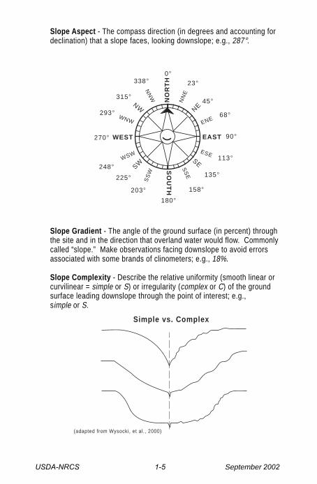
Slope Aspect - The compass direction (in degrees and accounting fordeclination) that a slope faces, looking downslope; e.g., 287°.
NO
RT
H
NN
E
NE
ENE
EAST
ESE
WEST
SO
UT
H
NN
W
NWWNW
WSW
SWS
SW
SS
E
SE
68°
90°
113°
135°
158°
180°
203°
225°
248°
270°
293°
315°
338°0°
23°
45°
Slope Gradient - The angle of the ground surface (in percent) throughthe site and in the direction that overland water would flow. Commonlycalled “slope.” Make observations facing downslope to avoid errorsassociated with some brands of clinometers; e.g., 18%.
Slope Complexity - Describe the relative uniformity (smooth linear orcurvilinear = simple or S) or irregularity (complex or C) of the groundsurface leading downslope through the point of interest; e.g.,simple or S.
(adapted from Wysocki, et al., 2000)
Simple vs. Complex

USDA-NRCS 1-6 September 2002
Slope Shape - Slope shape is described in two directions: up-and-downslope (perpendicular to the contour), and across slope (along thehorizontal contour); e.g., Linear, Convex or LV.
CV
L = LinearV = ConvexC = Concave
Surface flowpathway
CC
VCVV
LV LC
CL
VL
LL
(adapted from Wysocki,
et al., 2000)
Hillslope - Profile Position (Hillslope Position in PDP) - Two-dimen-sional descriptors of parts of line segments (i.e., slope position) along atransect that runs up and down the slope; e.g., backslope or BS. This isbest applied to transects or points, not areas.
Position Codesummit SUshoulder SHbackslope BSfootslope FStoeslope TS
Alluvium
SUSH
BS
FS TSC
hannel
TS
FS
BS
SHSU
(adapted from Ruhe, 1975)
USDA-NRCS 1-7 September 2002
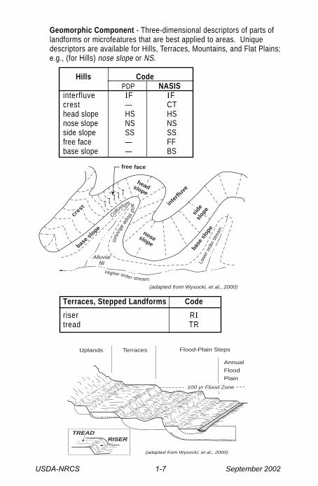
Geomorphic Component - Three-dimensional descriptors of parts oflandforms or microfeatures that are best applied to areas. Uniquedescriptors are available for Hills, Terraces, Mountains, and Flat Plains;e.g., (for Hills) nose slope or NS.
Hills CodePDP NASIS
interfluve IF IFcrest — CThead slope HS HSnose slope NS NSside slope SS SSfree face — FFbase slope — BS
Terraces, Stepped Landforms Code
riser RItread TR
Higher order stream
Low
er o
rder
stre
am
base
slo
pe
side
slop
e
noseslope
headslope
inte
rfluve
base s
lope
Alluvialfill
(adapted from Wysocki, et al., 2000)
Colluv
iumandslope
alluvium
crest
free face
TREADRISER
100 yr Flood Zone
Annual
Flood
Plain
Uplands Terraces Flood-Plain Steps
(adapted from Wysocki; et al., 2000)
USDA-NRCS 1-8 September 2002
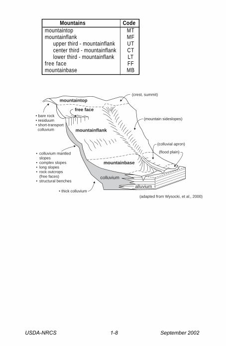
Mountains Codemountaintop MTmountainflank MF
upper third - mountainflank UTcenter third - mountainflank CTlower third - mountainflank LT
free face FFmountainbase MB
(colluvial apron)
(flood plain)
(mountain sideslopes)
(crest, summit)
• bare rock• residuum• short-transport colluvium
• colluvium mantled slopes• complex slopes• long slopes• rock outcrops (free faces)• structural benches
• thick colluvium
mountaintop
mountainflank
mountainbase
colluvium
alluvium
(adapted from Wysocki, et al., 2000)
free face
USDA-NRCS 1-17 September 2002
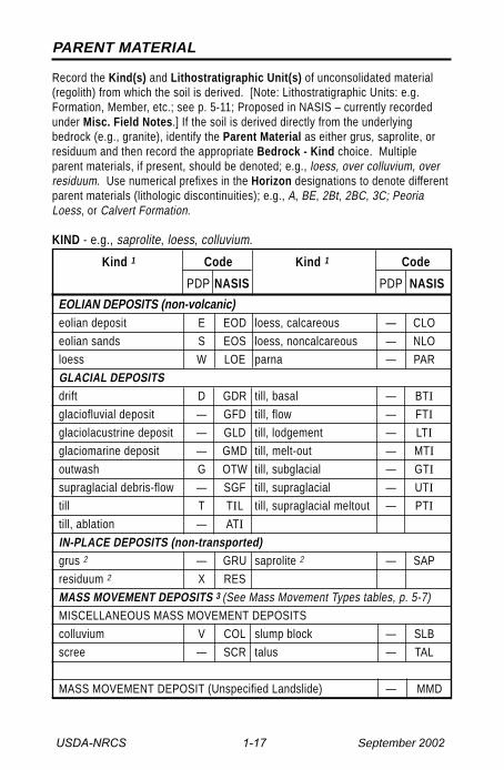
PARENT MATERIAL
Record the Kind(s) and Lithostratigraphic Unit(s) of unconsolidated material(regolith) from which the soil is derived. [Note: Lithostratigraphic Units: e.g.Formation, Member, etc.; see p. 5-11; Proposed in NASIS – currently recordedunder Misc. Field Notes.] If the soil is derived directly from the underlyingbedrock (e.g., granite), identify the Parent Material as either grus, saprolite, orresiduum and then record the appropriate Bedrock - Kind choice. Multipleparent materials, if present, should be denoted; e.g., loess, over colluvium, overresiduum. Use numerical prefixes in the Horizon designations to denote differentparent materials (lithologic discontinuities); e.g., A, BE, 2Bt, 2BC, 3C; PeoriaLoess, or Calvert Formation.
KIND - e.g., saprolite, loess, colluvium.
Kind 1 Code Kind 1 Code
PDP NASIS PDP NASIS
EOLIAN DEPOSITS (non-volcanic)eolian deposit E EOD loess, calcareous — CLO
eolian sands S EOS loess, noncalcareous — NLO
loess W LOE parna — PAR
GLACIAL DEPOSITSdrift D GDR till, basal — BTI
glaciofluvial deposit — GFD till, flow — FTI
glaciolacustrine deposit — GLD till, lodgement — LTI
glaciomarine deposit — GMD till, melt-out — MTI
outwash G OTW till, subglacial — GTI
supraglacial debris-flow — SGF till, supraglacial — UTI
till T TIL till, supraglacial meltout — PTI
till, ablation — ATI
IN-PLACE DEPOSITS (non-transported)grus 2 — GRU saprolite 2 — SAP
residuum 2 X RES
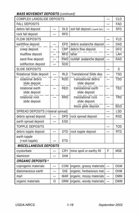
MASS MOVEMENT DEPOSITS 3 (See Mass Movement Types tables, p. 5-7)MISCELLANEOUS MASS MOVEMENT DEPOSITS
colluvium V COL slump block — SLB
scree — SCR talus — TAL
MASS MOVEMENT DEPOSIT (Unspecified Landslide) — MMD
USDA-NRCS 1-18 September 2002
MASS MOVEMENT DEPOSITS (continued)COMPLEX LANDSLIDE DEPOSITS — CLD
FALL DEPOSITS — FAD
debris fall deposit — DLD soil fall deposit (=earth fall ) — SFD
rock fall deposit — RFD
FLOW DEPOSITS — FLD
earthflow deposit — EFD debris avalanche deposit — DADcreep deposit — CRP debris flow deposit — DFDmudflow deposit — MFD lahar — LAHsand flow deposit — RWD rockfall avalanche deposit — RADsolifluction deposit — SOD
SLIDE DEPOSITS — S
Rotational Slide deposit — RLD Translational Slide dep. — TSDrotational debris — RDD translational debris — TDD
slide deposit slide depositrotational earth — RED translational earth — TED
slide deposit slide depositrotational rock — RRD translational rock — TRD
slide deposit slide depositblock glide deposit — BGD
SPREAD DEPOSITS (=lateral spread) — LSD
debris spread deposit — DPD rock spread deposit — RSD
earth spread deposit — ESD
TOPPLE DEPOSITS — TOD
debris topple deposit — DTD rock topple deposit — RTD
earth topple(=soil topple) — ETD
MISCELLANEOUS DEPOSITScryoturbate — CRY mine spoil or earthy fill F MSE
diamicton — DIM
ORGANIC DEPOSITS 4
coprogenic materials — COM organic, grassy materials — OGM
diatomaceous earth — DIE organic, herbaceous mat. — OHM
marl — MAR organic, mossy materials — OMM
organic materials O ORM organic, woody materials — OWM

USDA-NRCS 1-19 September 2002
VOLCANIC DEPOSITS (unconsolidated; eolian and mass movement)ash (< 2 mm) H ASH cinders (2-64 mm) — CIN
ash, acidic — ASA lahar — LAH(volcaniclastic mudflow)
ash, andesitic — ASN lapilli — LAP(2-64 mm, > 2.0 sg) 5
ash, basaltic — ASB pyroclastic flow — PYF
ash, basic — ASC pyroclastic surge — PYS
ash flow (pyroclastic) — ASF pumice (< 1.0 sg) 5 — PUM
bombs (> 64 mm) — BOM scoria (> 2.0 sg) 5 — SCO
tephra (all ejecta) — TEP
WATER LAID or TRANSPORTED DEPOSITSalluvium A ALL lacustrine deposit L LAD
backswamp deposit — BSD marine deposit M MAD
beach sand — BES overbank deposit — OBD
estuarine deposit Z ESD pedisediment — PED
fluviomarine deposit — — slope alluvium — SAL
greensands — — valley side alluvium — VSA
1 Parent material definitions are found in the “Glossary of Landforms andGeologic Terms”, NSSH - Part 629 (Soil Survey Staff, 2001), or the“Glossary of Geology” (Jackson, 1997).
2 Use the most precise term for the in situ material. Residuum is the mostgeneric term.
3 Cruden and Varnes, 1996.4 These generic terms refer to the dominant origin of the organic materials
or deposits from which the organic soil has formed (i.e. parent material)(Soil Survey Staff, 1993). These terms partially overlap with thoserecognized in Soil Taxonomy (terms which refer primarily to what theorganic material presently is); see the “Diagnostic Horizons” or “Proper-ties” table.
5 sg = specific gravity = the ratio of a material’s density to that of water[weight in air / (weight in air - weight in water)].

USDA-NRCS 1-20 September 2002
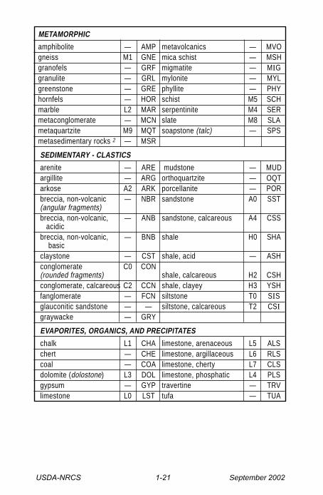
BEDROCK
Describe the nature of the continuous hard rock underlying the soil. Specifythe Kind, Fracture Interval, Hardness, and Weathering Class. Also recordLithostratigraphic unit(s) if possible (e.g. Formation, Member, etc.; — see p. 5–11); e.g. Dakota Formation. Proposed in NASIS; currently recorded under Misc.Field Notes.
KIND - e.g., limestone.
Kind 1 Code Kind 1 Code
PDP NASIS PDP NASIS
IGNEOUS - INTRUSIVEanorthosite — ANO pyroxenite — PYX
diabase — DIA quartz-diorite — QZD
diorite — DIO quartz-monzonite — QZM
gabbro — GAB syenite — SYE
granite I4 GRA syenodiorite — SYD
granodiorite — GRD tachylite — TAC
monzonite — MON tonalite — TON
peridotite — PER ultramafic rock 2 — UMU
IGNEOUS - EXTRUSIVE
a’a lava P8 AAL pahoehoe lava P9 PAH
andesite I7 AND pillow lava — PIL
basalt I6 BAS pumice (flow, coherent) E6 PUM
block lava — BLL rhyolite — RHY
dacite — DAC scoria (coherent mass) E7 SCO
latite — LAT trachyte — TRA
obsidian — OBS
IGNEOUS - PYROCLASTIC
ignimbrite — IGN tuff, welded — TFW
pyroclastics P0 PYR tuff breccia P7 TBR (consolidated)
pyroclastc flow — PYF volcanic breccia P4 VBR
pyroclastic surge — PYS volcanic breccia, acidic P5 AVB
tuff P1 TUF volcanic breccia, basic P6 BVB
tuff, acidic P2 ATU volcanic sandstone — VST
tuff, basic P3 BTU
USDA-NRCS 1-21 September 2002
METAMORPHIC
amphibolite — AMP metavolcanics — MVOgneiss M1 GNE mica schist — MSHgranofels — GRF migmatite — MIGgranulite — GRL mylonite — MYLgreenstone — GRE phyllite — PHYhornfels — HOR schist M5 SCHmarble L2 MAR serpentinite M4 SERmetaconglomerate — MCN slate M8 SLAmetaquartzite M9 MQT soapstone (talc) — SPSmetasedimentary rocks 2 — MSR
SEDIMENTARY - CLASTICS
arenite — ARE mudstone — MUD argillite — ARG orthoquartzite — OQT arkose A2 ARK porcellanite — POR breccia, non-volcanic — NBR sandstone A0 SST (angular fragments) breccia, non-volcanic, — ANB sandstone, calcareous A4 CSS
acidic breccia, non-volcanic, — BNB shale H0 SHA basic claystone — CST shale, acid — ASH conglomerate C0 CON (rounded fragments) shale, calcareous H2 CSH conglomerate, calcareous C2 CCN shale, clayey H3 YSH fanglomerate — FCN siltstone T0 SIS glauconitic sandstone — — siltstone, calcareous T2 CSI graywacke — GRY
EVAPORITES, ORGANICS, AND PRECIPITATES
chalk L1 CHA limestone, arenaceous L5 ALS chert — CHE limestone, argillaceous L6 RLS coal — COA limestone, cherty L7 CLS dolomite (dolostone) L3 DOL limestone, phosphatic L4 PLS gypsum — GYP travertine — TRV limestone L0 LST tufa — TUA
USDA-NRCS 1-22 September 2002
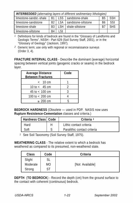
INTERBEDDED (alternating layers of different sedimentary lithologies) limestone-sandst.-shale B1 LSS sandstone-shale B5 SSH limestone-sandstone B2 LSA sandstone-siltstone B6 SSI limestone-shale B3 LSH shale-siltstone B7 SHS limestone-siltstone B4 LSI
1 Definitions for kinds of bedrock are found in the “Glossary of Landforms andGeologic Terms”, NSSH - Part 629 (Soil Survey Staff, 2001), or in the“Glossary of Geology” (Jackson, 1997).
2 Generic term; use only with regional or reconnaissance surveys(Order 3, 4).
FRACTURE INTERVAL CLASS - Describe the dominant (average) horizontalspacing between vertical joints (geogenic cracks or seams) in the bedrocklayer.
Average Distance CodeBetween Fractures
< 10 cm 110 to < 45 cm 245 to < 100 cm 3
100 to < 200 cm 4≥ 200 cm 5
BEDROCK HARDNESS (Obsolete — used in PDP. NASIS now usesRupture Resistence-Cementation classes and criteria.)
Hardness Class Code Criteria 1
Hard H Lithic contact criteria Soft S Paralithic contact criteria
1 See Soil Taxonomy (Soil Survey Staff, 1975).
WEATHERING CLASS - The relative extent to which a bedrock hasweathered as compared to its presumed, non-weathered state.
Class Code Criteria
Slight SLModerate MO [Not Available]Strong ST
DEPTH (TO BEDROCK) - Record the depth (cm) from the ground surface tothe contact with coherent (continuous) bedrock.
USDA-NRCS 2-29 September 2002
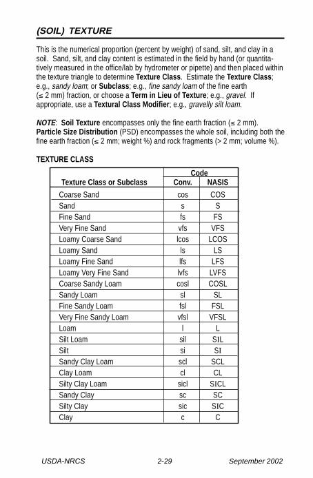
(SOIL) TEXTURE
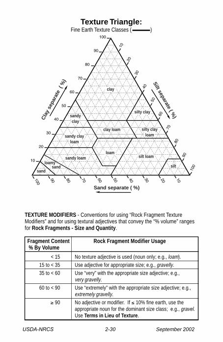
This is the numerical proportion (percent by weight) of sand, silt, and clay in asoil. Sand, silt, and clay content is estimated in the field by hand (or quantita-tively measured in the office/lab by hydrometer or pipette) and then placed withinthe texture triangle to determine Texture Class. Estimate the Texture Class;e.g., sandy loam; or Subclass; e.g., fine sandy loam of the fine earth(≤ 2 mm) fraction, or choose a Term in Lieu of Texture; e.g., gravel. Ifappropriate, use a Textural Class Modifier; e.g., gravelly silt loam.
NOTE: Soil Texture encompasses only the fine earth fraction (≤ 2 mm).Particle Size Distribution (PSD) encompasses the whole soil, including both thefine earth fraction (≤ 2 mm; weight %) and rock fragments (> 2 mm; volume %).
TEXTURE CLASS
CodeTexture Class or Subclass Conv. NASIS
Coarse Sand cos COSSand s SFine Sand fs FSVery Fine Sand vfs VFSLoamy Coarse Sand lcos LCOSLoamy Sand ls LSLoamy Fine Sand lfs LFSLoamy Very Fine Sand lvfs LVFSCoarse Sandy Loam cosl COSLSandy Loam sl SLFine Sandy Loam fsl FSLVery Fine Sandy Loam vfsl VFSLLoam l LSilt Loam sil SILSilt si SISandy Clay Loam scl SCLClay Loam cl CLSilty Clay Loam sicl SICLSandy Clay sc SCSilty Clay sic SICClay c C
USDA-NRCS 2-30 September 2002
TEXTURE MODIFIERS - Conventions for using “Rock Fragment TextureModifiers” and for using textural adjectives that convey the “% volume” rangesfor Rock Fragments - Size and Quantity.
Fragment Content Rock Fragment Modifier Usage % By Volume
< 15 No texture adjective is used (noun only; e.g., loam).
15 to < 35 Use adjective for appropriate size; e.g., gravelly.
35 to < 60 Use “very” with the appropriate size adjective; e.g.,very gravelly.
60 to < 90 Use “extremely” with the appropriate size adjective; e.g.,extremely gravelly.
≥ 90 No adjective or modifier. If ≤ 10% fine earth, use theappropriate noun for the dominant size class; e.g., gravel.Use Terms in Lieu of Texture.
Silt separate ( %)C
lay
sepa
rate
( %
)
Sand separate ( %)
sandy clayloam
sandy loamloamy sand
sand
sandyclay
clay loam
loamsilt loam
silt
silty clayloam
silty clay
clay
Texture Triangle:Fine Earth Texture Classes ( )

USDA-NRCS 2-31 September 2002
TEXTURE MODIFIERS - (adjectives)
ROCK Code Criteria: Percent (By Volume)FRAGMENTS: PDP/ of Total Rock Fragments and
Size & Quantity 1 Conv. NASIS Dominated By (name size): 1
ROCK FRAGMENTS (> 2 mm; ≥ Strongly Cemented)Gravelly GR GR ≥ 15% but < 35% gravelFine Gravelly FGR GRF ≥15% but < 35% fine gravelMedium Gravelly MGR GRM ≥15% but < 35% med. gravelCoarse Gravelly CGR GRC ≥ 15% but < 35% coarse gravelVery Gravelly VGR GRV ≥ 35% but < 60% gravelExtremely Gravelly XGR GRX ≥ 60% but < 90% gravelCobbly CB CB ≥ 15% but < 35% cobblesVery Cobbly VCB CBV ≥ 35% but < 60% cobblesExtremely Cobbly XCB CBX ≥ 60% but < 90% cobblesStony ST ST ≥ 15% but < 35% stonesVery Stony VST STV ≥ 35% but < 60% stonesExtremely Stony XST STX ≥ 60% but < 90% stonesBouldery BY BY ≥ 15% but < 35% bouldersVery Bouldery VBY BYV ≥ 35% but < 60% bouldersExtremely Bouldery XBY BYX ≥ 60% but < 90% bouldersChannery CN CN ≥ 15% but < 35% channersVery Channery VCN CNV ≥ 35% but < 60% channersExtremely Channery XCN CNX ≥ 60% but < 90% channersFlaggy FL FL ≥ 15% but < 35% flagstonesVery Flaggy VFL FLV ≥ 35% but < 60% flagstonesExtremely Flaggy XFL FLX ≥ 60% but < 90% flagstonesPARAROCK FRAGMENTS (> 2 mm; < Strongly Cemented) 2, 3
Parabouldery PBY PBY (same criteria as bouldery)Very Parabouldery VPBY PBYV (same criteria as very bouldery)Extr. Parabouldery XPBY PBYX (same criteria as ext. bouldery)etc. etc. etc. (same criteria as non-para)
1 The “Quantity” modifier (e.g., very) is based on the total rock fragment content.The “Size” modifier (e.g., cobbly) is independently based on the largest,dominant fragment size. For a mixture of sizes (e.g., gravel and stones), asmaller size–class is named only if its quantity (%) sufficiently exceeds that of alarger size–class. For field texture determination, a smaller size-class mustexceed 2 times the quantity (vol. %) of a larger size class before it is named(e.g., 30% gravel and 14% stones = very gravelly, but 20% gravel and 14%stones = stony). For more explicit naming criteria see NSSH-Part 618, Exhibit618.11(Soil Survey Staff, 2001b).
USDA-NRCS 2-32 September 2002
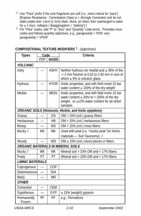
COMPOSITIONAL TEXTURE MODIFIERS 1 - (adjectives)
Types Code Criteria:PDP NASIS
VOLCANICAshy — ASHY Neither hydrous nor medial and ≥ 30% of the
< 2 mm fraction is 0.02 to 2.00 mm in size ofwhich ≥ 5% is volcanic glass
Hydrous — HYDR Andic properties, and with field moist 15 barwater content ≥ 100% of the dry weight
Medial — MEDL Andic properties, and with field moist 15 barwater content ≥ 30% to < 100% of the dryweight, or ≥12% water content for air-driedsamples
ORGANIC SOILS (Histosols, Histels, and histic epipdons)Grassy — GS OM > 15% (vol.) grassy fibersHerbaceous — HB OM > 15% (vol.) herbaceous fibersMossy — MS OM > 15% (vol.) moss fibersMucky 2 MK MK Used with peat (i.e. “mucky peat” for hemic
materials — Soil Taxonomy). 2
Woody — WD OM ≥ 15% (vol.) wood pieces or fibersORGANIC MATERIALS IN MINERAL SOILSMucky 2 MK MK Mineral soil > 10% OM and < 17% fibersPeaty PT PT Mineral soil > 10% OM and > 17% fibersLIMNIC MATERIALSCoprogenous — COPDiatomaceous — DIAMarly — MROTHERCemented — CEMGypsiferous — GYP ≥ 15% (weight) gypsumPermanently PF PF e.g., Permafrost Frozen
2 Use “Para” prefix if the rock fragments are soft (i.e., meet criteria for “para”).[Rupture Resistance - Cementation Class is < Strongly Cemented, and do notslake (slake test: ≈3cm (1 inch) diam. block, air dried, then submerged in waterfor ≥ 1 hour; collapse / disaggregation = “slaking”).]
3 For “Para” codes, add “P” to “Size” and “Quantity” code terms. Precedes nouncodes and follows quantity adjectives, e.g., paragravelly = PGR; veryparagravelly = VPGR.
USDA-NRCS 2-33 September 2002
Fragments
1 Compositional Texture Modifiers can be used with the Soil TextureName (e.g., gravelly ashy loam) or with Terms in Lieu of Texture (e.g.mossy peat). For definitions and usage of Compositional TextureModifiers, see the National Soil Survey Handbook - Part 618.67 (SoilSurvey Staff, 2001).
2 Mucky can be used either with organic soils (e.g. mucky peat) or mineralsoils (e.g., mucky sand) but its definition changes; Soil Taxonomy (SoilSurvey Staff, 1999).
USDA-NRCS 2-34 September 2002
Frag
men
ts
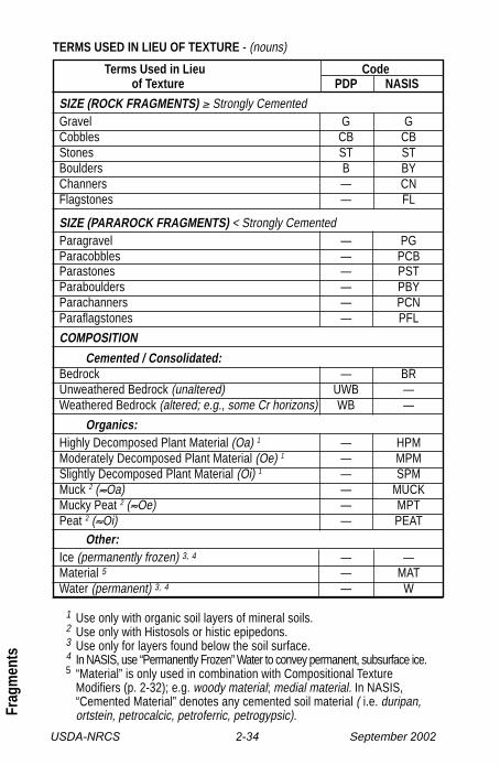
TERMS USED IN LIEU OF TEXTURE - (nouns)
Terms Used in Lieu Codeof Texture PDP NASIS
SIZE (ROCK FRAGMENTS) ≥ Strongly CementedGravel G GCobbles CB CBStones ST STBoulders B BYChanners — CNFlagstones — FL
SIZE (PARAROCK FRAGMENTS) < Strongly CementedParagravel — PGParacobbles — PCBParastones — PSTParaboulders — PBYParachanners — PCNParaflagstones — PFL
COMPOSITION
Cemented / Consolidated:Bedrock — BRUnweathered Bedrock (unaltered) UWB —Weathered Bedrock (altered; e.g., some Cr horizons) WB —
Organics:Highly Decomposed Plant Material (Oa) 1 — HPMModerately Decomposed Plant Material (Oe) 1 — MPMSlightly Decomposed Plant Material (Oi) 1 — SPMMuck 2 (≈Oa) — MUCKMucky Peat 2 (≈Oe) — MPTPeat 2 (≈Oi) — PEAT
Other:Ice (permanently frozen) 3, 4 — —Material 5 — MATWater (permanent) 3, 4 — W
1 Use only with organic soil layers of mineral soils.2 Use only with Histosols or histic epipedons.3 Use only for layers found below the soil surface.4 In NASIS, use “Permanently Frozen” Water to convey permanent, subsurface ice.5 “Material” is only used in combination with Compositional Texture
Modifiers (p. 2-32); e.g. woody material; medial material. In NASIS,“Cemented Material” denotes any cemented soil material ( i.e. duripan,ortstein, petrocalcic, petroferric, petrogypsic).
USDA-NRCS 2-35 September 2002
Co
mp
aris
on
of
Par
ticl
e S
ize
Cla
sses
in D
iffer
ent
Sys
tem
s bo
uld
ers
pe
bb
les
san
dsi
ltcl
ay
12
10
98
76
54
32
1
Silt
Cla
y
Si lt
or
Cla
y
Sa
nd
Gra
vel
or
Sto
ne
sB
roke
n R
ock
(a
ng
ula
r),
or
Bo
uld
ers
(ro
un
de
d)
Co
bb
les
Bo
uld
ers
Sto
ne
sG
rave
lS
an
d
Sa
nd
Gra
vel
Cla
yS
ilt
Cla
y 2
Silt
Sa
nd
Gra
vel
Co
b-
ble
sS
ton
es
Bo
uld
ers
0-1
-2-3
-4-5
-6-7
-8-9
-10
-12
75
mm
25
9.5
2 m
m.4
2.0
74
.00
5 m
m
20
04
01
0(3
/8")
(1")
(3")
40
92
mm
25
66
43
21
68
2 m
m5
10
18
35
60
12
02
30
1.5
.25
.12
5.0
62
.03
1.0
16
.00
8.0
04
.00
2
.07
4.4
22
mm
4
.81
97
63
00
mm
20
mm
2 m
m.2
.02
.00
2 m
m
mil
lim
ete
rs:
U.S
. S
tan
da
rdS
ieve
No
. (o
pe
nin
g):
.00
2 m
m
.02
.05
.1
30
0 3
14
06
0
.25
.5 35
1 18
102 m
m5 4
20
(3/4
")
76
(3")
(10
")(2
5")
60
0 m
m2
50
coa
rse
me
diu
mfi
ne
v. co.
co.
me
d.
fi.
v.fi
.co
.fi
ne
fin
eco
ars
e
fin
em
ed
ium
co
.fi
ne
coa
rse
fin
em
ed
.co
ars
efi
ne
co.
FIN
E E
AR
TH
RO
CK
FR
AG
ME
NT
Sst
on
es
fla
gst
.
15
03
80
cobb
les
ph
i #
:
AA
SH
TO
6,7
Un
ifie
d 5
Mo
dif
ied
Wen
two
rth
8
Inte
r-n
atio
nal
4
US
DA
1fi
ne
co.
0.0
00
2
0m
ill i
me
ters
:U
.S.
Sta
nd
ard
Sie
ve N
o.
(op
en
ing
):
mil
l im
ete
rs:
U.S
. S
tan
da
rdS
ieve
No
. (o
pe
nin
g):
mil
l im
ete
rs:
U.S
. S
tan
da
rdS
ieve
No
.:
mil
lim
ete
rs:
U.S
. S
tan
da
rdS
ieve
No
.:
20
04
01
04
(3/4
")(3
")
10
(3/4
")
cha
nn
ers
60
0 m
m bo
uld
ers
USDA-NRCS 2-36 September 2002
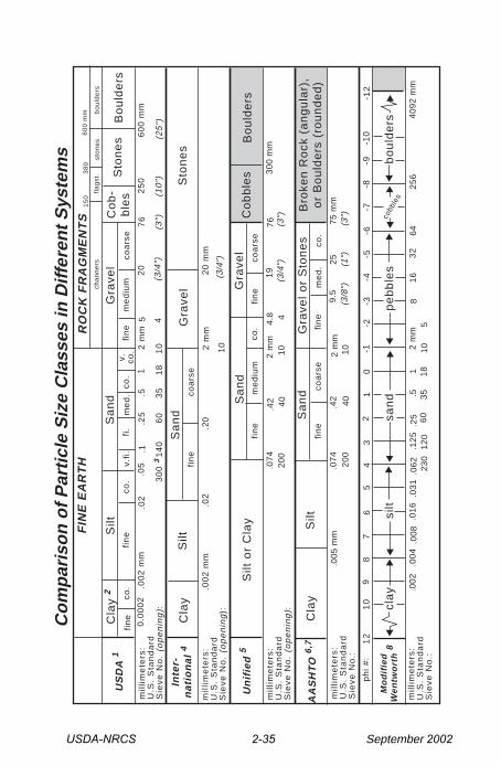
References for Table Comparing Particle Size Systems
1 Soil Survey Staff. 1995. Soil survey laboratory information manual. USDA,Natural Resources Conservation Service, Soil Survey Investigations ReportNo. 45, Version 1.0, National Soil Survey Center, Lincoln, NE. 305 p.
2 Soil Survey Staff. 1995. Soil Survey Lab information manual. USDA-NRCS,Soil Survey Investigation Report #45, version 1.0, National Soil SurveyCenter, Lincoln, NE. Note: Mineralogy studies may subdivide clay intothree size ranges: fine (< 0.08 µm), medium (0.08 – 0.2 µm), and coarse(0.2 – 2 µm); Jackson, 1969.
3 The Soil Survey Lab (Lincoln, NE) uses a no. 300 sieve (0.047 mmopening) for the USDA – sand / silt measurement. A no. 270 sieve (0.053mm opening) is more readily available and widely used.
4 International Soil Science Society. 1951. In: Soil Survey Manual. SoilSurvey Staff, USDA - Soil Conservation Service, Agricultural Handbook No.18, U.S. Gov. Print. Office, Washington, D.C. 214 p.
5 ASTM. 1993. Standard classification of soils for engineering purposes(Unified Soil Classification System). ASTM designation D2487-92. In: Soiland rock; dimension stone; geosynthetics. Annual book of ASTM standards- Vol. 04.08.
6 AASHTO. 1986a. Recommended practice for the classification of soils andsoil-aggregate mixtures for highway construction purposes. AASHTOdesignation M145-82. In: Standard specifications for transportationmaterials and methods of sampling and testing; Part 1: Specifications(14th ed.). American Association of State Highway and TransportationOfficials, Washington, D.C.
7 AASHTO. 1986b. Standard definitions of terms relating to subgrade, soil-aggregate, and fill materials. AASHTO designation M146-70 (1980). In:Standard specifications for transportation materials and methods ofsampling and testing; Part 1: Specifications (14th ed.). AmericanAssociation of State Highway and Transportation Officials,Washington, D.C.
8 Ingram, R.L. 1982. Modified Wentworth scale. In: Grain-size scales. AGIData Sheet 29.1. In: Dutro, J.T., Dietrich, R.V., and Foose, R.M. 1989.AGI data sheets for geology in the field, laboratory, and office, 3rd edition.American Geological Institute, Washington, D.C.
USDA-NRCS 2-37 September 2002
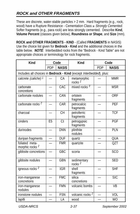
ROCK and OTHER FRAGMENTS
These are discrete, water-stable particles > 2 mm. Hard fragments (e.g., rock,wood) have a Rupture Resistance - Cementation Class ≥ Strongly Cemented.Softer fragments (e.g., para rock) are less strongly cemented. Describe Kind,Volume Percent (classes given below), Roundness or Shape, and Size (mm).
ROCK and OTHER FRAGMENTS - KIND - (Called FRAGMENTS in NASIS)Use the choice list given for Bedrock - Kind and the additional choices in thetable below. NOTE: Interbedded rocks from the “Bedrock - Kind Table” are notappropriate choices or terminology for rock fragments.
Kind Code Kind CodePDP NASIS PDP NASIS
Includes all choices in Bedrock - Kind (except Interbedded), plus:calcrete (caliche) 1 — CA metamorphic — MMR
rocks 2
carbonate — CAC mixed rocks 3 — MSRconcretionscarbonate nodules — CAN ortstein — ORF
fragmentscarbonate rocks 2 — CAR petrocalcic — PEF
fragmentscharcoal — CH petroferric — TCF
fragmentscinders E5 CI petrogypsic — PGF
fragmentsdurinodes — DNN plinthite — PLN
nodulesduripan fragments — DUF quartz — QUAfoliated meta- — FMR quartzite — QZTmorphic rocks 2
gibbsite concretions — GBC scoria — SCO
gibbsite nodules — GBN sedimentary — SEDrocks 2
igneous rocks 2 — IGR shell — SHFfragments
iron-manganese — FMC silica — SICconcretions concretionsiron-manganese — FMN volcanic bombs — VBnodulesironstone nodules — FSN volcanic rocks 2 — VOLlapilli — LA wood — WO
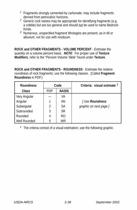
USDA-NRCS 2-38 September 2002
1 Fragments strongly cemented by carbonate; may include fragmentsderived from petrocalcic horizons.
2 Generic rock names may be appropriate for identifying fragments (e.g.a cobble) but are too general and should not be used to name Bedrock-Kinds.
3 Numerous, unspecified fragment lithologies are present, as in till oralluvium; not for use with residuum.
ROCK and OTHER FRAGMENTS - VOLUME PERCENT - Estimate thequantity on a volume percent basis. NOTE: For proper use of TextureModifiers, refer to the “Percent Volume Table” found under Texture.
ROCK and OTHER FRAGMENTS - ROUNDNESS - Estimate the relativeroundness of rock fragments; use the following classes. (Called FragmentRoundness in PDP.)
Roundness Code Criteria: visual estimate 1
Class PDP NASIS
Very Angular — VAAngular 1 AN [ Use RoundnessSubangular 2 SA graphic on next page ]Subrounded 3 SRRounded 4 ROWell Rounded 5 WR
1 The criteria consist of a visual estimation; use the following graphic.
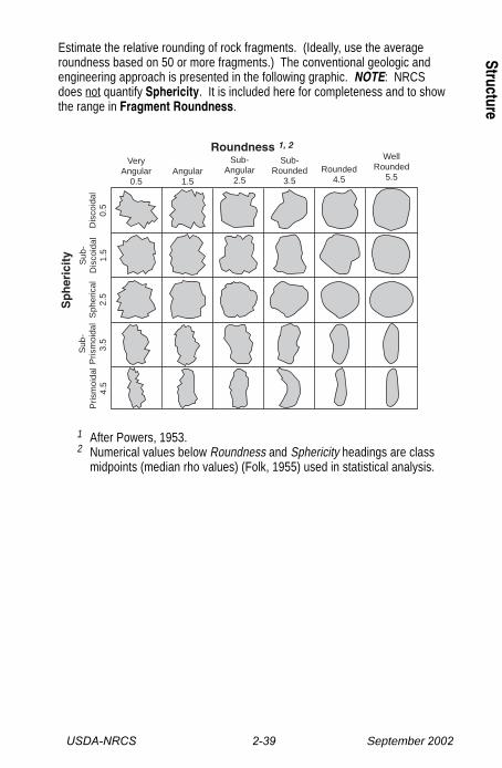
USDA-NRCS 2-39 September 2002
1 After Powers, 1953.2 Numerical values below Roundness and Sphericity headings are class
midpoints (median rho values) (Folk, 1955) used in statistical analysis.
VeryAngular
0.5Angular
1.5
Sub-Angular
2.5
Sub-Rounded
3.5Rounded
4.5
WellRounded
5.5
Dis
coid
al0.
5
Sub
-D
isco
idal
1.5
Sph
eric
al2.
5
Sub
-P
rism
oida
l3.
5 P
rism
oida
l4.
5
Sp
her
icit
y
Roundness 1, 2
Estimate the relative rounding of rock fragments. (Ideally, use the averageroundness based on 50 or more fragments.) The conventional geologic andengineering approach is presented in the following graphic. NOTE: NRCSdoes not quantify Sphericity. It is included here for completeness and to showthe range in Fragment Roundness.
Structure
USDA-NRCS 2-40 September 2002
Stru
ctur
e
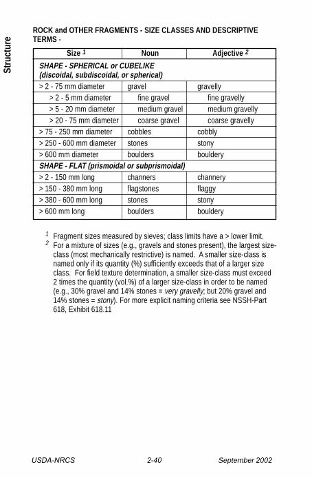
ROCK and OTHER FRAGMENTS - SIZE CLASSES AND DESCRIPTIVETERMS -
Size 1 Noun Adjective 2
SHAPE - SPHERICAL or CUBELIKE(discoidal, subdiscoidal, or spherical)> 2 - 75 mm diameter gravel gravelly
> 2 - 5 mm diameter fine gravel fine gravelly> 5 - 20 mm diameter medium gravel medium gravelly> 20 - 75 mm diameter coarse gravel coarse gravelly
> 75 - 250 mm diameter cobbles cobbly> 250 - 600 mm diameter stones stony> 600 mm diameter boulders boulderySHAPE - FLAT (prismoidal or subprismoidal)> 2 - 150 mm long channers channery> 150 - 380 mm long flagstones flaggy> 380 - 600 mm long stones stony> 600 mm long boulders bouldery
1 Fragment sizes measured by sieves; class limits have a > lower limit.2 For a mixture of sizes (e.g., gravels and stones present), the largest size-
class (most mechanically restrictive) is named. A smaller size-class isnamed only if its quantity (%) sufficiently exceeds that of a larger sizeclass. For field texture determination, a smaller size-class must exceed2 times the quantity (vol.%) of a larger size-class in order to be named(e.g., 30% gravel and 14% stones = very gravelly; but 20% gravel and14% stones = stony). For more explicit naming criteria see NSSH-Part618, Exhibit 618.11
USDA-NRCS 2-41 September 2002
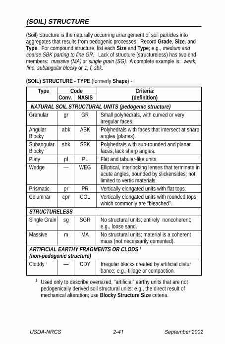
(SOIL) STRUCTURE
(Soil) Structure is the naturally occurring arrangement of soil particles intoaggregates that results from pedogenic processes. Record Grade, Size, andType. For compound structure, list each Size and Type; e.g., medium andcoarse SBK parting to fine GR. Lack of structure (structureless) has two endmembers: massive (MA) or single grain (SG). A complete example is: weak,fine, subangular blocky or 1, f, sbk.
(SOIL) STRUCTURE - TYPE (formerly Shape) -
Type Code Criteria: Conv. NASIS (definition)
NATURAL SOIL STRUCTURAL UNITS (pedogenic structure)Granular gr GR Small polyhedrals, with curved or very
irregular faces.Angular abk ABK Polyhedrals with faces that intersect at sharpBlocky angles (planes).Subangular sbk SBK Polyhedrals with sub-rounded and planarBlocky faces, lack sharp angles.Platy pl PL Flat and tabular-like units.Wedge — WEG Elliptical, interlocking lenses that terminate in
acute angles, bounded by slickensides; notlimited to vertic materials.
Prismatic pr PR Vertically elongated units with flat tops.Columnar cpr COL Vertically elongated units with rounded tops
which commonly are “bleached”.STRUCTURELESSSingle Grain sg SGR No structural units; entirely noncoherent;
e.g., loose sand.Massive m MA No structural units; material is a coherent
mass (not necessarily cemented).ARTIFICIAL EARTHY FRAGMENTS OR CLODS 1
(non-pedogenic structure)Cloddy 1 — CDY Irregular blocks created by artificial distur
bance; e.g., tillage or compaction.
1 Used only to describe oversized, “artificial” earthy units that are notpedogenically derived soil structural units; e.g., the direct result ofmechanical alteration; use Blocky Structure Size criteria.
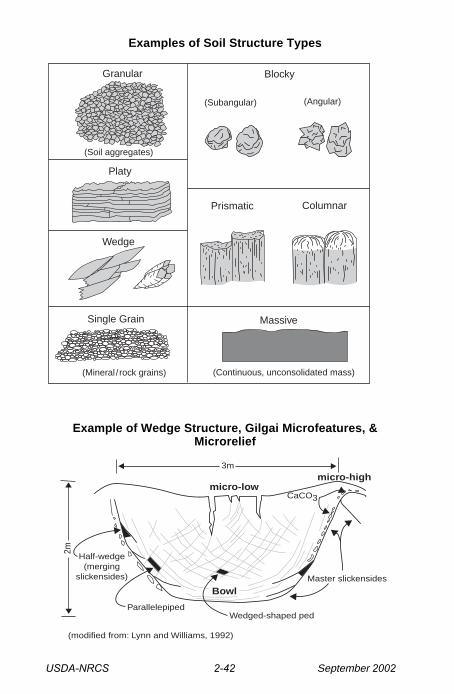
USDA-NRCS 2-42 September 2002
Examples of Soil Structure Types
Example of Wedge Structure, Gilgai Microfeatures, &Microrelief
Prismatic
Wedge
Platy
Columnar
Granular Blocky
(Subangular) (Angular)
Single Grain Massive
(Mineral / rock grains) (Continuous, unconsolidated mass)
(Soil aggregates)
Master slickensides
CaCO3
micro-highmicro-low
3m
Half-wedge(merging
slickensides)
2m
ParallelepipedWedged-shaped ped
Bowl
(modified from: Lynn and Williams, 1992)
USDA-NRCS 2-43 September 2002
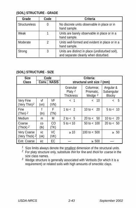
(SOIL) STRUCTURE - GRADE
Grade Code Criteria
Structureless 0 No discrete units observable in place or inhand sample.
Weak 1 Units are barely observable in place or in ahand sample.
Moderate 2 Units well-formed and evident in place or in ahand sample.
Strong 3 Units are distinct in place (undisturbed soil),and separate cleanly when disturbed.
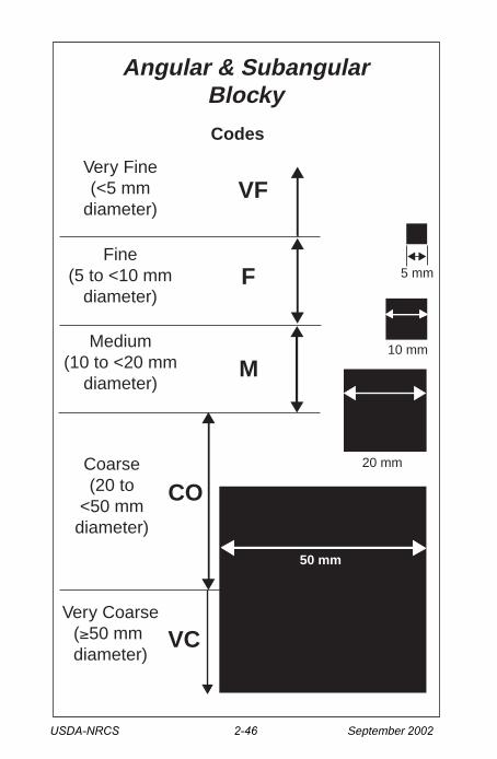
(SOIL) STRUCTURE - SIZE
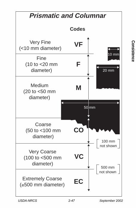
Size Code Criteria:Class Conv. NASIS structural unit size 1 (mm)
Granular Columnar, Angular &Platy 2 Prismatic, Subangular
Thickness Wedge 3 BlockyVery Fine vf VF < 1 < 10 < 5(Very Thin)2 (vn) (VN)Fine f F 1 to < 2 10 to < 20 5 to < 10(Thin) 2 (tn) (TN)Medium m M 2 to < 5 20 to < 50 10 to < 20Coarse co CO 5 to < 10 50 to < 100 20 to < 50(Thick) 2 (tk) (TK)Very Coarse vc VC ≥ 10 100 to < 500 ≥ 50(Very Thick) 2 (vk) (VK)Extr. Coarse ec EC — ≥ 500 —-
1 Size limits always denote the smallest dimension of the structural units.2 For platy structure only, substitute thin for fine and thick for coarse in the
size class names.3 Wedge structure is generally associated with Vertisols (for which it is a
requirement) or related soils with high amounts of smectitic clays.

USDA-NRCS 2-44 September 2002
Very Fine(<1 mm diameter)
Fine(1 to <2 mm diameter)
Medium(2 to <5 mm diameter)
Coarse(5 to <10 mm diameter)
Very Coarse(≥10 mm diameter)
VC
CO
M
F
VF
10 mm
5 mm
2 mm
1 mm
Codes
Granular
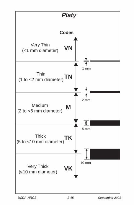
USDA-NRCS 2-45 September 2002
Very Thin(<1 mm diameter)
Thin(1 to <2 mm diameter)
Medium(2 to <5 mm diameter)
Thick(5 to <10 mm diameter)
Very Thick(≥10 mm diameter)
VK
TK
M
TN
VN
10 mm
5 mm
2 mm
1 mm
Codes
Platy
USDA-NRCS 2-46 September 2002
Very Fine(<5 mm
diameter)
Fine(5 to <10 mm
diameter)
Medium(10 to <20 mm
diameter)
Coarse(20 to
<50 mmdiameter)
Very Coarse(≥50 mm diameter)
VC
CO
M
F
VF
10 mm
5 mm
Codes
Angular & SubangularBlocky
50 mm
20 mm
USDA-NRCS 2-47 September 2002
Very Fine(<10 mm diameter)
Fine(10 to <20 mm
diameter)
Coarse(50 to <100 mm
diameter)
Very Coarse(100 to <500 mm
diameter)
Extremely Coarse(≥500 mm diameter)
VC
CO
M
F
VF
Codes
Prismatic and Columnar
10 mm
20 mm
50 mm
EC
Medium(20 to <50 mm
diameter)
100 mmnot shown
500 mmnot shown
Consistence
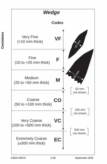
USDA-NRCS 2-48 September 2002
Very Fine(<10 mm thick)
Fine(10 to <20 mm thick)
Coarse(50 to <100 mm thick)
Very Coarse(100 to <500 mm thick)
Extremely Coarse(≥500 mm thick)
EC
VC
M
CO
F
VF
Codes
Wedge
100 mmnot shown
500 mmnot shown
50 mmnot shown
Medium(20 to <50 mm thick)
10 m
m
20 m
m
Cons
iste
nce