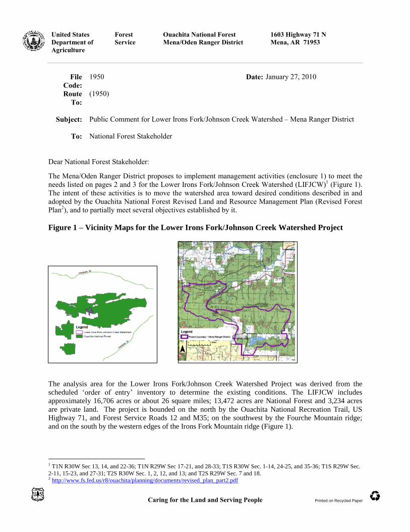
figure 1 vicinity maps for the lower irons fork/johnson...
TRANSCRIPT
United States
Department of
Agriculture
Forest
Service
Ouachita National Forest
Mena/Oden Ranger District
1603 Highway 71 N
Mena, AR 71953
Caring for the Land and Serving People Printed on Recycled Paper
File
Code:
1950 Date: January 27, 2010
Route
To:
(1950)
Subject: Public Comment for Lower Irons Fork/Johnson Creek Watershed – Mena Ranger District
To: National Forest Stakeholder
Dear National Forest Stakeholder:
The Mena/Oden Ranger District proposes to implement management activities (enclosure 1) to meet the
needs listed on pages 2 and 3 for the Lower Irons Fork/Johnson Creek Watershed (LIFJCW)1 (Figure 1).
The intent of these activities is to move the watershed area toward desired conditions described in and
adopted by the Ouachita National Forest Revised Land and Resource Management Plan (Revised Forest
Plan2), and to partially meet several objectives established by it.
Figure 1 – Vicinity Maps for the Lower Irons Fork/Johnson Creek Watershed Project
The analysis area for the Lower Irons Fork/Johnson Creek Watershed Project was derived from the
scheduled ‗order of entry‘ inventory to determine the existing conditions. The LIFJCW includes
approximately 16,706 acres or about 26 square miles; 13,472 acres are National Forest and 3,234 acres
are private land. The project is bounded on the north by the Ouachita National Recreation Trail, US
Highway 71, and Forest Service Roads 12 and M35; on the southwest by the Fourche Mountain ridge;
and on the south by the western edges of the Irons Fork Mountain ridge (Figure 1).
1 T1N R30W Sec 13, 14, and 22-36; T1N R29W Sec 17-21, and 28-33; T1S R30W Sec. 1-14, 24-25, and 35-36; T1S R29W Sec.
2-11, 15-23, and 27-31; T2S R30W Sec. 1, 2, 12, and 13; and T2S R29W Sec. 7 and 18. 2 http://www.fs.fed.us/r8/ouachita/planning/documents/revised_plan_part2.pdf

Lower Irons Fork/Johnson Creek Watershed Environmental Assessment – Public Comment Period Notification 2
The Revised Forest Plan provides primary direction for all management activities and contains the Vision,
Strategy and Standards for guiding all natural resource management activities for the Ouachita National
Forest. The Lower Irons Fork/Johnson Creek Watershed includes five management areas (MAs): Rare
Upland Communities (MA 6), Water and Riparian Communities (MA 9), Ouachita Mountains-Habitat
Diversity Emphasis (MA 14), Semi-primitive Areas (MA 17), and Renewal of Shortleaf Pine-Bluestem
Grass Ecosystem and Red Cockaded Woodpecker Habitat (MA 22) (Map 1).
Table 1. Percentage (acres) of watershed by management area (National Forest System
Lands Management Area
6 9 14 17 22
10% (1,347 acres) 15% (2,021acres) 16% (2,156 acres) 3% (404 acres) 56% (7,544 acres)
The Management Area summaries of current and desired conditions are located in enclosure 2 of this
document and provide program priorities and objectives for each individual MA within the analysis area.
Identified desired conditions and objectives are addressed, wholly or partially, within the context of this
proposal for management activities in the watershed.
The Lower Irons Fork/Johnson Creek Watershed proposal consists of the activities identified in enclosure
1. Also available at Ouachita National Forest web page are maps showing boundaries of the watershed
and approximate location of the different activities
(http://www.southernregion.fs.fed.us/ouachita/projects). Only one decision will be made regarding the
approval of these activities, however, more than one contract or authorization may be needed to
accomplish the work over the next few years.
Desired conditions (needs) for the Lower Irons Fork/Johnson Creek Watershed:
Maintain or Restore Community Diversity and Reduce Fuel Loads of National Forest System Lands
Reduction of existing fuel loading is needed on approximately 11,4313 acres within the project area to
meet desired prescribed fire frequency intervals for various ecosystem types (i.e., Ouachita Shortleaf
Pine-Oak Forest and Woodland, Ouachita Shortleaf Pine-Bluestem Woodland, Ouachita Dry-mesic Oak
Forest, and Riparian communities), and to restore others (i.e., Ouachita Shortleaf Pine-Oak Forest and
Woodland, Ouachita Shortleaf Pine-Bluestem Woodland, Ouachita Dry Oak Woodland, Ouachita
Montane Oak Forest, and Central Interior Acidic Cliff and Talus) (Map 3).
Maintain Full Range of Natural Systems Found Within the Ouachita National Forest
Special emphasis to conserve and restore Pine-Bluestem Woodland, Pine Woodland, Ouachita Dry Oak
Woodland, Ouachita Montane Oak Forest, and Central Interior Acidic Cliff and Talus communities
through thinning, selected herbicide treatment and/or prescribed fire has been identified on 4,523 acres
within the watershed (Map 2).
3 This figure represents the total amount of prescribed burning proposed, including portions of burn units that fall
outside of the project area boundary. Of this total, 7,731 acres fall within the Lower Irons Fork/Johnson Creek
Watershed Project boundary.

Lower Irons Fork/Johnson Creek Watershed Environmental Assessment – Public Comment Period Notification 3
Improve Forest Health
Stocking reduction is needed on 4,496 acres (commercial thinning activities), which is approximately 33
percent of the National Forest System lands in the Lower Irons Fork/Johnson Creek Watershed (Map 4).
Pre-commercial thinning activities are currently needed on 46 acres, and in the future on 261 acres
proposed for Modified Seed Tree regeneration harvest. The majority of treated areas would be in stands
classified as overstocked. Stocking reduction would reduce potential for southern pine beetle outbreaks
and uncharacteristic wildfires, increase timber growth and yield, stimulate rapid development of foraging
habitat, improve forest health and increase herbaceous plant species diversity to meet Revised Forest Plan
desired conditions.
Regeneration activities are needed on approximately 261 acres (modified seed tree regeneration; site
preparation and plant) within the watershed to transfer areas with mature trees to a grass-forb or shrub-
seedling (early-seral) condition in MA 14.
Overstocked stands would need releasing to manage desired trees for the specific management type (i.e.,
pine, pine-hardwood, and hardwood-pine).
Manage Forest Transportation System
The road system needs management activities to protect soil, water and wildlife resources; reduce road-
related barriers to aquatic organism passage; and to provide access to stands within the watershed analysis
area. Needed management activities include reducing open road density, installing gates or other barriers
on closed roads, and improving road conditions, vehicular access, and stream fords (Map 4).
Maintain or Enhance Designated Beneficial Uses of Water
Fish passage restoration at 2 stream crossings would aid in aquatic organism passage, and development of
a fishing pier at Irons Fork Reservoir would enhance recreational fishing opportunities.
Maintain or Improve Long Term Soil Productivity
Approximately 6.5 miles of unauthorized user-created all terrain vehicle (ATV) and off-highway vehicle
(OHV) trails, and approximately 1.5 acres of an old shale mining pit are impacting long term soil
productivity and need stabilization.
Supply Commodity and Commercial Uses (Timber and Minerals)
There is a need to provide a sustained yield of high-quality wood products at a level consistent with sound
economic principles. Hardwood firewood collection areas would be made available to the public to
improve utilization of those products.
Stands proposed for regeneration have been identified for herbicide, manual or mechanical site
preparation and hand planting with shortleaf pine in order to accomplish desired stocking levels in the
event that natural regeneration is not adequately attained.
Supply a Spectrum of Recreational Facilities and Opportunities
One dispersed campsite occurs within the project area, which will be maintained for recreational use. The
Ouachita National Recreation Trail (ONRT) runs along the northeast boundary, and transects the western
half of the project area and would be maintained through the elimination of non-native invasive species.

Lower Irons Fork/Johnson Creek Watershed Environmental Assessment – Public Comment Period Notification 4
One trail shelter has been proposed for construction along the ONRT within the project area, and a fishing
pier has been proposed for construction on the banks of Irons Fork Reservoir.
Eradication of Non-Native Invasive Species
Elimination of non-native invasive species (e.g., tall fescue, sericea lespedeza, autumn olive, honey
suckle, privet) is needed throughout the Lower Irons Fork/Johnson Creek Watershed within existing
wildlife openings and timber stands, along trails and closed roads, and all Forest Service roadways.
Past and Reasonably Foreseeable Future Actions:
The analysis of cumulative effects is a requirement of the National Environmental Policy Act (NEPA).
“A cumulative effect is the impact on the environment which results from incremental impact of
the action when added to other past, present and reasonably foreseeable future actions,
regardless of what agency (Federal or non-Federal) or person undertakes such other actions.
Cumulative effects can result from individually minor but collectively significant actions taking
place over a period of time” (40 CFR 1508.7).
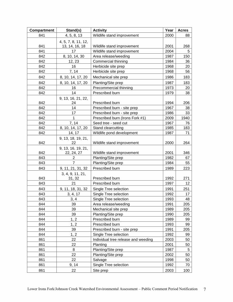
The following table summarizes activities that have occurred in the past and will be implemented in the
near future within the Lower Irons Fork/Johnson Creek watershed.
Table 2. Past activities within the Lower Irons Fork/Johnson Creek Watershed.
Compartment Stand(s) Activity Year Acres
835 16 Area release/weeding 1986 18
835 2,5,10,11,12,19,2
7,28,29,30 Commercial thinning 1976 365
835 8 Commercial thinning 1984 21
835 5 Commercial thinning 1985 25
835 5, 12, 27, 30 Commercial thinning 1998 154
835 1 Herbicide site prep 1966 36
835 1 Herbicide site prep 1968 18
835 6 Herbicide site prep 1979 21
835 10, 15 Herbicide site prep 1986 122
835 16 Herbicide site prep 1987 18
835 6 Mechanical site prep 1976 21
835 6 Mechanical site prep 1982 21
835 16 Mechanical site prep 1984 18
835 10, 15 Mechanical site prep 1987 122
835 1 Planting/Site prep 1972 5
835 6 Planting/Site prep 1976 21
835 16 Planting/Site prep 1985 18
835 10, 15 Planting/Site prep 1986 122
835 1 Precommercial thinning 1976 18
835 15 Precommercial thinning 1999 134
835
3,4,5,7,8,9,10,11,12,13,16,18,19,2
7,28,30 Prescribed burn 1997 545

Lower Irons Fork/Johnson Creek Watershed Environmental Assessment – Public Comment Period Notification 5
Compartment Stand(s) Activity Year Acres
835 6 Prescribed burn - site prep 1976 21
835 6 Prescribed burn - site prep 1980 21
835 10, 15 Prescribed burn - site prep 1985 122
835 5, 12, 15, 19, 27,
30 Prescribed burn - wildlife 1978 236
835 5, 12, 15, 27, 30 Prescribed burn - wildlife 1981 221
835 10 Prescribed burn - wildlife 1983 55
835 5, 12, 15, 27, 30 Prescribed burn - wildlife 1984 221
835 19, 27, 30 Prescribed burn - wildlife 1987 52
835 6 Re-planting/Site prep 1978 21
835 6 Re-planting/Site prep 1979 21
835 6 Re-planting/Site prep 1980 21
835 6 Re-planting/Site prep 1981 22
835 1 Seed tree - final removal 1972 18
835 1 Seed tree - seed cut 1964 18
835 6 Seeding/Site prep 1981 21
835 6 Stand clearcutting 1974 21
835 10 Stand clearcutting 1984 55
835 15 Stand clearcutting 1985 67
835 7, 10, 12 Wildlife pond development 1975 57
835 15 Wildlife pond development 1979 1
835 2, 5, 8, 11, 12,
27, 29, 30 Wildlife stand improvement 2000 322
835
2, 3, 4, 5, 7, 8, 9, 10, 11, 12, 13, 16, 19, 20, 21, 22, 27, 28, 30 Wildlife stand improvement 2001 707
836 1, 8, 12, 29 Commercial thinning 1998 142
836 2, 19 Herbicide site prep 1969 102
836 2, 9, 10 Mechanical site prep 1982 372
836 2, 9, 10 Planting/Site prep 1983 186
836 2, 9, 10 Precommercial thinning 1992 95
836 5 Prescribed burn - site prep 1993 40
836 5, 8, 11 Prescribed burn - wildlife 1977 151
836 1 Prescribed burn - wildlife 2006 2504
836 3 Prescribed burn (Johnson Creek #3) 2009 2199
836 2 Prescribed burn (Johnson Highway) 2008 70
836 10, 19 Seed tree - final removal cut 1981 82
836 5, 11 Seed tree - prep cut 1990 80
836 10, 19 Seed tree - seed cut 1967 82
836 10 Site prep 1969 55
836 2 Stand clearcutting 1980 75
836 9 Stand clearcutting 1981 56
836 2 Wildlife pond development 1964 1
836 10 Wildlife pond development 1967 1
836 8 Wildlife pond development 1979 1
836 9, 10 Wildlife pond development 1981 2

Lower Irons Fork/Johnson Creek Watershed Environmental Assessment – Public Comment Period Notification 6
Compartment Stand(s) Activity Year Acres
836 2 Wildlife pond development 1990 1
836 5, 11 Wildlife pond development 1994 2
836 1, 3, 8, 12, 18,
27, 29 Wildlife stand improvement 2002 210
837 9 Area release/weeding 1969 45
837 5, 10 Area release/weeding 1986 135
837 7 Commercial thinning 1989 112
837 7 Commercial thinning 1998 107
837 5, 9, 13 Herbicide site prep 1969 145
837 6 Herbicide site prep 1971 68
837 10 Mechanical site prep 1982 98
837 5 Mechanical site prep 1985 74
837 9 Planting/Site prep 1972 20
837 6 Planting/Site prep 1978 68
837 10 Planting/Site prep 1983 98
837 5 Planting/Site prep 1986 37
837 10 Precommercial thinning 2008 38
837 10 Precommercial thinning 2009 38
837 15 Prescribed burn 1996 51
837 5, 9, 13 Prescribed burn - site prep 1969 145
837 6 Prescribed burn - site prep 1971 68
837 5 Prescribed burn - site prep 1985 37
837 7, 10 Prescribed burn - wildlife 1977 210
837 5 Seed tree - final removal cut 1981 37
837 5, 6, 9, 13 Seed tree - seed cut 1968 213
837 6 Seeding/Site prep 1972 68
837 6 Seeding/Site prep 1974 68
837 10 Stand clearcutting 1981 98
837 10 Wildlife pond development 1981 1
837 10 Wildlife pond development 1984 1
837 7 Wildlife stand improvement 2002 107
838 5 Herbicide site prep 1984 60
838 1 Mechanical site prep 1983 36
838 1 Planting/Site prep 1984 36
838 5 Planting/Site prep 1985 30
838 5 Seed tree - seed cut 1982 60
838 1 Stand clearcutting 1982 39
838 1 Wildlife pond development 1982 1
840 4 Planting/Site prep 1982 75
840 1, 10, 16 Planting/Site prep 1984 102
840 7, 8, 9, 17, 18 Wildlife stand improvement 2000 178
840 6, 7, 8, 9, 17, 18,
23, 24 Wildlife stand improvement 2001 270
841 14 Planting/Site prep 1971 14
841 7, 11 Planting/Site prep 1982 79
841 8, 12, 13 Prescribed burn 1994 80
841 7 Wildlife pond development 1988 1
Lower Irons Fork/Johnson Creek Watershed Environmental Assessment – Public Comment Period Notification 7
Compartment Stand(s) Activity Year Acres
841 4, 5, 8, 13 Wildlife stand improvement 2000 88
841 4, 5, 7, 8, 11, 12,
13, 14, 16, 18 Wildlife stand improvement 2001 268
841 17 Wildlife stand improvement 2004 5
842 8, 10, 14, 30 Area release/weeding 1987 150
842 12, 23 Commercial thinning 1984 36
842 16 Herbicide site prep 1968 20
842 7, 14 Herbicide site prep 1968 56
842 8, 10, 14, 17, 20 Mechanical site prep 1986 183
842 8, 10, 14, 17, 20 Planting/Site prep 1987 183
842 16 Precommercial thinning 1973 20
842 14 Prescribed burn 1979 38
842 9, 13, 16, 21, 22,
24 Prescribed burn 1994 206
842 14 Prescribed burn - site prep 1967 38
842 17 Prescribed burn - site prep 1986 33
842 1 Prescribed burn (Irons Fork #1) 2009 1940
842 7, 14 Seed tree - seed cut 1967 76
842 8, 10, 14, 17, 20 Stand clearcutting 1985 183
842 14, 17 Wildlife pond development 1987 71
842 9, 13, 18, 19, 21,
22 Wildlife stand improvement 2000 264
842 9, 13, 16, 19, 21,
22, 24, 27 Wildlife stand improvement 2001 346
843 2 Planting/Site prep 1982 67
843 7 Planting/Site prep 1984 55
843 9, 11, 21, 31, 32 Prescribed burn 1989 223
843 3, 4, 9, 11, 21,
31, 32 Prescribed burn 1992 271
843 21 Prescribed burn 1997 12
843 9, 11, 18, 31, 32 Single Tree selection 1991 251
843 3, 4, 17 Single Tree selection 1992 17
843 3, 4 Single Tree selection 1993 48
844 39 Area release/weeding 1991 205
844 39 Mechanical site prep 1989 205
844 39 Planting/Site prep 1990 205
844 1, 2 Prescribed burn 1989 99
844 1, 2 Prescribed burn 1993 99
844 39 Prescribed burn - site prep 1991 205
844 1, 2 Single Tree selection 1992 99
861 22 Individual tree release and weeding 2003 50
861 22 Planting 2001 50
861 8 Planting/Site prep 1987 5
861 22 Planting/Site prep 2002 50
861 22 Salvage 1998 50
861 9, 14 Single Tree selection 1992 70
861 22 Site prep 2003 100

Lower Irons Fork/Johnson Creek Watershed Environmental Assessment – Public Comment Period Notification 8
Compartment Stand(s) Activity Year Acres
862 35, 36, 37, 38 Area release/weeding 1998 13
862 34 Individual tree release and weeding 2005 15
862 34 Individual tree release and weeding 2009 15
862 8 Planting/Site prep 1975 23
862 34 Planting/Site prep 2003 15
862 34 Planting/Site prep 2005 15
862 34 Planting/Site prep 2008 8
862 1, 4, 15, 16, 17,
23, 24, 25 Prescribed burn 1979 193
862 1, 4, 15, 16, 17,
23, 24, 25 Prescribed burn 1982 193
862 1, 10, 23 Prescribed burn 1994 109
862 34 Prescribed burn 2002 15
862 1, 2 Prescribed burn 2007 1508
862 3 Prescribed burn 2010 1184
862 1, 4, 15, 16, 17,
23, 24, 25 Prescribed burn - wildlife 1984 193
862 1, 4, 15, 16, 17,
23, 24, 25 Prescribed burn - wildlife 1991 193
862 4, 9, 11, 15, 16,
17, 24, 25 Prescribed burn - wildlife 1994 250
862 1, 2, 4, 6, 15, 16, 17, 18, 23, 24, 25 Prescribed burn - wildlife 1997 233
862 34, 35, 36, 37, 38 Seeding 2001 28
862 10 Seeding/Site prep 1977 39
862 34 Site prep 2003 15
1305/1307 various Prescribed burn (in watershed, outside project area)
2010 2781
Cumulative effects analysis will be conducted for this watershed using the larger land base 6th level
watershed area.
Physical and Biological Characteristics Likely to be Affected by Proposed Activities:
Air Quality – The project area has been divided into 20 burn units ranging in size from 18 to 3,027 acres
for a total of 11,431 acres4. Burn units would be designed to mitigate smoke, as well as to strategically
take advantage of road systems and natural barriers to reduce the need to construct control lines. The
Class I wilderness (Caney Creek) is approximately 14 miles south of the LIFJCW. The Black Fork
Wilderness is approximately 5 miles to the west. Other smoke sensitive targets identified for the LIFJCW
are the communities of Mena, Fort Smith and Russellville, Arkansas.
Soil Productivity – The analysis area for LIFJCW is located within the Central Ouachita Mountain
subdivision of the Ouachita Mountain Physiographic Region. Topographic features of the area consist of
low lying hills with gently sloping ridge tops and dissected moderately steep to steep side slopes, rugged
4 This figure represents the total amount of prescribed burning proposed, including portions of burn units that fall
outside of, and adjacent to the project area boundary. Of this total, 7,731 acres fall within the Lower Irons
Fork/Johnson Creek Watershed Project boundary.

Lower Irons Fork/Johnson Creek Watershed Environmental Assessment – Public Comment Period Notification 9
mountains with gently sloping to moderately steep ridge tops and steep to very steep side slopes, and
nearly level flood plains that flood occasionally to frequently. Geology of the southern portions of the
project area is dominantly tilted and fractured shale and sandstone of the Jackfork Sandstone and Stanley
Shale Formations that formed during the Pennsylvanian and Mississippian Periods, respectively. Geologic
formations dominating the northern portions of the project area include Johns Valley Shale and Atoka of
the Pennsylvanian Period. Most of the alluvial material on the larger stream and river terraces and flood
plains is of the Quaternary Period.
Within the analysis area, elevations range from 900 to over 2,500 feet above sea level. North slopes are
relatively cooler and damper, while south slopes tend to be warmer and drier. Slope gradients range from
0 to 60 percent.
The soils found in the watershed and additional analysis areas are taken from the Ouachita National
Forest Soil Survey. Most of the Forest was mapped by the Natural Resource Conservation Service
(NRCS) in cooperation with the Forest Service and State University Systems. A total of 37 different soil
map units were mapped in the analysis area on the Mena Ranger District (including private land). The
affected soils include the Avilla, Bismarck, Carnasaw, Caston, Ceda, Clebit, Cupco, Kenn, Leadvale,
Littlefir, Mazarn, Mena, Nashoba, Neff, Octavia, Pirum, Sherless, Speer, Wetsaw, and Wilburton.
In the Lower Irons Fork/Johnson Creek Watershed, approximately 9% of the area has a severe erosion
hazard rating and slopes in most of these areas exceed 35 percent. Approximately 48% of the area has a
moderate erosion soil rating; and approximately 43% of the area has a slight erosion soil rating.
Approximately 5% of project area has a severe compaction hazard rating; approximately 5% has a high
compaction hazard rating; approximately 9% has a moderate to high compaction hazard rating;
approximately 70% has a moderate compaction hazard rating; and approximately 11% has a slight
compaction hazard rating.
Approximately 6.5 miles of unauthorized roads/OHV trails and 1.5 acres of an old shale pit within the
watershed have created soil erosion.
A description of potential effects to soil productivity from watershed actions will be addressed and
analyzed.
Water Resources and Quality – The LIFJCW analysis area is located within two 6th level watersheds of
16,000-25,000 acres each on the Mena Ranger District (hydrologic unit codes 80401010102,
111102060103). Stream flow within the LIFJCW is intermittent until it meets the Irons Fork, Gap,
Cedar, or Johnson Creeks and eventually the Ouachita River or Fourche LaFave.
Irons Fork Reservoir, a surface water source for the city of Mena, occurs within the analysis area.
Midway Park spring draws water from the northern portion of the analysis area, and two wells supplying
Fred‘s Truck stop lie about 1.5 miles to the northeast of the project area.
The primary beneficial uses for streams are fisheries, which provide for protection and propagation of
aquatic life (Arkansas Pollution Control and Ecology Commission, 2002), and public drinking water. The
Irons Fork Reservoir is a drinking water source for the city of Mena. There are 40 ponds currently within
the project area, and the primary beneficial use of ponds is water supply to wildlife. The Lower Irons
Fork/Johnson Creek Watershed has a low aquatic risk, indicating minimal adverse effects from sediment
increases to aquatic beneficial uses. No impaired water bodies are within any of the two 6th level
watersheds that are affected by this analysis area. All waters within the Lower Irons Fork/Johnson Creek
Watershed meet water quality standards of Section 303(d) of the Clean Water Act.

Lower Irons Fork/Johnson Creek Watershed Environmental Assessment – Public Comment Period Notification 10
Two stream crossings within this watershed inhibit movement of fish and other aquatic organisms (Map
2).
Possible cumulative effects of management activities on water quality and its associated beneficial uses
will be addressed and analyzed.
Riparian Areas and Floodplains – Approximately 3,208 acres of potential floodplain soils were
identified, and there are approximately 29 ponds within the watershed. Two stream crossings within this
watershed inhibit movement of fish and other aquatic organisms.
Several populations of sensitive species exist, including: The Kiamichi shiner (Notropis ortenburgeri),
three crayfish (Orconectes menae, Procambarus reimeri and Procambarus tenuis) the Fourche Mountain
salamander (Plethodon fourchensis), and the Rich Mountain salamander (Plethodon ouachitae).
Impacts of management activities on 100-year floodplains and wetlands would be considered to assure
that management actions do not adversely alter natural values of such areas. Possible cumulative effects
of management activities on riparian areas and floodplains and their associated beneficial uses will be
addressed and analyzed.
Transportation and Infrastructure – Because of the location of the LIFJCW, there is a relatively high
road density. Thirty three percent of roads within the watershed analysis area are of U.S., County, State
or Private jurisdiction; 67 percent are of Forest Service jurisdiction. The road system appears to meet a
variety of both public and administrative needs. There are approximately 52 miles of road (open and
closed combined) in the watershed (private, state, county, U.S. and National Forest System roads). Of all
the classified (authorized) roads in the Lower Irons Fork-Johnson Creek Watershed on all land
ownerships, 85 percent are categorized as open and 15 percent are closed. Currently, an open road is
available for highway and off-highway vehicular traffic by the public, whereas a closed road is not.
Local residents mostly use the LIFJCW national forest land for day use and road-related activities such as
firewood gathering and recreation activities such as hunting, fishing, hiking, mountain biking and driving
for pleasure.
Existing open road miles are more than the Revised Forest Plan objective established for wildlife
purposes. Approximately 6.5 miles of unauthorized roads are located on National Forest System lands
and contribute to the existing open road density and impacts to water quality. The existing open road
density for the watershed across all land jurisdictions is 1.58 miles/mile2 (1.55 miles/mile
2 on National
Forest System lands only), which exceeds the Revised Forest Plan standard of 1.0 mile per square mile
for MAs 6, 9, 14, and 22; and 0.75 mile per square mile for MA 17. Numerous areas of the watershed are
not accessible or in the condition of their assigned maintenance level.
Approximately 9 miles of road require reconstruction prior to use for forest management activities,
including Forest Service roads 49, 7150, M40C, M40A, M42C, M43, and M43A. Approximately 2 miles
of road construction and 31 miles of temporary road construction are needed for forest management
activities, and these roads will be closed after use.
Possible cumulative effects of road density will be addressed and analyzed.
Wildfire Hazards and/or Fuels - The historic fire regime for the Lower Irons Fork/Johnson Creek
Watershed was one of natural (historic) fire occurrence and the risk of losing key ecosystem components
to wildland fire was low. The fire return interval (frequency) was between 0 and 35 years. Overall, the
fire regime condition class (FRCC) within the project area has been substantially altered from the

Lower Irons Fork/Johnson Creek Watershed Environmental Assessment – Public Comment Period Notification 11
historical range and risk of losing key ecosystem components is currently high. Approximately 4% of
National Forest System lands within the watershed have intact fire regimes (FRCC 1), while 20% and
76% have moderate or highly altered fire regimes (FRCC 2 and 3), respectively (Map 3). Approximately
11,431 acres are in need of prescribed burning (requiring 9 miles of fireline construction and 30 miles of
fireline reconstruction) 5
to improve the fire regime condition class and wildlife habitat, and facilitate
forest management activities. The fuel loading is approximately 10.5 tons per acre on average, which is
approximately 6-7 tons above target. This has limited the amount of open understories necessary for
wildlife foods, reduced natural regeneration of pine and oak and restricted the availability of suitable
habitat conditions for plants adapted to fire.
Approximately 1,465 National Forest System acres of this watershed are considered wildland-urban
interface, and 4,277 additional National Forest System acres are within ½ mile of private land (Map 3).
There were approximately 14,008 acres of prescribed burning between 1967 and 2009 in this watershed
(see table 2).
Possible cumulative effects of wildfire hazard and fuel loading will be addressed and analyzed.
Vegetation - The following ecological communities currently exist on National Forest System lands
within the Lower Irons Fork/Johnson Creek Watershed (Map 2).
Table 3. Ecological Communities of the Lower Irons Fork/Johnson Creek Watershed.
Ecological Community Current percentage of the
Lower Irons Fork/Johnson
Creek Watershed (acres)
Ouachita Shortleaf Pine-Bluestem 37% (4,942)
Ouachita Shortleaf Pine-Oak Forest and Woodland
Ouachita Shortleaf Pine-Oak Forest 15% (2,061)
Ouachita Shortleaf Pine-Oak Woodland 2% (266)
Ouachita Dry-Mesic Oak Forest 21% (2,844)
Ouachita Dry Oak Woodland 9% (1,176)
Ouachita Mesic Hardwood <1% (91)
Water and Riparian 15% (2,021)
Ouachita Montane Oak Forest <1% (59)
Central Interior Acidic Cliff and Talus <1% (12)
The dominant vegetation in the Lower Irons Fork-Johnson Creek Watershed includes pine-oak forest and
woodland, and dry-mesic oak forest (table 3). Many stands in the Lower Irons Fork-Johnson Creek
Watershed had been harvested in the past using single tree selection. As a consequence, these stands have
thick understory layers and relatively little pine. Some stands are overstocked and are showing signs of
stagnation due to insufficient water, soil and nutrients for all of the woody stems. These stands are
vulnerable to infestation by bark beetles, and many of these stands are nearly impassable due to the
density of understory vegetation. Pretreatment of these stands with prescribed fire will be necessary in
order to allow access for heritage surveys and tree marking.
5 These figures represent the total amount of prescribed burning, fireline construction, and fireline reconstruction
proposed, including portions of burn units that fall outside of, and adjacent to the project area boundary. Of this
total, 7,731 acres of prescribed burning, 9 miles of fireline construction and 20 miles of fireline reconstruction fall
within the Lower Irons Fork/Johnson Creek Watershed Project boundary.

Lower Irons Fork/Johnson Creek Watershed Environmental Assessment – Public Comment Period Notification 12
The flush of growth allowed by the exclusion of fire and selective harvesting of trees has resulted in the
present-day understory and midstory vegetation, which consists of more shade tolerant tree species like
blackgum, sweetgum, and red maple. These existing forests are generally more closed and less
biologically diverse than open-pine and oak woodlands of the past.
The western half of the Lower Irons Fork-Johnson Creek Watershed (compartments 835-842, 862) is
largely dominated by potential pine-bluestem woodland. There exists some evidence of ips beetle
infestation in the area. Pine woodland conditions could be restored and maintained by controlling
understory vegetation through thinning and repeated burning, and selective application of herbicide,
reducing competition among trees and consequently reducing pine beetle threat.
Much of the vegetation within Management Areas 14 and 22 consists of pine and pine hardwood stands
ranging in age from 10 to over 140 years. Shortleaf pine occurs in nearly pure stands on the warmer,
south-facing slopes, but does not occur naturally in large contiguous stands. A significant number of
hardwood species are associated with the shortleaf pine plant community. Oak and hickory species are
the most common, with post oak and blackjack oak generally occurring on poorer, dry sites. There are
two stands on the eastern boundary of the project dominated by loblolly pine.
Oak decline, which was prevalent in the recent past, has subsided and widespread insect infestations do
not appear to be a major problem at this time. However, information derived from stand examinations in
pine and pine-hardwood stands did reveal an average basal area of over 103 square feet per acre which
indicates overcrowding. Many stands exceed 100 square feet of basal area and also exceeded 80 years of
age. These conditions result in stress and reduction in vigor and health which increases susceptibility to
insects and diseases. The ID team determined it essential to reduce the stand densities due to the potential
threat of wildfire and insect and disease outbreaks.
Pine-hardwood forest types occupy slopes with a northern exposure as well as some lower slopes
adjoining riparian plant communities that colonize floodplains, waterways and moist drainages. The most
notable drainages in this watershed include Irons Fork, Johnson, Cedar, and Gap Creeks. Mesic
hardwood forest types as well as the hardwood-pine forest type make a significant component of the
overall forest in the Lower Irons Fork/Johnson Creek Watershed. Past disturbance events such as timber
harvesting, weather, disease and insect infestations are evident in many places. The overall health of the
forest is good.
A large component of hardwood tree species is present within all pine stands in the analysis area; whether
in the overstory (highest layer of the canopy), midstory (a middle layer), or understory (within 1 to 10 feet
of the ground). The dominant hardwood tree species observed in the overstory canopy is oak. In the
midstory, oak, hickory, and elm are common. The understory layer consists of more oak and hickory
along with maple, elm, flowering dogwood, blackgum, ash, and greenbriar, among others.
There are approximately 1,193 acres of hardwood and hardwood-pine forest types aged > 50 years within
MAs 14 and 17 in the Lower Irons Fork-Johnson Creek Watershed. These hard-mast producing stands
comprise approximately 32 percent of MAs 14 and 17 in the total Lower Irons Fork-Johnson Creek
Watershed. There are approximately 1,409 suitable acres of mature-growth 80 years and greater pine and
pine-hardwood forest types in MAs 14 and 17, totaling approximately 38 percent of these MAs in the
Lower Irons Fork-Johnson Creek watershed. There are currently 151 suitable acres of mature growth
hardwood 100 years and greater in MAs 14 and 17 (4%). The majority of hardwood trees in the Lower
Irons Fork-Johnson Creek Watershed falls in the 81-90 year old age classes. In MA 22, there are
approximately 6,035 suitable acres of mature growth 70 years and greater totaling 62%, and 439 suitable
acres of trees 100 years old and greater, totaling 4%.

Lower Irons Fork/Johnson Creek Watershed Environmental Assessment – Public Comment Period Notification 13
There are approximately 76 suitable acres of early seral habitat within the Lower Irons Fork-Johnson
Creek Watershed. This early seral habitat consists principally of lands that were in regeneration. This
comprises approximately 1 percent of the suitable acres within the Lower Irons Fork-Johnson Creek
Watershed.
Non-native invasive species are found throughout the entire watershed, but are estimated to cover only 1-
5% of National Forest System lands (e.g., wildlife openings, open and closed roads, non-motorized
recreation trails). Non-native invasive species include: sericea lespedeza, devil‘s walkingstick, silktree
(mimosa), privet, tall fescue, and Japanese honey suckle.
Possible cumulative effects of vegetation treatments will be addressed and analyzed.
Biological Diversity (wildlife, fish, plants and ecological communities) – The natural rare upland
communities included in the Lower Irons Fork-Johnson Creek Watershed are: Ouachita Dry Oak
Woodland, Ouachita Mesic Hardwood Forest, Ouachita Montane Forest, and Central Interior Acidic Cliff
and Talus (table 3).
No new ponds or wildlife openings are needed, but two fish passages are being proposed for restoration,
and five wood duck nesting boxes are being proposed for installation within the watershed.
Potential effects on Proposed, Endangered, Threatened and Sensitive (PETS) species or their habitat,
Management Indicator Species (MIS) (See Enclosure 3) and Ecological Communities within and near the
analysis area will be evaluated. Harperella (Ptilimnium nodosum) and the red-cockaded woodpecker
(Picoides borealis) are two Federally Endangered species known within the analysis area.
County Economy – The Lower Irons Fork/Johnson Creek watershed is located within Polk and Scott
Counties. The Polk County seat is located in Mena, Arkansas, and as of 2008, Polk County‘s population
totaled 20,257 people. Approximately 10 percent of Polk County, Arkansas‘ workforce is employed in the
agriculture, forestry, fishing and hunting industries. The local timber industry depends on national forest
land for a source of raw material. There are 96 firms in Polk County related to forestry, fishing, hunting,
agricultural support, construction or manufacturing. Compared to the rest of the United States, Polk
County shows a greater reliance on agriculture, forestry, fishing and hunting (9.5% of employment
compared to 1.5% in the US as a whole), and manufacturing (21.4% compared to 14.1% in the US).
Employment reliance on construction is roughly similar between Polk County and the rest of the United
States (8 versus 7%, respectfully; Headwaters Economics 2009). Many local residents depend on
firewood from timber and wildlife activities on the district such as regeneration harvest, site preparation
and wildlife midstory reduction.
The Scott County seat is located in Waldron in the west central area of the state. Cattle, swine and
poultry production, along with mining and tourism make up the majority of the Scott County economy.
As of 2009, Scott County's population was 11,304 people. Since 2000, it has had a population growth of
3.81 percent.
Between 2007 and 2009, Scott and Polk Counties received land payments in lieu of taxes from the federal
government as summarized in Table 46:
6http://www.uscounties.org/PrinterTemplate.cfm?Section=Find_a_County&Template=/cffiles/counties/pilt_res.cfm
&state=AR

Lower Irons Fork/Johnson Creek Watershed Environmental Assessment – Public Comment Period Notification 14
Table 4. 2007-2009 Federal payments in lieu of taxes to Scott and Polk Counties, Arkansas.
County 2009 2008 2007
Scott $472,066 $118,278 $147,374
Polk $250,182 $286,269 $187,993
Possible cumulative effects of management treatments to County economies will be addressed and
analyzed.
Financial Efficiency – A preliminary financial analysis has been conducted and indicates that the Lower
Irons Fork/Johnson Creek Watershed represents a prudent means of achieving the Revised Forest Plan
resource objectives.
Special Uses - The Irons Fork Reservoir dam and spillway, and Forest Road M62B are under a special
use authorization to the City of Mena Water Utilities.
Public Health and Safety – Polk and Scott Counties are in compliance with the United States
Environmental Protection Agency‘s (EPA) National Ambient Air Quality Standards (NAAQS) for the
criteria pollutants of concern for the proposed project. Existing emission sources occurring in the general
vicinity of the Lower Irons Fork/Johnson Creek Watershed consist mainly of mobile sources. These
would include, but are not limited to, combustion engines (such as those found in motor vehicles); dust
from unpaved surfaces; smoke from local, county, agricultural and forest burning; and other activities.
Possible cumulative effects of management treatments to the public health and safety will be addressed
and analyzed.
Scenery Resources – The Lower Irons Fork/Johnson Creek Watershed landscape is dominated by rolling
hills to high elevation mountains (relative to the Ouachita Mountain Range as a whole) aligned in an east-
west orientation interspersed with broad valleys.
Management activities that have played a role in developing the existing landscape character include past
timber sales (including road construction), wildlife ponds and openings, dispersed recreation and
prescribed burning.
Natural disturbance factors of wind, ice storms, droughts, fire and insect or disease cycles have played a
part in shaping the vegetation mosaic of the landscape. A viewer of the forest in the Lower Irons
Fork/Johnson Creek Watershed analysis area several hundred years ago would most likely have seen open
to very open upland forests dominated by shortleaf pine and hardwoods (mostly oak) in varying
proportions. Riparian areas, sheltered coves and other mesic areas would tend toward hardwood
dominance in multi-storied, very mixed species stands, with denser hardwood understories.
The Forest Service utilizes the Scenery Management System (SMS) to evaluate land management
activities in the context of integration of benefits, values, desires and preferences regarding aesthetics and
scenery. The Revised Forest Plan established Scenic Integrity Objectives (SIO) forest-wide using
Geographic Information System technology. The SIO values for the Ouachita National Forest where
aggregated into four general categories: Very High, High, Medium and Low.
Scenic Integrity Objectives (SIO) in the Lower Irons Fork-Johnson Creek Watershed include 4,786 acres
(36%) in the High category, 8,433 acres (63%) in the Medium category, and 144 acres (1%) in the Low
category.

Lower Irons Fork/Johnson Creek Watershed Environmental Assessment – Public Comment Period Notification 15
A description of existing conditions and an assessment of potential effects to scenery resources from
watershed actions will be addressed and analyzed.
Recreation Resources – The Lower Irons Fork/Johnson Creek Watershed analysis area is a
predominately natural or natural-appearing environment with a low probability of experiencing isolation
from sights and sounds of man (Recreation Opportunity Spectrum class ―Roaded Natural‖.) Interaction
between users may be low to moderate, but with evidence of other users prevalent. Conventional
motorized use is provided for in construction standards and design of facilities. Opportunities for both
motorized and non-motorized forms of recreation may be provided.
There are no Forest Service developed recreation campgrounds or facilities within the Lower Irons
Fork/Johnson Creek Watershed analysis area. Roads within the Lower Irons Fork/Johnson Creek
Watershed require vehicles with a relatively high ground clearance. Hiking and mountain bike riding,
dispersed camping, OHV, mainly 4-wheelers and dirt-bikes, hunting, fishing, and driving for pleasure are
the predominant recreational activities. Irons Fork Reservoir is popular for fishing, and a fishing pier is
proposed for construction along its banks near the public boat ramp.
There is one dispersed campsite within the Lower Irons Fork/Johnson Creek Watershed, and it would
remain open. The Lower Irons Fork-Johnson Creek Watershed includes a portion of the 192-mile
Ouachita National Scenic Trail, and a trail shelter is proposed for construction at mile marker
68.9 (near the trail‘s intersection with US Highway 71 at Foran Gap).
Blue Mountain is an 11,678 acre semi-primitive area of which 856 acres crosses into the Lower Irons
Fork-Johnson Creek project area. The ridges of the Blue Mountain area are elevated significantly above
the surrounding terrain with Blue Mountain rising above 2,600 feet.
The Lower Irons Fork/Johnson Creek Watershed (road system and general forest area) is currently open
to all OHV traffic unless posted as closed or a road has an earthen mound or gate.
Possible cumulative effects of management treatments to recreation resources will be addressed and
analyzed.
Climate Change – Human activities that release carbon dioxide have resulted in increasing
concentrations sufficient to increase the earth‘s surface temperature above natural cycles. Changes in
temperatures as well as changes in precipitation can affect forests directly. Species ranges and
distributions may change as a result of the complex combinations of changes in temperature,
precipitation, severe weather events, insects and diseases, herbivore populations, and other interrelated
ecosystem factors, albeit in uncertain ways. Wildfires are the greatest cause of carbon release from
forests. However, the greatest changes in forest sequestration and storage over time have been due to
changes in land use and land use cover, particularly conversions from forest to agriculture and more
recently from forest to urban development, dams, highways, and other infrastructure
It is not currently feasible to quantify the direct and indirect effects of individual or multiple projects on
global climate change; and therefore, determining effects of those projects or project alternatives on
global climate change cannot be made at any scale. However, in recognizing the sensitive nature of
concerns about climate change, the qualitative direct, indirect, and cumulative climate change effects for
each alternative will be addressed and analyzed to the extent possible.
Lower Irons Fork/Johnson Creek Watershed Environmental Assessment – Public Comment Period Notification 16
Environmental Issues Related to the Proposed Action
No significant issues are anticipated, but analysis of effects of the proposed action (and alternatives) on
soils, water, air, roadless character and wildlife, including any Protected, Proposed, Endangered,
Threatened or Sensitive species that may occur in the Lower Irons Fork/Johnson Creek Watershed area
would be addressed.
Alternatives to the Proposed Action
No Action
Proposed Action without Herbicides
Proposed Action without Modified Seed Tree Harvest but with Modified Shelterwood Harvest
Other Requirements
This project is subject to a formal notice and comment period pursuant to 36 Code of Federal Regulation
(CFR) 215.3(a-e) (2003 version). Comments must be postmarked or received within 30 days beginning
the day after publication of this notice in the Arkansas Democrat-Gazette. Written comments should be
sent to: District Ranger Jim E. Zornes, Mena and Oden Ranger Districts, Ouachita National Forest, Attn:
Lower Irons Fork/Johnson Creek Watershed. Oral or hand-delivered comments may be made at the Mena
Ranger District office at 1603 Highway 71 North, Mena, AR 71953 within the normal weekday business
hours of 8:00 a.m. to 4:30 p.m. Comments may also be mailed electronically to the Mena Ranger District
office, in a common digital format (without attachments), using the following email address: comments-
Only individuals or organizations that provide comments or otherwise express interest during the
comment period will be eligible to appeal. Include your name, address, and your signature or other means
of identification. For organizations, a signature or other means of identification verification must be
provided for the individual authorized to represent your organization.
The District Ranger is the Responsible Official for this project. Please contact Ayn Shlisky of the Mena
and Oden Ranger Districts if you have any specific questions about the watershed and/or proposed
opportunities.
Description of Remaining Project Planning Steps
After comments have been received, they will be considered by the interdisciplinary team as it prepares
its analysis of environmental effects from the proposal and its alternative. If no significant environmental
effects are found, the Responsible Official will issue a Finding of No Significant Impact (FONSI), along
with a complete environmental assessment (EA) and Decision Notice (DN). The FONSI, EA and DN
will be made available electronically, and you will be notified in writing of their availability. If
significant environmental effects are identified due to the proposal or its alternative, we will issue a notice
of our intent to prepare an environmental impact statement.
Thank you for your participation in the development of these proposed land management activities for the
Lower Irons Fork/Johnson Creek Watershed. We look forward to hearing from you and expect that your

Lower Irons Fork/Johnson Creek Watershed Environmental Assessment – Public Comment Period Notification 17
active participation will help us make a better-informed decision regarding management of the Mena and
Oden Ranger Districts.
JIM E. ZORNES
District Ranger
Enclosures
Lower Irons Fork/Johnson Creek Watershed Environmental Assessment – Public Comment Period Notification 18
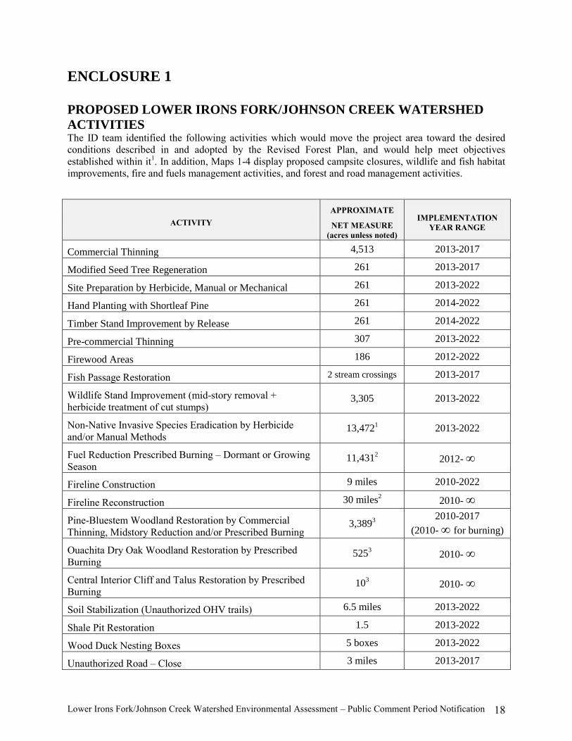
ENCLOSURE 1
PROPOSED LOWER IRONS FORK/JOHNSON CREEK WATERSHED
ACTIVITIES The ID team identified the following activities which would move the project area toward the desired
conditions described in and adopted by the Revised Forest Plan, and would help meet objectives
established within it1. In addition, Maps 1-4 display proposed campsite closures, wildlife and fish habitat
improvements, fire and fuels management activities, and forest and road management activities.
ACTIVITY
APPROXIMATE
NET MEASURE
(acres unless noted)
IMPLEMENTATION
YEAR RANGE
Commercial Thinning 4,513 2013-2017
Modified Seed Tree Regeneration 261 2013-2017
Site Preparation by Herbicide, Manual or Mechanical 261 2013-2022
Hand Planting with Shortleaf Pine 261 2014-2022
Timber Stand Improvement by Release 261 2014-2022
Pre-commercial Thinning 307 2013-2022
Firewood Areas 186 2012-2022
Fish Passage Restoration 2 stream crossings 2013-2017
Wildlife Stand Improvement (mid-story removal +
herbicide treatment of cut stumps) 3,305 2013-2022
Non-Native Invasive Species Eradication by Herbicide
and/or Manual Methods 13,472
1 2013-2022
Fuel Reduction Prescribed Burning – Dormant or Growing
Season 11,431
2 2012- ∞
Fireline Construction 9 miles 2010-2022
Fireline Reconstruction 30 miles2 2010- ∞
Pine-Bluestem Woodland Restoration by Commercial
Thinning, Midstory Reduction and/or Prescribed Burning 3,389
3
2010-2017
(2010- ∞ for burning)
Ouachita Dry Oak Woodland Restoration by Prescribed
Burning 525
3 2010- ∞
Central Interior Cliff and Talus Restoration by Prescribed
Burning 10
3 2010- ∞
Soil Stabilization (Unauthorized OHV trails) 6.5 miles 2013-2022
Shale Pit Restoration 1.5 2013-2022
Wood Duck Nesting Boxes 5 boxes 2013-2022
Unauthorized Road – Close 3 miles 2013-2017
Lower Irons Fork/Johnson Creek Watershed Environmental Assessment – Public Comment Period Notification 19
ACTIVITY
APPROXIMATE
NET MEASURE
(acres unless noted)
IMPLEMENTATION
YEAR RANGE
Unauthorized Road – Close and Decommission 0.3 mile 2013-2017
System Road – Permanent Closure 4 miles 2013-2017
System Road – Close to Off-highway Vehicles 1 mile 2013-2017
System Road – Seasonally Close 7 miles 2013-2017
System Road Construction 2 miles 2013-2017
System Road Reconstruction 9 miles 2013-2017
Temporary Road Construction 31 miles 2013-2017
Road Maintenance 18 miles 2013-2022
Construction of Fishing Pier 1 pier 2010-2022
Construction of Trail Shelter 1 shelter 2010-2022
1 – This figure represents the total area of National Forest System lands that could be subject to non-native species
eradication. The actual area of non-native species eradication needs are unknown at this time, but are estimated to be
approximately 1-5% of this figure.
2 – These figures represent the total amount of prescribed burning and fireline reconstruction proposed, including
portions of burn units that fall outside of, and adjacent to the project area boundary. Of this total, 7,731 acres of
prescribed burning and 20 miles of fireline reconstruction fall within the Lower Irons Fork/Johnson Creek
Watershed Project boundary.
3 – This figure is also included in the total amount of proposed prescribed burning, wildlife stand improvement and
commercial thinning.

Lower Irons Fork/Johnson Creek Watershed Environmental Assessment – Public Comment Period Notification 20
DESCRIPTION OF ACTIVITIES TO CHANGE EXISTING CONDITION
„Standards,‟ the rules against which practices are measured, and other guidance provide the technical
and scientific specifications that must be met to complete acceptable projects. Revised Forest Plan
Design Criteria were developed to ensure compliance with applicable laws, regulations, Executive
Orders and policies; to resolve management issues and concerns; and to direct management practices
toward achievement of desired conditions.
DESCRIPTION OF ACTIVITIES
Commercial Thinning
Current composition is mostly shortleaf pine with some thicker hardwood patches. These stands in
Management Area 14 would be commercially thinned to a target basal area (BA) of 60-70 square feet per
acre. These stands in Management Area 22 would be commercially thinned to a target basal area (BA) of
50-60 square feet per acre. This thinning would improve the existing stand and regulate growth by
adjusting stand density through cutting and removal of trees, while striving to retain healthy, well-formed
leave trees. The post-thinning stocking levels would allow for a more advantageous distribution of site
resources; thereby, creating vigorous timber stands that are less susceptible to Southern Pine Beetle
infestations. Thinning hardwoods in the stands would provide areas for mast production. Post harvest
BA of hardwood species in Management Area 14 would be maintained at approximately 5-15 square feet
per acre in pine dominated stands and approximately 20-35 square feet per acre percent in the pine-
hardwood mixed stands. Post harvest BA of hardwood species in Management Area 22 would be
maintained at approximately 5-10 square feet per acre (Forest Wide Design Criteria FI005, TH001)
Modified Seed Tree Regeneration
Modified seed tree regeneration is the start of a two-aged regeneration method involving cutting of all
pine trees except for 5 to 15 BA per acre that are widely and uniformly dispersed for seed production.
Residual trees consist mainly of overstory shortleaf pine, but would also include a quantity of remaining
overstory or midstory hardwoods (approximately 5 BA per acre). Leave trees would be retained
throughout the life of each stand to insure a mixed stand composition and supply of wildlife habitat.
(Forest Wide Design Criteria WF001-WF005, WF007, VM003, VM004, FR001-FR009, FR011, FR014,
TH001)
Site Preparation (Herbicide, Manual or Mechanical)
Site preparation improves access for planting, reduces competing hardwoods and prepares a seedbed
suitable for desired natural regeneration of shortleaf pine. In stands receiving a modified seed tree
regeneration harvest, preparation of the site for shortleaf pine would occur. (Forest Wide Design Criteria
FR013)
Various methods of site preparation involving manual, herbicide and/or mechanical treatments would be
used either separately or in combination with one another.
Herbicide
Herbicide application may be necessary to achieve desired goals of site preparation and noxious
weed eradication. A mixture of herbicides with the active ingredients imazapyr, metsulfuron

Lower Irons Fork/Johnson Creek Watershed Environmental Assessment – Public Comment Period Notification 21
methyl and triclopyr would best achieve desired condition goals for site preparation. This
mixture provides improved control more than herbicides containing only imazapyr, in addition to
reducing costs. Triclopyr, metsulfuron methyl and imazapyr would be applied at rates necessary
to control targeted vegetation and not exceed the label rate.
Application methods would include: 1) foliar spray, which involves application of herbicide to
foliage of trees and shrubs less than six feet in height; 2) frill treatment, which involves
application of herbicide by spray bottle into cuts that expose the tree‘s sapwood; and 3) cut-stump
treatment, which involves application of herbicide by spray bottle to the surface of cut stumps.
Application of foliar-spray methods would be made during the spring and summer seasons when
vegetation is green and growing. Cut-surface treatments, which include frill and cut-stump
treatments, however, are not dependent upon time of year. (Forest Wide Design Criteria HU001-
HU016, HU018)
Manual
Manual treatments consist of hand-operated tools (e.g., chainsaws) to cut or girdle overstory and
midstory vegetation and herbicides in combination with manual ground tools as a means to aid
delivery of herbicide into the cambium (see ―Herbicide‖). (Forest Wide Design Criteria FR013)
Mechanical
Mechanical methods would also be used, which include mechanical scarification (where
prescribed burning is not feasible) and mechanical ripping (if natural regeneration were deemed
unsuccessful). (Forest Wide Design Criteria FR013)
Hand Planting with Shortleaf Pine
Planting may be used on a case-by-case basis to accomplish desired stocking levels. Shortleaf pine
seedlings would be planted in loosened soil created by a mechanical ripper mounted on a bulldozer in
order to take advantage of microsites and increase seedling survival. Tree spacing would be adjusted
based on past regeneration survival percentages. (Forest Wide Design Criteria FR007)
Timber Stand Improvement by Release
Release operations are treatments conducted to regulate species composition and improve quality of
young stands. Release of shortleaf pine seedlings from undesirable vegetation would occur in those
stands scheduled for regeneration cuttings. The proposed regeneration areas would receive this treatment
within three to five years of stand establishment.
Manual treatments (e.g. chainsaws or machetes) would be used when boles of desired trees are not
shaded. Herbicide methods—specifically foliar applications and/or cut-surface treatments (see
―Herbicide‖)—would be used when competing vegetation is more than half the height of desired
regeneration and, therefore, shading the boles. The hardwood patches would receive thinning in order to
provide areas for mast production at the approximate rate of 20 percent in each stand. (Forest Wide
Design Criteria FI001-FI004)
Timber Stand Improvement by Precommercial Thinning
In areas with excessive numbers of saplings (i.e., >1,000 trees per acre) a thinning treatment is conducted
in order to give a desirable number of these trees room to grow. Precommercial thinning involves the

Lower Irons Fork/Johnson Creek Watershed Environmental Assessment – Public Comment Period Notification 22
cutting of trees not for immediate financial return, but to reduce stocking to concentrate growth on the
remaining desirable trees. Hardwoods would be retained as a portion of the desirable trees following
Revised Forest Plan standards. Precommercial thinning is accomplished using chainsaws. (Forest Wide
Design Criteria FI001-FI004)
Firewood Areas
Firewood cutting would be available in those stands culturally treated with the objective of reducing the
amount of existing hardwood for regeneration or wildlife stand improvement. (Forest Wide Design
Criteria FW001, FW002)
Pine-Bluestem Woodland and Pine Woodland Restoration
Pine woodland communities on the Ouachita National Forest have been given special emphasis by the
Revised Forest Plan toward their conservation and restoration. The following proposed treatment strives
to meet this direction by restoring a pine woodland community through commercial thinning, selective
herbicide use, midstory reduction and prescribed fire. Currently the proposed treatment area is composed
of mature overstory pines with a sparse mix of hardwood tree species. The mid-story is poorly developed
with only pockets of shade tolerant shrub species and colonies of various huckleberry species. Ground
cover is composed of grasses and early summer herbs.
Pine Woodland Restoration - Commercial Thinning, Prescribed Fire , and Herbicides
Commercial thinning would be used to improve the existing stand and stimulate growth and
development of overstory pine. Pine stands would be thinned from below to a basal area (BA) of
50 square feet per acre. Leave trees would have a dbh of 10 inches or greater. Overstory leave
trees would be well spaced with leave canopy closures ranging from 40 – 60 percent. Opening
the canopy overstory would allow for the penetration of sunlight to the forest floor thus
stimulating the development of herbaceous groundcover. The open woodland condition would be
maintained through a one-time selective treatment of herbicides, a prescribed fire interval of 1 – 5
years or as needed once restored conditions are reached.
Pine Woodland Restoration – Midstory Reduction
The goal of midstory removal is to thin out mid-canopy vegetation to increase growth of
understory forbs, grasses, and shrubs, to enhance wildlife forage, and increase growth and vigor
of overstory pine and hardwoods. Plots would be thinned from below to approximately a
midstory leave BA of 10 square feet per acre. Determining which trees would be removed would
be based more upon individual tree crown location and how the crown is shading the understory
rather than on a dbh limit. Therefore, trees larger than seven inches dbh would occasionally be
removed. Although the purpose is mainly to reduce a hardwood midstory layer, hardwoods
would be retained following Revised Forest Plan standards.
Lower Irons Fork/Johnson Creek Watershed Environmental Assessment – Public Comment Period Notification 23
Non-native Invasive Weed Treatments
Manual treatments and herbicide treatments would normally be applied to all areas within the watershed
as needed to control and or eliminate the spread of non-native invasive plant species (e.g., tall fescue,
sericea lespedeza, autumn olive, honey suckle, privet). These treatments would include use of approved
USDA herbicides and manual treatments such as prescribed fire, mid-story reduction and manual
uprooting.
Herbicides would be applied to existing wildlife openings, timber stands, closed roads, and along
roadways as needed for elimination of non-native noxious weeds. A mixture of herbicides containing the
active ingredients imazapic, glyphosate and/or triclopyr and an adjuvant for increased control would be
used to eradicate noxious weeds encroaching timber stands, wildlife openings and roadways. This
mixture provides for control of undesired non-native invasive and noxious plant species and aids in the
release and establishment of desirable grassland plant species.
Fish Passage Restoration
Proposed fish passage restoration would include activities such as addition of drainage structures, culvert
replacement, and/or addition of riprap.
Ouachita Dry Oak Woodland Restoration – Prescribed Fire
The Revised Forest Plan placed special emphasis on the Ouachita Dry Oak Woodland community.
Ouachita Dry Oak Woodland occurs along gentle to steep slopes and over bluff escarpments with
southerly to westerly aspects. Parent material can range from calcareous to acidic with very shallow, well-
drained to excessively well-drained soils, sometimes with a fragipan that causes "xero-hydric" moisture
conditions. This system was historically woodland in structure, composition, and process but now
includes areas of more closed canopy forests due to fire suppression. Oak species dominate this system
with an understory of herbaceous and shrub species. Drought stress and associated fire are the major
dynamics influencing and maintaining this system. To mimic natural fire regimes, many of these sites will
receive a prescribed burn every 5-7 years, with an occasional growing season fire included.
Fuel Reduction Prescribed Burning
The project area has been divided into 20 burn units ranging in size from 18 to 3,027 acres, for a total of
11,4317 acres. Each burn unit will be treated with controlled broadcast fire approximately every 1 to 5
years during either the growing or dormant season. This recurring schedule will be on a continuous basis
and extend indefinitely beyond the 10-year period during which other proposed management activities
will occur. Prescribed burning is a key management tool to achieve improved Fire Regimes and
Condition Classes for National Forest lands. (Forest Wide Design Criteria PF001-PF006)
Growing Season
Prescribed burning involves application of controlled, moderate to high intensity fire to control
competing vegetation (hardwoods), prepare sites for seeding, and perpetuate fire dependent
species (e.g., shortleaf pine). Other added benefits would include to reduce accumulated fuels,
7 This figure represents the total amount of prescribed burning proposed, including portions of burn units that fall
outside of, and adjacent to the project area boundary. Of this total, 7,731 acres fall within the Lower Irons
Fork/Johnson Creek Watershed Project boundary.

Lower Irons Fork/Johnson Creek Watershed Environmental Assessment – Public Comment Period Notification 24
stimulate growth of native vegetation, and improve wildlife habitat. These burns are
implemented during the time between leaf emergence and leaf fall. Vegetation three inches and
less in diameter at the ground level would be targeted for higher rootstock eradication. This will
result in less competition for pine seedlings and other desirable fire dependant species, while
creating an open understory, stimulating growth of native grasses and forbs, and increasing
foraging for browsing animals.
Prescribed burning, and treatments preceding the burns, would maintain 10-20 percent of hard
mast producers. The pretreatments, if any, would retain all soft mast producing species present in
order to sustain their presence subsequent to prescribed burning. (Forest Wide Design Criteria
PF001-PF006)
Dormant Season
Prescribed burning involves application of controlled, low intensity fire to reduce accumulated
fuels, stimulate growth of native vegetation, and improve wildlife habitat. There would be
approximately 80 percent coverage in areas to be burned, with expected fuel reduction of
approximately 30 percent. Some duff would be retained for soil protection. Vegetation 1¼
inches in dbh and less in diameter would be targeted for reduction to create an open understory,
stimulating growth of native grasses and forbs, and increasing foraging for browsing animals.
Prescribed burning, and treatments preceding the burns, would maintain 10-20 percent of hard
mast producers. The pretreatments, if any, would retain all soft mast producing species present in
order to sustain their presence subsequent to prescribed burning. (Forest Wide Design Criteria
PF001-PF006)
Fireline Construction
Fireline would be constructed to contain the prescribed burns. Fireline would be waterbarred and seeded
after use to control erosion and provide temporary linear openings for wildlife. (Forest Wide Design
Criteria PF005)
Fireline Reconstruction
Existing fireline or temporary road construction prisms would be reconstructed to contain the prescribed
burns. Fireline would be waterbarred and seeded after use to control erosion and provide temporary
linear openings for wildlife. (Forest Wide Design Criteria PF005)
Soil Stabilization
Unauthorized user created all terrain vehicle (ATV) and off-highway vehicle (OHV) trails would be
closed, re-seeded, and mulched; and natural slopes would be re-contoured, restored, and waterbarred to
prevent additional soil erosion and watershed resource damage. (Forest Wide Design Criteria SW008)
Unauthorized Road – Close and Decommission
User created roads and old roadways created by past watershed entries not needed for future management
activities would be closed and decommissioned. Methods of decommissioning range from blocking the
road entrance (earthen mound) to full obliteration, and may include re-vegetation, waterbarring,
establishing drainways, removing unstable road shoulders, recontouring and restoring natural slopes.
Some user created roads and old roadways created by past watershed entries are needed for timber

Lower Irons Fork/Johnson Creek Watershed Environmental Assessment – Public Comment Period Notification 25
harvest, but would be closed and decommissioned post-harvest. (Forest Wide Design Criteria TR005,
TR007)
System Road – Permanent Closure
All or portions of Forest Service roads 7150, 7180, M35, M36, M38, M40A, M40C, and M42C would
remain closed to all highway and off-highway vehicles to protect soil, water, wildlife resources and help
prevent increases in existing open road density. All or portions of Forest Service roads M36A, M36B,
M42, M43A, M43 (end segment), M44, M62, and M62A would be closed to all highway and off-highway
vehicles. Forest Service road M62B would be closed to off-highway vehicles, and the end segment of
M62B accessing the Irons Fork reservoir spillway would be closed to highway and off-highway vehicles
(Forest Wide Design Criteria TR005)
System Road – Seasonal Closure
All or portions of Forest Service roads 7180, M40, M42 and M42A would be seasonally closed with a
gate from March 1 to August 31 to all highway and off-highway vehicles to protect wildlife resources and
reduce existing open road density.
System Road – Construction
Approximately 2 miles of system roads would be constructed to accommodate access for management
activities (Map 4). These roads would be added to the system as classified roads, but would be closed to
vehicular traffic after use with a gate. (Forest Wide Design Criteria TR001-TR003, TR007-TR013,
TR015-TR018)
System Road – Reconstruction
Portions of roads 49, 7150, M40A, M40C, M42C, M43, and M43A would be reconstructed to facilitate
access and hauling of timber from stands proposed for commercial harvest, and would be closed to
highway and off-highway vehicles after harvest operations are complete. (Forest Wide Design Criteria
TR011-TR013, TR015-TR018)
Temporary Road Construction
Approximately 31 miles of temporary road would be constructed to access and haul timber from stands
proposed for commercial harvest. After use, these temporary roads would be closed with earthen berms
and seeded. (Forest Wide Design Criteria TR001-TR003, TR007-TR013, TR015-TR018)
Road Maintenance
There are approximately 18 miles of existing classified road that would require general road maintenance.
This maintenance includes slide and slump repair, surface blading, spot surfacing with gravel,
maintenance of drainage structures, ditch cleaning and clearing the roadside of vegetation. (Forest Wide
Design Criteria TR011)
Trail Shelter Construction
A wooden trail shelter with a sheltered cooking and eating area, including a picnic table would be
constructed along the Ouachita National Recreation Trail at mile marker 68.9 (Foran Gap) as time and
funding allows.

Lower Irons Fork/Johnson Creek Watershed Environmental Assessment – Public Comment Period Notification 26
Fishing Pier Construction
A fishing pier would be constructed on the banks of Irons Fork Reservoir to enhance recreational fishing
opportunities and access.
Soil Stabilization and Restoration
An abandoned shale pit adjacent to Forest Service road M44 would be re-seeded, and mulched; and
natural slopes would be re-contoured, restored, and waterbarred to prevent additional soil erosion and
watershed resource damage. (Forest Wide Design Criteria SW008)
Wood Duck Nest Boxes
Nest boxes for wood ducks would be constructed and placed near the shore of Irons Fork Reservoir to
provide nesting habitat and replace a decreasing supply of natural nesting cavities.

Lower Irons Fork/Johnson Creek Watershed Environmental Assessment – Public Comment Period Notification 27
Enclosure 2
Revised Forest Plan – Management Area Direction
MANAGEMENT AREA 14
Ouachita Mountains – Habitat Diversity Emphasis
This MA consists of extensive blocks of upland (non-riparian) forest located throughout the Ouachita
Mountains. The primary community types, each of which also occur in other MAs, are Ouachita Pine-
Oak Forest; Ouachita Pine-Oak Woodland; Ouachita Pine-Bluestem Woodland (with Red-Cockaded
woodpeckers); and Ouachita Dry-Mesic Oak Forest (NatureServe). The Ouachita Mountains-Habitat
Diversity Emphasis MA includes all National Forest System lands in the Ouachita Mountains not
assigned to special areas. These lands are available for varied intensities of ecosystem management and
roaded-natural recreational opportunities.
Desired Condition
This MA will be a mosaic of shortleaf pine-hardwood (including pine-dominated, hardwood-dominated,
and evenly mixed forests and woodlands). Forest-wide desired conditions by structural class and
community are presented in the Vision (Part 1 of the Revised Forest Plan) for these communities. Within
this MA, grass-forb and seedling-sapling conditions will be well represented, particularly in the portions
suitable for timber management, where they make up at least 6 percent of the landscape. These ―early
successional‖ conditions will exist primarily under partial canopies of scattered overstory pines and/or
hardwood trees. Mid-successional and mature forests and woodlands will be even more widespread,
making up at least 70 percent of the landscape.
Adequate amounts of all forest conditions needed to sustain viable populations of many of the plant and
animal species native to the Forest will be available. The habitat needs of other native species with
specialized habitat needs will be met in other appropriate MAs. Deer and turkey habitat capability will
remain near 2004 levels; habitat capability for prairie warbler, and northern bobwhite, among other
indicator species, will be higher than 2004 levels.
Visitors and managers will have access to a moderately extensive transportation system. Visitors will
also find non-motorized recreation opportunities available on a seasonal and shifting basis, depending on
road closures and the scheduling of resource management activities. The main road system will be well
maintained, but visitors may see timber harvest equipment and encounter logging traffic. A portion of the
road system will be available for low clearance vehicle travel. Some portions will be designated and
available for OHV use. The remainder of the road system will be closed seasonally or long-term.
Recently cut areas with logging slash, stumps, and some areas of disturbed soil will be evident on a short-
term and continuing basis, as will be signs of prescribed burning and roadwork. Where such active
management activities take place, appropriate scenery management techniques will be practiced.

Lower Irons Fork/Johnson Creek Watershed Environmental Assessment – Public Comment Period Notification 28
MANAGEMENT AREA 22
Renewal of the Shortleaf Pine-Bluestem Grass Ecosystem and Red-cockaded Woodpecker Habitat
These lands consist primarily of extensive blocks of Ouachita Pine-Oak Forest, Ouachita Pine-Oak
Woodlands, and intermingled stands of Ouachita Dry-Mesic Oak Forest. In addition to providing
extensive areas in which restoration of pine-bluestem ecosystems is featured, MA 22 incorporates two
Habitat Management Areas (HMAs; one in Arkansas, one in Oklahoma) for the endangered Red-
cockaded Woodpecker (RCW).
Management Area 22 within the project area is available for oil and gas exploration and leasing with
controlled surface use stipulations on the entire management area. Acres in this Management Area are
both suitable and unsuitable for timber production. Active RCW stands, recruitment stands, and
recruitment clusters are all unsuitable for timber production. As required by the 1995 Red-cockaded
Woodpecker EIS, HMAs (MA 22a) have been designated.
The remaining part of MA 22 (entirely in Arkansas) is the Extended Area, or MA 22b. The Extended
Area provides for renewal of the shortleaf pine-bluestem grass ecosystem and future expansion habitat for
RCWs.
Desired Condition
The dominant natural plant community of this area is shortleaf pine trees with bluestem grasses and a
variety of other herbaceous plants flourishing on the forest floor. Restoration of landscape patterns and
functions—with special emphasis on renewing the historic role of fire and increasing the abundance of
older pine and hardwood stands with grassy understories—are key features of this MA. Hardwood trees
are more common in stream corridors and on some north-facing slopes in the area; they are also important
components of all pine stands in the MA. Hardwood dominated areas will be less numerous in this MA
than in others across the Forest, but will still comprise at least 20 percent of the area.
The Ouachita Mountains Red-cockaded Woodpecker Habitat Management Area (HMA) in Arkansas is
designed to support a future population of at least 250 RCW breeding groups, as defined by the USFWS
Recovery plan for a Secondary Core Population. This HMA has sufficient habitat capacity to provide for
400 active clusters; the smaller Oklahoma HMA has sufficient habitat capacity to provide for 50 active
clusters. Active management of these HMAs should yield an approximate 5 percent annual population
increase.
Visitors will see a large portion of the area featuring a fairly open canopy varying from approximately 60
square feet to 80 square feet of basal area per acre of older pine and hardwood trees. To develop and
sustain older stands, regeneration cycles are a minimum of 120 years. Regeneration areas also retain a
portion of the overstory indefinitely to reduce potential impacts from canopy fragmentation and to retain
visual quality. In the future, those pine-dominated areas that would be committed to regeneration, i.e., the
0-10 year age class, will make up no more than 8.3 percent of the area. This MA has at least 66 percent of
the acreage in trees older than 40 years, including 40 percent of the acreage in trees older than 70 years,
and approximately 17 percent of the acreage in trees older than 100 years.
Fire is used to maintain a healthy functioning ecosystem. The forest floor in the burned areas contains a
high number of herbaceous plant species, reptiles, small mammals, and breeding birds. Harvesting
activities are planned to provide large blocks of older trees. Ecotonal differences are minimized by
limiting age differences between stands. Visitors may encounter disturbances to the forest in this area
from prescribed fire and timber harvest activities. The disturbances are seasonal and short-term.

Lower Irons Fork/Johnson Creek Watershed Environmental Assessment – Public Comment Period Notification 29
MANAGEMENT AREA 9
Water and Riparian Communities
The MA consists of Water and Riparian Communities, including streams, rivers and ponds, terrestrial
areas with riparian vegetation and terrestrial areas identified as necessary to protect water quality and
associated beneficial uses found within the Ouachita Mountains, Arkansas River Valley. MA 9 direction
applies wherever streams, riparian areas, ponds appear, except where even more stringent management
requirements are in place (e.g., MA 20, Wild and Scenic River Corridors).
Desired Condition
Riparian areas and ponds will have a relatively natural appearance. Permanent roads will be minimized
but may occur at designated crossings and designated access points. Water quality will be good to
excellent. Aquatic ecosystems function properly and support aquatic biota commensurate with the
associated ecoregion. The vegetation consists of native species, and the predominant tree species along
most streams will be hardwoods. Suitable ponds are managed for a diversity of sport fishing experiences.
Developed recreation sites containing intensively managed lakes and ponds will provide improved visitor
access and sport fish populations will be managed for sustained yield. Ponds managed for primitive use
and fishing will have limited access but support balanced sport fishing populations.
Movement of fish and other aquatic organisms in otherwise free-flowing perennial streams and other
streams vital to the life cycles of federally listed or sensitive species will not be obstructed by road
crossings, culverts, or other human-caused obstructions.
MANAGEMENT AREA 6
Rare Upland Communities
MA 6 consists of Rare Upland Communities, including upland (non-riparian; non-bottomland) areas
supporting one or more natural communities that are relatively rare or uncommon in the Ouachita
Mountains or West Gulf Coastal Plain.
Central Interior Acidic Cliff and Talus, Ouachita Dry Oak Woodland, and Ouachita Montane Oak Forest
are the rare upland communities included in the Lower Irons Fork/Johnson Creek Watershed. MA 6 is
unsuitable for timber production, available for oil and gas exploration and leasing with no surface
occupancy and suitable for livestock grazing.
Desired Condition
These communities are managed to perpetuate or restore their ecological integrity, including high-quality
habitat for certain sensitive species. These patchy systems range from a few acres to a few hundred acres.
A prescribed fire program that mimics the natural fire regime is an important management tool for
restoring and maintaining most of these communities and providing for patch connectivity among the
interspersed communities.

Lower Irons Fork/Johnson Creek Watershed Environmental Assessment – Public Comment Period Notification 30
STRATEGY
The Revised Plan also contains a set of Program Priorities and Objectives. The following is a summary
of the relevant objectives that can be addressed, wholly or partially, through management activities in the
Lower Irons Fork/Johnson Creek watershed.
Restoring and maintaining healthy and productive ecosystems, providing high-quality recreation
opportunities, protecting air quality, and providing clean water, appealing scenery, forest products
and economic opportunities to communities that rely upon this Forest are the highest priorities under
the Revised Forest Plan.
Forest Health/Terrestrial, Riparian and Aquatic Communities/Wildlife and Fish Habitat
(including Proposed, Threatened, Endangered and Sensitive Species Habitat)
Priorities –
o Take steps to improve forest health by reducing the likelihood of insect infestations,
disease outbreaks and establishment of non-native, invasive species on National Forest
System lands.
o Use an integrated pest management approach to prevent or reduce damage to forest
resources from pest organisms, including non-native invasive species.
o Maintain or restore community diversity - and a significant component of species
diversity - by utilizing prescribed burning in appropriate portions of MA 6 (Rare Upland
Communities) and by utilizing prescribed burning, regeneration harvests, intermediate
stand treatments (thinning) and midstory reduction in MAs 14. MA 6 will have priority
for prescribed burning.
o Maintain the full range of natural systems found within the Ouachita National Forest,
giving special attention to conservation of rare systems or communities and the
restoration of a component of ―old growth‖ in all forest and woodland system types.
Conserve rare upland communities and rare riparian/aquatic communities within the Rare
Upland Communities and Water and Riparian Communities Management Areas. Use
active management to restore fire-maintained old growth forests and woodlands,
primarily custodial management in this watershed, to allow natural restoration of old
growth conditions in parts of the national forest outside the ―lands suitable for timber
production‖ in MA 14. Maintain or restore the full range of patch sizes commensurate
with natural occurrences of community (system) types.
Objectives –
o Increase prescribed fire to an average of 180,000 acres per year by 2011 to help achieve
and maintain desired community conditions.
o Move 5,000 acres into fire regime condition class I annually.
o Treat at least 300 acres per year for non-native, invasive species.
o Maintain or improve the population status of all species that are federally listed or
proposed for listing when evaluated at 5-year intervals.
o For wildlife purposes, strive to achieve a total open road density of 1.0 mile per square
mile or less for all MAs.

Lower Irons Fork/Johnson Creek Watershed Environmental Assessment – Public Comment Period Notification 31
o Establish 5,500 acres per year in grass/forb condition within the pine-oak forest
subsystem while maintaining 60-90 percent in mature to late seral condition. o Increase cumulative total area being restored to shortleaf pine-bluestem grass or shortleaf
pine-oak woodland conditions to 350,000 acres by 2021. o Apply management actions to restore ecosystem health in at least 5,000 acres per year of
oak forests and woodlands affected by oak decline and other hardwood diseases, insect
problems and drought. o Reduce susceptibility to southern pine or Ips beetle outbreaks on at least 25,000 acres per
year. o Refine the Forest-wide inventory of rare natural systems (upland systems named in MA
6, plus Ouachita Mountains Forested Seep) by ensuring that such systems are identified
during forest vegetation surveys and by other means, which may include remote sensing,
GIS analyses, and special surveys. Add newly located upland rare systems or
communities to MA 6.
Soil, Water and Air
Priorities –
o Maintain or enhance designated beneficial uses of water.
o Protect source waters and other potable water sources.
o Include erosion and sediment control measures in all ground disturbing project plans.
o Maintain or improve long term soil productivity.
o Identify roads and trails that should be reconstructed or decommissioned to reduce
sediment and improve watershed condition.
o Meet Federal and State goals concerning air and water quality (e.g., National Ambient
Air Quality Standard (NAAQS), Environmental Protection Agency (EPA)/state water
quality goals).
o Protect watershed functions by implementing standards that meet or exceed state best
management practice guidelines. o Minimize air pollution impacts to the Air Quality Related Values of the Class I Area,
Caney Creek Wilderness, through a cooperative working relationship with agencies
managing air quality.
Objectives –
o Maintain or improve watershed health. o Conduct watershed improvement actions on at least 40 acres per year. o Protect and improve the Air Quality Related Values of the Class I Area.
Public Use and Enjoyment
Priorities –
o Supply a spectrum of recreational facilities and opportunities that are responsive to user
demands.
o Provide abundant and diverse opportunities for enjoying scenery, streams, lakes and
rivers, heritage sites, geological features and wildlife.

Lower Irons Fork/Johnson Creek Watershed Environmental Assessment – Public Comment Period Notification 32
o Sustain the availability of the least common segments of the Recreation Opportunity
Spectrum—Primitive, Semi-Primitive Non-motorized and Semi-Primitive Motorized. o Maintain a network of hiking, biking, equestrian and multiple-use trails in good
condition, relying upon partnerships to the greatest extent possible. o Construct new trails only when partnerships are in place to support trail maintenance
long-term.
o Designate and sign a system of designated routes suitable for recreational travel by
motorized vehicles, including off-highway vehicles.
o Maintain or enhance the visual character of the Forest by using the Scenery Management
System to achieve scenic integrity objectives.
o Provide for an optimal, sustained yield of sport fish populations through structural and
nonstructural habitat improvements.
o Provide for an optimal, sustained yield of game animals by perpetuating a mix of early,
mid and late successional forest and woodland conditions.
Objectives –
o Conduct maintenance on at least 300 miles of trails (non-motorized use) per year.
o Designate and sign a system of roads and trails suitable for public access by motor
vehicle, including off-highway vehicles.
o Maintain recreational fishing opportunities of stocked lakes and ponds.
Transportation System
Priorities –
o Develop and operate the minimum road system, including all bridges and culverts,
maintained to the minimum standard needed to meet requirements of proposed actions,
protect the environment and provide for reasonable and safe access.
o Manage the forest transportation system, including the open road density, to minimize
wildlife habitat disturbance during the critical reproductive period (March–August),
optimize road maintenance, reduce road-related barriers to aquatic organism passage, and
reduce conflicts with non-motorized recreational activities.
o The Motor Vehicle Use Map (MVUM) may designate and identify OHV routes that
would allow for some motorized recreation while protecting environmental quality.
Objectives –
o By 2015, identify all system roads that should be obliterated.
o Obliterate 25 percent of roads identified under the previous objective by 2015 (many
such needs to obliterate roads will be identified well before 2015).
o Reduce miles of road under Forest Service maintenance.
o Improve aquatic organism passage on an average of no less than six stream crossings per
year (where there are road-related barriers to passage).

Lower Irons Fork/Johnson Creek Watershed Environmental Assessment – Public Comment Period Notification 33
Commodity and Commercial Uses (Timber and Minerals)
Priorities –
o Contribute to the economic base of local communities by providing a sustained yield of
high-quality wood products at a level consistent with sound economic principles, local
market demands and desired ecological conditions.
o Develop local economy marketing opportunities to improve utilization of hardwood
products.
o Administer minerals program to: (a) Encourage and facilitate the orderly exploration,
development, and production of mineral and energy resources in order to promote self
sufficiency in those mineral and energy resources necessary for economic growth and
national defense; and (b) Ensure that exploration, development, and production of
mineral and energy resources are conducted in an environmentally sound manner and that
these activities are integrated with the planning and management of other National Forest
resources.
Objectives –
o Sell an average of at least 200,000 hundred cubic feet (ccf) of timber per year.
Fuels
Priorities –
o Reduce fuel loads of National Forest System lands that have the greatest potential for
catastrophic wildland fire.
o Lands in and around ―Firewise Communities‖ and other ―Communities at Risk‖ are the
highest priority for mechanical treatment including commercial and noncommercial
thinning and/or midstory removal followed by prescribed fire (usually done within two
years of mechanical work).
o Suppress wildfires at minimum cost, ensuring firefighter and public safety as the first
priority. Protect property and natural and cultural resources based on the relative values
to be protected.
Objectives –
o Treat the highest priority areas at a rate of 500 to 1,000 acres per year. Most of these
areas (i.e., adjacent NF lands) should be restored to condition class 1 by FY 2011.
o Complete 50,000 to 100,000 acres per year of hazardous fuel reduction in the other
moderate to high priority areas.

Lower Irons Fork/Johnson Creek Watershed Environmental Assessment – Public Comment Period Notification 34
ENCLOSURE 3
Management Indicator Species (MIS) Selected for this Project The entire list of 24 Management Indicator Species (MIS) was reviewed and a subset selected as MIS for
this project. MIS selected include seven terrestrial species and ten fish species (table 1). Species with no
known occurrence within the project area or lacking suitable habitat were not selected as MIS for this
project. Table 2 summarizes Federally Proposed, Threatened and Endangered, and Forest Sensitive
species to be analyzed.
Table 1. MIS Species evaluated for the Lower Irons Fork/Johnson Creek Watershed analysis area.
Common Name Scientific Name Primary reason(s) for selection Selected as MIS for
Project
(Yes/No)
Terrestrial MIS
Northern
Bobwhite
Colinus
virginianus
To help indicate effects of management on
public hunting demand and to help indicate
effects of management on the pine-oak
woodland community
Yes
Eastern wild
turkey
Meleagris
gallapavo
To help indicate effects of management on
public hunting demand
Yes
White-tailed
deer
Odocoileus
virginianus
To help indicate effects of management on
public hunting demand
Yes
Red-cockaded
woodpecker
Picoides borealis To help indicate effects of management on
recovery of this endangered species and to
help indicate effects on management of
shortleaf pine-bluestem woodland
community
Yes
Prairie warbler Dendroica
discolor
To help indicate effects of management on
early successional component of forest
communities
Yes
Scarlet tanager Piranga olivacea To help indicate effects of management on
mature forest communities
Yes
Pileated
woodpecker
Dryocopus
pileatus
To help indicate effects of management on
snags and snag-dependent species
Yes
Ponds and Lakes (No recreational lakes or ponds exist within the project areas)
Bluegill Lepomis
macrochirus
To help indicate management effects on
health of ponds and lakes and demand for
recreational fishing.
Yes
Redear sunfish Lepomis
microlophus
Largemouth bass Micropterus
salmoides
Arkansas River Valley Streams (Analysis area occurs outside of the Arkansas River Valley Ecoregion)
Yellow bullhead Ameiurus natalis To help indicate effects of management on
aquatic habitat and water quality in streams
within the Arkansas River Valley Ecoregion.
No
(Analysis area
occurs outside of the
Central
stoneroller
Campostoma
anomalum
Redfin darter Etheostoma

Lower Irons Fork/Johnson Creek Watershed Environmental Assessment – Public Comment Period Notification 35
Common Name Scientific Name Primary reason(s) for selection Selected as MIS for
Project
(Yes/No)
whipplei Arkansas River
Valley Ecoregion)
Green sunfish Lepomis cyanellus
Longear sunfish Lepomis megalotis
Gulf Coastal Plain Ecoregion Streams (Analysis area occurs outside of the Gulf Coastal Plain Ecoregion)
Pirate perch Aphredoderus
sayanus
To help indicate effects of management on
aquatic habitat and water quality in streams
within the Gulf Coast Plain Ecoregion.
No
(Analysis area
occurs outside of the
Gulf Coastal Plain
Ecoregion)
Central
stoneroller
Campostoma
anomalum
Creek
chubsucker
Erimyzon
oblongus
Green sunfish Lepomis cyanellus
Longear sunfish Lepomis megalotis
Ouachita Mountain Ecoregion Streams
Central
stoneroller
Campostoma
anomalum
To help indicate effects of management on
aquatic habitat and water quality in streams
within the Ouachita Mountain Ecoregion.
Yes
Johnny darter Etheostoma nigrum No (Glover & Mtn.
Fork Rivers only)
Orangebelly
darter
Etheostoma
radiosum
Yes
Redfin darter Etheostoma
whipplei
No (does not occur
in analysis area)
Northern
studfish
Fundulus catenatus Yes
Northern hog
sucker
Hypentelium
nigricans
Yes
Green sunfish Lepomis cyanellus Yes
Longear
sunfish
Lepomis megalotis Yes
Striped shiner Luxilus
chrysocephalus
Yes
Smallmouth
bass
Micropterus
dolomieu
Yes
Channel darter Percina copelandi No (Glover & Mt.
Fork Rivers only)
Forest-wide
Smallmouth bass Micropterus
dolomieu
To help indicate the effects of management
on meeting public fishing demand in streams
Yes

Lower Irons Fork/Johnson Creek Watershed Environmental Assessment – Public Comment Period Notification 36
Table 2. Federally Proposed, Endangered, Threatened and Forest Sensitive Species to be analyzed
Group Scientific Name Common Name Status
Vascular Plant Ptilimnium nodosum Harperella Endangered
Bird Picoides borealis Red-cockaded woodpecker Endangered
Snail Stenotrema pilsbryi Rich Mountain slitmouth Sensitive
Fish Notropis ortenburgeri Kiamichi shiner Sensitive
Crustaceans Orconectes menae Crayfish Sensitive
Crustaceans Procambarus reimeri Crayfish Sensitive
Crustaceans Procambarus tenuis Crayfish Sensitive
Amphibian Plethodon fourchensis Fourche Mtn. salamander Sensitive
Amphibian Plethodon ouachitae Rich Mtn. salamander Sensitive
Mammal Myotis leibii Eastern small-footed bat Sensitive
Bird Aimophila aestivalis Bachman‘s sparrow Sensitive
Bird Haliaeetus leucocephalus Bald eagle Sensitive
Insect Speyeria diana Diana fritillary Sensitive
Vascular Plant Amorpha ouachitensis Ouachita leadplant Sensitive
Vascular Plant Calamovilfa arcuata Cumberland sandreed Sensitive
Vascular Plant Castanea pumila var.
ozarkensis
Ozark chinquapin Sensitive
Vascular Plant Cypripedium kentuckiense Southern lady‘s slipper Sensitive
Vascular Plant Solidago ouachitensis Ouachita Mtn goldenrod Sensitive
Vascular Plant Vernonia lettermannii Narrowleaf ironweed Sensitive