figure 4.2 land use zone map change in boundary of the
TRANSCRIPT

RESOLUTION NO. 19- 1915
A RESOLUTION OF THE CITY COUNCIL OF THE CITY OFAGOURA HILLS, CALIFORNIA, ADOPTING A SPECIFICPLAN AMENDMENT TO REMOVE AN APPROXIMATELY9,644 -SQUARE -FOOT PORTION OF PROPERTY
DESCRIBED AS ASSESSOR' S IDENTIFICATION NUMBER2061- 006-038 FROM THE AGOURA VILLAGE SPECIFICPLAN (CASE NO. SPA -01630-2019)
THE CITY COUNCIL OF THE CITY OF AGOURA HILLS, CALIFORNIA,
HEREBY FINDS, RESOLVES, AND ORDERS AS FOLLOWS:
Section I. David Artinian ( the "Applicant") duly filed an application, with respect tothe real property that is a vacant, unaddressed lot on Agoura Road ( Assessor'sIdentification Number ( AIN) 2061- 006-038), requesting approval of a Specific PlanAmendment to the Agoura Village Specific Plan (" AVSP") ( Case No. SPA -01630-2019) the " Project") to remove an approximately 9,644-square400t portion of AIN 2061- 006-38
from the AVSP, which is related to the applicant's request for a General Plan AmendmentCase No. GPA -01629-2019), Zone Change ( Case No. ZONE -01631- 2019), and
administrative Lot Line Adjustment ( Case No. LOT -01632-2019), and a request to
Terminate a Covenant and Lot Tie Agreement,
Section II. The following amendments to the AVSP constitute the Project:
A. Table 4.2 Build -out Summary change in both Total Zone Area and inDevelopable Envelope categories in Project Zone A North from 250,000 square feet to240,000 square feet, as shown in Exhibit A attached and incorporated herein;
B. Figure 4.2 Land Use Zone Map change in boundary of the AVSP to remove theapproximately 9,644 -square -foot portion of AIN 2061- 006-038, as shown in Exhibit B, attached and incorporated herein;
C. Figure 4.3 Development Zone Map change in boundary of the AVSP to removethe approximately 9,644 -square -foot portion of AIN 2061- 006-038, as shown in Exhibit C, attached and incorporated herein; and
D. Figure 2. 3 Highway 101 Interchange at Kanan Road change in boundary of theRVSP to remove the approximately 9,644 -square -foot portion of AIN 2061- 006-038, asshown in Exhibit D, attached and incorporated herein.
Section III, The Planning Commission of the City of Agoura Hills considered theProject application at a public hearing held on October 17, 2019 at 6:30 p.m. in the CityHall Council Chambers, City Hall, 30001 Ladyface Court, Agoura Hills, California. Notice ofthe time, date, place and purpose of the aforesaid hearing was duly given and publishedas required by state law. Following the close of the public hearing, the Planning
Resolution No. 19- 1915Page 2 of 3
Commission adopted Resolution No. 19- 1234, recommending that City Council adoptthe Resolution for a Specific Plan Amendment, with a vote of 5- 0.
Section IV. The City Council of the City of Agoura Hills considered the Projectapplication at a public hearing held on November 13, 2019 at 6:00 p. m. in the City HallCouncil Chambers, City Hall, 30001 Ladyface Court, Agoura Hills, California. Notice of the
time, date, place and purpose of the aforesaid hearing was duly given and published asrequired by state law.
Section V. Evidence, both written and oral, including the staff report andsupporting documentation, was presented to and considered by the City Council at theaforesaid public hearing.
Section VI. The City Council of the City of Agoura Hills hereby finds that theproposed amendments are needed to ensure consistency between the Agoura VillageSpecific Plan and the other related actions requested by the Applicant that are identified inSection I. Upon approval of the Specific Plan Amendment, and the actions requested asidentified in Section I, the Specific Plan Amendment will be consistent with the GeneralPlan and Zoning Map.
Section VII. Pursuant to the California Environmental Quality Act (" CEQA"), as
amended, Section 15061( b)( 3) of the CEQA Guidelines promulgated there under, andthe City's local CEQA Guidelines, the Project is exempt from CEQA, as the activities donot have the potential for causing a significant effect on the environment. The Projectconsists of a Specific Plan Amendment related to adjustments in lot boundaries in whichland is being removed from one lot in the Agoura Village Specific Plan area and addedto another lot outside of the Agoura Village Specific Plan area. The Project does notinvolve a change in permitted uses in the Agoura Village Specific Plan. The 9, 644. square -foot area would be shifted from a retail/ restaurant/office/ limited multi -familyresidential mixed- use category of the AVSP to a retail/service/office category of CRS. No development or other physical activities are proposed as part of the Project.
Section VIII. Based on the aforementioned findings and all evidence in the record, the City Council hereby adopts Specc Plan Amendment Case No. SPA -01630-2019 toamend the Agoura Village Specific Plan as described in Section II of this Resolution, withrespect to the property described in Section I hereof.
Section IX. Certification. The City Clerk shall certify to the adoption of thisresolution and shall cause a certified resolution to be filed in the book of originalresolutions.
Resolution No. 19- 1915Page 3 of 3
PASSED, APPROVED, AND ADOPTED this 13th day of November 2019, by thefollowing vote to wit:
AYES:
NOES:
ABSTAIN
ABSENT:
ATTEST:
Kimbe
5) Northrup, Buckley Weber, Anstead, Lopez, Weber0)
0)
o) ra Hi// ou s
C'orpora
o Dec. 48, o
1982
Ca/ iforr a
M. Rodrigues, MMC,' Gity Qerk
APPROVED AS TO FORM:
Candice K. LUee, City Attorney

ATTACHMENT 3
EXHIBIT A
AVSP TABLE 4.2

O
Or
eA
A
N~
N
N
H
N
O
a
OMi
O
N
N
bGGdLA
w
O
a
w
Op
00
pr
4r
N
O
O
N
O
N
N
C
N
O
in
tn
H
Ocq47,
e4
N
N
7
r
n
n
1
H
M
M
H
en
In
cnpa+
bq
A
q
A
O
N
N
N
o$
F
y
p
7
p
On
Ln
U
V1
CA
h
COO
p
Hca
a'
7
o
t7
y
if)
O
A
m
Nr
inW)
N
bOp
i
a+
a
A
o
3z
o
o
o
o
O
4'
O
M
O
M
W
N
N
O
UCd
a
m0
e
a8
p
o
O
o
v
o
0
M
N
i
a°
y
O
w
N
O
vi
N
y
O
b
O
u
O
O
OJ
U
t`
N
e
o
o
y
o
o
O
o
0o
w
m
QF"
p
dab
co
0
ai
c
o
y'
a
N
y
a
y
v
A.
o
aNi
c
O
a`i
a`"i
O
O
atAi
a`"i
O
N
04
G:
Ci
i0.
O
N
i-.
Co
3.
N
U
O
O
NO.
GJ
N
p
04
Y.
X
CO
uj
7
0
O
W"
N
O
o
o
o
x
G
o
b
o
co
o
w
o
N
C
N
p
u
a
Yd
EWoo
to
b
a1
t(
u,
N
Q
d
O
N
d:
N
N
aJ
u
H-i
y
a1
3
Rrye"
rxU9ints:
rx
040:cn
V)
a
a
O
xin
o
n
Q
To
ti
cd
d
C
d
w
id
ti.
0
75
CZ
ow
0:
O
O
O
C)
O
O
O
O
O
C
Cwo
y
Q
O
O
O
O
O
O
O
T
O
N
y
d
D
tn
U
u
A
W
VO'
M
NO
O
p
a o
u>
M
N
M
N
oo
M
N
Cj
0. w
Gp
a
a
0
u
a^.
oEc
0
0WC
c
Cf)
A
y
oO
oO
0
0
o
o
aO
nM
O
y
O
O
Oyy
O
O
O
O
O
O
o
y
H
Q
o
vo
o
cin
N
N
ami
N
ti
M
M
g
N
o
PC
a
N
o
a
u
p
m
o
o
cM
o
a
o
p
W
h
o
o
u
onQ.
aN
d
Q
pa
U
A
A
W
gwUQO
cV
v1
a0
A"I- i'ACH M ENT 3
AVSP FIGURE 4.2

Agoura Village Specific Plan
Figure 4,2 Lane Use Zone Map - Proposed Changes
Exhibit B
II
I
II
II •
I, s-
i
I '
Area to be
t removed
from Zone A
r NorthI
ist
NTS

ATTACHMENT 3
EXHIBIT C
AVSP FIGURE 4.3
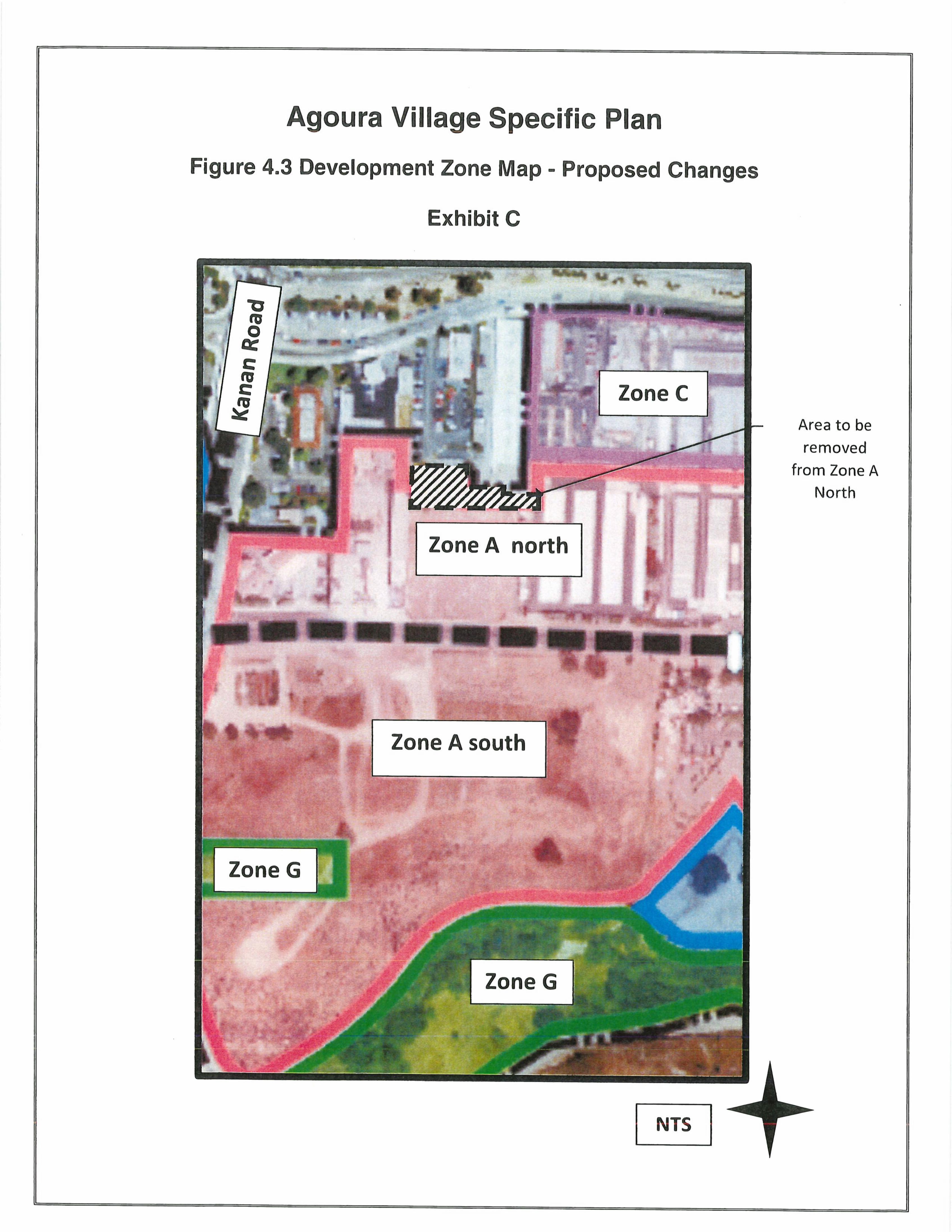
Agoura Village Specific Plan
Figure 4.3 Development Zone Map = Proposed Changes
M7 F_
x
m
Ma
M
Exhibit C
ast'
Zone C
F Area to be
removed
from Zone A
North
Zone A north
in40
0,
Zone A south
4
Zone G
NTS

ATTACHMENT 3
EXHIBIT D
AVSP FIGURE 2.3

iq
I

A RA JriILLS
Office of the City Clerk30001 Ladyface Court
Agoura Hills, CA 91301
CERTIFICATION
STATE OF CALIFORNIA ) COUNTY OF LOS ANGELES ) SS
CITY OF AGOURA HILLS )
I, Kimberly M. Rodrigues, City Clerk of the City of Agoura Hills, California, dohereby certify that the foregoing eleven ( 11) pages of Resolution No. 19- 1915; A
Resolution of the City Council of the City of Agoura Hills, California Adopting A SpecificPlan Amendment to Remove an Approximately 9,644 -Square -Foot Portion of PropertyDescribed as Assessor's Identification Number 2061- 006-038 from the Agoura VillageSpecific Plan ( Case No. Spa -01630-2019); are the full, true and correct original of theResolution adopted by the City Council at its Regular Meeting held at 6: 00 p. m. onWednesday, November 13, 2019, and on file and of record in the Office of the City Clerk, pursuant to the City's Electronic Documentation Management System ( EDMS) policy.
oCa Hi//
s
jovPorafO
o Dec.
a8, v
1982 /
Cc7 iforr a Q
Dated: December 2, 2019
Kimberly M. Rodrigues, MPPA, MMCCity Clerk